COMPETENCY BASED CURRICULUM SURVEYOR Surveyor_CTS_NSQF-5.pdf · surveyor government of india...
46
SURVEYOR GOVERNMENT OF INDIA MINISTRY OF SKILL DEVELOPMENT & ENTREPRENEURSHIP DIRECTORATE GENERAL OF TRAINING COMPETENCY BASED CURRICULUM SURVEYOR (Duration: Two Years) CRAFTSMEN TRAINING SCHEME (CTS) NSQF LEVEL- 5 SECTOR – CONSTRUCTION, CONSTRUCTION MATERIAL AND REAL ESTATE
-
Upload
phamnguyet -
Category
Documents
-
view
215 -
download
0
Transcript of COMPETENCY BASED CURRICULUM SURVEYOR Surveyor_CTS_NSQF-5.pdf · surveyor government of india...

SURVEYOR
GOVERNMENT OF INDIA MINISTRY OF SKILL DEVELOPMENT & ENTREPRENEURSHIP
DIRECTORATE GENERAL OF TRAINING
COMPETENCY BASED CURRICULUM
SURVEYOR (Duration: Two Years)
CRAFTSMEN TRAINING SCHEME (CTS)
NSQF LEVEL- 5
SECTOR – CONSTRUCTION, CONSTRUCTION MATERIAL AND REAL ESTATE
SURVEYOR
SURVEYOR (Engineering Trade)
(Revised in 2018)
CRAFTSMEN TRAINING SCHEME (CTS)
NSQF LEVEL - 5
Developed By
Ministry of Skill Development and Entrepreneurship
Directorate General of Training
CENTRAL STAFF TRAINING AND RESEARCH INSTITUTE EN-81, Sector-V, Salt Lake City,
Kolkata – 700 091

SURVEYOR
The DGT sincerely acknowledges contributions of the Industries, State Directorates,
Trade Experts, Domain Experts and all others who contributed in revising the curriculum.
Special acknowledgement is extended by DGT to the following expert members who had
contributed immensely in this curriculum.
List of Expert members contributed/ participated for finalizing the course curriculum of Surveyor trade held at CSTARI, Kolkata on 9th November’ 2017.
S No. Name & Designation
Shri/Mr./Ms. Organization Remarks
1. B.V.S. Sesha Chari, Director CSTARI, Kolkata Chairman
2. Bhupinder Singh, Ph.D., Associate Professor
Indian Institute of Technology, Roorkee
Expert
3. S.K. Bhattachariya, Proprietor ESBEE Associates, Kolkata Member
4. B. Maity, Chief Executive Pioneer Surveyors Newtown, Kolkata-700156
Member
5. Ram Ch. Bid, Asst. Engineer CPWD/KCD-V, Nizam Palace, Kolkata
Member
6. Utpal Banerjee, Operation Manager
Wazir Advisor Pvt. Ltd., Kolkata Member
7. Prodyut Kr. Ghosh, Survey Co-ordinator
ESBEE Associates, Kolkata Member
8. Subrata Guha, Junior Engineer CPWD/KCD-V, Nizam Palace, Kolkata
Member
9. Angad Yadav, Principal Archana Institute of Technical Education and Research, Prantik Township, Bolpur
Member
10. Narendra Nath Saha, Instructor S.P.B. Technical Institute, Uchalan, Burdwan
Member
11. Sk. Habibul Rahaman, Sr. GIS Engineer
Archana Institute of Technical Education and Research, Prantik Township, Bolpur
Member
12. Rinku Das, Instructor ITI Howrah Homes Member
13. Harun Ali Seikh, Instructor S.P.B. Technical Institute, Uchalan, Burdwan
Member
14. Amrita Gopal Gantait, Instructor Govt. I.T.I. Tollygunge, West Bengal
Member
15. L.K. Mukherjee, DDT CSTARI, Kolkata Member
ACKNOWLEDGEMENT

SURVEYOR
16. Nirmalya Nath, ADT CSTARI, Kolkata Member
17. P.K. Ghosh, SR. D/Man CSTARI, Kolkata Member
18. B.K. Nigam, Trg.Officer CSTARI, Kolkata Member
19. A. Pandey, Trg.Officer CSTARI, Kolkata Member
20. R. N. Manna, Trg.Officer CSTARI, Kolkata Co ordinator
Member
SURVEYOR
S No. Topics Page No.
1. Course Information 1-2
2. Training System 3-6
3. Job Role 7
4. General Information 8-9
5. NSQF Level Compliance 10
6. Learning/ Assessable Outcome 11-12
7. Learning Outcome with Assessment Criteria 13-19
8. Syllabus 20-29
9. Syllabus - Core Skill
9.1 Core Skill – Workshop Calculation & Science 30-32
9.2 Core Skill – Employability Skill 33-37
10. Annexure I - List of Trade Tools & Equipment 38-40
11. Annexure II - Format for Internal Assessment 41
CONTENTS

1
SURVEYOR
During the two-year duration a candidate is trained on subjects viz. Professional Skill,
Professional Knowledge, Workshop Science & Calculation and Employability skills. In addition to
this a candidate is entrusted to make/do project work and Extra Curricular Activities to build up
confidence. The practical skills are imparted in simple to complex manner & simultaneously
Professional Knowledge (theory subject) is taught in the same fashion to apply cognitive
knowledge while executing task. The practical part starts with simple geometrical drawing and
finally ends with preparing topographical map, Cadastral/ mouza map, detailed road project,
survey drawing using CAD, application of GIS techniques, Hydrographic survey, Transmission
line site survey, railway line site survey, sanction plan of Residential / Public building, and
detailed estimate. The semester wise course coverage is categorized as below:-
Semester-I: In the beginning of the course the trainees are acquainted with occupational safety
& health, PPE, etc. The practical part starts with basic drawing (consisting of lettering,
numbering, geometrical figure, symbols & representations). Later the drawing skills imparted
are drawing of different scales, projections, perform site survey and prepare a site plan using
chain / tape, prismatic compass, perform AutoCAD drawing. Observation of all safety aspects is
mandatory. The safety aspect covers components like OSH&E, PPE, Fire extinguisher, First Aid,
etc. Knowledge and application of Computer Aided Drawing has been introduced in this
semester. Workspace creating drawing using toolbars, commands, and menus. Plotting drawing
from CAD.
Semester-II: In this semester different site survey using Plane table( radiation, intersection,
traversing, determination of height), Theodolite (measurement of angle, traversing,
computation of area), Levelling instrument (different levelling – differential, reciprocal, etc.),
taecheometer (determination of horizontal and vertical distance, constants, etc.), field book
entry, plotting, mapping, calculation of area, preparing traverse drawing, simple building
drawing using CAD are being taught in the practical.
Semester-III: Making topographical map using Level instruments with contours ( Interpolation
of contour, preparation of section, computation of volume, setting of simple, compound,
reverse, transition and vertical curve), performing survey using Total Station and preparation of
map (measurement of angle, co-ordinates and heights, downloading survey data and plotting),
making of site plan by Cadastral survey (preparation of site plan, calculation of plot area, etc.),
performing road project survey (location survey and preparation of route map, profile/
longitudinal / cross sectional levelling and plotting) and survey drawing using CAD.
Semester-IV: Drawing of cartographic projection, setting and application of GIS & GPS
techniques in various fields, collection and processing of data, performing hydrographic survey
1. COURSE INFORMATION
2
SURVEYOR
(determining hydrographic depth, measuring velocity of flow, determining cross sectional area
of river, calculating the discharge of a river, etc.), performing transmission line site survey
(making of alignment, conducting detailed survey, final location survey and making of tower
foundation pit point), performing railway line site survey, drawing of building by CAD and
preparation of estimation are being done as part of practical training.
3
SURVEYOR
2.1 GENERAL
Directorate General of Training (DGT) under Ministry of Skill Development &
Entrepreneurship offers range of vocational training courses catering to the need of different
sectors of the Labour market. The vocational training programmes are running under aegis of
National Council of Vocational Training (NCVT). Craftsman Training Scheme (CTS) and
Apprenticeship Training Scheme (ATS) are two pioneer programmes under NCVT for
propagating vocational training.
Surveyor trade under CTS is one of the most popular courses delivered nationwide
through network of ITIs. The course is of two years (04 semesters) duration. It mainly consists
of Domain area and Core area. In the Domain area (Trade Theory & Practical) impart
professional skills and knowledge, while Core area (Workshop Calculation & science and
Employability Skills) impart requisite core skill, knowledge and life skills. After passing out of the
training program, the trainee is awarded National Trade Certificate (NTC) by NCVT which is
recognized worldwide.
Trainee broadly needs to demonstrate that they are able to:
Read & interpret technical parameters/documentation, plan work, identify necessary materials and tools;
Perform task with due consideration to safety rules, accident prevention regulations and environmental protection stipulations;
Apply professional knowledge, core skills & employability skills while performing the job.
Check the survey drawing and data and rectify errors .
Document the technical parameters related to the task undertaken. Process data recorded during field measurements and make relevant conclusions.
2.2 CARRIER PROGRESSION PATHWAYS:
Can take admission in diploma course in notified branches of Engineering by lateral
entry.
Can join Apprenticeship programme in different types of industries leading to National
Apprenticeship certificate (NAC).
Can join Crafts Instructor Training Scheme (CITS) in the trade for becoming instructor in
ITIs.
2. TRAINING SYSTEM
4
SURVEYOR
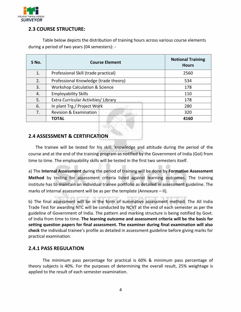
2.3 COURSE STRUCTURE:
Table below depicts the distribution of training hours across various course elements
during a period of two years (04 semesters): -
S No. Course Element Notional Training
Hours
1. Professional Skill (trade practical) 2560
2. Professional Knowledge (trade theory) 534
3. Workshop Calculation & Science 178
4. Employability Skills 110
5. Extra Curricular Activities/ Library 178
6. In plant Trg./ Project Work 280
7. Revision & Examination 320
TOTAL 4160
2.4 ASSESSMENT & CERTIFICATION
The trainee will be tested for his skill, knowledge and attitude during the period of the
course and at the end of the training program as notified by the Government of India (GoI) from
time to time. The employability skills will be tested in the first two semesters itself.
a) The Internal Assessment during the period of training will be done by Formative Assessment
Method by testing for assessment criteria listed against learning outcomes. The training
institute has to maintain an individual trainee portfolio as detailed in assessment guideline. The
marks of internal assessment will be as per the template (Annexure – II).
b) The final assessment will be in the form of summative assessment method. The All India Trade Test for awarding NTC will be conducted by NCVT at the end of each semester as per the guideline of Government of India. The pattern and marking structure is being notified by Govt. of India from time to time. The learning outcome and assessment criteria will be the basis for setting question papers for final assessment. The examiner during final examination will also check the individual trainee’s profile as detailed in assessment guideline before giving marks for practical examination.
2.4.1 PASS REGULATION
The minimum pass percentage for practical is 60% & minimum pass percentage of theory subjects is 40%. For the purposes of determining the overall result, 25% weightage is applied to the result of each semester examination.

5
SURVEYOR
2.4.2 ASSESSMENT GUIDELINE
Appropriate arrangements should be made to ensure that there will be no artificial barriers to assessment. The nature of special needs should be taken into account while undertaking the assessment. Due consideration should be given while assessing for teamwork, avoidance/reduction of scrap/wastage and disposal of scrap/waste as per procedure, behavioral attitude, sensitivity to the environment and regularity in training. The sensitivity towards OSHE and self-learning attitude are to be considered while assessing competency. Assessment will be evidence based comprising the following:
Job carried out in labs/workshop
Record book/ daily diary
Answer sheet of assessment
Viva-voce
Progress chart
Attendance and punctuality
Assignment
Project work
Evidences of internal assessments are to be preserved until forthcoming semester examination for audit and verification by examining body. The following marking pattern to be adopted while assessing:
Performance Level Evidence
(a) Weightage in the range of 60%-75% to be allotted during assessment
For performance in this grade, the candidate should produce work which demonstrates attainment of an acceptable standard of craftsmanship with occasional guidance, and due regard for safety procedures and practices
Demonstration of good skill in the use of hand tools, machine tools and workshop equipment.
Below 70% tolerance dimension achieved while undertaking different work with those demanded by the component/job.
A fairly good level of neatness and consistency in the finish.
Occasional support in completing the project/job.
(b) Weightage in the range of 75%-90% to be allotted during assessment
For this grade, a candidate should produce work which demonstrates attainment of a reasonable standard of craftsmanship, with little guidance, and
Good skill levels in the use of hand tools, machine tools and workshop equipment.
70-80% tolerance dimension achieved while undertaking different work with those

6
SURVEYOR
regard for safety procedures and practices
demanded by the component/job.
A good level of neatness and consistency in the finish.
Little support in completing the project/job.
(c) Weightage in the range of more than 90% to be allotted during assessment
For performance in this grade, the candidate, with minimal or no support in organization and execution and with due regard for safety procedures and practices, has produced work which demonstrates attainment of a high standard of craftsmanship.
High skill levels in the use of hand tools, machine tools and workshop equipment.
Above 80% tolerance dimension achieved while undertaking different work with those demanded by the component/job.
A high level of neatness and consistency in the finish.
Minimal or no support in completing the project.

7
SURVEYOR
Topographical Surveyor, surveys land to determine out line, contours and relative position of control points (land marks) on tract of land, coast, harbor, etc. for preparing topographical and other maps and records. Establishes control points and pillars to do instrumentation work on ground to prepare maps. Provides identification marks on ground for photographs taken in aerial survey. Fixes position of control points on ground in relation to some permanent position and with reference to celestial bodies using theodolites and precise levels, tachometer, digital planimeter etc. Adjusts and sets theodolites, compasses, plane tables, leveling instruments, Total station, GPS, DGPS and other modern instruments for survey, observes and records measurements and angles from three determined points (triangulation), locations to scale on proper sketch. Corrects margin of error due to worn-out tapes which become incorrect, and readings on instruments which are affected by environmental factors.
Plan and organize assigned work and detect & resolve issues during execution in his own
work area within defined limit. Demonstrate possible solutions and agree tasks within the team. Communicate with required clarity and understand technical English. Sensitive to environment, self-learning and productivity.
Reference NCO-2015: 2165.0200
3. JOB ROLE

8
SURVEYOR
Name of the Trade Surveyor
NCO - 2015 2165.0200
NSQF Level Level – 5
Duration of Craftsmen Training
Two years (Four semesters each of six months duration).
Entry Qualification Passed 10th Class examination under 10+2 System of education.
Unit Strength (No. Of Student)
20 (Max. supernumery seats: 6)
Space Norms 64 Sq. m
Power Norms 3 KW
Instructors Qualification for
1. Surveyor Trade Degree in Survey Engineering / Civil Engineering from recognized university with one year experience in relevant field.
OR Diploma in Survey Engineering /Civil Engineering from recognized board of education with two years experience in relevant field.
OR NTC/NAC in the Trade of “Surveyor” With 3 years post qualification experience in the relevant field. Desirable: - Preference will be given to a candidate with CIC (Craft Instructor Certificate) in Surveyor trade. Out of two Instructors required for the unit of 2 (1+1), one must have Degree/ Diploma and other must have NTC/NAC qualifications.
2. Workshop Calculation & Science
Degree in Engineering with one year experience. OR
Diploma in Engineering with two years experience. Desirable: Craft Instructor Certificate in RoD & A course under NCVT.
3. Employability Skill MBA or BBA with two years experience or Graduate in Sociology/ Social Welfare/ Economics with Two years experience or Graduate/ Diploma with Two years experience and trained in Employability Skills from DGT institutes. AND
4. GENERAL INFORMATION

9
SURVEYOR
Must have studied English/ Communication Skills and Basic Computer at 12th / Diploma level and above.
OR Existing Social Studies Instructors duly trained in Employability Skills from DGT institutes.
List of Tools and Equipment
As per Annexure – I
Distribution of training on Hourly basis: (Indicative only)
Total hours /week
Trade Practical
Trade Theory
Workshop Cal. & Sc.
Employability Skills
Extracurricular Activity
40 Hours 28 Hours 6 Hours 2 Hours 2 Hours 2 Hours
10
SURVEYOR
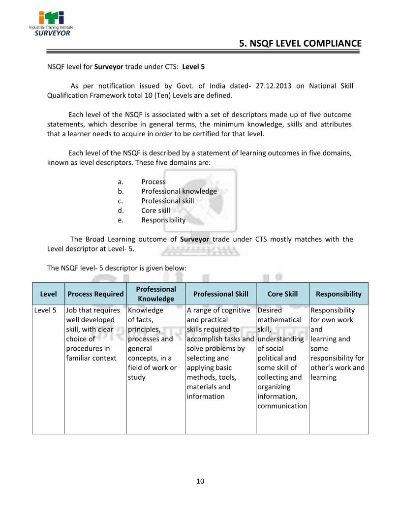
NSQF level for Surveyor trade under CTS: Level 5 As per notification issued by Govt. of India dated- 27.12.2013 on National Skill
Qualification Framework total 10 (Ten) Levels are defined.
Each level of the NSQF is associated with a set of descriptors made up of five outcome statements, which describe in general terms, the minimum knowledge, skills and attributes that a learner needs to acquire in order to be certified for that level. Each level of the NSQF is described by a statement of learning outcomes in five domains, known as level descriptors. These five domains are:
a. Process b. Professional knowledge c. Professional skill d. Core skill e. Responsibility
The Broad Learning outcome of Surveyor trade under CTS mostly matches with the
Level descriptor at Level- 5. The NSQF level- 5 descriptor is given below:
Level Process Required Professional Knowledge
Professional Skill Core Skill Responsibility
Level 5 Job that requires well developed skill, with clear choice of procedures in familiar context
Knowledge of facts, principles, processes and general concepts, in a field of work or study
A range of cognitive and practical skills required to accomplish tasks and solve problems by selecting and applying basic methods, tools, materials and information
Desired mathematical skill, understanding of social political and some skill of collecting and organizing information, communication
Responsibility for own work and learning and some responsibility for other’s work and learning
5. NSQF LEVEL COMPLIANCE

11
SURVEYOR
Learning outcomes are a reflection of total competencies of a trainee and assessment will be carried out as per the assessment criteria.
6.1 GENERIC LEARNING OUTCOME
1. Recognize & comply safe working practices, environment regulation and housekeeping. 2. Work in a team, understand and practice soft skills, technical English to communicate
with required clarity. 3. Demonstrate knowledge of concept and principles of basic arithmetic, algebraic,
trigonometric, statistics, co-ordinate system and apply knowledge of specific area to perform practical operations.
4. Read and apply engineering drawing for different application in the field of work.
5. Understand and explain the concept in productivity, quality tools, and labour welfare
legislation and apply such in day to day work to improve productivity & quality.
6. Explain energy conservation, global warming and pollution and contribute in day to day
work by optimally using available resources.
7. Explain personnel finance, entrepreneurship and manage/organize related task in day to
day work for personal & societal growth.
8. Understand and apply basic computer working, basic operating system and uses
internet services to get accustomed & take benefit of IT developments in the industry.
9. Understand and apply management of workers, communications and team
management skills.
6.2 SPECIFIC LEARNING OUTCOME
Semester – I
10. Concept of drawing & sheet layout.
11. Draw lettering & numbering applying drawing instruments.
12. Draw plain geometrical figures, curves & conics.
13. Construct plain scale, diagonal scale, comparative scale, vernier scale.
14. Draw orthographic projections of different objects with proper dimensioning &
lettering.
15. Draw conventional signs & symbols used in surveying.
16. Perform site survey using chain/ tape & prepare a site plan.
17. Perform the site survey using prismatic compass.
18. Perform Auto Cad drawing.
6. LEARNING/ ASSESSABLE OUTCOME

12
SURVEYOR
Semester – II
19. Perform the site survey using plane table.
20. Perform theodolite survey.
21. Perform traverse survey by theodolite & prepare a site map.
22. Determine of R.L & heights of different points by levelling instruments.
23. Performing tacheometric survey using tacheometer.
24. Perform AutoCAD drawing (single story building).
Semester – III
25. Make topography map using level instrument with contours.
26. Concept & set out of curves.
27. Perform survey work using modern survey instruments (total station) for prepare a
map.
28. Concept of cadastral survey & make a site plan.
29. Perform a road project survey.
30. Perform survey work for prepare a topographical map, cadastral map, road Project
(Survey camp in a suitable hilly/undulated area).
31. Perform AutoCAD drawing field survey data.
Semester – IV
32. Concept & draw cartographic projection. 33. Concept & use of GPS & GIS. 34. Perform Hydrographic survey using hydrographic survey instruments..
35. Perform transmission line site survey & prepare a site plan
36. Perform railway line site survey line survey using modern survey instruments.
37. Draw a double storied building by AutoCAD & prepare a detail estimate of the building.

13
SURVEYOR
GENERIC LEARNING/ ASSESSABLE OUTCOME
LEARNING/ ASSESSABLE OUTCOME
ASSESSMENT CRITERIA
1. Recognize & comply safe working practices, environment regulation and housekeeping.
1.1 Follow and maintain procedures to achieve a safe working environment in line with occupational health and safety regulations and requirements and according to site policy.
1.2 Recognize and report all unsafe situations according to site policy.
1.3 Identify and take necessary precautions on fire and safety hazards and report according to procedures.
1.4 Identify, handle and store / dispose off dangerous goods and substances according to site policy and procedures following safety regulations and requirements.
1.5 Identify and observe site policies and procedures in regard to illness or accident.
1.6 Identify safety alarms accurately.
1.7 Report supervisor/ Competent of authority in the event of accident or sickness of any staff and record accident details correctly according to site accident/injury procedures.
1.8 Identify and observe site evacuation procedures according to site policy.
1.9 Identify Personal Productive Equipment (PPE) and use the same as per related working environment.
1.10 Identify basic first aid and use them under different circumstances.
1.11 Identify different fire extinguisher and use the same as per requirement
1.12 Identify environmental pollution & contribute to the avoidance of instances of environmental pollution
1.13 Deploy environmental protection legislation & regulations
1.14 Take opportunities to use energy and materials in an environmentally friendly manner
1.15 Avoid waste and dispose waste as per procedure
1.16 Recognize different components of 5S and apply the same in the working environment.
2. Work in a team, understand and practice soft skills, technical English to
2.1 Obtain sources of information and recognize information.
2.2 Use and draw up technical drawings and documents.
2.3 Use documents and technical regulations and
7. LEARNING OUTCOME WITH ASSESSMENT CRITERIA

14
SURVEYOR
communicate with required clarity.
occupationally related provisions.
2.4 Conduct appropriate and target oriented discussions with higher authority and within the team.
2.5 Present facts and circumstances, possible solutions &use English special terminology.
2.6 Resolve disputes within the team
2.7 Conduct written communication.
3. Demonstrate knowledge of concept and principles of basic arithmetic, algebraic, trigonometric, statistics, co-ordinate system and apply knowledge of specific area to perform practical operations.
3.1 Semester examination to test basic skills on arithmetic, algebra, trigonometry and statistics.
3.2 Their applications will also be assessed during execution of assessable outcome and also tested during theory and practical examination.
4. Read and apply engineering
drawing for different
application in the field of
work.
4.1 Semester examination to test basic skills on engineering drawing.
4.2 Their applications will also be assessed during execution of assessable outcome and also tested during theory and practical examination.
5. Understand and explain the concept in productivity, quality tools, and labour welfare legislation and apply such in day to day work to improve productivity & quality.
5.1 Semester examination to test the concept in productivity,
quality tools and labour welfare legislation.
5.2 Their applications will also be assessed during execution
of assessable outcome.
6. Explain energy conservation, global warming and pollution and contribute in day to day work by optimally using available resources.
6.1 Semester examination to test knowledge on energy conservation, global warming and pollution.
6.2 Their applications will also be assessed during execution of assessable outcome.
7. Explain personnel finance,
entrepreneurship and
manage/organize related
task in day to day work for
personal & societal growth.
7. 1 Semester examination to test knowledge on personnel finance, entrepreneurship.
7. 2 Their applications will also be assessed during execution of assessable outcome.
8. Understand and apply basic 8. 1 Semester examination to test knowledge on basic

15
SURVEYOR
computer working, basic
operating system and uses
internet services to get
accustomed & take benefit
of IT developments in the
industry.
computer working, basic operating system and uses internet services.
8. 2 Their applications will also be assessed during execution of assessable outcome.
9. Understand and apply
Management of Workers,
Communication,
Coordination and Team
Management skills
9. 1 Semester examination to test knowledge on management of work. Communication, Co ordination and Management skill.
9. 2 Their applications will also be assessed during execution of assessable outcome. like, planning, scheduling, engineering, designing, procurement & contracting, execution
16
SURVEYOR
SPECIFIC LEARNING/ ASSESSABLE OUTCOME
LEARNING/ ASSESSABLE OUTCOME
ASSESSMENT CRITERIA
Semester-I 10. Concept of drawing & sheet
layout.
10.1 Ensure data & information received are sufficient for preparation of drawing
10.2 Prepare layout of drawing sheet
10.3 Prepare a title box
10.4 Set & fix drawing paper on the drawing board
11. Draw lettering & numbering
applying drawing
instruments
11.1 Draw, horizontal line, vertical line, parallel line using T-square, set- square
11.2 Draw different types of lettering
11.3 Draw numbers in different fonts
11.4 Draw different types of lines
11.5 Dimensioning a drawing. (various types)
12. Draw plain geometrical
figures, curves & conics
12. 1. Draw geometrical figures from given data (different types)
12. 2. Construct ellipse and parabolic curves using the various conditions given
13. Construct plain scale,
diagonal scale, comparative
scale, vernier scale.
13. 1. Draw different types of scales.
13. 2. Find out R.F of the scale, calculate the length of the scale on drawing
13. 3. Check the drawing to confirm their correctness
14. 14. Draw orthographic
projections of different
objects with proper
dimensioning & lettering
14. 1. Develop view in orthographic projection by placing object between horizontal & vertical plane of axis.
14. 2. Generate side view of blocks in different inclination on V.P & H.P by auxiliary vertical plane.
14. 3. Construct an isometric scale to a given length
14. 4. Draw the isometric projection of regular solids
15. Draw conventional signs &
symbols used in surveying
15. 1. Draw some conventional signs & symbols used in topographic maps.
16. Perform site survey using
chain/ tape & prepare a site
16. 1. Perform surveying measuring distance by chain/ tape and other accessories
16. 2. Errors in chaining and their corrections.

17
SURVEYOR
plan. 16. 3. Enter measured data in field book and plotting the same.
16. 4. Conduct chain surveying and prepare a site plan.
16. 5. Calculate area of a plot.
17. Perform the site survey using
prismatic compass
17.1 Measure bearings of a line and conduct the traverse survey using prismatic compass & others accessories
17.2 Entry in field book and Compute the correct bearings plo
17.3 Plotting the traverse & adjust the closing error
17.4 Calculate the area of the traverse
18. Perform Auto Cad drawing 18. 1. Draw some figures using Auto Cad.
Semester-II
19. Perform the site survey using
the plane table.
19.1 Set up the plane table including – centering, leveling & orientation
19.2 Perform plane table survey on field by radiation method.
19.3 Perform plane table survey by intersection, resection method.
19.4 Perform a plane table survey by traversing method with all details
20. Perform Theodolite survey 20.1 Temporary adjustment of Theodolite. (set up,
centering, levelling, focussing)
20.2 Measure horizontal angle by various method & enter into field book
20.3 Measure vertical angle
20.4 Determine height of a tower/ post using Theodolite.
21. Perform traverse survey by
Theodolite, prepare a site
map.
21. 1 Conduct reconnaissance survey prepare key plan
21. 2 Mark the station point
21. 3 Prepare reference sketch
21. 4 Measure lengths & bearing
21. 5 Measure horizontal angles (repetition method)
21. 6 Compute co-ordinates, check angles, calculate bearings, find consecutive co-ordinates & independent co-ordinates
21. 7 Plot the traverse
21. 8 Calculate the area by co-ordinates methods.
22. Determine RL and heights
by leveling instruments of
22. 1 Set levelling instruments and temporary adjustment. (Dumpy/ Auto level)
22. 2 Determine reduced level and check it.

18
SURVEYOR
different points. 22. 3 Conduct reciprocal levelling
22. 4 Fix up a bench mark
23. Perform tachometric survey
using tachometer
23. 1 Determine the stadia constant of a tachometer
23. 2 Determine horizontal distance by stadia tachometer
23. 3 Determine vertical distance by stadia tachometer
24. Perform AutoCAD drawing
and estimate a simple
building
24.1 Draw a survey traverse using AutoCAD command
24.2 Draw a simple building using AutoCAD command
Semester-III
25. Make topography map using
level instrument with
contours.
25.1 Fix horizontal & vertical control points
25.2 Prepare a contour map (by square method)
25.3 Make cross section on contour map
25.4 Mark the gradient on contour map
25.5 Calculate the volume from contour map by prismoidal or trapezoidal formula
26. Concept & set out of curves. 26.1 Draw and mark the parts of simple circular curve.
26.2 Set out a simple circular curve by linear method from given data
26.3 Set out a simple circular curve by instrument method from given data
26.4 Set out a simple compound curve by instrument method from given data
26.5 Set out a simple reverse curve by instrument method from given data
26.6 Set out a simple transition curve from given data
27. Perform survey work using
modern survey instruments
(total station) for prepare a
map.
27.1 Set up the total station
27.2 Measure horizontal angle, vertical angle, height by T.S.
27.3 Stake out a point by using T.S.
27.4 Download & plot the survey map
28. Concept of cadastral survey &
make a site plan.
28.1 Prepare a cadastral map.(including inking & plot numbering)
28.2 Calculate the plot area using digital planimeter.
28.3 Prepare a site plan from existing cadastral map.
29. Perform a road project
survey.
29.1 Prepare a longitudinal levelling and plot it.
29.2 Prepare a cross section levelling and plot it
29.3 Determine formation level, depth of cutting and depth
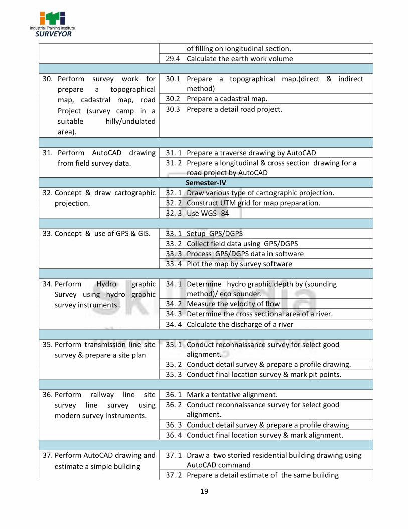
19
SURVEYOR
of filling on longitudinal section.
29.4 Calculate the earth work volume
30. Perform survey work for
prepare a topographical
map, cadastral map, road
Project (survey camp in a
suitable hilly/undulated
area).
30.1 Prepare a topographical map.(direct & indirect method)
30.2 Prepare a cadastral map.
30.3 Prepare a detail road project.
31. Perform AutoCAD drawing
from field survey data.
31. 1 Prepare a traverse drawing by AutoCAD
31. 2 Prepare a longitudinal & cross section drawing for a road project by AutoCAD
Semester-IV 32. Concept & draw cartographic
projection.
32. 1 Draw various type of cartographic projection.
32. 2 Construct UTM grid for map preparation.
32. 3 Use WGS -84
33. Concept & use of GPS & GIS. 33. 1 Setup GPS/DGPS
33. 2 Collect field data using GPS/DGPS
33. 3 Process GPS/DGPS data in software
33. 4 Plot the map by survey software
34. Perform Hydro graphic
Survey using hydro graphic
survey instruments..
34. 1 Determine hydro graphic depth by (sounding method)/ eco sounder.
34. 2 Measure the velocity of flow
34. 3 Determine the cross sectional area of a river.
34. 4 Calculate the discharge of a river
35. Perform transmission line site
survey & prepare a site plan
35. 1 Conduct reconnaissance survey for select good alignment.
35. 2 Conduct detail survey & prepare a profile drawing.
35. 3 Conduct final location survey & mark pit points.
36. Perform railway line site
survey line survey using
modern survey instruments.
36. 1 Mark a tentative alignment.
36. 2 Conduct reconnaissance survey for select good alignment.
36. 3 Conduct detail survey & prepare a profile drawing
36. 4 Conduct final location survey & mark alignment.
37. Perform AutoCAD drawing and
estimate a simple building
37. 1 Draw a two storied residential building drawing using AutoCAD command
37. 2 Prepare a detail estimate of the same building

20
SURVEYOR
SYLLABUS - SURVEYOR
FIRST SEMESTER – 06 Months
Week No.
Reference Learning Outcome
Professional Skills with Indicative Hours
Professional Knowledge
1-2 Recognize & comply safe working practices, environment regulation. Concept of drawing & sheet layout.
1. Importance of trade training, Demonstrate of tools & equipment used in the trade. (6 hrs)
2. Occupational safety & Health. (6 hrs)
3. Introduction of safety equipments and their uses. (10 hrs)
4. Introduction of first aid, health, safety & environmental guidelines, legislations & regulations as applicable. (8 hrs)
5. Personal Protective Equipment (PPE). (8 hrs)
6. Hazard identification and avoidance, Safety signs for Danger. (4 hrs)
7. Use of drawing instruments and equipments with care. (4 hrs)
8. Method of fixing of drawing sheet on drawing board. (2 hrs)
9. Layout of different size of drawing sheet and folding of sheets. (8 hrs)
Importance of safety and general precautions related to the trade. All necessary guidance to be provided to the new comers to become familiar with the working of ITI system. Importance of survey or trade Job after completion of training. Introduction of First aid. Job responsibility of the trade.
Overview the subject to be taught.
List of the instrument equipments to be used during training
Layout of drawing sheet
Dimensions of drawing sheet.
3-6 Draw lettering & numbering & dimensioning applying drawing instruments.
10. Lettering & numbering (Single & double stroke) (70 hrs)
11. types of lines and dimensioning. (42 hrs)
Details layout of lettering, lines & dimensioning system .
7-8 Draw plain geometrical figures, curves & conics
12. Construction of plain geometrical figures, curves & conics. (56 hrs)
Introduction of surveying, types of surveying, use, application principal.
9-10 Construct plain 13. Drawing of : - Knowledge of different types of
8. SYLLABUS

21
SURVEYOR
scale, diagonal scale, comparative scale, vernier scale.
14. Construction of scales – plain, diagonal, vernier. (56 hrs)
scales, determine of R.F & uses of scales.
11-14 Draw orthographic projections of different objects with proper dimensioning & lettering.
15. Drawing of three views in orthographic projection of point, line, plane, solid objects. (40 hrs)
16. Section of solids. (32 hrs) 17. Isometric projection of
geometrical solids. (40 hrs)
Different types of projection views orthographic, sectional , isometric view.
15 Draw conventional signs & symbols used in surveying
18. Drawing of conventional signs & symbols (10 hrs)
19. Free hand sketch of liner measurement instruments(18 hrs)
Use & application of conventional signs & symbols.
16-18 Perform site survey using chain/ tape & prepare a site plan.
20. Practice of folding & unfolding of chain. (5 hrs)
21. Equipment and instrument used to perform surveying & testing of chain. (5 hrs)
22. Ranging (direct/ indirect) & distance measure with chain/ tape. (10 hrs)
23. Offset taking & entering field book. (6 hrs)
24. Overcoming obstacles in chaining. (6 hrs)
25. Chaining on sloping ground. (10 hrs)
26. Conduct a chain survey of a small area with all details and plotting the map. (20 hrs)
27. Calculating the area of site. (6 hrs)
28. Prepare a site plan by the help of chain / tape. (16 hrs)
Uses of Chain/ tape, testing of a chain & correction. Ranging (direct & indirect), Principle of chain survey, application. Terms used in chain survey, Offset, types of offsets, limit of offset, field book, types of field book, entry of field book method of chaining in slopping ground. Field procedure of chain survey errors in chain survey, plotting procedure. Calculation of area (regular & irregular figure) Knowledge of site plan.
19-22 Perform the site survey using prismatic compass
29. Temporary adjustment of prismatic compass. (10 hrs)
30. Measure fore & back bearing of a line. (10 hrs)
31. Measure true bearing of a line. (20 hrs)
32. Prepare a closed & open traverse using prismatic compass measure the bearings, entry into
Basic terms used in compass survey. Instrument & its setting up. Conversion of bearing web to R.B. Calculation of included angle from bearing local attraction, magnetic declination and true bearing, closing error.
22
SURVEYOR
field book, calculation of correct bearing and adjust. (Local attraction), determine the closing error and adjust. Plotting the same. (72hrs)
Adjustment of closing error, precaution in using prismatic compass.
23 Perform Auto CAD drawing
33. Practice with AutoCAD using commands (28 hrs)
Introduction to Auto CAD. Use AutoCAD command.
24 Project work a) Prepare a map by using chain /tape & compass. (Close traverse), plotting & calculate
the area.
25 Revision
26 Examination
Note: -More emphasis to be given on video/real-life pictures during theoretical classes. Some real-life
pictures/videos of site survey using Chain / Tape, Prismatic Compass, may be shown to the trainees to
give a feel of actual survey work and their future assignment.

23
SURVEYOR
SYLLABUS - SURVEYOR
SECOND SEMESTER – 06 Months
Week No.
Reference Learning Outcome
Professional Skills with Indicative Hours
Professional Knowledge
27-29 Perform the site survey using the plane table.
34. Demonstration of instrument used for plane table surveying & their uses (alidade, U-fork, trough compass) Set up the plane table (24 hrs)
Centering
Levelling
Orientation
35. Practice the method of plane tabling (40 hrs)
Radiation
Intersection
Resection
Traversing 36. Determination of height by
telescopic alidade (20 hrs)
Plane table survey, principle, merits & demerits Instrument used in plane table survey setting up the plane table. (centering, levelling, orientation) Methods of plane table survey (radiation, intersection, resection, traversing) Error in plane table survey.
30-33 Perform Theodolite survey
37. Practice to set up the Theodolite(10 hrs)
38. Reading the vernier & booking (hor./ver.) Angle. (10 hrs)
39. Perform permanent adjustment of Theodolite (10 hrs)
40. Measurement of horizontal angle by various methods. (20 hrs)
41. Setting out the angles. (10 hrs) 42. Measurement of vertical angle,
deflection angle (15 hrs) 43. Prolongation of line by various
methods. (15hrs) 44. Determination of height of
inaccessible object by Theodolite. (22hrs)
Introduction to Theodolite. Types of Theodolite, parts of Theodolite, Terms used in Theodolite survey. Temporary adjustment of Theodolite, Angle measurement process. Reading of angles, field book entry of measured angles. Permanent adjustment of Theodolite.
34-37 Perform traverse survey by Theodolite, prepare a site map.
45. Traversing (closed & open) using Theodolite & tape/chain (20 hrs)
46. Measurement of horizontal angles & bearing of a line.
Traversing using theodolite (closed & open), traverse computation, determination of consecutive coordinates, independent co-ordinate,
24
SURVEYOR
(20 hrs) 47. Computation of coordinates
from the bearing, angle length. (20 hrs)
48. Preparation of gales traverse table (20 hrs)
49. Computation of area using co-ordinates (20 hrs)
50. Determine omitted measurements(12 hrs)
checking & balancing of traverse, preparation of gales traverse table, computation of area using co-ordinates , calculation of omitted measurement
38-43 Determine of RL and heights of different points. by levelling instruments .
51. Practice in setting up of dumpy level and performing temporary adjustments (15 hrs)
52. Practice in staff reading(10 hrs) 53. Practice in simple levelling(15
hrs) 54. Practice differential levelling (fly
levelling) (15 hrs) 55. Practice reciprocal levelling. (20
hrs) 56. Carryout levelling field book.
(10 hrs) 57. Equate reduction of level (rise
fall method, height of instrument method) comparison of method. (20 hrs)
58. Solve problems on reduction of level. (08 hrs)
59. Practice levelling with (auto / digital level) (20 hrs)
60. Practice profile levelling or longitudinal & cross section levelling, plotting the profile. (20 hrs)
61. Check levelling (15 hrs)
Introduction to levelling. Types of levelling instrument. Technical terms used in levelling Temporary & permanent adjustment. Different types of levelling Entry of level book. (Reduced level calculation method) Curvature & refraction effect sensitivity of bubble tube. Common error and their elemation. Degree of accuracy.
44-45 Performing tachometric survey using tacheometer
62. Determination of horizontal and vertical distances by tachometric method. (30 hrs)
63. Determination of stadia constants of a tachometer. (26 hrs)
Introduction of tachometry & terms use advantages and disadvantages. Tachometric constants & its determination. Determination of horizontal & vertical distances by various methods.
46-48 Perform AutoCAD drawing (
64. Prepare traverse drawing using Auto cad. (20 hrs)
Use AutoCAD command for drawings.
25
SURVEYOR
single story building)
65. Prepare a simple building (30 hrs)
66. Drawing using Auto cad. (34hrs)
49-50 Project work 1. Prepare a traverse map with theodolite, & others survey instruments 2. Prepare a longitudinal section (more than 300 metre). 3. Draw a single story building using autocad.
51 Revision
52 Examination
Note: - More emphasis to be given on video/real-life pictures during theoretical classes. Some real-life pictures/videos of site survey using Leveling instrument, Theodolite, Tachometer, and road survey may be shown to the trainees to give a feel of actual survey work and their future assignment.
26
SURVEYOR
SYLLABUS - SURVEYOR
THIRD SEMESTER – 06 Months
Week No.
Reference Learning Outcome
Professional Skills with Indicative Hours
Professional Knowledge
53-57 Make topography map using level instrument with contours
67. Prepare contour (direct/ indirect method) (20 hrs)
68. Interpolation of contour. (15 hrs)
69. Draw contour lines. (15 hrs) 70. Locating contour gradients. (15
hrs) 71. Preparation of section from
contour map. (20 hrs) 72. Computation of volume
(prismoidal / trapezoidal) formula. (15 hrs)
73. Establishment of gradient by abney level. (15 hrs)
74. Make a topography map with contours. (indirect method) (25 hrs)
Contouring, contour interval selection of contour interval, characteristics of contour, uses of contour contouring by various method. Interpolation of contour by various methods, drawing of contours, computation of volume establishment of gradient by abney level.
58-62 Concept & set out of curves
75. Computation of elements of simple curve. (20 hrs)
76. Set out of simple curve by linear method. (20 hrs)
77. Set out of simple curve by instrument method. (20 hrs)
78. Set out of compound curve by instrument method. (20 hrs)
79. Set out of reverse curve by instrument method. (20 hrs)
80. Set out of transition curve by instrument method. (20 hrs)
81. Set out of vertical curve by instrument method. (20 hrs)
Curves, Purpose, Types of curves – simple, compound, reverse, transition, vertical. Elements of simple curve, computation of elements of simple curve. Various methods for setting out simple, compound, reverse, transition & vertical curve.
63-66 Perform survey work using modern survey instruments (Total station ) for prepare a map
82. Temporary adjustment of Total station. (20 hrs)
83. Measurement of angle & coordinates and heights. (27 hrs)
84. Traversing using Total station. (40 hrs)
85. Download survey data and Plotting. (25 hrs)
Familiarization with modern survey instruments. Parts of Total station, temporary adjustment of T.S, working procedure of T.S.

27
SURVEYOR 67 Concept of
cadastral survey & make a site plan
86. Prepare a site plan by the help of mouza map. (16 hrs)
87. Calculate the plot area by digital planimeter. (12 hrs)
Familiarisation with cadastral map, term used in cadastral survey, preliminary knowledge for prepare a site plan. Calculation of area by digital planimeter.
68-70 Performing a road project survey.
88. Road project reconnaissance. (10 hrs)
89. Preliminary survey. (18 hrs) 90. Final location survey including
preparation of route map. (36 hrs)
91. Profile or longitudinal & cross sectional levelling & plotting. (20 hrs)
Types of surveys for location of a road. Points to be considered during reconnaissance survey. Classification of roads and terms used in road engineering, alignment of roads relative importance of length of road, height of embankment depth of cutting & filling, road gradients super elevation etc.
71-73 Perform survey work for prepare a topographical map ,cadastral map(mouza map), road project ( survey camp in a suitable hilly / undulated area)
92. Prepare topographical map (direct & indirect method). (28 hrs)
93. Make a cadastral/ mouza map & calculate the plot area. (28 hrs)
94. Prepare a detail road project more than 1KM. (28 hrs)
Details knowledge for preparation of topographical map. Details knowledge for preparation of cadastral map. Details knowledge for preparation of a road project.
74 Perform AutoCAD drawing from field survey data.
95. Survey drawing practice using AutoCAD commands (28 hrs)
Use auto cad command survey software for survey drawing.
75-76 Project work 4. Draw a topography map with contours using, survey software & autocad. 5. Draw a longitudinal & cross section for a road project.
77 Revision
78 Examination
Note: -More emphasis to be given on video/real-life pictures during theoretical classes. Some real-life pictures/videos of site survey using Leveling instrument, Theodolite, Tachometer, Total station, etc. and road survey may be shown to the trainees to give a feel of actual survey work and their future assignment.
28
SURVEYOR
SYLLABUS - SURVEYOR
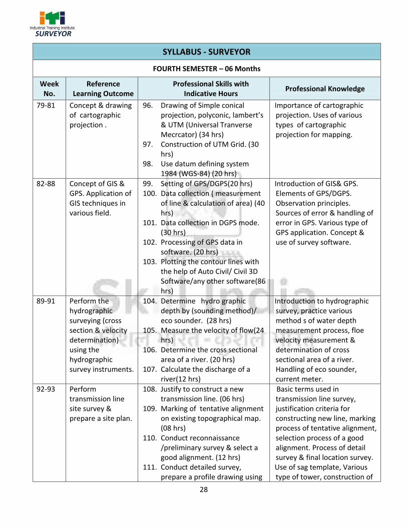
FOURTH SEMESTER – 06 Months
Week No.
Reference Learning Outcome
Professional Skills with Indicative Hours
Professional Knowledge
79-81 Concept & drawing of cartographic projection .
96. Drawing of Simple conical projection, polyconic, lambert’s & UTM (Universal Tranverse Mecrcator) (34 hrs)
97. Construction of UTM Grid. (30 hrs)
98. Use datum defining system 1984 (WGS-84) (20 hrs)
Importance of cartographic projection. Uses of various types of cartographic projection for mapping.
82-88 Concept of GIS & GPS. Application of GIS techniques in various field.
99. Setting of GPS/DGPS(20 hrs) 100. Data collection ( measurement
of line & calculation of area) (40 hrs)
101. Data collection in DGPS mode. (30 hrs)
102. Processing of GPS data in software. (20 hrs)
103. Plotting the contour lines with the help of Auto Civil/ Civil 3D Software/any other software(86 hrs)
Introduction of GIS& GPS. Elements of GPS/DGPS. Observation principles. Sources of error & handling of error in GPS. Various type of GPS application. Concept & use of survey software.
89-91 Perform the hydrographic surveying (cross section & velocity determination) using the hydrographic survey instruments.
104. Determine hydro graphic depth by (sounding method)/ eco sounder. (28 hrs)
105. Measure the velocity of flow(24 hrs)
106. Determine the cross sectional area of a river. (20 hrs)
107. Calculate the discharge of a river(12 hrs)
Introduction to hydrographic survey, practice various method s of water depth measurement process, floe velocity measurement & determination of cross sectional area of a river. Handling of eco sounder, current meter.
92-93 Perform transmission line site survey & prepare a site plan.
108. Justify to construct a new transmission line. (06 hrs)
109. Marking of tentative alignment on existing topographical map. (08 hrs)
110. Conduct reconnaissance /preliminary survey & select a good alignment. (12 hrs)
111. Conduct detailed survey, prepare a profile drawing using
Basic terms used in transmission line survey, justification criteria for constructing new line, marking process of tentative alignment, selection process of a good alignment. Process of detail survey & final location survey. Use of sag template, Various type of tower, construction of

29
SURVEYOR
sag template. (12 hrs) 112. Conduct final location survey.
(12 hrs) 113. Mark tower foundation pit
point (as per type of tower) (06 hrs)
tower foundation.
94-95 Perform the railway line site survey using modern survey instruments.
114. Justify to construct a new Railway line. (06 hrs)
115. Marking of tentative alignment. (08 hrs)
116. Conduct reconnaissance /preliminary survey & select a good alignment. (15 hrs)
117. Conduct detailed survey, prepare of drawing including design of curves with setting out table. (15 hrs)
118. Conduct final location survey. (12 hrs)
Basic terms used in railway line project survey, justification criteria for constructing new line, marking process of tentative alignment, selection process of a good alignment. Process of detail survey & final location survey.
96-100 Draw a double storied building by Autocad & prepare a detailed estimate of building.
119. Draw a double storied residential building plan, elevation, cross section, site plan, lay out plan, foundation details etc. (100 hrs)
120. Prepare a detail estimate of this building. (40 hrs)
Specification & uses of various types of building materials, types of foundation, knowledge of R.C.C.works, & other construction related items. Procedure of prepare a detail estimate.
101-102
Project work a) Prepare a two storied residential building plan & prepare a detail estimate.
103 Revision
104 Examination
Note: - More emphasis to be given on video/real-life pictures during theoretical classes. Some real-life pictures/videos of site survey using Chain / Tape, Prismatic Compass, Plane table , Total station, GPS/DGPS etc, may be shown to the trainees to give a feel of actual survey work and their future assignment.

30
SURVEYOR
9.1 Syllabus for Workshop Calculation and Science
S No. Workshop Calculation Workshop Science
First Semester Duration: Six Months
1. Unit: Systems of unit- FPS, CGS, MKS/SI
unit, unit of length, Mass and time,
Conversion of units
Material Science : properties - Physical &
Mechanical, Types – Ferrous & Non-Ferrous,
difference between Ferrous and Non-Ferrous
metals,
introduction of Iron, Cast Iron, Wrought Iron,
Steel, difference between Iron and Steel, Alloy
steel, carbon steel, stainless steel, Non-Ferrous
metals, Non- Ferrous Alloys.
2. Fractions : Fractions, Decimal fraction,
L.C.M., H.C.F., Multiplication and
Division of Fractions and Decimals,
conversion of Fraction to Decimal and
vice versa. Simple problems using
Scientific Calculator.
Mass ,Weight and Density :
Mass, Unit of Mass, Weight, difference
between mass and weight, Density, unit of
density, specific gravity of metals.
3. Square Root : Square and Square Root,
method of finding out square roots,
Simple problem using calculator.
Speed and Velocity: Rest and motion, speed,
velocity, difference between speed and
velocity, acceleration, retardation, equations of
motions, simple related problems.
4. Ratio & Proportion :
Simple calculation on related problems.
Work, Power and Energy: work, unit of work,
power, unit of power, Horse power of engines,
mechanical efficiency, energy, use of energy,
potential and kinetic energy, examples of
potential energy and kinetic energy.
5. Percentage : Introduction, Simple
calculation. Changing percentage to
decimal and fraction and vice-versa.
Second Semester Duration: Six Months
1. Algebra : Addition, Subtraction,
Multiplication, Division, Algebraic
formula, Linear equations (with two
variables).
Heat & Temperature: Heat and temperature,
their units, difference between heat and
temperature, boiling point, melting point, scale
of temperature, relation between different
scale of temperature, Thermometer, pyrometer,
transmission of heat, conduction, convection,
radiation.
9. SYLLABUS - CORE SKILLS

31
SURVEYOR
2. Mensuration : Area and perimeter of
square, rectangle, parallelogram,
triangle, circle, semi circle, Volume of
solids – cube,
cuboid, cylinder and Sphere. Surface
area of solids – cube, cuboid, cylinder
and Sphere.
Basic Electricity: Introduction, use of
electricity, how electricity is produced, Types
of current - AC, DC, their comparison, voltage,
resistance, their units. Conductor, insulator,
Types of connections – series, parallel, electric
power, Horse power, energy, unit of electrical
energy.
3. Trigonometry: Trigonometrical ratios,
measurement of angles. Trigonometric
tables
Levers and Simple Machines: levers and its
types.
Simple Machines, Effort and Load, Mechanical
Advantage, Velocity Ratio, Efficiency of
machine, Relationship between Efficiency,
velocity ratio and
Mechanical Advantage.
Third Semester Duration: Six Months
1. - Geometrical construction & theorem: division of line segment, parallel lines, similar angles, perpendicular lines, isosceles
triangleand right angled triangle.
- Forces definition. - Compressive, tensile, shear forces and simple problems. -Stress,strain, ultimate strength, factor of safety.
-Basic study of stress-strain curve for MS.
2. - Area of cut-out regular surfaces: circle and
segment and sector of circle.
- Temperature measuring instruments. Specific heats of solids & liquids.
3. - Area of irregular surfaces. - Application related to shop problems.
- Thermal Conductivity, Heat loss and heat gain.
4. - Volume of cut-out solids: hollow cylinders, frustum of cone, block section.
- Volume of simple machine blocks.
- Average Velocity, Acceleration & Retardation.
- Related problems.
5. - Material weight and cost problems related to trade.
- Circular Motion: Relation between circular motion and Linear motion,
Centrifugal force, Centripetal force
6. - Finding the value of unknown sides and angles of a triangle by Trigonometrical
method.
7. - Finding height and distance by trigonometry.
8. Application of trigonometry in shop problems. (viz. taper angle calculation).

32
SURVEYOR
Fourth Semester
Duration: Six Months
1. Graph: - Read images, graphs, diagrams – bar chart, pie chart. - Graphs: abscissa and ordinates, graphs of straight line, related to two sets of varying quantities.
- Friction- co-efficient of friction, application and effects of friction in Workshop practice. Centre of gravity and its practical application.
2. Simple problem on Statistics: - Frequency distribution table - Calculation of Mean value. - Examples on mass scale productions. -Cumulative frequency -Arithmetic mean
- Magnetic substances- natural and artificial magnets. - Method of magnetization. Use of magnets.
3. Acceptance of lot by sampling method (within specified limit size) with simple examples (not more than 20 samples).
- Electrical insulating materials. - Basic concept of earthing.
4.
- Transmission of power by belt, pulleys & gear drive. - Calculation of Transmission of power by belt pulley and gear drive.
5. - Heat treatment and advantages.
6.
Concept of pressure – units of pressure, atmospheric pressure, absolute pressure, gauge pressure – gauges used for measuring pressure Introduction to pneumatics & hydraulics systems.

33
SURVEYOR
9.2 Syllabus – Employability Skill
CORE SKILL – EMPLOYABILITY SKILL
First Semester
1. English Literacy Duration : 20 hrs Marks : 09
Pronunciation Accentuation (mode of pronunciation) on simple words, Diction (use of word and speech)
Functional Grammar Transformation of sentences, Voice change, Change of tense, Spellings.
Reading Reading and understanding simple sentences about self, work and environment
Writing Construction of simple sentences Writing simple English
Speaking/ Spoken English Speaking with preparation on self, on family, on friends/ classmates, on known people, picture reading, gain confidence through role-playing and discussions on current happening, job description, asking about someone's job, habitual actions. Cardinal (fundamental) numbers, ordinal numbers. Taking messages, passing on messages and filling in message forms, Greeting and introductions, office hospitality, Resumes or curriculum vita essential parts, letters of application reference to previous communication.
2. IT Literacy Duration : 20 hrs Marks : 09
Basics of Computer Introduction, Computer and its applications, Hardware and peripherals, Switching on-Starting and shutting down of the computer.
Computer Operating System
Basics of Operating System, WINDOWS, The user interface of Windows OS, Create, Copy, Move and delete Files and Folders, Use of External memory like pen drive, CD, DVD etc. Use of Common applications.
Word Processing and Worksheet
Basic operating of Word Processing, Creating, Opening and Closing Documents, Use of shortcuts, Creating and Editing of Text, Formatting the Text, Insertion &Creation of Tables. Printing document. Basics of Excel worksheet, understanding basic commands, creating simple
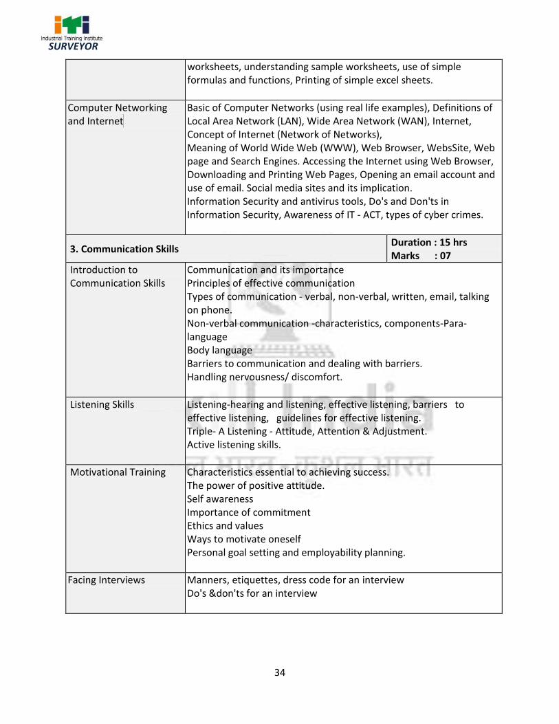
34
SURVEYOR
worksheets, understanding sample worksheets, use of simple formulas and functions, Printing of simple excel sheets.
Computer Networking and Internet
Basic of Computer Networks (using real life examples), Definitions of Local Area Network (LAN), Wide Area Network (WAN), Internet, Concept of Internet (Network of Networks), Meaning of World Wide Web (WWW), Web Browser, WebsSite, Web page and Search Engines. Accessing the Internet using Web Browser, Downloading and Printing Web Pages, Opening an email account and use of email. Social media sites and its implication. Information Security and antivirus tools, Do's and Don'ts in Information Security, Awareness of IT - ACT, types of cyber crimes.
3. Communication Skills Duration : 15 hrs Marks : 07
Introduction to Communication Skills
Communication and its importance Principles of effective communication Types of communication - verbal, non-verbal, written, email, talking on phone. Non-verbal communication -characteristics, components-Para-language Body language Barriers to communication and dealing with barriers. Handling nervousness/ discomfort.
Listening Skills Listening-hearing and listening, effective listening, barriers to effective listening, guidelines for effective listening. Triple- A Listening - Attitude, Attention & Adjustment. Active listening skills.
Motivational Training Characteristics essential to achieving success. The power of positive attitude. Self awareness Importance of commitment Ethics and values Ways to motivate oneself Personal goal setting and employability planning.
Facing Interviews Manners, etiquettes, dress code for an interview Do's &don'ts for an interview
35
SURVEYOR
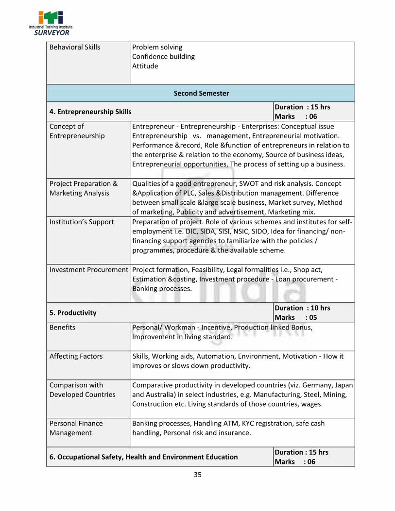
Behavioral Skills Problem solving Confidence building Attitude
Second Semester
4. Entrepreneurship Skills Duration : 15 hrs Marks : 06
Concept of Entrepreneurship
Entrepreneur - Entrepreneurship - Enterprises: Conceptual issue Entrepreneurship vs. management, Entrepreneurial motivation. Performance &record, Role &function of entrepreneurs in relation to the enterprise & relation to the economy, Source of business ideas, Entrepreneurial opportunities, The process of setting up a business.
Project Preparation & Marketing Analysis
Qualities of a good entrepreneur, SWOT and risk analysis. Concept &Application of PLC, Sales &Distribution management. Difference between small scale &large scale business, Market survey, Method of marketing, Publicity and advertisement, Marketing mix.
Institution’s Support Preparation of project. Role of various schemes and institutes for self-employment i.e. DIC, SIDA, SISI, NSIC, SIDO, Idea for financing/ non-financing support agencies to familiarize with the policies / programmes, procedure & the available scheme.
Investment Procurement Project formation, Feasibility, Legal formalities i.e., Shop act, Estimation &costing, Investment procedure - Loan procurement - Banking processes.
5. Productivity Duration : 10 hrs Marks : 05
Benefits Personal/ Workman - Incentive, Production linked Bonus, Improvement in living standard.
Affecting Factors Skills, Working aids, Automation, Environment, Motivation - How it improves or slows down productivity.
Comparison with Developed Countries
Comparative productivity in developed countries (viz. Germany, Japan and Australia) in select industries, e.g. Manufacturing, Steel, Mining, Construction etc. Living standards of those countries, wages.
Personal Finance Management
Banking processes, Handling ATM, KYC registration, safe cash handling, Personal risk and insurance.
6. Occupational Safety, Health and Environment Education Duration : 15 hrs Marks : 06
36
SURVEYOR
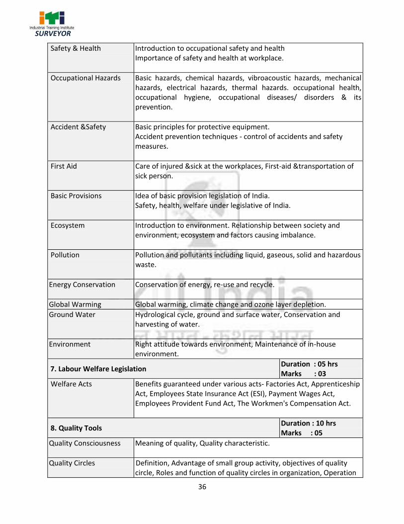
Safety & Health Introduction to occupational safety and health Importance of safety and health at workplace.
Occupational Hazards Basic hazards, chemical hazards, vibroacoustic hazards, mechanical hazards, electrical hazards, thermal hazards. occupational health, occupational hygiene, occupational diseases/ disorders & its prevention.
Accident &Safety Basic principles for protective equipment. Accident prevention techniques - control of accidents and safety measures.
First Aid Care of injured &sick at the workplaces, First-aid &transportation of sick person.
Basic Provisions
Idea of basic provision legislation of India. Safety, health, welfare under legislative of India.
Ecosystem Introduction to environment. Relationship between society and environment, ecosystem and factors causing imbalance.
Pollution Pollution and pollutants including liquid, gaseous, solid and hazardous waste.
Energy Conservation Conservation of energy, re-use and recycle.
Global Warming Global warming, climate change and ozone layer depletion.
Ground Water Hydrological cycle, ground and surface water, Conservation and harvesting of water.
Environment Right attitude towards environment, Maintenance of in-house environment.
7. Labour Welfare Legislation Duration : 05 hrs Marks : 03
Welfare Acts Benefits guaranteed under various acts- Factories Act, Apprenticeship Act, Employees State Insurance Act (ESI), Payment Wages Act, Employees Provident Fund Act, The Workmen's Compensation Act.
8. Quality Tools Duration : 10 hrs Marks : 05
Quality Consciousness Meaning of quality, Quality characteristic.
Quality Circles Definition, Advantage of small group activity, objectives of quality circle, Roles and function of quality circles in organization, Operation

37
SURVEYOR
of quality circle. Approaches to starting quality circles, Steps for continuation quality circles.
Quality Management System
Idea of ISO 9000 and BIS systems and its importance in maintaining qualities.
House Keeping Purpose of housekeeping, Practice of good housekeeping.
Quality Tools Basic quality tools with a few examples.

38
SURVEYOR
List of Tools and Equipment
SURVEYOR (For batch of 20 candidates)
S No. Name of the Tools and Equipment Specification Quantity
A. TOOLS, EQUIPMENT & GENERAL OUTFIT
1. Abney level 1 No.
2. Box sextant 1 Nos.
3. Binocular 4 Nos.
4. Chalk board/White board 1 No.
5. Scientific calculator 2 Nos.
6. Computing scales two hectares 4 Nos.
7. Computing scales five hectares 4 Nos.
8. Offset scale for cadastral survey 4 Nos
9. Metal cross staff- box type 2 Nos.
10. Metal cross staff- open type 2 Nos.
11. Drawing Board 1250 mm x 900 mm 21 Nos.
12. Engineer's chain 2 Nos.
13. Dumpy level 6 Nos.
14. Auto level 6 Nos.
15. Fire extinguisher 1 No.
16. Gunter's chain 4 Nos.
17. Height indicators 8 Nos.
18. Instructor's chair 1 No.
19. Instructor's table 1 No.
20. Tracing board with lamp 2 Nos.
21. Leveling staff – 4M 10 Nos.
22. Metric chain- 30 m & 20 m 5 each
23. Magnifying glass 2 Nos.
24. Magnet bar (for magnetizing through compass needles)
2 Nos.
25. Pen knife 5 Nos.
26. Prismatic compass 5 Nos.
ANNEXURE-I

39
SURVEYOR
27. Planimeter Digital 2 Nos.
28. Plane table with stand , accessories & water proofing cover
8 Nos.
29. Telescopic alidade 2 Nos.
30. Indian pattern clinometers 2 Nos.
31. Ranging rod 2 m 40 Nos.
32. Offset rod 5 Nos.
33. Optical square 5 Nos.
34. Railway curves- Set of 50 in a box 4 Nos.
35. Steel almirah Big 4 Nos.
36. Stool 21 Nos.
37. Survey plotting scale- 8 scales with offset
scale in box 4 sets
38. Stencil set 4 Nos.
39. Fibre glass tape 30 m 10 Nos.
40. Steel tape 30 m 10 Nos.
41. Steel band 30 m 2 Nos
42. Surveyor's umbrella 4 Nos.
43. Theodolite transit 5 Nos.
44. Computer & software 5 sets
45. Total station 2 Nos.
46. DGPS-latest version 2 Nos.
47. Hand GPS-latest version 2 Nos.
48. A3 size Printer- Colour 1 No.
49. Computer table 5 Nos.
50. Computer chair 5 Nos.
51. Printer table 1 No.
52. UPS 5 KVA 1 No.

40
SURVEYOR
TOOLS & EQUIPMENTS FOR EMPLOYABILITY SKILLS
S No. Name of the Equipment Quantity
1. Computer (PC) with latest configurations and Internet connection with standard operating system and standard word processor and worksheet software.
10 nos.
2. UPS - 500VA 10 nos.
3. Scanner cum Printer 01 no.
4. Computer Tables 10 nos.
5. Computer Chairs 20 nos.
6. LCD Projector 01 no.
7. White Board 1200mm x 900mm 01 no.
Note: Above Tools & Equipments not required, if Computer LAB is available in the institute.

41
SURVEYOR
Name & Address of the Assessor: Year of Enrollment:
Name & Address of ITI (Govt./Pvt.): Date of Assessment:
Name & Address of the Industry: Assessment location: Industry/ ITI
Trade Name: Semester: Duration of the Trade/course:
Learning Outcome:
S N
o.
Maximum Marks (Total 100 Marks) 15 5 10 5 10 10 5 10 15 15
Tota
l In
tern
al
Ass
ess
men
t M
arks
Res
ult
(Y
/N)
Candidate Name Father's/Mother’s
Name
Safe
ty C
on
scio
usn
ess
Wo
rkp
lace
Hyg
ien
e
Att
end
ance
/ P
un
ctu
alit
y
Ab
ility
to
Fo
llow
Man
ual
s/ W
ritt
en
Inst
ruct
ion
s
Ap
plic
atio
n o
f K
no
wle
dge
Skill
s to
Han
dle
To
ols
&
Equ
ipm
ent
Eco
no
mic
al U
se o
f M
ater
ials
Spee
d in
Do
ing
Wo
rk
Qu
alit
y in
Wo
rkm
ansh
ip
VIV
A
1
2
ANNEXURE-II
FORMAT FOR INTERNAL ASSESSMENT