Comparison of the Ike Dike Concept and the USACE Plan
15
Chapter 2. The USACE Coastal Spine – A Weakened Ike Dike Comparison of the Ike Dike Concept and the USACE Plan Figure 2-1 shows the current Ike Dike concept, an idea that was originally proposed by Dr. William Merrell, Texas A&M University-Galveston (TAMUG), shortly after Hurricane Ike severely damaged the Houston-Galveston region in 2008 (Houston Chronicle, 2009). The Ike Dike concept is comprised of three sections. The middle section, positioned at the shoreline, extends from High Island to the western end of Galveston Island. The eastern section turns inland at High Island. The western section, also positioned at the shoreline, extends from the western end of Galveston Island to Freeport, Texas, where it ties into the existing system of hurricane protection levees there. The Ike Dike includes a large storm surge barrier and gate system that spans Bolivar Roads pass; and it includes a small storm surge barrier and gate system that spans San Luis Pass. Jackson State University, JSU (2018), evaluated the storm surge reduction achieved with a 17-ft high Ike Dike and found that a 17-ft crest elevation is quite effective in providing substantial reduction in surge levels for the entire region (shown in a later section). JSU (2018) research showed that middle and western sections are important elements for reducing flood risk throughout the region that lies behind the coastal spine. Research showed that the western section is much more important than the eastern section in reducing surge levels. The eastern section primarily provides benefits for the less populated eastern side of Galveston Bay. Current thinking is that the eastern section is probably not cost effective. Figure 2-1. Schematic of the footprint for the Ike Dike coastal spine concept.
Transcript of Comparison of the Ike Dike Concept and the USACE Plan

Chapter 2. The USACE Coastal Spine – A Weakened Ike Dike
Comparison of the Ike Dike Concept and the USACE Plan
Figure 2-1 shows the current Ike Dike concept, an idea that was originally proposed by Dr. William Merrell, Texas A&M University-Galveston (TAMUG), shortly after Hurricane Ike severely damaged the Houston-Galveston region in 2008 (Houston Chronicle, 2009). The Ike Dike concept is comprised of three sections. The middle section, positioned at the shoreline, extends from High Island to the western end of Galveston Island. The eastern section turns inland at High Island. The western section, also positioned at the shoreline, extends from the western end of Galveston Island to Freeport, Texas, where it ties into the existing system of hurricane protection levees there. The Ike Dike includes a large storm surge barrier and gate system that spans Bolivar Roads pass; and it includes a small storm surge barrier and gate system that spans San Luis Pass.
Jackson State University, JSU (2018), evaluated the storm surge reduction achieved with a 17-ft high Ike Dike and found that a 17-ft crest elevation is quite effective in providing substantial reduction in surge levels for the entire region (shown in a later section). JSU (2018) research showed that middle and western sections are important elements for reducing flood risk throughout the region that lies behind the coastal spine. Research showed that the western section is much more important than the eastern section in reducing surge levels. The eastern section primarily provides benefits for the less populated eastern side of Galveston Bay. Current thinking is that the eastern section is probably not cost effective.
Figure 2-1. Schematic of the footprint for the Ike Dike coastal spine concept.

Figure 2-2, taken from USACE (2020), shows the footprint of the recommended USACE Plan. The Plan is comprised of multiple lines of defense, a sound strategy for reducing flood risk. The first line of defense, a coastal spine positioned at the shoreline, extends from High Island to the western end of Galveston Island. The footprint of the USACE coastal spine is now nearly the same as the middle section of the Ike Dike concept. In the USACE Plan, land barrier segments of the coastal spine, on Galveston Island and Bolivar Peninsula, consist of low dual sand dunes (heights of 12 and 14 ft). Like the Ike Dike, the USACE Plan includes a large storm surge barrier and gate system that spans Bolivar Roads Pass (elevation of 21.5 ft). The USACE Plan has no western section or gate system at San Luis Pass. The Plan raises the Galveston Seawall to 21 ft. The Plan includes multiple in-bay measures to reduce residual flood-induced damage further. In-bay measures consist of the Galveston Ring Barrier that encircles the City of Galveston and joins the Seawall, short storm surge wall/gate systems at the entrance channels leading to both the Clear Lake and Dickinson areas, and non-structural measures along the western side of Galveston Bay in the crosshatched areas shown in Figure 2-2. It is important to note that the strength of the first line of defense, the coastal spine, influences the required extent, strength, and cost for all in-bay measures.
Figure 2-2. Schematic of the footprint for the USACE Plan
USACE has picked up the Ike Dike concept but made it much weaker, to the point that the land barrier in the USACE Plan provides minimal benefit in reducing damage and flood risk. The Ike Dike concept is intended to shorten and strengthen the coastal surge defenses (like the Dutch approach); and keep water out of the bays to limit internal surges. The USACE Plan severely compromises both core objectives; and it does so in two ways: 1) by adopting a low easily erodible sand dune system for the land barrier on Galveston Island and Bolivar Peninsula, and 2) by omitting the western section of the coastal spine, including the San Luis Pass gate system, which the Ike Dike concept includes. Even with the USACE Plan considerable residual damage and risk remains throughout the region that lies behind the coastal spine. In contrast, a robust Ike Dike, with a strong land barrier and a western section having a gate system at San Luis Pass, substantially reduces residual damage and risk throughout the entire region, compared to the USACE Plan.
Weak Land Barrier in the USACE Plan
Both the beach/dune erosion modeling described in USACE (2020) and the modeling and analyses presented in the next chapter, Chapter 3, show that the low dual dune system in the USACE Plan performs poorly for hurricanes, even weak hurricanes. For example, USACE beach/dune erosion modeling showed that the proposed dual dune system is flattened completely in their simulation of Hurricane Ike, which produced a measured peak surge level of 11 ft NAVD88 at the Galveston Pleasure Pier (lower than the heights of the 12- and 14-ft dunes). The stage-frequency curve shown in Figure 2-22 of Appendix D to USACE (2020) shows that a peak surge of 11 ft corresponds to a return period of 30 years.
The proposed dual dune system performs poorly even for weaker non-tropical and tropical storms. As stated in USACE (2020), “Non-tropical storms were shown to produce only slight profile responses but were frequent so the total impact on profile evolution was significant,” and “Tropical Cyclones had dramatic effect on the dune with near complete destruction if the dune crest was submerged,” and “the dune fails quickly once overtopping begins, leaving the upland area exposed to storm surge and direct wave impact.” It is notable that the proposed frequency of dune renourishment in the USACE Plan, which is planned every 6 or 7 years and is based upon the calculated frequency of dune flattening, is identical to the recurrence rate of what the USACE defines as “intermediate” tropical cyclones, which in essence are relatively weak Category 1 and 2 strength hurricanes.
Dune destruction enables storm surge to enter Galveston and/or West Bays, increasing internal surge generation and exacerbating flooding throughout the entire region. Major hurricanes, which have a recurrence rate of once every 9 years, on average, according to the USACE Report, will quickly and completely devastate the dunes and likely lead to breaching of the barrier islands much like what occurred during Hurricane Ike. For major hurricanes, storm surge will pour into the bays, causing considerable flooding and damage, much of which can be avoided with a more robust and stronger land barrier. Chapter 3 discusses use of a fortified dune to address this weakness of the USACE Plan.
To compound the poor performance of the USACE land barrier, once a storm flattens the dunes, or worse, breaches the barrier islands, the USACE Plan contains no provision for emergency dune and barrier island repair. Instead, the heavily damaged dune system and degraded barrier island will remain in this state until the next scheduled renourishment, which could be as much as 5 or 6 years in the

future and possibly more if funding from both the State and Federal governments (a 50/50 cost share) is not available to perform renourishment in a timely manner. The periodic dune renourishment proposed in the USACE Plan will leave the entire region vulnerable to severe flooding if another hurricane strikes during the same hurricane season or anytime in the succeeding years before completion of the next renourishment. A strong and resilient land barrier, comprised of a fortified dune of the type proposed in Chapter 3, avoids this vulnerability.
Omitting the Western Section of the Coastal Spine
Unlike the Ike Dike concept, the coastal spine in the USACE Plan notably lacks continuity between the hurricane protection levee system at Freeport and the west end of Galveston Island, leaving open a “back door” that enables surge propagation into both West and Galveston Bays. Omitting the western section of the coastal spine, which includes a gate system at San Luis Pass, allows the hurricane surge forerunner to propagate through San Luis Pass, into West Bay, and then into Galveston Bay, albeit with a reduced amplitude. Omission also enables the main surge to flank the western end of the USACE coastal spine, first through San Luis Pass and then over an inundated Follets Island, enter West Bay, and then to a lesser degree from West Bay into Galveston Bay. Every contribution to water in the Bays increases flood risk and damage. The critical role of the western section, and the consequences of omitting it, are explained further and discussed in more detail in Chapter 4. Several examples of increased inundation and damage arising from omission of the western section, in both Bays, are presented graphically in Chapter 4. We recommend a thorough, quantitative examination of the cost and benefits of providing a continuous first line of defense in this region, including cost avoidance/savings for the Galveston Ring Barrier and all other in-bay measures.
USACE cites a number of reasons for not including a gate system at San Luis Pass. One reason cited is that there is little additional flood damage and risk associated with leaving San Luis Pass open. This claim is contradicted by information provided in USACE (2020); 55% of the $1.15B in average annual residual damage occurs in West Bay, much of which is due to omission of the western section, some due to the low weak land barrier. Related to the first reason, USACE claims that the water exchange between West Bay and Galveston Bay is only 3-5%, with the implication that this magnitude is too small to make a difference in Galveston Bay. It is unclear if this magnitude of exchange refers to astronomical tide-induced exchange or to forerunner-induced exchange. Tidal exchange will be different from exchange for the forerunner; the latter has a much longer “period” and does not reverse direction every 24 hours like the tide does. Also, water exchange relates to filling, but wind compounds the effect of filling, setting down one side and setting up the other. During hurricanes, we expect that the exchange between the two bays depends upon forerunner amplitude, the main surge hydrograph, local winds, and sea level. JSU research indicates that the propagation of the surge forerunner into Galveston Bay, via West Bay, is exacerbated by rising sea level. Damping of the forerunner and main surge that propagate through an open San Luis Pass does occur, and is discussed in Chapter 4. However, even if propagation from West Bay into Galveston Bay is such that peak surge in Galveston Bay is only increased by 1 or 2 ft, this change can cause or exacerbate flooding and damage, as demonstrated in Chapter 4.

The western section, and a gate at San Luis Pass, has been dismissed by the USACE with no rigorous economic analysis of cost and benefits to support the decision. Engagement with other modelers on this topic, and their concurrence with the USACE position, are cited in USACE (2020) as a justification for omitting the western section; however, none of those other modelers has done a rigorous benefit-cost analysis either. Appendix B provides a simple analysis of the cost effectiveness of implementing the full Ike Dike concept, including the western section and a robust land barrier having a fortified dune. Results from the analysis presented in Appendix B suggest that full Ike Dike implementation is cost effective, and it will increase the benefit-cost ratio for the entire project.
A second reason cited is the USACE claim that San Luis Pass is the last natural inlet in Texas, seemingly one that is unaffected by human intervention. We believe the Pass has been influenced by a number of engineering activities: 1) shoaling induced by bridge construction, and 2) by construction and maintenance of the navigation channel and jetty system at Bolivar Roads, and subsequent formation of tidal shoals, which have altered alongshore transport of sand toward the west and toward the Pass for some time. We expect that the very large volume of sand to be placed on Galveston Island as part of the USACE Plan, much of which will be transported to the west, will also strongly influence the Pass.
A third reason cited is the perceived adverse impact that a gate system would have on the environment. To date, the USACE has done no serious rigorous analyses to quantify the environmental impact of adding a gate system at San Luis Pass, and no specific environmental impacts have been identified. The San Luis Pass gate has been dismissed for environmental reasons with simple hand waving. We recommend that a rigorous technical analysis be done of the environmental impact of the San Luis Pass gate system, as part of an overall evaluation of the Ike Dike’s western section. The USACE has undertaken rigorous environmental flow modeling and analyses to examine the environmental impact of the gate system at Bolivar Roads; and successfully designed a gate system that seems to have minimal impact on the environment. We see no reason why the same cannot be done at San Luis Pass. It appears that the modeling tools and analysis techniques required to do a rigorous analysis have already been created to facilitate the investigation of environmental impacts associated with the Bolivar Roads Surge Barrier.
One of the core objectives of the Ike Dike concept is to minimize the amount of water in the bays at the time of hurricane landfall, which reduces the potential for internal surges. Both large shallow bays, West Bay and Galveston Bay, are highly conducive to internal surge generation. Gating Bolivar Roads Pass enables partial sealing of the bays (it is the main source of filling). Gating San Luis Pass allows complete sealing of the bays. In light of uncertainties surrounding the hurricane surge forerunner and its prediction (discussed in Chapter 4) and the importance of keeping the forerunner and main surge out of the bays, we recommend inclusion of the western section and gate system at San Luis Pass in the USACE Plan.
Sealing the bays early is essential for minimizing the amount of internally-generated storm surge. Referring to the Bolivar Roads surge gates, the USACE (2020) states, “The gate operations will be dependent on the intensity, track and orientation of the land falling storm which will dictate the trigger condition (e.g., 3m TWL) of gate closings.” Waiting until the total water level (TWL) reaches nearly 10 ft before closing the gates would likely be disastrous and lead to severe flooding for the region. Ten additional feet of water inside the bays will lead to much larger internal surges. The hurricane surge
forerunner will be extremely important in the decision of when to close the gates. It will be critically important to close the gates while the surge forerunner amplitude is small and probably at low tide.
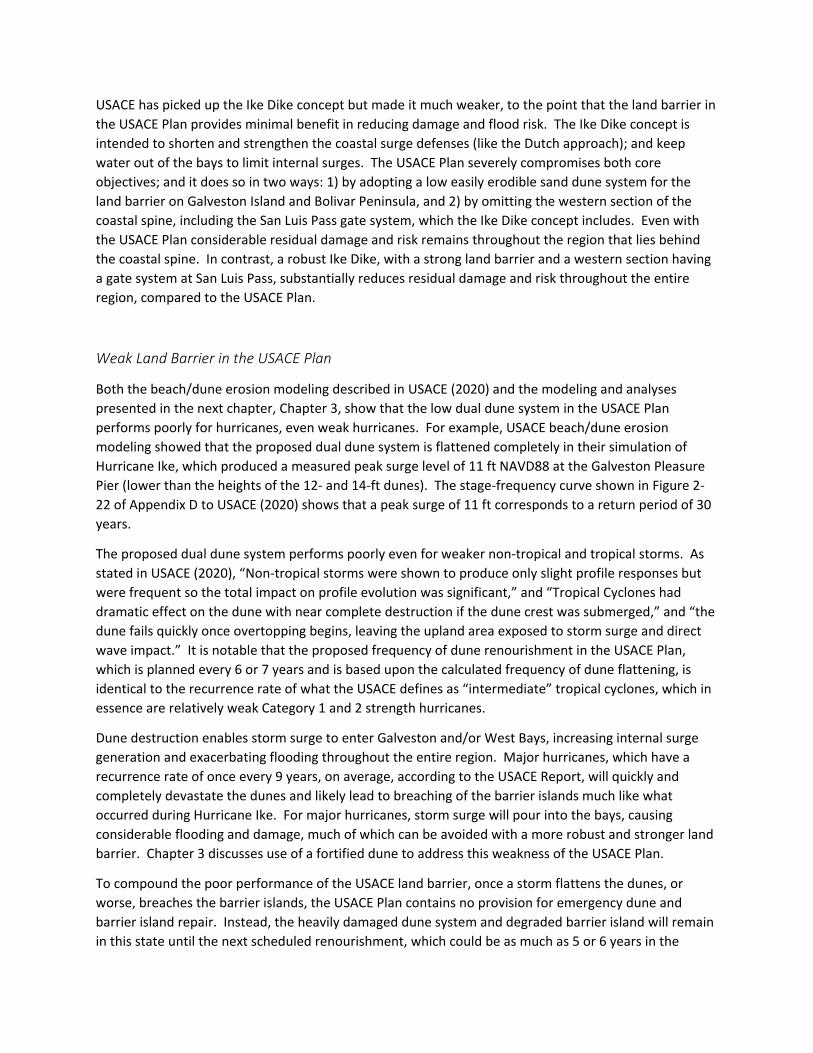
Performance of the USACE Coastal Spine –Damage and Risk Reduction
The USACE coastal spine provides limited protection for the region (less than 50 years). The stage frequency curve in Figure 2-22 of Appendix D to the USACE (2020) report shows that 50-yr and 100-yr water levels just offshore of Galveston are 13 and 16.5 ft, respectively, for present sea level (compared to dune elevations of 12 and 14 ft for the USACE land barrier). As illustrated below in Figure 2-3, which shows inundation maps without and with the USACE Plan, the proposed weak land barrier will breach and overflow at 50- and 100-year conditions, resulting in significant inundation, damage and risk. Both Galveston Island (the portion that lies outside the Ring Barrier) and Bolivar Peninsula are completely inundated, as is the entire West Bay north shore and multiple areas of the Galveston Bay periphery.
Figure 2-3. Inundation associated with the USACE Plan for 50-yr and 100-yr events, and for the intermediate sea level rise scenario (images extracted from the Storm Surge Modeling StoryMap. Coastal Texas Study web page)
Poor performance of the low dual dune land barriers in the USACE coastal spine, and omission of the western section, leads to poor performance in reducing damage and flood risk. Despite an expenditure of $26.17B, the USACE Plan decreases average annual damages by only 60% for the intermediate sea level rise scenario. Even with the USACE Plan in place, residual average annual damage is predicted to be very high, $1.15B (split this way: 55% in West Bay and 45% in Galveston Bay).
For the high future sea level rise scenario, the Plan performs even more poorly, decreasing average annual damages by only 44%. For this high sea level rise scenario, the predicted average annual residual damage is nearly 3 times as high, $3.28B, as damage for the intermediate sea level rise scenario. The USACE Plan fails to position the entire region in a sound protective posture, should the intermediate or high future rates of sea level rise occur. A higher level of protection is needed, which achieves greater risk reduction for both present sea level and possible higher future sea levels. A stronger more robust Ike Dike can provide the higher level of protection.
The very high amounts of residual damage are a significant shortcoming for such a major investment. However, the region should experience even more damage than predicted because of USACE failure to fully account for their own modeling that predicts the frequent loss of dune protection through erosion and breaching of the low weak sand dunes on Galveston Island and Bolivar Peninsula. In the with-project storm surge modeling, the dual sand dune system is represented as a solid barrier having an elevation of 12 ft. However, results of the USACE life cycle beach/dune response modeling in Annex 1 to Appendix D of USACE (2020) indicate that the dune is below 12 ft for 75%-80% of the time.
Once this flaw is corrected in the surge modeling, we expect even higher residual damages throughout the entire region and a decrease in the project’s benefit-cost ratio. Because of the flaw, all second lines of defense and nonstructural measures are probably under-designed; and their costs are probably underestimated. A strong Ike Dike can substantially reduce residual damages throughout the region; improve the project’s benefit-cost ratio, and lower costs for all in-bay measures including the Ring Barrier.
For major hurricanes, in essence, the USACE Plan stops only half the surge, the half that propagates through Bolivar Roads Pass; but it allows half the surge to enter into the bays over the degraded and breached barrier islands and by flanking the western end of the coastal spine. The USACE Plan fails to meet the crucial objective of keeping water out of the shallow bays, leading to much higher in-Bay surge. Its performance lies somewhere between the Ike Dike coastal spine concept and previously eliminated, ill-conceived alternatives that sought to defend against the surge by locating the first line of defense inside Galveston Bay. The weak first line of defense in the USACE Plan means that the second lines of defense and non-structural measures inside the bays must be more widespread, stronger and higher, and therefore more costly.
Loss of Focus on Reducing Damage and Flood Risk
In the latest iteration of the USACE Feasibility Study, the strength of the land barrier in the USACE Plan decreased dramatically. The Plan Formulation Appendix A in USACE (2020) discusses this major change, and states:
4.3.1 Levee along West Galveston and Bolivar Levee The levee proposed along West Galveston and Bolivar peninsula provided an engineered barrier to prevent storm surge from entering the Bay over land. Public comment indicated that the roadway access issues were unfavorable, the real estate impacts were disruptive, and the views would be unacceptably changed. Many expressed dissatisfaction that the impacts would be borne by the residents and businesses on the island and peninsula without reducing their storm surge risk. Many commenters also expressed that they are aware of the risks of development on a barrier island or peninsula, and accept the risk of storm damage over the levee. In response, the Team found that the levee was unimplementable and it was removed from the recommendation.
4.3.2 Beach and Dune Restoration (G5) The beach and dune restoration feature proposed along the Gulf on West Galveston and Bolivar Peninsula was justified for inclusion within the ER purpose. It restored the coastal habitat that had lost sediment to years of coastal forces on the Gulf side and hardened features, yards, structures and roadways. Once the levee, was found to be unacceptable, the beach and dune restoration was refined to include taller dunes and wider berms to increase the risk reduction it provides. The beach feature does not provide a comparable scale of risk reduction as compared to the levee, but is placed gulfward of all structures, and creates fewer community impacts. The larger beach feature also sustains the barrier features and supports the function of the Bolivar Roads Gate System.
Clearly, preferences by some public commenters and other motivations have adversely reshaped this project in critical ways. Engineered coastal levees (18 ft high on Bolivar Peninsula and 17 ft high on Galveston Island) were dropped from the project. They were replaced with a lower and much weaker natural sand dune system (12 and 14 ft high dunes on both Galveston Island and Bolivar Peninsula) that performs poorly in reducing damage and flood risk. The text above acknowledges that the low dune system “does not provide a comparable scale of risk reduction as compared to the levee;” however, no thorough quantitative evaluation of the adverse impact of this major change on flood damage reduction throughout the region was done. We recommend that such an analysis be done, and that results are clearly communicated to all regional stakeholders.
It appears that the nature of the USACE Plan has fundamentally changed, from a regional flood risk reduction project with local ecosystem restoration features to more of a regional ecosystem restoration project with local flood risk reduction features. The concept of a strong regional-scale coastal spine as a first line of defense to reduce flood damage has been abandoned. As indicated in USACE (2020), the low dual dune system included in the USACE Plan is simply a refined version of the dune proposed as an environmental restoration feature (G5) in the first iteration of the Feasibility Study, but now maintained for the 50-yr economic life of the project at a total fully funded cost of $8.4B. It is quite clear that the land barrier in the USACE Plan is primarily an ecosystem restoration feature, having minimal benefit in
reducing damage and flood risk for the region. Omission of an emergency dune repair component in the USACE Plan is another clear indicator that the proposed beach/dune system is little more than a long-term ecosystem restoration measure, and not an effective flood risk reduction element of a coastal spine.
In light of the very high residual damage and risk associated with the USACE Plan, the apparent shift in focus for the important land barrier, we recommend a return to trying to minimize flood risk, and maximize net benefits and the benefit-cost ratio, consistent with USACE National Economic Development guidelines. Stakeholder preferences are certainly important. However, compromise will be required because of the regional nature of this project, and the overriding importance of the coastal spine in reducing flood risk for everyone and everything behind it.
Inconsistencies in the Applied Design Standard
It appears that other preferences and motivations also have led to compromises and inconsistencies in the design standard. The USACE (2020) Design Appendix D states “The criteria used for conceptual design of the systems and crest elevations is fundamentally based on damage overtopping limit state with annual exceedance probability of 1%.” The Appendix states that the 1% AEP overtopping threshold is used along with the 10-yr and 25-yr rainfall rates to conduct drainage analyses and determine pump capacities. An intermediate rate of sea level rise is included as part of the design standard. However, for several proposed elements of the USACE Plan, a lower design standard has been used. For example, the elevation of the dual dune system (14 ft) is set far below (probably 10 ft, or more, lower) than the elevation that would adhere to the design standard It appears that design of improvements to the Galveston Seawall has not fully accounted for future sea level, which impacts pump selection and project performance. The elevation of the Galveston Ring Barrier (14 ft) was selected in an effort to address concerns with stick-up heights for the proposed floodwalls. Elevation selection and pump design for the Ring Barrier was done using present sea level conditions, not the intermediate se level rise scenario as specified in the design standard. Adherence to the stated design standard would result in an 18-ft elevation and greater stick-up heights. Pump station capacities at Clear Lake and Dickinson Bay were scaled back from 25-yr (+ 30%) rates to 10-yr rainfall rates to reduce the size of the pump station footprints. The use of different and inconsistent design approaches/standards for different project components is of concern, and can lead to different levels of protection and uneven performance.
Varying Heights of USACE Coastal Spine Elements
In the USACE coastal spine, heights of different elements comprising the spine vary considerably (Bolivar Roads Storm Surge Barrier at 21.5 ft, slightly lower Seawall at 21 ft, much lower sand dunes at 14 ft). The shortest element, the Bolivar Roads Surge Barrier which is about 2 miles in length, has the highest elevation. The Seawall, which is approximately 7 miles long and protects the City of Galveston is lower. The longest element by far, 43 miles of land barrier, has the lowest elevation, and is much lower than the other elements. The variation seems illogical in terms of storm surge reduction and protecting life and property. We recommend much more consistency in elevation for all elements of the coastal

spine, increasing the height of the land barrier, thereby avoiding weaknesses in the level of protection provided by the critical first line of defense.
The crest elevations of the Bolivar Roads Surge Barrier and the land barriers should complement the elevation of the Galveston Seawall. We recommend that the crest elevations of both the gate system and land barriers be less than the elevation of the Galveston Seawall, by 1 or 2 ft. In the event of storm surge that approaches the crest elevation of the Seawall, a Bolivar Roads Surge Barrier and land barriers that are lower than the Seawall help divert water away from the Seawall. This diversion in turn helps reduce the volume of overtopping that enters the City, and reduces the potential for damage. A Bolivar Roads Surge Barrier that is higher than the Seawall, as is presently the case in the USACE Plan, would tend to divert water toward the City, which is undesirable. The Bolivar Roads Barrier can be overtopped without much harm.
Variability in heights of different components of the coastal spine, and inconsistency in treating future sea level, leads to varying levels of protection. Transparent and effective communication of residual water levels, risk and damage for the entire region is essential, and is discussed more in a later section.
A Better Approach – a Robust Ike Dike
From a regional perspective, a higher level of protection is needed from the coastal spine, the first line of defense; and it can be achieved in a cost effective manner. A robust Ike Dike, comprised of a fortified sand dune, enhanced with a solid core, and gate systems at Bolivar Roads and San Luis Passes can remedy many of the shortcomings associated with the USACE coastal spine. Implementation of the Ike Dike concept is referred to here as the 17-ft Ike Dike; it has been the subject of extensive research that is documented in the JSU (2018) report and elsewhere in this report.
Figures 2-4 and 2-5 show peak storm surge maps (i.e., maps of maximum water surface elevation) for the 100-yr proxy storm, Storm 033, from the JSU research. Storm 033 is a hypothetical major hurricane that produces peak surges that best replicate 100-yr statistical values along the west side of Galveston Bay, for existing conditions. Results shown in both figures are for a higher future sea level, +3.31 ft NAVD88, the value used in JSU research. Note that the USACE uses a very similar future sea level of +3.46 ft NAVD88 to represent their intermediate scenario for future sea level rise. Figure 2-4 shows results for Storm 033 and the future without-project condition. Figure 2-5 shows results for Storm 033, for a future with-project condition, the 17-ft Ike Dike. Peak surge results shown in both figures do not reflect a snap-shot in time during the hurricane. Rather, they reflect the maximum storm surge value that is computed at each computational point of the surge model domain, during the hurricane simulation, without regard for when the maximum surge value occurred during the simulation.
The substantial reduction in peak storm surge achieved with the 17-ft Ike Dike is seen by comparing the peak surge maps in Figures 2-4 and 2-5. The 17-ft Ike Dike reduces peak surge levels by 8 to 10 ft all along the western side of Galveston Bay and into the upper Houston Ship Channel. Reductions in West Bay range from 6 to 8 ft throughout most of the Bay.
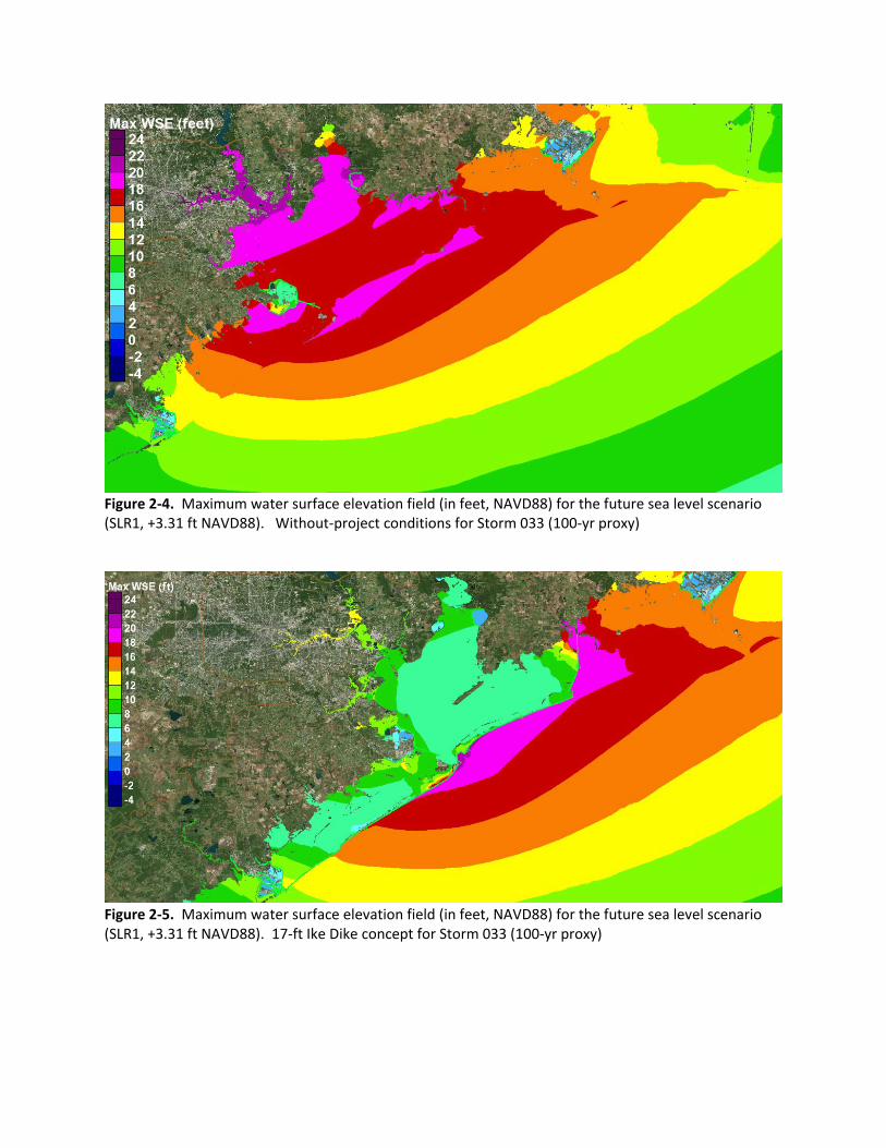
Figure 2-4. Maximum water surface elevation field (in feet, NAVD88) for the future sea level scenario (SLR1, +3.31 ft NAVD88). Without-project conditions for Storm 033 (100-yr proxy)
Figure 2-5. Maximum water surface elevation field (in feet, NAVD88) for the future sea level scenario (SLR1, +3.31 ft NAVD88). 17-ft Ike Dike concept for Storm 033 (100-yr proxy)
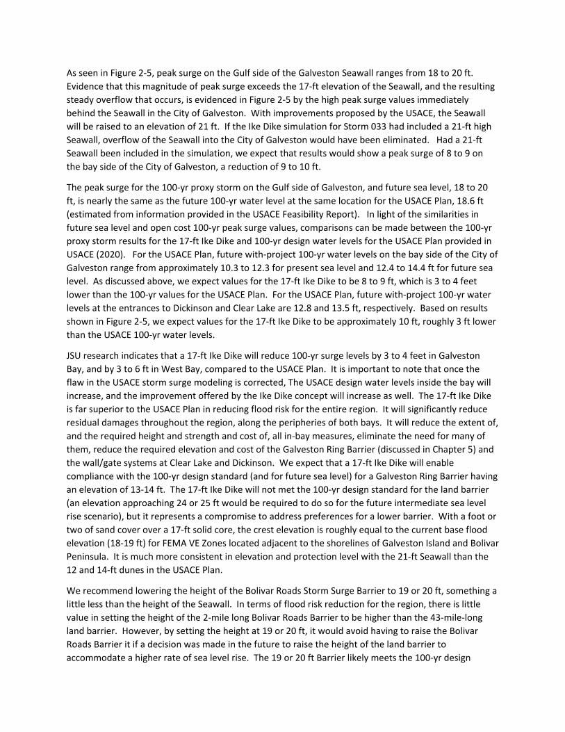
As seen in Figure 2-5, peak surge on the Gulf side of the Galveston Seawall ranges from 18 to 20 ft. Evidence that this magnitude of peak surge exceeds the 17-ft elevation of the Seawall, and the resulting steady overflow that occurs, is evidenced in Figure 2-5 by the high peak surge values immediately behind the Seawall in the City of Galveston. With improvements proposed by the USACE, the Seawall will be raised to an elevation of 21 ft. If the Ike Dike simulation for Storm 033 had included a 21-ft high Seawall, overflow of the Seawall into the City of Galveston would have been eliminated. Had a 21-ft Seawall been included in the simulation, we expect that results would show a peak surge of 8 to 9 on the bay side of the City of Galveston, a reduction of 9 to 10 ft.
The peak surge for the 100-yr proxy storm on the Gulf side of Galveston, and future sea level, 18 to 20 ft, is nearly the same as the future 100-yr water level at the same location for the USACE Plan, 18.6 ft (estimated from information provided in the USACE Feasibility Report). In light of the similarities in future sea level and open cost 100-yr peak surge values, comparisons can be made between the 100-yr proxy storm results for the 17-ft Ike Dike and 100-yr design water levels for the USACE Plan provided in USACE (2020). For the USACE Plan, future with-project 100-yr water levels on the bay side of the City of Galveston range from approximately 10.3 to 12.3 for present sea level and 12.4 to 14.4 ft for future sea level. As discussed above, we expect values for the 17-ft Ike Dike to be 8 to 9 ft, which is 3 to 4 feet lower than the 100-yr values for the USACE Plan. For the USACE Plan, future with-project 100-yr water levels at the entrances to Dickinson and Clear Lake are 12.8 and 13.5 ft, respectively. Based on results shown in Figure 2-5, we expect values for the 17-ft Ike Dike to be approximately 10 ft, roughly 3 ft lower than the USACE 100-yr water levels.
JSU research indicates that a 17-ft Ike Dike will reduce 100-yr surge levels by 3 to 4 feet in Galveston Bay, and by 3 to 6 ft in West Bay, compared to the USACE Plan. It is important to note that once the flaw in the USACE storm surge modeling is corrected, The USACE design water levels inside the bay will increase, and the improvement offered by the Ike Dike concept will increase as well. The 17-ft Ike Dike is far superior to the USACE Plan in reducing flood risk for the entire region. It will significantly reduce residual damages throughout the region, along the peripheries of both bays. It will reduce the extent of, and the required height and strength and cost of, all in-bay measures, eliminate the need for many of them, reduce the required elevation and cost of the Galveston Ring Barrier (discussed in Chapter 5) and the wall/gate systems at Clear Lake and Dickinson. We expect that a 17-ft Ike Dike will enable compliance with the 100-yr design standard (and for future sea level) for a Galveston Ring Barrier having an elevation of 13-14 ft. The 17-ft Ike Dike will not met the 100-yr design standard for the land barrier (an elevation approaching 24 or 25 ft would be required to do so for the future intermediate sea level rise scenario), but it represents a compromise to address preferences for a lower barrier. With a foot or two of sand cover over a 17-ft solid core, the crest elevation is roughly equal to the current base flood elevation (18-19 ft) for FEMA VE Zones located adjacent to the shorelines of Galveston Island and Bolivar Peninsula. It is much more consistent in elevation and protection level with the 21-ft Seawall than the 12 and 14-ft dunes in the USACE Plan.
We recommend lowering the height of the Bolivar Roads Storm Surge Barrier to 19 or 20 ft, something a little less than the height of the Seawall. In terms of flood risk reduction for the region, there is little value in setting the height of the 2-mile long Bolivar Roads Barrier to be higher than the 43-mile-long land barrier. However, by setting the height at 19 or 20 ft, it would avoid having to raise the Bolivar Roads Barrier it if a decision was made in the future to raise the height of the land barrier to accommodate a higher rate of sea level rise. The 19 or 20 ft Barrier likely meets the 100-yr design

standard for still water level and the intermediate sea level rise scenario, but not the overtopping standard. However, in light of the fact that there is water behind the gates and considering the large water retention capacity of Galveston Bay, it seems unnecessary to meet the overtopping design standard.
In addition, we recommend investigating the benefits, consequences, and potential cost savings that are associated with reducing the crest elevation of the floating sector gates of the Bolivar Roads Storm Surge Barrier. Because of the short duration of very high surge levels during hurricanes and the large water retention capacity of Galveston Bay, JSU research suggests that overtopping/overflow of lower Bolivar Roads gates does not appear to cause large increases in water levels inside the Bay. Reducing navigation gate elevations, and perhaps other gate elevations, will reduce the likelihood and magnitude of negative heads which is a design concern for the sector gates, reduce the magnitude of wave loadings, might improve gate operability, enable some water to exit the Bay under negative head conditions, and reduce costs of the gates. More information about this JSU analysis can be found in Chapter 13 of the JSU (2018) report.
Cost Effectiveness of Implementing the Ike Dike Concept
Davlasheridze et al (2019) showed that the Ike Dike concept is cost effective. Appendix B presents a simple analysis of the cost effectiveness of strengthening the USACE coastal spine, replacing the dual sand dune system with a higher fortified dune, and adding a western section including a gate at San Luis Pass. The analysis utilizes cost and residual damage data provided in USACE (2020). The simple analysis suggests that full implementation of a 17-ft Ike Dike concept, having a fortified dune and a western section of the coastal spine, is cost effective and will improve the benefit-cost ratio for the project.
The cost estimate for the Bolivar Roads Surge Barrier, $13.8B, seems very high, $7B to $10B higher than international experience suggests. This subject is discussed in more detail in Chapter 7, along with a discussion of other aspects of the Surge Barrier. We are concerned that the overly high cost estimate adversely skews the overall project cost, and led to limited consideration of other means for reducing residual damage throughout the region. In light of the overestimate of Surge Barrier cost and information provided in Appendix B, we believe that the cost of improvements to the USACE coastal spine that are needed to fully implement the Ike Dike concept will not change the current total project cost.
Environmental Benefits of the Ike Dike
A western section of the coastal spine provides considerable reduction in storm surge and wave energy that can damage the wetlands that lie behind Follets Island as well as wetlands located elsewhere around the periphery of West Bay, much more so than the USACE Plan provides. The USACE Plan includes an environmental restoration dune on Follets Island (ecosystem restoration measure B-2). Compared to measure B-2, a western section of the Ike Dike provides the same ecosystem restoration benefits as B-2 and far superior protection to the wetlands behind it; and it provides long-term protection not short-term protection like measure B-2. The western section precludes the need for the
B-2 measure and avoids its cost. A western section also provides damage reduction benefits to ecosystem restoration measure G-28, much more than does the USACE Plan.
Implementing the full Ike Dike concept, including the western section, helps preserve the integrity of the entire G-28 ecosystem restoration measure, which includes elements in both West and Galveston Bays. Ike Dike implementation helps preserve its function and capital investment. These environmental benefits associated with Ike Dike have not been considered and thoroughly analyzed. We recommend doing this particular analysis, along with a comparison to the same types of benefits provided by the USACE Plan, as part of a rigorous and thorough analysis of the benefits and costs associated with implementation of the full Ike Dike concept.
Consideration of Future Sea Level
The USACE process is difficult for large projects involving multiple lines of defense, especially those that expect a long lifetime under changing threats, such as sea level rise (SLR). Accounting for significant future SLR causes larger, more expensive protection schemes than those needed now. And, today’s work is obviously constrained to present technologies. Much of this added protection probably won’t be needed until much later in the project life. However, not accounting for future SLR in present plans causes the protection to be too weak in the future and availability of future funding for project improvements is uncertain. The process seems to preclude the use of adaptive solutions and adaptive management, which can take advantage of new technologies and evolve in response to changing environmental threats.
Future sea level appears to be treated inconsistently in the design of different elements of the USACE Plan. It appears to have been considered in all gate designs. However, it is not adequately addressed in design of the Galveston Ring Barrier and Seawall improvements, or in design of the dual sand dunes. Consistency in approach and/or clarification of reasons for the inconsistency is needed.
Communication of Residual Surge Levels, Flood Risk, and Damage
We believe it is extremely important to communicate visually and quantitatively to stakeholders what their level of residual risk is with the USACE Plan, in terms of water levels, inundation and residual damage. Clear communication is necessary because the USACE Plan results in very high residual damages, and because inconsistent design standards are applied to different project elements. We recommend a dedicated section in the feasibility report that describes in great detail, and with highly informative and effective graphics, how the entire Houston-Galveston region responds to a “direct-hit” hurricane that most closely produces the 1% AEP (90% CL) still water level at Galveston (Gulf side). Illustrate with maps of the residual water level, inundation and residual damage. Graphics should be of sufficient quality and scale to enable making reasonably accurate quantitative estimates using them. We also recommend detailed views of Plan performance in the following key sub-regions: western Galveston Island, north shore of West Bay, City of Galveston, Bolivar Peninsula, west side of Galveston Bay, and areas along the Upper Houston Ship Channel. We also believe it is important to show the water levels, inundation and residual damages for a hurricane that exceeds the design-level event, such as a hurricane that produces a peak water level that is closest to the 0.2% AEP water level. It would be
informative to show results for the different sea level rise scenarios that are considered. Figure 1-7 in the USACE (2020) main report, which illustrates system response for without project conditions, might be a good starting point for the type of graphic to use for this purpose. The Coastal Texas Study web site provides some nice features, such as the surge maps that can be swiped, a capability that can be utilized as well.
References
Davlasheridze, M. et al. (2019). Economic impacts of storm surge and the cost-benefit analysis of a coastal spine as the surge mitigation strategy in Houston-Galveston area in the USA. Mitigation and Adaptation Strategies for Global Change 24(1). DOI: 10.1007/s11027-018-9814-z.
Houston Chronicle. (2009). Oceanographer: 'Ike Dike' could repel most storm surges, https://www.chron.com/news/houston-texas/article/Oceanographer-Ike-Dike-could-repel-most-storm-1627411.php
Jackson State University. (2018). Final Report - Ike Dike Concept for Reducing Hurricane Storm Surge in the Houston-Galveston Region, Jackson, MS. 549 pp. https://www.tamug.edu/ikedike/pdf/JSU-Final-Report-Ike-Dike-Concept.pdf
U.S. Army Corps of Engineers. (2020). Coastal Texas Study 2020 Draft Feasibility Report, https://www.swg.usace.army.mil/Business-With-Us/Planning-Environmental-Branch/Documents-for-Public-Review/