Comparison of Present-day and End-Century Multi-hazard...
1
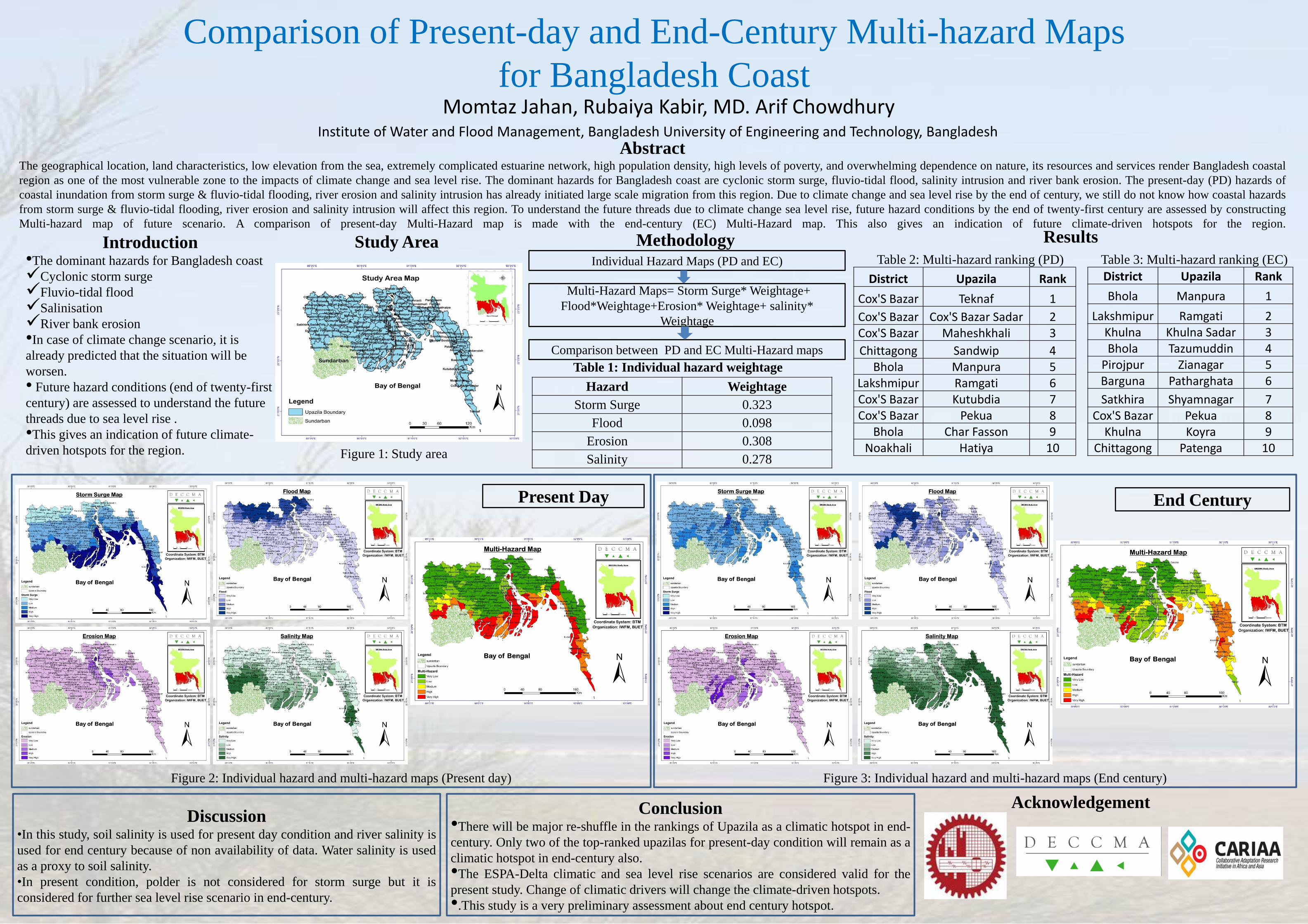
Comparison of Present-day and End-Century Multi-hazard Maps for Bangladesh Coast Momtaz Jahan, Rubaiya Kabir, MD. Arif Chowdhury Institute of Water and Flood Management, Bangladesh University of Engineering and Technology, Bangladesh Abstract The geographical location, land characteristics, low elevation from the sea, extremely complicated estuarine network, high population density, high levels of poverty, and overwhelming dependence on nature, its resources and services render Bangladesh coastal region as one of the most vulnerable zone to the impacts of climate change and sea level rise. The dominant hazards for Bangladesh coast are cyclonic storm surge, fluvio-tidal flood, salinity intrusion and river bank erosion. The present-day (PD) hazards of coastal inundation from storm surge & fluvio-tidal flooding, river erosion and salinity intrusion has already initiated large scale migration from this region. Due to climate change and sea level rise by the end of century, we still do not know how coastal hazards from storm surge & fluvio-tidal flooding, river erosion and salinity intrusion will affect this region. To understand the future threads due to climate change sea level rise, future hazard conditions by the end of twenty-first century are assessed by constructing Multi-hazard map of future scenario. A comparison of present-day Multi-Hazard map is made with the end-century (EC) Multi-Hazard map. This also gives an indication of future climate-driven hotspots for the region. Introduction •The dominant hazards for Bangladesh coast Cyclonic storm surge Fluvio-tidal flood Salinisation River bank erosion •In case of climate change scenario, it is already predicted that the situation will be worsen. • Future hazard conditions (end of twenty-first century) are assessed to understand the future threads due to sea level rise . •This gives an indication of future climate- driven hotspots for the region. Study Area Methodology Individual Hazard Maps (PD and EC) Multi-Hazard Maps= Storm Surge* Weightage+ Flood*Weightage+Erosion* Weightage+ salinity* Weightage Comparison between PD and EC Multi-Hazard maps Hazard Weightage Storm Surge 0.323 Flood 0.098 Erosion 0.308 Salinity 0.278 Table 1: Individual hazard weightage Present Day End Century Results District Upazila Rank Cox'S Bazar Teknaf 1 Cox'S Bazar Cox'S Bazar Sadar 2 Cox'S Bazar Maheshkhali 3 Chittagong Sandwip 4 Bhola Manpura 5 Lakshmipur Ramgati 6 Cox'S Bazar Kutubdia 7 Cox'S Bazar Pekua 8 Bhola Char Fasson 9 Noakhali Hatiya 10 District Upazila Rank Bhola Manpura 1 Lakshmipur Ramgati 2 Khulna Khulna Sadar 3 Bhola Tazumuddin 4 Pirojpur Zianagar 5 Barguna Patharghata 6 Satkhira Shyamnagar 7 Cox'S Bazar Pekua 8 Khulna Koyra 9 Chittagong Patenga 10 Table 2: Multi-hazard ranking (PD) Table 3: Multi-hazard ranking (EC) Discussion •In this study, soil salinity is used for present day condition and river salinity is used for end century because of non availability of data. Water salinity is used as a proxy to soil salinity. •In present condition, polder is not considered for storm surge but it is considered for further sea level rise scenario in end-century. Conclusion •There will be major re-shuffle in the rankings of Upazila as a climatic hotspot in end- century. Only two of the top-ranked upazilas for present-day condition will remain as a climatic hotspot in end-century also. •The ESPA-Delta climatic and sea level rise scenarios are considered valid for the present study. Change of climatic drivers will change the climate-driven hotspots. •.This study is a very preliminary assessment about end century hotspot. Acknowledgement Figure 1: Study area Figure 2: Individual hazard and multi-hazard maps (Present day) Figure 3: Individual hazard and multi-hazard maps (End century)
-
Upload
vuongkhuong -
Category
Documents
-
view
215 -
download
1
Transcript of Comparison of Present-day and End-Century Multi-hazard...
Comparison of Present-day and End-Century Multi-hazard Maps
for Bangladesh Coast Momtaz Jahan, Rubaiya Kabir, MD. Arif Chowdhury
Institute of Water and Flood Management, Bangladesh University of Engineering and Technology, Bangladesh
Abstract The geographical location, land characteristics, low elevation from the sea, extremely complicated estuarine network, high population density, high levels of poverty, and overwhelming dependence on nature, its resources and services render Bangladesh coastal
region as one of the most vulnerable zone to the impacts of climate change and sea level rise. The dominant hazards for Bangladesh coast are cyclonic storm surge, fluvio-tidal flood, salinity intrusion and river bank erosion. The present-day (PD) hazards of
coastal inundation from storm surge & fluvio-tidal flooding, river erosion and salinity intrusion has already initiated large scale migration from this region. Due to climate change and sea level rise by the end of century, we still do not know how coastal hazards
from storm surge & fluvio-tidal flooding, river erosion and salinity intrusion will affect this region. To understand the future threads due to climate change sea level rise, future hazard conditions by the end of twenty-first century are assessed by constructing
Multi-hazard map of future scenario. A comparison of present-day Multi-Hazard map is made with the end-century (EC) Multi-Hazard map. This also gives an indication of future climate-driven hotspots for the region.
Introduction •The dominant hazards for Bangladesh coast
Cyclonic storm surge
Fluvio-tidal flood
Salinisation
River bank erosion
•In case of climate change scenario, it is
already predicted that the situation will be
worsen.
• Future hazard conditions (end of twenty-first
century) are assessed to understand the future
threads due to sea level rise .
•This gives an indication of future climate-
driven hotspots for the region.
Study Area
Methodology Individual Hazard Maps (PD and EC)
Multi-Hazard Maps= Storm Surge* Weightage+
Flood*Weightage+Erosion* Weightage+ salinity*
Weightage
Comparison between PD and EC Multi-Hazard maps
Hazard Weightage
Storm Surge 0.323
Flood 0.098
Erosion 0.308
Salinity 0.278
Table 1: Individual hazard weightage
Present Day End Century
Results
District Upazila Rank
Cox'S Bazar Teknaf 1
Cox'S Bazar Cox'S Bazar Sadar 2
Cox'S Bazar Maheshkhali 3
Chittagong Sandwip 4
Bhola Manpura 5
Lakshmipur Ramgati 6
Cox'S Bazar Kutubdia 7
Cox'S Bazar Pekua 8
Bhola Char Fasson 9
Noakhali Hatiya 10
District Upazila Rank
Bhola Manpura 1
Lakshmipur Ramgati 2
Khulna Khulna Sadar 3
Bhola Tazumuddin 4
Pirojpur Zianagar 5
Barguna Patharghata 6
Satkhira Shyamnagar 7
Cox'S Bazar Pekua 8
Khulna Koyra 9
Chittagong Patenga 10
Table 2: Multi-hazard ranking (PD) Table 3: Multi-hazard ranking (EC)
Discussion •In this study, soil salinity is used for present day condition and river salinity is
used for end century because of non availability of data. Water salinity is used
as a proxy to soil salinity.
•In present condition, polder is not considered for storm surge but it is
considered for further sea level rise scenario in end-century.
Conclusion •There will be major re-shuffle in the rankings of Upazila as a climatic hotspot in end-
century. Only two of the top-ranked upazilas for present-day condition will remain as a
climatic hotspot in end-century also.
•The ESPA-Delta climatic and sea level rise scenarios are considered valid for the
present study. Change of climatic drivers will change the climate-driven hotspots.
•.This study is a very preliminary assessment about end century hotspot.
Acknowledgement
Figure 1: Study area
Figure 2: Individual hazard and multi-hazard maps (Present day) Figure 3: Individual hazard and multi-hazard maps (End century)