Comparing Salinity and Hydrodynamics in the Historical … · • Andy Bell • Bill Fleenor •...
28
RMA Comparing Salinity and Hydrodynamics in the Historical and Contemporary Deltas Stephen Andrews, Ph.D. Ed Gross, Ph.D. John DeGeorge, Ph.D., P.E. Stacie Grinbergs, P.E.
Transcript of Comparing Salinity and Hydrodynamics in the Historical … · • Andy Bell • Bill Fleenor •...

RMA
Comparing Salinity and Hydrodynamics in the Historical and Contemporary Deltas
Stephen Andrews, Ph.D.
Ed Gross, Ph.D.
John DeGeorge, Ph.D., P.E.
Stacie Grinbergs, P.E.

RMA
Outline
• Project Goals
• Model information
• Historical Delta model
• Development
• Calibration
• Contemporary Delta model
• Calibration
• Comparison simulation info
• Results
• Salinity
• Tidal prism
• Tidal velocities
• Tracer dispersion
• Conclusions

RMA
Project Goals
• Characterize hydrodynamic and salinity regime of Delta prior to geomorphic and hydrologic modifications that began in the 1850s
• Levee construction, loss of tidal marsh
• Channel straightening, deepening
• Upstream dams
• Flooded islands
• Bathymetric changes (hydraulic mining sed.)
• Others…
• Comparison to Current Delta
• X2 relationship to Net Delta Outflow
• Tidal prism
• Flood vs. ebb dominance
• Advective and dispersive fluxExtent of
historical tidal marsh
Changes in channel geometry
From Whipple et al. (2012)

RMA
Project Team
• Metropolitan Water District of Southern California[Funding agency]
• Paul Hutton, Project Manager
• San Francisco Estuary Institute[Historical Delta Configuration, Bathymetry]
• Sam Safran
• Robin Grossinger
• Julie Beagle
• Hydrology Team
• Tariq Kadir (DWR)
• Guobiao Huang (DWR)
• Andy Draper (MWH)
• J. Phyllis Fox
• Dan Howes (CSU, San Luis Obispo)
• Resource Management Associates [Hydrodynamics]
• Steve Andrews
• Ed Gross
• John DeGeorge
• Stacie Grinbergs
• University of California, DavisCenter for Watershed Studies[DEM creation, Hydrodynamics]
• Andy Bell
• Bill Fleenor
• Alison Whipple
• Steve Micko
• Fabian Bombardelli
• Mui Lay
• Amber Manfree

RMA
Hydrodynamic
Model
Historical Delta Modeling Overview
Channel Planform Map
Historical Bathymetry Digital Elevation Model
Model Grid
Hydrology and
Other Inputs
Results, Analysis,
Implications

RMA
SetForcing
GetResults
3D Hydrodynamic Modeling FrameworkNew Application of the UnTRIM Engine by RMA with UCD
Boundary Inflows
Meteorological Data
Inputs
Gate Operations
Flow Diversions
Model Parameters
Grid
Initial Conditions
Interface Code
• Read Inputs
• Write Outputs
Computational
Submodels
• Turbulence
• Bed Friction
• Wind
• Hydraulic Structures
UnTRIM Engine(Vincenzo Casulli, Univ. of
Trento, Italy)
Compute
Text FilesnetCDF
Files
Outputs
Flows, velocities, water surface
elevations, salinity
Python Post-Processing,
Visualization Routines
Time SeriesMapsAnimations

RMA
Hydrodynamic Model Information• UnTRIM Computational Engine
• 3D hydrodynamic and scalar transport model
• Utilizes unstructured orthogonal grid
• Computationally efficient and stable
• Developed and maintained by V. Casulli (Univ. of Trento, Italy)• Casulli and Cheng (1992), Casulli and Walters (2000), Casulli and Stelling (2010)
• z0 bed friction parameterization
• Generalized length scale verticalturbulence closure scheme (Warner, 2005)
• Implemented by Bundesanstalt fürWasserbau (BAW)
• Constant wind stress, evaporation,and precipitation by region
• Target moderate grid resolutionwith subgrid
• Produces improved estimatesof cell volume and channel conveyance
Model geometry with contoured
subgrid bathymetry

RMA
Historical Delta Mesh Topology• Flow-aligned quadrilateral elements follow levee
crests in main channels
• Triangular elements fill tidal plains
• Low-order channels captured with subgrid
• Janet grid generation software(Lippert & Sellerhoff, 2006)

RMA
Recent Grid Additions
• Historical Suisun bathymetry
• Expansion of flood basins
Full Model
Grid Extent

RMA
Historical Delta Model Calibration
• Bay-Delta Science Conference presentation, October 2014
• Tidal range in channels
• Depth and frequency of marsh plain inundation
*Historical observations pre-1850sparse, sometimes questionable
RMA
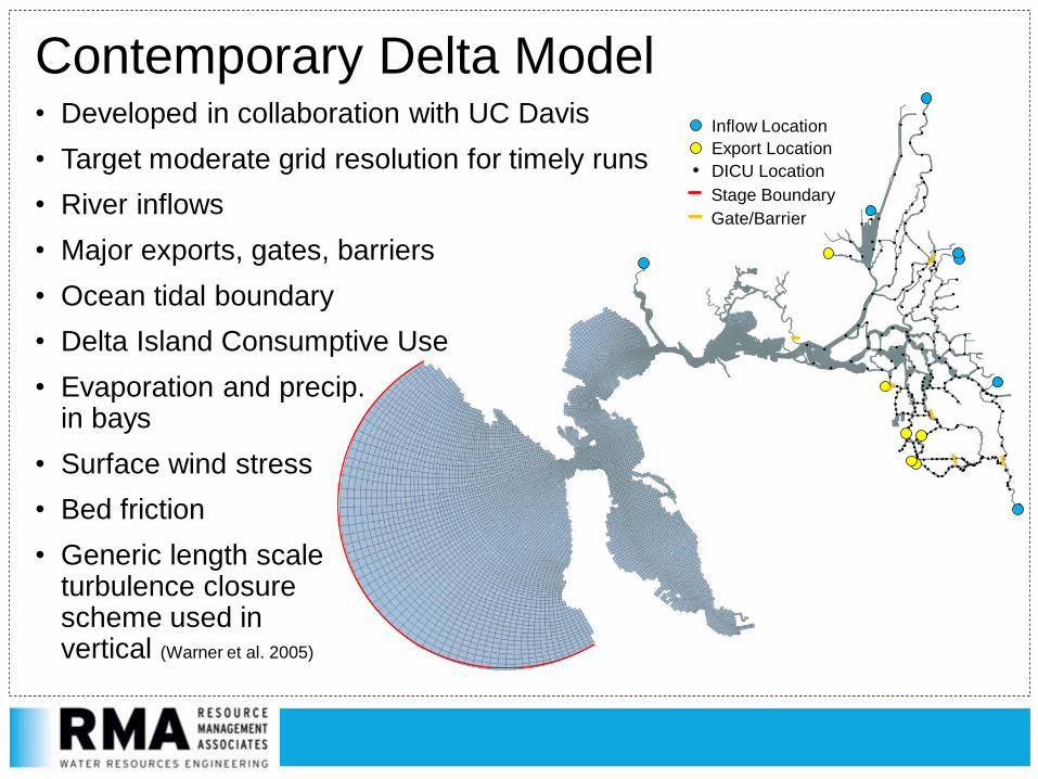
Contemporary Delta Model • Developed in collaboration with UC Davis
• Target moderate grid resolution for timely runs
• River inflows
• Major exports, gates, barriers
• Ocean tidal boundary
• Delta Island Consumptive Use
• Evaporation and precip.in bays
• Surface wind stress
• Bed friction
• Generic length scaleturbulence closurescheme used invertical (Warner et al. 2005)
Inflow Location
Export Location
DICU Location
Stage Boundary
Gate/Barrier

RMA
Model Calibration: Stage and FlowObserved Data Location

RMA
Model Calibration: Salinity
13 Apr 2010 20 May 2010 15 Jun 2010
13 Jul 2010 17 Aug 2010 14 Sep 2010 26 Oct 2010
• USGS Polaris water quality transects
Rio Vista
Golden
Gate
Observed Observed Observed
Observed Observed Observed Observed
Modeled Modeled Modeled
Modeled Modeled Modeled Modeled

RMA
Comparison Runs: Boundary Conditions
• Contemporary Historical
Inflows USGS, DWR Observed C2VSim
Exports DWR None
Delta Use DWR DICU C2VSim Inflows - Outflow
Ocean Water Level NOAA Point Reyes Station Point Reyes – 1ft to account for sea level rise
Meteorological Inputs NOAA, CIMIS Observed Same
Hydraulic StructureOperations
USBR, DWR None
Initial Salinity Condition USGS Polaris Same
RMA
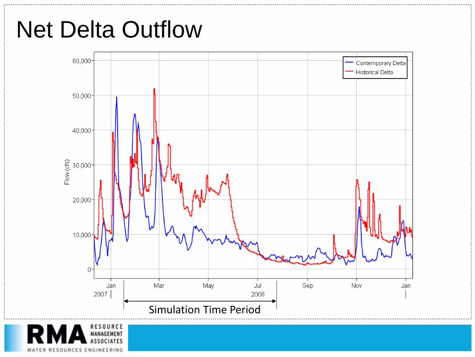
Net Delta Outflow
Simulation Time Period

RMA
In-Delta Water Use Processes• Contemporary Delta – withdrawals, return flows, seepage, evaporation
• Historical Delta – evapotranspiration from marsh, ponds

RMA
X2 Transect Location
50 km 80 km 90 km70 km
60 km

RMA
X2 Time Series Comparison
2 PSU bottom salinity(15min data for plot, daily avg for analysis)Note: Different Net Delta Outflow
RMA
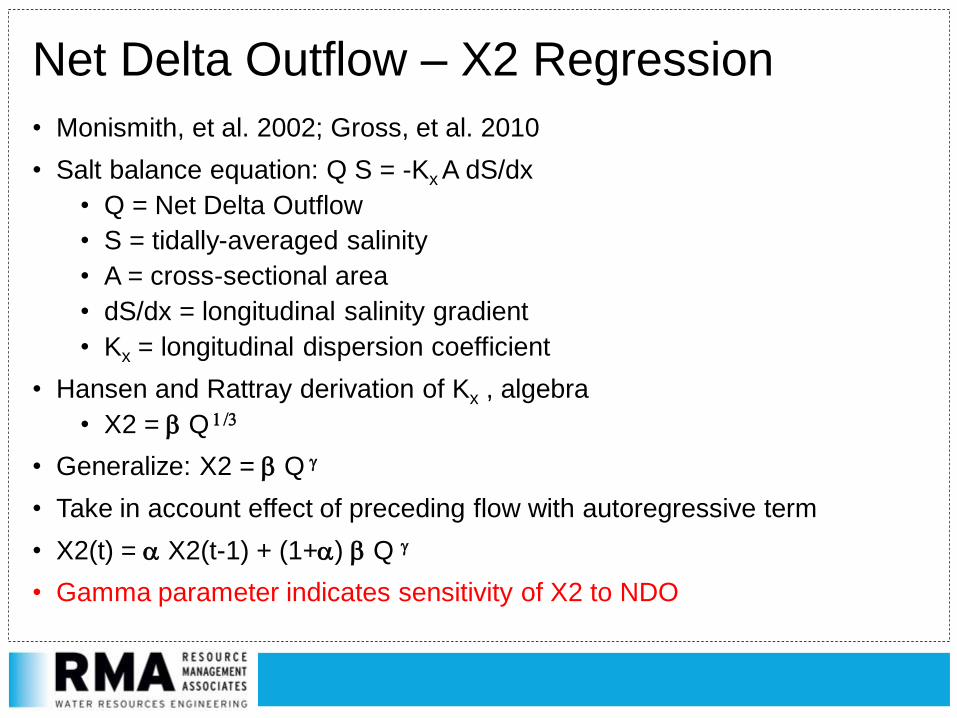
Net Delta Outflow – X2 Regression
• Monismith, et al. 2002; Gross, et al. 2010
• Salt balance equation: Q S = -Kx A dS/dx
• Q = Net Delta Outflow
• S = tidally-averaged salinity
• A = cross-sectional area
• dS/dx = longitudinal salinity gradient
• Kx = longitudinal dispersion coefficient
• Hansen and Rattray derivation of Kx , algebra
• X2 = b Q 1/3
• Generalize: X2 = b Q g
• Take in account effect of preceding flow with autoregressive term
• X2(t) = a X2(t-1) + (1+a) b Q g
• Gamma parameter indicates sensitivity of X2 to NDO

RMA
ContemporarySimulation Regression
g = 0.248 g = 0.219
Historical Simulation Regression

RMA
Contemporary Flows with Contemporary and Historical Regression Fits

RMA
Tidal Prism
• Volume of water that enters/exits the Delta between mean low tide and mean high tide
• Determined by analysis of flow record at Martinez
• Historical Delta -> greater marsh area to flood
• Contemporary Delta -> wider and deeper channels
• Model Results:
• Historical Delta: 205 x 106 m3 (166,000 acre-feet)
• Contemporary Delta: 200 x 106 m3 (162,000 acre-feet)
• Slight (2.5%) increase for historical Delta

RMA
Flood versus Ebb Tide Dominance• Flood tide dominance: flood tide shorter in duration, higher tidal velocities
• Ebb tide dominance: ebb tide shorter, with higher tidal velocities
• Implications for transport of sediment, material, aquatic organisms
Ebb Tide
Flood Tide
HHW
LLWHLW
LHW
Ebb tide period
Flood tide period
Maximum ebb velocities
Maximum flood velocities
Cache at Ryer, Contemporary Delta

RMA
Marsh Causes Shifts To Flood Dominance?• Hypothesis: marsh draining elongates ebb period, shifts velocities towards
flood dominance (however, we saw the opposite)

RMA
Conclusions and Future Work
• Reached calibration with adequate representation of the tidal range and inundation characteristics of the historical Delta and Suisun Bay/Marsh
• Performed salinity regression comparison
• Very similar X2 dependence on Delta outflow for moderate flows
• Next: analysis of longer time period with low-flow in the historical Delta
• Small differences in tidal prism with historical Delta, even with large increases in marsh area
• Seen in other RMA studies (BDCP, levee break simulations)
• Counter-intuitive tidal velocity results – currently being analyzed
• Collaborations for future investigations?

RMA
• Development, calibration, and the simulations shown here using theHistoric Delta Model were funded by the Metropolitan Water District of Southern California, under the direction of Paul Hutton
• DWR and UCD are independent collaborators
• University of California, DavisCenter for Watershed Studies[DEM creation, Hydrodynamics]
• Andy Bell
• Bill Fleenor
• Alison Whipple
• Steve Micko
• Fabian Bombardelli
• Mui Lay
• Amber Manfree
• Metropolitan Water District of Southern California[Funding agency]
• Paul Hutton, Project Manager
• San Francisco Estuary Institute[Historical Delta Configuration, Bathymetry]
• Sam Safran
• Robin Grossinger
• Julie Beagle
• Hydrology Team
• Tariq Kadir
• Guobiao Huang
• Andy Draper (MWH)
• J. Phyllis Fox
• Dan Howes (CSU, San Luis Obispo)
Thanks!

RMA
Referenced Works• Cappiella, K., Malzone, C., Smith, R., and B. Jaffe. 1999. Sedimentation and Bathymetry Changes in
Suisun Bay: 1867-1990. U. S. Geological Survey Open-File Report 99-563, http://pubs.usgs.gov/of/1999/0563/.
• Casulli, V. and R.T. Cheng. 1992. Semi-implicit finite difference methods for three-dimensional shallow water flow. Int. J. Numer. Meth. Fluids 15: 629-648.
• Casulli, V. and R.A. Walters. 2000. An unstructured grid, three-dimensional model based on the shallow water equations. Int. J. Numer. Meth. Fluids 32: 331-348.
• Casulli, V. and G.S. Stelling. 2010. Semi-implicit subgrid modelling of three-dimensional free-surface flows. Int. J. Numer. Meth. Fluids. DOI: 10.1002/fld.2361.
• Gross, Edward S, MacWilliams, Michael L, & Kimmerer, Wim J. (2010). Three-dimensional modeling of tidal hydrodynamics in the San Francisco Estuary. San Francisco Estuary and Watershed Science, 7(2).
• Lippert, C. and F. Sellerhoff. 2006. Efficient generation of orthogonal unstructured grids. 7th International Conference on Hydroscience and Engineering (ICHE-2006), Sep. 10 – Sep. 13, Philadelphia, USA.
• Monismith, S., W. Kimmerer, J.R. Burau, and M.T. Stacey. 2002. Structure and flow-induced variability of the subtidal salinity field in Northern San Francisco Bay. J. Phys. Oceanogr., 32, 3003–3019.
• Warner, J.C. 2005. Performance of four turbulence closure models implemented using a generic length scale method. Ocean Modelling 8:81-113.
• Whipple, A.A., Grossinger, R.M., Rankin, D., Stanford, B., and R.A. Askevold. 2012. Sacramento-San Joaquin Delta Historical Ecology Investigation: Exploring Pattern and Process. Prepared for the California Department of Fish and Game and Ecosystem Restoration Program. A Report of SFEI-ASC’s Historical Ecology Program, Publication #672, San Francisco Estuary Institute-Aquatic Science Center, Richmond, CA.

RMA
Contact Information
Steve Andrews - [email protected]
John DeGeorge - [email protected]
Resource Management Associates4171 Suisun Valley Rd, Suite JFairfield, CA 94534
707-864-2950