Commonwealth of the Northern Mariana Islands Integrated ... · Commonwealth of the Northern Mariana...
49
Commonwealth of the Northern Mariana Islands Integrated 305(b) and 303(d) Water Quality Assessment Report Traditional Sailing Canoe, Saipan Division of Environmental Quality Revised: October, 2008 Editor: Peter Houk Authors: Brian Bearden, Frances Castro, Peter Houk, Derek Chambers, and Clarissa Bearden
Transcript of Commonwealth of the Northern Mariana Islands Integrated ... · Commonwealth of the Northern Mariana...

Commonwealth of the Northern Mariana Islands Integrated 305(b) and 303(d) Water Quality
Assessment Report
Traditional Sailing Canoe, Saipan
Division of Environmental Quality Revised: October, 2008
Editor: Peter Houk
Authors: Brian Bearden, Frances Castro, Peter Houk, Derek Chambers, and Clarissa Bearden
TABLE OF CONTENTS
Introduction to this Report and the 305(b) Process .................................. 3
Executive Summary...................................................................................... 4
Background ................................................................................................... 6
Background of CNMI and its Waters ......................................................................... 6 Surface Water Quality Background............................................................................ 6 Groundwater Background ......................................................................................... 14 Background on DEQ Programs to Correct Impairments....................................... 16
Surface Water Assessment......................................................................... 17
Beach Water Quality Monitoring Program ............................................................. 17 Background and Methodology.................................................................................. 17 Results and Discussion ............................................................................................. 22
Lagoon and Coral Reef Biocriteria Monitoring Programs..................................... 30 Background and Methodology.................................................................................. 30 Results and Discussion ............................................................................................. 31
Integrated 305b and 303d Waterbody Classification .............................................. 35 (CALM) Waterbody Classification ........................................................................... 35 303(d) Priority List ................................................................................................... 36
Relevant Issues Associated With Water Quality Permitting and Pollution Prevention Programs.................................................................................................. 42
Current program activities and projects relevant to 303(d) listed waters ............... 42 Laolao Bay Stormwater Control (Relevant to Category 4b Waters for ‘SEB 2, 3’)............................................................................................................................... 42 Obyan Beach Stormwater Control (Relevant to Category 4b Waters for‘SEB 4’)............................................................................................................................... 42 Talakhaya Restoration Project (Relevant to Category 4b Waters for ‘Talakhaya’)................................................................................Error! Bookmark not defined. Garapan Drainage Improvement Designs (Relevant to Category 4b Waters for WB 12b, 14-17) .....................................................Error! Bookmark not defined.
Groundwater Assessment........................................................................... 45
Numeric Groundwater Standards............................................................................. 45 Summary Results of Groundwater Monitoring ....................................................... 45
Literature Cited .......................................................................................... 48
2

Introduction to this Report and the 305(b) Process Section 305(b) of the federal Water Pollution Control Act (Clean Water Act) requires that states and territories monitor the quality of their surface and groundwaters and produce a report describing the status of their water quality. This report is referred to as the 305(b) which will be used by the United States Environmental Protection Agency (EPA), US Congress, and the public, to evaluate: (1) whether U.S. waters meet water quality standards, (2) the progress made in maintaining and restoring water quality, and (3) the extent of remaining problems. EPA requires all impaired waterbodies, from unknown pollution sources, to be placed on the 303(d) list for further studies regarding the sources and quantities of various pollutants. The EPA consolidated assessment and listing methodology (CALM) categories were used to classify all assessed waterbodies in the CNMI during 2006 and 2007. The Division of Environmental Quality under the Office of the Governor is responsible for preparing the Commonwealth of the Northern Mariana Islands (CNMI) 305(b) report, and subsequent 303(d) listings.
3

Executive Summary The health and economic wellbeing of the people of the Commonwealth of the Northern Mariana Islands (CNMI) depend upon good water quality. Tourism is a major driving force behind the CNMI economy. Tourists come to see beautiful sandy beaches, clear blue water, and diverse coral reefs. The CNMI has over 250 species of coral (Randall, 1995) over 850 species of fish (Myers, 2000), and over 1000 marine invertebrates (Paulay 2003) that inhabit our corals reefs. CNMI residents rely upon clean water and healthy reefs for fishing and recreation. Healthy marine environments require clean water that remains within a narrow range of water quality parameters. Under the current development pressure we are challenged to maintain and improve our water resources. Both point and non-point source pollution are responsible for lowering the quality of the CNMI’s waters. Sewage outfalls, failing sewer collection systems, sedimentation from unpaved roads, poor erosion control practices during development, urban runoff, and reverse osmosis discharges are the most significant stressors to our water quality. Most of CNMI’s wetlands that naturally filter stormwater prior to its marine discharge were filled for agriculture use and urban development during the Japanese occupation period. Presently, wetlands comprise less than 5% of the land, and are patchily distributed around Saipan and Tinian Island, presenting enhanced challenges to improving our surface waters. The largest groundwater problems in the CNMI are high chlorides resulting from over-pumping of the basal aquifer in an effort to keep up with the increasing population demand, and nutrient and bacteria input from septic systems. Eighty beach locations are monitored for traditional surface water quality parameters and Enterococci bacteria levels. Unsurprisingly, most microbiological violations were recorded for monitoring stations in close proximity to large, heavily populated drainages, especially during rain events. Bacteria enriched waters are mainly associated with the Saipan lagoon, representing CNMI’s most developed coastline. Two biocriteria monitoring programs have been established by the Division of Environmental Quality (DEQ) in conjunction with the Coastal Resources Management Office. The Saipan Lagoon monitoring program collects data regarding the abundances of fast growing macroalgae, seagrass, and corals within each lagoon habitat. Our nearshore reef monitoring program collects data on the coral assemblages that inhabit our reef slopes. These data provide an evaluation of the benthic communities based upon know relationships between ecological measures and water quality. Throughout CNMI’s 53.7 km of beach coastline 69% was assessed during 2006 – 2007, indicating that 86% of all monitored waterbodies were impaired and remain 303(d) listed for various reasons. Saipan has the largest percentage of impaired waters (92%) due to bacteria violation and biological data. The impaired waters of Tinian (100%) and Rota (80%) are listed mainly due to historical nutrient data, an artifact of CNMI’s stringent orthophosphate and dissolved oxygen water quality standards that do no represent ambient conditions. While these numbers may seem high the guidance materials from
4

EPA that drive this reporting process requires an ‘impairment’ ranking for all waters that are not proven pristine. The CNMI Division of Environmental Quality has implemented several programs that address and regulate development, agriculture, fuel storage, pesticide use, and other potential contributing pollutants. All projects and ongoing issues that have or potentially may affect CNMI’s water quality are furthered within.
5

Background
Background of CNMI and its Waters The Commonwealth of the Northern Mariana Islands (CNMI) consists of two geologically distinct island chains located at 145º E, between 14º – 21º N (Figure 1). The Southern Mariana Islands are between 5 and 20 million years old and consist of raised, limestone reef bedrock resultant from high sea level stands prior to the Holocene (~6,000 before present) (Karig, 1975, Mrozowski and Hayes, 1980). The Northern Islands lie to the northwest, residing on the still active Mariana Ridge. This report contains information from the southern islands of Saipan, Tinian, Aguijan, and Rota, where the vast majority of the population lives (Table 1). Saipan is the capital of CNMI, and the largest and most inhabited of the islands. Threats to water quality are greatest in Saipan, where DEQ operations are based, resulting in more resources being dedicated to understanding these impaired waters.
Surface Water Quality Background The CNMI has two classes (AA and A) for marine water use and two classes (1 and 2) for fresh surface water use. All fresh surface water bodies in the CNMI (wetlands, intermittent streams, and perennial streams) are Class 1, meaning that these waters should remain in their natural state with an absolute minimum of pollution from any human-caused source. On Saipan Island there are approximately three perennial streams, one lake, and several isolated wetland regions (Figure 2). On Tinian there are several wetlands, no lakes, and only intermittent streams (Figure 3). On Rota there are several perennial and intermittent streams, no lakes, and no wetlands (Figure 4). Wetlands and perennial streams comprise less than 5% of the land, and are patchily distributed around Saipan and Tinian Island. Some of these resources are used for drinking water and recreation but are not tested by the DEQ Lab on a regular basis due to their low abundance and use. Wetlands can be found on the islands of Saipan, Tinian, Rota, and Pagan, however they cover less than 2% of the CNMI at the present time (based on current CNMI GIS layers). Despite their low occurrence, wetlands provide habitat for unique and endangered plants and animals present in CNMI. Wetlands also serve other functional purposes such as storm runoff water storage and pollutant uptake. For a more detailed look at CNMI’s wetlands and their functional roles one can refer to CNMI’s “National Wetland Inventory” document (Prepared by US Fish and Wildlife, 1989, CRM Office). This document states there are approximately 600 acres of wetlands in CNMI. The “Commonwealth of the Northern Mariana Islands Wetlands Conservation Plan” states that only 36% of the original wetland acreage still exists (CRM Office), losses due to filling are as follows: Garapan - 200 acres, San Roque - 50 acres, Flores Pond - 130 acres, Lake Susupe area - 200 acres, and Kagman and Lower Base - 600 acres. Saipan was heavily farmed during Japanese times (pre-World War II), which resulted in filling of
6

wetland areas to make them suitable. Increasing development continues to threaten wetlands on all of the islands but current regulations are in place to mitigate these impacts for all future projects. The majority of the coastal marine waters are Class AA, meaning that these waters should remain in their natural pristine state as nearly as possible with an absolute minimum of pollution or alteration of water quality from any human-related source or actions. The uses protected in these waters are the support and propagation of marine life, conservation of coral reefs and wilderness areas, oceanographic research, and aesthetic enjoyment and compatible recreation inclusive of whole body contact (e.g. swimming and snorkeling) and related activities (Table 2). Class A waters are only found near the two largest oceanic sewage outfalls and the ports of the CNMI. Class A waters are protected for their recreational use and aesthetic enjoyment; other uses are allowed as long as they are compatible with the protection and propagation of fish, shellfish, and wildlife, and recreation in and on these waters of a limited body contact nature. In the case of the CNMI, as with all island nations, discussions about surface water quality must include information regarding the status of nearshore marine communities. Marine communities can shift in response to nutrient enrichment (e.g. water quality impairment) (Fabricius and De’ath 2001, Houk and van Woesik 2008). Similarly, changes in temperature, salinity, pH, dissolve oxygen, and other water quality criteria will also affect coral reef assemblages (Valiela 1995). At any particular time, water quality measurements are affected by rainfall or storm events, tidal fluctuations, and other atmospheric and oceanographic conditions. This dynamic nature makes all water quality data very difficult to properly assess a region, project, or pollutant source, without appropriate sample sizes and design. Another way to examine the quality of the water is to examine the nearshore assemblages that are bathed by watershed discharge. In this report we utilize biological criteria (data regarding our nearshore coral reef assemblages) to compliment water quality data when making our assessments. Both point and non-point source pollution are responsible for lowering the quality of the CNMI’s surface waters. Sewage outfalls, failed sewer collection facilities, sedimentation from unpaved roads and development, urban runoff, reverse osmosis discharges, and nutrients from golf courses and agriculture are the most significant stressors to surface and marine water quality.
7

Table 1. Statistics for the Southern Mariana Islands. Resource ValueSurface area of CNMI 457.1 sq kmSurface area of Saipan 120.4 sq kmSurface area of Tinian 101.5 sq kmSurface area of Rota 85.0 sq kmPopulation (total) 69,221 (in 2000)Saipan Population 62,392 (in 2000)Rota Population 3,282 (in 2000)Tinian Population 3,540 (in 2000)CNMI Residents 21,306 (in 1995)Alien workers 37,540 (in 1995)Tourists 497,601 (in 2001)Length of perennial and intermittent streams on Saipan 95.5 kmArea of freshwater and tidal wetlands on Saipan 2,808 sq kmArea of Saipan lagoon 30,750 sq kmLength of Saipan coastline 75.52 kmLength of Rota coastline 55.84 kmLength of Tinian coastline 58.65 kmArea of bays (Lau Lau Bay, Saipan) 10,662 sq kmArea of Saipan marina (Smiling Cove) 0.1 sq kmArea of CNMI EEZ 414,398 sq km (approximate)CNMI Department of Commerce Statistical Yearbook 1996 (based on 1995 census)
CNMI Geographic Information System
CNMI Department of Commerce
8

Figure 1. The Mariana Islands.
9

Table2. Class A Waters, CNMI.
Water Body Reason for Class A designation Puerto Rico Industrial, Saipan Commercial port and municipal waste outfall Agingan Point, Saipan Municipal waste outfall East Harbor, Rota Commercial port West Harbor, Rota Commercial port San Jose Harbor, Tinian Commercial port
10

Figure 2. Class 1 waters of Saipan: watersheds (black, outlined), intermittent streams (blue), wetlands (green), and coral reefs are shown in dashed black lines.
11

Figure 3. Class 1 waters of Tinian: watersheds (black, outlined), intermittent streams (blue), wetlands (green).
12
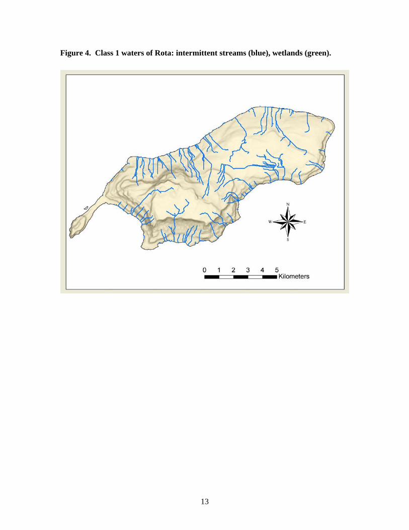
Figure 4. Class 1 waters of Rota: intermittent streams (blue), wetlands (green).
13

Groundwater Background The Northern Mariana Islands formed as the result of arc volcanism west of the Pacific and Philippine plate junction. The geology of the southern islands suggests they were once submerged below sea-level, allowing a layer of coral reef to form over the volcanic rock. As a result of repeated fluctuations in sea-level and tectonics, the southern islands of Saipan, Tinian, Rota, Aguijan, and Farallon de Medinella currently comprise a predominantly limestone bedrock (Randall, 1995). This geological nature has produced two types of aquifers. In isolated, high-elevation areas, geology has created a situation where limestone fresh water aquifers overlie an impermeable volcanic layer, yielding a good and relatively protected supply of drinking water. However, the majority of the fresh water is found in the basal aquifer with a fresh water lens sitting on top of sea water, separated as a result of differences in density of the fluids.
The location and distribution of the fresh water aquifers are of extreme importance in the CNMI because the vast majority of drinking water comes from aquifers. The largest groundwater problem in the CNMI is high chlorides resulting from over-pumping of this basal aquifer in an effort to keep up with the increasing population demand. Over-pumping of groundwater can result in saltwater intrusion of the basal aquifer. The thickness of the freshwater lens on top of the saltwater is related to several factors, including extent of recharge areas, geology, and proximity to the coastline. Saltwater intrusion is reversible and does not cause permanent damage to the surrounding aquifer. The chloride problem only exists on the island of Saipan, but new developments initiated on Tinian and Rota may affect the basal aquifers there if future well drilling is not monitored or managed properly. To protect the basal aquifer from saltwater intrusion the drilling of new water wells needs to be closely monitored. New well explorations should only be considered in areas where the thickness of the freshwater lens is identifiable and adequate. Other means of protecting the basal aquifer from saltwater intrusion are to control and limit the pumping rate of existing wells, and closely monitor the sample results of existing well for chlorides, conductivity and total dissolved solids.
The Safe Drinking Water/Groundwater Management Program has been compiling a database of wells in the CNMI over the past three years (2005-2008). There are currently 513 wells in the database. This total includes active and inactive drinking water, irrigation, exploratory, under ground injection, and monitoring wells. Of these 513 wells, 13 are located on Rota, 10 on Tinian, and the rest on Saipan. Of the 490 Saipan wells, 206 are owned by the Commonwealth Utilities Corporation (CUC - the local municipal water utility), while the other 284 wells are owned by other government entities, private companies or individuals. On Saipan, there are several uses of groundwater including human consumption (public water supply systems) and irrigation for crops and golf courses. The CNMI is heavily dependent on tourism and garment factories for the local economy. Due to the high level
14
of chlorides in the public water system, major hotels and factories along the coast drill seawater wells and use reverse osmosis treatment for their private water supply. The high level of chlorides in the public water supply on Saipan is a result of over pumping the municipal wells (which promotes salt water intrusion) to keep up with the demand for water. The 136 wells owned by the public utility company on Saipan theoretically produce enough water to meet the demands of the island. However, the real demand for water is significantly greater than the theoretical demand because of leaks in the municipal and homeowner water distribution systems (Army Corps, 2003). The production can not keep up with the demand and the leaks, so many neighborhoods on Saipan only receive water via the distribution system for several hours a day. A concern on Saipan is the presence of coliform bacteria in the untreated (unchlorinated) well water. In March 2006 bacteriological testing of these samples revealed that approximately 60% of the wells tested positive for total coliform bacteria while 10% tested positive for E. coli bacteria. This contamination is a perceived result of high concentrations of septic systems in several villages that are not served by the sewer system that were improperly constructed. An emerging concern on Saipan is nitrate contamination of the groundwater. CUC monitors for nitrate and nitrite at 45 sites throughout the public water distribution system. In June of 2006, one violation was noted from Saipan’s southern water distribution system. While this was the first exceedance since monitoring began in 2001, one additional violation was noted in December 2006, followed by eight in June 2007, with levels as high as 14 mg/l (the MCL is 10 mg/l). Apparently, the concentration of nitrates in the groundwater fluctuates rapidly as three sites with over 14 mg/l in June 2007 had only 6 and 8 mg/l two weeks later. Rainfall is believed to play an important role in the variability of nitrates in the groundwater. In March 2008, the University of Guam Water Environmental Research Institute (WERI) funded a study to determine the relationship between rainfall and nitrate concentration in Saipan’s groundwater that has just started. The majority of the population of Saipan resides on the western side of the island. The villages of Garapan, Chalan Laulao, Susupe, Chalan Kanoa, and San Antonio are estimated to have concentrated sixty percent of the total island’s population within twenty percent of the available landmass on Saipan. Meanwhile, the majority of the municipal water supply wells, pumping from the basal aquifer, are located in the southern part of the island. There is a smaller concentration of municipal wells located at higher elevations in the central part of the island, and a few springs, that serve the other forty percent of the population of Saipan. At the present time the island of Rota, with a population of about 3,000, receives its municipal water from two springs (Water Cave and Onan Cave) and three newly drilled wells. The wells are drawing water from the high level aquifers and are not susceptible to salt water intrusion. However, the springs on Rota are suspected to be groundwater under direct influence of surface water (GUDI). Presently, DEQ is initiating monitoring of turbidity changes in accordance with the seasonal changes in order to determine if
15

further filtration should be required. Tinian on the other hand, with a population of about 3,200, gets its municipal water from two Maui type wells also suspected of GUDI and three deep wells. Both Tinian and Rota have not had water demands that lead to over-pumping of the aquifers.
Background on DEQ Programs to Correct Impairments The CNMI Division of Environmental Quality has implemented several programs that address and regulate development, agriculture, fuel storage, pesticide use, and other potential pollutants. All programs are mentioned below, however, further information regarding the present status and pertinent findings for each program are located in sections III and IV of this report. There are several DEQ programs which deal with regulation and enforcement of pollution sources that may potentially affect water quality. The DEQ wastewater and erosion control branch reviews permit applications that deal with the Clean Water Act and section 401 territory water quality certifications. The DEQ non-point source (NPS) pollution branch addresses stormwater runoff concerns at the watershed level through education, outreach, and demonstration projects. The NPS branch administers EPA 319 grants and reviews permits to ensure compliance with the federal 6217 NPS program. The safe drinking water branch regulates public drinking water systems, well drilling, and underground injection wells. The air and toxic management branch deals with hazardous sources of pollution which may affect CNMI’s waters. Finally, the above and underground fuel storage and pesticide branch deals with the legal and illegal storage of contaminants that often pose threats to CNMI’s waters.
16

Surface Water Assessment
Beach Water Quality Monitoring Program
BACKGROUND AND METHODOLOGY The Division of Environmental Quality surveillance laboratory was established by the Commonwealth of the Northern Mariana Islands to provide monitoring data required under the Safe Drinking Water Act (P.L. 93-523). The data generated by the laboratory are used to evaluate the quality of drinking and recreational waters in the Commonwealth. Therefore, a quality assurance plan is essential in the generation of these data and is an important part of the day-to-day activities of the laboratory. The DEQ Environmental Surveillance Laboratory Quality Assurance Manual includes Standard Operating Procedures (SOPs) for sampling, testing, reporting, and providing quality assurance for water quality parameters. There are two primary functions of the quality assurance plan: 1) it assures that proper quality control practices are implemented in day-to-day laboratory task, and 2) it assures that the reported data are valid, and are of a known precision and accuracy. Although the success of the program depends upon the training, professional pride and awareness of each individual technician, final responsibility for the reliability of reported analytical results rest with the Environmental Surveillance Laboratory Supervisor. The microbiological and chemical parameters that the Division of Environmental Surveillance Laboratory currently monitors includes: salinity (‰), dissolved oxygen (% D.O.), temperature (°C), pH, turbidity (NTU), and Enterococci bacteria (cfu/100ml). Orthophosphate (PO4) and Nitrates (NO3) were not monitored during 2006 - 2007 because DEQ recently procured new equipment that enhances their capability, and just recently was our QA/QC approved by EPA. The development of the CNMI Water Quality Standards were largely based upon the review of existing water quality standards for other tropical islands, and unfortunately not specific to the CNMI (Table 5), and furthered below. On a weekly basis, DEQ monitors 39 fixed stations along Saipan’s most frequented west coast beaches for microbiological and chemical parameters (Figure 5). Six beaches on the northeast coast and six beaches on the southeast coast are monitored on a 8-week rotational basis, and monthly during the non 8-week cycle, because the quality of the water is consistently good and/or a smaller population uses these waters. Eleven sites around Managaha Island, a small (~1.5 km coastline) island located within the Saipan Lagoon, are also monitored on a 8-week rotational basis, and monthly during the non 8-week cycle (Figure 6). On Tinian and Rota DEQ monitors eleven and twelve locations, respectively (Figures 7 and 8), that are frequently used by the community.
Because of the rarity of fresh, surface waters in the CNMI (<2.5% of CNMI surface area), and the lack of public use, there is no regular monitoring to support this waterbody assessment process at the present time.
17

The goal of the DEQ Lab Surface Water Quality Monitoring Program is to assess CNMI’s waterbodies for compliance with recreational uses and aquatic life uses. EPA guidance material was used assign each water body as 1) non-supportive, 2) partially supportive, and 3) fully supportive for use (Table 6).
Table 5. CNMI’s pertinent water quality standards.
PARAMETER CLASS AA CLASS A CLASS 1 CLASS 2 Fecal Coliform (CFU/100 ml)
GM1< 200 < 400
GM1< 200 Never > 400
GM1< 200 Never > 400
GM1< 200 Never > 400
Enterococci (CFU/ 100 ml)
GM < 35 ‹ 104 Single Sample
GM <125 < 276 Single Sample
GM < 33 < 61 Single Sample
GM < 90 < 108 Single Sample
E. coli GM < 126 < 235 Single Sample
GM < 126 < 406 Single Sample
PH 7.5 – 8.6 7.5 – 8.6 6.50-8.50 6.50 - 8.50 NO3 - N (mg/L) < 0.20 < 0.50 Total Nitrogen (mg/L)
< 0.4 < 0.75 < 0.75 < 1.50
Orthophosphate PO4 (mg/L)
< 0.025 < 0.05 < 0.10 < 0.10
Total Phos PO4 (mg/L)
< 0.025 < 0.05 < 0.10 < 0.10
Ammonia (mg/L) (un-iodized)
< 0.02 < 0.02 < 0.02 < 0.02
Dissolved O2 (%) > 75 > 75 > 75 > 75 Total Filterable Suspended Solids (mg/L)2
5 40 5 40
Salinity (‰)2 10 10 20‰ or above 250 mg/L
20‰ or above 250 mg/L
Total Dissolved Solids (mg/L)
500 mg/L 500 mg/L
Temperature (°C)2 1.0 1.0 1.0 1.0 Turbidity (NTU)2 0.5 1.0 0.5 1.0 Radioactive Materials
Discharge prohibited Discharge prohibited Discharge prohibited Discharge prohibited
Oil & Petroleum ND3 ND3 ND3 ND3
1 GM - Geometric mean in not less than four samples over a 30 day period. 2 Shall not exceed ambient by more than the stated value. 3 ND - Non-detectable.
Table 6. Criteria for waterbody classification.
Degree of
Aquatic Life Use Support
Criteria
Fully Supporting
For any one pollutant, WQS exceeded in ≤10 percent of measurements.
Partially Supporting
For any one pollutant, WQS exceeded in 11 to 25 percent of measurements.
Not Supporting
For any one pollutant, WQS exceeded in >25 percent of measurements.
18

Figure 5. Saipan Island beach water quality monitoring locations, biological criteria monitoring stations are indicated by the stars.
19

Figure 6. Managaha Island beach water quality monitoring locations, biological criteria monitoring stations are indicated by the stars.
20
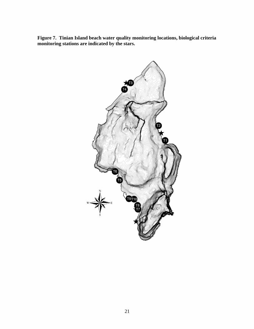
Figure 7. Tinian Island beach water quality monitoring locations, biological criteria monitoring stations are indicated by the stars.
21

Figure 8. Rota Island beach water quality monitoring locations, biological criteria monitoring stations are indicated by the stars.
RESULTS AND DISCUSSION
Based upon Enterococci bacteria data, Saipan had the largest number of waterbodies that received a non-supportive ranking for recreational use (16 sites) compared with Managaha, Tinian, Aguijan, and Rota, where no sites were non-supportive, and only 7 were listed as partially supportive between 2006 and 2007 (Table 7 - 9). There was a large enough sample size for Saipan to conduct regression analyses between rainfall (independent variable) and Enterococci bacteria counts (dependent variable) (Table 7). Rainfall explained a significant amount (p<.05, regression analysis) of the variance in bacteria levels at 9 monitoring locations around Saipan (Table 7) (Figure 9 and 10). This is a substantial decrease from 2006 when 28 beaches had significant ties between bacteria levels and rainfall, mainly in the northern part of Saipan. Unfortunately, the lack of a significant relationship is not due to decreased bacteria in the waters as our results show increases in bacteria levels since 2006 at these sites. This increase is a hypothesized consequence of non-rain associated, sewage collection system failures over the past two years, highlighted a potential problem with the current system. Conversely, in the south of Saipan, the completion of the new sewer line corresponded with a decrease in bacteria levels, all sites here are now classified as partially or fully supportive (stations WB 30 – 37, Table 7). In Rota, impaired waterbodies were associated with marinas and boat launching areas, and in one instance urban runoff, while the remaining waters were found to be in excellent quality. These findings are consistent with our 2006 reporting. Only three sites
22

23
on Tinian were classified as partially supportive, all are affiliated with relatively large watersheds, while the remaining had consistently low bacteria levels. Regressions with rainfall data were all not significant for Tinian monitoring sites, and much stormwater is discharges through the porous limestone rock as groundwater. Data were also assessed for several other parameters including pH, dissolved oxygen, salinity, and temperature. These data showed little variation over the past two years, and all monitoring locations were ranked as fully supportive based upon them. Despite the fact that they are not presented in tabular format they were used to make final site rankings. Chemical parameters for orthophosphate (PO4) and nitrates (NO3) were not monitored during 2006 – 2007 as DEQ was procuring, setting up, and gaining EPA approval for their new flow injector analysis (FIA). In 2008 DEQ has begun sampling for nutrient criteria.

Table 7. Summary of beach monitoring locations and Enterococci bacteria violations for Saipan: a ranking of 1 = non-supportive, 2 = partially supportive, and 3 = fully supportive. Regression analysis results are presented as P values.
Beach Identifier Beach Name
2006 Sample Size (n)
2007 Sample Size (n)
Percent Violations
(Enterococci) 2006
Percent Violations
(Enterococci) 2007
Rankings 2006
Rankings 2007 R2 P Value
WB 1 Wing Beach 51 34 7.8 14.7 3 2 0.01 >0.05WB 2 PauPau Beach 51 34 5.9 20.6 3 2 0.01 >0.05WB 3 Nikko Hotel 51 34 3.9 23.5 3 2 0.01 >0.05WB 4 San Roque School 51 34 11.8 14.7 2 2 0.01 >0.05WB 5 Plumeria Hotel 51 34 2.0 17.6 3 2 0.00 >0.05WB 6 Aqua Resort Hotel 51 34 3.9 17.6 3 2 0.02 >0.05WB 7 Tanapag Meeting Hall 51 34 35.3 35.3 1 1 0.01 >0.05WB 8 Central Repair Shop 51 34 23.5 35.3 2 1 0.00 >0.05WB 9 Sea Plane Ramp 51 34 2.0 20.6 3 2 0.00 >0.05
WB 10 DPW Channel Bridge 51 34 70.6 64.7 1 1 0.00 >0.05WB 11.2 S. Puerto Rico Dump 51 34 58.8 58.8 1 1 0.03 >0.05WB 12 Smiling Cove Marina 51 34 3.9 26.5 3 1 0.01 >0.05
WB 12.1 American Memorial Park 51 34 33.3 29.4 1 1 0.01 >0.05WB 13 Outer Cove Marina 51 34 0.0 17.6 3 2 0.01 >0.05WB 14 Micro Beach 51 34 9.8 26.5 3 1 0.01 >0.05WB 15 Hyatt Hotel 51 34 15.7 14.7 2 2 0.00 >0.05WB 16 Dai-Ichi Hotel 51 34 21.6 17.6 2 2 0.01 >0.05WB 17 Drainage #1 51 34 31.4 41.2 1 1 0.02 >0.05WB 18 Samoan Housing area 51 34 11.8 14.7 2 2 0.00 >0.05WB 19 Hafa-Adai Hotel 51 34 23.5 32.4 2 1 0.00 >0.05WB 20 Drainage #2 51 34 33.3 32.4 1 1 0.06 0.020 *WB 21 Garapan Fishing Dock 51 34 25.5 41.2 1 1 0.05 0.050 *WB 22 Garapan Beach 51 34 3.9 32.4 3 1 0.00 >0.05WB 23 Drainage #3 51 34 31.4 44.1 1 1 0.00 >0.05WB 24 Chalan Laulau Beach 51 34 7.8 5.9 3 3 0.17 0.000 ***
24
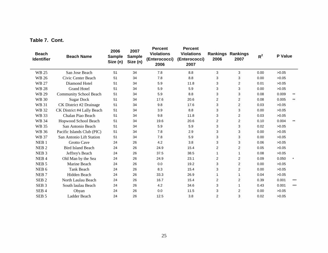
Table 7. Cont.
Beach Identifier Beach Name
2006 Sample Size (n)
2007 Sample Size (n)
Percent Violations
(Enterococci) 2006
Percent Violations
(Enterococci) 2007
Rankings 2006
Rankings 2007 R2 P Value
WB 25 San Jose Beach 51 34 7.8 8.8 3 3 0.00 >0.05WB 26 Civic Center Beach 51 34 7.8 8.8 3 3 0.00 >0.05WB 27 Diamond Hotel 51 34 5.9 11.8 3 2 0.01 >0.05WB 28 Grand Hotel 51 34 5.9 5.9 3 3 0.00 >0.05WB 29 Community School Beach 51 34 5.9 8.8 3 3 0.08 0.009 **WB 30 Sugar Dock 51 34 17.6 20.6 2 2 0.08 0.005 **WB 31 CK District #2 Drainage 51 34 9.8 17.6 3 2 0.03 >0.05WB 32 CK District #4 Lally Beach 51 34 3.9 8.8 3 3 0.00 >0.05WB 33 Chalan Piao Beach 51 34 9.8 11.8 3 2 0.03 >0.05WB 34 Hopwood School Beach 51 34 19.6 20.6 2 2 0.10 0.004 **WB 35 San Antonio Beach 51 34 5.9 5.9 3 3 0.02 >0.05WB 36 Pacific Islands Club (PIC) 51 34 7.8 2.9 3 3 0.00 >0.05WB 37 San Antonio Lift Station 51 34 7.8 5.9 3 3 0.00 >0.05NEB 1 Grotto Cave 24 26 4.2 3.8 3 3 0.06 >0.05NEB 2 Bird Island Beach 24 26 24.9 15.4 2 2 0.05 >0.05NEB 3 Jeffrey's Beach 24 26 37.5 38.5 1 1 0.08 >0.05NEB 4 Old Man by the Sea 24 26 24.9 23.1 2 2 0.09 0.050 *NEB 5 Marine Beach 24 26 0.0 19.2 3 2 0.00 >0.05NEB 6 Tank Beach 24 26 8.3 15.4 3 2 0.00 >0.05NEB 7 Hidden Beach 24 26 33.3 26.9 1 1 0.04 >0.05SEB 2 North Laulau Beach 24 26 16.7 15.4 2 2 0.39 0.001 ***SEB 3 South laulau Beach 24 26 4.2 34.6 3 1 0.43 0.001 ***SEB 4 Obyan 24 26 0.0 11.5 3 2 0.00 >0.05SEB 5 Ladder Beach 24 26 12.5 3.8 2 3 0.02 >0.05
25

Figure 9. Average enterococci bacteria levels at Saipan west beach monitoring sites during rain (daily value > 0.10 inches), and non-rain events for 2006.
Site
1 2 3 4 5 6 7 8 9 1011
.2 1212
.1 13 14 15 16 17 18 19 20 21 22 23 24 25 26 27 28 29 30 31 32 33 34 35 36 37
Mea
n E
nter
ococ
ci c
olon
y fo
rmin
g un
its (c
fu's
)
0
200
600
800
1000
No RainRain
2006
26

Figure 10. Average Enterococci bacteria levels at Saipan beach monitoring sites during rain (daily value > 0.10 inches), and non-rain events for 2007.
Site
1 2 3 4 5 6 7 8 9 1011
.2 1212
.1 13 14 15 16 17 18 19 20 21 22 23 24 25 26 27 28 29 30 31 32 33 34 35 36 37
Mea
n E
nter
ococ
ci c
olon
y fo
rmin
g un
its (c
fu's
)
0
1000
2000
3000
4000
5000
No RainRain
2007
27

Table 8. Summary of beach monitoring locations and Enterococci bacteria violations for Tinian and Rota: a ranking of 1 = non-supportive, 2 = partially supportive, and 3 = fully supportive.
Beach Identifier Beach Name Island
Name Longitude Latitude2006
Sample Size (n)
2007 Sample Size (n)
Percent Violations
(Enterococci) 2006
Percent Violations
(Enterococci) 2007
Rankings 2006
Rankings 2007
T1 Unai Masalok Beach Tinian 15.0211 145.6525 26 19 0.0 10.5 3 2T2 Unai Dangkolo Beach Tinian 15.0329 145.6467 26 19 3.8 0.0 3 3T3 Unai Babui Tinian 15.0775 145.6197 26 19 0.0 15.8 3 2T4 Unai Chulu Tinian 15.0705 145.6126 26 19 0.0 0.0 3 3T5 Leprosarium Beach I Tinian 14.9796 145.6099 26 19 3.8 10.5 3 2T6 Leprosarium Beach II Tinian 14.9875 145.6056 26 19 3.8 10.5 3 2T7 Tachogna Beach Tinian 14.9511 145.6285 26 19 0.0 5.3 3 3T8 Taga Beach Tinian 14.9542 145.6270 26 19 0.0 5.3 3 3T9 Harbor Tinian 14.9625 145.6171 26 19 7.7 0.0 3 3T10 Kammer Beach Tinian 14.9619 145.6228 26 19 0.0 0.0 3 3R1 Coral Garden Beach Rota 14.1161 145.1667 23 27 0.0 3.7 3 3R2 Kokomo Beach Club Rota 14.1294 145.1598 23 27 8.7 14.8 3 2
R3 Mobile Station Storm Drainage Rota 14.1369 145.1428 23 27 0.0 0.0 3 3
R4 East Harbor Dock Rota 14.1371 145.1416 23 27 0.0 0.0 3 3R5 Tweksberry Beach Rota 14.1311 145.1282 23 27 0.0 0.0 3 3R6 West Harbor Marina Rota 14.1335 145.1309 23 27 0.0 0.0 3 3R7 District #2 Storm Drainage Rota 14.1408 145.1379 23 27 4.3 22.2 3 2R8 District #1 Strom Drainage Rota 14.1422 145.1394 23 27 0.0 11.1 3 2R9 Veterans Memorial Beach Rota 14.1674 145.1787 23 27 4.3 0.0 3 3R10 Teteto Beach Rota 14.1702 145.1861 23 27 0.0 0.0 3 3R11 Guata Beach Rota 14.1723 145.1945 23 27 0.0 3.7 3 3R12 Swimming Hole Rota 14.1823 145.2091 23 27 8.7 0.0 3 3
28

Table 9. Summary of beach monitoring locations and Enterococci bacteria violations for Managaha: a ranking of 1 = non-supportive, 2 = partially supportive, and 3 = fully supportive.
Beach Identifier Beach Name 2006 Sample
Size (n)2007 Sample
Size (n)
Percent Violations
(Enterococci) 2006
Percent Violations
(Enterococci) 2007
Rankings 2006 Rankings 2007
M1 Managaha Beaches 30 25 6.7 4.0 3 3M2 Managaha Beaches 30 25 6.7 0.0 3 3M3 Managaha Beaches 30 25 3.3 0.0 3 3M4 Managaha Beaches 30 25 0.0 0.0 3 3M5 Managaha Beaches 30 25 0.0 0.0 3 3M6 Managaha Beaches 30 25 3.3 0.0 3 3M7 Managaha Beaches 30 25 6.7 0.0 3 3M8 Managaha Beaches 30 25 0.0 0.0 3 3M9 Managaha Beaches 30 25 3.3 0.0 3 3M10 Managaha Beaches 30 25 3.3 4.0 3 3M11 Managaha Beaches 30 25 6.7 0.0 3 3
29
30
Lagoon and Coral Reef Biocriteria Monitoring Programs
BACKGROUND AND METHODOLOGY Many monitoring programs that assess waterbody health with water quality data only are not sufficient to detect changes over time due to infrequent sampling and low sample sizes. One way to enhance water quality data collection may be through the use of continuous recording instruments. However, this approach is very expensive for multiple waterbodies. A more cost and time efficient method is to gather data on the distribution and abundances of organisms that live within the waterbodies that are to be assessed. For all island nations with tropical marine waters these marine communities will shift in response to nutrients, sediment loads, and turbidity (Rogers, 1990, Telesnicki and Goldberg, 1995). As a result, the CNMI uses several measures of the coral reef and seagrass community as biological criteria for waterbody evaluation described herein.
The CNMI interagency marine monitoring team (MMT) was initially established in 1997 to help understand the current conditions of their coral reefs and associated resources. It has expanded over the past 7 years to improve data collection techniques, data accuracy, staff training, and spatial coverage (Houk and Starmer, 2008, Houk and Van Woesik, 2006, 2008). It is the goal of the CNMI Marine Monitoring Team to continually assess our reefs as population and development grow, and provide pertinent data to trigger management action. DEQ plays a major role in the MMT through its marine biologist, non-point source pollution program, and laboratory program. Data from two monitoring efforts are used in this report to categorize waterbodies in accordance with EPA guidance materials: 1) Saipan Lagoon seagrass and 2) nearshore coral reef monitoring. Currently, no EPA criteria exist for the evaluation of seagrass beds and coral reefs, however, this report logically extended the existing EPA guidance material to provide for the evaluation of waterbodies based upon our benthic communities. Lagoon benthic communities were evaluated by calculating a ratio of seagrass to turf/macroalgae coverage based upon replicated benthic assessment transects during each year (Houk and van Woesik 2008). Only Halodule uninervis seagrass beds were used in this evaluation because they show the greatest affinities with watershed population and development (Houk and van Woesik 2008), and are widely distributed throughout the lagoon. The data collected here represent the highest level of technical components based upon EPA guidance material. All data were collected and analyzed by a professional biologist for interpretation using statistically appropriate techniques. Coral reef benthic communities were evaluated by calculating a ratio of coral/crustose coralline algae (CCA), favorable attributes for sustainable coral assemblages, to turf/macroalgae, unfavorable attributes (Rogers, 1990, Richmond, 1997, Fabricius and De’ath, 2001, Houk and van Woesik 2006). Ratio’s were calculated from statistically validated benthic surveys (Houk and van Woesik 2007). A second measure used to evaluate waterbody ‘health’ was coral species richness per unit area. This metric builds

upon significant affinities between species richness and watershed population and development in the CNMI (Houk and van Woesik, in review). ALUS rankings were derived from trend data, comparing replicated measures from the 2006 305(b) report to the present using paired t-tests following:
Degree Aquatic Life Use Support CriteriaOne step increase (i.e., from 'not' to 'partially'
supportive, or from 'partially' to 'fully supportive' Significant increase in biological metrics
No change No significant differenceOne step decrease (i.e., from 'partially' to 'not' supportive, or from 'fully' to 'partially supportive' Significant decrease in biological metrics
RESULTS AND DISCUSSION The only differences in ALUS rankings for seagrass beds within the Saipan Lagoon were improvements from partially to fully supportive ranking for stations located in the southern lagoon, affiliated with the sewer line improvements noted in the water quality section above (Figure 11). This is encouraging and if positive trends continue we aim to request a de-listing of these waters from our 303(d) list in 2010. However, the numerous seagrass beds in the Saipan Lagoon which were non-supportive for aquatic life use (Figure 11) mostly represent the marine waters adjacent to large, steep sloping, populated watersheds. Runoff that passes through these watersheds drains into the lagoon during storm events, carrying associated pollutants. Watershed plans to deal with these regions have been established in many cases, however, capital funding to implement the construction of large-scale best-management-practices impedes further progress. The northernmost, non supportive seagrass habitats are attributed to failing sewer collection facilities as populations are relatively low but overflows are common. As a result of nutrient and bacteria input seagrass habitats become dominated by macroalgae (Calurpa, Dictyota, and Acanthophora mainly) compared with seagrass (Halodule uninervis). Results from beach water quality monitoring agree with benthic data showing high bacteria levels in regions with high abundances of macroalgae. Similar to our coral reef reporting below, we aim to utilize trend data in the future to estimate the direction (positive or negative) biological assemblages are heading, and ranking the associated waterbodies in accordance with trends, and not single assessment data.
Twenty one coral reef surveys were conducted for waterbody evaluation (Figure 12). Of the twenty one locations surveyed, 5 were non-supportive, 11 were partially supportive, and 5 were fully supportive for aquatic life use (Table 10). Compared with the 2006 rankings there was an overall decline in the number of fully supportive sites from 10 to 5, as most sites are now classified as partially supportive. This is attributed to our generation of trend data that has enabled us to more accurately estimate the direction (positive or negative) biological assemblages are heading. Not supportive rankings were suspected to be a consequence of sedimentation, polluted groundwater discharge, and the proximity to boat marinas. Partially supportive sites are all associated with large volume
31

watersheds with varying levels of suspect pollution. Further studies are currently underway to formulate a predictive knowledge regarding the expected benthos abundances given a set of watershed statistics. DEQ aims to continue their monitoring program and further trend data collection for our coral reefs. This will help to evaluate the effectiveness of management strategies and action, and allow for a priority ranking of remaining, problematic watersheds.
32
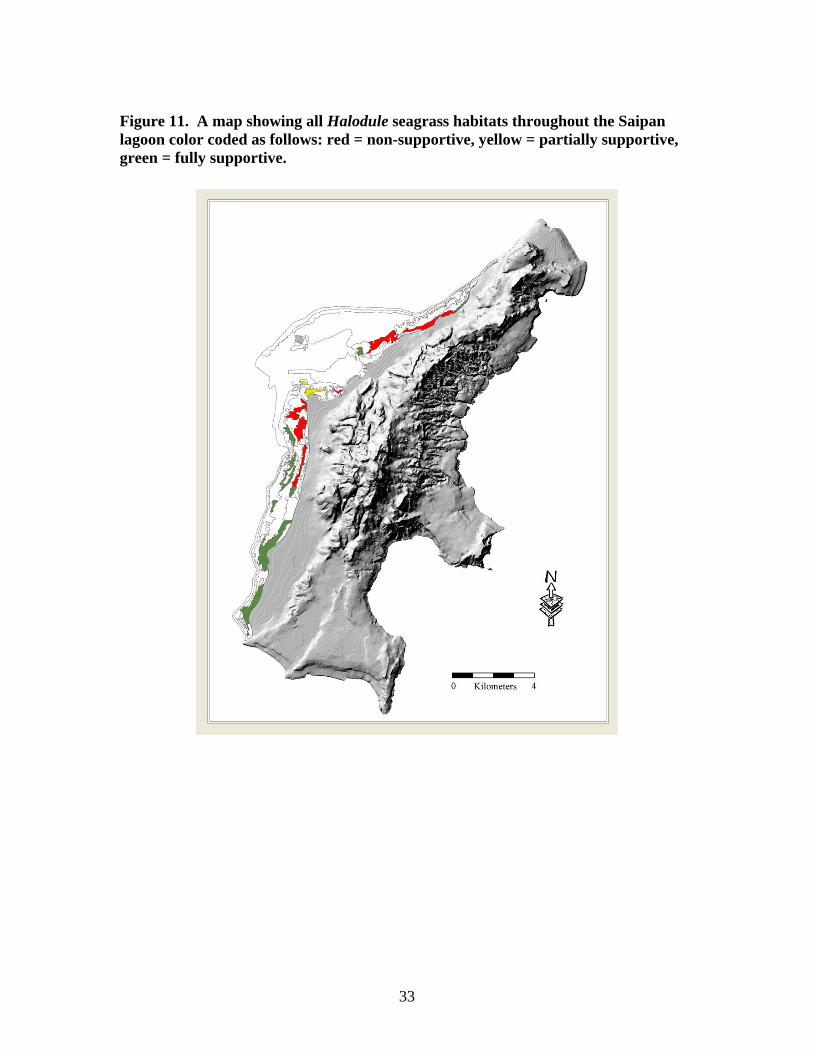
Figure 11. A map showing all Halodule seagrass habitats throughout the Saipan lagoon color coded as follows: red = non-supportive, yellow = partially supportive, green = fully supportive.
33

Figure 12. A map of coral reef biocriteria monitoring locations used in the present assessment.
34

Table 10. Aquatic life use support rankings based upon coral reef monitoring data.
Site Name Island Change in Coral Species Richness
P-value
Change in Benthic Substrate Ratio P-value ALUS
AGU - 1 Aguijan -- -- Fully SupportiveNEB 2 - Bird Island Saipan -1.25 0.07 -0.75 0.02 Partially SupportiveNEB 6 - Tank Beach Saipan -- -- Partially SupportiveT2 - Unai Dangkolo Tinian -- -- Partially SupportiveAGU - 2 Aguijan -- -- Fully SupportiveSasanhaya Rota -0.66 0.30 -1.21 <0.01 Partially SupportiveSEB 3 - Lau Lau #1 Saipan -0.44 0.48 -0.18 0.11 Not SupportiveSEB 4 - Obyan Saipan -- -- Fully SupportiveSEB 6 Saipan -6.00 <0.01 -1.10 <0.01 Partially SupportiveTalakhaya Rota -0.06 0.89 0.10 0.01 Partially SupportiveT3 - Unai Babui Tinian 0.13 0.82 Not SupportiveBoy Scout Saipan -2.31 <0.01 -0.28 0.11 Partially SupportiveT6 - Leprosarium II Tinian 0.56 0.35 -1.41 0.01 Partially SupportiveR1 - Coral Gardens Rota 0.44 0.42 -0.29 0.25 Fully SupportiveSEB 2 - Lau Lau #2 Saipan 0.13 0.84 -0.18 0.28 Partially SupportiveM1 - M11 Managaha Island Managaha -- -- Fully SupportiveT7 - Tachogna Tinian -- -- Not SupportiveR12 Rota -0.88 0.09 0.07 0.06 Not SupportiveR6 - West Harbor Rota -0.38 0.57 -0.46 0.04 Not SupportiveSanta Margarita Rota 0.56 0.41 -0.32 0.02 Partially SupportiveR9 Rota 0.56 0.41 -- Partially Supportive
Integrated 305b and 303d Waterbody Classification
(CALM) WATERBODY CLASSIFICATION EPA Consolidated Assessment and Listing Methodology (CALM) was used to classify each waterbody based upon water quality and biocriteria assessments as follows:
- Category 1 Water body meets all designated uses. No use is impaired. - Category 2 Water body meets some of the designated uses. There is
insufficient data to evaluate any remaining designated uses. - Category 3 There are insufficient data to evaluate any designated uses. - Category 4a Water body is impaired for one or more designated uses, but
a TMDL has already been prepared and completed. - Category 4b Water body is impaired for one or more designated uses, but
a TMDL is not necessary because other pollution control requirements are reasonably expected to result in the attainment of the water quality standard in the near future.
- Category 4c Water body is impaired for one or more designated uses, but a TMDL is not necessary because a pollutant does not cause the impairment.
- Category 5 Water body is impaired, and a TMDL is required [303(d) list].
35

Each water quality or biocriteria monitoring location was considered to be representative of water quality conditions within a 250 m radius. This distance is based upon CNMI water quality standards for sample violations. Assessments from water quality and biocriteria data were used to rank waterbodies following EPA guidance materials; all ‘partially supportive’ or ‘non-supportive’ rankings are defined as not meeting the designated use and the waterbody is considered ‘impaired’. If remedial actions have resulted in a positive change in the water quality data and waterbody ranking, the site is now being closely monitored for future removal from CNMI’s 303(d) list, pending a second significant positive trend being noted in 2010. Because biological criteria data are better indicators for aquatic life support (due to relatively small water quality sample sizes), these data were used to formulate final rankings when they are available. The cause for listing all impaired waters is listed in table 11 following:
- 1 New waters listed as impaired due to present Enterococci bacteria violations.
- 2 Waters listed as impaired due to past (2002 – 2006) Enterococci bacteria violations.
- 3 Waters listed as impaired due to biological criteria data. - 4 and 5 Waters listed as impaired due to orthophosphate (4) and dissolved
oxygen (5) criteria violations (2002 – present). As described above described above, the development of the CNMI Water Quality Standards were largely based upon the review of existing water quality standards for other tropical islands, and unfortunately not specific to the CNMI. Thus, waterbodies that were 303(d) listed solely because of these criteria are of lowest priority for enhanced management consideration.
Throughout CNMI’s 53.7 km of beach coastline 69% was assessed during 2006 – 2007 (Table 12). CNMI wide results indicate that 89% of all monitored waterbodies were impaired and placed in CALM category 5, and remain 303(d) listed for various reasons (Table 11 and 12). Saipan has the largest percentage of impaired waters (94%) due to bacteria violation and biological data. The impaired waters of Tinian (100%) and Rota (85%) are listed mainly due to historical nutrient data, an artifact of CNMI’s stringent orthophosphate and dissolved oxygen water quality standards that do no represent ambient conditions. As discussed at length in our 2004 report, nutrient standards were adopted from the state of Hawaii’s water quality standards (volcanic islands in Hawaii versus raised limestone islands in the CNMI), and are not indicative of ambient conditions in the CNMI. While their revision remains a top priority, DEQ does not have the technical staff available and despite many attempts to collaborate with the University of Guam Water and Energy Research Institute, we are not yet able to resolve this matter.
303(D) PRIORITY LIST A TMDL priority listing was created to accompany all waters placed on the 303(d) list, or category 5 waters (Table 11). All waterbodies were listed as A or B as follows:
36

37
A – Bio-criteria or Enterococci data analyses resulted in a non-supportive ranking. Waters are heavily used by residents and tourists. Waters have several suspect sources of pollution. These waters are currently the top priority for TMDL listing. B - Bio-criteria or Enterococci data analyses resulted in a partially, or not
supportive ranking. Waters are not heavily used by residents and tourists. A suspect pollution source may or may not be known. These waters are currently the medium priority for TMDL listing.
C – Contemporary bio-criteria or Enterococci data analyses resulted in a fully supportive ranking. Past data relating to single samples bacterial violations or. dissolved oxygen and/or orthophosphate data analyses resulted in a non-supportive ranking, and serve as the only reason for placement on the 303(d) list. It is believed that many waterbodies exceed these standards naturally, as discussed above. These waters are currently the low priority for TMDL listing.

Table 11. (CALM) waterbody classifications, impairment causes, and priority listings.
Beach Identifier Beach Name Island
Name
2006 Enterococci Rankings (Recreational
Use)
2007 Enterococci Rankings (Recreational
Use)
2006/7 Bio-Criteria Ranking (ALUS)
(CALM) Waterbody Category
Impairment Cause
Priority Listing
WB 1 Wing Beach Saipan Fully supportive Partially supportive no data within 250 m of point 5 1, 2, 4 BWB 2 PauPau Beach Saipan Fully supportive Partially supportive no data within 250 m of point 5 1, 2, 4, 5 BWB 3 Nikko Hotel Saipan Fully supportive Partially supportive no data within 250 m of point 5 1, 2, 4, 5 BWB 4 San Roque School Saipan Partially supportive Partially supportive Non Supportive 5 1, 2, 3, 4, 5 BWB 5 Plumeria Hotel Saipan Fully supportive Partially supportive Non Supportive 5 1, 2, 3, 4, 5 BWB 6 Aqua Resort Hotel Saipan Fully supportive Partially supportive Non Supportive 5 1, 2, 3, 4 AWB 7 Tanapag Meeting Hall Saipan Not supportive Not supportive Non Supportive 5 1, 2, 3, 4, 5 AWB 8 Central Repair Shop Saipan Partially supportive Not supportive Non Supportive 5 1, 2, 3, 4, 5 AWB 9 Sea Plane Ramp Saipan Fully supportive Partially supportive no data within 250 m of point 5 2, 4, 5 BWB 10 DPW Channel Bridge Saipan Not supportive Not supportive no data within 250 m of point 5 1, 2, 4, 5 A
WB 11.2 S. Puerto Rico Dump Saipan Not supportive Not supportive Non Supportive 5 1, 2, 3, 4, 5 AWB 12 Smiling Cove Marina Saipan Fully supportive Not supportive no data within 250 m of point 5 1, 2, 4, 5 A
WB 12.1 American Memorial Park Drainage Saipan Not supportive Not supportive no data within 250 m of point 5 1, 2, 4, 5 BWB 13 Outer Cove Marina Saipan Fully supportive Partially supportive no data within 250 m of point 5 1, 2, 4 AWB 14 Micro Beach Saipan Fully supportive Not supportive no data within 250 m of point 5 1, 2, 4, 5 BWB 15 Hyatt Hotel Saipan Partially supportive Partially supportive Non Supportive 5 1, 2, 3, 4, 5 BWB 16 Dai-Ichi Hotel Saipan Partially supportive Partially supportive Non Supportive 5 1, 2, 3, 4, 5 BWB 17 Drainage #1 Saipan Not supportive Not supportive Non Supportive 5 1, 2, 3, 4, 5 BWB 18 Samoan Housing area Saipan Partially supportive Partially supportive Non Supportive 5 1, 2, 3, 4, 5 AWB 19 Hafa-Adai Hotel Saipan Partially supportive Not supportive Non Supportive 5 1, 2, 3, 4, 5 AWB 20 Drainage #2 Saipan Not supportive Not supportive Non Supportive 5 1, 2, 3, 4, 5 AWB 21 Garapan Fishing Dock Saipan Not supportive Not supportive Non Supportive 5 1, 2, 3, 4, 5 AWB 22 Garapan Beach Saipan Fully supportive Not supportive Non Supportive 5 1, 2, 3, 4, 5 AWB 23 Drainage #3 Saipan Not supportive Not supportive Partially Supportive 5 1, 2, 3, 4, 5 AWB 24 Chalan Laulau Beach Saipan Fully supportive Fully supportive Partially Supportive 5 1, 3, 4, 5 AWB 25 San Jose Beach Saipan Fully supportive Fully supportive Fully Supportive 1WB 26 Civic Center Beach Saipan Fully supportive Fully supportive Fully Supportive 5 4, 5 CWB 27 Diamond Hotel Saipan Fully supportive Partially supportive Fully Supportive 1WB 28 Grand Hotel Saipan Fully supportive Fully supportive Fully Supportive 1WB 29 Community School Beach Saipan Fully supportive Fully supportive Fully Supportive 5 4, 5 C
38
Table 11. Cont.
Beach Identifier Beach Name Island
Name
2006 Enterococci Rankings (Recreational
Use)
2007 Enterococci Rankings (Recreational
Use)
2006/7 Bio-Criteria Ranking (ALUS)
(CALM) Waterbody Category
Impairment Cause
Priority Listing
WB 30 Sugar Dock Saipan Partially supportive Partially supportive Partially Supportive 5 1, 2, 3, 4, 5 BWB 31 CK District #2 Drainage Saipan Fully supportive Partially supportive Partially Supportive 5 1, 2, 3, 4, 5 BWB 32 CK District #4 Lally Beach Saipan Fully supportive Fully supportive Fully Supportive 5 2, 4, 5 BWB 33 Chalan Piao Beach Saipan Fully supportive Partially supportive Fully Supportive 5 1, 2, 4, 5 BWB 34 Hopwood School Beach Saipan Partially supportive Partially supportive Fully Supportive 5 1, 2, 4, 5 BWB 35 San Antonio Beach Saipan Fully supportive Fully supportive Fully Supportive 5 1, 2, 4, 5 BWB 36 Pacific Islands Club (PIC) Saipan Fully supportive Fully supportive Fully Supportive 5 1, 2, 4, 5 BWB 37 San Antonio Lift Station Saipan Fully supportive Fully supportive Fully Supportive 5 1, 2, 4, 5 BNEB 1 Grotto Cave Saipan Fully supportive Fully supportive no data within 250 m of point 5 1 CNEB 2 Bird Island Beach Saipan Partially supportive Partially supportive Partially Supportive 5 1, 2, 3 BNEB 3 Jeffrey's Beach Saipan Not supportive Not supportive no data within 250 m of point 5 1, 2, 4 BNEB 4 Old Man by the Sea Saipan Partially supportive Partially supportive no data within 250 m of point 5 1, 2, 4 BNEB 5 Marine Beach Saipan Fully supportive Partially supportive no data within 250 m of point 5 1, 2, 4 BNEB 6 Tank Beach Saipan Fully supportive Partially supportive Partially Supportive 5 1, 2, 3, 4 BNEB 7 Hidden Beach Saipan Not supportive Not supportive no data within 250 m of point 5 1, 2 BSEB 2 North Laulau Beach Saipan Partially supportive Partially supportive Partially Supportive 5 1, 2, 3, 4 ASEB 3 South laulau Beach Saipan Fully supportive Not supportive Not Supportive 5 1, 2, 3, 4 ASEB 4 Obyan Saipan Fully supportive Partially supportive Fully Supportive 5 1 CSEB 5 Ladder Beach Saipan Partially supportive Fully supportive no data within 250 m of point 5 1, 2 BSEB 6 Coral Ocean Point Saipan Fully supportive Partially supportive Partially Supportive 5 1, 3 BSEB 8 Boy Scout Beach Saipan No Data No Data Partially Supportive 5 3 B
M1 Managaha Beaches Managaha Fully supportive Fully supportive Fully Supportive 1M2 Managaha Beaches Managaha Fully supportive Fully supportive Fully Supportive 1M3 Managaha Beaches Managaha Fully supportive Fully supportive Fully Supportive 1M4 Managaha Beaches Managaha Fully supportive Fully supportive Fully Supportive 1M5 Managaha Beaches Managaha Fully supportive Fully supportive Fully Supportive 1M6 Managaha Beaches Managaha Fully supportive Fully supportive Fully Supportive 1M7 Managaha Beaches Managaha Fully supportive Fully supportive Fully Supportive 1M8 Managaha Beaches Managaha Fully supportive Fully supportive Fully Supportive 1
39

Table 11. Cont.
Beach Identifier Beach Name Island
Name
2006 Enterococci Rankings (Recreational
Use)
2007 Enterococci Rankings (Recreational
Use)
2006/7 Bio-Criteria Ranking (ALUS)
(CALM) Waterbody Category
Impairment Cause
Priority Listing
M9 Managaha Beaches Managaha Fully supportive Fully supportive Fully Supportive 1M10 Managaha Beaches Managaha Fully supportive Fully supportive Fully Supportive 1M11 Managaha Beaches Managaha Fully supportive Fully supportive Fully Supportive 1T1 Unai Masalok Beach Tinian Fully supportive Partially supportive no data within 250 m of point 5 2, 4 BT2 Unai Dangkolo Beach Tinian Fully supportive Fully supportive Partially Supportive 5 1, 3, 4 CT3 Unai Babui Tinian Fully supportive Partially supportive Not Supportive 5 1, 2, 3, 4 BT4 Unai Chulu Tinian Fully supportive Fully supportive no data within 250 m of point 5 1, 4 BT5 Leprosarium Beach I Tinian Fully supportive Partially supportive no data within 250 m of point 5 1, 2, 4 BT6 Leprosarium Beach II Tinian Fully supportive Partially supportive Partially Supportive 5 1, 2, 3, 4 BT7 Tachogna Beach Tinian Fully supportive Fully supportive Not Supportive 5 3, 4 BT8 Taga Beach Tinian Fully supportive Fully supportive no data within 250 m of point 5 1, 4 CT9 Harbor Tinian Fully supportive Fully supportive no data within 250 m of point 5 1, 4 CT10 Kammer Beach Tinian Fully supportive Fully supportive no data within 250 m of point 5 1, 4 CR1 Coral Garden Beach Rota Fully supportive Fully supportive Fully Supportive 1R2 Kokomo Beach Club Rota Fully supportive Partially supportive no data within 250 m of point 5 2, 4 BR3 Mobile Station Storm Drainage Rota Fully supportive Fully supportive no data within 250 m of point 5 1, 4 CR4 East Harbor Dock Rota Fully supportive Fully supportive no data within 250 m of point 5 4 CR5 Tweksberry Beach Rota Fully supportive Fully supportive no data within 250 m of point 5 1, 4 CR6 West Harbor Marina Rota Fully supportive Fully supportive Not Supportive 5 1, 3, 4 AR7 District #2 Storm Drainage Rota Fully supportive Partially supportive no data within 250 m of point 5 1, 2, 4 BR8 District #1 Strom Drainage Rota Fully supportive Partially supportive no data within 250 m of point 5 2, 4 BR9 Veterans Memorial Beach Rota Fully supportive Fully supportive no data within 250 m of point 1R10 Teteto Beach Rota Fully supportive Fully supportive no data within 250 m of point 5 1, 4 CR11 Guata Beach Rota Fully supportive Fully supportive no data within 250 m of point 5 1, 4 CR12 Swimming Hole Rota Fully supportive Fully supportive Not Supportive 5 2, 3, 4 CR13 Santa Margarita Rota No Data No Data Partially Supportive 5 3 BR14 Sasanhaya Rota No Data No Data Partially Supportive 5 3 BR15 Talakhaya Rota No Data No Data Partially Supportive 5 3 B
AGU - 2 - Aguijan No Data No Data Fully Supportive 1AGU - 1 - Aguijan No Data No Data Fully Supportive 1
40

IslandTotal
Coastline (km)
Total Beach Coastline (km)
Total Coastline Monitored for
Recreational Use (Enterococci) (km)
Total Coastline Monitored in (Bio-
Criteria Program, ALUS) (km)
(CALM) Category 1 (not impaired,
sufficient data) (km)
(CALM) Category 5 (impaired)
Saipan 68.96 28.57 25 18 1.5 23.5Managaha 1.04 1.04 1.04 1.04 1.04 0Tinian 51.36 7.08 5 2 0 5Aguijan 11.57 0 0 1 1 0Rota 50.52 17.05 6 3.5 1 6.5
Table 12. Final statistics for CNMI waters based upon (CALM) classification.
41

Relevant Issues Associated With Water Quality Permitting and Pollution Prevention Programs The Division of Environmental Quality (DEQ) and other CNMI government agencies implement several environmental programs to control point and non-point sources of pollution. The two most relevant are the Earthmoving and Erosion Control and Non-Point Source Pollution Programs. The former represents a permitting based program while the latter focuses more on public education and demonstration projects dealing with land based pollution. DEQ’s NPS program also coordinates with EPA, NOAA, and the CNMI Coastal Resources Management Office to implement the requirements of the Section 6217 Coastal Non-Point Source Pollution Program into all applicable CNMI regulations and environmental programs.
CURRENT PROGRAM ACTIVITIES AND PROJECTS RELEVANT TO 303(D) LISTED WATERS
Laolao Bay Stormwater Control (Relevant to Waters for ‘SEB 2, 3’) On Saipan’s east coast, the coral reefs of Laolao Bay are severely threatened by sediment from eroding dirt and gravel roads, streambeds, and upland runoff including septic system percolation. Funding and community effort is being devoted to reducing sedimentation and nutrient delivery through best management practices. In 2006, hundreds of community volunteers, Laolao Bay stakeholders, and local and federal agencies gathered for a revegetation effort of the upper badlands area. As a result, 4900 tree and grass seedlings were planted in 7 of 24 acres. In 2008, Phase II of the revegetation project will commence to further revegetate the remaining barren land causing sediment runoff into the bay. In addition, architectural and engineering designs have been completed for the improvement of Laolao Bay Road. This project includes road stabilization and stormwater controls along the road. DEQ is also in the process of gathering watershed data to find permanent solutions by linking data and management decisions. These efforts have been ongoing with funding support from the CNMI Coral Reef Initiative Program.
Obyan Beach Stormwater Control (Relevant to Category 4b Waters for‘SEB 4’) Obyan Beach is another dive site frequented by residents and tourists that has been exposed to sedimentation runoff into the ocean from gravel roads. CRMO and DEQ have joined efforts to address the runoff problem by completing engineering designs that would improve the road and water quality of runoff waters. In 2007, The Mariana Islands Nature Alliance (MINA), a local grassroots organization along other with government, and non-government organizations joined to address erosion concerns at Obyan. Several barriers for dispersing and filtering the runoff were installed as a non-point source pollution prevention best management practice. The re-establishing of plants has stabilized many impacted areas near the site and protects it from further
42

damage. Construction of the A&E designs for road and drainage improvements remains a top priority. The group also blocked off the area to prevent vehicular access leading to the beach area.
Talakhaya Restoration Project (Relevant to Category 4b Waters for ‘Talakhaya’)
The Talakhaya watershed in Rota, CNMI, contains Rota’s only perennial streams that support domestic uses. For decades, this watershed has suffered from frequent wildfires intentionally set by hunters to create new vegetation growth to attract Sambar deer. The fires remove vegetation and cause significant soil erosion and slumping, particularly during the rainy season. The greatest threat to this water resource and the health of coral reef communities is runoff containing sediments and nutrients. The natural resource management agencies of the CNMI continue to make important strides in the effort to prevent, control, and reduce the occurrences of wildfires. Between 2006 and 2008, efforts to revegetate the badlands area have been ongoing amongst the Rota community. Over 200 Earth Team Volunteers participated in the effort and about 19,000 grass and tree seedlings were casted. Seventy-five (75%) percent of the plants were native species. The project also established the Luta Livelihoods Initiative providing jobs for the unemployed to work on the revegetation project. The projects developed partnerships amongst the community, local and federal government agencies. Similar to the Laolao Bay project, a second phase will commence in the summer of 2008. Monitoring of the marine water quality by the DEQ Laboratory is ongoing on an 8-week cycle followed by regular monthly sampling. Monitoring conducted by the CNMI’s Marine Monitoring Team (MMT) over the last five years shows that turf algae, which grow rapidly in response to nutrient addition associated with upland sedimentation, have begun to dominate Talakhaya’s nearshore coral reef community. In addition, observations from MMT surveys in 2005 show an increase in heterotrophic organisms (i.e., sponges, bivalves, soft corals, etc.), presumably as a result of increased phytoplankton blooms (food for heterotrophs) and decreased light and oxygen levels. As a result, the Talakhaya watershed has been identified as a Threat/Focus Area in the CNMI’s Coral Reef Initiative Local Action Strategies and listed as a Category I Watershed in the CNMI’s Unified Watershed Assessment. Some recent actions taken to address this issue include meetings with the Rota watershed committee to discuss the revegetation and education/outreach efforts for Talakhaya. As a result, a watershed retoration plan has been developed and funding has been granted through the Coral Reef Initiative program to implement the plan which includes revegetation of the barren areas on the watershed, an outreach and education plan, and water quality and marine monitoring.
Garapan Drainage Improvement Designs (Relevant to Category 4b Waters for WB 12b, 14-17)
43

Two sub-drainages within the Garapan district have been identified as significant contributors to tainted water quality in the Garapan Lagoon. Through several outreach campaigns and meetings with CNMI’s inter-agency watershed group this information has been disseminated to the public and elected governmental officials. A conceptual, remedial wetland ponding system design was prepared by DEQ and presented to government officials to seek funding for proper planning designs and construction. Currently, two of Saipan’s most polluted sub-drainages have completed designs, received permits, and construction funds are earmarked for the establishment of stormwater treatment wetlands. Because of these advances several waterbodies (noted above) were listed as category 4b. The DEQ water quality and marine monitoring programs will serve to examine the effectiveness of stormwater treatment infrastructure.
44

Groundwater Assessment
Numeric Groundwater Standards In December 2004, regulations designating groundwater management zones (GMZs) on Saipan were promulgated. Three zones, Class I, II, and III were created based on groundwater quality, availability of recharge, susceptibility to degradation, and present and future land use (Figure 13). Class I GMZs are critical groundwater protection areas capable of supplying high quality fresh water, and receive the highest level of environmental protection. Class I GMZs include all high level (perched) aquifers, municipal well fields, and watersheds contributing to surface infiltration to springs and fresh water systems. Class II GMZs are important protection areas considered capable of supplying good quality groundwater, but generally of lower quality (e.g. higher chlorides concentration) that Class I GMZs. Class II GMZs include relatively high quality basal groundwater lens resources with chloride concentrations less than 500 mg/l. Class III GMZs are ares providing recharge to primarily brackish aquifers, having some intrinsic value as a resource to supply deslination plants, but primarily of lower value than groundwater found in Class I and II GMZs. Class III GMZs include the groundwater resources with chloride concentrations in excess of 500 gm/l.
Summary Results of Groundwater Monitoring The CNMI Groundwater Protection and Management Act was enacted into law in 1988. The first set of Well Drilling regulations were adopted in 1992 and later amended in 1994, and most recently in 2004. The well drilling regulations set standard requirements and criteria for licensed well drillers, well construction, setback distances, and requirements for operating of new and renewed wells. As part of operations, annual monitoring of chlorides, conductivity, total dissolve solids, pH, total coliform and monthly withdrawal rate of water are required for all wells. With the new GIS program and hand held GPS units, DEQ will continue to improve the database of all private wells with information on operation date, location, and monitoring data. The database is its early infantile stages with much need for improvement on quality control of missing or inaccurate data. It is envisioned that the data will be integrated into the CNMI GIS system. DEQ will be able to use the fully developed GIS system to identify existing sources of contamination and potential problems for proposed new and existing wells. A general review of the sample data for the private wells shows that chlorides and conductivity gradually increase over time in many of the wells. In some wells, a reduction in the operating pressure has resulted in a decrease in conductivity and chlorides. (Note: Conductivity was believed to be a better indicator of increasing saltwater intrusion due to potential laboratory error associated with testing equipment for
45

Figure 13. Groundwater management zones for Saipan Island.
0.5 0 0.5 1 1.5 Miles
N
EW
S
Saipan Groundwater Management Zones
Class IClass IIClass III
Roads
Groundwater Mangement Zones
46

chlorides). It is the current unofficial policy to limit all new wells to under a pumping rate of 20 gallons per minute unless there are unusual circumstances with high quality aquifer and special needs. As DEQ laboratory capabilities increase, DEQ will continue requiring the testing of nitrates in private and municipal water wells used for drinking and other human consumptions. To be assured that the quality of groundwater being used by the local community is not contaminated from old military or current activities, testing for metals, volatile organic compounds, and synthetic organic compounds, pesticide and herbicide, radionuclides and other inorganic compounds were required as part of a source water assessment. In May 2000, DEQ and EPA region IX conducted an island wide sampling of all private wells for VOC’s, metals, pesticides and herbicides on several wells. In 1999, DEQ started enforcing the Phase II/V chemical monitoring and is currently underway. Several private well were found to have exceeded the EPA Maximum Contaminant Level (MCL) for drinking water. The USGS office in the CNMI was closed in late 2005, and as a result, the Safe Drinking Water/Groundwater Management Program began monthly monitoring of the static water level in the 14 USGS wells on Saipan. The program hopes to be able to use this data in the management of withdrawal rates from the aquifers on Saipan.
47
Literature Cited Clarke, K.R., Warwick, R.M. 2001. Change in Marine Communities: An Approach
to Statistical Analysis and Interpretation. 2nd edition, PRIMER-E, Plymouth, UK.
CNMI Department of Natural Resources, 1989. Commonwealth of the Northern Mariana Islands Wetlands Conservation Priority Plan, An Addendum to the 1985 Statewide Comprehensive Outdoor Recreational Plan. CRM Office, CNMI.
Fabricius, K., De’ath, G. 2001. Environmental factors associated with the spatial
distribution of crustose coralline algae on the Great Barrier Reef. Coral Reefs 19, 303-309.
Houk, P. 1999. State of the reef report for 5 sites on Rota Island, Commonwealth of the
Northern Mariana Islands. CNMI Division of Environmental Quality unpublished report.
Houk, P. 2000. State of the reef report for Saipan Island, Commonwealth of the
Northern Mariana Islands. CNMI Division of Environmental Quality unpublished report.
Houk, P., Starmer, J. 2004. Long-Term Marine and Water Quality Monitoring Plan.
CNMI Division of Environmental Quality and Coastal Resources Management Office, Saipan, CNMI.
Houk, P., Van Woesik, R. 2006. Coral reef benthic video surveys facilitate long-term
monitoring in the Commonwealth of the Northern Mariana Islands: toward an optimal sampling strategy. Pac. Sci. 60(2), 175-188.
Karig DE. 1971. Structural history of the Mariana Island Arc System. Geological
Society of American Bulletin. 82, 323-344. Lapointe, B.E. 1997. Nutrient Thresholds for Bottom-up Control of Macroalgal Blooms
on Coral Reefs in Jamaica and Southeast Florida. Limn. Ocean. 42(5), 1119-1131. Littler, M.M., Littler, D.S. 1985. Factors controlling relative dominance of primary
producers on biotic reefs. In: Proceedings of the Fifth International Coral Reef Congress, Tahiti 4, 35-40.
Meesters, E.H., Hilterman, M., Kardinaal, E., Keetman, M., De Vries, M., Bak,
R.P.M. 2001. Colony size-frequency distributions of scleractinian coral populations: Spatial land interspecific variation. Mar. Eco. Prog. Ser. 209, 43-54.
48

Myers, R.F. 2000. Micronesian reef fishes. 3rd Edition. Coral Graphics, Guam. Mrozowski CL, Hayes DE. 1980. The evolution of the Parece Vela Basin, eastern
Philippine Sea. Earth and Planetary Sci. Lett. 46, 49-67. Randall, R.H. 1995. Biogeography of reef-building corals in the Mariana and Palau
Islands in relation to back-arc rifting and the formation of the Eastern Philippine Sea. Nat. Hist. Res. 3(2), 193-210.
Richmond, R.H. 1997. Reproduction and Recruitment in Corals: Critical Links in the
Persistence of Reefs. In C.E. Birkeland, Life and Death of Coral Reefs, Chapman & Hall, New York, NY, pp. 536.
Rogers, C. S. 1990. Responses of coral reefs and reef organisms to sedimentation.
Marine Ecology Progress Series 62, 185-202. Telesnicki, G.J., Goldberg, W.M. 1995. Effects of turbidity on the photosynthesis
and respiration on two South Florida reef coral species. Bulletin of Marine Science 57(2), 527-539.
U.S. Army Corps of Engineers, 2003. Water Infrastructure Development Plan for the
Island of Saipan, Commonwealth of the Northern Mariana Islands. U.S. Army Corps Engineer District, Honolulu, Hawaii.
US Fish and Wildlife Service, 1989. National Wetlands Inventory, Map of Saipan. CRM
Office, CNMI. Valiela, I. 1995. Marine Ecological Processes, Springer-Verlag, New York, NY, pp.
686.
49