
COMMERCIALISATION OF REMOTE SENSING U.S. AND …
141
COMMERCIALISATION OF REMOTE SENSING U.S. AND INTERNATIONAL LAW TOWARDS A LIBERALIZATION OF ECONOMIC REGULATIONS by Michel Bourbonni5re A thesis submitted to the Faculty of Graduate Studies and Research in partial fulfülment of the requirements of the degree of Master of Laws (LL.M.) The Institute of Air and Space Law McGiU University Mon treai, Quebec, Canada August 1996
Transcript of COMMERCIALISATION OF REMOTE SENSING U.S. AND …

COMMERCIALISATION OF REMOTE SENSING U.S. AND INTERNATIONAL LAW
TOWARDS A LIBERALIZATION OF ECONOMIC REGULATIONS
by Michel Bourbonni5re
A thesis submitted to the Faculty of Graduate Studies and Research in partial fulfülment of the
requirements of the degree of Master of Laws (LL.M.)
The Institute of Air and Space Law McGiU University Mon treai, Quebec, Canada August 1996

National Library Bibiiotheque nationale du Canada
Acquisitions and Acquisitions et Bibliographie Senrices services bibliographiques
385 Wdiiigton Street 395, rue Wellington OttawaûN K l A W ôttawaûN K 1 A W Canada Canada
The author has granted a non- exciusive licence allowing the National Library of Canada to reproduce, loan, distribute or seîî copies of this thesis in microform, paper or electronic formats.
The author retains ownership of the copyright in this thesis. Neither the thesis nor substantial extracts fiom it may be printed or otheîwise reproduced without the author's permission.
L'auteur a accorde une licence non exclusive permettant a la Bibliothèque nationale du Canada de reproduire, prêter, distribuer ou vendre des copies de cette thèse sous la forme de microfiche/lnlm, de reproduction sur papier ou sur format électronique.
L'auteur conserve la propriété du droit d'auteur qui protège cette thèse. Ni la thèse ni des extraits substantiels de celle-ci ne doivent être imprimés ou autrement reproduits sans son autorisation.

A B S T R A C T
This thesis analyses the International and American laws and reg dations
structuring the commercialization of space based remote sensing images.
Chapter one outlines the historical evolution influencing the present regulatory
structure. Chapter two describes the technolog y of space based remote sensing systems.
Chapter three analyses the international treaties and institutions dong with their
application to commercial remote sensing by satellites. Chapter four analyses the
American legislative evolution and regulatory structure pertaining to commercial remote
sensing . The argument of the thesis is that a contextual evolution of the global geopolitical
climate is forcing a regulatory retooling for commercial space endeavours. The
contextual evolution has created new paradigms based upon international economic
market values. The initial international treaties and institutions must evolve to reflect
these criteria.

Cette h&se analyse le droit international
commercialisation de la télM6tection spatial.
et Américain ayant trait à la
Le premier chapitre décrit l'&olution historique du droit spatial. Le deuxieme
chapitre décrit la technologie de la téléât5tection spatial. Le troisieme chapitre analyse
les instruments de droit spatial en ce qui ii trait à la commercialisation de la télM6tection.
Le quatrième chapitre analyse la structure législative et réglementaire Amencaine.
Il y a eu une evolution dans le contexte géopolitique qui engendre l'application
d'un nouveau paradigme économique et commercial. Les instruments de droits spatial
et les institutions doivent évoluer pour refleter ces nouveaux crit&res.

. 1 would like to express my sincere appreciation and gratitude to the following
professors, fiiends and colleagues who have contributed to my research and who have
made this past year mernorable.
Professor Dr. Richard Tanda, Director of the Centre of Regulated Industries,
whose expert howledge in economics and law provided me with guidance and invaiuable
cornments and suggestions.
Professor Dr. Michael Miide, Director of the Institute and Centre of Air and
Space Law, for his support and encouragement in my research.
1 owe a special thanks and appreciation to Dr. Louis Heack who inspired my
intellectuai thirst for air and space law and who continues to be an invaluable source of
motivation, and innovative ideas.
Finally, 1 owe a very special thanks to my spouse Teresa Carluccio, whose very
clear and logical mind ensured a smwth flow of ideas and consistency among them, and
to my children VaErie and Mathieu who always encouraged me to do my "homework".
iii

TABLE OF CONTENTS
INTRODUCTION . . . . . . . . . . . . . . . . . . . . . . . . . . . . . . . . . . . . . . . . 1
. . . . . . . . . . . . . . . . . . . . . . . . . . . CHAETER 1 Historical Considerations 4
. . . . . . . . . . . . . . . . . . . . . . . . . . . . . . . CHWTER 2 Techical Aspects 9 . . . . . . . . . . . . . . . . . . . . . . . . . . . . 2.1 Charactenstics of Remote Senshg 9
. . . . . . . . . . . . . . . . . . . . . . . . . . . . . . . 2.2 hirpose of Remote Sensing -10 . . . . . . . . . . . . . . . . . . . . . . . . . . . . . 2.3 Technology of Remote Sensing 12
2.4 Technologid Characteristics of the Landsat System . . . . . . . . . . . . . . . . 15 . . . . . . . . . . . . . . . . . . . . . . . . . . . . . . . . CHAP'ER 3 International Law 23
. . . . . . . . . . . 3.1 The Outer Space Treaty contents and the geopolitical Climate 23 . . . . . . . . . . . . . . . . . . . . 3.2 Commercial Nature of Remote Sensing Data - 2 8
3.3 Developing Countries Objections to the International Regulatory h e w o r k . . . . . . . . . . . . . . . . . . . . . . . . . . . . Sovereignty Over natural resources 37
. . . . . . . . . . . . . . . . . . . . . . . 3.4 United Nations remote Sensing P ~ c i p l e s 38
. . . . . . . . . . . . . . . . . . . . . . . . . . . . . . . . CHAPTER 4 American Law -47 . . . . . . . . . . . . . . . . . . . . . 4.1 Land Remote Sensing Commercialization Act 50
. . . . . . . . . . . . . . . . . . . . . . . . . . . 4.2 Land Remote Sensing Policy Act -59 . . . . . . . . . . . . . . . . . . . . . . . . . . . . . . . . . . . . . 4.3 Market Analysis -63
4.3.1 Market Structure . . . . . . . . . . . . . . . . . . . . . . . . . . . . . . . . . 64 . . . . . . . . . . . . . . . . . . . . . . . . . . . . . . . . . . 4.3.11 Market Entry 70
4.3.II.A Satelite launching and Deployment . . . . . . . . . . . . . . . 70 4.3.II.B Lisencing requirements . . . . . . . . . . . . . . . . . . . . . . 72
4.3.II.B.1 Operating License . . . . . . . . . . . . . . . . . . . . 73 4.3. II-B- 1-a Procedural Characteristics . . . . . . . . . . . . . . 75 4.3.II.B.l.b Substantive Tests . . . . . . . . . . . . . . . . . . . 79 4.3. II-B- 1-b-1 National Security Concems . . . . . . . . . . . . 80 4.3. II-B- 1-b-II Seinires . . . . . . . . . . . . . . . . . . . . . . . 88 4.3. II-B- 1 -b-III Control and Jurisdiction . . . . . . . . . . . . . 90 4.3.II.El.b.IV Significant and Substantive Agreement . . . . 95 4.3.II.B. 1-b-V Jurisdictional Scope . . . . . . . . . . . . . . . . 97 4.3. II-B- 1-b-VI International Obligations . . . . . . . . . . . . . 98
. . . . . . . . . . . . . . . . . . . . . 4.3. II-B- 1-b-Vn Sanctions 99 4.3.B.2 Radio Frequency License . . . . . . . . . . . . . . . . 100 4.3.B.3 Export License . . . . . . . . . . . . . . . . . . . . . . 102
4.3.U.C Ground Station Contracts . . . . . . . . . . . . . . . . . . . . 105 . . . . . . . . . . . . . . . . . . . . . . . . . . . . . . . . . . 4.4 Market Balkanization 110
. . . . . . . . . . . 4.5 International Freedom of Information & United States Law 111 . . . . . . . . . . . . . . . . . . . . . . . . . . . . . . . 4.6 Remote Sensing and GATS 113

CONCLUSION . . . . . . . . . . . . . . . . . . . . . . . . . . . . . . . . . . . . . . . .Il5 BIBLIOGRAPHY . . . . . . . . . . . . . . . . . . . . . . . . . . . . . . . . . . . . . . -122

INTRODUCTION
This thesis will analyse the International and American laws regulating the use
of outer space and the commercialization of space based remote sensing data. Chapter
one shaii briefly outline the distinct historical context within which space based
overhead irnaging technology and international space law was created and developed.
Chapter two of this paper will describe the technology of remote sensing. This
technology will be analyzed in its basic characteristics and purposes. This will be done
both in general terms and with specific references to the American Landsat program.
Chapter three wiU examine the international law and institutions pertaiaing to
commercial remote sensing. The major space treaties pertaining to the use of outer
space and remote sensing WU be examined along with theù possible effect upon the
commercialization of remote sensing data as enacted by internai domestic legislation.
This chapter will also focus on the international institutions and their effect or lack of
effect on commercialization of remote sensing data. The analysis will then determine
if international law imposes certain imperative content upon domes tic legislation
regulating remote sensing. The capacity of the international legal regime and present
institutions to regdate an evolving market based space remote sensing industry shall
be analysed.
Chapter four WU analyze the American policy and regulations pertaining to
remote sensing data commercialization. The relationship between the international
norms and intemal American regulations shail be analysed. The analysis wiil scrutinise
1

how intenial law has included andlor infiuenced international legai instruments ia their
content. There is a reciprocal and symbiotic effect between the intemal and
international legal systems. Each influences the other's evolution. The chapter shaii
then concentrate on an economic analysis of market structures and market entry within
the context of an information based free and open society. Certain policy choices and
presuppositions of the American legislation wiil be highlighted and cnticised. Although
this thesis is not primarily concemed with military and security aspects of remote
sensing data it is however concemed with the fact that the present American regulatory
structure is strongly Muenced by the military ongins of space based remote sensing
technology. From a historical perspective the presence of "military" overtones within
the American regulatory structure is understandable. The American regulatory culture
must now change in order to clearly reflect a new market paradigm. The central
argument of chapter four is that the Amencan regulatory culture must evolve and
conform with the realities of a global information based market economy. The
historical legacy of space technology, king permeated with Cold War concepts,
prevent an efficient and effective development of commercial market structures. The
effect of the "national security" concept upon the legal superstructure wili be discussed
in detail within the fourth chapter of this paper where its application and effect upon
commercial reguiations WU be explored. The conclusion wiU caii for the removal of
this concept fiom the American regulatory structure replacing it with a new conceptual

and institutional approach better suited to the needs of a modem information based
society.
This thesis will argue for the international and national need to establish an
institutional and legal hmework based upon commercial market paradigms for remote
sensing. A new reguiatory hmework is necessary to ensure the evolution of an
international legal superstructure w ith respect to the commercialization of space based
data coilection and dissemination. This thesis will conclude by establishing that
American leadership should be used to create a more open international market
structure for the space industry. The American space industry is the most important
of its kind in the worid. The American laws and regulations must therefore be a mode1
upon which the international market should be based. The World Trade Organization
çWTO) through the GATS should succeed UNCOPUOS in the regulation of
commercial remote sensing.

HISTORICAL CONSIDERATIONS
Remote sensing is a term geaerally associated with the application of satellite
technology. However the origins of overhead surveillance can be traced to the use of
hot air balloons during military conflicts, the purpose of which was to gain
information c o n c e d g enemy troops and capacity. The emergence of the concept of
airspace sovereignty above the underlying Statel initially severely curtailed the use of
overhead imagery. The overflight of an airplane through the airspace of a foreign State
became, irrespective of its altitude, a clear violation of international public law.
Despite this fact, during the Cold War the United States operated high altitude U-2 and
SR-71 spy planes to obtain irnagery of Soviet and Cuban mititary installations. In July
1955, at the first Geneva Summit on arms control verification, President Eisenhower
proposed the legalisation by an international treaty of photographic overflights of
certain military installation^.^ The Amencan proposal was refused by the Soviets,
l Convention on International Civil Aviation, December 7, 1944, T.I.A.S. No. 1591, 3 Bevans, 944, 15 U.N.T.S. 295. mereinafter Chicago Convention of 19441, art. 1: the contracting States recognise that every State has complete and exclusive sovereignty over its airspace above its temtory.
D.J. Johnson, M. Nelson & Robert J. Lempert, U.S. Soace-Based remote Sensine: Challenss and Prosoect~ (Santa Moncia, CA: Rand, 1993) at 5. "Eisenhower and others believed it was preferable to have legal overfiights of U- 2s as a confidence-building measure than to provoke the Soviets with violations of their airspace". This "open skies" concept was to be successfully used by President Bush in 1989 during negotiations between NATO and the Warshaw Pact.
whose technical capabilities at the tirne would not have ailowed them to match the
American overflights . D u ~ g the Cuban Missile cnsis President Kemedy authorised a sufficient
number of U-2 flights to photograph the entire island of Cuba? Initially the Soviets
and Cubans lacked the techaological capacity to prevent such overflights. The evolution
of Soviet weaponry, leadhg to the actual shooting down of a U-2 spy plane and the
capture of its pilot, Gary Powers, brought this practice to an end.4 The importance of
the U-2 incidents Lies in the fact that the only illegal aspect of this activity, inasmuch
as international law is concemed, were the flights themselves and not the espionage.
The collecting of imagery was in itself not an illegal act. There was no instrument of
public international law prohibiting a State fkom obtaining images of another State.
D. Brugioni, "The Art and Science of Photoreconnaissance" (March 1996) Scientific American 78.
The American U-2 spy plane was acnially operating without any identification marks, and its pilot was not wearing his military uniform. Gary Powers was at the time sentenced by a Soviet tribunal to ten (10) years of imprisonement for espionage. In the midst of international tension President Eisenhower finally admitted Amencan responsibility for this incident. Although the military and security implications are an important part of the evolution of international remote sensing law, a detailed study of the miiitary and security implications of remote sensing is beyond the scope of this note. For interesting reading on this topic, see L. Haeck, "Aspects juridiques de certaines utilisations militaires de l'espace" article to be published in the next issue and on file with the author Ann. Air & Sp. L.; O.J. Lissftzyn, "Some Legal Implications of the U-2 and RB-47 Incidentsw (1962) 56 American J. International L. 135; 0. Wright, "Legai Aspects of the U-2 incidents" (1960) 54 Amencan J. International L. 836; Hans- Joachim Heintze, Jorg Wallner, et al. "Remote Sensing and S trenghtening European Secunty" (1993) 9 Space Policy 55.

What is not specificaliy prohibited in public intemational law is allowed.' It therefore
logicaiiy foiîows that an airplane flying within the territorial space of its countq of
registry can legally obtain pictures of a foreign State. These so-caiied "side views" can
also be taken from neutral areas which are not under the sovereignty of any State. A
perfect exampie of such side views are pictures taken of a State from the high seas.
Another international incident between the Soviet Union and an American spy
plane confirmed the legaiky of "side views". An American RB-47 spy plane was
downed by the Soviet Military while operathg a surveillance mission in international
ainpace near the Soviet Coast of the Barents Sea. At the tirne, the Soviets mistakenly
believed that the Amencans would not be able to prove the precise location of the RB-
47 plane in international air space at the time it was d ~ w n e d . ~ In this case the Soviets
admitted their error and the American pilots were returned. The distinction between
the two incidents is crucial. In the iïrst case the American pilot was imprisoned for
espionage while in the latter case the pilots were safely retumed to the United States
by the Soviets. At this historical juncture it became possible to argue that in
international law there is a clear distinction between "side views" or "peripheral
reco~aissance" and "penetrative reco~aissance". In other words international law is
See the Stearnship Lotus case (France v. Turkev) (1927), P.C.I.J. Ser. A., No. 10.
B. Cheng, The Hiehwa~s of Air and Outer S~ace Over Asig (Dorbrecht, Netherlands; Boston Martinus Nij hoff publishers Norwell, MA. U.S.A.) at 56.

concemed with the point of origin of reconnaissance and not with the act of
reconnaissance in genera17. As Bin Cheng wrote:
We now have the major premise for answering the question whether &ta gathering by ariiticial satellites is lawfbl. The major premise in this syliogism is that whilst data gathering from intemational space is lawful, data gathering by one state in the territory of another state, including the latter's national airspace, without the latter's permission, tacit or express in unlawfiil.
Despite the legality of side views the usefblness of such images is very weak,
limited in both scope and detail. It has therefore k e n correctiy argued that
International law "grants every nation the nght to conduct e~pionage".~ The legal
problems of overhead photography and the limitations of side views could be overcome
with the use of outer space for remote imaging. However the establishment of such a
conclusion presupposes the classification of outer space as an international area beyond
the reach of national sovereignty. "Like the high seas, outer space is beyond State
sovereignty. As espionage from the former is generaliy accepted as king a legai
activity, it has k e n concluded that espionage from outer space is also legal. " 'O
This discussion highlights an interesting theoretical debate in space law between the functiondist school of thought and the spatialist school of thought. For an interesting analysis of this debate, see B. Cheng "The legal Regime of Airspace and Outer Space: The Boundary Problem Functionalism versus Spatialism: The Major Prernises (1980) V Ann. Air & Sp. L. 323.
Cheng, ibid, at 49.
H. Feder, "The Sky's the Lirnit? Evaluating the International Law of Remote Sensing" (199 1) 23 Int. Law & Pol. 599 at 605-606.
l'bid. at 604. -

In August 1960 the American govemment established its t i rs t reconnaissance
satellite program code named CORONA." Space based overhead intelligence
gathering by the military has since been fomally included in arms treaties under the
rubrique "National Technical Means".
l1 A.D. Wheelon, "Lifting the Veil on CORONA" (1995) 1 1:4 Space Poky 249.
8

CHAPTER 2
TECHNICAL ASPECTS OF REMOTE SENSING
CHAPTER 2 SECTION 1:
CHARACTERISTICS OF REMOTE SENSIN(;
The subject of this thesis is the gathering and dissemination of &ta via
commercial space based sateilite imaging technology. In the early sixties "astronauts
on board the Mercury and Gemini missions took photographs of the Eaith's surface
with handheld 35mrn and 70mm cameras.12 These pictures "inspired NASA and the
department of the Interior to request funding for an earth resources observation
satellite"." Consequently the use of this technology greatly evolved. The Apollo
missions used ''multiband cameras and sophisticated sensors recording unprecedented
views of earth" .14 From its origins as a tool of military intelligence pthering satellite
imagery has developed as a valuable tool of meteorology, cartography, geology, crop
monitoring, etc.
l2 H. Desaussure, "Remote Sensing Satellite Regulation by National and International Law" (1989) IS Rutgers Cornputer & Tech. L. J. 35 1 at 363.
l3 Johnson, s u p ~ note 2 at 7.
14 Ibid. at 363.

There is no legal definition of remote sensing which can claim universal
acceptance. In this thesis the term "remote sensing" shall refer to: "The science and
art of obtalliing information about an object, area or phenornenon through the analysis
of data acquired by a device that is not in contact with the object, area or phenomenon
under in~estigation."'~ It can be said that each individual nomaliy posses remote
sensing capabilities. These are Our sense of sight, sense of hearing and sense of srneil.
Remote sensing by satellite operates as an "eye" in the sky. Other human senses have
not k e n replicated to operate fkom space. Nevertheless it should be noted that
American and Intemationai laws pertainuig to remote sensing are exclusively concerned
with space based technology .
Space based remote sensing can be classified according to two main categories.
These are:
(i) The purpose of the operation; and,
(ii) Thetechnologyoftheoperation.
CHAPTER 2 SECTION 2:
THE PURPOSE OF REMOTE SENSING
Remote sensing can be divided into five distinct types of uses, or purposes.
l6 T.M. Lillesand & R.W. Kiefer, Remoté Sensine and Image intemretation, (New York: John Wiley & Sons, 1979) at 1.

First, remote sensing can be "civil" in its purpose. Civil remote sensing is
conducted by "agencies, organizations, or individuals who exploit remote sensing
systems and data to promote the general welfare and provide for the public goo~i".~~
weather satelites are typical examples of civil uses or purposes. The data and
information resulting fkom a public good service is deemed vital public kaowledge and
is therefore witheld fiom comrnercialization. Access to information ciassified as a
"public good" must not be contingent upon the financial capacity of the individual who
needs the information. In accordance with this percption Amencan legislation has
consistently re fused to include weather satelites in the corn mercialkation of space based
remote sensing data. This thesis will not analyze the civil use of remote sensing
satellites.
Second, remote sensing can have a military or national security purpose. in fact
remote sensing satellites were origlliaiiy created for this kind of use. This thesis wiü
not deal w ith satellites w hich are exclusively designed and used for military intelligence
functions. However, this king said, it is nonetheless important to understand the
military ongins of this technology and its effect upon the development of space law.
The national mititary origins of remote sensing explains some aspects of the present
American regdatory and international legal structure. Even if military satelites are not
dealt with in this thesis, the military ongins of the technology and it effect upon the
l7 Johnson, supra note 2 at 2.
11
regulatory structure by the use of the "national security" concept is a central part of
this thesis.
Third, remote sensing satellites can have a scientific purpose. Scientific satellites
are used purely for research and discovery. Again, this thesis will not deal with
exclusivly scientific rexnote sensing satellites.
Fourth, remote sensing satellites can have a commercial purpose. Commercial
purpose is defined as the exploitation of "remote sensing data to gain profit, either
through the procurement and sale of data as an intermediate good or through value
added analysis that uses sensing as a production inputm.'* Although commercial
remote sensing data can be used for any of the above cited uses, the commercial
operation itself functions within its own replatory system. This thesis wiU address the
commercial legal system exclusively focussing particularly on the American legal
regime.
CHAPTER 2 SECTION 3:
THE TECHNOLOGY OF REMOTE SENSING
As described above, remote sensing fiom space first used N m based optical
systerns. Such film based technology is simple. Cameras "capture Light reflected from
the surface of the earth with standard camera technology, and drop film canisters into

the atmosphere to be retrieved and pmcessed." l9 The technology has by now evolved
to the point where remote sensing satellites are presently equipped with electro-opical
s y ~ t e m s , ~ ~ synthetic aperture radar (also referred to as SAIQ21 orland infrared
technology ."
Within the field of remote sensiag technology one can distinguish between
"passive" and "active" remote sensing. 'Passive" sensing involves a reading of the
earth's natural radiation, whereas "active" sensing requires transmission by the satellite
of electrornagnetic radiation and the interpretation of its reflection."
Passive remote sensing devices "measure the iacoming energy, which either
started at the sua and was reflected by the object, or started at the object as a hinction
of its temperature" .14 Active remote sensing devices emit specific waves and then
l9 J. Bail, "Satelite Remote Sensing" in http://www . doc. gov/oasc/rmtsens. html at 2.
20 These "collect images in the visual spectral bands with charge-coupled devices similar to those used in video-carneras and fax machines. The images are trans fered to binary code, and transmitted to the earth throug h communications down-links. These images may then be rnanipulated using software, or produced in hard copy form". See ibid.
2L "Synthetic aperture radar systems emit and retreive radio waves bounced off the Earth's surface that can detect relief features regardless of light and weather conditions on Earth". See ibid.
"Like those used to forecast the weather, sense variations in heat levels". See Ibid. -
23 C.C. Joyner & D.R. Miller, "Selling Satellites; The Commercialization of LANDSAT" (1985) 26 Harv. International L. 1. 63 at 64.
http:Ilwww. WS~~.~O~~IEOS~TEXT/PUBLIC/~~~~~~~. html at 1.

interpret theû reflection fiom the subject matter. This technology is based on the
premise that each substance possesses a distinctive signature pattern of electromagnetic
energy reflection defived from its specific physical and chernical structure. With the
use of both passive and active remote sensing information can be coliected which is
invisible to traditional optical light recording technology.
The main attributes which determine the observation capacity of remote sensing
equipment are: spatial resolution,* spectral coverageZ6 and temporal fiequency."
Of these three attributes probably the most sensitive technical critenon of remote
sensing is the level of res~lution.~' It is generaiiy accepted that a resolutioo of ten
ZS "Descnbes the level of detail, or smailest size of an object, which can be identified. Present civil systems have spatial resolutions in the range from 10 meters to 4 kilometers. Some data with spatial resolution under 10 meters is currently commercially available from systems originally intended for military use such as the Russian satelite cameras. A number of civilian systems that have been proposed for launch within the next several years will offer 1-5 meter resolution data". Ibid.
26 This refers to how many different colors and different parts of the spectrum are measured. Systems today make from one to seven measurements of light energy for each target are-. Tbid.
" This "refers to the cycle coverage or how often data are collected from a particular satelite. The temporal fkquency of operating remote sensing satelites range from one satelite pass every month to two everyday. Ibid.
28 Ibid, at 106-107. "a digital image consists of many square dots or "pixels. A high-resolution image is defined as a digital picture where the length and width of each pixel represents a ground distance of less that five meters. The ground extent of the pixel is expressed in terms of GSD - ground sample distance (in meters). Images captured on film are described at an equivalent GSD.

meters dows the photography of subjects deemed sensitive for national secunty
rea~ons~~.
Passive remote sensing is currently commerciaiiy operated through both French
SPOT satellites and the American Landsa?' programs. The Canadian Radarsat
operates the first commercial active radar remote sensing pr~grarn.~' The data
cok ted by these satellites is then communicated to ground stations for interpretation
through various techniques of enhan~ernent.~~
Joyner & Miller, suz>r;i note 23 at 65. An analysis of national secunty concems is beyond the scope of this paper. On this topic, see B. Jasani & C. Larsson, " Security Implications of Remote Sensing " (February 1988) 4: 1 Space Policy 48; J. T. Richelson, "Implications for Nations Without S pace-Base- Intelligence Collection Capabilities' in M. Krepon, P. Zimmerman, L. Spector & M. Umberger, eds., Commercial Observation Satellites and International Securitv (New York: S t-Martin's, 1990) at 55-73; Ham-Joachim Heintze, Jorg Wallner, David Hounam, and Manfred Nowak, "Remote Sensing and strenghtening European Secunty" Space Policy (1993) p. 55.
Landsat is the acronym for Land Remote-Sensing Satelite system [hereinafter Land sa t] . The distinction between the two systems could be of legal significance as far as copyright questions are concemed but not for the purpose of this paper.
A ground station footprint is an approximate circular area where the satellite is within line of sight of the ground station. The footpnnt size is limited by the earth's curvature and increases at greater orbital altitudes. See V. Gupta "New Satellite Images for Sale" (1995) 20 International Secunty 94 at 106.

CHAPTER 2 SECTION 4:
TECHNOLOGICAL CHARACTERISTICS OF THE LANDSAT SYSTEM:
The first Landsat space observation platform was launched on 23 July 1972 by
NASA.33 The original name of the satellite was Earth Resources Technology Satellite-
A (ERTS-A). The satellite "used a Nimbus-type platform that was modined to carxy
sensor systems and data relay eq~iprnent".~~ Landsat-2 was launched 22 January 1975
again by NASA. Landsats 3, 4, and 5 were respectively launched in 1978, 1982, and
1984. Landsats 4 and 5 are both equippd with MSS and Thematic mapper sens or^.'^
The Landsat space observation platforms orbit the Earth at an altitude of 705
kilometres. A cycle of 233 orbits is completed every sixteen days. The system provides
a swath overlap "that varies from 7 percent at the equator to nearly 84 percent at 81
north or south latitude".36 Each swath covers 185 kilometres. The satellites use
several different MSS and TM bands to analyze different characteristics of our
33 http://edcwww. cr. usgs. gov/glis/hyper/guide/ldt - tm. at 1.
Ibid.
35 Zbjd "However, routine collection of MSS data was terminateci in late 1992".
36 IbidA at 2.

planet.)' These bands can also be combined to form composite pictues. From this
possibility flows the art of image processing allowing the discovery information.
The MSS and TM sensors prirnarily detect reflected radiation from the earth surface in the visible and near-infrared (IR) wavelengths, but the TM sensors pprovides more radiometric uiformation than the MSS sensor. The wavelength range for the TM sensor is ftom the visible @lue), through the mid-IR, into the thermal-IR portion of the electrornapetic soectrum. Sixteen detectors for the visible and mid-IR wavelength bands in the TM sensor provide 16 scan lines on each active scan. Four detectors for the thermal-IR band provide four scan lines on each active scan. The TM sensor has a spatial resolution of 30 rn for the visible, near-IR, and mid-IR wavelengths and a spatial resolution of 120 m for the thermal-Ir band.38
The orbital pattern of the Landsat satellites is polar and sun-synchronous. The
equatorial crossing times range from 8:30 a.m. in the case of Landsat 1 to 9:00 a.m.
for Landsat 2 and 9:45 a. m. for Landsat 5.
The principal Landsat ground station is located in Norman, Oklahoma.
Downlinks from the satellites are recorded on a daily basis on high density tapes. The
main image processing facility is located in Lanham, Maryland. Data is communicated
37 "The characteristics of the MSS and TM bands were selected to maximise their capabilities for detecting and monitenng different types of Earth resources. For example, TM band 2 can detect green reflectance from healthy vegetation, and band 3 of TM is designated for detecting chlorophyli absorbtion in vegetation. TM band 4 is ideal for near-IR refiectance peaks in healthy green vegetation and for detecting water-land interfaces. TM band 1 can penetrate water for bathymetric mapping dong coastal areas and is useful for soil-vegetation differentiation and for distinguishing forest types. The two mid-IR red bands on TM (bands 5 and 7) are useful for vegetation and soi1 moisture studies, and discriminating between rock and minerai types. The thermal-IR band on TM (band 6) is designated to assist in thermal mapping, and for soi1 moisture and vegetation studies". http://edcwww .W. usgs.gov/glis/ hyper /gu ide ld t tm at 4.

nom the Oklahoma facility to the Maryland installations via a tracking and data
satellite whose ground station is located in White Sands, New Mexico.
As swn as the data is received by the processing facility it is immediately
screened for cloud cover and quaiity. Data which has been requested by a client is
immediately processed. Data is then stored for six months at this facility. Permanent
storage occurs at Jessup, Maryland.
The Landsat structure was created using a govemment bureaucratic paradigm.
The distancing of ground facilities from Oklahoma to Maryland via New Mexico is not
conducive to the efficient operation of a commercial remote sensing operation.
Remote sensing is no longer the exclusive domain of the superpowers.
Commercial remote sensing operations are currently being exploited in several
countries. Herein are two charts illustrating both current commercial remote sensing
capabilities and planned commercial remote sensing capabilities."
39 http:/lwww.doc.gov/oasc/rmtsens. html at 3, 7.
18

1 CURRENT WORLDWIDE COMMERCIAL R E M T E SENSMG CAPABILlllES
Satelite
U.S.A.
r
U.S.A.
France
Rmia
Russia
Russia
Canada
Japan
India
India
India
E.U.
E-O, MS
E-O, MS
SPOT E-O,PAN,
and MS
- -
FILM, PAN 3 6 mos
Archive Radar
E-O, MS
E-O, PAN,
MS
E-O, MS
E-O MS
Radar Var

(1) Timehess is generally d e h d as the time elapsed between customet order and product delivery for
a newly acquired, high priority image under nonaal operating circumstances. The figures show are
estimates b d on satelite revisit tirne, method of downlink and product delivery, and past reseiiet
experience.
(2) Almaz data are available from archives only as no Almar satellite is currently in orbit.
(3) Availability of RESURS data are sporadic at present.
(4) SAR data frorn JERS were only available in Japan for the first two years of the satellite's operation but
are now available worldwide.
(5) India has signed data distribution agreements with international commercial entities for delivery outside
of data frorn al1 LRS satellites.
"PAN" is short for Panchromatic
"MS" is short for multi-spectral

1 PLANNU> WORLDWlDE COMMERCIU. BEMOTE SENSING CAPABILITIES
SATELLITE RES.
U.S.A.
U.S.A.
U.S.A.
U.S.A.
U.S.A.
U.S.A.
PAN, MS 5-7 days
GDE PAN
U.S.A. I 2-3 days U.S.A.
U.S.A.
FRANCE
ISRAEL
mDIA
CHI-BRAZ
JUAN
JAPAN
KOREA
PAN
MS
lm-
3-Sm
2-3 days Space
Imagiw
5-7 days
PAN
CBERS
ADEOS
2.5m& Var
KOMSAT
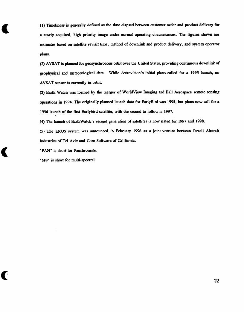
(1) Timeliness is generaily defineci as the time elapsed between customer order and product delivery for
a newly acquired, high priority image under normal operathg circumstances. The figures shown are
estimates based on satellite revisit tirne, mechod of downlink and product delivery, and systern operator
plans.
(2) AVSAT is planned for geosynchronous orbit over the United States, providing continuous downlinL of
geophysical and meteorologicol data. W l e Astrovision's initial plans cailed for a 1995 launch, no
AVSAT sensor is cumntly in orbit.
(3) Earth Watch was f o d by the merger of WorldView Imaging and Bal1 Aerospace remote sensing
operations in 1994. The o r i g i d y planned launch date for EarlyBird was 1995. but plans now di for a
1996 launch of the first Earlybird satellite, with the second to follow in 1997.
(4) The launch of EarthWatch's second generation of satellites is now slated for 1997 and 1998.
(5) The EROS system was announced in Febniary 1996 as a joint venture between Israeli Aircraft
industries of Tel Aviv and Core Software of California.
"PAN" is short for Panchromatic
"MSw is short for multi-spectral

CHAPTER 3
THE INTERNATIONAL LAW OF REMOTE SENSINCI
This chapter deals with the applicable public international law and institutions
which regulate space based remote sensing activities. The purpose of the tirst part of
this chapter is to establish the nature and extent of the international laws regarding
space based remote sensing and to explain the environment in which they originated.
The second part of the chapter will examine the pertinence of these rules and their
effect and relevance upon the commerciaiization of remote sensing. The purpose of
the chapter king to illustrate that the original environment responsible for the the
institutional and legal superstructure has been transformed. When there is a contextual
and paradigrnatic evolution institions and legd principles must respect and reflect this
evolution. Science is quickly changing, not only in its content, but also in its relevance
to modern society. The era of big science as a public good has mutated. Science has
now merged with commercial paradigms. The resulting new paradigms are inciting
a conceptual evolution of the laws and institutions.
CHAPTER 3 SECTION 1:
THE OUTER SPACE TREATY AND THE GEOPOLITICAL CLIMATE
It is genedy accepted that the space age began in 1957 when the Soviet Union
launched the fist artificial satellite, Sputnik 1, into orbit. Placed before a 'fait

accompliw the international legal regime had to evolve quickly to keep pace with this
new technological reality." International law had aiways developed slowly over a
long p e n d of time. A new dialectic between the superpowers consisting of muhial
deterrence and technological innovations would greatly accelerate the creation and
evolution of international space law." By 1979, after only twenty-two years, the
"corpus Juns Spatialis" consisting of five international treaties had been created . These
treaties were accompanied by several UN General Assembly resolutions on the
topic. 42
International public space law is essentially composed of treaty law. The
fundamental document which forms the basis of international space law is the Outer
Space Treaty." In 1967, the year of signature of the Outer Space Treaty, the
geopolitical climate of the Cold War stiil prevailed. A polansed bipolar and bipower
globe was not conducive to elaborate treaty making. The result was the creation of a
relatively simple treaty edicting general noms which allowed both superpowers to
continue their space endeavours. The paradigm was one of mutual distrust and
See W. McDougal, The Heavens and Earth. A wlitical histo (New York: Basic Books, 1985).
See S. Hobe, "Peaceful and Military Uses of Outer Space and Space Technology: The Importance of Space Technology to International Space Law" in Third ECSL Summer Course on Smce Law and Policv (Spain: University of Granada, 1994) at 165.
Ibid. at 165. - Treatv on Princi~les Governin~ the Activities of States in the Ex~loration and use of Outer Soace. includin~ the Moon and Other Celestial Bodies, 27 January 1967, T.I. A.S. No. 6347, 610 U.N.T.S. 205 [hereinafter Outer Space Treatyl
24

enlightened self interest where both superpowers agreed not to daim exclusive
sovereignty in outer space? Remote sensing was for both military machines an
essential twl of intelligence gathering. Neither the Sovist Union nor the United States
wanted a treaty which would have a restrictive effect upon thek "mutuaily tolerated use
of reconnaissance satellites or other means of reconnaissance"? The result was a
treaty as eloquent in its silence on certain issues as in what if edicts. It is therefore of
no great surprise that an exegetical analysis of the Outer Space Treaty reveals an
omission of any direct references to remote sensing. However, while the Outer Space
Treaty does not specifically mention remote sensing certain articles can however be
interpreted to apply to remote sensing.
Article II of the Outer Space Treaty edicts that outer space is not subject to
national appropriation. National State sovereignty therefore does not extend into outer
space. Space objects may orbit around the globe irrespective of vertical national
boundaries. This p ~ c i p l e however presupposes the existence of a horizontai national
bounâary over nation States. This horizontal boundary between air and outer space is
a key issue purposefuily ornitted in the Outer Space Treaty. The rationale for this
omission was claimed to be the belief that "any definition of a boundary between air
44 See M. Couston, Droit Soatial Économiaue. Reeimes Aooliçables à 1'Exoloitation de 1'Esoace" (Paris; Société française de droit abrien et spatial, 1995). "Si l'on considbre par exemple le principe de non-appropriation de l'espace et des corps célestes, lourd de conséquences pour les activitks spatiales commerciales, il n'a eté établi que parce que les deux Grands à 1'6poque n'étaient pas sûr, ni l'un ni l'autre, de gagner la course à l'espace et plutôt que de prendre le risque de voir leur adversaire s'approprier cet espace tant convoite, ils ont preféri5 le geler."
45 Hobe, supm note 4 1 at 174.

and outer space would hinder the development of technology and would thus be
useless" ." Although no text formaliy establishes this boundary there appears to be a
consensus that the lowest apogee of a satellite at the time of signature of the Outer
Space Treaty is the limit between air space and outer space, ïicated approximately 100
km above the earth's surface.*'
Article III of the Outer Space Treaty edicts that, in the interest of maintainhg
international peace and security and promoting international cosperation and
understanding, ali activities in space must be done in accordance with international law,
including the Charter of the United Nations." As we have already demonstrated the
collection of data through the use of space based remote sensing equipment is not
contrary to international law. As long as a satellite is at an altitude exceeding 100 km
from the surface of the earth it can be considered to be in outer space and thus does
not intrude in sovereign airspace. In light of this basic fact this thesis argues that
international law encourages the accumulation of data.
The Outer space treaty also edicts that outer space must be used for peaceful
purposes. An interesting interpretative debate ensues. The United States has argued that
Ibid. - The debate over the boundaries and demarcation is beyond the scope of this paper. Several themies exist such as the demarcation based on scientific and technological criteria, or the creation of an arbitrary or conventional boundary, or a boundary based on the functional approach. For an explanation of these theories see 1. H. Diederiks-Verschoor , An In traduction to Soace Law (Deventer: Kluwer Law and Taxation Publishers, 1993) at 15-20.
Outer Space Treaty, suDra note 43.

the t em "peaceful purpose' must be understd to denote non-aggressive purposes.
Taken in this way the word '*peaceful" does not mean non-military. By contrast, the
Soviets argued that the word "peacefulw rneans non rnilitary.
Although this thesis is primatily concemed with commercial use of remote
sensing, the definitional debate over the proper meaning and tenor of the concept
'peaceful" in an exegetical analysis of the Outer Space Treaty remains pertinent. Its
relevance lies in the fact of the dual use of modem civilian technology. The rnilitary
establishment can easily become a consumer of data produced from civilian remote
sensing satellite systems or even a purveyor of commercial data. Therefore if the
concept "peaceful" denotes non military, then the sale of military data coilected by
space based observation assets would be a violation of international law . Assuming that
the Outer Space Treaty is enforceble in domestic law the contract of sale of military
&ta obtained by space based remote sensing equipment would be nuU and void since
the object of the sale would be ficit. The interpretative nuance of this concept is
therefore crucial to the proper functioning of an open commercial market legai
structure.
This thesis argues in favour of the American position. The interpretation of the
word "peaceful" as proferred by the Soviet Union is untenable and at best dubious.
Considering that most satellites and space missions have been carried out by the
military for both the Soviets and the Americans this dissertation argues that the practice

of States tends to favour the non aggression interpretation as proferred by the United
Having detennined that remote sensing is an acceptable space activity
irrespective of its civilian or military aspects, one must now examine ehether
in ternational law aUow s this ac tivity to be commercialized.
CHAPTER 3 SECTION 2:
COMMERCIAL NATURE OF REMOTE SENSING DATA
The Outer Space Treaty, as was indicated earlier, was concluded during the
Cold War at a time when commercial relations between the two superpowers were non-
existent.s0 Commercial considerations were therefore not directly dealt with in the
treaty. This dissertation argues that an exegetical analysis of the Outer Space Treaty
reveals that the terminology of the treaty is however general enough to ailow an
interpretation permitting commercial activities in space.
The words "exploration" and "use" are used repeatedly in the Outer Space
Treaty in its official titie, within the preamble, and in Articles 1 and III. One school
49 On this point and for an excellent analysis on the military use of space, see I.A. Vlasic, "Space Law and the Military Applications of Space Technology" in N. ~asentuliyana, Perswctives on International Law (Boston: Iüuwer Law International, 1995) at 385.
5o Commercial relations were even outlawed by the Trading with the Enemy Act 1917 act oct. 6, 1917, ch. 106, 40 STAT.411.

of thought argues that space must be the object of explorati~n.~' This dissertation
argues that such a restrictive interpretation is untenable and at best specious. The result
of such an interpretation would be to exclude from the Outer Space Treaty a i i practical
space activities directed towsrds earth. An expansive interpretation of these concepts
is in fact much more logical. By the use of an expansive interpretation where
"exploration" means simply scientific research and "use" means the practical
implementation of the result of the said research, one obtains a broad application of the
Outer Space Treaty. under an expansive interpretation, the Outer Space Treaty applies
not only to exploration of space, but also to exploration in and from space? The
word "use" therefore encompasses the practical application of aii of this research. It
has k e n proffered that the statements in the negotiations of the Outer Space Treaty
dong with the Viema Convention on the Law of Treaties argue in favour of an
expansive interpretation."
This point is thoughtfûlly analyzed by H.L. Van Traa-Engelman, who also
argues in favour of an expansive interpretation of these two concepts. Although the
purpose of the Outer Space Treaty is to ensure freedorn of peaceful scientific
exploration of outer space Van Traa-Engelrnan correctly writes that "the combination
of the two words "exploration" and "use" indicates the possibility of a type of use
K.-H. Bockstiegel, Reconsideration of the Legal framework for Commercial Space Activities (ECSL Summer Course, 1994) at 179.

king more comprehensive than a type of use only limited to exploration purposes"."
It bas also been furthet argued that the word "use" must be interpreted as an expansive
attribute to the limited termhology of "exploration" ." Van Traa-Engelman points out
that :
The use particularly of the word progress (in the preamble) supports the conclusion that a progressive use of outer space, although within the limits of peaceful purposes, is not only permitted but even intended to be one of the objects of the treaty. According to Our specifications, since commerciai use can ody take place when a certain level of progress has been obtained, this type of use seems to be stimulated by the treaty as long as the contrary is not evident."
Article 1 of the Outer Space Treaty edicts that:
the exploration and use of outer space ... shall be carried out for the benefit and in the interest of ail countries, irrespective of their degree of economic or scientific development, and shali be the province of al i mankirid.
It has been argued by some authors that Article 1 of the Outer Space Treaty
prohibits commerciai use? This dissertation argues that such an interpretation is at
best specious for it would presuppose the existence of a contradiction between the
benefit and interest of all countries and commercial activity. Furthermore, Van Traa-
Y H.L. van Traa-Engelman, Commercial Utilization of Outer Syce Law and Practice (Dordrecht: Martinus Nij hoff Publishers , 1993) at 20.
55 S.B. Rosenfeld, "Use" in Economic Development of Outer Space, proceedings of the 24th Colloquium on the Law of Outer Space of the IISL, Rome, 6-11 September 198 1, at 73-77.
56 van Traa-Engelman, SUDQ note 54.
" b i d L at 21, where van Traa-Engelman mentions this opposing view.

Engelman correctly points out that "a prohibition has to be based on a clear treaty
obligation"" which is definitely not the case in the above cited text.
Article II edicts that "Outer space ... is not subject to National appropriation".
The purpose of this article is to "strengthen the principle of access and freedom in
outer space by refusing national appropriation claims regarding outer space"." The
intent of this disposition was clearly geopolitical as the superpowers did not want to
deal with reciprod clairns of sovereignty in outer space. Furthemore, national
appropriation is not a necessary prerequisite to commercial activity. Article 11 can
easily coexist with commercial activities.
Article 1 and II have achieved widespread acceptance in the practice of States
to the point where there is international consensus that "the twin principles of freedom
and non-appropriation have acquired the statu of customary law. "'O
Article III edicts the applicability of general p ~ c i p l e s of international law to
space activities. Commercial goals are obviously acceptable in international law.
The Outer Space Treaty never specificaiiy prohibits the commercial use of
space. The contrary is however also me; the Outer Space Treaty never clearly allows
commercial activity in space. Van Tm-Engelman correctly writes that:
whilst the majority of the Articles do not express a specific stance on the issue, a number seem at least to accommodate the commercial use of outer space. What must be noted here is the "heavy emphasis on 'state'
" Ibid. at 21.
59 lbid. at 21.
Feder, SUD^ note 9 at 605.

in the Treaty in general in combination with the provision of Article VI. 61
Article VI of the Outer Space Treaty, however, does impose substantial
restrictions on space activities perfonned by the private space actors which are the
"institutions pre-eminently concemed with commercial use".62 Said Article VI edicts
a rule of State responsibility for private actors in outer space and a corresponding
obligation upon the State to authorize and supervise private space activity so that these
may be carried out in conformity with the provisions set forth in the Outer Space
Treaty. This replation of State action in outer space WU be a strong factor
influencing national legislation of commercial space ac tivities. Its e ffects will be
included in interna1 American law regulating the commerciaiization of remote sensing.
It can be argued that the Outer Space Treaty establishes a legal regime which
prevents legal barriers fiom king established against the commercialization of space.
The treaty does this by establishing negative freedoms for States. The freedoms are
- - - - - - - . - ..
van Traa-Engleman, SuDra note 54 at 23. Article VI OST edicts that "states parties to the treaty shall bear international responsibility for national activities in outer space, including the moon and other celestial bodies, whether such activities are carried on by govemrnental agencies or by non-govemmental entities, and for assuring that national activities are caffied out in conformity with the provisions set forth in the present treaty. The activities of non govemmental
entities in outer space.. . shall require authorization and continuhg supervision by the appropriate State Party to the treaty".
'* nid. at 23. It has been further argued that Article VI of the Outer Space Treaty has been regarded as a part of general intemational law see, Dr. Assad Kotaite (President of the Council of ICAO) "ICAO's Role with Respect to the Institutional Arrangements and Legal Framework of Global Navigation Satelite System (GNSS) Planning and Implementation" said article to be published in the
. next volume of the Annals of Air and Space Law presently on file with the author.

negative simp1y because States are fiee from restrictions. The freedom is therefore
contingent upon their technological and economic capacities to sustain space research
and development. Small States cannot claim any benefits fiom this convention despite
the supposedly idealistic wording of Article 1 of the Outer Space Treaty. In reality
outer space is now king used for the benefit of aii States wbich can afford to pay
for access. Affordability is in tum contingent upon either the interna1 markets for
space products or the accessibiiity to intemational markets for space products.
Other treaties play a minor role in the international regulation of remote
sensing. The Rescue and Retum ~ g r e e m e n t ~ ~ and the 1972 Liability Conventiona
add nothing to remote sensing regulation. At best these two treaties simply reiterate
certain basic principles previously established in the Outer Space Treaty. The
Registration Convention of 197565 edicts in Article II that States must keep a record
of ali space objects launched "by means of an entry in an appropriate registryW.The
manner by which this is accomplished is lefi to the discretion of each state.
Furthermore the same article also imposes an obligation on each launchhg State to
Agreement on the Rescue of Austronauts. the Return of Astronauts and the Retum of obiects Launched into Outer Space, 19 U.S.T. 7570, T.I.A.S. No. 6599, 672 U.N.T.S. 45 [hereinafter Rescue and Retum Agreement].
Convention on International Liabilitv for Damage Caused bv Soace Objects, gwned for signature 29 March 1972, 24 U.S.T. 2389, T.I.A.S. No. 7762, 961 U. N.T.S. 187 mereinafter Liabilitv Convention].
Convention on the Reeistration of Objects Launched into Outer Space. opened for signature 14 Januay 1975, 28 U.S.T. 695, T.I.A.S. No. 8480, 1023 U.N.T.S. 15 mereinafter &gistration Conven tionl .

infonn the Secretary-General of the United Nations of the establishment of such
registry .
The Liability Convention although not dealing directly with remote sensing does
create certain international obligations which influence the Amencan regdatory
structure of this activity. The licensing requirements for remote sensing operators WU
take into consideration the obligations created by the Liabiiity Convention. Tbis point
wiü be examined later in the paper.
It is intereshg to note that private individuals were never the object of space
treaties. The reason for this is simple. During the formative years of space law space
activity was the exclusive domain of the superpowers, one of which had a market
economy while the other was communist. Private enterprise and consequently pnvate
space ventures were therefore not a conceptual option for the Soviet Union. Pnvate
space activity was perceived by the Soviets as an act of piracy. The Kennedy
administration correctly rejected this perception. However the Liability Convention is
a result of a compromise on this issue edicting State liability for private actors in outer
space.
States engaged in commercial activities in outer space benefit from the general
presumption which flows from the five space treaties in favour of freedom of space
activities? The particular effects and specific prescriptions of the five space treaties
are to be found in the following list of general limitations on outer space activity.
66 Bockstiegel, SUD^ note 5 1 at 180.
34

These include the prohibition of national appropriation of outer space (Outer Space
Treaty, An Ki), the duty of due regard to the corresponding interests of a i i other States
and to respect the principle of cwperation and mutual assistance (Outer Space Treaty,
Arts. V, M, X & Xi), the registration obligations (Outer Space Treaty, Art VIII and
Registration Convention) and the duty to respect international law including the Charter
of the United Nations (Outer Space Treaty, Art III)?'
In engaging in space activities private enterprises are subject to the same
limitations as are States. "The rights of private enterprises can not go any further in
public international law as the rights of theû home States"." Furthemore Article VI
of the Outer Space Treaty edicts a State's obligation to supervise its nationals during
their endeavours in space. This disposition bas direct e ffect upon intemal national
positive laws regulating space activities. The manner in which State supervision is
conducted is left to the discretion of each State. Disparities anse when different intemal
laws regulate through a variety of techniques, manners, and institutions, the entry of
private enterprise in the space market. What is certain however is that States have an
obligation at least to inform themselves of their nationals' space activities and to
"exercise influence in such a way that the use of outer space by private enterprise is
in conformity with the Outer Space Treaty."
67 Ibid. at 180.
nidL at 181.
69 Ibid. at 181.
A third obligation of States pertaïning to private commercial enterprises in outer
space emanates fkom Article IX of the Outer Space Treaty, which edicts that
international consultation is a necessary prerequisite if it is reasonable to believe that
any given space activity could be potentiaiiy harmful or interfere with activities of
other State parties. The effect of this disposition cm be quite large, as Dr. Bockstiegel
fkom Cologne University notes:
The private enterprise must be prepared that not only objections may be raised by its home state with regard to the commercial activity it plans, but also by other States and possibly foreign cornpetitors which the other state might consult in that respect. This, of course, raises a number of difficulties, because a private enterprise planning certain space activities might have a high and justified interest in not to bave this information conveyed to any competit~rs.'~
It is important to note that the scope of application of these internationai treaties
is not limited only to nation States. In fact Article Xm of the Outer Space Treaty
provides rules for the applicability of the treaty for inter-govemmental organisations,
Articles VI and X W I of the Outer Space Treaty regulates the applicability of the Outer
Space Treaty to international organisations. These dispositions are not surpnsing for
international govemmental organisations since they are "accepted as subjects of
international law, while this normaiiy is not the case for international non-govemmental
organizations" .'l

CHAPTER 3 SECTION 3:
DEVELOPING COUNTRIES' OBJECTIONS TO THE INTERNATIONAL
REGULATORY FRAMEWORK, S0VE:REIGNTY OVER NATURAL
RESOURCES ARGUMENT:
In edicting the applicability of international law to outer space, the Outer Space
Treaty opened the door to a debate conceming the applicability of conflicthg legal
principles. Certain States argued that the U.N. resolution of 1962 (1803) concerning
"Permanent Sovereignty Over Natural ResourcesnR extended State sovereignty over
ceriain types of data. It was argued that national sovereignty encompassed aIi data
pertaining to natural resources coilected by space based equipment. Conversely, Article
19 of the United Nations Universal Declaration of Human Rights on the fiee flow of
informationn is presented as a legal justification for unrestricted collection of data by
space based remote sensing assets. This latter principle in tum "bears its greatest
relevance in the justification of the doctrine of the free dissemination of, and non-
discriminatory access to information' .14 Although both positions are logicaily
defendable they are contingent upon the ideological presuppositions of the States
concemed. This thesis however opines that the space industry must be based upon the
" Permanent Sovereignty Over Natural Resources, U.N.G.A. 1803 0, UN GAOR, Supp. (No. 17) (1962).
1948 Universal Declaration of Human Rights, G. A. Res. 2 17 A (III) UN GAOR ïïï 1, U.N. DOC. A1180 (1948), art 19.7
74 Van Traa-Engelman, supm note 54 at 236.

principle of maximizing the fkeedom of and to information. The collection of data, the
creation of idormation and the dissemination of both of thesemust be maxUIlaliy
facilitated Modem society is quickly becoming information based. Remote sensing cm
be an important part of this information economy. The fiee flow of overhead irnagery
data is consistent with the values of a fiee and democratic society. Transparency of
information breads public and international confidence and security. An excellent
example of the positive public potential of the use of commercial remote sensing
equipment in an open information market is its usehilnessas a resource for arms
control monitoring7'.
CHAPTER 3 SECTION 4
UNITED NATIONS REMOTE SENSING PRINCIPLES
The United Nations Cornmittee on Peaceful Uses of Outer Space (UNCOPUOS)
produced a document containhg fifteen p ~ c i p l e s pertaining to remote sensing. The
general assembly of the United Nations adopted this text entitled "Principles Relating
to Remote sensing of the Earth From Space' as U.N. resolution 41/65 on December
3 1986.
" On this point see U.N. Document "La Vérification Sous tous ses Aspects, y Compris le Rôle de l'organisation des Nations unies dans le Domaine de la Vérification" rapport du Secrétaire géneral, 95-26409.
The first nation to submit to UNCOPUOS a formal proposal to govern remote
sensing was Argentina in June 1970.76 Sixteen years later and after difficult
negotiations during UNCOPUOS's 29th session, held in June of 1986, a consensus was
reached pertaining to principles of remote ~ e n s i n g . ~ The difficulty in reaching a
conclusion resided in the fact that two distinct visions of remote sensing data ownership
were espoused by the world community. Certain countries, such as "Argentina, Brazii,
and other Latin-American countries believed that the States whose resources were the
subject of remote sensing had a proprietary right to the information about their
country"
The second major issue to be addressed was the accessibility to the data
obtained by remote sensing. The Latin Arnerican countries argued for a priority of
access to the sensed data by the sensed State. The priority of access argument is
predicated upon the previous sovereignty argument and is the logical corollary of that
position. The industrialised countries led by the American govemment were strongly
opposed to these arguments.
P ~ c i p l e 1 establishes the scope of applicability of the principles by edicting a
restrictive definition of remote sensing. It States that remote sensing is to be used "for
the purpose of improving naturai resources management, land use and the protection
76 DeSaussure, SUD^ note 12 at 354.
U.N. Doc, A/AC. 1WL. 158.
" DeSaussures, S Y P C ~ note 12 at 354.

of the en~ironrnent".~~ The principles therefore apply only to civiiian remote sensing
since the miiitary operations are specificaliy excluded from the definition. It can also
be argued that this definition excludes media purposes, that is to say news gathe~g."
Furthemore Principle 1 distinguishes three different types of data which can be
obtained by remote senshg. The classification of types of data is of primary
importance. Primary data is the raw data acquired through remote sensing in the fom
of electromagnetic signals, photograpbic film, magnetic tape or any other medium.*'
Processed Data is defined as pnmary data that has k e n processed to a point where
it can be interpreted." Analyzed information is knowledge resulting from the
interpretation of processed data by use of both the data and information from other
sources .83
The principles can be divided into two themes namely: (a) Principles promoting
cooperation among States, and @) Principles concemhg Sovereignty. Principle II
provides that remote senshg must be camed out for the benefit and interest of all
countries , regardless of their economic , social or technological development , taking the
needs of developing countries into particular consideration. The State which conducts
79 Princioles Relatine to Remote Sensine of the Earth from Outer Soace, G.A. Res. 41/65, 42 U.N. GAOR Annex at 2 (95th plen. mtg) U.N. Doc. A/RES/41/65 (1987) [hereinafter UN Principles on Remote Sensina, Principle I(a).
'O Feder, s u p note 9 at 612.
'' UN Princi~ies on Remote Sensing, supra note 79, Principle I@).
Ibid ., Principle I(c).
fiid L, Principle I(d) .

the remote sensing is encouraged in Principle V to promote international cooperation
by permitting other States to participate in this endeavour. Principle VI promotes the
establishment of State CO-operation in the areas of data collecting, data storage
processing and interpretation. Principle W encourages technical assistance by the
sensing States to other interested States on mutuaily agreeable terms. One of the most
important concepts is articulated in Principle W, which requires that a sensing State
must if requested by the sensed State enter into consultation. The purpose of this is to
give the sensed State the occasion to participate in and partake in the benefits of the
remote sensing operation over its own temtory. P ~ c i p l e IX reiterates the rules of the
Registration Convention requiring declarations to the Secretary General of the United
Nations.
Other Principles address the sovereignty concems of the sensed States by
attempting to "strike a balance between an open skies policy and one respecting
inherent rights of State~".~' Principle IV applies a concept onginaily found in the
Outer Space Treaty to remote sensing by articulating the belief that remote sensing is
to be camed out for the benefit and in the interest of ail countries: "This principle goes
further, however, by ensuring that States conduct these activities with respect for the
principle of fbil and permanent sovereignty of aii States and peoples over their own
wealth and natural resources. "85
Feder , s u ~ r a note 9 at 615.
Tbid. at 615. -

The balance which these principles attempt to achieve is to respect the rights
to fkeedom of information enjoyed by the sensing States, thus ailowing them the right
to coliect data fiom space on other countries, while on the other hand ensuring access
to this data by the sensed State dong with a non prejudicial use of this data by the
sensing State. P ~ c i p l e XII articulates this compromise by establishing access to
primary data and analyzed information on a non discriminatory basis at a reasonable
cost.
Principles X and XI enunciates positive obligations upon sensing States. A
sensing state must disclose information pertaining to disasters and environmental
disasters. Sirnilarly, any information which could prevent environmental damage must
be disclosed.
Principle XIV deals with the Liability of the State for remote sensing activities.
The Principles are very broad in nature and scope. They represent a
compromise between two different visions of the world. The legal status of these
Principles must now be discussed in order to ascertaine properly their tme value.
The principles are contained in a United Nations General Assembly resolution.
They are not contained in a treaty. A U.N. resolution does not legaliy bind the States
which voted for it. Furthermore the resolutions contain new concepts that are not the
codification of existing customary law. It has k e n argued that international law in
space couid be rapidly created as a form of instant customary law." Applying such

a position to the remote sensing principles is at best specious. Instant customary
international law lach by definition the attribute of elapsed time in State practice. Such
deficiency must be counterôalanced by a very strong opino juris. AU States which are
space powers must act with the belief that these principles have force of law, which is
dennitely not the case with the Remote Sensing Principles. As H. Feder correctly
argues, the "U.N. resolution cannot transform the Principles ioto customary
International law if they have not found their way into accepted practice"".
These principles have not in their totality k e n incorporated in the intemal law
of States. The principles are only at best able to reinforce existing concepts alieady
present in space treaty law and may only serve a hortatory purpose.
The principles cannot be said to have a moral force akin to the Universal
Declaration of Human Rights; as they are enounced in a resolution and not in a
Declaration their moral force is much weaker. The resolutions are an important step
in the evolution of international space law but they are simply that, a useful step in the
evolution of law.
The result is a resolution which fails to resolve some fundamental disagreements and f d s to set forth a specific regime. Its only real significance is that it expresses the desire of the U.N. to achieve international harmony and coordination in this specific activity, and establish the U.N. Secretary General as a recipient of ail information on national programs
" Ibid. at 617.
88 Desaussures, s u p note 12 at 357.

The result of these principles is twofold. First, the principles are weak in
content and applicabiiity. Member States conserve complete latitude in the
promulgation of their own values on remote sensing. Second, the principles on remote
sensing and the general international space treaty law were designed in accordance with
a paradigm which is passé, which no longer reflects the reaiity of the world today. As
previously stated this body of law was i~tially formed during the Cold War in a
bipwer bipolar geopolitical system. The dissolution of the USSR canceiïed this
paradigm. Furthemore the Principles on remote sensing were a compromise between
the developing States and the developed nations. This North-South dichotomy was
predicated upon the mistrust that the developing world had of the use the developed
States would make of the wealth of information obtained by remote sensing.
Information is now the comerstone upon which modem society is built.
Marshall McLuhan showed great foresight in coining the term "global village".
Through remote sensing the global village is becoming even smaller. It is not just the
communication within the viilage which technology has made easier, one can now see
everywhere within the village.
The old "corpus juris" of space law was based on State actors. The State
actors were in an ideological dialectical relationship, that is communist vs capitalist
and developed vs. developing. The dialectics have now c hanged. The capitalist-
communist division is no longer pertinent. The north-south dichotomy is quickly
evolving through easier access to technology. The developing countries are no longer

a forum for ideological clashes between the superpowers. The present public space law
legal system, unfominately, has not kept pace with this evolution.
One can conclude that international Law was formed in an epoch where States
were the only participants in space activity. The initial activities, and even more so for
remote sensing, were either military in nature or had a strong public goods attribute,
as in weather forecasting. However international law does impose certain obligations
upon States which must be reflected in their intemal legal dispositions. Briefly stated
these are:
(a) There must be a peacefbl use;
@) No nuclear use;
(c) Space used for the benefit of mankind; and,
(d) Non appropriation of outer space.
The entire body of space law does not prevent private industry from
participahg in space, although rules of liability do make States responsible for pnvate
actors. International law has been made according to a public paradigm. Due to their
origin, these laws ignore values which are important to the creation of an international
market where competitive forces can distribute the allocation of resources in an
efficient and competitive manner. Such a market environment encourages an equitable
use of outer space.
Present international law structures do not address problems of market entry,
price fixing and market divisions. The next chapter wiii examine how the American
legislation has created a protective environment for the American space industry. The

Amencan regulatory structure represent the most complete and influentid space legal
structure currently in force. The Amencan space industry is so powerful that its
regulatory system can influence global market stmctures. It is therefore imperative for
the Americans to take the initiative to liberate the legal structure fiom old paradigms
which &der the development of an open and cornpetitive international market.

CHAPTER 4
AMERICAN LAWS AND REGULATIONS OF REMOTE SENSING
This chapter wiii analyze the evolution of the American regulatory regime
govenllng remote sensing. The policy evolution wiil be outlined from a purely
operational govemmentaî service through the unsuccesshil attempt in 1984 to
commercialise and privatise the Landsat remote sensing program, to the new 1992
Land Remote Sensing Policy Act. The chapter wili argue that American remote sensing
policy has been characterised by a myopic view of the role of the remote sensing
industry which has resulted in incomplete deregulation and a dysfunctional system. The
origin of space based remote sensing technology as a tool of national security has
created a conceptual legacy which permeates the American regulatory culture.
Regulations contain bûdly defined terms and overly discretionary powers. The effects
of the regdations are counterproductive to the declared goals of the present laws. The
major concem outlined in this thesis is that paradigms have changed. Commercial
space based remote sensing operators must now take over a system that was established
as a bureaucratie govemmental structure. Furthermore commercial remote sensing
operators must deal with a regulatory scheme which was woven with concepts not
conducive to the proper hinctioning of a market based structure.
The core of the argument within this chapter is the following. In a manner
simiiar to the International contextual change the original intemal environment has
mutated. A new environment produces a new conceptual response. The result of a new

conceptual response is the creation of a distinct paradigm, that is, distinct to its epoch.
The new paradigm fùnctions as a novel homogeneous ethos upon which social
constructs, perceptions, and relations between the individual and institutions are based.
The manner in which the gregarious interactions are defined therefore changes. The
institutions through which our human interrelations occurs must therefore evolve. This
chapter shall examine the American legislative evolution and resulting regulatory
structures which define the manner in which commercial remote sensing operators
function. This chapter argues that the resulting new paradigm is currently forcing a
conceptual evolution to occur. That is, an efficient market paradigm is presently the
best criteon upon which to structure the manner in which commercial remote sensing
is to be regulated. Regdations must therefore evolve from its military and national
security origins to a more liberal, predictable and transparent structure. ' f i s king
said, the national security concems although no longer dominant are still nonetheless
pertinent. The pertinance of national security concems must be secondary in
importance and effect to an efficient market regulation. The problem with the present
replatory structure is that the national secunty concems ara overbearing upon the
market concerns. A new regulatory culture must create a balance where the national
security concems are addressed and proportionately balanced with the commercial
evolution. This chapter will argue for a simple change in emphasis away from the
historical dominance of national security concems in space based remote sensing. That
is the primary crirereon of choice for a regulatory structure must be commercial
viability, openness and predictability.

The second part of this analysis s h d examine the need for regulatory change
resulting fkom this new paradigm. The anaiysis wiil show a lingering resistance within
the American regulatory culture to the new paradigm. The resistance to change being
evidenced by the survival, and persistant use of the "national security" concept
acompanied by a variety of ambiguous terminology yielding overly discretionary
powers within the institutional and regulatory hmework. Although the "national
security" concems was initially the "raison d'être" of this technology the concept is
now the source of stress causing tensions with the new paradigm. The tension is
evidenced by a lack of predictability and transparancy, both necessary attributes to the
evolution of remote sensing in the market based paradigm of the new environment.
Due to the contemporary prevalence of protectionist attitudes the 1984
legislationB9 faiied to create a market in which the space based remote sensing
industry could become self sufficient. Protectionist attitudes are no longer relevant in
today's modem global market environment. The 1992 act corrected certain lacunae,
but a cold war protectionist penchant prevented an adequate liberalisation and
harmonization of the regulations governing remote sensing.
The essence of the argument is that the present regulatory structure lacks
transparency and predictability. There are inherent contradictions, regulatory
redundancies, and needless market entry barriers creating an overly bureaucratised
system. The result is an inefficient, poorly stnictured and fractured market for the
89 The Land Remote Sensino Commercialization Act, 15 U.S.C. ss. 4200 (Supp. IV 1986) pereinafter Land Remote Sensine Co. Act].

remote sensing industry. This thesis wiU argue for an evolution in the American
regulatory culture away from Cold War worries to a more dynamic and open global
information market structure reflecting new paradigms. The American tradition bas
k e n to maximise freedom. Trade wars have been fought to open foreign markets. This
tradition of openess must be refiected in the space based remote sensing regulatory
structure.
CHAPTER 4 SECTION 1:
LAND REMOTE SENSING COMMERCIALIZATION ACT
In 1958 the Amencan govemment established a civilian space agency calied the
National Aeronautics and Space Administration (hereinafier cded NASA). Before
privatization began in 1984 NASA had launched 5 Landsat satellites. The Carter
administration in 1979 established as one of its goals the commercialization of the
Landsat remote sensing program.'" The policy was maintained by the Reagan
administration which declared in March 1983 its intention to complete the process
initiated by the previous Democratic admini~tration.~~ Meteorological satellites were
Desaussure, SUD@ note 12 at 365.
Ibid. at 365.

however to be excluded from privatisation as it was estimated that this was a public
good service."
Up until this pmcess began the Landsat program was administered by the
National Aeronautics and Space Administration (NASA). NASA's mandate was to
"conduct research and to develop space technology for transfer to the pnvate
~ e c t o r " . ~ ~ The result of this policy change began with the transfer of the Landsat
system to the National Oceanic and Atmospheric Administration (NOAA) in 1984.94
The Department of Commerce was entrusted with the task of negotiating and
transferring the control of the Landsat program to private enterprise9? Seven bidders
were initialiy interested in purchashg the Landsat system. The ultimate winner was
a consortium calied Earth-Orbiting Satellite Company (EOSAT), composed of RCA
and Hughes Aircraft. The privatization contract was finally signed on September 27,
1985.
The declared putpose of the Land Remote Sensing Commercialization Act of
1984 was to "provide for the phased orderly commercialization of land remote sensing
- - - - - . - - . . - - - - - . . - - . p. -- - - .
S. Parisien, "La Commercialisation des Activités de T61éd6tection Spatiale aux États-unis: Consid6rations Nationales et Internationales'' (1995) XW Ann. Air & Sp. L. 241 at 243.
93 K.M. Eisenbeis, Privatizine Govemment Information The Effects of Policv on Access to Landsat Satellite Data (London: Scarecrow Press, 1995) at 5.
DeSaussures, SUD^ note 12 at 365.
95 Ibid. at 365.

technologies" .96 Previously established French and Soviet commerciali;riition programs
forced the American government to react so as not to lose what were perceived to be
economic benefits from space technology. At the time it was estimated that sales from
the French SPOT remote sensing satellite program were to reach the ten million d o b
($lO,Oûû,OûO.ûû USD) leveLg7 The Soviets were also starting to commercialise their
sateilite imagery through a government mapping agency caiied Soyuzkarta.
The Land Remote Sensing Commercialkation Act does not contain a legal
definition of remote sensing. In the regulations adopted pursuant to this act a definition
can however be found where the activity is defineci more broadly than what the U.N.
principles ailow. The UN principles limit remote sensing to the sensing of the earth for
the purpose of irnproving natural resources management, land use and in the
protection of the environme~t.~~ The Land Remote Sensing Commerciahtion Act
on the other hand provides that remote sensing data is to be a major benefit in
managing the earth9s natural resources and in planninr and conductinn many
other activities of economic Neither the American regulations nor the
U.N. principles provide limits establishing a maximum level of resolution (GSD)
permissible. However data is subject to govemmental review through the Secretary of
% Ibid. at 365.
" Ibid. at 366.
98 UN Princides on Remote Sensinq, supra note 79.
* 15 U.S.C. section 4201(1) (Supp. IV 1986).
Commerce for cornpliance with the national security and international obligations of
the United States. 'Oo
The Amencan legislation does not follow the United Nations tripartite
classification of data but refers only to either basic or unenhanced data. American
regulations however do go a step further than the U.N. document in describing data
as either king basic, experimentai or unenhanced.lol Basic data is that collected by
private licensees which is selected by the govemment for public storage.lm
Experimental data is &ta collected by the United States govemment in experimental
programs.'" Unenhanced Data is the substantial equivalent of the U.N. definition
for primary data because it is the unprocessed or minimally processed signals of nùns
colle~ted. '~ American regulations add another definition in the t e m "value added
activity" which is "any activity that substantiaily and irreversibly changes the
information content of the unenhanced &ta". 'O5 As Desaussures writes, this last
'" DeSaussure, supra note 12 at 368; see also 15 U.S.C. sections 4203(c), 4241@), 4243(a)(l) (Supp. IV 1986); 15 C.F.R. sections 960.l(a), (c) (1988).
'O1 Rules and Regulations Federal Register, Vol. 52:132, p.25966 (herein after refered to as Rules and Regulations) section 960.3.
*OL Ibid.
Ibid.
'OL Ibid See also DeSaussure, supra note 12 at 368.

classification ''would cover both the prirnary data and analyzed information
classifications contained in the principles". lM
The United Nations principles offer a somewhat more Liberal mode1 for data
accessibility than the one espoused by the 1984 American legislation. As previously
outlined, the U.N. principles proffer immediate availability of both the prirnary and the
processed data by the sensed State on a nondiscriminatory basis and at reasonable
co~ts.'~' On the other hand, American legislation allows nondiscriminatory access to
ai i potential users for only raw or unenhanced data.''' The American legislation
appears prima facie more liberal than the UN Principles as far as determinhg who has
access to raw data is concemed as it opens the nondiscriminatory principle to all
prospective buyerslW instead of only to the sensed State. The nondiscrirninatory
basis is subject to an exception based on "national Security concerns". Il0 However
this discretionary exemption was maintained in the 1992 legislation and creates
inherent regulatory tensions. The Amencan legislation is however more restrictive than
the U.N. principles in limiting the type of data to which users have access. The result
of the American vision is that less data is available on a nondiscriminatory basis to a
'O6 Desaussure, SUDW note 12 at 369.
107 Rernote Sensing Principles XII, SUD^ note 79.
lm 15 U.S.C. section 601(a).
'" 15 U.S.C. 4204(3)(B).
''O 15 U.S.C. 4204(3)(A).

larger market. Furthermore the concept "nondiscriminatory" is defined within the
L.R.S.C.A. as king;
. . . without preference, bias or any other special arrangement . . . regarding delivery , format, financing , or technical considerations which would favour one buyer or class of buyers over another ...
The sale of data is made on a aondiscrirniaatory basis only if (i) any offer to seil or deliver data is published in advance in such a manner as will ensure that the offer is equaiiy available to al l prospective buyers; (6) the system operator has not established or changed any price, policy, procedure, or other term or condition in a manner which gives one buyer or class of buyer de facto favoured access to &ta; (üi) the system operator does not make unenhansed data available to any purchaser on an exclusive basis; and (iv) in a case where a system operator offers volume discounts, such discounts are no greater than the demonstrable reductions in the cost of volume
The nondiscriscrimination p ~ c i p l e contained in the 1984 legislation was applicable to
every remote sensing satellite operator.u2 Furthermore it was established as a
"rationale for equally charging al i users substantiaiiy higher data prices".l13 This
dubious conception of the "nondiscnminatory" concept had negative effects upon
several areas of American policy.
First, the higher data cost had a negative effect upon its purchase by
developing nations.'14 As J o a ~ e Irene Gabrynowicz correctly argues, this practice
of increased data prices had a negative effect on American foreign policy in that;
L.R.S.C.A., S. 104(3)@)
L.R.S.C.A., S. 601(a).
Il3 J.I. Gabrynowicz, "The Promise and Problems of the Land Remote Sensing Policy Act of 1992" (1993) 10 Space Policy 3 19 at 322.

Non-discriminatory access as a foreign poîicy was seriously weakened, denying data to a number of foreign users and denying the USA a practice which had resulted in foreign good will, enhanced intergovemmental relationships, and the democratization of foreign institutions through making w ith econornic, political and environmental value available to other nations. IlS
Second, by forcing ali private enterprises to seii aii data in the same marner,
an important characteristic of private markets was legislatively canceiied. The basic
reality of markets is that al1 customers do not have equal needs.l16 Producers should
have the ability to negotiate different pricing arrangements for valid commercial
reasons. For example different purchasers can create a given level of economic
certainty for the supplier. Space based remote sensing operators should be aliowed to
benefit from exclusive data supply arrangements. Market entry can be facilitated and
secured with exclusive supply contracts. Consequently this interpretation "barred many
cornpetitive pricing practices and prevented start-up ventures from attracting capital via
exclusivity clausest'. ' l7 The defective concept of "non discrimination" espoused
within the Land Remote Sensing Commercialization Act therefore functioned as a
barrier to market entry. Niche markets could not be created. This conceptual flaw of
the Land Remote Sensing Commercialization Act proved to be a major consideration
for the legislative retooling of remote sensing data market regulations.
Il6 Plato had written in the Republic that there is nothing more unequal than treating unequals equally!
Il7 S. Pace, The Re~ulation of Commercial Remote Sensing System~ (Santa Monica, CA: RAND, 1994) at 3.

There is a caveat which must be respected with exclusive data supply contracts.
The potential danger of exclusive supply contracts is that they can becorne a form of
anti-cornpetitive vertical market structure. Hence generating the need for proper anti-
trust regulation in order to aiiow these contracts to coherently function within a
cornpetitive market structure.
From a commercial point of view it is important to note the effect of the non
discriminatory p ~ c i p l e upon imagery publication. The key question to ask is whether
imagery can be published before the unenhanced data has been made comrnercially
available? This dissertation argues that the nondiscriminatory principle should not
prevent initial publication of imagery if there are no undue time constraints for
subsequent commercial data accessibility by other purchasers.
Once the raw data has gone through a value added process a form of propnetary
rights are created in the American legislation where nondiscriminatory and open access
rules are denied. "The proprietor of the information can deny access to others, or seiï
11 118 it on any basis and at any price he chooses .
In the füst phase of the program, the United States govemment maintained its
owaership of the Landsat system and of the raw and primary &ta.llg EOSAT
acquired rights to revenues fkom the sale of data.'20 EOSAT was to be considered
as an agent of the Secretary of Commerce insofar as its relationship with the foreign
118 Desaussure, SUD^ note 12 at 369.
Il9 Land Remote Sensine Co Ac?, supra note 89, art. 201@).
nid., art. 204(a).
ground reception stations wwas concemed. EOSAT was legally obliged to distribute
raw data to all potential purchasers on a non discriminatory basis."' The price of
data was to be established by EOSAT itself on a profit oriented basis.lP
The American government kept indirect control of the data through the
Secretary of Commerce. Foreign contracts had to be notified to the Secretary of
Commerce. This regulatory structure is another example of the coid war legacy
permeated with national security concems. The entire system was to be transferred to
the private sector which had to ensure continuity and new satellites.
This fïrst attempt at privatisation was a failure. Data costs were too high for the
market. The product was not very cornpetitive with the French SPOT system or with
the Soviets, both of which were selling higher resolution images. As D. Mussington
wntes, the 1984 regulatory structure had created a perverse regulatory structure "which
stifled innovations, (and) raised unit pnces for images and imagery technologies to
exceedingly high levels". l3 The Americans concluded that a legislative retooling was
required if they were to maintain theû international leadership in this field.
12' 15 U.S.C. 4215, S. 205(a).
ln L.R.S.C.A, SUD^ note 89, art. 202(a)(l).
lU D. Mussington, US Foreign Economic policy and high technol~v Industries: The Case of Irnginine and satellite Technolog& (Monterey , California; Monterey Institute of International S tudies, Center for International Trade S trategy , 1995).
CHAPTER 4 SECTION 2:
LAND REMOTE SENSING POLICY ACT
The Land Remote Sensing Policy Act was signed by President George Bush on
28 October 1992.12* The Law reasserts the wiii of the United States to maintain its
world leadership in satellite remote sensing. Such a statement of "world leadership" is
uncharacteristic of American legislation. Political and strategical concems were
probably the main motivathg factor for such a declaration.
The Land Remote Sensing Policy Act cancelled the privatization goals of the
1984 act by stating clearly in section 5601 (6) that "full commercialization of the
Landsat program cannot be achieved within the foreseeable funire " . The philosophy
of the previous act, which rejected the maintenance of a pubiicly tinanced space based
remote sensing system, was cancelled. The Land Remote Sensing Policy Act
"recognises that using public funds for remote sensing satellites is a national investment
that makes long-term commercialization by the private sector possible".'^ It is
politicaliy easier to estabiish positive goals than to state that the previous act was an
error or failure. The Land Remote Sensing Policy Act abandons the phased transition
to a fuUy commercial system in a politically adroit and skilfuliy drafted marner. The
American govemment also reestablishes its financial commitment to the Landsat
program.
HR 6133, 102nd Congress, 2nd Sess., 5 October 1992.
lU Gabrynowicz, SUD^ note 1 13 at 32 1.

Under the Land Remote Sensing Policy Act remote sensing looses its purely
civilian designation. The Land Remote Sensing Policy Act tacitly achowledges the
hybrid military-civilian use of overhead irnapiog technology. This recognition is w t
explicitly stated but emanates fiom the management structure established by the
legislation. The Management of the Landsat program is no longer to be the sole
responsibility of the Department of Commerce, but is now assigned to a joint
Department of Defense and NASA program called "Landsat Management Program".
In this sense the new law correctly reflects a major characteristic of overhead imagery
technology but fails to establish a proper balance between the two branches of
government. It is correct to maintain an aspect of "national security". It is however
wrong in attempting to create a market structure to maintain an emphasis of priority
of "national security" in a commercial structure. What is required is a structure where
national security concems can be addressed without causing prejudice to market
structures. Even an excess of a good thing stiU remains an excess just the same.
Seen in this Light the Land Remote Sensing Policy Act is a good, albeit an
imperfect evolution fkom the previous act, which did not recog~se the dual nature of
the technology. Considering the dual use of the technology and the potential for
military purchase and use of civilian data the new joint management is a can become
positive aspect of the Land Remote Sensing Policy Act if a proper balance between the
military and commercial paradigms is established.
The Land Remote Sensing Policy Act maintains the open skies concept and
redefines the nondiscriminatory data access principles previously edicted within the
"Land Remote Sensing Commercialization Act" of 1984. The redefmition limits the
scope of applicability of the nondiscriminatory principle to Landsat or government
(USA) funded remote sensing programs. Privately hinded remote sensing enterprises
are no longer encumbered by a non discretionary pncing mechanism. Section 5651 of
the Land Remote Sensing Policy Act edicts that:
... any unenhansed data generated bv the Landsat svstem or any other remote sensine svstem funded and owned bv the United States Govemment shali be made available to ali users without preference, bias, or any other special arrangement ... regarding delivery, format, pncing , or technical considerations w hich would favour one customer or cfass of customers over another?
The change in policy leading to a redefïnition of the nondiscriminatory concept
of the American remote sensing legislation presupposes a review of the American
interpretation of the U.N remote sensing principles.
The Land Remote Sensing Policy Act marks a truly important change in the
American interpretation of the UN remote sensing p ~ c i p l e s hereinabove analyzed.
Prior to the Land Remote Sensing Policy Act it was argued that P ~ c i p l e W
pertaining to the dissemination of data only applied to data collected by remote sensing
systems which were operated by States. The argument was based on the premise that
"data nom private systems was not available to the State, therefore it was unavailable
for the purposes of the Principles". 12' According to this theory private remote sensing
operators would not have a legal or moral obligation to communicate data to a sensed
126 L.R.S.P.A., SUD^ note 89.
ln Gabrynowicz, SUD^ note 113 at 325.

State. In its tùst attempt at commercial remote sensing legislation the American
govemment did not adopt the U.N. principle of data accessibility privileges for a
sensed State? The 1992 act reflects a very clear policy change concemhg this
point, extending the scope of applicability of data accessibility privileges by sensed
States to pnvate remote sensing companies in section 5621 @) of said act. The Land
Remote Sensing Policy Act edicts clear and specific rules which oblige pnvate
companies to ensure data accessibility to foreign govemments. 12' This is an important
aspect of the new regulatory structure as it is incorporated within the mandatory
conditions for licensing private remote sensing operators within section 960.12(d)(l)
of the regulations. In this respect the Land Remote Sensing Policy Act data rules and
Licensing requirements resemble the UN principles.
International law evolves through the practice of States. The practice of States
can be evidenced by their internai positive laws. The practice of States is particularly
important for space iaw when one examines the practice of the major States involved
in space activity. The US is ineluctably the major State present in space. This
dissertation therefore argues that the Amencan policy on remote sensing as edicted in
12' Section 601 (a) of the Land Remote Sensing Commercialisation Act edicts that "Any unenhanced data generated by any system operator under the provision of this act shall be made available to al1 users on a nondiscriminatory basis in accordance with the requirements of this act."
'29 Land Remote Sensing Policy Act of 1992, sanctioned October 28 1992 15 USC 5601, (also herein refered to as L.R.S.P.A.) sections. 5622@)(2), edicts that a lisencee must "make available to the govemment of any country (including the United States) unenhanced data collecteci by the system conceming the temtory under the jurisdiction of such govemment as soon as such data are available and on reasonable ternis and conditions " .

the Land Remote Sensing Policy Act has a definite effect upon the interpretation of the
UN remote sensing principles (specificaliy principle XI I ) and their applicability to
private entities partaking in this activity .
Under the Land Remote Sensing Policy Act the cost structure of the data has
been reduced, since profitability is no longer a criterion for data sales. Section 5651
(a) edicts that data "shd be made available to ali users without preference, bias or any
other special arrangements. The only exception is to be found in section 5651 @) for
data sold to the US govemment to be used solely for non commercial purposes.
n 130 Unenhanced data is now to be supplied at "the cost of fulfilling user requests ,
which in turn is defined in the Land Remote Sensing Policy Act as being
the incremental costs associated with providing product generation, reproduction, and distribution of unenhanced data in response to user request and shali not include any acquisition, amortitation, or depreciation of capital assets originaliy paid for by the Unites States Govemment or other costs not specifically attributable to fulfdiing user requests. 131
CHAPTER 4 SECTION 3:
MARKET ANALYSIS
This section wili analyze market structures resulting From the existing
international and Amencan regulatory framework descnbed above. The
130 Ibid., S. 5613(a).
13' %id., S. 5602(2).

commerciaiization of remote sensing presupposes the cornmodification of data.
Information as a marketable product has inherent attributes producing a distinct market.
CHAITER 4 SECTION 3 SUB!3ECTION 1:
MARKET STRUCTURE
First, information or knowledge is a non consumable product in the sense that
data, once obtained, can be easily stored and become the object of a multiplicity of
commercial transactions. Once data is obtained or created its reproduction cost is
minimal. Furthemore data can theoreticaily be sold infinitely as it never gets used up.
Data can however become outdated. In remote sensing this results from improvements
in the technological means to achieve a smalier degree of ground separation distance
through sophisticated higher resolution technology. This, however, does not mean that
old data necessarily looses its pertinence or usefûlness. In comparative analysis, an
important part of remote sensing, older data is used to evaluate the physical evolution
of an area. In this way new data can make old data useful. Hence the necessity of
properly archiving data.13' The Land Remote Sensing Policy Act adresses this point
- - - - - - - - - - - - - - - - - - - - -- - - - - - - -- --
132 "It has been estimated that Earth observation satelites will produce of the order of 20 Tbits (20 x 10 twelfth power bits) of data per day. These data, together with the data previously accumulated, will produce archives of Earth observation data which will contain in total the order of 100,000 tbits by the year 2005.2, see R. Harris & R. Krawec, "Some Current International and National Earth Observation Data Policy " (1993) 9 Space Policy 273.

in its pricing policy . The investment in researc h, processing , storage, and distribution,
is deemed not to be recovered in the data price mechanism.
Secondly, prior to the commerciaLization movement remote sensing data was
considered a public good. The Land Remote Sensing Policy Act maintains this attribute
for weather satellites.'" Comrnerciaiization necessarily presupposes the inclusion of
data in the private realm within a system of private property. The rationale for this is
that data can then "be produced and sold in the market in order to take advantage of
the efficiency of the market"."' The problem with transferring a good fiom the
public realm to the private realm lies in the fact that transaction costs for the
participants are increased in a private market struct~re.''~ For the transition to be
worthwhile the efficiency gained in the market structure must therefore be greater than
the resulting increased transaction costs. Without a properly structured market
mechanism the transition could exacerbate market distortions . 13'
The supply side of the Earth observation industry is composed of four
interlinked levels , 13' these are:
(1) spacecraft and sensor manufacture;
-- -
'" L.R.S.P.A., S. 5671, s u ~ r a note 129.
R. Mansell & S. Paltridge, "The Earth Observation Market: Industrial Dynamics and their Impact on Data Policy" (1993) 9 Space Policy 286 at 290.
MX. Macauley & M.A. Toman, "Providing Earth Observation Data from Space: Economics and Institutions" 8 1 American Economics Review. 38 at 39 (199 1).

(2) spacecraft system launch;
(3) sensor system operation, signal transfer to ground stations, and primary
processing of information; and,
(4) "value added" processing and dissemination of imagery.
One of the results of the American policy is the creation of a v e r t i d y
integrated market.13' Level No. 3 was in fact legislatively integrated with level 1
by the American decision to aiiow EOSAT to operate the Landsat system. EOSAT
is a company whose corporate ownership has changed since 1984 and which is
currently controlled by Hughes Aircrafi Company and the Lockheed Martin
C~rporation"~ (level 1 and level 2 space segment suppliers). The rationale for
jus tehg vertical integration in this market is tah the cost of a Landsat satellite is
approximately 300 million USD per unit.I4O The cost is so excessively high that the
capital investment cannot be justified by the revenues of raw data sales alone.
Commercial viability can only be ensured if satellite builders and operators "gain
13* This phenornenon is not exclusive to the American market as Vertical integration has also occured in the Canadian and French remote sensing industry. See Mussington, SUD^ note 81 at 72, which illustrated this "SPOT image's purchase of a 20 per cent stake in Imagerie Stereo Applique au Relief (ISTAR), a small image-enhancement company involved in the processing satellite and aircraft images; Martin Marietta's purchase of a 15 per cent equity stake in Radarsat International Eosat's purchase of distribution nghts for IRS-P2 satellite imagery.
139 http:/lwww.eosat.com/EOS~TEXT/PUBLiC/whoeosat. html at 1.
140 S. Pace, "Remote Sensing and Global Competitiveness" (Santa Monica, CA: RAND, 1993) at 4.

downstream revenues from value-added distribution and application""'. Furthemore,
vertical integration is, accordùig to this school of thought, a means of reducing
dependence of the data processing sector from exclusive government data suppliers.
Govemment is thus seen as an added risk factor in a commercial venture. It is argued
that govemments are subject to possible political variances affecting data supply policy.
In defending this theory Scott Pace writes:
Thus while it is tempting to rely on subsidized govemment data (whether nom the U.S. or elsewhere), longer run pressures by both suppliers and users should be towards competitive, vertical alliances providing different types of remote sensing data. Such alliances can provide market feedback to new technology developments, enhance technology transfer among members, and establish market openings for other products of alliance members. 14*
Mr. Pace's argument is fine as far as it goes, but it does not go far enough.
Granted, vertical integration can at times be a usefull tool in corporate development.
There are however certain anti-trust concerns with this form of commercial structure.
Vertical integration is not the panacea to the problems of commercial remote sensing.
Even private industry has admitted that this market structure has its lacunae.
Initiaily EOSAT claimed to refuse vertical integration of the American overhead
imagery market.lq This was too little too late since vertical integration was already
14* Ibid.
143 See Mansell & Paltridge, s u m a note 134 at 295 "in the United States, Hughes and General Electric (after its purchase of RCA), EOSAT's parent companies, have resisted suggestions that their subsidiary should enter the value added services market for earth obsentation data. EOSAT has claimed that entering the value added services market would be akin to competing with its own customers

a "fait accompli" due to the corporate ownership of EOSAT. The potential problem in
the American structure is tbat Hughes is a dominant primary space contractor. This
vertical integration places Hughes in a conflict of interest position when marketing
remote sensing satellites. Furthermore Eosat may not oniy control the supply side of
images but also a large portion of the value added market. This king said, it is
however important to keep in mind that vertical integration is not necessarily coatrary
to anti-trust laws.'" Vertical integration however does become a problem if and
when it is used as a tool by major players to control price structures and limit market
entry. If pricing in a verticaliy integrated satellite data market reflects the total
industrial structure from the space supplier down to the data supplier the result is a
distorted pricing mechanism. If the demand-supply pricing mechanism is distorted (i.e.
does not reflect tme end user demand) a reduction in market entry possibilities for new
participants which are not linked with primary space suppliers results.
For the space segment suppliers this (vertical integration) has the advantage of allowing them to own the intermediaries between the end users and govemment agencies who buy the space systems. They are in a strong position to influence the flow of information along the value added chain. They are also well positioned to influence prices as long as economic rights in Earth observation data products are effectively maintained. 14'
although this position may be changing as EOSAT is explonng options to sel1 more than raw data."
For an interesting on the effect of economic theory and the evolution of antitrust law pertaining to vertical integration see S. C. S teven , " Exclusionary Vertical Restraints Law; Has Economics Mattered" (1993) 83 Amencan Economic Review 168.
ManseIl & Paltridge, SUD^ note 134 a? 296.
The Landsat system was stnictured in a time when profitability of the operation
was not an important consideration. As earlier indicated in the thesis, Laudsat ground
structures were not conceived of as efficiency would dictate, k ing artificially seperated
in three different States. Landsat is a conceptual relic from a govemmental 'big
science" era. This thesis argues that the Land Remote Sensing Policy Act makes a
strategic error in attempting to make the system profitable through vertical market
integration.
The fact remains that pnor to privatisation Landsat was a govemment operated
monopoly. The commercialization of the Landsat system was a big gift to the Hughes
and Martin Marietta group. The transfer of a monopoly to private space contractors
without a recuperation by the Amencan govemment of its investment created a
govemment subsidised industry. In this case vertical integration was used to transfer
a govemment monopolistic industry into the private market place. This imperfect
market structure can, if improperly supervised, give rise to various types of unfair
market practices.
The consequence of this market structure could be the manipulation of the
smaiier &ta market for the benefit of the space segment suppliers, that is the sale of
satellites? Vertical integration can also lead to exclusionary market power. In this
case Hughes, king a large satellite manufacturer, can affect the costs of EOSAT's
14' Ibid' at 296. "In a marketplace characterized by this type of integration it is likely that the intemediaries will seek to minimize the potential for new entry in the data intermediary segment of the market and to maximize the iikelihood of continuing demand for space segment construction".

cornpetitors. Anti-trust laws must therefore be vigilantly applied to prevent market
distortions.
CHAPTER 4 SECTION 3 SUBSECTION 11:
lMARKET ENTRY
Market entry for new participants in the remote sensing industry can be very
difficult. This section will analyze market entry for remote sensing satellite operation
from three perspectives: (a) satellite launching and deployment ; (b) Licensing
requirernents; and (c) ground station contracts.
CHAPTER 4 SECTION 3 SUBSECTION II A:
MARKER ENTRY: SATELLITE LAUNCHING AND DEPLOYMENT
Satellite development (a level No. 1 entry) and deploy ment (a level No. 2 entry)
are very expensive, thus creating a strong bamer to new participants. The main
economic concern in a systems launch is the determination of the financial viability of
either a large platform with many sensors or the use of several smaii platfor~ns.'~~
The American legislation establishes a policy choice favouring the large complex space
platform by edicting the continuation of the Landsat program. On the positive side this
choice represents an economy of scale, while on the negative side the choice is
ld7 Maccauley & Toman, SUD^ note 137 at 39.
70

accompanied with a higher level of launch risks. The recent launch Mure of a Landsat
satellite proved damaging to the Amencan expenment, precipitating a legislative
change to the Land Remote Sensing Policy Act and the reemergence of govemment
intervention to rescue a weakened participant in a pnvate market.
This dissertation argues that if commercialization was in fact the primary
concem of the Amencan government the most logical choice would have been to
favour within the Land Remote Sensing Policy Act the development and deployment
of s m d scale space imaging systems.'" The commercial advantages of smaii scale
space imaging systems are clear: development and launch costs are reduced dong with
launching risks, thus facilitating market entry . 149 Niche markets can thus be
created. ''O
The decision to have Landsat operated by one systems operator, EOSAT, was
wrong. The granting of a monopoly to EOSAT was not conducive to the creation of
'48 See B. J. Harris, "Commercial Applications Multispectral Senson Systemn in R.J. Birk & B. Spiering, Small Satelite Technoloeies and A plications II @'roc. SPIE 169 1, 1992) at 63-74; B. J. Harais, "Commercial Remote Sensing Small Satelites feasibility Study" in R.J. Birk & B. Spiering, Small Satelite Technoloeies and Applications II (Proc. SPIE 1691, 1992) at 2-1 1.
149 "If small-scale systems are viable, then much of the argument for an exclusive role of govemment to remedy market failure due to scale and scope effects in the supply process is undermined." See Macauley & Toman, âupm note 137 at 40.
"Encouraging entrepreneurhl entry would require the dissolution of present entry barriers, including legal restrictions on remote sensing data access and discriminatory pricing. In addition, ready access would need to be provided (at user cost) to existing public facilities like launc h sites and communication networks." See Macauley & Toman g.mm note 137 at 40; see also D. Polsky Werner, "Addax Finds Remote-Sensing Niche" Space News (1 3- 19 Much 1995) at 32.

a heaithy space &ta market. This decision impeded the formation of a proper market
in two ways. First, as already demonstrated, a vertically integrated structure with
internai conflicts resulted. Second, and just as importantly, the choice was restrictive
in its effects on market entry. A regulatory structure permitting a multiplicity of
participants to develop and place sensors on a single space platform would have
optimised market entry. The result would have k e n to spread the nsk among a greater
number of smaller participants. The benefit is twofold and very utilitarian as a greater
number of padcipants can benefit from an economy of ~cale. '~' Under this mode1
space on satellites is sold to companies who wish to place sensors on board. Once the
space aboard the satellite has been sold its financial viability for the operator is insured
and the launch can take place. Financial risks are reduced and market entry is
maximised.
CHAPTER 4 SECTION 3 SUBSECTION II B:
MARKET ENTRY: LICENSING REQUIREMENTS:
The present regulatory structure forces a remote sensing satellite operator to
obtain three separate lincenses. These are (a) a remote sensing operating lisence; (b)
a radio frequency license; and, (c) an export license.
- - - - - --
15' See Macauley & Toman, S U D ~ note 137 at 40.
72
CHAPTER 4 SECTION 3 SUBSECTION II B-1:
OPERATING LICENSE:
The Land Remote Sensing Policy Act establishes the Secretary of Commerce
as the authority for the issuing of a remote sensing operator license.ln Licenses are
processed within the Department of Commerce by the General Counsel of the
N0AA.l." In reviewing an application for an operating license there is a presumption
favouring remote sensing systems whose technology and charactenstics are readily
available or planned for availability on the world market? Under the previous 1984
Land Remote Sensing Commercialization Act the Department of Commerce had issued
only two licenses for remote system operators. These were for Landsat and for the
Large Format Camera carried by the Space Shuttle.'" To date ten (10) operating
licenses have been issued to private operators since the promulgation of the Land
152 15 U.S.C., S. 5621 et seq. and 5602(12) suDra note 129.
lm Pace, su~ra note 1 17 at 3.
lY "Foreign Access to Remote Sensing Space Capabilities" (1994) 10 Space policy 243.
lS5 Pace, su~ra note 117 at 3.

Remote Sensing Policy ~ct . ' " It has been argued that without the 1992 legislative
retooling these new companies would not have applied for remote sensing lisences.ln
Licensing regdations are an important part of implementing the
commercialization policy goals edicted within the Land Remote Sensing Policy Act.
A successhil regulatory regime must be transparent and predictable in order to facilitate
market entry. License applications must be treated expeditiously and with
confidentiality. In areas of high technology trade secrets are crucial to corporate health,
as a leak could compromise a cornpetitive edge. This section will analyze the licensing
requirements in this light, concentrathg on certain regulatory aspects which are
deemed important to the industry. The analysis wili scmtinise fîrst the procedural and
then the substantive aspects of the regdation.
Is6 Public Meeting on Licensing of Pnvate Remote-sensing Space Systems, held on Friday June 14, 1996 in room 4830 DOC Building, 14th & Constitutional Avenue, N.W. Washington D.C. Moffit Reporting Services, unpublished document on file with the author, at p.5. (hereinafter refered to as "Public meeting for regulatory review " .
ln Pace, SUD= note 1 17 at 3.
IS8 This bipartate division is done for the sake of intelectual and analytical perspicuity. It must not be interpreted as a negation of the substantive attributes of procedure itself. Form, and therefore procedure, in itself can in fact predetermine substance.

CHAPTER 4 SECTION 3 SUBSECTION II B-1-a:
OPERATING LICENSE: PROCEDURAL CHARACTERISTICS
Applications are nled with the Assistant Administrator National Environment
Satellite, Data and Information service (NESDIS), NOAA, Washington, DC.lS9
Applications must be in wnting but no specific format or form is mandatory. In the
case of a corporation the application must be signed by at least a vice-president. A
corporate resolution authorising another officer of lower rank to sign the application
would not suf f i~e . '~ The application must be submitted in eight (8) copies16' and
must contain detaiied information conceming the corporate structure of the applicant
including a certified copy of the charter or instrument by which the applicant was
formed and authonsed to do bus in es^.'^^
The application must also contain certain technical information, such as adequate
operational information regarding the applicant's remote-sensing space system on which
to assess cornpliance with national security and international requirements. The
technical information required includes:
(1) the intended date of commencement of operations and the expected duration
of such operations;
lS9 Rules and Regulations, S. 960.5(a).
Rules and Regulations SUD^ note 101, section 960.5@)(1).
ibid Section. 96OS(c). -
16* Section 960.6@).

(2) The method ef iaunch. and the name and location pf & O-mrator ef &
launch vehicle and & launch site;
(3) The range of orbits and altitudes requested for authorised operations;
(4) The range of spatial resolution or instantaneous field of view requested;
(5) the spectral bands requested for authorised operation. la
The regulation edicting launch specifications as a condition of licensing has
proved to be cumbersome, redundant and consequently restrictive in effect. It is
cumbersome because if a launch provider cannot provide a timely launch a new license
application consuming valuable time and energy must be made in order to change the
launch service provider.
The replation is redundant because launch service providers are also subject
to strict regulations establishing the safety of their activity. Furthermore, if a licensee
wishes to use a foreign launch service the export of his satellite is subject to an export
license which is aiready effectively dealt with at that point in time, again avoiding
procedural redundancy. This thesis argues that the regulations should only request the
applicant to divulge whether the launch service provider is American or foreign and
that the use of different launch providers should not require licensing modifications.
The lisence should only require the use of a duly certified launch service provider.
This presupposes that a launch service is a fùngible good. This type of regulation
would in k t be beneficial in two ways. First it would benefit the American launch
- - -
163 ibid Sections 960.6(1), (2), (3), (4), & (5).
76

seMces industry by creating a competitive edge through a reduced regulatory process.
Second, by reducing launch uncertainties to potential investors, fioancing would be
subject to lower risks logicaily yielding lower financing costs. A launch is in itself
already a high risk endeavour not to be overburdened by excessive replatory
delays . lu
Technical information in the application, such as the range of orbits or altitude,
range of spatial resolution and instantaneous field of view, spectral bands, etc, can also
be important to the competitive position of the applicant. The application may also
contain more commercial information, such as intended data acquisition and
distribution plans 16', method of data distribution (including SC heduling plans and
pro ce dure^),'^^ location of major distribution outlets, data reproduction policy,
pricing policy, etc. In this regard the confidentiality of the application procedure is of
prime importance to industry.
Several govemmental agencies are involved in issuing remote sensing operathg
licenses. These are the Department of Defense (DOD), the intelligence community, the
State Department and the Department of the Intenor. Industry has voiced concem on
lu On this point Mr. Burnett of EarthWatch gave the following critique in the Public meeting for regulatory review, supra note 156, at 42, 43, "1 mean, we'eve got investors that have invested money in this business on the basis of getting the satellite up this fdl and into operation. We certainly don't want, in the future, to have to have a situation where we have to corne in and go through at least two processes to change a launch vehicle service provider.
Rules and Regulations, supra note 101 Section 960.6(d)(5)(e).
'" - ibid Section 960.6(d)(5)(2).
this point regardhg the possible information leaks to which the procedure might
inherently be subject. The application review should be centralised in one office to
prevent hiformation lealcages resulting fiom the circulation of documents.16'
The interagency aspect of the application processl" is the source of two
concems for applicants. The first problem resides in the fact that possible thne delays
c m be caused by the interagency review process. Although section 5621 (c) of the
Land Remote Sensing Policy Act provides that the Secretary shaii process licensing
applications within 120 days fiom the receipt of such applications there are two lacunas
to this legishtive disposition. First, the delay is not de rigueur. Second, and most
importantly, the delay does not apply to other agencies which may participate in the
process. According to Michael Mignogno, Chief of Landsat commercialization division
within the NOAA, the first three weeks, that is twenty-one days, are used to determine
the cornpleteness of the application. 169 Agencies should also look for completeness
before conducting a forma1 review. The NOAA then asks the other agencies to
lm In the Public meeting for regulatory review when discussing this point Gerald Musarra from Lockheed Martin corporation argued about "keeping information in one place as opposed to unnecessary copying and circulating of it so that those who have an absolute need to know go to the information and not the other way around. " Public meeting for regulatory review, supra note 156 at 3 1.
la L.R.S.P.A., S. 5657.
'" Public Hearings, SUD^ note ??? at 56.

complete their work within sixty day~.''~ The quicker the process is the better it is
for the applicant."'
The second problem resides in the uncertainty caused by the interagency review
process. It is very difficult to predict the outcome of an interagency process. The
result is an increase in applicant uncertainty during the application procedure. '"
CIIAPTER 4 SECTION 3 SUBSECTION II B-lob:
OPERATING LICENSE: SUBSTANTIVE TESTS
The second aspect of the issuhg of a remote sensing operating license relates
to the substantive tests that are applied. This section wiil analyze seven substantive tests
of licensing regulations which are of particular concern to industry in that they affect
the stmcturing of the market within which industry operates. These are (i) national
secunty concems, (ii) seinire, (iii) control and jurisdiction concerns, (iv) substantive
170 - Ibid. at 57
"' As John Neer from Space Imaging argued "...you wouldn't want to wait three months to find out you should do a loads anaiysis on a new vehicule." Public meeting for regulatory review, supra note 156 at 58.
ln As Gerald Musarra of Lockheed Martin argued "1 think that what probably causes potential licensees the most discornfort is the idea that the application is filed, and you have really no sense of the sorts of things that would corne into play in the course of the inter-agency review that could create a problem for application, either result in its being denied or could result in the imposition of conditions in the license that might make it difficult to operate." Public meeting for regulatory review, su~ra note 156 at 50.

and significant agreements concems, (v) Jurisdictional scope, (vi) international
obligations and (vii) sanctions .
CHAPTER 4 SECTION 3 SUBSECTION II B-1-b-1:
NATIONAL SECURITY CONCERNS
AU applicants must satisfy national secunty concems and international
obligations of the United States.'" The operator is obliged to maintain a record of
ai i satellite tasking for the previous year and to fumish the American government
access to these records upon request.'74 AU encryption devices must be approved by
the American govemment. D u ~ g times of conflict access to the satellites could then
be govemment controlled. Al1 data clownlinks must be such as to permit easy access
by the American Govemment. 17' Access to imagery for a certain time or for a certain
area can therefore be restricted for reasons of "national security". The problem with
the "national security" concept is that it is very general in nature, and discretionary,
causing a high level of uncertainty for the operator of the remote sensing equiprnent.
For a commercial image provider this issue is of prime importance as it can have a
L.R.S.P.A., SUD^ note 129, Section. 5622(b)(l). see also section 960.11 of the Rules and Regulations SUD^ note 101.
17' U.S. Policy on Foreign access to Remote Sensing Space Capabilities, HR 6133 (march 10 1994) at 243.
direct dissuasive effect on both investors and potential clients. n6 The rationale behind
this vague cirafting style is simple. It is impossible to foresee in a comprehensive list
aU possible national security concems which would necessitate govemment suspension
of overhead imagery. The govemment therefore unequivocaiiy reserves the right of
suspension. The problem is that this type of draftïng reduces predictability and
transparency, two attributes required to enhance the market environment. This type of
regulatory culture is an archaism fiom the Cold War period. As this thesis has
demonstrated paradigms have changed. This however must not be interpreted as
meaning that there is no longer a need for national security concem in the regulatory
process. Rather, it means that a new balance must be achieved in the regulatory culture
between market necessities and weil defined national security concems which are
predictable and transparent. Otherwise potential investors in space based remote
sensing ventures wiü simply seek other venues for their enterprises. The consequence
of the "national security" concept in the regulatory structure is a reduction in the
competitiveness of the American space image providers. This thesis argues that the
uncertainty and dissuasive effects caused to investments by the ''national security" is,
17' AS Gil Rye of OSC argued in the public meeting in describing the effect this has on potential investors; "It's one thing to ask the customer to understand that the U.S. Govemment may decide to pull the plug, but it's another thing to say we really can't articulate or explain to you when the govemment might or under what circumstances the govemment might pull the plug. Public meeting, SUD^ note 164 at 89. On the same point Phi1 Cumer of GDE argued " We've had potential custorners or more independent business partner distributor type things who've wanted a signed assurance by the U.S. Govemment that the plug will never be pulled over the areas that they're interested in or they wouldn't continue at al1 if they just assumed they wouldn't get it". Public meeting for regulatory review, suprg note 156 at 93.

ironically, itself prejudicial to national economic interests. The argument presupposes
a replatory regime within which a new equilibrium is reached between 'national
securityn concems and economic market concems where the latter has priority over
the former thus prevailing if a conflict occurs. Furthermore, it is unjust to ask industry
in its efforts to seek out investors and new markets to be the interpreter of a vaguely
estabiished legal concept.
The legal justification for the constitutionality of this institutional discretionary
power is that the restriction is not content-based but rather is a "denial of access to
information". ln A lower standard than that established by the First Amendment
results. This thesis argues that even if the NOAA argument is not irrational it does
have several lacunae.
First, the legal justification for the constitutionality of the govemment
discretionary power may have been cogent when EOSAT operated in a monopoly
situation but in the current cornpetitive market it is no longer viable. As we have seen,
ten licenses have now been issued to private remote sensing companies. Within this
context the suspension of imaging capabilities is much more akin to a e s t amendment
violation than a denial of access to information.
ln Petition by The Radio-Television News Directors Association, the Amencan Society of Newspaper Editors, the Media Institute, the National Association of Broadcasters, the National Broadcasting Company, Inc. , the Reporters Cornmittee for Freedom of the Press, and Turner Broadcasting System, Inc., for rule making working document No. 2 at 13, see also regulations 25968. presented and prepared by Pierson, Bal1 & Dowd Attorneys at law. Document on file with the au thor.

Second, the regulation has a negative effect upon the goals of the Land Remote
Sensing Policy Act. Govemment policy is clearly one of promoting the development
of the remote sensing industry. However the "national security concept" as it presently
exists has a dissuasive effect on investments by the press, thus increasing market entry
barriers. The national security aspect has fiom the very beginning been severely
cnticised by the press. In April of 1988, during the cirafting of the first regulations,
The Radio-Television News Directors Association, the American Society of Newspaper
Editors, the Media Institute, the National Association of Broadcasters, the National
Broadcasting Company, Inc., the Reporters Cornmittee for Freedom of the Press, and
Turner Broadcasting System, Inc., jointly submitted a petition arguing for the inclusion
of the First Amendment principles in the regulatory structure. Unfortunately this was
not to be the case. The uncertainty resulting fiom the strong discretionary power
included in the existing regulations now creates a strong barrier to market entry by the
press.178 It is important to note that the purpose of newsgathering by remote sensing
is a commercial operation with an important distinction fiom other earth remote
sensing satelites in that a newsgathering operation does not target information
pertaining to natural resources. 179
878 ibid "The resulting uncertainty has inhibited the media's efforts to explore the feasibility of developing an independent remote-sensing capability. '
179 Li Frieden, "Newsgathenng by Satellites: a New Challenge to International Law at the Dawn of the Twenty-Fint Century" (1989) 25 Stanford I. Int'l. L. 103 at 193. See also R.P. Merges & G.H Reynolds, "News Media Satellites and the First Amendment: A Case Study in the Treatment of New Technologies" (1989) High Tech. L. J. 1.

The moment is propitious for a regulatory amendment. The NOAA must take
advantage of this and effect a regulatory change to include first amendment rights. The
benefits of such an amendment are numerous.
First, the courts have had the opportunity to analyze the scope and effect of the
f%st amendment. The problems caused by the vagueness of the "national security"
concept within the present regulations would be eliminated. A more predictable and
transparent repiatory environment would result. The first amendment rights are not
incompatible with national security concerns. Freedom of expression and national
security concerns have in fact already k e n delicately balanced by the courts. In the
Pentagon Papers case the United States Supreme Court was faced with a conflict
between national security concems and the freedom of the press. The argument that
overhead imagery must be censored at times of conflict to Save Amencan lives is
"prima facie" persuasive but incomplete. Granted during the Gulf war a limitation of
overhead imagery proved to be necessary. This limitation was however acquiesced to
voluntarily by space based image prividers and not through coercive measures.
However the freedom of the press to completely inform the public of govemmental
activity can in itself also Save lives. As Mr. Justice Black wrote in a decision in which
Mr. Justice Douglas concurred:
In the First Amendment the Founding Fathers gave the free press the protection it must have to fûlfii its essential role in our democracy. The press was to serve the govemed, not the governors. The govemment's power to censor the press was abolished so that the press would remain forever free to censure the government. The press was protected so that it could bare the secrets of govemment and inform the people. Only a free and unrestrained press can effectively expose deception in
government. And paramount among the responsibilities of a fiee press is the duty to prevent any part of the govemment nom deceiving the people and sending hem off to distant lands to die of foreign fevea and foreign shot and sheli. In my view, far from deserving condemnation for their courageous reporting, The New York Times, the Washington Post, and other newspapers should be commended for serving the purpose that the Founding Fathers saw so clearly. In revealing the workings of govemment that led to the Vietnam war, the newspapen nobly did precisely that which the founders hoped and trusted they would do.. .''O
Freedom of the press and of information is in itself a question of national secunty, for
such fkeedom is the very founhtion of a tmly democratic political system.
The application of f i r t amendment rights to remote sensing regdations does not
necessarily entail a denial of remedies to the American govemment in limiting imagery
at times of national security risks. Government could attempt to obtain a federal court
injunction limiting the publication of imagery. In this case the prior restraint doctrine
argues that "injunctions against speech should be disfavoured. " la' WMe injunctions
are disfavoured they are not impossible to obtain. In the case of United States v. The
Promessive, 1nc.,l8* the United States govemment did obtain an injunction restricting
publication. As Justice Warren (District Judge) wrote in his decision,
... In the light of these factors, this court concludes that publication of the technical information on hydrogen bomb contained in the article is analogous to publication of troop movements or locations in time of war and fails within the extrernely narrow exception to the rule against prior restraint .
lS0 N.Y. Times Co. v. United States, 403 US. 713, (1971).
See J.N. Moore, F.S. Tipson & R.F. Turner, National Security Law (Durham, NC: Carolina Acadernic Press, 1990) at 977.
182 467 F.Supp. 990 ( W B . Wis. 1979).
The important point here is tbat the First Amendment p ~ c i p l e would c k @ the
reasons used for limiting imagery publication. Limitations could only result nom an
injunction. An open court debate over image publication restraints, where ail parties
could voice their concems, would result. The advantage obtained is that of stabsty and
predictability . The principle would make the regulato ry structure immune from
whimsical political change, another dissuasive force to large investments. The resulting
regulatory stability, clarity and predictability would enhance the competitiveness of
American remote sensing image providers . For the American Government the
injunction process is however a doubh edged sword since there is a pemasive nsk in
attempting to block publication of sensitive information. As Thomas S. Martin (then
deputy assistant attorney general for the Civil Division) wrote in commenthg the case
of "The Progressive" :
the principle difficulty is that the govemment must confirm the nature and accuracy of that which it wishes to keep secret. Once the govemment takes this action, the stakes become enormously high. Wbat one then has is not an article that some countries WU pay attention to because it might be right, but an article that every country will pay attention to because it is nght. If it is in fact published or otherwise distributed, the damage resulting is increased ge~rnetrically.'~~
lg3 Thomas S. Martin, "National Security and the Fint Amendment: a Change in perspective" [June 19821 68 A.B.A.J. 680, 683. See also Vincent Blasi, "Towards a Theory of Prior restraint: The central linkage" (1981) 66 Minn. L. Rev. 1 1 ; Stepher R. Barnett "The puzzle of Prior restraint" (1977) 29 Stan L. Rev. 539; E. Schmidt, "The Espionage Statutes and Publication of Defense Information" 73 Colum. L. Rev. 929 (1973); Thomas 1. Emerson, "The Doctrine of Pnor Restraint" (1955) 20 L. & Contemp. Probs. 648; John Calvin Jefferies Jr., "Rethinking Prior Restraint" (1983) 92 Yale L.J. 409; William T. Mayton, "Towards a Theory of First Amendment Process; Injunctions of Speech, Subsequent Punishment, and the Cost of the Prior Resvaint Doctrine" (1982) 67 Corne11 L. Rev. 245; Frederick Schauer, "Feu, Risk and the First Amendment:

This thesis argues that the term "national security" is so nebulous and imprecise
that it renders the regulation unconstitutional, 18' yielding "a fortiori' another reason
for the r e g latory modification herein espoused. Again, w hat must be avoided, and this
can never be overly stressed, is the danger, inherent in the present regulatory structure,
of the use of "national security concems" to restrict freedom of expression and fkeedom
of the press.'*' The "national security" handicap must be abolished fiom the
regulatory structure for proper market development to occur. "National Security"
concems can best be protected by a viable well structured market composed of
consciencous corporate citizens. The threat of the loss of access to the American space
market for irresponsible use of space technology can achieve much more than any
ambiguous coercive measures.
Furthemore the "national security" concept is an inneficient way of replating
the misuse of data. Misuse of data is a problem occuring on the consumer side of a
commercial equation and not on the provider side. Therefore the American govemment
cannot regulate &ta use by applying a nebulous "national security" concept to licensing
regulations. Market entry bamers cannot ensure proper data use. Also export licenses
Unraveling the 'Chilling Effect'" (1978) 58 B.U.L. Rev. 685.
'" Federal Register, Vol. 52: 132 at 25968.
las See also G.M. Krarner, "The First Amendment of Viewed from Space: National Security Versus Freedom of the Press" (1989) ADAS at 339. Amencan constitutional requirements on remote sensing can also be seen as regulating content to ensure rights of pnvacy. Overhead observations could be interpreted by courts as an unreasonable search.
regulate which foreign entity has access to this technology. Hence, the question of
foreign access to this technology should not be a critereon of choice in granting an
operating license as it creates a regulatory redundancy. A teleological analysis of the
"national security" concept thus strenghtens the argument for its deletion from the
licensing regulatory structure.
CHAPTER 4 SECTION 3 SUBSECTION II B-1-b-II:
SEIZURE:
There are specific replations which edicts various enforcement procedures if
the licensee fails to comply with the Land Remote Sensing Commercialization Act. One
of these procedures is the ability to seize "any object, record, or report if there is
probable cause to believe that such object, record, or report is being or is likely to be
used to commit a vi~lation". '~~ The administrator then issues the licensee a Notice
of Seinire (NOS).I8' Within thirty days after receipt of said NOS the licensee may
request a hearing . lS8 The administrator then has a discretionary ability to decide
whether or not to return the seized items to the licensee pending the outcome of the
hearing.189 It is doubdul that the Administrator would exercise his discretion in
.
186 Rules and Regulations, supra note 101 section. 960.13 and 960.13(c).
lS7 Rules and Regulations, ibid section. 960.16(a).
lS8 Rules and Regulations, ibid Section 960.16@).
lS9 Regulations, S. 960.16@).

fàvour of the licensee. If the Administrator has gone through the process of issuing a
NOS it is because he believes to have probable cause for doing so and wiU not negate
his previous action or weaken his position before the hearing by exercising his
discretionary power in favour of the licensee. In this light, the discretionary power of
the administrator is illusory, a mere shadow and simulacmm of justice. The result is
an arbitrary seirure where the seized party must then fight to get his property back.
From this standpoint, the process is wrong and u n j ~ s t . ' ~ ~ What is accompiished by
the current regulations is a reversa1 of the burden of proof. When the weak must be
protected fiom the strong a reversa1 in the burden of proof can be a usefuli procedural
tool as it is used for reasons of equity. This is however not the case. In the subsequent
hearing the licensee must prove that the NOS was wrongfùiiy issued and abusive. The
inclusion of First Amendment rights in the regulatory structure would necessdy entail
a correction of the seizure rules.
Regulations concerning any seizure must also respect limitations imposed by the
Fourth Amendment. Before a seinire could be carried out the Administrator would be
obliged to obtain a warrant from an impartial magistrate after proving probable
cause.191 This thesis argues that court review pnor to a seizure is just, equitable and
proceduraliy correct. By cancelling a discretionary use of administrative power the
system becornes more transparent and predictable. The result is a better climate for
lW The principle here being that no one cm do justice to oneself. It dates back to antiquity and has endured over tirne.
191 See Marvland v. Macon 472 U.S. 463, 468 (1985); Zurcher v. Stanford Daily, 436 U.S. 547, 565 (1978).

market development; hence strenghtening the Amencan position within the global
indus~y of space based remote sensing image providers.
CHAPTER 4 SECTION 3 SUBSECTION II B-1-b-III:
CONTROL AND JURISDICTION:
The Land Remote Sensing Policy Act provodes a "control and jurisdictionU
criteria in the Iicensing regime for future private remote sensing satellite systems.'*
It is expressly forbidden for any person who is subject to jurisdiction or control of the
United States to operate a private remote sensing space system without a licence.19'
The cnteria of "subject to the control or jurisdiction of the United States" is to be
interpreted by taking into account the location of operations, assets, persomel, and
other such factors.lg4 Govemment jurisdictional control is defined in the regulations
as apply ing to:
(a) An individual who is a citizen of the United States;
@) A corporation, partnership, association or other entity organized or existing under
the laws of the United States or any State, territory or possession thereof; or
'92 L.R.S.P.A. supm note 129 Section. 5621.
19) L.R.S.P.A. %idLi Section. 5622.
lg4 L.R.S.P.A., ibid Section. 5612(d).
(c) Any other private space system operator having substantial comections with the
United States or deriving substantial benefits from United States laws tbat support its
international remote sensing operations . Igs
This prohibition affects both direct operators and indirect operators (affiliates
or subsidiary companies). An affiliate is defied in the replations as king either any
legal person which owns or controls more than 5% interest in the applicant or licensee
or which is under common ownership or control with the applicant or Li~ensee.'~~
That is one who shares with the applicant or licensee a common owner.
Ownership cnteria are evidently very strict. A subsidiary company is defined
as king an entity whose controlling interest is held by the applicant or Licensee.19'
Licenses are to be issued by the Secretary of Commerce in consultation with other
appropriate govemment agencies . lg8
The current benchmark for foreign equity investment in an American remote
sensing company is 25% The Presidential Directive extabiishes that foreign interests
in American remote sensing companies are to be Limited and estabiished by the
lg5 Federal Register, Vol. 52: 132, at 25970, S. 960.2 Relevant connections include using a U.S. launch vehicle andlor platform, operating a spacecraft command and/or data acquisition station in the U.S., and processing the data at and/or marketing it from facilities within the U.S.
'% Federal Register, Vol. 52: 132, ai 25970, see aiso Rules and Regulations SUD^
note 101 section. 960.3.
l" Federal Register, Vol. 52:132, at 25971, see also Rules and Regulations SUD^ note 101 section. 960.3.
lg8 L.R.S.P.A., $ a m note 129 at ss. 5602 9120, & 5621.
Secretary of Commerce. The Secretary of Commerce has in tum left the application
of this mle to the National Oceanic and Atmospheric Administration who specifies
when issuing a license a 2596 foreip ownership limit on the license itself. This thesis
argues that the foreign equity investment rule is not only an anachronism, but conflicts
with the regulatory structure and with the commercia~tion goals of the Land Remote
Sensing Policy Act.
First, the 25% rule evidently dissuades foreign investment in Amencan remote
sensing companies. The rule reroutes foreign capital into the hands of foreign
cornpetitors, thus reducing the competitive advantage of American remote senshg
companies. The regulation therefore creates incentives for foreign systems to
proiiferate. This restrictive regulatory disposition therefore iimits the pool of capital
fiom which fmancing can be drawn. The freedom of private sensing companies to
obtain financing in foreign capital markets is curtailed. Consequently, a reduction in
the bargaining power of remote sensing operaton occurs. This is due to the fact that
they can only negotiate loans in the American fuiancial markets. The result is higher
hancing costs with a more expensive and less competitive end product. In this way
the mle contradicts the declared goal of the Land Remote Sensing Policy Act, which
is to maintain international leadership. Ig9
Another contradiction is illustrated in the following situation; section 960.2 of
the regulations provides that a license is mandatory for:
199 L.R.S.P.A., ibid Section 5601(3).

any person subject to the jurisdiction or control of the United States who operated a private remote-sensing space system either directly or through an afnliate or subsidiary.
For the purposes of these regulations a person, affiliate, or subsidiwy is subject to the jurisdiction or control of the United States if such a person is:
(c) any other private space system operator having substantial connections with the United States or denving substantiai benefits nom U.S. law that support its international remote sensing operatiom.
The regulations therefore require foreign remote sensing operators to get an American
lisence when their operations have a substantial American co~ection but not if they
substantialiy invest their money in American companies. This is illogical to Say the
lea~t.~'' This thesis argues that foreign investrnent is too important and complex to
be regulated by a simplistic 25% equity rule. The object of the regulation is to promote
the American remote sensing industry. A regulatory amendment dropping the 25 % rule
and welcoming foreign investments would have a double beneficial effect. Not only
would more money be available for American businesses but by the same stroke
investments would be diverted from foreign remote-sensing ventures. What must be the
object of the regulations is the effective control of remote sensing companies in
conjunction with the proper functioning of the remote sensing market. Protectionism
cloaked in nationalkm cannot achieve this. Foreign investment in American space
As Mr. Dennis Bumett of EarthWatch argued in the public meeting for regulatory review SUDIX, note 156, at 152 describing this contradiction ". . .we've got a big net here, and you al1 have to corne in there, and you can't operate unless you're licensed by us. Oh, by the way, a certain percentage of you can't get licenses because of your ow nership structure. y ou ' re a foreig n Company, yod re operating in the united Stated and now I'm sorry. well, you have to get a license, but you can't get a license".

based remote sensing companies should be subject to anti-trust regulations. The
critereon of choice for the review of foreip investment rnust be based on a marht
paradigm, that is maximitiag competitioa.
Foreign investments can be controiîed in the same way in which the foreign
ownership concept evolved for the airline iad~stry.*~~ Foilowing the air transport
industry model, foreign inves tments in American remote sensing companies would be
welcome subject to a reciprocal acceptance of American investment in foreign space
industries. In this type of replatory structure a more cornpetitive global market results
and foreign market penetration is facilitated through alliances. Furthermore the
regulation of these global alliances could more effectively be established through anti-
trust ptinciples than through NOAA regulations. Furthermore the use of an antitrust
regulatory model would have the added benefit of preventing horizontal integration of
the market. The present regulatory structure is unfominately silent on this point.
201 see Arlington, David T., "Liberalisation of Restrictions on Foreign Ownership in U.S. Air Carriers" JALC 133 (1993).

CHAPTER 4 SECTION 3 SUBSECTION II B-1-b-IV:
SIGNIFICANT AND SUBSTANTIAL AGREEMENT:
Any agreements entered into by the licensee with either a foreign nation, or an
entity or consortium involving foreign nations or foreign entities must be divulged to
the Secretary of Commerce? Two problems arise nom this disposition.
The first problem is that the Licence has an obligation to ver@ the corporate
structure and nationality of the person, be it physical or juridical, with whom he is
contracting. This obligation is quite onerous. Taken a step fiirther the licensee has to
ensure itself that any corporate structure modifications of its partners respect American
legislation. Foreign investment, whether it be the purchase of shares, or substantial
loan agreements in a partner of the licensee would also have to be controlled be the
Licensee. Other more subtle corporate changes such as the change in the effective
control of the board of directors of a Company could also be subject to scrutiny. Again,
the extraterritorial effect of the American legislation is clear.
The second, and more serious problem, is that there is no accepted definition
of what constitutes a significant or substantial agreement is?03 A high level of
uncertainty in the creation of foreign commercial alliances results, handicapping what
is nomaliy an efficient tool for foreign market petration. The regdations have a
--
2m L.R.S.P.A. S U D ~ note 129, section. 5622@)(6).
Zm In the Public meeting on regulatory review pnvate industry was very cntical about this ambiguity S U D ~ note 156.

definitional lacuna which must be adressed. Considering that sanctions for violating
licensing requirements cm be quite onero~s:~ a prudent administrator of a remote
sensing company could conceivably have all international agreements reviewed. This
is an unjust burden for industry to bear. Regulations edicting transaction review
should be completely cancelled or at least strictly limited to a few clearly defhed
transactions. If not cancelled the regulations should include at least a disposition
whereby, if it is uncertain whether or not a transaction should be reviewed, the
regulating authorities would simply need to be infonned of the transaction. Unless the
regulatory authorities then specifically inform the licensee of the need for a review
application within a specific and very short deadline the transaction would be presumed
not to require review. In this way a remote sensing operating company would not be
subject to the dilemma of dealing with an undefined regulatory variable. The
terminological imprecision of the regulatory disposition edicting the diwlgence of
information pertaining to significant and substantial agreements to the Secretary of
Commerce renders the disposition constitutionaly questionable. The term "signifkant
and substantial agreements" is, like the term "national security" so nebulous and
imprecise that it renders the regulatory disposition unconstit~tional~~~ yieldllig "a
fortiori" another reason for the amendment of the general regulations goveming
disclosures .
'04 Rules and Regulations, SUD^ note 101 section. 960.15.
205 Federal Register, Vol. 52: 132, at 25968.

CHAPTER 4 SECTION 3 SUBSECTION II B-1-b-V:
JURISDICTIQNAI, SCOPE:
Concems over the questions of jurisdictional scope address the effect of the
" sufficient connections with the United States " critena used to determine whether
juridical person is a legal subject of Amencan junsdiction. The question of junsdiction
pertains to the operators themselves and not to the space based assets. A satellite could
conceivably be registered in another country while its operators are subject to
American regulations. The theoreticai desirability of such a regulatory disposition lies
in the fact that it can ensure a level playing field for ali participants inside the dominant
American market for remote sensing data. It is, however, important to note that such
licensing requirements only apply to private enterprises, and herein lies its problem.
By excluding govemment owned remote sensing enterprises such as the French SPOT
satellites, the American regulations create two market entry categories .*O6 Market
entry is therefore faciiitated for govemment owned remote sensing enterprises and
rendered more difficult for private enterprise. This public - private distinctionin the
American regulations governing market entry requirements hhders privatisation of
foreign . remote sensing concems and therefore has an extratemtorial effect in
stnicturing the global market structure. The danger here is the development of what
appears to be a form of "passive coliusion" among govemmentaiiy controiied or
*O6 Federal register, Vol. 52: 132, at 25967.

subsidised remote sensing entities. Agah proper application of an anti-trust regdatory
system would be a more efficient method of market control.
CHAPTER 4 SECTION 3 SUBSEXTION II B-1-b-VI:
RESPECT OF INTERNATIONAL OBLIGATIONS:
In issuing the License the Secretary of Commerce must determine in writing that
the licensee wiU respect American international obligations and national security
con~erns.~~' The criteria of capacity to respect international obligations and
particularly the national security aspect thereof introduces a subjective evaluation
procedure for the applicant. The international obligations of the United States in this
case are first that the licensee must demonstrate his capacity to make available to the
government of a sensed State unenhanced data as soon as such data is available and on
reasonable terms and conditions.208 Second, the Licensee must also provide for the
disposition of the space based assets after their useful 1ife'O9 in such a manner as to
207 L.R.S.P.A. suma note 129, Section. 5621(b).
208 - Ibid., Section. 5622@)(2).
209 .Y Ibid S. 5622@)(4). This international obligation results from the "Treaty on Pnnciples Goveming the Activities of States in the Exploitation and Use of Outer Space, including the Moon and other Celestial Bodies" article VI, and the "Convention on the International Liability for darnage caused by Space Objects. Article II which edicts a regime of absolute liability of States for damage caused by space assets to objects on the surface of the earth or to airplanes in flight, and article III which creates a regime of liability of States based on negligence for darnage caused by space assets elsewhere than on the surface of the earth.

be satisfactory to the President of the United-States. Additionally the Secretary of
Commerce shaii receive complete orbit and data collection characteristics of the system
and of any modification or deviation thereof."* There is therefore additional
executive authority here .
In issuing a license the national Oceanic and atmospheric Agreement does not
apply a critereon of business or financial viability of the operation. The granting of
a license is contingent upon the technical ability of respecting national security
concems and international obligations. There are no criterea of public convinience or
of fit w U g and able as in the airline industry.
CHAPTER 4 SECTION 3 SUBSECTION II B-1-b-W:
SANCTIONS:
The possible sanctions for the licensee in the event he should fail to meet his
obligations are quite severe Civil penalties of up to $10,000 per &y can be issued by
the Secretary of Commer~e.~~' The secretary of Commerce may also either tenninate,
modify, or suspend licenses if it is deemed that the iicensee has substantiaiiy failed in
210 Tbid., Section. 5622(5).
*11 Tbid., Section 5623(a)(3): "each day of operation in violation of such licenses or regulations constituting a separate violation. "

its obligations either in failing to execute any international obligations of the American
govemment or in violating any national security concems of the United States?
It is important to stress that the issuing of a licence, and therefore market entry,
cannot be prevented by the Secretary of Commerce on the sole basis of protecting
Amencan licensees from further ~ornpetition,~'~ providing that the licence applicant
is subject to the jurisdiction or control of the Unites States. These are very broad
criteria of application, giving in fact sweeping powers to the Secretary of Commerce,
and they mise several points of concem regarding financing, jurisdictional scope, and
First Amendment concerns.
CHAPTER 4 SECTION 3 SUBSECTION II B-2:
RADIO FREQUENCY LICENSES:
The operation of a satellite presupposes communications links. These are
necessary to control the satellite and its equipment (commonly referred to as the uplink)
and to receive the data transmitted by the satellite (commonly referred to as the
downlink). A separate and distinct license must be obtahed by the satellite operator
from the Federal Communications Commission (FCC). The 1992 Land Remote Sensing
Policy Act edicts that the Secretary of Commerce must respond to an operathg
212 Ibid., Section 5623(a)(2).
213 - Ibid., Section 562 1 (d).

licensing application within 120 days of the receipt of such application.*14 This t h e
Mt however does not apply for the FCC License application. According to Scott
Pace, technical coordination issues are not a major concem for radio fiequency
iicensing. The main problem creating a market entry banier results from the fàct that
the FCC has not established a license fee schedule structured for the economic reality
within which a remote sensing satellite operator must ~perate.~'' The only FCC fee
schedule established has been for communication satellites and represent a six-figure
market entry fee.216 Market entry fees for radio fiequency licenses must be different
than those for communications satellites since the size of the market in remote sensing
is considerably smailer that the communications satellite market. The following chart
iUustrates this difference in market size for the year 1995.
ibid Section 5621(c). -
215 Pace, suma note 140 at 4.
*16 b i d L at 4, 5.

~ DOMESTIC REVENUE FROM COMMERCIAL SPACE ACTWI'TIES
ACTLVfl'Y AMOUNT MARKET A SEARE
Sat Comm.Svc. 2,750 USDB (1995) 37 %
Satelite Mfg. 1.70 USDB (1995) 23%
Launch Services .6SO USDB (1995) 9 %
. -
Remote Sensing .316 USDB (1995) 4 %
TOTAL 7.416 USDB (1995) 100 %
>
CHAPTER 4 SECTION 3 SUBSECTION II B-3:
EXPORT LICENSE:
The American govemrnent has established a policy pertaining to foreign access
to remote sensing capabilities. The policy attempts to strike a balance between "the
development of industrial competitiveness in the field of remote sensing space
capabilities whiie at the same time protecting US national security and foreign policy
inter est^".^^^ This poiicy regulates the exportation of remote sensing capabilities and
therefore the capacity of foreign entities to gain quick market entry by the purchase of
*17 http: Ilwww .dm govloasclintro. html at 2.
218 "Foreign Access to Remote Sensing Space Capabilities" (1994) 10 Space Policy at 243.

space assets. Space based remote sensing systems have k e n classified "among the most
valuable United States national secunty assets"?19 The scope of this policy not only
includes access to the overhead imagery systems themselves but also to export licenses
for certain items which are contained in the United States munitions List (USML), and
the operating licences granted under the Land Remote sensing Policy Act. The licences
are mutually exclusive. In other words, the granting of an operational licence does not
relieve the licencee from the obligation to obtain a separate export licence if the need
arises.
According to the stated policy the American government shail consider export
Licences on a case by case basis. Export agreements must ensure the purchaser's
"willingness and ability to accept commitments to the United States govemment
conceming sharing, protection and denial of products and data".p0 Constraints can
also be imposed by American authonties concerning resolution, geographic coverage,
timeliness , spectral coverage, data processing , exploitation techniques, tasking
capabilities and ground architecture^."^ It is clear that the purchase of Arnerican
remote sensing space technology presupposes acquiescence to American extratemtorial
legislation.
*19 U.S. Policy on Foreign Access to Remote Sensing Space Capabilities, HR 6133 (10 March 1994).
U.S. Policy on Foreign Access to Remote Sensing Space Capabilities, HR 6133 (10 March 1994).
ni U.S. Policy on Foreign Access to Remote Sensing Space Capabilities HR 6133 (10 March 1994).

Licences are valid for a specific p e n d of time and are subject to foreign
ow nets hip requirements as desc ribed above. Any derogation from this principle is
possible subject ody to the "explicit permission of the Secretary of Comrner~e" .~
The secretary of commerce exercises in this case strong discretionary powen. Such
powers must however be exercised in con fo rmity w it h various international commercial
agreements. The classification of remote sensing technology as a "munition" is
exceptional and is a unique c haracteristic of the regulatory structure promulgated by
the American go~ernment .~ It is important to stress that the attribute "munitions"
only applies to the technology, hardware, and software, but not to the data itself. A
reclassification to the Commerce Control list of dual use technology could ease market
entry , making the " licensing process more predictable and timely for exporters" .='
The present regulatory structure ignores the fundamental differences between
a r m s and remote sensing technology. First, irrespective of their defensive or offensive
purpose, arms are by definition designed to cause harm. On the other hand, remote
sensing technology is designed to obtain information which is quickly becoming a
fundamental feature of modem society. Second, the armament market is a govemment
driven market based on public expenditures. The commercialization of remote sensing
presupposes its transfer from a govemrnental market to a commerciaily driven market.
U.S. Policy on Foreign Access to Remote Sensing Space Capabilities HR 6133 (10 March 1994).
" Pace, supra note 140 at 4.
rU Ibid. at 4.

The removal of remote sensing equipment from the USML is therefore logicaily
required. Furthermore, there is a redundancy in regulations concerning exports. This
area is overly regulated considering the overlapping effect of the USML, the CCL, the
national security concept, the foreign agreement and foreign investment review
processes. There is currentiy an unnecessary amount of bureaucracy aimed at
protecting Amencan interests from an iii dehed danger. The Cold War is finished and
paradigms have changed.
The needs of the market structures must be adressed. Licensing procedures must
be streamlined and clarified. There should be one application procedure in only one
government office for both the operating license and radio fiequency license. A
simplification in administrative procedures would certainly ease market entry.
CHAPTER 4 SECTION 3 SUBSECTION II Br
MARKET ENTRY: GROUND STATION CONTRACTS:
Market entry can also be achieved through foreign ground station operation
contracts. Due to the nature of the technology, remote sensing satellites cannot be in
constant communication with their principle ground station. Furthermore, the nature
of the competition demands that information be available in real time. This means that
data must be available for analysis and sale as quickly as possible after the satellite has
actuaiiy sensed the subject under examination. The preservation of data on the satellite
for communication to a single main ground station is therefore commerciaily

undesirable for two reasons. First, such data storage on board the space platform
would require a more cornplex and expensive satellite thus rendering the data in tum
more expensive. Second, this method of data storage and delivery would result in
long delays in information relay. The satellite operator must instead 'negotiate a
technical partnershipWm to be cornpetitive in real time deiivery of data. This is a
technological imperative which forces satellite operators to have international partners.
In this case market entry is purchased by the acquisition of commercial nghts by
foreign ground stations who cooperate with the American cornmercialization program.
The basic access fee for a foreign ground station is 1 million USD? If a station
desires serial transmission of data an additional cost of 150,000 USD is charged
thereafter for eac h addi tional station.z7
Such a procedure is fine as far as it goes, but it does not go far enough to
ensure a proper information market structure. The ground station license mode1 is
particularly good for the Americans, it does however have certain lacunae.
First, foreign ground stations can only receive data that the operator has decided
they should receive. The operator of the space platform thus maintains complete
control over what is sensed from outer space. This concept is calied "shutter control"
PS P. Salin, "Landsat Contracts Signed by U.S. Agencies with Foreign Ground Stations" (1992) 41 German J. Air & Sp. L. 165.
P.A. Salin, "LANDSAT Contracts Signed by US Agencies with Foreign Ground- Stations: Commercial Remote-Sensing from NASA Scientific Expenments to EOSAT Pnvate Endeavours" (1992) German J. Air & Sp. L. 165 at 174.

and is in fact a form of censorship. Furthemore, the product, Le. data, which is
commercialised or sold by the foreign ground stations is subject to the control and
commercial policies established by the American owner of the space platform, which
are in tum influenced by the American regulatory regime. These agreements speciQ
that they be governed by the laws of EOSAT's State of incorporation, that is
Deleware? The result is an extraterritorial effect of American data collection
poiicy .
Second, EOSAT contracts with foreign ground stations grant "nonexclusive"
sales rights to these new commercial partners. As P. Salin points out in his article
"overlapping and possible direct competition" From neighbouring stations becomes a
r e a l i ~ . ~ ~ The ground stations in India and Pakistan, or those in Argentina and Chile
are now in direct competition with one another. EOSAT therefore not only promotes
the commercialization of the data but also structures the cornpetitive behaviour of
foreign ground station sales of Landsat data.
Third, this door to market entry can only be used by a Limited number of
participants. A finite nurnber of ground stations are required to run a remote sensing
system. If the space platform operator aiiows too many foreign ground stations to
operate, the economic viability of each station and consequently of the entire systern
could be jeopardised.
ns Ibid. at 174.
" Ibid. at 173.

From an economic point of view, the danger in a vertically integrated market
structure would be to find in a ground station contract a form of restrictive distribution
arrangement. A restrictive distribution arrangement is one where one or both of the
parties accep limitations on the scope of managerial discretion with respect to certain
marketing practices, such as the selec tion of sales territones, customers, products, or
p r i ~ e s . ~ * In establishing ground station agreements, EOSAT (or any other private
remote sensing operator for that matter) must within the contract control the sales of
the data by the ground station operator in order to protect its operating license
requirements. Some of these licensing requirements call for a certain form of price
control."' Other operating requirements involve a governmental review and
consequentiy corporate control of substantial agreements with ceRain clients, as
described earlier. These ground station agreements must therefore transfer certain
decision-making authority directly to the main-operator in the United States.
Entry into the remote sensing data provider market via a ground station
contract has the advantage of king relatively inexpensive as satelite development and
launching costs are avoided. The disadvantage of this form of market entry is that it
L. E. Preston, "Restrictive Distribution Arrangements: Economic Analysis and Public Policy Standards" (1965) Law & Contemporary Problems, 506; see also Cornanor, Williams S., " Vertical Price fixing, vertical Market restrictions, and The New Antitrust policy" (1985) vol. 98 Harvard Law Review, 983; Hay george, "Vertical restraints After Mosanto" (1985) vol. 70 Comell law Review, p. 4 18; Williamson, Oliver E., / Assesing Vertical Market Restrictions; Antitrust Ramification of the transaction Cost Approach" University of Pensylvania Law Review (1979) Vol. 127, p. 953.
See L.R.S.P.A., suDr9 note 129 Section. 5622(bj(2j.

is at best a limited enterprise. The ground station is subject to the regulatory
requirements of the satelite system operators country. The foreign ground station
operator is therefore subjected to the extratemtorial application of a foreign regulatory
system. This king said, however, ground station contracts can be important an
important tool of market development.
First, on an international public level, the operation of a ground station can
promote stmctumlly the international market by allowing developing nations to obtaia
an inexpensive participation in the space industry. By investing in ground stations and
purchasing rights to obtain, or market remote sensing data, developing nations
participate in financing space endeavours. In this way space becomes more accessible
to developing nations who can then use this investment as a tool of technological
development for a modern market industrial base.
Second, on a private level, ground station contracts can be a form of market
petration for private space imaging providers. It can be an inexpensive method of
establishing an international sales network as foreign investors wiU attempt to rnaximize
the retum on their investment by promoting the use of space based imaging in their
part of the world.

CHAPTER 4 SECTION 4
MARKET BALKANISATION:
The 1984 act created a market in which data was sold for a profit. AU
institutions, be they govemmental, educational, public or private were treated in the
same manner. It was felt however that data was becoming too expensive as demand
was decreasing. The 1992 Land Remote Sensing Policy Act reoriented the American
policy, ailowing low cost access to public and govemment bodies for non commercial
data use.WZ This created very strong market divisions. The Amencan govemment is
in reality restricting access to its intemal markets in an effort to strengthen its
dominance of the international market.
The 1984 Land Remote Sensing Commercialization Act contained a disposition
edicting that data not only be made available to ail potential users in a non-
discriminatory manner, but also that this be done in a manner consistent with
applicable antitrust l a ~ s . " ~ The 1992 Land Remote Sensing Policy Act is notably
silent on the same point, omitting any specific reference to the application of antitrust
laws to data dissemination. Although badly done the 1984 act was more concerned to
=* 15 U.S.C. 5601 (13) edicts "To maximize the value of the Landsat program to the American public, unenhanced Landsat 4 through 6 data should be made available, at a minimum, to United States Govemment agencies, to global environmental change researchers, and to other researchers who are financially supporteci by the United States Govemment, at the cost of fulfilling user requests, and unenhanced Landsat 7 data should be made available to al1 users at the cost of fulNling user requests".
233 15 U.S.C. 4203 0).
create a free market, while the 19- act displays a less rigorous approach to ensuring
an open markt in the United States for space based remote sensing data.
CHAPTER 4 SECTION 5:
INTERNATIONAL FREEDOM OF INFORMATION AND UNITED STATES
LAW
International law concernhg Freedom of information can be applied to the
United States remote sensing policy pertaining to market regulations. As was seen
earlier, the American position regarding the legality of remote sensing data acquisition
was based on the international right of freedom of information. This cogent argument
defeated arguments of the developing States who wished to claim sovereignty rights
over data. The right to gather data, coupled with Article V of the Outer Space Treaty,
which edicts that international law applies to outer space activities, ineluctably leads
to the application of the major international *dom of information covenants to the
remote sensing industry. The relevant covenants are The Universal Declaration of
Human R i g h t ~ , ~ ~ and the International Covenant on Civil and Political Rights?
The European Convention for the Protection of Human Rights and Fundamental
Freedoms would additionally apply to the European c~mpetitors."~ The American
-- -
234 U.N.G.A. Res. 217 0, 10 Decernber 1948.
" U.N.G.A. Res. 2 2 0 0 0 , 16 December 1966, art. 19.
231 U.N.T.S. 221 (1955), art 10.

position justifying remote sensing was based on a restrictive application of these
documents. These legal texts however proffer rights which are much broader in scope
than the Americans were willing to admit. It can be argued fiom the above cited texts
that there exists more than a simple right to seek data and information. A right to
impart information and data can also be said to exist. The importance of this argument
lies in the fact that the exercise of a right to impart or communicate data presupposes
international data market permeability .
The rights to acquire and impart data are negative nghts, the logical corollary
of which is the positive right to acquire space technology. Equal access to and use of
outer space for all nations can only occur if there is a wiilingness of the major space
powers to share their acquired knowledge and technology. The benefits of this
argument are twofold. The international access to space technology not only eases the
financial stress of space technology development for the space powers but dso eases
market entry for the developing nations.
The international concem restricting this Freedom rests in the argument of the
security of States. A mechanism must therefore be found which can balance these two
concems. International commercial access to space markets must be secured even as
the national security concems of the space powers must be addressed.

CaAfTER 4 SECTION 6
REMOTE SENSING AND GATS:
The Uruguay Round of the GATS expanded the economic impact of the
agreement by including services. An annex was also ùicluded regardhg space based
telecomrnunications. GATS is designed to reduce protectionism and favour international
cornpetition. Two important concepts of international trade can now be applied to space
tec hnology , these are the Most Favoured Nation Principle (MFN), and the National
Treatment p ~ c i p l e . National security concems are also addressed in the GATS as they
are acceptable exceptions to the p ~ c i p l e s just noted?' Furthemore, developing
nations' concems have also been addressed in the GATS to protect developing markets
aliowing a progressive integration with stronger markets."'
By expanding the GATS to the remote sensing industry international data trade
could be harmonised. Present American regulations are vague. Nebulous replations
do not encourage investments. The inclusion of remote sensing in the GATS would
ensure constant application of American regulations to the international market and new
GATS, Arts. XXI & XIV.
Developing nations could be reluctant about the effect of the GATS on a protected market. See R. Janda, "Passing the Torch: Why ICA0 Should Leave Economic Regulation of International Air Transport to WTO" (1995) XM Ann. A u & Sp. L. 409 at 427. Such a concem would not occur for developing states in the space sector because firstly these do not have space industries to protect and without access to the large Amencan markets it is impossible for them to develop space industries.

market entrants. The result would be industrial alliances based on economic paradigms
and not political goals.
The GATS also has antidumping reg~lations?~ One may ask whether the
Land Rernote Sensing Poiicy Act which makes raw data available at below production
costs would violate the GATS dumping regulations. After all, it is clearly stated in the
American legisiation that the data availability policy was enacted to favour the United
States data enhancement industry and maintain American leadership. On this point
Serge Parisien argues that the American legislation would not be considered dumping
since the United-States has consistently low prices in both its domestic and
international markets?'
*' GATS, Art VI.
240 S. Parisien, SUD^ note 92 at 280.

CONCLUSION
A new information gathering, access and distribution paradigm has developed.
The international law of space was created in an environment permeated by the
paradigm of public State action. States were not only the sole actors but also were
necessarily funding the entire adventure. The motivations for going into space were
polùicaliy saturated with national chauvinism. The American military industrial
complex initially had a monopoly on the development of space technology. Private
commercial industry and thus private money markets were excluded fiom space
adventures . Initially , the commercial economic market paradig m could not fùnction in
space due to the high nsks and uncertain economic retums. The reality of the world
today is very different. The epoch of big government budgets for purely exploratory
space science projects is gone. The market environment is now a MUST for continued
space use. Commercialization is presently the key to space technology development.
The success of future commercial space ventures wiil depend upon the creation of an
efficient, transparent, and predictable market structure.
Space product markets must be liberalised. Reciprocity and freedom of trade
wilî ensure a more homogeneous economic development. Medium and small seize
space actors, if they are to be successfÙ1, must have access to large markets, and in
particular to the dominant intemal American space market. Market entry must therefore
be facilitated. Herein lies the key to a future international market structure. In a
manner similar to that by which the air transport industry was liberalised entry to the

large Amencan market can be used as a motivating factor to Liberalise the space market
policies of other nations. Access to large global markets can only be beneficial to ail
space participants. It therefore logicaily foiiows that the present market balkanization
is countefproductive even if cloaked in national chauvinism.
International and domestic laws must therefore evolve and change to absorb this
new paradigm. Freedom of use of outer space means Little if one does not have the
corresponding financial capacity to exploit the international space market. The freedom
of use of outer space as edicted by the Outer Space Treaty has consistently been
interpreted as a negative freedom, namely the freedom fiom constraints in international
law to physically achieve and maintain orbit. The same negative libertarian philosophy
has also been applied to the entrenchment of the fkeedom to collect data by space based
remote sensing satellites. The negation of national boundaries in space is a negative
libertarian construct. Such a system of liberties is fine as far as it goes but it dws not
go far enough. A positive Liberty of access to technology and to the corresponding
market is required for an efficient and equitable exploitation of this resource. Anything
else would tirnit space activity to those States with large intemal markets. As a matter
of fact, by using an expansive interpretation of the space legal documents it could
logicaliy be argued that market access is in fact a concept of international law. The
benefit of all of mankind could be interpreted as a freedom of ail mankind to bave
access to space products. The logical corollary to freedom of information gathering is
fkeedom of the dissemination of such information. Commercial dissemination of data
presupposes market entry.

This change in approach also necessitates a fundamental change in the
institutions of space law. Space markets must be properly regulated. The American
reguiatory culture must free itself of its Cold War legacy. Military and security
considerations are not conducive to the proper functioning of commeercial structures.
A free market cannot properly operate without basic economic rules.
UNCOPUOS w2s fine when it was created but it is not a forum conducive to
proper regulation of an international market for space activities. UNCOPUOS is an
inherently political creation to which market paradigms are foreign.
Space technologies are becoming an important aspect of international trade.
This paper argues that the WTO through the GATS is a proper forum within which a
better market based regulation of space exploitation may be conducted. Universal
access to space technology markets is an essential condition of efficient space
exploitation for the benefit of all of mankind.
The continuum of application of military needs on the one hand and of
commercial requirements on the other must not be used as an excuse to close off
markets on the pretext of national security concems. The evolution in air transport
regulation through the open skies concept, and of foreign ownership of airlines are
prime examples of the failure of this argument. In remote sensing, "open skies" is a
usefbl concept meaning that space participants can collect OH1 data as it wants; but a
completely "open skies" theory must also include not just a right to freely collect data
but also to fieely disseminate, and impart data in all markets. Again, this presupposes

the right to purchase remote sensing equipment and to have access to intemal national
markets.
The failure of the first American commercialization attempt can additionally be
traced to the fact that the industry was only partially commercialized. Export
restrictions on remote sensing equipment were maintained, and foreign fioancing was
severely limited. Furthermore, both 1984 and 1992 legislations possessed vague
terminology creating uncertainty , and lack of transparency . The results were restrictive,
in effect reducing entry and creating market balkanization.
The American regulatory dispositions created a protectionist system where entry
to the market is very costiy and nebulous. The Amencan regulations are characterised
by the high discretionary powers given to the S.O.C. and by their extraterritorial
effects. This thesis has displayed a number of problems within the current Amencan
regulatory system. These are:
First, the subsidy of a monopoly. The Amencan govemment gave the Landsat
system to Hughes and Martin Marietta. This confîîcts with stated american policy
against subsidies and amounts to protectionism for American industry.
Second, overbearing control in the name of "national security". The technology
now bears the burden of its origin. The "national security" concepts must be removed
fiom the regulatory structure. The "national security " concept is redundant,
ambiguous, and a barriet to market enw. The American govemment is attempting to
control misuse of data through a nebulous concept which regulates market entry. This
is counterproductive and wrong. The concept has the effect of hindering the

development of the intenial American remote sensing industry and has no effect
whatsoever upon the actual misuse of data. It is an anachronism from a Cold War
regulatory culture. The control of use of remote sensing data through the creation of
an international registry of remote sensing data purchasers is a more efficient and
thorough marner of adresshg questions of national and international secunty. This,
however, presupposes that the concept "national se~urity'~ is redefiwd as behg "misuse
of data". An international registry of data purchasers is more efficient because what
must be regulated is the misuse of the data and not the access to the market as a
provider of &ta. It is more thourough because as the technology is no longer the
exclusive domain of the Americans their regulatory structure cannot cover a global
space based remote sensing data industry. Any attempt to do so by an intemal
American regulatory structure can only be countreproductive to the development of a
proper market structure. Transparency of use is the best safeguard against misuse.
Data and information do not kill, people do.
Such a registry has the added advantage of respecting concepts of fieedom of
information, a key concept forming the basis of an information based society.
Third, the replatory structure suffers from the absence of anti-trust
applications. Various forms of vertical and horizontal market integrations and
alliances, both tacit and overt, direct and indirect are o c c u ~ g . These must be
properly regulated before they become a problem.
Fourth, There is an unnecessary regulatory burden in obtaining a space based
remote sensing operating license. The information to be subrnitted with an application

must be reduced. Launch requirements must also be rernoved from licensing
conditions.
With aîi this king said one must however keep in mind that the market for
space based imagery is weak and that it is an infant industry. Investments are stiü very
speculative in nature. Although the American plicy does assure the continuance of
the Landsat technology the continued subsidy of EOSAT must not become a barrier to
competitive commercial developrnent. There does appear to be a "demanci" problem
in the market equation. The present technology does not appear capable of giving
consumers real time imagery upon demand. Market regulatory structures however
must not exacerbate a difficult situation.
Commercialization is necessary to make space avaiiable to all. This is not only
consistent with the principles established in the Outer Space Treaty but is the best way
to achieve the treaty's ends in a modern information based market society. This
is a nascent industry where the main participants are stiii jousting in an unstructured
global environment to estabiish their national market positions.
United Nation principles on remote sensing must also be changed to respect the
changing paradigm of space commercialization wherein the military and non military
dichotomy wiii cease to exist. A change of forum to the WTO would not oniy give the
UN principles an economic dimension but result in a more effective enforcement
mechanism for universal access to space. Countries would no longer be able to persue
unfai. trade practices in the remote sensing industry. The time is now propitious for

the elabration of a market environment regdation for space exploitation whereby
market entry would be facilitated.

BIBLIOGRAPHY
BOOKS AND ARTICLES
1) Arüngton, David T., "Liberalisation of Restrictions on Foreign Ownership in
U. S. Air Carriers" JALC 133 (1993);
2) Bail, Jonathan, " Sateiite Remote Sensing"
hm: //www .doc.gov/oasclrmtsens. html.
3) Barnett, Stephen R., "The Puzzle of Prior Restraint" 29 Stan L. Rev. 539
(1977);
4) Blasi, Vincent, "Towards a Theory of Prior Restraint: The Cenval Linkagew
66 Minn. L.Rev. 11 (1981);
5) Bockstiegel, Karl-Heinz, " Reconsideration of the Legal Framework for
Commercial Space Activities", in ECSL Space Law and policy summer Course
1994, p. 179.
6) Brugioni, D. "The Art and Science of Photoreconnaissance" March (1996)
Scienti fic Amencan.

7) Cheng, Chia-Jui et al. in "The Highways of Air and Outer Space Over Asia*
(Dordrecht: Martinus Nij hoff publishers 1992).
8) Cheng, Chia-Jui, "The Legal Regime of Airspace and Outer Space: The
Bouodary Problem Functionalism Versus Spatialism: The Major Premises" 5
Amah of Air and Space Law (1980) 323.
9) Couston, Mireille, Droit Spatial Économi~ue, Reeimes Awlicable~ a I'Exdoitation - & 1'Esoace (Pans; Société Française de Droit Aérien et Spatial,
1995)
10) Desaussure, Hamilton, "Remote Sensing Satellite Regulation by National and
International Law" (1989) 15 Rutgers Cornputer & Technology Law Journal,
351.
11) Diederiks-Verschoor, 1. H. Ph., & Introduction @ S-pace Law (Kluwer Law
and Taxation Publis hers, Deventer-Boston, 1993).
12) Edgar Schmidt, "the Espionage Statutes and Publication of Defense
Information" 73 Colum. L. rev. 929 (1973);

13) Eisenbeis, Kathleen M., Pnvatizing Government Information The EfEec~ cf
Policv on Access fB Landsat Satellite Da@ (The Scarecrow Press Inc. metuchen,
N.J., & london, 1995).
14) Emerson, Thomas I., "The Doctrine of Prior Restraint" 20 L. & Contemp.
Probs. 648 (1955);
15) Feder, Harry, "The Sky's the Limit? Evaluating the International Law of
Remote Sensing" (1991) 23 Int. Law and Pol. 599.
16) Frieden, Luc, "Newsgathe~g by Satellites: A New Challenge to International
Law at the Dawa of the Twenty First Century" (1989) 25 Stanford Journal of
International Law, p. 103.
17) Gabrynowicz, Joanna Irene, "The Promise and Problems of the Land Remote
Sensing Policy Act of 1992", (1993) 10 Space Policy, p. 3 19.
18) Gupta, Virpin, "New Satellite Images for Sale" (1995) 20 International
Security 94.
19) Haeck, Louis. Aspects Juridiques de Certaines Utilisations Militaires de
l'Espace" Annales de Droit Aerien et Spatiale;

20) Harris, Ray, and Krawec, Roman, "Some Current International and National
Earth Observation Data Policies" (1993) 9 Space Policy, p. 273.
2 1) Heintze, Hans-j oachim and W a b r Jorg " Remote Sensing and Strenghtening
European Security" 9 Space policy, 1993 P. 55.
22) Hobe, Stephan, "Peaceful and Military Uses of Outer Space Technologyu in
ECSL Summer Course 1994, p. 165.
23) Janda, Richard, "Passing the Torch: Why ICA0 Should Leave Economic
Regulation of International Air Transport to WTO" (1995) XXI AM. Air & Sp.
L. 409.
24) Jefferies, John Calvin Jr. "Rethinking Prior Restraint" 92 Yale L.J. 409
(1983);
25) Johnson Dana J., Nelson Max, Lempert Robert J., U.S. Space-Based
Remote Sensine: Challenges Prospects. Published 1993 by RAND.
26) Joyner, Christopher C. & Miller, Douglas R., "Selling Satellites; The
Commercialization of LANDSAT" (1985) 26 Harvard International Law
Journal, 43.

27) Kotaite, Assad, "ICAO's Role with Respect to the I n s t i t u t i o n a l
Arrangements and Legal framework of Global Navigation Satelite Systems (GNSS)
Planning and Implementation" article to be published in the next volume
of the Amais of Air and Space Law, presenily on He with the author.
28) Kramer, G.M., 'The First Amendment Viewed from Space: National Security
Versus Freedom of the Press" ADAS, 1989, p.339.
29) Lüîesand, Thomas M. and Kiefer Ralf W. Remote Sensing and
Intemretation, John Wiley & Sons, New York, 1979.
30) LissPtzyn, O. J., "Some Legal Implications of the U-2 and RB-47 Incidents" 56
American Journal of International Law, 1962 p. 135;
3 1) Macaulley, Moiiy K. and Toman, Michael A., "Providing Earth Observation
Data from Space; Economics and Institutions" in 81 American Eeonomic
Review, p. 38 (1991);
32) Mc Dougal, W. The Heavenq and Earth, A Political History of the Smcc &g,
Basic Books, New York, 1985.

33) Maiisel, Robin, and Paltridge, Sam, "The Earth Observation Market:
Industrial Dynamics and their Impact on Data Policy' (1993) 9 Space Policy,
p. 286.
34) Martin, Thomas S., "National Secunty and the First Amendment: a Change
in Perspective", 68 A.B.A.J.680,683 (June 1982),
35) Mayton, William T., "Towards a Theory of First Amendment Process;
Injunctions of Speech, Subsequent Punishment, and the Cost of the Prïor
Restraint Doctrine" 67 Comell L. Rev. 245 (1982);
36) Merges, Robert, P., and Reynolds, Glenn H. "News Media Satellites and the
First Amendment; A Case study in the Treatment of New Technologies" 4 High
Technology Law Journal 1 (1989);
37) Moore, John Norton et al. National Security Law. Carolina Carolina
Academic Press, Durham North Carolina, 1990.
38) Musshgton, David. "US Foreign Economic Policy and High Technology
Industries the Case of Imaging and Satellite Technologies" (Center for
International Trade Strategy 1995).

39) Pace, Scott The Regdation of Commercial Remote Sensing
Systems, RAND, 1994. t
40) Pace, Scott, Reme Sensing a d Global Com~etitiveness, RAND, 1994.
4 1) Parisien, Serge. " La Commercialisation des Activites de Tél6dbtection Spatiale
aux État s-unis : Consid6rations Nationales et Internationales " (1 995) XW,
Amais of Air and Space Law, 241.
42) Preston Lee E. "Restrictive Distribution Arrangements: Economic Analysis and
Public Policy Standards" in law and Contemporary Problems, p. 506.
43) Rosenfeld, S.B., "Use" in Economic Development of Outer Space, Proceedings
of the 24th Colloquium on the Law of Outer Space of the IISL, Rome 6-12
September 1981, p. 73-77.
44) Salin, Patrick. "Landsat Contracts Signed by U.S. Agencies with Foreign
Ground Stations" 41 German Journal of Air and Space Law 165. (1992)
45) Salop, Stephen C., " Exclusionary Vertical Restraints Law: Has Economics
Mattered?" in 83 American Economic Review , 168, (1993).

46) Schauer, Frederick, "Fear, Risk and the First Amendment: Unravehg the
'Chilling Effect'" 58 B.U.L. Rev. 685 (1978)
47) Schmidt, E., "The Espionage Statutes and Publication of Defense Informationn
73 Colum. L. Rev. 929 (1973);
48) van Traa-Engelman, Hm Lm, in "Commercial Utilization of Outer Space Law
and Practice " (Dordrecht: Martinus Nij hoff publishers 1993).
49) Van traa-Engelman, H.L., "Corn mercialization of Space Activities , Legal
Requirements Constituting a Basic Incentive for Private Enterprise
Involvement", (1 996) 12 Space Policy p. 1 19.
50) Viasic, I.A., "Space Law and the Military Applications of Space Technology "
in Persuectives p ~ ! International Law, Ed N. Jasentuliyana (Kluwer, 1995).
51) Wheelon, Albert Dm, "Lifting the Veil on CORONA" (1995) 11 Space Policy,
p. 249.
52) Werner, Debora Polsky "Addax Finds Remote Sensing Niche" space News
1995.

53) Wright, O. "Legal Aspects of the U-2 Incidents" 54 American J o d of
International Law 1960 p. 836
"La Verification Sous tous ses Aspects, y Compris le Rôle de l'organisation des
Nations Unies dans le Domaine de la Vérification' Rapport du Secretaire
Genéral, 95-26409
"Commercial Applications Multispectral Senson System" in SmaU Satelite
Technologies and Appücations II, Brian J. Horais, Proc. SPIE 1691, pp. 63-
74, by: Ronald J. Birk and Bruce Spiering, 1992;
"Commercial Remote Sensing Small Satelites Feasibility Study' in Small
Satelite Technologies and Applications II, Brian J. Horais, Proc. SPIE 1691,
pp. 2-1 1, by: Ronald J. Birk and Bruce Spienng, 1992
INTERNATIONAL LAWS AND TREATIES
57) Principles Relating to Remote Sensing of the Earth from Outer Space, G.A.
Res. 41/65, 42 U.N. GAOR Annex at 2 (95th plen. mtg) U.N. Doc.
A/RES/41/65 (1987).

58) Convention on International Civil Aviation, December 7 1944, Tias, No. 159 1,
3 Bevans, 944, 15 U.N.T. S. 295, hereinafier referred as "Chicago Convention
of 1944",
59) Agreement on the Rescue of Austronauts, the Retum of Astronauts and the
Return of objects Launched into Outer Space 19 U.S.T. 7570 T.I.A.S. No.
6599, 672 U.N.T.S. 45.
60) Convention on International Liability for Damage Caused by Space Objects,
opened for signature, 29 March 1972, 24 U.S.T. 2389, T.I.A.S. No. 7762, 961
U.N.T.S. 187
61) The Convention on the Registration of Objects Launched into Outer Space,
opened for signature, 14 January 1975, 28 U.S.T. 695, T.I.A.S. No. 8480,
1023 U.N.T.S. 15
62) Treaty on P ~ c i p l e s Govemhg the Activities of States in the Exploration and
Use of Outer Space, Including the Moon and Other Celestial Bodies, 27
January 1967, TIAS No. 6347, 610 UNTS 205.
63) Permanent Sovereignty Over Natural Resources, U. N. G. A. 1803 (XVII), UN
GAOR, Supp. (No. 17) (1962).

64) 1948 Universal Declaratioa of Human Rights, G.A. Res. 217 A (III) UN
GAOR rn 1, U.N. DOC. A ~ O (1948)
INTERNATIONAL CASES
65) Steamship Lotus case (France v. Turkey (1927), P.C.I.J. Ser. A., No. 10.
AMERICAN LAWS
66) The Land Rernote-sensing Cornmerciaikation Act, 15 U.S.C. U.S. Policy on
Foreign Access to Remote Sensing Space Capabilities.
67) Land Remote Seming Commercialization Act of 1984, sanctioned july 17 1984,
15 USC 4201.
68) Land Remote Sensing poiicv Act of 1992, sanctioned October 28 1992, 15 USC
5601.
69) US Policy on Foreign access to Remote sensing capabilities, HR 6133 (March
10 1994).

70) Rules and Regdations Federal Register, Vol. 52: 132, p. 25966.
71) Trading With the Enemv Act 1917, 6 October 1917, ch. 106, 40 STAT.411.
AMERICAN CASES
72) Maryland v. Macon 472 U.S. 463 (1985).
73) Zurcher v. Stanford Dailv 436 U.S. 547 (1978).

IMAGE EVALUATION TEST TARGET (QA-3)
APPtlED IWGE . lnc fi 1653 East Main Street - -. , , Rochester. NY t 4609 USA --
,--= Phone: 71 614824300 -- -- - - Fax: 716/288-5989


![[REMOTE SENSING] 3-PM Remote Sensing](https://static.fdocuments.in/doc/165x107/61f2bbb282fa78206228d9e2/remote-sensing-3-pm-remote-sensing.jpg)