Commercial Newsgathering From Space
57
Commercial Newsgathering From Space May 1987 NTIS order #PB87-235396
Transcript of Commercial Newsgathering From Space

Commercial Newsgathering From Space
May 1987
NTIS order #PB87-235396

Recommended Citation:U.S. Congress, Office of Technology Assessment, Commercial Newsgathering From Space—A Technical Memorandum, OTA-TM-ISC-40 (Washington, DC: U.S. Government Print-ing Office, May 1987).
Library of Congress Catalog Card Number 87-619818
For sale by the Superintendent of DocumentsU.S. Government Printing Office, Washington, DC 20402-9325
(order form on p. 51)

Foreword
The news media have begun to increase the use of satellite imagery in reportingon world events. This has led some to believe that the media will soon wish to ownand operate their own remote sensing systems dedicated to newsgathering. The mediahave generally supported the idea of a dedicated “mediasat” because it could supply
a stream of timely and critical information, peering where repressive governments ordangerous natural environments have heretofore kept the press at bay. However, themediasat concept has also generated concern. Some U.S. policy makers believe that themedia’s use of this potential] y intrusive technology could create national security prob-lems, complicate U.S. foreign relations, and, perhaps, erode the average citizen’s ex-pectation of personal privacy.
In order to become more fully aware of the opportunities and risks associated withthe media’s use of remote sensing technology, the House Committee on Science, Space,and Technology requested the Office of Technology Assessment to examine this issuein a technical memorandum.
This technical memorandum concludes that although the technology is availableto create a mediasat system, the high cost and current low demand for remotely senseddata will limit media efforts to own and operate a dedicated remote sensing satellitesystem. Nonetheless, government and commercial remote sensing activities will con-tinue in this country and in other countries. These activities will provide the media withan increasing variety of sophisticated and relatively inexpensive remotely sensed images.As the media’s use of such images increases, conflicts are certain to arise between themedia’s first amendment rights and certain U.S. national security and foreign policyinterests. OTA concludes that such conflicts are ultimately manageable, but that theexistence of foreign remote sensing systems (which can only be indirectly affected byU.S. laws) may require some international consultation.
OTA was assisted in the preparation of this technical memorandum by many out-standing advisors and reviewers. We express sincere appreciation to each of these in-dividuals and organizations. As with all OTA reports, the content of this technicalmemorandum is the sole responsibility of the Office of Technology Assessment and doesnot necessarily represent the views of our advisors or reviewers.
- J O H N H . G I B B O N SDirector
iii
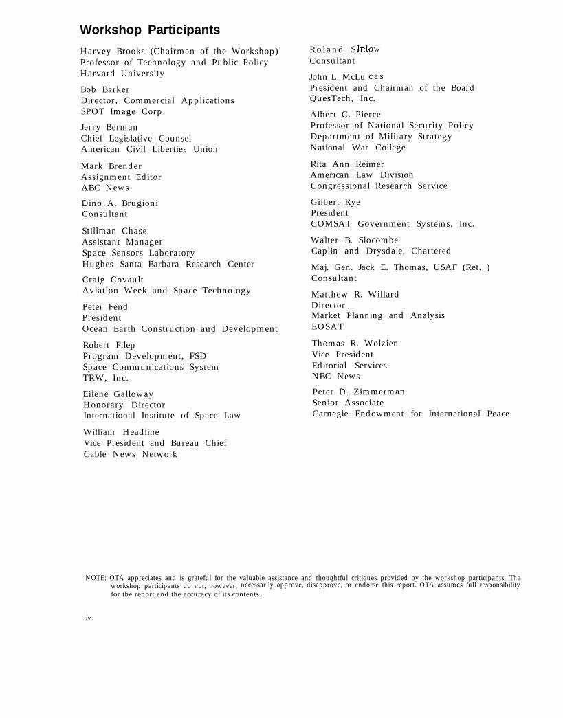
Workshop Participants
Harvey Brooks (Chairman of the Workshop)Professor of Technology and Public PolicyHarvard University
Bob BarkerDirector, Commercial ApplicationsSPOT Image Corp.
Jerry BermanChief Legislative CounselAmerican Civil Liberties Union
Mark BrenderAssignment EditorABC News
Dino A. BrugioniConsultant
Stillman ChaseAssistant ManagerSpace Sensors LaboratoryHughes Santa Barbara Research Center
Craig CovaultAviation Week and Space Technology
Peter FendPresidentOcean Earth Construction and Development
Robert FilepProgram Development, FSDSpace Communications SystemTRW, Inc.
Eilene GallowayHonorary DirectorInternational Institute of Space Law
William HeadlineVice President and Bureau ChiefCable News Network
Roland S . Consultant
John L. McLu
ow
c a sPresident and Chairman of the BoardQuesTech, Inc.
Albert C. PierceProfessor of National Security PolicyDepartment of Military StrategyNational War College
Rita Ann ReimerAmerican Law DivisionCongressional Research Service
Gilbert RyePresidentCOMSAT Government Systems, Inc.
Walter B. SlocombeCaplin and Drysdale, Chartered
Maj. Gen. Jack E. Thomas, USAF (Ret. )Consultant
Matthew R. WillardDirectorMarket Planning and AnalysisEOSAT
Thomas R. WolzienVice PresidentEditorial ServicesNBC News
Peter D. ZimmermanSenior AssociateCarnegie Endowment for International Peace
NOTE: OTA appreciates and is grateful for the valuable assistance and thoughtful critiques provided by the workshop participants. Theworkshop participants do not, however, necessarily approve, disapprove, or endorse this report. OTA assumes full responsibilityfor the report and the accuracy of its contents.
iv

OTA Project Staff on Commercial Newsgathering From Space
Lionel S. Johns, Assistant Director, O T AEnergy, Materials, and International Security Division
Peter Sharfman, Program ManagerInternational Security and Commerce
Richard DalBello, F’reject Director
Ray A. Williamson
Gordon Law
Administrative Staff
Jannie Coles Cecile Parker Jackie Robinson

Additional Reviewers
Robert J. Aamoth, Esq. David H. MoorePierson, Ball and Dowd Natural Resources and Commerce Division
Kim Ford CoffmanCongressional Budget Office
Presidential Management Intern Lt. Col. J. David PattersonGeneral Accounting Office
Paul KreisbergDirector of StudiesCouncil on Foreign Relations
Phillip KunsbergAssistant DeputyOffice of the Under Secretary of Defense for
Policy
Earl S. MerrittVice PresidentEarth Satellite Corp.
Air Force FellowAmerican Enterprise Institute for Public Policy
and Research
Charles SheffieldVice PresidentEarth Satellite Corp.
Paul UhlirNational Academy ofSpace Science Board
Sciences

Related OTA Reports
Civilian Space
●
●
●
●
●
●
●
●
●
●
●
Space Stations and the Law: Selected Legal Issues. OTA-BP-ISC-41, September 1986. GPO stock #052-003-01047-0; $3.75.
international Cooperation and Competition in Civilian Space Activities. OTA-ISC-239, July 1985. GPOstock #052-003-00958-7; $17.00.
U.S.-Soviet Cooperation in Space OTA-TM-STI-27, July 1985. GPO stock #052-003-01004-6; $4.50.
Civilian Space Stations and the003-00969-2; $7.50.
Remote Sensing and the Private#PB 84-180 777; $4.50.
U.S. Future in Space. OTA-STI-241, November 1984. GPO stock #052-
Sector: Issues for Discussion. OTA-TM-ISC-20, March 1984. NTIS order
Salyut: Soviet Steps Toward Permanent Human Presence in Space. OTA-TM-STI-14, December 1983. GPOstock #052-003-00937-4; $4.50.
UNISPACE ’82: A Context for lnternational Cooperation and Competition. OTA-TM-ISC-26, March 1983.NTIS order #PB 83-201 848.
Space Science Research in the United States. OTA-TM-STI-19, September 1982. NTIS order #PB 83-166512.
Civilian Space Policy and Applications. OTA-STI-177, June 1982. NTIS order #PB 82-234444.
Radio frequency Use and Management: Impacts From the World Administration Radio Conference of 1979.OTA-CIT-163, January 1982. NTIS order #PB 82-177536.
Solar Power Satellite Systems and Issues. OTA-E-144, August 1981. NTIS order #PB 82-108846.
Military Space
●
●
●
●
Anti-Satellite Weapons, Countermeasures, and Arms Control. OTA-ISC-281, September 1985. GPO stock##052-003-01009-7; $6.00.
Ballistic Missile Defense Technologies. OTA-ISC-254, September 1985. GPO stock #052-003-01008-9; $12.00.
Arms Control in Space. OTA-BP-ISC-28, May 1984. GPO stock #052-003-00952-8; $3.00.
Directed Energy Missile Defense in Space. OTA-BP-ISC-26, April 1984. GPO stock #052-003-00948-O; $4.50.
NOTE: Reports are available through the U.S. Government Printing Office, Superintendent of Documents, Washington, D.C. 20401-9325,(202) - 783-3238: and the National Technical information Service, 5285 Port Royal Road, Springfield, VA 22161, (703) 487-4050,
vii

ContentsPage
Introduction . . . . . . . . . . . . . . . . . . . . . . . . . . . . . . . . . . . . . . . . . . . . . . . . . . . . . . . . . . . . . . . . 1Principal Findings . . . . . . . . . . . . . . . . . . . . . . . . . . . . . . . . . . . . . . . . . . . . . . . . . . . . . . . . . . . 2Remote Sensing Technology and the Media . . . . . . . . . . . . . . . . . . . . . . . . . . . . . . . . . . . . . 8
Mediasat Described . . . . . . . . . . . . . . . . . . . . . . . . . . . . . . . . . . . . . . . . . . . . . . . . . . . . . . . . 8The Media and the Uncertain Value of Satellite Imagery . . . . . . . . . . . . . . . . . . . . . . . . 11Alternatives for the Media . . . . . . . . . . . . . . . . . . . . . . . . . . . . . . . . . . . . . . . . . . . . . . . . . . 17
National Security and Foreign Policy . . . . . . . . . . . . . . . . . . . . . . . . . . . . . . . . . . . . . . . . . . 30National Security Concerns. . . . . . . . . . . . . . . . . . . . . . . . . . . . . . . . . . . . . . . . . . . . . . . . . 30The Effect of Foreign Remote Sensing Systems on U.S. Policies . . . . . . . . . . . . . . . . . . 3 4
National Security and the First Amendment . . . . . . . . . . . . . . . . . . . . . . . . . . . . . . . . . . . . 35Mediasat Restrictions and the First Amendment . . . . . . . . . . . . . . . . . . . . . . . . . . . . . . . 35The 1984 Landsat Act..... . . . . . . . . . . . . . . . . . . . . . . . . . . . . . . . . . . . . . . . . . . . . . . . . . 36
Appendix A. The Technology of Newsgathering From Space . . . . . . . . . . . . . . . . . . . . . 3 9Appendix B. Media Access to and Use of Remote Sensing Data: A Legal Overview 45
BoxesBox Page
A. A Remote Sensing Satellite System . . . . . . . . . . . . . . . . . . . . . . . . . . . . . . . . . . . . . . . . . 8B. Why Remote Sensing Can Be Useful for Newsgathering . . . . . . . . . . . . . . . . . . . . . . . 11C. Spatial Resolution and Spectral Resolution . . . . . . . . . . . . . . . . . . . . . . . . . . . . . . . . . . . 12D. The Challenge of Timely Global Coverage . . . . . . . . . . . . . . . . . . . . . . . . . . . . . . . . . . . 13E. Remotely Sensed Data and News Presentation . . . . . . . . . . . . . . . . . . . . . . . . . . . . . . 16F. The Status of Land Remote Sensing in the United States . . . . . . . . . . . . . . . . . . . . . . 19G. Remote Sensing and the Public
Interest. . . . . . . . . . . . . . . . . . . . . . . . . . . . . . . . . . . . . . . . . . . . . . . . . . . . . . . . . . . . . . . . . . 27H. Mediasat and Personal Privacy. . . . . . . . . . . . . . . . . . . . . . . . . . . . . . . . . . . . . . . . . . . . . 36
FiguresFigure No. Page
1. Landsat-5 Spacecraft. . . . . . . . . . . . . . . . . . . . . . . . . . . . . . . . . . . . . . . . . . . . . . . . . . . . . . . 32. Artist’s Conception of the French SPOT Remote Sensing Satellite . . . . . . . . . . . . . . . 43. A Remote Sensing System . . . . . . . . . . . . . . . . . . . . . . . . . . . . . . . . . . . . . . . . . . . . . . . . . . 94. Data Processing and Interpretation . . . . . . . . . . . . . . . . . . . . . . . . . . . . . . . . . . . . . . . . . . 95. Polar Orbit Provides Global
Coverage . . . . . . . . . . . . . . . . . . . . . . . . . . . . . . . . . . . . . . . . . . . . . . . . . . . . . . . . . . . . . . . . 106. The Orbital Path of Remote Sensing Satellite Is Sun Synchronous. . . . . . . . . . . . . . 147. The Earth Revolves 2,752 km to the East Between Passes . . . . . . . . . . . . . . . . . . . . 148. Adjacent Swaths Are Imaged 7 Days Apart . . . . . . . . . . . . . . . . . . . . . . . . . . . . . . . . . 15
TablesTable No. Page
I. Some Recent Uses of Remotely Sensed Images by the Press . . . . . . . . . . . . . . . . . . . . 152. Remote Sensing Data Needs of Foreign and Domestic Users . . . . . . . . . . . . . . . . . . . 263. Summary of Applications of Landsat Data in the Various Earth Resources
Disciplines . . . . . . . . . . . . . . . . . . . . . . . . . . . . . . . . . . . . . . . . . . . . . . . . . . . . . . . . . . . . . 27
ix
· ...
~ --.

INTRODUCTION
The U.S. news media’s’ recent use of satelliteimages to cover such newsworthy events as theChernobyl nuclear disaster, the Soviet “shuttle”launch site at Tyuratam, and the progress of theIran-Iraq war has raised the possibility y that news-gathering from space could become a routine andprofitable commercial activity. Some media ex-perts have supported the concept of a mediasat2
because it could supply a stream of timely andcritical information, peering where repressive gov-ernments or dangerous natural environments haveheretofore kept the press at bay.
The mediasat concept has also generated con-cern. Some U.S. policy makers believe that the me-dia’s use of this potentially intrusive technologycould increase the visibility and risk of militaryoperations, complicate U.S. foreign relations byangering allies and adversaries, and erode the aver-age citizen’s expectation of personal privacy.
Believing that “the use of space technologies bythe media and the merging of traditional journalis-tic practices with long-held national space policieshas not yet been satisfactorily addressed, ” theHouse Committee on Science, Space, and Technol-ogy3 requested the Office of Technology Assess-
This technical memorandum uses the terms “news media " or "me-dia” interchangeably to refer to both the electr<ln]c and the printmedia The bra riches ot the media are referred to separately () n 1 ywhen the] r d it teren t need~ would appear t () d]~ta te u n]que tee-h no]-og}r or polic } ch olcei. Except where otherwise i nd l{ a ted, the termmed]a reter~ only to the U. S media.
: hlediasat ” IS not an exlstlng satelllte system or buslnes~ (lrga-n]zat ion, A+ used In thi~ techn ica] memorandum, the term “med]a -w t‘ reter~ to the concept of a sa tel I I te System and business organ iza -tlon that would routinely collect news and Intormat Ion t(lr mediauw t rom \pace.
‘I.etter trorn The Hon. Don Fuqua, Cha]rman, House Committeeon Sc]ence and Technology, to ](lhn H. Llbbons, D]rector, Officeot Technolo~}’ Assessment, Oct 16, 1 Q80, letter trom The Hon. BillNelson, Chairman, Subc(lmmlttee on Space S( ]ence and ApplIca-t]on~, Houw Comrnlttee on Sc]ence a n d Technolog} to ]ohn FiGibbons, Director, OttIce of Technology ,4ssessment, Oct 7 lQ8tI
ment to examine this issue. In response to the com-mittee’s request, OTA contracted for papers onremote sensing technology, the media’s needs anddesires, the national security implications, and thelegal issues associated with newsgathering fromspace. 4 OTA held a workshop on December 18,1986, to discuss these papers and to explore gen-erally the opportunities and risks of the media’suse of satellite imagery. This technical memoran-dum relies heavily on, but is not limited to, theinformation found in the contract papers and theworkshop discussion.
Although the U.S. media currently make somelimited use of satellite imagery, OTA is unawareof any serious planning to establish a mediasatorganization. The purpose of this technical memo-randum is not to examine the feasibility of a spe-cific satellite system or business plan, but rather,to assess whether current government policy isappropriate to accommodate both current activ-ities and future developments. Because the media-sat concept is, for the most part, undefined, OTAwas forced in this technical memorandum to makea series of assumptions regarding fundamental is-sues such as cost, markets, technical capability,and utility of a mediasat. Although these assump-tions are critical to OTA’s conclusions, they areonly “best guesses, ” based on the advice of ex-perts in the media and in the field of remote sens-ing. With regard to specific issues—such as theeconomic viability of a mediasat or its effect onnational security and foreign policy—altering theseunderlying assumptions could dramatically alterthe conclusions reached in this technical memo-randum.
(In lanuar} I q87, the committee’s name ~j~~ changed to th(’ C (~nvm i ttee on Sc]ence, Space, and Tech no] og~. 1
‘A ~ummary of the paper+ on remote wnsing tec hn(~lox> and lt’-ga] ]ssue\ a r e included ]n appi. A & B

PRINCIPAL FINDINGS
Finding 1
The media’s experience with satellite imageryhas thus far been extremely limited. Therefore,the precise value of satellite imagery to the mediais uncertain and is likely to remain so until ex-perience and a more robust remote sensing mar-ket combine to define a stable demand for thesedata.
The media have used and continue to use satel-lite images in their news gathering activities.Whether this limited use will blossom into exten-sive, routine use or even a dedicated “mediasat”organization will depend on:
1. the cost of remotely sensed data;2. the demand for, and therefore the value of,
“media-quality” images to the media and toother users; and
3. U.S. and foreign government policies regard-ing the collection and distribution of high-quality satellite images.
Much of the current writing on the mediasatconcept has stressed the desire for high resolution,timely delivery, and assured access to data. Al-though these demands follow logically from cur-rent newsgathering practices, they are not theproduct of detailed technical or economic researchor of experience. It is important to recognize that,in the absence of such research or experience, thenews media can have only an imprecise under-standing of the value of low- and high-resolutiondata and the value of real-time and delayed in-formation.
Finding 2
The current commercial remote sensing systems,the U.S. EOSAT and the French SPOT, allow themedia to experiment with satellite imagery but lackthe high resolution, timely delivery, and assuredaccess to data that some media experts feel couldmake satellite imagery an integral part of the news-gathering process.
EOSAT (figure 1) and SPOT (figure 2) providea relatively low-cost means by which the mediacould practice both using satellite imagery andworking within current government policies. How-
2
ever, existing commercial systems do not provide“timely access” or high resolution, primarily be-cause these capabilities are expensive and unnec-essary to meet the needs of the traditional pur-chasers of remotely sensed data. In addition, themedia’s access to data cannot be assured becausethe remote sensing companies currently dependon ground stations owned by other countries tocollect certain data. Experience gained with thecurrent commercial systems has shown that de-livery of data considered by a foreign governmentto be sensitive may be delayed or denied.
Finding 3
It is possible to build a mediasat system withhigh resolution, timely global coverage, and as-sured access to data using current technology.
Experts generally agree that costs and marketuncertainties, more than technology, inhibit theestablishment of a mediasat system. Media expertshave identified high spatial resolution (5 metersor less) as the principal performance requirementfor a mediasat. By comparison, the Thematic Map-per (TM) and the Multispectral Scanner (MSS) sen-sors on EOSAT’s satellite provide 30 and 80 me-ter resolution, respectively. The French SPOTsystem provides 10 meter panchromatic (black andwhite) as well as 20 meter multi-spectral (color)imagery. Nonetheless, sensors capable of produc-ing 5 meter images are readily available and couldbe flown on existing spacecraft designs.
To be effective, a mediasat needs more thanhigh resolution; it must also be able to sense newswherever and whenever it occurs and to trans-mit the news rapidly to the news agency. A media-sat system would need at least two satellites to en-sure same day coverage of events around the globe.In order to receive data in near-real-time, a medi-asat system would need to have access to groundstations all over the earth, use on-board taperecorders, or use space-to-space communicationssimilar to the National Aeronautics and Space Ad-ministration’s (NASA) partially complete Track-ing Data Relay Satellite System (TDRSS). Thetechnology exists to obtain high-resolution, near-real-time imagery; what is lacking is the clear fi-nancial justification for employing this technology.

Attitude
Figure 1.— Landsat-5 Spacecraft
Global positioning Antenna mastsystem antenna
High gain antenna
(2) omni antenna
IMultispectral scanner
/control module I I I
H Solar array panel
/
S u n S e n s o r s
S-band antenna
\Thematic mapper
Wideband module
Instrumentmodule
SOURCE: National Oceanic and Atmospheric Admintstration
MISSION: Collect remotely sensed multispectral land data broadcast data for receipt
at ground stations operating under formal agreements
ORBIT. 705-mm sun synchronous 16 day repeat cycle
SENSORS AND FUNCTIONS
Mdtl-spoctrd Scmn.r (MSS).Swath w)dth IS 185-km ‘eso(utlon IS 8 0 - m
Sonwr‘Ahvehngths
(Km) Prtmary U*IO 5 13 6 ~ovement 01 swlment laden waler ,dellneatlon of snaltow
wafer areas06 07 Cultural fealures07.08 iegelatton bounaary between land arm water Iandforms0 8 - 1 1 PenetraIlon of a t m o s p h e r e naze vegetation ooundary
between land anO water Iandforms
ThornatIc M+por (TM): The TM IS designed 10 orOvlde 30-m resotut!on
except for 120-m resolutlor 1~ the thermal Infrared band
SonunWvokrlgths
bin)0 4 5 0 5 2
0 5 2 0 6 0
0 6 3 0 6 90 7’6 0901 55 1 -5
1040 ! 2 w
2 0 8 2 3 5
Pr}mary (JsoaCoastal waler mapp(ng SOI( vage!atlon dlfferent!a[tondectduous coniferous GlfferentlatlonGram reflectance DY healthy vegelahonChbrophyll absorption for piant soacles dlfferentlallonBtomass suweys waler OOdy dellneattonVagetatlon momture measurementPlant heat stress management other thermal mapp(ng
Hydrothermal maopmg
OIRECT BROAOCAST B r o a d c a s t s a r e provtded for ground stat ions which h a v eentered Into formal agreements covering (he recelpl and dlsrrOut)on of these dara

4
Finding 4
Although cost and market research have yet tobe done, preliminary calculations indicate that thecosts of a mediasat might exceed the expected rev-enues of such a system.
To be financially viable, a mediasat would haveto generate revenue sufficient to offset the costsof the system. Experts have estimated that a com-plete one or two satellite mediasat system (i.e.,sensor, spacecraft, launch vehicle, data collectionfacilities, and image processing facilities) capableof.5 meters resolution, designed to operate about5 years, could cost between $215 million and $470million to establish and $10 million to $15 mil-lion a year to operate. Even if each network usedsatellite images every day, only a few thousandimages would be used per year; hence the system’sdevelopment and operating costs could only bepaid back if networks were willing to pay $35,000to $73,000 per “story,” an order of magnitude morethan existing expenditures for daily news coverage.
Nonetheless, should it turn out that OTA’s costestimates for a mediasat are dramatically over-stated (because the technology has become moresophisticated and/or less costly) or a very highdemand (from the media and other data users5)were to develop for satellite images, mediasatmight become an economically viable concept.
Finding 5
A mediasat would probably compound prob-lems inherent in the management of national secu-rity and foreign policy in a spirited democracy;however, such problems would likely be man-ageable.
Experts generally agree that the media’s exten-sive use of high-resolution satellite imagery fornewsgathering could complicate certain U.S. na-tional security activities and certain U.S. foreignpolicies. Experts disagree, however, about the na-ture and seriousness of these “complications,” andthe extent to which they differ from traditionaltensions between the press and the national secu-rity and foreign policy communities.
Although each is the subject of some contro-versy, national security experts consulted by OTAidentified five areas where a mediasat could com-plicate U.S. national security and foreign policies.The
1.
2.
3.
4.
5.
— —
media could:
disseminate information regarding U.S. mil-itary operations, thereby depriving U.S.troops of the critical element of surprise;reveal information considered sensitive byforeign governments, thereby promptingthem to retaliate against U.S. Governmentactivities, assets, or personnel;provide valuable intelligence to countries cur-rently lacking their own reconnaissance sat-ellites;reveal facts about an unfolding crisis, mak-ing it more difficult for government leadersto act calmly and responsibly; andmisinterpret satellite data in such a way asto precipitate a crisis.
5Some of the costs of a mediasat could be offset by selling datato map makers, geologists, agricultural planners, and other currentusers of remotely sensed data.
k -
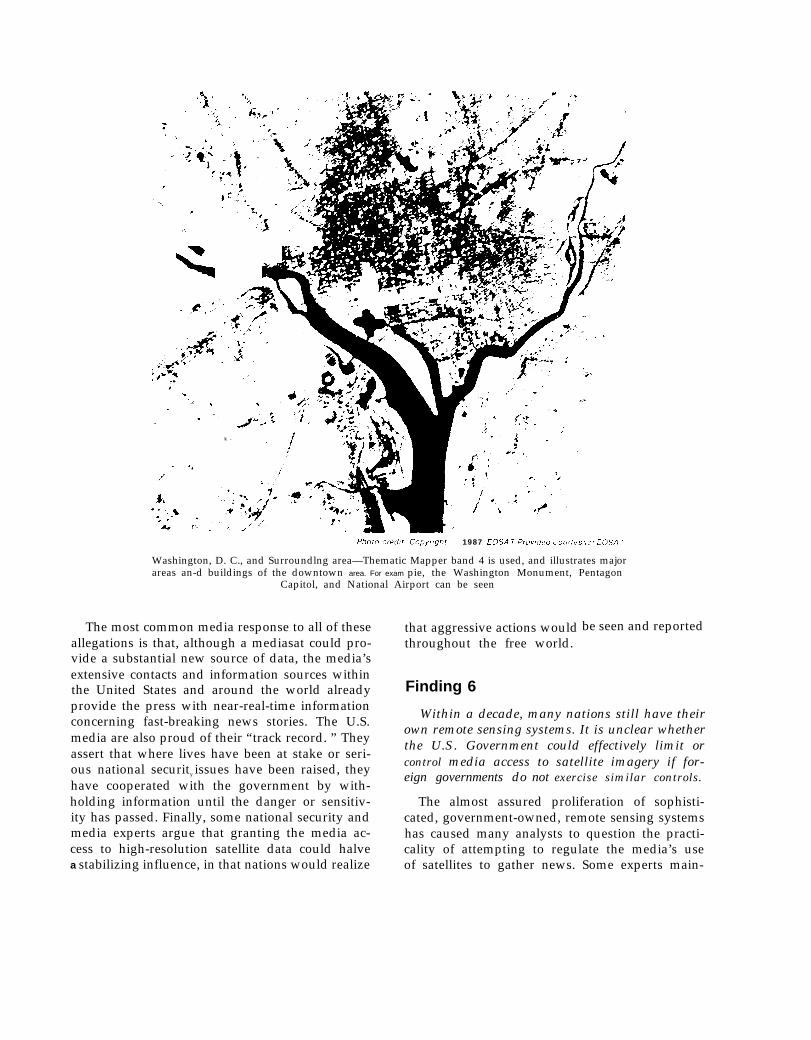
1987 EOSA T Prov/ded L ourles } of E(3SA TPhoto uecfft Copyr/ght
Washington, D. C., and Surroundlng area—Thematic Mapper band 4 is used, and illustrates majorareas an-d buildings of the downtown area. For exam pie, the Washington Monument, Pentagon
Capitol, and National Airport can be seen
The most common media response to all of theseallegations is that, although a mediasat could pro-vide a substantial new source of data, the media’sextensive contacts and information sources within
that aggressive actions wouldthroughout the free world.
Finding 6
be seen and reported
the United States and around the world alreadyprovide the press with near-real-time informationconcerning fast-breaking news stories. The U.S.media are also proud of their “track record. ” They
Within a decade, many nations still have theirown remote sensing systems. It is unclear whetherthe U.S. Government could effectively limit orcontrol media access to satellite imagery if for-eign governments do not exercise similar controls.
The almost assured proliferation of sophisti-cated, government-owned, remote sensing systemshas caused many analysts to question the practi-cality of attempting to regulate the media’s useof satellites to gather news. Some experts main-
assert that where lives have been at stake or seri-ous national security issues have been raised, theyhave cooperated with the government by with-holding information until the danger or sensitiv-ity has passed. Finally, some national security andmedia experts argue that granting the media ac-cess to high-resolution satellite data could halvea stabilizing influence, in that nations would realize

6—. —
tain that since U.S. laws would not be applicableto foreign systems, U.S. news agencies could by-pass U.S. restrictions by purchasing data from,or investing in, foreign remote sensing systems.
Others disagree, arguing that foreign remotesensing systems—either as a result of financialconstraints, less sophisticated technology, or acountry’s own domestic policies—might have lim-ited resolution. Therefore, it is possible that, withminimum intergovernmental coordination, theUnited States could substantially delay the timewhen the media would have access to very high-resolution satellite images.
Finding 7
Government attempts to limit access to or useof satellite imagery would likely result in firstamendment challenges to such limitations. Theoutcome of these challenges would turn on theexact nature of the government limitations andthe Supreme Court's ultimate determination of thestatus of newsgathering activities under the Con-stitution.
Should the U.S. Government desire to inhibita media-owned satellite from gathering potentiallysensitive information it could—either permanently,through the licensing procedures established in the1984 Landsat Act, b or temporarily during a crisis—attempt to limit:
1. the resolution of the satellite’s sensors;2. the images that the satellite is allowed to col-
lect; or3. the images the media are allowed to dis-
seminate.
The 1984 Landsat Act requires all remote sens-ing system operators to obtain a license from theSecretary of Commerce, who is charged with theduty of ensuring that applicants comply with the“international obligations and national securityconcerns of the United States. ” Some media rep-resentatives have argued that such licensing pro-visions should be declared invalid because theyare not drafted with the narrow specificity requiredof statutes affecting first amendment interests. Thevalidity of this point of view will rest heavily on
’15 U.S.C. 4201-4292
the Supreme Court’s ultimate determination of thestatus of newsgathering activities.
If newsgathering is given the degree of firstamendment protection afforded traditional speak-ing and publishing activities, the licensing proce-dure established in the Landsat Act and future re-strictions on mediasat activities might be regardedas impermissible “prior restraints” on free speech.The doctrine of “prior restraint” holds that ad-vance limitations on protected speech may not be“predicated on surmise or conjecture that un-toward consequences may result.”7 Prior restraintsare allowable only if necessary to prevent “direct,immediate, and irreparable damage to our Nationor its people.”8 On the other hand, should the Su-preme Court hold that news gathering was deserv-ing of some lesser degree of protection than pub-lication of information already obtained, thegovernment would have considerably more lati-tude to limit mediasat activities. Restrictions onthe dissemination of information already gatheredwould, of course, receive the full protection ofthe first amendment.
If the media do not own a satellite system, butrather rely on a commercial company such asEOSAT to provide them with data, it would beless clear whether the media could successfully ar-gue that licensing restrictions violate their firstamendment rights. Should the U.S. Governmentask EOSAT to stop distributing raw data for afew days during a crisis and EOSAT agreed, thenews media might have a case against EOSAT forbreach of contract, but their case against the U.S.Government for infringing their first amendmentrights would be less clear.
Finding 8
Should the U.S. Government wish to encouragethe eventual development of a U.S. mediasat in-dustry, it should continue its support for the U.S.Landsat system; such support would likely requiresizable subsidy for a period of years. 9
‘Justice Brennan concurring in, New York Times Co. v. UnitedStates, 403 U.S. 713, 724 (1971).
‘Justices Stewart and White, concurring, New York Times Co.v. United States, ibid.
‘The funding problems and opportunities of the Landsat programand EOSAT are beyond the scope of this paper. In reaching thisconclusion, OTA drew upon its previous work. See: U.S. Congress,

A mediasat industry is less likely to develop inthe United States if the media must shoulder theentire cost of the “infrastructure” needed to sup-
Office of Technology Assessment, lnternational Cooperation andCompetition in Civilian Space Activities, OTA-ISC-239 (Washing-ton, DC: U.S. Government Printing Off Ice, July 1985), p. 15, U.S.Congress, Office of Technology Assessment, Remote Sensing andthe Private Sector: Issues for Discussion —A Technical Memoran-dum, OTA-TM-ISC-20 (Washington, DC: U.S. Government Print-ing Office, March 1984 ).
7
port its occasional use of satellite images. If, onthe other hand, there already existed in the UnitedStates a strong “value-added” industry—smallfirms expert in the interpretation and visual pres-entation of data—and a large pool of experiencedphotointerpreters, the mediasat concept would be-come more viable. A robust value-added indus-try and a cadre of experienced photointerpretersare more likely to develop if the United States hasa healthy land remote sensing industry cateringto diverse scientific and commercial needs.

REMOTE SENSING TECHNOLOGY AND THE MEDIA
Mediasat Described
At present, the news media obtain data fromtwo commercial remote sensing systems, EOSAT—formerly the U.S. Government’s Landsat sys-tem10—and SPOT, a French system.11 Neither ofthese commercial systems was designed to meetthe specific needs of the media and neither firmhas plans to buy new satellites or alter its busi-ness structure to allow it to meet these needs. Con-sequently, media experts have begun to examinethe feasibility and desirability of a “mediasat;” aspacecraft owned and operated—in whole or inpart—by the news media and dedicated to newsand information gathering activities [see box Aand figures 3 and 4; box B and figure 5]. Althoughindividual conceptions of a “mediasat” vary, asit is most often described, a mediasat would dif-fer from the current commercial systems in threeimportant ways:
1. Spatial Resolution: Spatial resolution of 5meters or less [see box C] is often identifiedas the principal performance requirement fora mediasat.12 By comparison, the TM andthe MSS sensors on EOSAT’s satellite yield30 and 80 meter resolution, respectively. TheFrench SPOT system provides 10 meter pan-chromatic as well as 20 meter multispectralimagery. At present, neither SPOT norEOSAT has plans to fly sensors capable ofapproaching the 5 meter resolution soughtby the media.13
1OFor a hi5tov of the U.S. Landsat system and the details Of itssomewhat stormy transfer to the private sector, see: U.S. Congress,Office of Technology Assessment, Remote Sensing and the PrivateSector: Issues for Discussion—A TechnicaI Memorandum, OTA-TM-ISC-20 (Washington, DC: U.S. Government Printing Office,March 1984); National Research Council Space Applications Board,Remote Sensing of the Earth From Space: A Program in Crisis (Wash-ington, DC: National Academy Press, 1985).
‘] The French Government controls the SPOT satellite and a pri-vate French company, Spot Image, S. A., and its American subsidi-ary, Spot Image, Corp., market the data.
IZAt the workshop it Was clear that the media’s desire for sensorsallowing a resolution of s meters or less is not based on experienceor research. The exact number is flexible and could be more accuratelystated as “that degree of resolution which is better than either theSPOT or EOSAT systems but which is still affordable. ”
lqIt is important t. note the relationship between resolution andthe width of coverage (swath width). Had the French chosen a 20km by 20 km swath width instead of their current 60 km by 60 kmcoverage, they would have had a resolution of 3.3 meters, assumingthe same number of minimum picture elements (pixels) in their sen-
Box A.—A Remote Sensing Satellite System
A remote sensing satellite system consists offour major components, each of which is criti-cal to producing useful data:
1.
2.
3.
4.
The Spacecraft. Sensors, and TransmittersThe spacecraft provides a stabilized plat-form and power for the sensors and theiroptics, the receiving and transmitting an-tennas, and the associated electronics nec-essary to control the spacecraft and to de-liver data to Earth. Some remote sensingspacecraft may also carry tape recorders tostore data until the spacecraft is within sightof a receiving station.The Receiving Station and Other Commu-nications Components: A ground stationmay receive data in digital form directlyfrom the satellite as it passes overhead, or,if the satellite is not in a position to com-municate with the ground station, througha system equivalent to NASA’s 3-satelliteTracking and Data Relay Satellite System(TDRSS).* In the latter case, data are passedfrom the remote sensing satellite to a com-munication satellite in geosynchronous orbitand then retransmi tted to a ground facility.From the ground facility, the data are thenpassed directly to a processing laboratory.The Data Processing Facilities: Before theraw data can be converted into photographicimages or computer tapes capable of beinganalyzed by the end user, they must be proc-essed to remove geometric and other distor-tions inevitably introduced by the sensors.For the purposes of newsgathering, high-speed mainframe computers maybe requiredto process the data from current spacecraft.Interpretation of the Data: After the rawdata are processed and converted to com-puter tapes or photographs, they must beinterpreted. Part of the interpretation proc-ess may invoke merging or integrating otherdata either directly on the computer tape,or comparing such data with photographs.At this stage, computer analysis could beperformed by micro-or mini-computer. Avariety of advanced techniques (see box G)are available to turn remotely sensed datainto new products for different users.
*Only one TDRSS satellite is currently in orbit.
8

9.
Figure 3.—A Remote Sensing System
C o m m u n i c a t i o n s
/
components
Spacecraft
Tape- - 1 : R e l a y : S a t e l l i t e I
storage
IData
Sensor handl ing Transmi t ters
Datainterpretation
Tapes
- ReceiverData
Imageprocessing o
S O U R C E Hughes, Santa Barbara Research Center
Figure 4.— Data Processing and Interpretation
Data I Information processing andprocessing I interpretation
II
●
Film Filmrecorder Information
t1
Manual interpretation
II n i t i a l ‘1
p r o c e s s i n g
I● Calibration● Radiometric I
correction Displays
Ž Geometriccorrection
● FormattingComputer Information
I .
Computer
I ● AnalysisP r i n t o u t • Interpretation
I
interpretation
SOURCE Office of Technology Assessment, 1987

10
Figure 5.— Polar Orbit Provides Global Coverage
Mediasat remote sensing satellite
705 km height, 98.9 minute orbit
SOURCE: Hughes, Santa Barbara Research Center
2. Timely Global Coverage: To be most effec-tive, a mediasat would have to deliver newsin a matter of hours from anywhere on theglobe [see box D and figures 6-8]. Neitherthe satellites nor the business structures ofEOSAT and SPOT are designed to produceimagery that quickly. Such timeliness wouldrequire new ground processing techniques
3.
continued from page 8
sor array. Reducing swath width, however, would have greatly in-creased the time it takes to obtain global coverage with one satellite.It would also have reduced the synoptic view desired for many otheruses of the data.
and delivery methods and at least two satel-lites and supporting communication facilitiesto ensure that the media would have the op-portunity to image every spot on Earth atleast once a day.Media Control Over System and Products:EOSAT and SPOT, although commercialsystems, receive substantial financial supportand guidance from their sponsoring govern-ments and rely on the cooperation of thosecountries that maintain ground stations (seethe following section, National Security andForeign Policy). As a result, issues such as
11
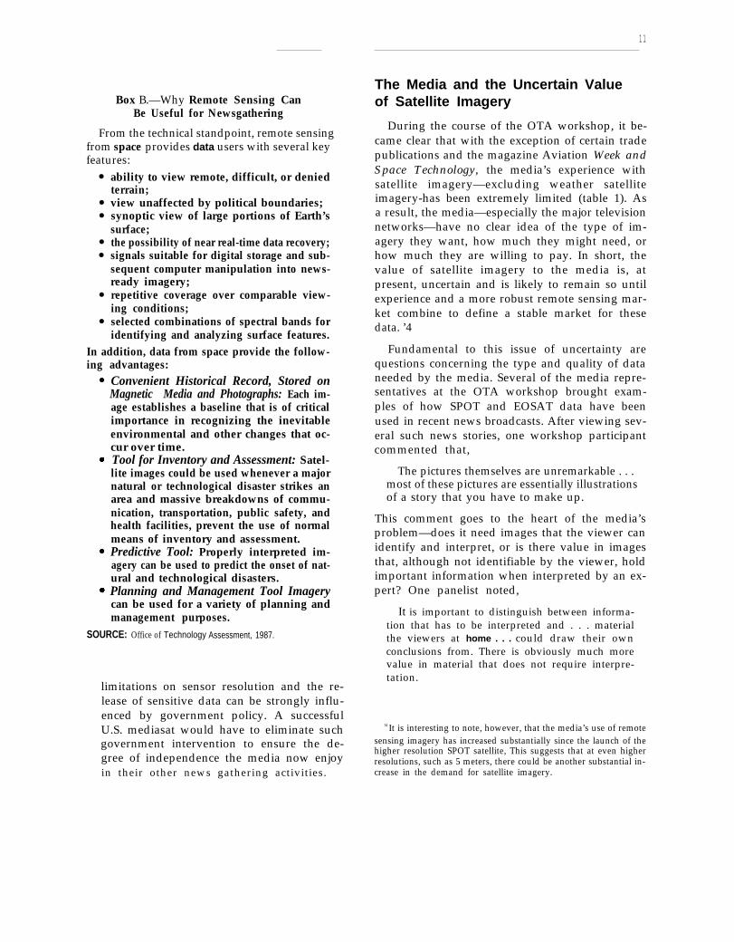
Box B.—Why Remote Sensing CanBe Useful for Newsgathering
From the technical standpoint, remote sensingfrom space provides data users with several keyfeatures:
●
●
●
●
●
●
●
ability to view remote, difficult, or deniedterrain;view unaffected by political boundaries;synoptic view of large portions of Earth’ssurface;the possibility of near real-time data recovery;signals suitable for digital storage and sub-sequent computer manipulation into news-ready imagery;repetitive coverage over comparable view-ing conditions;selected combinations of spectral bands foridentifying and analyzing surface features.
In addition, data from space provide the follow-ing advantages:
Convenient Historical Record, Stored onMagnetic Media and Photographs: Each im-age establishes a baseline that is of criticalimportance in recognizing the inevitableenvironmental and other changes that oc-cur over time.Tool for Inventory and Assessment: Satel-lite images could be used whenever a majornatural or technological disaster strikes anarea and massive breakdowns of commu-nication, transportation, public safety, andhealth facilities, prevent the use of normalmeans of inventory and assessment.Predictive Tool: Properly interpreted im-agery can be used to predict the onset of nat-ural and technological disasters.Planning and Management Tool Imagerycan be used for a variety of planning andmanagement purposes.
SOURCE: Office of Technology Assessment, 1987.
limitations on sensor resolution and the re-lease of sensitive data can be strongly influ-enced by government policy. A successfulU.S. mediasat would have to eliminate suchgovernment intervention to ensure the de-gree of independence the media now enjoyin their other news gathering activities.
The Media and the Uncertain Valueof Satellite Imagery
During the course of the OTA workshop, it be-came clear that with the exception of certain tradepublications and the magazine Aviation Week andSpace Technology, the media’s experience withsatellite imagery—excluding weather satelliteimagery-has been extremely limited (table 1). Asa result, the media—especially the major televisionnetworks—have no clear idea of the type of im-agery they want, how much they might need, orhow much they are willing to pay. In short, thevalue of satellite imagery to the media is, atpresent, uncertain and is likely to remain so untilexperience and a more robust remote sensing mar-ket combine to define a stable market for thesedata. ’4
Fundamental to this issue of uncertainty arequestions concerning the type and quality of dataneeded by the media. Several of the media repre-sentatives at the OTA workshop brought exam-ples of how SPOT and EOSAT data have beenused in recent news broadcasts. After viewing sev-eral such news stories, one workshop participantcommented that,
The pictures themselves are unremarkable . . .most of these pictures are essentially illustrationsof a story that you have to make up.
This comment goes to the heart of the media’sproblem—does it need images that the viewer canidentify and interpret, or is there value in imagesthat, although not identifiable by the viewer, holdimportant information when interpreted by an ex-pert? One panelist noted,
It is important to distinguish between informa-tion that has to be interpreted and . . . materialthe viewers at home . . . could draw their ownconclusions from. There is obviously much morevalue in material that does not require interpre-tation.
14 It is interesting to note, however, that the media’s use of remotesensing imagery has increased substantially since the launch of thehigher resolution SPOT satellite, This suggests that at even higherresolutions, such as 5 meters, there could be another substantial in-crease in the demand for satellite imagery.

12
Box C.—Spatial Resolution and Spectral Resolution
Spatial resolution refers to the ability of an optical device, such as the sensor of a remote sensing space-craft, to separate objects of a given size. An instrument of high resolving power can separate two smallobjects very close together, or resolve the image of relatively small features on a larger object. For example,a spatial resolution of 1 meter (approximately 39 inches) could allow a viewer to distinguish between anautomobile and a bus, but such resolution might not allow one to distinguish between an automobile anda pickup truck.
The best resolution available on images formed by civilian remote sensing satellites is the lo-meterresolution offered by the sensors and optical systems on the French SPOT satellite. * Such resolution allowsone to see individual buildings and streets in a city landscape. It also permits one to pick out semi-trailertrucks on the streets or ships at a dock. It would generally not make it possible for the viewer to distinguishbetween the image of two semi-trailer trucks parked side by side and a building of similar dimensions,because the images of the two trucks would merge.
Overall resolution is limited by the resolving power of the sensor’s individual picture elements. Theminimum picture element, or pixel, of SPOT data, for example, corresponds to 10 meters (approximately33 feet) on the ground. No amount of simple magnification of the remotely-sensed image will improve theresolution beyond this minimum pixel size. For an object with dimensions less than 10 meters, the sensorwill effectively spread out the light emanating from such an object so that it is impossible to determinethe position of the object within the 10 meter pixel. Structural details of the object will also be spread outin a similar manner.
However, knowledge of the general terrain, the detailed characteristics of particular objects, and ex-perience in photointerpretation, can vastly improve an interpreter’s ability to understand the details of animage. In addition, sophisticated and costly computer processing can improve on the theoretical resolutionof an image by as much as a factor of 2.**
Although the spatial resolution of a sensor provides a general guide to its ability to “see” objects onthe ground, photointerpreters are also concerned with spectral resolution. Since all objects reflect light differ-ently, an object’s color or its contrast with the background environment can also be used to distinguishit. For example, the Great Wall of China is wide enough to be detected on Landsat TM images (resolutionof 30 meters, or 98 feet). However, because the wall is nearly the same color as the surrounding countryside,it is extremely difficult to pick out in certain Landsat spectral bands. On the other hand, it is often possibleto see a bridge or roadway of less than 30 meters wide when their contrast with the surrounding wateror earth is extremely high. In effect, the bridge or road tends to “fill” each pixel with its reflected light,and because there are many such pixels spread out in a line across the scene, the eye links them together.Because objects that appear to have similar color characteristics as seen by the naked eye reflect light some-what differently in different parts of the spectrum, it is often possible to distinguish objects on the imageby subtracting the different color bands from one another. In this way, a field of corn can be distinguishedfrom a field of soybeans, even though the sensors are incapable of resolving individual plants.
● Early in their program, France considered building a system of higher resolution that could be used by both civilian and military data users. How-ever, because of high costs and other priorities for research and development funds, it deferred such a program,
**See John A. Adams, “Counting the Weapons,” IEEE Spectrum, July 1986, pp. 46-56, for a general discussion of spectral and spatial resolution.

13
Box D.—The Challenge of Timely Global Coverage
The Landsat satellite travels in a near-polar orbit at a distance of 706 kilometers and circles the Earthevery 98.9 minutes. The SPOT satellite flies in a similar orbit, 832 kilometers above Earth, with an orbitalperiod of 101.5 minutes. Because Earth is spinning, as a satellite travels from pole to pole, it flies overa different part of Earth on each orbit. Each of the two Landsat spacecraft, for example, passes over thesame portion of Earth at the Equator once every 16 days. (Near the poles, the “footprint” of its sensorsoverlap in successive orbital passes, covering the same portion of Earth in as few as 8 days. ) SPOT repeatsits orbit only once every 26 days. However, because the SPOT sensors can be pointed to the side (off-nadir), their ability to sense a particular area on Earth in successive passes is substantially increased. TheSPOT sensors can revisit a site 7 days out of 26. The ability to point its sensors also allows the SPOTsatellite to take quasi-stereo images.
For the purposes of a mediasat capable of providing daily coverage of the Earth, it is necessary tohave several identical satellites with pointable sensors to ensure that one is always in position to see thearea of interest.
Delivering the data collected to Earth for processing is an important part of the overall process of landremote sensing. Because the satellite orbits the Earth, for some part of every orbit it will not be within“sight” of national ground stations. A satellite system must have one or more of the following capabilities:
1. tape recorders to store data until they can be played back as the satellite passes over a ground station,2. space-to-space communications such as NASA’s Tracking and Data Relay Satellites (TDRSS) to pass
the information around the globe and then to Earth, or3. ground stations in many foreign countries to ensure that data collected over other countries are
eventually passed back to national territory.
None of these alternatives is without difficulty: high-capacity space-rated tape recorders have a high fail-ure rate, historically, and are still not regarded as reliable; TDRSS cannot yet provide worldwide coverage(the second of three critical satellites was destroyed along with the Shuttle Challenger in January 1986),it is expensive to use, and commercial users currently receive very low priority; finally, receiving data fromforeign ground stations can be slow and subject to political interference.
One of the most substantial impediments to timely delivery of imagery is the effects of clouds. Onany one day, substantial portions of the Earth’s surface are covered by clouds. Some areas can be obscuredfor weeks or even months at a time. Other areas are difficult to see even in “clear” weather as a resultof smog or other obscuring atmospheric problems.

14
Ground track
A
Inclination=98.2
Time of day=9:45 am
Direction
of travel ,
Each pass of the satelIite crosses the equatorat the same time (9:45 am)
SOURCE: National Oceanic and Atmospheric Administration
Figure 7.—The Earth Revolves 2,752 km to the East (at the equator) Between Passes
, sensor swath( 2 5 k m )
Satellitearound track
‘
SOURCE: National Oceanic and Atmospheric Administration
15
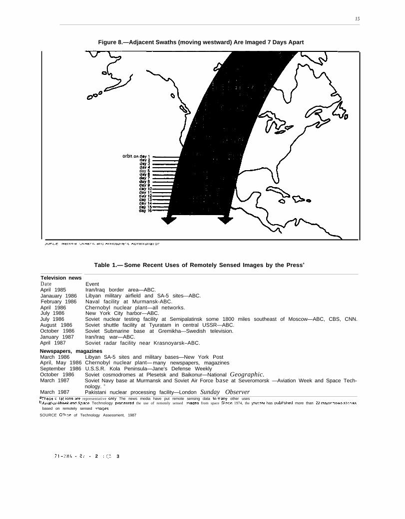
Figure 8.—Adjacent Swaths (moving westward) Are Imaged 7 Days Apart
orb
day
Table 1.— Some Recent Uses of Remotely Sensed Images by the Pressa
Television newsDateApril 1985Janauary 1986February 1986April 1986July 1986July 1986August 1986October 1986January 1987April 1987
EventIran/Iraq border area—ABC.Libyan military airfield and SA-5 sites—ABC.Naval facility at Murmansk-ABC.Chernobyl nuclear plant—all networks.New York City harbor—ABC.Soviet nuclear testing facility at Semipalatinsk some 1800 miles southeast of Moscow—ABC, CBS, CNN.Soviet shuttle facility at Tyuratam in central USSR—ABC.Soviet Submarine base at Gremikha—Swedish television.Iran/Iraq war—ABC.Soviet radar facility near Krasnoyarsk–ABC.
Newspapers, magazinesMarch 1986 Libyan SA-5 sites and military bases—New York PostApril, May 1986 Chernobyl nuclear plant— many newspapers, magazinesSeptember 1986 U.S.S.R. Kola Peninsula—Jane’s Defense WeeklyOctober 1986 Soviet cosmodromes at Plesetsk and Baikonur—National Geographic.March 1987 Soviet Navy base at Murmansk and Soviet Air Force base at Severomorsk —Aviation Week and Space Tech-
nology. b
March 1987 Pakistani nuclear processing facility—London Sunday ObserveraTheSe c itat ions are representative only The news media have put remote sensing data to many other usesbAv[atlon week ad Space Technology p!oneered the use of remotely sensed Images from space since 1974, the journal has publlshed more than 22 ma)or neWs .Storles
based on remotely sensed Images
SOURCE Office of Technology Assessment, 1987
71-284 - 87 - 2 : QL 3

16
Other panelists generally agreed with this com-ment and emphasized that material requiring inter-pretation is similar to a “source story;” that is,a story based on inside or expert information butlacking images to allow the viewer to draw hisor her own conclusions. Although useful in theprint media, “source stories” have a more limitedvalue in television news where the viewer expectsthe picture to tell the story [see box E]. I
s
15One panelist felt that the attention given to the issue of “sourcestories” was unwarranted. He maintained, “Those of us who havelived through the technological developments that have affected themedia over the last ten or twenty years would never attempt to neatlycategorize the potential uses of remote sensing. Experience tells usthat every time a significant technological advance has been made,its early planned uses either became secondary or were lost in thehuge quantity of additional applications that developed once ex-perience had been gained. Remote sending will simply open up avariety of options to illustrate all sorts of stories in different waysand in different media. ”
One panelist commented that the media “clearlyhad a lot of homework to do, ” but that this learn-ing process could proceed in stages. First, he sug-gested that the media should gain as much experi-ence as possible working with current satelliteimages and within current government policies,This would allow the media to define the kindsof news stories that would gain from “eye in space”graphics every day. Second, the news mediashould test the ability of SPOT, EOSAT, or someother source of data to meet their needs. Third,examine the attitudes of readers and viewerstoward the use of these new graphic displays toreach some conclusions regarding the compara-tive values of high- and low-resolution data. Fi-nally, when they had gained sufficient experienceregarding both the value of current imagery andthe cost and future demand for high-resolution
17
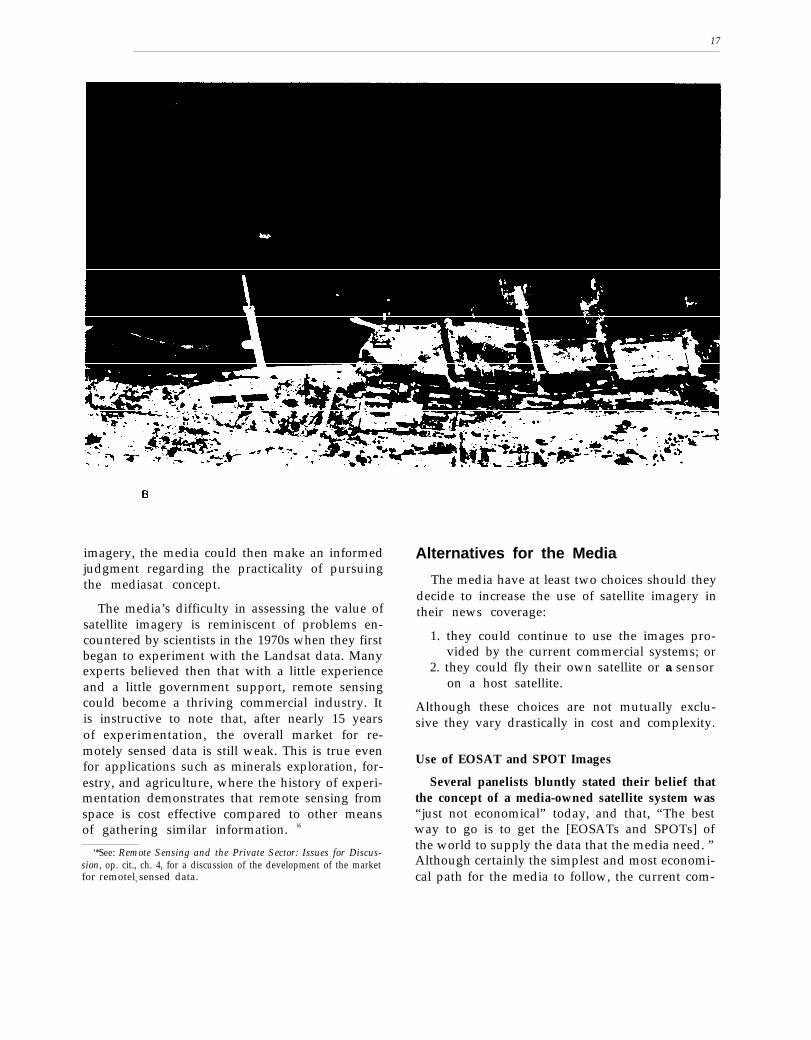
imagery, the media could then make an informedjudgment regarding the practicality of pursuingthe mediasat concept.
The media’s difficulty in assessing the value ofsatellite imagery is reminiscent of problems en-countered by scientists in the 1970s when they firstbegan to experiment with the Landsat data. Manyexperts believed then that with a little experienceand a little government support, remote sensingcould become a thriving commercial industry. Itis instructive to note that, after nearly 15 yearsof experimentation, the overall market for re-motely sensed data is still weak. This is true evenfor applications such as minerals exploration, for-estry, and agriculture, where the history of experi-mentation demonstrates that remote sensing fromspace is cost effective compared to other meansof gathering similar information. l6
‘*See: Remote Sensing and the Private Sector: Issues for Discus-sion, op. cit., ch. 4, for a discussion of the development of the marketfor remotely sensed data.
Alternatives for the Media
The media have at least two choices should theydecide to increase the use of satellite imagery intheir news coverage:
1. they could continue to use the images pro-vided by the current commercial systems; or
2. they could fly their own satellite or a sensoron a host satellite.
Although these choices are not mutually exclu-sive they vary drastically in cost and complexity.
Use of EOSAT and SPOT Images
Several panelists bluntly stated their belief thatthe concept of a media-owned satellite system was“just not economical” today, and that, “The bestway to go is to get the [EOSATs and SPOTs] ofthe world to supply the data that the media need. ”Although certainly the simplest and most economi-cal path for the media to follow, the current com-

18
*
. . . ..
Photo redit US. Department of Defense
Cam Ranh Bay, Vietnam airfield. This photo, taken from an aircraft, was released Feb. 9, 1987, by the Department of Defenseto refute Soviet and Vietnamese denials of the existence of Soviet forward-deployment bases in Vietnam. Shown in this imageare Soviet TU-95 Bear aircraft, TU-16 Badgers, and Mig-23 Flogger aircraft. Photo resolution estimated to be about 1 meter.
mercial systems cannot provide timely access todata, assured access to data, and high resolution[see box F].
The workshop discussed two aspects of the time-liness issue: 1) the problem of getting the data fromthe satellite to the media user; and 2) the need forthe human resources to interpret the data.17 O n
17Both of these problems were illustrated by one newsman’s ex-perience in trying to obtain and use the satellite images of Cher-nobyl. He recalled: “I remember working the phones all day tryingto get the Chernobyl images and finally at three in the afternoonthey arrived and everyone was excited and we looked at the imagesand said, ‘what the hell are we looking at?’ So I called up EarthSat,the image processing company, and 1 said, ‘Hey, can you send some-body down and help us interpret this stuff?’ He said, ‘Well, we cando it next week. You know they’re used to dealing with geologists.I said, ‘Next week? I’ll send a helicopter this afternoon. ’ “
the subject of timely access to data, one panelistpointed out that neither SPOT nor EOSAT is de-signed to meet the particular needs of the newsmedia. The Landsat system, now operated byEOSAT, had been a government-designed researchsystem that was never expected to-deliver datarapidly. “If you call today and ask for a scene fromlast year, EOSAT may be able to get it to youwithin a week if it’s already been processed, ” thepanelist commented, but “if it’s unprocessed ittakes 4 to 5 weeks.” The panelist pointed out thatEOSAT had been able to provide the Chernobylimages in 24 hours only because it was luckyenough to have a satellite in position and it hadbeen willing to suspend all its other activities. Most

19
Box F.—The Status of Land Remote Sensing in the United States
The value of viewing Earth from space to provide crucial resource and environmental informationon the atmosphere, oceans, and land masses was recognized early in this Nation’s development of spacetechnology. Two years after the National Aeronautics and Space Act of 1958 was signed, the United Statesreceived its first images from space, taken by the polar-orbiting weather satellite called the Television andInfrared Observation Satellite (TIROS).
Today the TIROS satellites, and their geostationary cousins, the Geostationary Orbiting EnvironmentalSatellites (GOES) continually monitor weather systems within their field of view. Originally developedby NASA, both systems have been operated by the National Oceanic and Atmospheric Administration(NOAA) since 1970.
NASA designed and built the Landsat system in the early 1970s. Landsat 1 (originally called the EarthResources Technology Satellite) was launched in 1972, followed by Landsat 2 and 3 in 1975 and 1978. Allthree satellites carried a multispectral scanner (MSS) capable of a spatial resolution of 80 meters in fourspectral bands. The output of this sensor, transmitted to Earth, then corrected and stored, constitutes theprimary archival library of Landsat data, extending back to 1972. Landsat 4, which NASA launched in1982, carries both the MSS sensor and the more powerful Thematic Mapper (TM), capable of 30 metersresolution in 6 spectral bands, and 120 meters resolution in the near infrared. An identical Landsat 5 waslaunched in 1984, after Landsat 4 began to experience technical difficulties. Both satellites still provide bothMSS and TM data, although Landsat 4 is limited in the amount of TM data it can transmit.
In the late 1970s, believing that the development of land remote sensing would fare better in the pri-vate sector, the Carter administration began to plan for the eventual transfer of the Landsat system to pri-vate ownership. The first stage in that process was to transfer the control over the system to NOAA. *Transfer to NOAA was completed in 1984. The Reagan Administration decided early in its tenure to has-ten the process of transfer to the private sector. In January 1984, the Department of Commerce releaseda request for proposal (RFP) designed to solicit offers from private industry to own and operate the Land-sat and any follow-on civilian remote sensing system.
Concurrently, Congress began to develop legislation to promote the transfer to private ownership andoperation. The goal of both efforts was to assist the private sector in developing a self-sustaining, commer-cial land remote sensing enterprise. The Land Remote-Sensing Commercialization Act of 1984 was signedinto law on July 17, 1984.
In October 1984, after examining a total of seven RFPs, the Department of Commerce accepted theproposal of EOSAT, a new company formed by RCA and Hughes Aircraft Corp. However, EOSAT andthe Department of Commerce had difficulty reaching agreement on the terms of the subsidy. After consid-erable discussion, involving the Office of Management and Budget, the Department of Commerce, andCongress, the principals agreed on a government subsidy of $250 million for two follow-on Landsat satel-lites. The government agreed to launch Landsat 6 and 7 on the shuttle. In addition, the government alsocontracted with EOSAT (for a fee) to operate Landsat 4 and 5 and to market the resulting data. However,although Congress has generally supported the subsidy, the Reagan Administration has proved reluctantto complete the subsidy payments to EOSAT, believing that the private sector should shoulder a greatershare of the burden of providing the data. Neither the 1987 nor the 1988 proposed budgets contained fund-ing for the subsidy. EOSAT recently submitted a new proposal and a new budget to the Department ofCommerce, which calls for a cost increase of nearly $50 million. In addition, space transportation costswill certainly be greater than earlier envisioned.
Some Members of Congress have expressed concern that the United States will lose its leadership inremote sensing from space if the civilian program is allowed to die for lack of funding. However, as ofMay 1, 1987, the issue of funding for Landsat 6 and 7 had not been resolved. The lack of a U.S. civiliansystem and the attendent value-added industry could seriously inhibit efforts by the U.S. media to makeserious use of data taken from space for newsgathering and analysis.
*For a more detailed account of the early steps taken to transfer the Landsat system, see U. S. Congress, OTA, Remote Sensing and the PrivateSector: Issues for Discussion-A Technical Memorandum, OTA-TM-ISC-20 (Washington, DC: U.S. Government Printing Office, March 1984), pp. 20-23.

20
Photo credit: Copyright © 1987 EOSAT. Provided courtesy of EOSAT
New York City and Harbor, 1986. This image utilizes Thematic Mapper band 4 to differentiateurban and rural features of the City and Harbor. The detail of the 30 meter sensor allows cleardefinition of roadways, docks and ships in the Harbor, and the infrared illustrates parks andgrassy areas in brighter shades, as opposed to the dark areas of urban New York downtown.
panelists felt that neither of these conditions wouldbe repeated very often.18
Should the media decide that, even with theirlimitations, SPOT and EOSAT data were still val-uable, they might negotiate special agreements forreceiving raw data on a rapid basis and under-take the expense of doing their own ground proc-essing and interpretation. One panelist estimated
18It is useful to note that most of EOSAT’s Thematic Mapper tapeshave never even been processed to image format. The rate of datacollection (100 scenes per day) far exceeds the rate of scene process-ing (20 scenes per day).
EOSAT’s future business plans do include improvements thatwould allow a turn around time from acquisition to finished prod-uct of only one week. Although this is a substantial improvement,for most news stories, a delay of one week would probably be unac-ceptable.
that a fully operational ground receiving and proc-essing facility might cost on the order of $10 mil-lion to $15 million. Even if the media invested intheir own ground processing facilities, they wouldstill not have solved the problems caused by thelimited global coverage and resolution of currentsatellites.
There was considerable disagreement at theworkshop regarding the press’ ability to interpretsatellite imagery correctly. One panelist stated thatthe media had done a poor job of covering Cher-nobyl and contributed to the general hysteria byannouncing that two reactors were on fire insteadof one. The panelist argued that any competentanalyst looking at the images would have recog-nized that:

21—.. —
Photo credit Copyright 1987 EOSAT Provided courtesy of EOSAT
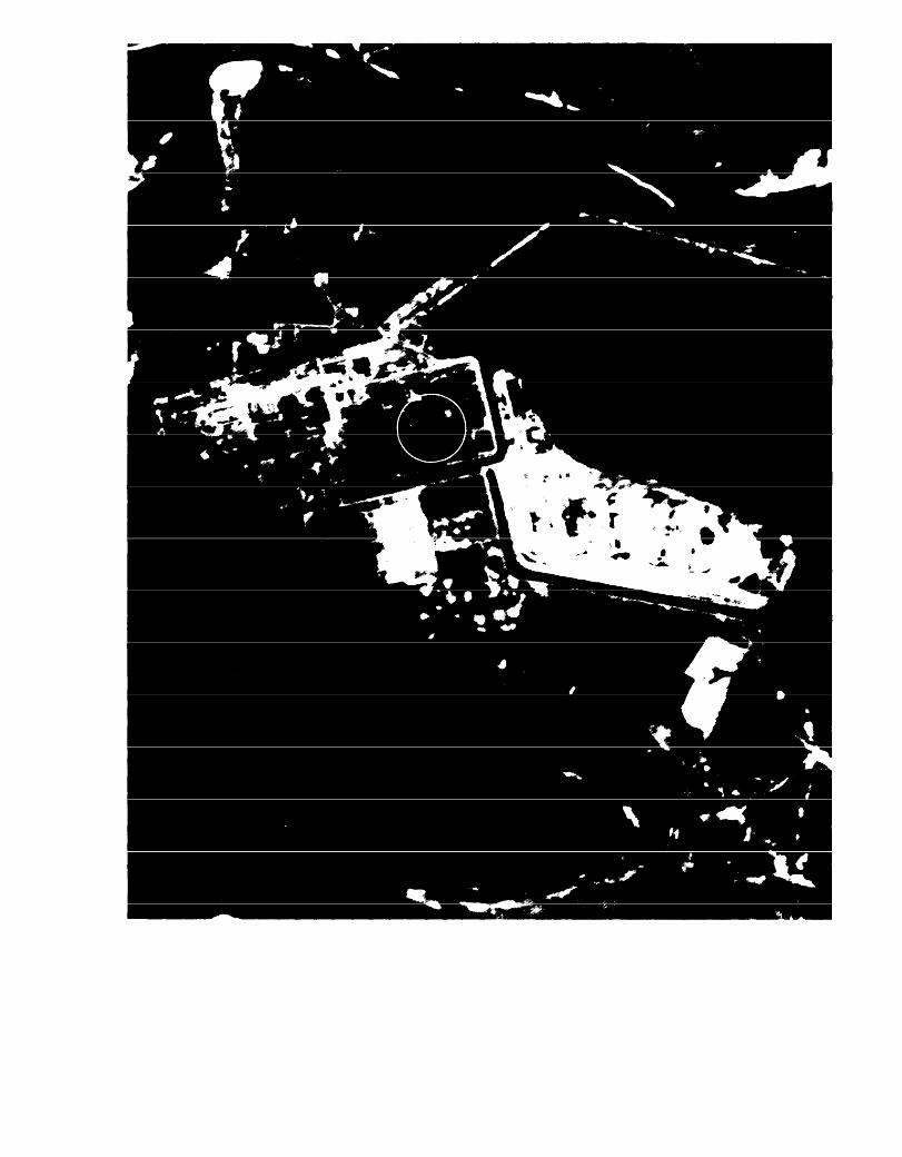
Chernobyl, U. S. S. R., on Apr. 29, 1986. The first image collected by satellite of the nuclear reactoris ilIustrated using band 7 of the Thematic Mapper. The reactor facility (circled) and surroundingagricultural areas are clearly illustrated and defined, and the still-burning reactor can be identifiedby a bright pixel—whose digital evaluation helped the United States determine the correct statusof the reactor during the incident. Evaluation of infrared and thermal imagery of the reactor
cooling pond also confirmed U.S.S.R. reports of plant shutdown and startup.
. . . nuclear powerplants must have cooling pondsand effluents and no one looked at the imageryto say, “where is the effluent for the secondreactor?”
Another panelist countered that it was one thingto say that:
. . . any idiot knows that a nuclear reactor hasan effluent pond, but what makes the problemhard is that you don’t know which idiot to hire.If you’re going to do lots of stories about nuclearreactors you hire people who know that nuclearreactors have effluent ponds. If, on the other hand,you are going to have a lot of stories about forestdegradation you need to have people who know
It was clear from the workshop discussion thatif the media intend to use satellite imagery exten-sively they must solve the interpretation problem.This would mean either hiring photointerpreters—much as they now hire meteorologists—or rely-ing on outside contractors (the so-called “value--added” industry) to turn the raw satellite data intonewsworthy information. At present, the value--added industry is small and, like the commercialremote sensing companies, is not organized to re-spond to the needs of the news media. But, as onepanelist pointed out, a news organization’s mostimportant asset is its credibility. Most paneliststhought that the industry would be able to solvethe interpretation problem once it had more ex-
a lot about forests. perience with the technology.

22
Assuming the media could arrange to receivemost data in a timely fashion and arrange for theirinterpretation, it might still be difficult to get as-sured access to politically sensitive data. Govern-ment support and control of the two existing com-mercial systems and the operational independenceof the foreign ground stations create at least thepossibility that governments could, on occasion,prevent politically sensitive data from reachingthe media.
Both EOSAT and SPOT rely on foreign groundstations to collect data when the satellite cannotcommunicate with earth stations in the UnitedStates or France. The owners of the Earth stationspay an annual fee which allows them to collectthe data from their region and sell it. The Earthstation owners pay royalties on sales of the re-gional data. In the case of the Landsat Earth sta-tions, the Memorandum of Understanding (MOU)is between the U.S. Government (with NOAA [theNational Oceanic and Atmospheric Administra-tion] as the U.S. representative) and the foreigngovernment. Under the U.S. MOUs, foreign groundstations are supposed to provide nondiscrimina-tory access to all purchasers. In practice, how-ever, the ground stations can refuse to sell data,delay the shipment of data, or deny that data evenexist .19 The only recourse after a ground station’srefusal to honor the “nondiscriminatory access”clause of their contract is for the U.S. Govern-ment to terminate service to that ground station.This would mean a loss of the annual fee ($600,000in the case of the U.S. MOUs) and, given the un-reliability of on-board tape recorders and the un-certain status of NASA’s Tracking and Data Re-lay Satellite System (TDRSS),20 the potential lossof a great deal of data.
All of these problems notwithstanding, perhapsthe biggest difficulty the media have with currentsystems is their limited resolution. Neither EOSAT
19When a buyer asks EOSAT for data that were collected by aforeign ground station, EOSAT must request that the foreign groundstation sell EOSAT those data. One panelist pointed out that cer-tain countries were notorious for refusing to release data. For exam-ple, the panelist said that it was very difficult to purchase data fromIndia, particularly if they contained scenes of the India/Pakistanborder.
20It is important to note that, as a result of the cost, complexity,and limited access to TDRSS, EOSAT does not have plans to in-clude TDRSS communication packages on its next two satellites.
nor SPOT has plans to provide the very high reso-lution sought by the news media. Several panelistspointed out that focusing on high resolution was,in some respects, misleading—the question is notwhat is the best technology the media can buy,but rather, what does the media need? If the me-dia’s primary use of satellites is to show a typhoonin Bangladesh, a volcano in Hawaii, or an oilspilloff the coast of England, then there is no reasonto incur the costs associated with very high reso-lution. If, on the other hand, the media wish tocount tanks in East Germany or show the effectsof street rioting in South Africa, then the newsmedia would probably want the highest resolu-tion they could afford.21
Other panelists suggested that the media hadyet to make innovative use of the available low-resolution imagery. “Spatial resolution is only partof the game, ” cautioned one panelist, “We are onlybeginning to understand spectral [see box C] differ-ences. ” Because different objects reflect light differ-ently, certain objects are identifiable even thoughthey are smaller than the spatial resolution of thesensor. For example, a road or a river might beless than 10 meters wide and yet still appear onan image of 30 meter resolution if the road or riverreflected light in a substantially different mannerthan the surrounding area. One panelist recalled:
When we looked at the high spatial resolutiondata from Chernobyl it was hard to tell howmany reactors were damaged, but on the spec-tral data the fact that one reactor was burningpopped out immediately.
Another panelist cautioned that, although spec-tral differences were important, when EOSATbrought back images of China, the Great Wall wasnot visible in certain spectral bands because theWall was made from, and therefore reflected lightin the same wavelength as, the surrounding rock.Panelists agreed that each system has its own spe-cific strengths and limitations, and that to date,the media had not used the available images crea-tively.
21It is interesting to note that of all the remote sensing images usedin Aviation Week and Space Technology— including many magesof the Soviet Union and of Soviet technology—the images that gen-erated the most sustained interest were those of the Mount St. He-lens explosion. Several panelists predicted that the media would finda large demand for satellite images of major natural events.

23
Implement Mediasat Concept
If the media should decide that satellite imagerywas very valuable, but that the operating proce-dures of the current commercial systems were toorigid or that access to high-quality data could notbe assured, then the media might be driven to de-velop their own system. The exact nature of thissystem would be the product of two importantconsiderations. First, the media would have to de-cide on the appropriate level of technology, whichwould include, but not be limited to, a choice ofthe resolution of the sensors to be used (e.g., 5meter, 3 meter, etc. ) Second, the media would haveto decide how much they could afford. These twoconsiderations are very closely related.
If a mediasat is to become a reality, the newsmedia must be able to assess the value of bothcurrent satellite images and successive technicalimprovements. As a result of the media’s inex-perience using satellite imagery, the uncertaintiesregarding the present market for data, and the lackof credible cost estimates for high-resolution im-agery, deciding how good is “good enough” is adifficult task. During the workshop, several par-ticipants suggested that 5 meter resolution mightmeet the needs of the news media. Yet, when onepanelist illustrated the effect of increased resolu-tion by showing 10 meter and 5 meter images ofWashington, D. C., several panelists were notice-ably unimpressed. “You say that 5 meter resolu-tion will produce good pictures, ” commented oneparticipant, “1 still say it’s a source story [see boxE]. You show that picture and you will have peo-ple saying: ‘What is this? You’re telling me thisis Washington? It looked to me like New York. ’ “Another panelist, familiar with satellite imagerycountered that, “You ought to take a look at thisunder a magnifying glass. There is a great dealmore information in this 5 m picture than in the10 m picture. ” This interaction highlighted oneof the basic dilemmas facing the news media—how to assess the value of increased informationwhen that information can be transmitted to theconsumer only imperfectly .22
ZZFo]]oW,ing the workshop, OTA received a letter from Earl S,Merrit, Vice President of EarthSat, a corporation specializing in the“value-added” business of imagery processing. The letter, which calledinto question the value of even very high resolution imagery, stated:
[T ]he satell~te-acquired Information WII[ always be source” materialeven If the resol ut]on was I meter due to [ the need for expert ]nterpre-
If cost were not a consideration, the media mightwant the highest resolution pictures they couldget, but costs rise dramatically as resolution in-creases. This results, in part, from the fact thatthe data rate23 rises as the inverse square of theresolution. This means that, assuming the satel-lite is covering the same area, as resolution im-proves from 10 meters to 5 meters, the amountof data that must be collected, transmitted, andprocessed increases by a factor of 4. Similarly,improving the resolution to 2.5 meters would in-crease the original 10 meter data rate by a factorof 16. This led some panelists to conclude thatdata rate could influence the ground segment costsfor the mediasat system more than any othersingle element .24
Panelists cautioned that although increased datarate was a “problem, “ it was possible to identifysome potential solutions. Data rate, it was argued,could be greatly diminished by using the satellitesto take pictures of specific, pre-identified events(e.g., an oil tanker beached on the California coast,a hijacked airplane sitting on the tarmac in Tripoli),rather than taking pictures of the entire Earth andthen sifting through the raw data in the hopes offinding “news. ” In addition, data compressiontechniques could be used to greatly diminish thedata flow problem .25
tation ]. This fact would seem to provide a ‘ damper” on the networkuse of such source material since the number of “experts” in interpre-tation is limited. Thus, I see the networks eventually using the “source”to highlight a story but not to provide the bottom line. . . human-intelligence gathering “journalism’ will continue to dominate newsgathering.
23Data rate refers t. the flow of information about the picture“seen” by the satellite’s sensor. At higher resolutions the picturesare more detailed and therefore contain more information. In orderto transmit more information about the same scene in the same timeperiod, the data rate must increase.
24EOSAT’s 30 meter TM sensor has a data rate of 85 million bitsper second (MBPS), The data rate for a 5 meter mediasat with thesame swath width would be 3,060 MBPS, By narrowing the swathwidth (therby reducing the coverage) and using data compressiontechniques, the data rate could be reduced to the 100 to 150 Mbpsrange. Even this much reduced data rate would require more so-phisticated data systems in both the sensor and the satellite thanwe now possess.
25Data compression is a process that reduces greatly the amountof data which must be transmitted from the spacecraft to the groundstation. Although there are many data compression techniques, mostoperate by reducing or eliminating the redundancy that is inherentin raw data, Where the quality of the resulting image is to be judgedby subjective criterion such as visual appearance—as may be thecase with media images—the transmitted data need only be suffi-cient to construct a facsimile of the orginal data. Under thesecircumstances—and depending on the amount of redundancy in thedata–compression ratios of more than a factor of 2 could be achieved.
24
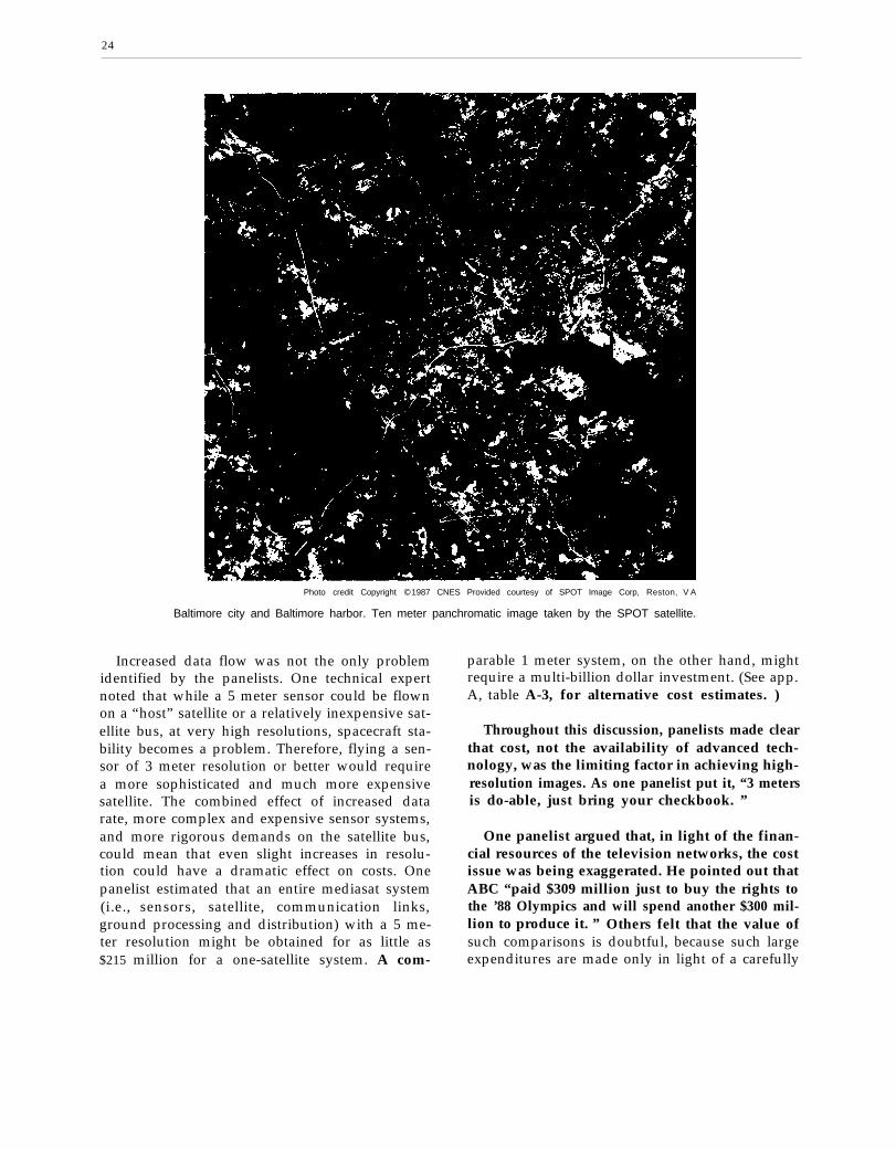
Photo credit Copyright © 1987 CNES Provided courtesy of SPOT Image Corp, Reston, V A
Baltimore city and Baltimore harbor. Ten meter panchromatic image taken by the SPOT satellite.
Increased data flow was not the only problemidentified by the panelists. One technical expertnoted that while a 5 meter sensor could be flownon a “host” satellite or a relatively inexpensive sat-ellite bus, at very high resolutions, spacecraft sta-bility becomes a problem. Therefore, flying a sen-sor of 3 meter resolution or better would requirea more sophisticated and much more expensivesatellite. The combined effect of increased datarate, more complex and expensive sensor systems,and more rigorous demands on the satellite bus,could mean that even slight increases in resolu-tion could have a dramatic effect on costs. Onepanelist estimated that an entire mediasat system(i.e., sensors, satellite, communication links,ground processing and distribution) with a 5 me-ter resolution might be obtained for as little as$215 million for a one-satellite system. A com-
parable 1 meter system, on the other hand, mightrequire a multi-billion dollar investment. (See app.A, table A-3, for alternative cost estimates. )
Throughout this discussion, panelists made clearthat cost, not the availability of advanced tech-nology, was the limiting factor in achieving high-resolution images. As one panelist put it, “3 metersis do-able, just bring your checkbook. ”
One panelist argued that, in light of the finan-cial resources of the television networks, the costissue was being exaggerated. He pointed out thatABC “paid $309 million just to buy the rights tothe ’88 Olympics and will spend another $300 mil-lion to produce it. ” Others felt that the value ofsuch comparisons is doubtful, because such largeexpenditures are made only in light of a carefully

25
Photo credit Copyright 1987 CNES Provided courtesy of SPOT Image Corp.. Reston, VA
Baltimore harbor area. Ten meter panchromatic image taken by the SPOT satellite.
calculated expectation that they will increase rev-enues at least as much.
The hard question, then, is “what value wouldsatellite images add to current news stories ?“ or,more to the point, “what additional news storiesand revenue could be generated by the use of sat-ellite imagery?” Obviously, satellite images wouldnot be useful in all of any given day’s news sto-ries. Even assuming that ABC, CBS, NBC, andCNN use one satellite image per evening everyday of the year, it is difficult to imagine how rev-enues could be generated to offset the cost of a$215 million to $470 million satellite system. Ifall four major networks used 1 satellite image everynight, this would mean that about 1,500 imageswould be used every year, If one assumes that amediasat would cost approximately $215 millionto $470 million to build and launch, and another
$50 million to $75 million to operate over a periodof 5 years ($10 million to $15 million per year),then the average cost over the 5-year period wouldbe $53 million to $1.09 million per year, Puttingthese admittedly speculative figures together, oneconcludes that each satellite image would have tobe worth about $35,000 to $73,000 to the net-works (see app. A for cost assumptions). Giventhat the average network news story is producedfor less than $5,000, it is hard to imagine how thenetworks could justify this additional expendi-ture. 26
*’Several panelists felt that OTA cost and demand projections weretoo pessimistic. One panelist stated:
I particularly want to challenge the assertion that each networkwould not use images every day It reminds me only too well of thesimilar statements made in the wake of the first Telstar feeds tothe United States from Europe and the confident predictions that therewas no possibility that such programming would ever become com-monplace because the Intercontinental link would always be too costly.

26
There are ways that the news media might tryto reduce the cost of a mediasat system: they couldform a consortium—either domestic or international—to share the cost, they could resell data to other
2 7 o r , t h e y m i g h tusers to subsidize their own use,wait until technical advances reduce the cost ofsensors, satellites, and launch vehicles.28 At pres-ent, it is unknown whether any of these measures,or combinations of measures, would reduce thecost of a mediasat to the point where it would beeconomically viable today. Two points, shouldhowever, be kept in mind: first, it is impossibleto estimate accurately the future demand for re-motely sensed data; and second, simple calcula-tions that compare the cost of a mediasat and po-tential mediasat revenues could be misleading. Itis difficult to describe the value of a press “exclu-sive, ” and, as banks have recently demonstratedwith their electronic teller machines, there is valuein providing new services .29
Some panelists expressed the view that inter-ested governments should combine their resourcesin an INTELSAT-like organization to ensure con-tinued, cost-effective access to remote sensing data.Inherent in this concept is the belief that a medi-asat would not be economically viable even iffunded by a consortium of news agencies. In onepanelist’s opinion:
The money received from Chernobyl wouldfit in a thin wallet. When will there be anothersuch accident located in a place where we can-not fly in with a good hand-held camera? An in-ternational governmental consortium is the bestway to ensure the continued availability of re-mote sensing data, It could begin to form whenEOSAT and SPOT get tired of throwing moneyat the problem, when Congress takes Gramm-Rudman-Hollings seriously, and when someone
27It is significant t. note that total remote sensing data sales be-tween 1979 and 1984 only produced a little over $30 million. See:“Landsat Data Users Notes,” No. 35, March 1986, p.7.
28Many of the technologies currently being investigated by theStrategic Defense Initiative Organization (i.e., inexpensive launchvehicles, satellites, and sensors) could make mediasat a reality.
“One panelist, noting that the fortunes of the major networkshad been in decline recently, argued that a mediasat might be justi-fied partly on the grounds that while a network might be able tooperate a mediasat, its affiliates could not do so on their own. There-fore, a network might want to operate a mediasat because it couldhold the network together, thereby preserving other revenues.
sees other countries as a set of partners eager tohelp share costs, and more importantly, help pro-mote the use of [remote sensing] systems.
Finally, it should be noted that some expertssee “mediasat” as one aspect of a more profoundtransition of the news networks from the statusof news providers to a much broader role in theinformation industry. As one panelist noted:
It is my belief that the largest market formedisat data will not be the news divisions butrather the secondary markets. Media companieswill sell the interpreted data to buyers aroundthe world . . . and will change their structure tobecome huge value-added entities . . . The me-dia [will never] be able to spend the amounts ofmoney for a mediasat without aggressively open-ing new markets around the world.
Should the networks undergo the radical trans-formation foreseen by this panelist, the assump-tions and conclusions of this technical memoran-dum would have to be similarly modified. Thelikelihood and prospects of such a transformationare beyond the scope of this technical memoran-dum. Box G and tables 2 and 3 provide informa-tion on many of the possible uses for remotelysensed data beyond newsgathering.
Table 2.—Remote Sensing Data Needs ofDomestic Users
Foreign and
Agriculture (Federal, State, and private): specific sampl-ing areas chosen according to the crop; time-dependentdata related to crop calendars and the weather patternsForestry (Federal, State, and private): specific samplingareas; twice per year at preselected datesGeology and nonrenewable resources (Federal, State,and private): wide variety of areas; seasonal data in ad-dition to one-time samplingCivil engineering and /and use (State and private): popu-lated areas; repeat data required over scale of monthsor years to determine trends of land useCartography (Federal, State, and private): all areas; repeatdata as needed to update mapsCoastal zone management (Federal and State): monitor-ing of all coastlands at selected dates depending on lo-cal seasonsPollution monitoring (Federal and State): broad, select-ed areas; highly time-dependent needs both for routinemonitoring and in response to emergenciesNewsgathering (private): selected areas; highly time-de-pendent needs in response to fast breaking news stories
SOURCE: Office of Technology Assessment

27
Box G.—Remote Sensing and the Public Interest
U.S. land and meteorological remote sensing systems have from the beginning been intended to servethe public interest, whether primarily for research, as in the case of the Landsat system, or for operationalweather forecasting and severe weather warning, as in the case of the meteorological satellite systems.
The Landsat system has demonstrated to a small but dedicated group of customers, both inside andoutside the government, that satellite data can be highly effective in meeting their resource informationneeds. Land remote sensing systems serve a wide variety of data users (table z), most of whom requiresatellite data of 10 to 100 meters resolution on time scales of weeks to months. However, the agriculturalcommunity and those who monitor the courses of natural and manmade disasters have need for data ona more timely basis.
It is clear from examining table 3 that the public interests and those of the media are often synon-ymous. Data from a mediasat could make an important contribution in warning of and assessing naturaland manmade disasters, as well as in managing disaster recovery.
The value-added industry has developed a number of techniques for converting data to informationthat would serve the public good. Some of these would be of interest to the media:
. use of time lapse images to compare scenes over time;
. overlay of black and white imagery with spectral imagery to bring out features not visible in either;
. use of ground-based images to illustrate features close-up; and
● using stereo pairs to generate three-dimensional images from different perspectives.As one expert on photointerpretation and remotely sensed imagery has pointed out:
. . . remote sensing technology, properly applied, could save countless lives and billions of dollars in propertydamage each year. Few outside the military and intelligence [communities] are aware of this resource. Fewerstill know how to interpret that technology and even fewer know how and when to apply it. Yet it is the sametechnology with which the United States monitors SALT and the Middle East Truce Agreement, observes andpredicts crop yields in the Soviet Union, Australia, Canada, Argentina, and India, and assesses damage causedby such catastrophes as the Italian, Guatemalan, and Alaskan earthquakes.. . . If existing multisensory imagery had been analyzed, the plight of $150,000,000 in Ethiopia and other Africancountries could not only have been predicted, but actions taken before disaster struck. *
● Dino Brugioni, Air Force Magazine, October 1985.
Table 3.—Summary of Applications of Landsat Data in the Various Earth Resources Disciplines
Agricultureforestry and
range resources
Discrimination ofvegetative types
Crop typesTimber typesRange vegetation
Measurement of cropacreage by species
Determination ofrange readinessand biomass
Determination ofvegetation vigor
Determination ofvegetation stress
Determination of soilcondit ions
Determination of soilassociations
Assessment of grassand forest firedamage
Land use andmapping
Classification of landuses
Cartographic mappingand map updating
Categorization of landcapabil i ty
Separation of urbanand ruralcategories
Regional planningMapping of transpor-
tat ion networksMapping of land-
water boundariesMapping of wetlands
Geology
‘Recognition of rocktypes
Mapping of major ge-ologic units
Revising geologicmaps
Delineation of uncon-solidated rock andsods
Mapping igneous in-trusions
Mapping recent vol-canic surfacedeposits
Mapping land formsSearch for surface
guides to minerali-zation
Determination ofregional structures
Mapping linears(fractures)
Water resources
Determination ofwater boundariesand surface waterarea and volume
Mapping of floodsand flow plains
Determination of aerialextent of show andsnow boundaries
Measurement of gla-cial features
Measurement of sedi-ment and turbiditypatterns
Determination ofwater depth
Delineation of irrigat-ed fields
Inventory of lakes
Oceanographyand marine
resources
Detection of I ivingmarine organisms
Determination of tur-bidity patterns andcirculation
Mapping shorel inechanges
Mapping of shoalsand shallow areas
Mapping of ice forshipping
Study of eddies andwaves
Environment
Monitor ing surfacemining andreclamation
Mapping andmonitoring ofwater pollution
Detection of airpollution andits effects
Determination ofeffects ofnatural dis-asters
Monitor ing en-vironmental ef-fects of man sactivities (lakeautrophicationdefoliation,etc.)
S O U R C E N M Shwt P D Lowman Jr and S C Freden Msslon (O Earl/i Landsaf 14ews Me Wor/d N A S A Sclentlflc and Twhnlcal Office 1 9 7 6

28
Photo credit Copyright © 1987 EOSAT Provided courtesy of EOSAT
Portion of Landsat 5 Thematic Mapper image showing Augustine Volcano, Alaska during eruption on Mar. 27, 1986. Band 4,i n the near infrared, clearly defines snow/cloud area from surrounding vegetation and terrain, with 30 meter ground resolution.

29—
Photo credit Copyright : 1987 EOSA T Prowded coo lrtesy of EOSA T
The 120 meter thermal band on the Thematic Mapper displays the hot flow at the north endof the Augustine Volcano through the smoke and cloud cover. By combining the spectral bands
of the Thematic Mapper, the clarity of 30 meter resolutionis complemented by thermal information,

NATIONAL SECURITY AND FOREIGN POLICY
So far, this paper has examined the desirabilityand feasibility of a mediasat from the perspectiveof the press. It is also important to examine theU.S. Government’s interests, attitudes, and con-cerns regarding this concept. The remainder of thistechnical memorandum will focus primarily onthe tensions that are certain to develop betweenthis Nation’s commitment to freedom of the pressand its commitments to current national securityand foreign policies. As one author framed theproblem:
In a robustly pluralist society such as ours, freespeech is easy to accept and to enjoy, and in ahostile, potentially lethal international environ-ment such as the one in which we live, nationalsecurity seems a fundamentally worthwhile pur-suit. The difficulty lies in making tradeoffs.30
In the preceding discussion, this technical memo-randum concluded that, in the near-term, the highcost of gathering and processing satellite imagerywould inhibit the news media’s attempts to estab-lish a mediasat. Nonetheless, in the long run, themedia are likely to continue using satellite imageryand gain access to increasingly sophisticated re-mote sensing technology. Accepting this fact, theUnited States will eventually have to balance theguarantees of free speech and the need for nationalsecurity with respect to media use of remotelysensed data from spacecraft.
National Security ConcernsExperts generally agree that the media’s exten-
sive use of high-resolution satellite imagery fornewsgathering could complicate certain U.S. na-tional security activities and certain U.S. foreignpolicies. They also agree that this Nation’s strongand unwavering commitment to the principle offreedom of the press has served it well. The task,therefore, is to balance these two fundamental con-cerns. As the following discussion illustrates, thearguments on both sides of this issue are strongand clear choices are few.
Participants identified and discussed five setsof national security and foreign policy concernsduring the workshop.
JoPau] 0. Stephens, T& First Amendment and National Security,Center for Law and National Security, University of Virginia, vol.1:2, May 1984, p. 1.
30
1. Dissemination of Information ConcerningU.S. Military Operations
Some panelists expressed the concern that, with-out adequate oversight of a mediasat, the mediamight disclose information concerning U.S. mili-tary operations under circumstances that couldresult in casualties and/or frustrate U.S. objec-tives. The disclosure by the media of informationconcerning U.S. troop movements, shipments ofmateriel, or the location or heading of ships andcargo planes could deprive U.S. troops of the ele-ment of surprise—a critical tactical advantage infast-paced, modern warfare.
The most common media response to such alle-gations is that, although a mediasat could pro-vide a substantial new source of data, the media’sextensive contacts and information sources withinthe United States and around the world alreadyprovide the press with real-time information con-cerning fast-breaking news stories. “The systemleaks like crazy anyway,” asserted one panelist,“I find it hard to get excited over the incrementaldamage that a mediasat could do. ” The media arealso quick to assert that their past record is a goodone. Where lives were at stake or serious nationalsecurity issues in question, they argue that the newsmedia have acted responsibly, often refusing torelease information that would seriously prejudicenational security .31
One media representative said that in 1986, hisnetwork’s correspondent was flying in a charteredairplane and saw the U.S. fleet turn south towardsLibya hours before the United States’ retaliatorybombing. Although this information was radioedto the network affiliate in Rome and then passedback to the United States:
We did not go on the air with it because werealized that specific lives were in jeopardy , . .
~lA1though the workshop participants generally accepted the Prop-osition that the news media acts responsibly, a minority of expertsand media pundits have argued the opposite. For example, analystsat Accuracy in Media, Inc. (AIM), have argued generally that themedia’s “policy of publishing sensitive information . . . may jeop-ardize the lives of innocent peopIe. ” (See: “AIM Report, ” July-A,1985, No. XIV-13, p.1) The media have been criticized for speculat-ing about sensitive programs such as the launches of classified DODpayloads on the Space Shuttle. More recently, the media were criti-cized because some felt that they were putting the lives of the Beiruthostages in danger by speculating on the nature of U.S. efforts tofree them.
31— — —
It is our policy that when there is a specific issueof life or death we will not broadcast that infor-mat ion.
Another panelist commented that although thenetwork’s restraint in the Libyan incident was com-mendable:
I assume you don’t have fancy cryptographiccommunication equipment; therefore, you gaveLibya the message when you radioed it from theairplane to the ground station.
This comment identifies two important problems:
1. the media have only a limited ability to pro-tect sensitive information even if they desireto do so; and
2. the national security community may haveto rely on the press’ restraint to withhold in-formation that once was under the controlof the national security community.
Some media experts argue that a “newsgather-ing” satellite would work to the advantage of theUnited States by providing additional reconnais-sance capability. It would be more difficult fornations to cheat on treaties or hide hostile activi-ties if faced with frequent overflights by bothmedia- and government-owned satellites.
2. Retaliation by Foreign Governments forMedia Disclosures
Recent world events have demonstrated thestrange symbiotic relationship that exists betweenthe U.S. Government and the U.S. news media.The taking of media hostages in Beirut and thearrest and detention of Nicholas Daniloff inMoscow are just two examples of the willingnessof certain foreign governments to use the U.S. me-dia as pawns in their struggle with the U.S. Gov-ernment. Mediasat raises the opposite concern—that the U.S. Government might be held respon-sible for the actions of the news media .32 Someworkshop participants expressed the concern that
~ZTh~ LJ S. Government accepted ]ega] responsibility for the ac-tions of its citizens in space in the Outer Space Treaty (18 U,S. T.2410: T, I.A. S, 6347). Article VI of the Outer Space Treaty states:
States shall bear mtemational responsibility for national actiwI t]es In outer space whether such activities are carried on by go\, -ernmental agencies or by non-go vernrnenta I entlt]es, and for assur-]ng that nat]ona] actlvtt]es are earned out m conforn-uty wvth ( th]s)Treaty The act]wt]es of non-governmental entitles in outer spaceshal I requ]re au thorlzat]on and cont]nulng supervision by the appro-priate State party to the Treaty
friendly foreign governments might retaliate byexpelling diplomats or closing valuable U.S. mil-itary bases should the press reveal information thatembarrassed or threatened the national securityof those nations. Governments already hostile tothe United States could resort to terrorism or di-rect armed aggression .33
Some panelists felt that this was neither a sig-nificant nor a novel issue, and that although coun-tries might initially complain, eventually theywould accept a mediasat as they now acceptEOSAT and SPOT.34 The Soviets, one panelistnoted, had complained bitterly through diplomaticchannels when the magazine Aviation Week andSpace Technology first ran pictures of its launchfacilities at Tyuratam, but over the years theircomplaints gradually ceased .35 Other paneliststook an uncompromising view of threats of for-eign retaliation. They maintained that this issuewas one that should now and always be non-negotiable by the U.S. Government as it lies atthe heart of the principle of freedom of the press.One panelist commented hotly:
When the Soviets or other countries call andsay, “why aren’t you stopping that story on theevening news, ” you say, “we can’t, and that’s thedifference between our country and yours. ”
3. Loss of Control During a Crisis
Advances in transportation and communicationtechnologies have made the world smaller and re-duced the time available to leaders to make deci-sions. Although far from perfect, the communi-
330ne panelist pointed out that some nations already have, andothers may eventually have, the capability to destroy or incapaci-tate satellites of the types likely to have commercial value.
“For many years after the U.S. Landsat program began, manydeveloping countries claimed that a state should not be “sensedwithout its prior consent. It is significant to note that the PrinciplesRelating to Remote Sensing of the Earth From Space (A RES 41 05,Jan. 22, 1987), recently published by the United N’ations, omits an}reference to prior consent. This is at least some indication that asnations become more familiar with this technology and as the tech-nology becomes more widely available, countries ~vil 1 cease t o re-gard it with suspicion.
‘sThe initial Soviet complaints resulted in part because this wasthe first publication of such images and, in part, because of the ttm-ing of the release. The pictures appeared immediately before the IQ7SApollo-Soyuz U.S. Soviet link-up in space and may have beenregarded by the Soviets as a violation of the “spirit of cooperation”which both governments were trying to project to the world, Onepanelist noted, however, that the Soviet’s ability to disable satel-lites was far less in 1975 than it is today.

32
. .
Photo credit’ Copyright L 1987 CNES. Provided courtesy of SPOT Image Corp , Reston, VA
Soviet nuclear testing facility, Semi palatinsk, U.S.S.R. Visible are cable scars and access roadsconnecting with drill holes. Ten meter panchromatic image taken by the French SPOT satellite.
cation and information assets available to world “grace period” could be reduced to zero and thatleaders have allowed them to stay just ahead of world leaders would be forced to respond to pressbreaking events. This small grace period has given reports on which they had little or no informa-leaders time to plan and confer with advisors be- tion. One analyst noted that President Kennedyfore being forced to make critical decisions that had 6 days to formulate a response to the discov-could lead to confrontation or conflict. As medi- ery that Soviet missile sites were being built inasats become more capable, some fear that this Cuba. How might the President have handled this

crisis had he been forced by media disclosures torespond to Congress, the press, and the Amer-ican people within the first few hours?
During the workshop, participants put forwardtwo responses to this issue. The first was similarto the response to the issue of dissemination ofmilitary information; that is, that a mediasatwould provide only an incremental increase overcurrent capabilities. The sophisticated communi-cation equipment now employed by the media al-ready forces world leaders to respond in real-timeto breaking news. Second, no matter how ad-vanced the media’s assets were, they could neverrival the sophistication and timeliness of the en-tire intelligence apparatus currently available tothe superpowers, of which satellites are only asmall part.
4. Providing Valuable Intelligenceto Third Parties
The United States and the Soviet Union still holda virtual monopoly on sophisticated, global recon-naissance data. These data are, for the most part,jealously guarded, although in certain circum-stances discrete portions of these data have beenreleased to aid allies or confound adversaries.Some panelists expressed concern that mediasatactivities, by making satellite images more gener-ally available, would erode this important U.S.advantage. Workshop participants were unableto reach consensus on either the dangers posedby this potential erosion or the nature of the sup-posed advantages now enjoyed.
The issue seems to turn on the judgment that:1) there exists a sizable set of issues about whichthe United States and the Soviet Union would havea common interest in withholding or controllingthe flow of information, and 2) the fact that So-viet reconnaissance systems could detect some-thing does not necessarily mean that they havedetected it. Some panelists simply discounted theimportance of the first concern, stating that, “thesituations where the United States wants to con-ceal something from a third country that theSoviets wouldn’t cooperate with would be few andfar between. ” In response to the second concern,certain panelists noted that the likelihood thatcommercial news gathering satellites would find
out things that the Soviets didn’twas, “conceivable but extremely
33
already knowunlikely. ”
5. Dangers of Media Misinterpretation of Data
The previous section has already discussed theproblems that the media have had in interpretingthe satellite imagery they have already obtained.Some panelists expressed fears that inaccuratereporting—caused primarily by the strong pres-sure to “break the news"—could precipitate a cri-sis. For example, one expert recently wrote that:
[S]everal networks showed SPOT photographsof the Soviet nuclear proving grounds at Semi-palatinsk and claimed that the Soviets were pre-paring to resume nuclear testing. They showedphotos of what was described as a “drill site. ”Looking at the photo, any competent imageryanalyst would have pointed out that the arrange-ment and the cable scars terminating at the sitewould have proved that it was not a drill site butrather an instrumentation site, common to all nu-clear proving grounds.36
It is conceivable that similar media misinterpre-tations on more serious issues such as troop move-ments or arms control violations could seriouslydisrupt international affairs, Some media expertsdiscount this concern, arguing: first, that as themedia continue to use satellite data they will growmore sophisticated and become less prone to er-ror; and second, the common practice of verifyingmajor stories with multiple sources of informa-tion should reduce the likelihood of misinterpre-tation,
One panelist felt that the media should be forcedto use a common pool of qualified analysts to en-sure that image misinterpretation was kept to abare minimum. Most panelists strongly disagreedwith this suggestion, claiming that:
It’s part of the process of free speech to permitand encourage diverse interpretation. Attemptsto limit interpretation will have a direct impacton the American people’s ability to get informa-tion and make their own judgments.
7*D. A, Brugioni, Satellite Images on T\’: The Camera Can [.ie,W a s h i n g t o n post, Ilec IJ, IQ86, p . HI, co]. 1 .
34
The Effect of Foreign Remote SensingSystems on U.S. Policies
Within a decade, many nations will have theirown remote sensing systems. The U.S. Govern-ment cannot effectively limit or control media ac-cess to satellite imagery if foreign governmentsdo not exercise similar controls. At present, theonly non-U. S. commercial remote sensing systemis France’s SPOT. However, research-oriented re-mote sensing systems are currently under devel-opment by Canada, China, the European SpaceAgency, India, and Japan. Japan launched its firstMarine Observation Satellite (MOS I) in Febru-ary 1987. In addition, instruments flown on theshuttle and on the proposed international spacestation and its related polar platforms will supplyanother source of high-quality data with poten-tial media application. All these systems, eventhose not considered “commercial,” add to the poolof data available for exploitation by the media.
The almost assured proliferation of sophisti-cated remote sensing systems has caused manyanalysts to question the practicality—except forminimal launch vehicle and payload licensing37—of attempting to regulate the media’s use of satel-lites to gather news. The most obvious means forcontrolling a mediasat organization would be to:1) allow the launch of only certain types of satel-lites (e.g., limit the type and resolution of sen-sors); 2) control what the satellite takes picturesof in orbit; and/or 3) limit the flow of data fromthe satellite to the end user. Disregarding for themoment the constitutionality of any of these pro-posals, U.S. laws attempting to accomplish oneor more of these tasks would not be applicable
“Both the Land Remote-Sensing Commercialization Act of 1984115 U.S.C, 4201-4292] and The Commerical Space Launch Act [49U,S. C. 2601-2623] require licensing for private systems operatedwithin the United States.
to foreign systems. As a result, U.S. news agen-cies could purchase data from, or invest in, for-eign remote sensing systems. In the opinion ofsome panelists, the only effect of U.S. limitationswould be to stifle a domestic mediasat industry.
Others argue that foreign remote sensing sys-tems—either as a result of high costs, less sophis-ticated technology, foreign government policies,or a simple lack of need for high-resolution images—may have only limited capabilities .38 Therefore,with minimum international coordination, U.S.policies could substantially delay the time whenthe media would have access to very high-resolu-tion satellite images. The U.S. Government mightattempt to negotiate agreements39 with other coun-tries regarding sensor resolution or data dissemi-nation. Such agreements would certainly be op-posed by the news media and, given the U.S.commitment to both the freedom of the press andthe “open skies” policy, 40 it is not certain how muchsupport such agreements would find in either Con-gress or the executive branch.
38The option of a satellite owned by a U.S. entity but launchedunder a foreign “flag of convenience, ” to evade U.S. Governmentregulation appears to be foreclosed by the recent 7 national agree-ment not to export rockets that could serve as long-range missiles—and therefore also rockets capable of launching satellites into polarorbits, See John H. Cushman, Jr., “7 Nations Agree to Limit Ex-port of Big Rockets, ” The New York Times, Apr. 17, 1987, p. 1.
Jgsuch an “agreement” could be a formal treaty or a more flexibleset of gentlemen’s agreements concerning topics such as sensor reso-lution or data distribution. COCOM is a current example of suchan informal agreement. COCOM coordinates the export control re-gimes of the member nations but COCOM agreements have no le-gal standing in any of its member nations.
413T0 reduce tensions between the United States and the SovietUnion, President Eisenhower in 1956 suggested to the Soviets thateach country should allow the other to overfly its territory on aregular basis. Although the Soviets rejected this suggestion as a trans-parent espionage device, the United States’ continued commitmentto the principle of “open skies” allowed it to support its later asser-tion that spaceborne reconnaissance was a peaceful activity. See:Walter A. McDougall, The Heavens and the Earth (New York: BasicBooks, Inc., 1985), p. 127.

NATIONAL SECURITY AND THE FIRST AMENDMENT
The first amendment provides that “Congressshall make no law . . . abridging the freedom . . .of the press. ” Since the adoption of the Constitu-tion, the Supreme Court has repeatedly affirmedthe depth and breadth of its commitment to thesefew powerful words, even when confronted withserious national security concerns. Although itwould be possible to write a treatise on the legalissues that a mediasat could generate, this paperis concerned with merely outlining the issues re-lated to two narrowly drawn questions:
1. Are there restrictions that the governmentcould impose in the interests of national secu-rity that would pass constitutional muster?
2. Is the licensing scheme established in the 1984Remote Sensing Act a reasonable exercise ofU.S. domestic and international responsibil-i t ies and is i t consis tent with the f i rs tamendment ?
Mediasat Restrictions andthe First Amendment41
Before one can assess the constitutionality ofmediasat restrictions, it is important to considerthe legal status of newsgathering. In Branzburgv. Hayes, the Supreme Court held that news-gathering qualifies for some first amendment pro-tection, because “without some protection forseeking out the news, freedom of the press couldbe eviscerated. ”42 But, the Court in Branzburg didnot say—and has never said—that newsgather-ing is due the same degree of protection affordedtraditional speaking and publishing activities. In-deed, the Court has upheld restrictions on news-gathering where reporters sought access to gov-ernment facilities or government information notgenerally available to the public .43 The degree ofprotection ultimately granted to news gatheringactivities will determine which restrictions the U.S.
i IThl~ paper discusses only the first amendment issues raised bya mediasat. Media owned satellites would, of course, be subject toall the domestic laws and regulations (e. g., Federal CommunicationCommission regulations, Space Launch Act of 1984) that would ap-ply to other satellites, In addition, treaties that have been signedand ratified, such as the 1967 Outer Space Treaty and the 1972 Lia-bility Convention, are legally binding on private sector activities.
J2408 us, fjtjs, 6 8 1 ( 1$’72).
“See: Pen v. Procunier, 417 U.S. 817 (1974), and Saxbe v. Wash-ington Post Co,, 417 U.S. 843 (1974 ).
Government could properly place on a mediasat.Unfortunately, until the Supreme Court has oc-casion to rule on this specific issue, it will not besettled decisively.
As noted above, should the U.S. Governmentdesire to inhibit a media-owned satellite fromgathering potentially sensitive information itcould—either permanently or during a crisis—attempt to limit: 1) the resolution of the satellitessensors, 2) the images that the satellite is allowedto collect, or 3) the images the media may dis-seminate. If news gathering is granted the highestdegree of first amendment protection, all such re-strictions might well be regarded as impermissi-ble “prior restraints” on free speech. The doctrineof “prior restraint” holds that advance limitationson protected speech may not be “predicated onsurmise or conjecture that untoward consequencesmay result .“44 Prior restraints are allowable onlyif necessary to prevent “direct, immediate, andirreparable damage to our Nation or its people. ”45
If newsgathering is given full first amendment pro-tection by the Supreme Court, U.S. Governmentrestrictions would have to meet the strict tests re-quired of allowable “prior restraints. ” On the otherhand, should the Court decide that news gather-ing was deserving of some lesser degree of pro-tection, the government would have considera-bly more latitude to limit mediasat activities.
But even if the government could not meet thestrict “prior restraints” test, it could still enforcepost-publication sanctions.46 Federal espionagelaws prohibit gathering or transmitting defenseinformation, photographing defense installations,publishing or selling photographs of defense in-stallations and the disclosure of classified infor-
44Justice Brennan concurring in, New York Times Co. v. UnitedStates (The “Pentagon Papers” case), 403 U.S. 713, 724 (1971 ). Theruling in New York Times was a brief per curium decision, but eachJustice elaborated on his views in a separate concurring or dissent-ing opinion. See also: Near v. Minnesota, 283 U, S. 697 ( 1931),
“Justices Stewart and White, concurring, New York Times Co.v. United States, Id.; To date, the only case which upheld a priorrestraint in this context is a 1979 decision by a U, S. District Court,United States v. The Progressive, Inc. (467 F. Supp. 990 (W, D. Wis, ~).In that case the court issued an injunction against a magazine thatwas planning to publish a detailed description of hydrogen bombtechnology.
i~A]though they do not involve issues of “prior rfXt I’aint, ” post-
publication sanctions must still be consistent with the first amendment.
35

36— —
mation. 47 Should the media violate any of theselaws by disseminating satellite images, the gov-ernment could—subject to the limitations of thefirst amendment—prosecute those responsible.”
If the media do not own the satellite system,but rather rely on a commercial company s u c has EOSAT to provide it with data, it would beless clear whether the media could successfully ar-gue that licensing restrictions violate their firstamendment rights. Should the U.S. Governmentask EOSAT to stop distributing raw data for afew days during a crisis and EOSAT agreed, thenews media might have a case against EOSAT forbreach of contract, but its case against the U.S.Government for infringing its first amendmentrights would be less clear.
If the media were buying their data from a for-eign satellite system and the foreign governmentdecided, for political or national security reasons,to halt or delay delivery of the data, the mediawould have no constitutional protections. Theymight, of course, be able to proceed with a breachof contract action.
The 1984 Landsat Act
Under current international law” and in con-sideration of valid concerns about the nationalsecurity 50 and the public welfare,51 there seems lit-
4718 U.S.C . 792 to 799.48Most of these statutes require that the person taking the proscribed
action have “reason to believe” it would have a harmful impact.This would raise a number of difficult issues. For example, wouldit be a violation to include accidently a defense installation in a ser-ies of satellite photographs, or to include information that was notvisible to the media but which was visible to a foreign power usingsophisticated processing techniques?
4* Outer Space Treaty, Article VI, Supra, Note 32; Some authorshave suggested that a state’s responsibilities under article VI are ex-tensive:
( W)hile no one would doubt the need for government control overspace activity at its present stage, Article VI would prohibit, asa matter of treaty obligation, strictly private, unregulated activityin space or on celestial bodies even at a time when such private activ-ity becomes most commonplace Although the terms “authorization”and “continuing supervision” are open to different interpretations,it would appear that Article VI requires a certain minimum of licens-ing and enforced adherence to government-] reposed regulations. Man-ual of Space Law, Jasentuliyana and Lee (eds.) (Oceana Publishing,1979 ) , vo l . 1 , p . 17 .
50A rocket that can put a payload into polar orbit can also delivera warhead to any point on the Earth. As with other technologieson the Munitions Control List, the government has a valid interestin closely monitoring foreign access to this technology.
51 Launch vehicles and payloads present a potentially extreme safetyhazard to the citizens of this and other countries. In addition to cur-
tle doubt that the U.S. Government has the right,and indeed, the duty, to exercise its supervisionover the space ventures of its citizens. In light ofthese serious concerns, some form of licensing andregulation is required. The question, then, iswhether the specific licensing system requirementin the 1984 Landsat Act is a proper exercise of gov-ernment authority.
Among its other provisions, the Landsat Actrequires those seeking an operating license to“operate the system in such manner as to preserve
rent international law, common sense would dictate that the U.S.Government should play some role in ensuring that launch activi-ties and payload do not cause injury.
Box H.—Mediasat and Personal Privacy
The media’s rights under the first amendmentare not the only rights that a mediasat would callinto question. As remote sensing satellites be-come more sophisticated, it is possible that theaverage person’s expectation of privacy could beeroded. Satellites are currently capable of spot-ting certain crimes, such as environmental pol-lution. Eventually, satellites may be able toperform other law enforcement functions suchas identifying and locating marijuana fields. Inthe far future, satellites may be able to monitorthe activities of individuals.
Under current law, a person is protected againstpublicity given to facts of his or her private life.Although this “right of privacy” is sometimeshard to define in specific terms, it seems clear thatits protections are reduced when a person ap-pears in public. * Mediasat could alter the cur-rent understanding of what the law regards as“appearing in public.” Recently, in Califoria v.Ciraolo the Supreme Court decided that aerialreconnaissance was an acceptable law enforce-ment technique and that activities taking placein the defendant’s back yard were in “plain view”even though they were surrounded by a 10 ft.high fence.** Applying Ciraolo’s logic broadly,one could argue that citizens have no right ofprivacy for any activity that might be seen froman airplane or by a satellite.***
● I. Hanson, L&+ and Related Torts, sec. 26o (1%9).**106 S,ct. 1s09 (1966).● ** Ctiaolo was a ahninal law caae involving a warrantless search.
The case’s reasoning may not be relevant to civil suits involving in-vasion of privacy.

37
and promote the national security of the UnitedStates.” 52 Some attorneys53 have argued that thelicensing provision of the Landsat Act should bedeclared invalid because these provisions are nei-ther “susceptible of objective measurement,“54 nordrafted with the “narrow specificity,”55 requiredof statutes affecting first amendment interests.
Given both the government’s valid nationalsecurity interest in regulating the use of launchvehicles and payloads, and the necessarily chang-ing nature of national security concerns, it is dif-
“15 us c 4242(b )( 1 )
‘See: Robert J. Aamoth, ‘From Landsat to Nled}asat, ‘ An7enc.3n
Enterpnw, the 1.act’ and the Commer<lal [~se~ ot Space (\l’a>hing-
t[)n, [>(-. INatlonal LeKal C e n t e r tt)r t h e I’ublic I n t e r e s t , 1Q8.5), vol,
II, P 1
‘h’e~]sh]~n I, ~o~rd of Regents, 3 8 5 [J. S 584, ~o~ ( l~b7 I
‘Hjne\ L .Ifajor of Oradell, 4 2 5 L’ S blO, IJ20 ( lQ7d i.
ficult to assess how courts might respond to thisargument. The references to national security inthe 1984 Remote Sensing Act are certainly verygeneral. However, a court might choose insteadto focus on the specific facts of each case or onpast Government actions in granting or denyinglicenses. The court could also decide that the reg-ulations supporting the statute are sufficiently spe-cific to supply both the necessary “objective meas-urement” and “narrow specificity. ”
Should a court decide that the licensing provi-sions of the act were not invalid on their face, thenthe news media might still argue that the govern-ment’s use of license denials or license-imposedsystem limitations was unconstitutional. As dis-cussed above, the freedom the government wouldhave to impose restrictions would be directly re-lated to the court’s final determination of the con-stitutional status of news gathering activities.
Appendix A
The Technology ofNewsgathering From Space1
Stillman C. Chase, Hughes Santa Barbara Research Center; andMatthew Willard, Earth Observation Satellite Co.
Introduction
Remote sensing of the Earth from space began in1960 with the launch of the first TIROS weather sat-ellite. The U.S. environmental satellite program hassince expanded to provide low-resolution, broad-scaledata from both low-Earth polar orbits and from geo-synchronous orbit. These data have been widely usedby the media for more than two decades to illustratethe form and motion of large-scale weather patterns.
Higher resolution multispectral images of the Earthfrom space first became available to the civilian userin 1972, when NASA launched the first Landsat satel-lite into a near-polar orbit. ’ That spacecraft carrieda sensor called a multispectral scanner (MSS), whichproduced experimental data in four spectral bands thatcould be used to aid cartography; agricultural inven-tories; mineral, oil, and gas exploration; and land-useplanning. The media have found these images of littleinterest primarily because the data provide a spatialresolution of only 80 meters (262 feet). Although theimages generated with MSS data reveal some culturalfeatures, including large road ways such as the inter-state highways, and even large buildings, such as thePentagon, or the shuttle assembly plant at Cape Ca-naveral, the identity of smaller features cannot be dis-cerned. 3 In addition, because the first three Landsatspacecraft passed over the same longitude at the Equa-tor only once every 18 days, and because the intervalbetween data collection and subsequent delivery to theuser (the turnaround time) could be as great as 2months, any information they might have providedwas not timely enough for media use.
In 1982 NASA launched Landsat 4, which, in addi-tion to the MSS, carried an improved sensor, theThematic Mapper (TM). When Landsat 4 began to failin 1984, an identical Landsat 5 was launched. Land-sats 4 and 5 are still providing data from both MSSand TM sensors, although the ability to transmit datafrom the TM on Landsat 4 is limited. The TM is capa-
‘Thls a p p e n d i x [s adapted from a paper ,Jrlglnally prepared t(,r the CITA
workshop on Newsgatherlng From Space‘It wa~ then called Earth Resources T e c h n o l o g y Satelllte (ERTS)‘Ohlects lust below the Ilmlt of resolution, generally can be discerned as
oblec ts on the Images, but their ldentlt} genera]]}, c a n n o t
ble of providing images of 30 meters (98 feet) resolu-tion in seven spectral bands. The TM senses a swath185 kilometers (115 miles) wide directly under thespacecraft. Its relatively high resolution provides im-ages that have already proved useful for news report-ing. Data are sold in the form of computer-compatibletapes or black and white or color photographs.
Each spacecraft crosses any particular longitude atthe Equator only once every 16 days, 4 which meansthat its chance of passing over a part of the world inwhich a newsworthy event is taking place is low. How-ever, because Landsats 4 and 5 are 8 days apart in theircycles, the two together can provide better coverage.For example, although the TM of Landsat 5 was ableto provide an important image of the failed Chernobylreactor, it passed above Chernobyl on April 29, 3 daysafter the first explosion, and could not return until So-viet technicians had extinguished the fire. In otherwords, it was unable to monitor the detailed progressof the fire, although it did show that the fire had beenextinguished. The thermal band on the TM demon-strated that only one reactor had burned. Eight dayslater, Landsat 4 was able to acquire an additional im-age of the reactor site.
Over the years, 11 other countries (table A-1) havebuilt data-receiving stations. Landsat 4 and 5 are ca-pable of transmitting data directly to these foreign sta-tions when the satellites are within range, or transmit-ting data to Earth via the Tracking and Data RelaySatellite System (TDRSS). Basic processing by the EO-SAT Corp. corrects the data for geometric and radio-metric distortions.
The Landsat system, which was originally developedand operated by NASA, was transferred to the Na-tional Oceanic and Atmospheric Administration in1983. 5 In order to transfer land remote-sensing tech-nology to the private sector, the Federal Governmentturned over operation of the Landsat system and mar-keting of its data to the EOSAT Corp. in December
4Because the Landsat orbit IS a polar orbit ]t can ‘ rewslt’ areas north ot
the Equator more often The exact number ot day’s between overhead passesvanes accordln~ to latitude
‘NOAA assumed t~peratlonal resp{lnslb[l[t} f(,r the TNI ~ensor In 1Q84
39

40
Table A-1 .—Foreign Landsat Ground Stations
Actively receiving data (MOU signed with NOAA):AustraliaBrazilCanadaEuropean Space Agency (Sweden, Italy)IndiaJapanThailandPeoples Republic of ChinaSaudi ArabiaSouth Africa
Not presently receiving data:ArgentinaPakistan (under construction)Indonesia (no signed agreement)Bangladesh (no signed agreement)SOURCE National Oceanic and Atmospheric Administration
1985. ’ In return for a government subsidy of $250 mil-lion, ’ EOSAT was to build and operate Landsat 6 and7. However, because EOSAT has received only partof the agreed-upon subsidy, it has been forced to stopconstruction of Landsat 6. The future of civilian landremote sensing in the United States is in serious doubt.8
In February 1986, France successfully launched itsown system, called the Systeme Probatoire d’Obser-vation de la Terre (SPOT). SPOT provides 20 meterdata in three spectral bands, as well as 10 meter pan-chromatic (black and white) imagery of Earth’s sur-face. Although the SPOT satellite recrosses the samelongitude only once every 26 days, its sensor is capa-ble of viewing at an angle, or off-nadir, making it pos-sible to gather images from a particular surface area7 out of 26 days. ’
A Mediasat System
Although attention generally focuses on the sensorsand their capabilities, the imaging instrument itselfwould be a small component of an overall satellite sys-tem capable of providing the data for media use. A
‘See U S Congress, Ottlce of Technology Awes\ merit, Land Remote Sens-lrrg and the h vate Sector; Issues for Ilkuss)on ( W a s h i n g t o n , D C L1 SGovernment Printing Otflce, March 1984, for an extens]ve discussion of thehlstorv behind transfer of the Landsat svstem to the nrivate sector. See also,In ferrr’ationa] Cooperation and Competition in Civdian Space Actlvltles{Washington, DC U S. Government Pr]nting Ottice, July 1985; and U.S.Congress, ‘The Comrnerclallzation of Meteorologlca] and Land Remote-Sensing Satellites, Hearings before the Subcommittee on Natural ResourcesAgriculture Research and Fnwronment and the Subcommittee on Space Scienceand Appl icatlons ot the House of Representatives Committee on Science andTechn{>logy, 1Q83 [Nc> 53]
‘Not inclu&ng launch co5t5, wh]ch were estimated to be $50 mllllon to $70mllllon
“Theresa XJl Foley,, “Reagan Asked to Intercede To Save Landsat Program,Av]at]orr Week and Space Technology, Apr 6, 1987, pp 29-30.
‘Note that viewing ob]ects at an angle causes the resolution to decreaseIn addltlon, ob}ects In the shadow ot tall structures WIII generally not be wslble
remote-sensing satellite system consists of four majortasks, each of which is critical to producing usefulimages:
1. data acquisition—the spacecraft, sensors, andtransmitters;
2. data collection and delivery—the receiving sta-tion and other communication components; and
3. initial image processing; and4. interpretative analysis.
In addition, a launch vehicle is required to place thespacecraft in orbit.10
Media proponents of using remotely sensed datahave suggested the following key requirements:
● high spatial resolution (5 meters or less);● sensors operating in at least three spectral bands,
or colors;● frequent revisit of each area (1 to 2 days);. relatively narrow field of view (10 to 15 miles); and● quick delivery time to the media (24 hours or less).For purposes of discussion, OTA has selected a base-
line system capable of 5 meters resolution that wouldsatisfy most of the conditions the media say they needfor a mediasat (table A-2 and table A-3). For compari-son, OTA also selected a less capable, but less costlyminimum system capable of 10 meters resolution thatcould serve the interim needs of the media (table A-4).The sensor and associated electronics of the second,less capable system might be carried as an auxiliarypackage on a large spacecraft similar to the Omnistarsatellite proposed by EOSAT. This step would allownews agencies to gain experience with using remotelysensed data in preparation for constructing a muchmore capable, but more costly, baseline system.
‘ U n t i l at least 1 0 9 0 t h e ablllt> c~f the IJnited States to launch paylt~aclswill be severelv constralneci The first fllght ot the refurbished \huttle mavnot take place betc~re late 1 ~88 [ n addlt Ion, because bulldlng an expendable
l~unch veh]cle takes 2 }ear~ t~r more e~en It a I,iunc her w e r e (~rdered In kla}
lq87 It w o u l d n o t b e ready un t i l mld t[~ l a t e 1484
Table A-2.—Moderate and High-PerformanceConcepts Drive Sensor Cost
C o n c e p t Minimum Baseline
Push broom optics--- . . . . . . . . Refractive ReflectiveFocal length/f-number . . 60 cm; f/4 212 cm; f/6
Resolution at nadir . . . . . . 10m 5mNumber detectors and
spacing . . . . . . . . . 512, 7µM 5,120, 15 mSwath width at nadir. . . . . . 5 km 25 kmPointing mechanics . . . . . . One axis One axis
gimbel gimbelSystem power/data rate . . . 10-30W 50-100W
8.3 Mbps 166 MbpsSensor size (1XWX H) . . . . 30“ X 30” x30” 60” x30” x30“Sensor weight . . . . ... . . <100 Ibs -500 IbsSensor cost . . . . . . . . . . . . . $5-10 million $60-80 millionSOURCE Hughes Corp Santa Barbara Research Center

41
Table A-3.—Estimates of Baseline MediasatSystem Costsa
Component One satellite-system Two satellite system
Sensor $60-80 million $100-140 millionLaunch $35-50 million $70-100 millionSpacecraft $40-50 million $70-90 millionData collection
(TDRS with dual taperecorders ) $40-50 million $70-90 million
Ground segment(data capture facilityImage processingspacecraft managementand control $40-50 million $40-50 million
Total $215-280 million $350-470 millionaToese are ‘oug;-pslfmates– based OP gereal Knowledge of #-hal such syslem; mlgfit cost They
dre 001 base~ or + pa fi(cular ~nglneerlng dewgr Es[lmates co not include insurance or operaf,nq ~.osts
S(JL RCF Off Ice of Technology Asses~ment 1987
tive enough and lack the appropriate field of view. Amediasat would require specialized sensors and opticssimilar to those being developed for the next genera-tion Landsat or SPOT systems (so-called multispectrallinear arrays). The sensor itself would be simpler tobuild and cheaper than the TM, as it would have norapid scanning or cooled detectors.
For purposes of illustration, OTA has selected a goalof 5 meters spatial resolution at the nadir. This repre-sents a factor of 6 improvement (or a factor of 36 inareal resolution) over the resolution of the TM, or afactor of 2 (4 in areal resolution) over SPOT. How-ever, in order to revisit a spot on Earth within 2 daysof overflight, the sensor must have the capacity to pointoff-nadir by at least 45 degrees (figure A-1).11 There-fore, the sensor chosen in this design would be capa-
Table A-4.— Estimates of Low-Cost, MinimumMediasat System Costsa
Component One satellite system Two satellite system
Sensor $5-$10 million $10-$15 millionLaunch Not applicableSpacecraft
(Incremental marginalcosts) $2 million $4 million
Data collection(Incremental marginalcosts) $2 million $3 million
Ground segment(image processing) $10-$20 million $10-$20 million
Total $19-$34 million $27-$42 milliondTh,s ~onceot a~~”~es that (he sensor( 5 would fly a s a n acdlt(onal sensor Op d remote senw
satellite It also assumes that a ded!cated ground system would be necessary 10 process datan a Umely manner These are only rouqh esflmates based or general knowleage of what suchsystems might cost They are ~ol based on a particular englneerlnq design Cost esllma!es donot include Insurance or operating costs
SOURCE Off Ice of Technology Assessment 1987
Data Acquisition
The Spacecraft.—A relatively small three-axis stabi-lized spacecraft, equivalent in capability to the space-craft used for the polar-orbiting TIROS environmentalspacecraft, could serve the needs of a mediasat. Itwould be flown in a near-polar, Sun-synchronous or-bit having Equator crossing times in the morning whenshadows are generally strong to provide good imagedefinition. To achieve daily coverage, two spacecraftwould be flown.
Sensor Design. —High spatial resolution is the prin-cipal performance requirement for a mediasat. Neithera conventional television camera nor a specialized high-resolution (875 or 1,200 line) camera are capable ofserving as the mediasat sensors, even when fitted withadequate optics, primarily because they are not sensi-
1‘By increasing the off-nadir pointing angle to 58 degrees, lt IS possible toachieve one-day rewstt capabdity, However, the resolution ot the image wouldbe degraded to a rather large 34 meters. In addltlon the haze and obliquityof the viewtng angle would further degrade the Image and reduce the photc~-Interpreter’s abillty to dellneate details
Figure A-1 .—Mediasat Two-Day Repeat CoverageWith One Satellite
Earth coverage at ±45° from 705 km orbit
Ž Footprint is 5 m (16.4 ft) at nadir, 12.2 m (40 ft) at edgeof field (450,
● Swath is 25 km (15.5 miles) at nadir, 60 km (37.3 miles)at edge of field
SOURCE Hughes. Santa Barbara Research Center

42
Figure A-2.—The Baseline System Has High Performance
● Image footprint grows with off-nadir view
45* off-nadir angle 100
Off-nadir distance (miles)
SOURCE Hughes, Santa Barbara Research Center
ble of resolutions from 5 to 13 meters in off-nadir view-ing (figure A-2), At high latitudes, this design wouldallow daily coverage, because the ground tracks of thesensor would overlap from day to day (figure A-2 andfigure A-3)
The choice of sensor resolution constitutes a criticaldesign compromise, for the costs of bettering the reso-lution increase at a nonlinear rate. A system achieving5 meters resolution at 45 degrees off-nadir would haveto be capable of reaching nearly 2 meters resolutionat the nadir. However, the costs of providing a systemcapable of resolving objects as small as 2 meters aremuch greater than five-halves of the cost of a 5 metersystem, because improvements in the resolution or sen-sitivity of the sensors would also require substantialimprovements in the other parts of the system suchas the data transmission components (see below). Over-all costs of the system therefore are extremely sensi-tive to the capability of the sensors.
For television use, and for additional analytical ca-pacity, the media requires sensors capable of produc-ing images in three spectral channels in order to presenta color image to the public. In addition, the sensorwould provide a panchromatic (black and white) bandhaving the same resolution but higher sensitivity in or-der to sense the Earth at low light level. A 25-km by25-km instantaneous field of view (approximately a15-mile by 15-mile image) would provide approxi-mately 10 television screens of data in each satelliteimage.
Spacecraft Management and Control.—Either at thereceiving station, the image processing facility, or some
One-axis gimbal
East-west pointing
16”aperture
reflecting telescope
other location, a facility would have to be built to com-municate with the satellite. This station would sup-port the receiving facility, overall mission managementand spacecraft scheduling, including sending com-mands to the spacecraft, as well as monitoring space-craft health and status. A facility of this sort could coston the order of $20 million to $30 million.
Data Collection and Delivery
Rapid data delivery from the spacecraft to the me-dia (approximately 6 to 8 hours) is essential for timelymedia use. The collection and delivery system is com-posed of two major components: transmission to a re-ceiving facility; and delivery to the processing facility.
Transmission From the Spacecraft .—The transmis-sion components of the spacecraft would consist of asophisticated special-purpose computer for organizingthe sensed data, a transmitter, and pointable antennasfor transmitting data to a communication satellite ordirectly to Earth. Here again, the costs of a remote-sensing system increase much faster than the increasein resolution. In particular, costs could increase by asmuch as the inverse square of the resolution because,as the pixel size decreases, the number of pixels in anarea increase by the square of the change in pixel size.Thus, halving the size of the resolution element quad-ruples the number of pixels in the image. Improvingthe resolution to 5 meters (and reducing the area cov-ered in each image frame) could lead to transmissiondata rates of 100 to 150 megabits per second (Mbps).For comparison, the current TM data rate is 85 Mbps,

43
40
30
w
10
Figure A-3.— Mediasat Revisit Time Improves at Higher Latitudes
600 Field of regard(1 ,957 miles)
\
I
Washington,DC I
n. I I I I
16 Day repeatfor nadir view
4 50 f o r ( 9 3 4 m i l e s )
3 0 ” f o r ( 5 4 0 m i l e s )
M o s c o w
0 10 20 30 40 50 60Latitude (degrees)
S O U R C E H u g h e s , S a n t a B a r b a r a Resea rch Cen te r
and the SPOT sensors approximately 50 Mbps. How-ever, data compression techniques used on the space-craft could reduce the data rate well below 100 Mbps.
Data Collection.—Remote-sensing systems haveused three different methods for collecting global im-agery from polar-orbiting satellites:
1. a system of ground stations spread around theworld,
2. the NASA Tracking and Data Relay Satellite(TDRS), or
3. tape recorders onboard the satellite to store datauntil they can be transmitted to a single Earthreceiving station located on home territory.
A Worldwide System of Earth Receiving Stations.—In developing the Landsat system, the United Statesencouraged other nations to build and operate theirown data-receiving stations (table A-l). In part thiswas an attempt to spread the use of remotely senseddata to countries where conventional map and aerialphotographic techniques were limited. These stationshave also supplemented the acquisition of data fromthe Landsat series of satellites, which have either car-ried tape recorders or a TDRS transmitter. For a fee,
EOSAT transmits data from the Landsat satellite asit passes within range. In return, these stations arelicensed to sell data to customers, but must provideit on the same nondiscriminatory basis as EOSAT.However, because these stations are under the controlof foreign governments, in practice customers havesometimes experienced considerable delays in receiv-ing requested data.12 This fact, and the considerablecost inherent in receiving timely data from a scatteredset of receiving stations, make this option infeasiblefor a mediasat system.
The Tracking and Data Relay Satellite .—TDRS con-sists of two or three satellites in geosynchronous orbitand a single Earth receiving station. The TDRS relaysdata from the remote-sensing spacecraft to NASA’sTDRS reception facility at White Sands, New Mex-ico. From there the data can be re-transmitted via adomestic communications link to a processing center.Using a system like TDRS allows a remote-sensing sat-ellite to avoid reliance on onboard tape recorders or
“Interviews with NOAA oli]clals, 1985, Workshop paper by Peter Fenci
ocean Earth Corp , 1986.

44
foreign ground receiving systems. EOSAT currentlyuses the TDRS system on a limited basis for collect-ing Landsat data of areas outside of the footprint ofEOSAT’s data capture facility at the Goddard SpaceFlight Center.
Use of TDRS has several major drawbacks. First,the annual cost for this service varies according to thevolume of data transmitted, and could reach $5 to $6million per year. In addition, using the TDRS systemrequires adding a TDRS communication package tothe spacecraft at a cost of approximately $25 million.
Second, because only one TDRS is currently oper-ating, imagery cannot be relayed from the Far East orPacific Basin. A second TDRS is on the manifest ofthe first shuttle scheduled to fly after shuttle flights areresumed. 13 This will provide global coverage exceptin a narrow zone of exclusion over India. However,the currently operating TDRS has developed techni-cal problems that may shorten its lifetime.
The third, and potentially most serious, drawbackis that because TDRS was developed primarily to serveNASA and DOD missions, it operates on a prioritybasis. Many of the system users have much higher pri-ority than a private sector corporation would have.Thus, during flights of the space shuttle and some DODspace missions, the media might have little or no ac-cess to TDRS.
Tape Recorders. —Tape recorders can be used tostore data on the spacecraft until they can be trans-mitted to Earth. A space-rated tape recorder of the nec-essary data capacity currently costs about $5 million.A fully redundant system would require three taperecorders per satellite. Each tape recorder weighs about150 pounds, and therefore also substantially increasesthe weight of a spacecraft.
A receiving station is most effective when locatedat a northern latitude so the data capture facility iswithin transmission range of the satellite more often.For instance, the receiving station EOSAT plans tobuild in Norman, Oklahoma, will “see” about 34 min-utes of data per day. A facility in Fairbanks, Alaska,would “see” approximately 80 minutes of data per dayand therefore be able to receive substantially moredata, more frequently. A data-receiving station mightcost as much as $10 million.
A tape recorder system would be completely self-sufficient and the capital and operating costs wouldbe quite a bit less without the cost of the TDRS com-munication package. However, space-rated tape re-
13The first shuttle IIlght is scheduled to occur in spring 1988, but maY be
delayed unt]l late 1Q88 or possibly early 1989
corders capable of high data rates have proved unreli-able in the past and have failed, or suffered operationallimitations, before the sensors failed. Moreover, insome instances there would be delays in transmittingdata to the media, depending on the area of interestbeing imaged and the time at which the satellite nextcomes in view of the receiving station. Even at north-ern latitudes, for example, delays in transmitting datato the receiving facility could be as much as 5 to 6hours. Generally, most of these time delays would betolerable.
Delivery to the Image Processing Facility.—Oncecollected, the data must be re-transmitted to the medi-asat data processing facility where the raw data couldbe transformed into usable images for television andnewspapers. Because the data would need to be trans-mitted quickly for media use, it is likely that they wouldbe sent via a domestic communication satellite. A dedi-cated transponder for this purpose would cost about$2 million per year.
Image Processing
The cost and complexity of the processing systemdepends on a variety of factors, including data rate,the number of scenes to be processed per day, and thespeed with which data would need to be turned intoimages usable by the media. These and other desireddata processing requirements must be considered be-fore a detailed cost estimate of the image processingfacility can be made, A fully operational groundprocessing facility might cost on the order of $10 to$15 million.
Image Interpretation
Obtaining the image is only the first step in theprocess of making use of imagery from space. The im-ages are often of very little use until they are integratedwith other data, enhanced, and analyzed by expertphoto-interpreters. For example, computer processingmay make it possible to improve the image’s resolu-tion, or to analyze one of the color bands for particu-lar information. In the civilian realm the need for suchexpertise in oil, gas, and minerals exploration; cropassessment; land planning; map making; or archaeo-logical research” has encouraged the development ofan industry (the so-called value-added industry) tomake the data more useful. The media will have torely on experts from the value-added industry to in-terpret mediasat images for the public.
“U.S. Congress, Off Ice of Technology Assessment, Technologies for I’re-h~storic and H~storic Preservation, OTA-E-319 (Washington, DC U SGovernment Printing Office, September 1986)

Appendix B
Media Access to and Use of RemoteSensing Data: A Legal Overview*
Rita Reimer, Congressional Research Service
The Constitutional Statusof Newsgathering
Although the Supreme Court stated in Branzburgv. Hayes, a 1972 journalists’ privilege case, that “[itis not] suggested that news gathering does not qualifyfor first amendment protection; without some protec-tion for seeking out the news, freedom of the presscould be eviscerated, [,]"1the Court has not yet decidedwhether newsgathering activities receive the same con-stitutional protection as traditional speaking and pub-lishing activities. The only Supreme Court cases thataddress this issue per se involve media access to prisoninmates, and thus are not directly analogous to amediasat.
In two 1971 companion cases, Pell v. Procunier 2 andSaxbe v, Washington Post Co., 3 the Court rejectedarguments that the first amendment guaranteed thepress the right to interview individual prisoners. (Thepress had argued that they had a constitutional rightto interview any willing inmate, which could only beabridged if prison authorities made an individualizeddetermination that interviewing a particular inmatewould constitute a clear and present danger to prisonsecurity or another substantial interest of the prisonsystem. )
This decision was affirmed 4 years later, in H o u -chins v. KQED,4 a 3-I-3 decision that indicated thatthe press should at times be given preferential treat-ment, including under the circumstances presented inthat case (where television station KQED sought ac-cess to a local jail to document allegedly unsafe andunhealthy conditions).
The Pell v. Procunier Court cited with approval thefollowing statement from Zemel v. Rusk, < a 1965 case
that upheld the right of the State Department to refuseto issue passports for travel to Cuba under specifiedcircumstances:
There are few restrictions on action which could notbe clothed by ingenious argument in the garb of de-creased information flow, For example, the prohibi-tion of unauthorized entry into the White House dimin-ishes the citizen’s opportunities to gather informationhe might find relevant to his opinion of the way thecountry is being run, but that does not make entryinto the White House a First Amendment right. Theright to speak and publish does not carry with it theunrestrained right to gather information.Again, none of these cases are analogous to a media-
sat situation where various companies and organiza-tions are likely to launch such satellites or attempt toutilize government civilian satellites on a space-avail-able basis. Denying the press access to such activitieswould seem clearly to run counter to these cases.
U.S. restrictions on newsgathering are less likely ifthe U.S. media should choose to buy its data from for-eign remote sensing systems such as the French SPOT.Here the issue is not the constitutionality of such at-tempts but rather their practicality. In the absence ofan intergovernmental agreement, U. S. laws could notbe used to influence the data acquisition practices offoreign governments.
A more difficult problem is presented in attemptingto determine what restrictions could properly be placedon use of the information that is so acquired.
The Doctrine of Prior Restraint
The doctrine of “prior restraint” holds that, exceptin extraordinary situations, any procedure used to sup-press protected speech must rely on a post-publicationsanction rather than on a pre-publication restriction.The leading case in point is Near v. Minnesota, ’ a 1931decision that struck down an injunction barring pub-lication of a local newspaper, which had been adjudgeda public nuisance because it had printed allegedlydefamatory articles about some public officials.
In Near v. Minnesota, the Supreme Court stated,“NO one would question but that a government might
, ~~~ ( I < @3~ \ ] Qj } }
45

46
prevent actual obstruction to its recruiting service orthe publication of the sailing dates of transports or thenumber and location of troops.”7
The concern most frequently expressed in connec-tion with potential mediasat activities involves nationalsecurity. One commentator has summarized SPOT’spotential in this context as follows:
If Iraq says it attacked a port in Iran, but Iran deniesit, satellite imagery could resolve the dispute. Whatdoes the closed Soviet city of Gorki look like, or KharqIsland or the hijacked Achille Lauro cruise ship? Didan Afghan village really burn down? Satellite imagerycould provide the answers. . . The next time a Grenadaerupts, it may matter less that reporters and camera-men are not invited along; the spacecam will have itcovered. 8
Perhaps the most famous prior restraint case is thatinvolving the so-called “Pentagon Papers, ” a 1971 Su-preme Court decision, New York Times Co. v. UnitedStates,9 The “Pentagon Papers” came from a classified47-volume Pentagon study, officially entitled “Historyof U.S. Decision Making Process on Vietnam Policy, ”which described the origins of United States’ involve-ment in the Vietnam war. The material had alreadybeen widely circulated and all of it was at least 3 yearsold. The government originally sought to have pub-lication curtailed under Section 793 of the EspionageAct; ’” but when this statute was held inapplicable, theyalso argued that “inherent [constitutional] powers” tosafeguard national security entitled them to an injunc-tion prohibiting publication, However, their argumentswere rejected in a 6-3 decision. The ruling itself is abrief per curiam decision but each Justice elaboratedon his views in a separate concurring or dissenting opin-ion. Of the six concurring opinions, Justices Black andDouglas, both of whom held an absolutist view of thefirst amendment,11 each stated that in his view prior
restraints were never permissible. Justice Brennanthought that prior restraint was permissible to the ex-tent described in Near v. Minnesota, but added that“the First Amendment tolerates absolutely no prior ju-dicial restraints of the press predicated upon surmiseor conjecture that untoward consequences may re-sult . “12 Justice Stewart, joined by Justice White, statedthat, in the absence of applicable statutes, he wouldpermit prior restraints on publication only if necessaryto prevent “direct, immediate, and irreparable dam-
7283 U S at 716 (footnote ornltted )
‘Mauro, ‘ The Puzzling Problems ot Pictures Fr[lm Space, Ii’ashlrrgton
)Ournalism Review (June 1986) 15’403 Us. 713 (1971),IOIfj L1 .S .C, Sec. 793(e).
“The first amendment in pertinent part provides, ‘Congress shall makeno law abridging freedom of speech, or of the press. JustIces Black andDouglas interpreted this language [no law] literally and thus corwstently voted
agatnst any press restrictions‘2403 U.S. at 725-26.
age to our Nation or its people.“13 Finally, Justice Mar-shall found prior restraint inappropriate in this casebecause it had not been authorized by Congress.
The only case that upheld a prior restraint in thiscontext is a 1979 decision by the United States DistrictCourt for the Western District of Wisconsin, UnitedStates v. The Progressive, Inc.14 In that case an injunc-tion was issued against a magazine which was plan-ning to publish an article that contained a detailed dis-cussion of hydrogen bomb technology.
The Progressive court relied primarily on the Penta-gon Papers case, noting that several of the majorityJustices in that decision had indicated that they mightbe more favorably inclined toward the government’sposition if there was a specific statute, that is, a con-gressional enactment, that barred the challenged pub-lication. The court noted that there was such a statutein the Progressive case, 42 U.S.C. Section 2274. Thecourt also indicated that in its view the governmenthad met the standard laid down in the Pentagon Paperscase by Justices Stewart and White, in that the pub-lication would result in “grave, direct, immediate andirreparable harm to the United States.”15
When the United States invaded Grenada in 1983,the government imposed a total news blackout on theoperation. Media representatives were prohibited fromaccompanying the invasion forces in the initial land-ings on the island and members of the press who at-tempted to travel independently to the island were pre-vented from reporting news of the invasion. The banwas lifted some days later, after the island had beensecured and most of the fighting had ended.
The press subsequently challenged the ban andsought a permanent injunction against any future suchban. However, the challenge was dismissed as mootby the United States District Court for the District ofColumbia, 16 which held that the plaintiffs had notshown that they personally faced a specific, imminentthreat of irreparable harm, as required before the con-duct of vital governmental functions, requiring the ex-ercise of discretion in a myriad of unpredictable cir-cumstances, will be enjoined. The court explained:
The invasion of Grenada was, like any invasion ormilitary intervention, a unique event. Its occurrencerequired a combination of geopolitical circumstancesnot likely to be repeated. In addition, it required adiscretionary decision by the President of the UnitedStates as Commander-in-Chief to commit United Statesforces. The decision to impose a temporary press banwas also a discretionary one. It was made by the mili-tary commander in the field of operations because the
“{d. at 7 3 0“467 F. Supp. 990 (W D. WM ), cfismmed mem 610 F 2d 819 (7th Clr 1979).“ 4 6 7 F.Supp at 996“Flynt v Wejnberger, 588 F. Supp. 57 (D. D C 1984) .

47
safety of press representatives could not be guaran-teed and in order to ensure that secrecy was main-tained, thereby protecting the safety of United Statestroops and promoting the success of the military oper-ation. 17
The court also stated that a permanent injunctionagainst future press bans of this nature “would limitthe range of options available to the commanders inthe field in the future, possibly jeopardizing the suc-cess of military operations and the lives of military per-sonnel and thereby gravely damaging the national in-terest." 18
It is likely that future cases of this nature, includingthose involving images from space, would be resolvedon a case-by-case basis under reasoning comparableto that set forth in the district court’s decision in Flyntv. Weinberger.
No special rules would be needed to govern the useof imagery obtained from foreign satellites. Attemptsto limit the media’s use of such imagery would be sub-ject to the same constitutional scrutiny as attempts tolimit imagery obtained from U.S. satellites. Materialof a foreign origin which was aired or printed in theUnited States would, however, be subject to the sameconstitutional and other restrictions as would mate-rial of a U.S. origin. For example, attempts to limitits publication would be subject to the rules on “priorrestraint. ” Similarly, the dissemination of such infor-mation could serve as the basis for a defamation suitin the United States. Most important, it could violatevarious national security laws if sensitive informationwere disclosed.
The Land Remote-Sensing Commercialization Actof 1984, its legislative history, and the proposed regu-lations intended to implement it19 all speak to nationalsecurity concerns in general terms and thus providelittle guidance as to how particular matters would behandled. For example, the Act’s congressional findingsstate that “land remote sensing by the Government orprivate parties of the United States affects internationalcommitments and policies and national security con-cerns of the United States;”20 and its declaration of pur-poses notes that a purpose of the law is to “maintainthe United States’ worldwide leadership in civil remotesensing, preserve its national security, and fulfill itsinternational obligations. “21 Those seeking a license tooperate private remote-sensing space systems mustagree to “operate the system in such manner as to pre-serve and promote the national security of the UnitedStates.” 22
‘ {(f at 5Q‘“Id at 00‘5 I Fed Reg QQ71 ( Mar 24 I Q&lo ~
‘ ‘15 L] S C %’C 4201(4 I- ‘ 15 U S C Sec 4202~ b t“15 L’ S C &’C 4242( b )( 1 ‘
The proposed regulations similarly require appli-cants to submit “adequate operational information re-garding the applicant’s remote-sensing space systemon which to base review to ensure compliance withnational security and international requirements.”23
The accompanying commentary states that the NationalEnvironmental Satellite, Data, and Information Serv-ice (NESDIS) recognizes that some prospective appli-cants may want greater certainty as to when a licensemight be denied or conditions imposed to protect na-tional security or foreign policy interests, but explainsthat this is not feasible because “individual judgments[will be] made in a context affected by rapidly chang-ing technology and [therefore] must be made on a case-by-case basis.”24 The EOSAT contract similarly pro-vides that the company will comply with all nationalsecurity requirements .25
The Secretary of Commerce is to consult with theSecretary of Defense on all matters arising under theLand Remote-Sensing Commercialization Act that af-fect national security,26 and with the Secretary of Stateon all such matters that affect international obliga-tion .
27 Those secretaries are responsible for determin-
ing which conditions come within their respective areasof concern, and notifying the Secretary of Commercepromptly of any such conditions. Again, no specificinformation is provided to limit or clarify preciselywhat is covered by this broad language.
In sum, it appears that the standard of “grave, direct,and irreparable harm to the United States” as cited inthe Pentagon Papers and Progressive cases would beutilized in deciding whether pre-publication restraintswere appropriate with regard to Landsat-generated ma-terials. Because the government and the press are likelyto disagree about when this possibility exists, judicialintervention would seem necessary to determine what,if any, restraints could appropriately be applied to par-ticular sets of circumstances as they arise.
Subsequent Sanctions
The fact that material can constitutionally be broad-cast or printed does not mean that those responsiblecannot subsequently be sanctioned for that action. Sev-eral Federal laws could be applied to the publicationor other release of classified information, dependingon its content, even where the doctrine of prior restraint
1 ~propo~e~ 15 CF[< Sec 960, ~ Spec]f]c technical Intormatlon and marh~t -Ing plans for the data rece]ved, must & lnc I uded t{) help the I lcenslng a~enc},
make it~ cietermlnatl{>n
2’51 Fed Reg ‘J4R! ( Nlar 24 1 98~ 1“EOSAT hearlnx, ~upra n 1 0 , a t 58 (The text {>f the c (~ntra( t )s no t
prf~t,]ded}‘h Is [1 S C Sec 4277( a }‘-15 L“ s c. Sec 4277( b 1

48
precluded the government from prohibiting its dissem-ination.
Federal espionage laws are codified at chapter 37 ofthe Federal criminal code.28 Specific prohibitions in-clude gathering, transmitting or losing defense infor-mation; 29 gathering or delivering defense informationto aid a foreign government;30 photographing defenseinstallations; 31 using aircraft for photographing defense
installations; 32 publishing or selling photographs of de-fense installations; 33 and the disclosure o f c l a s s i f i e d i n -formation .34 Most of these statutes do not require aspecific intent to injure the United States, but only thatthe person taking the proscribed action have “reasonto believe” it will have a harmful impact.
Several Justices writing in the Pentagon Papers caseindicated that these laws could be invoked against thosewho published classified material; see, for example,the following statement from Justice White’s concur-ring opinion:
The Criminal Code contains numerous provisionspotentially relevant to these cases. Section 797 makesit a crime to publish certain photographs or drawingsof military installations. Section 798, also in preciselanguage, proscribes knowing and willful publicationof any classified information concerning the crypto-graphic systems or communication intelligence activ-ities of the United States as well as any informationobtained from communication intelligence operations.If any of the material here at issue is of this nature,the newspapers are presumably now on full notice ofthe position of the United States and must face the con-sequences if they publish. I would have no difficultyin sustaining convictions under these sections on factsthat would not justify the intervention of equity andthe imposition of a prior restraint .35
Justice Marshall similarly expressed the view that prose-cutions under these laws would be acceptable if pub-lications were found to have violated their prohibi-tions. 36 Even Justice Douglas, well known for hisopposition to any press restrictions, indicated that hemight be persuaded to apply Federal espionage lawsto the press under carefully drawn circumstances, aswhen war had been declared pursuant to a declarationof war (Vietnam was an undeclared war) .37 The threedissenting Justices (Chief Justice Burger, Justice Harlanand Justice Blackmun) supported the imposition of aprior restraint in this case, so they presumably would
1“18 U.S. C Sects 7Q2 to 7Q9.~“18 U. S C Sect 7Q3.’ 018 U SC. Sect 794.‘i 18 U.S. C Sect 795.“18 U S.C Sect 796 .“18 US C Sect 797 .“18 U S C Sect. 798“4o3 U S at 735-37 (White, J , concurring )(tootn{>te~ omi t t ed )‘“Id at 745 (Marshall, J , concurring]
“ld at 7 2 0 - 2 2 ([lluglas, ] ~oncurrlng)
also have supported post-publication sanctions againstthose who published the challenged material.
Other Federal laws that might encompass certainland remote-sensing activities include .50 U.S.C. Sec-tion 783, which prohibits the communication of clas-sified information by a government officer or em-ployee, or the receipt of classified information by aforeign agent or a member of a Communist organiza-tion; and 42 U.S. C. Section 2274, the statute utilizedin the Progressive case, a provision of the AtomicEnergy Act which prohibits the communication of re-stricted data which may be utilized to injure the UnitedStates or to secure an advantage to any foreign nation.
On the other hand, it is difficult to generalize as tohow these laws would apply to particular Landsat ac-tivities. For example, the prohibition on gathering ortransmitting defense information applies to “whoever,for the purpose of obtaining information respecting thenational defense with intent or reason to believe thatthe information is to be used to the injury of the UnitedStates, or to the advantage of any foreign nation,” takesany proscribed action .38 Those presenting satellite-generated material could argue that their intent wasnot to gather or transmit defense information, or thatthey had no reason to believe that it would be usedto harm the United States, On the other hand, someprohibitions would seem clearly to apply to these activ-ities, such as those against photographing defense in-stallations,39 and publishing or selling photographs ofsuch installations.40 Even here, h o w e v e r , s o m e q u e s -tions would likely remain. For example, would the in-cidental inclusion of a defense facility in a series of sat-ellite photographs encompassing many images comewithin the purview of these prohibitions? What if thesystem operator lacked the sophistication to identifythe prohibited image, but a purchaser using more ad-vanced techniques ‘was able to do so? It is simply im-possible to answer such questions at this time.
Material generated by- remote sensing activitieswhich is broadcast or published is subject to the samerestrictions as is similar material which comes frommore conventional sources. For example, to the extentthat it is obscene or defamatory, it can be challengedon those grounds. However, as technology becomesmore advanced, a potential problem involving the rightof personal privacy could develop—if it has not already.
A person who appears in public ordinarily waiveshis or her right to privacy, as long as the resulting pho-tographs or commentary are accurate. ’l Aerial recon-
’“18 U S C. Sec 793(a)’918 U S C Sec. 795.4“18 U,S. C Sec. 797.‘)l, Hanson, Lfbel and Related Torts, Sec 260 (1969). An action will lie
It a misleading impression IS given, however, as in the case of an innocentchild whose picture IS used to illustrate an article on juvenile delinquentsLletzger L’ Dell I’ubi)shlng Co , 207 Misc 182, 136 N Y.S 2d 888 (Sup 1955)

49
naissance is an accepted law enforcement technique,most recently affirmed by the Supreme Court in a 1986decision California v. Ciraolo. ” On the other hand,a person is protected against publicity given concern-ing facts of his or her private life.43 If, in fact, landremote-sensing satellites were capable of determiningwhich newspaper a person is reading in his or her back-yard, the potential for invasion of privacy would seemto be quite high. Again, this possibility would not serveas the basis for prohibiting printing or broadcastingsuch material, but such dissemination could lead tolater lawsuits by those who felt their privacy had beeninvaded.
International Considerations
At the international level, the Treaty on PrinciplesGoverning the Activities of States in the Explorationand Use of Outer Space, Including the Moon and OtherCelestial Bodies [Outer Space Treaty ],” which wassigned in 1967, declares that space “shall be free forexploration and use by all States, ” and that it “is notsubject to national appropriation. ” Although stateshave not agreed on the definition of where outer spacebegins, ” they have agreed that civilian land remote-sensing satellites operate in outer space and not withinthe boundaries of any country.
While all countries have laws against espionage,there is no rule or principle of international law thatprohibits a nation from observing activity withinanother nation from beyond that country’s territory.46
Indeed, the United States has consistently adhered toan “open skies” policy, which states that no nation hasthe right to control or prevent remote-sensing of itsown territory. This does not mean that no legal ques-tions exist with regard to the practice of remote sens-ing from space.
In 1971, the United Nations’ Committee on thePeaceful Uses of Outer Space [COPUOS] establisheda working group on remote sensing to develop a setof rules governing the operation of these systems. In1987, COPUOS agreed on a set of 15 principles thatwould serve as voluntary guidelines for national re-mote sensing activities .47 Although no requirement thatprior consent be obtained before one country could
“’54 U S L \\’ 4471 ( lq8e/J‘ I Hanson, supra n 15, Sec 252“Jan 27 1907, 18 U S T 2410, T I A S No tJ347, b10 U N T S. 205“ N o t e Expl[)rat[[)ns In Space I.aw An Examlnatlon ot the Legal Issues
Raised by Ge(wtatlonarY, Remote Sen\lng, and Dtrect Bmacicase Satellites,N }’ L Sch I Ret’ 1 Q( 1985 J 724.
‘“IcI a t 723-24‘ Prlnclples relat]ng to remote senslnK ok the Earth From Space, ‘ LIntted
Nat ions Genera l Assembl> A RES 41 55 22 January 1987
survey another’s resources is included, the guidelinespromote international cooperation and access to dataon a nondiscriminatory basis.48 Interestingly, much ofthe concern in this area has arisen not in the UnitedStates or the Soviet Union, but among lesser devel-oped countries who fear that they will be at an unend-ing disadvantage if their needs and desires are not takeninto account at this relatively early stage of the plan-ning process,’” While it is likely that over time a con-sensus will be reached as to some of these issues, na-tional self-interest may make this a long and drawn-outprocess, one in which the end results remain uncer-tain. Major deviations from the present practice could,of course, affect the media’s ability to access and re-port on certain items generated by use of this tech-nology.
Conclusion
There is apparent agreement on the usefulness of landremote-sensing techniques in gathering a wide rangeof information, where such gathering and dissemina-tion is not likely to be challenged (primarily environ-mental and geological data ). Questions arise when thematerial so gathered can be seen as a threat to nationalsecurity, personal privacy, or other protected interests.
At this time it appears that courts would likely up-hold the right of the media to operate and/or utilizeland remote sensing satellites, and the media wouldbe allowed to broadcast or print any information whichwas so obtained unless a pre-publication restriction wasjustified to prevent direct, immediate, and irreparabledamage to the United States or its citizens (the stand-ard employed in the Pentagon Papers case). However,the media could subsequently be penalized for releas-ing information found to violate national security orother pertinent statutes.
At the international level, there is currently no re-striction on observing and photographing a countryfrom outside its borders, including by satellite, fromspace. However, future international agreements maylimit somewhat the complete freedom which is cur-rently enjoyed in this context .50
This entire situation involves a rapidly evolving tech-nology, which is sought to be handled by a much moreslowly evolving state of the law. As such, it will likelyremain unsettled for the foreseeable future.
~r~nC,ple~ X11 and X111“Stewart, “The New W’orld Intormatlon and Commun]catl[,n Order !n L@i
tlt [ I S Lledla [)ractlce lb ~’m% ~ ork L ‘nl~erwt}’ / {nfern<lt],~na~ & [’(,I035 ( 1 Q84 1
‘L’h”tlte, Explorations In Space Law wpra n 45 ~ en t lre artlc Ie
o