Columbia River Basin Water Supply and Demand Forecast for the 2030s
COLUMBIA RIVER BASIN: DAMS AND HYDROELECTRICITY
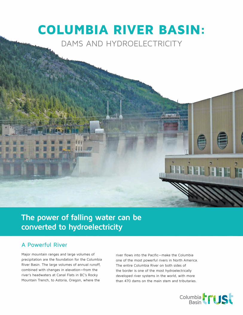
A Powerful RiverMajor mountain ranges and large volumes of precipitation are the foundation for the Columbia River Basin. The large volumes of annual runoff, combined with changes in elevation—from the river’s headwaters at Canal Flats in BC’s Rocky Mountain Trench, to Astoria, Oregon, where the
river flows into the Pacific—make the Columbia one of the most powerful rivers in North America. The entire Columbia River on both sides of the border is one of the most hydroelectrically developed river systems in the world, with more than 470 dams on the main stem and tributaries.
The power of falling water can be converted to hydroelectricity
Two Countries: One RiverMost dams on the Columbia River system were built between the 1940s and 1980s. They are part of a coordinated water management system guided by the 1964 Columbia River Treaty (CRT) between Canada and the United States. The CRT:
1. coordinates flood control
2. optimizes hydroelectricity generation on both sides of the border.
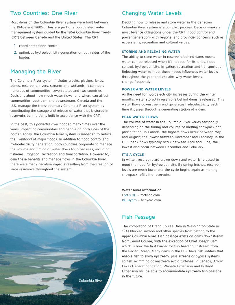
Managing the RiverThe Columbia River system includes creeks, glaciers, lakes, ponds, reservoirs, rivers, streams and wetlands. It connects hundreds of communities, seven states and two countries. Decisions about how much water flows, and when, can affect communities, upstream and downstream. Canada and the U.S. manage the trans-boundary Columbia River system by coordinating the storage and release of water that is stored in reservoirs behind dams built in accordance with the CRT.
In the past, this powerful river flooded many times over the years, impacting communities and people on both sides of the border. Today, the Columbia River system is managed to reduce the likelihood of major floods. In addition to flood control and hydroelectricity generation, both countries cooperate to manage the volume and timing of water flows for other uses, including fisheries, irrigation, recreation and transportation. However to, gain these benefits and manage flows in the Columbia River, there were many negative impacts resulting from the creation of large reservoirs throughout the system.
Changing Water LevelsDeciding how to release and store water in the Canadian Columbia River system is a complex process. Decision-makers must balance obligations under the CRT (flood control and power generation) with regional and provincial concerns such as ecosystems, recreation and cultural values.
STORING AND RELEASING WATERThe ability to store water in reservoirs behind dams means water can be released when it’s needed for fisheries, flood control, hydroelectricity, irrigation, recreation and transportation. Releasing water to meet these needs influences water levels throughout the year and explains why water levels change frequently.
POWER AND WATER LEVELSAs the need for hydroelectricity increases during the winter months, water stored in reservoirs behind dams is released. This water flows downstream and generates hydroelectricity each time it passes through a generating station at a dam.
PEAK WATER FLOWSThe volume of water in the Columbia River varies seasonally, depending on the timing and volume of melting snowpack and precipitation. In Canada, the highest flows occur between May and August; the lowest between December and February. In the U.S., peak flows typically occur between April and June; the lowest also occur between December and February.
IT’S A CYCLEIn winter, reservoirs are drawn down and water is released to meet the need for hydroelectricity. By spring freshet, reservoir levels are much lower and the cycle begins again as melting snowpack refills the reservoirs.
Water level information Fortis BC – fortisbc.com BC Hydro – bchydro.com
Fish PassageThe completion of Grand Coulee Dam in Washington State in 1941 blocked salmon and other species from getting to the upper Columbia River. Fish passage exists on dams downstream from Grand Coulee, with the exception of Chief Joseph Dam, which is now the first barrier for fish heading upstream from the Pacific Ocean. Many dams in the U.S. have fish ladders that enable fish to swim upstream, plus screens or bypass systems, so fish swimming downstream avoid turbines. In Canada, Arrow Lakes Generating Station, Waneta Expansion and Brilliant Expansion will be able to accommodate upstream fish passage in the future.
Waneta Expansion
Columbia River

Glossary
FRESHETA sudden rise in a stream or river due to heavy rain or melting ice or snow.
GENERATING STATION A building where electricity is generated. Also known as a powerhouse.
GENERATORA device that converts mechanical energy to electrical energy.
HYDROELECTRICITYElectric power generated through use of the gravitational force of falling water.
KILOWATT HOUR (KWH)Used to express power consumption. One kilowatt hour equals the amount of power a 1,000-watt appliance would use if kept running for an hour.
MEGAWATT (MW)Used to express generating capacity. One megawatt equals one million watts.
SUBSTATIONA building where voltage is transformed from high to low, or the reverse.
TRANSFORMERTransfers electrical energy from one circuit to another.
TRANSMISSIONThe bulk transfer of electrical energy from generating stations to substations located near demand centres.
TURBINEA mechanism in a generating station that rotates with the force of water and is attached to a generator that produces electricity.
WATER STORAGE DAMA dam used to collect or store water for later use.
How Does a Dam Generate Power?1. Water flows into a generating station, also known as a powerhouse, where
energy from the water is converted into hydroelectricity.
2. A tube, known as a penstock, carries water to the turbine.
3. The water spins large turbine blades.
4. The spinning turbine blades rotate a turbine shaft.
5. The shaft is connected to a generator that spins.
6. The generator rotates and converts mechanical energy into electrical energy.
7. Water flows back into the river and continues downstream, where it may repeat this cycle many times.
Waneta Expansion
Generating Station/Powerhouse
Water flows into powerhouse.
River feeds into reservoir.
Turbine
Water storage dam
Transfer Substation
Substation
The average household in BC uses 10800kwh of hydroelectricity per
year.
Melting snow-pack eventually flows into lakes and
reservoirs.
Columbia Basin Trust
ourtrust.org/crt
Columbia Basin Trust supports the ideas and efforts of the people in the Columbia Basin. We take our lead from residents and communities. The Trust is here to offer resources and support to all Basin residents. While our range of services, programs, initiatives and financial investments is extensive, our purpose is straightforward: we exist and act for the social, economic and environmental well-being of the Basin—now and for generations to come.
Columbia Basin Trust and Power Projects Together with Columbia Power Corporation, we own and operate four power projects in the southwestern Basin: Arrow Lakes Generating Station, Brilliant Dam, Brilliant Expansion and Waneta Expansion which is also co-owned by Fortis Inc.
Columbia Wetlands
Kootenay River
Columbia River
Columbia River
Libby
K i n b a s k e t R e s e r v o i r
D u n c a nR e s e r v o i r
K o o c a n u s aR e s e r v o i r
R e v e l s t o k e D a m
R e v e l s t o k e R e s e r v o i r
K o o t e n a y C a n a lArrow Lakes
Generating Station
BRITISHCOLUMBIA
ALBERTA
WASHINGTON
OREGONIDAHO
WYOMING
MONTANA
United StatesCanada
NEVADAUTAH
Columbia Riv
er
Columbia River
Invermere
Canal Flats
FernieCranbrook
Creston
Revelstoke
Nelson
Nakusp
Castlegar
Trail
Spokane
Missoula
Boise
Portland
Astoria
Coeur d’Alene
BoundaryDam 1,042 MW
Box CanyonDam 69 MW
Albenie FallsDam 43 MW
Hungry HorseDam 428 MW
Golden
Valemount
Noxon Rapids Dam481 MW
Chief Joseph Dam 2,614 MW
Wells Dam774 MW
Rocky Reach Dam1,300 MW
Rock Island Dam624 MW
Wanapum Dam1038 MW
Priest Rapids Dam 956 MW
Lower Granite Dam810 MW
DworshakDam 400 MW
Little GooseDam 810 MW
Lower MonumentalDam 810 MW
Ice Harbor Dam603 MW
McNary Dam991 MW
Hells Canyon Dam450 MW
Oxbow Dam190 MW
Brownlee Dam585 MW
BonnevilleDam 1,067 MW
John Day Dam2,160 MW
The DallesDam 1,807 MW
GrandCoulee Dam6,620 MW
L I B B Y D A M
M I C A D A M
D U N C A ND A M
H U G H K E E N L E Y S I D E D A M
Pend d'Oreille River
Snake River
Pa
cif
ic O
ce
an
A r r o w L a k e sR e s e r v o i r
Okana
gan
Rive
r
Kootenay River
Spokane River
Wenatchee River
Yakima River
Snak
e Rive
rDeschu
tes R
iver
Will
amett
e Rive
r
Cowlitz River
Lewis River
The Columbia
River flows into the Pacific Ocean
at Astoria, Oregon.
Legend
Columbia River Treaty Dams
Canadian Dams/Generating Stations
Dams in the U.S.
Direction of Water Flow
Communities
Columbia Basin Trust Region
Columbia River Basin in Canada
Columbia River Basin in the U.S.
0 100 200km
NAD 83 Lambert Conformal Conic
Central Meridian: -117
Standard Parallel 1: 45
Standard Parallel 2: 49
Features on the map have been generalized for illustrative purposes.
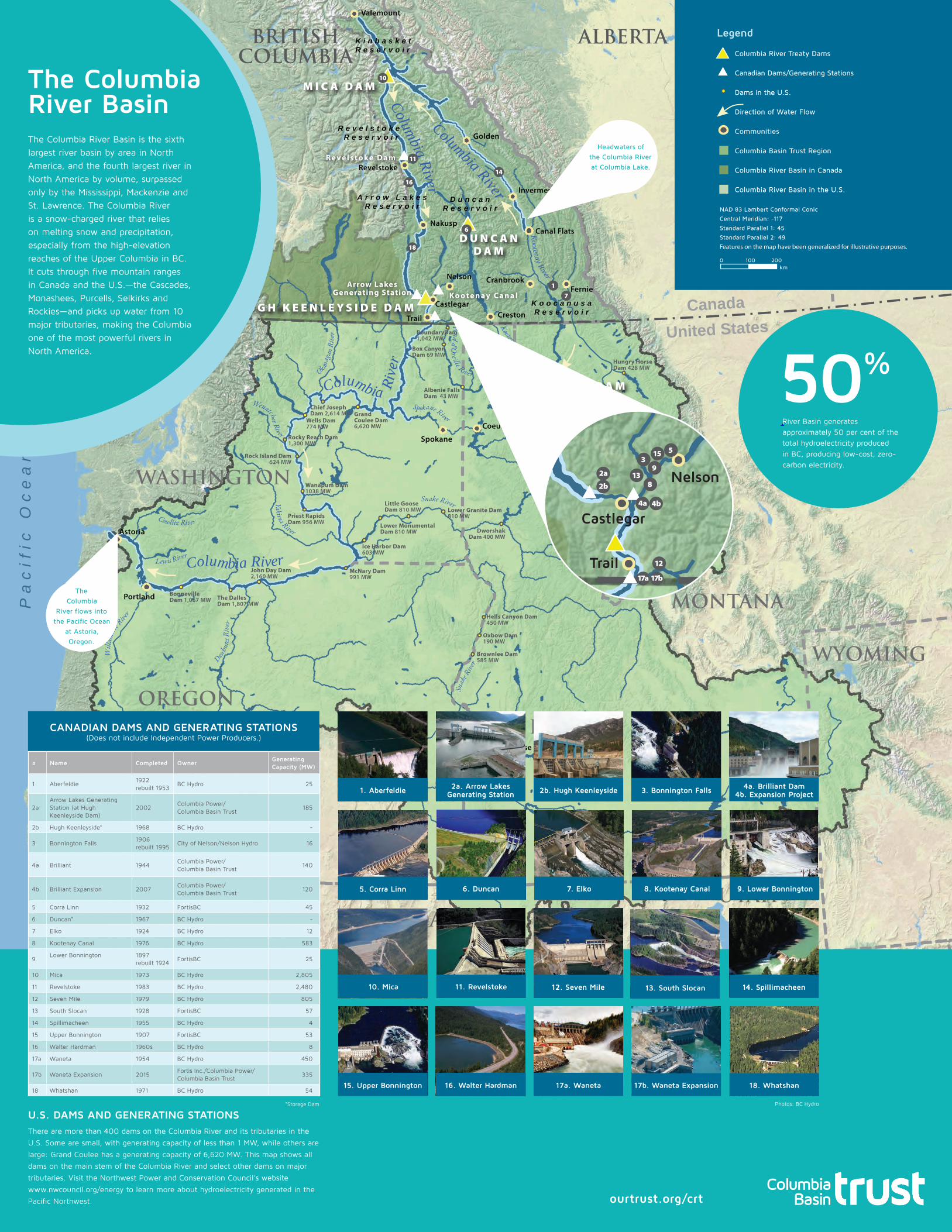
50%
River Basin generates approximately 50 per cent of the total hydroelectricity produced in BC, producing low-cost, zero-carbon electricity.
ourtrust.org/crt
The Columbia River BasinThe Columbia River Basin is the sixth largest river basin by area in North America, and the fourth largest river in North America by volume, surpassed only by the Mississippi, Mackenzie and St. Lawrence. The Columbia River is a snow-charged river that relies on melting snow and precipitation, especially from the high-elevation reaches of the Upper Columbia in BC. It cuts through five mountain ranges in Canada and the U.S.—the Cascades, Monashees, Purcells, Selkirks and Rockies—and picks up water from 10 major tributaries, making the Columbia one of the most powerful rivers in North America.
Kootenay River
Columbia River
Columbia River
Libby
D u n c a nR e s e r v o i r
K o o c a n u s aR e s e r v o i r
R e v e l s t o k e D a m
Columbia Riv
er
Invermere
Canal Flats
Revelstoke
Nakusp
Albenie FallsDam 43 MW
Noxon Rapids Dam481 MW
Chief Joseph Dam 2,614 MW Grand
Coulee Dam6,620 MW
D U N C A ND A M
Pend d'Oreille River
A r r o w L a k e sR e s e r v o i r
Okana
gan
Rive
r
Kootenay River
Spokane River
Wenatchee River
Headwaters of the Columbia River at Columbia Lake.
10
11
16
6
18
1
14
7
Castlegar
Trail
Nelson
17a 17b
4a
2a
2b
4b
12
813
93
15 5
U.S. DAMS AND GENERATING STATIONS There are more than 400 dams on the Columbia River and its tributaries in the
U.S. Some are small, with generating capacity of less than 1 MW, while others are
large: Grand Coulee has a generating capacity of 6,620 MW. This map shows all
dams on the main stem of the Columbia River and select other dams on major
tributaries. Visit the Northwest Power and Conservation Council’s website
www.nwcouncil.org/energy to learn more about hydroelectricity generated in the
Pacific Northwest.
# Name Completed OwnerGeneratingCapacity (MW)
1 Aberfeldie1922rebuilt 1953
BC Hydro 25
2aArrow Lakes Generating Station (at Hugh Keenleyside Dam)
2002Columbia Power/ Columbia Basin Trust
185
2b Hugh Keenleyside* 1968 BC Hydro -
3 Bonnington Falls1906 rebuilt 1995
City of Nelson/Nelson Hydro 16
4a Brilliant 1944Columbia Power/ Columbia Basin Trust
140
4b Brilliant Expansion 2007Columbia Power/ Columbia Basin Trust
120
5 Corra Linn 1932 FortisBC 45
6 Duncan* 1967 BC Hydro -
7 Elko 1924 BC Hydro 12
8 Kootenay Canal 1976 BC Hydro 583
9Lower Bonnington 1897
rebuilt 1924FortisBC 25
10 Mica 1973 BC Hydro 2,805
11 Revelstoke 1983 BC Hydro 2,480
12 Seven Mile 1979 BC Hydro 805
13 South Slocan 1928 FortisBC 57
14 Spillimacheen 1955 BC Hydro 4
15 Upper Bonnington 1907 FortisBC 53
16 Walter Hardman 1960s BC Hydro 8
17a Waneta 1954 BC Hydro 450
17b Waneta Expansion 2015Fortis Inc./Columbia Power/Columbia Basin Trust
335
18 Whatshan 1971 BC Hydro 54
CANADIAN DAMS AND GENERATING STATIONS (Does not include Independent Power Producers.)
*Storage Dam Photos: BC Hydro
14. Spillimacheen
15. Upper Bonnington 16. Walter Hardman 17a. Waneta 17b. Waneta Expansion 18. Whatshan
13. South Slocan
1. Aberfeldie 2a. Arrow Lakes Generating Station 2b. Hugh Keenleyside
12. Seven Mile
3. Bonnington Falls 4a. Brilliant Dam 4b. Expansion Project
5. Corra Linn 6. Duncan 7. Elko 8. Kootenay Canal 9. Lower Bonnington
10. Mica 11. Revelstoke