
COLLUVIUM AND TALUSonlinepubs.trb.org/Onlinepubs/sr/sr247/sr247-020.pdfColluvium and Talus 529 both...
30
'A I '- . . ,'.. . - -- . -. 't 2 6,Chapter 20 A. KEITH TURNER COLLUVIUM AND TALUS 1. INTRODUCTION P hysical and chemical weathering of bedrock produce disaggregated particles that accumulate on the land surface in the ab- sence of erosional processes adequate to remove them. In locations with sufficient topographic re- lief, gravitational forces acting on these disaggre- gated particles cause them to move down the slopes and accumulate as distinctive deposits along the lower portions of slopes, in topographic depressions, and especially at the bases of cliffs. The terms colluvium or colluvial materials are used to refer to deposits that have been transported by gravitational forces. The characteristics of colluvial materials vary according to the characteristics of the bedrock snrc.es and the climate under which weathering and transport occur. Generally, colluvium is weakly stratified and consists of a heterogeneous mixture of soil and rock fragments ranging in size from clay particles to rocks a meter or more in di- ameter. These deposits are often only marginally stable. Because they are found along the lower portions of valley sides, such deposits frequently need to he partially excavated to allow passage of transportation facilities (Figure 20-1). The rsiilr- ing cut slopes are commonly iinsrahle and require constant monitoring and maintenance. In humid tropical climates rapid chemical weathering promotes the formation of deep residual soils, or residuum. Creep of such soils on slopes may cause them to gradually take on the characteristics of colluvial materials. In cold climates colluvium is affected by the presence of permanently frozen ground, or permafrost. As discussed in Chapter 25, frozen ground conditions impede internal drainage and often lead to saturation of the surficial layers. Solifluction, the slow flowage of saturated surficial FIGURE 20-1 Colluvial slope along materials, produces characteristic lobate topo- Denver and Rio graphic patterns reflecting slope instability. Grande Western Instability of colluvial slopes in tropical condi- Railroad, Glenwood tions is discussed in Chapter 19, and Chapter 25 Canyon, Colorado. contains a discussion of such slopes in very cold J.D. IIIGGINSC0L0RADO SCHOOL OF MINES, GOLDEN. climates. Information provided in this chapter COLORADO 525
Transcript of COLLUVIUM AND TALUSonlinepubs.trb.org/Onlinepubs/sr/sr247/sr247-020.pdfColluvium and Talus 529 both...

'A I
'-
.
. ,'.. .
- -- . -.
't 2
6,Chapter 20 A. KEITH TURNER
COLLUVIUM AND TALUS
1. INTRODUCTION
P hysical and chemical weathering of bedrock produce disaggregated particles
that accumulate on the land surface in the ab-sence of erosional processes adequate to remove them. In locations with sufficient topographic re-lief, gravitational forces acting on these disaggre-gated particles cause them to move down the slopes and accumulate as distinctive deposits along the lower portions of slopes, in topographic depressions, and especially at the bases of cliffs. The terms colluvium or colluvial materials are used to refer to deposits that have been transported by gravitational forces.
The characteristics of colluvial materials vary according to the characteristics of the bedrock snrc.es and the climate under which weathering and transport occur. Generally, colluvium is weakly stratified and consists of a heterogeneous mixture of soil and rock fragments ranging in size from clay particles to rocks a meter or more in di-ameter. These deposits are often only marginally stable. Because they are found along the lower portions of valley sides, such deposits frequently need to he partially excavated to allow passage of transportation facilities (Figure 20-1). The rsiilr-
ing cut slopes are commonly iinsrahle and require constant monitoring and maintenance.
In humid tropical climates rapid chemical weathering promotes the formation of deep residual soils, or residuum. Creep of such soils on slopes may
cause them to gradually take on the characteristics of colluvial materials. In cold climates colluvium is affected by the presence of permanently frozen ground, or permafrost. As discussed in Chapter 25, frozen ground conditions impede internal drainage and often lead to saturation of the surficial layers. Solifluction, the slow flowage of saturated surficial FIGURE 20-1
Colluvial slope along materials, produces characteristic lobate topo- Denver and Rio graphic patterns reflecting slope instability. Grande Western
Instability of colluvial slopes in tropical condi- Railroad, Glenwood tions is discussed in Chapter 19, and Chapter 25 Canyon, Colorado. contains a discussion of such slopes in very cold J.D. IIIGGINSC0L0RADO
SCHOOL OF MINES, GOLDEN.
climates. Information provided in this chapter COLORADO
525
526 Landslides: Investigation and Mitigation
should be combined with that in Chapters 19 and 25 for a complete evaluation of these materials.
1.1 Definition of Colluvium
Bates and Jackson defined colluvium as follows:
A general term applied to any loose, heteroge-neous, and incoherent mass of soil material and/or rock fragments deposited by rain wash, sheet wash, or slow continuous downslope creep, usually collecting at the base of gentle slopes or hillsides. (Bates and Jackson 1980, 125)
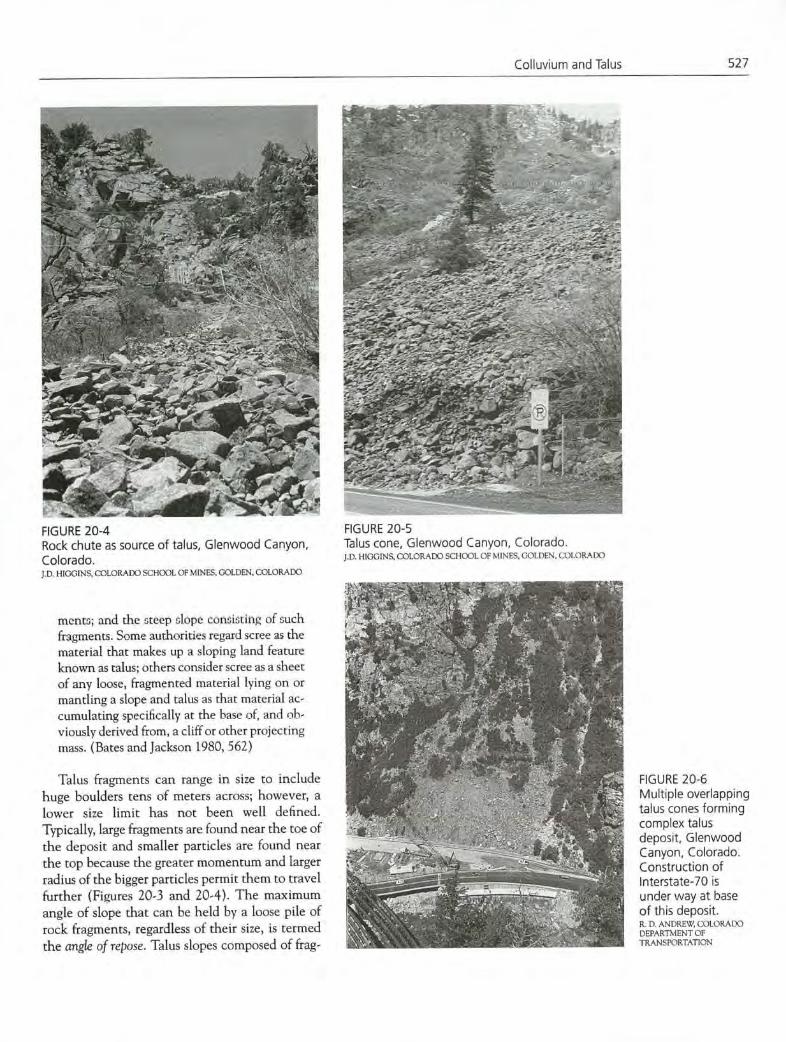
Typically, colluvium is a poorly sorted mixture of angular rock fragments and fine-grained materials. These deposits rarely are more than 8 to 10 m thick, and they usually are thinnest near the crest and thickest near the toe of each slope (Figure 20-2).
Colluvium may be the most ubiquitous surficial deposit. Costa and Baker (1981) reported esti-mates that colluvium COVES more than 95 percent of the ground surface in humid temperate regions and from 85 to 90 percent of the ground surface in semiarid mountainous areas. At the base of slopes, colluvium interfingers with alluvial deposits and may actually constitute the major portion of these deposits.
1.2 Definition of Talus and Scree
FIGURE 20-2 Relatively rapid physical fragmentation of bedrock Idealized cross exposed on cliffs frequently produces large num- section of colluvial bers of rock fragments ranging in size from small to deposit. very large. After falling from the cliff, these frag-
- -- 4uuuu•b
4•UU•UU•U•
Colluvium interfingers a••u•uuu••uuu IMOMMOOMMOMMOMMI with alluvium at
base of
400000 4•UUU•U•UUU••UUUU U•••••U
slope 41U••UUUU••U••••••UI i•u••u•uu•muuuu..•u
4UU••••U••UU•UUU•••U
..... ....•.. .....................
OEM _____________iuu••....uuuuu•u••u•rn.uuiu
U
.I
10100001 ................................0
..'.... .4.
I" Ult
- / c FIGURE 20-3 Talus slope in western Colorado. R. D. ANDREW, COLORAIX) DEPARTMENT OF ThANSPORTATION
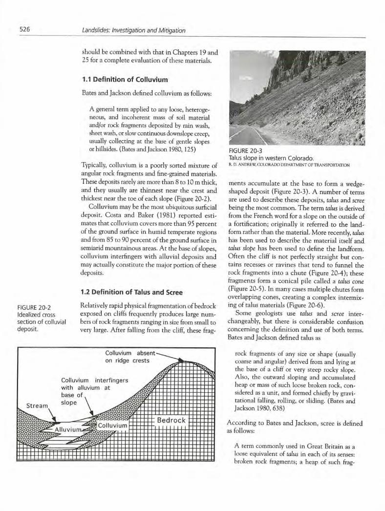
ments accumulate at the base to form a wedge-shaped deposit (Figure 20-3). A number of terms are used to describe these deposits, talus and scree
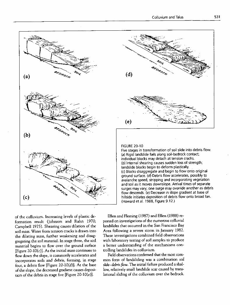
being the most common. The term talus is derived from the French word for a slope on the outside of a fortification; originally it referred to the land-form rather than the material. More recently, talus has been used to describe the material itself and talus slope has been used to define the landform. Often the cliff is not perfectly straight but con-tains recesses or ravines that tend to funnel the rock fragments into a chute (Figure 20-4); these fragments form a conical pile called a talus cone
(Figure 20-5). In many cases multiple chutes form overlapping cones, creating a complex intermix-ing of talus materials (Figure 20-6).
Some geologists use talus and scree inter-changeably, but there is considerable confusion concerning the definition and use of both terms. Bates and Jackson defined talus as
rock fragments of any size or shape (usually coarse and angular) derived from and lying at the base of a cliff or very steep rocky slope. Also, the outward sloping and accumulated heap or mass of such loose broken rock, con-sidered as a unit, and formed chiefly by gravi-tational falling, rolling, or sliding. (Bates and Jackson 1980, 638)
According to Bates and Jackson, scree is defined as f011ows:
A term commonly used in Great Britain as a loose equivalent of talus in each of its senses: broken rock fragments; a heap of such frag-
Colluvium and Talus
527
zl~-
.-_
h 4 .
FIGURE 20-4 Rock chute as source of talus, Glenwood Canyon, Colorado. J.D. HIGGINS, COLORADO SCHOOL OF MINES. GOLDEN, COLORADO
mcnts; and the steep slope consisting of such fragments. Some authorities regard scree as the material that makes up a sloping land feature known as talus; others consider scree as a sheet of any loose, fragmented material lying on or mantling a slope and talus as that material ac-cumulating specifically at the base of, and ob-viously derived from, a cliff or other projecting mass. (Bates and Jackson 1980, 562)
Talus fragments can range in size to include huge boulders tens of meters across; however, a lower size limit has not been well defined. Typically, large fragments are found near the toe of the deposit and smaller particles are found near the top because the greater momentum and larger radius of the bigger particles permit them to travel further (Figures 20-3 and 20-4). The maximum angle of slope that can be held by a loose pile of rock fragments, regardless of their size, is termed the angle of repose. Talus slopes composed of frag-
; -
717
4 -
-
-1-- :- - -
I- -4 -----
FIGURE 20-5 Talus cone, Glenwood Canyon, Colorado. J.D. HIGGINS. COLORADO SCHOOL OF MINES, GOLDEN. COLORADO
FIGURE 20-6 Multiple overlapping talus cones forming complex talus deposit, Glenwood Canyon, Colorado. Construction of lnterstate-70 is under way at base of this deposit. R. D. ANDREW. COLORADO DEPARTMENT 01' TRANSPORTATION

528
Landslides: Investigation and Mitigation
FIGURE 20-7 Principal features of a soil slide—debris flow (modified from Smith 1988).
ments of varying sizes typically exhibit angles of repose that are rarely less than 34 degrees or greater than 37 degrees (Strahler 1971, 583). The angles of most talus slopes appear relatively uni-form from top to bottom (Figure 20-3). However, several authors suggest that these slopes may be slightly concave, with steeper angles on the high-est portions.
1.3 Terms Used in This Chapter
In this chapter the terms colluvium or colluvial de-posits will be considered the most generic for all deposits created by the accumulation of disaggre-gated particles largely by gravitational forces. For such deposits composed of predominantly coarse rocky fragments, the term talus will generally be used to refer to both the landform and the materi-al, and the term talus slope will be used only when it is necessary to distinguish between the landform and the material. The term scree will not be used.
2. SLOPE INSTABILITY IN COLLUVIUM
Given the ubiquitous nature of colluvium and its distribution within many hilly or mountainous areas, it should not be surprising that the instabil-ity of colluvial slopes has resulted in major eco-nomic losses and on some occasions the loss of human life (Costa and Baker 1981).
The most common class of landslides in collu-vium involves two distinct components of move-ment: an initial shallow rotational or translational slide followed by flowage of the disturbed mass (Ellen and Fleming 1987; Ellen 1988). This fail-ure mode results in a relatively small circular scar
at the location of the initial slide, a long narrow track leading directly down the hillside formed by the flowage of the liquefied soil and debris, and a zone of deposition in the minor drainage channel at the base of the slope (Figure 20-7). Numerous individual such slides provide large volumes of de-bris that clog stream channels. Liquefaction of this material causes it to remobilize and produce large and rapidly moving debris flows that destroy lives and property downstream.
Various terms have been used for such land-slides in the past, including debris avalanche (Sharpe 1938), soil slip/debris flow (Campbell 1975), flow slide (Hutchinson 1968), soil avalanche (Wentworth 1943; Keefer 1984), and disintegrating soil slip (Kesseli 1943). In this chapter these land- slides will be referred to as debris flows to conform with the terminology developed in Chapter 3. However, it should be noted that in these land- slides both sliding and flowing are critical to the process. Sliding determines the timing and loca- tion of the initiation of the movement, whereas flowing determines movement path and rate. A more complete term for these landslides would be soil slide—debris flow; however, the simpler term de-bris flow will be used except in cases where a dis-tinction between slide and flow is useful.
Debris flows involving colluvium may move with velocities exceeding 3 m/sec, and their com- position will reflect not only the colluvium mate- rials, which may range from fine-grained soils to coarse-grained debris, but also abundant coarse organic materials (such as trees) and materials from within and adjacent to stream channels (in-cluding buildings and automobiles). Accordingly, debris flows may include movements that others have termed mudflows, debris avalanches, or debris torrents (Sharpe 1938; Swanston and Swanson 1976; Varnes 1978). This simplification appears justified because all these processes are similar (Costa 1984; Ellen and Wieczorek 1988, 4).
Much colluvium in midlatitude regions origi-nated during Pleistocene glacial periods when a mantle of rubble was formed by vigorous frost ac-tion on bedrock exposed beyond the ice-sheet mar-gins. In areas subjected to glaciation, colluvial deposits overlie, and thus are younger than, glacial deposits. In investigations of slope stability in mid-latitude regions, it must be recognized that many of these colluvial deposits formed under different cli-mate regimes. Since their physical properties reflect

Colluvium and Talus 529
both their age and their origin, their stability may be marginal under current climate conditions.
Sidle et al. (1985) identified five natural factors that have the greatest influence on the stability of colluvial slopes:
Soil properties, especially the hydrologic and mineralogic conditions that affect engineering soil behavior and strength properties of the col-luvium; Geomorphology, including the geologic and tectonic setting, slope gradient, and shape; Hydrology, especially soil water recharge and effective evapotranspiration rates that reflect local climate and vegetation conditions; Vegetative cover, including the reinforcing ef-fect of root systems and the loss of such strength when roots deteriorate following timber har-vesting or fire; and Seismicity, especially the potential for liquefac-tion of marginally stable soils on steep slopes.
These natural factors are important on all slopes, but they must be evaluated in special ways when slopes are formed with colluvial materials. Section 2.3 contains a discussion of commonly found char-acteristics of colluvial deposits that must be con-sidered when field investigations are conducted or strength properties are assigned for stability calcu-lations. Geomorphic factors, especially the impor-tance of topographic hollows in many situations, are evaluated in Section 2.4. Hydrology and the importance of vegetative cover to the stability of colluvial slopes are discussed in Sections 2.5 and 2.6, and the frequently overlooked effects of fire on the strength and erosion resistance of collu-vium are discussed in Section 2.7. Seismic shaking frequently results in widespread failures of collu-vial slopes, but since this topic is addressed in Chapter 4, only a brief discussion is included in Section 2.8 of this chapter.
2.1 Studies of Landslides in Colluvium
Before the 1960s, the importance of landslides in colluvium was largely ignored except by re-searchers in southern California (Eaton 1935; Sharpe 1938; Kesseli 1943). Several collections of technical reports now exist that address colluvial landslides from several aspects and at various lev-els of detail. The Geological Society of America
has published three major collections of studies of colluvial landslides (Coates 1977; Costa and Wieczorek 1987; Schultz and Jibson 1989). Books by Sidle et al. (1985) and Anderson and Richards (1987) also contain considerable information about such landslides as well as examples of land-slides that do not involve colluvium. Numerous references will be made to these publications in the subsequent discussion.
Japanese researchers have also conducted de-tailed evaluations of the landslide danger on col-luvial slopes (Sassa 1984; Sassa et al. 1981; Takahashi 1978). Reviews and assessments of these Japanese studies were provided by Chen (1987) and Okunishi and Okimura (1987).
Unusually large rainstorms have triggered cata-strophic landslide events in colluvium at several locations around the world. These events led to considerable economic damage and loss of life. They were thus studied in some detail to deter-mine their underlying causes in the hope that this information would prove useful in preventing fu-ture disasters. These studies form the basis for much of the current knowledge and theories con-cerning landslide processes involving colluvium.
Jones (1973) was the first to emphasize the potential severity of colluvial landslides in areas beyond southern California. He reported on the tens of thousands of landslides that occurred along the Serra das Araras escarpment in Brazil follow-ing a severe storm on January 22-23, 1967. Debris flows developed on valley sideslopes in colluvial and residual soils several meters thick overlying the crystalline bedrock. The steep vegetation-covered slopes were nearly denuded as soil and rock debris flowed into local valleys. Once deposited in the valleys, the materials became remobilized and formed huge debris flows that caused severe damage to roads and a major power plant and killed more than 1,700 people (Jones 1973; Costa and Baker 1981). Very similar thin landslides and debris flows were observed in saturated residual soils in south-western Colombia (Figure 20-8). In this case, how-ever, the landslides were triggered by earthquake shaking rather than intense rainfall.
In August 1969, Hurricane Camille caused se-vere damage in the Blue Ridge Mountains region of Virginia (Williams and Guy 1973). Thick col-luvium and weathered bedrock were destabilized by a 24-hr precipitation that exceeded 600 mm, and debris flows surged rapidly down heavily
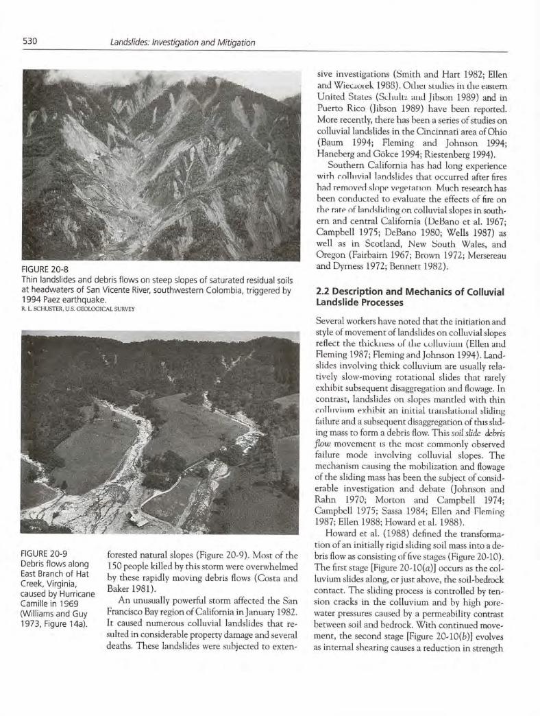
FIGURE 20-8 Thin landslides and debris flows on steep slopes of saturated residual soils at headwaters of San Vicente River, southwestern Colombia, triggered by 1994 Paez earthquake. R. L. SCI lUSTER, U.S. GEOLOGiCAL SURVEY
) :Ti, .T:•.
I....'.'. 5 ,
' . __•'••);.'/
530
Landslides: Investigation and Mitigation
FIGURE 20-9 Debris flows along East Branch of Hat Creek, Virginia, caused by Hurricane Camille in 1969 (Williams and Guy 1973, Figure 14a).
forested natural slopes (Figure 20-9). Most of the 150 people killed by this storm were overwhelmed by these rapidly moving debris flows (Costa and Baker 1981).
An unusually powerful storm affected the San Francisco Bay region of California in January 1982. It caused numerous colluvial landslides that re-sulted in considerable property damage and several deaths. These landslides were subjected to exten-
sive investigations (Smith and Hart 1982; Ellen and WiecLuieL 1988). OI.liei studies in the easlern United StaLes (Scliuliz and Jibson 1969) and in Puerto Rico (Jibson 1989) have been reported. More recently, there has been a series of studies on colluvial landslides in the Cincinnati area of Ohio (Baum 1994; Fleming and Johnson 1994; Haneherg and Gökce 1994; Riestenberg 1994).
Southern California has had long experience with colliivial landslides that occurred after fires had removed slope vegetation Much research has been conducted to evaluate the effects of fire on the rare of landsliding on colluvial slopes in south-ern and central California (Debano et at. 1967; Campbell 1975; DeBano 1980; Wells 1987) as well as in Scotland, New South Wales, and Oregon (Fairhairn 1967; Brown 1972; Mersereau and Dyrness 1972; Bennett 1982).
2.2 Description and Mechanics of Colluvial Landslide Processes
Several workers have noted that the initiation and style of movement of landslides on colluvial slopes reflect the ihkk&iess of the oiiuv iuiii (Ellen and Fleming 1987; Fleming and Johnson 1994). Land-slides involving thick colluvium are usually rela-tively slow-moving rotational slides that rarely exhibit subsequent disaggregation and flowage. In contrast, landslides on slopes mantled with thin colliiviiim exhibit an initial uaitslaiiotial sliding failure and a subsequent disaggregation of this slid-ing mass to form a debris flow. This soil slidc debris flow movement is the most commonly observed failure mode involving colluvial slopes. The mechanism causing the mobilization and flowage of the sliding mass has been the subject of consid-erable investigation and debate (Johnson and Rahn 1970; Morton and Campbell 1974; Campbell 1975; Sassa 1984; Ellen and Fleming 1987; Ellen 1988; Howard et al. 1988).
Howard et al. (1988) defined the transforma-tion of an initially rigid sliding soil mass into a de-bris flow as consisting of five stages (Figure 20-10). The first stage [Figure 20-10(a)] occurs as the col-luvium slides along, or just above, the soil-bedrock contact. The sliding process is controlled by ten-sion cracks in the colluvium and by high pore-water pressures caused by a permeability contrast between soil and bedrock. With continued move-ment, the second stage [Figure 20-10(b)] evolves as internal shearing causes a reduction in strength
Colluvium and Talus
531
(a)
(b)
FIGURE 20-10 Five stages in transformation of soil slide into debris flow. (a) Rigid landslide fails along soil-bedrock contact; individual blocks may detach at tension cracks. (b)lnternal shearing causes sudden loss of strength; landslide blocks begin to deform plastically. (c) Blocks disaggregate and begin to flow onto original ground surface. ( Debris flow accelerates, possibly to avalanche speed, stripping and incorporating vegetation and soil as it moves downslope. Arrival times of separate surges may vary; one surge may override another as debris flow descends. (e) Decrease in slope gradient at base of hillside initiates deposition of debris flow onto broad fan. (Howard et al. 1988, Figure 9.12.)
of the colluvium. Increasing levels of plastic de-. formation result (Johnson and Rahn 1970;
Campbell 1975). Shearing causes dilation of the soil mass. Water from tension cracks is drawn into the dilating mass, further weakening and disag-gregating the soil material. In stage three, the soil material begins to flow over the ground surface [Figure 20-10(c)]. As the initial mass continues to flow down the slope, it commonly accelerates and incorporates soils and debris, forming, in stage four, a debris flow [Figure 20-10(d)]. At the base of the slope, the decreased gradient causes deposi-tion of the debris in stage five [Figure 20-10(e)].
Ellen and Fleming (1987) and Ellen (1988) re-ported on investigations of the numerous colluvial landslides that occurred in the San Francisco Bay Area following a severe storm in January 1982. These investigations combined field observations with laboratory testing of soil samples to produce a better understanding of the mechanisms con-trolling landslides in colluvium.
Field observations confirmed that the most com-mon form of landsliding was a combination soil
slide—debris flow. The initial failure produced a shal-low, relatively small landslide scar caused by trans-lational sliding of the colluvium over the bedrock.

532
Landslides: Investigation and Mitigation
Most of these initial soil slides mobilized completely to form debris flows that drained the scars, leaving them empty of failed material. The debris flows ran rapidly downhill in relatively narrow tracks. However, in some cases the mobilization of the slid-ing material was less complete. Such partially mobi-lized flows left dislocated masses of materials in the initial landslide scar and carried intact blocks of ma-terial down the slope within the debris flow. Reliable eyewitness reports suggested that rates of mobiliza-tion varied from just a few seconds to more than 24 hr (Ellen and Fleming 1987).
Ellen and Fleming wished to identify reasons for such differences in degree and speed of mobi-lization and flow of the initial soil slide materials. Previous studies (Rodine 1974; Pierson 1981) sug-gested that some clay in the colluvium is necessary to sustain flow. However, Ellen and Fleming sus-pected that there must be an upper limit to the mount of clay. They suggested that increased clay
content adds cohesive strength to soils, which im-pedes remolding and also reduces permeability. Ellen and Fleming considered reduced permeabil-ity as critical because most soils having normal densities dilate when subjected to shearing and must then take up additional water to continue flowing. Reduced permeability would interfere with the rapid intake of water.
In the Ellen and Fleming study, the clay contents of 50 soil samples ranged from about 3 to 35 percent; however, 98 percent of the samples had clay con-tents greater than 8 percent. When samples öb-tamed from very slow-moving debris flows in cut slopes or old landslides were removed from consid-eration, the largest clay content was 25 percent. Ellen and Fleming concluded that the range in clay contents, from 8 to 25 percent, was still so broad that clay content by itself was inadequate to define colluvial slopes that might be susceptible to land-sliding. They looked for some additional quantitative measures that might help define this susceptibility.
Rodine (1974) and Johnson (1984) proposed a mobility index (MI) defined as
MI = Saturated water content of in-place soil
Water content required for that soil to flow
(20.1)
Although it is obvious that flow is most apt to occur when MI ~> 1.0, they demonstrated that it can take place when MI is as low as 0.85. However,
the determination of MI required soils testing to obtain a value for the denominator, the water con-tent required for the soil to flow. This appeared in-convenient to Ellen and Fleming, and they proposed an approximate mobility index (AMI) defined as
AMI = Saturated water content of in-place soil
Liquid limit
(20.2)
Ellen and Fleming (1987) justified this change on practical grounds. Qualitatively, the liquid limit represents a water content at which soils ex-hibit marginally fluid behavior at near-surface conditions. Quantitatively, the liquid limit corre-sponds to a shear strength of about 2 kPa, and if this shear-strength value is used in the equation describing shear flow proposed by Johnson (1970), flow is predicted for colluvium slabs thicker than about 20 cm on slopes of 30 degrees for typical soil materials having saturated unit weights of 20 kN/m3 (Ellen and Fleming 1987, 34). Since this critical thickness value of 20 cm was considerably less than the 1-rn thicknesses typically observed in the San Francisco Bay Area, Ellen and Fleming believed that this validated the AMI concept.
Ellen and Fleming suggested that the observed differences in degree and rates of mobilization could be explained by differences in soil structure or fab-ric. Soils that have a relatively flocculated or loose fabric will collapse when subjected to even small shear movements. Under wet conditions, the col-lapse leads to a rapid liquefaction due to increased pore pressure. Collapsible soils having low perme-ability are especially susceptible, since rapid drainage of the excess water is unlikely. In contrast, relatively dense colluvial soils dilate when subjected to shear. The increased volume requires water to be drawn into the soil mass in order for flowage to continue. This water inflow requires time, especially if the soil has a relatively low permeability.
From the foregoing considerations, Ellen and Fleming (1987) concluded that loose, contractive colluvium with relatively low permeability is the most likely source of rapidly mobilized debris flows. These soils have void ratios greater than those at the liquid limit and hence when saturated have AMI values greater than 1.0. Liquefaction is almost instantaneous, occurring after strains as small as 1 percent, and the debris flows empty the initial landslide scars and flow rapidly downslope

Colluvium and Talus
533
forming debris deposits with smooth surfaces. In contrast, dilative, denser colluvium is less likely to mobilize rapidly. Shear deformation along the base of the sliding mass is usually inadequate to remo-bilize the entire soil mass. Selective mobilization along the flanks and margins is possible, creating blocks within the mass. Cracks may channel water to selected areas, further encouraging selective re-mobilization. At the toe of the sliding slab, lique-faction may result from the greater volume of available water coupled with greater strains and remolding caused by oversteepening and bending as the slab moves out of the scar (Figure 20-11).. Consequently, dilative, denser colluvial deposits produce slower-moving debris flows containing lumps or blocks of undeformed material. In some cases these denser colluvial soils produce more slablike, broader landslide areas (Figure 20-12).
2.3 Characteristics of Colluvium Affecting Slope Stability
Colluvium is formed by the movement and depo-sition of particles by gravity, although water and wind are sometimes secondary transportation agents. Colluvium may accumulate one small grain at a time or as a result of large catastrophic movement of materials, especially debris flows. In rugged terrain, colluvium can be merged and in-terlayered with alluvium in debris fans and cones associated with minor drainages. The aprons or wedges of colluvium may be modified over time by deposition, flooding, and dissection of stream channels and by internal composition changes re-sulting from weathering. Within any given collu-vial deposit, particle gradation and density vary with depth and in irregular patterns across the ex-tent of the deposit.
Colluvium frequently contains stratigraphic horizons that repreent changes in deposition rates. For example, long periods of inactivity may allow the development of organic soil horizons that are then covered during periods of intense de-position. These horizons can be. observed in exca-vations but are difficult to discern by conventional drilling methods.
Colluvium formed in and regions often results from a combination of gravity-driven grain-by-grain downslope movements with debris-flow materials rapidly deposited from rare flash floods. These floods are of short duration and lose their moisture
Ii......... Ii.........
rapidly by evaporation and infiltration. The re-sulting deposits often exhibit a very flocculated or loose soil structure that is stable only as long as it remains dry. Wetting of these soils, such as may be caused by diversion of water from a paved highway surface, will cause the flocculated structure to col-lapse to a much smaller volume. This collapse may further lead to temporary liquefaction of the soils and their rapid erosion by flowage. These arid col-luvial soils are said to be subject to hydrocom-paction. Hydrocompaction may lower the ground surface by as much as 1 In (Figure 20-13).
Hydrocompaction is obviously damaging to transportation facilities. Its potential can be read-ily determined by evaluating in situ soil densities. Stabilization can be achieved by saturating the materials before construction, but a considerable period of time may be required for complete satu-ration and compaction. Also, stabilization requires large volumes of water, which may not be avail-able in arid regions where hydrocompaction risk is most frequent. Even after compaction is achieved, these soils remain highly erodible, so careful de-sign of culverts and water collection and dispersal systems is necessary.
Shales and other soft rocks generally produce fine-grained colluvium, often containing signifi-cant proportions of clay. The slow downslope creep of colluvium results in a progressive align-ment of mineral grains and the creation of numer-ous microscopic shear surfaces. These surfaces greatly reduce the normally expected shear strength of colluvial materials, and yet the surfaces are hard to identify or retain in samples. Fleming and Johnson reported on their examination of col-luvial landslide materials from the Cincinnati, Ohio, area:
FIGURE 20-1 1 Schematic downslope cross section of soil slide—debris flow as it leaves scar, showing zones of dilation d and con-traction c in slab as it passes over lip. Position of neutral fiber depends on soil behavior (modified from Ellen 1988, Figure 6.30).

534 Landslides: Investigation and Mitigation
FIGURE 20-12 Sketch based on photograph of landslide in shallow colluvium along Salmon Creek, Mann County, California. Hillside slopes toward observer at about 22 degrees. Both margins of landslide have mobilized as debris flows; slab remaining within arcuate scar above horses has slid downward about 1 m (Ellen 1988, Figure 6.3 SB).
0 5 METERS
APPROXIMATE SCALE AT SCAR
EXPLANATION
Ground surface covered by Deposits largely from light- grass or brush colored soil
Dark soil exposed in scar
:::•. Light-colored soil and bedrock Ej exposed in scar, and lesser light-colored deposits on floor of scar
Deposits from dark soil
The failure surfaces are paper thin, highly poi-ished, and striated. At all scales of observa-tion, roughness is evident on the surfaces. At a scale-of a few micrometers, the surfaces have small steps between shiny surfaces that appear to be analogous to chatter marks on rocks in fault zones. At a larger scale, the surfaces are scratched by fossil fragments and sand-size grains in the colluvium. At a still larger scale, the surfaces bifurcate around rock fragments, and multiple surfaces occur where the shape of
the failure surface is changing. (Fleming and Johnson 1994, B-i)
Fleming and Johnson (1994) differentiated be-tween landslides that occurred in thin colluvium (less than about 2 m thick) and those that oc-curred in thicker colluvium. They noted that the thick-colluvium landslides moved relatively slowly, perhaps only a few centimeters a year, and exhibited multiple overlapping scarps at their heads, multiple toe bulges downslope, and indis-
Remnants of slip surface at -2 base of dark soil
.'. Area of seepage
.L £ Slip surface at toe of slab
Boundary of subsIdiary scars

Colluvium and Talus
535
- .-' -
-. ---.~---- : --
- --;.:• -
tinct flanks. In contrast, the landslides in the thin colluvium moved more rapidly, rypia11y e.xhihired a "stick-slip" behavior in which they accelerated after initial movement, and often moved com-pletely out of their initial failure scars. These land-slides had well-defined flanks, multiple head scarps, and a single toe.
Fleming and Johnson conducted laboratory tests on soil samples collected near the failure zones. Strength values varied according to the way the samples were collected and tested. Minimum strength values were obtained from a ring-shear device using samples that had had their coarse fractions removed. These estimates of residual shear strength values matched values obtained by back calculation of stability for the thick-col luvium landslides. The measured, laboratory-derived shear-strength values appeared insufficient to support the colluvium on the thin-colluvium slopes. Fleming and Johnson suggested that addi-tional strength provided by tree roots, roughness of the failure surface, or a small residual cohesion might explain the discrepancy between the appar-ent strength and the slope stability.
2.4 Geomorphic Factors
A uniform thickness of colluvium is rarely present on any slope, and thicker deposits may effectively mask minor hollows in the underlying bedrock sur-face (Figure 20-14). The presence of such hollows may materially affect the stability of a colluvium-covered slope (Dietrich et al. 1986). Hack and Goodlett (1960) proposed that slopes be divided geomorphically into hollows, noses, and side slopes. Hollows are "any area on the slope in which the contours are concave outward away from the ridge" and they "generally occur in the valley axis at the stream head as a sort of extension of the channel" (Hack 1965, 20). Noses are areas "on the interfiuve in which the slopes are convex outward toward the valley" (Hack 1965, 21), and side slopes are areas with straight contours located be-tween noses and either hollows or channels.
The importance of hollows as locations suscep-tible to the initiation of colluvial landsliding varies, both locally and between regions, because of complex interactions and small variations in ge-ologic, topographic, and climate factors. Hollows frequently appear to be important sources of debris flows. However, their importance as initiators of shallow colluvial landslides is more variable.
Hack and Goodlctt (1960) first noted that hol-lows appeared to be an important factor in initiat-ing debris flows in the Appalachian Mountains of Virginia. Their observations were subsequently confirmed by others (Woodruff 1971; Williams and Guy 1973; Lessing et al. 1976; Bogucki 1977; Pomeroy 1981, 1984). The importance of hollows was also revealed by studies in other regions: in coastal Alaska (Swanston 1967, 1969), British Columbia (O'Loughlin 1972), and the Oregon Coast Range (Pierson 1977; Deitrich and Dunne 1978; Swanson et al. 1981; Swanson and Roach 1985). Studies conducted in the San Francisco Bay Area following the damaging storm of January 1982 focused on hollows as a source of debris (Smith and Hart 1982; Reneau and Dietrich 1987; Ellen and Wieczorek 1988; Smith 1988).
In general, it appears that hollows are most im-portant in areas where hill slopes are underlain by fairly massive bedrock and there is a regular dissec-tion of the topography into minor drainages, and hollows are less important where the bedrock is vari-able and the topography is less regular. Along the Oregon coast, where the bedrock is composed of volcanic rocks including lava flows, tuffs, and brec-cias, Marion (1981) reported that side slopes were more important sites of landslide initiation than hollows. Jacobson (1985) reported that shallow landslides tended to initiate on benches on side
FIGURE 20-13 Results of saturation test on hydrocompactible colluvial soils in western Colorado; land surface has collapsed about im. A.K. TURNER, COLORAIX) SCHOOL OF MINES, GOLDEN, COLORADO

536 Landslides: Investigation and Mitigation
slopes formed of stratified sandstone and shale and not along hollow axes. Pomeroy (1981, 1984) re-ported that in areas of Pennsylvania where sand-stone and shale are interbedded, the topography lacks a regular division into noses and hollows, and in these regions hollows are not important factors in initiating landslides. However, in nearby regions where steeper slopes are underlain by more sand-stone and less shale, hollows appear to be the most important source of landslides.
In the San Francisco region, about two-thirds of the shallow colluvial landslides are initiated in hollows (Smith and Hart 1982; Reneau and Dietrich 1987; Smith 1988). This finding suggests that the mapping and identification of hollows be given priority in producing landslide hazard maps for this region. Hollows act not only as sources of landslides but also as conduits for debris flows that frequently result from the initial landsliding. Landslide hazard and susceptibility mapping pro-cedures based on analysis of drainage patterns have been implemented (Hollingsworth and Kovacs 1981; Baldwin et al. 1987; Smith 1988).
2.5 Hydrology
Intense rainfall is cited as the most common trigger-ing mechanism for landslides involving colluvium (Jones 1973; Campbell 1975; Fukuoka 1980; Brand et al. 1984; Cannon and Ellen 1985; Church and Miles 1987; Neary and Smith 1987; Wieczorek 1987). Much work has been done to relate debris-flow occurrences to rainfall intensity and duration (Campbell 1975; Mark and Newman 1988; Cannon 1988; Cannon and Ellen 1988; Wieczorek and Sar-miento 1988). Campbell (1975) suggested that at least 267 mm of rainfall is necessary in southern California after a dry season to bring the soils to field capacity, the water content at which water drains from the soil at the same rate as it is added. Campbell further demonstrated that a rainfall in-tensity of 5 to 6 mm/hr is necessary to trigger debris flows once field capacity has been achieved.
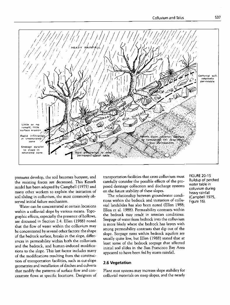
Kesseli (1943) postulated that slope failure of colluvium occurs when rainfall intensity is great enough to cause water to percolate into the collu-vium at a rate that exceeds the rate at which the water can percolate into bedrock (Figure 20-15). This condition forms a temporary perched water table in the colluvium, and a downslope seepage force develops within the soil mass. Excess pore
EXPLANATION
Impermeable clayey materials in bedrock and soil mantle
Permeable granular soil mantle
7' Clayey sheared bedrock; orientation indicates direction of
shear foliation
k 'I-I Relatively permeable, fractured, resistant rock, typically sandstone or greenstone
FIGURE 20-14 Schematic downslope cross sections of hillsides in (a) hard, (b) intermediate, and (c) soft bedrock terrain, showing how hollows may mask bedrock irregularities (Ellen et al. 1988, Figure 7.5).
Colluvium and Talus
537
ii ••'
••/ / // /
I / / ,/
HEA(/Y B/Al /Ft1/
/ I •I / / •1 ' / / /
~ Cor.
l.twelsyoi';lluvial
permeable
Littleor no runoff; little
surface erosion
Rapid infiltratio in unsaturated.
zone
Seepage parallel to slope in
saturated zone
FIGURE 20-15 Buildup of perched water table in colluvium during heavy rainfall (Campbell 1975, Figure 16).
pressures develop, the soil becomes buoyant, and the resisting forces are decreased. This Kesseli model has been adopted by Campbell (1975) and many other workers to explain the initiation of soil sliding in colluvium, the most commonly ob-served initial failure mechanism.
Water can be concentrated at certain locations within a colluvial slope by various means. Topo-graphic effects, especially the presence of hollows, are discussed in Section 2.4. Ellen (1988) noted that the flow of water within the colluvium may be concentrated by several other factors: the shape of the bedrock surface, breaks in the slope, differ-ences in permeability within both the colluvium and the bedrock, and human-induced modifica-tions to the slope. This last factor includes many of the modifications resulting from the construc-tion of transportation facilities, such as cut-slope geometries and installation of ditches and culverts that modify the patterns of surface flow and con-centrate flows at specific locations. Designers of
transportation facilities that cross colluvium must carefully consider the possible effects of the pro-posed drainage collection and discharge systems on the future stability of these slopes.
The relationship between groundwater condi-tions within the bedrock and initiation of collu-vial landslides has also been noted (Ellen 1988; Ellen et al. 1988). Permeability contrasts within the bedrock may result in artesian conditions. Seepage of water from bedrock into the colluvium is more likely where the bedrock has layers with strong permeability contrasts that dip out of the slope. Seepage rates within bedrock aquifers are usually quite low, but Ellen (1988) stated that at least some of the bedrock seepage that affected initial soil slides in the San Francisco Bay Area appeared to have been fed by storm rainfall.
2.6 Vegetation
Plant root systems may increase slope stability for colluvial materials on steep slopes, and the nearly

538
Landslides: Investigation and Mitigation
total removal of forest cover by clearcutting may cause increased slope instability. Nevertheless, vegetation growing on a slope was traditionally considered to have a negligible effect on slope sta-bility and was ignored in slope stability computa-tions (Greenway 1987). However, studies in the mountainous forested regions of the United States, Canada, Japan, and New Zealand have shown that neglecting the effects of vegetation on steep slopes mantled with relatively thin colluvial soils can yield stability estimates that are consid-erably in error. Still, vegetation-slope interactions are complex, and this complexity has hampered attempts to quantify such interactions in slope-stability analyses (Greenway 1987).
The importance of roots for the stability of shal-low colluvial soils on steep slopes and the effects of forest removal have been documented for western North America (Swanston 1970; O'Loughlin 1974b; Ziemer and Swanston 1977; Burroughs and Thomas 1977; Wu et al. 1979; Gray and Megahan 1981; Sidle and Swanston 1982). Similar studies have been conducted in Japan (Endo and Tsuruta 1969; Kitamura and Namba 1976; Nakano 1971) and in New Zealand (O'Loughlin 1974a; O'Lough-lin and Pearce 1976; O'Loughlin et al. 1982; Selby 1982). Recent studies have reported on the role of roots in slope stability of colluvial soils in the Cincinnati, Ohio, area (Riestenberg 1994).
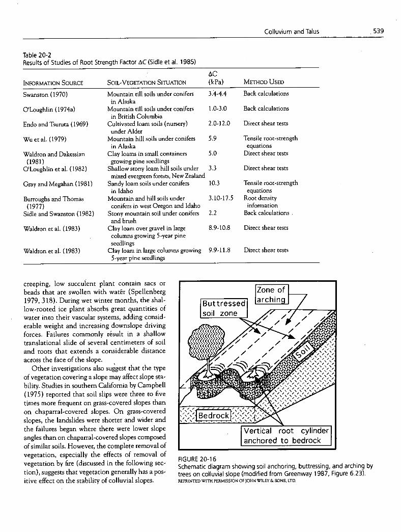
Generally, it is claimed that root systems con-tribute to soil strength by providing an additional cohesion component, referred to as AC. Available data, including the data presented in Table 20-1 from studies in New Zealand, suggest that roots in-crease the cohesion but do not influence the angle of internal friction (Sidle et al. 1985). Bishop and Stevens (1964) identified a fourfold to fivefold in-crease in the number of shallow landslides on steep hillsides in southeastern Alaska within 10 years of clearcutting. They suggested that the increase was at least partially attributable to root deterioration.
Some studies have attempted to quantify the strength of soil-root systems. Large metal shear boxes of various sizes and designs have been used in field tests to shear undisturbed blocks of soil containing roots (Endo and Tsuruta 1969; O'Loughlin 1974a, 1974b; Waldron and Dakessian 1981; O'Loughlin et al. 1982; Waidron et al. 1983). These tests demonstrated that the majority of the roots that broke failed in tension rather than by shear. This finding confirms many observations of actual landslides in which failed roots were reported around colluvial landslide scars. Estimates of the magnitude of AC provided by roots have been made by several investigators using different methods. These estimates are summarized in Table 2 0-2.
Sidle et al. (1985) concluded that roots influ-ence soil strength and increase colluvial slope stability in three ways:
They bind unstable soil mantles to stable sub-soils or substrata. This effect is most pro-nounced when a potential failure zone exists within the rooting zone. They form a dense interwoven network in the upper 30 to 50 cm of soil, and this network pro-vides lateral membrane strength that tends to re-inforce the shallow soil mass and hold it in place. Roots of individual trees may provide deeper anchors, stabilizing soil arches that extend across the slope (Figure 20-16). The trees act as buttresses or pile anchors. It may be possible to apply soil-arching restraint theory to determine a critical spacing of trees that maximizes the sta-bilization of a colluvial slope.
Vegetation may also lead to slope instability. Keller (1979, 117-118) reported that shallow soil slips are especially common in southern California on steep cut slopes covered with ice plant (Carpobrotus edulis). The stems of this
Table 20-1 Shear-Strength Parameters for New Zealand Beech Forest Soils with and Without Competent Roots (Sidle et al. 1985)
INTACT FOREST WITH CLEARCUT AREA WITHOUT SHEAR-STRENGTh PARAMETER COMPETENT ROOTS COMPETENT ROOTS
Apparent cohesion (kPa) 6.6 3.3 Internal friction angle (degrees) 36 36
IZone of Buttressedl larching soil zon( / ,
I Z"
.bearocK ,S.,\,s,S.A,\
Vertical root cylinder anchored to bedrock
FIGURE 20-16 Schematic diagram showing soil anchoring, buttressing, and arching by trees on colluvial slope (modified from Greenway 1987, Figure 6.23). REPRINTED WITH PERMISSION OF JOHN WILEY & SONS, LTD.
/ •h.c.% / S.' / I
a I #5S.S.S.S.S.S.1
6 • L • 9" S. S. S. S. S. S. S. I
, , , , / / ,1 S.S.S.S.S.'.S.S.S.S.I •••• , , , , , / , , , , 1
S.S.S.S.S.S.S.S.S.. I
S.S.S.S.S.S.S.S.
'S.'
539 Colluvium and Talus
Table 20-2 Results of Studies of Root Strength Factor tC (Sidle et al. 1985)
INFORMATION SOURCE SOIL-VEGETATION SITUATION AC (kPa) METHOD USED
Swanston (1970) Mountain till soils under conifers 3.4-4.4 Back calculations in Alaska
O'Loughlin (1974a) Mountain till soils under conifers 1.0-3.0 Back calculations in British Columbia
Endo and Tsuruta (1969) Cultivated loam soils (nursery) 2.0-12.0 Direct shear tests under Alder
Wu et al. (1979) Mountain hill soils under conifers 5.9 Tensile root-strength in Alaska equations
Waldron and Dakessian Clay barns in small containers 5.0 Direct shear tests (1981) growing pine seedlings
O'Loughlin et al. (1982) Shallow stony loam hill soils under 3.3 Direct shear tests mixed evergreen forests, New Zealand
Gray and Megahan (1981) Sandy loam soils under conifers 10.3 Tensile root-strength in Idaho equations
Burroughs and Thomas Mountain and hill soils under 3.10-17.5 Root density (1977) conifers in west Oregon and Idaho information
Sidle and Swanston (1982) Stony mountain soil under conifers 2.2 Back calculations and brush
Waldron et al. (1983) Clay loam over gravel in large 8.9- 10.8 Direct shear tests columns growing 5-year pine seedlings
Waldron et al. (1983) Clay loam in large columns growing 9.9-11.8 Direct shear tests 5-year pine seedlings
creeping, low succulent plant contain sacs or beads that are swollen with water (Spellenberg 1979, 318). During wet winter months, the shal-low-rooted ice plant absorbs great quantities of water into their vascular systems, adding consid-erable weight and increasing downslope driving forces. Failures commonly rsuIt in a shallow translational slide of several centimeters of soil and roots that extends a considerable distance across the face of the slope.
Other investigations also suggest that the type of vegetation covering a slope may affect slope sta-bility. Studies in southern California by Campbell (1975) reported that soil slips were three to five times more frequent on grass-covered slopes than on chaparral-covered slopes. On grass-covered slopes, the landslides were shorter and wider and the failures began where there were lower slope angles than on chaparral-covered slopes composed of similar soils. However, the complete removal of vegetation, especially the effects of removal of vegetation by fire (discussed in the following sec-tion), suggests that vegetation generally has a pos-itive effect on the stability of colluvial slopes.

Upper wettable layer
Zone of increased pore pressure
Failure __ -------- _____ - .%.%.%.
' ' c
dr0, 1..
zone
540
Landslides: Investigation and Mitigation
FIGURE 20-17 Schematic diagram of postf ire colluvial soil slope, showing effects of hydrophobic soil layer.
2.7 Fire
Increased instability of colluvial slopes has been observed following naturally occurring or human-induced fires. Wildfires are a common occurrence in many ecosystems; for example, Hanes (1977) estimated that the chaparral vegetation of south-em California burns every 10 to 40 years. Human-induced fires are a widely used component of land management practices in many parts of the world. Fire is used to clear vegetation before develop-ment, to bum residues after cropping or timber harvesting, to aid in the establishment or mainte-nance of preferred vegetation species, and to re-duce wildfire hazard by controlled, prescribed burning. As a consequence, fire is a fairly common occurrence at many landslide sites.
Many soils exhibit water-repellent properties after burning. On a typical burned slope, the surfi-cial soil is loosely compacted and easily wettable. However, a few millimeters below the surface, a layer of soil forms that is water repellent, or hy-drophobic (Figure 20-17). This water repellency is created when waxy organic molecules formed by the burning of vegetative litter in and on the soil surface are driven down into the soil, where they coat individual soil particles. The waxy organic coating resists penetration by water and forms a barrier to infiltration of the water into the regolith below (DeBano 1980). DeBano et al. (1967) indi-cated that water repellency in soil develops at a temperature of about 200°C and increases to a maximum at about 370°C. At higher temperatures
'S F'
er
the water repellency is destroyed, so the existence, thickness, and continuity of a water-repellent layer within the colluvium depend on the inten-sity and duration of the fire.
The most widely documented cases of increased landsliding following fires are based on studies conducted in the Los Angeles region of southern California (Wells 1987). The mediterranean cli-mate there with its warm, dry summers and winter rainy season causes the peak fire season to imme-diately precede a period of increased precipitation. Early rains fall on barren, freshly burned slopes. These effects were first reported by Eaton (1935), who correctly identified the flooding responses as debris flows. From Eaton's descriptions, it is clear that the phenomenon was recognized and under-stood by those working in the Los Angeles area but not by those in other regions (Wells 1987).
The problem of slope instability after fires and subsequent flooding by debris flows is not confined to southern California. Brown (1972) reported de-bris flows and increased sedimentation rates from freshly burned watersheds in Australia. Increased landsliding was observed in Scotland where hill heathland was burned to prevent tree regenera-tion (Fairbairn 1967). Mersereau and Dyrness (1972) and Bennett (1982) reported the effects on slope instability of slash burning following clear-cut timber harvesting in the Cascade Mountains and Coast Range of western Oregon. Cannon et al. (1995) provided a detailed evaluation of postflre debris flows that inundated a 3-mi stretch of Interstate-70 west of Glenwood Springs, Colorado. Following a period of extremely intense rainfall, debris flows originated in areas near the highway that had been subjected to an intense fire in July 1994 that burned more than 800 ha. These debris flows engulfed more than 30 vehicles and their drivers, pushing several into the adjacent Colorado River, and at one location formed an alluvial fan deposit within the river channel (Figure 20-18). Fortunately, no deaths and only a few minor injuries resulted. However, this major highway, which carries about 15,000 vehicles a day, was completely closed for more than 16 hr be-fore emergency cleanup crews succeeded in open-ing one lane in each direction to traffic.
In colluvium the relationship between fire and landsliding is complex. Decreased infiltration ca-pacity due to the development of a water-repellent zone generally occurs at moderately to severely burned sites. The decreased infiltration capacity has
Underlying wettable soil

Colluvium and Talus
541
FIGURE 20-18 Cleanup activities after debris flows blocked lnterstate-70 wesl. of Gleriwood Springs, Colorado. These debris flows occurred with first heavy rains after large forest fire had affected slopes above roadway. BOB ELDERKIN, BUREAU OF LANI) MANAGEMENT
n-.
%\
two opposing effects on slope instability: a possible decrease in landsliding due to reduced moisture within the colluvium and a possible increase in sheet erosion and shallow landsliding due to satura-tion and erosion of the surface layers. In southern California, Rice (1977) observed an initial decrease in Iaridsliding immediately following a fire and peak landslide activity about 2 to 3 years later. This in-creased slope instability was explained as a result of decomposition of former root systems and develop-ment of root systems by new vegetation that opened passages through the water- repellent layers, allowing increased infiltration into the colluvium.
Greatly accelerated rates of surface erosion by both wet and dry processes have been observed during the days and weeks following a fire (Wells 1987). During and immediately following a fire, significant amounts of hillslope debris are deliv-ered to minor stream channels by a process called dry ravel. This process involves downslope move-ment by gravitational forces of individual soil grains, aggregates of grains, and coarser fragments. It is particularly active on steeper slopes (those more than 30 degrees) and in dry, noncohesive soils such as those derived from granites, pumice, and certain sandy sedimentary rocks (Sidle 1980).
The cause of dry ravel has been related to lower bulk densities of nonwettable materials, leading to decreased angles of internal friction. Thus, mate-rials that were at or near their natural angle of re-pose before the fire would experience dry ravel during and after the burning (Sidle et al. 1985).
The effects of dry ravel are increased by the rapid development of extensive nIl networks on many slopes during the season immediately after a fire. These nIl networks form in the surficial soil layers in response to the underlying shallow, water-repellent soil. They form extremely rapidly, some-times in minutes, and provide an efficient means of moving surficial materials into the minor stream channels (Wells 1987). Once the stream channels become clogged with sediment derived from both ry ravel and nIl erosion processes, saturation of
these materials and initiation of debris flows down the channels are the obvious consequences.
More material may be added to the stream channels by soil slide—debris flows along the val-Icy sides. Such slope failures are also a consequence of the presence of shallow, water-repellent layers in the colluvium. The material merely adds to the volume of material already clogging the stream channels and further increases the potential for
542
Landslides: Investigation and Mitigation
FIGURE 20-19 Extensive and active talus deposits in mountainous region. K.E. KOLM, COLORADo SCHOOL OF MINES, GOLDEN, COLORADO
disastrous debris flows downstream. This combina-tion of events helps explain why comparatively large postfire debris flows result from very small storms or after relatively short periods of rainfall. Frequently these debris flows disrupt or even de-stroy transportation facilities (Figure 20-18).
2.8 Seismicity
Earthquake shaking, a major triggering factor for many types of landslides, is discussed in Chapter 4. Many of the examples used in Chapter 4 are land-slides involving materials other than colluvium and so are beyond the scope of this chapter. However, numerous landslides on colluvial slopes are com-mon when moderate to large earthquakes occur in hilly regions. For example, more than 2,000 land-
slides and avalanches were reported in a 5000-km2 zone around the epicenter of the 1964 Good Friday earthquake in Alaska (Hackman 1965) and more than 1,000 landslides occurred in a 250-km2 region during the 1971 San Fernando Valley earthquake in southern California (Morton 1971).
Sidle et al. (1985) suggested that inadequate at-tention had been paid to documenting the inten-sity of landslides caused by earthquake shaking or to the geomorphic, ecologic, and socioeconomic significance of such landslides. This lack of at-tention seems to be no longer the case. Chapter 4 contains several references to recent (post-1980) studies of the socioeconomic effects and geotech-nical issues of earthquake- induced landslides. Relevant studies concerning landslides involving colluvium and residual soils include case histories in Guatemala and Ecuador (Harp et al. 1981; Crespo et al. 1991; Schuster 1991) and reports of studies following two recent earthquakes in California—the Loma Prieta earthquake near San Franci:co in October 1989 and the Nnrrhridge earthquake north of Los Angeles in January 1994 (Plafker and Galloway 1989; Harp and Jibson 1995; Keefer and Manson in press). The Loma Prieta earthquake triggered an estimated 2,000 to 4,000 landslides on colluvial slopes that blocked a major highway and many secondary roads in the region (['lafker and Galloway 1989; Keefer and Manson in press). Interpretation of aerial photographs has identified more than 12,000 landslides with a width of at least 3 m that were triggered by the 1994 Northridge earthquake (Harp and Jibson 1995).
3. SLOPE INSTABILITY IN TALUS
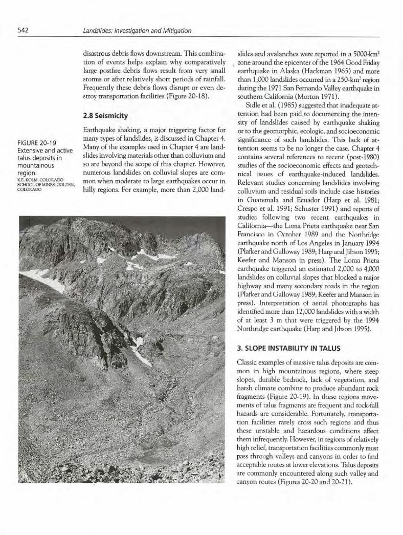
Classic examples of massive talus deposits are com-mon in high mountainous regions, where steep slopes, durable bedrock, lack of vegetation, and harsh climate combine to produce abundant rock fragments (Figure 20-19). In these regions move-ments of talus fragments are frequent and rock-fall hazards are considerable. Fortunately, transporta-tion facilities rarely cross such regions and thus these unstable and hazardous conditions affect them infrequently. However, in regions of relatively high relief, transportation facilities commonly must pass through valleys and canyons in order to find acceptable routes at lower elevations. Talus deposits are commonly encountered along such valley and canyon routes (Figures 20-20 and 20-2 1).
y ',4..
-, S 1.. i.,'. ? i '' -._/ - .l_. •. -. .......... a.' . ,- '•-1
-
I
jj
A3 fr
-k
51
: ,,- . ... .
. 5 .1 .. . - • ,. .. -.-'. . . . ' ;' .,,..
f
I 'Lr 5:,, .
. .;.---_ '' ') " ;.•. S. 5• '_'
''S.. •5.....................................'S . S _ S.
Colluvium and Talus
543
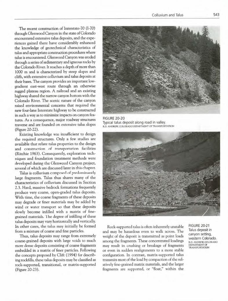
The recent construction of Interstate-70 (1-70) through Glenwood Canyon in the state of Colorado encountered extensive talus deposits, and the expe-riences gained there have considerably enhanced the knowledge of geotechnical characteristics of talus and appropriate construction procedures where talus is encountered. Glenwood Canyon was eroded through a series of sedimentary and igneous rocks by the Colorado River. It reaches a depth of more than 1000 m and is characterized by steep slopes and cliffs, with extensive colluvium and talus deposits at their bases. The canyon provides an important low-gradient east-west route through an otherwise rugged plateau region. A railroad and an existing highway shared the narrow canyon bottom with the Colorado River. The scenic nature of the canyon raised environmental concerns that required the new four-lane Interstate highway to be constructed in such a way as to minimize impacts on canyon fea-tures. As a consequence, major roadway structures traverse and are founded on extensive talus slopes (Figure 20-22).
Existing knowledge was insufficient to design the required structures. Only a few studies are available that relate talus properties to the design and cOfl5tn.Icrinfl oi transportation facilities (Ritchie 1963). Consequently, exploration tech-niques and foundation treatment methods were developed during the Glenwood Canyon project, several of which are discussed later in this chapter.
Talus is colluvium compnsed of prInhTiiTu-lril ly large fragments. Talus thus shares many of the characteristics of colluvium discussed in Section 2.3. Hard, massive bedrock formations frequently produce very coarse, open-graded talus deposits. With time, the coarse fragments of these deposits may degrade or finer materials may be added by wind or water transport so that these deposits slowly become infilled with a matrix of fine-grained materials. The degree of mulling of these talus deposits may vary horizontally and vertically. In other cases, the talus may initially be formed from a mixture of coarse and fine particles.
Thus, talus deposits may range from extremely coarse-grained deposits with large voids to much more dense deposits consisting of coarse fragments embedded in a matrix of finer particles. Following the concepts proposed by Clift (1994) for describ-ing rockfills, these talus deposits may be classified as rock-supported, transitional, or matrix-supported (Figure 20-23).
FIGURE 20-20 Typical talus deposit along road in valley. R.D. ANDREW COLORADO DEPARTMENT OF TRANSPORTATION
Rock-supported talus is often inherently unstable and may be hazardous even to walk across. The weight of the deposit is transmitted as point loads among the fragments. These concentrated loadings may result in crushing or breakage of fragments or even in sudden realignments to a more stable configuration. In contrast, matrix-supported talus transmits most of the load by compaction of the rel-atively fine-gramned matrix materials, and the larger fragments are supported, or "float," within the
FIGURE 20-2 1 Talus deposit in canyon setting, western Colorado. R.D. ANDREW, OJLORADO DEPARTMENT Of TRANSPORTATION

544 Landslides: Investigation and Mitigation
.,:
' if
F / ,_ ,4J. ../
FIGURE 20-22 Completed Interstate-70 crossing extensive talus, Glenwood Canyon, Colorado. A.K. TURNER, COLORAI)O SCHOOL OF MINES. GOLDEN. COLORADO
(a)
Unfilled space between larger particles
Loose matrix material
(b)
Somewhat-compressed matrix material
4.
(c)
Matrix material compressed to a maximum
FIGURE 20-23 Schematic diagrams of three classes of talus: (a) rock-supported, (b) transitional, and (c) m atrix-su p ported (modified from Clift 1994, Figure 15).
matrix. Transitional talus has intermediate proper-ties; the matrix materials may be loosely compacted since they only partially fill many of the voids, and the weight of the deposit is transmitted mostly by the contact between the large fragments. Each of these three talus categories behaves differently in a kinematic sense. Often a single talus deposit will contain scctions from all thrcc categories. Because the surface of most talus deposits is armored witn larger-sized particles, the degree of infilling with depth is difficult to predict.
Estimating strength and stability properties of talus is extremely difficult. Stabilizing or densify-ing open-graded talus may be accomplished by grouting. However, experience with 1-70 in Glenwood Canyon demonstrated that determin-ing the best method of injecting grout, estimating the volume of grout required, or defining im-proved bearing capacity involved much trial and error, in situ field testing, and experience with the characteristics of talus in the area. Gaining suit-able access for the necessary exploration equip-ment is often difficult on talus and may be hazardous in some cases (Figure 20-24).
Ritchie (1963) noted that talus becomes strati-fied because of the gradual accumulation of rock fragments. Once a rock fragment comes to rest on the sloping surface of a talus deposit, Ritchie (1963, 23) stated, "it never, of itself, begins to roll again (although much of the material may move about by debris sliding). On mature natural slopes, rock roll is seldom a problem for highways located near their base." Ritchie emphasized that excavations into talus slopes are especially troublesome. Talus slopes reflect the natural angle of repose of the talus ma-terial, and generally cut slopes are constructed at a steeper angle. Even so, these cut slopes extend large distances away from the transportation facility, and once a rock begins to roll on such a slope, it cannot stop until it reaches the base of the cut. Many cut slopes are constructed slightly steeper than the in-clination of the crude stratification of the talus. This constructed slope angle causes individual rock fragments to ravel, or pop out, from the face of the cut, resulting in continuous and progressive failure of the cut. Ritchie recommended that some form of slope protection for the traveling public is most de-sirable, if not mandatory, where such cut slopes are necessary in talus.
Talus slopes present other hazards. Although most talus is unlikely to initiate debris flows such
: 43
4414 t 4
, -
Colluvium and Talus
545
as those in finer-grained colluvium, debris flows often issue from rock chutes above talus deposits. In severe cases these debris flows may extend com-pletely across the talus siop and wu.e daiiiugt Lu
transportation facilities located on the luwet p01-
tions of the talus deposit.
4. SUBSURFACE INVESTIGATIONS
Traditional technologies, such as drillin, jest pits, trenches, and geophysical methods, are all em-ployed to obtain information on the physical char-acteristics of colluvium. However, each method has limitations in evaluating colluvial deposits. Internal heterogeneity of colluvial deposits cou-pled with the tendency for the strength of collu-vium to degrade over time increase uncertainty and risk concerning characterizations of engineer-ing properties. Colluvium deposited in water-deficient environments may exhibit a flocculated or honeycomb soil-particle structure that can lead to hydrocompaction.
4.1 Planning Subsurface Investigations
Engineering geologists and geotechnical engineers should plan very carefully any subsurface investi-gations for site-specific determination of the engi-neering properties of colluvium in order to take into account and reflect the following characteris-tics of this material:
Colluvium at depth may be deeply weathered and is often more dense (infilled); The moisture profile can increase to saturation with depth; Internal friction and cohesion may vary hori-zontally and vertically within the deposit; Climate and parent materials are major contribu-tors to the engineering parameters of colluvium; Typical slope angles, particle size and distribu-tion, strength properties, and moisture content are all related to the origin and location of the colluvium; Colluvial deposits are often only marginally sta-ble, and their relatively steep slopes may make equipment access difficult or even impossible; and Colluvial slopes frequently are located in areas subject to rock-fall and debris-flow hazards, so precautions to protect field investigation per-sonnel may be necessary.
By recognizing these characteristics and planning investigative procedures to account for them, the engineering geologist or geotechnical engineer is more likely to develop a successful investigation. For example, exploratory drill holes should be ex-tended to greater than typical depths to check for unusual conditions, and areas subjected to subsur-face investigations should be extended to add con-fidence to global stability calculations. Many years of water-level measurements may be required to provide confidence in the estimated maximum water levels assumed in design calculations.
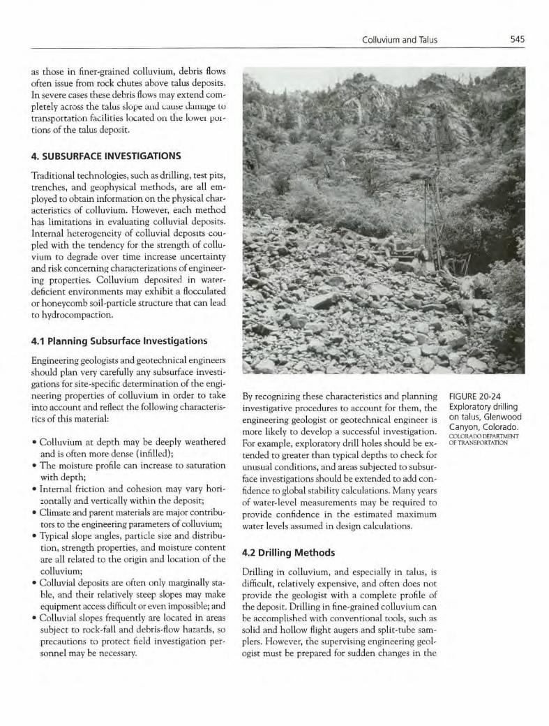
4.2 Drilling Methods
Drilling in colluvium, and especially in talus, is difficult, relatively expensive, and often does not provide the geologist with a complete profile of the deposit. Drilling in fine-grained colluvium can be accomplished with conventional tools, such as solid and hollow flight augers and split-tube sam-plers. However, the supervising engineering geol-ogist must be prepared for sudden changes in the
FIGURE 20-24 Exploratory drilling on talus, Glenwood Canyon, Colorado. COLORADO DEPARTMENT OF TRANSPORTATION

546
Landslides: Investigation and Mitigation
properties of the deposit and to expect zones with no drilling recovery.
In Glenwood Canyon, Colorado, numerous talus deposits were encountered during construc-tion of 1-70. At one point near the center of the canyon, a large ventilation structure for two tun-nels was to be located in the bottom of a narrow tributary canyon that had extensive talus deposits. Construction planning required a detailed sub-surface evaluation of these talus deposits. These explorations provided much new experience concerning the best methods for investigating the nature of talus deposits.
The Colorado Department of Transportation (CDOT) cooperated with manufacturers to de-velop wire-line core drilling bits and procedures to successfully drill the test holes in these talus de-posits. Severe problems resulted from the use of traditional exploratory drilling methods. in the initial exploration, soil-sampling drill rigs equipped with tn-cone bits and drive casings, or casings with diamond shoes, were used. These methods resulted in very slow production rates and poor-quality samples. When traditional dia-mond coring bits were used, they were damaged by heat buildup during periodic losses of drilling fluid. At this location, loss of drilling fluid was a com-mon occurrence because of void spaces within the talus. Although void spaces are rarely found deep within a talus deposit, some voids exceeding 3 m were found at depth during this investigation. Uneven or eccentric loadings are detrimental to most rock-coring bits; thus, in spite of the best ef-forts of the drilling personnel, the diamond bit was frequently damaged because it became placed be- tween a boulder and a void.
4.3 Test Pits and Trenches
Test pits and trenches often provide better obser-vations of the profile of a colluvial deposit than can be obtained by examining samples removed from exploratory holes. Visual inspection of the walls of a trench can lead to more accurate design of sampling and testing programs and ultimately to a more accurate determination of engineering properties. The geologist and the designer are cau-tioned to consider that any excavations in collu-vium may collapse rapidly. These deposits are among the most dangerous in which to perform steep-sided excavations.
4.4 Geophysical Exploration Methods
Geophysical methods often are not satisfactory or especially reliable for determining subsurface in-terfaces such as water horizons and bedrock con-tacts. The third dimension of a hillside deposit adds considerable uncertainty to the interpreta-tion. These methods are better used to supplement drilling and test pit data.
5. DESIGN CONSIDERATIONS FOR COLLUVIUM
Although colluvium is unconsolidated and there-fore a soil according to engineering classifications, construction in colluvium is typically much more difficult than in other major deposits, including al-luvial, glacial, lacustrine, or eolian soils. Colluvium is more likely to exhibit unfavorable properties such as particle size and strength variations, large void spaces, and unexpected excavation failures.
5.1 Creep
Creep is a phenomenon of concern when structures are placed on colluvial deposits. It is known that some long-term translation or movement of mate-rials can occur, especially within the near-surface regime. However, little definitive infotmation exists on this phenomenon. A series of inclinometers were installed by CDOT through a major talus de-posit in Glenwood Canyon, Colorado. These inch-nometers were monitored for 4 years to support design calculations for foundations of a planned ex-tensive viaduct along the base of the deposit. No movement was observed during the monitoring pe-riod. However, this single short-term program cer-tainly cannot be used to conclude that this talus deposit will not exhibit creep in the future. The viaduct foundations were designed to accommodate lateral loadings that would result from some creep movements of the talus.
5.2 Installation of Ground Anchors
Installation of ground anchors in talus can cost an order of magnitude more than a similar installation in a clay soil. Drilling of horizontal or subhorizon-tal holes into colluvium, especially talus, requires special equipment and experienced crews (Fig-ures 20-25 and 20-26). During construction of

Colluvium and Talus 547
lnterstate-70 through Glenwood Canyon, many of the slopc stabilization systems required either tern poru-y or pLrminent reruning w'ills that rdied on tiebacks into talus or colluvial slopes for their sta 4f'. bility (Figures 20-26 and 20-27). Where talus de- posits were encountered, conventional ground anchor installations employing stage grouting were .. not feasible because of the numerous void spaces . . . and zones of very loose matrix material. Most of . the grout was being lost rcsulting in inadequ ir
N. . -
bond strength and -ì lack of corrosion protection - - A system that used geotextile "socks" to con-
. )
tain grout, known as grout containment devices •. : - •• -
(GCDs) was ultimately employed to install these anchors. Experiments were conducted with many '
different types of geotextiles, including both woven and nonwoven products, to determine which performed best as GCDs. Most of the non- woven GCDs ruptured against the sharp frag- ments in the talus deposits under the high - pumping pressures required to inject the grout The most effective method of installation was to - '- -- ' •.: .- -y'S .
grout a woven geotexule material in short sections (approximately 1.5 m long) as the drill casing was FIGURE 20-25
removed. In coarse talus, the only other technique Large specialized rig drilling horizontal ground anchor holes in talus,
that was successful involved a proprietary cx Glenwood Canyon, Colorado. - pander-body anchor that utilized a steel GCD.
1-Th 5.3 Pile Foundations
Foundations for structures that must be placed on colluvium must account for potential nonuniform bearing capacities beneath them. Nonuniform bearing capacities lead to unexpected eccentrici-
ties that may result in distress or failure of the - -• -.-
structure. The depth and configuration of most - - colluviil deposits favor a pile foundation disign - —
-- Installation of deep pile foundations can be very :-
s-S difficult and expensive if large boulders, which - — - n-
may be randomly dispersed within many of these 4 _-I-- depusits, ame eflCuiiI1ter'(l. -'-
In Glenwood Canyon, the foundations for an •.'. " .
extensive viaduct had to be placed on a talus de- posit (Figure 20-28). Preblasting techniques were developed by CDOT and successfully used to
allow the driving of large-diameter piles through
this talus. The method involved predrilling a small-diameter hole at the location of each steel FIGURE 20-26
pile using wire-line drilling. The hole was cased Smaller rig drilling ground anchor holes in talus for temporary
. - slope-retention devices (square concrete pads, upper part of photograph), with polyvmnylchloride (PVC) pipe and hackfilled Glenwood Canyon, Colorado. with drill cuttings. Gelatin dynamite was attached COLORAi )O DEtARTMENT OF TR A N S PO RTAT I ON

Vj
.-,-
'I-
r-
.-
çi1 4t:': r ..
FIGURE 20-27 Installation of permanent retaining walls that utilize tiebacks into talus, Glenwood Canyon, Colorado. COLORADO L)EI'ARTMENT OF TRANsPORTArION
r ,
:-'
'"
FIGURE 20-28 lnterstate-70 viaduct founded on talus, Glenwood Canyon, Colorado. J.L). 11160INS. COLORADO SCHOOL OF MINES. GOLDEN, COLORADO
548 Lands/ides: Investigation and Mitigation
to reinforced detonator cords and lowered into the
hole, which was then stemmed. Detonation of the
charges fractured any large talus fragments so the
piling could be driven through the small broken
fragments. The process was repeated as necessary
until the pile had been driven to the desired tip el-
evation. Ihis procedure obviously added to the
cost for installation of these steel piles. However,
when compared with other alternatives, ii was a
feasible and cost-effective solution.
5.4 Control of Groundwater and
Surface Water
Control of groundwater and surface water is a crit-
ical design consideration. Every effort must be
made to avoid increasing water sources in the col-
luvial soils. Dcsign intentions must be enforced by
construction personnci. One common mistake is
to allow the concentration of roadway runoff into
pipes that discharge into minor drainages.
Improperly designed drainage structures may cause
erosion or even landslides, and collection of water
around foundations can lead to damaged struc-
tures. A properly designed drainage system should
take into consideration its relationship to the ge-
ologic history of the deposit.
5.5 Dangers of Rock Fall and Debris Flow
When evaluating the stability of colluvial and
talus deposits, the engineering geologist must be
concerned with rock-fall and debris-flow hazards.
A historical perspective that emphasizes the origin
of these deposits through downslope movement of
materials must be emphasized to designers of trans-
portation facilities. In spite of careful evaluation
and design in Glenwood Canyon, rock-fall inci-
dents have caused minor damage to roadway struc-
tures (Figure 20-29) and killed three occupants of
one vehicle when it was hit by a large rock.
ACKNOWLEDGMENTS
The long-term support and interest of many mem-
bers of the Colorado Department of Transporta-
tion, especially Robert K. Barrett, Richard Ti
Andrew, and John B. Gilmore, made possible the
development of several sections of this chapter.
Their willingness to share their experiences during
the construction of lnterstate-70 through Glen-
Colluvium and Talus
549
11
_.5'•'
Aftw
FIGURE 20-29 Minor rock-fall damage at base of talus slope, lnterstate-70, Glenwood Canyon, Colorado. J.D. HIGGINS. COLORA[X) SCHOOL OF MINES, GOLDEN. COLORADO
wood Canyon is greatly appreciated, and they pro-vided several of the illustrations used in this chap-ter. The author's colleagues at the Colorado School of Mines, Kenneth E. Koim and Jerry D. Higgins, generously offered additional photographs.
REFERENCES
Anderson, M.G., and K.S. Richards, eds. 1987. Slope Stability: Geo technical Engineering and Geomorph-ology. John Wiley and Sons, Inc., New York, 648 pp.
Bates, R.L., and J.A. Jackson, eds. 1980. Glossary of Geology, 2nd ed. American Geological Institute, Falls Church, Va., 751 pp.
Baldwin, J.E., 11, H.F. Donley, and T.R. Howard. 1987. On Debris Flow/Avalanche Mitigation and Control, San Francisco Bay Area, California. In Debris Flows/Avalanches: Process, Recognition, and Mitigation (J.E. Costa and G.F. Wieczorek, eds.), Reviews in Engineering Geology, Vol. 7, Geological Society of America, Boulder, Cob., pp. 223-236.
Baum, R.L. 1994. Contribution of Artesian Water to I'rogressive Failure of the Upper Part of the Delhi Pike Landslide Complex, Cincinnati, Ohio. U.S. Geological Survey Bulletin 2059-D, 14 pp.
Bennett, K.A. 1982. Effects of Slash Burning on Surface Soil Erosion Rates in the Oregon Coast Range. M.S. thesis. Oregon State University, Corvallis, 70 pp.
Bishop, D.M., and M.E. Stevens. 1964. Landslides on Logged Areas on Southeast Alaska. Research Paper
NOR-1. Forest Service, U.S. Department of Agriculture, Juneau, Alaska, 18 pp.
Bogucki, D.J. 1977. Debris Slide Hazards in the Adirondack Province of New York State. Environ-mental Geology, Vol. 1, pp. 3 17-328.
Brand, E.W.,J. Premchitt, and H.B. Phillipson. 1984. Relationship Between Rainfall and Landslides in Hong Kong. In Proc., Fourth International Sym-posium on Landslides, Canadian Geotechnical Society, Toronto, Vol. 1, pp. 377-384.
Brown, J.A.H. 1972. Hydrologic Effects of a Brushfire in a Catchment in Southeastern New South Wales. Journal of Hydrology, Vol. 15, pp. 77-96.
Burroughs, E.R., and B.R. Thomas. 1977. Declining Root Strength in Douglas Fir after Falling as a Factor in Slope Stability. Research Paper INT-190. Forest Service, U.S. Department of Agriculture, Ogden, Utah, 27 pp.
Campbell, R. H. 1975. Soil Slips, Debris Flows, and Rainstorms in the Santa Monica Mountains and Vicinity, Southern California. U.S. Geological Survey Professional Paper 851, 51 pp.
Cannon, SF1. 1988. Regional Rainfall-Threshold Conditions for Abundant Debris-Flow Activity. In Landslides, Floods, and Marine Effects of the Storm of January 3-5, 1982, in the San Francisco Bay Region, California (S.D. Ellen and G.F. Wieczorek, eds.), U.S. Geological Survey Professional Paper 1434, pp. 35-42.
Cannon, S.H., and S.D. Ellen. 1985. Rainfall Con-ditions for Abundant Debris Avalanches in the San Francisco Bay Region, California. California Geology, Vol. 38, No. 12, pp. 267-272.

550
Landslides: Investigation and Mitigation
Cannon, S.H., and S.D. Ellen. 1988. Rainfall That Resulted in Abundant Debris-Flow Activity During the Storm. In Landslides, Floods, and Marine Effects of the Storm ofJanuary 3-5, 1982, in the San Francisco Bay Region, California (S.D. Ellen and G.E Wieczorek, eds.), U.S. Geological Survey Professional Paper 1434, pp. 27-34.
Cannon, S.H., P.S. Powers, R.A. PihI, and W.P. Rogers. 1995. Preliminary Evaluation of the Fire-Related Debris Flows on Storm King Mountain, Glenwood Springs, Colorado. U.S. Geological Survey Open File Report 95-508, 38 pp.
Church, M., and M.J. Miles. 1987. Meteorological Antecedents to Debris Flow in Southwestern British Columbia: Some Case Studies. In Debris Flows/Avalanches: Process, Recognition, and Mitiga-tion (J.E. Costa and G.E Wieczorek, eds.), Reviews in Engineering Geology, Vol. 7, Geological Society of America, Boulder, Cob., pp. 63-80.
Chen, C. 1987. Comprehensive Review of Debris Flow Modelling Concepts in Japan. In Debris Flows! Avalanches: Process, Recognition, and Mitigation (J.E. Costa and G.E Wieczorek, eds.), Reviews in Engineering Geology, Vol. 7, Geological Society of America, Boulder, Cob., pp. 13-30.
Clift, A.E. 1994. In Situ Properties and Settlement Characteristics of Rockfill. Ph.D. thesis No. T-4375. Colorado School of Mines, Golden, 201 pp. plus appendices.
Coates, D.R., ed. 1977. Landslides. Reviews in Engi-neering Geology, Vol. 3, Geological Society of America, Boulder, Cob., 278 pp.
Costa, I.E. 1984. Physical Geomorphology of Debris Flows. In Developments and Applications of Geo-morphology (J.E. Costa and P.J. Fleisher, eds.), Springer-Verlag, Berlin, pp. 268-317.
Costa, J.E., and V.R Baker. 1981. Surficial Geology: Building with the Earth. John Wiley and Sons, New York, 498 pp.
Costa, J.E., and G.F. Wieczorek, eds. 1987. Debris Flows/Avalanches: Process, Recognition, and Miti-gation. Reviews in Engineering Geology, Vol. 7, Geological Society of America, Boulder, Cob., 139pp.
Crespo, E., T.D. O'Rourke, and K.J. Nyman. 1991. Effects on Lifebines. In The March 5, 1987 Ecuador Earthquakes: Mass Wasting and Socioeconomic Effects, National Academy Press, Washington, D.C., pp. 83-99.
DeBano, L.E 1980. Water Repellent Soils: A State -of-the-Art. Pacific Southwest Forest and Range
Experiment Station General Technical Report PSW-46. Forest Service, U.S. Department of Agriculture, Berkeley, Calif., 21 pp.
DeBano, L.E, J.E Osborn, J.S. Krammes, and J. Letey. 1967. Soil Wettability and Wetting Agents.. .Our Current Knowledge of the Problem. Pacific South-west Forest and Range Experiment Station Research Paper PSW-43. Forest Service, U.S. Department of Agriculture, Berkeley, Calif., 13 pp.
Dietrich, WE., andT. Dunne. 1978. Sediment Budget for a Small Catchment in Mountainous Terrain. Zeitschrift für Geomorphologie, Supplement, Vol. 29, pp. 191-206.
Dietrich, WE., C.J. Wilson, and S.L. Reneau. 1986. Hollows, Colluvium, and Landslides in Soil-Mantled Landscapes. In Hillslope Processes (A. Abrahams, ed.), 16th Annual Geomorphology Symposium, Binghampton, N.Y., Allen and Unwin Ltd., Winchester, Mass., pp. 361-388.
Eaton, E.C. 1935. Flood and Erosion Control Prob-lems and Their Solution. Transactions, American Society of Civil Engineers, Vol. 101, pp. 1302-1330.
Ellen, S.D. 1988. Description and Mechanics of Soil Slip/Debris Flows in the Storm. In Landslides, Floods, and Marine Effects of the Storm of January 3-5, 1982, in the San Francisco Bay Region, Cali-fornia (S.D. Ellen and G.E Wieczorek, eds.), U.S. Geological Survey Professional Paper 1434, pp. 63-112.
Ellen, S.D., S.H. Cannon, and S.L. Reneau. 1988. Distribution of Debris Flows in Mann County. In Landslides, Floods, and Marine Effects of the Storm of January 3-51 1982, in the San Francisco Bay Region, California (S.D. Ellen and G.E Wieczorek, eds.), U.S. Geological Survey Professional Paper 1434, pp. 113-132.
Ellen, S.D., and G.F. Wieczorek. 1988. Landslides, Floods, and Marine Effects of the Storm of January 3-5, 1982, in the San Francisco Bay Region, Cali-fornia. U.S. Geological Survey Professional Paper 1434, 310 pp.
Ellen, S.D., and R.W. Fleming. 1987. Mobilization of Debris Flows from Soil Slips, San Francisco Bay Region, California. In Debris Flows/Avalanches: Process, Recognition, and Mitigation (J.E. Costa and G.E Wieczorek, eds.), Reviews in Engineering Geology, Vol. 7, Geological Society of America, Boulder, Cob., pp. 31-40.
Endo, T, and T. Tsuruta. 1969. The Effect of the Tree's Roots on the Shear Strength of Soil. In Annual Report for 1968, Hokkaido Branch, Forest Exper-iment Station, Sapporo, Japan, pp. 167-182.

Colluvium and Talus
551
Fairbairn, W.A. 1967. Erosion in the River Findhorn Valley. Scottish Geographic Magazine, Vol. 83, No. 1, pp. 46-52.
Fleming, R.W., and A.M. Johnson. 1994. Landslides in Colluvium. U.S. Geological Survey Bulletin 2059-B, 24 pp.
Fukuoka, M. 1980. Landslides Associated with Rain-fall. Geotechnical Engineering, Vol. 11, pp. 1-29.
Gray, D.H., and W.F. Megahan. 1981. Forest Vegetation Removal and Slope Stability in the Idaho Batholith. Research Paper INT-271. Forest Service, U.S. Department of Agriculture, Ogden, Utah, 23 pp..
Greenway, D.R. 1987. Vegetation and Slope Stability. In Slope Stability (M.G. Anderson and K.S. Richards, eds.), John Wiley and Sons, New York, pp. 187-230.
Hack, J.T. 1965. Geomorphology of the Shenandoah Valley, Virginia and West Virginia, and Origin of the Residual Ore Deposits. U.S. Geological Survey Professional Paper 484, 84 pp.
Hack, J.T, and J.C. Goodlett. 1960. Geomorphology and Forest Ecology of a Mountain Region in the Central Appalachians. U.S. Geological Survey Pro-fessional Paper 347, 66 pp.
Hackman, R.J. 1965. Interpretation of Alaskan Post-Earthquake Photographs. Photogrammetric Engi-neering, Vol. 31, pp. 604-610.
Haneberg, W.C., and A.O. Gokce. 1994. Rapid Water-Level Fluctuations in a Thin Colluvium Landslide West of Cincinnati, Ohio. U.S. Geological Survey Bulletin 2059-C, 16 pp.
Hanes, TL. 1977. Chaparral. In Terrestrial Vegetation of California (M.G. Barbour and J. Major, eds.), John Wiley and Sons, New York, pp. 417-470.
Harp, E.L., and R.W. Jibson. 1995. Inventarj of Landslides Triggered by the 1994 Northridge, Cali-fornia, Earthquake. U.S. Geological Survey Open-File Report 95-2 13, 16 pp., 2 plates.
Harp, E.L., R.C. Wilson, and G.E Wieczorek. 1981. Landslides from the February 4, 1976, Guatemala Earthquake. U.S. Geological Survey Professional Paper 1204-A, 35 pp.
Hollingsworth, R., and G.S. Kovacs. 1981. Soil Slumps and Debris Flows: Prediction and Pro-tection. Bulletin of the Association of Engineering Geologists, Vol. 28, No. 1, pp. 17-28.
Howard, T.R., J.E. Baldwin, II, and H.E Donley. 1988. Landslides in Pacifica, California, Caused by the Storm. In Landslides, Floods, and Marine Effects of the Storm of January 3-5, 1982, in the San Francisco Bay Region, California (S.D. Ellen and
G.E Wieczorek, eds.), U.S. Geological Survey Professional Paper 1434, pp. 163-184.
Hutchinson, J.N. 1968. Mass Movement. In Encyclo-pedia of Geomorphology (R.W. Fairbridge, ed.), Reinhold Press, New York, pp. 688-695.
Jacobson, R.B. 1985. Spatial and Temporal Distribution of Slope Processes in the Upper Buffalo Creek Drainage Basin, Marion County, West Virginia. Ph.D. thesis. Johns Hopkins University, Baltimore, Md., 484 pp.
Jibson, R.W. 1989. Debris Flows in Southern Puerto Rico. In Landslide Processes of the Eastern United States and Puerto Rico (A.P. Schultz and R.W. Jibson, eds.), Special Paper 236, Geological Society of America, Boulder, Cob., pp. 29-55.
Johnson, A.M. 1970. Physical Processes in Geology. Freeman, Cooper and Co., San Francisco, 577 pp.
Johnson, A.M. 1984. Debris Flow. In Slope Instability (D. Brunsden and D.B. Prior, eds.), John Wiley and Sons, New York, pp. 257-36 1.
Johnson, A.M., and P.H. Rahn. 1970. Mobilization of Debris Flows. Zeitschrift für Geomorphologie, Supplement, Vol. 9, pp. 168-186.
Jones, EQ. 1973. Landslides of Rio de Janeiro and the Serra das Araras Escarpment, Brazil. U.S. Geolog-ical Survey Professional Paper 697, 42 pp.
Keefer, D.K. 1984. Landslides Caused by Earthquakes. Geological Society of America Bulletin, Vol. 95, No. 4, pp. 406-421.
Keefer, D.K., and M.W. Manson. In press. Landslides Produced by the 1989 Loma Prieta, California, Earthquake—Regional Distribution and Charac-teristics. In The October 17, 1989, Loma Prieta, California, Earthquake: Landslides and St-ream Channel Change (D.K. Keefer, ed.) (U.S. Geo-logical Survey Professional Paper 1551-C), Vol. 2 of The Loma Prieta Earthquake of October 17, 1989, U.S. Geological Survey Professional Papers.
Keller, E.A. 1979. Environmental Geology, 2nd ed. C.E. Merrill Publishing Company, Columbus, Ohio, 548 pp.
Kesseli, J.E. 1943. Disintegrating Soil Slips of the Coast Ranges of Central California. Journal of Geology, Vol. 51, No. 5, pp. 342-352.
Kitamura, Y., and S. Namba. 1976. A Field Experiment on the Uprooting Resistance of Tree Roots. In Proc., 77th Meeting of the Japanese Forest Society (English translation by J.M. Arata and R.R. Ziemer), Forest Service, U.S. Department of Agriculture, Arcata, Calif., pp. 568-570.
Lessing, P., B.R. Kulander, B.D. Wilson, S.L. Dean, and S.M. Woodring. 1976. West Virginia

552
Landslides: Investigation and Mitigation
Landslides and Slide Prone Areas. Environmental Geology Bulletin 15. West Virginia Geological and Economic Survey, Morgantown, 64 pp.
Marion, D.A. 1981. Landslide Occurrence in the Blue River Drainage, Oregon. M.S. thesis. Oregon State University, Corvallis, 114 pp.
Mark, R.K., and E.B. Newman. 1988. Rainfall Totals Before and During the Storm: Distribution and Correlations with Damaging Landslides. In Land-slides, Floods, and Marine Effects of the Storm of January 3-5, 1982, in the San Francisco Bay Region, California (S.D. Ellen and G.E Wieczorek, eds.), U.S. Geological Survey Professional Paper 1434, pp. 17-26.
Mersereau, R.C., and C.T Dyrness. 1972. Accelerated Mass Wasting after Logging and Slash Burning in Western Oregon. Journal of Soil and Water Conservation, Vol. 27, No. 3, pp. 112-114.
Morton, D.M. 1971. Seismically Triggered Land-slides in the Area above the San Fernando Valley. In The San Fernando, California, Earthquake of February 9, 1971, U.S. Geological Survey Professional Paper 733, pp. 99-104.
Morton, D.M., and R.H. Campbell. 1974. Spring Mudflows at Wrightwood, Southern California. Quarterly Journal of Engineering Geology, Vol. 7, No. 4, pp. 377-384.
Nakano, T. 1971. Natural Hazards: Report from Japan. In Natural Hazards—Local, National, Global (G.F. White, ed.), Oxford University Press, New York, pp. 23 1-243.
Neary, D.G., and L.W. Smith, Jr. 1987. Rainfall Thresholds for Triggering a Debris Avalanching Event in the Southern Appalachian Mountains. In Debris Flows/Avalanches: Process, Recognition, and Mitigation (J.E. Costa and G.E Wieczorek, eds.), Reviews in Engineering Geology, Vol. 7, Geological Society of America, Boulder, Cob., pp. 81-92.
Okunishi, K., and T. Okimura. 1987. Groundwater Models for Mountain Slopes. In Slope Stability (M.G. Anderson and K.S. Richards, eds.), John Wiley and Sons, New York, pp. 265-286.
O'Loughlin, C.L. 1972. A Preliminary Study of Land-slides in the Coast Mountains of Southwestern British Columbia. In Mountain Geomorphology: Geomorphological Processes in the Canadian Cordil-lera (H.O. Slaymaker and H.J. McPherson, eds.), Tantalus Research, Vancouver, British Columbia, Canada, pp. 101-111.
O'Loughlin, C.L. 1974a. The Effect of Timber Removal on the Stability of Forest Soils. Journal of Hydrology of New Zealand, Vol. 13, No. 2, pp. 121-123.
O'Loughlin, C.L. 1974b. A Study of Tree Root Strength Deterioration Following Clearfelling. Canadian Journal of Forestry Research, Vol. 4, No. l,pp. 107-113.
O'Loughlin, C.L., and A.J. Pearce. 1976. Influence of Cenozoic Geology on Mass Movement and Sediment Yield Response to Forest Removal, North Westland, New Zealand. Bulletin of the International Association of Engineering Geologists, Vol. 14, pp. 41-46.
O'Loughlin, C.L., L.K. Rowe, and A.J. Pearce. 1982. Exceptional Storm Influences on Slope Erosion and Sediment Yields in Small Forest Catchments, North Westland, New Zealand. In National Conference Publication 82/6, Institution of Engi-neers, Barton, Australian Capital Territory, pp. 84-9 1.
Pierson, T.C. 1977. Factors Controlling Debris-Flow Initiation on Forested Hillslopes in the Oregon Coast Range. Ph.D. thesis. University of Washington, Seattle, 166 pp.
Pierson, T.C. 1981. Dominant Particle Support Mechanisms in Debris Flows at Mt. Thomas, New Zealand, and Implications for Flow Mobility. Sedimentology, Vol. 28, No. 1, pp. 49-60.
Plafker, G., and J.P. Galloway. 1989. Lessons Learned from the Loma Prieta, California, Earthquake of October 17, 1989. U.S. Geological Survey Cir-cular 1045, 48 pp.
Pomeroy, J.S. 1981. Storm-Induced Debris Avalanching and Related Phenomena in the Johnstown Area, Pennsylvania, with Reference to Other Studies in the Appalachians. U.S. Geological Survey Professional Paper 1191, 22 pp.
Pomeroy, J.S. 1984. Storm-Induced Slope Movements at East Brady, Northern Pennsylvania. U.S. Geological Survey Bulletin 1618, 16 pp.
Reneau, S.L., and W.E. Dietrich. 1987. The Impor-tance of Hollows in Debris Flow Studies: Examples from Mann County, California. In Debris Flows! Avalanches: Process, Recognition, and Mitigation (J.E. Costa and G.E Wieczorek, eds.), Reviews in Engineering Geology, Vol. 7, Geological Society of America, Boulder, Cob., pp. 165-180.
Rice, R.M. 1977. Forest Management to Minimize Landslide Risk. In Guidelines for. Watershed Management (S.H. Kunkle and J.L. Thames, eds.), United Nations Food and Agriculture Organization, Rome, Italy, pp. 27 1-287.
Riestenberg, M.M. 1994. Anchoring of Thin Colluvium by Roots of Sugar Maple and White Ash on HilLslopes in Cincinnati. U.S. Geological Survey Bulletin 2059-E, 25 pp.

Colluvium and Talus 553
Ritchie, A.M. 1963. Evaluation of Rockfall and Its Control. In Highway Research Record 17, HRB, National Research Council, Washington, D.C., pp. 13-28.
Rodine, J.D. 1974. Analysis of the Mobilization of Debris Flows. Ph.D. thesis. Stanford University, Stanford, Calif., 226 pp.
Sassa, K. 1984. The Mechanism Starting Liquefied Landslides and Debris Flows. In Proc., Fourth International Symposium on Landslides, Canadian Geotechnical Society, Toronto, pp. 349-354.
Sassa, K., A. Takei, and H. Mauri. 1981. Influences of Underground Erosion on Instability of a Crystalline Schist Slope. In Proc., International Symposium on Weak Rock; Soft, Fractured, and Weathered Rock, A.A. Balkema, Rotterdam,. Netherlands, pp. 543-548.
Schultz, A.P., and R.W. Jibson, eds. 1989. Landslide Processes of the Eastern United States and Puerto Rico. Special Paper 236. Geological Society of America, Boulder, Cob., 102 pp.
Schuster, R.L. 1991. Introduction. In The March 5, 1987, Ecuador Earthquakes (R.L. Schuster, ed.), Natural Disaster Studies, National Research Council, Washington, D.C., No. 5, Chap. 1, pp. 11-22.
Selby, M.J. 1982. HilLslope Materials and Processes. Oxford University Press, New York, 264 pp.
Sharpe, C.S.F. 1938. Landslides and Related Phenomena: A Study of the Mass Movement of Soil and Rock. Columbia University Press, New York, 136 pp.
Sidle, R.C. 1980. Slope Stability on Forest Land. Pacific Northwest Extension Publication PNW 209. Oregon State University, Corvallis, 23 pp.
Sidle, R.C., A.J. Pearce, and C.L. O'Loughlin. 1985. Hillslope Stability and Land Use. Water Resources Monograph 11. American Geophysical Union, Washington, D.C., 140 pp.
Sidle, R.C., and D.N. Swanston. 1982. Analysis of a Small Debris Slide in Coastal Alaska. Canadian Geotechnical Journal, Vol. 19, pp. 167-174.
Smith, T.C. 1988. A Method for Mapping Relative Susceptibility to Debris Flows, with an Example from San Mateo County, California. In Landslides, Floods, and Marine Effects of the Storm of January 3-5, 1982, in the San Francisco Bay Region, California (S.D. Ellen and G.E Wieczorek, eds.), U.S. Geological Survey Professional Paper 1434, pp. 185-194.
Smith, T.C., and E.W. Hart. 1982. Landslides and Related Storm Damage January 1982, San Francisco Bay Region. California Geology, Vol. 36, No. 7, pp. 139-152.
Spellenberg, R. 1979. The Audubon Society Field Guide to North American Wildflowers, Western Region, 7th ed. Knopf, New York, 862 pp.
Strahler, A.N. 1971. The Earth Sciences, 2nd ed. Harper & Row, New York, 824 pp.
Swanson, EJ., and C.J. Roach. 1985. Frequency of Debris Avalanches from Clearcut Hollows, Siuslaw River Basin, Oregon (abstract). Eos, Vol. 66, p. 900.
Swanson, F.J., M.M. Swanson, and C. Woods. 1981. Analysis of Debris-Avalanche Erosion in Steep Forest Lands: An Example from Mapleton Oregon, USA. In Erosion and Sediment Transport in Pacific Rim Steeplands (T.R.H. Davies and A.J. Pearce, eds.), Publication 132, International Association of Hydrological Sciences, Delft, Netherlands, pp. 67-75.
Swanston, D.N. 1967. Soil-Water Piezometry in a Southeast Alaska Landslide Area. Pacific Northwest Forest and Range Experiment Station Research Note PNW-68. Forest Service, U.S. Department of Agriculture, Portland, Oreg., 17 pp.
Swanston, D.N. 1969. Mass Wasting in Coastal Alaska. Pacific Northwest Forest and Range Experiment Station Research Paper PNW-83. Forest Service, U.S. Department of Agriculture, Portland, Oreg., 15 pp.
Swanston, D.N. 1970. Mechanics of Debris Avalanching in Shallow Till Soils of Southeast Alaska. Pacific Northwest Forest and Range Experiment Station Research Paper PNW-103. Forest Service, U.S. Department of Agriculture, Portland, Oreg., 17 pp.
Swanston, D.N., and F.J. Swanson. 1976. Timber Harvesting, Mass Erosion, and Steepland Forest Management in the Pacific Northwest. In Geo-morphology and Engineering (D.R. Coates, ed.), Dowden Hutchinson and Ross, Stroudsburg, Pa., pp. 199-22 1.
Takahashi, T. 1978. Mechanical Characteristics of Debris Flow. Journal of the Hydraulics Division, ASCE, Vol. 104, No. HY8, pp. 1153-1 169.
Vames, D.J. 1978. Slope Movement Types and Processes. In Special Report 176: Landslides: Analysis and Control (R.L. Schuster and R.J. Krizek, eds.), TRB, National Research Council, Washington, D.C., pp. 11-33.
Waldron, S.J., and S. Dakessian. 1981. Soil Reinforcement by Roots: Calculation of Increased Soil Shear Resistance from Root Properties. Soil Science, Vol. 132, No. 6, pp. 427-435.
Waldron, S.J., S. Dakessian, and J.A. Nemson. 1983. Shear Resistance Enhancement of 1.22-meter
554
LandslideY.- Investigation and Mitigation
Diameter Soil Cross Sections by Pine and Alfalfa Roots. Journal of the Soil Science Society of America, Vol. 47, No. 1, pp. 9-14.
Wells, W.G., II. 1987. The Effects of Fire on the Generation of Debris Flows in Southern Califor-nia. In Debris Flows/Avalanches: Process, Recogni-tion, and Mitigation (J.E. Costa and G.F. Wieczorek, eds.), Reviews in Engineering Geology, Vol. 7, Geological Society of America, Boulder, Cob., pp. 105-114.
Wentworth, C.K. 1943. Soil Avalanches on Oahu, Hawaii. Bulletin of the Geological Society of Amer-ica, Vol. 54, No. 1, pp. 53-64.
Wieczorek, G.E 1987. Effect of Rainfall Intensity and Duration on Debris Flows in Central Santa Cruz Mountains, California. In Debris Flows/Avalanches: Process, Recognition, and Mitigation (J.E. Costa and G.E Wieczorek, eds.), Reviews in Engineering Geology, Vol. 7, Geological Society of America, Boulder, Cob., pp. 93-104.
Wieczorek, G.E, and J. Sarmiento. 1988. Rainfall, Piezometric Levels, and Debris Flows Near La
Honda, California, in Storms Between 1975 and 1983. In Landslides, Floods, and Marine Effects of the Storm of January 3-5, 1982, in the San Francisco Bay Region, California (S.D. Ellen and G.E Wieczorek, eds.), U.S. Geological Survey Professional Paper 1434, pp. 43-62.
Williams, G.P., and H.P. Guy. 1973. Erosional and Depositi anal Aspects of Hurricane Camille in Virginia, 1969. U.S. Geological Survey Professional Paper 804, 80 pp.
Woodruff, J .E 1971. Debris Avalanches as an Ero-sional Agent in the Appalachian Mountains. Journal of Geography, Vol. 70, pp. 399-406.
Wu, T.H., W.P. McKinnel, and D.N. Swanston. 1979. Strength of Tree Roots and Landslides on Prince of Wales Island, Alaska. Canadian Geotechnical Journal, Vol. 16, No. 1, pp. 19-33.
Ziemer, R.R., and D.N. Swanston. 1977. Root Strength Changes after Logging in Southeast Alaska. Pacific Northwest Forest and Range Experiment Station Research Note PNW-306. Forest Service, U.S. Department of Agriculture, Portland, Oreg., 10 pp.


![Genesis and Distribution of Colluvium in Buffalo Creek ...onlinepubs.trb.org/Onlinepubs/trr/1986/1089/1089-009.pdflower Washington Formation [as defined by Berryhill et al. (1)], ...](https://static.fdocuments.in/doc/165x107/60a2cd80cca186387b3772de/genesis-and-distribution-of-colluvium-in-buffalo-creek-lower-washington-formation.jpg)


