COLLECTIVE HABITATION IN URBAN PLANNING OF …
13
FACTA UNIVERSITATIS Series: Architecture and Civil Engineering Vol. 14, N o 2, 2016, pp. 223 - 235 DOI: 10.2298/FUACE1602223A COLLECTIVE HABITATION IN URBAN PLANNING OF JAGODINA, SERBIA UDC 728.2(497.11) Vladimir Avramovic Freelance Architect, Velenje, Slovenia * University of Belgrade, Faculty of Architecture, Serbia Abstract. An extensive collective habitation in Jagodina started in the middle of 1950s by planned construction of settlements ‘Pivara’ and ‘Kablovi’ by architect Dragiša Brašovan. Along with the further demographic and economic development of Jagodina, construction of numerous settlements of collective buildings on the periphery of the town was continued during the first fifteen years of the 21 st century when the settlements were built, mostly contrary to the provisions of valid planning documents. An urban development of Jagodina was regulated by general urban plans from 1956, 1976 and 2015.Planning documents were not being carried out completely, and a legalization of unplanned residential and other construction represented a reason for changes in existing planning documents. Since 2000 the residential and another construction has been realized by individual decisions of local government, and a good base for complex treatment of urban town development was not made by GUP 2015. According to GUP 2015, five residential zones cover the largest part of central building area. According to architectural-urban values, settlements ‘Pivara’ and ‘Kablovi’ are particularly noteworthy, followed by settlements ‘Kajsijar’, ‘Strelište’, ‘Sarina meĎa’ and other ones. Kew words: collective habitation, residential zones, urban development, urban planning, Jagodina 1. INTRODUCTION The town of Jagodina originates from the medieval village Jagodna, first mentioned as a temporary royal residence in 1399. During the Turks reign, the settlement called Jagodina palanka (small town) (noted by foreign travelers as Jadunum, Eperis or Jasince) arose on the ruins of the village. In the middle of 16 th century, a settlement mostly consisted of Islamic population on Carigrad (Constantinople) road had four caravan stations, two mosques and a Turkish school, and in 1660. a traveler named Evlija Received March 16, 2016 / Accepted May 5, 2016 Corresponding author: Vladimir Avramovic, Saleska cesta 20c, 3320 Velenje, Slovenia E-mail: [email protected] * PhD Student
Transcript of COLLECTIVE HABITATION IN URBAN PLANNING OF …
FACTA UNIVERSITATIS Series: Architecture and Civil Engineering Vol. 14, No 2, 2016, pp. 223 - 235 DOI: 10.2298/FUACE1602223A
COLLECTIVE HABITATION IN URBAN PLANNING
OF JAGODINA, SERBIA
UDC 728.2(497.11)
Vladimir Avramovic
Freelance Architect, Velenje, Slovenia *University of Belgrade, Faculty of Architecture, Serbia
Abstract. An extensive collective habitation in Jagodina started in the middle of 1950s
by planned construction of settlements ‘Pivara’ and ‘Kablovi’ by architect Dragiša
Brašovan. Along with the further demographic and economic development of Jagodina,
construction of numerous settlements of collective buildings on the periphery of the town
was continued during the first fifteen years of the 21st century when the settlements were
built, mostly contrary to the provisions of valid planning documents.
An urban development of Jagodina was regulated by general urban plans from 1956, 1976
and 2015.Planning documents were not being carried out completely, and a legalization of
unplanned residential and other construction represented a reason for changes in existing
planning documents. Since 2000 the residential and another construction has been realized
by individual decisions of local government, and a good base for complex treatment of urban
town development was not made by GUP 2015.
According to GUP 2015, five residential zones cover the largest part of central building
area. According to architectural-urban values, settlements ‘Pivara’ and ‘Kablovi’ are
particularly noteworthy, followed by settlements ‘Kajsijar’, ‘Strelište’, ‘Sarina meĎa’ and
other ones.
Kew words: collective habitation, residential zones, urban development, urban
planning, Jagodina
1. INTRODUCTION
The town of Jagodina originates from the medieval village Jagodna, first mentioned
as a temporary royal residence in 1399. During the Turks reign, the settlement called
Jagodina palanka (small town) (noted by foreign travelers as Jadunum, Eperis or Jasince)
arose on the ruins of the village. In the middle of 16th
century, a settlement mostly
consisted of Islamic population on Carigrad (Constantinople) road had four caravan
stations, two mosques and a Turkish school, and in 1660. a traveler named Evlija
Received March 16, 2016 / Accepted May 5, 2016
Corresponding author: Vladimir Avramovic, Saleska cesta 20c, 3320 Velenje, Slovenia E-mail: [email protected] *PhD Student

224 V. AVRAMOVIC
Ĉelebija stated that there were 1500 houses in Jagodina. After Second Serbian Uprising,
Jagodina was rapidly developing as a bordering place at the border of Miloš’s Serbia, and
finally became a part of it in 1883 as a formed town. Afterward, Jagodina was recording a
continuous demographic development, conditioned by longitudinal migrations along the
river Morava towards the north and transverse migrations from Šumadija and Eastern
Serbia. In 1946 regarding the centenary of the birth of Svetozar Marković, the town was
renamed Svetozarevo, and in 1992, it brought back its name Jagodina by citizens referendum.
Today, Jagodina is a center of the Pomoravlje District within the regions of Šumadija and
Western Serbia.
According to the 2011 census, Jagodina had a population of 37.282 inhabitants, 13.844
households, and 17.488 apartments. In regards to previous censuses, the number of inhabitants
is mildly increasing whereas the number of households is increasing noticeably (with less
number of members). But, in comparison to censuses before 1991, when a number of
apartments was lower or approximately equal to a number of households, in the period after
1991, the number of apartments was increasingly exceeding the number of households. It is
estimated that in the end of 2015, there were about 4.000 uninhabited apartments in
Jagodina, mostly in newly built collective apartment buildings which customers were not
interested in (of average price about 500€/ m²), with about 2.100 apartments more,
inhabited by persons who are not apartments owners. (Momčilović, 2014)
During the 1950s after World War II, Jagodina transformed mainly from service,
agricultural and poorly industrialized small town into an industrial town, particularly after
1955 when the construction of a cable factory started. This industrial giant and other
town enterprises attracted numerous residents from surrounding and farther places.
Apartments in new settlements, which were realized predominantly by the plan, were
rapidly built and given to the use of new residents.
During the 1990s, in well-known social-political circumstances, apartments building in
Jagodina almost died down (except sporadic building for refugees and displaced persons’
needs). After 2000, in the spirit of favoring private sector and complete privatization, market-
oriented collective apartment building revived, but due to residents’ low purchasing power
and low demand, selling was poor. A part of apartments was of low quality (due to
unprofessional construction, savings in material etc.), and lower number of customers was
deceived by apartment sellers who did not fulfil their obligations.
In a campaign of providing new working places and economic development, a local
government easily granted investors with locations at public urban land. The green areas
in town core were mostly taken for new collective residential buildings locations, which
purpose was changed by single decisions, often contrary to the provisions of valid planning
documents. Then, by changing these or making new planning documents, the building was
legalized by single decisions as acquired obligation. By decisions on new locations of
collective residential buildings, a parking lot was not planned (instead, the investor pays
tax for the construction of shared public parking lot, which was realized far from a
residential building, or was not realized at all, due to lack of space and means).
In the period after World War II, several general urban plans and a greater number of
detailed urban plans were made for Svetozarevo/Jagodina. The provisions of these
planning documents on the residential building as the massive one were respected more
than the provisions on the nonresidential building. General plans were carried out (or
broken) by the realization of urban elaboration plans, and every new GUP or its change
was made more for the legalization of deviation from the previous plan and less for

Collective Habitation in Urban Planning of Jagodina, Serbia 225
shortcomings of its program and plan. In that sense, general urban planning had a partial
influence on the urban town development, which was managed by detailed plans and
projects (nowadays by immediate decisions of local government) for solving daily
political problems. The relation between urban development and urban planning of the
town and its habitation is discussed in the first part of this work.
Main residential zones of the town with individual and collective habitation, also
valorized in the current GUP 2015 of Jagodina, are located in parts of the town to the west
and east of the river Belica. In the zones to the west of Belica, habitation distinctly dominates
whereas in the zones to the east of Belica it is mixed with central public functions. In most of
the zones, there are micro-urban units of collective habitation, distinguished by the quality of
its solution and realization. Development and characteristics of residential zones in the current
GUP, as well as the choice of the highest quality urban-architectural achievements of
collective habitation, are discussed in the second part of this work.
2. URBAN DEVELOPMENT AND URBAN PLANNING OF JAGODINA
There are more significant factors that greatly contributed to the development of the
present-day urban structure of Jagodina. Despite spatial interventions by which the original
image of settlements has been changed, remains of the old agglomeration are visible and
valued in urban planning of Jagodina, so that the town general perspective has not been
significantly changed.
Besides the Belica which flows in southeast-northwest direction and represents an
important factor in town urban development, forming new route of Carigrad’s road (known
among Jagodina residents as ‘Duga ĉaršija’) and crossroads of general east-west direction,
Jagodina is getting final outlines of the future development in ‘cruciform shape’
(Macura,1984). The cruciform shape consisted of the old and the new route of Carigrad’s
road, Levaĉ road route towards Kragujevac over Stone bridge, Rakitovo's road route towards
Ribare (see Fig. 1). With railway construction, the importance of ‘Duga ĉaršija’ has been
emphasized. As a highway direction northwest-southeast, it has a crucial role in Jagodina’s
longitudinal structure development.
One of the first plans which were supposed to regulate the town urban development
was ‘Project of Jagodina’s Regulation’ which was adopted by town authorities in 1942
(Dedić, 2005). Regarding statistical data on population growth, social and economic
occasions and composition of the population, this project was rather advanced for that
time, but in war conditions, it was not carried out. Partly on this basis after World War II,
the directions of the future town spatial development were set.
The first indications of the contemporary way of planning collective residential blocks
emerged in the preliminary draft of the regulation plan of Svetozarevo town in 1949 in
part of today Ružica Milanović Street and along the whole Levaĉka Street (today 7th
July
Street). Due to the unplanned individual building, by which the provided space was
occupied, this residential group has never been realized.
Regarding a development of Jagodina, the attempts of adjustment have been made
with a development of other surrounding settlements. In Big Pomoravlje, a three-town
agglomeration Jagodina-Ćuprija-Paraćin has been spontaneously formed for a long time.
In modest urban literature, this agglomeration together with all suburban settlements is
called Moravian conurbation. A group of authors from the Institute for Advancement of

226 V. AVRAMOVIC
Communal Housing, which was working on program basis for the development of
Svetozarevo in 1968, saw a general economic town development perspective within
broader spatial-functional units of three neighboring towns. There were ideas that ‘apart
from functional connection towns should be directed towards territorial connection as
well through a system of inter-settlement units with differentiated purposes…’(Federal
Bureau of Urban Planning and Communal Housing MA Svetozarevo and YUGINUS,
1976) In that case, new residential settlements on the outskirts of the town would be
planned as a part of Moravian conurbation. However, there were no documented spatial
researches on triple Moravian conurbation. It was mainly unplanned developing,
depending on the individual needs of each municipality.
Relying only on its own strength and territory, economic and infrastructural objects
were being formed in Jagodina, which represented a powerful attraction for potential
migrants. Built industrial capacities attracted inhabitants from closer and wider area, which
caused new challenges for the town’s planned urbanization. In these social and economic
circumstances, residential building, particularly the collective one was becoming a key factor
of urbanization.
As the town was developing, the problem of urban regulation, set in the second part of
19th
century, was imposing more and more. Conflict situations needed an urgent solution,
so that a more appropriate policy of urban development was introduced, which ensured a
more balanced distribution of the population and their housing care. That meant the
transformation of the present residential area and forming the new one.
Fig. 1 Reconstruction of Jagodina’s cruciform ĉaršija in the first part of 19th
century (Resource: Macura V., Ĉaršija and town center, IRO Gradina, Niš, 1984.)

Collective Habitation in Urban Planning of Jagodina, Serbia 227
In the period of post-war reconstruction, the most common form of residential fund
renewal was so-called marginal construction. ‘Every free space in the built part of the
town area (locations for a new building without or with a minimal destruction, most often
were made by bombing during the war) was filled with high residential and other
buildings.’ (Vujnović, 1972). First planning of spatial regulation of urban area was established
through a series of partial conceptual images of the town regulation plan, which were done, as
a rule, in scale 1:2500 for broader construction area and 1:5000 for the narrower one. These
planning documents were, actually, representing only a framework for building, whereas
every permit for construction of public and collective residential buildings was granted by
Urban Institute at the Planning Commission of the People Republic of Serbia. With the help
of this planning commission, urban development for medium-term realization planning was
carried out in stages.
At the request of National Board of Svetozarevo Municipality, with the aim of making
urban planning, Geodetic Authority carried out a reambulation in 1954 and harmonized the
state on old plans with the state on the field. On this basis, only the newly carried out parceling
was showed whereas there was no vertical presentation, neither the newly constructed
buildings were recorded.
Only with the first General urban planning, a comprehensive assessment of habitation
within a wider town area began. The first General urban plan of Svetozarevo was adopted
at the session of National Board of Svetozarevo Municipality on 22nd
March 1956 and it
included the area of 250 hectares (Federal Bureau of Urban Planning and Communal
Housing MA Svetozarevo and YUGINUS, 1976). The decision on the first General urban
plan coincided with the changes in housing policy. The decisions on rational designing-
and building initiated the policy of ‘the concentration of residential construction on
blocks and larger units’ (Karamata, 1972). The more contemporary way of the town
planning was approached, starting with the analysis of numerous effects, to determining
needs of habitation development, economic activities, infrastructure, and other activities,
with overcoming past conflict situations in the construction area. Thus, the reconstruction
of the narrow town center was carried out, through the change of the use of town blocks
and the construction of public use facilities.
Due to massive, particularly residential construction, in the period from the first to
next GUP there were numerous changes. Experts from the Institute for Advancement of
Communal Housing, Social Republic of Serbia, during 1967 and 1968, on the basis of the
analysis and critic of present General plan from 1956, pointed out the need for making a
new plan (Federal Bureau of Urban Planning and Communal Housing MA Svetozarevo
and YUGINUS, 1976). Conclusions of these analyzes initiated the new General urban
plan of Svetozarevo which making started in June 1973 and finished in May 1976. In this
plan, a residential development in Jagodina’s postwar period could be best seen. All
collected and processed documentations of this plan considerably facilitate the insight
into the process of the emergence of residential areas in Jagodina.
In comparison to previous GUP 1956, the new General urban plan 1976 was made in
changed socio-economic and political conditions as well as in circumstances of newer,
more modern scientific and professional approach to urban planning. The previous plan
was made more than 20 years ago when the town had the population of about 14.000
inhabitants, twice less than in the time of making the new plan. The new plan was made
for an area of about 1.100 hectares, on which 47 urban zones were formed. The greatest
number of the zones (25), was intended mostly for habitation.
228 V. AVRAMOVIC
A noticeable growth of population made problems in more densely built central parts
of the town. That is why the new areas for the planned number of inhabitants were
mainly provided in the peripheral free areas, following logical directions of the town’s
spreading. The process of urban renewal was equally present in old parts of the town as
well, where the ambient of ground buildings and gardens of pre-war Jagodina was partly
replaced by modern buildings, skyscrapers, and highrises.
According to established social and urban model of local communities, completely
new settlements were made in Jagodina with a favored multi-families habitation. The
building of a settlement called ‘Kablovi’ beside railway station and a settlement called
‘Pivara’ across the factory began in 1955, in the spirit of modernized Serbian traditional
architecture of Moravian region by architect Dragiša Brašovan, within a design studio
‘Contemporary architecture’ which Brašovan set up in 1959 (Kadijević, 1990). It was
followed by settlements that considerably changed looks and identity of the town, like
‘Tabana’ i ‘Tavrića obora’, and in 1970s settlements ‘Uĉiteljsko imanje’ and ‘Kajsijer’
were built, as well as a residential settlement ‘Strelište’ with one-story buildings in a row.
Within the reconstruction of the existing town area, a central zone was a subject to
architectural-urban competition. That is how a block 10 was formed with 10-story residential
buildings. A settlement on the location ‘Sarina Medja’ was built from the funds for directed
residential construction.
As in earlier years, also in newer social circumstances in transitional Serbia, Jagodina
still does not have a long-term strategy for spatial development. There were numerous
changes and additions to previous general urban plans of the town, in which there were
many partial solutions. Mainly programs and locations for specific current facilities were
being changed, without perceiving the urban town unit. Such approach of individual
construction caused numerous conflict situations in the town urban policy implementation.
According to the new General urban plan of Jagodina (GUP of Jagodina, 2015)
attempts were made to change that. However, without opening public space for critics
and under the pressure of municipal administration to complete the plan, with detailed
elaboration for the town building area in only five months this document did not fulfil its
mission. A great number of shortcomings was noticed in its content, due to the fact that
the data from General urban plan 1976 were used, to a great extent, for making the plan,
which was wrongly interpreted, or they were not valid anymore due to the changes in the
field. The consequence was that, due to lack of elementary plan’s provisions, practically
there was no planned residential construction in Jagodina based on a detailed analysis of
state and long-term projection of spatial development. How to provide further town
spreading? Which direction? Which areas…were only some of the question that the new
GUP should have given the answers to.
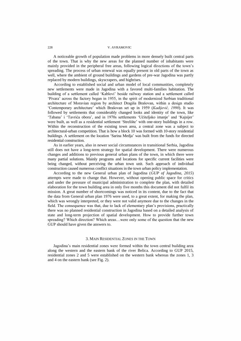
3. MAIN RESIDENTIAL ZONES IN THE TOWN
Jagodina’s main residential zones were formed within the town central building area
along the western and the eastern bank of the river Belica. According to GUP 2015,
residential zones 2 and 5 were established on the western bank whereas the zones 1, 3
and 4 on the eastern bank (see Fig. 2).

Collective Habitation in Urban Planning of Jagodina, Serbia 229
Fig. 2 Main residential zones in Jagodina according to GUP 2015
The zones at the western bank of the Belica – 2 (‘Across Belica’) and 5 (‘Tabane’)
The zones at the eastern bank of the Belica – 1 (Central), 3 (Southern) and 4 (Northern)
Urban zones to the west of the river Belica represent a mainly residential area with the mixed type of residential construction-collective buildings and relatively densely built family buildings. The specificity of these zones’ territory is the importance of non-residential buildings of historical heritage made in the period of intensive town’s expansion in the 19
th century. According to GUP of Jagodina 2015, these zones with the
most dominant residential intention include an urban unit ‘Across Belica’ (zone 2) in the southern part and an urban unit ‘Tabane’ (zone 5) in the northern part. A western entrance to the town from today Milana Mijalkovića Street makes a borderline between these two zones. For these zones, the largest number of projects of planned residential construction has been made. Realization of those projects enabled Jagodina to get an appearance of the modern town. In zone 2, a micro-settlement ‘Kajsijer’ with collective residential buildings ‘L’ and ‘P’ could be considered the most successful urban and architectural achievement (see Fig. 3).

230 V. AVRAMOVIC
Fig. 3 A settlement ‘Kajsijer’
This settlement was built in accordance with the policy of directed construction, as a sequel of building an urban complex which had been started (‘Uĉiteljsko naselje’) in neighboring zone 5. Based on changed urban-technical conditions, an office building, as a connecting part was added to the residential ones, by which the unique unit with the green area inside was accomplished in terms of urban architecture.
A zone 5 ‘Tabane’ was formed at the former rarely built and free land. This zone is leaning against a spontaneously formed group of the northern part of zone 2 and it covers an area of 85 hectares, more than 2/3 of the zone is intended for habitation, mostly habitation in lower buildings. The exceptions are two settlements ‘Uĉiteljsko imanje’ and ‘Strelište’ with up to six-story buildings. The main characteristics of the zone 5 are typical for areas formed as a result of careful planning and realization of residential needs of new inhabitants. In a spatial organization, even construction density, and clearly defined transport network are planned. A special quality of space in this zone is a group of residential buildings in a row, together with multi-story residential buildings characterized by proper regulation and a parcel structure. Because of that, this zone is distinguished as the most arranged in the urban area of Jagodina. The settlement ‘Strelište’ (see Fig. 4) with story residential buildings in a row and the settlement ‘Uĉiteljsko imanje’ with a residential block of ‘D’ buildings are standing out as representative examples of urbanism and architecture, realized within the zone 5.
Fig. 4 A settlement ‘Strelište’

Collective Habitation in Urban Planning of Jagodina, Serbia 231
A settlement ‘Strelište’ within the zone 5 was built in the early 1970s in the far north of
this zone. In only a few years, several capital projects that changed the looks of this part of the
town were realized. The new modern buildings were built, among which, groups of multi
families residential buildings in a row are dominating, which, despite certain monotony,
provide decent housing conditions. All buildings in a row were built according to the standard
project which was implemented in other parts of the town as a model.
Residential zones to the east of the river Belica are larger in total than the zones to the
west of the Belica and they are characterized by considerably more intensive construction
changes. In terms of space, they cover a central part of the town area in which other
significant constructions and communal facilities are as well, built in the period of intensive
town’s spreading. Partial urban reconstruction with a combination of modern multi-story
residential buildings and buildings of historical heritage is the characteristic of these zones.
There is a clear distinction between old and new architecture, which would be even more
drastic if those zones had not been constantly protected from daring, more or less
successful, modernistic projects.
According to GUP of Jagodina 2015, the main residential zones to the east of the river
Belica are 1 (Central), 3 (Southern) and 4 (Northern). The most important factor in this part
of the town construction area is the town’s main street, that is, the old direction of
Carigrad’s road, so-called ‘Duga ĉaršija’ which divides these zones in the area between the
river Belica and the main street and the space between the main street and railways.
In terms of development, the most distinguished unit of these zones is the space
between the river Belica and the main street, with design variety of stylistic trends. It
consists of the central part of representative character (within the zone 1), which
belonged to Main ĉaršija, southern part (within the zone 3), which belonged to Lower
main ĉaršija, with the almost chaotic individual construction and northern part (within the
zone 4), which belonged to Upper main ĉaršija, with a series of almost joint individual
buildings. The oldest buildings originate from 1870, whereas those from the previous
periods were destroyed long ago. By urban reconstruction that has been done until now, a
steadiness of individual buildings, mainly the residential ones, is emphasized. Space for
building new series of residential and mixed blocks has been provided by destroying the
old dilapidated buildings. In new, more contemporary way of building it has been tried to
achieve physical continuity, as well as the impression of fitting new things into the existing
ones. Space does not have some outstanding buildings, except a part of the so-called
administrative complex in zone 1. Since 1955, for needs of Jagodina’s brewery, in a part of
zone 3 in the 29th November Street, one of the first residential workers’ colonies ‘Pivara’
was made. In all urbanistic and architectural suggestions within this part of zone 3, that
were made up to now, attention was paid to the embedding of new buildings and spaces
in the buildings in this settlement.
On the other hand, the space between the main street and railway is characterized by
regular orthogonal raster, with the dominance of two types of residential construction – a
series of individual residential buildings (as significantly common, or the single typology
of residential construction) and residential groups of blocks intended for collective
habitation. Thus in the zone 3 (which is one of rare zones where the large industrial
complex is kept – Jagodina’s brewery), residential rows are spreading in the direction of the
town’s spreading (northwest-southeast), along Kneza Miloša Street (former Mariborska),
whereas the blocks are formed in the surroundings of Jagodina’s brewery. In the
southernmost part of this zone, on the east side of the main street, blocks of residential

232 V. AVRAMOVIC
settlement ‘Sarina Medja’, which represent a positive example regarding the program,
urbanistic and design concept, have been formed.
As representative examples of built spaces within the whole south zone 3, the following
residential settlements and multi families residential buildings are standing out: 1. a settlement
of ground and multi-story buildings in a row in Kneza Miloša Street, 2. a settlement ‘Pivara’,
3.a settlement ‘Sarina Medja’ and 4. a settlement of Solidarity Fund.
Fig. 5 A settlement ‘Sarina Medja’
A suburban settlement ‘Sarina Medja’ (see Fig. 5) has been planned as a residential
beginning of the future larger center in the southeast part of the town. This center along
the road Jagodina-Ćuprija was conceived as one of the hubs of Moravian conurbation.
The building with moderate horizontal and vertical dimensions enable a solid comfort of
collective habitation.
Central residential zone 1 includes the area of the town center of Jagodina with the
narrow surrounding. That is a zone of the total area of about 78 hectares where public
functions representative buildings are located as well as habitation with higher density.
While preparing detailed urban plans and other urban documentations, for each part of
zone, suggestions from the competition material of survey urban competition for central
part of Svetozarevo from 1971 and from the Detailed urban plan of Svetozarevo central
zone from 1974 were being used, elaborators of Yugoslav Institute for Town Planning
and Housing from Belgrade (Federal Bureau of Urban Planning and Communal Housing
MA Svetozarevo and YUGINUS, 1976) as well as from GUP of Svetozarevo 1976.
According to mentioned suggestions, aspirations in GUP of Jagodina 2015 were that
territory of zone 1 would be evenly covered by residential activities and that newly
constructed buildings make functional and a shaped unit with already constructed buildings.
Some of the recommendations were that unplastered red blocks or bricks should be used for
façade, to build sloping roofs and to achieve primary plastics. Physical structures of other
activities - trade, social institutions and institutions for children etc., are planned to be
embedded into residential tissue and designed only as annexes to residential buildings. It is
determined that residential buildings, except those in block 10, may be 6-story high. By
rules of construction and spatial planning, it is planned to avoid closed forms when
grouping buildings, which enables making the greater free areas and quiet zones on the
inside of building groups. As the most significant examples of urbanism and architecture

Collective Habitation in Urban Planning of Jagodina, Serbia 233
realized within zone 1, the following residential objects are standing out: 1. a settlement
‘Kablovi’, 2. residential-business block ‘NA-MA’ and 3. a residential block of ‘B’ buildings.
Fig. 6 A settlement ‘Kablovi’
In the settlement ‘Kablovi’ (see Fig. 6) made by architect Dragiša Brašovan, a
construction concept based on the idea of national building tradition in the spirit of
modernized Serbian folklore architecture of the Moravian region. Within a harmonious
architectural-urbanistic unit that refines a center of the town, folklore architecture has been
interpreted as the architecture ‘national by character’. The settlement has been realized
progressively, and the new collective residential buildings by other authors were
subsequently built within its complex by the same models. Besides a settlement ‘Pivara’
in zone 3, this settlement represents the first achievement of the collective residential
architecture in Jagodina after World War II. (Avramović, 2011).
In the north zone 4 within the Upper main ĉaršija, a spontaneous individual building
of considerable density for this type of construction is dominating. There are no
particularly significant new urbanistic and architectural achievements within the zone.
4. CONCLUSIONS
Jagodina’s urban matrix was being made spontaneously as a heritage result of the
previous time and largely preserved in the town’s contemporary changes. This has been
made possible due to the fact that preserved buildings and settlements from previous
periods were being included in the town contemporary development trends, and the new
buildings and settlements were being built largely in the historical spirit of the town.
Thus, the continuity of Jagodina’s urban development has been mainly achieved until the
end of 20th century with more or less help of urban planning. But, this continuity has
been disrupted by individual construction of collective residential and other buildings in
the first fifteen years of the 21st century due to the fact that individual decisions on
construction locations were being made beyond spatial units context in the valid urban
plans. In this way, a function of urban planning, as a mechanism for management of the
town spatial development, was depreciated and replaced by pragmatic administrative
procedures of local government authority.

234 V. AVRAMOVIC
Jagodina’s residential architecture and urbanism, as of ‘the most towns in Serbia, are
conditioned by socio-economic and political environment, tradition and territory
characteristics, regarding form and function. It is expressed in all aspects of urban
development, particularly in spaces with the largest presence of urban architectural
heritage. Among the mentioned conditions, those of economic-political sphere are the
most actual, which influences result in orchestrated planning and designing, legalization
of illegal construction (directly or by plan changings) etc.
Urban development of collective habitation in Jagodina in the second part of 20th
century had the following three characteristic aspects:
Partial reconstruction and maintenance of buildings from previous epochs. A
construction of multi families residential buildings in the very urban core was
done by embedding new buildings in the existing urban structure. Respecting time
stratification of urban heritage, new buildings were being constructed in accordance
with the new aspects of life. In this way precisely, a future development character of a
central town zone has been determined.
Construction on insufficiently built or free building land, in immediate proximity to
town centre. A more radical urban reconstruction aimed at integrating new blocks of
collective inhabitation with inherited town structure. That was an attempt to integrate
contemporary urban morphology in traditional, inherited town matrix. With the
inevitable conflicts, above all concerning elementary urban matrix, completely new
town spaces were made through the construction of numerous multi families
residential buildings.
Construction of new settlements in peripheral parts of the town. Later, due to
needs for new residential space, builders’ interest was directed towards the town
periphery. Construction of new collective and individual residential buildings –
planned and unplanned construction, represented the largest physical change in
town’s morphology. In that way, the tradition was broken and a creating of town’s
new urban identity began.
Since the beginning of 21st century, a construction in Jagodina has been less based on
urban planning and more on investors’ interest in constructing collective buildings on specific
attractive locations in the town tissue, as well as on the unplanned construction of individual
buildings, which further changes the town identity in a negative way. Because of disrespect of
valid planning documents while making single decisions on residential and other construction,
an urban planning has been excluded as the instrument for spatial development management
and replaced by pragmatic voluntarism of local authorities.
General urban plan of the town from 2015, which has been done for a short time and
without necessary input data, does not give answers to strategic questions concerning
residential construction, neither in terms of program nor in terms of space, which is why
conditions and needs for partial decisions on building, in accordance with daily town
development politics, have been made. For real answers to these questions, it is necessary to
make a new, complex planning document, based on current data of state on locations, but
also a consistent planning elaboration and implementation of this document.
Zones of construction town area dominating in residential intentions cover its central
space. According to GUP 2015, five residential zones have been marked out, in four of which
habitation is dominant, and one (central) zone is of mixed intention with substantial
participation of public services buildings.

Collective Habitation in Urban Planning of Jagodina, Serbia 235
Individual habitation, with old and newer buildings, covers the largest areas of
residential zones. All settlements of collective residential buildings were built after World
War II, mainly in peripheral parts of the town, emphasizing the traditional northwest-
southeast direction of town’s spreading along ‘Duga ĉaršija’. The exception is only the
collective residential construction in town’s mixed central zone with multi stories buildings.
The oldest workers’ settlements ‘Pivara’ and ‘Kablovi’ by architect Dragiša Brašovan
which were built in the middle of 1950s, then the settlements and buildings on the periphery
of zones – ‘Kajsijer’, ‘Strelište’, ‘Sarina medja’ and others represent the most important
architectural-urbanistic achievements of collective habitation. An urban ambient of these
settlements and architecture of their buildings with not so many stories ensure a humane and
healthy environment of multi families habitation.
REFERENCES
1. Avramovic, V. (2011) Residential architecture of Jagodina after World War II. A master thesis,
University of Belgrade, Faculty of Architecture, Belgrade. 2. Dedic, Dragoslav (2005) Urbanistic and demographic development of Jagodina XIV-XX century, Roots
III, magazine for historiography and archives, Historical Archives of Jagodina, Jagodina
3. Kadijevic, A. (1990) Life and Work of the Architect Dragisa Brasovan, 1887-1965. Belgrade City Annual GMGB, XXXVII, pp. 141-173.
4. Karamata, K. (1972) Habitation in General Urbanistic Plan of Belgrade – Apartment and Housing,
magazine ‘Construction’, special edition, Belgrade, pp.52. 5. Macura, V. (1984) “Čaršija” and town center, IRO Gradina, Niš pp.70.
6. Momcilović, P. (2014) Jagodina between reality and dream, Machine, www.masina.rs
7. Vujnovic, R. (1972) On complex residential building – Apartment and Housing, magazine
‘Construction’, special edition, Belgrade, pp. 5.
8. General Urbanistic Plan of Jagodina (2015), ‘Official Gazette of Jagodina town’, 10-1/2015.
9. Federal Bureau of Urban Planning and Communal Housing, MA Svetozarevo and Yugoslav Institute for Town Planning and Housing (1976) Research for purposes of General Urbanistic Plan of Svetozarevo,
Belgrade, pp. 29.
KOLEKTIVNO STANOVANJE U URBANISTIČKOM
PLANIRANJU JAGODINE, SRBIJA
Obimnije kolektivno stanovanje u Jagodini počinje sredinom 50-tih godina prošlog veka
planskom izgradnjom naselja "Pivara" i "Kablovi", arhitekte Dragiše Brašovana. Sa daljim
demografskim i privrednim razvojem Jagodine nastavlja se sa izgradnjom više naselja kolektivnih zgrada
na perifernim delovima grada sve do petnaestih godina XXI veka kada nastaju naselja pretežno mimo
odredbi važećih planskih dokumenata.
Urbani razvoj Jagodine planski je regulisan generalnim urbanističkim planovima iz 1956., 1976. i
2015. godine. Planska dokumenta nisu kompletno sprovoĎena, a legalizacija neplanske stambene i druge
izgradnje predstavljala je povod za izmene postojećih planskih dokumenata. Od 2000. godine stambena i
ostala izgradnja realizuje se po pojedinačnim odlukama lokalne samouprave, a GUP-om iz 2015. godine
nije stvorena kvalitetna osnova za kompleksni tretman urbanog razvoja grada.
Pet stambenih zona po GUP-u iz 2015. zahvataju najveći deo centralnog graĎevinskog područja Po
arhitektonsko-urbanstičkim vrednostima posebno se ističu naselja "Pivara" i "Kablovi", a zatim naselja
"Kajsijar", "Strelište", "Sarina meĎa" i druga.
Kljuĉne reĉi: kolektivno stanovanje, stambene zone, urbani razvoj, urbanističko planiranje, Jagodina