COLISEUM/OAKLAND AIRPORT BART STATION€¦ · COLISEUM/OAKLAND AIRPORT BART STATION ACCESS PLAN...
17
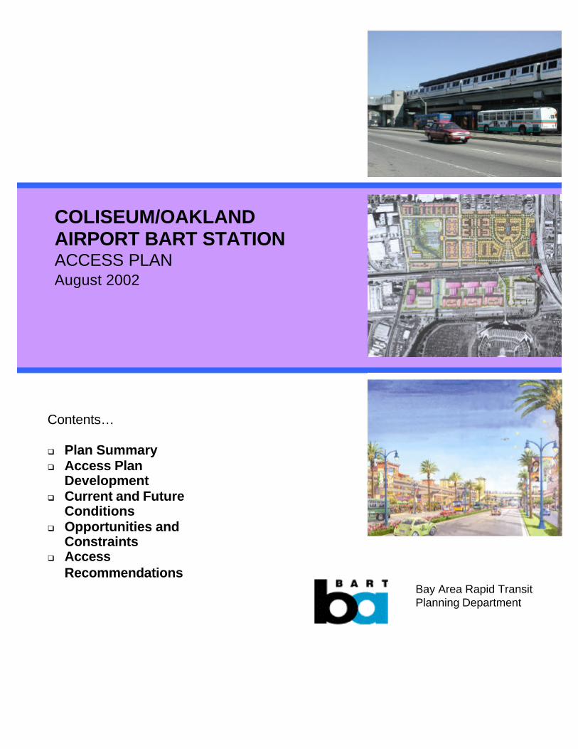
COLISEUM/OAKLAND AIRPORT BART STATION ACCESS PLAN August 2002 Contents… q Plan Summary q Access Plan Development q Current and Future Conditions q Opportunities and Constraints q Access Recommendations Bay Area Rapid Transit Planning Department
Transcript of COLISEUM/OAKLAND AIRPORT BART STATION€¦ · COLISEUM/OAKLAND AIRPORT BART STATION ACCESS PLAN...
COLISEUM/OAKLANDAIRPORT BART STATIONACCESS PLANAugust 2002
Contents…
q Plan Summaryq Access Plan
Developmentq Current and Future
Conditionsq Opportunities and
Constraintsq Access
RecommendationsBay Area Rapid TransitPlanning Department
BART Planning Department 1 August 2002
I. PLAN SUMMARY
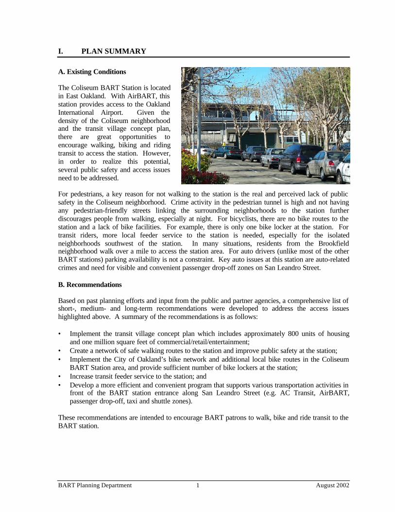
A. Existing Conditions
The Coliseum BART Station is locatedin East Oakland. With AirBART, thisstation provides access to the OaklandInternational Airport. Given thedensity of the Coliseum neighborhoodand the transit village concept plan,there are great opportunities toencourage walking, biking and ridingtransit to access the station. However,in order to realize this potential,several public safety and access issuesneed to be addressed.
For pedestrians, a key reason for not walking to the station is the real and perceived lack of publicsafety in the Coliseum neighborhood. Crime activity in the pedestrian tunnel is high and not havingany pedestrian-friendly streets linking the surrounding neighborhoods to the station furtherdiscourages people from walking, especially at night. For bicyclists, there are no bike routes to thestation and a lack of bike facilities. For example, there is only one bike locker at the station. Fortransit riders, more local feeder service to the station is needed, especially for the isolatedneighborhoods southwest of the station. In many situations, residents from the Brookfieldneighborhood walk over a mile to access the station area. For auto drivers (unlike most of the otherBART stations) parking availability is not a constraint. Key auto issues at this station are auto-relatedcrimes and need for visible and convenient passenger drop-off zones on San Leandro Street.
B. Recommendations
Based on past planning efforts and input from the public and partner agencies, a comprehensive list ofshort-, medium- and long-term recommendations were developed to address the access issueshighlighted above. A summary of the recommendations is as follows:
• Implement the transit village concept plan which includes approximately 800 units of housingand one million square feet of commercial/retail/entertainment;
• Create a network of safe walking routes to the station and improve public safety at the station;• Implement the City of Oakland’s bike network and additional local bike routes in the Coliseum
BART Station area, and provide sufficient number of bike lockers at the station;• Increase transit feeder service to the station; and• Develop a more efficient and convenient program that supports various transportation activities in
front of the BART station entrance along San Leandro Street (e.g. AC Transit, AirBART,passenger drop-off, taxi and shuttle zones).
These recommendations are intended to encourage BART patrons to walk, bike and ride transit to theBART station.
BART Planning Department 2 August 2002
II. ACCESS PLAN DEVELOPMENT
A. Background
The 1999 Bay Area Rapid Transit’s (BART) Strategic Plan called for improvements to station accessby all modes through the promotion of alternatives to driving alone, and linking station access withother key strategic goals. In May 2000, the BART Board adopted the “Access Management andImprovement Policy Framework” which focuses on:
• Enhancing customer satisfaction;• Increasing ridership by enhancing access to the BART system;• Creating access programs in partnership with communities; and• Managing access programs and parking assets in an efficient, productive, environmentally
sensitive and equitable manner.
In accordance with these goals, the BART Board directed staff to prepare three ComprehensiveStation Plans and eleven additional Access Plans for stations throughout the BART system. Theseplans will examine and prioritize station access improvements, which could include physicalenhancements, new programs, or policy changes that would facilitate BART’s goal to achievepatronage targets by mode for each station and to support systemwide targets. These plans may stillneed to evolve and adjust over time due to changing conditions, new policies and programs.
B. Purpose
In response to peak period access constraints primarily at home-origin BART stations, the BARTBoard asked staff to develop Access Plans consistent with BART's Strategic Plan and its accessmanagement policies. The Access Plans are intended to balance automobile and other modes whilefocusing primarily on peak period access constraints. These plans may also address access issuesoutside the formal scope of home-based AM trips and are expected to benefit all trips to and fromBART.
A key goal of the Plans is to ensure that access planning for BART stations will both consider andguide other capital investments, such as those promoting station area development and increasingstation capacity. In this initial stage of preparing Access Plans, however, the primary focus remainsaccess to the station. A Comprehensive Plan would encompass a more complete integration of stationaccess, station area development and internal station capacity.
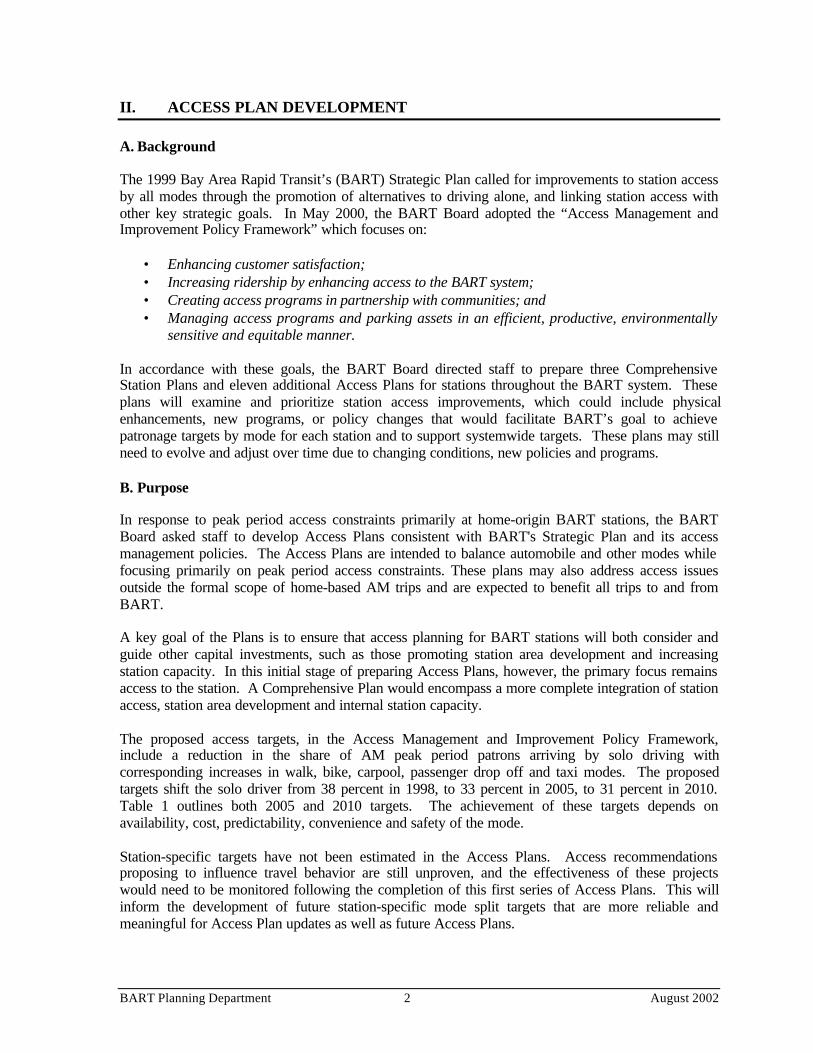
The proposed access targets, in the Access Management and Improvement Policy Framework,include a reduction in the share of AM peak period patrons arriving by solo driving withcorresponding increases in walk, bike, carpool, passenger drop off and taxi modes. The proposedtargets shift the solo driver from 38 percent in 1998, to 33 percent in 2005, to 31 percent in 2010.Table 1 outlines both 2005 and 2010 targets. The achievement of these targets depends onavailability, cost, predictability, convenience and safety of the mode.
Station-specific targets have not been estimated in the Access Plans. Access recommendationsproposing to influence travel behavior are still unproven, and the effectiveness of these projectswould need to be monitored following the completion of this first series of Access Plans. This willinform the development of future station-specific mode split targets that are more reliable andmeaningful for Access Plan updates as well as future Access Plans.
BART Planning Department 3 August 2002
Table 1: Systemwide Mode Share Targets (AM Peak)*
Mode 1998 Mode Share 2005 Targets 2010 TargetsWalk 23.0% 24.0% 24.5%Bike 2.0% 2.5% 3.0%Transit 21.0% 21.5% 22.0%Drop-off, Carpool, Taxi 16.0% 19.0% 19.5%Drive Alone 38.0% 33.0% 31.0%
* Targets do not include new ridership to be generated by the BART-SFO extension.Data Source: Analysis prepared by R. Willson, Ph.D., AICP, Transportation Consultant, 2001
C. Process
The development of the Station Access Plans began with a systematic information gathering effort.Relevant data included: ridership, mode split, on-going access activities and programmed capitalimprovements. The station area scan included land use, demographics, existing plans and pendinglocal improvements projects from local stakeholders.
The next steps involved an assessment of the current access opportunities and constraints at eachstation. The primary internal forum to solicit input occurred through the Station Area WorkingGroup. This interdepartmental staff met on three occasions to discuss draft plans, share information,and provide critical comments.
The access planning process also included outreach with external local partners as well as review oflocal planning and programming documents. For the Coliseum Station Access Plan, the followingdocuments were reviewed and partners consulted through a series of meetings and conversations.
Review of Local and Regional Plans• Oakland General Plan• Coliseum Redevelopment Plan• City of Oakland, Alameda County and Regional Bike Plans• Coliseum/Oakland Airport BART Station Area Concept Plan (to be completed in 2002)• Coliseum BART Station Crime Prevention through Environmental Design (2002)• Oakland International Airport Connector EIS/EIR
Input from BART Departments and Partner Agencies• BART Departments: Marketing and Research, Capital Grants, Customer Access, Operations,
Transit System Development, Real Estate, Maintenance & Engineering, Operating Budgets &Analysis, Police, AFC, Safety and Community Relations
• City of Oakland (CEDA and Redevelopment)• Oakland Housing Authority• AC Transit
Stakeholder Outreach• City of Oakland Bike and Pedestrian Advisory Committee• BART Access Task Force and Bike Task Force• AC Transit Accessibility Advisory Committee• Coliseum Neighborhood Council• Brookfield Homeowners Association
BART Planning Department 4 August 2002
Source: Thomas Bros., Maps
BART
NN
III. CURRENT AND FUTURE CONDITIONS
A. Station Setting
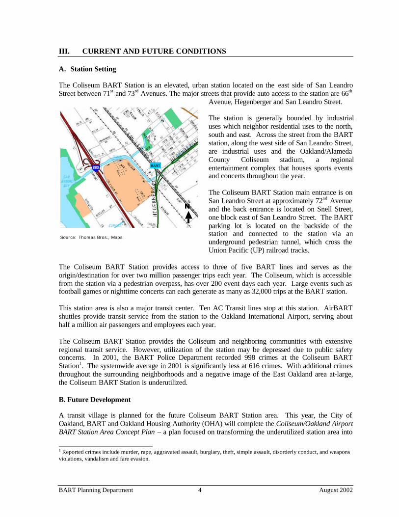
The Coliseum BART Station is an elevated, urban station located on the east side of San LeandroStreet between 71st and 73rd Avenues. The major streets that provide auto access to the station are 66th
Avenue, Hegenberger and San Leandro Street.
The station is generally bounded by industrialuses which neighbor residential uses to the north,south and east. Across the street from the BARTstation, along the west side of San Leandro Street,are industrial uses and the Oakland/AlamedaCounty Coliseum stadium, a regionalentertainment complex that houses sports eventsand concerts throughout the year.
The Coliseum BART Station main entrance is onSan Leandro Street at approximately 72nd Avenueand the back entrance is located on Snell Street,one block east of San Leandro Street. The BARTparking lot is located on the backside of thestation and connected to the station via anunderground pedestrian tunnel, which cross theUnion Pacific (UP) railroad tracks.
The Coliseum BART Station provides access to three of five BART lines and serves as theorigin/destination for over two million passenger trips each year. The Coliseum, which is accessiblefrom the station via a pedestrian overpass, has over 200 event days each year. Large events such asfootball games or nighttime concerts can each generate as many as 32,000 trips at the BART station.
This station area is also a major transit center. Ten AC Transit lines stop at this station. AirBARTshuttles provide transit service from the station to the Oakland International Airport, serving abouthalf a million air passengers and employees each year.
The Coliseum BART Station provides the Coliseum and neighboring communities with extensiveregional transit service. However, utilization of the station may be depressed due to public safetyconcerns. In 2001, the BART Police Department recorded 998 crimes at the Coliseum BARTStation1. The systemwide average in 2001 is significantly less at 616 crimes. With additional crimesthroughout the surrounding neighborhoods and a negative image of the East Oakland area at-large,the Coliseum BART Station is underutilized.
B. Future Development
A transit village is planned for the future Coliseum BART Station area. This year, the City ofOakland, BART and Oakland Housing Authority (OHA) will complete the Coliseum/Oakland AirportBART Station Area Concept Plan – a plan focused on transforming the underutilized station area into
1 Reported crimes include murder, rape, aggravated assault, burglary, theft, simple assault, disorderly conduct, and weaponsviolations, vandalism and fare evasion.
BART Planning Department 5 August 2002
a vibrant mixed-use community.
The key components of the transit village conceptplan are:
• OHA - 396 units of affordable housingand a park located on the east side of SanLeandro Street between 66th and 69th
Avenues, and East Lawn Street;• BART – 300 to 400 residential units and
several thousand square feet of supportingretail uses on the BART parking lot(BART parking will be relocated to thewest side of San Leandro Street); and
• City of Oakland - One million square feetof office/retail/entertainment development located on the west side of San Leandro Streetbetween 66th and 73rd Avenues, and Damon Slough.
Other major investments in the area that will help the development of a transit-oriented district,increase transit ridership and support the City’s and BART’s joint development policies include thefollowing:
• The $232M BART Oakland Airport Connector (OAC) project is scheduled for operations in2008. This project will provide a people mover between the Coliseum BART Station and theOakland International Airport (OIA). The guideway will primarily be elevated on adedicated right-of-way along Hegenberger Road and the two end terminals will be physicallyintegrated with the Coliseum BART Station and the OIA. This project will provide reliabletransit service, increase capacity along the Hegenberger Road corridor and support the futureexpansion of the OIA. It will also provide two intermediate stations at Edgewater Road andDoolittle Drive, supporting the City’s efforts to revitalize the Hegenberger Road corridor andimproving local access to BART.
• A new Capitol Corridor station, a $4.5M intercity rail project, will be constructed across thestreet from the BART station on the west side of San Leandro Street in 2004. This stationwill provide access to Sacramento and San Jose. There will be two pedestrian accessimprovements associated with this project: a signalized at-grade crossing on San LeandroStreet in front of the BART station entrance; and a pedestrian ramp linking to the existingpedestrian overpass across San Leandro Street, which lands at the BART station.
C. Community and Rider Demographics
Ridership
In Fiscal Year (FY) 2002, the average weekday daily exits at the Coliseum BART Station was 6,671,a 39 percent increase from FY 1997. However, the FY 2002 ridership is three percent less than lastyear’s ridership which reflects the impact of the recent economic downturn. By 2010, based onpopulation and employment projections provided by the Association of Bay Area Governments(ABAG), the Coliseum BART Station ridership is projected to increase by 18 percent.2 The ridershipprojection does not include the proposed BART extension to Milpitas, San Jose and Santa Clara,
2 Ridership that may be generated by future developments outlined in the previous section is not included in the projection.
BART Planning Department 6 August 2002
Table 2: Home Origin Access Mode Split
Mode Coliseum Fruitvale MacArthurWalk 7% 13% 27%Bike 2% 4% 4%Transit 38% 28% 20%Auto 52% 53% 49%
Data Source: 1998 Customer Profile Survey, BART (AM and PM Trips)
which will increase ridership and access needs when it opens around 2012.
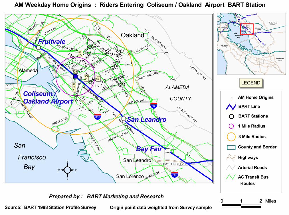
The majority of the passengers that use this station live in East Oakland. Others live in the Oaklandhills beyond I-580 or in the City of Alameda. See “AM Weekday Home Origins” Map on thefollowing page. The home origin trip purpose is similar to that of the Fruitvale and MacArthurBART stations - three-quarters of the trips are work trips, most of which are destined for downtownOakland and San Francisco.
Demographics
The following is a brief summary of the Coliseum BART passenger demographic information3.• 68 percent of the riders are Female , 11 percent higher than the systemwide average.• 50 percent of the riders are 25 to 44 years old . The second largest group is 45 to 64 at about
30 percent.• 78 percent of the riders are Black.• 42 percent of the riders’ household income is in the $30K or Less range. This is two times
higher than the systemwide share of 21 percent. The second largest group is $30K to $60K at36 percent.
• 12 percent of the riders identified themselves as having a disability.4 This rate is comparableto that of the Fruitvale and MacArthur stations.
D. Mode Split
The access mode split shows that approximately one-half of the passengers arrive at the station byauto. See Table 2. Mode split data is based on both AM and PM home-based trips to the station.
Relative to the Fruitvale and MacArthur BART Stations, the Coliseum BART Station Walk and Bikemode splits are low and Transit is significantly higher. The systemwide average distance that peoplewalk from home to a BART station is 0.43 miles and 2.59 miles when riding transit. Key factorsinfluencing the Coliseum BART station mode split are: lower residential density around the station(approximately one-half of that of Fruitvale and MacArthur); high level of auto related crimes at theBART station and in East Oakland; and a high percentage of BART riders that do not have access to acar (46 percent).
3 1998 Customer Profile Survey, BART (Home-based trips, AM and PM)4 Passengers identified themselves as being disabled if they are blind or have low vision, deaf or are hearing impaired, havemobility problems (e.g. wheelchair user), or have a mental or cognitive impairment.
xz
xz
xz
xz
#########
##
## ## ## ###
# ## #
### ### ## ####
### ### # ###
### # ## # ### ### # ### ###
##########
###
##### ### ##
###
###########
##
###
# #### ###
#
# ## ## #####
## #
### #
# # ## ###
### ###
#### ###
#
########
##
#
# ## # ##### ### #
### ######
# ###
##
### # ### #
##
## ##
## ### # ## #
### # ##
### # ###
#
## # ##### # ###
# ## ## ###
# ## #
#
# ## ####
## ## #
#### # ## # ##
##
#######
#####
#### ## # ## ###
#
#### ##
## ####
#### #
# ### ## #
#
# ## # #### # ## #
#
# ####### #
#
#### ## # ## ##
##
##
# ######
# ###
###
# # ### # ####
### # ####
# # ###
#####
# # ######
# ########### #
## ### ###
### ##
# #######
#### #
## ####
###
## ##
# ## ## ### ## ## #
## # ## # ##
# ###
## # ##
#### # #
## ## ### #
## ## #
#
### ##### ###
#
## # ###
### # ##
#### ###### #
# #
##
#######
###
#
## ## ## # ## ## ##
# ## ## # ### ## ##
## ## ##### ## #
#
## ## ## ## ## ##
##
# ## # ## #
##
# #######
####
#
# ####
######
# #
### # ####
# # ###
## # ## ### # #
#
# #### ### ###
# #
###
# ##### ##
#
# # #######
## #
###
######
##
####
# ### ### ##
# ##### ## #####
### ####### ###
###
#
###
####
## #####
### ##
####
####
####
### # ## # ## # ###
##
#####
# ## ###
##
### ### #
###
#
## ######### #
###
########
##
##
### ##
# #####
##### # ##
###
# ## ##
##### #
# #
# ### #
#
## ###
#
## ######
###
###
##
# ##### #
##
#
##
### ### # #
##
### ##### ##
#
# ##### ####
# #
### ### ###
###
### ##### ##
#
#
# # ######## ##
###
## ### #####
#
###########
#
# ### ##### ### #
## #####
# ### # #
#### ## # ## ##
#####
## ## ##
###
#
### # ###
#
## ## ## #
# ## ##
## #
## # # ###
# ##
##### ### ###
##
#
# ######### #
#
## ### ### ### ##
#### ##
## ## #
##
###
## ## ##
###
## ##
####### #
#
#### ###
## ## ##
# ##### ##
## ##
########
####
#
# ## # ## # ## # ## #
#
### #### ###
#
####
#######
##########
# ##
#
# ## ## # ##### #
# # ####### # #
##
## #######
##
##### ###
# ## #
## # ### # ### # ##
### ## ### ## #
##
##########
##
### #####
# ###
#### ###
## ####
### #####
# ##
#
## #####
# #####
## ### ### ### ##
## ### ## ##
# ##
## ## #####
## ##
## #
# ###
## #
# ##
### ######### ## ### ###### ### ## ###
## ## ####
# ## ##
########## # #
### ### ###
# ##
#
##
# ## ### ## ###
# #### ## ##
## # ## ### ### ##
# ##
# ### ## # ## ##
# #
# ########
### #
### ## ### ## #
##
## ## ## ## ## #
#
##
# # ####
# # #
##
######
# ######
#
#########
#
##
#### ### ## #
##
## # ### ## ### ## ## # ## ## ### ## ### # ##
###### ##
####
##
########
###
xz
"!13
.-,880
.-,580
Oakland
Alameda
San Leandro
San Lorenzo
ALAMEDA
COUNTY
BayFrancisco
Bay Fair
Fruitvale
San Leandro
Coliseum / Oakland Airport
San
.-,880
REDWOOD RD
HIGH ST
BANCROFT AVE
98TH AVE
SKYLINE BLVD
MACARTHUR BLVD
LAKE CHABOT RD
35TH AVEFR
UITV
ALE
AVE
MARINA BLVD
KELLER AVE
GRANT AVE
73RD AVE
GOLF LINKS RD
ISLAN
D DR
23RD AVE
DUTTON AVE
SAN LEANDRO ST
SAN LEANDRO BLVD
HEGE
NBER
GER
RD
COLISEUM WAY
MAITLAND DR
LEWELLING BLVD
DOOLITTLE DR
66TH AVE
FOOTHILL BLVD
AIRPORT DR
35646
34556
56NG
4958A
58
AM Weekday Home Origins : Riders Entering Coliseum / Oakland Airport BART Station
S
N
EW
County and Border
BART Line
xz
Prepared by : BART Marketing and Research
Highways
LEGEND
Source: BART 1998 Station Profile Survey
Arterial Roads
Origin point data weighted from Survey sample
AC Transit Bus Routes
0 1 2 Miles
xz
xz
xz
xzxz
xz
xz
xzxz
xzxzxz
xz
xz
xzxz
xzxz
xzxzxz
xz
xz
xz
xz
xzxz
xzxz
xz
xz xz xz
## ###### # # #
#### ## #
### ## #
### ### ## ####
### ## # #### ### # ### ### #
## # ### ###
#### ########
#
## ### ###### #
##### ### #####
######### ####
#### #### #
###
# ## ## ##### ## #
### #
# ### ###
### ####### ##
#
######
#####
#
# ### ### ## ### #
### ######
# ###
## ## ## #
## ### #
### ## # ### #
##
## ## ##### # ##
#
# ## # ###
# # # ## #
### # ###### ###
# ## ## #### ## ##
# ## ###### ## #
## ## # ## # ##
##
##########
##
#### ### ## ####
#### ###
# # # ##
#### #
# ### ####
# ## # #### # ## #
###### ####
#
####
## # ## ### #
### #
# ## #####
#
# ### # #### ###
#
### # ### ## ####
## #### # ####
##
# ######## ### #
# ### ## ## ### #
## ######### #
#
# #######
#### #
## ## ##
### ## ##
### ## ### ## ###
## # ## #
### ###
## # ##
#### # ### #
# ### ### ###
#### ### #### ##
### ###### ###
#### ###### #
# #
##
######### ##
## ## ### ## ## ##
# ## ## # ### ## ##
## ####### ## ##
#### #
# #### ##
# ## #
# # ## ##
#
# ###########
#
# ####
####### #
### # ####
# # ###
## # ## ### #
##
## ###### ## #
# #
###
# ##### ###
# # ### ###### #
###
### ## ##
#
# # ### ###
# ## ##
# ##### ## ### ##
### ## ##### ###
# #########
#
## #####
# ## ##
# #######
# ###
#### ##
# ## ##
### ### ### #
###
# #####
## ## ###
## ### ### # ## ##
## ######### #
##### #####
# ##
##### ##
# ### ##
##### # #####
# ## ##
### ## ## #
# ### #### #
## #
## ## #
###### ## ##
## # #### ####
# ##
## ### # ##
#
### ##### ###
# ##### ###
## #
###### ### ##
#
### ##### #
# #
## #
#### #### ##
### #### # ## ##
##### ### #
## ##
###
### #######
# ### ##### ##
# #
## ####
## ### # #
#### ## ##
# ####
##### #
## ####
#### ## ##
#
## ## ## ## ####
## ### ## # ### ##
############
#
## ###
###### ##
## ###### #
## ##
#### ###
# ## ###
###
## ## ## ###
## ### ### ### #
#
# # ## ##### ## #
#
#### ## #### ##
########
#####
# ## # ## # ## # ## #
#### #### ###
#
#######
####
## ##### ###
# ##
## ## ### ### ## #
# # ####### # #
##
## ##### ####
## ### ### ###
##
# #### ##
## ## #
## # ## # ## ## # ##
### ##### ##
###
### ## #
# ## ###
### ###### ##
#
#### ##
### ####
# ## ### ### ##
#
## #####
# ### ##
## ### ### #
## ##
## ### ## ### #
#
## ###### #
## ##
## ##
##### ## ##
####### ### ## ## ### ###### ########
## ## ##### ## ##
# ## ### #### # #
##### # ###
# ## #
### ## ### ## ###
# ## #### #### # #
# ### ### ### #
#
# ### ### ## ### #
## #######
# ##
# ### ###
## ### #
### ## ###
## ###
#### #### ## ###
## ## ##
## ## ##
### # #
##### ###
###### #####
##
##
###### ####
##### ## # ##
## #
## # ### ## ####### # ## ## ##
# ## ### # ##
####
## #####
#
# ####### ##
###xz
"!8 4
"!1
San Francisco Bay
San Francisco Alameda County
San Mateo County
.-,80
.-,88 0
.-,28 0
.-,58 0
Coliseum/Oakland Airport
Santa Clara County
Contra Costa County
3 Mile Radius
AM Home Origins#
BART Stations
1 Mile Radius
BART Planning Department 8 August 2002
IV. OPPORTUNITIES AND CONTRAINTS
Given the future transit village and redevelopment plans which will address the underutilized and/orincompatible land uses in the station area, there are great opportunities to improve public safety andencourage walking, biking and riding transit. However, in order to realize this potential, thefollowing access issues need to be addressed.
A. Walk
For pedestrians, there is a lack of pedestrian-friendly streets that provide safe access to the station,especially at night. For example, along San Leandro Street (the main street leading to the stationfrom the north and south), there is no continuous sidewalk or convenient crosswalks.
Additionally, because of the Union Pacific (UP) rail tracks, people who live in the neighborhoods eastof the station and/or use the parking lot need to use an isolated underground tunnel to access thestation. To improve safety conditions in the tunnel, BART recently installed surveillance camerasand a wheelchair lift, and painted the tunnel to enhance the lighting. However, BART riders still feelunsafe when using the tunnel and continue to express their preference for an at-grade crossing acrossthe UP tracks to access the station.
These findings and many other public safety issues were identified through a public planning exercisecalled Crime Prevention Through Environmental Design (CPTED) recently completed by BART.CPTED basically calls for design solutions to improve public safety. The CPTED findings andrecommendations have been incorporated into this access plan.
B. Bike
Given the topography and moderate density of the neighborhoods surrounding the station, there isgreat potential for increasing the bike mode share. The City of Oakland, Alameda County and MTChave adopted bike plans that identify San Leandro Street, 66th Avenue and Hegenberger as key bikeroutes providing access to the Coliseum BART Station. However, they are not yet in place.Providing bike facilities along the proposed key routes as well as local routes (including 69th Avenue,75th Avenue, Snell Street, 85th Avenue, and Edes Avenue) would encourage residents to bike to thestation. Bike facilities on 85th and Edes would especially benefit the Brookfield neighborhood, whichis located in an isolated area southwest of the Coliseum BART station and has limited access totransit services.
There is also a shortage of bike lockers at the station. Today there is one bike locker which providestwo bike parking spaces. There are five persons on an official wait list that have requested a bikelocker.
C. Transit
Currently, there are ten AC Transit routes that serve the Coliseum BART Station. See Table 3. The58 is a Trunk route, the 46, 56, and 57C are Crosstown routes, and the 45 and 98 areCrosstown/Feeder routes. The service areas of these routes are extensive. They generally includeFoothill Square, Seminary Avenue and the Dimond District, to the east beyond I-580, Oakland andEmeryville to the north, Brookfield and City of Alameda to the west and 105th Avenue and Sobranteto the south.

BART Planning Department 9 August 2002
Table 3: AC Transit Routes with Coliseum BART Stops
Route Bus Line Peak frequency Off-Peakfrequency
OperationWD (Weekday)WE (Weekend)
45 Coliseum BART – FoothillSquare
15 min 30 – 60 min WD: (5:30AM – 11:00PM)WE: (7:15AM – 8:00PM)
46 Coliseum BART – DiamondDistrict
15 - 30 min 30 min WD: (5:30AM – 7:00PM)
4949M/X
Fruitvale BART – ColiseumBART
15 min 30 min WD: (6:00AM – 7:00PM)
56 Seminary Avenue – 90th
Avenue15 min 30 – 50 min WD: (5:00AM – 8:00PM)
WE: (5:30AM – 7:30PM)57C Emeryville Amtrak – Coliseum
BART15 min - WD: (5:00AM – 7:30AM &
6:00PM – 8:00PM)58 Downtown Oakland –
MacArthur Blvd. Express10 - 15 min 17 - 60 min WD: 24 Hours
WE: 24 Hours98 Coliseum BART – 98 th Avenue 15 min 20 – 30 min WD: (5:45AM – 8:30PM)345 Eastmont Mall – Foothill
Square Owl- 60 min WD: (Midnight – 5AM)
WE: (Midnight – 5AM)
Data Source: 2002 DRAFT AC Transit Service Deployment Plan
In the future, a new Transit Center with bus stops and shelters supporting existing services will beprovided along San Leandro Street and a Bus Rapid Transit service has been proposed along theInternational Boulevard corridor. Service changes planned for the future (subject to public outreach,necessary approvals and funding availability) include additional day, evening, and weekend servicesas follows:
• Route 46 will provide additional evening service from 7:00PM to 8:00PM with 30 minuteheadways.
• Routes 49 and 98 will provide additional weekend service from 7:00AM to 7:00PM with 30minute headways.
• The Eastmont Transit Center to the Oakland Airport segment of Route 58 will become aseparate route. This route will operate 7 days a week with daytime headways of 20 minutes,30 minutes at night and 60 minutes during the owl period.
Though additional services are planned, they are not focused on increasing local feeder service to theColiseum BART Station, which is especially needed to serve the isolated neighborhoods locatedsouthwest of the station. Feeder service provided by 15/25 seater shuttles may be appropriate incomplementing AC Transit’s service.
D. Auto
In June 2002, the BART Board voted to allocate up to 25 percent of the parking spaces at BART
BART Planning Department 10 August 2002
Table 4: Parking Spaces
Type of Parking Space SpacesSurface Spaces 932Accessible/Handicapped 21Curb/Street 96Official BART 3Motorcycles 24
Source: BART Access Database
stations to fee-based monthly reserve parking. This plan, scheduled to take affect December 2002,will allow BART customers the option of reserving a parking space until 10AM for a monthly fee.
Today, unlike most other BART stations, parking at the Coliseum BART Station is not a key accessconstraint. There are approximately 1,030 free BART parking spaces that can be used by BARTpatrons. Recent windshield surveys show that 20 percent to 30 percent of the spaces are not used.The vacancy is due to the recent decline ofBART ridership and people’s reluctance to parkat a station with a high crime rate, a finding fromthe CPTED planning effort.
The most significant auto access issue at thisstation is inadequate drop-off zones along SanLeandro Street. Currently there is a drop-offzone north of the station entrance on the eastside of San Leandro Street. However, thelocation is not visible to BART riders andsignage is poor. As a result, BART riders oftenuse the AC Transit bus zones and are ticketed.This problem discourages drop-off activities and worse, discourages people from using the ColiseumBART Station and the BART system.
V. ACCESS RECOMMENDATIONS
As a way of addressing the access issues outlined above, the recommendations in this access planfocus on the following:
• Implement the transit village concept plan which includes approximately 800 units of housingand one million square feet of commercial/retail/entertainment;
• Create a network of safe walking routes to the station and improve public safety at the station;• Implement the City of Oakland’s bike network and additional local bike routes in the Coliseum
BART Station area, and provide sufficient number of bike lockers at the station;• Increase transit feeder service to the station; and• Develop a more efficient and convenient program that supports various transportation activities in
front of the BART station entrance along San Leandro Street (e.g. AC Transit, AirBART,passenger drop-off, taxi and shuttle zones).
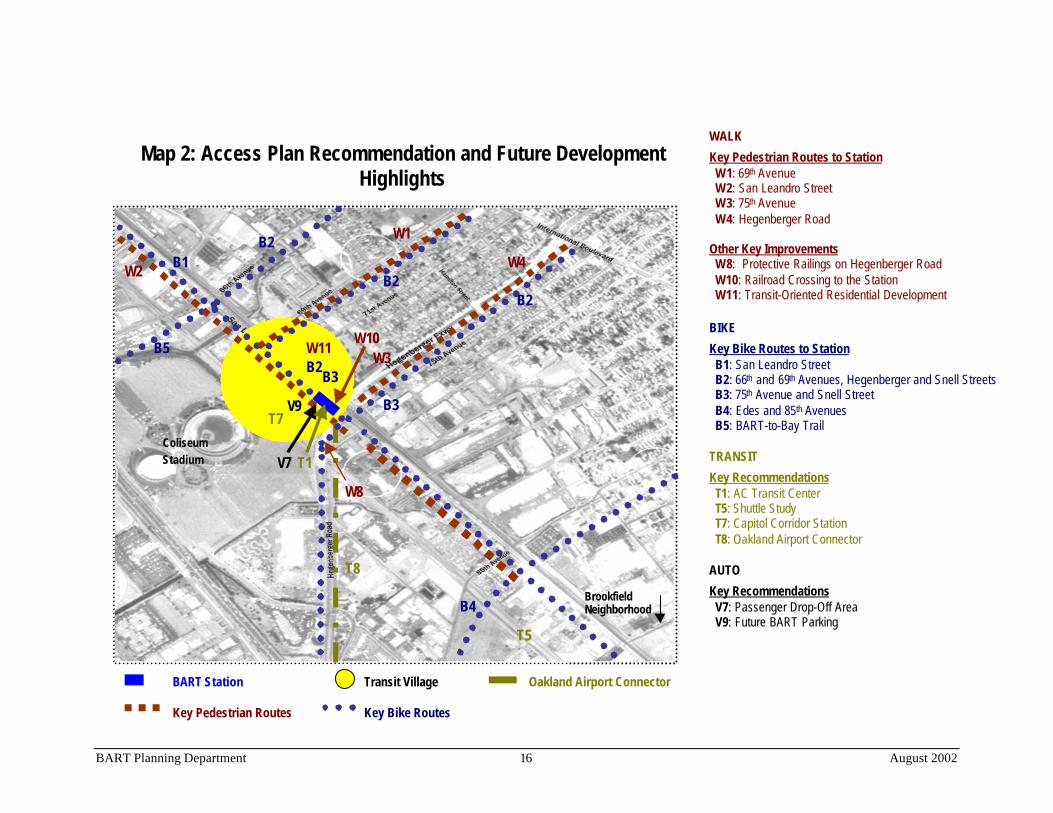
Table 5 and Map 2 detail the full list of access recommendations. Each recommendation addressesimplementation and funding. However, the recommendations have not been prioritized based on anyset criteria. The effectiveness of the access recommendations will be monitored and in turn willinform future prioritization.
All access improvements must be designed to meet or exceed BART standards and accommodatepeople with disabilities.

BART Planning Department 11 August 2002
Table 5: Access Improvement Recommendations
Mode Recommendation Map Reference Number and Description S/M/LTerm*
Lead Funding Tier and Source**
WALKW1: 69th Avenue (from San Leandro to International) - Provide pedestrianfacilities, continuous clear walking pathways, curbcuts, safe street crossings,streetscape improvements and wayfinding signs.
S, L City of Oakland Tier 2: OHA, Safe Routes toSchool
W2: San Leandro Street (from Seminary to 85th Avenues) - Same as W1plus surveillance cameras, upgraded rail crossings at cross streets, andcountdown and audible signals at 69th and station entrance.
S, M, L City of Oakland PARTIALLY FUNDED(Capital $1.1M)Tier 1: MTC, AC Transit, Cityof Oakland
W3: 75th Avenue (from San Leandro to Hamilton) - Same as W1. M City of Oakland Tier 3: TBD
Access toStation
W4: Hegenberger (from Hawley to International) - Provide continuoussidewalks, streetscape improvements and wayfinding signs.
M City of Oakland Tier 3: TBD
W5: Security Cameras – Maintain recently installed security cameras andsystem.
S, M, L BART FUNDED (O/M $)Tier 1: BART
W6: Lighting - Upgrade the lighting within the parking lot to provide aminimum maintained level of .75 foot-candles, 5 to 6 feet above the lotsurface. Extend the lighting along the “No Name” and Snell Streets from theBART parking lot entrance road which parallel Hegenberger to 75th Avenue.
S BART Tier 2: BART, City of Oakland
W7: Street Crossing – Provide safe pedestrian crossings on Snell Street bythe station entrance from the parking lot.
M City of Oakland,BART
Tier 2: BART
W8: Protective Railing – Install protective railings along the Hegenbergerramps.
M Caltrans Tier 3: TBD
W9: Traffic Safety - Study and implement appropriate traffic safety andcalming measures on 66th Avenue from San Leandro to International.
M City of Oakland Tier 3: Safe Routes to School
PedestrianSafetyImprovements
W10: Railroad Crossing – Pursue a new rail crossing from Snell Street tothe BART station.
S, M City of Oakland,BART
Tier 3: TBD

BART Planning Department 12 August 2002
W11: Residential Development - Provide high density residential near thestation.
L OHA, BART,City of Oakland,Developer
PARTIALLY FUNDED(Capital $34M)Tier 3: Developer, OHA, Cityof Oakland
Transit-OrientedDevelopmentGuidelines
W12: New Street - Create a new street (72nd Avenue) on the west side ofSan Leandro Street to provide a more direct pedestrian link between the newCapitol Corridor station and the BART station entrance.
L City of Oakland,Developer
Tier 2: Developer, City ofOakland
BIKEB1: San Leandro Street -• Provide a bike routes and/or paths (consider purchasing the UP right of
way) and wayfinding signs.• Provide traffic light bike sensitive loops at San Leandro and 75th Ave.• If new traffic signals are installed, consider providing bike loop detectors
when appropriate.
M, L City of Oakland Tier 3: TBD
B2: 66th Avenue, 69th Avenue, Hegenberger and Snell Street (from theColiseum Neighborhood and beyond to the station back entrance) -• Provide bike lanes or routes and wayfinding signs.• Upgrade rail crossings and street pavement conditions.• Include 69th Avenue and Snell Street in the City’s Bike Plan.
L City of Oakland,Caltrans
Tier 3: TBD
B3: 75th Avenue, and Snell Street (from the Elmhurst neighborhood to thestation back entrance) -• Provide bike lanes or routes and wayfinding signs.• Include 75th Avenue and Snell Street in the City’s Bike Plan.
L City of Oakland,BART
Tier 3: TBD
Access toStation
B4: Edes Avenue and 85 th Avenue (from the Brookfield neighborhood andbeyond to San Leandro Street) -• Provide bike lanes or routes and wayfinding signs.• Upgrade rail crossings and street pavement conditions.• Include Edes Avenue and 85th Avenue in the City’s Bike Plan.
L City of Oakland Tier 3: TBD
BART Planning Department 13 August 2002
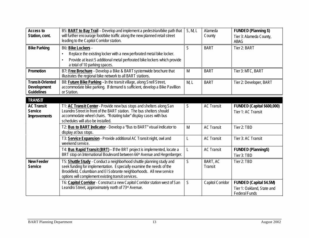
Access toStation, cont.
B5: BART to Bay Trail – Develop and implement a pedestrian/bike path thatwill further encourage foot/bike traffic along the new planned retail streetleading to the Capitol Corridor station.
S, M, L AlamedaCounty
FUNDED (Planning $)Tier 3: Alameda County,ABAG
Bike Parking B6: Bike Lockers -• Replace the existing locker with a new perforated metal bike locker.• Provide at least 5 additional metal perforated bike lockers which provide
a total of 10 parking spaces.
S BART Tier 2: BART
Promotion B7: Free Brochure - Develop a Bike & BART systemwide brochure thatillustrates the regional bike network to all BART stations.
M BART Tier 3: MTC, BART
Transit-OrientedDevelopmentGuidelines
B8: Future Bike Parking - In the transit village, along Snell Street,accommodate bike parking. If demand is sufficient, develop a Bike Pavillionor Station.
M, L BART Tier 2: Developer, BART
TRANSITT1: AC Transit Center - Provide new bus stops and shelters along SanLeandro Street in front of the BART station. The bus shelters shouldaccommodate wheel chairs. “Rotating tube” display cases with busschedules will also be installed.
S AC Transit FUNDED (Capital $600,000)Tier 1: AC Transit
T2: Bus to BART Indicator - Develop a “Bus to BART” visual indicator todisplay at bus stops.
M AC Transit Tier 2: TBD
T3: Service Expansion - Provide additional AC Transit night, owl andweekend service.
L AC Transit Tier 3: AC Transit
AC TransitServiceImprovements
T4: Bus Rapid Transit (BRT) – If the BRT project is implemented, locate aBRT stop on International Boulevard between 66th Avenue and Hegenberger.
L AC Transit FUNDED (Planning$)Tier 3: TBD
T5: Shuttle Study - Conduct a neighborhood shuttle planning study andseek funding for implementation. Especially examine the needs of theBrookfield, Columbian and El Sobrante neighborhoods. All new serviceoptions will complement existing transit services.
S BART, ACTransit
Tier 2: TBDNew FeederService
T6: Capitol Corridor - Construct a new Capitol Corridor station west of SanLeandro Street, approximately north of 73rd Avenue.
S Capitol Corridor FUNDED (Capital $4.5M)Tier 1: Oakland, State andFederal Funds
BART Planning Department 14 August 2002
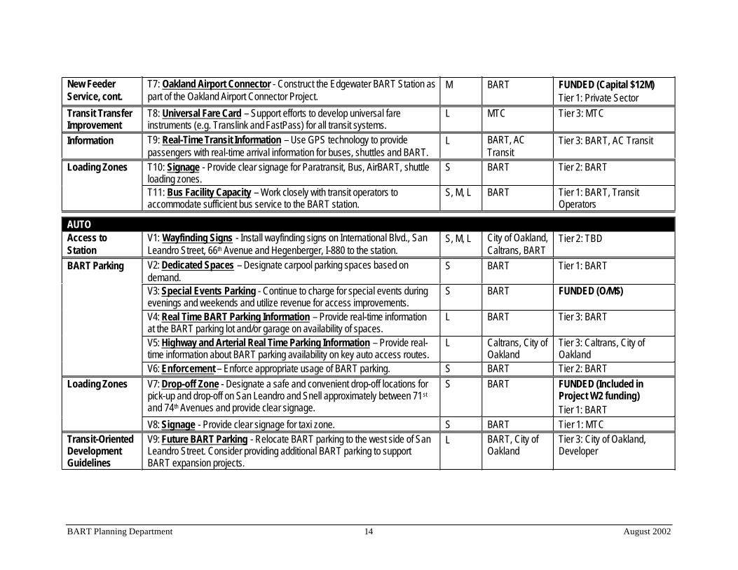
New FeederService, cont.
T7: Oakland Airport Connector - Construct the Edgewater BART Station aspart of the Oakland Airport Connector Project.
M BART FUNDED (Capital $12M)Tier 1: Private Sector
Transit TransferImprovement
T8: Universal Fare Card – Support efforts to develop universal fareinstruments (e.g. Translink and FastPass) for all transit systems.
L MTC Tier 3: MTC
Information T9: Real-Time Transit Information – Use GPS technology to providepassengers with real-time arrival information for buses, shuttles and BART.
L BART, ACTransit
Tier 3: BART, AC Transit
T10: Signage - Provide clear signage for Paratransit, Bus, AirBART, shuttleloading zones.
S BART Tier 2: BARTLoading Zones
T11: Bus Facility Capacity – Work closely with transit operators toaccommodate sufficient bus service to the BART station.
S, M, L BART Tier 1: BART, TransitOperators
AUTOAccess toStation
V1: Wayfinding Signs - Install wayfinding signs on International Blvd., SanLeandro Street, 66th Avenue and Hegenberger, I-880 to the station.
S, M, L City of Oakland,Caltrans, BART
Tier 2: TBD
V2: Dedicated Spaces – Designate carpool parking spaces based ondemand.
S BART Tier 1: BART
V3: Special Events Parking - Continue to charge for special events duringevenings and weekends and utilize revenue for access improvements.
S BART FUNDED (O/M$)
V4: Real Time BART Parking Information – Provide real-time informationat the BART parking lot and/or garage on availability of spaces.
L BART Tier 3: BART
V5: Highway and Arterial Real Time Parking Information – Provide real-time information about BART parking availability on key auto access routes.
L Caltrans, City ofOakland
Tier 3: Caltrans, City ofOakland
BART Parking
V6: Enforcement – Enforce appropriate usage of BART parking. S BART Tier 2: BARTV7: Drop-off Zone - Designate a safe and convenient drop-off locations forpick-up and drop-off on San Leandro and Snell approximately between 71st
and 74th Avenues and provide clear signage.
S BART FUNDED (Included inProject W2 funding)Tier 1: BART
Loading Zones
V8: Signage - Provide clear signage for taxi zone. S BART Tier 1: MTCTransit-OrientedDevelopmentGuidelines
V9: Future BART Parking - Relocate BART parking to the west side of SanLeandro Street. Consider providing additional BART parking to supportBART expansion projects.
L BART, City ofOakland
Tier 3: City of Oakland,Developer
BART Planning Department 15 August 2002
Transit-OrientedDevelopmentGuidelines, cont.
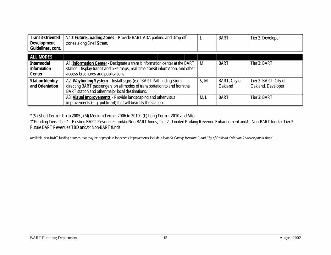
V10: Future Loading Zones - Provide BART ADA parking and Drop-offzones along Snell Street.
L BART Tier 2: Developer
ALL MODESIntermodalInformationCenter
A1: Information Center - Designate a transit information center at the BARTstation. Display transit and bike maps, real-time transit information, and otheraccess brochures and publications.
M BART Tier 3: BART
A2: Wayfinding System – Install signs (e.g. BART Pathfinding Sign)directing BART passengers on all modes of transportation to and from theBART station and other major local destinations.
S, M BART, City ofOakland
Tier 2: BART, City ofOakland, Developer
Station Identityand Orientation
A3: Visual Improvements - Provide landscaping and other visualimprovements (e.g. public art) that will beautify the station.
M, L BART Tier 3: BART
* (S) Short Term = Up to 2005 , (M) Medium Term = 2006 to 2010 , (L) Long Term = 2010 and After** Funding Tiers: Tier 1 - Existing BART Resources and/or Non-BART funds; Tier 2 - Limited Parking Revenue Enhancement and/or Non-BART funds); Tier 3 -Future BART Revenues TBD and/or Non-BART funds
Available Non-BART funding sources that may be appropriate for access improvements include Alameda County Measure B and City of Oakland Coliseum Redevelopment Bond
BART Planning Department 16 August 2002
WALKKey Pedestrian Routes to Station W1: 69th Avenue W2: San Leandro Street W3: 75th Avenue W4: Hegenberger Road
Other Key Improvements W8: Protective Railings on Hegenberger Road W10: Railroad Crossing to the Station W11: Transit-Oriented Residential Development
BIKEKey Bike Routes to Station B1: San Leandro Street B2: 66th and 69th Avenues, Hegenberger and Snell Streets B3: 75th Avenue and Snell Street B4: Edes and 85th Avenues B5: BART-to-Bay Trail
TRANSITKey Recommendations T1: AC Transit Center T5: Shuttle Study T7: Capitol Corridor Station T8: Oakland Airport Connector
AUTOKey Recommendations V7: Passenger Drop-Off Area V9: Future BART Parking
Map 2: Access Plan Recommendation and Future DevelopmentHighlights
B3
V9
V7
W1
V5
W3
W4W2 B1
B3
B2
B2
B2
B2
T5
BART Station Transit Village Oakland Airport Connector
Key Pedestrian Routes Key Bike Routes
B4
T7
T1
T8
B5 W10
W8
W11
ColiseumStadium
BrookfieldNeighborhood