Cockermouth Flood Investigation Report
50
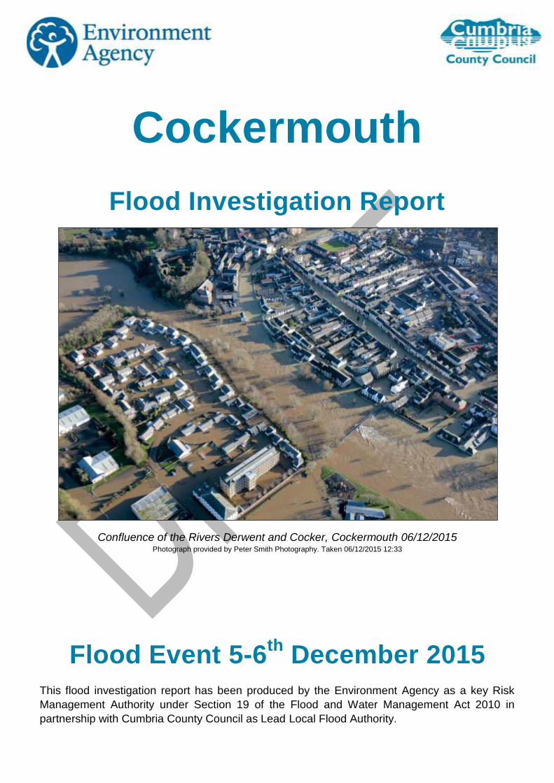
Cockermouth Flood Investigation Report Confluence of the Rivers Derwent and Cocker, Cockermouth 06/12/2015 Photograph provided by Peter Smith Photography. Taken 06/12/2015 12:33 Flood Event 5-6 th December 2015 This flood investigation report has been produced by the Environment Agency as a key Risk Management Authority under Section 19 of the Flood and Water Management Act 2010 in partnership with Cumbria County Council as Lead Local Flood Authority.
Transcript of Cockermouth Flood Investigation Report
Cockermouth
Flood Investigation Report
Confluence of the Rivers Derwent and Cocker, Cockermouth 06/12/2015 Photograph provided by Peter Smith Photography. Taken 06/12/2015 12:33
Flood Event 5-6th
December 2015
This flood investigation report has been produced by the Environment Agency as a key Risk
Management Authority under Section 19 of the Flood and Water Management Act 2010 in
partnership with Cumbria County Council as Lead Local Flood Authority.

Environment Agency Cumbria County Council
2
Version
Prepared by
Reviewed by
Date
Working Draft for
discussion with EA Ian McCall Michael Lilley 17th March 2016
Draft incorporating EA
feedback Ian McCall Michael Lilley 19th May 2016
3
Contents
Executive Summary .................................................................................................................................................... 4
Introduction ................................................................................................................................................................. 6
Scope of this report ....................................................................................................................................................... 6
Flooding History ............................................................................................................................................................ 7
Event background ...................................................................................................................................................... 8
Flooding Incident .......................................................................................................................................................... 8
Existing Flood Defences ............................................................................................................................................. 11
Investigation .............................................................................................................................................................. 13
Rainfall Event .............................................................................................................................................................. 13
Map of Flow Routes .................................................................................................................................................... 16
Impacts and Likely Causes of Flooding ...................................................................................................................... 18
Timeline .............................................................................................................................................................. 18
Rubby Banks Road Area.................................................................................................................................... 20
Jennings Brewery Area ...................................................................................................................................... 22
Main Street Area ................................................................................................................................................ 23
Derwentside Gardens and Derwent Mills Area .................................................................................................. 25
Gote Road Area ................................................................................................................................................. 26
Environment Agency and Highways Flood Incident Response .................................................................................. 28
Maintenance Activities ....................................................................................................................................... 29
United Utilities: Thirlmere Reservoir ...................................................................................................................... 31
Recommended Actions ............................................................................................................................................ 33
Next Steps ................................................................................................................................................................. 37
Appendices ................................................................................................................................................................ 38
Appendix 1: Glossary .................................................................................................................................................. 38
Appendix 2: Summary of Relevant Legislation and Flood Risk Management Authorities ......................................... 39
Appendix 3: Links to Other Information on Flooding .................................................................................................. 41
Appendix 4: Flood Warnings and Alerts ..................................................................................................................... 42
Appendix 5: CH2M Hill UK Projects and Flood Risk Management brochure ............................................................. 46

Environment Agency Cumbria County Council
4
Executive Summary Cockermouth experienced severe flooding on the 5th and 6th of December following Storm
Desmond. This storm caused a period of prolonged, intense rainfall across Northern England,
falling on an already saturated catchment, and led to high river levels and flooding throughout
Cumbria and beyond. The flow in the River Derwent on the 6th December was the highest flow
ever recorded, with the previous record set in the November 2009 floods. Record levels were
also observed in Derwentwater and Bassenthwaite Lake.
In response to the flood event, this Flood Investigation Report has been completed by the
Environment Agency as a key Risk Management Authority (RMA) working in partnership with
Cumbria County Council as the Lead Local Flood Authority, under the duties as set out in Section
19 of the Flood and Water Management Act 2010. This report provides details on the flooding
that occurred in Cockermouth on the 5th and 6th of December, and has used a range of data
collected from affected residents, site visits, surveys of the area, and data collected by
observers, along with river and rainfall telemetry during the flood event. This data has been
compiled by CH2M, specialist consultants in flood risk management, who have provided
advice in understanding the event and recommendations for future action. Further information
can be found in Appendix 5.
466 properties in Cockermouth were flooded from both the River Cocker and River Derwent,
when the flood defences in the town were overtopped and outflanked. Overtopping of the
defences occurred when the water level exceeded the height of the defence and flowed over
the structures. Outflanking occurred when the river levels were high enough for water to flow
around the furthest extent of the defended line. The flood event exceeded the design level of
the existing flood defences within Cockermouth, however, no defences failed or collapsed.
The defences reduced the damage caused to property and infrastructure, and delayed the
onset of flooding, allowing residents additional time to prepare for the flood.
This report details the flooding that occurred from the Rivers Derwent and Cocker. The flow
routes and causes of flooding are identified. River banks and flood defences were
overwhelmed in a number of locations throughout Cockermouth:
Victoria Road Bridge, on the left bank of the River Cocker, upstream of Rubby Banks
Road and the raised hump north of this bridge.
Flooding to properties at Hatters Croft on the left bank of the River Cocker downstream
of South Street Footbridge that are part of the defended line
The defences on the left and right banks of the River Cocker downstream of Main
Street Bridge
The defences at Jennings Brewery
The left bank of the River Derwent at Waterloo Street
The car park at the Trout Hotel on the left bank of the River Derwent
The embankment on the right bank of the River Derwent at Derwentside Gardens
The embankment on the right bank of the River Derwent immediately upstream of Gote
Bridge
Outflanking of defences protecting the Gote Road area to the north of Spital Ing Lane
Surface water flooding also occurred at:
Junction at Rubby Banks Road and South Street
5
Both these locations were also flooded from rivers when defences were overtopped. Please note that references to left and right bank are taken looking downstream with the flow
of water.
Seventeen actions have been recommended in this report to manage future flood risk.
These will require the involvement of a number of organisations and local communities.
One of the main actions is a review of the performance of the existing Cockermouth Flood
Risk Management Scheme to identify what worked well, and any areas that could be
improved. This review will also include potential improvements to processes such as flood
warnings and gravel management. This review is being undertaken separately to this
report and is already underway, with an expected completion date in July 2016.
In response to the flooding, a number of community meetings have taken place, and these will
continue in order to ensure that all those affected are given the opportunity to be involved in
reducing the flood risk to the town.
Any additional information that can be provided provided to the Environment Agency and
Cumbria County Council to help develop our understanding of the flooding is welcomed. A lot
of information has already been provided, much of which has been used to inform this report.
Any additional information should be provided to;
http://www.cumbria.gov.uk/planning-environment/flooding/floodriskassessment.asp
Environment Agency Cumbria County Council
6
Introduction
Under Section 19 of the Flood and Water Management Act (2010) Cumbria County Council, as Lead Local Flood Authority (LLFA), has a statutory duty to produce Flood Investigation Reports for areas affected by flooding. Section 19 of the Flood and Water Management Act states: (1) On becoming aware of a flood in its area, a lead local flood authority must, to the extent that it
considers it necessary or appropriate, investigate: (a) which risk management authorities have relevant flood risk management functions, and (b) whether each of those risk management authorities has exercised, or is proposing to
exercise, those functions in response to the flood. (2) Where an authority carries out an investigation under subsection (1) it must —
(a) publish the results of its investigation, and (b) notify any relevant risk management authorities.
This section of the Act leaves the determination of the extent of flood investigation to the LLFA. It is not practical or realistic for Cumbria County Council to carry out a detailed investigation into every flood incident that occurs in the County, but every incident, together with basic details will be recorded by the LLFA. Only those with 5 or more properties/businesses involved will have investigations published. An investigation will be carried out, and a report prepared and published by the LLFA when the flooding impacts meet the following criteria:
where there is ambiguity surrounding the source or responsibility of flood incident,
internal flooding of one property that has been experienced on more than one occasion,
internal flooding of five properties has been experienced during one single flood incident and
there is a risk to life as a result of flooding. As a flood Risk Management Authority (RMA), the Environment Agency have partnered with Cumbria County Council (CCC) to produce the 53 flood investigation reports across Cumbria.
Scope of this report
This Flood Investigation Report is:
an investigation on the what, when, why, and how the flooding took place resulting from the 5th-6th December 2015 flooding event and
a means of identifying potential recommendations for actions to minimise the risk or impact of future flooding.
This Flood Investigation Report does not:
interpret observations and measurements resulting from this flooding event. Interpretation will be undertaken as part of the subsequent reports,
provide a complete description of what happens next. The Flood Investigation Reports outline recommendations and actions that various organisations and authorities can do to minimise flood risk in affected areas. Once agreed, the reports can be used by communities and agencies as the basis for developing future plans to help make areas more resilient to flooding in the future. For further information on the S19 process, including a timetable of Flood Forum events and associated documentation, please visit the County Council website at:
http://www.cumbria.gov.uk/floods2015/floodforums.asp
To provide feedback on the report please email [email protected].
7
Flooding History
Cockermouth is highly prone to flooding with 15 flood events recorded since detailed records began in
1761. The town, at the confluence of the Rivers Cocker and Derwent, is prone to flooding due to the
natural topography of the area. Flooding occurred most recently in 2005, 2008 and 2009.
The November 2009 event was estimated to be an event with a rarity greater than 0.2% Annual
Exceedence Probability (AEP)*. The AEP describes the likelihood of a specified flow rate (or volume of
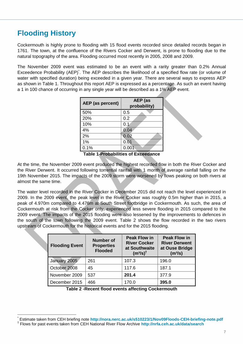
water with specified duration) being exceeded in a given year. There are several ways to express AEP
as shown in Table 1. Throughout this report AEP is expressed as a percentage. As such an event having
a 1 in 100 chance of occurring in any single year will be described as a 1% AEP event.
AEP (as percent) AEP (as
probability)
50% 0.5
20% 0.2
10% 0.1
4% 0.04
2% 0.02
1% 0.01
0.1% 0.001
Table 1-Probabilities of Exceedance
At the time, the November 2009 event produced the highest recorded flow in both the River Cocker and
the River Derwent. It occurred following torrential rainfall with 1 month of average rainfall falling on the
19th November 2015. The impacts of the 2009 storm were worsened by flows peaking on both rivers at
almost the same time.
The water level recorded in the River Cocker in December 2015 did not reach the level experienced in
2009. In the 2009 event, the peak level in the River Cocker was roughly 0.5m higher than in 2015, a
peak of 4.970m compared to 4.476m at South Street footbridge in Cockermouth. As such, the area of
Cockermouth at risk from the Cocker only, experienced less severe flooding in 2015 compared to the
2009 event. The impacts of the 2015 flooding were also lessened by the improvements to defences in
the south of the town following the 2009 event. Table 2 shows the flow recorded in the two rivers
upstream of Cockermouth for the historical events and for the 2015 flooding.
Flooding Event Number of Properties Flooded
Peak Flow in River Cocker at Southwaite
(m³/s)†
Peak Flow in River Derwent at Ouse Bridge
(m³/s)
January 2005 261 107.3 196.0
October 2008 45 117.6 187.1
November 2009 537 201.4 377.9
December 2015 466 170.0 395.0
Table 2 -Recent flood events affecting Cockermouth
* Estimate taken from CEH briefing note http://nora.nerc.ac.uk/s510223/1/Nov09Floods-CEH-briefing-note.pdf
† Flows for past events taken from CEH National River Flow Archive http://nrfa.ceh.ac.uk/data/search

Environment Agency Cumbria County Council
8
Event background
This section describes the location of the flood incident and identifies the properties that were flooded.
Flooding Incident
Cockermouth is located at the confluence of the Rivers Cocker and Derwent. Both rivers have a large
catchment area incorporating the high fells of the Lake District National Park. Buttermere and Crummock
Water are located along the course of the River Cocker, and Bassenthwaite Lake and Derwent Water lie
within the Derwent catchment. Cockermouth is a historic town with a castle and a thriving market with
medieval and Georgian streets beneath the castle walls. It is located in the Borough of Allerdale in
Cumbria and has a population of approximately 7,900.
Cockermouth is a town that has historically grown up around the river system with much of the industry
using its water. Jennings Brewery is sited on the right bank of the River Cocker immediately upstream of
the confluence. The centre of Cockermouth retains much of its historic character. It is known for its range
of small specialist shops and is a popular destination for tourists.
On 5th and 6th December 2015, 466 properties suffered flooding. The area affected by the flooding is shown in Figure 1. The main impact of this flooding can be attributed to the River Derwent, rather than both rivers, following Storm Desmond. This storm caused 36 hours of intense rainfall leading to high river levels that overtopped and outflanked flood defences at a number of locations within the town.
Figure 1- Extent of River (Fluvial) Flooding* in Cockermouth on 5-6th December 2015
*The flood outline identifies the maximum extent of flooding. Not all properties within the extent area were flooded.
River
Cocker
River
Derwent
Gote
Bridge
South Street
Bridge
Cocker
Bridge

9
The extent of the flood is similar to that of the 2009 event. However, flood depths tended to be lower since raised defences on both the Rivers Derwent and Cocker were able to hold back flows for longer, and contain more flow. For this report, the flooded area has been divided into 5 sub-areas for investigation. These are based on flood flow routes, and broadly correspond to the flood warning areas within Cockermouth. These sub-areas are shown in Figure 2:
Rubby Banks road – The area on the left bank of the River Cocker upstream of Main Street Bridge
Jennings Brewery – The area on the right bank of the River Cocker including Jennings Brewery itself
Main Street – The area on the left bank of the River Derwent
Derwentside Gardens – The eastern area on the right bank of the River Derwent including Derwentside Gardens, Derwent Mills industrial estate and the James Walkers’ factory
Gote Road – The remainder of the right bank of the River Derwent within Cockermouth

Environment Agency Cumbria County Council
10
Figure 2-Identification of areas flooded
Derwentside
Gardens
Gote
Road
Main
Street
Jennings
Brewery
Rubby
Banks Road
11
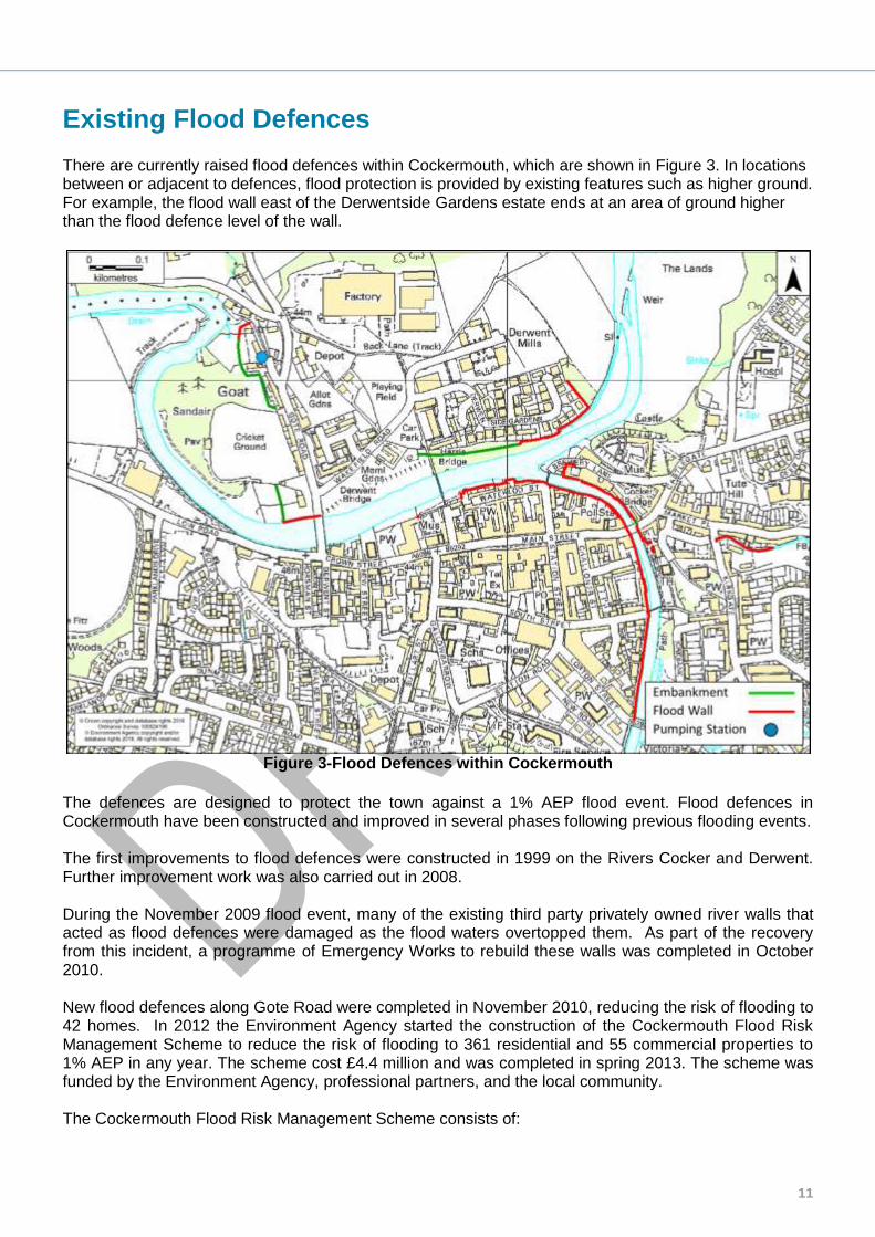
Existing Flood Defences There are currently raised flood defences within Cockermouth, which are shown in Figure 3. In locations between or adjacent to defences, flood protection is provided by existing features such as higher ground. For example, the flood wall east of the Derwentside Gardens estate ends at an area of ground higher than the flood defence level of the wall.
Figure 3-Flood Defences within Cockermouth
The defences are designed to protect the town against a 1% AEP flood event. Flood defences in Cockermouth have been constructed and improved in several phases following previous flooding events. The first improvements to flood defences were constructed in 1999 on the Rivers Cocker and Derwent. Further improvement work was also carried out in 2008. During the November 2009 flood event, many of the existing third party privately owned river walls that acted as flood defences were damaged as the flood waters overtopped them. As part of the recovery from this incident, a programme of Emergency Works to rebuild these walls was completed in October 2010. New flood defences along Gote Road were completed in November 2010, reducing the risk of flooding to 42 homes. In 2012 the Environment Agency started the construction of the Cockermouth Flood Risk Management Scheme to reduce the risk of flooding to 361 residential and 55 commercial properties to 1% AEP in any year. The scheme cost £4.4 million and was completed in spring 2013. The scheme was funded by the Environment Agency, professional partners, and the local community. The Cockermouth Flood Risk Management Scheme consists of:

Environment Agency Cumbria County Council
12
Rubby Banks Road – Stone-clad reinforced concrete defence wall incorporating a self-closing barrier to raise the height of the wall during a flood event. The road level is raised at the downstream end of this wall near Victoria Bridge.
Hatters Croft – Stone-clad reinforced concrete defence wall with glass panel at top of wall. Properties fitted with flood-resilient windows
Market Street – Reinforced concrete wall and flood gate at Riverside Car Park
Brewery Lane – Reinforced concrete wall along riverside. Flood Gate across Brewery Lane
Police Station – Stone-clad reinforced concrete wall
Waterloo Street – Stone-clad reinforced concrete wall
Derwentside Gardens – Embankment and brick-clad reinforced concrete wall joining into area of high ground
Gote Road – Embankment and flood wall with pumping station In 2015 Cumbria County Council installed a new surface water storage system under Main Street. The scheme is designed to reduce flood risk to a 1% AEP event and consists of enlarged man holes and pipe work.
13
Investigation
This section provides details of the rainfall event, the likely causes of flooding and the history of flooding in the area. This investigation was carried out by the Environment Agency through surveys of the area and data collected from the community affected. This report has compiled this data to provide details of flooding from the Rivers Derwent and Cocker both of which are Main Rivers.
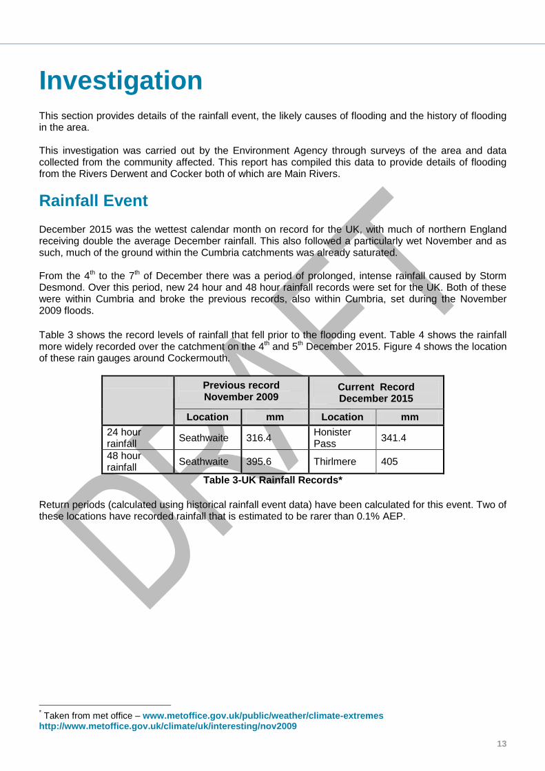
Rainfall Event December 2015 was the wettest calendar month on record for the UK, with much of northern England receiving double the average December rainfall. This also followed a particularly wet November and as such, much of the ground within the Cumbria catchments was already saturated. From the 4th to the 7th of December there was a period of prolonged, intense rainfall caused by Storm Desmond. Over this period, new 24 hour and 48 hour rainfall records were set for the UK. Both of these were within Cumbria and broke the previous records, also within Cumbria, set during the November 2009 floods.
Table 3 shows the record levels of rainfall that fell prior to the flooding event. Table 4 shows the rainfall more widely recorded over the catchment on the 4th and 5th December 2015. Figure 4 shows the location of these rain gauges around Cockermouth.
Previous record November 2009
Current Record December 2015
Location mm Location mm
24 hour rainfall
Seathwaite 316.4 Honister Pass
341.4
48 hour rainfall
Seathwaite 395.6 Thirlmere 405
Table 3-UK Rainfall Records*
Return periods (calculated using historical rainfall event data) have been calculated for this event. Two of these locations have recorded rainfall that is estimated to be rarer than 0.1% AEP.
* Taken from met office – www.metoffice.gov.uk/public/weather/climate-extremes http://www.metoffice.gov.uk/climate/uk/interesting/nov2009

Environment Agency Cumbria County Council
14
Monitoring Station
Rainfall (mm) Estimated Annual
Exceedance Probability*
4th December 5th December Rolling 24 hour
Rainfall
Cornhow 12.8 81.8 94.4 7.1%
High Snab Farm 39.6 159.2 193.0 0.7%
Honister Pass 58.6 294.4 341.4 <0.1%
Seathwaite 36.6 185.2 214 1.33%-1.67%
Sunderland Waste Water Treatment Works (WWTW)
7.8 42.8 50.6 25%
Thirlmere 35.0 317.6 324.8 <0.1%
Table 4-Rainfall recorded at gauges around Cockermouth
Figure 4-River Derwent catchment and locations of rain gauges
This rainfall event led to exceptionally high river flows across the country and widespread flooding.
There are a number of river monitoring gauges upstream and within Cockermouth measuring flow and
level on the Rivers Cocker and Derwent. The locations of these are shown in Figure 5.
* Calculated using FEH DDF methodology, this estimation is not calibrated for values with an AEP less than 0.1%
Sunderland
WWTW
Cornhow
High Snab
Farm
Honister
Pass
Seathwaite
Thirlmere
Portinscale
Dale Head
Hall

15
Figure 5-Location of river gauges upstream of Cockermouth
Table 5 shows the peak flows recorded at these gauging stations. For the Ouse Bridge gauging station
on the River Derwent, the flows on 5th December were higher than those for any previous event. Flows
calculated at Southwaite Bridge on the River Cocker were less than the November 2009 event and this
is reflected in the flooding extent and mechanisms.
Figure 6 shows the recorded river levels at the two monitoring gauges from the 4th to the 8th of
December. This illustrates the relative size of the two rivers and the times of peak flow during the
December flood event.
Gauging Station
River
Peak flow (m3/s) Estimated AEP
of Dec 2015 event
Dec 2015
Past events
June 2012
Nov 2009
October 2008
Jan 2005
Ouse Bridge
Derwent 395 154 378 187 196 0.1%-0.3%
Southwaite Cocker 170 110 201 117 107 1%
Table 5-Flows recorded at the gauging stations
Southwaite
Ouse
Bridge
South
Street
Kingfisher

Environment Agency Cumbria County Council
16
Figure 6-Flow measured at river gauges upstream of Cockermouth
This flood event was of a greater magnitude than the Cockermouth scheme was designed to protect against (1% AEP). As such, river levels would be expected to be higher than the level of the flood defences.
Map of Flow Routes
There were a number of flooding flow routes during the event, shown in Figure 7. The details of these
flow routes and the flooding within each of the identified areas is discussed in the ‘Impacts and Likely
Causes of Flooding’ section.
Peak flow 170m³/s
05/12/15 18:45
Peak flow 395m³/s
06/12/15 06:45

17
Figure 7-Map of flood flow routes Note: The flood outline identifies the maximum extent of flooding. Not all properties within the extent area were flooded.

Environment Agency Cumbria County Council
18
Impacts and Likely Causes of Flooding
Timeline
Table 6 below shows the times of key events during the Cockermouth flooding in December 2015.
4th December Event
Flood gates closed
1530 Flood alert issued
5th December Event
1440-1530 Flood warnings issued
1500 Flood flow is reported via a route upstream of Derwent Mills outflanking the defences along the river at Derwent Gardens
1530 Reports of the embankment being outflanked at the north area of Gote Road
and Spital Ing Lane
1630 The embankment upstream of Gote Bridge is reported to be overtopped leading to flow onto Gote Road from the south
1649 Reports of the River Cocker overtopping the defences at Waterloo footbridge and flowing up High Sand Land towards Main Street
1649 Severe Flood Warning issued
Gote Road Pumping Station fails
1655 Continued overtopping from the River Derwent observed behind Waterloo Street
1700 Properties on Main Street reported to have been flooded
Jennings Brewery defences overtopped
1720 Overtopping of the floodgate on Low Sand Lane is was reported
1740 Flow through Trout Hotel Car Park
1800 Properties on Derwentside Gardens reported to have been flooded
1800-1900 Flood flow is reported flowing down Rubby Banks Road outflanking the defences having overtopped the road hump at Victoria Road Bridge
1845 Peak flow at South Street footbridge gauging station
(River Cocker) – 4.476m
2100 The floodgate at the Town Hall Riverside public car park is overtopped
6th December Event
0330 Peak flow at Kingfisher gauging station
(River Derwent) – 4.543m
Table 6-Timeline of Key events
The timeline highlights that flood warnings did not give sufficient time. This is currently under review. The
flooding mechanisms included both rivers overtopping or bypassing existing flood defences, and flooding
19
from surface water drainage that was unable to discharge into the rivers. Flood defences and river banks
were overtopped at:
Victoria Road Bridge, on the left bank of the River Cocker, upstream of Rubby Banks
Road and the raised hump north of this bridge
Flooding to properties at Hatters Croft on the left bank of the River Cocker downstream
of South Street Footbridge that are part of the defended line
The defences on the left and right banks of the River Cocker downstream of Main
Street Bridge
The defences at Jennings Brewery
The left bank of the River Derwent at Waterloo Street
The car park at the Trout Hotel on the left bank of the River Derwent
The embankment on the right bank of the River Derwent at Derwentside Gardens
The embankment on the right bank of the River Derwent immediately upstream of Gote
Bridge
Outflanking of defences protecting the Gote Road area to the north of Spital Ing Lane
Surface water flooding also occurred at:
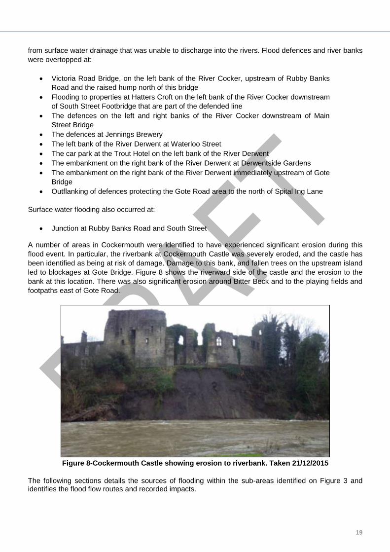
Junction at Rubby Banks Road and South Street A number of areas in Cockermouth were identified to have experienced significant erosion during this
flood event. In particular, the riverbank at Cockermouth Castle was severely eroded, and the castle has
been identified as being at risk of damage. Damage to this bank, and fallen trees on the upstream island
led to blockages at Gote Bridge. Figure 8 shows the riverward side of the castle and the erosion to the
bank at this location. There was also significant erosion around Bitter Beck and to the playing fields and
footpaths east of Gote Road.
Figure 8-Cockermouth Castle showing erosion to riverbank. Taken 21/12/2015
The following sections details the sources of flooding within the sub-areas identified on Figure 3 and identifies the flood flow routes and recorded impacts.

Environment Agency Cumbria County Council
20
Rubby Banks Road Area
Figure 9-Flow routes from the River Cocker along Rubby Banks Road
Note: The flood outline identifies the maximum extent of flooding. Not all properties within the extent area were flooded.
This is an area of residential properties on the left bank of the River Cocker including Rubby Banks Road
which runs alongside the river. The area and the flood flow routes into this area are shown in Figure 9.
The Rubby Banks Road area lies north of the Victoria Road (B5292) Bridge. The flood defences run
alongside Rubby Banks Road. Along part of this wall’s length, the defences include self-closing barriers
housed within the lower part of the defence wall. These are not visible outside of flood conditions. At the
southern extent of this wall, the road level of Rubby Banks Road was raised to form a hump, acting as a
flood defence. There are also a number of properties downstream of South Street, including Hatters
Croft, forming part of the defence line. At these locations, property-level protection, such as flood
resilient windows, have been installed.
The self-closing flood barriers along Rubby Banks Road worked correctly and did not overtop. There was
some overtopping immediately upstream of the self-closing barrier as a wave was created by river flow
hitting the upstream corner of the barrier wall. This water then continued to flow down the inside of the
Self-Closing
Flood Barrier
Hatters Croft
Road hump
21
defence wall causing ponding of floodwater at the junction of Rubby Banks Road and South Street. The
surface water drainage system was also surcharging in this location.
The flood resilient property windows on properties at Hatters Croft forming part of the defence line were
also seen to have worked successfully, however these properties were still flooded. This occurred early
in the flood event prior to the peak river level. The source of this flooding was seen to be water rising
through the floor of the buildings, followed later by flood water entering through the front of the
properties.
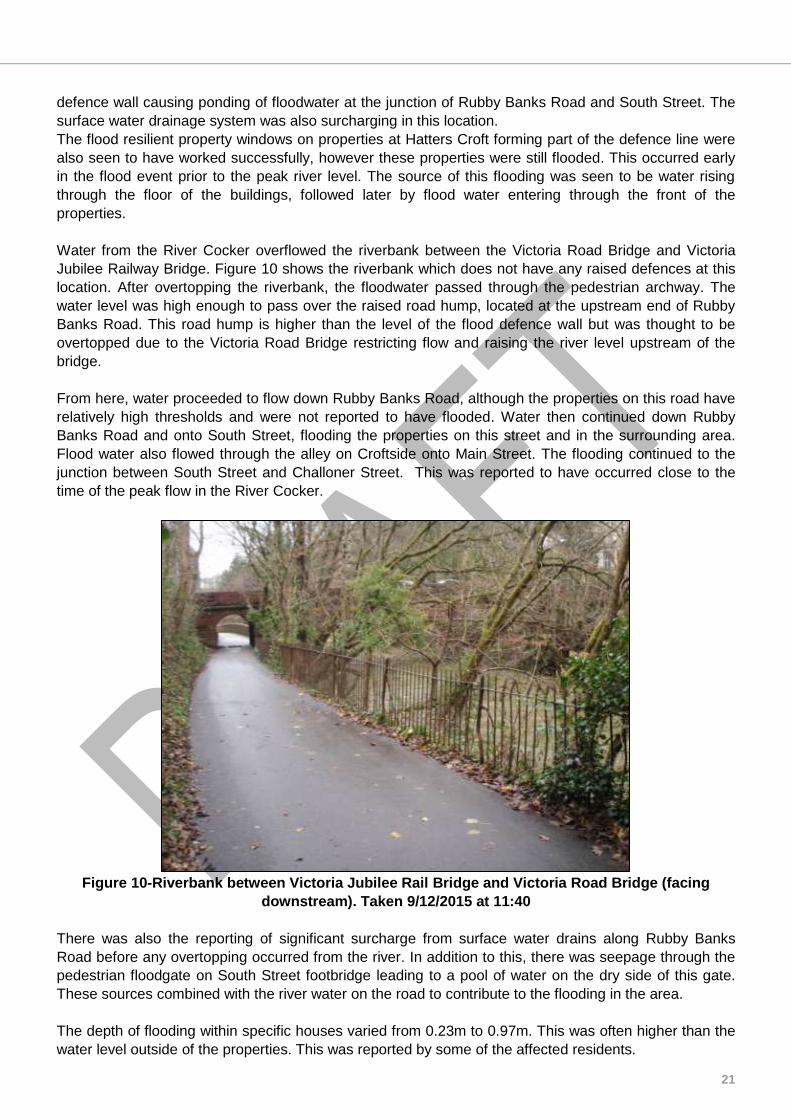
Water from the River Cocker overflowed the riverbank between the Victoria Road Bridge and Victoria
Jubilee Railway Bridge. Figure 10 shows the riverbank which does not have any raised defences at this
location. After overtopping the riverbank, the floodwater passed through the pedestrian archway. The
water level was high enough to pass over the raised road hump, located at the upstream end of Rubby
Banks Road. This road hump is higher than the level of the flood defence wall but was thought to be
overtopped due to the Victoria Road Bridge restricting flow and raising the river level upstream of the
bridge.
From here, water proceeded to flow down Rubby Banks Road, although the properties on this road have
relatively high thresholds and were not reported to have flooded. Water then continued down Rubby
Banks Road and onto South Street, flooding the properties on this street and in the surrounding area.
Flood water also flowed through the alley on Croftside onto Main Street. The flooding continued to the
junction between South Street and Challoner Street. This was reported to have occurred close to the
time of the peak flow in the River Cocker.
Figure 10-Riverbank between Victoria Jubilee Rail Bridge and Victoria Road Bridge (facing
downstream). Taken 9/12/2015 at 11:40
There was also the reporting of significant surcharge from surface water drains along Rubby Banks
Road before any overtopping occurred from the river. In addition to this, there was seepage through the
pedestrian floodgate on South Street footbridge leading to a pool of water on the dry side of this gate.
These sources combined with the river water on the road to contribute to the flooding in the area.
The depth of flooding within specific houses varied from 0.23m to 0.97m. This was often higher than the
water level outside of the properties. This was reported by some of the affected residents.

Environment Agency Cumbria County Council
22
Jennings Brewery Area
Figure 11-Flow routes on the right bank of the River Cocker
Note: The flood outline identifies the maximum extent of flooding. Not all properties within the extent area were flooded.
This is an area of properties on the right bank of the River Cocker. It is a mix of retail and residential
properties and also includes Jennings Brewery and Cockermouth Town Hall. The area is adjacent to
Cocker Bridge carrying Main Street across the river. The area and the flood flow routes into this area are
shown in Figure 11.
There are flood defence walls at the river bank and at Jennings Brewery. The public car park at the town
hall is allowed to flood as part of the defence scheme and has a flood gate and defence wall at its
entrance.
Flooding first occurred in the Riverside Public Car Park. This area is not protected by flood defences and
is expected to flood when there are high river levels. However, the water subsequently overtopped the
floodgate at this car park, reported to have occurred at 21:00 on the 5th December. This occurred after
the peak on the River Cocker but before the peak on the River Derwent. Flooding in this area was
caused by levels in the Cocker rising due to water backing up from high levels in the River Derwent. The
Riverside
Car Park

23
flooding extended to the junction between Main Street and Market Place, as the road rises steeply
beyond this location.
Defences were overtopped downstream of the Main Street Bridge and at Jennings Brewery. There is no
record of the times that these defences were overtopped but was thought to be after the time of the peak
flow in the River Cocker.
There was one report of a property internally flooded from water rising through a ground floor toilet,
although there were no reports of drains surcharging onto the roads in this area. Flooding to the
properties on Market Place and Market Street was between 0.5m and 0.65m depth. The electricity
substation at Brewery Lane was also flooded and remained live.
Main Street Area
Figure 12-Flow routes into Main Street Area
Note: The flood outline identifies the maximum extent of flooding. Not all properties within the extent area were flooded.
This is the main thoroughfare in Cockermouth and is predominantly retail properties. The area is
defended by a flood defence wall along the river bank that includes several floodgates. The area and the
flood flow routes into this area are shown in Figure 12.
This area was flooded from both the River Cocker and River Derwent. Defences at this location were
both overtopped and outflanked.
The River Cocker overtopped the defences at Waterloo footbridge at 16:49 as the Severe Flood
Warning was issued. This floodwater was observed flowing up High Sand Lane towards Main
Street.
Trout
Hotel

Environment Agency Cumbria County Council
24
From 16:55 onwards, there was continued overtopping of the River Derwent behind Waterloo
Street.
At 17:00 properties were flooding on Main Street and water was running from East to West.
Reports indicate that the floodgate on Low Sand Lane was being overtopped by 17:20, and water
flooding Main Street in a West to East direction.
Reports of floodwater overtopping the high ground in the Trout Hotel car park indicate a time of
approximately 17:40.
There was significant flow onto Main Street through the car park at the Trout Hotel. Floodwater also
overtopped the flood barrier on Low Sand Lane, upstream of the hotel. This route is highlighted in Figure
13. Floodwater then continued to flow down Main Street and formed the main flood route into the area.
The amount of water following this route was increased by debris at Gote Bridge obstructing flow and
leading to a higher river level at the Trout Hotel.
Flooding occurred to all properties between the River Derwent and Main Street. This flooding extended
to the junction between Main Street and New Street. The depth of this flooding was approximately 0.45m
within properties.
Figure 13-River Derwent at Main Street area highlighting flow route through the Trout Hotel car
park. Photograph provided by Peter Smith Photography. Taken 06/12/2015 12:37
Trout Hotel
Overtopped
floodgate on Low
Sand Lane

25
Derwentside Gardens and Derwent Mills Area
Figure 14-Flow routes in Derwentside Gardens area
Note: The flood outline identifies the maximum extent of flooding. Not all properties within the extent area were flooded.
Derwentside Gardens is a relatively new residential estate constructed in the late 1990s. This area also
includes the Derwent Mills Industrial Estate and James Walkers’ factory. The area and the flood flow
routes into this area are shown in Figure 14.
Whilst this estate is sited on slightly higher ground than the main town, it is still at risk of flooding and is
protected by a flood defence wall and embankment that was constructed in 2012 as part of the
Cockermouth Flood Risk Management Scheme. The north-eastern extent of this wall ties into ground
above the level of the defence line.
Flow on the right bank of the River Derwent overtopped the defences at this location. These defences
were also outflanked with water travelling overland via routes upstream of Derwent Mills and at the
eastern extent of the Derwentside Gardens estate. Figure 15 shows this area during the flood event.
Flood water was observed by residents to be flowing back towards the River Derwent over the
embankment at the southern extent of the estate.
All properties in Derwentside Gardens were flooded as well as the James Walkers’ factory to the north
and the nearby playing fields. This flow then continued downstream, and overland contributing to
flooding in the Gote Road area.
Flood depths in Derwentside Gardens varied due to the differing threshold heights of properties.
Flooding was recorded at a depth of 0.6m in this area and in the James Walkers’ factory.
Environment Agency Cumbria County Council
26
Figure 15-Derwentside Gardens during event showing flow route upstream of defence.
Photograph provided by Peter Smith Photography. Taken 06/12/2015 12:37
Gote Road Area
Figure 16-Flow routes in Gote Road area
Note: The flood outline identifies the maximum extent of flooding. Not all properties within the extent area were flooded.
Gote Road
Pumping Station

27
This is an area of residential properties adjacent to the Derwentside Gardens area. Gote Road is carried
over the River Derwent by Gote Bridge. The area and the flood flow routes into this area are shown in
Figure 16.
There is an area of natural high ground on the upstream right bank of Gote Bridge. Defences have been
constructed downstream of the bridge and to the west of Gote Road. There is also a pumping station
alongside the Gote Road defences to pump water trapped on the dry side of the flood embankment back
to the river. This embankment also has an outfall flap and penstock to drain water that accumulates on
the dry side of the defences. After the flood event, there was a delay and problems in opening the
penstock. This will be investigated as part of the scheme performance review.
The properties on Gote Road were flooded from the River Derwent through multiple flow paths. The
pumping station within this area stopped pumping due to power failure when it was itself flooded. The
location and resilience of the electrical sub-station will be investigated as part of the scheme
performance review.
This area was flooded as a result of three different mechanisms.
1. The defences were outflanked at the north end of Gote Road leading to properties being flooded
at approximately 15:30.
2. The embankment on the right bank upstream of Gote Bridge overtopped at approximately 16:30.
This then led to floodwater flowing along Gote Road from the south, flooding all properties in this
area. This was the main flow route for floodwater. Flooding to properties in this area was
recorded at depths up to 2 metres.
3. There was also flow through the Derwentside Gardens area.
4. There was also reported flooding from a manhole on the old mill race which Tommy Gill Beck
flows into before, discharging into the River Derwent.
Figure 17-Gote Road area during event. Photograph provided by Peter Smith Photography. Taken
06/12/2015 12:35
Gote Bridge caused an obstruction to the river leading to higher river levels upstream of the bridge. This
was visible during the event where there was a significant difference in levels upstream and downstream
of the bridge. A number of trees and other debris partially blocked the bridge arches at peak flows,
increasing the impact of this. This exacerbated the overtopping of the defences and the flow into this
area.

Environment Agency Cumbria County Council
28
Environment Agency and Highways Flood Incident
Response
Due to the nature of the river environment in Cockermouth, gravel deposition occurs on both the Rivers
Cocker and Derwent. This can reduce channel capacity, which can have an impact on flood risk.
Regular monitoring of gravel accumulation forms part of the Environment Agency’s maintenance
programme in Cockermouth. If gravel builds up to a level where flood risk is increased, then the
Environment Agency undertakes gravel removal to maintain channel capacity and conveyance through
the town.
Following the flood event in December 2015, the Environment Agency has undertaken a channel survey
to determine the extent of gravel accumulation and identify areas of increased potential flood risk.
Significant volumes of gravel have been deposited, and removal is to commence in June 2016.
Following the flood event the Environment Agency has also removed blockages and obstructions (such
as large trees) from the Rivers Cocker and Derwent in Cockermouth.
Immediately prior to the flood event the Environment Agency inspected watercourses and operational
structures such as debris screens to ensure that there were no blockages which may have caused an
increase in flood risk.
There are a number of flood gates within the Cockermouth Flood Risk Management Scheme which
require closing prior to potential flooding. These flood gates were closed by the Environment Agency on
the morning of 4th December, well in advance of any flooding occurring. The only operational issue
reported in relation to the floodgates was leakage through the floodgate at South Street footbridge on
Rubby Banks Road.
A flood alert for the Rivers Cocker and Derwent was issued on the 4th of December, at 15:30. Flood
warnings were issued to the flood warning areas within Cockermouth between 14:30 and 15:30 on the
5th December. Table 7 shows the times that flood warnings were issued for the different flood warning
areas in Cockermouth. Additional details on these flood warning areas and the warnings issued are
shown in Appendix 4.
Flood Alert issued 04/12/2015 15:30
Flood Warnings
Cricket Ground and Trout Hotel Car Park 05/12/2015 01:11
Old Courthouse and Market Place Area 05/12/2015 14:27
Bridge Street, Crown Street, High Sand
Lane and Main Street
05/12/2015 14:40
Gote Road to Derwent Mills Area and Low
Road
05/12/2015 14:40
Challoner Street, Croft Terrace, Jubilee
Court and Rubby banks Road
05/12/2015 15:28
Severe Flood Warning issued 05/12/2015 16:49
Table 7-Times of Flood Alert and Warnings
A severe flood warning was issued for Cockermouth at 16:49 on the 5th December as flooding to the
town was thought to be imminent. This severe warning was issued after some areas to the north of the
town had begun to flood. A number of the affected residents felt these warnings arrived too late and did
not give them enough notice to respond to the imminent flooding.

29
A number of properties affected by the flooding event did not receive flood warnings as these were not
registered with the Environment Agency. In addition to this some properties in Derwentside Gardens
were registered but did not receive flood warnings. This was thought to be due to loss of power to this
area as local electricity substations had been affected by the flooding.
The Environment Agency has worked closely with the Cockermouth Flood Action Group (CFAG) for a
number of years to help plan and prepare for flood events. The Environment Agency also sent messages
to stakeholders via the Cumbria Community Messaging (CCM) system to raise awareness and provide
advice and guidance.
Highways deployed an 8” pump, in case the new surface water system was overwhelmed. The pump
was never used and was only withdrawn when the river overtopped the walls in Waterloo Street. The
surface water system functioned as designed until inundated by the river.
Maintenance Activities
The Environment Agency maintains flood risk management structures and sections of river channel
where maintenance actively reduces the risk of flooding to people and property. Activities we undertake
are summarised below:
We conduct yearly visual inspections of flood defence embankments and walls and deliver a
variety of maintenance tasks which include, as necessary:
o grass cutting,
o tree and bush management,
o invasive species control,
o vermin control and
o expansion joint repairs.
We deliver targeted maintenance on River Channels where the activity is beneficial to the
reduction in flood risk. This could include:
o Weed Control,
o Grass Control,
o Tree and Bush Management,
o Invasive Non Native Species Control,
o Gravel Removal, when justified through investigation and survey.
In Cockermouth, we undertake tree and bush management and gravel management on the Derwent
from Derwentside Gardens to the Gote and on the Cocker up to Victoria Bridge.
On operational structures, we undertake:
o quarterly operational inspections and
o yearly mechanical maintenance
On Culverts, which could pose a risk of flooding to properties, we monitor the risk of flooding
through 6 yearly inspections, and deliver the following on a risk based approach:
o Cleansing works
o Repairs and reconditioning works
Facts and Figures for Cockermouth:
Gravel naturally collects in the River Derwent upstream of Gote Bridge. We monitor this section
yearly and remove gravel when it reaches a “trigger level”. We will be removing gravel from this
section in June 2016.

Environment Agency Cumbria County Council
30
o On average, we remove gravel from here every 3 years, depending on the severity and
frequency of floods.
We maintain 0.5km of Flood Defence Embankment in Cockermouth.
We maintain 1.2km of flood defence wall
We maintain over 70 structures in Cockermouth
31
United Utilities: Thirlmere Reservoir
Background
Thirlmere reservoir was built in 1894 to supply drinking water for Manchester. The reservoir can store up to 40,000 megalitres (million litres) of water and approximately 700,000 people – about 10% of the region’s water users - receive drinking water supplies from Thirlmere. Most are in Manchester but other communities include Blackpool and the Fylde coast, Lancaster and of course local communities such as Keswick and Borrowdale.
At the southern end of Thirlmere is the Thirlmere aqueduct. This is a 134 mile long gravity tunnel which links Thirlmere to Manchester. The aqueduct extracts up to 220 megalitres of water from Thirlmere per day.
Thirlmere discharges into St John’s Beck, which is a tributary of the River Greta. The River Greta flows through Keswick and joins the River Derwent just after it leaves Derwent Water as it flows towards Bassenthwaite Lake. St John’s Beck accounts for about one fifth of the water in the River Greta
How Thirlmere is operated
Thirlmere reservoir is maintained and managed according to legislation and the local arrangements
agreed with Keswick Flood Action Group (KFAG). United Utilites operate to a set of flood level
drawdown rules agreed with KFAG.
These rules specify reservoir levels for each month at which United Utilities will release more water into
St John’s Beck. Releases continue until the relevant month’s target level is achieved and continues in
order to maintain it if necessary. This is a best endeavours effort, as incoming water from rainfall and the
catchment may be greater than the maximum possible releases
In November, this level is 3.0m below top water level – equivalent to 76% full. The idea being that this
spare capacity can absorb some of the heavy rain which falls during these months. United Utilities
operated the reservoir to these agreed levels prior to the December flood event.
However, the catchment is in a delicate environmental balance and there is a natural limit to the amount of water that United Utilities can release without causing damage to St Johns Beck which is a Special Area of Conservation. The normal compensation flow in St John’s Beck is 13.64 million litres per day. United Utilities can increase this to 100 million litres per day.
Even at this level, it causes some flooding to farmland. Any more than 100 million litres per day and
more farmland will flood on a more frequent basis. United Utilities also have to consider the impact
increased flows have on those who use the Beck for fishing. All releases, except for the 13.64 million
litres per day compensation, are ceased if the reservoir starts to spill
Nov 2015- Levels in Thirlmere Reservoir.
United Utilities can increase the rate at which water is removed from the reservoir up to a certain limit. When the Thirlmere Aqueduct is open, the safe and environmental limit is 320 million litres a day. If the rain falls faster than this then the reservoir will start to fill until it eventually overflows.

Environment Agency Cumbria County Council
32
In November 2015, there had already been more than twice the normal level of rainfall expected for the
month. Thirlmere reservoir was filling throughout November, and started to spill over on Monday 30
November. The reservoir level reached 1.56m above the weir crest during Storm Desmond, the highest
recorded level. This level was still within the design parameters of the dam, and below the potential
maximum flood for which it was designed. The parapet (roadside) wall is designed to be an integral part
of the dam. It is a substantial, water tight structure that will retain the maximum still-water flood during
the probable maximum flood. Studies and inspection reports indicate that the wall is sufficient to
withstand the effects of waves to the top, and just spilling over the wall. This is how the wave wall
operated during Storm Desmond, and the wall has not suffered damage.
On 5th December alone, around 14,000 million litres of water entered the reservoir, which is more than a
third of its capacity. The average rainfall for Cumbria for the month of December is 146.1mm, and more
than this fell during one day. Over the course of the weekend, flows down St Johns Beck were higher
than ever recorded before. Given the amount of rainfall, increasing the outflow beyond 320 million litres
per day would have made little material difference.
Future investment
United Utilities have been considering options for further flood drawdown releases, and possible
modifications to the infrastructure at Thirlmere as part of the new pipeline scheme to West Cumbria.
Limitations to the speed of reservoir drawdown, caused by constraints at the dam outlet to St John’s
Beck, are well understood and following studies, potential solutions have been identified. These
solutions will be considered as part of the detailed design of the modifications to abstraction
infrastructure, new water treatment works, and pipelines for the Thirlmere to West Cumbria transfer.
Current flood drawdown releases are approximately 100 million litres per day. The limitation is not the
outflow from the low level scour valves on the dam, which can release up to 900 million litres per day in
emergency draw down for reservoir safety. The issue at present is infrastructure downstream of the
valves, including a bridge that could be washed away if flows higher than the currently agreed releases
are made.
Work has progressed to develop the long term provision of water to West Cumbria, which will include a
solution that could allow a higher rate of release. In essence, this is to engineer a channel to
accommodate the higher flows, and make modifications to the valves to enable better control. This would
allow approximately 500 million litres per day of flood drawdown release to be made whilst still
maintaining flows to the Water Treatment Works to supply customers.
United Utilities are committed to ongoing engagement with KFAG, the Environment Agency, and Natural
England regarding the volumes of water that can be released into St. Johns Beck in the future. An
environmental assessment will need to be conducted in to the impact of releases downstream of the
reservoir and this will involve all parties mentioned above, as well as local residents who could
potentially be impacted by any changes.
St John’s Beck is part of a Special Area of Conservation and therefore any solution needs to be
compliant with the Habitats Directive.
United Utilities currently estimate that construction of new infrastructure will begin in 2017 and take an
estimated 12 months to deliver the work to accommodate the releases in to St John’s Beck.

33
Recommended Actions The following table details recommended actions for various organisations and members of the public to
consider using the Cumbria Floods Partnerships 5 Themes: Community Resilience, Upstream
Management, Strengthening Defences, Maintenance, and Internal Drainage Boards (IDB’s). Some of
these recommendations may have already been carried out and or are ongoing.
Some of the actions referred to below are identified on Figure 18 following this table.
Cumbria Flood
Partnership
Theme
Action by Recommended Action Timescale
Co
mm
unity R
esili
ence
Cumbria Local Resilience
Forum *
Review and update plans to
enable homes & business to
be better prepared for
flooding & reduce the
impacts of flooding. For
example, review of
evacuation procedures /
emergency response.
2016
Environment Agency, Cumbria
County Council Highways, and
Electricity North West.
Review the flood risk and
resilience of critical transport
and power supply
infrastructure such as the
Jennings Brewery
substation.
2016
Environment Agency and
Cumbria County Council
Highways
Consider means to increase
flow capacity through Gote
Bridge or provide a means of
trapping debris upstream of
the town in a location where
an obstruction would not be
critical.
2016
Cumbria County Council
Review traffic arrangements
at pinch points within
Cockermouth to ensure
residents are able to
evacuate safely during a
flood event.
2016
Cumbria Planning Group,
Allerdale Borough Council,
Cumbria County Council, and
Environment Agency
Review Local Development
Plans and Strategic Flood
Risk Assessment to reflect
current understanding of
flooding.
2016
Environment Agency
Ensure all properties at risk can register to receive flood warnings and details are up-to-date.
2016
Environment Agency Raise awareness/engagement with
2016
Environment Agency Cumbria County Council
34
community on gravel management activities.
Up
str
eam
Ma
na
ge
me
nt
Cumbria Floods Partnership
(CFP)
The CFP action plan will
consider natural flood
management options to
reduce flood risk across the
catchment. This may also
include land use changes
and or flood storage.
2016
Ma
inte
na
nce
Cumbria County Council,
United Utilities, and Allerdale
Borough Council
Review and investigate
drainage and sewage
systems to better understand
where improvements are
required.
2016
Environment Agency and
Cumbria County Council
Review outfalls to the river
system within Cockermouth
and ensure all outfalls are
sealed with flap valves or
non-return valves to prevent
the defence scheme being
compromised.
2016
Environment Agency, United
Utilities, and Cumbria County
Council
Complete on-going
inspections and repairs to
assets that may have been
damaged during the flood
event.
2016
Environment Agency
Review maintenance
programme within the
catchment in response to the
flooding event of 2015. This
will include gravel/debris
removal from the river
channels in Cockermouth.
June/July 2016
Cumbria County Council
Complete outfall works to
Main Street surface water
system.
October 2016
Str
eng
the
nin
g D
efe
nce
s
Environment Agency
Review modelling and
forecasting data to ensure
that models for the Derwent
catchment reflect real
conditions as accurately as
possible and use this
information to make any
improvements to the flood
warnings service. This will be
used to inform future
investment plans.
2016
Environment Agency
Carry out scheme
performance review. The
output of this review will
inform a detailed action plan,
with timescales, which will
2016
35
identify potential
improvements and
implement necessary
improvement works. This will
include the following
locations:
Flood defence under
Victoria road bridge
Waterloo Street
including footbridge
Trout Hotel car park
Gote Bridge
Gote road
Derwentside Gardens
Derwent Mills
Environment Agency
Investigate if Derwentwater
and Bassenthwaite Lake
levels can be managed
differently to reduce flood
risk.
2016
Environment Agency
The Environment Agency is
carrying out a series of
repairs to flood defence
assets that were damaged
during the floods as part of
the c.£10m Asset Recovery
Programme which covers
Cumbria and Lancashire.
This programme of repairs is
scheduled to be complete
before winter 2016/17.
Winter 2016/17
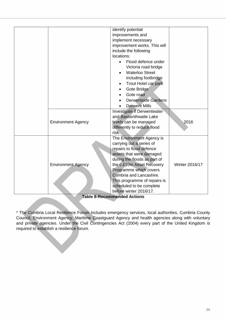
Table 8-Recommended Actions
* The Cumbria Local Resilience Forum includes emergency services, local authorities, Cumbria County
Council, Environment Agency, Maritime Coastguard Agency and health agencies along with voluntary
and private agencies. Under the Civil Contingencies Act (2004) every part of the United Kingdom is
required to establish a resilience forum.
Environment Agency Cumbria County Council
36
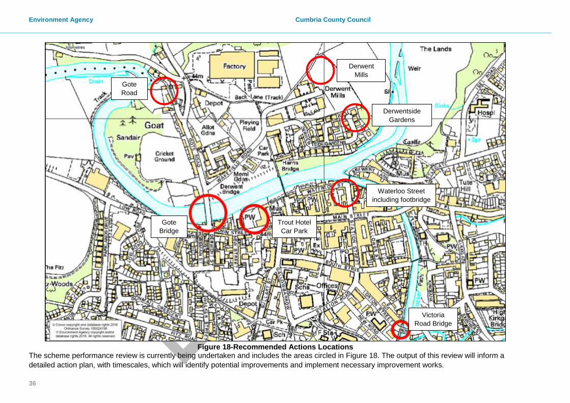
Figure 18-Recommended Actions Locations
The scheme performance review is currently being undertaken and includes the areas circled in Figure 18. The output of this review will inform a
detailed action plan, with timescales, which will identify potential improvements and implement necessary improvement works.
Gote
Bridge
Trout Hotel
Car Park
Victoria
Road Bridge
Gote
Road
Waterloo Street
including footbridge
Derwent
Mills
Derwentside
Gardens

37
Next Steps
The Cumbria Floods Partnership has brought together a wide range of community representatives and
stakeholders from a variety of sectors to plan and take action to reduce flood risk. The Cumbria Floods
Partnership, led by the Environment Agency, is producing a 25 year flood action plan for the Cumbrian
catchments worst affected by the December 2015 flooding.
The plan will consider options to reduce flood risk across the whole length of a river catchment including
upstream land management, strengthening flood defences, reviewing maintenance of banks and
channels, considering water level management boards, and increasing property resilience. The Cumbria
Floods Partnership structure below details how these 5 themes are being delivered in the Flood Action
Plans which will be completed in July 2016.
The ‘Cumbria Floods Partnership’ was set up by Flood Minister Rory Stewart MP following December’s
floods, and includes all of Cumbria’s Flood Risk Management Authorities. They are working alongside
the existing ‘Cumbria Strategic Partnership’, which was formed as part of the Flood and Water
Management Act 2010 and comprises of the County’s Flood Risk Management Authorities (RMAs)
including the Environment Agency, Cumbria County Council, Local Authorities, and United Utilities. Both
partnerships are working with communities, businesses, and relevant stakeholders to understand and
reduce flood risk across Cumbria.
Figure 19 below helps demonstrate how the two partnerships are working together:
Figure 19-Cumbria Flood Partnership and Cumbria Strategic Partnership
Environment Agency Cumbria County Council
38
Appendices
Appendix 1: Glossary
AEP Annual Exceedance Probability
AOD Above Ordnance Datum
CCC Cumbria County Council
CFP Cumbria Floods Partnership
EA Environment Agency
FAG Flood Action Group
FWD Flood Warnings Direct
LLFA Local Lead Flood Authority
MsfWG Making space for Water Group
WWTW Waste Water Treatment Works

39
Appendix 2: Summary of Relevant Legislation and Flood
Risk Management Authorities The table below summarises the relevant Risk Management Authority and details the various local source of flooding that they will take a lead on.
Flood Source
Environment Agency
Lead Local Flood Authority
District Council
Water Company
Highway Authority
RIVERS
Main river
Ordinary watercourse
SURFACE RUNOFF
Surface water
Surface water on the highway
OTHER
Sewer flooding
The sea
Groundwater
Reservoirs
The following information provides a summary of each Risk Management Authority’s roles and responsibilities in relation to flood reporting and investigation. Government – DEFRA develop national policies to form the basis of the Environment Agency’s and the LLFA’s work relating to flood risk. Environment Agency has a strategic overview of all sources of flooding and coastal erosion as defined in the Act. As part of its role concerning flood investigations this requires providing evidence and advice to support other Risk Management Authorities (RMA’s). The EA also collates and reviews assessments, maps, and plans for local flood risk management (normally undertaken by LLFA). Lead Local Flood Authorities (LLFAs) – Cumbria County Council is the LLFA for Cumbria under the Flood & Water Management Act 2010. Part of their role requires them to investigate significant local flooding incidents and publish the results of such investigations. LLFAs have a duty to determine which RMA has relevant powers to investigate flood incidents to help understand how they happened, and whether those authorities have, or intend to, exercise their powers. LLFAs work in partnership with communities and flood RMA’s to maximise knowledge of flood risk to all involved. This function is carried out at CCC by the Development Management Team. District and Borough Councils – These organisations perform a significant amount of work relating to flood risk management including providing advice to communities and gathering information on flooding. These organisations are classed as RMA’s.

Environment Agency Cumbria County Council
40
Water and Sewerage Companies manage the risk of flooding to water supply and sewerage facilities and the risk to others from the failure of their infrastructure. They make sure their systems have the appropriate level of resilience to flooding and where frequent and severe flooding occurs they are required to address this through their capital investment plans. It should also be noted that following the Transfer of Private Sewers Regulations 2011 water and sewerage companies are responsible for a larger number of sewers than prior to the regulation. These organisations are classed as RMA’s Highway Authorities have the lead responsibility for providing and managing highway drainage and certain roadside ditches that they have created under the Highways Act 1980. The owners of land adjoining a highway also have a common-law duty to maintain ditches to prevent them causing a nuisance to road users. These organisations are classed as RMA’s Flood risk in Cumbria is managed through the Making Space for Water process, which involves the cooperation and regular meeting of the Environment Agency, United Utilities, District/Borough Councils and CCC’s Highway and LFRM Teams to develop processes and schemes to minimise flood risk. The MSfWGs meet approximately 4 times per year to cooperate and work together to improve the flood risk in the vulnerable areas identified in this report by completing the recommended actions. CCC as LLFA has a responsibility to oversee the delivery of these actions. Where minor works or quick win schemes can be identified, these will be prioritised and subject to available funding and resources will be carried out as soon as possible. Any major works requiring capital investment will be considered through the Environment Agency’s Medium Term Plan process or a partners own capital investment process. Flood Action Groups are usually formed by local residents who wish to work together to resolve flooding in their area. The FAGs are often supported by either CCC or the EA and provide a useful mechanism for residents to forward information to the MSfWG.

41
Appendix 3: Links to Other Information on Flooding
Sign up for Flood Warnings https://www.gov.uk/sign-up-for-flood-warnings Environment Agency – Prepare your property for flooding; a guide for householders and small businesses to prepare for floods https://www.gov.uk/government/publications/prepare-your-property-for-flooding Environment Agency – What to do before, during and after a flood: Practical advice on what to do to protect you and your property https://www.gov.uk/government/publications/flooding-what-to-do-before-during-and-after-a-flood Environment Agency – Living on the Edge: A guide to the rights and responsibilities of riverside occupiers https://www.gov.uk/government/publications/riverside-ownership-rights-and-responsibilities Flood and Water Management Act 2010: http://www.legislation.gov.uk/ukpga/2010/29/contents Water Resources Act 1991: http://www.legislation.gov.uk/all?title=water%20resources%20act Land Drainage Act: http://www.legislation.gov.uk/all?title=land%20drainage%20act

Environment Agency Cumbria County Council
42
Appendix 4: Flood Warnings and Alerts
Flood Warning Areas within Cockermouth
Cockermouth is covered by a Flood Alert and certain areas are additionally served by the 5 Flood Warnings shown
in the map above. Flood Warning Areas are well defined following the major flood event in 2009. Flood Warning
levels will be reviewed in terms of revised modelling for the Rivers Derwent and Cocker and a Flood Forecasting
Report is being undertaken; some amendments to these areas are anticipated.
NC4B
NC4E
NC4C
NC4D
NC4A
43
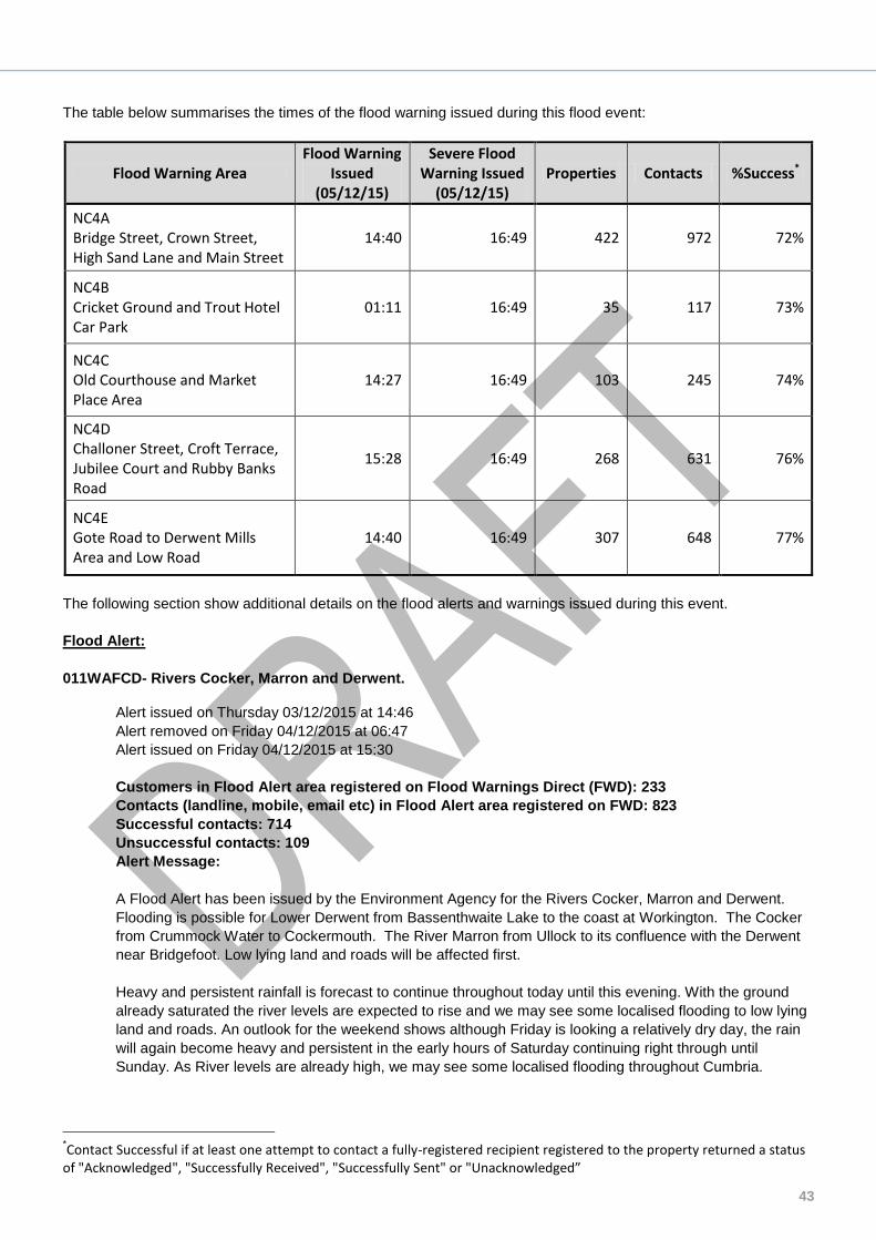
The table below summarises the times of the flood warning issued during this flood event:
Flood Warning Area Flood Warning
Issued (05/12/15)
Severe Flood Warning Issued
(05/12/15) Properties Contacts %Success*
NC4A Bridge Street, Crown Street, High Sand Lane and Main Street
14:40 16:49 422 972 72%
NC4B Cricket Ground and Trout Hotel Car Park
01:11 16:49 35 117 73%
NC4C Old Courthouse and Market Place Area
14:27 16:49 103 245 74%
NC4D Challoner Street, Croft Terrace, Jubilee Court and Rubby Banks Road
15:28 16:49 268 631 76%
NC4E Gote Road to Derwent Mills Area and Low Road
14:40 16:49 307 648 77%
The following section show additional details on the flood alerts and warnings issued during this event.
Flood Alert:
011WAFCD- Rivers Cocker, Marron and Derwent.
Alert issued on Thursday 03/12/2015 at 14:46
Alert removed on Friday 04/12/2015 at 06:47
Alert issued on Friday 04/12/2015 at 15:30
Customers in Flood Alert area registered on Flood Warnings Direct (FWD): 233
Contacts (landline, mobile, email etc) in Flood Alert area registered on FWD: 823
Successful contacts: 714
Unsuccessful contacts: 109
Alert Message:
A Flood Alert has been issued by the Environment Agency for the Rivers Cocker, Marron and Derwent.
Flooding is possible for Lower Derwent from Bassenthwaite Lake to the coast at Workington. The Cocker
from Crummock Water to Cockermouth. The River Marron from Ullock to its confluence with the Derwent
near Bridgefoot. Low lying land and roads will be affected first.
Heavy and persistent rainfall is forecast to continue throughout today until this evening. With the ground
already saturated the river levels are expected to rise and we may see some localised flooding to low lying
land and roads. An outlook for the weekend shows although Friday is looking a relatively dry day, the rain
will again become heavy and persistent in the early hours of Saturday continuing right through until
Sunday. As River levels are already high, we may see some localised flooding throughout Cumbria.
*Contact Successful if at least one attempt to contact a fully-registered recipient registered to the property returned a status
of "Acknowledged", "Successfully Received", "Successfully Sent" or "Unacknowledged”

Environment Agency Cumbria County Council
44
Flood Warning Target Areas:
011FWFNC4A- Rivers Cocker and Derwent at Cockermouth, Bridge St, Crown St, High Sand Lane and Main
St
Flood Warning issued on Saturday 05/12/2015 at 14:40
Severe Flood Warning issued on Saturday 05/12/2015 at 16:49
Severe Flood Warning downgraded to Flood Warning on Monday 07/12/2015 at 17:55
Flood Warning removed on Tuesday 08/12/2015 at 17:32
Date/Time Warning Level Reached: 05/12/2015 15:15
Time customers had to take action: 00:34:08
Customers in Flood Warning area registered on FWD: 422
Contacts (landline, mobile, email etc) in Flood Warning area registered on FWD: 972
Successful contacts: 696
Unsuccessful contacts: 276
Warning Message:
A Flood Warning has been issued by the Environment Agency for the Rivers Cocker and Derwent at
Cockermouth, Bridge St, Crown St, High Sand Lane and Main St.
Flooding is expected for Commercial and residential properties adjacent to the Rivers Cocker and Derwent
at Cockermouth, Brewery Lane, Bridge St, Crown Street, High Sand Lane, Main Street and Waterloo Street
area. Immediate action required.
011FWFNC4B- River Cocker and Derwent at Cockermouth, Cricket Ground and Trout Hotel Car Park
Flood Warning issued on Saturday 05/12/2015 at 01:11
Severe Flood Warning issued on Saturday 05/12/2015 at 16:49
Severe Flood Warning downgraded to Flood Warning on Monday 07/12/2015 at 17:55
Flood Warning removed on Tuesday 08/12/2015 at 17:32
Date/Time Warning Level Reached: 05/12/2015 06:15
Time customers had to take action: 05:03:45
Customers in Flood Warning area registered on FWD: 35
Contacts (landline, mobile, email etc) in Flood Warning area registered on FWD: 117
Successful contacts: 85
Unsuccessful contacts: 32
Warning Message:
A Flood Warning has been issued by the Environment Agency for the Rivers Cocker and Derwent at
Cockermouth, Cricket Ground and Trout Hotel Car Park.
Flooding is expected for Low Lying land and properties adjacent to the Rivers Cocker and Derwent at
Cockermouth. Immediate action required.
Heavy and persistent rainfall is expected from Friday night and throughout Saturday. River levels will
continue to rise and further Flood Warnings are likely. Please check for updates throughout the weekend.
Operational Teams have closed flood defences and are checking watercourses for blockages.
011FWFNC4C- River Cocker at Cockermouth, The Old Courthouse and Market Place Area
Flood Warning issued on Saturday 05/12/2015 at 14:27
Severe Flood Warning issued on Saturday 05/12/2015 at 16:49
Severe Flood Warning downgraded to Flood Warning on Monday 07/12/2015 at 17:42
Flood Warning removed on Tuesday 08/12/2015 at 17:32

45
Date/Time Warning Level Reached: 05/12/2015 15:15
Time customers had to take action: 00:47:25
Customers in Flood Warning area registered on FWD: 103
Contacts (landline, mobile, email etc) in Flood Warning area registered on FWD: 245
Successful contacts: 182
Unsuccessful contacts: 63
Warning Message:
A Flood Warning has been issued by the Environment Agency for the River Cocker at Cockermouth, The
Old Courthouse and Market Place Area.
Flooding is expected for Residential and commercial properties adjacent to the River Cocker at
Cockermouth. Immediate action required.
011FWFNC4D- River River Cocker at Cockermouth, Challoner Street, Croft Terrace, Jubilee Court and
Rubby Banks Road
Flood Warning issued on Saturday 05/12/2015 at 15:28
Severe Flood Warning issued on Saturday 05/12/2015 at 16:49
Severe Flood Warning downgraded to Flood Warning on Monday 07/12/2015 at 17:42
Flood Warning removed on Tuesday 08/12/2015 at 17:32
Date/Time Warning Level Reached: 05/12/2015 16:30
Time customers had to take action: 01:01:18
Customers in Flood Warning area registered on FWD: 268
Contacts (landline, mobile, email etc) in Flood Warning area registered on FWD: 631
Successful contacts: 482
Unsuccessful contacts: 149
Warning Message:
A Flood Warning has been issued by the Environment Agency for the River Cocker at Cockermouth,
Challoner St, Croft Terrace, Jubilee Court and Rubby Banks Rd.
Flooding is expected for Residential and commercial properties adjacent to the River Cocker at
Cockermouth, Challoner Street, Croft Terrace, Croftside, Jubilee Court, Rubby Banks Rd and South Street
Area. Immediate action required.
011FWFNC4E- River Derwent at Cockermouth, Gote Road to Derwent Mills Area and Low Road
Flood Warning issued on Saturday 05/12/2015 at 14:40
Severe Flood Warning issued on Saturday 05/12/2015 at 16:49
Severe Flood Warning downgraded to Flood Warning on Monday 07/12/2015 at 17:55
Flood Warning removed on Tuesday 08/12/2015 at 17:32
Date/Time Warning Level Reached: 05/12/2015 15:15
Time customers had to take action: 00:34:08
Customers in Flood Warning area registered on FWD: 307
Contacts (landline, mobile, email etc) in Flood Warning area registered on FWD: 648
Successful contacts: 498
Unsuccessful contacts: 150
Warning Message:
A Flood Warning has been issued by the Environment Agency for the River Derwent at Cockermouth, Gote
Road to Derwent Mills Area and Low Road.
Flooding is expected for Commercial and residential properties adjacent to the River Derwent at
Cockermouth, Gote Road, Riverside Terrace, Derwent Mills, Derwentside Gardens, Wakefield Road,
Market Place and Low Road Area. Immediate action required.
Environment Agency Cumbria County Council
46
Appendix 5: CH2M Hill UK Projects and Flood Risk
Management brochure

47
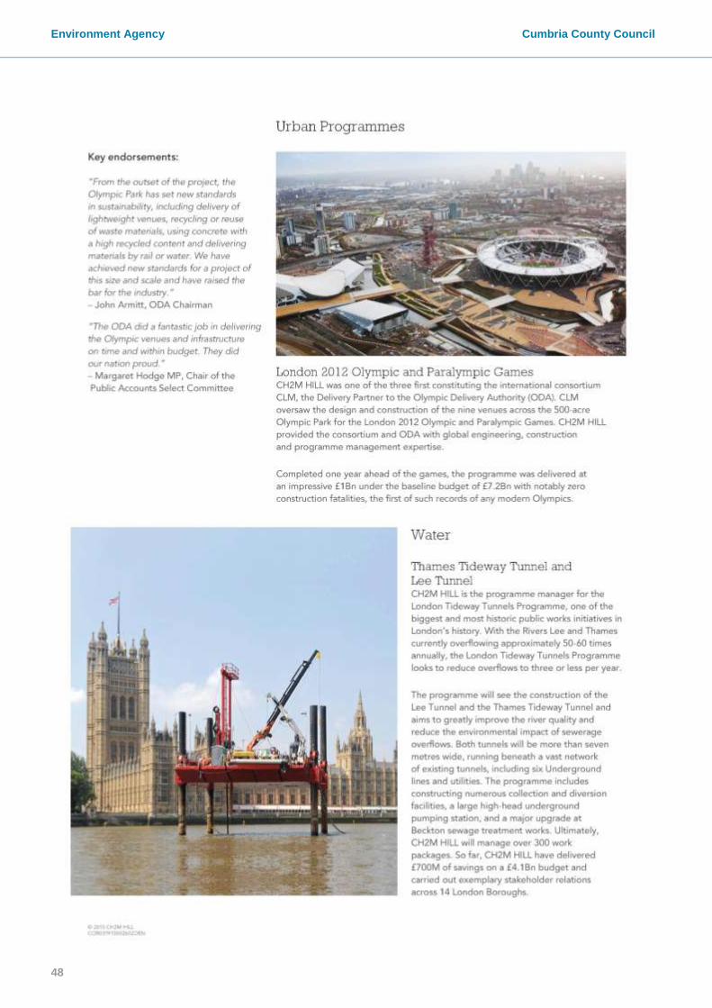
Environment Agency Cumbria County Council
48

49

Environment Agency Cumbria County Council
50