COBAR guide.pdf
120
Cobar Region: Explorers Guide CRCLEME L andscape E nvironments and M ineral E xploration Cooperative Research Centre for South Australia Northern Territory Queensland New South Wales Victoria Tasmania COBAR REGION Cobar A guide for mineral exploration through the regolith in the Cobar Region, Lachlan Orogen, New South Wales K.G. McQueen
Transcript of COBAR guide.pdf
Cobar Region: Explorers Guide �
CRCLEME
Landscape Environments
and Mineral Explorat ion
Cooperative Research Centre for
SouthAustralia
NorthernTerritory
Queensland
New South Wales
Victoria
Tasmania
COBAR REGIONCobar
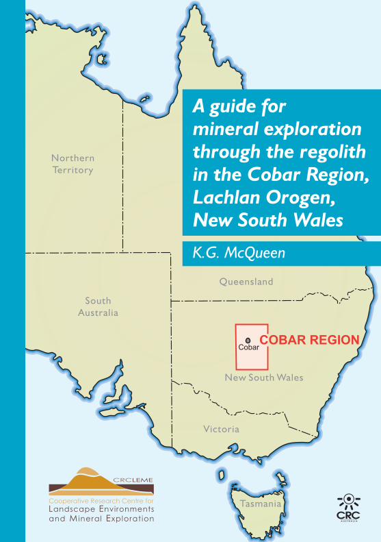
A guide for mineral exploration through the regolith in the Cobar Region,Lachlan Orogen,New South Wales
K.G. McQueen

Cobar Region: Explorers Guide��
Cobar Region: Explorers Guide ���
A GUIDE FOR MINERAL EXPLORATION THROUGH THE REGOLITH IN THE
COBAR REGION, LACHLAN OROGEN, NEW SOUTH WALES
K.G. McQueen
Cobar Region: Explorers Guide�v
© This publication is Copyright of the Cooperative Research Centre for Landscape Environments and Mineral Exploration, (2008), which resides with its Core Participants: CSIRO (Exploration & Mining and Land & Water), The Australian National University, Curtin University of Technology, The University of Adelaide, Geoscience Australia, Primary Industry and Resources SA, NSW Department of Primary Industries, and Minerals Council of Australia. Apart from any fair dealing for the purposes of private study, research, criticism or review, as permitted under Copyright Act, no part may be reproduced or reused by any process whatsoever, without prior written approval from the Core Participants mentioned above.
McQueen, K.G.
A guide for mineral exploration through the regolith in the Cobar Region, Lachlan Orogen, New South Wales.
1. Regolith. 2. Mineral exploration. 3. Geomorphology. 4. Geochemistry. 5. Geophysics.
ISBN No. 1 921039 85 X
DisclaimerThe user accepts all risks and responsibility for losses, damages, costs and other consequences resulting directly or indirectly from using any information or material contained in this publication. To the maximum permitted by law, CRC LEME excludes all liability to any person arising directly or indirectly from using any information or material contained in this publication.
CRC LEME EXPLORERS’ GUIDE SERIESObjective: This series is about the regolith; that cover of weathered material between fresh rock and fresh air that blankets much of Australia. More specifically it is about exploration for mineral deposits in regolith-dominated terrains. Mineral exploration is never easy. Of the thousands of prospects chosen for evaluation each year, only a very small percentage are deemed to be sufficiently prospective to justify follow-up work, and of these only a handful at best will go on to yield economic mineral deposits. Intelligent and informed exploration must increase the chances of success, and a greater understanding of regolith types, and regolith processes can only help to shorten the odds in favour of the explorer.
Series Editors: D. Garnett, G. Govett and L. Worrall.
Address and affiliation of author
K.G. McQueen
Cooperative Research Centre for Landscape Environments and Mineral Exploration
Australian National University
Canberra ACT 0200
Australia
Cobar Region: Explorers Guide v
CONTENTS
1. INTRODUCTION ....................................................................... 11.1 Purpose of the guide ..................................................................... 1
1.2 Location and physical setting ....................................................... 1
1.3 Geological framework and basement rocks ................................. 2
1.4 Ore deposit types and exploration targets ..................................... 6
2. THE REGOLITH .......................................................................... 112.1 Landscape history .......................................................................... 11
2.2 Regolith architecture ...................................................................... 14
2.3 Regolith materials .......................................................................... 19
In situ regolith.................................................................................. 19
Transported regolith ........................................................................ 20
Indurated regolith ............................................................................ 22
Lag materials ................................................................................... 23
2.4 Regolith minerals ........................................................................... 25
2.5 Regolith geochemistry ................................................................... 25
Element dispersion controls ........................................................... 28
Weathering regimes ........................................................................ 30
Examples of specific element dispersion features ......................... 32
Regolith element associations ........................................................ 35
Geochemical characterisation of regolith materials ....................... 36
Parent rock identification ............................................................... 37
Degree of weathering and leaching ................................................ 40
2.6 Geophysical character of the regolith ............................................ 41
Magnetic response .......................................................................... 41
Electrical properties ........................................................................ 41
Cobar Region: Explorers Guidev�
Gravity .................................................................................... 44
Seismic .................................................................................... 44
Radiometric response .............................................................. 44
Spectral remote sensing .......................................................... 45
2.7 Mapping the regolith .............................................................. 46
What are regolith-landform maps? ........................................... 46
3. EXPLORATION CHALLENGES AND STRATEGIES .... 543.1 Key questions ......................................................................... 54
3.2 Integrating regolith knowledge into exploration programs .... 56
3.3 Sample media, sampling strategies and techniques ............... 58
What to sample where? ........................................................... 58
Sample options ........................................................................ 61
Soils ......................................................................................... 61
Lag .......................................................................................... 61
Calcrete ................................................................................... 62
Saprolite .................................................................................. 63
Bedrock/saprock ..................................................................... 64
Gossans and ironstones ........................................................... 64
Drainage sediments ................................................................. 65
Groundwater ............................................................................ 66
Biota ........................................................................................ 68
3.4 Drilling ................................................................................... 90
3D interpretation of the regolith and drill hole sampling ........ 70
Things to look for and sample in drilling ................................ 71
Logging and interpretation ...................................................... 74
3.5 Analytical approach and methods .......................................... 78
Cobar Region: Explorers Guide v��
3.6 Quality assurance and quality control ......................................... 80
3.7 Identifying anomalies .................................................................. 81
3.8 Concluding comments ................................................................. 84
ACKNOWLEDGEMENTS ............................................................ 84
REFERENCES ................................................................................ 85
GLOSSARY ..................................................................................... 94
GUIDE SUMMARY AND KEY ..................................................... 98
APPENDICES on CDDigital copy of guide
Guide to illustrative sites
Regional 1:500 000 Cobar regolith-landform map
Sampling procedures: soils; lag; biota
Case studies for deposits in the Cobar region
Steps in regolith-landform mapping
Standard regolith-landform codes
Element symbols, atomic number and atomic weight
Identifying geochemical anomalies
List of CRC LEME reports, publications, theses and maps for the Cobar region.

Cobar Region: Explorers Guidev���
Cobar Region: Explorers Guide �
1. INTRODUCTION
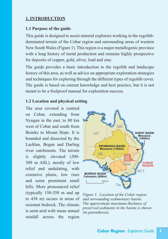
1.1 Purpose of the guideThis guide is designed to assist mineral explorers working in the regolith-dominated terrain of the Cobar region and surrounding areas of western New South Wales (Figure 1). This region is a major metallogenic province with a long history of metal production and remains highly prospective for deposits of copper, gold, silver, lead and zinc. The guide provides a basic introduction to the regolith and landscape history of this area, as well as advice on appropriate exploration strategies and techniques for exploring through the different types of regolith cover. The guide is based on current knowledge and best practice, but it is not meant to be a foolproof manual for exploration success.
1.2 Location and physical settingThe area covered is centred on Cobar, extending from Nyngan in the east, to 80 km west of Cobar and south from Bourke to Mount Hope. It is bounded and dissected by the Lachlan, Bogan and Darling river catchments. The terrain is slightly elevated (200-300 m ASL), mostly of low relief and undulating, with extensive plains, low rises and some prominent small hills. More pronounced relief (typically 150-350 m and up to 438 m) occurs in areas of resistant bedrock. The climate is semi-arid with mean annual rainfall across the region
Figure 1. Location of the Cobar region and surrounding sedimentary basins. The approximate maximum thickness of preserved sediments in the basins is shown (in parentheses).
KMf042-08MURRAY BASIN
Cainozoic (600m)
SURAT BASINMesozoic(1600m)
EROMANGA BASINMesozoic (1200m)
EA
ST
ER
N
HIG
HL
AN
DS
WA
SA
NSW
NT
Qld
Vic
Tas
ACT
COBARREGION
1000 km0
Cobar Region: Explorers Guide�
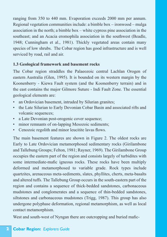
ranging from 350 to 440 mm. Evaporation exceeds 2000 mm per annum. Regional vegetation communities include: a bimble box – ironwood – mulga association in the north; a bimble box – white cypress pine association in the southeast; and an Acacia eromophila association in the southwest (Beadle, 1948; Cunningham et al., 1981). Thickly vegetated areas contain many species of low shrubs. The Cobar region has good infrastructure and is well serviced by road, rail and air.
1.3 Geological framework and basement rocksThe Cobar region straddles the Palaeozoic central Lachlan Orogen of eastern Australia (Glen, 1995). It is bounded on its western margin by the Koonenberry - Kiewa Fault system (and the Koonenberry terrain) and in the east contains the major Gilmore Suture - Indi Fault Zone. The essential geological elements are:• an Ordovician basement, intruded by Silurian granites; • the Late Silurian to Early Devonian Cobar Basin and associated rifts and volcanic sequences; • a Late Devonian post-orogenic cover sequence; • minor remnants of on-lapping Mesozoic sediments; • Cenozoic regolith and minor leucitite lavas flows.
The main basement features are shown in Figure 2. The oldest rocks are Early to Late Ordovician metamorphosed sedimentary rocks (Girilambone and Tallebung Groups; Felton, 1981; Rayner, 1969). The Girilambone Group occupies the eastern part of the region and consists largely of turbidites with some intermediate-mafic igneous rocks. These rocks have been multiply deformed and metamorphosed to variable grade. Rock types include quartzites, arenaceous meta-sediments, slates, phyllites, cherts, meta-basalts and altered tuffs. The Tallebung Group occurs in the south-eastern part of the region and contains a sequence of thick-bedded sandstones, carbonaceous mudstones and conglomerates and a sequence of thin-bedded sandstones, siltstones and carbonaceous mudstones (Trigg, 1987). This group has also undergone polyphase deformation, regional metamorphism, as well as local contact metamorphism.West and south-west of Nyngan there are outcropping and buried mafic-
Cobar Region: Explorers Guide �
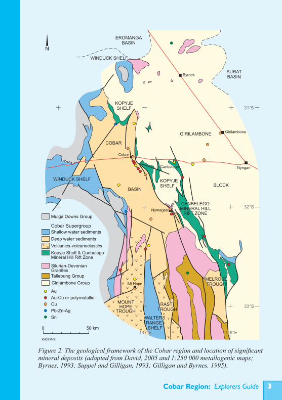
Figure 2. The geological framework of the Cobar region and location of significant mineral deposits (adapted from David, 2005 and 1:250 000 metallogenic maps; Byrnes, 1993; Suppel and Gilligan, 1993; Gilligan and Byrnes, 1995).
Cobar Region: Explorers Guide�
ultramafic bodies (e.g. Rosedale, West Lynn, Honeybugle, Gilgai, Hermitage Plains). These consist of pyroxenites, gabbros and serpentinised rocks that can be grouped with the Alaskan-type zoned intrusions of the Fifield area (e.g. Owendale and Tout complexes). They are considered Early Silurian in age and linked to subduction of an older basaltic back-arc basin (Barron et al., 2004). The Ordovician basement has been intruded by an array of dominantly S-type, Silurian granite plutons. These are particularly extensive in the south-eastern part of the region. They include the Nymagee Igneous Complex (north-east of Nymagee), the small Tinderra, Wilgaroon and Wild Wave granite bodies (north-east and east of Cobar), the larger Erimeran Granite, Derrida Granite and Urambie Granodiorite batholiths and plutons (in the south) and the fault-bounded Thule Granite (near the south-west margin of the Cobar Basin). Most of these granites are muscovite-, and in some cases cordierite-bearing, with some pegmatitic, aplitic and microgranite phases. There are also minor hornblende- and biotite-bearing granodiorites. Small I-type granite intrusions of Siluro-Devonian age occur in the Byrock area. These outcrop poorly and are mostly highly felsic (Blevin and Jones, 2004a; 2004b). Swarms of Silurian-Devonian gabbroic dykes intrude some basement areas (e.g, in the Erimeran Granite and north of Girilambone). The dominant geological feature of the region is the Cobar Basin, which formed in the Late Silurian to Early Devonian as a back-arc, intracratonic basin with deep-water troughs and flanking shallow-water shelves (these include the Cobar Supergroup; Glen et al., 1996). This basin was inverted and structurally deformed in the late Early Devonian, with a second deformation in the Mid-Carboniferous (Glen, 1992; Scheibner and Basden, 1998). Initial deformation resulted in NW-trending folds, development of a regional N-S cleavage and eastwards thrusting. Further deformation produced overprinting NE-trending folds and left lateral faulting. The main rock units include cleaved and weakly metamorphosed (to greenschist facies) trough sediments deposited during initial basin rifting (Nurri, Mouramba and Lower Amphitheatre groups) and subsequent sag-phase development of the basin (Biddabirra Formation and Upper Amphitheatre Group). These generally deep marine units consist of various turbiditic sandstones, siltstones and
Cobar Region: Explorers Guide �
mudstones (or slates) with some basal, matrix supported conglomerates, local felsic volcanic rocks and minor limestones. The shelf sediments (Kopyje, Winduck and Walters Range groups) consist of shallow-water siliclastic sediments, limestones and volcanoclastic sediments. South of the Cobar Basin are the parallel Mount Hope and Rast Troughs, which represent narrow volcano-tectonic rifts (Scheibner, 1987; Trigg, 1987). These contain Early Devonian subaerial and submarine bimodal volcanic rocks, high-energy turbidites some shallow water sediments and intrusive felsic porphyries and dykes (Mt Hope Group and Rast Group).East of the Cobar Basin is the related Canbelego-Mineral Hill rift zone, which contains siliclastic sediments, volcanoclastics and felsic volcanic rocks (Baledmund Formation, Florida, Babinda and Majumba Volcanics; Felton, 1981; Pogson, 1991). To the south these grade into deeper water sediments of the Melrose Trough. A Late Devonian sequence of dominantly fluviatile conglomerates, sandstones siltstones and shales (Mulga Downs Group; Glen, 1987) overlies the Winduck Shelf to the north-west and south-west of the Cobar Basin. The thick-bedded, coarser grained sandstones and conglomerates of the Mulga Downs Group generally show well developed cross bedding and sharp erosional channel bases. The conglomerates typically contain abundant, well-rounded and well-sorted pebbles of white vein quartz and quartzites. This sequence marks the transition from a dominantly marine to emergent (terrestrial fluviatile) environment. Small remnants of possible Jurassic and Cretaceous river and lake sediments occur across the region. Extensive shallow marine sediments of the Cretaceous Eromanga and Surat basins overly Palaeozoic rocks to the north and north-east. Cenozoic deposits are widespread and include clays, sands and gravels infilling palaeochannels, and alluvial/colluvial deposits forming fans and depositional plains. North-east of Cobar, near El Capitan and Byrock, there are remnants of Early Miocene leucitite lava flows. Soils are mainly massive red earths grading to brown and grey soils towards the south (Walker, 1978). They are commonly calcareous and
Cobar Region: Explorers Guide�
contain significant wind blown dust. Sheetwash and wind erosion have removed up to 0.5 m of the soil profile since European settlement.
1.4 Ore deposit types and exploration targetsThe Cobar region is a major metallogenic province for hydrothermal copper, gold and lead-zinc-silver mineralisation. Major deposits are largely epigenetic-hydrothermal or volcanogenic in origin. Other potential deposit types include palaeochannel placer deposits (PGE, gold, tin, iron), residual deposits (nickel, PGE, scandium, REE), clays, refractories, limestone and construction materials (Table 1). Known mineral deposits are compiled on the Bourke, Cobar and Nymagee 1:250 000 metallogenic maps and documented in the accompanying notes (Byrnes, 1993; Suppel and Gilligan, 1993; Gilligan and Byrnes, 1995).Ore deposits in the Cobar Basin represent a continuum from high temperature (possibly deeper formed), structurally controlled, hydrothermal systems in high strain zones to lower temperature, stratigraphically controlled (stratabound) systems, with related feeder veins and stockworks. The high temperature systems have a multi-stage paragenesis with different metal associations for the different stages. This has resulted in separate gold-, copper- and zinc-lead rich deposits or zones of different metal combinations at some deposits. Examples include the C.S.A., Great Cobar, New Cobar (Figure 3), Chesney, New Occidental, the Peak, Perseverance, Nymagee and Hera deposits. The stratabound deposits and vein stockworks have some similarities to Mississippi Valley type and epithermal deposits respectively. Examples are the Wonawinta and Gundaroo zinc-lead-silver prospects and the McKinnons gold deposit (Figure 4). The Elura lead-zinc-silver deposit is an example of a system somewhere between the main end members. The typical Cobar-style deposits of the eastern Cobar Basin consist of multiple lenses in steeply plunging, pipe-like clusters. They are localised along major shear and thrust fault systems at dilation sites, particularly in zones of juxtaposed rocks with contrasting competency (Glen, 1995; Stegman, 2001). The deposits have great depth extension but a small surface footprint and are very small surface targets (typical strike lengths 250-300 m). Their polymetallic composition favours a multi-element approach to geochemical
Cobar Region: Explorers Guide �
exploration and some have been found from their magnetic signatures. The stratabound systems are broader targets, but do not have magnetic signatures. Small gold-bearing, hydrothermal quartz vein deposits also occur in Early Devonian meta-sedimentary rocks within the Cobar Basin (e.g. at Mount Drysdale and Gilgunnia). The volcanic dominated sequences of the Canbelego-Mineral Hill rift zone and the Mount Hope trough contain volcanic-associated massive sulphide (VMS) deposits, hydrothermal replacement deposits and small hydrothermal veins. Examples of volcanic-associated deposits include those at Mineral Hill, the Pipeline Ridge prospect, south of Canbelego and other small base metal sulphide deposits associated with the Florida Volcanics at Canbelego. The Shuttleton and Mt Hope copper deposits may also be volcanic-associated systems (David, 2005). The Mount Boppy gold deposit, developed in faulted and brecciated meta-sedimentary rocks at Canbelego, is a hydrothermal replacement deposit with epithermal characteristics. The Ordovician basement sequences contain a range of deposit types. The most important are pyritic copper-rich sulphide deposits in the Girilambone Group, developed between Girilambone and Hermidale (e.g. Murrawombie, Tritton, Budgerygar and Budgery deposits). These deposits have been described as volcanogenic in origin (Besshi-type, David, 2005) although they clearly have a strong structural control or overprint and similarities to the Cobar-style epigenetic hydrothermal deposits. Small quartz-vein gold deposits occur in the Girilambone Group (e.g. Muriel Tank and Restdown goldfields). These are structurally controlled, slate-hosted mesothermal deposits. At Mount Dijou and Bald Hills in the far north of the region, mafic volcanic rocks of possible Ordovician age host small vein and lode-style gold deposits. Tin-bearing quartz veins occur in the Tallebung Group and associated S-type granite intrusions near Tallebung. Intrusion-related deposits occur in association with the various granites of the region. These include skarn deposits, such as the copper-tin mineralisation at Doradilla, and minor mineralisation around a sub-
Cobar Region: Explorers Guide�
cropping granite body at the Beanbah prospect north-east of Cobar. Drilling has intersected disseminated base metal sulphide mineralisation associated with granitic rocks at the Sandy Creek prospect, south of Cobar (David and Glen, 2004).Placer deposits have generally been neglected as potential exploration targets in the Cobar region. Minor alluvial gold has been worked in the upper parts of Whitbarrow Creek, north of Nymagee and on the eastern side of Mt Drysdale. Alluvial tin was worked in the Tallebung tin field and alluvial gold and platinum (20,000 ozs) were extracted from deep lead palaeochannel sediments eroded from primary mineralisation in the Alaskan-type ultramafic-
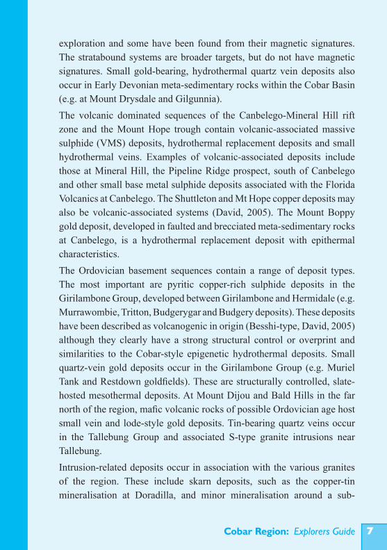
Figure 3. Open pit, New Cobar gold-copper deposit (view NW). This is a Cobar-style deposit hosted by siltstones-sandstones of the Great Cobar Slate. It is structurally controlled and localised in a NNW-trending shear zone with associated ‘pebble’ shears. The top five benches are in oxidised and leached saprolite showing strong ferruginisation, particularly along fractures. The lower section is weakly oxidised saprock. Major quartz vein (centre, near old workings) post-dates the main mineralisation..
Cobar Region: Explorers Guide �
mafic intrusions at Fifield, south-east of the region (Johan et al., 1989).Residual deposits formed by intense weathering of mafic-ultramafic intrusions are potential exploration targets, particularly in areas under cover. There has been exploration for residual nickel, PGE and scandium mineralisation in the eastern portion of the region and to the south. There is some potential for kaolinite deposits and refractories (e.g, silcrete), in weathering profiles and palaeo-lake deposits. Leucitite is currently being quarried for road aggregate near Byrock and small limestone bodies have been worked in the past.
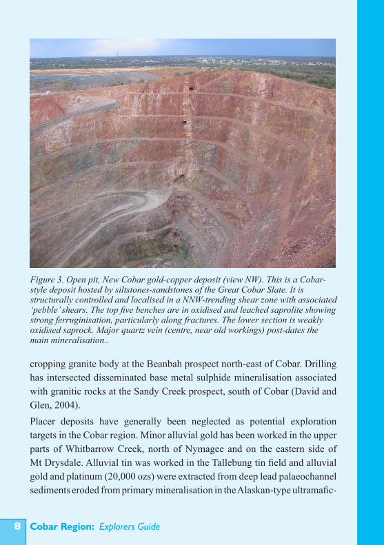
Figure 4. Open pit, McKinnons gold deposit (view NW). This is a pyritic quartz-vein stockwork system, exploited in the oxidised, supergene gold-enriched zone. Pit walls expose bleached saprolite with minor near surface ferruginisation and deeper ferruginisation along faults/shears and bedding planes near weathered mineralisation. Primary pyrite is exposed in the lower left part of the pit. The deposit shows primary silicic and sericitic wallrock alteration and weathering-related alteration of sericite to illite.
Cobar Region: Explorers Guide�0
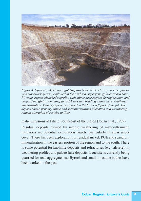
Table 1. Potential exploration targets in the Cobar region.
Cobar Region: Explorers Guide ��
2. THE REGOLITH
2.1 Landscape historyThe Cobar region forms an elevated upland surrounded by the Eromanga, Surat and Murray basins (Figure 1). Much of the bedrock has been exposed since at least the Mesozoic (>65 Ma) and during this time subjected to weathering and erosion under a wide range of climatic conditions. Erosion and deposition have been partly controlled by events in the surrounding basins, particularly basin initiation and changes in base level. Bedrock lithology and structure have also strongly influenced landform development.During the Mesozoic, the region was a dominantly terrestrial environment, marginal to the Eromanga-Surat Basin, as indicated by remnants of Jurassic to Early Cenozoic river, lake and shallow marine sediments still preserved at various elevations in the landscape. Ongoing weathering, erosion and deposition through the Cenozoic produced the extensive regolith, including transported sediments in palaeochannel systems (up to 80 m deep), colluvial fans, colluvial/alluvial plains and modern drainages. Much of this cover buries a palaeo-landscape, more deeply incised than the present landscape. The drainage evolution provides a key to the landscape history. Flow directions have responded to formation of the Eromanga and Murray Basins, sea level changes and minor tectonism. In the Mesozoic, the Cobar landscape appears to have been a generally low relief, deeply weathered plain, sloping gently to the north (Gibson, 1999). Predominantly north-flowing drainage in the Mesozoic was partly changed to south-westerly and westerly drainage during the Cenozoic. In the western part of the region there is evidence of more recent drainage disruption (around and to the south of Lake Barnato). Here, south-west draining streams were diverted to the west through the range at Mount Gap and also into the present Sandy Creek system. This suggests northward tilting of this area, probably in the later Cenozoic (Duk-Rodkin et al., 2004). To the south, drainage was influenced by incision of the Lachlan River from the Late Cretaceous. This resulted in higher rates of erosion and more
Cobar Region: Explorers Guide��
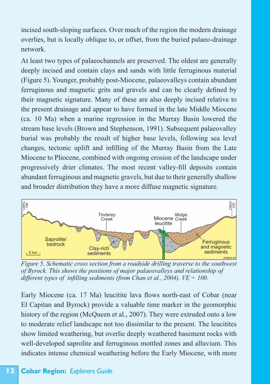
incised south-sloping surfaces. Over much of the region the modern drainage overlies, but is locally oblique to, or offset, from the buried palaeo-drainage network. At least two types of palaeochannels are preserved. The oldest are generally deeply incised and contain clays and sands with little ferruginous material (Figure 5). Younger, probably post-Miocene, palaeovalleys contain abundant ferruginous and magnetic grits and gravels and can be clearly defined by their magnetic signature. Many of these are also deeply incised relative to the present drainage and appear to have formed in the late Middle Miocene (ca. 10 Ma) when a marine regression in the Murray Basin lowered the stream base levels (Brown and Stephenson, 1991). Subsequent palaeovalley burial was probably the result of higher base levels, following sea level changes, tectonic uplift and infilling of the Murray Basin from the Late Miocene to Pliocene, combined with ongoing erosion of the landscape under progressively drier climates. The most recent valley-fill deposits contain abundant ferruginous and magnetic gravels, but due to their generally shallow and broader distribution they have a more diffuse magnetic signature.
Early Miocene (ca. 17 Ma) leucitite lava flows north-east of Cobar (near El Capitan and Byrock) provide a valuable time marker in the geomorphic history of the region (McQueen et al., 2007). They were extruded onto a low to moderate relief landscape not too dissimilar to the present. The leucitites show limited weathering, but overlie deeply weathered basement rocks with well-developed saprolite and ferruginous mottled zones and alluvium. This indicates intense chemical weathering before the Early Miocene, with more
Figure 5. Schematic cross section from a roadside drilling traverse to the southwest of Byrock. This shows the positions of major palaeovalleys and relationship of different types of infilling sediments (from Chan et al., 2004). VE = 100.
5 km
Ferruginousand magnetic
sediments
MulgaCreek
TindareyCreek
CB
AC
18
8
CB
AC
24
5
Saprolite/bedrock
Clay-richsediments
Mioceneleucitite
KMQf044-08
Cobar Region: Explorers Guide ��
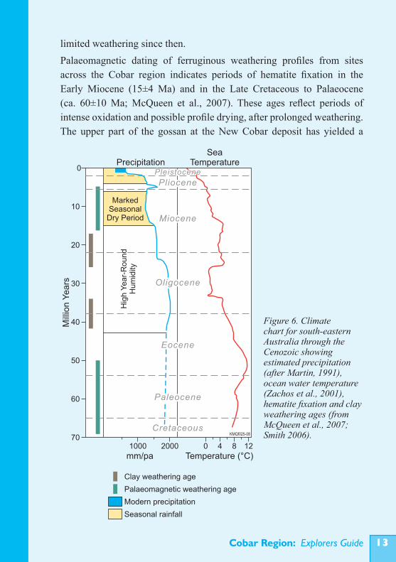
limited weathering since then. Palaeomagnetic dating of ferruginous weathering profiles from sites across the Cobar region indicates periods of hematite fixation in the Early Miocene (15±4 Ma) and in the Late Cretaceous to Palaeocene (ca. 60±10 Ma; McQueen et al., 2007). These ages reflect periods of intense oxidation and possible profile drying, after prolonged weathering. The upper part of the gossan at the New Cobar deposit has yielded a
Figure 6. Climate chart for south-eastern Australia through the Cenozoic showing estimated precipitation (after Martin, 1991), ocean water temperature (Zachos et al., 2001), hematite fixation and clay weathering ages (from McQueen et al., 2007; Smith 2006).
Cobar Region: Explorers Guide��
Jurassic palaeomagnetic age (ca. 180 Ma; McQueen et al., 2002) and dating of manganese oxide coatings (Ar-Ar method on cryptomelane) indicates precipitation of these in the Miocene (ca. 16±0.5 Ma). Oxygen isotope ratios for kaolinite in several thick clay profiles are consistent with deep weathering in the Late Cretaceous and at one site post Eocene (Smith, 2006). This geochronological framework for various regolith materials is consistent with likely weathering regimes for climatic conditions through the Cenozoic (Figure 6). Conditions were warm and humid from the Late Cretaceous to the end of the Early Miocene, with fluctuations to at least two cooler-drier episodes prior to the Oligocene (McGowran and Li, 1997). The climate then became generally cooler, drier and more seasonal through the later Cenozoic, but with a significant short warmer and wetter period in the Late Miocene (Martin, 1991). The different weathering conditions significantly affected geochemical dispersion processes through the Cenozoic.The landscape has evolved in response to weathering, erosion and deposition at rates controlled by climate and base level fluctuations, bedrock variability and to a lesser degree tectonic activity (Spry, 2003). Many surficial materials have been inverted in the landscape and recycled through the changing landscape levels. Valley incision and elevations of dated surfaces indicate relatively low average, regional erosion rates since the Cretaceous (probably <0.5-1 m/Ma).Many of the outcropping ore deposits in erosional parts of the landscape have been more resistant to erosion than the surrounding rocks and form hills or low rises (e.g. Mount Drysdale, CSA, New Cobar, New Occidental, Peak deposits). This is due to hardening by a combination of primary silicification associated with mineralisation, secondary ferruginisation related to weathering of iron-rich sulphides, oxidation and precipitation of hematite, as well as some secondary silicification due to dissolution and re-precipitation of silica under acid conditions around the weathering sulphides.
2.2 Regolith architectureThe three-dimensional distribution of the regolith in the Cobar region has been broadly established by surface mapping, interpretation of radiometric and aeromagnetic data, observation of exposed profiles and drilling (Gibson,
Cobar Region: Explorers Guide ��
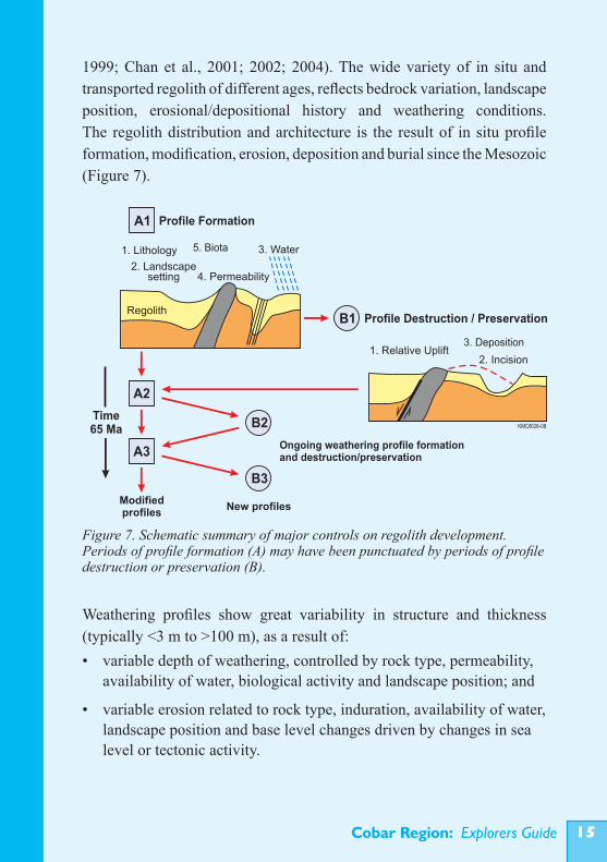
1999; Chan et al., 2001; 2002; 2004). The wide variety of in situ and transported regolith of different ages, reflects bedrock variation, landscape position, erosional/depositional history and weathering conditions. The regolith distribution and architecture is the result of in situ profile formation, modification, erosion, deposition and burial since the Mesozoic (Figure 7).
Weathering profiles show great variability in structure and thickness (typically <3 m to >100 m), as a result of:• variable depth of weathering, controlled by rock type, permeability, availability of water, biological activity and landscape position; and
• variable erosion related to rock type, induration, availability of water, landscape position and base level changes driven by changes in sea level or tectonic activity.
Figure 7. Schematic summary of major controls on regolith development. Periods of profile formation (A) may have been punctuated by periods of profile destruction or preservation (B).
Modifiedprofiles
New profiles
1. Lithology
2. Landscape setting 4. Permeability
3. Water
Regolith
1. Relative Uplift2. Incision
KMQf026-08
Profile Formation
Profile Destruction / Preservation
A1
B1
A2
B2
B3
Ongoing weathering profile formationand destruction/preservation
3. Deposition
Time65 Ma
5. Biota
A3
Cobar Region: Explorers Guide��
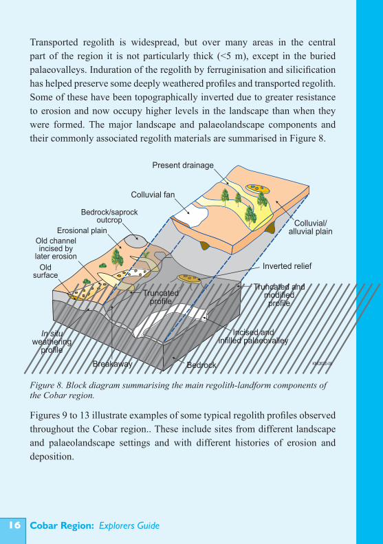
Transported regolith is widespread, but over many areas in the central part of the region it is not particularly thick (<5 m), except in the buried palaeovalleys. Induration of the regolith by ferruginisation and silicification has helped preserve some deeply weathered profiles and transported regolith. Some of these have been topographically inverted due to greater resistance to erosion and now occupy higher levels in the landscape than when they were formed. The major landscape and palaeolandscape components and their commonly associated regolith materials are summarised in Figure 8.
Figures 9 to 13 illustrate examples of some typical regolith profiles observed throughout the Cobar region.. These include sites from different landscape and palaeolandscape settings and with different histories of erosion and deposition.
Figure 8. Block diagram summarising the main regolith-landform components of the Cobar region.
Old channelincised by
later erosion
Bedrock/saprockoutcrop
Oldsurface
In situweathering
profile
Breakaway Bedrock
Truncated andmodifiedprofile
Truncatedprofile
Incised and infilled palaeovalley
Colluvial fan
Colluvial/alluvial plain
Present drainage
Inverted relief
KMQf020-08
Erosional plain
Cobar Region: Explorers Guide ��
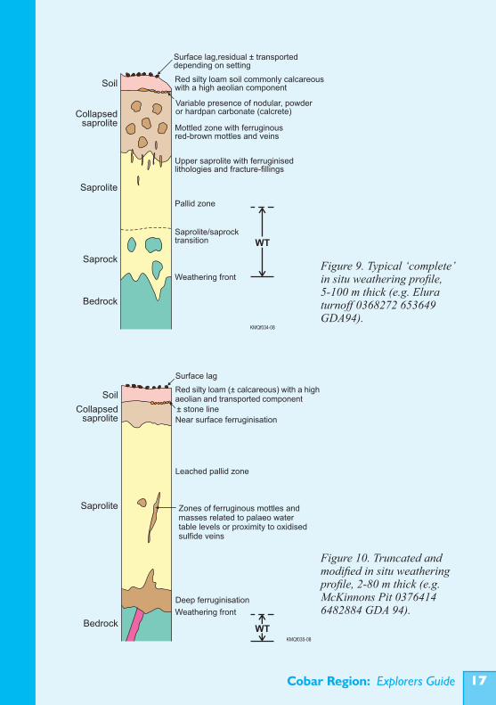
Figure 9. Typical ‘complete’ in situ weathering profile, 5-100 m thick (e.g. Elura turnoff 0368272 653649 GDA94).
Figure 10. Truncated and modified in situ weathering profile, 2-80 m thick (e.g. McKinnons Pit 0376414 6482884 GDA 94).
Soil
Collapsedsaprolite
Saprolite
Saprock
Bedrock
Surface lag,residual ± transported depending on setting
Red silty loam soil commonly calcareous with a high aeolian component
Variable presence of nodular, powder or hardpan carbonate (calcrete)
Mottled zone with ferruginous red-brown mottles and veins
Upper saprolite with ferruginised lithologies and fracture-fillings
Pallid zone
Saprolite/saprocktransition
Weathering front
WT
KMQf034-08
KMQf035-08
Soil
Collapsedsaprolite
Saprolite
Bedrock
Surface lag
Red silty loam ( calcareous) with a highaeolian and transported component
±
± stone line
Near surface ferruginisation
Leached pallid zone
Zones of ferruginous mottles and masses related to palaeo water table levels or proximity to oxidised sulfide veins
Deep ferruginisation
WT
Weathering front
Cobar Region: Explorers Guide��
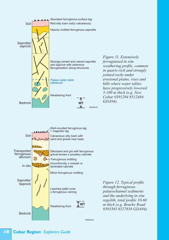
Figure 12. Typical profile through ferruginous palaeochannel sediments and the underlying in situ regolith, total profile 10-60 m thick (e.g. Bourke Road 0393383 6527838 GDA94).
Figure 11. Extensively ferruginised in situ weathering profile, common in quartz-rich and strongly jointed rocks under erosional plains, rises and hills where water tables have progressively lowered 5-100 m thick (e.g. New Cobar 0391294 6512484 GDA94).
Soil
Saprolite/saprock
Bedrock
Abundant ferruginous surface lag
Red silty loam soil(± calcareous)
Heavily mottled ferruginous saprolite
Strongly jointed and veined saprolite and saprock with extensive ferruginisation along structures
Palaeo water table stillstands
Weathering front
KMQf036-08
WT
Bedrock
Well-rounded ferruginous lag+ magnetic lag
Weathering front
KMQf046-08
Saprolite/Saprock
In situ
Transportedferruginous
alluvium
Soil
Leached pallid zone ± ferruginous veining
Minor ferruginous mottling
Ferruginous mottling
Silts/sand and grit with gravel lenses ± powdery calcrete
ferruginous
Calcareous silty loam with sand and gravel near base
Unconformity ± nodular or laminated calcrete
WT
Cobar Region: Explorers Guide ��
2.3 Regolith materialsFor mineral exploration purposes the regolith can be divided into four types of material:• in situ regolith; • transported regolith; • indurated regolith; • lag materials.
These materials are a mixture of rock-derived, extraneous (e.g. introduced salts) and biogenic components They may have previously existed as other types of regolith (e.g. indurated lag).
In situ regolithIn situ regolith can be subdivided according to landform setting and degree of weathering. Well-developed, weathering profiles show a progression from fresh rock, to saprock to saprolite reflecting increasing alteration of the weatherable minerals (minor, <20% and >20% respectively). This progression is usually vertical, but may be uneven with less altered
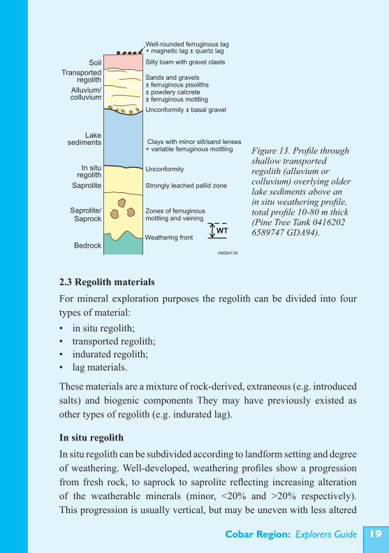
Figure 13. Profile through shallow transported regolith (alluvium or colluvium) overlying older lake sediments above an in situ weathering profile, total profile 10-80 m thick (Pine Tree Tank 0416202 6589747 GDA94).
Soil
Lakesediments
Alluvium/colluvium
Transportedregolith
Saprolite/Saprock
Bedrock
Well-rounded ferruginous lag+ magnetic lag ± quartz lag
Weathering front
Strongly leached pallid zone
WT
KMQf047-08
In situregolith
Saprolite
Silty loam with gravel clasts
Sands and gravels± ferruginous pisoliths ± powdery calcrete± ferruginous mottling
Zones of ferruginous mottling and veining
Unconformity ± basal gravel
Unconformity
Clays with minor silt/sand lenses+ variable ferruginous mottling
Cobar Region: Explorers Guide�0
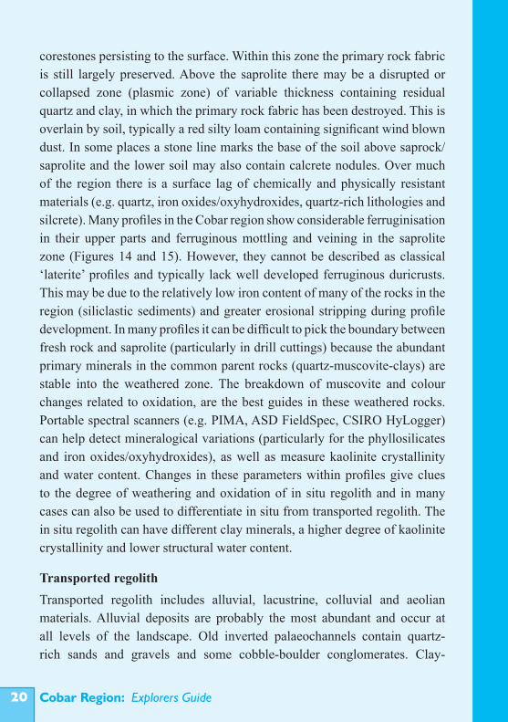
corestones persisting to the surface. Within this zone the primary rock fabric is still largely preserved. Above the saprolite there may be a disrupted or collapsed zone (plasmic zone) of variable thickness containing residual quartz and clay, in which the primary rock fabric has been destroyed. This is overlain by soil, typically a red silty loam containing significant wind blown dust. In some places a stone line marks the base of the soil above saprock/saprolite and the lower soil may also contain calcrete nodules. Over much of the region there is a surface lag of chemically and physically resistant materials (e.g. quartz, iron oxides/oxyhydroxides, quartz-rich lithologies and silcrete). Many profiles in the Cobar region show considerable ferruginisation in their upper parts and ferruginous mottling and veining in the saprolite zone (Figures 14 and 15). However, they cannot be described as classical ‘laterite’ profiles and typically lack well developed ferruginous duricrusts. This may be due to the relatively low iron content of many of the rocks in the region (siliclastic sediments) and greater erosional stripping during profile development. In many profiles it can be difficult to pick the boundary between fresh rock and saprolite (particularly in drill cuttings) because the abundant primary minerals in the common parent rocks (quartz-muscovite-clays) are stable into the weathered zone. The breakdown of muscovite and colour changes related to oxidation, are the best guides in these weathered rocks. Portable spectral scanners (e.g. PIMA, ASD FieldSpec, CSIRO HyLogger) can help detect mineralogical variations (particularly for the phyllosilicates and iron oxides/oxyhydroxides), as well as measure kaolinite crystallinity and water content. Changes in these parameters within profiles give clues to the degree of weathering and oxidation of in situ regolith and in many cases can also be used to differentiate in situ from transported regolith. The in situ regolith can have different clay minerals, a higher degree of kaolinite crystallinity and lower structural water content.
Transported regolithTransported regolith includes alluvial, lacustrine, colluvial and aeolian materials. Alluvial deposits are probably the most abundant and occur at all levels of the landscape. Old inverted palaeochannels contain quartz-rich sands and gravels and some cobble-boulder conglomerates. Clay-
Cobar Region: Explorers Guide ��
Figure 14. Upper part of typical weathering profile in the Cobar region, showing surface lag, red silty loam soil, surface ferruginous zone and underlying saprolite with ferruginous concentrations along joints, bedding planes and in porous rock units (borrow pit west of Louth road, 30 km northwest of Cobar).
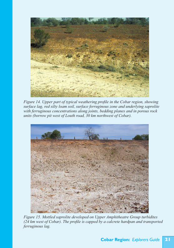
Figure 15. Mottled saprolite developed on Upper Amphitheatre Group turbidites (24 km west of Cobar). The profile is capped by a calcrete hardpan and transported ferruginous lag.
Cobar Region: Explorers Guide��
rich sediments with sand and minor gravel lenses occur in the deeply incised palaeochannels that developed through the Cenozoic. Some of the palaeochannel sediments also contain ferruginous pisoliths. Sandy loams (largely moved by sheetwash from recent soil and aeolian deposits) with minor channel gravels dominate the currently active alluvial systems. Clays, silts and fine sands are common in alluvial swamp and lake deposits that developed as a result of drainage disruptions. Thick clay sequences are also preserved in older lake and palaeochannel systems adjacent to the on-lapping Eromanga Basin in the north of the region. Colluvium is widespread in thin, bedrock-masking deposits on depositional plains, slopes and rises and less commonly in fans adjacent to range-fronts and higher relief landforms. The colluvium is generally dominated by lithic and vein quartz clasts in a silty to fine-sand matrix. Clasts are typically coarse and angular on upper slopes and decrease in grainsize downslope. Aeolian silt and clay are significant components in the red silty-loam soils of the region. Well-rounded and sorted sands and silts occur in stabilised longitudinal dunes on the western edge of the area and in some source-bordering dunes adjacent to lakes and the modern drainage system.
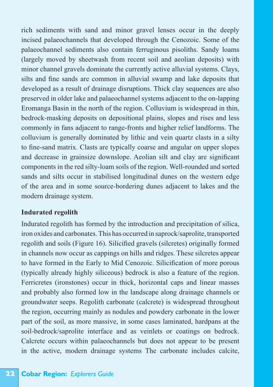
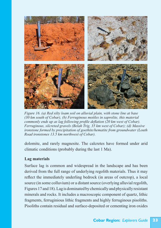
Indurated regolithIndurated regolith has formed by the introduction and precipitation of silica, iron oxides and carbonates. This has occurred in saprock/saprolite, transported regolith and soils (Figure 16). Silicified gravels (silcretes) originally formed in channels now occur as cappings on hills and ridges. These silcretes appear to have formed in the Early to Mid Cenozoic. Silicification of more porous (typically already highly siliceous) bedrock is also a feature of the region. Ferricretes (ironstones) occur in thick, horizontal caps and linear masses and probably also formed low in the landscape along drainage channels or groundwater seeps. Regolith carbonate (calcrete) is widespread throughout the region, occurring mainly as nodules and powdery carbonate in the lower part of the soil, as more massive, in some cases laminated, hardpans at the soil-bedrock/saprolite interface and as veinlets or coatings on bedrock. Calcrete occurs within palaeochannels but does not appear to be present in the active, modern drainage systems The carbonate includes calcite,
Cobar Region: Explorers Guide ��
dolomite, and rarely magnesite. The calcretes have formed under arid climatic conditions (probably during the last 1 Ma).
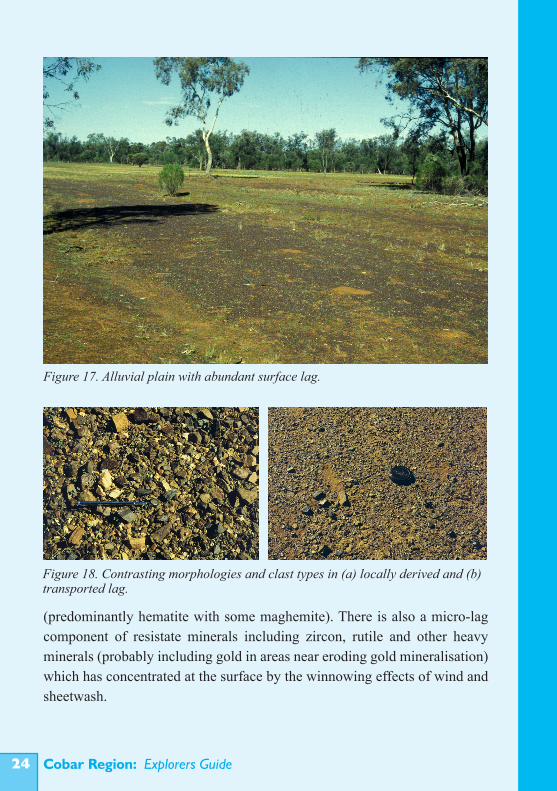
Lag materialsSurface lag is common and widespread in the landscape and has been derived from the full range of underlying regolith materials. Thus it may reflect the immediately underling bedrock (in areas of outcrop), a local source (in some colluvium) or a distant source (overlying alluvial regolith, Figures 17 and 18). Lag is dominated by chemically and physically resistant minerals and rocks. It includes a macroscopic component of quartz, lithic fragments, ferruginious lithic fragments and highly ferruginous pisoliths. Pisoliths contain residual and surface-deposited or cementing iron oxides
Figure 16. (a) Red silty loam soil on alluvial plain, with stone line at base (30 km south of Cobar), (b) Ferruginous mottles in saprolite, this material commonly ends up as lag following profile deflation (20 km west of Cobar). Ferruginous, silcreted gravels (Belah Trig, 35 km west of Cobar); (d) Massive ironstone formed by precipitation of goethite/hematite from groundwater (Louth Road ironstones 13.5 km northwest of Cobar).
Cobar Region: Explorers Guide��
(predominantly hematite with some maghemite). There is also a micro-lag component of resistate minerals including zircon, rutile and other heavy minerals (probably including gold in areas near eroding gold mineralisation) which has concentrated at the surface by the winnowing effects of wind and sheetwash.
Figure 17. Alluvial plain with abundant surface lag.
Figure 18. Contrasting morphologies and clast types in (a) locally derived and (b) transported lag.
Cobar Region: Explorers Guide ��
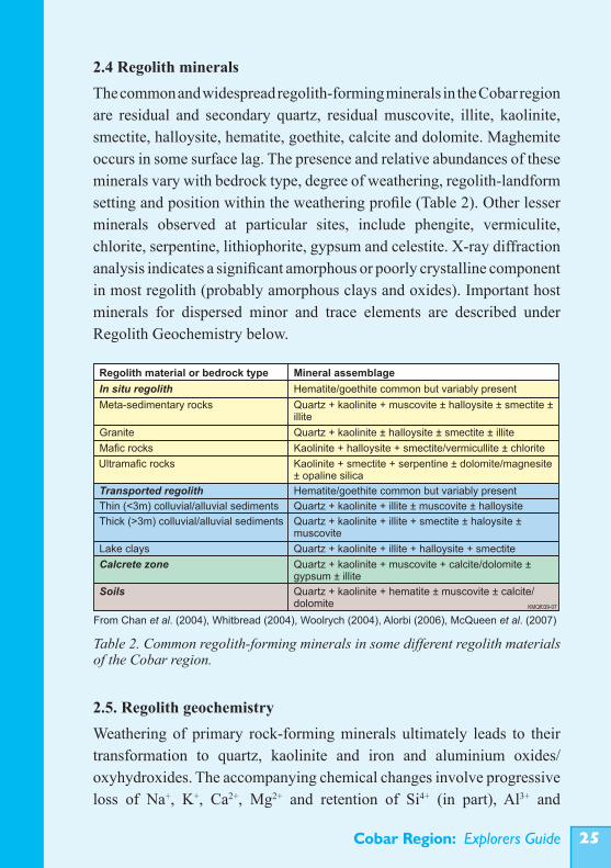
2.4 Regolith mineralsThe common and widespread regolith-forming minerals in the Cobar region are residual and secondary quartz, residual muscovite, illite, kaolinite, smectite, halloysite, hematite, goethite, calcite and dolomite. Maghemite occurs in some surface lag. The presence and relative abundances of these minerals vary with bedrock type, degree of weathering, regolith-landform setting and position within the weathering profile (Table 2). Other lesser minerals observed at particular sites, include phengite, vermiculite, chlorite, serpentine, lithiophorite, gypsum and celestite. X-ray diffraction analysis indicates a significant amorphous or poorly crystalline component in most regolith (probably amorphous clays and oxides). Important host minerals for dispersed minor and trace elements are described under Regolith Geochemistry below.
2.5. Regolith geochemistryWeathering of primary rock-forming minerals ultimately leads to their transformation to quartz, kaolinite and iron and aluminium oxides/oxyhydroxides. The accompanying chemical changes involve progressive loss of Na+, K+, Ca2+, Mg2+ and retention of Si4+ (in part), Al3+ and
Table 2. Common regolith-forming minerals in some different regolith materials of the Cobar region.
KMQf039-07
Kaolinite + halloysite + smectite/vermicullite ± chlorite
Quartz + kaolinite halloysite smectite illite± ± ±
Regolith material or bedrock type Mineral assemblage
In situ regolith Hematite/goethite common but variably present
Quartz + kaolinite + muscovite ± halloysite ± smectite ± illite
Meta-sedimentary rocks
Mafic rocks
Granite
Ultramafic rocks Kaolinite smectite serpentine dolomite/magnesite± opaline silica
+ + ±
Transported regolith Hematite/goethite common but variably present
Quartz + kaolinite + illite ± muscovite ± halloysite
Quartz kaolinite illite smectite ± haloysite ± muscovite
+ + +
Quartz kaolinite illite halloysite smectite + + + +
Thin (<3m) colluvial/alluvial sediments
Thick (>3m) colluvial/alluvial sediments
Lake clays
Calcrete zone Quartz kaolinite muscovite calcite/dolomite ± gypsum ± illite
+ + +
Soils Quartz + kaolinite + hematite ± muscovite ± calcite/dolomite
From Chan et al. (2004), Whitbread (2004), Woolrych (2004), Alorbi (2006), McQueen et al. (2007)
Cobar Region: Explorers Guide��
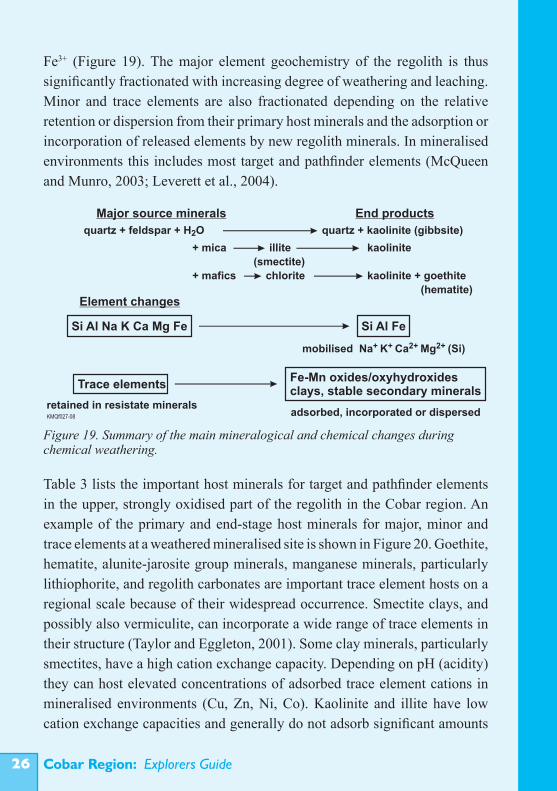
Fe3+ (Figure 19). The major element geochemistry of the regolith is thus significantly fractionated with increasing degree of weathering and leaching. Minor and trace elements are also fractionated depending on the relative retention or dispersion from their primary host minerals and the adsorption or incorporation of released elements by new regolith minerals. In mineralised environments this includes most target and pathfinder elements (McQueen and Munro, 2003; Leverett et al., 2004).
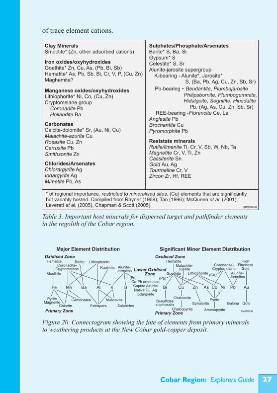
Table 3 lists the important host minerals for target and pathfinder elements in the upper, strongly oxidised part of the regolith in the Cobar region. An example of the primary and end-stage host minerals for major, minor and trace elements at a weathered mineralised site is shown in Figure 20. Goethite, hematite, alunite-jarosite group minerals, manganese minerals, particularly lithiophorite, and regolith carbonates are important trace element hosts on a regional scale because of their widespread occurrence. Smectite clays, and possibly also vermiculite, can incorporate a wide range of trace elements in their structure (Taylor and Eggleton, 2001). Some clay minerals, particularly smectites, have a high cation exchange capacity. Depending on pH (acidity) they can host elevated concentrations of adsorbed trace element cations in mineralised environments (Cu, Zn, Ni, Co). Kaolinite and illite have low cation exchange capacities and generally do not adsorb significant amounts
Figure 19. Summary of the main mineralogical and chemical changes during chemical weathering.
quartz + feldspar + H O2 quartz + kaolinite (gibbsite)
+ mica illite kaolinite
+ mafics chlorite kaolinite + goethite
(hematite)
Si Al Na K Ca Mg Fe Si Al Fe
+ + 2+ 2+mobilised Na K Ca Mg (Si)
(smectite)
Major source minerals End products
Element changes
Trace elements
retained in resistate minerals
Fe-Mn oxides/oxyhydroxidesclays, stable secondary minerals
adsorbed, incorporated or dispersed KMQf027-08
Cobar Region: Explorers Guide ��
of trace element cations.
Figure 20. Connectogram showing the fate of elements from primary minerals to weathering products at the New Cobar gold-copper deposit.
Hematite
Goethite
Chlorite
Carbonates
Feldspars
Muscovite
Sulphides
Kaolinite
Lithiophorite
PyriteMagnetite
Alunite-Jarosites
Coronadite-Cryptomelane
Fe Mn Ba Al K S
(Fe)
Oxidised Zone
Major Element Distribution
Bi Cu Zn As Co Ni Pb Au
Hematite
Goethite Lithiophorite Alunite-Jarosites
Coronadite-Cryptomelane
Malachite-cuprite
HighFineness
Gold
Gold
KMQf021-08
GalenaPyrite
Sphalerite
Chalcocite
Chalcopyrite
Bi-sulfidessulphosalts
?
(Cu)(Pb)
Oxidised Zone
Significant Minor Element Distribution
Primary ZonePrimary Zone
Lower OxidisedZone
Cu-Pb arsenatesCuprite AzuriteNative Cu, Ag
lodargyrite
Arsenopyrite
Barite
Table 3. Important host minerals for dispersed target and pathfinder elements in the regolith of the Cobar region.
Cobar Region: Explorers Guide��
Element dispersion controlsThe main controls on target and pathfinder element dispersion are:• hydrological factors, particularly the presence, flow rates and flow directions of groundwater; • chemical conditions in different parts of the regolith, mainly redox potential (Eh) and hydrogen ion activity (pH); • availability of complexing and oxidising agents (e.g. O2, CO2, SO4
2-, NO3
-, halides, organic compounds); • temperature (to a small degree); • physical processes causing mechanical dispersion (e.g. related to water, wind and gravity).
The major rock weathering reactions for different parent rocks (and contained sulphide mineralisation) help to produce or modify these conditions and the external drivers over time are climate, landscape position and biological activity.Dispersed elements can become fixed, commonly by adsorption onto, or incorporation into, regolith minerals. This results in predictable distributions for some elements within the weathered landscape. Some minerals are more abundant in certain types of regolith and these are commonly preserved in particular landscape or palaeo-landscape settings. For example: indurated materials (including ferruginised saprolite and ironstones) commonly occur on hills or rises; thick clay-rich saprolite may be preserved in areas of limited erosion, including beneath duricrusts, eroded saprock commonly forms colluvial fans; whereas weathering-resistant vein quartz, quartz-rich rocks and ferruginous pisoliths become concentrated in surface and alluvial channels. Landscape position will also influence surface and ground water flow, important controls on both mechanical and hydromorphic dispersion.In the Cobar region, intensely weathered profiles on the dominant meta-sedimentary bedrocks contain abundant kaolinite with quartz and minor illite and muscovite. These minerals have a low ability to host trace elements and are thus depleted in these, except where goethite/hematite or specific secondary trace element minerals have precipitated. Iron oxides/oxyhydroxides have formed where ferrous iron (Fe2+) in solution has been oxidised to ferric iron
Cobar Region: Explorers Guide ��
(Fe3+). Once formed these highly stable minerals have generally persisted in the profile.Iron mobility and the precipitation sequence of goethite and hematite have been critical to the distribution of dispersed elements. These minerals commonly show different distributions in and around weathering mineralisation and have different preferences for hosting trace elements. Over weathered sulphide deposits, the major host minerals for target and pathfinder elements progressively change from primary sulphide and specific secondary minerals (including supergene sulphides, arsenates, sulphates, carbonates, chlorides and oxides) in the lower part of the profile to more generic Fe- and Mn-oxides/oxyhydroxides towards the top (e.g. Scott et al., 1991; Cairns et al., 2001; McQueen and Munro, 2003; Leverett et al., 2004). Within the weathering profile, element dispersion is largely by chemical and hydromorphic processes. However, after elements become fixed in the stable ferruginous component near surface they are commonly dispersed by mechanical processes in the eroding landscape. This can result in markedly different dispersion patterns in different parts of the regolith. For example, Pb and As can show limited hydromorphic dispersion within the weathering profile compared to Cu and Zn which may form a broad hydromorphic dispersion halo, generally fixed in goethite. At the surface however, Pb and As (as well as Sb, Bi and Ba) become strongly bound to hematite which may be widely dispersed into colluvium, alluvium and soil by mechanical processes.It is likely that biogeochemical processes have played a role in element dispersion through the regolith. The root systems of plants can transfer elements in solution up the weathering profile and onto the surface. Plants can thus potentially transfer geochemical anomalies in a continuous and ongoing process through transported, depositing and weathering cover. The hugely abundant micro-biota of the regolith must also play a significant role in mineral weathering, biochemical dissolution and fixation of major and trace elements. Bioturbation of the upper parts of the regolith (e.g. by burrowing organisms, termites and tree throw) has led to mechanical redistribution of regolith components and their contained element concentrations.
Cobar Region: Explorers Guide�0
Weathering regimesChemical conditions in the regolith of the Cobar region have changed significantly through time, particularly in response to climatic, hydrologic and biological changes. Predominantly warm and wet climatic conditions with high water table levels, from the Late Cretaceous to the Miocene, would have favoured hydration/hydrolysis reactions and mobility of reduced species, particularly Fe2+ and Mn2+, in water saturated profiles. Groundwater pH conditions would have been neutral to acid, the latter particularly where sulphides were oxidising. It is also likely that high organic content would have favoured organo-complexing of many elements and higher availability of phosphorus and nitrogen. The change to generally more arid conditions since the Mid Miocene, with falling and fluctuating water tables, favoured oxidation reactions and more complex regional groundwater compositions, particularly with higher salinity, increased activity of carbonate and sulphate and neutral to alkaline pH. Under superimposed arid conditions the solubility and mobility of some elements, particularly Au, would have increased where chloride and thiosulphate complexing occurred, whereas other elements, especially Pb, Ag, Ba and Hg would have been relatively fixed as insoluble chlorides, sulphates or carbonates. Marked pH gradients around sulphide deposits that continued to weather resulted in dispersion of some elements (e.g. As, Cu and Zn) to form broader anomalies. During exploration it is important to know what part of the weathering history is preserved in a particular profile (Figure 21). Erosion may have removed or partly removed older regolith and the contained dispersion patterns. In many cases older regolith is preserved but the earlier dispersion patterns are overprinted by patterns developed during later arid conditions. This combination can result in very low concentrations of many target and pathfinder elements over mineralised sites, particularly in the non-ferruginous saprolite. Dispersion halos formed under different weathering regimes may have quite different target and pathfinder element distributions (Table 4). Recognising these different weathering regimes and position within the profile can be determined from:• location within the regional landscape and interpreted palaeolandscape (i.e at the km scale);
Cobar Region: Explorers Guide ��
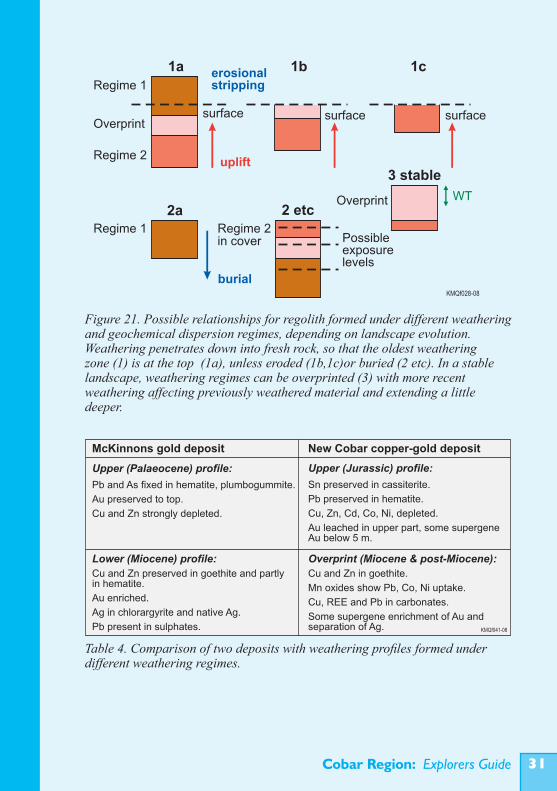
Figure 21. Possible relationships for regolith formed under different weathering and geochemical dispersion regimes, depending on landscape evolution. Weathering penetrates down into fresh rock, so that the oldest weathering zone (1) is at the top (1a), unless eroded (1b,1c)or buried (2 etc). In a stable landscape, weathering regimes can be overprinted (3) with more recent weathering affecting previously weathered material and extending a little deeper.
Regime 1
Regime 2
Overprintsurface surface surface
erosionalstripping
uplift
Regime 1 Regime 2in cover
burial
WT
Possibleexposurelevels
Overprint
1a 1b 1c
2a 2 etc
3 stable
KMQf028-08
Table 4. Comparison of two deposits with weathering profiles formed under different weathering regimes.
McKinnons gold deposit New Cobar copper-gold deposit
Upper (Palaeocene) profile:
Pb and As fixed in hematite, plumbogummite.
Au preserved to top.
Cu and Zn strongly depleted.
Upper (Jurassic) profile:
Sn preserved in cassiterite.
Pb preserved in hematite.
Cu, Zn, Cd, Co, Ni, depleted.
Au leached in upper part, some supergene Au below 5 m.
Lower (Miocene) profile:
Cu and Zn preserved in goethite and partly in hematite.
Au enriched.
Ag in chlorargyrite and native Ag.
Pb present in sulphates.
Overprint (Miocene & post-Miocene):
Cu and Zn in goethite.
Mn oxides show Pb, Co, Ni uptake.
Cu, REE and Pb in carbonates.
Some supergene enrichment of Au andseparation of Ag. KMQf041-08
Cobar Region: Explorers Guide��
• type and age of any overlying transported regolith (e.g. deposits in incised palaeochannels); • intensity and style of weathering and induration (e.g. as indicated by major mobile and immobile element patterns, distribution pattern for Fe, radiometric properties of surface materials) ; • architecture and types of in situ regolith materials preserved (e.g. the pattern of transition for fresh rock to surface regolith in drill holes); • element associations indicative of particular chemical regimes (including level of depletion/concentration and extent of dispersion of elements such as Cu, Zn, Pb, Ag, Mn, As, REE).
Element dispersion patterns can be quite different for different deposits or in different parts of the same weathering profile where these are related to different weathering regimes (Table 2).
Examples of specific element dispersion features
Gold Gold has been mobilised in the Cobar regolith, as indicated by its association with calcrete and the presence of high fineness supergene gold in the gossans and oxide zones of some gold-bearing deposits (e.g. New Cobar and McKinnons). The dissolution and dispersion mechanisms are not established, but probably involved a combination of organo-complexing, possibly thio-complexing and gold chloride dispersion under different weathering regimes.The nature of the primary gold would have influenced the type of dispersion. Studies in other areas (e.g. the Yilgarn area of WA) suggest that coarse gold and gold ‘locked’ within vein quartz remains relatively stable in the regolith and can be residually concentrated near surface, with only partial depletion from the upper regolith. Gold associated with sulphides is more mobile due to the small particle size (commonly submicron), easy access by supergene solutions and increased concentrations of S-oxyanions favouring gold dissolution. Some rock types (e.g. mafic-ultramafic rocks) are more effective at buffering groundwaters, leading to reduced Au depletion. Silica-rich rocks may inhibit gold depletion, due to silicification of the regolith occluding the gold grains. Gold in the regolith is commonly present as elemental gold

Cobar Region: Explorers Guide ��
particles, with the particle size dependant on the mineralisation type, dispersion mechanism and nature of supergene gold precipitation. Coarse primary gold tends to be unevenly distributed or ‘nuggety’ in the regolith, whereas very fine-grained gold is more evenly distributed. Gold present in the ‘calcrete zone’ tends to be very fine-grained and evenly dispersed. The nature of the gold determines the most appropriate sampling medium, sample size and analytical method for exploration. For fine-grained evenly dispersed gold a suitable method is aqua-regia digest of small samples (30-50 g) followed by analysis using either ICP-MS or graphite furnace atomic absorption spectroscopy (GF-AAS). Coarser ‘nuggety’ gold will require larger samples (3-5 kg) and methods such as bulk cyanide leach (BLEG) or screened fire assay.
SilverSilver is associated with most of the mineralisation types in the Cobar region and can be a useful pathfinder element, particularly for Pb-Zn-Ag mineralisation. In the Cobar regolith it is mostly hosted by jarosite group minerals, chlorargyrite, iodargyrite and native silver. In saline groundwaters it is relatively immobile, precipitating as silver halides. Around weathering sulphides buffered by carbonate-rich host rocks it may be widely dispersed as silver thiosulphate (Rutherford and Salt, 2005). This process could also result in supergene silver enrichment, where Ag(S2O3)2
3- in solution has encountered chloride-rich groundwaters (e.g. at the recently discovered De Nardi deposit, 60 km south of Cobar).
CopperCopper is strongly leached from the upper part (<10 m) of the regolith over copper mineralisation (e.g. the gossans over the Girilambone Cu mineralisation contain around 400-500 ppm Cu, the upper gossan at the New Cobar deposit has around 800 ppm, and the CSA gossans 100-1900 ppm). Copper has generally been broadly dispersed under low pH conditions around weathering sulphides and adsorbed/fixed away from mineralisation where conditions have been more alkaline. This commonly produces broad (up to 100s of m) haloes with greater than 100
Cobar Region: Explorers Guide��
ppm Cu. Much of this Cu dispersion probably occurred under early, wetter more acidic weathering regimes. In weathering environments where the pH has been strongly buffered by carbonate-rich host rocks or very alkaline and carbonate-rich groundwater Cu is less widely dispersed, with copper commonly precipitating as malachite-azurite.
ZincZinc is generally widely dispersed in the weathering profiles of the Cobar region. It is commonly hosted by goethite and lithiophorite, but is also present in some gossans as smithsonite, substituted in alunite-jarosite minerals and rosasite. Unlike Pb, it is not so strongly associated with hematite-rich lag. Around the major Elura (Endeavor) Zn-Pb-Ag deposit there is an extensive soil geochemical anomaly with >400 ppm zinc. This appears to reflect a subtle drainage feature suggesting detrital dispersion from the gossan (Dunlop et al., 1983). Under very alkaline conditions, for example around mineralisation lacking pyrite (as at the Parkers Hill deposit near Mineral Hill), Zn may be retained in the weathering profile at concentrations similar to the primary mineralisation (Scott, 2004).
LeadLead, together with Bi, Sn, W, is generally the least chemically mobile of the target and pathfinder elements under a wide range of weathering conditions. This has resulted in intense localised Pb anomalies around many of the Pb-bearing Cobar deposits. For example gossans at the CSA deposit retain 1300 to 15500 ppm Pb. Above the Hera Au-Cu-Zn-Pb deposit there is a coherent anomaly of >1000 ppm Pb over a strike length of 400 m (Skirka and David, 2005). Lead is strongly retained in hematite-rich lag. The sub-cropping Elura deposit has a well defined and extensive Pb anomaly in soils, partly related to erosion of the Pb-rich gossan. Lead is also a good pathfinder in the weathered bedrock and residual/colluvial soil.
ArsenicArsenic is commonly used as a pathfinder element, particularly for gold, but also for base metal sulphide deposits. In primary mineralisation, As is a trace
Cobar Region: Explorers Guide ��
element in abundant pyrite or a major element in minor arsenopyrite. Under humid and moderate to low pH weathering conditions As was dispersed by rapid weathering of pyrite and arsenopyrite and then adsorbed onto iron oxides/oxyhydroxides where these formed in and around the weathering deposit. This has generally resulted in large and strong As anomalies. Arsenic is fixed in hematite-rich lag at the surface and can become widely dispersed by mechanical processes during erosion. Under both arid (similar to present) and higher pH conditions, As may combine with Cu and Pb to form relatively insoluble arsenates (e.g. at New Cobar; Leverett et al., 2004) or remain in solution to become widely dispersed in groundwater.
Regolith element associations Four major regolith-related element associations can be recognised in the Cobar region. These are: • an ‘evaporitic’ association of Ca-Mg±Au, in some cases with Ba- Sr, related to regolith carbonate and sulphate accumulation in the near surface regolith, also within and in some cases at the base of palaeo-channels and transported regolith; • an association of Mn-Co-Zn±Ni-Cu±Au developed in redox boundary accumulations of manganese oxides/oxyhydroxides (particularly lithiophorite), commonly at around 20-30 m and at the present, deeper water table; • an association of Fe-Cu-Zn with goethitic accumulations in the regolith; • an association of Fe-As-Pb±Sb±Bi with hematite, particularly in ferruginous lag, palaeochannel sediments containing ferruginous lag and in hematite rich mottles in the upper saprolite.
It is important to recognise and understand these associations as they modify the range of background variation for some elements in different parts of the regolith. Some may be mistaken for anomalies related to mineralisation if threshold values are set too low. They can also represent geochemical environments where elements dispersed from weathering mineralisation are fixed and detectable at high concentrations.
Cobar Region: Explorers Guide��
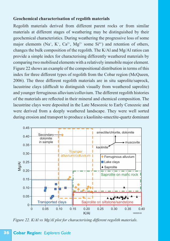
Geochemical characterisation of regolith materialsRegolith materials derived from different parent rocks or from similar materials at different stages of weathering may be distinguished by their geochemical characteristics. During weathering the progressive loss of some major elements (Na+, K+, Ca2+, Mg2+ some Si4+) and retention of others, changes the bulk composition of the regolith. The K/Al and Mg/Al ratios can provide a simple index for characterising differently weathered materials by comparing two mobilised elements with a relatively immobile major element. Figure 22 shows an example of the compositional distribution in terms of this index for three different types of regolith from the Cobar region (McQueen, 2006). The three different regolith materials are in situ saprolite/saprock, lacustrine clays (difficult to distinguish visually from weathered saprolite) and younger ferruginous alluvium/colluvium. The different regolith histories of the materials are reflected in their mineral and chemical composition. The lacustrine clays were deposited in the Late Mesozoic to Early Cenozoic and were derived from a deeply weathered landscape. They were well sorted during erosion and transport to produce a kaolinite-smectite-quartz dominant
Figure 22. K/Al vs Mg/Al plot for characterising different regolith materials.
0.45
0.40
0.35
0.30
0.25
0.20
0.15
0.10
0.05
0
Mg
/Al
0.400.350.300.250.200.150.100.050
K/Al
Youngeralluvium/colluvium Ferruginous alluvium
Lake clays
Saprolite
Transported clays
Saprolite on mafic rock
Saprolite on siltstone/sandstone
Secondarydolomitein sample
smectite/chlorite, dolomite
muscovite
kaolinite
KMQf029-08
Cobar Region: Explorers Guide ��
sediment. The saprolite/saprock contains significant muscovite and illite, which have been variably altered to kaolinite, depending on degree of in situ weathering and depth in the profile. The younger alluvium/colluvium was deposited in the later Cenozoic, when the climate was significantly drier and chemical weathering less intense. Erosion of less altered profiles, more limited sorting and low levels of post-depositional weathering produced material that retained significant amounts of weakly altered phyllosilicates. These sediments can also contain local concentrations of dolomitic calcrete, which will be apparent in their Mg/Al ratio. There is some compositional overlap between the three materials and the clearest distinction is between saprolite and transported clays. This approach to chemically distinguishing regolith types can be applied where there are regolith components characterised by different parent rock compositions, different degrees of weathering or different histories of sorting or remixing/homogenisation during transport. The differences can be established with an orientation survey.
Parent rock identificationIdentifying parent rocks from their weathered regolith can be a major challenge. Broad differences in mineralogy (e.g. abundance of quartz, muscovite, clays and iron oxides) and texture (mostly grain size and shape) are commonly apparent over markedly different bedrock types. In saprock and saprolite the original rock fabric is preserved to give clues. In many cases however, particularly in the upper part of the weathering profile, these features are destroyed. Geochemical criteria, based on the least mobile elements, can help discriminate parent rock types for in situ regolith (e.g. Khider and McQueen, 2005). This requires total, whole sample geochemical data, ideally from XRF or INAA analysis. Analysis by multi-acid ‘total’ digest and ICP-OES/MS will not include elements hosted in insoluble minerals (e.g. Zr in zircon or Ti in rutile) and may also result in lower than true values for Al2O3 and K2O in some samples, due to incomplete dissolution of muscovite or formation of potassium perchlorate during digestion (Chan et al., 2004).
Cobar Region: Explorers Guide��
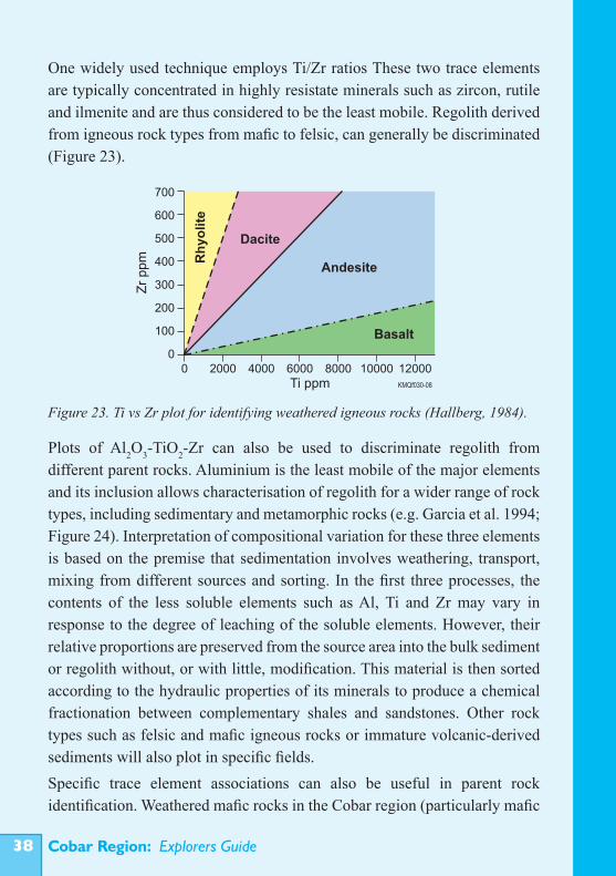
One widely used technique employs Ti/Zr ratios These two trace elements are typically concentrated in highly resistate minerals such as zircon, rutile and ilmenite and are thus considered to be the least mobile. Regolith derived from igneous rock types from mafic to felsic, can generally be discriminated (Figure 23).
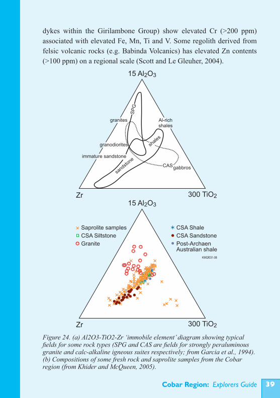
Plots of Al2O3-TiO2-Zr can also be used to discriminate regolith from different parent rocks. Aluminium is the least mobile of the major elements and its inclusion allows characterisation of regolith for a wider range of rock types, including sedimentary and metamorphic rocks (e.g. Garcia et al. 1994; Figure 24). Interpretation of compositional variation for these three elements is based on the premise that sedimentation involves weathering, transport, mixing from different sources and sorting. In the first three processes, the contents of the less soluble elements such as Al, Ti and Zr may vary in response to the degree of leaching of the soluble elements. However, their relative proportions are preserved from the source area into the bulk sediment or regolith without, or with little, modification. This material is then sorted according to the hydraulic properties of its minerals to produce a chemical fractionation between complementary shales and sandstones. Other rock types such as felsic and mafic igneous rocks or immature volcanic-derived sediments will also plot in specific fields.Specific trace element associations can also be useful in parent rock identification. Weathered mafic rocks in the Cobar region (particularly mafic
Figure 23. Ti vs Zr plot for identifying weathered igneous rocks (Hallberg, 1984).
700
600
500
400
300
200
100
00 2000 4000 6000 8000 10000 12000
KMQf030-08
Zr
pp
m
Ti ppm
Basalt
Andesite
Dacite
Rh
yo
lite
Cobar Region: Explorers Guide ��
dykes within the Girilambone Group) show elevated Cr (>200 ppm) associated with elevated Fe, Mn, Ti and V. Some regolith derived from felsic volcanic rocks (e.g. Babinda Volcanics) has elevated Zn contents (>100 ppm) on a regional scale (Scott and Le Gleuher, 2004).
Figure 24. (a) Al2O3-TiO2-Zr ‘immobile element’ diagram showing typical fields for some rock types (SPG and CAS are fields for strongly peraluminous granite and calc-alkaline igneous suites respectively; from Garcia et al., 1994). (b) Compositions of some fresh rock and saprolite samples from the Cobar region (from Khider and McQueen, 2005).
granites
granodiorites
immature sandstone
sandsto
ne
shales
gabbros
Al-richshales
SP
G
CAS
Zr
Zr
15 Al O2 3
15 Al O2 3
300 TiO2
300 TiO2
Saprolite samples
CSA Siltstone
Granite
CSA Shale
CSA Sandstone
Post-ArchaenAustralian shale
KMQf031-08
Cobar Region: Explorers Guide�0
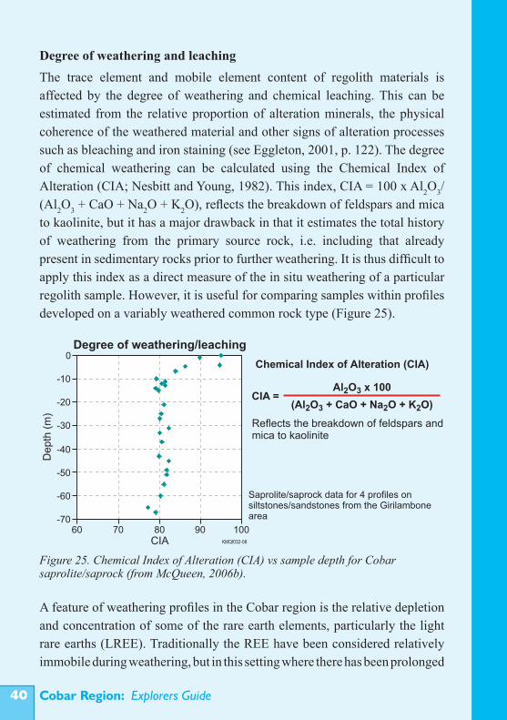
Degree of weathering and leachingThe trace element and mobile element content of regolith materials is affected by the degree of weathering and chemical leaching. This can be estimated from the relative proportion of alteration minerals, the physical coherence of the weathered material and other signs of alteration processes such as bleaching and iron staining (see Eggleton, 2001, p. 122). The degree of chemical weathering can be calculated using the Chemical Index of Alteration (CIA; Nesbitt and Young, 1982). This index, CIA = 100 x Al2O3/(Al2O3 + CaO + Na2O + K2O), reflects the breakdown of feldspars and mica to kaolinite, but it has a major drawback in that it estimates the total history of weathering from the primary source rock, i.e. including that already present in sedimentary rocks prior to further weathering. It is thus difficult to apply this index as a direct measure of the in situ weathering of a particular regolith sample. However, it is useful for comparing samples within profiles developed on a variably weathered common rock type (Figure 25).
A feature of weathering profiles in the Cobar region is the relative depletion and concentration of some of the rare earth elements, particularly the light rare earths (LREE). Traditionally the REE have been considered relatively immobile during weathering, but in this setting where there has been prolonged
Figure 25. Chemical Index of Alteration (CIA) vs sample depth for Cobar saprolite/saprock (from McQueen, 2006b).
Cobar Region: Explorers Guide ��
weathering, including under early acid and later alkaline conditions, they have been significantly redistributed. This is to the point where REE depletions in one part of the profile and subsequent enrichments in other parts can provide an index for the intensity and style of chemical weathering (Ackerman and Chivas, 2004; McQueen, 2006b).
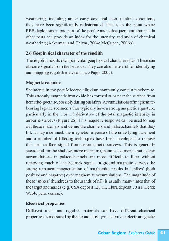
2.6 Geophysical character of the regolithThe regolith has its own particular geophysical characteristics. These can obscure signals from the bedrock. They can also be useful for identifying and mapping regolith materials (see Papp, 2002).
Magnetic responseSediments in the post Miocene alluvium commonly contain maghemite. This strongly magnetic iron oxide has formed at or near the surface from hematite-goethite, possibly during bushfires. Accumulations of maghemite-bearing lag and sediments thus typically have a strong magnetic signature, particularly in the 1 or 1.5 derivative of the total magnetic intensity in airborne surveys (Figure 26). This magnetic response can be used to map out these materials and define the channels and palaeochannels that they fill. It may also mask the magnetic response of the underlying basement and a number of filtering techniques have been developed to remove this near-surface signal from aeromagnetic surveys. This is generally successful for the shallow, more recent maghemite sediments, but deeper accumulations in palaeochannels are more difficult to filter without removing much of the bedrock signal. In ground magnetic surveys the strong remanent magnetisation of maghemite results in ‘spikes’ (both positive and negative) over maghemite accumulations. The magnitude of these ‘spikes’ (hundreds to thousands of nT) is usually many times that of the target anomalies (e.g. CSA deposit 120 nT, Elura deposit 70 nT, Derek Webb, pers. comm.).
Electrical propertiesDifferent rocks and regolith materials can have different electrical properties as measured by their conductivity/resistivity or electromagnetic
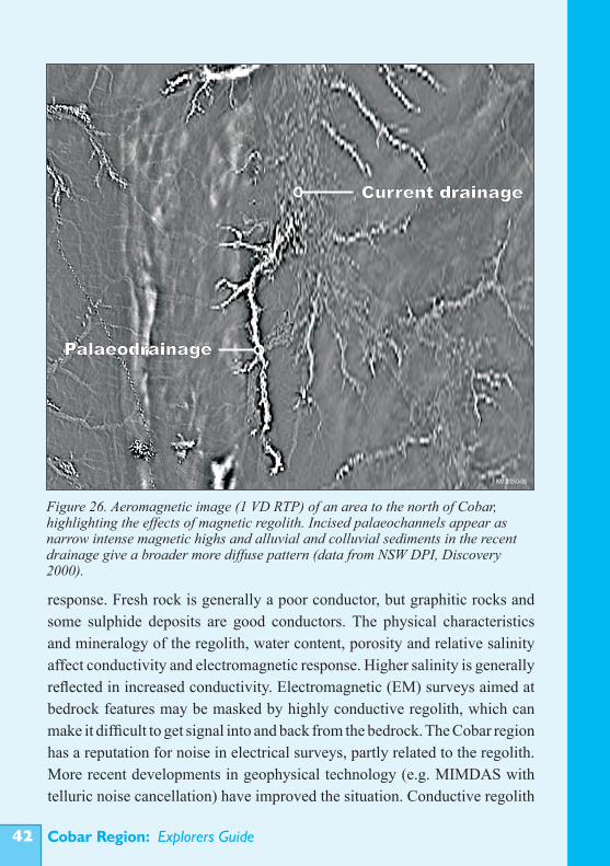
Cobar Region: Explorers Guide��
response. Fresh rock is generally a poor conductor, but graphitic rocks and some sulphide deposits are good conductors. The physical characteristics and mineralogy of the regolith, water content, porosity and relative salinity affect conductivity and electromagnetic response. Higher salinity is generally reflected in increased conductivity. Electromagnetic (EM) surveys aimed at bedrock features may be masked by highly conductive regolith, which can make it difficult to get signal into and back from the bedrock. The Cobar region has a reputation for noise in electrical surveys, partly related to the regolith. More recent developments in geophysical technology (e.g. MIMDAS with telluric noise cancellation) have improved the situation. Conductive regolith
Figure 26. Aeromagnetic image (1 VD RTP) of an area to the north of Cobar, highlighting the effects of magnetic regolith. Incised palaeochannels appear as narrow intense magnetic highs and alluvial and colluvial sediments in the recent drainage give a broader more diffuse pattern (data from NSW DPI, Discovery 2000).
KMQf050-08
Palaeodrainage
Current drainage
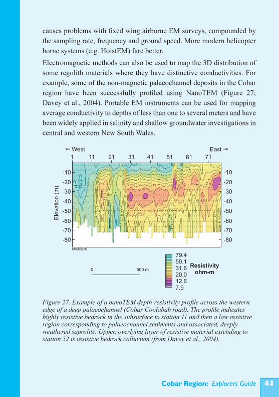
Cobar Region: Explorers Guide ��
causes problems with fixed wing airborne EM surveys, compounded by the sampling rate, frequency and ground speed. More modern helicopter borne systems (e.g. HoistEM) fare better.Electromagnetic methods can also be used to map the 3D distribution of some regolith materials where they have distinctive conductivities. For example, some of the non-magnetic palaeochannel deposits in the Cobar region have been successfully profiled using NanoTEM (Figure 27; Davey et al., 2004). Portable EM instruments can be used for mapping average conductivity to depths of less than one to several meters and have been widely applied in salinity and shallow groundwater investigations in central and western New South Wales.
Figure 27. Example of a nanoTEM depth-resistivity profile across the western edge of a deep palaeochannel (Cobar Coolabah road). The profile indicates highly resistive bedrock in the subsurface to station 11 and then a low resistive region corresponding to palaeochannel sediments and associated, deeply weathered saprolite. Upper, overlying layer of resistive material extending to station 52 is resistive bedrock colluvium (from Davey et al., 2004).
Cobar Region: Explorers Guide��
GravityGravity surveys map variations in the density of regolith and bedrock. Gravity variations can be used to map faults, dykes, basement highs and sediments where there are significant density contrasts (e.g. thickness of palaeochannel sediments where these have lower density than the surrounding bedrock). Variations in the depth and intensity of weathering of bedrock can affect their density and hence gravity response. In many parts of the Cobar region this makes it difficult to detect small bedrock targets such as ore deposits. Significant accumulations of higher density regolith (e.g. silcretes and ferricretes) can produce gravity anomalies. Gravity methods have been widely used in the Cobar area to map basement rocks and structures, but have only been used incidentally to characterise regolith. In other areas (e.g. the Tanami) gravity measurements have been used to map very thick, low density palaeochannel deposits (J. Wilford, pers. comm.). Airborne gravity gradiometry (e.g. Feynman Helicopter and Falcon) has potential to map the 3D distribution of some regolith materials.
SeismicSeismic imaging uses either reflection of energy generated as shock waves to detect boundaries or structures in the crust or refraction of energy to determine variation in the composition of materials. Seismic techniques are not widely used in mineral exploration but have some potential for mapping the 3D structure of the regolith (e.g. estimating thickness of cover, profiling palaeochannels and characterising different types of regolith; Drummond, 2002).
Radiometric responseAirborne radiometric surveys measure gamma radiation from a number of radioactive isotopes that may be linked to the abundances of potassium, thorium and uranium in the top 30 cm of the regolith. The relative abundances of these elements can be used to distinguish a number of different types of regolith in the Cobar region. A ternary image with K in red, Th in green and U in blue is often used to display gamma-ray data. Areas of exposed meta-sedimentary bedrock and saprolite typically show a roughly similar
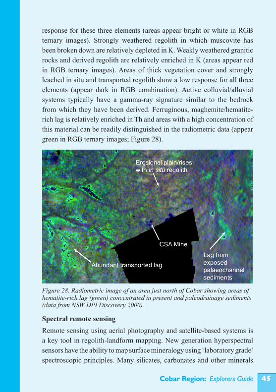
Cobar Region: Explorers Guide ��
response for these three elements (areas appear bright or white in RGB ternary images). Strongly weathered regolith in which muscovite has been broken down are relatively depleted in K. Weakly weathered granitic rocks and derived regolith are relatively enriched in K (areas appear red in RGB ternary images). Areas of thick vegetation cover and strongly leached in situ and transported regolith show a low response for all three elements (appear dark in RGB combination). Active colluvial/alluvial systems typically have a gamma-ray signature similar to the bedrock from which they have been derived. Ferruginous, maghemite/hematite-rich lag is relatively enriched in Th and areas with a high concentration of this material can be readily distinguished in the radiometric data (appear green in RGB ternary images; Figure 28).
Spectral remote sensingRemote sensing using aerial photography and satellite-based systems is a key tool in regolith-landform mapping. New generation hyperspectral sensors have the ability to map surface mineralogy using ‘laboratory grade’ spectroscopic principles. Many silicates, carbonates and other minerals
Figure 28. Radiometric image of an area just north of Cobar showing areas of hematite-rich lag (green) concentrated in present and paleodrainage sediments (data from NSW DPI Discovery 2000).
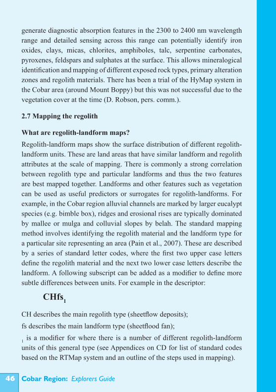
Cobar Region: Explorers Guide��
generate diagnostic absorption features in the 2300 to 2400 nm wavelength range and detailed sensing across this range can potentially identify iron oxides, clays, micas, chlorites, amphiboles, talc, serpentine carbonates, pyroxenes, feldspars and sulphates at the surface. This allows mineralogical identification and mapping of different exposed rock types, primary alteration zones and regolith materials. There has been a trial of the HyMap system in the Cobar area (around Mount Boppy) but this was not successful due to the vegetation cover at the time (D. Robson, pers. comm.).
2.7 Mapping the regolith
What are regolith-landform maps?Regolith-landform maps show the surface distribution of different regolith-landform units. These are land areas that have similar landform and regolith attributes at the scale of mapping. There is commonly a strong correlation between regolith type and particular landforms and thus the two features are best mapped together. Landforms and other features such as vegetation can be used as useful predictors or surrogates for regolith-landforms. For example, in the Cobar region alluvial channels are marked by larger eucalypt species (e.g. bimble box), ridges and erosional rises are typically dominated by mallee or mulga and colluvial slopes by belah. The standard mapping method involves identifying the regolith material and the landform type for a particular site representing an area (Pain et al., 2007). These are described by a series of standard letter codes, where the first two upper case letters define the regolith material and the next two lower case letters describe the landform. A following subscript can be added as a modifier to define more subtle differences between units. For example in the descriptor:
CH describes the main regolith type (sheetflow deposits);fs describes the main landform type (sheetflood fan);
1 is a modifier for where there is a number of different regolith-landform units of this general type (see Appendices on CD for list of standard codes based on the RTMap system and an outline of the steps used in mapping).
CHfs1
Cobar Region: Explorers Guide ��
Constructing a regolith-landform map is a first step in deciphering the landscape history of an area and understanding the landscape (and palaeo-landscape) setting of regolith materials. From this, the origin and history of modification of these materials can be determined and hence their suitability as geochemical sampling media. Regolith-landform maps are also the basis for constructing derivative maps that show particular attributes useful for explorers (i.e. exploration ‘Go’ maps). At the most basic level these identify areas of in situ vs transported regolith, which is fundamental to deciding how to explore and what to sample. Other attributes include regolith composition, degree of weathering, relative age and thickness and source of transported regolith. Landform information is useful for predicting element dispersion pathways. As for all maps the scale of mapping depends on the purpose and use. To be useful in regional exploration a scale of 1:100,000 or more detailed is required (1:25,000 is an optimum size but more detailed mapping may be helpful at the prospect scale). Figure 29 shows the broad distribution of major regolith-landform units across the Cobar region. Two excerpts of regolith-landform maps produced at 1:100 000 and 1:25 000 scales for part of the Byrock area (Figures 30 and 31) show the typical differences in detail for these scales. A series of regolith-landform maps has been produced by CRC LEME for the Cobar region and the maps are available from Geoscience Australia. These maps include the BYROCK, SUSSEX, CAMBELEGO, COOLABAH and HERMIDALE 1:100 000 sheet areas. Figures 32-39 show examples of some typical regolith-landform units.
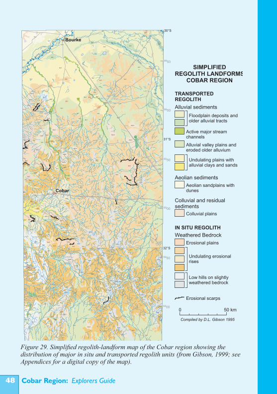
Cobar Region: Explorers Guide��
Figure 29. Simplified regolith-landform map of the Cobar region showing the distribution of major in situ and transported regolith units (from Gibson, 1999; see Appendices for a digital copy of the map).KMQf023-08
Floodplain deposits and older alluvial tracts
Active major stream channels
Alluvial valley plains and eroded older alluvium
Undulating plains with alluvial clays and sands
Aeolian sandplains with dunes
Alluvial sediments
Aeolian sediments
Colluvial plains
Colluvial and residual sediments
Erosional plains
Undulating erosional rises
Low hills on slightly weathered bedrock
Weathered Bedrock
IN SITU REGOLITH
TRANSPORTEDREGOLITH
0 50 km
SIMPLIFIEDREGOLITH LANDFORMS
COBAR REGION
Compiled by D.L. Gibson 1995
Erosional scarps
Bourke
Cobar
30°S
31°S
32°S
33°S147°E146°E
6600
6650
6500
6550
6400
6450
400 450
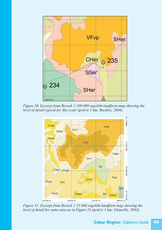
Cobar Region: Explorers Guide ��
Figure 30. Excerpt from Byrock 1:100 000 regolith-landform map showing the level of detail typical for this scale (grid is 1 km; Buckley, 2004).
Figure 31. Excerpt from Byrock 1:25 000 regolith-landform map showing the level of detail for same area as in Figure 24 (grid is 1 km; Glanville, 2003).
KMQf051-08
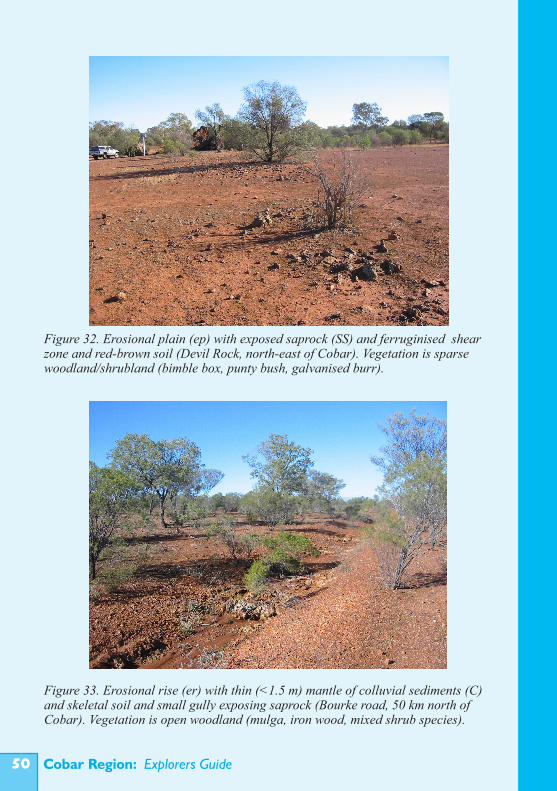
Cobar Region: Explorers Guide�0
Figure 32. Erosional plain (ep) with exposed saprock (SS) and ferruginised shear zone and red-brown soil (Devil Rock, north-east of Cobar). Vegetation is sparse woodland/shrubland (bimble box, punty bush, galvanised burr).
Figure 33. Erosional rise (er) with thin (<1.5 m) mantle of colluvial sediments (C) and skeletal soil and small gully exposing saprock (Bourke road, 50 km north of Cobar). Vegetation is open woodland (mulga, iron wood, mixed shrub species).
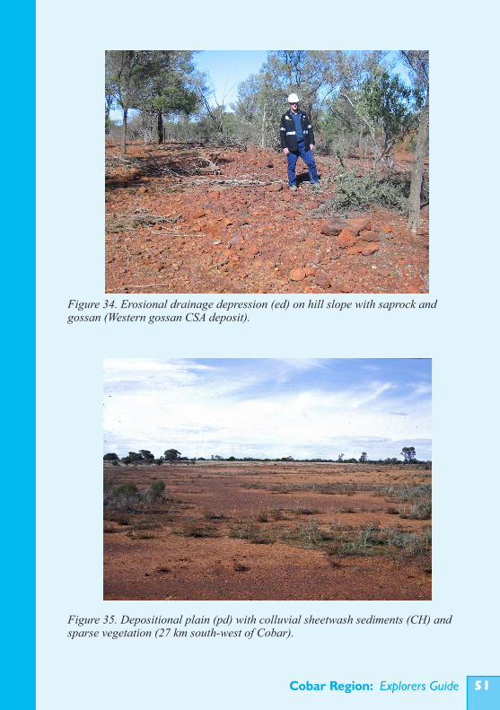
Cobar Region: Explorers Guide ��
Figure 34. Erosional drainage depression (ed) on hill slope with saprock and gossan (Western gossan CSA deposit).
Figure 35. Depositional plain (pd) with colluvial sheetwash sediments (CH) and sparse vegetation (27 km south-west of Cobar).
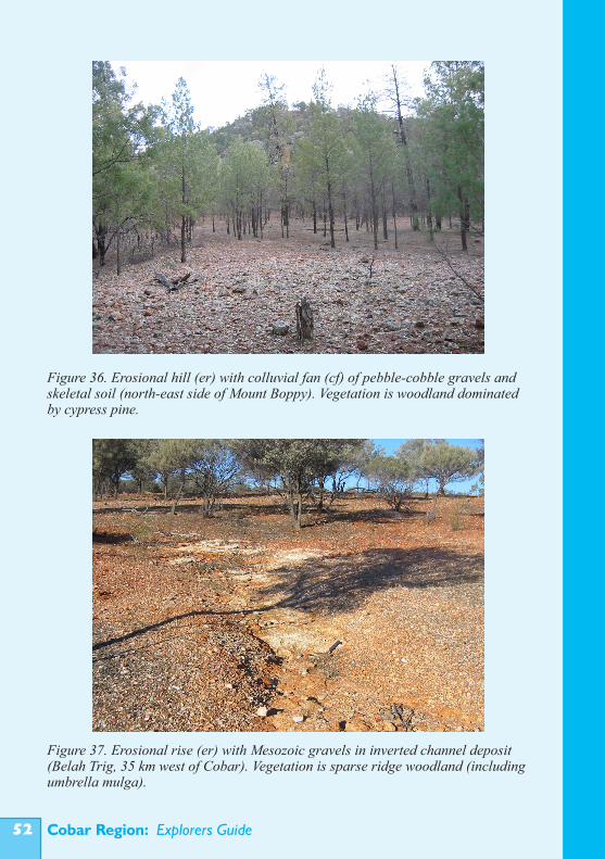
Cobar Region: Explorers Guide��
Figure 36. Erosional hill (er) with colluvial fan (cf) of pebble-cobble gravels and skeletal soil (north-east side of Mount Boppy). Vegetation is woodland dominated by cypress pine.
Figure 37. Erosional rise (er) with Mesozoic gravels in inverted channel deposit (Belah Trig, 35 km west of Cobar). Vegetation is sparse ridge woodland (including umbrella mulga).
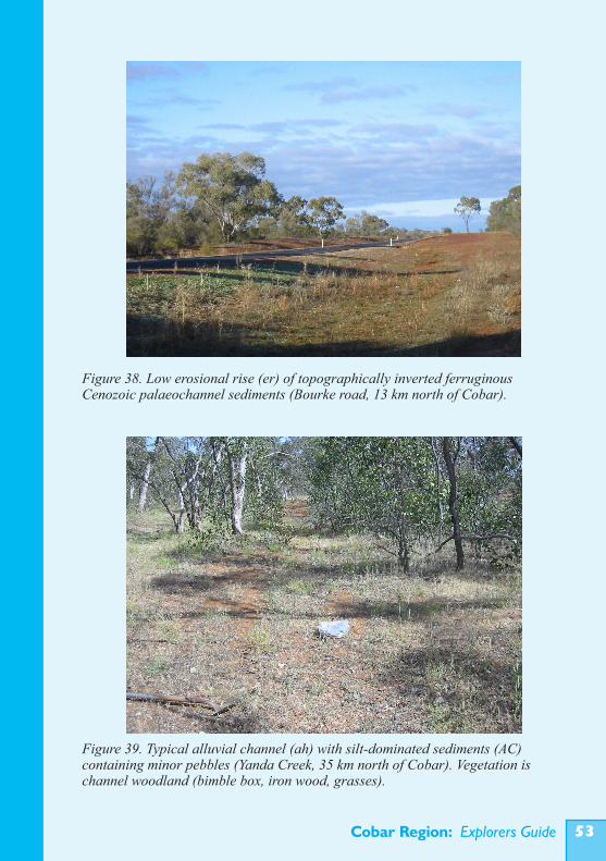
Cobar Region: Explorers Guide ��
Figure 39. Typical alluvial channel (ah) with silt-dominated sediments (AC) containing minor pebbles (Yanda Creek, 35 km north of Cobar). Vegetation is channel woodland (bimble box, iron wood, grasses).
Figure 38. Low erosional rise (er) of topographically inverted ferruginous Cenozoic palaeochannel sediments (Bourke road, 13 km north of Cobar).
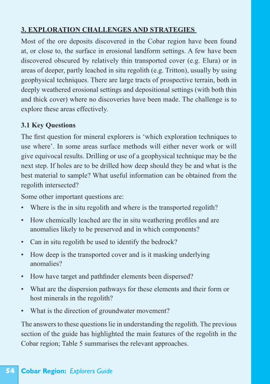
Cobar Region: Explorers Guide��
3. EXPLORATION CHALLENGES AND STRATEGIES Most of the ore deposits discovered in the Cobar region have been found at, or close to, the surface in erosional landform settings. A few have been discovered obscured by relatively thin transported cover (e.g. Elura) or in areas of deeper, partly leached in situ regolith (e.g. Tritton), usually by using geophysical techniques. There are large tracts of prospective terrain, both in deeply weathered erosional settings and depositional settings (with both thin and thick cover) where no discoveries have been made. The challenge is to explore these areas effectively.
3.1 Key QuestionsThe first question for mineral explorers is ‘which exploration techniques to use where’. In some areas surface methods will either never work or will give equivocal results. Drilling or use of a geophysical technique may be the next step. If holes are to be drilled how deep should they be and what is the best material to sample? What useful information can be obtained from the regolith intersected?Some other important questions are:• Where is the in situ regolith and where is the transported regolith?
• How chemically leached are the in situ weathering profiles and are anomalies likely to be preserved and in which components?
• Can in situ regolith be used to identify the bedrock?
• How deep is the transported cover and is it masking underlying anomalies?
• How have target and pathfinder elements been dispersed?
• What are the dispersion pathways for these elements and their form or host minerals in the regolith?
• What is the direction of groundwater movement?
The answers to these questions lie in understanding the regolith. The previous section of the guide has highlighted the main features of the regolith in the Cobar region; Table 5 summarises the relevant approaches.
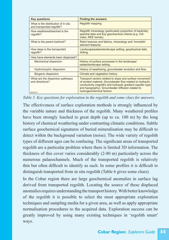
Cobar Region: Explorers Guide ��
The effectiveness of surface exploration methods is strongly influenced by the variable nature and thickness of the regolith. Many weathered profiles have been strongly leached to great depth (up to ca. 100 m) by the long history of chemical weathering under contrasting climatic conditions. Subtle surface geochemical signatures of buried mineralisation may be difficult to detect within the background variation (noise). The wide variety of regolith types of different ages can be confusing. The significant areas of transported regolith are a particular problem where there is limited 3D information. The thickness of this cover varies considerably (2-80 m) particularly across the numerous palaeochannels. Much of the transported regolith is relatively thin but often difficult to identify as such. In some profiles it is difficult to distinguish transported from in situ regolith (Table 6 gives some clues).In the Cobar region there are large geochemical anomalies in surface lag derived from transported regolith. Locating the source of these displaced anomalies requires understanding the transport history. With better knowledge of the regolith it is possible to select the most appropriate exploration techniques and sampling media for a given area, as well as apply appropriate normalisation procedures to the acquired data. Exploration success can be greatly improved by using many existing techniques in ‘regolith smart’ ways.
Table 5. Key questions for exploration in the regolith and some clues for answers.KMQf052-07
Key questions Finding the answers
Regolith mapping.
Regolith mineralogy (particularly proportion of kaolinite), spectral data and key geochemical criteria (e.g. CIAindex, REE trends).
What is the distribution of in situ and transported regolith?
How weathered/leached is the regolith?
What is the parent bedrock? Relict textures and fabrics, mineralogy and ‘immobile' element features.
Landscape/palaeolandscape setting, geophysical data, drilling.
How deep is the transported regolith?
How have elements been dispersed?
Mechanical dispersion History of surface processes in the landscape/palaeolandscape setting.
Hydromorphic dispersion History of weathering, groundwater evolution and flow.
Biogenic dispersion Climate and vegetation history.
What are the dispersion pathways and directions?
Transport vectors related to slope and surface movement of eroded material. Groundwater flow related to hydraulic conductivity (regolith) and hydraulic gradient (aquifer type and topography). Groundwater diffusion related to hydrogeochemical factors.
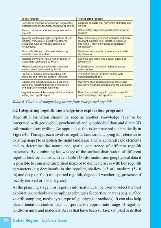
Cobar Region: Explorers Guide��
3.2 Integrating regolith knowledge into exploration programsRegolith information should be seen as another knowledge layer to be integrated with geological, geochemical and geophysical data and direct 3D information from drilling. An approach to this is summarized schematically in Figure 40. This approach involves regolith-landform mapping (or reference to existing maps) to establish the main landscape and palaeolandscape elements and to determine the nature and spatial occurrence of different regolith materials. By combining knowledge of the surface distribution of different regolith-landform units with available 3D information and geophysical data it is possible to construct simplified maps or to delineate areas with key regolith parameters (e.g dominantly in situ regolith, shallow (<5 m), medium (5-10 m) and deep (>10 m) transported regolith, degree of weathering, presence of locally derived or distal lag etc). At the planning stage, this regolith information can be used to select the best exploration methods and sampling techniques for particular areas (e.g. surface vs drill sampling, media type, type of geophysical methods). It can also help plan orientation studies that incorporate the appropriate range of regolith-landform units and materials. Areas that have been surface sampled or drilled
Table 6. Clues to distinguishing in situ from transported regolithKMQf053-07
In situ regolith Transported reoglith
Consists of clasts that may show rounding and sorting.
Sedimentary structures and textures may be present.
Consists of massive or collapsed fragmentarymaterial without secondary rounding or sorting.
Parent rock fabric and textures preserved in saprolite.
Typically contains a higher proportion of lessresistant minerals (e.g. partly weatheredfeldspars). Can be variably silicified or ferruginised.
May be relatively enriched in harder and moreresistant minerals (e.g. quartz, ferruginousfragments). May show signs of secondarycementation.
Kaolinite is commonly more abundant in the clay fraction.
Muscovite illite and other less stable clayminerals more abundant.
Kaolinite commonly has a higher degree ofcrystallinity (estimated by PIMA).
Kaolinite commonly has a lower degree ofcrystallinity.
Phyllosilicates may have lower structuralwater content (estimated by PIMA).
Phyllosilicates may have higher structuralwater content.
Present or palaeo landform setting witherosional and remnant bedrock features.
Present or palaeo landform setting withdepositional features.
Radiometric signature may be distinctive,commonly reflecting bedrock compositionand degree of element leaching.
May have abundant ferruginous clasts withdistinctive magnetic and radiometric signatures.
Vegetation associations may reflect landformsetting and regolith types.
Deep transported regolith may have specific,commonly large, tree species.
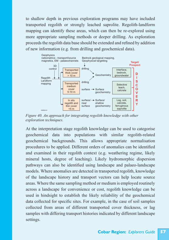
Cobar Region: Explorers Guide ��
to shallow depth in previous exploration programs may have included transported regolith or strongly leached saprolite. Regolith-landform mapping can identify these areas, which can then be re-explored using more appropriate sampling methods or deeper drilling. As exploration proceeds the regolith data base should be extended and refined by addition of new information (e.g. from drilling and geochemical data).
At the interpretation stage regolith knowledge can be used to categorise geochemical data into populations with similar regolith-related geochemical backgrounds. This allows appropriate normalisation procedures to be applied. Different orders of anomalies can be identified and examined in their regolith context (e.g. weathering regime, likely mineral hosts, degree of leaching). Likely hydromorphic dispersion pathways can also be identified using landscape and palaeo-landscape models. Where anomalies are detected in transported regolith, knowledge of the landscape history and transport vectors can help locate source areas. Where the same sampling method or medium is employed routinely across a landscape for convenience or cost, regolith knowledge can be used in hindsight to establish the likely reliability of the geochemical data collected for specific sites. For example, in the case of soil samples collected from areas of different transported cover thickness, or lag samples with differing transport histories indicated by different landscape settings.
Figure 40. An approach for integrating regolith knowledge with other exploration techniques.
Geophysicsradiometrics - transport/sourcemagnetics, EM - palaeochannels
Bedrock geological mapping,Geophysical targetting
RegolithLandformmapping
3Dcontrol drilling
drilling
surface/nearsurface
surface Surfacegeochemistry
Geochemistry
Surface/shallowgeochemistry
DISCOVERY
Transportedthick cover
> 10 m
Interface,bedrock,
groundwater
Transportedmediumcover
5-10 m
Selectiveleach,
calcrete
In situ regolith and thin cover
<5 m
Lag, soil, calcrete,
ferruginoussaprolite
Target/Prospect
KMQf048-08
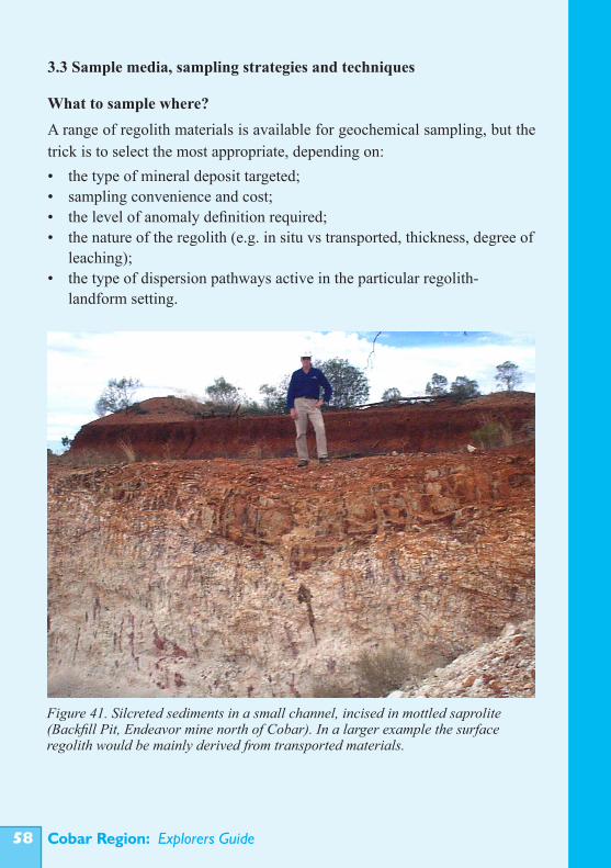
Cobar Region: Explorers Guide��
3.3 Sample media, sampling strategies and techniques
What to sample where?A range of regolith materials is available for geochemical sampling, but the trick is to select the most appropriate, depending on: • the type of mineral deposit targeted; • sampling convenience and cost; • the level of anomaly definition required; • the nature of the regolith (e.g. in situ vs transported, thickness, degree of leaching); • the type of dispersion pathways active in the particular regolith- landform setting.
Figure 41. Silcreted sediments in a small channel, incised in mottled saprolite (Backfill Pit, Endeavor mine north of Cobar). In a larger example the surface regolith would be mainly derived from transported materials.
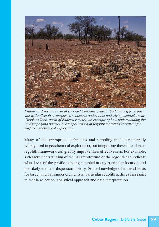
Cobar Region: Explorers Guide ��
Many of the appropriate techniques and sampling media are already widely used in geochemical exploration, but integrating these into a better regolith framework can greatly improve their effectiveness. For example, a clearer understanding of the 3D architecture of the regolith can indicate what level of the profile is being sampled at any particular location and the likely element dispersion history. Some knowledge of mineral hosts for target and pathfinder elements in particular regolith settings can assist in media selection, analytical approach and data interpretation.
Figure 42. Erosional rise of silcreted Cenozoic gravels. Soil and lag from this site will reflect the transported sediments and not the underlying bedrock (near Chookies Tank, north of Endeavor mine). An example of how understanding the landscape (and palaeo-landscape) setting of regolith materials is critical for surface geochemical exploration.
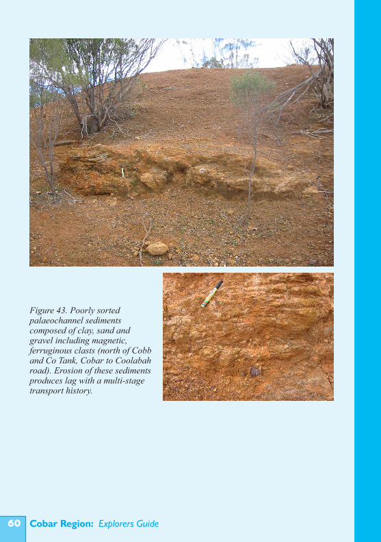
Cobar Region: Explorers Guide�0
Figure 43. Poorly sorted palaeochannel sediments composed of clay, sand and gravel including magnetic, ferruginous clasts (north of Cobb and Co Tank, Cobar to Coolabah road). Erosion of these sediments produces lag with a multi-stage transport history.
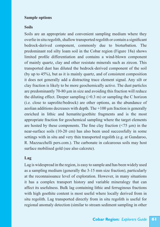
Cobar Region: Explorers Guide ��
Sample options
SoilsSoils are an appropriate and convenient sampling medium where they overlie in situ regolith, shallow transported regolith or contain a significant bedrock-derived component, commonly due to bioturbation. The predominant red silty loam soil in the Cobar region (Figure 18a) shows limited profile differentiation and contains a wind-blown component of mainly quartz, clay and other resistate minerals such as zircon. This transported dust has diluted the bedrock-derived component of the soil (by up to 45%), but as it is mainly quartz, and of consistent composition it does not generally add a distracting trace element signal. Any silt or clay fraction is likely to be more geochemically active. The dust particles are predominantly 70-80 µm in size and avoiding this fraction will reduce the diluting effect. Deeper sampling (>0.3 m) or sampling the C horizon (i.e. close to saprolite/bedrock) are other options, as the abundance of aeolian additions decreases with depth. The +100 µm fraction is generally enriched in lithic and hematite/goethite fragments and is the most appropriate fraction for geochemical sampling where the target elements are hosted by these components. The fine clay fraction (<75 µm) in the near-surface soils (10-20 cm) has also been used successfully in some settings with in situ and very thin transported regolith (e.g. at Gundaroo, R. Mazzucchelli pers.com.). The carbonate in calcareous soils may host surface mobilised gold (see also calcrete).
LagLag is widespread in the region, is easy to sample and has been widely used as a sampling medium (generally the 3-15 mm size fraction), particularly at the reconnaissance level of exploration. However, in many situations it has a complex transport history and variable mineralogy that can affect its usefulness. Bulk lag containing lithic and ferruginous fractions with high goethite content is most useful where locally derived from in situ regolith. Lag transported directly from in situ regolith is useful for regional anomaly detection (similar to stream sediment sampling in other
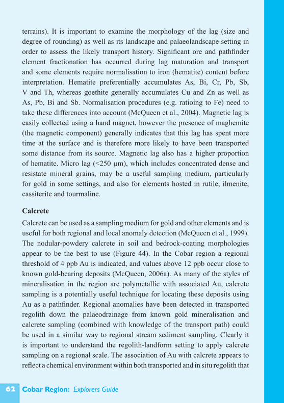
Cobar Region: Explorers Guide��
terrains). It is important to examine the morphology of the lag (size and degree of rounding) as well as its landscape and palaeolandscape setting in order to assess the likely transport history. Significant ore and pathfinder element fractionation has occurred during lag maturation and transport and some elements require normalisation to iron (hematite) content before interpretation. Hematite preferentially accumulates As, Bi, Cr, Pb, Sb, V and Th, whereas goethite generally accumulates Cu and Zn as well as As, Pb, Bi and Sb. Normalisation procedures (e.g. ratioing to Fe) need to take these differences into account (McQueen et al., 2004). Magnetic lag is easily collected using a hand magnet, however the presence of maghemite (the magnetic component) generally indicates that this lag has spent more time at the surface and is therefore more likely to have been transported some distance from its source. Magnetic lag also has a higher proportion of hematite. Micro lag (<250 µm), which includes concentrated dense and resistate mineral grains, may be a useful sampling medium, particularly for gold in some settings, and also for elements hosted in rutile, ilmenite, cassiterite and tourmaline.
CalcreteCalcrete can be used as a sampling medium for gold and other elements and is useful for both regional and local anomaly detection (McQueen et al., 1999). The nodular-powdery calcrete in soil and bedrock-coating morphologies appear to be the best to use (Figure 44). In the Cobar region a regional threshold of 4 ppb Au is indicated, and values above 12 ppb occur close to known gold-bearing deposits (McQueen, 2006a). As many of the styles of mineralisation in the region are polymetallic with associated Au, calcrete sampling is a potentially useful technique for locating these deposits using Au as a pathfinder. Regional anomalies have been detected in transported regolith down the palaeodrainage from known gold mineralisation and calcrete sampling (combined with knowledge of the transport path) could be used in a similar way to regional stream sediment sampling. Clearly it is important to understand the regolith-landform setting to apply calcrete sampling on a regional scale. The association of Au with calcrete appears to reflect a chemical environment within both transported and in situ regolith that
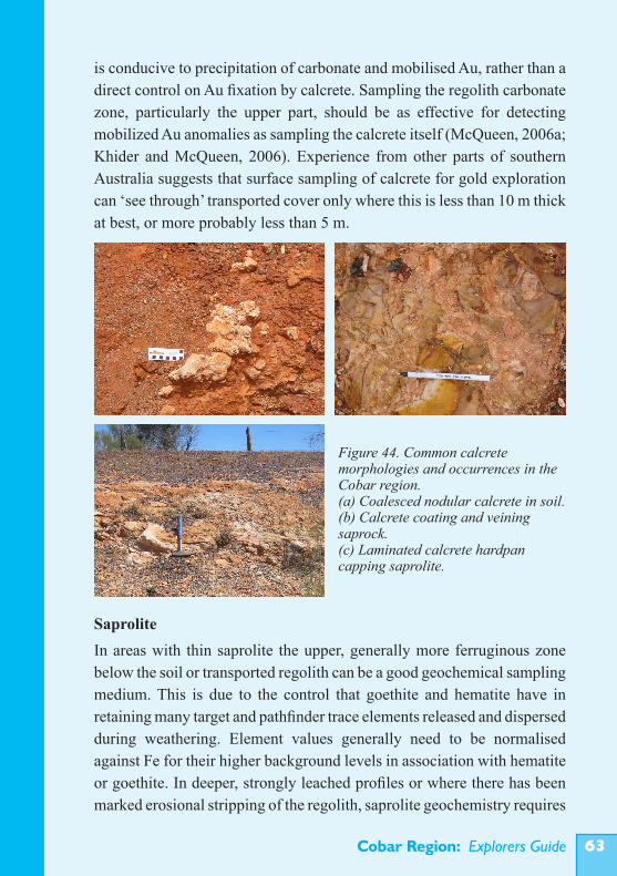
Cobar Region: Explorers Guide ��
is conducive to precipitation of carbonate and mobilised Au, rather than a direct control on Au fixation by calcrete. Sampling the regolith carbonate zone, particularly the upper part, should be as effective for detecting mobilized Au anomalies as sampling the calcrete itself (McQueen, 2006a; Khider and McQueen, 2006). Experience from other parts of southern Australia suggests that surface sampling of calcrete for gold exploration can ‘see through’ transported cover only where this is less than 10 m thick at best, or more probably less than 5 m.
SaproliteIn areas with thin saprolite the upper, generally more ferruginous zone below the soil or transported regolith can be a good geochemical sampling medium. This is due to the control that goethite and hematite have in retaining many target and pathfinder trace elements released and dispersed during weathering. Element values generally need to be normalised against Fe for their higher background levels in association with hematite or goethite. In deeper, strongly leached profiles or where there has been marked erosional stripping of the regolith, saprolite geochemistry requires
Figure 44. Common calcrete morphologies and occurrences in the Cobar region. (a) Coalesced nodular calcrete in soil. (b) Calcrete coating and veining saprock. (c) Laminated calcrete hardpan capping saprolite.
Cobar Region: Explorers Guide��
more careful interpretation. The active redox front, generally close to the water table, is typically a zone of accumulation for dispersed trace elements. This zone is commonly marked by accumulation of goethite/hematite and in some cases manganese oxides. Perched iron oxide/oxyhydroxide concentrations in thicker saprolite also commonly retain ore and pathfinder elements. Where target elements are hosted by resistate minerals or mineral inclusions within major rock-forming minerals that have not been degraded by weathering (e.g. quartz), an alternate approach is to analyse the insoluble residue after strong acid leaching of samples (aqua regia followed by sulphuric acid; Pwa et al., 1999; van Moort and Pwa, 2005). This removes most of the clays, iron and manganese oxides, together with any secondary element additions to the regolith from an extraneous non-ore source, and may give a clearer indication of primary dispersion patterns related to mineralisation.
Bedrock/SaprockRock chips can be sampled from outcrops or exposed bedrock in costeans, where the regolith is relatively thin. Generally bedrock has to be sampled by drilling through the in situ or transported regolith. Dispersion patterns are typically very limited in weakly weathered rock, or restricted to primary dispersion halos. Ferruginous or gossanous material may contain the best signal of mineralisation. Rock chip sampling at surface or from drilling is useful for tightly defining broader dispersion patterns detected in soils or saprolite. It is also obviously the main method of directly identifying mineralisation.
Gossans and ironstonesMost of the outcropping sulphide deposits discovered in the Cobar region have had some form of gossanous expression. In strongly weathered erosional settings the upper parts of the gossans are strongly depleted in ore elements, but depending on the setting and weathering regime history certain target and pathfinder elements are sufficiently abundant to identify the gossans. Copper, Zn and Au may be strongly depleted in the very upper parts of very mature gossan profiles. At the CSA and New Cobar deposits Pb, Bi and As are strong pathfinders, with lesser but still anomalous amounts of Au, Ag,
Cobar Region: Explorers Guide ��
Sb, Se. Tin and W can be key indicator elements where they are present in resistate minerals (e.g. cassiterite and rutile). There have been some extensive gossan and ironstone sampling surveys in the Cobar region, but these have not yet led to major new discoveries (e.g. Capnerhurst, 2003; 2005). Explorers should be alert to possible gossan fragments in transported regolith, particularly in palaeochannel sediments. Where these are detected it may be possible to trace them back to their source in poorly outcropping or now buried bedrock areas. Caution is required in sampling ironstones, as ferruginised regolith and massive iron oxide concentrations are relatively common. These have formed by precipitation and concentration of hematite/goethite in porous regolith to form dense mottles, as infillings along faults and joints and as massive and cementing materials (ferricretes) formed from near-surface groundwaters and springs (e.g. the Louth Road ironstones). Being physically and chemically stable ironstones persist in the landscape after erosion and may also be topographically inverted. They can be enriched in some trace elements, particularly Pb and As, due to scavenging by hematite, goethite and manganese oxides. Multi-element associations are the clue to true gossans. Textural features such as boxworks can be a guide, but are not always present in true gossans where additional iron has been introduced in solution or colloidal form. Traces of oxide zone and related resistate minerals are also good indicators (e.g. cerussite, copper carbonates and sulphates, gold, cassiterite).
Drainage sedimentsDrainage flow in the Cobar region is ephemeral with intense flow after heavy rain. Channels are poorly defined and commonly choked with silt from deflation of the surrounding soils. These silts contain a significant aeolian component and are generally not in geochemical equilibrium with the adjacent catchment bedrock. Therefore they are not a useful or reliable sampling medium. The coarser sediments, which include rock fragments and ferruginous lag, and the fine (and heavier) fractions from the base of the channels in low-order drainages are more suitable for geochemical sampling. The coarser fragments represent a type of mechanically
Cobar Region: Explorers Guide��
dispersed ‘channel lag’, and in areas of eroding bedrock will reflect the upstream bedrock geochemistry. In these settings they may be effective for evaluating interfluve areas during regional reconnaissance exploration.A number of regional drainage surveys have been conducted with variable success (Cohen et al., 1996). In the 1980s Geopeko-Norgold completed a large drainage sampling program in the south-western and central part of the Cobar region, utilising the subsidiary channels and collecting ferruginous pisolitic material from below 1 m to avoid the infilling silt (Allan and Taylor, 1989; Schmidt, 1991; Allan et al., 1992). Bulk samples (5-10 kg) were analysed for Au following a cyanide leach (BLEG). The <180 µm and magnetic fractions were analysed for Cu, Pb, Zn, As, Bi, Sb, Fe and Mn by ICP-OES after perchloric-hydrochloric acid digestion. Metal values were higher in the magnetic (pisolitic lag) fraction than the <180 µm samples, except for Cu and Zn. Gold showed an association with As-Bi-Sb or Pb-Zn. The Wonawinta zinc-lead-silver prospect was detected by this drainage sampling and the McKinnons gold deposit was discovered during the program, but mainly from its outcropping expression, with only one low-order anomaly (0.45 ppb Au) downstream. A low-level but extensive Pb anomaly is detectable in the coarser fractions (>1.18 mm) of samples collected from 10-20 cm depth in drainage channels off the Elura Zn-Pb-Ag deposit (Dunlop et al., 1983). This anomaly extends for at least 5 km and has formed by a multi-stage process of early chemical dispersion of Pb into ferruginous material, lag concentration at the surface and then detrital dispersion down the more recent drainage.
GroundwaterGroundwater is the main agent of weathering and retains and transports elements as dissolved ions, complexes, colloids and gases. Groundwater anomalies may be broader and more regular than mineralisation and the secondary dispersion halo in the regolith (Giblin, 1995). Sampling and analysis of groundwater encountered during drilling can also indicate bedrock composition and how the bedrock is weathering, as well as provide information on active element dispersion processes. The concentrations of trace elements will depend on their abundance in the regolith and the solvent capacity of the contacting groundwater. To date, groundwater has not been
Cobar Region: Explorers Guide ��
widely used as a sampling medium, largely because of uncertainty about appropriate sampling and treatment methods and the additional time and cost. Studies of shallow groundwaters from unconfined aquifers in regolith (mostly saprolite and some palaeochannel sediments) in the Cobar region suggest there is potential for using these to detect dispersed elements. Enrichments in Cu (0.33 mg/L) and Zn (0.29-0.35 mg/L) above regional groundwater concentrations (0.1 and 0.01 mg/L, respectively) have been observed near sub-economic mineralisation at the White Tank and Wilga Downs prospects (Khider, 2007). Elevated Ni contents (0.05 mg/L) have been detected in high-chloride and sulphate-bearing groundwaters intersected in a palaeochannel over buried ultramafic rocks at the West Lynn prospect. Anomalous levels of gold (up to 0.04 µg/L) have been detected in chloride-sulphate groundwaters around the Peak gold deposit south of Cobar, using carbon sachet extraction. These groundwaters also contained other detectable trace metals (Cu 0.001-0.011 mg/L, Zn 0.005-0.158 mg/L, As 0.001-0.004 mg/L, D. McPhail, pers. comm.).Depth to the water table varies across the region from approximately 12 to 140 m. In most areas the water table is sub-parallel to the broad surface topography. Three different groundwater types have been identified (Mullholand, 1940; Khider, 2004; Khider and McPhail, 2005). These are:• chloride type, in which Cl- is the main anion with Na+ and K+ the major cations (EC >5,000 µS/cm); • calcium-bicarbonate type, rich in HCO3- and Ca2+ and Mg2+ with relatively low Cl- , found in restricted areas with weathered mafic rocks (e.g. leucitites); • mixed bicarbonate-chloride type with moderate amounts of HCO3-, Cl- and Na+.
Chloride type groundwaters, with variable chloride content, are the most common. Waters in transported regolith commonly have very high chloride contents. In detail, groundwater compositions vary considerably. Some have high SO4
2- contents.
Cobar Region: Explorers Guide��
Where groundwater is intersected in exploration drilling it can be easily sampled with a purpose built plastic baler, generally after allowing a day or two for water to seep into the hole. Ideally, for consistent sampling the water should be filtered (0.45 µm filter). For cation analysis, samples should be acidified with nitric acid in pre-washed plastic bottles. Generally a second sample is collected without acidification and submitted for anion analysis (Cl, SO4, Br, F, I, NO3 and PO4). To fully understand the groundwater chemistry it is critical to measure the pH, temperature, electrical conductivity and oxidation potential (Eh). More sophisticated groundwater studies may be useful in specific drill holes thought to be in near-miss situations (i.e. as a type of down-hole geochemical sensing technique).
BiotaThe regolith biota offer a range of potential sampling media, but the advantages over other media still need to be established in the Cobar region. Trees sample large volumes of regolith and groundwater via their extensive root systems and depending on the root depth can potentially penetrate through deep (up to ca. 20 m) transported cover. In the Cobar region studies have been conducted on metal uptake in white cypress pine (Callitris glaucophylla). Levels of up to 6 ppb Au have been found in needles of cypress pine trees growing in both transported and in situ regolith near the McKinnons gold deposit. Some anomalous values coincide with elevated Au in soil and the projected trend of mineralisation. There are also coincident anomalies in As, Sb and La in the pine needles (Cohen et al., 1996; Cohen et al., 1998). Cypress pine trees can also take up Ni, with levels of 10-30 ppm observed in needles from trees growing over sub-cropping and buried (<3 m cover) ultramafic rocks at Miandetta (Alorbi, 2006). Sampling and analysis of needles and bark from trees growing over a more deeply buried Ni-rich weathering profile on pyroxenites at the Gilgai Complex showed that they did not contain Ni above 3 ppm, which is close to background levels for cypress pine in the region. At this site the cover was transported regolith ranging from 10 to over 50 m thick.There have been some biogeochemical studies in other parts of central
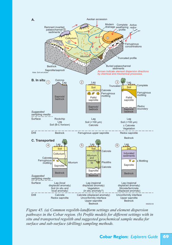
Cobar Region: Explorers Guide ��
Figure 45. (a) Common regolith-landform settings and element dispersion pathways in the Cobar region. (b) Profile models for different settings with in situ and transported regolith and suggested geochemical sample media for surface and sub-surface (drilling) sampling methods.
Saprock/bedrock
Saprock/bedrock Saprock/
bedrock
Pallidsaprolite
Pallidsaprolite
LagLag Lag
Soil Soil
Redoxboundary
CalcreteFerruginousmottling
Ferruginousmottling
Outcrop
RockchipLag
Soil (B-C horizon)
Bedrock
Lag
Soil (+100 µm)Calcrete
Ferruginous upper saprolite
Lag
Soil (+100 µm)
± CalcreteVegetation
Redox saprolite
Bedrock
21 3
Truncated Complete
Surface
Drill
Suggestedsampling media
Surface
Drill
Lag (local displaced anomaly)
Lag (regional displaced anomaly)
Lag (regional displaced anomaly)
Soil (in situ and local anomaly)
Vegetation(in situ anomaly?)
Silcrete/ferricrete(displaced anomaly)
CalcreteRedox saprolite Unconformity interface
Upper saproliteBedrock
Calcrete (displaced anomaly) Unconformity interfaceUpper saprolite
Bedrock
BedrockBedrock Bedrock
KMQf022-08
Saprolite
Saprolite Saprolite
Lag LagLag
SoilSoil SoilCalcrete
Calcrete
Pisoliths± Mottling
Alluviumand
channelfill
Colluvium
CalcreteFerruginous
mottling Alluvium
Induratedsediments
64 5
5
3
4
6
2
1
Aeolian accession
Moderndrainage
Colluvium
Alluvium
Remnant invertedpalaeochannel
sediments
Buried palaeochannelsediments
Truncated profile
Ferruginousconcentrations
Completeweathering
profile
Saprolite/saprock
Bedrock
Arrows indicate element dispersion directions by chemical and mechanical processes.
Activeredox
WT
Outcrop
Note: Soil not shown
Suggestedsampling media
A.
B. In situ
C. Transported
Cobar Region: Explorers Guide�0
and western New South Wales (e.g. Huang, 1998; Hill and Hill, 2003, Roach, 2005) using other plant species such as mulga (Acacia aneura), black cypress pine (Callitris endlicheri), river red gum (Eucalyptus camaldulensis), golden wattle (Acacia pycnantha), yellow box (E. melliodora) and red box (E. polyanthemos). Results have been promising but not totally definitive.Appropriate sampling media and methods for different types of regolith and landscape positions in the Cobar region are summarised in Figure 45. Also shown schematically are likely element dispersion pathways for the common landscape and palaeo-landscape settings.
3.4 Drilling
3D interpretation of the regolith and drill hole samplingDrilling is used to test targets initially identified by surface geochemistry, shallow auger sampling, geophysical methods or geological mapping. It provides samples for detecting subsurface geochemical dispersion and importantly, information on the 3D distribution of regolith and bedrock units.Reconnaissance drilling and sampling in areas of regolith cover in the Cobar region has commonly involved Rotary Air Blast (RAB) or Aircore drilling to ‘fresh’ bedrock or refusal and sampling of material at this position. Most mineral explorers now realise that this is a very restricted and inconsistent method of sampling as ‘refusal’ could be a wide range of materials ranging from bedrock to different components of the regolith (e.g. silcrete, hard pans, gravel layers in transported regolith). Sampling at a particular depth within the regolith is also fraught with uncertainties, given the considerable variability in regolith profiles and the established heterogenous uptake of dispersed elements in different regolith components. Ideally, drill holes should be drilled to fresh rock (or at least to the base of oxidation). This ensures that the whole regolith profile has been observed and also allows for sampling the bedrock to establish rock type for geological mapping. Analysis of bedrock samples is useful for detecting primary dispersion anomalies and unweathered mineralisation and for assisting rock identification. Element dispersion in bedrock is very limited and hence the
Cobar Region: Explorers Guide ��
anomalies are very small targets. Secondary dispersion in the regolith is more extensive and this is the main reason for sampling the regolith. The challenge is to sample the most appropriate material. It helps to sample and analyse the whole profile at 1 m intervals for at least a small number of drill holes (e.g. 1 in 10) that are representative of the different types of regolith in a given area. This type of orientation will indicate how the chemical composition of the regolith varies through the profile and assist with identifying the most appropriate horizons and materials. Good visual, textural and spectral logging of regolith cuttings from all holes is essential for appropriate 3D knowledge of the regolith and to identify consistent and appropriate sampling media. This approach should also be used during Reverse Circulation (RC) percussion drilling through the regolith to bedrock targets.
Things to look for and sample in drillingRegolith features observable in drill cuttings will vary with the type of regolith (e.g. in situ vs transported) and the degree of weathering profile development and preservation. Well-developed in situ profiles will typically show reddish orange and yellow-brown colouration in an upper mottled zone grading to white or cream in bleached saprolite, but with yellow-brown and orange zones marking old redox fronts, generally related to palaeo or perched water table levels. Dominant goethite is indicated by yellow colours and hematite by reds and pinks. Mixtures typically result in different shades of orange. The transition to fresh rock is generally marked by a change from buff, pale brown, yellow or orange to grey and greenish grey (for the typical siltstones and shales). This is also commonly close to or just below the active redox front. In drill core or large-fragment cuttings it is possible to see the detailed distribution of the different regolith components, including the weathering products of the primary minerals in saprolite and saprock, ferruginous fracture fillings and mottles, and manganese oxide coatings. Ferruginous mottles are commonly zoned, with yellow goethitic and reddish hematitic bands. Manganese oxides form black powdery coatings and fillings. Massive goethite/hematite fillings can be brown or black but show a
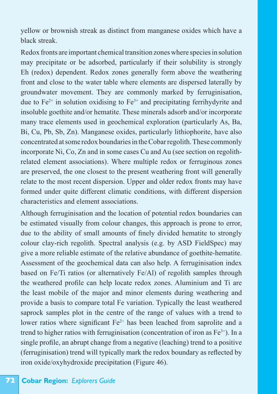
Cobar Region: Explorers Guide��
yellow or brownish streak as distinct from manganese oxides which have a black streak. Redox fronts are important chemical transition zones where species in solution may precipitate or be adsorbed, particularly if their solubility is strongly Eh (redox) dependent. Redox zones generally form above the weathering front and close to the water table where elements are dispersed laterally by groundwater movement. They are commonly marked by ferruginisation, due to Fe2+ in solution oxidising to Fe3+ and precipitating ferrihydyrite and insoluble goethite and/or hematite. These minerals adsorb and/or incorporate many trace elements used in geochemical exploration (particularly As, Ba, Bi, Cu, Pb, Sb, Zn). Manganese oxides, particularly lithiophorite, have also concentrated at some redox boundaries in the Cobar regolith. These commonly incorporate Ni, Co, Zn and in some cases Cu and Au (see section on regolith-related element associations). Where multiple redox or ferruginous zones are preserved, the one closest to the present weathering front will generally relate to the most recent dispersion. Upper and older redox fronts may have formed under quite different climatic conditions, with different dispersion characteristics and element associations.Although ferruginisation and the location of potential redox boundaries can be estimated visually from colour changes, this approach is prone to error, due to the ability of small amounts of finely divided hematite to strongly colour clay-rich regolith. Spectral analysis (e.g. by ASD FieldSpec) may give a more reliable estimate of the relative abundance of goethite-hematite. Assessment of the geochemical data can also help. A ferruginisation index based on Fe/Ti ratios (or alternatively Fe/Al) of regolith samples through the weathered profile can help locate redox zones. Aluminium and Ti are the least mobile of the major and minor elements during weathering and provide a basis to compare total Fe variation. Typically the least weathered saprock samples plot in the centre of the range of values with a trend to lower ratios where significant Fe2+ has been leached from saprolite and a trend to higher ratios with ferruginisation (concentration of iron as Fe3+). In a single profile, an abrupt change from a negative (leaching) trend to a positive (ferruginisation) trend will typically mark the redox boundary as reflected by iron oxide/oxyhydroxide precipitation (Figure 46).
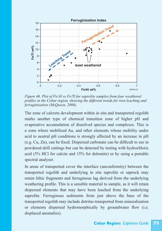
Cobar Region: Explorers Guide ��
The zone of calcrete development within in situ and transported regolith marks another type of chemical transition zone of higher pH and evaporative accumulation of dissolved species and complexes. This is a zone where mobilised Au, and other elements whose mobility under acid to neutral pH conditions is strongly affected by an increase in pH (e.g. Cu, Zn), can be fixed. Dispersed carbonate can be difficult to see in powdered drill cuttings but can be detected by testing with hydrochloric acid (5% HCl for calcite and 15% for dolomite) or by using a portable spectral analyser.In areas of transported cover the interface (unconformity) between the transported regolith and underlying in situ saprolite or saprock may retain lithic fragments and ferruginous lag derived from the underlying weathering profile. This is a sensible material to sample, as it will retain dispersed elements that may have been leached from the underlying saprolite. Ferruginous sediments from just above the base of the transported regolith may include detritus transported from mineralisation or elements dispersed hydromorphically by groundwater flow (i.e. displaced anomalies).
Figure 46. Plot of Fe/Al vs Fe/Ti for saprolite samples from four weathered profiles in the Cobar region, showing the different trends for iron leaching and ferruginisation (McQueen, 2006).
Ferruginisation Index
0
2
4
6
8
10
12
14
16
18
0 0.2 0.4 0.6 0.8 1
KMQf033-08Fe/Al wt%
Fe
/Tiw
t%
Leaching
Trend
Ferruginisatio
n Trend
least weathered
Cobar Region: Explorers Guide��
Zones within in situ regolith with gossanous fragments and ferruginous quartz veins should be sampled, as these may represent the remnants of mineralisation not obvious at the surface due to soil cover or burial by transported regolith. Shear zones, indicated by brecciated, veined and deformation fabrics in cutting fragments or core sticks, should also be samples, as they may contain elements dispersed from related mineralisation.
Logging and interpretationRegolith logging needs to be systematic and consistent. This has been a major problem in the past due to poorly defined or highly subjective regolith terminology and individualistic methods of logging. To improve regolith logging CRC LEME has constructed a ‘Regolith Glossary’ (Eggleton, 2001), is publishing a field guide to describing and sampling regolith materials (Pain in prep) and has helped develop objective regolith logging methods, including the HyLogger. Digital data bases work best with quantitative descriptors (e.g. % quartz rather than ‘quartz-rich’). It is important to log and describe the regolith separately from the unweathered bedrock. Avoid mixing regolith and fresh-rock terms and the urge to interpret and describe the regolith as the weathering product of a particular parent rock type. Describe it as it is.Dry and washed cuttings should be laid out and described on site by the geologist as drilling proceeds. Samples of dry cuttings and a few washed chips should be kept as an archival reference (e.g. in plastic chip trays). It is useful to draw up rough drill sections in the field to help with correlation and recognition of distinctive regolith units. Scanning of drill cuttings with a magnetic susceptibility meter is a quick (and quantitative) way to detect highly magnetic materials and variations in some regolith and bedrock types (e.g. transported magnetic gravels in post-Miocene palaeochannel and channel deposits). Most of the regolith derived from the common meta-sedimentary rocks in the Cobar region has very low magnetic susceptibility. Analysis by portable XRF (e.g. ‘Niton’) is useful for detecting variations in iron content and high abundances of some target and pathfinder elements.Good digital data management is critical to properly integrate information from field logging, later laboratory logging and geochemical analysis. ‘Visualisation’ software (e.g. ‘Discover’) can help interpret the 3D structure
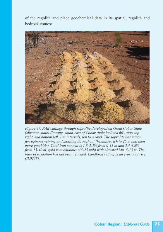
Cobar Region: Explorers Guide ��
of the regolith and place geochemical data in its spatial, regolith and bedrock context.
Figure 47. RAB cuttings through saprolite developed on Great Cobar Slate (siltstone-slate) Ilewong, south-east of Cobar (hole inclined 60˚, start top right, end bottom left, 1 m intervals, ten to a row). The saprolite has minor ferruginous veining and mottling throughout (hematite-rich to 25 m and then more goethitic). Total iron content is 1.8-3.5% from 0-13 m and 3.4-4.8% from 13-40 m, gold is anomalous (15-25 ppb) with elevated Mn, 5-13 m. The base of oxidation has not been reached. Landform setting is an erosional rise. (IL0238).
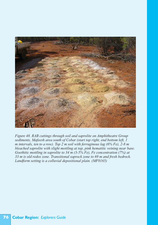
Cobar Region: Explorers Guide��
Figure 48. RAB cuttings through soil and saprolite on Amphitheatre Group sediments, Mafeesh area south of Cobar (start top right, end bottom left, 1 m intervals, ten to a row). Top 2 m soil with ferruginous lag (6% Fe), 2-8 m bleached saprolite with slight mottling at top, pink hematitic veining near base. Goethitic mottling in saprolite to 34 m (3-5% Fe), Fe concentration (7%) at 33 m is old redox zone. Transitional saprock zone to 69 m and fresh bedrock. Landform setting is a colluvial depositional plain. (MF0165)
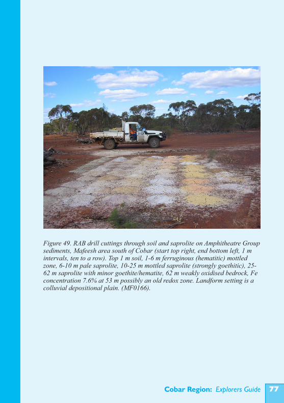
Cobar Region: Explorers Guide ��
Figure 49. RAB drill cuttings through soil and saprolite on Amphitheatre Group sediments, Mafeesh area south of Cobar (start top right, end bottom left, 1 m intervals, ten to a row). Top 1 m soil, 1-6 m ferruginous (hematitic) mottled zone, 6-10 m pale saprolite, 10-25 m mottled saprolite (strongly goethitic), 25-62 m saprolite with minor goethite/hematite, 62 m weakly oxidised bedrock, Fe concentration 7.6% at 53 m possibly an old redox zone. Landform setting is a colluvial depositional plain. (MF0166).
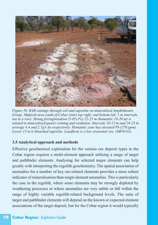
Cobar Region: Explorers Guide��
3.5 Analytical approach and methodsEffective geochemical exploration for the various ore deposit types in the Cobar region requires a multi-element approach utilising a range of target and pathfinder elements. Analysing for selected major elements can help greatly with interpreting the regolith geochemistry. The spatial association of anomalies for a number of key ore-related elements provides a more robust indicator of mineralisation than single element anomalies. This is particularly the case in the regolith, where some elements may be strongly depleted by weathering processes or where anomalies are very subtle or fall within the range of highly variable regolith-related background levels. The suite of target and pathfinder elements will depend on the known or expected element associations of the target deposit, but for the Cobar region it would typically
Figure 50. RAB cuttings through soil and saprolite on mineralised Amphitheatre Group, Mafeesh area south of Cobar (start top right, end bottom left, 1 m intervals, ten to a row). Strong ferruginisation (5-6% Fe) 12-25 m (hematitic 18-20 m) is related to mineralised quartz-veining and oxidation. Intervals 10-12 m and 19-23 m average 4.4 and 2.7g/t Au respectively. Hematitic zone has elevated Pb (270 ppm). Lower 15 m is bleached saprolite. Landform is a low erosional rise. (MF0143).
Cobar Region: Explorers Guide ��
include As, Ag, Au, Co, Cu, Pb, Zn, Ni, with the variable inclusionof Bi, Mo, PGE, Sb, Se, Sn and W. Major/minor elements such as Al, Fe, Ca, Mg, K, Mn, Cr, V and Ti can be used to monitor the main host components for trace elements in the regolith and help identify different regolith materials. If necessary, trace element data can be normalised for varying abundances of the hosting minerals, for example Fe and Mn oxides/oxyhydroxides or regolith carbonates. Major element data can also aid interpretation of profiles and guide consistency of sampling. Modern methods of analysis are highly suited to multi-element measurement at low cost and the extra expense of analysing additional elements is usually far outweighed by the benefits of the additional knowledge. For parent rock identification using Ti and Zr, a total analysis method is recommended (e.g. XRF).Regional baseline studies in the Cobar region (e.g. Chan et al., 2001; 2002; 2004) indicate that multi-acid (‘total’) or strong acid (aqua-regia) digest followed by analysis using Inductively Coupled Plasma Optical Emission Spectrometry and Mass Spectrometry (ICP-OES/MS) are good ‘first-pass’ methods for geochemical exploration of the regolith. With this approach the maximum information is obtained on the overall geochemical nature of the regolith (particularly from drill profiles) at reasonable cost. ICP-OES analysis is used for major and minor elements, as it gives a detection range that covers their typical abundances. Many trace elements (including target and pathfinder elements) have very low abundance, particularly in strongly leached regolith, and ICP-MS is the preferred method, as it has detection limits well below these abundances .Partial leach methods may be useful where the element dispersion controls and regolith host sites are well understood (e.g. from an orientation study). These methods also have the advantage of lowering detection limits by excluding from solution the non-selected sample component. Generally the lower the total dissolved solids in solution the more sensitive the analysis (e.g. by ICP-MS). On the other hand, if the regolith is poorly known or highly variable in the way it hosts dispersed elements, anomalies may be missed or ‘spotty’. Some selective leach methods are designed to extract the most recently mobilised and deposited trace elements that are loosely bound or hosted by particular amorphous phases, particularly in soils (e.g.
Cobar Region: Explorers Guide�0
Enzyme Leach, MMI, Regoleach). This approach tests for currently active dispersion patterns, but in many settings these may be very deep. Being less robust, partial leach digestions require consistent laboratory handling and treatment. Where true total analysis data are required, for example to assist with interpretation of parent rock type, or apply element ratio techniques to detect primary alteration patterns, analysis by X-ray Fluorescence (XRF), Instrumental Neutron Activation Analysis (INAA) or sample fusion followed by ICP-OES/MS is recommended. Some elements, notably Au, may require specific analysis techniques generally on larger samples to reduce the ‘nugget effect’.
3.6 Quality assurance and quality controlIt is critical to assess and understand the quality of geochemical data. Aspects to consider are sampling procedure, sample preparation and analytical precision and accuracy.The degree to which a sample represents a larger volume of material is fundamental to all sampling. It will depend on the size of the sample, the degree of homogeneity of the material, the mineral/component particle size and the way in which the sample is collected. Bulk chips and pulverised drill cuttings can be sampled with a sample spear/pipe inserted across the whole volume (several times) or by splitting using a riffle splitter. Comparison of analyses from duplicate or replicate samples collected in this way can be used to assess the representativeness of the sampling. When combining samples from different intervals to make composite samples it is important to maintain equal sample size (weight). Contamination between samples or sample intervals can be a problem during RAB, air core and percussion drilling. This can occur by abrasion of the hole walls (in RAB) as well as sample lag and mixing in the drill line (this can produce ‘smearing’ of high element values over apparently broader intervals). Reverse circulation (Air Core and RC) avoids contamination from the hole walls, but there may still be some mixing of residual material in drill rods and the cyclone collector. Flushing the drill by drilling a short interval at a new site and then restarting the hole, is a good way to avoid contamination between holes.
Cobar Region: Explorers Guide ��
Contamination of samples during preparation or storage can be a problem. Avoid initial preparation (splitting, sieving) in areas around operating mines or sites where contaminating dust may be an issue. Check the facilities and practices of commercial laboratories with an inspection visit.Duplicate or replicate splits of the same homogenised sample should be submitted to assess analytical precision (reproducibility). Standard reference samples should also be used to assess the accuracy (closeness to ‘real’ value) of the analytical results. Standards may be commercially available reference samples or carefully prepared internal standards that have been multiply analysed, preferably by a number of laboratories. Several standards should be used to cover the range of expected abundances for the various elements to be analysed. Most commercial laboratories will also carry out a separate quality control exercise using duplicates and their own reference standards and report the results. However, analytical precision and accuracy should still be independently checked. Ideally one duplicate and one reference standard should be included for every twenty samples. At a minimum, reference standards should be included for different sample batches submitted to the laboratory. For some elements (e.g. gold) it is good practice to cross check analyses using a different analytical method (e.g. aqua-regia digest graphite furnace vs fire assay vs instrumental neutron activation).
3.7 Identifying anomaliesA geochemical anomaly is a geochemical feature different from what is considered normal. Identifying anomalies therefore requires some method for knowing or defining the range of normal variation (generally called the background). Anomalies in element abundances are not defined by absolute values but by comparative values and will vary depending on the sampling medium, regolith-landform setting, the nature and history of weathering and parent rock types. Put simply, there is not a common background level for all regolith materials across the region. It is critical to examine the spatial distribution of element abundances and element associations. Geochemical anomalies associated with mineralisation are
Cobar Region: Explorers Guide��
spatial patterns as much as abundance patterns.A simple approach to statistically defining an anomaly in a single population of normally distributed data is to consider values outside 2 standard deviations from the mean as anomalous. This is somewhat arbitrary, and rarely do geochemical data fit a normal distribution pattern (typically they are positively skewed, with a long tail of high values) and commonly there is more than one population of data present in a data set (more detail is given in the Appendices).Orientation surveys and case studies that compare typical background materials and sites with materials from areas of known mineralisation can be used to establish thresholds. This approach assumes that all the natural variability is covered in the orientation survey. It may miss very subtle anomalies or those associated with a different or unknown style of mineralisation.When data from a geochemical survey are received the quality should be checked and some initial assessment made of the nature of the distribution of values, presence of outliers, and element correlations. This is referred to as exploratory data analysis (EDA) and commonly uses frequency plots, correlations matrices, bivariate scatter plots and in some cases cluster analysis or multivariate analysis to examine the data. EDA can indicate very obvious anomalies, the presence of multiple populations of data and likely element associations. Multiple populations may be indicated by distinct groupings in the frequency distribution of a data set and in some cases these can be highlighted by careful assessment of transformed values (e.g. log transformed data vs probability is commonly used). The population of highest values may represent anomalies, but there may also be anomalies present in the upper values of other individual populations.Groups of geochemical values that are statistically defined should always be examined in terms of their spatial (geographic and three dimensional) relationships and linked to their regolith and geological context. This can often clear up uncertainties about multiple populations and appropriate thresholds for defining anomalies.Where there is a consistent background relationship between particular elements and specific regolith host minerals (e.g. As, Pb, Bi, Sb in hematite-
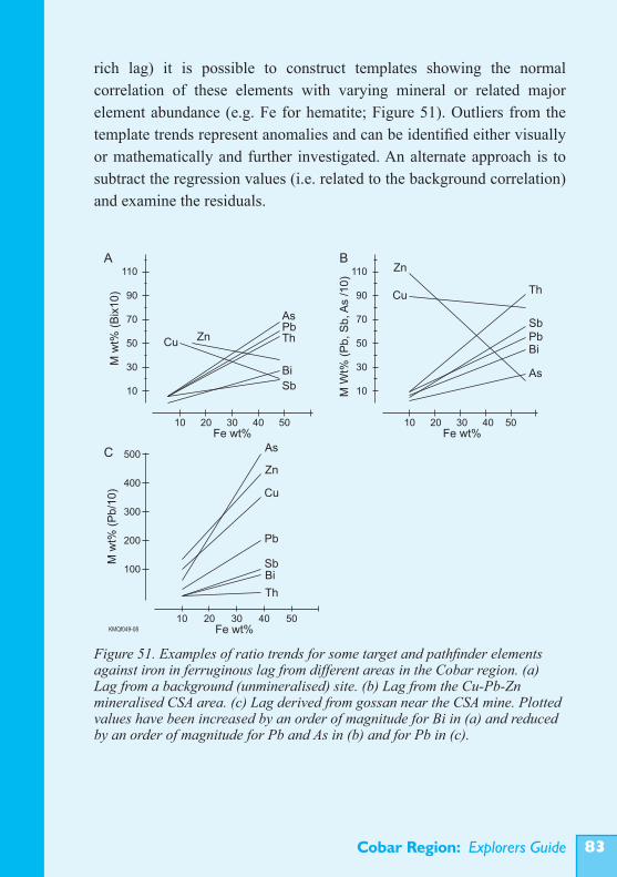
Cobar Region: Explorers Guide ��
rich lag) it is possible to construct templates showing the normal correlation of these elements with varying mineral or related major element abundance (e.g. Fe for hematite; Figure 51). Outliers from the template trends represent anomalies and can be identified either visually or mathematically and further investigated. An alternate approach is to subtract the regression values (i.e. related to the background correlation) and examine the residuals.
Figure 51. Examples of ratio trends for some target and pathfinder elements against iron in ferruginous lag from different areas in the Cobar region. (a) Lag from a background (unmineralised) site. (b) Lag from the Cu-Pb-Zn mineralised CSA area. (c) Lag derived from gossan near the CSA mine. Plotted values have been increased by an order of magnitude for Bi in (a) and reduced by an order of magnitude for Pb and As in (b) and for Pb in (c).
110
90
70
50
30
10
504030Fe wt%
2010
110
90
70
50
30
10
504030Fe wt%
2010
500
400
300
200
100
504030Fe wt%
2010KMQf049-08
A B
C
Mw
t%(B
ix1
0)
MW
t%(P
b,S
b,A
s/1
0)
Mw
t%(P
b/1
0)
Cu Zn
AsPbTh
Bi
Sb
Zn
Cu Th
SbPbBi
As
Th
As
Pb
Zn
Cu
SbBi
Cobar Region: Explorers Guide��
3.8 Concluding commentsThere has been a long history of mineral exploration and ore discovery in the Cobar region and many technologies have been widely applied. Future discoveries will probably come from exploration methods that incorporate the following:• Detection and interpretation of subtle geochemical anomalies in surface media over in situ and thin transported regolith; • Drilling through cover and sampling of appropriate regolith zones in the underlying in situ regolith; • Use of novel media in areas of thicker transported cover, such as groundwater and biota; • Improved geophysical techniques; • Improved drilling techniques.
All of these approaches will require a good understanding of regolith materials, their setting and origin within the landscape and palaeo-landscapes of the region.
ACKNOWLEDGEMENTSThis guide is a synthesis of research by a large number of people working in collaborative projects within and between the Cooperative Research Centre for Landscape Environments and Mineral Exploration and the New South Wales Department of Primary Industries. The work and publication of the guide were supported by the Australian Government’s Cooperative Research Centre Program within CRC LEME and by the NSW DPI. The guide has benefited significantly from comments and suggestions by Rex Berthelsen, Phil Carrello, David Gibson, Dick Glen, Grahame Kennedy, Dave Lawie, Dougal Munro, Hugh Patterson, Don Perkin, Dave Robson, Keith Scott, John Watkins, Derek Webb, Michael Whitbread, John Wilford and Peter Williams. The Visual Resources Unit at CSIRO, Division of Exploration and Mining, Bentley WA, formatted and published the guide and I am particularly grateful to Angelo Vartesi and Travis Naughton for their assistance with this work and preparation of the figures. Ian Roach also assisted with some of the map formatting. Editorial assistance from Gerry Govett, David Garnett, Colin Pain, and Lisa Worrall is gratefully acknowledged.
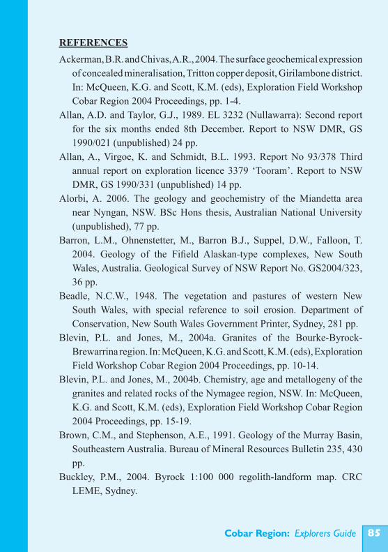
Cobar Region: Explorers Guide ��
REFERENCESAckerman, B.R. and Chivas, A.R., 2004. The surface geochemical expression
of concealed mineralisation, Tritton copper deposit, Girilambone district. In: McQueen, K.G. and Scott, K.M. (eds), Exploration Field Workshop Cobar Region 2004 Proceedings, pp. 1-4.
Allan, A.D. and Taylor, G.J., 1989. EL 3232 (Nullawarra): Second report for the six months ended 8th December. Report to NSW DMR, GS 1990/021 (unpublished) 24 pp.
Allan, A., Virgoe, K. and Schmidt, B.L. 1993. Report No 93/378 Third annual report on exploration licence 3379 ‘Tooram’. Report to NSW DMR, GS 1990/331 (unpublished) 14 pp.
Alorbi, A. 2006. The geology and geochemistry of the Miandetta area near Nyngan, NSW. BSc Hons thesis, Australian National University (unpublished), 77 pp.
Barron, L.M., Ohnenstetter, M., Barron B.J., Suppel, D.W., Falloon, T. 2004. Geology of the Fifield Alaskan-type complexes, New South Wales, Australia. Geological Survey of NSW Report No. GS2004/323, 36 pp.
Beadle, N.C.W., 1948. The vegetation and pastures of western New South Wales, with special reference to soil erosion. Department of Conservation, New South Wales Government Printer, Sydney, 281 pp.
Blevin, P.L. and Jones, M., 2004a. Granites of the Bourke-Byrock-Brewarrina region. In: McQueen, K.G. and Scott, K.M. (eds), Exploration Field Workshop Cobar Region 2004 Proceedings, pp. 10-14.
Blevin, P.L. and Jones, M., 2004b. Chemistry, age and metallogeny of the granites and related rocks of the Nymagee region, NSW. In: McQueen, K.G. and Scott, K.M. (eds), Exploration Field Workshop Cobar Region 2004 Proceedings, pp. 15-19.
Brown, C.M., and Stephenson, A.E., 1991. Geology of the Murray Basin, Southeastern Australia. Bureau of Mineral Resources Bulletin 235, 430 pp.
Buckley, P.M., 2004. Byrock 1:100 000 regolith-landform map. CRC LEME, Sydney.
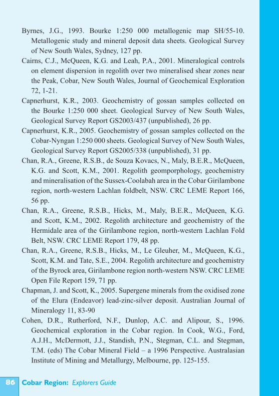
Cobar Region: Explorers Guide��
Byrnes, J.G., 1993. Bourke 1:250 000 metallogenic map SH/55-10. Metallogenic study and mineral deposit data sheets. Geological Survey of New South Wales, Sydney, 127 pp.
Cairns, C.J., McQueen, K.G. and Leah, P.A., 2001. Mineralogical controls on element dispersion in regolith over two mineralised shear zones near the Peak, Cobar, New South Wales, Journal of Geochemical Exploration 72, 1-21.
Capnerhurst, K.R., 2003. Geochemistry of gossan samples collected on the Bourke 1:250 000 sheet. Geological Survey of New South Wales, Geological Survey Report GS2003/437 (unpublished), 26 pp.
Capnerhurst, K.R., 2005. Geochemistry of gossan samples collected on the Cobar-Nyngan 1:250 000 sheets. Geological Survey of New South Wales, Geological Survey Report GS2005/338 (unpublished), 31 pp.
Chan, R.A., Greene, R.S.B., de Souza Kovacs, N., Maly, B.E.R., McQueen, K.G. and Scott, K.M., 2001. Regolith geomporphology, geochemistry and mineralisation of the Sussex-Coolabah area in the Cobar Girilambone region, north-western Lachlan foldbelt, NSW. CRC LEME Report 166, 56 pp.
Chan, R.A., Greene, R.S.B., Hicks, M., Maly, B.E.R., McQueen, K.G. and Scott, K.M., 2002. Regolith architecture and geochemistry of the Hermidale area of the Girilambone region, north-western Lachlan Fold Belt, NSW. CRC LEME Report 179, 48 pp.
Chan, R.A., Greene, R.S.B., Hicks, M., Le Gleuher, M., McQueen, K.G., Scott, K.M. and Tate, S.E., 2004. Regolith architecture and geochemistry of the Byrock area, Girilambone region north-western NSW. CRC LEME Open File Report 159, 71 pp.
Chapman, J. and Scott, K., 2005. Supergene minerals from the oxidised zone of the Elura (Endeavor) lead-zinc-silver deposit. Australian Journal of Mineralogy 11, 83-90
Cohen, D.R., Rutherford, N.F., Dunlop, A.C. and Alipour, S., 1996. Geochemical exploration in the Cobar region. In Cook, W.G., Ford, A.J.H., McDermott, J.J., Standish, P.N., Stegman, C.L. and Stegman, T.M. (eds) The Cobar Mineral Field – a 1996 Perspective. Australasian Institute of Mining and Metallurgy, Melbourne, pp. 125-155.
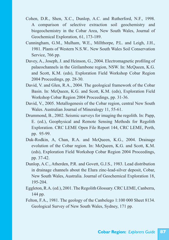
Cobar Region: Explorers Guide ��
Cohen, D.R., Shen, X.C., Dunlop, A.C. and Rutherford, N.F., 1998. A comparison of selective extraction soil geochemistry and biogeochemistry in the Cobar Area, New South Wales, Journal of Geochemical Exploration, 61, 173-189.
Cunningham, G.M., Mulham, W.E., Millthorpe, P.L. and Leigh, J.H., 1981. Plants of Western N.S.W.. New South Wales Soil Conservation Service, 766 pp.
Davey, A., Joseph, J. and Heinson, G., 2004. Electromagnetic profiling of palaeochannels in the Girilambone region, NSW. In: McQueen, K.G. and Scott, K.M. (eds), Exploration Field Workshop Cobar Region 2004 Proceedings, pp. 28-30.
David, V. and Glen, R.A., 2004. The geological framework of the Cobar Basin. In: McQueen, K.G. and Scott, K.M. (eds), Exploration Field Workshop Cobar Region 2004 Proceedings, pp. 31-36.
David, V., 2005. Metallogenesis of the Cobar region, central New South Wales. Australian Journal of Mineralogy 11, 55-61.
Drummond, B., 2002. Seismic surveys for imaging the regolith. In: Papp, E. (ed.), Geophysical and Remote Sensing Methods for Regolith Exploration. CRC LEME Open File Report 144, CRC LEME, Perth, pp. 95-99.
Duk-Rodkin, A, Chan, R.A. and McQueen, K.G., 2004. Drainage evolution of the Cobar region. In: McQueen, K.G. and Scott, K.M. (eds), Exploration Field Workshop Cobar Region 2004 Proceedings, pp. 37-42.
Dunlop, A.C., Atherden, P.R. and Govett, G.J.S., 1983. Lead distribution in drainage channels about the Elura zinc-lead-silver deposit, Cobar, New South Wales, Australia. Journal of Geochemical Exploration 18, 195-204.
Eggleton, R.A. (ed.), 2001. The Regolith Glossary. CRC LEME, Canberra, 144 pp.
Felton, F.A., 1981. The geology of the Canbelego 1:100 000 Sheet 8134. Geological Survey of New South Wales, Sydney, 171 pp.
Cobar Region: Explorers Guide��
Garcia, D., Fonteilles, M. and Moutte, J., 1994. Sedimentary fractionation between Al, Ti and Zr and the genesis of strongly peraluminous granites. Journal of Geology 102, 411-422.
Giblin, A.M., 1995. Groundwater geochemistry in Australia – an exploration window to concealed ore deposits. 17th IGES, Townsville, May 1995, Abstracts, pp. 319-322.
Gibson, D.L., 1999. Cobar 1:500 000 regolith-landform map and explanatory notes. CRC LEME Map and Open File Report 76, 53 pp.
Gilligan, L.B. and Byrnes, J.G., 1995. Cobar 1:250 000 metallogenic map, SH/55-14. Metallogenic study and mineral deposit data sheets. Geological Survey of New South Wales, Sydney, 240 pp.
Glanville, D.H., 2003. Regolith landform mapping, leucitite basalt and the landscape evolution of the Byrock region, north western NSW. BSc. Hons thesis, Australian National University (unpublished) 69 pp.
Glen, R.A., 1987. Geology of the Wrightville 1:100 000 Sheet 8034. Geological Survey of New South Wales, Sydney, 257 pp.
Glen, R.A., 1992. Thrust, extensional and strike-slip tectonics in an evolving Palaeozoic orogen: a structural synthesis of the Lachlan Orogen of southeastern Australia. Tectonophysics 214, 341-380.
Glen, R.A., 1995. Thrusts and thrust-associated mineralisation in the Lachlan Orogen. Economic Geology 90, 1402-1429.
Glen, R.A., Clare, A. and Spencer, R., 1996. Extrapolating the Cobar Basin model to the regional scale: Devonian basin-formation and inversion in western New South Wales. In Cook, W.G., Ford, A.J.H., McDermott, J.J., Standish, P.N., Stegman, C.L. and Stegman, T.M. (eds) The Cobar Mineral Field – a 1996 Perspective. Australasian Institute of Mining and Metallurgy, Melbourne, pp. 43-83.
Hallberg, J.A., 1984. A geochemical aid to igneous rock identification in deeply weathered terrain. Journal of Geochemical Exploration 20, 1-8.
Hill, S M and Hill, L.J., 2003. Some important plant characteristics and assay overviews for biogeochemical surveys in western New South Wales. In: Roach I.C. (ed.) Advances in Regolith. CRC LEME, pp. 187-192.
Cobar Region: Explorers Guide ��
Huang, X., 1998. Biogeochemical techniques for environmental monitoring and mineral exploration: A case study of the Temora gold mine. MSc thesis, University of Canberra (unpublished).
Johan, Z., Ohnenstetter, M., Slansky, E., Barron, L.M., and Suppel, D. 1989. Platinum mineralization in the Alaskan-type intrusive complexes near Fifield, New South Wales, Australia part 1. platinum-group minerals in clinopyroxenites of the Kelvin Grove prospect, Owendale intrusion. Mineralogy and Petrology 40, 289-309.
Khider, K., 2004. Geochemical dispersion of elements in Byrock-Hermidale groundwaters, Cobar region NSW. In: Roach I.C. (ed.) Regolith 2004, CRC LEME, Canberra, pp. 175-180.
Khider, K., 2007. Regional geochemical dispersion of elements in the regolith of the Girilambone region, central west NSW. PhD thesis, Australian National University (unpublished), 245 pp.
Khider, K. and McPhail, D.C., 2005. Hydrogeology and hydrogeochemistry in the Hermidale area, NSW. In: Roach I.C. (ed.) Regolith 2005 – Ten Years of CRC LEME. CRC LEME, Canberra, pp. 165-169.
Khider, K. and McQueen, K.G., 2005. Geochemical discrimination of weathered bedrock in the Hermidale-Byrock region of western NSW. In: Roach I.C. (ed.) Regolith 2005 - Ten Years of CRC LEME, CRC LEME, Canberra, pp. 170-173.
Khider, K. and McQueen, K.G., 2006. Gold dispersion in calcrete-bearing regolith of the Girilambone region, western NSW. In: Fitzpatrick R.W. and Shand P. (eds) Regolith 2006 – Consolidation and Dispersion of Ideas, CRC LEME, Perth Western Australia, pp. 190-195.
Leverett, P., McKinnon, A.R. and Williams, P.A., 2004. A supergene exploration model for Cobar style deposits. In: McQueen, K.G. and Scott, K.M. (eds), Exploration Field Workshop Cobar Region 2004 Proceedings, pp 46-50.
Leverett, P., McKinnon, A.R., Sharpe, J.L. and Williams, P.A., 2005. Secondary minerals from the central Cobar mines. Australian Journal of Mineralogy 11, 75-82.
Cobar Region: Explorers Guide�0
Martin, H.A., 1991. Tertiary stratigraphic palynology and palaeoclimate of the inland river systems in New South Wales. In: Williams, M.A.J., De Deckker, P. and Hershaw, A.P. (eds) The Cainozoic in Australia: A re-appraisal of the evidence. Geological Society of Australia Special Publication 18, 181-194.
McGowran, B. and Li, Q., 1998. Cainozoic climate change and its implications for understanding the Australian regolith. In Eggleton R.A. (ed.) The State of the Regolith. Geological Society of Australia Special Publication 20, 86-103.
McQueen, K.G., 2006a. Calcrete geochemistry in the Cobar-Girilambone region, New South Wales. CRC LEME Open File Report 200, 27 pp. and CD data base.
McQueen, K.G., 2006b. Unravelling the regolith with geochemistry. In: Fitzpatrick R.W. and Shand P. (eds) Regolith 2006 – Consolidation and Dispersion of Ideas, CRC LEME, Perth Western Australia, pp. 230-235.
McQueen, K.G., Hill, S.M. and Foster, K. A., 1999. The nature and distribution of regolith carbonate accumulations in southeastern Australia and their potential as a sampling medium in geochemical exploration Journal of Geochemical Exploration 67, 67-82.
McQueen, K.G., Scott, K.M., Ogilve, P.G. and Crowther, B.R., 2001. Atlas of regolith materials from the weathered zone, New Cobar deposit. CRC LEME Restricted Report 162R/E&M Report 815R, 25 pp.
McQueen, K.G. and Munro, D.C., 2003. Weathering-controlled fractionation of ore and pathfinder elements at Cobar, NSW. In: Roach I.C. (ed.) Advances in Regolith. CRC LEME, pp. 296-300.
McQueen, K.G., Munro, D.C., Gray, D. and Le Gleuher, M., 2004. Weathering-controlled fractionation of ore and pathfinder elements Part II: The lag story unfolds. In: Roach I.C. (ed.) Regolith 2004. CRC LEME, pp. 241-246.
McQueen, K.G., Pillans, B.J. and Smith, M.L., 2002. Constraining the weathering history of the Cobar region, Western NSW. In: Preiss, V.P. (ed.) Geoscience 2002: Expanding Horizons, Abstracts of the 16th Australian Geological Convention, Adelaide, 1-5 July 2002, No 67, p. 246.
Cobar Region: Explorers Guide ��
McQueen, K.G., Gonzalez, O.R., Roach, I.C., Pillans, B.J., Dunlap, W.J. and Smith, M.L., 2007. Landscape and regolith features related to Miocene leucitite lava flows, El Capitan northeast of Cobar, NSW, Australia. Australian Journal of Earth Sciences 54, 1-17.
Mullholand, C. St. J., 1940. Geology and underground water resources of the east Darling district. New South Wales Department of Mines, Geological Survey, Mineral Resources 39, 80 pp.
Nesbitt, H.W. and Young, G.M., 1982. Early Proterozoic climates and plate motions inferred from major element chemistry of lutites. Nature 299, 715-717.
Pain, C.F., Chan, R., Craig, M., Gibson, D., Kilgour, P. and Wilford, J., 2007. RTMAP regolith data base field book and users guide. CRC LEME Open File Report 231, 98 pp.
Papp, E. (ed.), 2002. Geophysical and Remote Sensing Methods for Regolith Exploration. CRC LEME Open File Report 144, CRC LEME, Perth, 115 pp.
Pogson, D.J., 1991. Geology of the Bobadah 1:100 000 Sheet 8233. Geological Survey of New South Wales, Sydney.
Pwa, A., McQueen, K.G., Scott, K.M. and van Moort, J.C., 1999. Regolith geochemical exploration using acid insoluble residues as a sample medium for gold and base metal deposits in the Cobar region, N.S.W., Australia. Journal of Geochemical Exploration 67, 15-31.
Rayner, E.O., 1969. The copper ores of the Cobar region, New South Wales. Geological Survey of New South Wales – Geology Memoir 10, 131 pp.
Roach, I.C., 2005. Biogeochemical expression of gold in native tree leaves at Wyoming and Tomingley, NSW. Regolith 2005 – Ten Years of CRC LEME. CRC LEME, Canberra, pp. 277-282.
Roach, I.C., 2008. Canbelego 1:100 000 regolith-landforms map and explanatory notes. CRC LEME Open File Report 238, 40 pp.
Rutherford, N.F. and Salt, C.J., 2005. LP3 Pb-Zn mineralization, Cobar district, NSW. In: Butt, C.R.M., Robertson, I.D.M., Scott, K.M. and Cornelius, M. (eds) Regolith Expression of Australian Ore Systems. CRC LEME, Perth, pp. 171-173.
Cobar Region: Explorers Guide��
Schmidt, B.L., 1991. Peko Exploration Ltd. Cobar Supergroup Project, EL’s 3401-3405. Report to NSW DMR, GS1990/249 (unpublished) 10 pp.
Scheibner, E., 1987. Geology of the Mount Allen 1:100 000 Sheet 8032. Geological Survey of New South Wales, Sydney.
Scheibner, E. and Basden, H. (eds), 1998. Geology of New South Wales – Synthesis Volume 2 Geological Evolution. Geological Survey of New South Wales, Memoir Geology 13(2), 666 pp.
Scott, K.M., 2004. Weathering of base metal deposits and implications for exploration in the Lachlan Fold Belt. In: PACRIM 2004 Congress, 19-22 September 2004 Adelaide, South Australia, Proceedings, pp. 257-261. The Australasian Institute of Mining and Metallurgy Publication Series No. 5/2004.
Scott, K.M. and Le Gleuher, M., 2004. Geochemical dispersion in the regolith, Girilambone belt region. In: McQueen, K.G. and Scott, K.M. (eds), Exploration Field Workshop Cobar Region 2004 Proceedings, pp. 74-77.
Skirka, M. and David, V., 2005. Hera Au-Cu-Zn-Pb-Ag prospect, Nymagee, New South Wales. In: Butt, C.R.M., Robertson, I.D.M., Scott, K.M. and Cornelius, M. (eds) Regolith Expression of Australian Ore Systems. CRC LEME, Perth, pp. 262-263.
Smith, M.L., 2006. Towards a geochronology for long-term landscape evolution of northwestern New South Wales. PhD thesis, Australian National University (unpublished), 163 pp.
Spry, M.J., 2003. The regolith and landscape evolution of a low relief landscape: Cobar central New South Wales, Australia. PhD thesis, University of Canberra (unpublished), 436 pp.
Stegman, C.L., 2001. Cobar deposits: Still defying classification. Society of Economic Geologists Newsletter 44, 15-25.
Suppell, D.W. and Gilligan, L.B., 1993. Nymagee 1:250 000 metallogenic map. Metallogenic study and mineral deposit data sheets. Geological Survey of New South Wales, Sydney, 171 pp.
Taylor, G. and Eggleton, R.A., 2001. Regolith Geology and Geomorphology. Wiley and Sons, Milton, 375 pp.
Cobar Region: Explorers Guide ��
Trigg, S.J., 1987. Geology of the Kilparney 1:100 000 Sheet 8232. Geological Survey of New South Wales, Sydney.
Van Moort, J.C. and Pwa, A., 2005. The use of quartz concentrate (acid-insoluble residue) as a sample medium in lithogeochemistry and regolith exploration studies: development of a method. Geochemistry, Exploration, Environment and Analysis 5, 267-277.
Walker, P.J., 1978. Soils – Cobar District. In: Technical Manual, Soil Conservation Service of New South Wales, pp. 5.1-5.13.
Whitbread, M.A.I., 2004. Lithogeochemical alteration around the Century and Elura Zn-Pb-Ag deposits: Detecting alteration expressions in deep and near surface environments. PhD thesis, University of Canberra (unpublished), 331 pp.
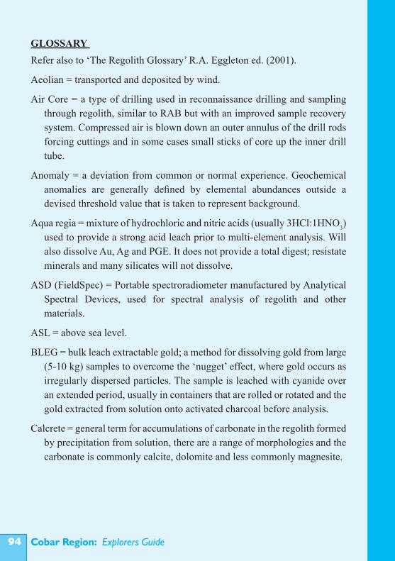
Cobar Region: Explorers Guide��
GLOSSARY Refer also to ‘The Regolith Glossary’ R.A. Eggleton ed. (2001).
Aeolian = transported and deposited by wind.
Air Core = a type of drilling used in reconnaissance drilling and sampling through regolith, similar to RAB but with an improved sample recovery system. Compressed air is blown down an outer annulus of the drill rods forcing cuttings and in some cases small sticks of core up the inner drill tube.
Anomaly = a deviation from common or normal experience. Geochemical anomalies are generally defined by elemental abundances outside a devised threshold value that is taken to represent background.
Aqua regia = mixture of hydrochloric and nitric acids (usually 3HCl:1HNO3) used to provide a strong acid leach prior to multi-element analysis. Will also dissolve Au, Ag and PGE. It does not provide a total digest; resistate minerals and many silicates will not dissolve.
ASD (FieldSpec) = Portable spectroradiometer manufactured by Analytical Spectral Devices, used for spectral analysis of regolith and other materials.
ASL = above sea level.
BLEG = bulk leach extractable gold; a method for dissolving gold from large (5-10 kg) samples to overcome the ‘nugget’ effect, where gold occurs as irregularly dispersed particles. The sample is leached with cyanide over an extended period, usually in containers that are rolled or rotated and the gold extracted from solution onto activated charcoal before analysis.
Calcrete = general term for accumulations of carbonate in the regolith formed by precipitation from solution, there are a range of morphologies and the carbonate is commonly calcite, dolomite and less commonly magnesite.
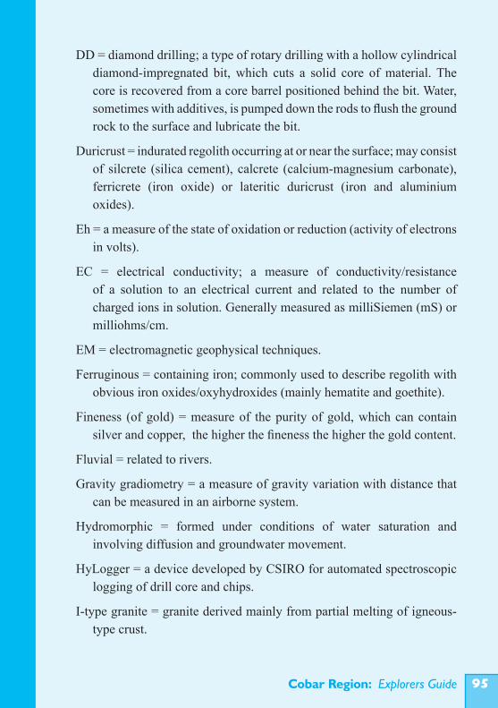
Cobar Region: Explorers Guide ��
DD = diamond drilling; a type of rotary drilling with a hollow cylindrical diamond-impregnated bit, which cuts a solid core of material. The core is recovered from a core barrel positioned behind the bit. Water, sometimes with additives, is pumped down the rods to flush the ground rock to the surface and lubricate the bit.
Duricrust = indurated regolith occurring at or near the surface; may consist of silcrete (silica cement), calcrete (calcium-magnesium carbonate), ferricrete (iron oxide) or lateritic duricrust (iron and aluminium oxides).
Eh = a measure of the state of oxidation or reduction (activity of electrons in volts).
EC = electrical conductivity; a measure of conductivity/resistance of a solution to an electrical current and related to the number of charged ions in solution. Generally measured as milliSiemen (mS) or milliohms/cm.
EM = electromagnetic geophysical techniques.
Ferruginous = containing iron; commonly used to describe regolith with obvious iron oxides/oxyhydroxides (mainly hematite and goethite).
Fineness (of gold) = measure of the purity of gold, which can contain silver and copper, the higher the fineness the higher the gold content.
Fluvial = related to rivers.
Gravity gradiometry = a measure of gravity variation with distance that can be measured in an airborne system.
Hydromorphic = formed under conditions of water saturation and involving diffusion and groundwater movement.
HyLogger = a device developed by CSIRO for automated spectroscopic logging of drill core and chips.
I-type granite = granite derived mainly from partial melting of igneous-type crust.
Cobar Region: Explorers Guide��
Induration = hardening of rock or regolith, commonly by an introduced cementing material.
Lacustrine = related to lakes.
Lag = a surface accumulation of residual material resulting from the removal of finer or less dense material by surface processes or by matrix removal as a result of differential weathering.
Ma = mega annum, million years.
Mottled Zone = part of a weathering profile showing mottles, commonly of concentrated coloured material such as iron oxide/oxyhydroxide.
Pathfinder element = an element not necessarily of economic interest, but found associated with the other elements in ore such that it can be used to help locate the ore (e.g. As is commonly used as a pathfinder for gold deposits).
pH = a measure of the acidity or alkalinity of a sample (-log of the concentration of H+).
Phyllosilicates = sheet silicate minerals such as those of the mica, clay, chlorite and serpentine groups.
PIMA = Portable Infrared Mineral Analyser; measures the spectra (1300-2500 nm) of rock and mineral samples, useful for identifying phyllosilicates and some other minerals and mineral properties in regolith materials. Other devices such as the ASD FieldSpec or AgriSpec and the CSIRO Hylogger extend the spectral range to the near infrared (350-2500 nm), useful for identifying iron oxides/oxyhydroxides.
Pisolith = a spherical or ellipsoidal clast resembling a pea, 2-64 mm in diameter; commonly ferruginous.
RAB = Rotary Air Blast; a type of open hole, generally shallow drilling, widely used in reconnaissance drilling and sampling through regolith. The drill uses a blade or hammer bit and compressed air pumped down the drill rods to return cuttings up the outside of the rods.
Cobar Region: Explorers Guide ��
RC = Reverse Circulation drilling; a type of rotary percussion drilling in which compressed air is pumped down an outer annulus of the drill rods to operate a down hole hammer bit and force the cuttings up an inner drill tube. This avoids abrasion of the sides of the hole, reducing sample contamination and helping to support the hole.
Redox = abbreviation for reduction-oxidation; a redox boundary in regolith marks the transition from relatively reducing (lower Eh) to relatively oxidising (higher Eh) conditions sufficient to cause Fe2+ to oxidise to Fe3+.
REE = rare earth elements, the lanthanide group in the periodic table.
Regolith = everything from fresh rock to fresh air, including particularly weathered rock, unconsolidated sediments, soil, organic material and ground water.
Regolith-landform unit = a land area characterised by similar landform and regolith attributes, it refers to an area of any size that can be isolated at the scale of mapping.
Saprock = slightly weathered rock having less than 20% of the weatherable minerals altered, generally requires a hammer blow to break, rock texture and fabric preserved.
Saprolite = weathered bedrock with more than 20% of the weatherable minerals altered, collapses under a light blow, rock fabric is preserved.
Siliclastic = used to describe non-carbonate sedimentary rocks with clasts largely composed of quartz or other silicates.
S-type granite = granite derived mainly from the partial melting of sedimentary-type crust.
Topographic inversion = where a feature formed low in the landscape is now high in the landscape because of its greater resistance to erosion than the surrounding materials.
Cobar Region: Explorers Guide��
GUIDE SUMMARY AND KEYPART 1 INTRODUCTION
The Cobar setting (pp. 1-2; Fig. 1)• Located in the Central Zone of the Lachlan Orogen in NW New South
Wales.• Slightly elevated, low-relief and undulating terrain, with extensive plains
and low hills.• Semi arid climate.• Moderate vegetation cover.• Erosion since European settlement has removed up to 0.5 m of the soil profile
possibly modifying the surface geochemical expression of mineralisation.• Good infrastructure.
Geology and basement rocks (pp. 2-6; Fig. 2)• Ordovician basement (low-grade metamorphosed siliclastics and volcanics),
intruded by Silurian granites and Alaskan-type mafic-ultramafic bodies.• Late Silurian to Early Devonian Cobar Basin and associated rifts and volcanic
sequences.• Late Devonian post-orogenic cover sequence.• Minor remnants of on-lapping Mesozoic sediments.• Cenozoic regolith and minor leucitite lavas flows.• Contains major fault systems and crustal lineaments.
Exploration potential (pp. 6-10; Table 1)• The Cobar region contains the largest Phanerozoic concentration of base
metals in New South Wales and has also been a major source of gold and silver. There is potential for further major discoveries, as much of the region has been under-explored because of difficulties with the extensive regolith cover.
Deposit types and implications for exploration (pp. 6-10; Table 1)• There is a range of deposit types in the Cobar region including major,
structurally controlled epigenetic systems referred to as Cobar-type.
Cobar Region: Explorers Guide ��
• The polymetallic composition of many of the deposits favours a multi-element approach to geochemical exploration.
• Some deposits (including some Cobar-type) have magnetic signatures related to magnetite or magnetic pyrrhotite.
• Typical Cobar-style deposits of the eastern Cobar Basin consist of multiple lenses in steeply plunging pipe-like systems. These have great depth extension but a small surface footprint. Exploration must allow for this, for example in choice of sample density.
• Stratabound systems are broader targets, but they do not have magnetic signatures.
PART 2 THE REGOLITH
Aspects of regolith and landscape history relevant to exploration (pp. 11-14; Figs 5, 6, 32-39)• Much of the bedrock of the Cobar region has been exposed for >65 Ma and
subjected to weathering and erosion under a wide range of climatic conditions, trending from warm humid to arid and dry, but with fluctuations.
• The region was exposed to intense chemical weathering before the Early Miocene (17 Ma), with more limited weathering since then.
• Ongoing weathering, erosion and deposition through the Cenozoic produced the extensive regolith, including transported sediments in palaeochannel systems (up to 80 m deep), colluvial fans, colluvial/alluvial plains and modern drainages. Much of this cover buries a palaeo-landscape, more deeply incised than the present landscape.
• There is a long history of drainage evolution and remnants of the earlier drainage are preserved in the present landscape. The modern drainage commonly overlies, but is locally oblique to, or offset, from the buried palaeo-drainage network.
Palaeochannels (p. 12; Figs 5, 8, 26, 27, 28, 38, 41, 43)• There are at least two types of palaeochannels. The oldest are generally
deeply incised and contain clays and sands with little ferruginous material. Younger, probably post-Miocene, palaeovalleys commonly contain abundant
Cobar Region: Explorers Guide�00
ferruginous and magnetic grits and gravels and can be clearly defined by their magnetic signature.
Recent drainage systems (pp. 11-13; pp. 65-66; Figs 26, 39)• The most recent valley-fill deposits contain abundant ferruginous and
magnetic gravels, but due to their generally shallow and broader distribution they have a more diffuse magnetic signature.
Topographic aspects and controls (pp. 13-14)• Ferruginisation and silicification have hardened some regolith materials and
controlled erosion and landscape development.• Some transported regolith has been inverted in the landscape and recycled
through the changing landscape levels. Valley incision and elevations of dated surfaces indicate relatively low average, regional erosion rates since the Miocene (probably <0.5-1 m/Ma).
• Many of the outcropping ore deposits in erosional parts of the landscape form hills or low rises due to associated silicification and ferruginisation.
Regolith architecture and typical profiles (pp. 14-19; Figs 7-13)• Controls on regolith development have been lithology, permeability, water
(reflecting climate), landscape setting and biota. Profiles have been affected by variable erosion and deposition (influenced by relative uplift and incision during drainage development).
• There is a wide variety of regolith profiles reflecting landscape and palaeolandscape setting.
Regolith materials (pp. 19-25)• There is a wide range of regolith materials that can be conveniently grouped
into: in situ regolith; transported regolith; indurated regolith; lag materials.
Cobar Region: Explorers Guide �0�
These materials are a mixture of rock-derived, extraneous (e.g. introduced salts) and biogenic components.• Well-developed in situ weathering profiles show a progression from fresh
rock, to saprock to saprolite reflecting increasing alteration of the weatherable minerals (minor, <20% and >20% respectively). This progression is usually vertical, but may be uneven with less altered corestones persisting to the surface.
• In many profiles it can be difficult to pick the boundary between fresh rock and saprolite (particularly in drill cuttings) because the main primary minerals in the common parent rocks (quartz-muscovite-clays) are stable into the weathered zone.
• In situ regolith is typically overlain by a red silty loam soil containing significant wind blown dust.
• Transported regolith is very widespread and variable in character. It includes alluvial, lacustrine, colluvial and aeolian materials. Over many areas in the central part of the Cobar region it is not particularly thick (<5 m).
• Indurated regolith includes ferricretes and more massive ironstones, silcrete and silicified saprock. These materials are commonly found as horizontal caps and linear masses at different levels of the present landscape. Calcrete is widespread as mainly nodular, hardpan and veining morphologies within the soil and transported regolith.
• Over much of the region there is a surface lag of chemically and physically resistant materials. Lag has been derived from the full range of underlying regolith materials and in many cases has been recycled or widely dispersed across the landscape.
Distinguishing in situ from transported regolith (pp. 19-22, 55-56; Table 6)• The most fundamental subdivision of regolith is into in situ and transported
types.• The two types can be distinguished using their textural, mineralogical, and
geochemical characteristics; kaolinite crystallinity, structural water content (in clays); regolith-landform setting; and spectral, radiometric and magnetic features (see Table 6).
Cobar Region: Explorers Guide�0�
Regolith minerals (pp. 25-27; Tables 2, 3)• The common regolith-forming minerals in the Cobar region are residual and
secondary quartz, residual muscovite, illite, kaolinite, smectite, halloysite, hematite, goethite, calcite and dolomite. Maghemite occurs in some surface lag. The presence and relative abundances of these minerals vary with bedrock type, degree of weathering, regolith-landform setting and position within the weathering profile.
• Iron and manganese oxides and oxyhydroxides and a wide range of minor regolith minerals, including carbonates, sulphates, phosphates, arsenates, chlorides and resistates, are the main hosts for dispersed pathfinder and target elements (Table 3).
• Portable spectral scanners (e.g. PIMA, ASD FieldSpec, CSIRO HyLogger) can help detect mineralogical changes in profiles and determine kaolinite crystallinity and structural water content. X-ray diffraction or electron microprobe analysis is required to fully characterise many regolith minerals.
Regolith geochemistry: major elements (pp. 25-27; Figs 19, 20)• The major chemical changes during weathering are progressive loss of Na+,
K+, Ca2+, Mg2+ (some Si4+) and retention of Si4+, Al3+ and Fe3+. This reflects transformation of feldspars, quartz, micas, mafic minerals and in some cases carbonates and volcanic glass to quartz, kaolinite and iron and aluminium oxides/oxyhydroxides.
Regolith geochemistry: minor and trace elements (pp. 27-35; Table 3; Figs. 19, 20)• During weathering and regolith development minor and trace elements have
been retained in resistate minerals or released from their primary host mineral to be incorporated in new regolith minerals, adsorbed onto regolith minerals or dispersed in solution.
• Typical element dispersion features observed in the Cobar regions are described for gold, silver, copper, zinc, lead and arsenic.
Cobar Region: Explorers Guide �0�
Element dispersion controls (pp. 28-29, Table 3, Fig. 20)• The main controls on target and pathfinder element dispersion are:
hydrological factors (flow rates and flow directions of groundwater); chemical conditions, mainly redox potential (Eh) and hydrogen ion activity (pH); availability of complexing and oxidising agents (e.g. O2, CO2, SO4
2-, NO3-, halides, organic compounds);
temperature (to a small degree); physical processes causing mechanical dispersion (e.g. related to water, wind
and gravity).• Iron mobility and the precipitation sequence of goethite and hematite have
been critical to the distribution of dispersed elements.• Biogeochemical processes have probably played a role in element dispersion
through the regolith. Plants can potentially lift geochemical anomalies through transported, depositing and weathering cover.
Weathering regimes (pp. 31-32, Table 4, Fig. 21)• Chemical conditions in the regolith have changed significantly through the
post-Mesozoic weathering history of the Cobar region.• Element dispersion patterns can be different for different deposits or in
different parts of the same weathering profile where these are related to different weathering regimes.
Regolith element associations (pp. 35)• Four major regolith-related element associations are present in the Cobar
region: - “evaporative”; - “redox-related”; - “goethite-controlled”; - “hematite-controlled”.• It is important to recognise these major associations. They affect the
background variation for some elements in different parts of the regolith. Some may be mistaken for anomalies related to mineralisation if threshold values are set too low. They can also represent geochemical environments where elements dispersed from mineralisation are fixed at high concentrations.
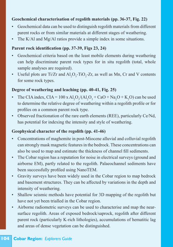
Cobar Region: Explorers Guide�0�
Geochemical characterisation of regolith materials (pp. 36-37, Fig. 22)• Geochemical data can be used to distinguish regolith materials from different
parent rocks or from similar materials at different stages of weathering.• The K/Al and Mg/Al ratios provide a simple index in some situations.
Parent rock identification (pp. 37-39, Figs 23, 24)• Geochemical criteria based on the least mobile elements during weathering
can help discriminate parent rock types for in situ regolith (total, whole sample analyses are required).
• Useful plots are Ti/Zr and Al2O3-TiO2-Zr, as well as Mn, Cr and V contents for some rock types.
Degree of weathering and leaching (pp. 40-41, Fig. 25)• The CIA index, CIA = 100 x Al2O3/(Al2O3 + CaO + Na2O + K2O) can be used
to determine the relative degree of weathering within a regolith profile or for profiles on a common parent rock type.
• Observed fractionation of the rare earth elements (REE), particularly Ce/Nd, has potential for indexing the intensity and style of weathering.
Geophysical character of the regolith (pp. 41-46)• Concentrations of maghemite in post-Miocene alluvial and colluvial regolith
can strongly mask magnetic features in the bedrock. These concentrations can also be used to map and estimate the thickness of channel fill sediments.
• The Cobar region has a reputation for noise in electrical surveys (ground and airborne EM), partly related to the regolith. Palaeochannel sediments have been successfully profiled using NanoTEM.
• Gravity surveys have been widely used in the Cobar region to map bedrock and basement structures. They can be affected by variations in the depth and intensity of weathering.
• Shallow seismic methods have potential for 3D mapping of the regolith but have not yet been trialled in the Cobar region.
• Airborne radiometric surveys can be used to characterise and map the near-surface regolith. Areas of exposed bedrock/saprock, regolith after different parent rock (particularly K-rich lithologies), accumulations of hematitic lag and areas of dense vegetation can be distinguished.
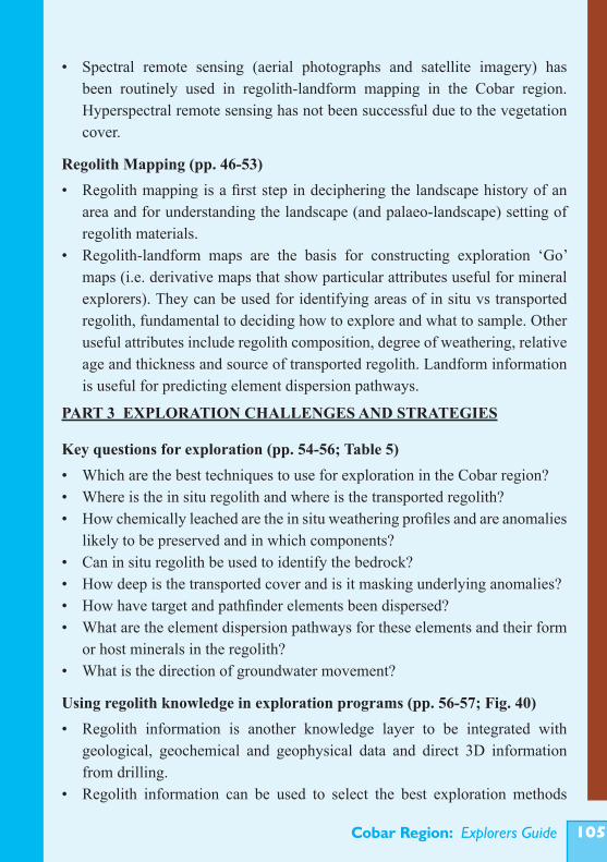
Cobar Region: Explorers Guide �0�
• Spectral remote sensing (aerial photographs and satellite imagery) has been routinely used in regolith-landform mapping in the Cobar region. Hyperspectral remote sensing has not been successful due to the vegetation cover.
Regolith Mapping (pp. 46-53)• Regolith mapping is a first step in deciphering the landscape history of an
area and for understanding the landscape (and palaeo-landscape) setting of regolith materials.
• Regolith-landform maps are the basis for constructing exploration ‘Go’ maps (i.e. derivative maps that show particular attributes useful for mineral explorers). They can be used for identifying areas of in situ vs transported regolith, fundamental to deciding how to explore and what to sample. Other useful attributes include regolith composition, degree of weathering, relative age and thickness and source of transported regolith. Landform information is useful for predicting element dispersion pathways.
PART 3 EXPLORATION CHALLENGES AND STRATEGIES
Key questions for exploration (pp. 54-56; Table 5)• Which are the best techniques to use for exploration in the Cobar region?• Where is the in situ regolith and where is the transported regolith?• How chemically leached are the in situ weathering profiles and are anomalies
likely to be preserved and in which components?• Can in situ regolith be used to identify the bedrock?• How deep is the transported cover and is it masking underlying anomalies?• How have target and pathfinder elements been dispersed?• What are the element dispersion pathways for these elements and their form
or host minerals in the regolith?• What is the direction of groundwater movement?
Using regolith knowledge in exploration programs (pp. 56-57; Fig. 40)• Regolith information is another knowledge layer to be integrated with
geological, geochemical and geophysical data and direct 3D information from drilling.
• Regolith information can be used to select the best exploration methods
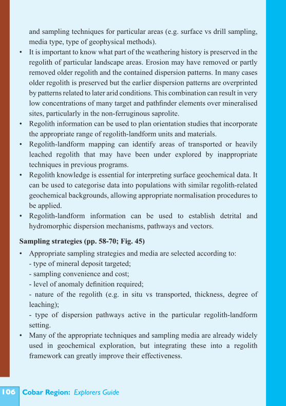
Cobar Region: Explorers Guide�0�
and sampling techniques for particular areas (e.g. surface vs drill sampling, media type, type of geophysical methods).
• It is important to know what part of the weathering history is preserved in the regolith of particular landscape areas. Erosion may have removed or partly removed older regolith and the contained dispersion patterns. In many cases older regolith is preserved but the earlier dispersion patterns are overprinted by patterns related to later arid conditions. This combination can result in very low concentrations of many target and pathfinder elements over mineralised sites, particularly in the non-ferruginous saprolite.
• Regolith information can be used to plan orientation studies that incorporate the appropriate range of regolith-landform units and materials.
• Regolith-landform mapping can identify areas of transported or heavily leached regolith that may have been under explored by inappropriate techniques in previous programs.
• Regolith knowledge is essential for interpreting surface geochemical data. It can be used to categorise data into populations with similar regolith-related geochemical backgrounds, allowing appropriate normalisation procedures to be applied.
• Regolith-landform information can be used to establish detrital and hydromorphic dispersion mechanisms, pathways and vectors.
Sampling strategies (pp. 58-70; Fig. 45)• Appropriate sampling strategies and media are selected according to: - type of mineral deposit targeted; - sampling convenience and cost; - level of anomaly definition required; - nature of the regolith (e.g. in situ vs transported, thickness, degree of
leaching); - type of dispersion pathways active in the particular regolith-landform
setting.• Many of the appropriate techniques and sampling media are already widely
used in geochemical exploration, but integrating these into a regolith framework can greatly improve their effectiveness.
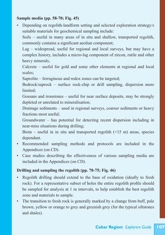
Cobar Region: Explorers Guide �0�
Sample media (pp. 58-70; Fig. 45)• Depending on regolith-landform setting and selected exploration strategy/s
suitable materials for geochemical sampling include: Soils – useful in many areas of in situ and shallow, transported regolith,
commonly contains a significant aeolian component; Lag – widespread, useful for regional and local surveys, but may have a
complex history, includes a micro-lag component of zircon, rutile and other heavy minerals;
Calcrete – useful for gold and some other elements at regional and local scales;
Saprolite – ferruginous and redox zones can be targeted; Bedrock/saprock – surface rock-chip or drill sampling, dispersion more
limited; Gossans and ironstones – useful for near surface deposits, may be strongly
depleted or unrelated to mineralisation; Drainage sediments – used in regional surveys, coarser sediments or heavy
fractions most useful; Groundwater – has potential for detecting recent dispersion including in
near-miss situations during drilling; Biota – useful in in situ and transported regolith (<15 m) areas, species
dependant.• Recommended sampling methods and protocols are included in the
Appendices (on CD).• Case studies describing the effectiveness of various sampling media are
included in the Appendices (on CD).
Drilling and sampling the regolith (pp. 70-75; Fig. 46) • Regolith drilling should extend to the base of oxidation (ideally to fresh
rock). For a representative subset of holes the entire regolith profile should be sampled for analysis at 1 m intervals, to help establish the best regolith zone and materials to sample.
• The transition to fresh rock is generally marked by a change from buff, pale brown, yellow or orange to grey and greenish grey (for the typical siltstones and shales).
Cobar Region: Explorers Guide�0�
• Regolith colour changes can indicate concentrations of iron and manganese oxides/oxyhydroxides. Fe/Al or Fe/Ti ratio trends in profiles can indicate ferruginised zones (Fig. 46).
• Redox fronts are important chemical transition zones where species in solution may precipitate or be adsorbed, particularly if their solubility is strongly Eh (redox) dependent.
• The zone of calcrete development marks a chemical transition zone of higher pH and evaporative accumulation of dissolved species and complexes.
Logging and interpretation (pp. 74-78)• Consistent and objective visual, textural and spectral logging of all regolith
cuttings is essential.• Quantitative description of features is best for digital data storage and
assessment.
Analytical approach and methods (pp. 78-80)• A multi-element approach is recommended using As, Ag, Au, Co, Cu, Pb, Zn,
Ni, with the variable inclusion of Bi, Mo, PGE, Sb, Se, Sn and W depending on target.
• Major/minor elements Al, Fe, Ca, Mg, K, Mn, Cr, V, can be used to monitor trace element hosts and identify different regolith materials.
• Multi-acid (‘total’) or strong acid (aqua-regia) digest followed by analysis using ICP-OES/MS are good ‘first pass’ methods for geochemical exploration of the Cobar regolith.
• Partial leach methods may be useful where the element dispersion controls and regolith host sites are well understood.
• True total analysis methods (e.g. XRF, INAA, fusion ICP OES/MS) are recommended to interpret parent rock type or detect primary alteration patterns.
• Some elements (e.g. Au, PGE) may require specific analytical techniques or sampling procedures.
Cobar Region: Explorers Guide �0�
Quality assurance and quality control (pp. 80-81)• Aspects to consider for quality assessment and assurance are: sampling
procedure; sample preparation; and analytical precision and accuracy.• Duplicate or replicate samples from bulk samples should be used to assess
the representativeness of the sampling procedure.• Duplicate or replicate splits of prepared and homogenised samples from
each sample batch should be submitted for analysis to assess analytical precision.
• Standard reference samples should be submitted for analysis with each sample batch to assess analytical accuracy.
• Some elements (e.g. Au) should be ‘cross checked’ using alternate sampling and analytical methods.
Identifying anomalies (pp. 81-83)• Trace elements do not have a common background level for all regolith
materials across the Cobar region. • It is critical to examine the spatial distribution of element abundances and
element associations. • Exploratory data analysis (EDA) is a useful first step in understanding the
distribution of analytical data and highlighting values for more detailed statistical and spatial analysis.
• Templates showing typical element variability for specific regolith materials can be used to identify anomalous outliers.
• Basic methods for statistical identification of anomalies are given in the Appendices (on CD).
Illustrative Field Sites• See self-guided tour in appendices (on CD).

Cobar Region: Explorers Guide��0
NOTES

Cobar Region: Explorers Guide ���
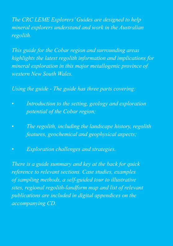
Cobar Region: Explorers Guide���
The CRC LEME Explorers’ Guides are designed to help mineral explorers understand and work in the Australian regolith.
This guide for the Cobar region and surrounding areas highlights the latest regolith information and implications for mineral exploration in this major metallogenic province of western New South Wales.
Using the guide - The guide has three parts covering:
• Introduction to the setting, geology and exploration potential of the Cobar region;
• The regolith, including the landscape history, regolith features, geochemical and geophysical aspects;
• Exploration challenges and strategies.
There is a guide summary and key at the back for quick reference to relevant sections. Case studies, examples of sampling methods, a self-guided tour to illustrative sites, regional regolith-landform map and list of relevant publications are included in digital appendices on the accompanying CD.