Coastal!landslides!within!theUKcontext! - ITRC · Moore et al (2010) describe landslide behaviour...
28
Infrastructure Transitions Research Consortium Working paper series Coastal landslides within the UK context Oliver Pritchard, Timothy S. Farewell & Stephen H. Hallett 2013
Transcript of Coastal!landslides!within!theUKcontext! - ITRC · Moore et al (2010) describe landslide behaviour...
Infrastructure Transitions Research Consortium Working paper series
Coastal landslides within the UK context Oliver Pritchard, Timothy S. Farewell & Stephen H. Hallett
2013
Oliver Pritchard Dr. Timothy S. Farewell, Dr. Stephen H. Hallett
Document v1
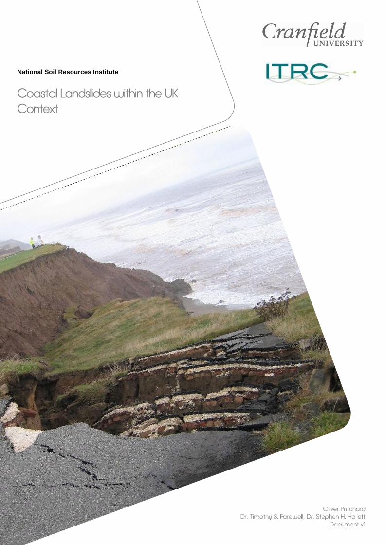
National Soil Resources Institute
Coastal Landslides within the UK Context

1
Contents
Abstract ...............................................................................................................................3
Glossary ..............................................................................................................................4
1. Introduction .....................................................................................................................5
1.1 Mass movement and landslides .................................................................................5 1.2 Prevalence of coastal landslides within the UK context .............................................6
2. Factors of slope instability ............................................................................................8
2.1 Principal of effective stress and shear strength in soils .............................................9 2.2 Influence of pore water pressure on slope stability ................................................. 10 2.3 Effect of land use on slope stability ......................................................................... 13 2.4 Clay mineralogy and slope stability ......................................................................... 14
3. UK coastal slope stability - Specific case studies ................................................... 16
4. Climate change and slope stability hazards ............................................................. 18
5. Conclusions ................................................................................................................. 21
6. Acknowledgements ..................................................................................................... 21
7. References ................................................................................................................... 22
2
Figures
Figure 1: Location of the 31 'best known' landslides in Great Britain (Reproduced from
http://www.geocases1.co.uk/landsliding1.htm) ....................................................................7 Figure 2: Particle size distributions of material types susceptible to liquefaction and flow
siding. 1) Coarse grained coal mine waste, 2) Loose silty sand fills, 3) Hydraulically placed
mine tailings and fills in dam embankments, 4) Sensitive clays, 5) Sub aqueous slopes,
natural and fill slopes. (Reproduced from Fell et al. 2007) ...................................................8 Figure 3: Simple sub division of the causes of landslides (Reproduced from:
http://www.geocases1.co.uk/landsliding1.htm) ....................................................................9 Figure 4: Diagram representing the principal of effective stress (σ′ = total stress - pore
water pressure) in a soil. The total stress is the weight of the overlying soil and eternal
load per square meter above a certain level in the soil (Reproduced from van Asselen et
al. 2009). ............................................................................................................................ 10 Figure 5: Variations in pore water pressures over time for a Hong Kong granitic soil under
constant rainfall intensities; a) 5 mm h-1
, b) 20 mm h-1
, c) 80 mm h-1
(Reproduced from
Chao Li et al. 2013) ........................................................................................................... 12 Figure 6: Pore water pressure records for the BIONICS embankment project (SS indicates
suction station at different depths). Vertical spikes show daily rainfall (Reproduced from
Toll et al. 2011). ................................................................................................................. 13 Figure 7: Changes in factor of safety with time in a given slope (Reproduced from
Popescu, 2002).................................................................................................................. 15 Figure 8: Landslide undercutting the concrete coastal path, Whitehaven, Cumbria
(Jenkins and Hobbs, 2007). ............................................................................................... 16 Figure 9: Cycle of landsliding and erosion (Reproduced from Dixon and Bromhead, 2002,
based on Hutchinson, 1973). ............................................................................................. 17 Figure 10: Monthly UK rainfall for 2012 expressed as a percentage above or below
monthly average (Reproduced from http://www.bbc.co.uk/news/science-environment-
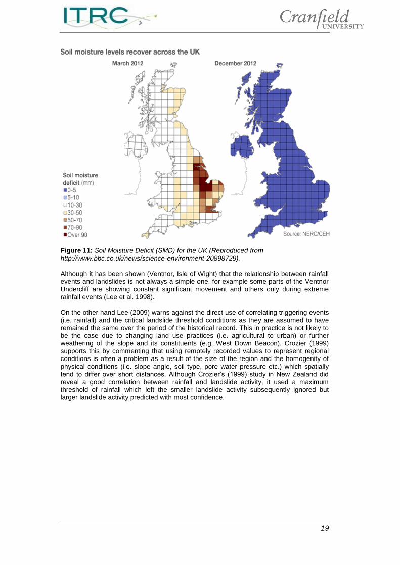
20898729). ......................................................................................................................... 18 Figure 11: Soil Moisture Deficit (SMD) for the UK (Reproduced from
http://www.bbc.co.uk/news/science-environment-20898729). .......................................... 19 Figure 12: UK rainfall and landslide frequency between 2006 to September 2012
(Reproduced from British Geological Survey, 2013). ........................................................ 20 Figure 13: The 'laid back' approach by the general public to coastal landslides, Barton on
Sea, Hampshire, UK (Reproduced from West, 2012). ...................................................... 20
3
Abstract
Over 15,000 landslides (inland and coastal) have been recorded within the United Kingdom (UK), with some of the largest and well known landslide complexes (i.e. Ventnor Undercliff, Isle of Wight) being in a coastal setting. The demand for growth of residential, commercial and infrastructure development near coastal areas has increased in recent years necessitating a need for development on areas presenting a first time or recurring slope failure. With a current average cost of £126 million per year, it can be seen that coastal erosion of which landslides encompass the majority of this term, are a major cause of economic concern. Although wave action is the obvious mechanism for coastal erosion and subsequent onset for landslide activity there are many soil and climatic factors (e.g. soil type, land use cover, permeability, clay mineralogy, pore water pressure, rainfall etc.) that are considered the main triggering factors with wave action occasionally being a subsidiary factor. With an average of approximately 28 landslides per year having been recorded by the UK media since 2005 and the year 2012 showing an increased number of ‘shallow’ landslides assumed to be as a result of intense rainfall, there is a need to correlate periods of future intense/prolonged rainfall in light of a predicted future climate in order to assess the future frequency of landslide activity in coastal areas. This brief summary report aims to introduce the impact and prevalence of landslides in a UK coastal context and understand the soil processes as triggering mechanisms to slope instability, and to differentiate these triggering mechanisms from the direct wave erosional action of the sea. This summary then hopes to suggest how the ground (soil) conditions (triggering mechanisms) and climate change interact, the understanding of such could give reliable estimates of landslide hazards and frequency in a coastal UK setting.
4
Glossary
BGS – British Geological Survey CIWEM – Chartered Institution of Water and Environmental Management CST – Council for Science and Technology NSRI – National Soil Resources Institute SMD – Soil Moisture Deficit UK – United Kingdom Citation. This report may be cited as follows: Pritchard, O., Farewell, T.S. and Hallett, S.H. (2013) Coastal Landslides within the UK Context. 27pp. NSRI, Cranfield University, UK. Report cover, shows the end of a road at Aldborough, East Riding of Yorkshire (British Geological Survey, 2013) Report © Cranfield University, 2013 This document is submitted as part of Cranfield University’s involvement in the UK Infrastructure Transitions Research Consortium (ITRC) project, Work Stream Two under contract to Oxford University. The materials have been prepared by Cranfield University. Whilst every care has been taken by Cranfield University to ensure the accuracy and completeness of the reports and maps, the reader must recognise that errors are possible through no fault of Cranfield University and as such the parties give no express or implied representations or warranty as to: (i) the quality or fitness for any particular purpose of the report or maps supplied or of any design, workmanship, materials or parts used in connection therewith or correspondence with regard to any description or sample; or (ii) the accuracy, sufficiency or completeness of the reports or maps provided. In particular, there are hereby expressly excluded all conditions, warranties and other terms which might otherwise be implied (whether by common law, by statute or otherwise). Cranfield University, its employees, servants and agents shall accept no liability for any damage caused directly or indirectly by the use of any information contained herein and without prejudice to the generality of the foregoing, by any inaccuracies, defects or omissions in the reports or maps provided.
5
1. Introduction
1.1 Mass movement and landslides
Landslides or ‘mass movements’ are the movements of a mass of rock, debris, artificial fill or earth down a slope under the force of gravity (Cruden and Varnes, 1996). Their physical aspects and remediation measures require a multidisciplinary approach involving geotechnical and coastal engineering, geomechanics, geology, geomorphology and soil science (Edil and Vallejo, 1980). Landslides are typically only regarded as a ‘hazard’ when they threaten or impact upon residential and commercial developments and infrastructure (Sims and Ternan, 1988). This is probably due to the large economic impact that they can have, although financial losses are poorly understood they are likely to be in excess of £10 million per year (Gibson et al. 2012), Europa (2006) suggest that landslides can cost up to 1.2 million euros per event on an annual basis. A government review (Office of Science and Technology, 2003) identified that coastal erosion in the UK, a large part as a result of landslide activity (Gibson et al, 2012) found that the average cost was £126 million per year. Gibson et al. (2012) hypothesise that there is up to £57 billion worth of housing stock at risk although this does not differentiate between coastal and terrestrial regions. In particular the Holbeck Hall landslide in Scarborough cost £2 million for the insurance costs of the building and a further £1.5 million for the remedial works that were required after the slide to further protect the slope from further slipping (Forster and Culshaw, 2004). Between 15,000 to 16,000 landslides (Inland and coastal) have been recorded in the UK to date (Foster et al, 2012). It is therefore probably a surprise that planning authorities have no legal obligation to understand the nature and extent of the landslide hazards relating to development(s), this is generally as a result of many authorities lack sufficient expertise in landslide assessment (Gibson et al. 2012) and subsequently do not have to consider them in their planning decisions. Planning Policy Guidance (PPG14) (Department for transport, local government and the Regions, 2002) identifies the responsibility of the developer to consider land instability issues. More recently the CIWEM (2006) has issued the following sentiments; “The planning system has an important role in preventing new development in areas of coastal risk and in enabling and incentivising the relocation of communities away from coastal flooding and erosion risk. For this to happen...need to inform regional and local planning strategies” Operators of infrastructure and utilities are required by the Health and Safety Executive to protect citizens from the impact that their operations and systems may have in exacerbating landslide instability (Health and Safety Executive, 2012). Building regulations also advise on further control to prevent/control the impact of slope stability (Anon, 2004), where ‘the building shall be constructed so that ground movement caused by’: ‘Swelling, shrinkage or freezing of the subsoil’; ‘Landslip or subsidence (other than subsidence arising from shrinkage), in so far as the
risk can reasonably foreseen, will not impair the stability of any part of the building’. Moore et al (2010) describe landslide behaviour prediction as a poorly developed and applied science, they also state that ‘accurate forecasting of landslide behaviour in the short and medium term has clear benefits for the management and mitigation of landslide risk to the community’. This is furthered by Lee and Moore (2007) who suggest that the incorporation of future predicted climate change is key in assessing the landslide risk to the UK. As recent ‘shallow’ landslides in the UK during the year 2012 have been identified
6
by the BGS as a causal response to extreme rainfall events with it likely that deeper seated failures will occur at later periods reflecting the period it takes for infiltrating water to reach the groundwater table (British Geological Survey, 2013) it can be seen action needs to be taken.
1.2 Prevalence of coastal landslides within the UK context
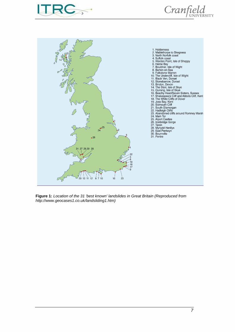
The extensive coastline (11,000km) of the UK incurs erosional processes that often produces first time failures (of which will be discussed later), (Bromhead and Ibsen, 2006) as well as re-activated landslides, they suggest that approximately 250km of UK coastline is at risk of instability. Landslides are a major process in coastal erosion within the UK (Forster and Culshaw, 2004). Coastal landslides are often complex erosional systems (Hodgson et al. 1996), it is not simply as a result of the rate of erosion by wave action but is also highly dependent upon the local stratigraphy (soil/rock layers), structure and hydrogeology (Bromhead,1979). For example the Holbeck Hall Landslide (1993) in Scarborough was not primarily as a result of wave action as coastal defences were buried by the slide but remained intact (Forster and Culshaw, 2004). Therefore it is essential to understand the fundamental processes of landslide initiation (Figure 3) in order to gain a firm understanding of what causes the development of landslides and subsequently to provide measures to mitigate against it. Figure 1 depicts the 31 ‘best known’ landslides for the UK and it is significant to notice that the majority of these are situated on or near the coastline, 21 of which are situated on the coastline of the UK. In Devon, the Axmouth to Lyme Regis Undercliffs National Nature Reserve is a complex of overlapping landslides, ranging in volume from hundreds of tonnes to millions of tonnes, and stretches for a distance of approximately ten kilometres (Gallois, 2010). The coastal landslides at Folkestone (Sussex), Ventnor (Isle of Wight) and Black Ven (west Dorset) are among the largest landslide systems in the UK (Gallois, 2007). Ventnor (Isle of Wight) is built on an ancient landslide. Over the last one hundred years this has claimed approximately fifty houses, hotels and caused persistent damage to roads and other infrastructure assets (Lee and Moore, 1991). Unfortunately it is coastal dwellers that are often suddenly jolted into action through the sudden realization that a receding shoreline is threatening their property and livelihoods (Clark et al. 1976), whether that is as a result of wave action eroding the cliffs or other factors causing cliff landslides and collapse.
7
Figure 1: Location of the 31 'best known' landslides in Great Britain (Reproduced from http://www.geocases1.co.uk/landsliding1.htm)
8
2. Factors of slope instability
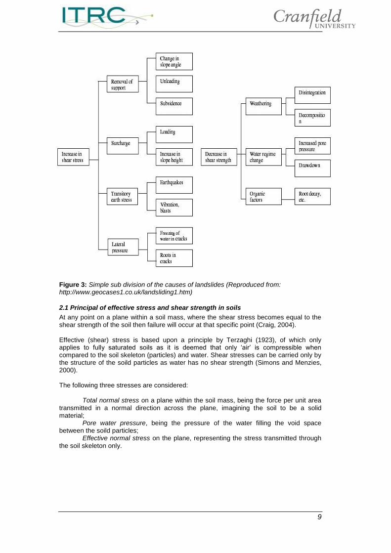
Most experiences of coastal landslides in the UK are the reactivation of pre existing landslides rather than first time failures, the latter being more rapid in velocity (Dixon and Bromhead, 2002) and often the causes of most fatalities. First time failures are as a result of pre failure mechanisms depicted as the formation of a continuous rupture/shear surface, once this continuous rupture surface has developed fully then ‘failure’ is deemed to occur (Fell et al. 2007) Hunter and Fell (2003) have identified a number of ‘soil slopes’ within which a rapid velocity landslide is likely to occur: Slides in saturated or near saturated granular soils e.g. loose road, railway, constructed
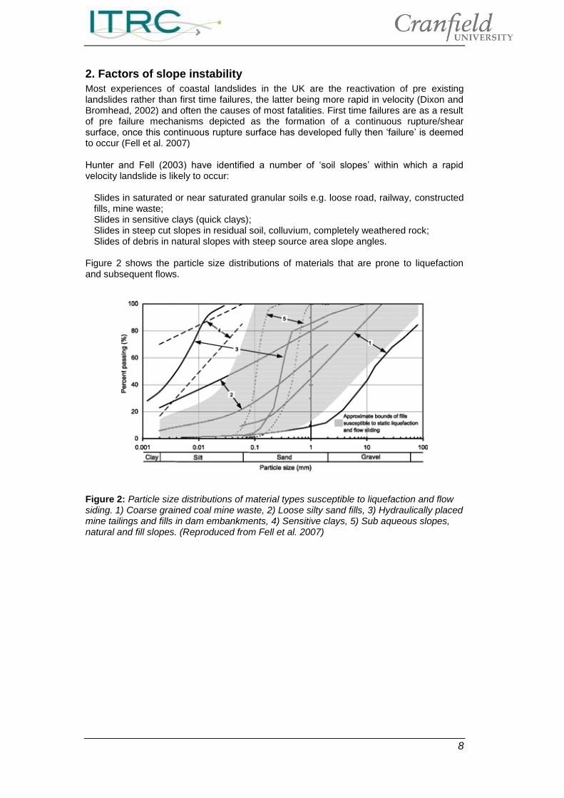
fills, mine waste; Slides in sensitive clays (quick clays); Slides in steep cut slopes in residual soil, colluvium, completely weathered rock; Slides of debris in natural slopes with steep source area slope angles. Figure 2 shows the particle size distributions of materials that are prone to liquefaction and subsequent flows.
Figure 2: Particle size distributions of material types susceptible to liquefaction and flow siding. 1) Coarse grained coal mine waste, 2) Loose silty sand fills, 3) Hydraulically placed mine tailings and fills in dam embankments, 4) Sensitive clays, 5) Sub aqueous slopes, natural and fill slopes. (Reproduced from Fell et al. 2007)
9
Figure 3: Simple sub division of the causes of landslides (Reproduced from: http://www.geocases1.co.uk/landsliding1.htm)
2.1 Principal of effective stress and shear strength in soils
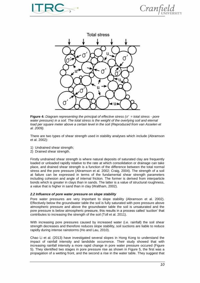
At any point on a plane within a soil mass, where the shear stress becomes equal to the shear strength of the soil then failure will occur at that specific point (Craig, 2004). Effective (shear) stress is based upon a principle by Terzaghi (1923), of which only applies to fully saturated soils as it is deemed that only ‘air’ is compressible when compared to the soil skeleton (particles) and water. Shear stresses can be carried only by the structure of the soild particles as water has no shear strength (Simons and Menzies, 2000). The following three stresses are considered: Total normal stress on a plane within the soil mass, being the force per unit area transmitted in a normal direction across the plane, imagining the soil to be a solid material; Pore water pressure, being the pressure of the water filling the void space between the soild particles; Effective normal stress on the plane, representing the stress transmitted through the soil skeleton only.
10
Figure 4: Diagram representing the principal of effective stress (σ′ = total stress - pore water pressure) in a soil. The total stress is the weight of the overlying soil and eternal load per square meter above a certain level in the soil (Reproduced from van Asselen et al. 2009). There are two types of shear strength used in stability analyses which include (Abramson et al. 2002): 1) Undrained shear strength; 2) Drained shear strength. Firstly undrained shear strength is where natural deposits of saturated clay are frequently loaded or unloaded rapidly relative to the rate at which consolidation or drainage can take place, and drained shear strength is a function of the difference between the total normal stress and the pore pressure (Abramson et al. 2002; Craig, 2004). The strength of a soil at failure can be expressed in terms of the fundamental shear strength parameters including cohesion and angle of internal friction. The former is derived from interparticle bonds which is greater in clays than in sands. The latter is a value of structural roughness, a value that is higher in sand than in clay (Waltham, 2002).
2.2 Influence of pore water pressure on slope stability
Pore water pressures are very important to slope stability (Abramson et al. 2002). Effectively below the groundwater table the soil is fully saturated with pore pressure above atmospheric pressure and above the groundwater table the soil is unsaturated and the pore pressure is below atmospheric pressure, this results in a process called ‘suction’ that contributes to increasing the strength of the soil (Toll et al. 2011). With increasing pore pressures caused by increased water (i.e. rainfall) the soil shear strength decreases and therefore reduces slope stability, soil suctions are liable to reduce rapidly during intense rainstorms (Ho and Lau, 2010). Chao Li et al. (2013) have investigated several slopes in Hong Kong to understand the impact of rainfall intensity and landslide occurrence. Their study showed that with increasing rainfall intensity a more rapid change in pore water pressure occured (Figure 5). They identified two stages in pore pressure rise as shown in Figure 5, the first was a propagation of a wetting front, and the second a rise in the water table. They suggest that
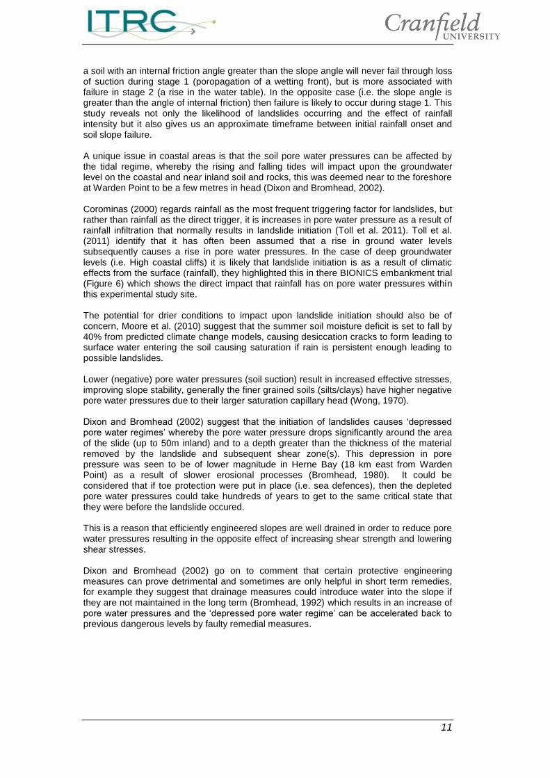
11
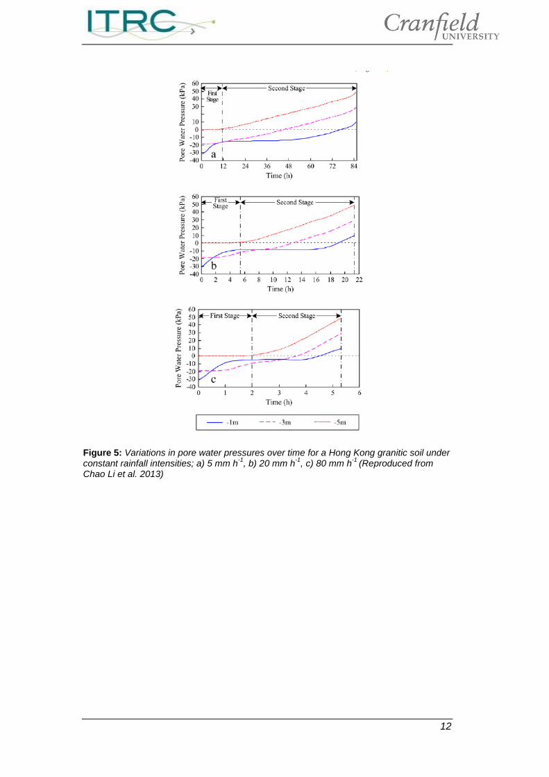
a soil with an internal friction angle greater than the slope angle will never fail through loss of suction during stage 1 (poropagation of a wetting front), but is more associated with failure in stage 2 (a rise in the water table). In the opposite case (i.e. the slope angle is greater than the angle of internal friction) then failure is likely to occur during stage 1. This study reveals not only the likelihood of landslides occurring and the effect of rainfall intensity but it also gives us an approximate timeframe between initial rainfall onset and soil slope failure. A unique issue in coastal areas is that the soil pore water pressures can be affected by the tidal regime, whereby the rising and falling tides will impact upon the groundwater level on the coastal and near inland soil and rocks, this was deemed near to the foreshore at Warden Point to be a few metres in head (Dixon and Bromhead, 2002). Corominas (2000) regards rainfall as the most frequent triggering factor for landslides, but rather than rainfall as the direct trigger, it is increases in pore water pressure as a result of rainfall infiltration that normally results in landslide initiation (Toll et al. 2011). Toll et al. (2011) identify that it has often been assumed that a rise in ground water levels subsequently causes a rise in pore water pressures. In the case of deep groundwater levels (i.e. High coastal cliffs) it is likely that landslide initiation is as a result of climatic effects from the surface (rainfall), they highlighted this in there BIONICS embankment trial (Figure 6) which shows the direct impact that rainfall has on pore water pressures within this experimental study site. The potential for drier conditions to impact upon landslide initiation should also be of concern, Moore et al. (2010) suggest that the summer soil moisture deficit is set to fall by 40% from predicted climate change models, causing desiccation cracks to form leading to surface water entering the soil causing saturation if rain is persistent enough leading to possible landslides. Lower (negative) pore water pressures (soil suction) result in increased effective stresses, improving slope stability, generally the finer grained soils (silts/clays) have higher negative pore water pressures due to their larger saturation capillary head (Wong, 1970). Dixon and Bromhead (2002) suggest that the initiation of landslides causes ‘depressed pore water regimes’ whereby the pore water pressure drops significantly around the area of the slide (up to 50m inland) and to a depth greater than the thickness of the material removed by the landslide and subsequent shear zone(s). This depression in pore pressure was seen to be of lower magnitude in Herne Bay (18 km east from Warden Point) as a result of slower erosional processes (Bromhead, 1980). It could be considered that if toe protection were put in place (i.e. sea defences), then the depleted pore water pressures could take hundreds of years to get to the same critical state that they were before the landslide occured. This is a reason that efficiently engineered slopes are well drained in order to reduce pore water pressures resulting in the opposite effect of increasing shear strength and lowering shear stresses. Dixon and Bromhead (2002) go on to comment that certain protective engineering measures can prove detrimental and sometimes are only helpful in short term remedies, for example they suggest that drainage measures could introduce water into the slope if they are not maintained in the long term (Bromhead, 1992) which results in an increase of pore water pressures and the ‘depressed pore water regime’ can be accelerated back to previous dangerous levels by faulty remedial measures.
12
Figure 5: Variations in pore water pressures over time for a Hong Kong granitic soil under constant rainfall intensities; a) 5 mm h
-1, b) 20 mm h
-1, c) 80 mm h
-1 (Reproduced from
Chao Li et al. 2013)
13
Figure 6: Pore water pressure records for the BIONICS embankment project (SS indicates suction station at different depths). Vertical spikes show daily rainfall (Reproduced from Toll et al. 2011). The rise in pore water pressures can be fairly rapid as a direct result of heavy rainfall, this rate of pressure increase is very dependent on the intensity of rainfall (seen particularly in Figure 6, more intense rainfall leads to greater runoff), nature of ground surface (i.e. paved/bare ground), catchment area (is it very localised?) and soil permeability (i.e. a sandy/gravelly soil less likely to see a rapid increase in pore water pressure as it is fairly well drained). Guzzetti et al. (2008) in a worldwide study concluded that shallow landslides and mudflows were generally initiated when rainfall levels approach 1mm per hour over 24 hoursand if we consider the monthly rainfalls in the UK in October 2012 (128mm) and November 2012 (134mm) (http://www.metoffice.gov.uk/news/in-depth/uk-weather-2012) (See also Figures 9 & 11) we can see why there have been a large number of landslide cases in the latter half of 2012.
2.3 Effect of land use on slope stability
The land use in an area is a key issue for slope stability, often regarded as one of the most important factors regarding rainfall-triggered landslides (Glade, 2003). If the area is vegetated then some water (rainfall) will be held (intercepted), approximately 50-60% of the water will run off the surface of the soil (Abramson et al. 2002). This runoff will be greater when the soil moisture content is near its capacity. Therefore if we consider Figure 11, it is possible to see that in December 2012 the soil moisture deficit is at a point where only 0-5mm rainfall is needed to completely saturate the soil. Therefore establishing the land use and soil type cover would be a key mechanism for establishing the impact of rainfall events on slope stability.
14
Abramson et al. (2002) identify a number of advantages and disadvantages of the effects of vegetation on slope stability: Beneficial Effects Interception of rainfall by foliage; Depletion of soil moisture and increase of soil suction by root uptake and transpiration; Mechanical reinforcement by roots; Restraint by butressing and soil arching between tree trunks; Arresting the roll of loose boulders by trees. Adverse effects Increased capacity for rainwater infiltration; Superficial root reinforcement may be rapidly eroded in a heavy storm;
Surcharging the slope with large heavy trees. Vegetation has the capability to significantly affect soil moisture conditions, as it can extract large quantities of water from the soil (Farewell et al. 2012) reducing the pore water pressures in the soil mass, the consequences of which have been discussed previously. The Forestry Commission (2012) have suggested that forests have a higher interception rate than other vegetation types and what water does reach the soil surface is further intercepted by soils that have a high organic matter content and subsequent ability to hold greater amounts of water.
2.4 Clay mineralogy and slope stability
The clay mineralogy of a soil refers to the type of clay mineral, each of which has a differing grain size, surface area and physico-chemical characteristics (Moore, 1991). If we consider the surface area of clay particles, an increase of which corresponds with a reduction in particle size and subsequent frictional coefficient of each particle (Mitchell, 1967). The approximate surface areas of clay minerals are as follows (Fripiant, 1965);
Kaolinite and Chlorite 5-100 m2 g-1 Mica and Illite 100-200 m2 g-1 Vermiculite 300-500 m2 g-1 Montmorillonite 800 m2 g-1 The physico-chemical behaviour of clay minerals influences the magnitude of the cohesion and intrinsic effective stress components of shear strength, this is as a result of the ionic and hydrogen bonding between clay particles (Moore, 1991). Moore(1991) go on to infer that changes in pore water chemistry effectively alter this physico-chemical interaction and subsequently leads to a direct impact on shear strength. Within a coastal context the impact of salt water has been shown, within a laboratory context, to have a positive effect on shear strength, this is as a result of stable clay particles having repulsive forces that dominate in natural waters at low ionic strength (i.e. low salt content), which further prevents the collision of particles forming aggregates or flocs (Edzwald and O’Melia, 1975), therefore the addition of rain water gives rise to lower residual strengths (Moore and Brunsden, 1991). It has been shown that both shear strength and compressibility of clays depend strongly on pore fluid composition (Sridharan, 1991; Di Maio, 1996). Effectively at the onset of high pore water pressures, the bonds between clay particles break as a result of ‘dilution’ of pore waters along the pre existing shear surfaces, which inevitably leads to movement (Moore and Brunsden, 1996). They go on to suggest along with the work of Moore (1991) that ‘the deposition of sea salts at the surface of mudslides (Worbarrow, Dorset) and the degradation of materials as a result of weathering and active mass movement causes an increase in pore water concentration’. Between November and January (In the years 1985-1987) the salt depostion at the surface of the pre existing slides at Worbarrow were highest at concentrations ranging between 15-33 g/m2 per month. This results in strength
15
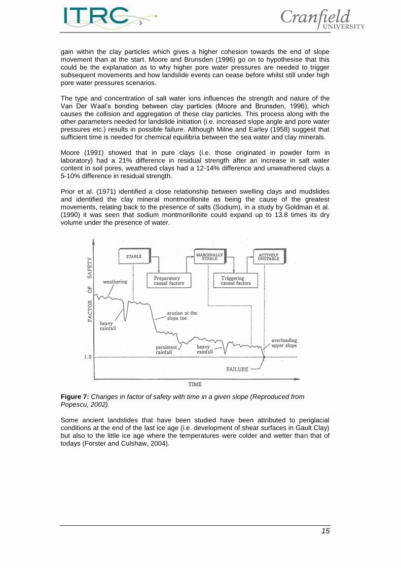
gain within the clay particles which gives a higher cohesion towards the end of slope movement than at the start. Moore and Brunsden (1996) go on to hypothesise that this could be the explanation as to why higher pore water pressures are needed to trigger subsequent movements and how landslide events can cease before whilst still under high pore water pressures scenarios. The type and concentration of salt water ions influences the strength and nature of the Van Der Waal’s bonding between clay particles (Moore and Brunsden, 1996), which causes the collision and aggregation of these clay particles. This process along with the other parameters needed for landslide initiation (i.e. increased slope angle and pore water pressures etc.) results in possible failure. Although Milne and Earley (1958) suggest that sufficient time is needed for chemical equilibria between the sea water and clay minerals. Moore (1991) showed that in pure clays (i.e. those originated in powder form in laboratory) had a 21% difference in residual strength after an increase in salt water content in soil pores, weathered clays had a 12-14% difference and unweathered clays a 5-10% difference in residual strength. Prior et al. (1971) identified a close relationship between swelling clays and mudslides and identified the clay mineral montmorillonite as being the cause of the greatest movements, relating back to the presence of salts (Sodium), in a study by Goldman et al. (1990) it was seen that sodium montmorillonite could expand up to 13.8 times its dry volume under the presence of water.
Figure 7: Changes in factor of safety with time in a given slope (Reproduced from Popescu, 2002). Some ancient landslides that have been studied have been attributed to periglacial conditions at the end of the last ice age (i.e. development of shear surfaces in Gault Clay) but also to the little ice age where the temperatures were colder and wetter than that of todays (Forster and Culshaw, 2004).
16
3. UK coastal slope stability - Specific case studies
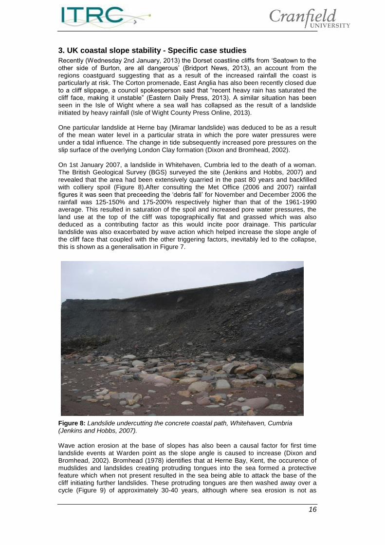
Recently (Wednesday 2nd January, 2013) the Dorset coastline cliffs from ‘Seatown to the other side of Burton, are all dangerous’ (Bridport News, 2013), an account from the regions coastguard suggesting that as a result of the increased rainfall the coast is particularly at risk. The Corton promenade, East Anglia has also been recently closed due to a cliff slippage, a council spokesperson said that “recent heavy rain has saturated the cliff face, making it unstable” (Eastern Daily Press, 2013). A similar situation has been seen in the Isle of Wight where a sea wall has collapsed as the result of a landslide initiated by heavy rainfall (Isle of Wight County Press Online, 2013). One particular landslide at Herne bay (Miramar landslide) was deduced to be as a result of the mean water level in a particular strata in which the pore water pressures were under a tidal influence. The change in tide subsequently increased pore pressures on the slip surface of the overlying London Clay formation (Dixon and Bromhead, 2002). On 1st January 2007, a landslide in Whitehaven, Cumbria led to the death of a woman. The British Geological Survey (BGS) surveyed the site (Jenkins and Hobbs, 2007) and revealed that the area had been extensively quarried in the past 80 years and backfilled with colliery spoil (Figure 8).After consulting the Met Office (2006 and 2007) rainfall figures it was seen that preceeding the ‘debris fall’ for November and December 2006 the rainfall was 125-150% and 175-200% respectively higher than that of the 1961-1990 average. This resulted in saturation of the spoil and increased pore water pressures, the land use at the top of the cliff was topographically flat and grassed which was also deduced as a contributing factor as this would incite poor drainage. This particular landslide was also exacerbated by wave action which helped increase the slope angle of the cliff face that coupled with the other triggering factors, inevitably led to the collapse, this is shown as a generalisation in Figure 7.
Figure 8: Landslide undercutting the concrete coastal path, Whitehaven, Cumbria (Jenkins and Hobbs, 2007). Wave action erosion at the base of slopes has also been a causal factor for first time landslide events at Warden point as the slope angle is caused to increase (Dixon and Bromhead, 2002). Bromhead (1978) identifies that at Herne Bay, Kent, the occurence of mudslides and landslides creating protruding tongues into the sea formed a protective feature which when not present resulted in the sea being able to attack the base of the cliff initiating further landslides. These protruding tongues are then washed away over a cycle (Figure 9) of approximately 30-40 years, although where sea erosion is not as
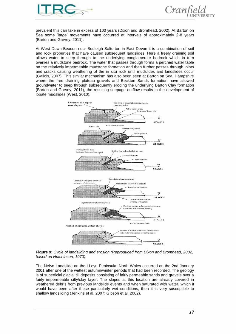
17
prevalent this can take in excess of 100 years (Dixon and Bromhead, 2002). At Barton on Sea some ‘large’ movements have occurred at intervals of approximately 2-8 years (Barton and Garvey, 2011). At West Down Beacon near Budleigh Salterton in East Devon it is a combination of soil and rock properties that have caused subsequent landslides. Here a freely draining soil allows water to seep through to the underlying conglomerate bedrock which in turn overlies a mudstone bedrock. The water that passes through forms a perched water table on the relatively impermeable mudstone formation and then further passes through joints and cracks causing weathering of the in situ rock until mudslides and landslides occur (Gallois, 2007). This similar mechanism has also been seen at Barton on Sea, Hampshire where the free draining plateau gravels and Beckton Sands formation have allowed groundwater to seep through subsequently eroding the underlying Barton Clay formation (Barton and Garvey, 2011), the resulting seepage outflow results in the development of lobate mudslides (West, 2010).
Figure 9: Cycle of landsliding and erosion (Reproduced from Dixon and Bromhead, 2002, based on Hutchinson, 1973). The Nefyn Landslide on the LLeyn Peninsula, North Wales occurred on the 2nd January 2001 after one of the wettest autumn/winter periods that had been recorded. The geology is of superficial glacial till deposits consisting of fairly permeable sands and gravels over a fairly impermeable silty/clay layer. The slopes at this location are already covered in weathered debris from previous landslide events and when saturated with water, which it would have been after these particularly wet conditions, then it is very susceptible to shallow landsliding (Jenkins et al. 2007; Gibson et al. 2002).
18
4. Climate change and slope stability hazards
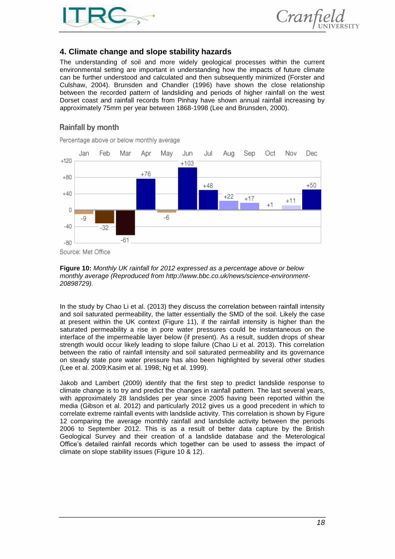
The understanding of soil and more widely geological processes within the current environmental setting are important in understanding how the impacts of future climate can be further understood and calculated and then subsequently minimized (Forster and Culshaw, 2004). Brunsden and Chandler (1996) have shown the close relationship between the recorded pattern of landsliding and periods of higher rainfall on the west Dorset coast and rainfall records from Pinhay have shown annual rainfall increasing by approximately 75mm per year between 1868-1998 (Lee and Brunsden, 2000).
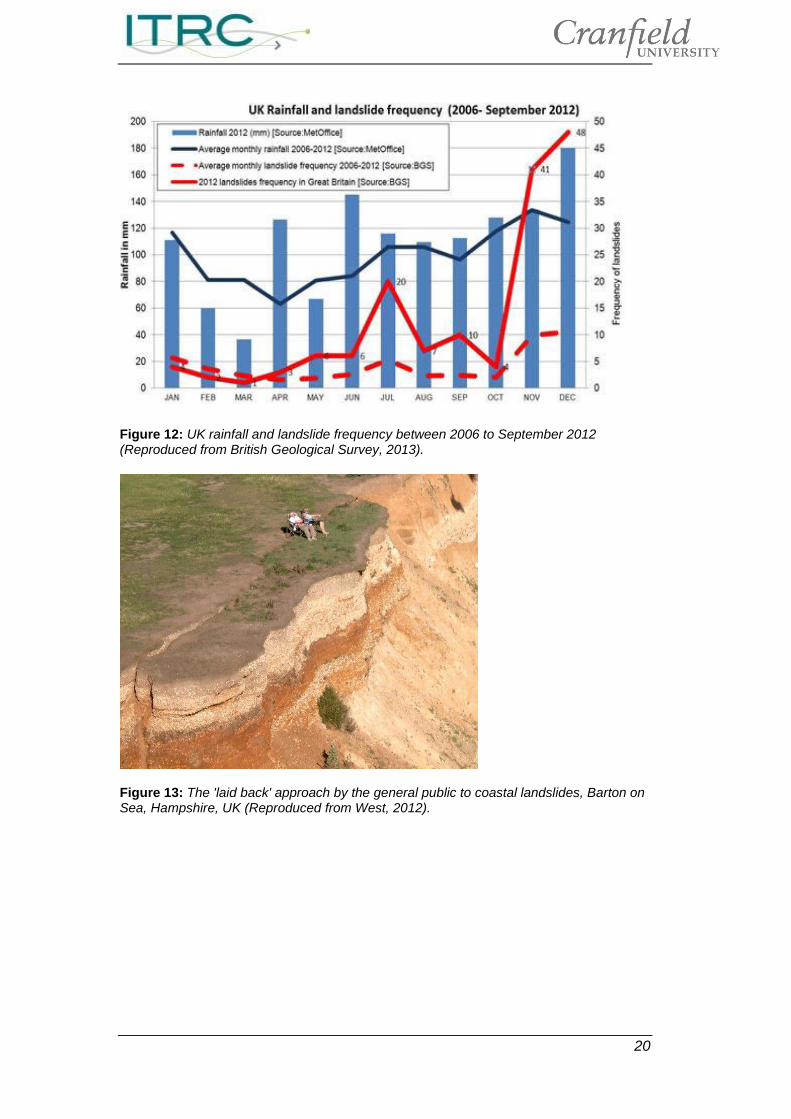
Figure 10: Monthly UK rainfall for 2012 expressed as a percentage above or below monthly average (Reproduced from http://www.bbc.co.uk/news/science-environment-20898729). In the study by Chao Li et al. (2013) they discuss the correlation between rainfall intensity and soil saturated permeability, the latter essentially the SMD of the soil. Likely the case at present within the UK context (Figure 11), if the rainfall intensity is higher than the saturated permeability a rise in pore water pressures could be instantaneous on the interface of the impermeable layer below (if present). As a result, sudden drops of shear strength would occur likely leading to slope failure (Chao Li et al. 2013). This correlation between the ratio of rainfall intensity and soil saturated permeability and its governance on steady state pore water pressure has also been highlighted by several other studies (Lee et al. 2009;Kasim et al. 1998; Ng et al. 1999). Jakob and Lambert (2009) identify that the first step to predict landslide response to climate change is to try and predict the changes in rainfall pattern. The last several years, with approximately 28 landslides per year since 2005 having been reported within the media (Gibson et al. 2012) and particularly 2012 gives us a good precedent in which to correlate extreme rainfall events with landslide activity. This correlation is shown by Figure 12 comparing the average monthly rainfall and landslide activity between the periods 2006 to September 2012. This is as a result of better data capture by the British Geological Survey and their creation of a landslide database and the Meterological Office’s detailed rainfall records which together can be used to assess the impact of climate on slope stability issues (Figure 10 & 12).
19
Figure 11: Soil Moisture Deficit (SMD) for the UK (Reproduced from http://www.bbc.co.uk/news/science-environment-20898729). Although it has been shown (Ventnor, Isle of Wight) that the relationship between rainfall events and landslides is not always a simple one, for example some parts of the Ventnor Undercliff are showing constant significant movement and others only during extreme rainfall events (Lee et al. 1998). On the other hand Lee (2009) warns against the direct use of correlating triggering events (i.e. rainfall) and the critical landslide threshold conditions as they are assumed to have remained the same over the period of the historical record. This in practice is not likely to be the case due to changing land use practices (i.e. agricultural to urban) or further weathering of the slope and its constituents (e.g. West Down Beacon). Crozier (1999) supports this by commenting that using remotely recorded values to represent regional conditions is often a problem as a result of the size of the region and the homogenity of physical conditions (i.e. slope angle, soil type, pore water pressure etc.) which spatially tend to differ over short distances. Although Crozier’s (1999) study in New Zealand did reveal a good correlation between rainfall and landslide activity, it used a maximum threshold of rainfall which left the smaller landslide activity subsequently ignored but larger landslide activity predicted with most confidence.
20
Figure 12: UK rainfall and landslide frequency between 2006 to September 2012 (Reproduced from British Geological Survey, 2013).
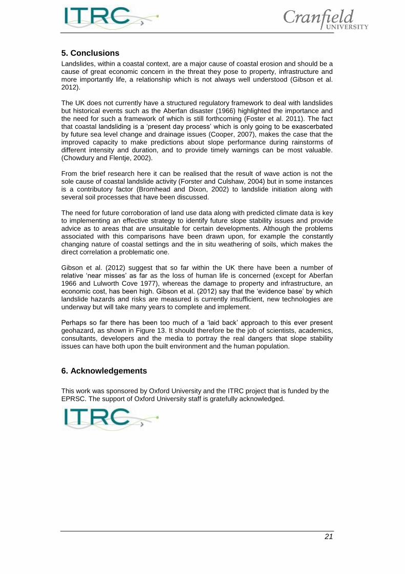
Figure 13: The 'laid back' approach by the general public to coastal landslides, Barton on Sea, Hampshire, UK (Reproduced from West, 2012).
21
5. Conclusions
Landslides, within a coastal context, are a major cause of coastal erosion and should be a cause of great economic concern in the threat they pose to property, infrastructure and more importantly life, a relationship which is not always well understood (Gibson et al. 2012). The UK does not currently have a structured regulatory framework to deal with landslides but historical events such as the Aberfan disaster (1966) highlighted the importance and the need for such a framework of which is still forthcoming (Foster et al. 2011). The fact that coastal landsliding is a ‘present day process’ which is only going to be exascerbated by future sea level change and drainage issues (Cooper, 2007), makes the case that the improved capacity to make predictions about slope performance during rainstorms of different intensity and duration, and to provide timely warnings can be most valuable. (Chowdury and Flentje, 2002). From the brief research here it can be realised that the result of wave action is not the sole cause of coastal landslide activity (Forster and Culshaw, 2004) but in some instances is a contributory factor (Bromhead and Dixon, 2002) to landslide initiation along with several soil processes that have been discussed. The need for future corroboration of land use data along with predicted climate data is key to implementing an effective strategy to identify future slope stability issues and provide advice as to areas that are unsuitable for certain developments. Although the problems associated with this comparisons have been drawn upon, for example the constantly changing nature of coastal settings and the in situ weathering of soils, which makes the direct correlation a problematic one. Gibson et al. (2012) suggest that so far within the UK there have been a number of relative ‘near misses’ as far as the loss of human life is concerned (except for Aberfan 1966 and Lulworth Cove 1977), whereas the damage to property and infrastructure, an economic cost, has been high. Gibson et al. (2012) say that the ‘evidence base’ by which landslide hazards and risks are measured is currently insufficient, new technologies are underway but will take many years to complete and implement. Perhaps so far there has been too much of a ‘laid back’ approach to this ever present geohazard, as shown in Figure 13. It should therefore be the job of scientists, academics, consultants, developers and the media to portray the real dangers that slope stability issues can have both upon the built environment and the human population.
6. Acknowledgements
This work was sponsored by Oxford University and the ITRC project that is funded by the EPRSC. The support of Oxford University staff is gratefully acknowledged.
22
7. References
Abramson LW, Lee TS, Sharma S, Boyce GM. 2002. Slope stability and stabilization
methods, second edition. John Wiley and Sons, New York.
Anon. 2004. The Building Regulations 2000 (structure), Approved document A, 2004 edition. Office of the Deputy Prime minister. Her Majesty's Stationery Office, London.
Barton ME, Garvey PM. 2011. Reactivation of landsliding following partial cliff stabilization at Barton On Sea, Hampshire, UK. Quarterly Journal of Engineering Geology and Hydrogeology. Vol. 44, pp. 233-248.
British Geological Survey. 2013. Increased incidence of landslides in 2012. Available at: http://www.bgs.ac.uk/science/landUseAndDevelopment/landslides/November2012.html.
Bridport News (02 January 2013). Landslide warning after heavy rain wreaks havoc in west Dorset. Availbale at: http://www.bridportnews.co.uk/news/10135333.Landslide_warning_after_heavy_rain_wreaks_havoc_in_west_Dorset/.
Bromhead, EN. 1978. Large landslides in London Clay at Herne Bay, Kent. Quarterly Journal of Engineering Geology and Hydrogeology. Vol 11, pp. 291-304.
Bromhead EN. 1979. Factors affecting the transition between the various types of mass movement in coastal cliffs consisting largely of overconsolidated clay with special reference to southern England. Quarterly Journal of Engineering Geology, Vol 12, pp. 291-300.
Bromhead EN, Ibsen ML. 2006. A review of landsliding and coastal erosion damage to historic fortifications in South East England. Landslides. Vol. 3, pp. 341-347.
Bromhead EN. 1980. Steady and transient seepage in soils with non-linear permeability characteristics. Ph.D. Thesis. University of London.
Bromhead EN. 1992. The stability of slopes. Blackie Academic and Professional. London.
Brunsden D, Chandler JH. 1996. Development of an episodic landform change model based upon the Black Ven Mudslide, 1946-1995. In: Anderson MG, Brooks SM (Eds.) Advances in hillsope processes 2, Wiley.
Chao Li W, Min Lee L, Cai H, Jie Li H, Dai FC, Long Wang M. 2013. Combined roles of saturated permeability and rainfall characteristics on surficial failure of homogenous soil slope. Engineering Geology. Vol. 153, pp. 105-113.
Chowdury R and Flentje P. 2002. Uncertainties in rainfall induced landslide hazard. Quarterly Journal of Engineering Geology and Hydrogeology. Vol. 35, pp. 61-69.
CIWEM. 2006. Taking managed realignment forward as a policy option for coastal management in England and Wales - A CIWEM Briefing report available at www.ciwem.org.
Clark MJ, Ricketts PJ, Small RJ. 1976. Barton does not rule the waves. Geographical Magazine, Vol. 48, pp. 580-588.
Cooper RG. 2007. Mass movements in Great Britain, Geological Conservation Review Series, No. 33. Joint Nature Conservation Committee, Peterborough.
Corominas J. 2000. Landslides and climate. Keynote lecture. In: Bromhead E, Dixon N, Ibsen ML (Eds.). Proceedings of the 8th International symposium on landslides. Vol. 4, pp. 1-33. Balkema, Rotterdam.
Craig RF. 2004. Craig’s Soil Mechanics: Seventh Edition. Spon Press, London.
Cruden DM, Varnes DJ. 1996. Landslide types and processes, special report- National Research Council. Transportation Research Board. Vol. 247, pp. 26-75.
23
Department for Transport, Local Government and the Regions. 2002. Planning Policy Guidance 14 (annex 2): Development on unstable land: subsidence and planning. The stationery Office, London.
Di Maio C. 1996. Exposure of bentonite to salt solution: osmotic and mechanical effects. Geotechnique. Vol. 46, pp. 695-707.
Dixon N, Bromhead EN. 2002. Landsliding in London Clay coastal cliffs. Quaterly Journal of Engineering Geology and Hydrogeology. Vol. 35, pp. 327-343.
Eastern Daily Press (03 January 2013), Update: Corton promenade closed temporarily after cliff collapse. Available at: http://www.edp24.co.uk/news/update_corton_promenade_closed_temporarily_after_cliff_collapse_1_1758145.
Edil TB, Vallejo LE. 1980. Mechanics of coastal landslides and the influence of slope parameters. Engineering Geology. Vol. 16, pp. 83-96.
Edzwald JK, O’Melia CR. 1975. Clay distributions in recent estuarine sediments. Clays and clay minerals. Vol. 23, pp. 39-44.
Europa. 2006. Questions and answers on the thematic strategy on soil protection, available at:http://europa.eu/rapid/press-releaseMEMO-06-341en.htm?locale+en.
Farewell TS, Hallett SH, Hannam JA, Jones RJA. 2012. Soil impacts on National Infrastructure in the United Kingdom. NSRI, Cranfield University, UK.
Fell R, Glastonbury J, Hunter G. 2007. Rapid landslides: the importance of understanding mechanisms and rupture surface mechanics. Quaterly Journal of Engineering Geology and Hydrogeology. Vol. 40, pp. 9-27.
Forestry Commission. 2012. The impact of forests and forest management on slope stability: Can CCF management improve slope stability?. Available at: http://www.forestry.gov.uk/pdf/Slope_stability_and_CCF.pdf/$file/Slope_stability_and_CCF.pdf.
Foster C, Pennington CVL, Culshaw MG, Lawrie K. 2012. The National landslide database of Great Britain: development, evolution and applications. Environmental earth sciences.
Foster C, Harrison M, Reeves HJ. 2011. Standards and methods of hazard assessment for mass-movements in Great Britain. NERC open research archive, Available at: http://nora.nerc.ac.uk/17145/1/AdaptAlp_paper_hjre.pdf.
Forster A and Culshaw M. 2004. Implications of climate change for hazardous ground conditions in the UK. Geology Today. Vol. 20, pp. 61-66.
Fripiant JJ. 1965. Surface chemistry and soil science. In: Hallsworth EG, Crawford DV (Eds.). Experimental Pedology. Butterworth. London.
Gallois RW. 2007. A recent landslide on the east Devon coast, UK. Quaterly Journal of Engineering Geology and Hydrogeology. Vol. 40, pp. 29-34.
Gallois RW. 2010. The failure mechanism of the 1839 Bindon Landslide, Devon, UK: Almost right the first time. Proceedings of the Ussher Society.
Gibson AD, Humpage AJ, Culshaw MG, Forster A, Waters RA. 2002. The geology and landslides of Nefyn Bay, Gwynedd. In: Nichol D, Bassett MG and Deisler VK (Eds.) Landslides and landslide management in North Wales. Geological Series No. 22. National museums and galleries of Wales.
Glade T. 2003. Landslide occurrence as a response to land use change: a review of evidence from New Zealand. Catena. Vol. 51, pp. 297-314.
Goldman LJ, Greenfield LL, Damle AS, Kingsbury GL, Northeim CM, Truesdale RS. 1990. Clay liners for waste management facilities: Design, construction and evaulation. Pollution technology review. Vol. 178, pp. 1-47. Noyes data corporation, New Jersey.
24
Guzzetti F, Peruccacci S, Rossi M, Stark CP. 2008. The rainfall intensity-duration control of shallow landslides and debris flows: an update. Landslides, Vol. 5, pp. 3-17.
Health and Safety Executive. 2012. Safety report assessment guide:chemical warehouses. http://www.hse.gov.uk/comah/sragcwh/warehousing.pdf.
Ho KKS, Lau JWC. 2010. Learning from slope failures to enhance landslide risk management. Quarterly Journal of Engineering Geology and Hydrogeology. Vol. 43, pp. 33-68.
Hodgson RLP, Grainger P, Kalaugher PG. 1996. Progressive weathering and degradation of mudstone in a coastal landslide. Quarterly Journal of Engineering Geology and Hydrogeology. Vol. 29, pp. 57-65.
Hunter G, Fell R. 2003. Mechanics of failure of soil slopes leading to rapid failure. In: Picarelli L (Ed.) Proceedings, international conference fast slope movements, prediction and prevention for risk mitigation, Naples, May 2003. Patron, Bologna, pp. 283-290.
Hutchinson JN. 1986. Cliffs and shores in cohesive materials: geotechnical and engineering geological aspects. In: Skafel MG (Ed.) Proceedings of symposium on cohesive soils. pp. 1-44. National Research Council, Burlington.
Isle of Wight County Press Online (03 January 2013), Sea wall to be closed for months after landslide. Available at: http://www.iwcp.co.uk/news/news/sea-wall-to-be-closed-for-months-after-landslide-47643.aspx.
Jakob M, Lambert S. 2009. Climate change effects on landslides along the Southwest Coast of British Columbia. Geomorphology. Vol. 107, pp. 275-284.
Jenkins GO, Hobbs PRN. 2007. Report of a walkover survey and desk study for the south beach landslide, Whitehaven, Cumbria. British Geological Survey Internal Report.
Jenkins GO, Gibson AD, Humpage AJ. 2007. Climate change and evolution of landslide hazard at Nefyn Bay, North Wales. In: McInnes R (Ed.). Landslides and climate change: challenges and solutions. Proceedings of the international conference on landslides and climate change. Taylor and Francis, pp. 113-119.
Kasim F, Fredlund DG, Gan JKM. 1998. Effect of steady state rainfall on long term matric suction conditions in slopes. Porceedings 2
nd International conference on
unsaturated soils. Pp. 78-83.
Lee EM. 2009. Landslide risk assessment: the challenge of estimating the probability of landsliding. Quaterly Jounral of Engineering Geology. Vol. 42, pp. 445-458.
Lee EM, Brunsden D. 2000. Coastal landslides of Southern England: Mechanism and management. In: Bromhead EN, Dixon N, Ibsen ML. (Eds.) Landslides: In research, theory and practice, Post conference tour.
Lee EM, Moore R. 2007. Ventnor Undercliff: development of landslide scenarios and quantitative risk assessment. In: McInnes R, Jakeways J, Fairbank H, Mathie E. (Eds.). Proceedings of the international conference on landslides and climate change, Ventnor, Isle of Wight. Taylor and Francis, London, pp. 323-333.
Lee EM, Moore R, McInnes RG. 1998. Assessment of the probability of landslide reactivation: Isle of Wight Undercliff, UK. 8th International IAEG Congress, Vancouver 1998.
Lee IM, Gofar N, Rahardjo H. 2009. A simple model for preliminary evaluation of rainfall induced slope instability. Engineering Geology. Vol. 108, pp. 272-285.
Lourenco SDN. 2008. Suction measurements and water retention in unsaturated soils. PhD Thesis, Durham University.
Milne IH, Earley JW. 1958. Effect of source and environment on clay minerals. AAPG Bulletin, Vol. 42, pp. 328-338.
Mitchell JK. 1967. Fundamentals of soil behaviour. Wiley, New York.
25
Moore R. 1991. The chemical and mineralogical controls upon the residual strength of pure and natural clays. Geotechnique. Vol. 41, pp. 35-47.
Moore R, Brunsden D. 1996. Physico-chemical effects on the behaviour of a coastal mudslide. Geotechnique. Vol. 46, pp. 259-278.
Moore R, Carey JM, McInnes RG. 2010. Landslide behaviour and climate change: predictable consequences for the Ventnor Undercliff, Isle of Wight. Quarterly Journal of Engineering Geology and Hydrogeology. Vol. 43, pp. 447-460.
Moore R, Lee EM, Noton NH. 1991. The distribution, frequency and magnitude of ground movements at Ventnor, Isle of Wight. In: Chandler RJ (Ed.). Slope stability Engineering: developments and applications. Thomas Telford, pp. 231-236.
Ng CWW, Chen SY, Pang YW. 1999. Parametric study of the effects of rain infiltration on unsaturated slopes. Rock Soil Mechanics. Vol. 20, pp. 1-14.
Popescu ME. 2002. Landslide causal factors and landslide remediatial options. Third international conference on landslides, slope stability and the safety of infrastructures.
Prior DB, Stephens N, Douglas GR. 1971. Some examples of mudflow and rockfall activity in North East Ireland. Special Publication 3. pp. 129-140. Institute of British Geographers, London.
Sims P, Ternan L. 1988. Coastal erosion: Protection and planning in relation to public policies - a case study from Downderry, South east Cornwall. In: Hooke JM (Ed.). Geomorphology in Environmental Planning. John Wiley and Sons, New York.
Sridharan A. 1991. Engineering behaviour of fine grained soils. Indian Geotechnical Journal. Vol. 21, pp. 1-136.
Toll DG, Lourenco SDN, Mendes J, Gallipoli D, Evans FD, Augarde CE, Cui YJ, Tang AM, Rojas JC, Pagano L, Mancuso C, Zingariello C, Tarantino A. Soil suction monitoring for landslides and slopes. Quaterly Journal of Engineering Geology and Hydrogeology. Vol. 44, pp. 23-33.
van Asselen S, Stouthamer E, van Asch ThWJ. 2009. Effects of peat compaction on delta evolution: A review on processes, responses, measuring and modeling. Earth Science Reviews. Vol. 92, pp. 35-51.
West IM. 2010. Barton and Highcliffe Coast Erosion. Available at: http://www.soton.ac.uk/imw.barteros.htm.
West IM. 2012. Barton and Highcliffe – Coast erosion and sea defences: Geology of the Wessex Coast of Southern England. Available at: http://www.southampton.ac.uk/~imw/barteros.htm.
Wong KK. 1970. Pore water suction in Hong Kong soil by pyschometric technique. MSc Thesis. University of Hong Kong. Unpublished.