Coastal Ecosystem Restoration - UNEP · Coastal Ecosystem Restoration: ......
58
After the Tsunami Coastal Ecosystem Restoration Lessons Learnt
Transcript of Coastal Ecosystem Restoration - UNEP · Coastal Ecosystem Restoration: ......

After the TsunamiCoastal Ecosystem Restoration
Lessons Learnt

This publication may be reproduced in whole or in part and in any form of educational or non-profit services without special permission from the copyright holder, provided acknowledgement of the source is made. UNEP would appreciate receiving a copy of any publication that uses this publication as a source. No use of this publication may be made for resale or any other commercial purpose whatsoever without prior permission in writing from UNEP. Applications for such permission, with a statement of the purpose and extent of the reproduction, should be addressed to the Director, DCPI, UNEP, P.O. Box 30552, Nairobi, Kenya. While reasonable efforts have been made to ensure that the contents of this publication are factually correct, UNEP does not accept responsibility for the accuracy and completeness of the information used in this publication, and shall not be liable for any loss or damage that may be occasioned directly or indirectly through the use of, or reliance on, the contents of this publication, including its translation into other languages than English. The opinions indicated in this publication should not necessarily be considered as reflecting the views or carrying the endorsement of the United Nations Environment Programme. Mention of a commercial company or product in this publication does not imply endorsement by the United Nations Environment Programme.
Published by United Nations Environment Programme (UNEP), 2007
Design and Layout: Rachel Dolores Unless otherwise credited, all the photos in this publication have been taken by the UNEP staff.

Table of Contents
Preface.................................................................................................................................. 4Executive.summary............................................................................................................... 5
1..Introduction....................................................................................................................... 61.1.. Profile.of.Aceh................................................................................................. 61.2... Apparent.changesin.land.cover..................................................................... 6
2..Coastal.Conditions.Before.the.Tsunami............................................................................. 82.1. Mangrove.forest.............................................................................................. 82.2. Beach.forest.................................................................................................. 102.3. Aquaculture.ponds........................................................................................ 112.4. Peatland........................................................................................................ 122.5. Swamps......................................................................................................... 142.6. Sandy.beach.vegetation.............................................................................. 14
3..Coastal.conditionsafter.the.tsunami............................................................................... 163.1. Impact.of.the.tsunamiand.earthquake......................................................... 163.2. Regeneration.of.vegetation.......................................................................... 263.3. Prospects.for.rehabilitation............................................................................ 27
4..Lessons.learned............................................................................................................... 304.1. Actors.in.coastal.rehabilitation...................................................................... 304.2. Progress.in.implementation........................................................................... 344.3. Level.of.success............................................................................................. 384.4. Limitations.and.constraintsin.the.field............................................................ 394.5. Recommendations........................................................................................ 51

� Coastal Ecosystem Restoration: Lessons Learned in Aceh since the Tsunami
Preface
The.tsunami.of.26.December.2004.swept.along.800.km.of.the.coast.of.the.Indonesian.province.of. Nanggröe. Aceh. Darussalam. (NAD,. or. Aceh),.causing.the.loss.of.at.least.167,000.lives..A.further.500,000.people.lost.their.homes.and.livelihoods.
A.year.later,.as.many.as.124.international.NGOs,.430. national. NGOs,. dozens. of. donor. and. UN.organizations,.a.variety.of.Government.institutions.and. military. institutions. had. been. recorded,.together. with. the. community,. to. be. working. on.rebuilding.Aceh.(BRR,.2005).
The.first.step.in.the.reconstruction.effort.focused.mostly.on.the.emergency.response,.particularly.with.regard.to.fulfilling.the.victims’.need.for.basic.items.such.as.food,.clean.water.and.shelter...As.conditions. in. the. field. began. to. improve,. the.emergency.gradually.subsided.and.work.moved.to.the.next.phase,.rehabilitation..From.that.point.on,. attention. began. to. be. directed. towards.restoration.of.the.environment,.particularly.in.those.areas.hit.by.the.tsunami.
A. number. of. organizations,. both. governmental.and. non-governmental,. initiated. a. variety. of.environmental.restoration.activities,.in.particular.the.planting.of.mangrove.and.other.coastal.vegetation.in.an.effort. to. restore. the.coastlands.. .Within.only.a. few.months,.coastal. rehabilitation.actions.had.mushroomed.throughout.the.Aceh.coast,.and.the.hitherto.unknown.term.‘mangrove’.suddenly.became.familiar.in.the.community,.who.had.previously.called.it.by.its.local.name.“bak bangka”..
After.18.months.of.coastal. rehabilitation.activity,.the.results.are.now.clear...Only.a.few.activities.of.it.have.been.fully.successful,.the.rest.has.failed...This.can.be.seen.simply. from.the. low.survival. rate.of.plants. in.the.field...Reasons.given.for.the.failures.include:.mistakes.in.the.selection.of.planting.sites,.unsuitable.choice.of.plants,.insufficient.preparation,.inadequate.guidance,.no. tending.of. the.plants,.and.the.low.capacity.of.human.resources.
Another.weakness.found.in.the.field.was.the.very.limited.amount.of.community.involvement.in.the.rehabilitation.activity..Communities.tended.to.be.included.only.as.workers,.not.as.partners.involved.actively.and.continuously..Moreover,.coordination.and.information.sharing.among.the.stakeholders.concerned. with. the. rehabilitation. activity. were.very.poor.
A.mistaken.perception.among.the.implementers.was. that. rehabilitation. activity. ended. once. the.seedlings. had. been. planted. in. the. field.. The.result.as.they.saw.it,.therefore,.was.the.number.of.seedlings.planted,.not.the.number.that.survived.after.planting.
Apart. from. the. matters. mentioned. above,. the.coastal.rehabilitation.activities.underway.in.NAD.province.have.provided.a.great.many.experiences.and.valuable.lessons....Unfortunately,.these..lessons.have. not. been. brought. to. the. attention. of. the.stakeholders. in.Aceh.. .For. this. reason,.Wetlands.International-Indonesia.Programme.collaborated.with.the.United.Nations.Environment.Programme.(UNEP).to.undertake.this.study.of.lessons.learned.from.coastal.ecosystem.restoration.efforts.in.Aceh.since.the.tsunami.
In. this. study,. the. causes. of. failures. have. been.identified. and. extracted. from. a. variety. of.stakeholders..In.addition,.this.study.also.provides.a. range. of. information,. experience,. strategies.and. other. matters. relevant. to. supporting. the..rehabilitation. activities. undertaken. by. both.government. and. NGOs.. . It. is. hoped. that. the.suggestions. and. recommendations. made. here.can. be. used. to. support. rehabilitation. efforts. in.NAD.Province..
�Coastal Ecosystem Restoration: Lessons Learned in Aceh since the Tsunami
Executive summary
This.report.explains.what.is.known.about.coastal.ecosystems.in.the.Indonesian.province.of.Nanggröe.Aceh.Darussalam.(NAD.or.Aceh),.their.status.before.the.tsunami.of.2004,.and.how.they.fared.after.it...It.reviews.the.ecosystem.restoration.activities.that.were. undertaken. in. 2005-2006. by. a. variety. of.governmental.and.non-governmental.actors,. in.partnership.with.many.different.stakeholder.groups,.and.updates. findings. into.2007.. . Specifically,. it.critically.examines. the. various.means.by.which.the.re-planting.of.mangroves.and.other.coastal.vegetation. was. attempted,. and. quantifies. the.outcome. in. terms. of. success. as. measured. by.long-term.seedling.survival...A.total.of.almost.30.million. seedlings. were. recorded. to. have. been.planted.on.27,500.ha.in.Aceh.since.the.tsunami...Unfortunately,.the.mangroves.were.often.planted.in.damaged.pond.areas.before.the.ponds.were.repaired,.and.many.were.destroyed.by.the.heavy.machinery.used.in.repair.work...Other.mangrove.planting.areas.were.later.destroyed.through.the.construction.of.infrastructure,.suggesting.a.lack.of.coordination.among.the.various.actors...The.need.to.avoid. such.mis-sequencing.and.mis-location.of.planting.effort. is.one.of.a.number.of. lessons.learned,.the.others.being:
•. that.short-term,.project-based,.cash-for-work.schemes. in. which. local. people. are. used.as. paid. labourers,. with. limited. supervision,.training. or. education,. tend. to. result. in. little.after-care. of. planted. seedlings,. and. high.seedling.mortality.rates;
•. that. with. 95%. of. planted. seedlings. being.Rhizophora.(mostly.R..mucronata),.the.resulting.mangrove. monocultures. lack. structural. and.taxonomic.diversity.and.zonation,.which.may.render. them. vulnerable. to. environmental.shocks.and.disease;
•. that.importing.seeds.and.seedlings.from.Java.to.relieve.local.supply.shortages.meant.that.many.(35-50%).died.in.shipping.and.the.rest.were.stressed.and.weakened;
•. that.the.use.of.mature.and.qualified.seed.and.seedlings.is.essential.to.high.survival.rates.after.planting;
•. that.the.choice.of.site.for.nurseries.is.important.to. seedling. production,. the.best. sites.being.tidal,.flat.and.sheltered.from.the.wind;
•. that.the.use.of.growth.media.with.too.little.mud.content.causes.seedlings.to.die;
•. that. a. 1-2. month. ‘hardening. off ’. period. is.needed. before. planting,. during. which. the.seedlings.are.progressively.deprived.of.fresh.water.and.shade;
•. that.seedlings.were.often.planted.in.the.wrong.sites,. that. is. in. sandy. areas,. in. areas. prone.to. drying. out,. and. in. high-energy. locations.vulnerable.to.currents.and.wind;
•. that.planting.in.privately-owned.areas.without.the. owner’s. permission. may. result. in. the.seedlings.being.removed.later;
•. that.various.technical.errors.can.kill.or.weaken.seedlings,.including.planting.at.the.hottest.times.of.day,.transporting.seedlings.with.bare.roots,.and.planting.seedlings.still.in.their.plastic.polybags;
•. that.young.seedlings.are.vulnerable. to.pest.attack,. especially. by. barnacles,. crabs. and.mud.shrimps;.and
•. that.seedlings.need.to.be.protected.against.browsing.livestock.
The.net.result.of.a.failure.to.address.these.challenges.was.that.around.half.the.planted.mangroves.did.not.survive...The.study.concludes.that.key.priorities.include.a.need.for.stakeholder.coordination,.full.long-term.community.participation.in.all.stages.of.the.process.and.its.planning,.and.awareness.of.the.correct.techniques,.sites.and.species.for.planting,.and.of.the.key.indicators.that.suggest.good.sites.(i.e..mud.skippers).and.bad.ones.(i.e..barnacles)..Educational.and.awareness-raising.activities.are.therefore. important.. . Diversification. of. species.planted.should.also.be.encouraged.

� Coastal Ecosystem Restoration: Lessons Learned in Aceh since the Tsunami
Figure 1-1. Map of NAD Province
1. Introduction
1.1. Profile of Aceh
The. Indonesian. province. of. Nanggröe. Aceh.Darussalam. (NAD,. or. Aceh). is. situated. between.latitudes.2–6.o.North.and.longitudes.95.–98.o.East,.and. occupies. the. northern. tip. of. the. island. of.Sumatra....It.has.an.area.of.57,365.57.km²,.and.is.divided.into.the.four.municipalities.(kota).of.Banda.Aceh,.Langsa,.Lhokseumawe,.and.Sabang,.and.17.districts. (kabupaten),.each.divided. into. sub-districts.(kecamatan)..To.the.north.and.east.lies.the.Strait.of.Malacca,.to.the.west.is.the.Indian.Ocean,.and.to.the.south.Aceh’s.only.land.frontier,.with.the.province.of.North.Sumatra.
Aceh. lies. in. the. moist. equatorial. zone. and. has.a. mean. annual. rainfall. of. 1,500-5,000. mm.depending.on.location.and.rain-shadow.effects,.being.drier. in.the.north.and.west,.and.wetter. in.the. south. and. east,. and. in. the. mountains.. The.geology. is. largely. granitic. and. volcanic. but.there.are.significant.areas.of.limestone.(karst). in.the.north..Farmland.includes.wet.rice,.which.may.be. irrigated. or. rain-fed,. mixed. gardens. of. fruit.
trees.and.vegetable.crops,.and.many.areas.are.suitable. for. coconut,. cocoa,. coffee. and. other.pan-tropical. crops.. . There. is. a. clear. distinction.between. the. flat.coastal.plain.and. the. steeper.upland. areas,. which. are. more. suitable. for. tree.crops.. The. main. crops. grown. are. rice,. maize,.soybean,.ground-nut,.green.beans,.cassava.and.sweet. potato.. . The. dominant. food. crop. is. rice,.while.maize.and.cassava.are.the.most.important.supplementary.starch.sources.
In. 2003,. NAD. Province. had. a. population. of.4,218,486,.which.was.growing.at.1.26%.annually...In-migration.had.declined.since.1999.due.to.the.conflict,.and.there.was.significant.out-migration.as.well...Average.population.density.in.2003.was.74.people/km2,.but.varied.considerably.from.one.district. to.another.. The. six.districts.most. severely.affected.by. the. tsunami. included.Banda.Aceh,.the.most.densely.populated.with.3,669.people/km2,.the.others.being.Aceh.Jaya,.Nagan.Raya,.Aceh.Barat,.Simeulue.and.Aceh.Besar...The.total.population.after.the.tsunami.had.been.reduced.to.about.4,010,860.
1.2 Apparent changes in land cover
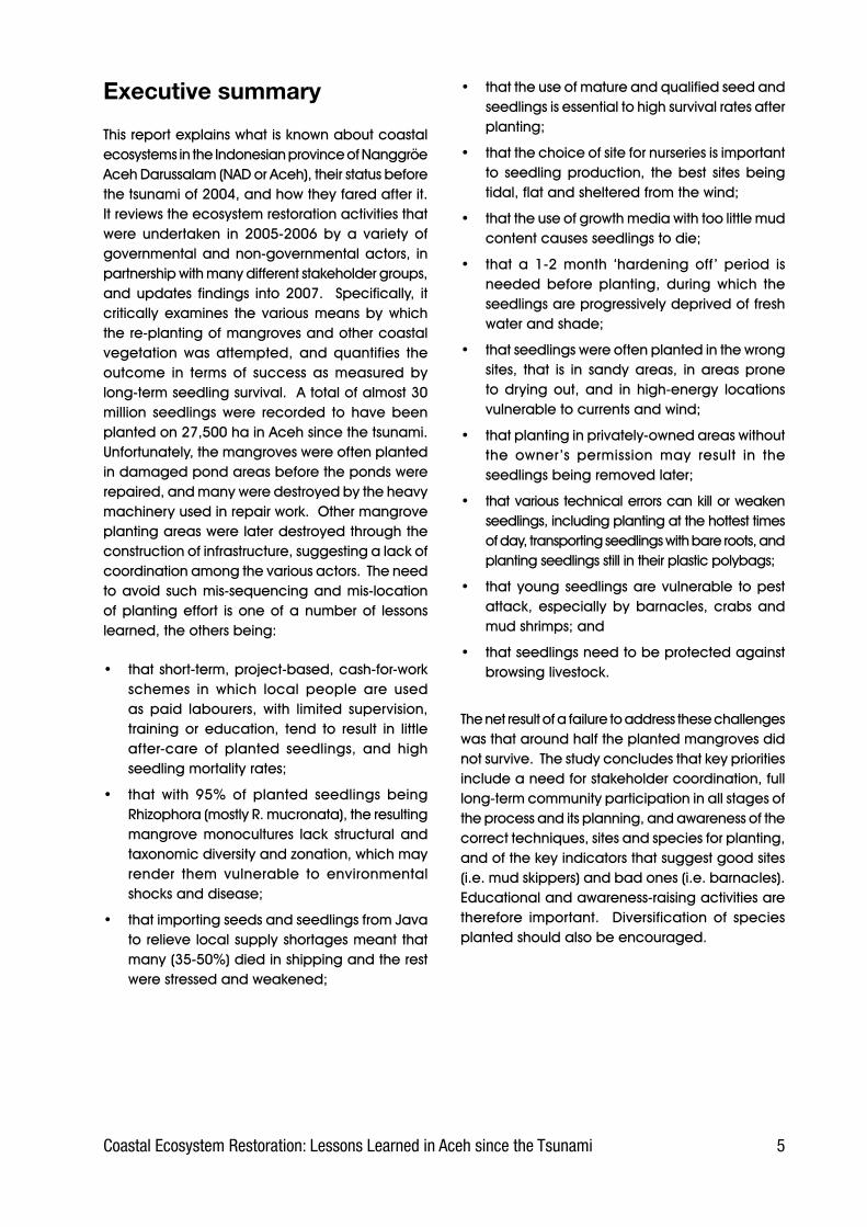
Figures.1-2.and.1-3. show. land.cover.conditions.for.NAD.Province.based.on. the. interpretation.of.Landsat.Satellite.Imagery.ETM.7.in.1999-2000.and.in. 2002-2003. respectively. (Ministry. of. Forestry,.2002,. 2005).. . These. interpretations. appear. to.show.that,.within.three.or.four.years,.land.cover.in.Aceh.province.had.undergone.drastic.change,.especially.in.the.reduced.area.of.Primary.Dry.Forest.relative.to.Secondary.Dry.Forest..These.differences.in.forest.cover.interpretation.between.1999-2000.and.2002-2003.are.summarised.in.Table.1-1.
Area in hectares1999-2000 2002-2003
Primary dry forest 1,471,000 480,000
Secondary dry forest 1,179,000 2,413,000
Primary swamp forest 1,000 0
Secondary swamp forest 117,000 165,000
Secondary mangrove forest 24,000 18,000
Plantation forest 269,000 36,000
Total forest cover 3,061,000 3,112,000
Table 1-1: Changes in forest cover in Aceh (source: satellite image interpretation by Ministry of Forestry, 2002, 200�)
�Coastal Ecosystem Restoration: Lessons Learned in Aceh since the Tsunami
Figure 1-2. Land cover conditions for NAD Province, based on interpretation of Landsat imagery 1999-2000 (Ministry of Forestry, 2002).
Figure 1-3. Land cover conditions for NAD Province, based on interpretation of Landsat imagery 2002-2003 (Ministry of Forestry, 200�).
� Coastal Ecosystem Restoration: Lessons Learned in Aceh since the Tsunami
2. Coastal Conditions Before the Tsunami
Aceh’s. eastern. coastline. is. 761. km. long. and. is.mostly. muddy. beach. which. had. once. been.covered.by.extensive.areas.of.mangrove.forest..The. eastern. coastal. districts. comprise. Aceh.Besar,. Banda. Aceh,. Pidie,. Bireun,. Aceh. Utara,.Lhokseumawe,. Aceh. Timur,. Langsa. and. Aceh.Tamiang...The.western.coastline.is.706.km.in.length.and. is.dominated.by.sandy.beach.covered.by.casuarina.(sea.pine),.coconut,.hibiscus,.and.other.species.of.coastal.vegetation...The.western.coastal.districts.are:.Aceh.Besar,.Aceh.Jaya,.Aceh.Barat,.Meulaboh,.Nagan.Raya,.Aceh.Barat.Daya,.Aceh.Selatan,. Simeulue. Island. and. Aceh. Singkil.. The.following.is.a.description.of.the.condition.of.the.various.coastal.ecosystem.types.as.they.existed.before.the.tsunami;.these.are.mangrove,.coastal.forest,. peatland,. swamp,. aquaculture. ponds,.and.sandy.beach.together.with.the.surrounding.vegetation.formations.
2.1 Mangrove forest
2.1.1 Condition of mangrove vegetation
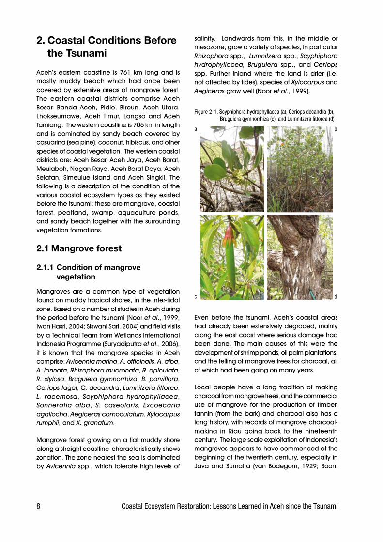
Mangroves. are. a. common. type. of. vegetation.found.on.muddy.tropical.shores,.in.the.inter-tidal.zone..Based.on.a.number.of.studies.in.Aceh.during.the.period.before.the.tsunami.(Noor.et al.,.1999;.Iwan.Hasri,.2004;.Siswani.Sari,.2004).and.field.visits.by.a.Technical.Team.from.Wetlands.International.Indonesia.Programme.(Suryadiputra.et al.,.2006),.it. is. known. that. the. mangrove. species. in. Aceh.comprise:.Avicennia marina,.A. officinalis,.A. alba,.A. lannata,.Rhizophora mucronata,.R. apiculata,.R. stylosa,.Bruguiera gymnorrhiza,.B. parviflora,.Ceriops tagal,.C. decandra, Lumnitzera littorea, L. racemosa, Scyphiphora hydrophyllacea, Sonneratia alba, S. caseolaris, Excoecaria agallocha, Aegiceras cornoculatum, Xylocarpus rumphii,.and.X. granatum..
Mangrove.forest.growing.on.a.flat.muddy.shore.along.a.straight.coastline..characteristically.shows.zonation..The.zone.nearest.the.sea.is.dominated.by.Avicennia. spp.,.which. tolerate.high. levels.of.
salinity.. . Landwards. from. this,. in. the. middle. or.mesozone,.grow.a.variety.of.species,.in.particular.Rhizophora.spp.,..Lumnitzera spp.,.Scyphiphora hydrophyllacea, Bruguiera spp.,. and. Ceriops spp.. Further. inland. where. the. land. is. drier. (i.e..not.affected.by.tides),.species.of.Xylocarpus and.Aegiceras grow.well.(Noor.et al.,.1999)..
Figure 2-1. Scyphiphora hydrophyllacea (a), Ceriops decandra (b), Bruguiera gymnorrhiza (c), and Lumnitzera littorea (d)
a b
c d
Even. before. the. tsunami,. Aceh’s. coastal. areas.had.already.been.extensively.degraded,.mainly.along.the.east.coast.where.serious.damage.had.been. done.. The. main. causes. of. this. were. the.development.of.shrimp.ponds,.oil.palm.plantations,.and.the.felling.of.mangrove.trees.for.charcoal,.all.of.which.had.been.going.on.many.years.
Local. people. have. a. long. tradition. of. making.charcoal.from.mangrove.trees,.and.the.commercial.use. of. mangrove. for. the. production. of. timber,.tannin. (from.the.bark).and.charcoal.also.has.a.long.history,.with.records.of.mangrove.charcoal-making. in. Riau. going. back. to. the. nineteenth.century...The.large.scale.exploitation.of.Indonesia’s.mangroves.appears.to.have.commenced.at.the.beginning.of.the.twentieth.century,.especially.in.Java.and.Sumatra. (van.Bodegom,.1929;.Boon,.
9Coastal Ecosystem Restoration: Lessons Learned in Aceh since the Tsunami
Box 2-1. Mangroves’ function in protecting the coast
Mangroves play an important role in protecting the coast from waves, wind and storms. Mangrove stands can protect settlements, buildings and agriculture from strong winds and from intrusion by sea water. The villages of Tongke-tongke and Pangasa, in Sinjai, South Sulawesi, which both possess a dense strip of mangrove along their coast, were protected from the Flores Tsunami in 1992, whereas neighbouring villages that did not have such dense mangrove cover suffered serious damage. In Bangladesh in June 1985, 40,000 coastal dwellers suffered as a result of hurricanes. Knowing the benefit of mangrove in mitigating storm damage, the Bangladesh Government then planted 25,000 hectares of coastlands with mangrove (Maltby, 1986 in Noor et al., 1999).
1936.in.Noor.et al.,.1999),.although.it.seems.that.heavy.equipment.only.started.to.be.used.in.1972.(Forestry.Department.&.FAO,.1990.in.Noor.et al.,.1999).. In. 1985,. 14. companies. were. granted.licences. to. exploit. a. total. of. 877,200. hectares.of. mangrove. forest,. that. is. about. 35%. of. the.mangrove. forest. remaining. in. Indonesia.at. that.time.(Forestry.Department.&.FAO,.1990.in.Noor.et al.,.1999)..
2.1.2 Distribution of mangroves in Aceh
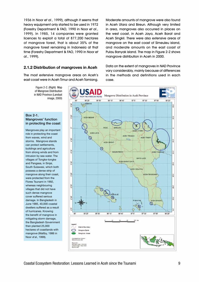
The. most. extensive. mangrove. areas. on. Aceh’s.east.coast.were.in.Aceh.Timur.and.Aceh.Tamiang..
Moderate.amounts.of.mangrove.were.also.found.in.Aceh.Utara.and.Bireun..Although.very. limited.in.area,.mangroves.also.occurred. in.places.on.the. west. coast,. in. Aceh. Jaya,. Aceh. Barat. and.Aceh.Singkil..There.were.also.extensive.areas.of.mangrove.on.the.east.coast.of.Simeuleu.island,.and. moderate. amounts. on. the. east. coast. of.Pulau.Banyak.island..The.map.in.Figure.2-2.shows.mangrove.distribution.in.Aceh.in.2000..
Data.on.the.extent.of.mangroves.in.NAD.Province.vary.considerably,.mainly.because.of.differences.in. the. methods. and. definitions. used. in. each.case..
Figure 2-2. (Right) Map of Mangrove Distribution
in NAD Province (Landsat image, 2000)

10 Coastal Ecosystem Restoration: Lessons Learned in Aceh since the Tsunami
Table.2-1.gives.data.from.several.sources.on.the.extent.of.mangrove.in.Aceh.province.from.1982.to.2002.
Table 2-1. Extent of mangrove forest in Aceh Provincebefore the tsunami
Source of data Year Extent (ha)Bina Program 1982 54,335Silvius et al. 1987 55,000INTAG 1996 60,000Giesen et al. 1991 60,000Forestry Planology Agency
2002 24,000
In.2004,.the.Ministry.of.Forestry.announced.in.a.press.release.that.mangroves.covered.296,078.ha.on.the.east.coast,.49,760.ha.on.the.west.coast.and.a.total.of.1,000.ha.in.the.Simeulue.District.(press.release.no..S..32/II/PIK-1/2004).
In. 2000,. however,. the. Ministry. of. Forestry. had.reported. that.only. 30,000.ha.of. Aceh’s. coastal.mangrove. forests. were. still. in. good. condition,.including. the.mangroves. on. Simeulue. Island.. A.total.of.286,000.ha.of.mangrove.was.in.moderate.condition,.and.25,000.ha.were.badly.degraded.
One.area.of.mangrove.forest.that.was.still.in.good.condition.and.growing.densely,.according.to.a.study.done.in.January.2004,.was.that.on.the.coast.of.Ulee.Iheue,.before.it.was.swept.by.the.tsunami...An.analysis.of.the.vegetation.in.this.forest.recorded.167.Rhizophora stylosa trees.and.9.Rhizophora apiculata in.a.small.plot.measuring.only.10m.x.10m.(Siswani.Sari,.2004).
Prior. to. the. tsunami,. the. main. threats. to. the.mangrove’s. continued. survival. were. charcoal.making. and. conversion. to. aquaculture. ponds..In.the.district.of.Aceh.Tamiang,.it.is.reported.that.only.8,800.ha.(44%).of.the.22,000.ha.of.mangrove.remained,. the. rest. having. been. converted. to.aquaculture. ponds. and. oil. palm. plantation.(Serambi Nanggroe,.13.July.2006)..The.same.trend.was.observed.in.other.districts,.particularly.those.on.Aceh’s.east.coast.
2.2 Beach forest
There.are.no.data.on.the.extent.of.beach.forests.in. Aceh. as. they. are. not. listed. separately. but.are. instead. classified. under. Primary. Dry. Forest.or.Secondary.Dry.Forest.(see.Section.1.2)..There.are. no. comprehensive. studies. of. biodiversity. in.the.whole.of.Aceh,.let.alone.in.its.beach.forests,.although.many.data.are.available.from.the.inland.forests.of. the.Leuser.Ecosystem...This. large.area.has.more.than.4,500.species.of.higher.plants,.434.species.of.birds,.392. species.of.mammals,.171.species.of.amphibians.&.reptile,.and.at.least.81.species.of.fish.(UML.Database,.2002,.in.Irfan,.2002)..This.means.that.around.45%.of.the.total.estimated.number.of.plant.species.in.the.West.Indo-Malayan.region,.85%.of.all.the.bird.species.in.Sumatra,.and.54%.of.the.estimated.total.land.fauna.in.Sumatra,.are.all.found.in.the.Leuser.Ecosystem...
One. comparative. study. is. available. for. beach.forests,.in.the.Pulot.area...With.its.unique.conditions,.from.the.ocean.shore.in.the.west.to.the.hills.in.the.east,. this. location.still.provides.good.habitat. for.a.wide.variety.of.wildlife.species..Sightings.have.been. recorded.of. no. fewer. than.44. species.of.bird,.including.three.of.hornbill.and.three.of.eagles.or. other. large.birds.of.prey.. Around.15. species.of.mammal.are. thought. to. live.here. still,.based.on. evidence. including. sightings,. tracks,. food.remnants.and.faeces,.and.information.from.the.local.inhabitants..Herpetofauna.diversity.has.not.yet.been.studied.specifically,.but.the.small.streams.in.the.area.are.likely.to.be.home.to.some.of.the.171.species.of.amphibians.and.reptiles.recorded.from.the.Leuser.Ecosystem.
Although.the.Pulot.area.is.not.as.rich.as.the.Leuser.Ecosystem,.a.brief.study.by.a.survey.team.from.Wetlands. International. Indonesia. Programme.found. that. it. is. still. habitat. for. a. number. of.rare. and. protected. species,. such. as. siamang.Symphalangus syndactylus,. gibbons. Hylobates agilis,. leaf-monkeys. Presbytis thomasi,. several.species. of. hornbill. (Bucerotidae),. birds. of. prey.(Accipitridae),.and.honeysuckers.(Nectariniidae).(Hasudungan,.2006).
11Coastal Ecosystem Restoration: Lessons Learned in Aceh since the Tsunami
Box 2-2. Green belt policy and spatial planning
The green belt is the zone of protected mangrove which is maintained all along the coast and which it is forbidden to cut down, convert or damage. The function of this mangrove green belt, in principle, is to preserve the coast from the threat of erosion and to act as a nursery and breeding ground for a variety of fish species.Government policy to formulate a green belt began in 1975 with the publication of a decree by the Director General for Fisheries (SK Dirjen Perikanan No H.I/4/2/18/1975) which pronounced the need to maintain a belt of land along the coast, with a width of 400m measured from the average low tide level. The Director General for Forestry subsequently issued decree No. 60/KPTS/DJ/I/1978 concerning guidelines for silviculture in areas of brackish water. This decree stipulated a 10m green belt along the length of rivers, and a 50m one along the coast, measured from the lowest point at low tide. In 1984, the Forestry and Agriculture ministers issued joint decrees No. KB 550/246/KPTS/1984 and No. 082/KPTS-II/1984, which called for the conservation of a 200m green belt along the coast, forbade the felling of mangrove trees in Java, and placed a conservation order on all mangroves growing on small islands (i.e. those of less than 1,000 ha).In 1990, Presidential Decree No. 32 concerning the Management of Conservation Areas replaced all previous regulations on green belts and granted more satisfactory protection to green belt zones. The decree stipulated that coastal mangrove green belts should be a minimum of 130 times the average tide, measured landwards from the point of the lowest tide mark. In practice, however, this decree suffered from a number of weaknesses as regards its application in the field. Some of the criticisms leveled at the decree are as follows.
The decree cannot be applied to areas which, as a result of exploitation or conversion at some time in the past, no longer possess mangroves. Provision has to be made for this.This decree cannot be used to make an effective determination of green belt on very wide flat shores or mud flats. In several such areas, if the green belt is measured from the lowest point at low tide, it will comprise nothing but mud flats and will not reach as far as the mangroves. This problem can be solved by having a definition of measurement that starts from the seaward edge of the mangrove. This decree does not press for the protection of mangroves as a whole nor of their ecological function. It disregards their ecological interdependence with, for example, terrestrial forests, freshwater sources or freshwater swamps. Unless the supporting ecosystems are also protected in a properly integrated manner, the future survival of the green belt will be at risk. This decree gives only one choice, conservation. This choice is inadequate for areas where the intensive use of mangroves has long been a tradition, with the result that it will be difficult to reach consensus on the management of mangroves in such areas. In Java, for example, almost the entire mangrove area has been used for aquaculture ponds and for a variety of other uses which do not support the conservation of mangrove ecosystems.
In 1993, the Ministry of Forestry advocated that the total extent of protected areas needed to be doubled from 15 million to 30 million hectares. This was relevant to much of the nation’s mangroves. In response, a variety of organizations active in the field of nature conservation submitted proposals for new conservation areas and extensions to existing ones. One proposal for an additional 630,000 hectares of mangrove to be conserved was submitted by the Asian Wetland Bureau and the Wetlands International Indonesia Programme in 1994.The most recent regulation on green belt is the Minister of Trade’s instruction of 1997 concerning the Designation of Mangrove Forest Green Belts (Inmendagri No. 26, 1997). This instructed all governors and heads of local government throughout Indonesia to determine mangrove forest green belt areas in their respective part of the country (Noor et al., 1999).
•
•
•
•
Compared.to.upland.forest,.trees.in.beach.forest.are.much.smaller.but.grow.at.high.densities...Tree.species. often. found. in. beach. forest. include:.Pterospermum diversifolium,. Eugenia cumini,.Alstonia macrophylla,. Macaranga tanarius,.Guettarda speciosa,.Peltophorum pterocarpum,.and.Ficus spp..Various. types.of.palm.also.grow.there,.in.particular.Lontar.Borrassus spp.,.and.Aren.Arenga pinnata..
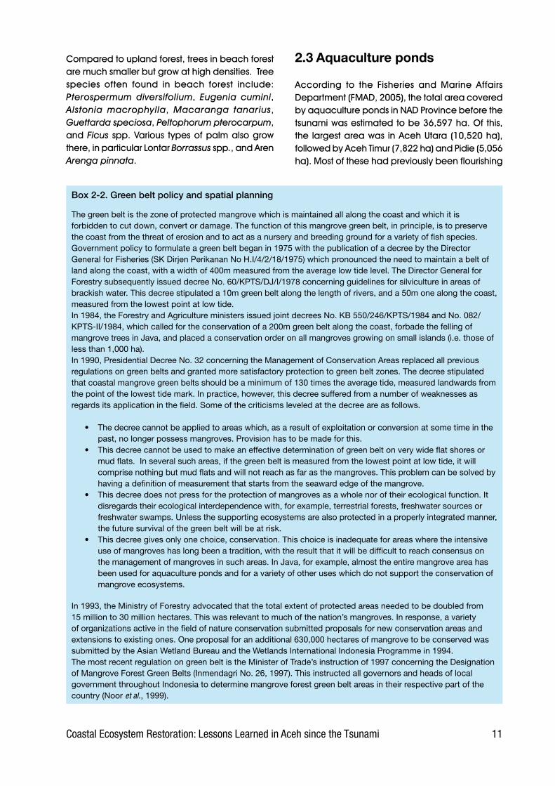
2.3 Aquaculture ponds
According. to. the. Fisheries. and. Marine. Affairs.Department.(FMAD,.2005),.the.total.area.covered.by.aquaculture.ponds.in.NAD.Province.before.the.tsunami.was.estimated.to.be.36,597.ha..Of.this,.the. largest.area.was. in.Aceh.Utara.(10,520.ha),.followed.by.Aceh.Timur.(7,822.ha).and.Pidie.(5,056.ha)..Most.of.these.had.previously.been.flourishing.

12 Coastal Ecosystem Restoration: Lessons Learned in Aceh since the Tsunami
mangrove. forests,. which. investors. had. then. cut.down. and. converted. to. ponds.. Their. two. main.reasons.for.choosing.these.sites.had.been:
•. To.sell.the.wood.obtained.from.cutting.down.the. trees. during. land. clearing.. Thus. the.investors.would.receive.money.before.starting.to.construct.the.ponds.
•. The.mangrove.forest.environment.is.particularly.suitable. for. the. cultivation. of. . shrimps. and.milkfish. because. it. possesses. a. source. of.brackish. water.. Ponds. will. therefore. be.cheaper.to.construct.as.the.land.will.not.need.to.be.modified..
The.area.taken.up.by.aquaculture.ponds.on.the.west.coast.was.much. less,.only.289.ha. in.Aceh.Barat.and.25.ha.in.Aceh.Utara.
BPS.(2004).presents.the.data.in.more.detail.and.differing.somewhat.from.that.provided.by.FMAD.(2005)..This.document.specifies.the.area.covered.by. aquaculture. ponds. in. each. district/town. as.shown.in.Table.2.2.below.
2.4 Peatland
NAD. Province. possesses. 274,051. hectares. of.peatland.(including.peaty.mineral.soil),.which.is.found.only.along.a.narrow.strip.on.the.west.coast..Of. this,. 169,000. ha. (61.6%). is. in. Aceh. Selatan.district. and. 105,000. hectares. (38.4. %). in. Aceh.Barat.(Figure.2-4).
The.extent.of.peatland.of.various.depths.in.each.district.in.Aceh.is.as.follows:
• Moderate depth peat:.Aceh.Selatan.96,900.ha.(67.0%).and.Aceh.Barat.47,852.ha.(33.0.%).
• Deep peat:.Aceh.Selatan.40,150.ha.(56.4%).and.Aceh.Barat.31,107.ha.(43.6%).
• Shallow peat:.Aceh.Selatan.15,181.ha.(76.8%).and.Aceh.Barat.4,591.ha.(23.2%)..
• Very shallow peat:. Aceh. Barat. 21,867. ha.(57.1%).and.Aceh.Selatan.16,403.ha.(42.9%)..
Table 2-2. Total area of aquaculture ponds for each district/town in NAD Province Source: BPS (200�)
No District/Town Pond area (ha)1 Simeulue 342 Aceh Singkil -3 Aceh Selatan 6484 Aceh Timur 8,4745 Aceh Barat 6796 Aceh Besar 9797 Pidie 2,6898 Bireuen 5,5809 Aceh Utara 8,78910 Aceh Barat Daya -11 Aceh Tamiang -12 Nagan Raya 90713 Aceh Jaya -14 Banda Aceh 42715 Lhokseumawe -
TOTAL NAD 36,439
Figure 2-3. Map of peatland distribution in NAD Province (Wahyunto et al. 200�)
13Coastal Ecosystem Restoration: Lessons Learned in Aceh since the Tsunami
Based.on.the.types.and.degree.of.decomposition,.the.peat.composition.of.each.layer.found.in.NAD.is:
• Very shallow peat:. Hemists/mineral. and.Saprists/Hemists.and.Saprists/mineral.
• Shallow peat:.Hemists/mineral,.Saprists/Hemists.and.Saprists/mineral.
• Moderate depth peat:. Hemists/Saprists,.Hemists/mineral,.Saprists/Hemists.and.Saprists/mineral.
• Deep peat:. Hemists/Saprists. and. Saprists/Hemists.(Suryadiputra.et al.,.2006).
This.unique.ecosystem.is.characterised.by.certain.species.that.are.only.rarely.found.in.drier.forests,.
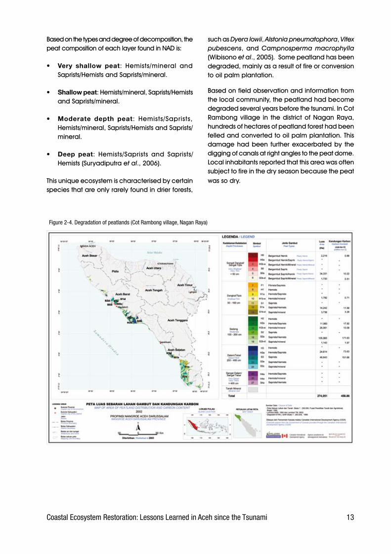
such.as.Dyera lowii,.Alstonia pneumatophora,.Vitex pubescens,. and. Campnosperma macrophylla (Wibisono.et al.,.2005). .Some.peatland.has.been.degraded,.mainly.as.a.result.of.fire.or.conversion.to.oil.palm.plantation.
Based.on.field.observation.and.information.from.the.local.community,.the.peatland.had.become.degraded.several.years.before.the.tsunami..In.Cot.Rambong.village. in. the.district.of.Nagan.Raya,.hundreds.of.hectares.of.peatland.forest.had.been.felled.and.converted.to.oil.palm.plantation..This.damage.had.been. further.exacerbated.by. the.digging.of.canals.at.right.angles.to.the.peat.dome..Local.inhabitants.reported.that.this.area.was.often.subject.to.fire.in.the.dry.season.because.the.peat.was.so.dry.
Figure 2-�. Degradation of peatlands (Cot Rambong village, Nagan Raya)
1� Coastal Ecosystem Restoration: Lessons Learned in Aceh since the Tsunami
2.5 Swamps
The.Planology.Agency.of.the.Ministry.of.Forestry.classifies.swamp.into.several.types.of.cover..These.are:. Primary. Swamp. Forest,. Secondary. Swamp.Forest,. Swamp. Shrub,. and. Unforested. Swamp..Data. from.ETM.7. Landsat. imaging. in.1999.and.2000.(Ministry.of.Forestry,.2002).showed.the.extent.of.each.type.to.be.as.follows:..
• Primary.swamp.forest:.1,000.ha.
• Secondary.swamp.forest:.117,000.ha.
• Swamp.shrub:.3,000.ha.
• Open.swamp.(unforested).3,000.ha..
.However,.very.different.conditions.were.shown.by.the.ETM.7.Landsat. imaging. for.2004. (Ministry.of.Forestry,.2005):
• Primary.swamp.forest:.none.remaining
• Secondary.swamp.forest:.165,000.ha.
• Swamp.shrub:.37.ha.
• Open.swamp.(unforested).10,000.ha..
Freshwater.swamp.ecosystems.are.rich.in.aquatic.plant.species,.including.Pistia stratiotes,.Nyampae nouchali,. Lotus.Nelumbo nucifera,.Echinodorus paleafolius,. Hydrocleydes spp.,. and. Typha angustifolia.. . Besides. aquatic. plants,. several.species. of. grasses. also. grow. well,. such. as.Phragmites karka and Saccharum spontaneum. One.species.of.palm,.the.sago.palm.Metroxylon sagu. is. a. landmark. species. characteristic. of. a.freshwater.swamp.ecosystem..However,.other.palm.genera.such.as.Oncosperma.spp..and.climbing.palms. Calamus. spp.. are. also. common. in. and.around.swamps..Other.trees.common.to.freshwater.swamp. include. Ficus microcarpa,. Barringtonia racemosa,.and.Artocarpus elastica.
2.6 Sandy beach vegetation
Information.on.condition.of.sandy.beaches.in.NAD.Province.is.limited,.but.their.condition.before.the.tsunami.can.be.seen.clearly.from.the.remains.of.trees.and.other.vegetation.found.along.the.sandy.beaches.. .From.observations.of. these.and.from.information. supplied. by. the. local. community,.it. can. be. deduced. that. the. dominant. species.growing. on. the. sandy. beaches. along. Aceh’s.west.coast.just.before.the.tsunami.struck.included:.Casuarina equisetifolia,. Hibiscus tilaceus,.Pongamia pinnata,. Ficus septica,. Timonus compressicaulis,. Pterospermum diversifolium,.Cerbera manghas,.and.Barringtonia asiatica.
Aceh’s.west.coast.is.dominated.by.sandy.beaches,.which.stretch.from.Banda.Aceh.to.Nagan.Raya..It. is. reported. to. have. been. very. common. for.communities. living. on. the. west. coast. to. grow.plantations.of.coconut.Cocos nucifera.and.rubber.Hevea brasiliensis..Usually,.coconut.groves.were.planted.near. the.coast,.and.rubber.plantations.further.inland.
Two.formations.of.coastal.vegetation.commonly.found. near. the. beach. were. the. ‘Pes-caprae.Formation’.and.the.‘Barringtonia.Formation’...
1�Coastal Ecosystem Restoration: Lessons Learned in Aceh since the Tsunami
2.6.1 Pes-caprae formation
This.formation.is.dominated.by.the.herb.Ipomoea pes-caprae,.which.is.common.on.dune.strands..The.herbs.grow.from.the.back.edge.of.the.beach.towards. the. front. and. sides.. Its. rate. of. growth.and.expansion.depends.on.the.condition.of.the.substrate.. If. the.substrate. is.stable,. the.plant.will.grow.rapidly.and.dominate.the.back.part.of.the.sandy. beach.. This. herb. is. usually. also. followed.by.the.growth.of.species.of.grass.such.as.Spinifex littoreus, Cyperus maritima, Ischaemum muticum,.and.herbs.such.as.Desmodium umbellatum,.Vigna marina,. Crotalaria striata,. and. Calopogonium mucunoides.
For.practitioners.of.coastal.rehabilitation,.Ipomoea pes-caprae. also. functions. as. a. biological.indicator.that.the.area.is.especially.suitable.for.the.planting.of.Casuarina equisetifolia,.Callophyllum innophyllum,. Cerbera manghas,. Terminalia catappa,. Barringtonia asiatica,. Pongamia pinnata,. Hibiscus tiliaceus, and. other beach.trees.
According.to.information.from.the.local.community,.before. the. tsunami. Ipomoea pes-caprae. only.inhabited. the.back.part.of. the.sandy.beaches..After.the.tsunami,.however,.it.was.found.growing.far.inland.
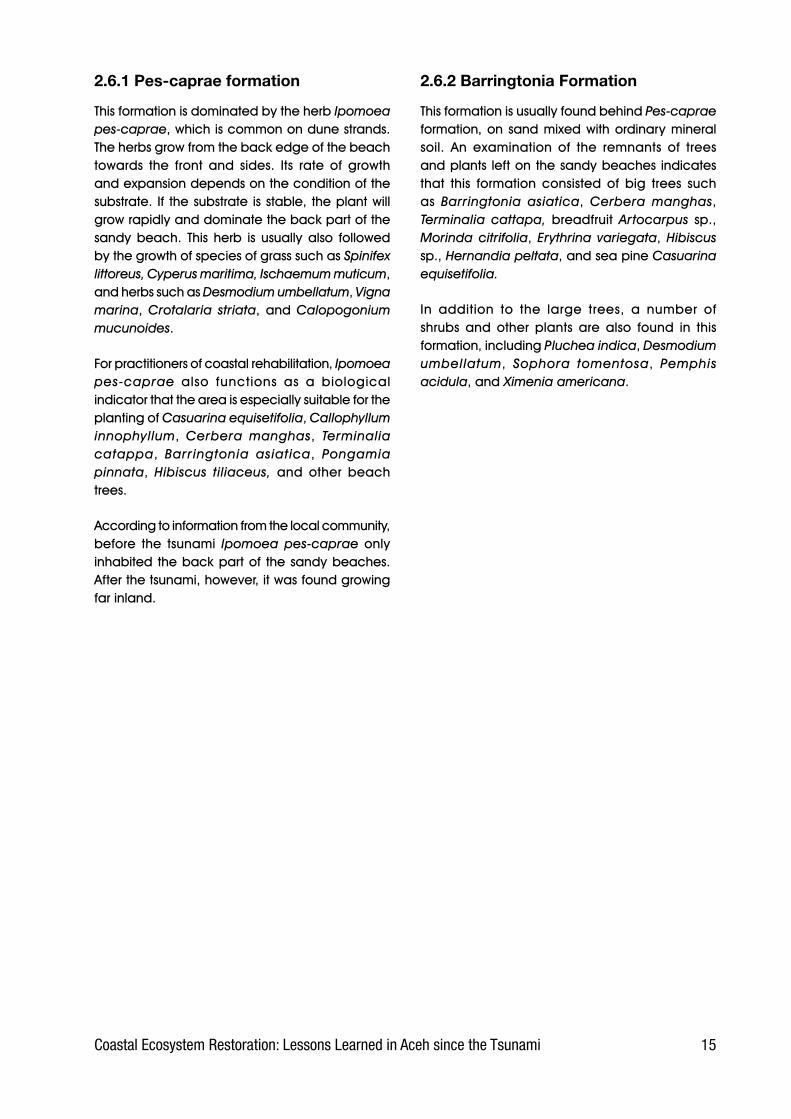
2.6.2 Barringtonia Formation
This.formation.is.usually.found.behind.Pes-caprae formation,.on. sand.mixed.with.ordinary.mineral.soil.. An. examination. of. the. remnants. of. trees.and.plants. left.on.the.sandy.beaches. indicates.that. this. formation. consisted. of. big. trees. such.as. Barringtonia asiatica,. Cerbera manghas,.Terminalia cattapa, breadfruit. Artocarpus sp., Morinda citrifolia,. Erythrina variegata,. Hibiscus sp.,.Hernandia peltata,.and.sea.pine.Casuarina equisetifolia.
In. addition. to. the. large. trees,. a. number. of.shrubs. and. other. plants. are. also. found. in. this.formation,.including.Pluchea indica,.Desmodium umbellatum,. Sophora tomentosa,. Pemphis acidula,.and.Ximenia americana.
1� Coastal Ecosystem Restoration: Lessons Learned in Aceh since the Tsunami
3. Coastal conditions after the tsunami
3.1 Impact of the tsunami and earthquake
3.1.1 Mechanisms of impact
The.10-15.metre.high.tsunami.travelling.at.more.than. 40. km. per. hour. which. hit. the. coast. of.Aceh. caused. tremendous. damage,. the. most.devastating. of. which. was. along. the. length. of.Aceh’s. west. coast. (comprising. Aceh. Barat. and.Nagan.Raya),.and. the.districts. of. Banda.Aceh,.Aceh.Jaya,.and.Aceh.Besar.
According.to.the.analysis.carried.out.by.the.national.aerospace.agency.(Lembaga Penerbangan dan Antariksa Nasional,. or. Lapan,. in. DAS,. 2005),. of.the.21.districts/towns.in.NAD.Province,.at.least.15.were.affected.by. the.earthquake.and. tsunami,.while. the. total. area. affected. was. 649,582. ha,.including.131,810.ha.of.wet. rice. fields,.9,448.5.ha.of.swamp,.and.32,004.ha.of.mangrove.forest.and.coastal.vegetation.
Damage. to.coastal.areas.was.caused.not.only.by.the.tsunami.but.also.by.the.violent.earthquake.that.altered.the.landscape.along.the.west.coast.of. Aceh. and. the. islands. of. Simeulue. and. Nias..The. following.paragraphs.describe. some.of. the.impacts.on.these.coastal.areas.
Damage.to.coastal.ecosystems.arising.from.the.Tsunami.was.brought.about.by.two.mechanisms:.
• Mechanism. 1:. the. energy. of. the. tsunami,.which.directly.struck.the.coast.and.destroyed.mangrove. forests,. casuarina. (sea-pine).stands,.coconut.groves,.and.a.range.of.other.vegetation.. This. happened. extremely. fast..Vegetation.was.damaged,.and.parts.were.torn.off..In.the.worst-struck.areas,.mangrove.trees.were.uprooted.by.the.force.of.the.waves..
• Mechanism. 2:. inundation. by. the. sea. water.brought. by. the. tsunami,. the. high. salinity. of.which.caused.coastal.vegetation.to.become.stressed,. dry. up. and. die.. Plant. death. due.to. saltwater. inundation. happened. relatively.gradually,. with. the. trees. that. died. from.inundation. generally. remaining. whole. and.standing.upright.
Almost.all.the.formations.and.types.of.vegetation.existing. along. Aceh’s. west. coast. were. severely.damaged.. More. than. 60,000. ha. of. rice. fields.were.badly.affected.by.sea.water.inundation..To.date,.only.21.6.%.of. the. total.area.of. rice. field.has. yet. been. rehabilitated,. while. most. of. the.remainder. has. been. abandoned. (BRR,. 2005)..Neither.mangrove.forests,.beach.forests,.sea.pine.forests,.swamps.nor.any.other.type.of.vegetation.along.the.coast.escaped.damage..The.following.paragraphs.describe.the.damage.done.to.several.types.of.wetlands.along.the.coast..
3.1.2 Changes to coastal landscapes
The.powerful.earthquake.of.26.December.2004,.which.triggered.the.tsunami,.caused..changes.to.the.landscape,.mainly.on.the.west.coast.of.Aceh.and.the.islands.of.Simeulue.and.Nias..According.to. an. assessment. conducted. by. a. team. from.Wetlands. International. in. (Suryadiputra. et al.,.2006),.Aceh’s.west.coast.experienced.subsidence.causing.the.shoreline.to.advance.100.to.200.m.inland.. On. Simeulue. island,. in. contrast,. part. of.the.land.was.lifted.up.by.2.m,.thereby.exposing.the.coral.reef.and.killing.the.mangrove.forest..The.same.happened.in.the.north.part.of.Nias.island,.causing. similar. damage. to. the. coral. reef. and.mangrove..Nevertheless,.not.all.parts.of.Nias.were.lifted.up..In.the.southern.part.of.the.island.the.land.subsided,.thus.causing.the.shoreline.to.advance.inland. by. 200. m.. Figure. 3-1. gives. a. general.picture.of.the.landscape.change,.based.on.field.observations.by.the.WI-IP.Team.on.the.west.coast.of.Aceh,.Simeulue.island.and.Nias.island..

1�Coastal Ecosystem Restoration: Lessons Learned in Aceh since the Tsunami
Figure 3-1. Landscape change caused by earthquake and tsunami along the Aceh coast
The.greatest.impact.from.subsidence.was.on.the.west.coast.of.Aceh,.where.an.estimated.two-thirds.of. the.coast. line.was.affected.to.a.degree.that.in.many.places.meant.that.the.shoreline.moved.up.to.200.m.inland..Areas. that.had.once.been.inhabited.and.cultivated.are.therefore.now.part.of. the. ocean.. For. the. inhabitants,. the. greatest.economic. impact. has. been. the. loss. of. their.land,. coconut. trees. and. other. property. upon.
Figure 3-2. Loss of land as a result of earthquake and tsunami (Lhok Bubon, Aceh Barat)
which. their. livelihoods. depended.. Similar. land.subsidence.also.occurred.on.the.southern.edge.of.Nias.island..
Seen.from.another.angle,.the.loss.of.a.substantial.part. of. the. coastland. also. means. the. loss. of.prospective.rehabilitation.sites..In.other.words,.the.available.space.has.decreased.as.a.result.
1� Coastal Ecosystem Restoration: Lessons Learned in Aceh since the Tsunami
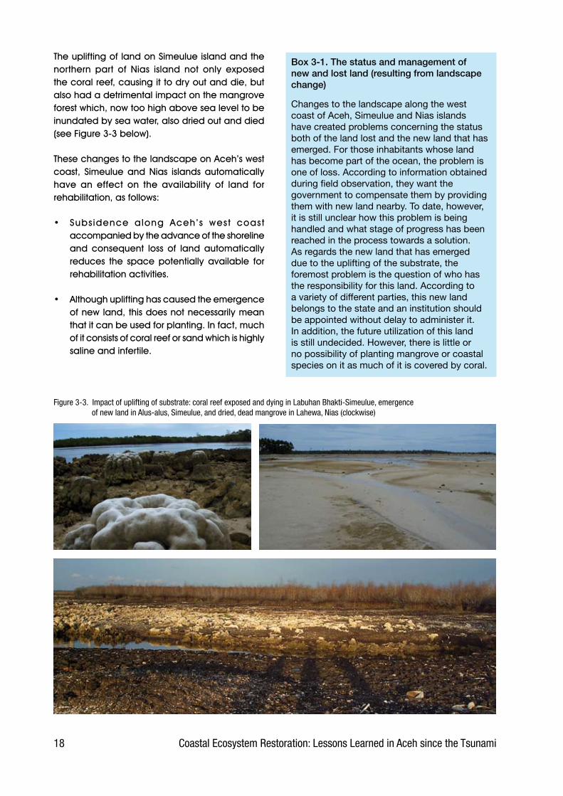
The.uplifting.of.land.on.Simeulue.island.and.the.northern. part. of. Nias. island. not. only. exposed.the.coral.reef,.causing.it.to.dry.out.and.die,.but.also.had.a.detrimental.impact.on.the.mangrove.forest.which,.now.too.high.above.sea.level.to.be.inundated.by.sea.water,.also.dried.out.and.died.(see.Figure.3-3.below)..
These.changes.to.the.landscape.on.Aceh’s.west.coast,. Simeulue. and. Nias. islands. automatically.have. an. effect. on. the. availability. of. land. for.rehabilitation,.as.follows:.
•. Subsidence. along. Aceh’s. west. coast.accompanied.by.the.advance.of.the.shoreline.and. consequent. loss. of. land. automatically.reduces. the. space. potentially. available. for.rehabilitation.activities.
•. Although.uplifting.has.caused.the.emergence.of.new.land,.this.does.not.necessarily.mean.that.it.can.be.used.for.planting..In.fact,.much.of.it.consists.of.coral.reef.or.sand.which.is.highly.saline.and.infertile.
Figure 3-3. Impact of uplifting of substrate: coral reef exposed and dying in Labuhan Bhakti-Simeulue, emergence of new land in Alus-alus, Simeulue, and dried, dead mangrove in Lahewa, Nias (clockwise)
Box 3-1. The status and management of new and lost land (resulting from landscape change)
Changes to the landscape along the west coast of Aceh, Simeulue and Nias islands have created problems concerning the status both of the land lost and the new land that has emerged. For those inhabitants whose land has become part of the ocean, the problem is one of loss. According to information obtained during field observation, they want the government to compensate them by providing them with new land nearby. To date, however, it is still unclear how this problem is being handled and what stage of progress has been reached in the process towards a solution.As regards the new land that has emerged due to the uplifting of the substrate, the foremost problem is the question of who has the responsibility for this land. According to a variety of different parties, this new land belongs to the state and an institution should be appointed without delay to administer it. In addition, the future utilization of this land is still undecided. However, there is little or no possibility of planting mangrove or coastal species on it as much of it is covered by coral.

19Coastal Ecosystem Restoration: Lessons Learned in Aceh since the Tsunami
3.1.3 Degradation of mangrove forest
a) Tsunami impact effects
Mangrove.forests.were.among.the.worst-damaged.wetland. ecosystems. in. Aceh,. but. sources. vary.widely. as. to. the. extent. of. mangrove. forest.damaged. by. the. tsunami.. . . Bappenas. (2005).estimates. it. to. be. 25,000. ha.. Lapan. (in. DAS,.2005),.however,.gives.a.higher.figure.stating.that.some.32,000.ha.of.Aceh’s.mangrove.forest.were.severely.damaged.by. the. tsunami,.as.detailed.in.Table.3-1.
By. interpreting. volunteers’. photographs. of. the.coast.and.other.available.information,.it.can.be.estimated.that.the.extent.of.tsunami.damage.to.mangrove.was.as.follows:
•. Aceh.Besar.100%.(approximately.26,823.ha)
•. Banda.Aceh.100%.(<500.ha)
•. Pidie.75%.(17,000.ha)
•. Aceh.Utara.and.Bireun.30%.(26,000.ha)
•. Aceh.Barat.50%,.(14,000.ha)
District/Town Area (ha)Banda Aceh 111.3Lhoksumawe 308.6
Aceh Jaya 67.6
Aceh Selatan 0
Aceh Singkil 1,460.4
Aceh Tamiang 16,095.0
Aceh Timur 10,453.6
Aceh Utara 0
Aceh Bireun 0
Nagan Raya 0
Pidie 32.3
Aceh Barat Daya 2.7
Aceh Barat 361.6
Aceh Besar 53.9
Simeulue 3,056.9Total 32,003.9
Table 3-1. Area of mangrove forest damagedby the tsunami in Aceh. Source: Lapan (in DAS, 200�)
Figure 3-�. Mangrove forest destroyed by tsunami in Tibang, Aceh Besar
Field.orientation. in. Tibang.village. revealed. that.all.of. the.mangrove.forest.on.the.coast.had.been.totally.destroyed..However,.young.mangroves.which.the.community.had.planted.around. their. tambak..aquaculture.ponds.had.escaped.serious.damage.
Figure 3-�. Surviving young mangrove stand belonging to the community
Damage.to.the.mangrove.forests.was.not.limited.to. the. loss.of. several. species.of.mangrove,.but.also.involved.the.devastation.of.the.mangrove’s.habitat.. The. loss. of. mature. trees. automatically.means. the. loss. of. seed. production,. while. the.degradation.of.so.much.of.the.habitat.means.a.great.reduction.in.the.area.suitable.for.replanting.mangrove.

20 Coastal Ecosystem Restoration: Lessons Learned in Aceh since the Tsunami
b) Uplift effects
Another. cause. of. mangrove. degradation. was.the.lifting.of.the.substrate.with.the.result.that.the.mangrove.was.no. longer. tidally. inundated.. This.was.common.on.Simeulue.and.in.part.of.the.Nias.island.coast.
Observation.of. the. impact.of. substrate.uplifting.on. the.mangrove. forest.was.carried.out.by. the.WI-IP.Team.in.September.2005.in.Lahewa.village.on. Nias.. It. was. found. that. the. tides. no. longer.reached.the.mangrove,.with.the.result.that.almost.all. of. the. mangrove. trees. had. dried. up.. The.dominant. species. in. Lahewa’s. mangrove. forest.was. Rhizophora apiculata,. interspersed. with.Ceriops decandra.
Observation.at.this.site.revealed.that.all.Rhizophora apiculata. trees. had. become. desiccated.. All.their. leaves. had. fallen,. creating. a. layer. of. dry.litter. extending. across. the. floor. of. the. stand..However,.on.cutting.the.twigs.and.branches,.it.was.discovered.that.the.interior.parts.(xylem,.phloem).were.still.moist,.indicating.that.the.trees.were.still.alive.. The. shedding. of. leaves. is. most. probably.the. mangrove’s. response. to. the. suddenly. dry.conditions..This.same.leaf-shedding.phenomenon.also.occurs. in. teak.trees.during.the.dry.season..Regular.monitoring.will.reveal.whether.or.not.this.species.of.mangrove.is.capable.of.adapting.to.its. new. environment.. Amid. the. dry. Rhizophora stands,.the.assessment.team.found.several.trees.of.Ceriops decandra. that.had.stayed. in. leaf. in.spite.of.the.dry.condition,.and.trees.of.this.species.generally.seemed.to.be.growing.normally....
Figure 3-�. Mangrove which has desiccated due to uplifting of the substrate at Lahewa village, Nias.
In.the.vicinity.of.the.mangrove.forest,.several.other.species.of.mangrove.were.found.to.be.growing.well. on. the. dry. land.. These. were. Aegiceras corniculatum, Ceriops decandra, Xylocarpus rumphii and.Dolichandrone spathacea.
The. assessment. team. also. discovered. that. the.floor.of.the.mangrove.stands.had.been.invaded.by.a.number.of.pioneering.species,.in.particular.the.fern.Acrostichum aureum. This.indicates.that.the. floor. of. the. mangrove. stands. is. now. never.inundated.by.sea.water..If.these.conditions.persist,.the. invasion. will. presumably. continue. until. the.entire.forest. floor. is.covered.with.this.vegetation.(Suryadiputra.et al.,.2005)..
In.August.2006,.WI-IP’s.local.partners.in.Lahewa-Nias.reported. that.desiccated.Rhizophora trees.had.eventually.died..Part.of.the.mangrove.stand.had.also.been.cut.by.the.community.for.fire.wood.
Figure 3-�. Invasion of mangrove stand floor by pioneer species of vegetation
21Coastal Ecosystem Restoration: Lessons Learned in Aceh since the Tsunami
The. illustrations. in. Figure. 3-8. show. two. different.conditions:. before. and. after. the. lifting. of. the.substrate.. Diagram. B. is. a. cross-section. of. the.condition. actually. observed. in. the. field. after.
Figure 3-�. Illustration of mangrove death caused by lifting of the substrate at Lahewa-Nias
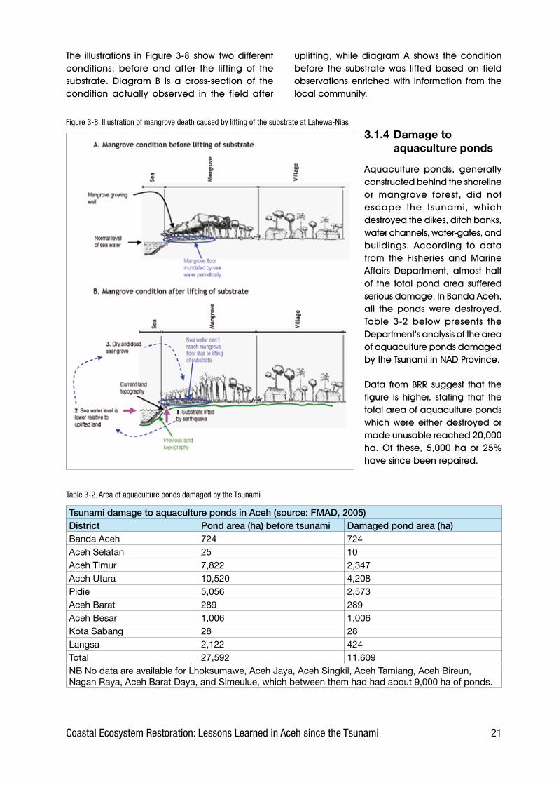
Tsunami damage to aquaculture ponds in Aceh (source: FMAD, 2005)District Pond area (ha) before tsunami Damaged pond area (ha)Banda Aceh 724 724Aceh Selatan 25 10Aceh Timur 7,822 2,347Aceh Utara 10,520 4,208Pidie 5,056 2,573Aceh Barat 289 289Aceh Besar 1,006 1,006Kota Sabang 28 28Langsa 2,122 424Total 27,592 11,609NB No data are available for Lhoksumawe, Aceh Jaya, Aceh Singkil, Aceh Tamiang, Aceh Bireun, Nagan Raya, Aceh Barat Daya, and Simeulue, which between them had had about 9,000 ha of ponds.
Table 3-2. Area of aquaculture ponds damaged by the Tsunami
uplifting,. while. diagram. A. shows. the. condition.before. the. substrate. was. lifted. based. on. field.observations.enriched.with. information. from. the.local.community..
3.1.4 Damage to aquaculture ponds
Aquaculture. ponds,. generally.constructed.behind.the.shoreline.or. mangrove. forest,. did. not.escape. the. tsunami,. which.destroyed.the.dikes,.ditch.banks,.water.channels,.water-gates,.and.buildings.. According. to. data.from. the. Fisheries. and. Marine.Affairs. Department,. almost. half.of. the. total.pond.area. suffered.serious.damage..In.Banda.Aceh,.all. the. ponds. were. destroyed..Table. 3-2. below. presents. the.Department’s.analysis.of.the.area.of.aquaculture.ponds.damaged.by.the.Tsunami.in.NAD.Province.....
Data. from.BRR. suggest. that. the.figure. is. higher,. stating. that. the.total.area.of.aquaculture.ponds.which. were. either. destroyed. or.made.unusable.reached.20,000.ha.. Of. these,. 5,000. ha. or. 25%.have.since.been.repaired.

22 Coastal Ecosystem Restoration: Lessons Learned in Aceh since the Tsunami
There.is.a.strong.link.between.pond.rehabilitation.and. coastal. reforestation,. in. particular. the.planting.of.mangroves..This.is.because,.in.Aceh,.most.mangrove.planting.has.been.done.in.and.around. aquaculture. ponds.. Ideally,. mangrove.planting.should.be.done.after.the.pond.has.been.repaired,.so.that.the.dikes.are.clear.to.see.and.the.deposits.left.by.the.tsunami.have.been.removed..If.mangroves.are.planted.before.the.ponds.are.repaired,.there.is.a.risk.that.the.seedlings.will.be.destroyed.later.by.the.heavy.equipment.used.to.reconstruct.the.ponds.
Figure 3-9. Tsunami deposits on pond floor
The.tsunami.brought.up.an.enormous.volume.of.material. from.the.ocean.bed..This.material.was.carried. a. considerable. distance. inland. by. the.wave,. then. deposited. over. a. large. part. of. the.coastal.area.
The.material.deposited.consisted.mostly.of.sand,.ranging.from.fine.to.coarse..Ponds.were.one.of.the. receptacles. for. these. deposits,. which. were.up.to.0.5.m.thick.
The.illustrations. in.Figure.3-10.show.two.different.conditions:.before.and.after.the.tsunami..Diagram.B. is. a. cross-section. of. the. condition. actually.observed. in. the. field,. showing. the. mangrove.damage.and.tsunami.deposits,.while.diagram.A.shows.the.condition.before.the.tsunami.based.on.field.observations.enriched.with.information.from.the.local.community.
The.deposited.material.totally.altered.the.condition.of.the.ponds,.causing.the.land’s.carrying.capacity.to. decline. drastically. to. the. point. where. the.area.was.no.longer.suitable.for.aquaculture..The.
Figure 3-10. Condition of aquaculture ponds at Lham Ujong before (top) and after (bottom) the tsunami
ponds. had,. however,. been. an.important.asset.to.the.community.because.they.provided.a.source.of.income..For.that.reason,.one.of.the.most.important.programmes.carried.out.by. the.government.and.several.NGOs.has.been.the.rehabilitation. of. these. ponds..The. rehabil itation. activit ies.generally.consisted.of.removing.the. materials. deposited. by. the.tsunami. and. rebuilding. the.damaged.dikes.
At.present,.most.of.the.mangrove.planting. in. NAD. Province. has.been. in. coastal. aquaculture.ponds.. However,. only. a. small.propor t ion. of. th is . can. be.considered. successful,. the. rest.having. failed,. with. tsunami.deposits.being.one.factor.in.this.failure..To.find.out.in.more.depth.about. the. impact. of. tsunami.deposits.on.mangrove.planting,.a.study.was.carried.out.at.Lham.Ujong,.Aceh.Besar.(see.Box.3-2)
23Coastal Ecosystem Restoration: Lessons Learned in Aceh since the Tsunami
3.1.5 Damage to peatlands
All.of.the.peatland.in.NAD.Province.is.situated.on.the. west. coast,. where. the. tsunami. hit. hardest..Ecological. assessment. conducted. by. WI-IP. in.Cot.Rambong.village.(Nagan.Raya.district).found.that. the. tsunami. had. reached. peatland. areas..The.sea.water.dumped.there.by.the.tsunami.was.unable.to.flow.away.and.became.trapped.in.the.peat.. Being. highly. saline,. it. had. a. detrimental.effect.on.the.peat.and.on.the.vegetation.above..Some.plants.became.stressed.and.subsequently.died.as.a.result..It.was.even.reported.that.entire.rubber. plantations. had. died. from. the. effect. of.the.sea.water.entering.the.peatland.where.they.were.growing..
Box. 3-2. The impact of tsunami deposits on the environment’s carrying capacity (Case study in Lham Ujong village)
The tsunami brought material from the sea and deposited it as much as 1 - 2 km inland. In order to determine the impact of this deposit, a case study was carried out by an Assessment Team from Wetlands International in August-September 2005 in the coastal area of Lham Ujong village (Aceh Besar). The study found that coarse material (like sand) had been deposited in locations near the shoreline to a thickness of 20 – 50 cm. This deposit then formed a solid barrier to soil aeration, while also absorbing and conducting heat easily. Under such conditions, the seedlings’ rooting process was seriously obstructed. Meanwhile, finer material (dust and clay) has been deposited further inland. If this material has been deposited on coastal plain to a thickness of less than 20 cm, it will have a more beneficial effect as it will supply additional minerals thus making the soil more fertile. (See Figure 3-11 below).
Preliminary results illustrated in the diagram above are as follows:Mangroves planted in ponds containing thick tsunami deposits are less likely to survive. This is strongly believed to be because the deposit is formed of coarse and solid materials. Such conditions cause the seedlings to become stressed and then die. Thick deposits are generally found in ponds near the shoreline. Mangrove planting in ponds further inland shows a higher survival rate. This is thought to be because the deposit consists of fine materials (dust and clay). A provisional hypothesis is that this fine deposit enriches the soil and is beneficial for plant rooting. Thus, seedlings planted here can grow well.
1.
2.
Figure 3-11. Correlation between location of Tsunami deposit andsuccess of mangrove rehabilitation in Lham Ujong village, Aceh Besar
District/Town Area (ha)Banda Aceh 797.0Lhokseumawe 120.1Aceh Jaya 3,126.8Aceh Selatan 60.9Aceh Singkil 633.4Aceh Tamiang 325.5Aceh Timur 1,558.0Aceh Utara 0.3Bireuen 623.1Nagan Raya -Pidie 708.1Aceh Barat Daya 171.7Aceh Barat 274.6Aceh Besar 945.9Simeulue 103.1TOTAL NAD 9,448.5
Table 3-3. Area of swamp damaged by Tsunami Source: Lapan (in DAS, 200�)
3.1.5 Damage to swamps
Swamps.affected.by.the.tsunami.were.generally.in.areas.close. to. the.coast..As.well.as.physical.damage.from.the.force.of.the.tsunami,.swamps.also.suffered.damage.due.to.inundation.by.sea.water,.one.obvious.result.of.this.being.the.death.of.some.of.the.swamp.vegetation.
Based. on. the. interpretation. of. satellite. images,.Lapan. (in. DAS,. 2005). states. that. 9,448.5. ha. of.swamp.were.affected.by.the.tsunami..The.district.of.Aceh.Jaya.suffered.the.greatest.area.of.swamp.damage. (3,126.8. ha),. followed. by. Aceh. Timur.(1,558.ha).and.Aceh.Besar.(945.9.ha)....A.list.of.the.area.of.swamp.damaged.in.each.district. is.given.in.Table.3-3.
In.addition.to.swamplands,.a.total.of.131,809.7. hectares. of. rice. fields. in.NAD. Province. were. affected. by. the.tsunami..Lhokseumawe.was.the.district.with. the. greatest. area. of. damaged.rice. field. (39,929.4. ha). while. Aceh.Utara. had. the. smallest. (11.9. ha)..Besides. rice. fields,. at. least. 22,618.7.hectares.of.dry.agricultural.land.was.also.affected.by.the.tsunami,.the.most.damage.being.in.Aceh.Timur.(9,199.5.ha;.Lapan.in.DAS,.2005).

2� Coastal Ecosystem Restoration: Lessons Learned in Aceh since the Tsunami
Observations. in. Lhok. Bubon. village,.Aceh. Barat.revealed.that. the. tsunami.had. inundated.swamps.behind.the.sandy.beach..This.had.increased.the.salinity.of.the.swamp,.thereby.causing.some.vegetation.to.die.off..Aside.from.sea.water.inundation,.vegetation.along.the.coast.was.also.severely.damaged.by.the.force.of.the.tsunami..Figure.3-12.illustrates.the.impact.of.the.tsunami.on.swampland.
Figure 3-12. Condition of swamp before and after the Tsunami, at Lhok Bubon-Aceh Barat
3.1.6 Damage to coastal vegetation
Coastal. terrestrial. vegetation. is. defined. as. all.that. growing. on. dry. land. in. coastal. areas,. not.in.inundated.or.tidal.zones..Terrestrial.vegetation.includes.beach.forest,.rubber.plantation,.coconut.plantation,. cultivated. gardens,. barringtonia.formation,.and.casuarina.pine.forest..It.is.estimated.that. the.damage.caused.by.the.tsunami. to. this.kind.of.ecosystem.covered.more.than.80,795.ha.(source:.EU.Joint.Research.Centre).
Figure 3-13. Damage to coastal zone of West Aceh, causedby tsunami

2�Coastal Ecosystem Restoration: Lessons Learned in Aceh since the Tsunami
Table.3-4.below.lists.the.areas.of.forest,.shrubland,.plantation.and.open.land.affected.by.the.tsunami.in.NAD.Province.
District /Town
Forest Shrubland Plantation Openland
Banda Aceh 0 181 1,508 184
Lhokseumawe 0 14,114 8,677 2,035
Aceh Jaya 3,499 8,764 595 676
Aceh Selatan 6,630 14,180 3,118 570
Aceh Singkil 17,923 14,314 3,627 2,913
Aceh Tamiang 0 11,848 14,675 1,505
Aceh Timur 50 16,203 10,577 1,641
Aceh Utara 0 3 85 119
Bireuen 0 3,532 5,276 1,121
Nagan Raya 7,074 22,026 26,624 343
Pidie 139 4,201 0 1,338
Aceh Barat Daya 2,005 7,748 8,686 1,127
Aceh Barat 12,450 19,520 9,833 4,016
Aceh Besar 692 2,964 3,434 346
Simeulue 8,983 11,070 808 3,975
TOTAL NAD 59,445 150,668 97,523 21,909
Table 3-�: Habitat areas affected by the tsunami (hectares) Source: Lapan (in DAS, 200�)
Figure 3-1�. Impact of Tsunami: coconut tree (left) and pine (right) broken, swept by the Tsunami at Lhok Nga-Aceh Besar
The. tsunami’s. sweeping. devastation. of. the.coastland.and.its.vegetation.is.apparent.all.along.the.west.coast.of.Aceh..The.wave’s.force.was.so.great. that. it. smashed. all. the. vegetation. up. to.several.kilometres.inland..
Vegetation.along.the.coast.was.damaged.and.killed.not.only.by.the.direct.force.of.the.tsunami.but.also.as.a.result.of.sea.water.inundation.which.lasted.for.several.days.. In.general,. it.was.areas.further.inland.that.were.inundated..
3.1.7 Formation of new lagoons
Seismic. and. tsunami. impacts. in. Aceh. have.created.lagoons,.which.were.not.previously.seen.in. Aceh.. These. are. bodies. of. sea. water. newly.isolated. from. the. sea. to. form. a. new. coastal.wetland.ecosystem...
The. assessment. carried. out. by. the. Wetlands.International.team.on.the.west.coast.of.Aceh.in.2005.found.at.least.4.new.lagoons,.one.of.them.
Figure 3-1�. Effect of sea water: Breadfruit tree alive and healthy (left), Mangosteen tree dead as a result of sea water inundation (right)
near. Pulot. village.. The. Pulot.village. lagoon. had. originally.been.a.river.estuary.facing.the.sea,. and. the. tsunami. drove.sea.water.far.upriver,.thereafter.blocking.the.estuary.mouth.with.deposits.of.marine.sand.as.well.as.material.from.the.land.
Thus. the. Krueng. Pulot. estuary.became.separated.from.the.sea.and.formed.a.lagoon.
This.lagoon.is.fairly.big,.covering.an. area. of. ±. 25. ha,. its. waters.reaching. a. depth. of. 2. to. 8.metres..Fishes.commonly.found.there. include. Lates calcarifer,.Caranx. sp.,. Epinephelus. spp..and.Mugil cephalus.
Steps.to.protect.the.Pulot.lagoon.would.be.justified,.for.the.following.reasons:
•. The. management. status.of. the. lagoon. is. unclear,.which.could.encourage.over.exploitation.of.its.resources...

2� Coastal Ecosystem Restoration: Lessons Learned in Aceh since the Tsunami
•. The.banks.of.the.lagoon.are.eroding,.which.could. accelerate. shallowing. of. the. lagoon.and.cloud.its.waters.
•. The.waters.of. the. lagoon.are. threatened.with.pollution.from.a.number.of.potential.sources,.both.from.tsunami.debris.and. from.current.activities.being.carried.out.in.the.area.of.the.lagoon..
•. The.lagoon.promises.economic.and.ecotourism.potential.which.can.contribute. to. the. future.development.of.Pulot.village.
•. It. is. a. natural. reservoir. which. can. mitigate.flooding.of.the.surrounding.land.during.high.tides.and.rain.
•. It.can.prevent.the.subterranean.intrusion.of.sea.water.to.the.surrounding.land.(especially.if.the.lagoon.is.filled.with.freshwater.from.rainfall).
•. It.holds.good.potential.for.fisheries,.with.a.variety.of.economically.valuable.fish.species.
•. The. lagoon. creates. a. micro-climate. for. the.surrounding.area,.making.the.air.feel.fresher.and.more.pleasant.
In. order. to. protect. the. lagoon,. it. needs. to. be.managed. in. an. integrated. manner. with. the.participation.of.the.local.community..Some.of.the.actions.needed.include.the.following:.
•. Determine. the. lagoon’s.management. status.through. participatory. mapping,. zoning. of.the. lagoon. and. its. surrounding. area,. and.formulation. of. regulations. for. the. use. of.resources.in.and.around.the.lagoon.
•. Prepare. seedlings. for. planting. around. the.lagoon.in.order.to.prevent.abrasion.of.its.walls.and. to. prevent. the. surrounding. area. from.becoming.arid..
•. Clear.away.the.debris. left.by.the.tsunami. in.and.around.the.lagoon..
•. Raise. the. community’s. awareness. of. the.lagoon’s.functions.and.benefits.to.the.economy.and.to.the.aquatic.environment..
•. Promote. the. beauty. of. the. lagoon. for. eco-tourism,.so.as.to.increase.income.to.the.local.community....
3.2 Regeneration of vegetation
3.2.1 Regeneration of mangrove
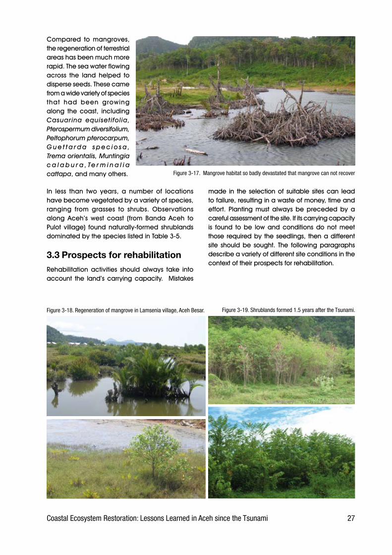
Field. observation. revealed. that. the. process.of. recovery. through. natural. regeneration. and.succession.has.been.much.slower.and.more.difficult.for. mangrove. than. for. other. species. of. coastal.vegetation..This. is.generally.because.the.habitat.had.been.destroyed.or.drastically.altered,. thus.making.it.unsuitable.for.mangrove..Changes.to.the.habitat.could.be.due. to.physical.and.chemical.changes. to. the. substrate. or. because. it. was. no.longer.influenced.by.ocean.tides...The.mangrove’s.poor.capacity.for.recovery.could.also.be.caused.by.the.loss.of.parent.trees,.without.which.there.was.no.possibility.of.regeneration.except.through.the.arrival.of.floating.propagules.from.elsewhere..
However,.in.several.places.(one.being.Lamsenia.village,. Aceh. Besar). the. regeneration. of. . Nypa.fruticans. and. Avicennia. spp.. was. progressing.well.. From. information. provided. by. the. local.inhabitants,.it.was.discovered.that.some.trees.had.survived.the.tsunami..These.have.managed.to.live.and.can.produce.seeds,.as.a.result.of.which.the.stands.of.Nypa.and.Avicennia.are.able.to.recover.(see.Figure.3-18).
3.2.2 Regeneration of coastal vegetation
Moments.after.the.tsunami,.almost.all.the.vegetation.along. the.coast. had.gone. leaving.nothing.but.bare.ground..Now,.however,.coastal.conditions.have.changed.as.succession.and.regeneration.have.occurred.naturally.along.Aceh’s.west.coast..Areas. that.had.been.completely.bare.are.now.supporting.the.growth.of.a.variety.of.species.
Figure 3-1�.Lagoon at Pulot village, formed by the Tsunami
2�Coastal Ecosystem Restoration: Lessons Learned in Aceh since the Tsunami
Compared. to. mangroves,.the.regeneration.of.terrestrial.areas.has.been.much.more.rapid..The.sea.water.flowing.across. the. land. helped. to.disperse.seeds..These.came.from.a.wide.variety.of.species.that. had. been. growing.along. the. coast,. including.Casuarina equisetifolia, Pterospermum diversifolium, Peltophorum pterocarpum, G u e t t a r d a s p e c i o s a , Trema orientalis, Muntingia c a l a b u r a , Te r m i n a l i a cattapa,.and.many.others.. Figure 3-1�. Mangrove habitat so badly devastated that mangrove can not recover
Figure 3-1�. Regeneration of mangrove in Lamsenia village, Aceh Besar.
made. in. the. selection.of. suitable. sites.can. lead.to.failure,.resulting.in.a.waste.of.money,.time.and.effort.. Planting. must. always. be. preceded. by. a.careful.assessment.of.the.site..If.its.carrying.capacity.is. found. to.be. low.and.conditions.do.not.meet.those. required.by. the.seedlings,. then.a.different.site. should.be. sought.. The. following.paragraphs.describe.a.variety.of.different.site.conditions.in.the.context.of.their.prospects.for.rehabilitation...
Figure 3-19. Shrublands formed 1.� years after the Tsunami.
In. less. than. two. years,. a. number. of. locations.have.become.vegetated.by.a.variety.of.species,.ranging. from. grasses. to. shrubs.. Observations.along. Aceh’s. west. coast. (from. Banda. Aceh. to.Pulot. village). found.naturally-formed. shrublands.dominated.by.the.species.listed.in.Table.3-5..
3.3 Prospects for rehabilitationRehabilitation. activities. should. always. take. into.account. the. land’s.carrying.capacity.. .Mistakes.
2� Coastal Ecosystem Restoration: Lessons Learned in Aceh since the Tsunami
Table 3-�. Species of vegetation commonly found in shrublands.
Local name/Species Family Abundance
Mengkirai Trema orientale Ulmaceae +++
Bayur Pterospermum diversifolium Sterculiaceae ++
Jati pasir Guettarda speciosa Rubiaceae +
Petai cina/Lamtoro Luacana glauca
Leguminosae +++
Kresen Muntingia calabura Tiliaceae ++
Ketepeng Senna alata Leguminosae +
Peltophorum pterocarpum Leguminosae +++
Cemara Casuarina equisetifolia Casuarinaceae +++
Macaranga tanarius Euphorbiaceae +
Jatropha gossypiifolia Euphorbiaceae +
Pulai Alstonia macrophylla Apocynaceae ++
Callicarpa arborea Verbenaceae +
Abelmoschus moschatus Malvaceae +
Timonius compressicaulis Rubiaceae +
Acacia auriculiformis Leguminosae ++
Acacia mangium Leguminosae ++
Crotalaria striata Leguminosae +
Indigofera suffruticosa Leguminosae +
Gmelina elliptica Verbenaceae +
Abutilon hirtum Malvaceae +
Sesamum indicum Pedaliaceae +
Premna coryombosa Verbenaceae ++
Kayu tua Leea indica Vitaceae +
Gamal Gliricidia sepium Leguminoseae +
Kuda-kuda Lannea coromandelica Anacardiaceae +
Abroma mollis Sterculiaceae +
Aeschynomene indica Leguminosae +
Galaran Ipomoea pes-caprae Convolvulaceae ++
Gelagah Sacharum spontaneum Poaceae +
Lantana camara Verbenaceae ++
Box 3-3. Natural regeneration; the threats and recommendations for better management
Lhok Nga was once famous for the beauty of its beach and pine forest, but the whole area was destroyed by the 2004 tsunami. Most of the pine stands died while the remaining few were very badly degraded. Only moments after the tsunami, most of the Lhok Nga area had been reduced to empty land. Now, however, the emptiness has been replaced by young stands of Casuarina growing very close together. WI-IP’s survey of the vegetation in July 2006 recorded that in a single plot measuring 20 m x 2 m there were 153 individual saplings with heights ranging from 50 cm to 350 cm, suggesting an overall density of nearly 4,000 saplings per hectare.
There are concerns that this dense, lush stand of Casuarina will suffer degradation from causes such as the uncontrolled taking of wildlings, forest fire, and land conversion. Hence the stands require protection, although carefully-managed use of Casuarina wildlings would be feasible. This location is also highly suitable for research, particularly to monitor the dynamics of Casuarina populations.
Figure 3-20. Condition of young Casuarina stand in Lhok Nga, Aceh Besar
3.3.1 Locations with good prospects for rehabilitation
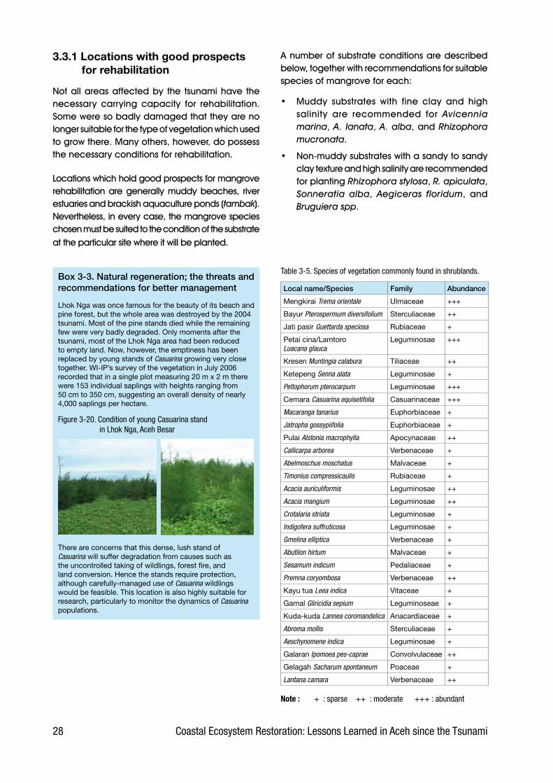
Not.all.areas.affected.by. the. tsunami.have. the.necessary. carrying. capacity. for. rehabilitation..Some.were.so.badly.damaged.that.they.are.no.longer.suitable.for.the.type.of.vegetation.which.used.to.grow.there..Many.others,.however,.do.possess.the.necessary.conditions.for.rehabilitation.
Locations.which.hold.good.prospects.for.mangrove.rehabilitation.are.generally.muddy.beaches,. river.estuaries.and.brackish.aquaculture.ponds.(tambak)..Nevertheless,.in.every.case,.the.mangrove.species.chosen.must.be.suited.to.the.condition.of.the.substrate.at.the.particular.site.where.it.will.be.planted..
A.number.of.substrate.conditions.are.described.below,.together.with.recommendations.for.suitable.species.of.mangrove.for.each:
•. Muddy. substrates. with. fine. clay. and. high.salinity. are. recommended. for. Avicennia marina,.A. lanata,.A. alba,.and.Rhizophora mucronata.
•. Non-muddy.substrates.with.a.sandy.to.sandy.clay.texture.and.high.salinity.are.recommended.for.planting.Rhizophora stylosa,.R. apiculata,.Sonneratia alba,. Aegiceras floridum,. and.Bruguiera spp.
Note : + : sparse ++ : moderate +++ : abundant
29Coastal Ecosystem Restoration: Lessons Learned in Aceh since the Tsunami
Figure 3-21. Suitable locations for mangrove;pond dikes (left) and river estuary (right).
sandy.and.dry..It.is.recommended.that.planting.is.done.in.Ipomoea Pes-caprae.formations.usually.found.at.the.back.of.sandy.beaches.
For. organosol. (peat),. indigenous. peatland.species.are.recommended,.such.as.Dyera lowii, Alstonia pneumatophora, Vitex pubescens,.and.Campnosperma spp.
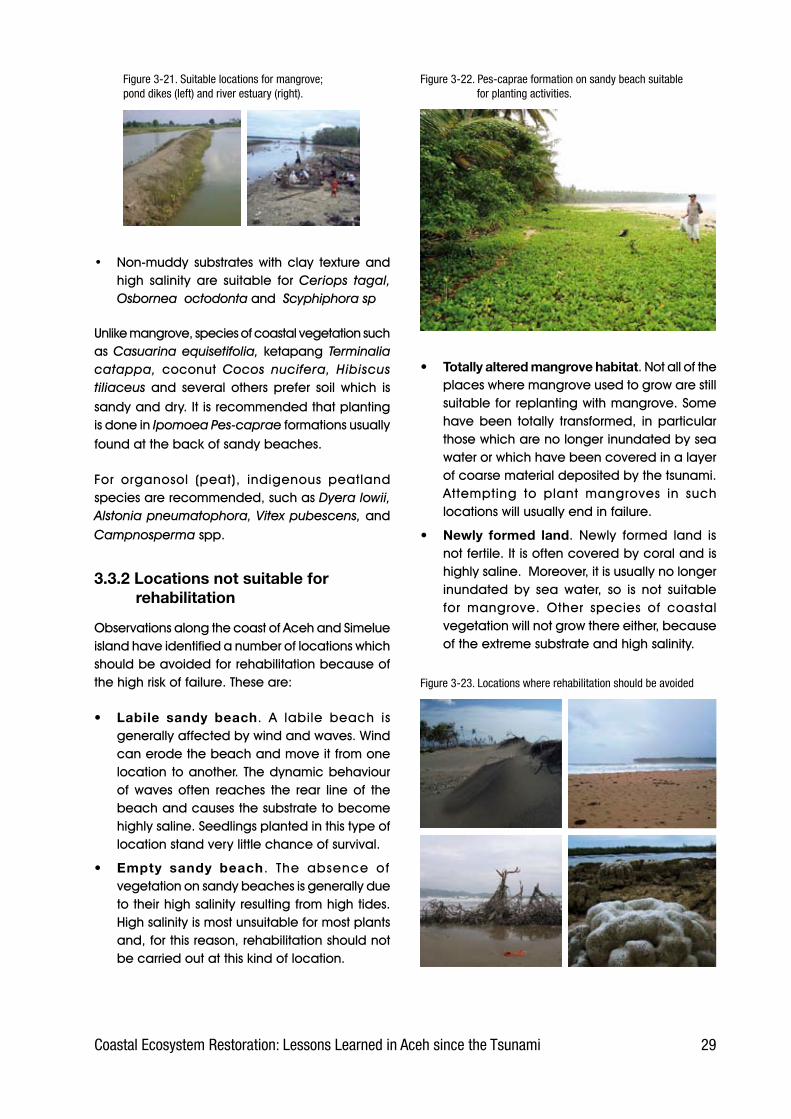
3.3.2 Locations not suitable for rehabilitation
Observations.along.the.coast.of.Aceh.and.Simelue.island.have.identified.a.number.of.locations.which.should.be.avoided.for.rehabilitation.because.of.the.high.risk.of.failure..These.are:
• Labile sandy beach.. A. labile. beach. is.generally.affected.by.wind.and.waves..Wind.can.erode.the.beach.and.move.it.from.one.location. to.another..The.dynamic.behaviour.of. waves. often. reaches. the. rear. line. of. the.beach.and.causes.the.substrate.to.become.highly.saline..Seedlings.planted.in.this.type.of.location.stand.very.little.chance.of.survival.
• Empty sandy beach.. The. absence. of.vegetation.on.sandy.beaches.is.generally.due.to.their.high.salinity.resulting.from.high.tides..High.salinity.is.most.unsuitable.for.most.plants.and,.for.this.reason,.rehabilitation.should.not.be.carried.out.at.this.kind.of.location.
• Totally altered mangrove habitat..Not.all.of.the.places.where.mangrove.used.to.grow.are.still.suitable.for.replanting.with.mangrove..Some.have.been. totally. transformed,. in.particular.those.which.are.no.longer.inundated.by.sea.water.or.which.have.been.covered.in.a.layer.of.coarse.material.deposited.by.the.tsunami..Attempting. to. plant. mangroves. in. such.locations.will.usually.end.in.failure..
• Newly formed land.. Newly. formed. land. is.not.fertile..It.is.often.covered.by.coral.and.is.highly.saline...Moreover,.it.is.usually.no.longer.inundated. by. sea. water,. so. is. not. suitable.for. mangrove.. Other. species. of. coastal.vegetation.will.not.grow.there.either,.because.of.the.extreme.substrate.and.high.salinity.
Figure 3-22. Pes-caprae formation on sandy beach suitable for planting activities.
•. Non-muddy. substrates.with.clay. texture.and.high. salinity. are. suitable. for. Ceriops tagal, Osbornea octodonta.and..Scyphiphora sp
Unlike.mangrove,.species.of.coastal.vegetation.such.as.Casuarina equisetifolia, ketapang. Terminalia catappa, coconut. Cocos nucifera, Hibiscus tiliaceus. and. several. others. prefer. soil. which. is.
Figure 3-23. Locations where rehabilitation should be avoided

30 Coastal Ecosystem Restoration: Lessons Learned in Aceh since the Tsunami
4. Lessons learned
The.recovery.of.tsunami-affected.areas.in.Nanggröe.Aceh.Darussalam.and.Nias.is.being.carried.out.in.three.stages:.emergency.response,.rehabilitation,.and.reconstruction..The.initial.emergency.response.stage,.which. focused.on. rescuing. survivors.and.providing. for. their. basic. needs,. lasted. from.January.2005.to.March.2005..The.second.stage,.rehabilitation,.began.in.April.2005.and.is.scheduled.to.end. in.December.2006..During. this. stage,.a.variety.of.rehabilitation.activities.have.been.carried.out,. including. cleaning. up. tsunami. debris. and.repairing. mosques,. hospitals. and. infrastructure..This.will.be.followed.by. the.reconstruction.stage,.which.is.scheduled.to.start.in.July.2007.and.finish.in.December.2009.(Bappenas,.2005)..
During.the.second.stage,.those.parts.of.the.coast.damaged. by. the. tsunami. are. being. reforested.through. the. planting. of. mangrove. and. other.coastal.species..Most.of.the.mangrove.planting.has. been. done. in. Banda. Aceh,. Aceh. Besar,.Pidie,. a. little. in. Aceh. Jaya. and. other. parts. of.Aceh’s.eastern.coast.that.have.muddy.beaches..Meanwhile,.the.planting.of.other.coastal.species.(generally.sea.pine.Casuarina equisetifolia).has.been.mainly.along.the.western.coast,.particularly.in.the.districts.of.Aceh.Besar,.Aceh.Barat,.Nagan.Raya.and.Aceh.Selatan.
4.1 Actors in coastal rehabilitation
The. rehabilitation. of. degraded. coastal. areas.involves. various. stakeholders,. each. with. their.particular.role.and.position..The.main.roles.of.all.those. involved. in. rehabilitating. Aceh’s. coastal.vegetation. can. be. grouped. into. three. simple.categories:. donor,. facilitator,. and. implementer...The. role. of. donor. is. usually. played. by. official.agencies,.foreign.governments.and.international.organizations.having.access.to.funds.raised.from.the.international.community...These.funds.(part.of.which.are.also.allocated.to.the.emergency.and.reconstruction. stages). are. then. dispersed. to. a.number.of.stakeholders,.primarily.to.international.and. national. NGOs,. to. facilitate. efforts. towards.the.goals.of.rehabilitation..These.NGOs.then.play.the. role. of. facilitator;. they. channel. funds. from.the.donors.to.the.implementers.in.the.field,.and.are. responsible. to. the. donors. for. the. results. of.field. activities. (including. the. use. of. the. funds)...Meanwhile,.the.implementers.are.those.(usually.the.communities.living.on.the.coast).who.undertake.the.actual.physical.work.of.rehabilitation.activities.in.the.field.and.who.are.responsible.to.the.facilitator.for.the.work.and.its.results.
Besides. the. main. actors,. other. parties. are.involved.as.supporters..They.are.not.part.of. the.implementation.mechanism.but.provide.support.for.
Figure �.1. Flowchart showing the mechanisms for rehabilitation activities an. activity.. They.
include.labourers,.seedling.suppliers,.etc..They.are.only.involved. when. a.particular.activity.is. going. on,. and.their. involvement.au tomat ica l l y.ceases.as.soon.as.the.task.is.finished..The. result. of. the.activity.is.not.their.responsibility.
The. relationships.between. these.roles. is. illustrated.in. the. flowchart,.left..

31Coastal Ecosystem Restoration: Lessons Learned in Aceh since the Tsunami
As.can.be.seen.from.the.chart,.coastal.rehabilitation.activities. are. carried. out. through. at. least. eight.pathways.of.cooperation.among.the.stakeholders.concerned..The.following.paragraphs.describe.the.roles.and.involvement.of.each.stakeholder..
4.1.1 Government
Government. actors. include. those. at. all. levels,.whether.central,.provincial,.district.or.municipal..The.position.of.BRR. (Agency. for. the.Rehabilitation.and.Reconstruction.of.Aceh.and.Nias).also.represents.the.government.role.having.specific.responsibility.for.the.coordination.and.implementation.of.the.rehabilitation.and.reconstruction.of.Aceh.and.Nias.
Only.a. few.government. institutions.are. involved.directly.in.coastal.rehabilitation..These.include:.the.Provincial.Forestry.Agency,.the.Forestry.Agency.for.each.District,.BKSDA.(Agency.for.the.Conservation.of.Natural.Resources),.and.BP-DAS.(the.Watershed.Management. Service).. Most. of. the. coastal.rehabilitation.activities.carried.out.have.involved.the.planting.of.mangroves.at.locations.affected.by.the.tsunami..GNRHL. (the.National.Movement.for.Forest.and.Land.Rehabilitation).is.the.channel.through. the. Ministry. of. Forestry. which. is. most.often.used.by.government.institutions.to.facilitate.coastal.rehabilitation.activity.in.Aceh.
As.it.did.before.the.tsunami,.government.has.generally.used.a.project.approach.to.organise.rehabilitation.activities..As.its.capacity.for.simultaneously.planning.and. implementing. such. activities. is. limited,. the.government.has.needed.to.work.with.other.actors,.for.example.to.supply.seedlings.and.labour.in.the.field...Seedlings.are.usually.obtained.from.private.companies.or.farmers’.groups,.and.labour.for.field.work. (e.g.. land.preparation,.planting). is. usually.obtained.by.engaging.the.private.sector.(e.g..by.tender).or.communities.
4.1.2 International Non-Governmental Organizations (NGOs)
Up.to.December.2005,.as.many.as.124.international.NGOs.had.been.recorded.by.BRR.as.being.involved.in. the. rehabilitation.and. reconstruction.of.Aceh.and.Nias..Few.of.these.have.a.particular.interest.in.environmental.issues,.and.no.more.than.20.are.known.to.have.a.coastal.restoration.programme.
Oxfam.International,.Islamic.Relief,.Mercy.Corps,.Wetlands. International. Indonesia. Programme.(WI-IP),. Care. International. Indonesia. and. other.international.NGOs.have.worked.or.are.working.on. coastal. rehabilitation. activities. in. Aceh...Although. some. of. them. use. the. same. patterns.and. approach. in. implementing. the. activities,.others.employ.a.different.approach..For.example,.Oxfam.International.has.combined.reforestation.activities.with.job.creation.through.its.cash.for.work.programme,. while. WI-IP. has. combined. coastal.rehabilitation.with.livelihood.development.through.its.small.grants.mechanism..
4.1.3 National NGOs
National. NGOs. are. those. which. are. either.domiciled.in.Aceh.or.come.from.other.provinces.of.Indonesia.and.have.new.(post-tsunami).or.old.(pre-tsunami).activities.in.Aceh.
Local.NGOs.usually. have. links.with. international.NGOs.or.even.directly.with.donor. institutions..Via.these.links,.some.national.NGOs.have.gained.the.trust.of.international.NGOs.and.donors.to.manage.the. implementation.of. rehabilitation.activities. in.Aceh..This.is.based.on.a.variety.of.considerations,.such.as.the.belief.that.the.local.NGOs.understand.field. conditions. in. Aceh,. have. better. access. to.local.government.and.other. relevant. institutions,.understand.the.sociocultural.character.of.the.local.communities,.and. share. the. same. language.. In.fact,. however,. not.all. these. local.NGOs.possess.adequate.skills.to.manage.coastal.rehabilitation.
At. present,. no. fewer. than. 430. National. NGOs.are. recorded. by. BRR. as. being. involved. in. the.rehabilitation.and.reconstruction.of.Aceh.and.Nias.(BRR,.2005)..It.is.estimated.that.fewer.than.20%.of.them.are.dealing.with.coastal.rehabilitation.
4.1.4 Private enterprise
Although. there. is.a. feeling. that. the.profit.motive.is.inconsistent.with.relief.work,.private.companies.have.been. involved.both. in. reconstruction.work,.such. as. in. supplying. materials. and. building.houses,.and.in.rehabilitation.activities.funded.by.the. Indonesian.Government.. . The. latter. role.has.involved. them. in.providing.mangrove. seedlings,.and. these. companies. have. then. employed.

32 Coastal Ecosystem Restoration: Lessons Learned in Aceh since the Tsunami
local. people. to. plant. them.in. the. field.. One. example. of.this. is. the.coastal. rehabilitation.programme.in.Lham.Nga.village,.Aceh. Besar,. which. according.to. labourers.at. the. site. in. June.2005.was. facilitated.by.BP-DAS.of.Kerueng.Aceh..
4.1.5 Community
The.chief.victims.of. the. tsunami.are.found.at.the.community.level,.where. the. proportion. of. total.assets. exposed. to. the. disaster.was.greatest. (e.g.. few. families.had.bank.accounts.where.assets.were. kept. safe).. Besides. the.tragedy.of.losing.their.family.and.relatives,. the. survivors.also. lost.their. property. and. livelihoods..For.this.reason,.the.various.parties.concerned.with.the.rehabilitation.and.reconstruction.of.Aceh.have.tried.as.far.as.possible.to.involve.them. in. the.projects,. including.coastal.rehabilitation.
Nevertheless,. the. community’s.position. is. more. that. of. field.implementers..Their.involvement.has. tended. to. be. passive. in.nature,. depending. simply. on.whether.or.not.an.activity.was.being.organized. in. their.area,.and. on. whether. there. were.any. third. parties. who. needed.them.
Field. observations. indicate.that. community. involvement.was. limited. to.certain.activities,.mainly.transporting.and.planting.seedlings.. In. most. cases,. they.had. no. involvement. at. all. in.the. processes. of. planning,.preparation,. acquisition. of.seedlings,.etc.,. these.activities.usually.being.performed.by.a.facilitator. (private. enterprise,.NGO.or.other).
BOX 4.1 Cash for work in rehabilitation activities
Many of the rehabilitation activities in Aceh, especially during the early phases, used the Cash for work mechanism. In this way, the community were involved in carrying out coastal rehabilitation by being paid around Rp 30,000 (ca US$ 3.25) for each day’s work.
The main reasons behind the Cash for work programme were:
It provides opportunity for employment, where jobs and livelihoods have been lost
In the short term, the money earned can be used to pay for daily necessities such as food, etc.
It injects money into the economy at the grass rootsIt helps people deal with psychological trauma by keeping them occupied It can help develop communication and relationships among people in
the community
(Oxfam International, 2005)
Observations at several planting sites using the Cash for work approach showed that at least two mechanisms were being applied. These were:
Mechanism 1: Payments were made by the fund manager/owner directly to the community in return for their involvement in planting seedlings. The money was calculated at a daily rate, but was usually paid out weekly.
Although successful at some planting sites, most efforts that used this mechanism failed, as indicated by the seedlings’ low survival rate. Failure was generally due to the following factors:
Planting was usually done by the community en masse and was therefore very difficult to control. As a consequence, it was very hard to ensure that the seedlings were planted in a careful, serious manner.
People participating in the Cash for work program were not given adequate technical guidance and information on how to plant the seedlings.
Timing was not appropriate. The best time to plant coastal species is in the early morning or late afternoon when it is relatively cool. In fact, however, some participants were busy with something else at those times and therefore did the planting in the middle of the day. The intense heat of the midday sun caused many seedlings to become stressed and die.
The location chosen for planting was unsuitable. For example, mangroves were planted on dry land, casuarina trees were planted on barren sand.
Once planted, the seedlings were not tended. Under the Cash for work program there was no obligation on the participants to tend the seedlings, thus their responsibility ended with the planting. As a result, many seedlings died from lack of water, were uprooted by high tides, or else were attacked by pests or livestock.
In general, therefore, the coastal rehabilitation Cash for work programme can be said to have been successful in promoting community participation, and in providing employment and income, but it did not succeed in rehabilitating the coast.
Mechanism 2: The fund manager entrusted the running of the Cash for work program to a local NGO. In this case, there was a closer relationship with the community and some technical guidance was provided, although this was often limited. The time schedule for the activity was usually determined jointly. This mechanism showed better results compared to the first, with higher survival rates at several of the planting sites.
Conclusion:Cash for work is more effective when used for physical, labour-intensive work that does not require carefulness, experience, or specific skills (for example, unskilled labour to help skilled construction workers, or to clean up the environment).
The Cash for work approach is not recommended for the planting of seedlings, which requires special expertise, experience, carefulness and continuous maintenance.
•
•
•••
•
•
•
•
•
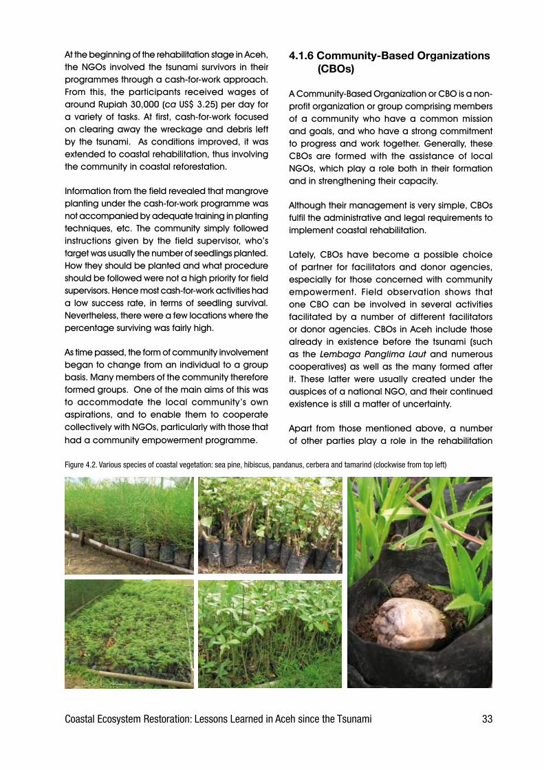
33Coastal Ecosystem Restoration: Lessons Learned in Aceh since the Tsunami
At.the.beginning.of.the.rehabilitation.stage.in.Aceh,.the.NGOs. involved. the. tsunami. survivors. in. their.programmes.through.a.cash-for-work.approach..From. this,. the. participants. received. wages. of.around.Rupiah.30,000.(ca.US$.3.25).per.day.for.a.variety.of. tasks..At. first,.cash-for-work. focused.on.clearing.away.the.wreckage.and.debris. left.by. the. tsunami.. .As.conditions. improved,. it.was.extended.to.coastal.rehabilitation,.thus.involving.the.community.in.coastal.reforestation.
Information.from.the.field.revealed.that.mangrove.planting.under.the.cash-for-work.programme.was.not.accompanied.by.adequate.training.in.planting.techniques,.etc.. The.community. simply. followed.instructions. given. by. the. field. supervisor,. who’s.target.was.usually.the.number.of.seedlings.planted..How.they.should.be.planted.and.what.procedure.should.be.followed.were.not.a.high.priority.for.field.supervisors..Hence.most.cash-for-work.activities.had.a. low.success. rate,. in. terms.of. seedling.survival..Nevertheless,.there.were.a.few.locations.where.the.percentage.surviving.was.fairly.high.
As.time.passed,.the.form.of.community.involvement.began.to.change.from.an.individual.to.a.group.basis..Many.members.of.the.community.therefore.formed.groups...One.of.the.main.aims.of.this.was.to. accommodate. the. local. community’s. own.aspirations,. and. to. enable. them. to. cooperate.collectively.with.NGOs,.particularly.with.those.that.had.a.community.empowerment.programme....
4.1.6 Community-Based Organizations (CBOs)
A.Community-Based.Organization.or.CBO.is.a.non-profit.organization.or.group.comprising.members.of. a. community. who. have. a. common. mission.and.goals,.and.who.have.a.strong.commitment.to.progress.and.work. together..Generally,. these.CBOs. are. formed. with. the. assistance. of. local.NGOs,.which.play.a. role.both. in. their. formation.and.in.strengthening.their.capacity.
Although.their.management.is.very.simple,.CBOs.fulfil.the.administrative.and.legal.requirements.to.implement.coastal.rehabilitation.
Lately,. CBOs. have. become. a. possible. choice.of. partner. for. facilitators. and. donor. agencies,.especially. for. those.concerned.with.community.empowerment.. Field. observation. shows. that.one. CBO. can. be. involved. in. several. activities.facilitated. by. a. number. of. different. facilitators.or.donor.agencies..CBOs.in.Aceh.include.those.already. in. existence. before. the. tsunami. (such.as. the. Lembaga Panglima Laut. and. numerous.cooperatives).as.well.as. the.many.formed.after.it.. These. latter. were. usually. created. under. the.auspices.of.a.national.NGO,.and.their.continued.existence.is.still.a.matter.of.uncertainty.
Apart. from. those. mentioned. above,. a. number.of.other.parties.play.a. role. in. the. rehabilitation.
Figure �.2. Various species of coastal vegetation: sea pine, hibiscus, pandanus, cerbera and tamarind (clockwise from top left)

3� Coastal Ecosystem Restoration: Lessons Learned in Aceh since the Tsunami
of. Aceh’s. coast,. including. research. institutions,.universities,.Scouts,.seedling.suppliers,.etc.
4.2 Progress in implementation
The. planting. of. mangroves. and. other. coastal.vegetation. was. first. initiated. by. a. number. of.International.NGOs.(Oxfam,.Islamic.Relief,.Mercy.Corps,.etc.).through.Cash for work programmes.in.April.2005. in. several. locations. in.Aceh.Besar,.and. in. Simeulue. through. a. programme. of.planting. by. community. groups. facilitated. by.Care. International-Indonesia. in. cooperation.with. Wetlands. International. (from. June. 2005)...Subsequently,. the. Watershed. Management.Service. (BP-DAS. -. Badan Pengelolaan Daerah Aliran Sungai).began.the.planting.of.mangroves.in.Lham.Nga.village.in.Aceh.Besar,.attended.by.Forestry.Minister.M.S..Kaban.. . It.was.not.until.21.November.that.BRR.officially.launched.the.‘Coastal.Re-greening. Project’. in. collaboration. with. WI-IP.and.WWF-Indonesia.. From. then.on,.a.variety.of.other. institutions,. both. governmental. and. non-governmental,. have. been. quick. to. join. in. the.coastal.rehabilitation.effort.
Mangroves. are. usually. planted. in. brackish.aquaculture.ponds,.degraded.mangrove.habitat,.and. along. river. banks.. Mangroves. were. also.found.to.have.been.planted.in.unsuitable.places,.however,.such.as.on.deep.sandy.beaches.and.dry.land..The.seedlings’.survival.rate.differed.widely.between. these. two. types. of. site,. being. much.higher.on.muddy.sites.(ponds.and.river.banks).than.on. sandy.beaches..Almost.all.of. the.mangrove.planting.done.on.sandy.sites.totally.failed.
The. assessment. conducted. by. the. WI-IP. team.in. September-October. 2005,. identified. 25. true.mangrove. species. in. Aceh. (including. Simeulue.island).and.Nias,.of.which.20.were.considered.to.have.good.potential.for.cultivation.and.planting.in.Aceh..In.practice,.however,.no.more.than.5.species.of.mangrove.have.been.planted.and.95%.consisted.of.Rhizophora apiculata.and.R. mucronata,. the.remaining.5%.being.Nipah.Nypa fruticans,.Tengar.Bruguiera spp..and.Api-api.Avicennia spp.
A.wider.variety.of.species.was.found.to.have.been.used.for.coastal.dry.land.rehabilitation,.however..Those.most.commonly.planted. included.coconut.Cocos nucifera,.sea.pine.Casuarina equisetifolia,.Terminalia cattapa,.Cerbera manghas,.Hibiscus tiliaceus,.neem.Azadirachta indica,.Callophylum inophyllum,.Jatropha curcas,.and.Pandanus tectorius.
Besides.these,.several.multi-purpose.and.economic.tree.species.were.also.planted,.including.Tamarind.Tamarindus indica,.Areca.palm.Areca cathecu,.Breadfruit. Artocarpus spp.,. Cocoa. Theobroma cacao,.and.others.in.limited.numbers.
According.to.WI-IP’s.analysis.of.available.data.from.various.sources.in.Aceh,.plans.have.been.made.for.the.rehabilitation.of.at.least.56,502.hectares.of.coast..Of.this,.27,532.ha.is.planned.for.mangroves.and.28,969.ha.for.other.species.of.coastal.vegetation..Only.a.few.of.the.implementers.have.reported.the.actual.extent.of.their.activities,.and.there.is.nothing.to.confirm.that.the.others.have.in.fact.carried.out.any.rehabilitation...Nevertheless,.a.total.of.29.84.million. seedlings. were. supposed. to. have. been.planted,.of.which.98.65%.are.mangroves.and.the.rest.other.coastal.species.(Figure.4-3)..
Figure �.3. Rough calculation of the total area rehabilitated and number of seedlings planted (based on data compiled from various sources)
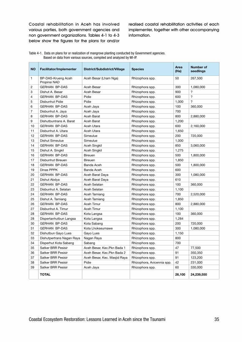
3�Coastal Ecosystem Restoration: Lessons Learned in Aceh since the Tsunami
Coastal. rehabilitation. in. Aceh. has. involved.various.parties,.both.government.agencies.and.non.government.organizations..Tables.4-1.to.4-3.below. show. the. figures. for. the. plans. for. and/or.
NO Facilitator/Implementer District/Subdistrict/Village SpeciesArea (Ha)
Number of seedlings
1 BP-DAS-Krueng Aceh Propinsi NAD
Aceh Besar (Lham Nga) Rhizophora spp. 50 267,500
2 GERHAN BP-DAS Aceh Besar Rhizophora spp. 300 1,080,000
3 Dishut A. Besar Aceh Besar Rhizophora spp. 900 ?
4 GERHAN BP-DAS Pidie Rhizophora spp. 600 ?
5 Disbunhut Pidie Pidie Rhizophora spp. 1,000 ?
6 GERHAN BP-DAS Aceh Jaya Rhizophora spp. 100 360,000
7 Disbunhut A. Jaya Aceh Jaya Rhizophora spp. 700
8 GERHAN BP-DAS Aceh Barat Rhizophora spp. 800 2,880,000
9 Dishutbuntrans A. Barat Aceh Barat Rhizophora spp. 1,200
10 GERHAN BP-DAS Aceh Utara Rhizophora spp. 600 2,160,000
11 Disbunhut A. Utara Aceh Utara Rhizophora spp. 1,650
12 GERHAN BP-DAS Simeulue Rhizophora spp. 200 720,000
13 Dishut Simeulue Simeulue Rhizophora spp. 1,000
14 GERHAN BP-DAS Aceh Singkil Rhizophora spp. 850 3,060,000
15 Dishut A. Singkil Aceh Singkil Rhizophora spp. 1,275
16 GERHAN BP-DAS Bireuen Rhizophora spp. 500 1,800,000
17 Disbunhut Bireuen Bireuen Rhizophora spp. 1,850
18 GERHAN BP-DAS Banda Aceh Rhizophora spp. 500 1,800,000
19 Dinas PPPK Banda Aceh Rhizophora spp. 600
20 GERHAN BP-DAS Aceh Barat Daya Rhizophora spp. 300 1,080,000
21 Dishut Abdya Aceh Barat Daya Rhizophora spp. 610
22 GERHAN BP-DAS Aceh Selatan Rhizophora spp. 100 360,000
23 Disbunhut A. Selatan Aceh Selatan Rhizophora spp. 1,100
24 GERHAN BP-DAS Aceh Tamiang Rhizophora spp. 700 2,520,000
25 Dishut A. Tamiang Aceh Tamiang Rhizophora spp. 1,850
26 GERHAN BP-DAS Aceh Timur Rhizophora spp. 800 2,880,000
27 Disbunhut A. Timur Aceh Timur Rhizophora spp. 1,100
28 GERHAN BP-DAS Kota Langsa Rhizophora spp. 100 360,000
28 Dispertanhutbun Langsa Kota Langsa Rhizophora spp. 1,284
30 GERHAN BP-DAS Kota Sabang Rhizophora spp. 200 720,000
31 GERHAN BP-DAS Kota Lhokseumawe Rhizophora spp. 300 1,080,000
32 Dishutbun Gayo Lues Gayo Lues Rhizophora spp. 1,150
33 Dishutpertrans Nagan Raya Nagan Raya Rhizophora spp. 800
34 Disperhut Kota Sabang Sabang Rhizophora spp. 700
35 Satker BRR Pesisir Aceh Besar, Kec.Pkn Bada 1 Rhizophora spp. 47 77,500
36 Satker BRR Pesisir Aceh Besar, Kec.Pkn Bada 2 Rhizophora spp. 91 350,350
37 Satker BRR Pesisir Aceh Besar, Kec. Masjid Raya Rhizophora spp. 91 123,200
38 Satker BRR Pesisir Pidie Rhizophora, Avicennia spp. 42 231,000
39 Satker BRR Pesisir Aceh Jaya Rhizophora spp. 60 330,000
TOTAL 26,100 24,239,550
Table �-1. Data on plans for or realization of mangrove planting conducted by Government agencies. Based on data from various sources, compiled and analyzed by WI-IP.
realised.coastal. rehabilitation.activities.of.each.implementer,.together.with.other.accompanying.information..

3� Coastal Ecosystem Restoration: Lessons Learned in Aceh since the Tsunami
Table �-2. Data on plans for or realization of mangrove planting conducted by NGOs. Based on data from various sources, compiled and analyzed by WI-IP.
Note:The number of seedlings planted through national NGOs is in reality much greater than that stated here, because most rehabilitation by international NGOs was in fact facilitated or implemented in the field by national NGOs. For example, the planting of �0% of the seedlings listed under WIIP was facilitated by around �0 local NGOs in Aceh, while the other 20% was facilitated by WI-IP directly with the community.
NO Facilitator/Implementer District/Subdistrict/Village SpeciesArea (Ha)
Number of seedlings
International NGOs
1 Islamic Relief Tibang, A. Besar Rhizophora spp. 4 20,000
2 Livelihood Development Cundien, A.Besar Rhizophora spp. - 800
3 (Conservation Program) Rhizophora spp. 1 4,000
4 OXFAM Lamsenia Rhizophora spp. 22 110,000
5 OXFAM Lhok Seudu Rhizophora spp. 22 110,000
6 OXFAM Pulot Rhizophora spp. 22 110,000
7 OXFAM Menasah Mesjid Rhizophora spp. 22 110,000
8 OXFAM Meunasah Ba’u Rhizophora spp. 22 110,000
9 OXFAM Daeah Mamplam Rhizophora spp. 22 110,000
10 OXFAM Lampulo malahayati Rhizophora spp. 10 50,000
11 OXFAM Alue Deah Tengoh Rhizophora spp. 20 100,000
12 OXFAM Deah Baro Rhizophora spp. 10 50,000
13 OXFAM Deah Glumpang Rhizophora spp. 10 50,000
14 OXFAM Ulee Lheu Mesjid Rhizophora spp. 24 120,000
15 OXFAM Lamteh Rhizophora spp. 2 10,000
16 OXFAM Tibang Rhizophora spp. 2 10,000
17 OXFAM Lam Batueng Rhizophora spp. 75 373,000
18 OXFAM Lam Prada Rhizophora spp. 75 373,000
19 OXFAM Man singet Rhizophora spp. 75 373,000
20 OXFAM Lam Seunong Rhizophora spp. 75 373,000
21 OXFAM Keude Aron Rhizophora spp. 75 373,000
22 OXFAM Gampong baru Rhizophora spp. 14 70,000
23 ADB Aceh Besar Rhizophora spp. 20 ?
24 GTZ-SLGSR Aceh Besar Rhizophora spp. 25 ?
25 FAO Paru Keude Rhizophora spp. 89.5 ?
26 FAO Paru Cot Rhizophora spp. 15 ?
27 FAO Meunasah & Rhizophora spp.,Nypa fruticans
8 ?
28 FAO Kiran Baroh Rhizophora spp. 12 ?
29 Wetlands International – Indonesia Programme (WI-IP) through Small Grants from Green Coast project1
A.Besar, B.Aceh, Semeulue, Nias, Pidie, Aceh Utara, Lhok Seumawe, Sabang.
Rhizophora spp. 200 1,100,000
TOTAL (International NGOs) 973,50 4,109,800
National NGOs *
1 Yayasan Leuser Indonesia Lambada, A.Besar Rhizophora spp. 3 13,000
2 Yayasan Gajah Sumatera Tibang, A. Besar Rhizophora spp. 2 10,000
TOTAL (National NGOs) 5 23,000

3�Coastal Ecosystem Restoration: Lessons Learned in Aceh since the Tsunami
Table �-3. Data on plans for or realization of planting of coastal vegetation by Government agencies and NGOs. Based on data from various sources, compiled and analyzed by WI-IP.
No Facilitator/ImplementerDistrict/Subdistrict/Village
SpeciesArea (Ha)
Number of seedlings
Government
GERHAN BP-DAS Aceh Besar Ketapang & Sea pine 800 ?
Satker BRR Pesisir Batee, Pidie Ketapang, Sea pine, Mimba,Bunot 12 5,760
Satker BRR Pesisir Kota Sigli Ketapang, Sea pine, Mimba,Bunot 18 8,640
Satker BRR Pesisir Simpang Tiga Ketapang, Sea pine, Mimba,Bunot 9 4,320
Satker BRR Pesisir Keumbang Tanjong Ketapang, Sea pine, Mimba,Bunot 8 3,840
Satker BRR Pesisir Lancak, Pasi lhok, Jeumerang
Ketapang, Sea pine, Mimba,Bunot 6 2,880
Satker BRR Pesisir Bandar Baru Ketapang, Sea pine, Mimba,Bunot 15 7,200
Satker BRR Pesisir Lancang Paru Ketapang, Sea pine, Mimba,Bunot 6 2,880
Satker BRR Pesisir Pasi Pusong Ketapang, Sea pine, Mimba,Bunot 9 4,320
Satker BRR Pesisir Pante Raja Mesjid Ketapang, Sea pine, Mimba,Bunot 11 5,280
Satker BRR Pesisir Meue Ketapang, Sea pine, Mimba,Bunot 6 2,880
Satker BRR Pesisir Cot Lheue Ketapang, Sea pine, Mimba,Bunot 15 7,200
Satker BRR Pesisir Sagoe Ketapang, Sea pine, Mimba,Bunot 7 3,360
Satker BRR Pesisir Meuraxa Ketapang, Sea pine, Mimba,Bunot 17 8,160
Satker BRR Pesisir Aceh Jaya Ketapang, Sea pine, Mimba,Bunot 200 96,000
Satker BRR Pesisir Bireuen Ketapang, Sea pine, Mimba,Bunot 100 48,000
Satker BRR Pesisir Peukan bada Sea pine, Ketapang, Mimba, Bunot 5 2,400
Satker BRR Pesisir Lhok Nga Ketapang, Sea pine, Mimba,Bunot 84 40,320
Satker BRR Pesisir Wilayah Pante Ketapang, Sea pine, Mimba,Bunot 31 14,880
Satker BRR Pesisir Mesjid Raya Ketapang, Sea pine, Mimba,Bunot 30 14,400
Note: Satker BRR Pesisir = BRR Coastal Work unit
TOTAL 1,389 282,720
NGO
Beach Care Programme, By Japan surf
Leupung-Lhok Nga Sea pine 2 ?
Livelihood Development Birek Sea pine 2 20
Livelihood Development Karueng Sea pine 1 40
Livelihood Development Baroh KK Ketapang, Sea pine, Mimba - 40
Livelihood Development Tanah Ano Ketapang, Sea pine, Mimba 3 1,066
Livelihood Development Jantang Coconut 4 800
Livelihood Development Paroy Ketapang, Sea pine, Mimba - 30
Livelihood Development Cot Coconut 1 300
Livelihood Development Glee Bruek Ketapang, Sea pine, Mimba - 40
Livelihood Development Pudeng Ketapang, Sea pine, Mimba,Bunot
Livelihood Development Cundien Coconut, Ketapang, Sea pine 3 415
OXFAM Alue Deah Tengoh Coconut & Sea pine 1,100
OXFAM Deah Baro Coconut & Sea pine 1,100
OXFAM Deah Glumpang Coconut & Sea pine 1,100
OXFAM Lamteh Coconut 5,000
OXFAM Tibang Sea pine 600
FAO Bandar Baru, Pideie Coconut, Sea pine, Ketapang 12 ?
Care International Indonesia & WIIP
Langi & Alus-alus villages in Simeulue district
Ketapang 20 10,500
Wetlands International – Indonesia Programme through Small Grants from Green Coast project
A.Besar, B.Aceh, Semeulue, Nias, Pidie, Aceh Utara, Lhok Seumawe, Sabang.
Sea pine, Coconut, Bunot, Tamarind, Ketapang
152 109,000
TOTAL 198 131,151
Note: Ketapang = Terminalia cattapa Mimba = Azadirachta indica Bunot = Punago = nyamplung = Callophylum inophyllum

3� Coastal Ecosystem Restoration: Lessons Learned in Aceh since the Tsunami
4.3 Level of success
To. date,. the. degree. of. success. achieved.by.rehabilitation.work.is.not.known.with.any.certainty. due. to. the. lack. of. data. on. the.percentage.of.seedlings.that.survived..Only.a.small.proportion.of.the.implementers.possess.data. on. the. progress. of. their. rehabilitation.activities,. including.seedling.survival.rate.in.the.field..Most.do.not.do.any.monitoring,.so.do. not. know. how. many. seedlings. survive..This. is.one.of. the. results.of. the. fragmented.nature.of.the.activities,.such.that.rehabilitation.is. considered. to. be. finished. as. soon. as.the. seedlings. have. been. planted.. Neither.tending. nor. monitoring. has. been. deemed.necessary.
Rough. calculations. made. during. field.observation. suggest. that. the. survival. rate. for.mangrove. (40%-60%). is.considerably.higher.than. for. other. coastal. species. (20%-50%)..As.time.goes.on,.however,.this.percentage.is.certain.to.decrease.for.the.following.reasons:.
•. Some. mangroves. were. planted. using.the.propagule.which,.for.a.period.of.1-2. months,. gives. the. plant. an. excellent.chance. of. living. as. the. embryo. is.sustained. by. the. nutrients. contained.in. the. hypocotyl.. Only. after. this. store.is. exhausted. and. the. seedling. has. to.depend. upon. nutrients. in. the. soil. can.success.or.failure.be.determined...
•. Seedlings.still.alive.now.will.not.necessarily.continue. to. live.. This. will. depend. upon.the.conditions.prevailing.in.the.seedling’s.environment,.such.as.drought,.the.action.of. the.waves.as. tides.ebb.and. flow,.or.being.eaten.by.animals..
•. The. seedlings. are. not. tended.. Without.proper. maintenance,. plants. will. be.attacked. by. pests. and. diseases. thus.reducing.the.survival.rate...
•. Regional. development. involving. the.development. of. public. facilities. and.infrastructure. (such. as. roads). could.destroy.rehabilitation.sites.
Box 4.2. Excerpts from press reports on Coastal Rehabilitation (translated from the Indonesian)
Tempo Interaktif, 4 January 2005As part of the three stages of action following the earthquake and tsunami in Nanggröe Aceh Darussalam and Nias-Sumatera Utara (i.e. emergency stage, rehabilitation and reconstruction), the Ministry for the Environment (KLH) announced that they have mobilized a Commando Post (Posko) for the rehabilitation of Aceh. Coordinated by the secretary to the Minister for the Environment, the Posko has sent tens of KLH Ministry staff to inventorise data concerning the damage to nature. This team has also been instructed to calculate how much must be spent to repair the environment.
Bisnis Indonesia, 07 January 2005The Forestry Department has allocated Rp 806 billion to re-establish 200,000 ha of mangrove forest along the coast of Nanggröe Aceh Darussalam (NAD) and its vicinity. This money will come from unused funds remaining from the 2003-2004 budget for the National Movement for Land and Forest Rehabilitation (GNRHL). It is envisaged that with this amount of money it will be possible to establish 150,000 – 200,000 ha of mangrove forest, calculated on an estimated cost of Rp 4-5 million per hectare, including labour costs.
Serambi Indonesia, 14 March 2005Inhabitants of Leupung in the Aceh Besar district have begun rehabilitation along the coast and river by planting 85,000 mangrove seedlings in an effort to restore the coastal ecosystem destroyed by the Tsunami. These thousands of seedlings have been provided through the help of a leading member of the local community and distributed to the inhabitants of six villages for planting along the coast and riverside.
BRR Press announcement, 21 November 2005The Agency for the Rehabilitation and Reconstruction of Aceh and Nias (BRR) on 21 November 2005 launched the Coastal Re-greening Project in collaboration with Wetlands International Indonesia Programme and WWF Indonesia. These latter two organisations are the primary implementers for the Green Coast Project in Indonesia which is funded by Oxfam Netherlands. This coastal reforestation program will focus on two areas: improving the livelihoods of coastal communities, and conserving the environment.
Serambi Nanggröe, 27 April 2006The Forestry and Plantations Agency (Dishutbun) for Aceh Barat is currently developing 800 ha of mangrove forest in watersheds and swamps distributed through the sub-districts of Samatiga, Meurebo, Johan Pahlawan, and Arongan Lambelek. To achieve this target, Dishutbun has prepared 2 million mangrove seedlings, all of which have been donated by the Watershed Management Service (BP-DAS) for Krueng Aceh Pemprov NAD. The seedlings will be planted by the local communities. This forms part of the National Movement for Land and Forest Rehabilitation (Gerhan), which has a target of planting 1,000 hectares.
Serambi Nanggröe, 29 July 2006A number of coastal inhabitants in the Syah Kuala sub-district of Banda Aceh have planted 200 thousand mangrove seedlings around newly renovated aquaculture ponds in order to reforest the coastal area devastated by the earthquake and tsunami on 26 December 2004. There are currently around 150 ha of aquaculture ponds that have been rehabilitated and are in need of mangrove because of the benefits these trees provide in preventing abrasion, especially abrasion to the community’s ponds. The mangrove seedlings were donated to the community by the Agency for the Rehabilitation and Reconstruction of Aceh and Nias (BRR).

39Coastal Ecosystem Restoration: Lessons Learned in Aceh since the Tsunami
•. Land. owners. may. change. their. minds. after.their. land.has.been.planted.with.mangrove.or.coastal.vegetation..Having.initially.agreed.to.the.planting.of.these.rehabilitation.species,.they. subsequently. pull. them. up. because.they.want.to.use.their.land.for.another.more.economically. advantageous. purpose. (e.g..aquaculture.ponds,.housing)..
4.4 Limitations and constraints in the field
The. coastal. rehabilitation. currently. underway.is. still. far. from. successful.. This. can. be. seen.from. the. low. percentage. of. seedlings. still.growing,.both.mangrove.and.terrestrial..Changing.environmental.conditions,.mistakes.in.the.choice.of.site,.the.implementers’.lack.of.preparation,.lack.of.experience,.insufficient.coordination,.unclear.spatial. planning,. and. other. constraints. are. all.factors.causing.the.low.level.of.success.in.coastal.rehabilitation.
Field.observations.identified.several.constraints.or.limiting.factors.which.caused.rehabilitation.efforts.to.fail...These.are.described.below..
4.4.1 No blueprint for coastal rehabilitation has yet been provided
It.is.essential.to.have.a.blue.print.for.rehabilitation.so. that. the. activities. are. integrated. and. given.direction..This.is.especially.important.considering.how. many. stakeholders. there. are. working. on.coastal. rehabilitation.. As. well. as. providing. a.spatial. plan,. the. blueprint. should. also. provide.information. on. important. matters. such. as. land.suitability,.land.conditions.and.level.of.damage,.the. plans. of. parties. concerned. with. the. land’s.utilization,.and.land.ownership.status..Without.this.blueprint,.rehabilitation.activities.will.lack.direction.and.run.a.serious.risk.of. leading.to.conflict.and.other.problems.in.the.future.
Unfortunately,. however,. possibly. because. of.complexities.in.the.field,.no.such.blueprint.has.yet.been.provided..Hence,.every.implementer.freely.chooses.sites. in.a.manner.which.appears.to.be.unplanned,.undirected.and.unorganised..It.even.happens.that.two.or.more.different.implementers.
find.themselves.planting.on.the.same.site..Lacking.clear.direction,.planting.is.done.without.knowledge.of.who.the.site.belongs.to.or.what.plans.there.may.be.for.its.development.
The. Ministry. of. Forestry. and. the. International.Tropical.Timber.Organisation.(ITTO).are.drawing.up.a.blueprint.for.rehabilitation,.but.it.is.not.expected.to.be.finished.until.the.end.of.2006.or.early.2007..If.this.does.in.fact.materialize,.this.document.is.likely.to.have.been.in.vain.as.most.field.activities.are.by.now.well.under.way.and.in.many.cases.already.finished,.and.the.rehabilitation.stage.is.itself.due.to.end.in.December.2006.
4.4.2 Most NGOs see coastal rehabilitation as a secondary activity
A. large. proportion. of. the. facilitators,. especially.those.who.arrived.shortly.after.the.tsunami.disaster,.are. primarily. concerned. with. the. emergency.response,.which.is.accompanied.by.the.building.of. facilities. such. as. houses,. boats,. roads. and.other. infrastructure.. Environmental. rehabilitation.is,.for.them,.not.a.top.priority..As.a.result,.coastal.rehabilitation. is. usually. subject. to. the. following.constraints:.
• Inadequate funding.. It. seems. that. funding.is. limited. to. the. provision. of. seedlings. and.meeting.the.cost.of.planting..No.funds.have.been.made.available.for.plant.maintenance/tending.
• Inadequate manpower.. This. has. been. the.cause. of. many. of. the. factors. leading. to.failure,.such.as.the.selection.of.unsuitable.sites,.seedlings.not.ready.for.planting,.planting.at.the.wrong.time,.etc..
• Inadequate preparation.. Because. of. the.lack. of. preparation,. several. international.NGOs. often. opted. for. the. ‘instant’. step. of.contracting. the. planting. to. another. party.such.as.a. local.NGO.or.CBO.which.was.not.in.practice.monitored.nor.evaluated..A.chief.driver.for.this.was.the.pressure.from.donors.on.international.NGOs.to.show.evidence.of.how.their.contributions.had.been.spent..
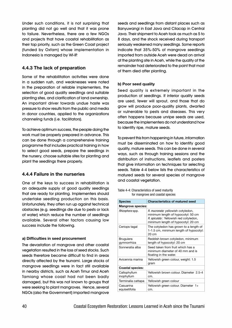
�0 Coastal Ecosystem Restoration: Lessons Learned in Aceh since the Tsunami
Under. such. conditions,. it. is. not. surprising. that.planting. did. not. go. well. and. that. it. was. prone.to. failure.. Nevertheless,. there. are. a. few. NGOs.and.projects. that.have.coastal. rehabilitation.as.their.top.priority,.such.as.the.Green.Coast.project.(funded. by. Oxfam). whose. implementation. in.Indonesia.is.managed.by.WI-IP.
4.4.3 The lack of preparation
Some. of. the. rehabilitation. activities. were. done.in. a. sudden. rush,. and. weaknesses. were. noted.in. the.preparation.of. reliable. implementers,. the.selection.of.good.quality.seedlings.and.suitable.planting.sites,.and.clarification.of.land.ownership..An. important. driver. towards. undue. haste. was.pressure.to.show.results.from.the.public.and.media.in.donor.countries,.applied.to. the.organizations.channeling.funds.(i.e..facilitators).
To.achieve.optimum.success,.the.people.doing.the.work.must.be.properly.prepared.in.advance..This.can.be.done.through.a.comprehensive.training.programme.that.includes.practical.training.in.how.to. select. good. seeds,. prepare. the. seedlings. in.the.nursery,.choose.suitable.sites.for.planting.and.plant.the.seedlings.there.properly...
4.4.4 Failure in the nurseries
One. of. the. keys. to. success. in. rehabilitation. is.an. adequate. supply. of. good. quality. seedlings.that.are.ready.for.planting..Implementers.should.undertake. seedling. production. on. this. basis..Unfortunately,.they.often.run.up.against.technical.obstacles.(e.g..seedlings.die.due.to.pests.or.lack.of.water).which.reduce.the.number.of.seedlings.available.. Several. other. factors. causing. low.success.include.the.following.
a) Difficulties in seed procurement
The.devastation.of.mangrove.and.other.coastal.vegetation.resulted.in.the.loss.of.seed.stocks..Such.seeds.therefore.became.difficult.to.find.in.areas.directly.affected.by.the.tsunami..Large.stocks.of.mangrove. seedlings. were. in. fact. still. available.in.nearby.districts,.such.as.Aceh.Timur.and.Aceh.Tamiang. whose. coast. had. not. been. badly.damaged,.but.this.was.not.known.to.groups.that.were.seeking.to.plant.mangroves...Hence,.several.NGOs.(also.the.Government).imported.mangrove.
seeds.and.seedlings.from.distant.places.such.as.Banyuwangi.in.East.Java.and.Cilacap.in.Central.Java..Their.shipment.to.Aceh.took.as.much.as.5.to.8.days,.and.the.shock.received.during.transport.seriously.weakened.many.seedlings..Some.reports.indicate. that. 35%-50%. of. mangrove. seedlings.imported.from.outside.Aceh.were.dead.on.arrival.at.the.planting.site.in.Aceh,.while.the.quality.of.the.remainder.had.deteriorated.to.the.point.that.most.of.them.died.after.planting.
b) Poor seed quality
Seed. quality. is. extremely. important. in. the.production.of. seedlings.. If. inferior.quality. seeds.are. used,. fewer. will. sprout,. and. those. that. do.grow. will. produce. poor-quality. plants,. dwarfed.or. vulnerable. to. pests. and. diseases.. This. very.often.happens.because.unripe.seeds.are.used,.because.the.implementers.do.not.understand.how.to.identify.ripe,.mature.seeds.
To.prevent.this.from.happening.in.future,.information.must. be. disseminated. on. how. to. identify. good.quality,.mature.seeds..This.can.be.done.in.several.ways,.such.as. through. training.sessions.and. the.distribution. of. instructions,. leaflets. and. posters.that.give.information.on.techniques.for.selecting.seeds..Table.4-4.below.lists.the.characteristics.of.matured.seeds.for.several.species.of.mangrove.and.coastal.vegetation...
Table �-�: Characteristics of seed maturity for mangrove and coastal species
Species Characteristics of matured seedMangrove species:
Rhizophora spp. R. mucronata: yellowish cotyledon, minimum length of hypocotyl: 50 cmR. apiculata : Yellowish red cotyledon, minimum length of hypocotyl: 20 cm
Ceriops tagal The cotyledon has grown to a length of 1-1.5 cm, minimum length of hypocotyl: 20 cm
Bruguiera gymnorrhiza
Reddish brown cotyledon, minimum length of hypocotyl: 20 cm
Sonneratia alba Seed taken from fruit which has a minimum diameter of 40 mm and is floating in the water.
Avicennia marina Yellowish green colour, weight: 1.5 gram
Coastal species:
Callophyllum inophyllum
Yellowish brown colour. Diameter 2.5-4 cm.
Terminalia cattapa Yellowish green colour
Casuarina equisetifolia
Yellowish green colour. Diameter 1+ cm.

�1Coastal Ecosystem Restoration: Lessons Learned in Aceh since the Tsunami
c) Lack of skill and expertise
The.field.implementers’.limited.capacity.and.lack.of. experience. are. among. the. main. causes. of.failure.in.seedling.production..Without.adequate.knowledge,. the. process. will. be. carried. out.haphazardly.without.proper.heed.to.the.principles.and. techniques. of. silviculture.. The. approach.taken.was.frequently.found.to.have.been.one.of.trial. and. error,. with. the. implementers. acting. by.guesswork.and.repeating.activities.that.seemed.to.work.and.altering.procedures.that.did.not..This.proved. extremely. inefficient,. considering. that.rehabilitation. activities. require. a. guaranteed.supply.of.good.quality.seedlings.in.large.quantities.and. ready. for.planting.at. the. time. required.by.the.project.
d) Inappropriate choice of nursery site
Mistakes. were. often. made. in. selecting. the. site.for. a. mangrove. nursery,. which. requires. special.conditions.. Among. other. things,. it. must. be.reached.by.high.tide,.have.a.muddy.substrate,.flat.topography,.and.be.near.both.to.a.source.of.media.such.as.water.and.soil,.as.well.as. to. the.planting. site.. . Field. observations. found. several.nurseries.in.unsuitable.sites,.where.tidal.inundation.was.too.deep.or.the.water.currents.too.strong,.or.else.the.nursery.was.far.from.a.source.of.suitable.media.because.the.area.had.been.covered.by.tsunami.deposits...
e) Mistakes in selecting media
Mangrove.species.prefer.a.muddy.medium.which.is.always.wet.with.brackish.water,.whereas.coastal.species. grow. well. in. a. medium. of. earth. mixed.with.sand..However,.it.was.found.in.the.field.that.mistakes.had.often.been.made.in.the.choice.of.media..The.most.common.mistake.was.to.use.a.sandy.medium.for.mangrove,.as.a.result.of.which.the.seeds.could.not.grow.properly.and.died..
Figure �.�. Nurseries sited in unsuitable areas: site subject to heavy inundation and strong currents (left); site not subject to inundation (right). Both failed totally. Photographs taken in Lham Nga, Aceh Besar
Figure �.�. Nursery failure due to mistakes in choice of media
f) No hardening off
In.practice,.seedlings.were.usually.taken.directly.from. the. nursery. for. planting,. without. being.given. the. chance. to. acclimatize.. As. a. result,.the. seedlings. became. stressed. and. died.. The.implementers.were.generally.unaware.of.this.link,.so.the.same.mistake.was.made.repeatedly.

�2 Coastal Ecosystem Restoration: Lessons Learned in Aceh since the Tsunami
To.make.seedlings. ready. for.planting.out. in. the.field,.they.must.go.through.a.process.of.hardening.or.acclimatization.of.1.–.2.months.prior.to.planting.out.. For. mangroves,. this. consists. of. gradually.reducing.the.shade.until.they.can.survive.without.shade.. For. coastal. species,. it. is. not. only. the.amount. of. shade. that. is. reduced. but. also. the.intensity.of.watering..Thus.the.seedlings.become.ready.to.adapt.to.field.conditions.
4.4.5 Planting in unsuitable locations
Many. instances. were. found. in. the. field. where.seedlings,.both.of.mangrove.and.coastal.species,.had.been.planted.in.unsuitable.sites.and.did.not.survive..In.general,.four.important.mistakes.were.made.in.selecting.a.planting.site.
a) Planting mangroves in sandy areas
Generally,. mangroves. planted. in. sand. will.gradually. show. signs. of. stress. and. then. die.. If.planted.with.its.propagule,.however,.the.seedling.will.at.first.appear.to.be.growing.normally.as.the.embryo.feeds.off.the.nutrients.in.the.propagule..This. gradually. runs. out,. as. the. plant’s. organs.such.as.leaves.and.roots.grow..When.it.has.been.completely.exhausted,.the.seedling.will.have.to.depend.on.the.nutrients.in.the.soil..At.this.point,.it.will.wilt.and.die..
b) Planting mangrove in dry mud
Although.better. than. sandy. soil,. the.planting.of.mangrove.in.dry.mud.is.also.not.recommended.because.a.supply.of.water.is.essential.for.the.plant.to.grow..Mangrove.planted.on.dry.mud.will.not.grow.normally.and.may.die..
Figure �.�. Mangrove planted on sandy beach
As. well. as. being. poor. in. nutrients,. sandy. soil. is.unsuitable.for.mangrove.seedlings.because.the.sand.absorbs.and.transmits.heat.from.the.sun.thus.burning.the.seedlings’.roots.
Figure �.�. Mangrove planted on permanently dry mud
c) Planting on open, labile sandy beach
Open.sandy.beach.is.very.difficult.to.rehabilitate..Apart.from.being.labile.as.the.sand.is.easily.eroded.by.the.wind,.it.is.highly.saline.and.stores.heat.from.the.sun..It.would.seem.obvious.that.such.an.area.is.unsuitable.for.planting.as.nothing.is.growing.on.it..Nevertheless,.planting.has.been.attempted.on.some.sites.of.this.nature.and,.as.a.result,.most.of.the.seedlings.died...
Figure �.�. Planting on open sandy beach
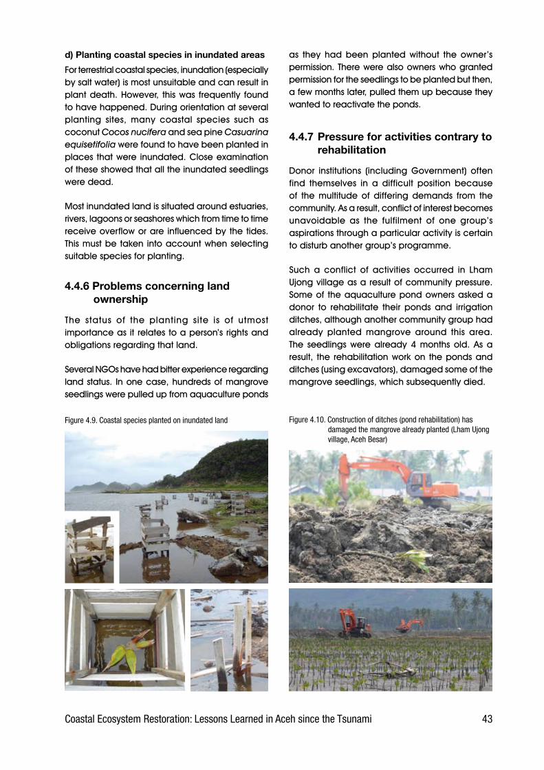
�3Coastal Ecosystem Restoration: Lessons Learned in Aceh since the Tsunami
d) Planting coastal species in inundated areas
For.terrestrial.coastal.species,.inundation.(especially.by.salt.water).is.most.unsuitable.and.can.result.in.plant.death..However,. this.was. frequently. found.to.have.happened..During.orientation.at.several.planting. sites,. many. coastal. species. such. as.coconut.Cocos nucifera.and.sea.pine.Casuarina equisetifolia were.found.to.have.been.planted.in.places.that.were. inundated..Close.examination.of.these.showed.that.all.the.inundated.seedlings.were.dead..
Most.inundated.land.is.situated.around.estuaries,.rivers,.lagoons.or.seashores.which.from.time.to.time.receive.overflow.or.are. influenced.by.the.tides..This.must.be.taken.into.account.when.selecting.suitable.species.for.planting.
4.4.6 Problems concerning land ownership
The. status. of. the. planting. site. is. of. utmost.importance.as.it.relates.to.a.person’s.rights.and.obligations.regarding.that.land.
Several.NGOs.have.had.bitter.experience.regarding.land.status.. In.one.case,.hundreds.of.mangrove.seedlings.were.pulled.up.from.aquaculture.ponds.
as. they. had. been. planted. without. the. owner’s.permission..There.were.also.owners.who.granted.permission.for.the.seedlings.to.be.planted.but.then,.a.few.months.later,.pulled.them.up.because.they.wanted.to.reactivate.the.ponds.
4.4.7 Pressure for activities contrary to rehabilitation
Donor. institutions. (including. Government). often.find. themselves. in. a. difficult. position. because.of. the. multitude. of. differing. demands. from. the.community..As.a.result,.conflict.of.interest.becomes.unavoidable. as. the. fulfilment. of. one. group’s.aspirations.through.a.particular.activity.is.certain.to.disturb.another.group’s.programme.
Such. a. conflict. of. activities. occurred. in. Lham.Ujong.village.as.a.result.of.community.pressure..Some.of. the.aquaculture.pond.owners.asked.a.donor. to. rehabilitate. their. ponds. and. irrigation.ditches,.although.another.community.group.had.already. planted. mangrove. around. this. area..The. seedlings.were.already.4.months.old..As.a.result,. the. rehabilitation.work.on. the.ponds.and.ditches.(using.excavators),.damaged.some.of.the.mangrove.seedlings,.which.subsequently.died.
Figure �.10. Construction of ditches (pond rehabilitation) has damaged the mangrove already planted (Lham Ujong village, Aceh Besar)
Figure �.9. Coastal species planted on inundated land

�� Coastal Ecosystem Restoration: Lessons Learned in Aceh since the Tsunami
There. was. a. similar. occurrence. in. Lham. Dingin.village,.where.the.pond.owners.demanded.that.the.government.build.a.sea.wall. in.front.of.their.140.ha.of.ponds.to.protect.them.from.erosion.and.damage. from. the. waves. (see. Box. 4-3. . below)..Unfortunately,. the. building. of. the. sea. wall. was.not. preceded. by. an. environmental. impact.
Box 4.3. SEA WALL IN LHAM DINGIN From Suryadiputra (editor, 2006).
A sea wall approximately 16.2 m long and 2 m high is being built along the coast of Lham Dingin (from the mouth of the Krueng Aceh to the mouth of the Krueng Cut). The sea wall is located approximately 200 m from the aquaculture ponds.
The building of this sea wall requires deeper study [construction of the sea wall by the Department of Public Works began in July/August 2005 without a prior Environmental Impact Assessment (AMDAL); information obtained from staff of BRR during a donors meeting at the Embassy of Denmark in Jakarta]. The sea wall could create new problems including:
Such a large structure will likely restrict the discharge of fresh water during the rainy season or salty water during high tide (see this hypothesis in Figure 4-11). Because the wall will lead to retention of water behind the structure, in areas that are largely aquaculture ponds and homes, there is a risk of flooding. If there is flooding of the ponds, this places aquaculture activities at risk because fish and shrimp fry that are being cultivated would be released to the sea or nearby rivers (Krueng Aceh and Krueng Cut).
It is suspected that there will be an increased risk of sea water intrusion. If sea water is trapped behind the wall after high tide in the pond area, and the water remains there for a long period of time, there is the potential for recharging of sea water in the soil, meaning that sea water will intrude further inland.
The presence of the sea wall is also likely to change the patterns of currents and wave action, causing them to shift to other locations. If this happens, it could affect other coastal areas through, for example, erosion.
Sea water and water from the Krueng Aceh and Krueng Cut rivers have relatively high levels of suspended particles (clay particles, fine sand, among others), with a concentration ranging from 36 – 46 mg/l. If this water floods the area behind the sea wall there is a risk it will lead to sedimentation, and ultimately turn the aquaculture ponds to land (there is a risk it could be land heavy in salt if sea water is dominant and is not washed away for long periods of time). A salty substrate could be an obstacle to the vegetation rehabilitation program that is underway in the area of the sea wall.
The sea wall could also restrict washing away of organic material resulting from the tsunami, meaning that decomposing organic matter will collect in the ponds. This situation is already evident in the Gampong Jawa area, and is characterized by a rotten smell.
During the dry season the sea wall could prevent water from entering the area behind the wall, leaving it dry. This is evident in Tibang, Gampong Jawa, Lham Pulo and Dean Raya where there is a scarcity of water and seedlings are drying out and dying [note: the two pieces of information above were provided by the Head of the Provincial
Environmental Agency of Aceh during a technical meeting at the Ministry of Environment in Jakarta in May 2006].
Based on the scenario outlined above, the following steps need to be taken:
A detailed study of the hydro-oceanographic aspects (including the watersheds of the Krueng Aceh and Krueng Cut) and coastal areas near the sea wall. This should include an analysis of any potential changes in currents, water turbidity, ground water quality, potential for sea water intrusion and possibility of flooding behind the sea wall.
Research on the ecological conditions (biodiversity and habitat for flora and fauna) in coastal parts of Lham Dingin and nearby areas. This should include research on the physical and chemical quality of the substrate/soil (including pond soil) behind the sea wall which could impact on the success of on-going rehabilitation activities and re-establishment of aquaculture activities (especially if the salt content is high).
Socio-economic research to understand the impacts on the ponds and homes that are behind the sea wall.
Research on possible alternatives to protect Lham Dingin (other than a large embankment built from rocks from the mountains), e.g. by mangrove planting.
Alternative to construction of sea wall. A protective barrier can be provided by coastal rehabilitation using mangroves and other coastal vegetation. There are examples from several coastal areas in Indonesia which show that mangroves trap mud naturally. Over time this mud increases the area for mangrove seedling growth, and a barrier is formed from dense and strong mangrove vegetation. Implementation of this concept will take time before it is functioning optimally, but the ecological advantages are many. In addition, it is most likely a less expensive option than constructing a stone sea wall.
1.
2.
3.
4.
5.
6.
•
•
•
•
assessment,.so.there.was.a.danger.that.the.ponds.behind.the.wall.would.be.flooded.at.high.tide..If,.instead,.part.of.the.pond.land.had.been.planted.with.mangrove,.according.to.the.concept.of.silvo-fishery,.the.mangrove.would.be.able.to.act.as.a.natural.defence.and,.at.the.same.time,.increase.natural.fishery.productivity.

��Coastal Ecosystem Restoration: Lessons Learned in Aceh since the Tsunami
4.4.8 Road construction from Banda Aceh to Meulaboh
There.are.fears.that.the.highway.construction.work.currently. in. progress. (traversing. the. west. coast.from.Banda.Aceh.to.Meulaboh).could.clash.with.the.rehabilitation.work.being.carried.out.by.other.agencies.. In. Pulot,. for. instance,. the. highway. is.planned. to. traverse. the. Pulot. lagoon. which. is.now.in.the.process.of.being.reforested.(by.WI-IP.and. UNEP).. Similarly,. in. Lamno,. the. highway. is.expected. to.hit. the.aquaculture.ponds.already.rehabilitated.by.BRR..To.overcome.such.problems,.the.road.construction.agency.needs.to.coordinate.its. activities. with. the. agencies. undertaking.environmental.rehabilitation.
4.4.9 Aquaculture pond rehabilitation without mangrove
Following. the. tsunami,. many. ponds. in. Aceh.Besar. and. Banda. Aceh. were. rehabilitated. by.a. variety. of. agencies,. including. ADB. and. BRR...Unfortunately,.this.was.not.done.in.the.light.of.the.
Figure �.11. Lham Dingin flooded with sea and river water (Photograph WI-IP 11 & 1� September 200�)
Construction of sea wall in front of aquaculture ponds in Lham Dingin village (Photograph Suryadiputra, September 200�)
Condition of ponds in Lham Dingin, which are behind (on the land side) the sea wall (September 200�)
Lham Dingin 11 September 200� Lham Dingin 1� September 200�
silvo-fishery.concept.now.being.widely.promoted.in.Aceh..Mangroves.were.not,.therefore,.planted.around.the.ponds.or.ditches..Had.this.been.done,.especially. on. the. dikes,. the. mangrove. trees.would.not.only.have.strengthened.the.ponds.but.also. provided. shade. and,. it. is. believed,. been.capable.of.increasing.the.productivity.of.natural.fishery.in.the.area..Table.3-2.above.showed.the.area. of. ponds. destroyed. by. the. tsunami. to. be.over.11,600.ha..Imagine.how.green.Aceh’s.coast.would.be.in.years.to.come.if.mangrove.could.be.planted.along.all. the.dykes.and.within.some.of.the.ponds.....
4.4.10 Rehabilitation using a project approach
In. a. project,. local. residents. are. typically. only.involved.as.unskilled. labour.. . This. is.not.enough.to.awaken.a.psychological.bond.between.them.and.the.seedlings.they.have.planted..Once.the.planting.has.been.completed,.the.people’s.sense.of. responsibility. ends. and. nobody. cares. about.the.result.
Sea wallOne hypothesis of the potential flooding that could result in Lham Dingin (where land sunk after the tsunami), if a sea wall is constructed

�� Coastal Ecosystem Restoration: Lessons Learned in Aceh since the Tsunami
Figure �.12 (Top, Middle left) Pond dikes and land (empty land in centre) where mangrove could be planted (these ponds are in Ceunamprong and Kareng Ateuh villages in Jaya subdistrict of Aceh Jaya district, and have been rehabilitated by BRR).(Middle right) One of these ponds has become little more than a buffalo wallow.(Bottom) Pond on Lhoong coast in danger of abrasion. Mangrove needs to be planted along the shore in front.
4.4.11 Technical errors and mistakes in the field
Rehabilitation. efforts. often. fail. as. a. result. of.technical.errors,.for.example,.mistakes.in.the.way.seedlings. are. handled. during. transportation..Such.mistakes.are.frequently.encouraged.by.the.desire.to.speed.up.or.simplify.the.process,.without.considering. the. effect. this. will. have.. Seedlings.must.be.handled.carefully,. so. that. they.are.not.damaged.(e.g..snapped.off).or.the.media.ruined..Other.mistakes.noticed.during. field.observation.included.transporting.seedlings.unshaded.during.the.heat.of.midday,.and.treating.them.carelessly.during.loading.and.unloading.
It.was.even.found.that.seedlings.had.been.removed.from.their.polybags. to.make.transportation.and.planting.easier..This.threatened.the.seedlings.in.at.least.two.ways:.the.sun’s.heat.shining.directly.on.the.roots,.and.damage.to.the.roots.as.they.were.planted.into.the.ground.
4.4.12 Conflict of Interest
The.rehabilitation.and.reconstruction.of.a.region.involves. a. large. number. of. different. parties,.each. with. their. own. point. of. view.. These. views.often.not.only.differ.but.may.also.conflict..Sadly,.coordination.among.stakeholders.is.so.weak.that.they.can.not.reach.agreement..Hence.each.goes.his. own. way.. Then,. when. one. party’s. activities.collide.with.those.of.another,.a.conflict.of.interest.arises.
Figure �.13. Seedlings taken out of the polybags to make work easier
Moreover,.a.single.project.is.not.sustainable...Once.the.project.is.over.the.rehabilitation.activities.are.finished,. and. the. seedlings. are. neglected. and.die.. .Also,.a.project. tends. to. focus.only.on. the.immediate.physical. results,. such.as. the.number.of.seedlings.planted,.rather.than.the.number.that.have.actually. survived.after.a. longer.period.of.time..In.trying.to.achieve.the.physical.target.the.activities. are. conducted. haphazardly. (without.adequate.preparation.and.without.a.clear.system.of.planting)..As.a.result,.the.survival.percentage.tends.to.be.low.
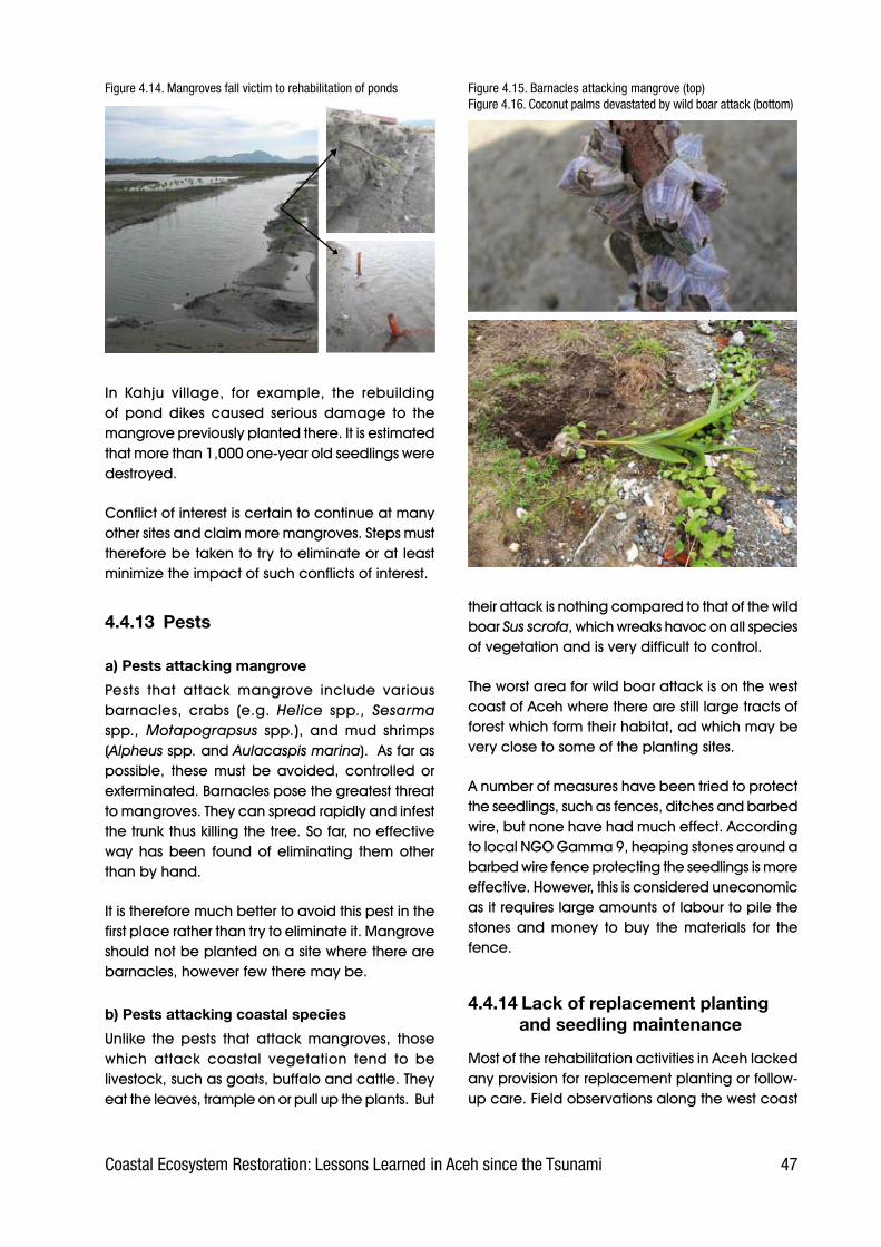
��Coastal Ecosystem Restoration: Lessons Learned in Aceh since the Tsunami
Figure �.1�. Mangroves fall victim to rehabilitation of ponds
In. Kahju. village,. for. example,. the. rebuilding.of. pond. dikes. caused. serious. damage. to. the.mangrove.previously.planted.there..It.is.estimated.that.more.than.1,000.one-year.old.seedlings.were.destroyed..
Conflict.of.interest.is.certain.to.continue.at.many.other.sites.and.claim.more.mangroves..Steps.must.therefore.be.taken.to.try.to.eliminate.or.at.least.minimize.the.impact.of.such.conflicts.of.interest..
4.4.13 Pests
a) Pests attacking mangrove
Pests. that. attack. mangrove. include. various.barnacles,. crabs. (e.g.. Helice spp., Sesarma spp., Motapograpsus spp.),. and. mud. shrimps.(Alpheus spp..and.Aulacaspis marina)...As.far.as.possible,. these. must. be. avoided,. controlled. or.exterminated..Barnacles.pose.the.greatest.threat.to.mangroves..They.can.spread.rapidly.and.infest.the.trunk.thus.killing.the.tree..So.far,.no.effective.way. has. been. found. of. eliminating. them. other.than.by.hand.
It.is.therefore.much.better.to.avoid.this.pest.in.the.first.place.rather.than.try.to.eliminate.it..Mangrove.should.not.be.planted.on.a.site.where.there.are.barnacles,.however.few.there.may.be..
b) Pests attacking coastal species
Unlike. the. pests. that. attack. mangroves,. those.which. attack. coastal. vegetation. tend. to. be.livestock,.such.as.goats,.buffalo.and.cattle..They.eat.the.leaves,.trample.on.or.pull.up.the.plants...But.
Figure �.1�. Barnacles attacking mangrove (top) Figure �.1�. Coconut palms devastated by wild boar attack (bottom)
their.attack.is.nothing.compared.to.that.of.the.wild.boar.Sus scrofa,.which.wreaks.havoc.on.all.species.of.vegetation.and.is.very.difficult.to.control..
The.worst.area.for.wild.boar.attack.is.on.the.west.coast.of.Aceh.where.there.are.still.large.tracts.of.forest.which.form.their.habitat,.ad.which.may.be.very.close.to.some.of.the.planting.sites.
A.number.of.measures.have.been.tried.to.protect.the.seedlings,.such.as.fences,.ditches.and.barbed.wire,.but.none.have.had.much.effect..According.to.local.NGO.Gamma.9,.heaping.stones.around.a.barbed.wire.fence.protecting.the.seedlings.is.more.effective..However,.this.is.considered.uneconomic.as.it.requires.large.amounts.of.labour.to.pile.the.stones. and. money. to. buy. the. materials. for. the.fence..
4.4.14 Lack of replacement planting and seedling maintenance
Most.of.the.rehabilitation.activities.in.Aceh.lacked.any.provision.for.replacement.planting.or.follow-up.care..Field.observations.along.the.west.coast.
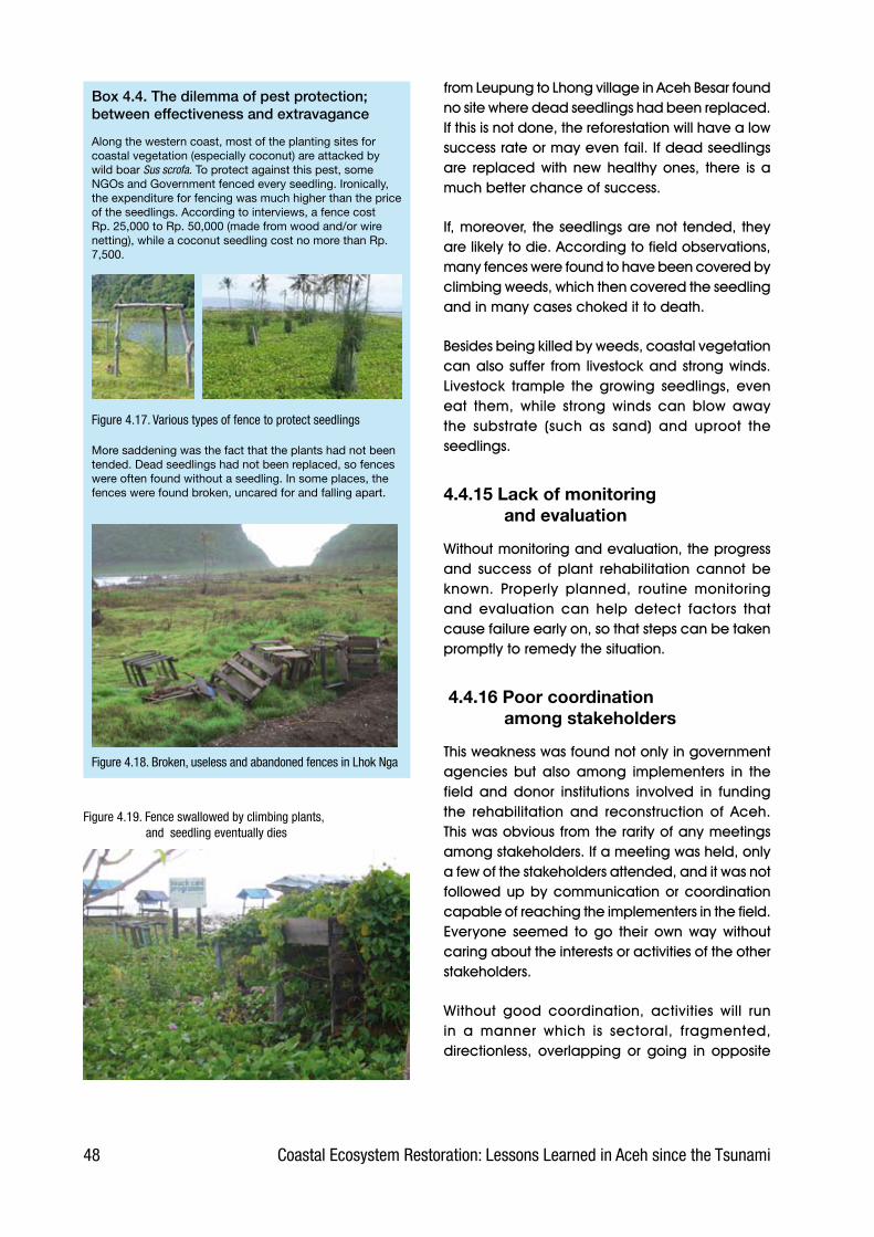
�� Coastal Ecosystem Restoration: Lessons Learned in Aceh since the Tsunami
Box 4.4. The dilemma of pest protection; between effectiveness and extravagance
Along the western coast, most of the planting sites for coastal vegetation (especially coconut) are attacked by wild boar Sus scrofa. To protect against this pest, some NGOs and Government fenced every seedling. Ironically, the expenditure for fencing was much higher than the price of the seedlings. According to interviews, a fence cost Rp. 25,000 to Rp. 50,000 (made from wood and/or wire netting), while a coconut seedling cost no more than Rp. 7,500.
Figure �.1�. Various types of fence to protect seedlings
More saddening was the fact that the plants had not been tended. Dead seedlings had not been replaced, so fences were often found without a seedling. In some places, the fences were found broken, uncared for and falling apart.
Figure �.1�. Broken, useless and abandoned fences in Lhok Nga
Figure �.19. Fence swallowed by climbing plants, and seedling eventually dies
from.Leupung.to.Lhong.village.in.Aceh.Besar.found.no.site.where.dead.seedlings.had.been.replaced..If.this.is.not.done,.the.reforestation.will.have.a.low.success.rate.or.may.even.fail..If.dead.seedlings.are. replaced.with.new.healthy.ones,. there. is.a.much.better.chance.of.success.
If,.moreover,. the.seedlings.are.not.tended,.they.are.likely.to.die..According.to.field.observations,.many.fences.were.found.to.have.been.covered.by.climbing.weeds,.which.then.covered.the.seedling.and.in.many.cases.choked.it.to.death.
Besides.being.killed.by.weeds,.coastal.vegetation.can.also.suffer. from. livestock.and.strong.winds..Livestock. trample. the. growing. seedlings,. even.eat. them,. while. strong. winds. can. blow. away.the. substrate. (such. as. sand). and. uproot. the.seedlings..
4.4.15 Lack of monitoring and evaluation
Without.monitoring.and.evaluation,.the.progress.and. success. of. plant. rehabilitation. cannot. be.known.. Properly. planned,. routine. monitoring.and. evaluation. can. help. detect. factors. that.cause.failure.early.on,.so.that.steps.can.be.taken.promptly.to.remedy.the.situation.
4.4.16 Poor coordination among stakeholders
This.weakness.was.found.not.only.in.government.agencies. but. also. among. implementers. in. the.field. and. donor. institutions. involved. in. funding.the. rehabilitation. and. reconstruction. of. Aceh..This.was.obvious.from.the.rarity.of.any.meetings.among.stakeholders..If.a.meeting.was.held,.only.a.few.of.the.stakeholders.attended,.and.it.was.not.followed.up.by.communication.or.coordination.capable.of.reaching.the.implementers.in.the.field..Everyone. seemed. to. go. their. own. way. without.caring.about.the.interests.or.activities.of.the.other.stakeholders.
Without. good. coordination,. activities. will. run.in. a. manner. which. is. sectoral,. fragmented,.directionless,. overlapping. or. going. in. opposite.
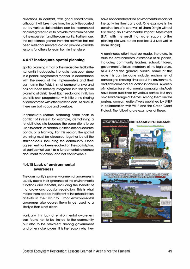
�9Coastal Ecosystem Restoration: Lessons Learned in Aceh since the Tsunami
directions.. In. contrast,. with. good. coordination,.although.it.will.take.more.time,.the.activities.carried.out.by.various.stakeholders.can.be.harmonized.and.integrated.so.as.to.provide.maximum.benefit.to.the.ecosystem.and.the.community...Furthermore,.the.experience.gained.from.the.activities.has.not.been.well.documented.so.as.to.provide.valuable.lessons.for.others.to.learn.from.in.the.future.
4.4.17 Inadequate spatial planning
Spatial.planning.in.most.of.the.areas.affected.by.the.tsunami.is.inadequate..It.tends.to.have.been.done.in.a.partial,.fragmented.manner,.in.accordance.with. the. needs. of. the. implementers. and. their.partners.in.the.field..It.is.not.comprehensive.and.has.not.been.formerly.integrated.into.the.spatial.planning.at.district.level..Each.sector.and.institution.plans.its.own.programme,.with.little.or.no.sharing.or.compromise.with.other.stakeholders..As.a.result,.there.are.both.gaps.and.overlaps.
Inadequate. spatial. planning. often. ends. in.conflict. of. interest;. for. example,. demolishing. a.rehabilitated.site.because.the.same.site.is.to.be.used.to.construct.a.harbour,.ditches.for.aquaculture.ponds,.or.a.highway..For.this.reason,.the.spatial.planning.must.be.discussed. together.by.all. the.stakeholders,. including. the. community.. Once.agreement.has.been.reached.on.the.spatial.plan,.all.parties.must.use.it.as.a.fundamental.reference.document.for.action,.and.not.contravene.it.
4.4.18 Lack of environmental awareness
The.community’s.poor.environmental.awareness.is.usually.due.to.their.ignorance.of.the.environment’s.functions. and. benefits,. including. the. benefit. of.mangrove. and. coastal. vegetation.. This. is. what.makes.them.appear.indifferent.to.the.rehabilitation.activity. in. their. vicinity.. . Poor. environmental.awareness. also. causes. them. to. get. used. to. a.lifestyle.that.is.not.clean.
Ironically,. this. lack. of. environmental. awareness.was. found. not. to. be. limited. to. the. community.but. also. to. be. prevalent. among. government.and.other.stakeholders..It.is.the.reason.why.they.
have.not.considered.the.environmental.impact.of.the.activities.they.carry.out..One.example.is.the.construction.of.a.sea.wall.at.Lham.Dingin.without.first.doing.an. Environmental. Impact.Assessment.(EIA),. with. the. result. that. water. supply. to. the.planting.site.was.cut.off.(see.Box.4-3.Sea.wall.in.Lham.Dingin).
A.continuous.effort.must.be.made,.therefore,.to.raise.the.environmental.awareness.of.all.parties,.including. community. leaders,. schoolchildren,.government.officials,.members.of.the.legislature,.NGOs. and. the. general. public.. Some. of. the.ways. this. can. be. done. include:. environmental.campaigns,.showing.films.about.the.environment,.and.environmental.education.in.schools...A.variety.of.materials.for.environmental.campaigns.in.Aceh.have.been.published.by.various.parties,.but.only.on.a.limited.range.of.themes..Among.them.are.the.posters,.comics,.leaflets/flyers.published.by.UNEP.in.collaboration.with.WI-IP.and.the.Green.Coast.Project..The.following.are.examples.of.these:.
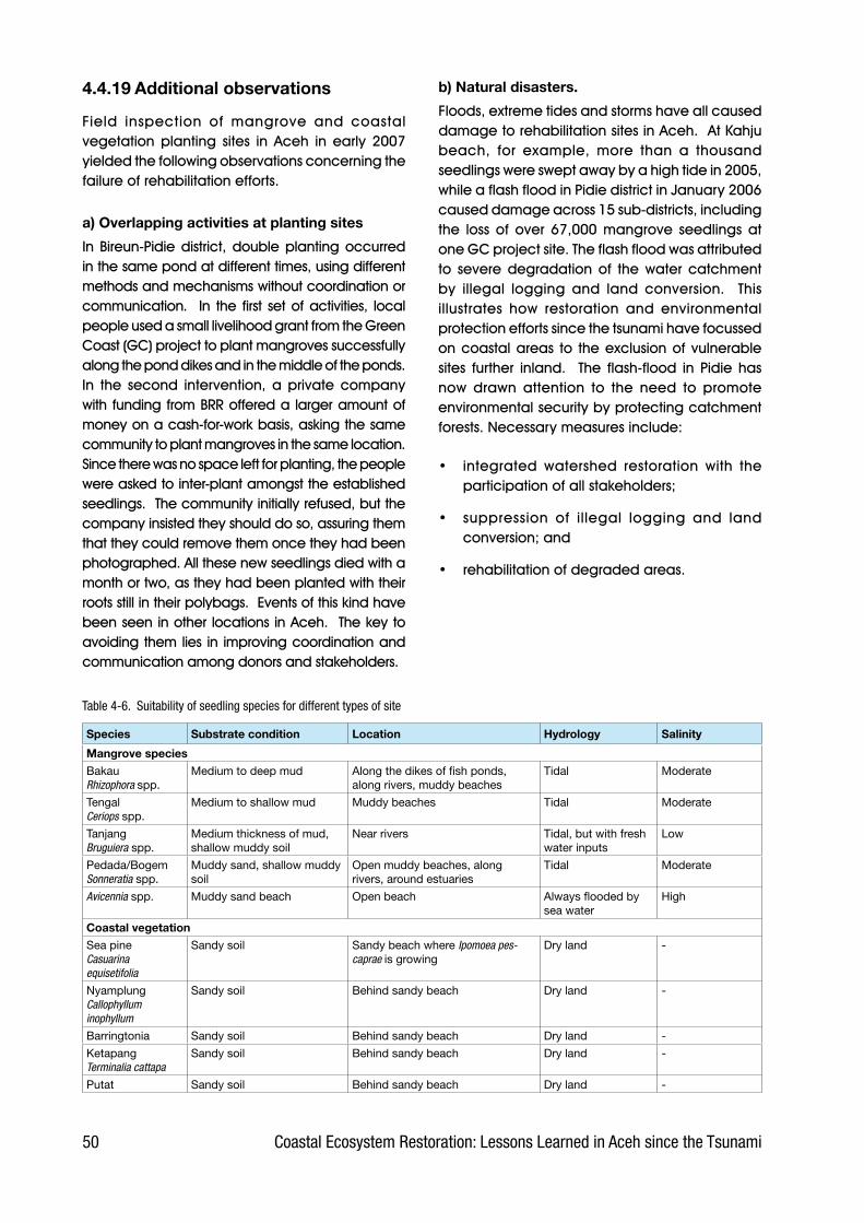
�0 Coastal Ecosystem Restoration: Lessons Learned in Aceh since the Tsunami
4.4.19 Additional observations
Field. inspection. of. mangrove. and. coastal.vegetation. planting. sites. in. Aceh. in. early. 2007.yielded.the.following.observations.concerning.the.failure.of.rehabilitation.efforts.
a) Overlapping activities at planting sites
In. Bireun-Pidie.district,.double.planting.occurred.in.the.same.pond.at.different.times,.using.different.methods.and.mechanisms.without.coordination.or.communication.. . In. the. first. set.of.activities,. local.people.used.a.small.livelihood.grant.from.the.Green.Coast.(GC).project.to.plant.mangroves.successfully.along.the.pond.dikes.and.in.the.middle.of.the.ponds...In. the. second. intervention,. a. private. company.with.funding.from.BRR.offered.a. larger.amount.of.money.on.a.cash-for-work.basis,.asking.the.same.community.to.plant.mangroves.in.the.same.location..Since.there.was.no.space.left.for.planting,.the.people.were.asked.to.inter-plant.amongst.the.established.seedlings...The.community.initially.refused,.but.the.company.insisted.they.should.do.so,.assuring.them.that.they.could.remove.them.once.they.had.been.photographed..All.these.new.seedlings.died.with.a.month.or.two,.as.they.had.been.planted.with.their.roots.still.in.their.polybags...Events.of.this.kind.have.been.seen.in.other.locations.in.Aceh...The.key.to.avoiding.them.lies. in. improving.coordination.and.communication.among.donors.and.stakeholders.
b) Natural disasters.
Floods,.extreme.tides.and.storms.have.all.caused.damage.to.rehabilitation.sites.in.Aceh...At.Kahju.beach,. for. example,. more. than. a. thousand.seedlings.were.swept.away.by.a.high.tide.in.2005,.while.a.flash.flood.in.Pidie.district.in.January.2006.caused.damage.across.15.sub-districts,.including.the. loss. of. over. 67,000. mangrove. seedlings. at.one.GC.project.site..The.flash.flood.was.attributed.to. severe. degradation. of. the. water. catchment.by. illegal. logging. and. land. conversion.. . This.illustrates. how. restoration. and. environmental.protection.efforts.since.the.tsunami.have.focussed.on.coastal.areas. to. the.exclusion.of.vulnerable.sites. further. inland.. . The. flash-flood. in. Pidie. has.now. drawn. attention. to. the. need. to. promote.environmental.security.by.protecting.catchment.forests..Necessary.measures.include:
•. integrated. watershed. restoration. with. the.participation.of.all.stakeholders;
•. suppression. of. illegal. logging. and. land.conversion;.and
•. rehabilitation.of.degraded.areas.
Species Substrate condition Location Hydrology Salinity
Mangrove species
BakauRhizophora spp.
Medium to deep mud Along the dikes of fish ponds, along rivers, muddy beaches
Tidal Moderate
TengalCeriops spp.
Medium to shallow mud Muddy beaches Tidal Moderate
TanjangBruguiera spp.
Medium thickness of mud, shallow muddy soil
Near rivers Tidal, but with fresh water inputs
Low
Pedada/BogemSonneratia spp.
Muddy sand, shallow muddy soil
Open muddy beaches, along rivers, around estuaries
Tidal Moderate
Avicennia spp. Muddy sand beach Open beach Always flooded by sea water
High
Coastal vegetation
Sea pineCasuarina equisetifolia
Sandy soil Sandy beach where Ipomoea pes-caprae is growing
Dry land -
NyamplungCallophyllum inophyllum
Sandy soil Behind sandy beach Dry land -
Barringtonia Sandy soil Behind sandy beach Dry land -
KetapangTerminalia cattapa
Sandy soil Behind sandy beach Dry land -
Putat Sandy soil Behind sandy beach Dry land -
Table �-�. Suitability of seedling species for different types of site

�1Coastal Ecosystem Restoration: Lessons Learned in Aceh since the Tsunami
4.5 Recommendations
The.obstacles,.failures.and.experiences.obtained.from.rehabilitation.efforts.during.the.two.last.years.in.Aceh.and.Nias.have.provided.us.with.valuable.lessons.. These,. it. is. hoped,. can. help. to. ensure.that.both.on-going.and.future.activities.run.better,.are. properly. prepared,. well. coordinated,. have.direction,.and.are.on.target,.thus.leading.to.the.success.of.the.coastal.rehabilitation.effort.
4.5.1 Selection of appropriate species and planting sites
The.species.selected.should.be.those.best.suited.to. the. conditions. prevailing. at. the. planting.site,.priority.being.given. to. local. species..Avoid.introducing. alien. species. as. this. can. seriously.disturb.the.equilibrium.of.the.ecosystem.
If. the. planting. site. is. muddy. beach,. mangrove.seedlings.should.be.selected,.though.the.decision.on.which.particular.species.of.mangrove.to.plant.will.depend.on.the.specific.characteristics.of.the.substrate,.in.particular.the.depth.of.the.mud,.the.condition.of. the.tides,. the.distance.from.a.river,.etcetera..On. the.contrary,. if. the.planting. site. is.sandy.beach,.other.species.of.coastal.vegetation.species.must.be.chosen.
4.5.2 Use of biological indicators when selecting planting sites
A. species. of. plant. or. animal. found. on. the. site.can.be.used.as.a.biological.indicator.of.the.site’s.suitability.for.the.purposes.of.rehabilitation..
•. Biological indicator for mangrove planting site..The.mud.skipper.(locally.known.as.Glodok.or. Tembakul,. Periophthalmus. spp.). is. an.animal.indicator.of.sites.suitable.for.planting.mangrove.. This. creature. likes. a. muddy.substrate.with.periodic.flooding..
•. Biological indicator for coastal species planting site.. Ipomoea pes-caprae. (locally.known. as. Katang-katang. or. Galaran). is. a.herb.that.flourishes.on.sandy.beaches..It.is.a.pioneer.species.able.to.grow.on.open.sandy.substrate,.and.has.high.tolerance.to.salinity..Substrate.(and.also.eventually.the.seedlings,.such.as.sea.pine).which.is.covered.by.this.herb.is. protected. from. the. sun’s. direct. heat. and.does.not.become.too.hot..Moreover,.it.is.also.protected.from.the.direct.force.of.the.wind,.so.is.more.stable.and.less.susceptible.to.erosion..These.conditions.are.usually.accompanied.by.the.appearance.of.micro-organisms.and.small.creatures.which.slowly. improve. the.carrying.capacity. of. the. substrate. by,. for. example,.enriching. its. organic. and. nutrient. content..
Figure �.20. Biological indicators of planting sites for mangrove and coastal vegetation: Ipomoea pes-caprae (left) and Mud skipper (right)

�2 Coastal Ecosystem Restoration: Lessons Learned in Aceh since the Tsunami
As. a. result,. species. such. as. sea. pine. and.Callophyllum.inophyllum.can.grow.well.
•. Biological indicator for sites to avoid for mangrove planting.. Barnacles. are. a. bad.sign.in.a.site.planned.for.mangrove.planting..Even. though.mud. skippers.are.abundant,. if.barnacles.are. found,. the.site. should.not.be.used.for.mangrove..Just.one.single.barnacle.in.the.site.will.multiply.very.rapidly.and..become.extremely.difficult.to.exterminate.
4.5.3 Improving selection of rehabilitation sites
Mistakes.in.selecting.the.planting.site.are.a.major.factor.leading.to.the.failure.of.rehabilitation.work..They. can. be. avoided. by. properly. assessing. a.prospective.site.before.deciding.whether.to.use.it.for.rehabilitation..A.Decision.Supporting.System.(DSS).is.a.tool.which.can.be.used.to.help.make.this.decision..In.this.system,.a.number.of.parameters.are. used. to. assess. the. land’s. suitability. and.feasibility..
Although.the.land.is.bio-physically.suitable,.there.may.be.other.factors.that.make.it.an.unfeasible.site.for.rehabilitation..For.example,.it.may.be.too.remote.from.the.community.for.rehabilitation.work.there.to.be.effective.or.efficient.
Furthermore,. all. the. potentials. and. constraints.must. be. identified. and. analyzed. to. discover.the.possibility.of. success.and. the. risk.of. failure..If. the. constraining. factors. are. greater. than. the.supporting. factors,. the. activity. should. not. be.undertaken.. If,. on. the. contrary,. the. supporting.factors.outnumber.the.constraints,.the.activity.has.a.good.chance.of.succeeding.and.can.therefore.be.undertaken.
4.5.4 Improving active community participation
The.community.is.the.spearhead.in.rehabilitation.activity..Unfortunately,.their.role.and.participation.is.still.very.limited,.appearing.to.be.little.more.than.a.symbol.that.the.rehabilitation.work.has.involved.the. community.. In. all. the. various. rehabilitation.activities.in.NAD.and.Nias,.the.community.has.so.far.been. involved.only.as.planters.and.porters,.and.their.involvement.has.automatically.ceased.when.the.planting.and.carrying.is.finished..Through.this.mechanism,.they.have.no.sense.of.ownership.towards. the. seedlings. they. have. planted,. nor.care. whether. or. not. the. seedlings. will. survive..This.is.one.of.the.factors.leading.to.the.failure.of.rehabilitation.
For.rehabilitation.to.be.successful,.the.community.must.be.involved.actively.in.the.whole.spectrum.
Figure �.21. DSS flow chart for selecting a rehabilitation site

�3Coastal Ecosystem Restoration: Lessons Learned in Aceh since the Tsunami
of.activities,.from.planning.to.planting.and.then.the.other.activities.after.planting...In.this.way,.the.community.not.only.gets. involved.but.can.also.develop. a. sense. of. ownership. and. an. attitude.of.caring.about. the.rehabilitation..They.will.also.have. acquired. the. range. of. skills. needed. to.undertake.the.whole.process.of.rehabilitation.on.their.own,.as. they.will.have.been. involved. from.the. beginning. to. the. end. of. the. activity.. If. this.mechanism. is. managed. well,. the. community.will.also.function.as.warden.of.the.growing.trees..Nevertheless,.this.must.continue.to.be.supported.by.raised.public.awareness.of.the.importance.of.coastal.vegetation.to.the.environment.and.to.the.community.
4.5.5 Capacity building through technical manuals and training
Based.on.field.observation,.it.is.known.that.very.few.field.implementers.have.either.the.experience.or.skills.needed.to.undertake.coastal.rehabilitation.activities.. As. a. consequence,. rehabilitation.programmes.are.not.carried.out.properly.and.thus.end.in.failure..By.providing.simple,.clear.manuals,.it.is.hoped.that.field.operators.can.be.helped.to.understand.the.procedure.through.every.stage.of.the.activity,.leading.to.much.better.performance..Other.materials,.such.as.posters.and.leaflets,.can.also.help.to.improve.the.community’s.capacity.
However,. for. some. field. operators,. particularly.those.with.little.or.no.formal.education,.a.manual.is. not. enough. on. its. own. as. they. may. not. be.able.to.understand.it..It.needs.to.be.interpreted.through.hands.on.training.and.demonstration.by.field.instructors.
4.5.6 Development of silvo-fishery
Currently,.almost.all.of.the.rehabilitation.programs.in.NAD.Province.and.Nias.have.the.same.planting.pattern,. i.e.. they. plant. on. empty. coastal. land..Unfortunately,.the.understanding.of.‘rehabilitation’.is.limited.to.the.physical.act.of.‘planting’,.lacking.a.basic.understanding.of.the.concept.of.conserving.the.coastal.ecosystem.in.its.entirety..To.overcome.this,. reforestation. should. also. be. carried. out. in.aquaculture.territory.(not.just.on.empty.land).by.planting.mangroves.along.the.dykes.and.in.some.of.the.ponds..This.concept.is.known.as.‘silvo-fishery’,.i.e..the.combination.of.forestry.through.planting.mangrove.and.fishery.through.the.cultivation.of.shrimps.or.fish.(see.Figure.4-22).
4.5.7 Improving coordination among stakeholders
The. poor. coordination. that. prevails. among.stakeholders. is. in. urgent. need. of. improvement.through. better. communication. and. information.sharing..To.do. this,.BRR.should. take. the. lead.as.both. initiator. and. facilitator,. by. holding. routine.meetings. that. involve. all. the. stakeholders. and.then. distributing. the. results. of. each. meeting. to.the. various. parties. working. in. Aceh. and. Nias..For.this.purpose,.BRR.could.be.assisted.by.other.institutions,.such.as.the.local.environmental.impact.management.agency.(BAPEDALDA),. the.Forestry.Agency.and.BP-DAS.
Furthermore,.all.the.other.stakeholders.(including.international.donors.and.NGOs).should.proactively.coordinate. their. activities. with. BRR. and. inform.the.other.parties,.so.that.all.can.learn.from.one.
Figure �.22. A recommended silvo-fishery system: planting mangrove around ponds

�� Coastal Ecosystem Restoration: Lessons Learned in Aceh since the Tsunami
another.. In. this. way,. the. development. of. each.stakeholder’s. activities. can. be. monitored. and.comprehensive.data.on.their.progress.be.made.available..In.addition,.the.stakeholders’.activities.will. run.better.as.a. result.of. sharing.experience.and.lessons.
4.5.8 The need for sustained tending, monitoring and evaluation
One.of.the.keys.to.successful.rehabilitation.is.the.tending. of. the. seedlings. after. they. have. been.planted.. The. main. tasks. involved. in. tending.include:.replacement.planting,.pest.and.disease.control,.and.weeding.. If. repeated.replacement.planting. still. results. in. failure,. further.enrichment.should.be.discontinued..This.is.likely.to.occur.when.the.substrate.is.unsuitable,.for.example.as.a.result.of.tsunami.deposits..Besides.tending,.both.monitoring.and.evaluation.need.to.be.carried.out.
BRR.or.government.agencies.should.play.a.role.in.monitoring.and.evaluation.so.that.all.the.activities.carried.out.by.all.the.various.parties.in.Aceh.are.well.looked.after.and.properly.documented..This.step. can. also. be. an. alternative. way. of. solving.problems. when. all. the. international. NGOs. and.foreign.donor.agencies.leave.Indonesia.
4.5.9 The need for mangrove diversity
The.current.planting.of.mangroves. in.Aceh.will,.unawares,.create.a.monoculture.because.almost.all.of.the.seedlings.used.are.of.only.two.species.of.a.single.genus,.Rhizophora..Although.these.are.local.species,.such.homogeneity.is.not.good.for.ecological.balance..
For. this. reason,.enrichment.planting. is.essential..This. can. be. done. by. planting. other. species. of.mangrove,.such.as.Avicennia spp.,.Bruguiera spp..and.Ceriops spp..on.sites.which.suit.each.particular.species..Thus.the.quality.of.the.mangrove.stand.will.improve.along.with.its.protective.function.and.other.benefits.
Figure �.23. Incorrect planting strategy at Lhoong, Aceh Besar (from beach towards land), most of the sea pine seedlings (in wire cages) died from drought
4.5.10 Planting from the back of the beach towards the front
Beach.vegetation.should.be.planted.starting.from.the.land.then.moving.towards.the.beach,.so.that.the.seedlings.do.not.die.as.a.result.of.inundation.by.sea.water,.nor.wilt.or.die.due.to.the.hot.sand.substrate..In.the.field,.however,.it.was.frequently.found.that.species.such.as.casuarina.and.coconut.had.been.planted.starting.from.the.sandy.shore.line.then.working.inland..Perhaps.this.was.done.in.the.expectation.that.the.shore.line.would.quickly.be.protected.from.the.action.of. the.waves,.but.in. fact.many.of. these. seedlings.died. from. lack.of.water.
To.improve.the.success.rate.further,.planting.should.be.done.from.the.back.(land).towards.the.beach,.and.should.stop.at.the.line.where.the.sand.is.deep.and.there.is.no.vegetation.growing.on.it..The.herb.Katang-katang.Ipomoea pes-caprae can.be.used.as.an.indicator.of.where.this.line.occurs..
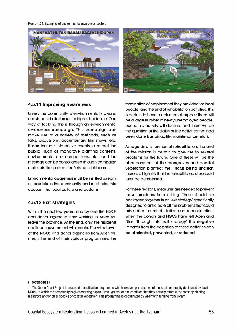
��Coastal Ecosystem Restoration: Lessons Learned in Aceh since the Tsunami
Figure �.2�. Examples of environmental awareness posters
4.5.11 Improving awareness
Unless. the.community. is.environmentally.aware,.coastal.rehabilitation.runs.a.high.risk.of.failure..One.way.of.tackling.this.is.through.an.environmental.awareness. campaign.. This. campaign. can.make. use. of. a. variety. of. methods,. such. as.talks,. discussions,. documentary. film. shows,. etc..It. can. include. interactive. events. to. attract. the.public,. such. as. mangrove. planting. contests,.environmental. quiz. competitions,. etc.,. and. the.message.can.be.consolidated.through.campaign.materials.like.posters,.leaflets,.and.billboards..
Environmental.awareness.must.be.instilled.as.early.as.possible.in.the.community.and.must.take.into.account.the.local.culture.and.customs.
4.5.12 Exit strategies
Within.the.next.few.years,.one.by.one.the.NGOs.and. donor. agencies. now. working. in. Aceh. will.leave.the.province..At.the.end,.only.the.residents.and.local.government.will.remain..The.withdrawal.of.the.NGOs.and.donor.agencies.from.Aceh.will.mean.the.end.of. their.various.programmes,. the.
termination.of.employment.they.provided.for.local.people,.and.the.end.of.rehabilitation.activities..This.is.certain.to.have.a.detrimental.impact;.there.will.be.a.large.number.of.newly.unemployed.people,.economic.activity.will.decline,.and.there.will.be.the.question.of.the.status.of.the.activities.that.had.been.done.(sustainability,.maintenance,.etc.).
As.regards.environmental.rehabilitation,.the.end.of. the. mission. is. certain. to. give. rise. to. several.problems.for.the.future..One.of.these.will.be.the.abandonment. of. the. mangroves. and. coastal.vegetation. planted;. their. status. being. unclear,.there.is.a.high.risk.that.the.rehabilitated.sites.could.later.be.demolished.
For.these.reasons,.measures.are.needed.to.prevent.these. problems. from. arising.. These. should. be.packaged.together.in.an.‘exit.strategy’.specifically.designed.to.anticipate.all.the.problems.that.could.arise.after. the. rehabilitation.and. reconstruction,.when.the.donors.and.NGOs.have.left.Aceh.and.Nias.. Through. this. ‘exit. strategy’. the. negative.impacts.from.the.cessation.of.these.activities.can.be.eliminated,.prevented,.or.reduced..
(Footnotes)1 The Green Coast Project is a coastal rehabilitation programme which involves participation of the local community (facilitated by local NGOs), in which the community is given working capital (small grants) on the condition that they actively reforest the coast by planting mangrove and/or other species of coastal vegetation. This programme is coordinated by WI-IP with funding from Oxfam.


Further information
Further technical information may be obtained from the UNEP Post-Conflict Assessment Unit website at: http://postconflict.unep.ch/