CNO Municipal Yacht Harbor Draft EA Appendices Yacht Harbor Pier ... List of Databases and...
118
Appendix A Supplemental Maps & Figures
-
Upload
trinhkhanh -
Category
Documents
-
view
217 -
download
1
Transcript of CNO Municipal Yacht Harbor Draft EA Appendices Yacht Harbor Pier ... List of Databases and...

Appendix A
Supplemental Maps & Figures
FEMA-1603-DR-LA AIDB #1776
City of New Orleans Municipal Yacht Harbor Pier
Replacement Project
Draft Environmental Assessment
Appendix A - Figure 1
Lake Pontchartrain Basin

FEMA-1603-DR-LA AIDB #1776
City of New Orleans Municipal Yacht Harbor Pier
Replacement Project
Draft Environmental Assessment
Appendix A - Figure 2 Pontchartrain Basin Geologic Map
Source: USGS 1998, 2012c
FEMA-1603-DR-LA AIDB #1776
City of New Orleans Municipal Yacht Harbor Pier
Replacement Project
Draft Environmental Assessment
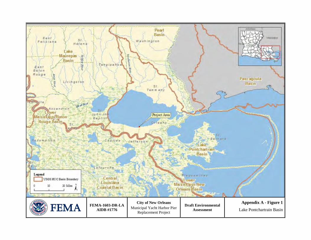
Appendix A - Figure 3 National Wetlands Inventory Map

FEMA-1603-DR-LA AIDB #1776
City of New Orleans Municipal Yacht Harbor Pier
Replacement Project
Draft Environmental Assessment
Appendix A - Figure 4 Gulf sturgeon Critical Habitat Map

FEMA-1603-DR-LA AIDB #1776
City of New Orleans Municipal Yacht Harbor Pier
Replacement Project
Draft Environmental Assessment
Appendix A - Figure 5 Louisiana Coastal Zone Map
Data: LDNR Office of Coastal Management

FEMA-1603-DR-LA AIDB #1776
City of New Orleans Municipal Yacht Harbor Pier
Replacement Project
Draft Environmental Assessment
Appendix A - Figure 6 Gulf Sturgeon Critical Habitat Map
- Units 1 - 14 Data: Gulf Sturgeon Critical Habitat (NMFS SERO)
Project Location

FEMA-1603-DR-LA AIDB #1776
City of New Orleans Municipal Yacht Harbor Pier
Replacement Project
Draft Environmental
Assessment
Appendix A – Figure 7
DFIRM Floodplain

Municipal Yacht Harbor Relocated Fishing Pier - Draft Design Drawings (Alternative 3) (Drawings not to scale)


Appendix B
Supporting Documentation

Appendix B Table 1 - List of Databases and Information Sources Used
Agency Dataset Name Data Last Updated
Date Accessed Source
Federal EPA ACRES 5/18/2012 NEPAssist - Online EPA AFS 5/18/2012 NEPAssist - Online EPA Air Emission Facilities 5/18/2012 5/18/2012 NEPAssist - Online EPA CERCLIS 5/18/2012 NEPAssist - Online EPA Clean Water Act -
Section 303(d) March 06,
2012 5/23/2012 Clean Water Act Section 303 - Online
EPA Health Statistics 5/18/2012 NEPAssist – EJViewer - Online
EPA Impaired Waterbodies 5/18/2012 NEPAssist - Online EPA PCS/ICIS 5/18/2012 NEPAssist - Online EPA RCRA 5/17/2012 NEPAssist - Online EPA Social Statistics 5/18/2012 NEPAssist –
EJViewer - Online EPA TRI 5/18/2012 NEPAssist - Online Gulf of Mexico Fishery Management Council “Gulf Council”
Species Listed In The Fishery Management Plans of the Gulf Of Mexico 05/14/2012 5/24/2012
Gulf of Mexico Fishery Management Council: Fishery Management Plans and Amendments - Online
NOAA - NMFS Essential Fish Habitat Mapper v2.0 10/24/2011 5/24/2012 NOAA EFH - Online
NOAA - NMFS Magnuson-Stevens Fishery Conservation and Management Act
2007 5/24/2012 NOAA Fisheries - Online
NOAA - NMFS Sea Turtle Stranding and Salvage Network (STSSN)
2012 6/05/2012 NOAA Fisheries - Online
NOAA - Office of Protected Resources
Loggerhead Turtle (Caretta caretta) September
22, 2011 5/8/2012 NOAA OPR - Online
US Census Bureau
2010 Census Data for: Louisiana, Orleans & Jefferson Parishes, Select Census Tracts within 1-mile radius of proposed project
2010 5/22/2012
2010 Census Interactive Population Search - Online
USDA - NRCS Custom Soil Resource Report for Jefferson and Orleans Parishes
4/21/2011 5/17/2012 Web Soil Survey - Online
USFWS Federally Designated Critical Habitat in Jefferson and Orleans Parishes
May 2012 5/8/2012
Critical Habitat Portal - Online
USFWS Federally Listed Threatened and Endangered Species of Jefferson and Orleans Parishes
May 2012 5/8/2012
IPac Web Portal - Online
USFWS National Wetlands 5/05/2012 5/18/2012 Wetlands Mapper -

Inventory (NWI) Online USFWS Saline Bayou 08/18/2011
11:32:36 5/21/2012 National Wild and Scenic Rivers by State - Online
USGS Environmental Atlas of Lake Pontchartrain
Tue 14 May 2002,
11:29:14 5/22/2012
Coastal & Marine Geology Program - Online
USGS Lake Pontchartrain (HUC 08090202)
Thursday, 29-Jul-2010 16:36 EDT
5/22/2012 Water Resources of the United States - Online
USGS Qal - Alluvium 5/22/2012
Mineral Resources On-Line Spatial Data - Online
State
Gulfsource Gulf Ecology 06/04/2012 Gulfsource.org - Online
LDNR SONRIS – Oil/Gas 5/21/2012 SONRIS - Online LDWF State Listed Species by
Parish – Jefferson Parish 5/21/2012 Species by Parish List - Online
LDWF State Listed Species by Parish – Orleans Parish 5/21/2012 Species by Parish
List – Online LDEQ CWA Section 303(d) –
Impaired Waterways 2010 5/22/2012
2010 Louisiana Water Quality Inventory: Integrated Report - Online
LDEQ/LDHH Swimming Advisory Due to Fecal Coliform 5/22/2012
Fish Consumption and Swimming Advisories - Online

CITY OF NEW ORLEANS ENVIRONMENTAL ASSESSMENT (EA)
MUNICIPAL YACHT HARBOR FISHING PIER REQUEST FOR AN IMPROVED/CHANGE OF LOCATION/REPLACEMENT
Date: 10/22/2012 Prepared by: June R. Griffin, CFM, FEMA, Environmental Adam Borden, CFM, FEMA Environmental Applicant: City of New Orleans Project Title: Municipal Yacht Harbor Fishing Pier Request for: Improved Project/Change of Location/Replacement - A/I Database #: 1776;
FEMA-DR-LA: 1603 FIPS #: 071-55000-00; PW #: 11698 Proposed Latitude: 30.029230 Longitude: -90.119420 Floodplain Review: The City of New Orleans/Orleans Parish enrolled in the National Flood Insurance Program (NFIP) on August 03, 1970. The site is located within a Zone “VE”, EL 17 North American Vertical Datum (NAVD) per Preliminary Digital Flood Insurance Rate Map 22071C0115 F, dated November 13, 2008. FEMA’s regulations implementing EO 11988, Floodplain Management, prohibit the Agency from funding new construction in V-Zones that is not functionally dependent on water or otherwise facilitates open space use. This project Scope of Work involves the relocation of a pier that is functionally dependent on water and the replacement of a restroom structure that is not functionally dependent and does not facilitate open space use. New construction of a functionally dependent pier is consistent with Floodplain Management regulations of 44 CFR 9. The restroom replacement has also been determined to be eligible by attached FEMA Memorandum of June 2, 2009 from James A. Walke, Acting Assistant Administrator, FEMA Disaster Assistance Directorate to FEMA Regional Administrators and Acting Regional Administrators for Regions I - X, Transitional Recovery Office Directors and Federal Coordinating Officers and also by attached memorandum of July 15, 2009 from Elizabeth A. Zimmerman, Assistant Administrator, FEMA Disaster Assistance Directorate to FEMA Regional Administrators and Acting Regional Administrators for Regions I - X, Transitional Recovery Office Directors and Federal Coordinating Officers. By Memorandum of February 17, 2012 from Frank Pagano, Mitigation Division Director of FEMA Region 6, to John Connolly, Senior Public Assistance Advisor, Louisiana Recovery Office, this project is located outside the protection of the HSDRRS; therefore, the 2008 Preliminary Digital Flood Insurance Rate Map (DFIRM) must be used for establishing the BFE. The applicant is required to coordinate with the local floodplain administrator regarding floodplain permit(s) prior to the start of any activities. All coordination pertaining to these permit(s) should be documented to the local floodplain administrator and copies provided to LA GOHSEP and FEMA as part of the permanent project files. Per 44 CFR 9.11 (d) (9), contents, materials and equipment, where possible, disaster-proofing of the building and/or elimination of such future losses should occur by relocation of those building contents, materials and equipment outside or above the base floodplain. A Cumulative Public Notice was published on October 21, 2007-November 02, 2007.

Scope of Work (SOW): The project is a request for a Change of Location and Replacement of Restroom Facilities. The City of New Orleans is requesting approval to relocate the Municipal Yacht Harbor Fishing Pier facility to a new site within the Municipal Yacht Harbor. It is the intention of the applicant to replace the pier with the same function and capacity that existed prior to the storm, with any increase in size of the overall square footage of the project being a result of codes and standards. It is also the intention of the city of New Orleans to replace the storm damaged restroom building with newly constructed elements of the same function and capacity; however, the City intends to relocate only the fishing pier to a new site within the Municipal Yacht Harbor Complex.
EXECUTIVE ORDER 11988 – FLOODPLAIN MANAGEMENT EIGHT-STEP DECISION MAKING PROCESS [EA]
Executive Order 11988 (Floodplain Management) requires federal Agencies “to avoid to the extent possible the long and short term adverse impacts associated with the occupancy and modification of the floodplain and to avoid direct or indirect support of floodplain development wherever there is a practicable alternative.” FEMA’s implementing regulations are at 44 CFR Part 9, which includes an Eight Step decision making process for compliance with this part.
This Eight Step Process is applied to the proposed Municipal Yacht Harbor Fishing Pier (MYHFP) facility. The proposed project area is within the 100-year (1% annual chance) floodplain. The steps in this decision making process is as follows.
Step 1: Determine if the Proposed Action is Located in the Base Floodplain The proposed action involves the relocation/ reconstruction of MYHFP facilities which are located within the 100 year floodplain- Coastal High Hazard. The current and proposed sites of the MYHFP facility are located within a “VE” Zone, EL 17, per Preliminary Digital Flood Insurance Rate Map (DFIRM) Panel #: 22071C0115 F, dated, 11.13.08. The floodplain in relation to the community and the proposed location for the MYHFP facility are depicted on Figures Figure 7 (Appendix A) of the Environmental Assessment.
Step 2: Early Public Notice (Preliminary Notice) FEMA has an obligation to provide adequate information to enable the public to have impact on the decision outcome for all action having the potential to affect, adversely, or be affected by floodplains or wetlands that it proposes. FEMA shall provide the public with adequate information and opportunity for review and comment at the earliest possible time and throughout the decision-making process; and upon completion of this process, provide the public with an accounting of its final decision (see §44 CFR 9.12). A Cumulative Initial Public Notice was published in statewide newspapers from 10/21/08-11/02/08.
Step 3: Identify and Evaluate Alternatives to Locating in the Base Floodplain. Alternative 1: No Action – The original structure is located within the 100-year (1% annual chance) floodplain. The No Action Alternative is not a practicable alternative, because it would leave the original structure in a damaged, unsafe, and unusable condition within the floodplain.
Alternative 2: Relocation outside the 100-yr (1% annual chance) floodplain – this alternative is not considered practicable. The MYHFP pier is functionally dependent upon its location within water. If relocated outside of the 100-year (1% annual chance) floodplain it would not be able to perform its intended purpose, therefore it must be located or carried out in close proximity to water. The city of New Orleans intends to replace the function and capacity of the storm damaged restroom building in its existing location with proper elevation standards. Although feasible, relocation of the restroom facility outside of the floodplain is not considered practicable. Its intended purpose is to serve the public utilizing the fishing pier. Elevation of the structure compliant with V-zone standards will mitigate potential storm related damage.
Alternative 3: Reconstruction of the fishing pier to pre-disaster condition at its present location is not considered the most practicable alternative. The applicant has proposed relocating the

MYHFP pier due to the direct path of water flowing from the 17th Street Canal Pumping Station which discharges large amounts of fresh water towards the current location of the fishing pier. The MYHMC has indicated that the fishing pier would be better located north of Breakwater Drive, on the outside perimeter of a concrete breakwater wall, to be out of the path of the 17th Street Canal outflow. The outflow is believed to have a negative effect on sport fishing and hence the replacement of the fishing pier facility would be better served out of the direct path of the 17th Street Canal. Replacement of the storm damaged restroom building with elevation at its existing location is a practicable alternative.
Alternative 4 (Proposed Alternative): The proposed Change of Location of the new MYHFP pier is located within the 100-year (1% annual chance) floodplain. The relocation is considered most practicable for the following reasons: (a) the applicant has indicated that the Municipal Yacht Harbor Fishing Pier would be better located north of Breakwater Drive, on the outside perimeter of a concrete breakwater wall, to be out of the path of the 17th Street Canal outflow, which discharges vast amount of water. The outflow is believed to have a negative effect on sport fishing and hence the replacement of the MYHFP facility would be better served out of the direct path of the 17th Street Canal, thereby enhancing recreational fishing experiences; (b) the MYHFP facility is functionally dependent upon its location in the Coastal High Hazard Area. If relocated outside of the 100-year (1% annual chance) floodplain it would not be able to perform its intended purpose, therefore it must be located or carried out in close proximity to water.
Replacement of the storm damaged restroom building with elevation at its existing location is the most practicable alternative. Although feasible, relocation of the restroom facility outside of the floodplain is not considered most practicable. Its intended purpose is to serve the public utilizing the fishing pier. Elevation of the structure compliant with V-zone standards will mitigate potential damage.
Step 4: Identify Impacts of Proposed Action Associated With Occupancy or Modification of the Floodplain. Alternative 4: (Proposed Alternative) –The proposed project restores the function and capacity of facilities lost as a result of the disaster. The restroom facility will be located in its pre-existing footprint with elevation to the BFE. The pier will be relocated in a more practicable location but still within the vicinity of the original pier. The proposed project will be located in a Coastal High Hazard area. This area is subject to the hazard of high velocity waters from tidal surge or hurricane wave wash. There proposed location is at risk of flood damage from surging water.
Step 5: Design or Modify the Proposed Action to Minimize Threats to Life and Property and Preserve its Natural and Beneficial Floodplain Values Harm to and within the floodplain must be minimized. New construction must be compliant with 44 CFR 9 minimization standards and current codes and standards. Per 44 CFR 9.11 (d)(9), where possible, disaster-proofing of the building and/or elimination of such future losses should occur by relocation of those building contents, materials and equipment outside or above the base floodplain. MYHFP facility is required to coordinate with the local floodplain administrator regarding floodplain permit(s) prior to the start of any activities.

Step 6: Re-evaluate the Proposed Action The proposed action will have risk associated with its location in a 100-year (1% annual chance) floodplain, Coastal High Hazard Area. However, the proposed pier is functionally dependent on water to serve its intended purpose. The restroom facility will be mitigated through elevation. All other mitigation measures outlined in 44 CFR 9.11 must be applied to this project, as well as conditions related to floodplain permits.
Step 7: Findings and Public Explanation (Final Notification) National Environmental Policy Act (NEPA) Environmental Assessment (EA) has been drafted to determine if the reconstruction of the MYHFP facility, as described, will have the potential for significant adverse effects on the quality of the human and natural environment. The results of the investigation are being used to make a decision whether to initiate preparation of an Environmental Impact Statement (EIS) or to prepare a Finding of No Significant Impact (FONSI). The availability of the Draft EA will be published in the local newspaper, The Advocate, on the following dates: November 23, 24, 26, 27, and 28, 2012. It will also be published in another local newspaper, The Times-Picayune, on the following dates: November 23, 25, 28, 30 and December 02, 2012. The comment period will be 15 days – beginning on November 23, 2012 and concluding December 7, 2012. Written comments on the EA or related matters can be emailed to [email protected], faxed to FEMA’s Louisiana Recovery Office at (504) 762-2323; or mailed to FEMA Louisiana Recovery Office, 1 Seine Court, New Orleans, Louisiana 70114. The public notices will announce the availability of the EA for public review at the Orleans Parish Main Library at 219 Loyola Avenue, New Orleans, LA 70112, (hours are 10 a.m. - 6 p.m., Mon. - Thurs., 10 a.m. - 5 p.m., Fri. & Sat.). The EA can also be viewed and downloaded from FEMA’s website at: http://www.fema.gov/environmental-planning-and-historic-preservation-program/environmental-documents-public-notices-3.
After evaluating alternatives, including impacts and mitigation opportunities FEMA has determined that the proposed project is the most practicable alternative.
Step 8: Implement the Action Mitigation measures as outlined in 44 CFR 9.11(d) must be applied to this project. Any other permits required must be secured prior to construction.

United StatesDepartment ofAgriculture
A product of the NationalCooperative Soil Survey,a joint effort of the UnitedStates Department ofAgriculture and otherFederal agencies, Stateagencies including theAgricultural ExperimentStations, and localparticipants
Custom Soil ResourceReport forJefferson Parish,Louisiana, and OrleansParish, LouisianaCNO Municipal Yacht HarborFishing Pier Project
NaturalResourcesConservationService
May 17, 2012

PrefaceSoil surveys contain information that affects land use planning in survey areas. Theyhighlight soil limitations that affect various land uses and provide information aboutthe properties of the soils in the survey areas. Soil surveys are designed for manydifferent users, including farmers, ranchers, foresters, agronomists, urban planners,community officials, engineers, developers, builders, and home buyers. Also,conservationists, teachers, students, and specialists in recreation, waste disposal,and pollution control can use the surveys to help them understand, protect, or enhancethe environment.
Various land use regulations of Federal, State, and local governments may imposespecial restrictions on land use or land treatment. Soil surveys identify soil propertiesthat are used in making various land use or land treatment decisions. The informationis intended to help the land users identify and reduce the effects of soil limitations onvarious land uses. The landowner or user is responsible for identifying and complyingwith existing laws and regulations.
Although soil survey information can be used for general farm, local, and wider areaplanning, onsite investigation is needed to supplement this information in some cases.Examples include soil quality assessments (http://soils.usda.gov/sqi/) and certainconservation and engineering applications. For more detailed information, contactyour local USDA Service Center (http://offices.sc.egov.usda.gov/locator/app?agency=nrcs) or your NRCS State Soil Scientist (http://soils.usda.gov/contact/state_offices/).
Great differences in soil properties can occur within short distances. Some soils areseasonally wet or subject to flooding. Some are too unstable to be used as afoundation for buildings or roads. Clayey or wet soils are poorly suited to use as septictank absorption fields. A high water table makes a soil poorly suited to basements orunderground installations.
The National Cooperative Soil Survey is a joint effort of the United States Departmentof Agriculture and other Federal agencies, State agencies including the AgriculturalExperiment Stations, and local agencies. The Natural Resources ConservationService (NRCS) has leadership for the Federal part of the National Cooperative SoilSurvey.
Information about soils is updated periodically. Updated information is availablethrough the NRCS Soil Data Mart Web site or the NRCS Web Soil Survey. The SoilData Mart is the data storage site for the official soil survey information.
The U.S. Department of Agriculture (USDA) prohibits discrimination in all its programsand activities on the basis of race, color, national origin, age, disability, and whereapplicable, sex, marital status, familial status, parental status, religion, sexualorientation, genetic information, political beliefs, reprisal, or because all or a part of anindividual's income is derived from any public assistance program. (Not all prohibitedbases apply to all programs.) Persons with disabilities who require alternative means
2

for communication of program information (Braille, large print, audiotape, etc.) shouldcontact USDA's TARGET Center at (202) 720-2600 (voice and TDD). To file acomplaint of discrimination, write to USDA, Director, Office of Civil Rights, 1400Independence Avenue, S.W., Washington, D.C. 20250-9410 or call (800) 795-3272(voice) or (202) 720-6382 (TDD). USDA is an equal opportunity provider andemployer.
3

ContentsPreface....................................................................................................................2How Soil Surveys Are Made..................................................................................5Soil Map..................................................................................................................7
Soil Map................................................................................................................8Legend..................................................................................................................9Map Unit Legend................................................................................................10Map Unit Descriptions........................................................................................10
Jefferson Parish, Louisiana.............................................................................12Ka—Kenner muck, drained.........................................................................12W—Water....................................................................................................12
Orleans Parish, Louisiana...............................................................................14An—Aquents, dredged................................................................................14AT—Aquents, dredged, frequently flooded.................................................14Ke—Kenner muck drained..........................................................................15W—Water....................................................................................................15
References............................................................................................................17Glossary................................................................................................................19
4

How Soil Surveys Are MadeSoil surveys are made to provide information about the soils and miscellaneous areasin a specific area. They include a description of the soils and miscellaneous areas andtheir location on the landscape and tables that show soil properties and limitationsaffecting various uses. Soil scientists observed the steepness, length, and shape ofthe slopes; the general pattern of drainage; the kinds of crops and native plants; andthe kinds of bedrock. They observed and described many soil profiles. A soil profile isthe sequence of natural layers, or horizons, in a soil. The profile extends from thesurface down into the unconsolidated material in which the soil formed or from thesurface down to bedrock. The unconsolidated material is devoid of roots and otherliving organisms and has not been changed by other biological activity.
Currently, soils are mapped according to the boundaries of major land resource areas(MLRAs). MLRAs are geographically associated land resource units that sharecommon characteristics related to physiography, geology, climate, water resources,soils, biological resources, and land uses (USDA, 2006). Soil survey areas typicallyconsist of parts of one or more MLRA.
The soils and miscellaneous areas in a survey area occur in an orderly pattern that isrelated to the geology, landforms, relief, climate, and natural vegetation of the area.Each kind of soil and miscellaneous area is associated with a particular kind oflandform or with a segment of the landform. By observing the soils and miscellaneousareas in the survey area and relating their position to specific segments of thelandform, a soil scientist develops a concept, or model, of how they were formed. Thus,during mapping, this model enables the soil scientist to predict with a considerabledegree of accuracy the kind of soil or miscellaneous area at a specific location on thelandscape.
Commonly, individual soils on the landscape merge into one another as theircharacteristics gradually change. To construct an accurate soil map, however, soilscientists must determine the boundaries between the soils. They can observe onlya limited number of soil profiles. Nevertheless, these observations, supplemented byan understanding of the soil-vegetation-landscape relationship, are sufficient to verifypredictions of the kinds of soil in an area and to determine the boundaries.
Soil scientists recorded the characteristics of the soil profiles that they studied. Theynoted soil color, texture, size and shape of soil aggregates, kind and amount of rockfragments, distribution of plant roots, reaction, and other features that enable them toidentify soils. After describing the soils in the survey area and determining theirproperties, the soil scientists assigned the soils to taxonomic classes (units).Taxonomic classes are concepts. Each taxonomic class has a set of soilcharacteristics with precisely defined limits. The classes are used as a basis forcomparison to classify soils systematically. Soil taxonomy, the system of taxonomicclassification used in the United States, is based mainly on the kind and character ofsoil properties and the arrangement of horizons within the profile. After the soilscientists classified and named the soils in the survey area, they compared the
5

individual soils with similar soils in the same taxonomic class in other areas so thatthey could confirm data and assemble additional data based on experience andresearch.
The objective of soil mapping is not to delineate pure map unit components; theobjective is to separate the landscape into landforms or landform segments that havesimilar use and management requirements. Each map unit is defined by a uniquecombination of soil components and/or miscellaneous areas in predictableproportions. Some components may be highly contrasting to the other components ofthe map unit. The presence of minor components in a map unit in no way diminishesthe usefulness or accuracy of the data. The delineation of such landforms andlandform segments on the map provides sufficient information for the development ofresource plans. If intensive use of small areas is planned, onsite investigation isneeded to define and locate the soils and miscellaneous areas.
Soil scientists make many field observations in the process of producing a soil map.The frequency of observation is dependent upon several factors, including scale ofmapping, intensity of mapping, design of map units, complexity of the landscape, andexperience of the soil scientist. Observations are made to test and refine the soil-landscape model and predictions and to verify the classification of the soils at specificlocations. Once the soil-landscape model is refined, a significantly smaller number ofmeasurements of individual soil properties are made and recorded. Thesemeasurements may include field measurements, such as those for color, depth tobedrock, and texture, and laboratory measurements, such as those for content ofsand, silt, clay, salt, and other components. Properties of each soil typically vary fromone point to another across the landscape.
Observations for map unit components are aggregated to develop ranges ofcharacteristics for the components. The aggregated values are presented. Directmeasurements do not exist for every property presented for every map unitcomponent. Values for some properties are estimated from combinations of otherproperties.
While a soil survey is in progress, samples of some of the soils in the area generallyare collected for laboratory analyses and for engineering tests. Soil scientists interpretthe data from these analyses and tests as well as the field-observed characteristicsand the soil properties to determine the expected behavior of the soils under differentuses. Interpretations for all of the soils are field tested through observation of the soilsin different uses and under different levels of management. Some interpretations aremodified to fit local conditions, and some new interpretations are developed to meetlocal needs. Data are assembled from other sources, such as research information,production records, and field experience of specialists. For example, data on cropyields under defined levels of management are assembled from farm records and fromfield or plot experiments on the same kinds of soil.
Predictions about soil behavior are based not only on soil properties but also on suchvariables as climate and biological activity. Soil conditions are predictable over longperiods of time, but they are not predictable from year to year. For example, soilscientists can predict with a fairly high degree of accuracy that a given soil will havea high water table within certain depths in most years, but they cannot predict that ahigh water table will always be at a specific level in the soil on a specific date.
After soil scientists located and identified the significant natural bodies of soil in thesurvey area, they drew the boundaries of these bodies on aerial photographs andidentified each as a specific map unit. Aerial photographs show trees, buildings, fields,roads, and rivers, all of which help in locating boundaries accurately.
Custom Soil Resource Report
6

Soil MapThe soil map section includes the soil map for the defined area of interest, a list of soilmap units on the map and extent of each map unit, and cartographic symbolsdisplayed on the map. Also presented are various metadata about data used toproduce the map, and a description of each soil map unit.
7

Canal NO 2 Can
al B
lvd
End
Blv
d Cat
ina
St
Lake
Ave
Miln
e B
lvd
Orp
heum
Ave
Bel
laire
Dr
Wue
rpel
St
Jewel St
Loui
svill
e S
t
Mem
phis
St
Poplar St
Lakeshore Dr
Col
bert
St
Filmore Ave
Loui
s X
IV S
t
Vick
sbur
g S
t
Car
rollt
on A
ve
Live Oak St
Fleu
r de
Lis
Dr
Hay PlWalker St
40th St
38th St
Mouton St
Pon
tcha
rtrai
n B
lvd
Porteous St
Topaz St
Sigur A
ve Huron Ave
Amethyst St
Breakwater Dr
Ony
x S
t
Crystal St
Sem
inol
e A
ve
Lilac St
Stafford Pl
Choctaw
Ave
Chickasaw
Ave
Conrad St
Roadway St
Sar
dony
x S
t
Foci
s S
t
Aris
Ave
Cen
ter S
t
Spencer Ave
Lakeshore Pkwy
Opal St
Sm
ith D
r
34th St
35th St
36th St
37th St
39th St
NO Hammond Hwy
Nur
sery
Ave
Ring St
Pap
wor
th A
ve
Lake Marina Ave
Robert E Lee Blvd
Downs St
And
rew
s A
ve
Tacoma St
Metairie Hammond Hwy
Gen
eral
Dia
z S
tC
herokee Ave
Rosebud St
Gem St
Chestnut St
Plaquemine St
Roy
St
Sapphire St
Ash St
Gar
net S
t
Ken
ison
St
May
an L
n
Wes
tend
Par
kN
ew B
asin Way
Lane St
Robert E Lee Blvd
Mouton St
Conrad St
36th St
Miln
e B
lvd
Can
al B
lvd
Walker St
Opal St
End
Blv
d
34th St
Robert E Lee Blvd
W
W
Ke
Ka
An
AT
776800
776800
777200
777200
777600
777600
778000
778000
778400
778400
778800
778800
779200
779200
3323
600
3323
600
3324
000
3324
000
3324
400
3324
400
3324
800
3324
800
3325
200
3325
200
3325
600
3325
600
3326
000
3326
000
3326
400
3326
400
3326
800
3326
800
0 1,000 2,000 3,000500Feet
0 300 600 900150Meters
±
30° 2' 30''
90°
6' 1
0''
30° 0' 32''
90°
6' 1
4''
30° 0' 35''
30° 2' 32''90
° 7'
54'
'90
° 7'
51'
'
Map Scale: 1:17,300 if printed on A size (8.5" x 11") sheet.
Custom Soil Resource ReportSoil Map

MAP LEGEND MAP INFORMATION
Area of Interest (AOI)Area of Interest (AOI)
SoilsSoil Map Units
Special Point FeaturesBlowout
Borrow Pit
Clay Spot
Closed Depression
Gravel Pit
Gravelly Spot
Landfill
Lava Flow
Marsh or swamp
Mine or Quarry
Miscellaneous Water
Perennial Water
Rock Outcrop
Saline Spot
Sandy Spot
Severely Eroded Spot
Sinkhole
Slide or Slip
Sodic Spot
Spoil Area
Stony Spot
Very Stony Spot
Wet Spot
Other
Special Line FeaturesGully
Short Steep Slope
Other
Political FeaturesCities
Water FeaturesStreams and Canals
TransportationRails
Interstate Highways
US Routes
Major Roads
Local Roads
Map Scale: 1:17,300 if printed on A size (8.5" × 11") sheet.
The soil surveys that comprise your AOI were mapped at 1:24,000.
Please rely on the bar scale on each map sheet for accurate mapmeasurements.
Source of Map: Natural Resources Conservation ServiceWeb Soil Survey URL: http://websoilsurvey.nrcs.usda.govCoordinate System: UTM Zone 15N NAD83
This product is generated from the USDA-NRCS certified data as ofthe version date(s) listed below.
Soil Survey Area: Jefferson Parish, LouisianaSurvey Area Data: Version 7, Sep 8, 2009
Soil Survey Area: Orleans Parish, LouisianaSurvey Area Data: Version 7, Sep 8, 2009
Your area of interest (AOI) includes more than one soil survey area.These survey areas may have been mapped at different scales, witha different land use in mind, at different times, or at different levelsof detail. This may result in map unit symbols, soil properties, andinterpretations that do not completely agree across soil survey areaboundaries.
Date(s) aerial images were photographed: Data not available.
The orthophoto or other base map on which the soil lines werecompiled and digitized probably differs from the backgroundimagery displayed on these maps. As a result, some minor shiftingof map unit boundaries may be evident.
Custom Soil Resource Report

Map Unit Legend
Jefferson Parish, Louisiana (LA051)
Map Unit Symbol Map Unit Name Acres in AOI Percent of AOI
Ka Kenner muck, drained 100.1 8.5%
W Water 311.0 26.5%
Subtotals for Soil Survey Area 411.1 35.0%
Totals for Area of Interest 1,174.4 100.0%
Orleans Parish, Louisiana (LA071)
Map Unit Symbol Map Unit Name Acres in AOI Percent of AOI
An Aquents, dredged 97.6 8.3%
AT Aquents, dredged, frequently flooded 93.9 8.0%
Ke Kenner muck drained 218.5 18.6%
W Water 353.3 30.1%
Subtotals for Soil Survey Area 763.3 65.0%
Totals for Area of Interest 1,174.4 100.0%
Map Unit DescriptionsThe map units delineated on the detailed soil maps in a soil survey represent the soilsor miscellaneous areas in the survey area. The map unit descriptions, along with themaps, can be used to determine the composition and properties of a unit.
A map unit delineation on a soil map represents an area dominated by one or moremajor kinds of soil or miscellaneous areas. A map unit is identified and namedaccording to the taxonomic classification of the dominant soils. Within a taxonomicclass there are precisely defined limits for the properties of the soils. On the landscape,however, the soils are natural phenomena, and they have the characteristic variabilityof all natural phenomena. Thus, the range of some observed properties may extendbeyond the limits defined for a taxonomic class. Areas of soils of a single taxonomicclass rarely, if ever, can be mapped without including areas of other taxonomicclasses. Consequently, every map unit is made up of the soils or miscellaneous areasfor which it is named and some minor components that belong to taxonomic classesother than those of the major soils.
Most minor soils have properties similar to those of the dominant soil or soils in themap unit, and thus they do not affect use and management. These are callednoncontrasting, or similar, components. They may or may not be mentioned in aparticular map unit description. Other minor components, however, have propertiesand behavioral characteristics divergent enough to affect use or to require differentmanagement. These are called contrasting, or dissimilar, components. They generallyare in small areas and could not be mapped separately because of the scale used.Some small areas of strongly contrasting soils or miscellaneous areas are identifiedby a special symbol on the maps. If included in the database for a given area, the
Custom Soil Resource Report
10

contrasting minor components are identified in the map unit descriptions along withsome characteristics of each. A few areas of minor components may not have beenobserved, and consequently they are not mentioned in the descriptions, especiallywhere the pattern was so complex that it was impractical to make enough observationsto identify all the soils and miscellaneous areas on the landscape.
The presence of minor components in a map unit in no way diminishes the usefulnessor accuracy of the data. The objective of mapping is not to delineate pure taxonomicclasses but rather to separate the landscape into landforms or landform segments thathave similar use and management requirements. The delineation of such segmentson the map provides sufficient information for the development of resource plans. Ifintensive use of small areas is planned, however, onsite investigation is needed todefine and locate the soils and miscellaneous areas.
An identifying symbol precedes the map unit name in the map unit descriptions. Eachdescription includes general facts about the unit and gives important soil propertiesand qualities.
Soils that have profiles that are almost alike make up a soil series. Except fordifferences in texture of the surface layer, all the soils of a series have major horizonsthat are similar in composition, thickness, and arrangement.
Soils of one series can differ in texture of the surface layer, slope, stoniness, salinity,degree of erosion, and other characteristics that affect their use. On the basis of suchdifferences, a soil series is divided into soil phases. Most of the areas shown on thedetailed soil maps are phases of soil series. The name of a soil phase commonlyindicates a feature that affects use or management. For example, Alpha silt loam, 0to 2 percent slopes, is a phase of the Alpha series.
Some map units are made up of two or more major soils or miscellaneous areas.These map units are complexes, associations, or undifferentiated groups.
A complex consists of two or more soils or miscellaneous areas in such an intricatepattern or in such small areas that they cannot be shown separately on the maps. Thepattern and proportion of the soils or miscellaneous areas are somewhat similar in allareas. Alpha-Beta complex, 0 to 6 percent slopes, is an example.
An association is made up of two or more geographically associated soils ormiscellaneous areas that are shown as one unit on the maps. Because of present oranticipated uses of the map units in the survey area, it was not considered practicalor necessary to map the soils or miscellaneous areas separately. The pattern andrelative proportion of the soils or miscellaneous areas are somewhat similar. Alpha-Beta association, 0 to 2 percent slopes, is an example.
An undifferentiated group is made up of two or more soils or miscellaneous areas thatcould be mapped individually but are mapped as one unit because similarinterpretations can be made for use and management. The pattern and proportion ofthe soils or miscellaneous areas in a mapped area are not uniform. An area can bemade up of only one of the major soils or miscellaneous areas, or it can be made upof all of them. Alpha and Beta soils, 0 to 2 percent slopes, is an example.
Some surveys include miscellaneous areas. Such areas have little or no soil materialand support little or no vegetation. Rock outcrop is an example.
Custom Soil Resource Report
11

Jefferson Parish, Louisiana
Ka—Kenner muck, drained
Map Unit SettingElevation: 0 feetMean annual precipitation: 51 to 72 inchesMean annual air temperature: 59 to 77 degrees FFrost-free period: 265 to 315 days
Map Unit CompositionKenner and similar soils: 85 percent
Description of Kenner
SettingLandform: MarshesDown-slope shape: LinearAcross-slope shape: LinearParent material: Herbaceous organic material over fluid clayey alluvium
Properties and qualitiesSlope: 0 to 1 percentDepth to restrictive feature: More than 80 inchesDrainage class: Poorly drainedCapacity of the most limiting layer to transmit water (Ksat): High to very high (2.00
to 20.00 in/hr)Depth to water table: About 12 to 48 inchesFrequency of flooding: RareFrequency of ponding: NoneMaximum salinity: Nonsaline to very slightly saline (0.0 to 4.0 mmhos/cm)Available water capacity: Very high (about 20.9 inches)
Interpretive groupsLand capability (nonirrigated): 4w
Typical profile0 to 3 inches: Muck3 to 48 inches: Muck48 to 96 inches: Muck
W—Water
Map Unit SettingMean annual precipitation: 51 to 72 inchesMean annual air temperature: 59 to 77 degrees FFrost-free period: 265 to 315 days
Map Unit CompositionWater, large: 100 percent
Custom Soil Resource Report
12

Orleans Parish, Louisiana
An—Aquents, dredged
Map Unit SettingMean annual precipitation: 51 to 75 inchesMean annual air temperature: 63 to 79 degrees FFrost-free period: 294 to 365 days
Map Unit CompositionAquents and similar soils: 90 percent
Description of Aquents
SettingLandform: MarshesDown-slope shape: LinearAcross-slope shape: LinearParent material: Alluvium
Properties and qualitiesSlope: 0 to 1 percentDepth to restrictive feature: More than 80 inchesDrainage class: Very poorly drainedDepth to water table: More than 80 inchesFrequency of flooding: NoneFrequency of ponding: None
AT—Aquents, dredged, frequently flooded
Map Unit SettingMean annual precipitation: 51 to 75 inchesMean annual air temperature: 63 to 79 degrees FFrost-free period: 294 to 365 days
Map Unit CompositionAquents and similar soils: 90 percent
Description of Aquents
SettingLandform: MarshesDown-slope shape: LinearAcross-slope shape: LinearParent material: Alluvium
Properties and qualitiesSlope: 0 to 1 percentDepth to restrictive feature: More than 80 inchesDrainage class: Very poorly drainedDepth to water table: More than 80 inches
Custom Soil Resource Report
14

Frequency of flooding: FrequentFrequency of ponding: None
Ke—Kenner muck drained
Map Unit SettingElevation: 0 feetMean annual precipitation: 51 to 75 inchesMean annual air temperature: 63 to 79 degrees FFrost-free period: 294 to 365 days
Map Unit CompositionKenner and similar soils: 85 percent
Description of Kenner
SettingLandform: MarshesDown-slope shape: LinearAcross-slope shape: LinearParent material: Herbaceous organic material over fluid clayey alluvium
Properties and qualitiesSlope: 0 to 1 percentDepth to restrictive feature: More than 80 inchesDrainage class: Poorly drainedCapacity of the most limiting layer to transmit water (Ksat): Very low to moderately
low (0.00 to 0.06 in/hr)Depth to water table: About 12 to 48 inchesFrequency of flooding: RareFrequency of ponding: NoneMaximum salinity: Nonsaline to very slightly saline (0.0 to 4.0 mmhos/cm)Available water capacity: Very high (about 20.1 inches)
Interpretive groupsLand capability (nonirrigated): 4w
Typical profile0 to 36 inches: Muck36 to 40 inches: Clay40 to 75 inches: Muck
W—Water
Map Unit SettingMean annual precipitation: 51 to 75 inchesMean annual air temperature: 63 to 79 degrees FFrost-free period: 294 to 365 days
Custom Soil Resource Report
15

Map Unit CompositionWater, large: 100 percent
Custom Soil Resource Report
16

ReferencesAmerican Association of State Highway and Transportation Officials (AASHTO). 2004.Standard specifications for transportation materials and methods of sampling andtesting. 24th edition.
American Society for Testing and Materials (ASTM). 2005. Standard classification ofsoils for engineering purposes. ASTM Standard D2487-00.
Cowardin, L.M., V. Carter, F.C. Golet, and E.T. LaRoe. 1979. Classification ofwetlands and deep-water habitats of the United States. U.S. Fish and Wildlife ServiceFWS/OBS-79/31.
Federal Register. July 13, 1994. Changes in hydric soils of the United States.
Federal Register. September 18, 2002. Hydric soils of the United States.
Hurt, G.W., and L.M. Vasilas, editors. Version 6.0, 2006. Field indicators of hydric soilsin the United States.
National Research Council. 1995. Wetlands: Characteristics and boundaries.
Soil Survey Division Staff. 1993. Soil survey manual. Soil Conservation Service. U.S.Department of Agriculture Handbook 18. http://soils.usda.gov/
Soil Survey Staff. 1999. Soil taxonomy: A basic system of soil classification for makingand interpreting soil surveys. 2nd edition. Natural Resources Conservation Service,U.S. Department of Agriculture Handbook 436. http://soils.usda.gov/
Soil Survey Staff. 2006. Keys to soil taxonomy. 10th edition. U.S. Department ofAgriculture, Natural Resources Conservation Service. http://soils.usda.gov/
Tiner, R.W., Jr. 1985. Wetlands of Delaware. U.S. Fish and Wildlife Service andDelaware Department of Natural Resources and Environmental Control, WetlandsSection.
United States Army Corps of Engineers, Environmental Laboratory. 1987. Corps ofEngineers wetlands delineation manual. Waterways Experiment Station TechnicalReport Y-87-1.
United States Department of Agriculture, Natural Resources Conservation Service.National forestry manual. http://soils.usda.gov/
United States Department of Agriculture, Natural Resources Conservation Service.National range and pasture handbook. http://www.glti.nrcs.usda.gov/
United States Department of Agriculture, Natural Resources Conservation Service.National soil survey handbook, title 430-VI. http://soils.usda.gov/
United States Department of Agriculture, Natural Resources Conservation Service.2006. Land resource regions and major land resource areas of the United States, theCaribbean, and the Pacific Basin. U.S. Department of Agriculture Handbook 296.http://soils.usda.gov/
17

United States Department of Agriculture, Soil Conservation Service. 1961. Landcapability classification. U.S. Department of Agriculture Handbook 210.
Custom Soil Resource Report
18

Orleans Parish, Louisiana
Mapsymbol
Map unit name Farmland classification
Cm All areas are prime farmlandCancienne silt loam
Co All areas are prime farmlandCancienne silty clay loam
Ha All areas are prime farmlandHarahan clay
Sh All areas are prime farmlandSchriever silty clay loam
Sk All areas are prime farmlandSchriever clay
Prime and other Important Farmlands
Tabular Data Version Date: 09/08/2009
Tabular Data Version: 6
Page 1 of 1

1
Rev. 05/31/2012
SPECIES LISTED IN THE FISHERY MANAGEMENT PLANS OF THE GULF OF MEXICO FISHERY MANAGEMENT COUNCIL
Common and scientific names of finfishes are from the most recent list of names of fishes published by the American Fisheries Society (Nelson et al. 2004).
Coastal Migratory Pelagics FMP (Gulf and South Atlantic Councils joint plan) Species in the Management Unit
king mackerel Scomberomorus cavalla Spanish mackerel Scomberomorus maculatus cobia Rachycentron canadum
Species in the Fishery but Not in the Management Unit
cero Scomberomorus regalis little tunny Euthynnus alletteratus dolphin Coryphaena hippurus bluefish Pomatomus saltatrix (Gulf of Mexico only)
Red Drum FMP Species in the Management Unit
red drum Sciaenops ocellatus Reef Fish FMP Species in the Management Unit Snappers - Lutjanidae Family
queen snapper Etelis oculatus mutton snapper Lutjanus analis blackfin snapper Lutjanus buccanella red snapper Lutjanus campechanus cubera snapper Lutjanus cyanopterus gray (mangrove) snapper Lutjanus griseus lane snapper Lutjanus synagris silk snapper Lutjanus vivanus yellowtail snapper Ocyurus chrysurus wenchman Pristipomoides aquilonaris vermilion snapper Rhomboplites aurorubens
Groupers - Serranidae Family
speckled hind Epinephelus drummondhayi yellowedge grouper Epinephelus flavolimbatus* goliath grouper Epinephelus itajara red grouper Epinephelus morio warsaw grouper Epinephelus nigritus* snowy grouper Epinephelus niveatus* black grouper Mycteroperca bonaci
2
yellowmouth grouper Mycteroperca interstitialis gag Mycteroperca microlepis scamp Mycteroperca phenax yellowfin grouper Mycteroperca venenosa
* Some recent publications use the genus name Hyporthodus rather than Epinephelus for yellowedge, warsaw and snowy grouper based on a revision recommended by Craig and Hastings (2007). However, it is the Council’s policy to use the names listed by the American Fisheries Society in the reference above.
Tilefishes - Malacanthidae (Branchiostegidae) Family
goldface tilefish Caulolatilus chrysops blueline tilefish Caulolatilus microps tilefish Lopholatilus chamaeleonticeps
Jacks - Carangidae Family
greater amberjack Seriola dumerili lesser amberjack Seriola fasciata almaco jack Seriola rivoliana banded rudderfish Seriola zonata
Triggerfishes - Balistidae Family
gray triggerfish Balistes capriscus Wrasses - Labridae Family
hogfish Lachnolaimus maximus
Common and scientific names of shrimps and lobsters are from the most recent list of names of crustaceans published by the American Fisheries Society (McLaughlin et al. 2005).
Shrimp FMP Species in the Management Unit
brown shrimp Penaeus aztecus white shrimp Penaeus setiferus pink shrimp Penaeus duorarum royal red shrimp Pleoticus robustus
Spiny Lobster FMP (Gulf and South Atlantic Councils joint plan) Species in the Management Unit
Caribbean spiny lobster (spiny lobster) Panulirus argus
3
Common and scientific names of corals are from the most recent list of names of cnidaria and ctenophora published by the American Fisheries Society (Cairns et al. 2002) or from Felder and Camp (2009).
Coral and Coral Reefs FMP Species in the Management Unit corals of the class Hydrozoa (stinging and hydrocorals)
corals of the class Anthozoa (stony corals) Note: The FMP does not list individual species comprising the management unit. The
following species are referred to in the FMP as being in the class Hydrozoa and Anthozoa occurring in Gulf of Mexico and/or South Atlantic waters:
Class Hydrozoa Order Milleporina (fire, stinging corals)
Family Milleporidae branching fire coral Millepora alcicornis blade fire coral Millepora complanata box fire coral Millepora squarrosa Order Stylasterina (hydrocorals) Stylaster duchassaingi Stylaster punctata Distichopora foliacea Pliobothrus symmetricus Subclass Zoantharia Order Scleractinia (stony corals) Family Astrocoeniidae
blushing star coral Stephanocoenia michelini Family Acroporidae staghorn coral Acropora cervicornis elkhorn coral Acropora palmata fused staghorn Acropora prolifera Family Agariciidae lettuce coral Agaricia agaricites thin leaf lettuce coral Agaricia tenifolia Lamarck’s sheet coral Agaricia lamarcki fragile saucer coral Agaricia fragilis saucer coral Helioseris cucullata Family Faviidae golfball coral Favia fragum knob coral Favia gravida grooved brain coral Diploria labyrinthiformis knobby brain coral Diploria clivosa symmetrical brain coral Diploria strigosa

4
rose coral Manicina aerolata aerolata Colpophyllia amaranthus boulder brain coral Colpophyllia natans Colpophyllia breviserialis tube coral Cladocora arbuscula thin tube coral Cladocora debilis great start coral Montastrea cavernosa boulder star coral Montastrea annularis mountainous star coral Montastrea faveolata boulder star coral Montastrea franksi knobby star coral Solenastrea hyades smooth star coral Solenastrea bournoni Family Pocillopridae
striate finger coral Madracis myriaster ten-ray star coral Madracis decactis eight-ray finger coral Madracis formosa yellow pencil coral Madracis mirabilis pointed pencil coral Madracis asperula Madracis brueggemanni Family Portidae blue crust coral Porites branneri finger coral Porites porites mustard hill coral Porites astreoides (green and brown color
morph) Family Rhizangiidae northern star coral Astrangia poculata Astrangia danae dwarf cup coral Astrangia solitaria hidden cup coral Phyllangia americana Family Siderastreidae lesser starlet coral Siderastrea radians massive starlet coral Siderastrea siderea Family Fungiidae Fungiacyathus pusillus Fungiacyathus symmetricus Fungiacyathus crispus Family Oculinidae zigzag coral Madrepora oculata Pourtales fan coral Madrepora carolina compact ivory bush coral Oculina arbuscula fused ivory tree coral Oculina varicosa delicate ivory bush coral Oculina tenella diffuse ivory coral Oculina diffusa robust ivory tree coral Oculina robusta

5
Family Meandrinidae maze coral Meandrina meandrites pancake star coral Dichocoenia stellaris ellipitical star coral Dichocoenia stokesi pillar coral Dendrogyra cylindrus Family Mussidae large flower coral Mussa angulosa Atlantic mushroom coral Scolymia lacera artichoke coral Scolymia cubensis lesser cactus coral Isophyllia multiflora sinuous cactus coral Isophyllia sinuosa rough star coral Isophyllastrea rigida ridged cactus coral Mycetophyllia lamarkiana lowridge cactus coral Mycetophyllia danaana rough cactus coral Mycetophyllia ferox knobby cactus coral Mycetophyllia aliciae Family Anthemiphylliidae Anthemiphllia patera patera Family Caryophyllidae Caryophyllia berteriana Caryophyllia horologium Caryophyllia polygona Caryophyllia cornuformis Caryophyllia ambrosia caribbeana Caryophyllia parvula Concentrotheca laevigate Layrinthocyathus facetus Layrinthocyathus langi Cyathoceras squiresi Layrinthocyathus facetus Layrinthocyathus langi Oxysmilia rotundifolia Trochocyathus rawsonii Tethocyathus cylindraceus Tethocyathus variabilis papillose cup coral Paracyathus pulchullas Deltocyathus moseley Deltocyathus calcar Deltocyathus italicus Deltocyathus eccentricus Deltocyathus pourtalesi smooth flower coral Eusmilia fastigiata Pourtalosmilia conferta

6
speckled cup coral Rhizosmilia maculata Stephanocyathus diadema Stephanocyathus paliferus Stephanocyathus laevifundus Stephanocyathus coronatus Peponcyathus folliculus Peponcyathus stimpsonii Desmophyllum cristagalli Thalamophyllia gombergi Lophelia prolifera Anomocora fecunda Coenosmilia arbuscula Dasmosmilia variegata Solenosmilia variabilis Asterosmila prolifera Asterosmila marchadi two-tone cup coral Phacelocyathus flos Family Flabellidae Flabellum moseleyi Flabellum fragile Javania cailleti Polymyces fragilis Gardineria paradoxa Family Guyniidae Guynia annulata Schizocyathus fissilis Stenocyathus vermiformis Pourtalocyathus hispidus Family Dendrophylliidae porus cup coral Balanophyllia floridana Balanophyllia palifera Dendrophyllia cornucopia Dendrophyllia gaditana Dendrophyllia alternata Enallopsammia profunda Enallopsammia rostrata Thecopsammia socialis Bathypsammia tintinnabulum Bathypsammia fallosocialis Rhizopsammia manuelensis Trochopsammia infundibulum (invasive species) orange cup coral Tubastrea coccinea

7
Order Antipatharia (black corals) whip coral Cirrhipathes desbonni wire coral Cirrhipathes leutkeni black coral Cirrhipathes sp. feather black coral Antipathes pennacea hair net black coral Antipathes lenta bushy black coral Antipathes sp.
REFERENCES Cairns, S. D., D. R. Calder, A. Brinckmann-‐Voss, C. B. Castro, D. G. Fautin, P. R. Pugh, C. E. Mills,W. C. Jaap, M. N. Arai, S. H. D. Haddock, and D. M. Opresko. 2002. Common and scientific names of aquatic invertebrates from the United States and Canada: Cnidaria and Ctenophora. 2nd edition. American Fisheries Society, Special Publication 28, Bethesda,Maryland. 115 p. Felder, D. L., and Camp, D. K. (eds.) 2009. Gulf of Mexico-‐Origins, Waters, and Biota. Volume 1. Biodiversity. Texas A&M University Press, College Station, Texas. 1393 pp. McLaughlin, P. A., D. K. Camp, M. V. Angel, E. L. Bousfield, P. Brunel, R. C. Brusca, D. Cadien, A. C. Cohen, K. Conlan, L. G. Eldredge, D. L. Felder, J. W. Goy, T. Haney, B. Hann, R. W. Heard, E. A. Hendrycks, H. H. Hobbs III, J. R. Holsinger, B. Kensley, D. R. Laubitz, S. E. LeCroy, R. Lemaitre, R. F. Maddocks, J. W. Martin, P. Mikkelsen, E. Nelson, W. A. Newman, R. M. Overstreet, W. J. Poly, W. W. Price, J. W. Reid, A. Robertson, D. C. Rogers, A. Ross, M. Schotte, F. R. Schram, C.-‐T. Shih, L. Watling, G. D. F. Wilson, and D. D. Turgeon. 2005. Common and scientific names of aquatic invertebrates from the United States and Canada: crustaceans. American Fisheries Society, Special Publication 31, Bethesda, Maryland. 545 p. Nelson, J.S., E.J. Crossman, H. Espinoza-‐Pérez, L.T. Findley, C.R. Gilbert, R.N. Lea, and J.D. Williams. 2004. Common and scientific names of fishes from the United States, Canada, and Mexico. American Fisheries Society, Special Publication 29, Bethesda, Maryland. 386 p. Craig, M.T. and P.A, Hastings 2007 A molecular phylogeny of the groupers of the subfamily Epinephelinae (Serranidae) with revised classification of the Epinephelini. Ichthyological Research 54:1-‐17. H:\COUNCIL\species listed in fmps.doc

Appendix C
Agency Correspondence

Appendix C – Table 1. Federal and State Consultations and Persons Contacted
Federal FEMA – Lead Agency Tiffany Spann, Deputy Environmental Liaison Officer FEMA LRO, EHP Dept. 1 Seine Ct New Orleans, LA 70113 Correspondence Type: Solicitation of Views (SOV, email) Date of Correspondence: May 15, 2012 Sent to: LDEQ, LDWF, LDNR-OCM, USACOE, NOAA/NMFS, USFWS, USEPA, FEMA USFWS Amy Trahan Louisiana Ecological Services 646 Cajundome Blvd., Suite 400 Lafayette, La. 70506 Correspondence Type: Solicitation of Views (email) Date of Correspondence: 5/15/2012 Response: (letter dated June 05, 2012) 6/07/2012 Received from: Brad Rieck, Deputy Field Supervisor USACOE Amy Powell New Orleans District Headquarters 7400 Leake Avenue New Orleans, LA 70118 Correspondence Type: Solicitation of Views (email) Date of Correspondence: 5/15/2012 Response: (letter dated June 04, 2012) 6/06/2012 Received from: Karen L. Oberlies, SOV Manager, (MVN) EPA Tamara Mick / Raul Gutierrez US EPA Region 6 - Wetlands Section EPA Region 6 Main Office 1445 Ross Avenue, Suite 1200 Dallas, Texas 75202 Correspondence Type: Solicitation of Views (email) Date of Correspondence: 5/15/2012 NOAA - NMFS Richard Hartman NMFS Baton Rouge Field Office c/o LSU South Stadium Road Military Science Bldg, Room 266 Baton Rouge, LA 70803 Correspondence Type: Solicitation of Views (email) Date of Correspondence: 5/15/2012 Response: (email) 5/15/2012 NOAA – NMFS Eric Hawk, ESA Section 7 Coordinator/Endangered Species Biologist Southeast Regional Office Protected Resources Division 263 13th Avenue South Saint Petersburg, Florida 33701 Phone: (727) 824-5312 Fax: (787) 851-5588 Correspondence Type: Inquiry regarding sea turtle occurrences in Lake Pontchartrain, LA. Date of Correspondence: 6/05/2012 Response: (email) 6/05/2012

USFWS Amy Trahan Louisiana Ecological Services 646 Cajundome Blvd., Suite 400 Lafayette, La. 70506 Correspondence Type: FEMA ESA Determination Concurrence Letter Date of Correspondence: 7/24/2012 Received from: Brad Rieck, Deputy Field Supervisor
State LDNR Karl Morgan Office of Coastal Management - Permits & Mitigation Division 617 North Third Street LaSalle Building Baton Rouge, Louisiana 70802 Correspondence Type: Solicitation of Views (email) Date of Correspondence: 5/15/2012 LDWF Carolyn Michon Natural Heritage Program Department of Wildlife and Fisheries P.O. Box 98000 Baton Rouge, LA 70898-9000 Correspondence Type: Solicitation of Views (email) Date of Correspondence: 5/15/2012 Response: (letter dated June 06, 2012) 6/11/2012 Received from: Carolyn Michon for Amity Bass, Coordinator LDEQ Beth Altazan-Dixon Performance Management LDEQ/Business and Community Outreach Division Office of the Secretary P.O. Box 4301 (602 N. 5th Street) Baton Rouge, LA 70821-4301 Correspondence Type: Solicitation of Views (email) Date of Correspondence: 5/15/2012
From: [email protected] Sent: To: [email protected]; [email protected];
[email protected]; [email protected]; [email protected]; [email protected]; [email protected]
Cc: Borden, Adam Subject: Solicitation of Views - FEMA Project: City of New Orleans, Municipal Yacht
Harbor Fishing Pier Attachments: PW 11698.5 Proposed Project Figures 1 -3.pdf
U.S. Department of Homeland Security Federal Emergency Management Agency FEMA-DR 1603/1607 LA 1 Seine Court New Orleans, LA 70114
May 11, 2012
MEMORANDUM TO: See Distribution
SUBJECT: Scoping Notification/Solicitation of Views
To Whom It May Concern:
The Department of Homeland Security’s Federal Emergency Management Agency (FEMA) is mandated by the U.S. Congress to administer Federal disaster assistance pursuant to the Robert T. Stafford Disaster Relief and Emergency Assistance Act (Stafford Act), PL 93-288, as amended. The Stafford Act authorizes FEMA’s Public Assistance Program to provide grant assistance for debris removal, emergency protective measures, and the repair, replacement, or restoration of disaster damaged, publicly owned facilities or certain private non-profit organizations.
On August 29, 2005 the Hurricane Katrina caused extensive damage from flooding to the City of New Orleans’ Municipal Yacht Harbor fishing pier, electrical systems, outdoor lighting and a public restroom facility (Figure 1 & 2).The applicant is proposing to demolish and remove the original damaged fishing pier facility and construct a new fishing pier in an alternate location (approximately 500-ft north-northeast of the piers original location). The alternate location will provide better recreational fishing away from the outfall of the USACOE’s 17th Street Canal and minimizes the encroachment of a proposed kite surfing launch area. The remaining land based facilities, as mentioned, are also proposed to be demolished and/or rebuilt in their original locations and capacity. The proposed fishing pier will begin as an approximately 122 ft long concrete walk and ramp and then transition into a wooden boardwalk supported by Class B piles driven to a depth of 35 ft to 55 ft depending on variances in dynamic capacity and substrate
properties. The wooden extent of the proposed pier will be approximately 335 linear feet and 7 ft wide until it transitions to 12 ft wide for the remaining length (Figure 3).
To ensure compliance with the National Environmental Policy Act (NEPA), Executive Orders (EOs), and other applicable Federal regulations, we will prepare an Environmental Assessment (EA) to address the proposed construction of the damaged land based facilities, the demolition and removal of the original and damaged fishing pier and the construction of a new fishing pier at an alternate location. To assist us in preparation of the EA, we request that your office review the attached documents for a determination as to the requirements of any formal consultations, regulatory permits, determinations, or authorizations.
The attached figures show the location for a proposed project for which FEMA Public Assistance funding has been requested.
Please respond within 30 calendar days of the date of this scoping notification.
Comments may be faxed to (504) 762-2323, emailed to [email protected] or mailed to the attention of Kristiaan Stuart, Environmental and Historical Preservation Department, at the address above.
For questions regarding this matter, please contact Kristiaan Stuart, Environmental Protection Specialist at (504) 762-2361.
Distribution: LDEQ, USEPA, USFWS, USACE, LDWF, LDNR
Regards,
Tiffany Spann-Winfield Deputy Environmental Liaison Officer 1 Seine Ct. New Orleans, LA 70113 (504) 218-6800 (504) 762-2918 [email protected]

Proposed Project Location, Lat, Long: 30.029230°, -90.119420° (WGS84)
Original Pier Location, Lat, Long: 30.027935°, -90.120575° (WGS84)
Project Location
Lake Pontchartrain
Figure 1 – Municipal Yacht Harbor Fishing Pier Proposed Project Location (FEMA 1603 DR LA – PW 11698 / AIDB 1776)

Breakwater Park
Approx. Proposed Pier Extent
Original Pier Location, Lat, Long: 30.027935°, -90.120575° (WGS84)
Lake Pontchartrain
West End Park
Municipal Yacht Harbor
17th S
treet
Can
al O
utflo
w
Figure 2 – Municipal Yacht Harbor Fishing Pier Proposed Project Site Map (FEMA 1603 DR LA – PW 11698 / AIDB 1776)

Concrete Segment
7 ft width
12 ft width
Pre-existing Restroom Facility
Original Fishing Pier Facility
Proposed Fishing Pier
Figure 3 – Proposed Project Structural Action Areas (FEMA 1603 DR LA – PW 11698 / AIDB 1776)
Breakwater Park

From: Richard HartmanTo: Stuart, Kristiaan (CTR)Subject: Re: Solicitation of Views - FEMA Project: City of New Orleans, Municipal Yacht Harbor Fishing PierDate: Tuesday, May 15, 2012 1:31:41 PM
Kristiaan - The proposed pier in Lake Pontchartrain would be located in an areacategorized as essential fish habitat under provisions of the Magnuson-StevensFishery Conservation and Management Act. Categories of EFH that potentially couldbe impacted by pier construction consist of estuarine water bottoms and estuarinewater column. Federally managed species and life stages in the project area consistof larvae and juveniles of white shrimp, brown shrimp and red drum. The projectarea also provides habitat supportive of economically important marine fisheryspecies, such as blue crab, spotted seatrout, sand seatrout, southern flounder, gulfmenhaden and Atlantic croaker. The Environmental Assessment for the projectshould include sections on EFH and marine fishery species that fully describe thoseresources and evaluate likely project impacts on those resources. Regarding impactestimates, NMFS would not disagree with a determination that, while the projectwould result in temporary adverse impacts to those resources from constructionactivities, it would not result in a significant long term adverse impact.
Richard HartmanNational Marine Fisheries Service
On Tue, May 15, 2012 at 10:44 AM, Stuart, Kristiaan (CTR)<[email protected]> wrote:
U.S. Department of Homeland Security
Federal Emergency Management Agency
FEMA-DR 1603/1607 LA
1 Seine Court
New Orleans, LA 70114
May 11, 2012
MEMORANDUM TO: See Distribution
SUBJECT: Scoping Notification/Solicitation of Views
To Whom It May Concern:
The Department of Homeland Security’s Federal Emergency Management Agency(FEMA) is mandated by the U.S. Congress to administer Federal disaster assistancepursuant to the Robert T. Stafford Disaster Relief and Emergency Assistance Act(Stafford Act), PL 93-288, as amended. The Stafford Act authorizes FEMA’s PublicAssistance Program to provide grant assistance for debris removal, emergencyprotective measures, and the repair, replacement, or restoration of disasterdamaged, publicly owned facilities or certain private non-profit organizations.
On August 29, 2005 the Hurricane Katrina caused extensive damage from flooding

to the City of New Orleans’ Municipal Yacht Harbor fishing pier, electrical systems,outdoor lighting and a public restroom facility (Figure 1 & 2).The applicant isproposing to demolish and remove the original damaged fishing pier facility andconstruct a new fishing pier in an alternate location (approximately 500-ft north-northeast of the piers original location). The alternate location will provide betterrecreational fishing away from the outfall of the USACOE’s 17th Street Canal andminimizes the encroachment of a proposed kite surfing launch area. The remainingland based facilities, as mentioned, are also proposed to be demolished and/orrebuilt in their original locations and capacity. The proposed fishing pier will beginas an approximately 122 ft long concrete walk and ramp and then transition into awooden boardwalk supported by Class B piles driven to a depth of 35 ft to 55 ftdepending on variances in dynamic capacity and substrate properties. The woodenextent of the proposed pier will be approximately 335 linear feet and 7 ft wideuntil it transitions to 12 ft wide for the remaining length (Figure 3).
To ensure compliance with the National Environmental Policy Act (NEPA),Executive Orders (EOs), and other applicable Federal regulations, we will preparean Environmental Assessment (EA) to address the proposed construction of thedamaged land based facilities, the demolition and removal of the original anddamaged fishing pier and the construction of a new fishing pier at an alternatelocation. To assist us in preparation of the EA, we request that your office reviewthe attached documents for a determination as to the requirements of any formalconsultations, regulatory permits, determinations, or authorizations.
The attached figures show the location for a proposed project for which FEMAPublic Assistance funding has been requested.
Please respond within 30 calendar days of the date of this scoping notification.
Comments may be faxed to (504) 762-2323, emailed [email protected] or mailed to the attention of Kristiaan Stuart,Environmental and Historical Preservation Department, at the address above.
For questions regarding this matter, please contact Kristiaan Stuart, EnvironmentalProtection Specialist at (504) 762-2361.
Distribution: LDEQ, USEPA, USFWS, USACE, LDWF, LDNR
Regards,
Tiffany Spann-Winfield
Deputy Environmental Liaison Officer
1 Seine Ct.
New Orleans, LA 70113
(504) 218-6800
(504) 762-2918
Kristiaan Stuart (CTR)
Fluor - TRS Contractor
Federal Emergency Management Agency
1 Seine Court
New Orleans, LA 70114
(504) 762-2361 (Desk)
E-mail: [email protected]
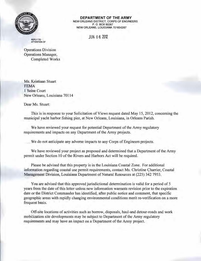
DEPARTMENT OF THE ARMY NEW ORLEANS DISTRICT, CORPS OF ENGINEERS
P. O. BOX 60267 NEW ORLEANS, LOUISIANA 70160-0267
JUN 04 2012 REPLY TO ATIENTION OF
Operations Division Operations Manager,
Completed Works
Ms. Kristiaan Stuart FEMA 1 Seine Court New Orleans, Louisiana 70114
Dear Ms. Stuart:
This is in response to your Solicitation of Views request dated May 15,2012, concerning the municipal yacht harbor fishing pier, at New Orleans, Louisiana, in Orleans Parish.
We have reviewed your request for potential Department of the Anny regulatory requirements and impacts on any Department of the Anny projects,
. We do not anticipate any adverse impacts to any Corps of Engineers projects.
We have reviewed your project as proposed and determined that a Department of the Army permit under Section 10 of the Rivers and Harbors Act will be required.
Please be advised that this property is in the Louisiana Coastal Zone. For additional information regarding coastal use permit requirements, contact Ms. Christine Charrier, Coastal , Management Division, Louisiana Department of Natural Resources at (225) 342 7953.
You are advised that this approved jurisdictional determination is valid for a period of 5 years from the date of this letter unless new information warrants revision prior to the expiration date or the District Commander has identified, after public notice and comment, that specific geographic areas with rapidly changing environmental conditions merit re-verification on a more frequent basis.
Off-site locations of activities such as borrow, disposals, haul-and detour-roads and work mobilization site developments may be subject to Department of the Army regulatory requirements and may have an impact on a Department of the Anny project.

-2
You should apply for said pennit well in advance of the work to be perfonned. The application should include sufficiently detailed maps, drawings, photographs, and descriptive text for accurate evaluation of the proposal.
Please contact Mr. Robert Heffner, of our Regulatory Branch by telephone at (504) 8621288, or bye-mail at [email protected] for questions concerning wetlands determinations or need for on-site evaluations. Questions concerning regulatory permit requirements may be addressed to Mr. Michael Farabee by telephone at (504) 862-2292 or by email at Michael. V [email protected].
Future correspondence concerning this matter should reference our account number MVJ'J2012-01294-SA. This will allow us to more easily locate records of previous correspondence, and thus provide a quicker response.
Sincerely,
Karen L. Oberlies Solicitation of Views Manager
Copy Furnished:
Ms. Christine Charrier Coastal Zone Management Department of Natural Resources Post Office Box 44487 Baton Rouge, Louisiana 70804-4487
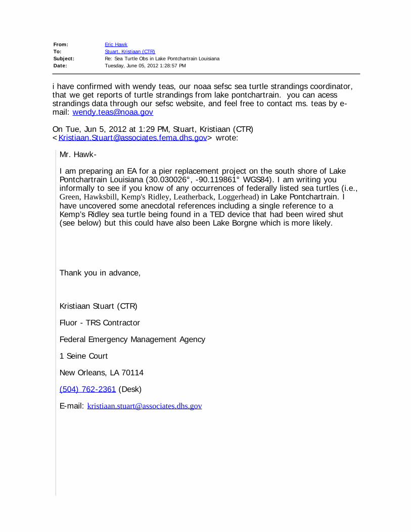
From: Eric HawkTo: Stuart, Kristiaan (CTR)Subject: Re: Sea Turtle Obs in Lake Pontchartrain LouisianaDate: Tuesday, June 05, 2012 1:28:57 PM
i have confirmed with wendy teas, our noaa sefsc sea turtle strandings coordinator,that we get reports of turtle strandings from lake pontchartrain. you can acessstrandings data through our sefsc website, and feel free to contact ms. teas by e-mail: [email protected]
On Tue, Jun 5, 2012 at 1:29 PM, Stuart, Kristiaan (CTR)<[email protected]> wrote:
Mr. Hawk-
I am preparing an EA for a pier replacement project on the south shore of LakePontchartrain Louisiana (30.030026°, -90.119861° WGS84). I am writing youinformally to see if you know of any occurrences of federally listed sea turtles (i.e.,Green, Hawksbill, Kemp's Ridley, Leatherback, Loggerhead) in Lake Pontchartrain. Ihave uncovered some anecdotal references including a single reference to aKemp’s Ridley sea turtle being found in a TED device that had been wired shut(see below) but this could have also been Lake Borgne which is more likely.
Thank you in advance,
Kristiaan Stuart (CTR)
Fluor - TRS Contractor
Federal Emergency Management Agency
1 Seine Court
New Orleans, LA 70114
(504) 762-2361 (Desk)
E-mail: [email protected]

http://www.seaturtle.org/mtn/archives/mtn83/mtn83p19.shtml
NOAA Nabs Turtle Killer
The US National Oceanic and Atmospheric Administration (NOAA) has charged thecaptain and the owner of a Louisiana shrimp trawler with civil violations of turtleexcluder device regulations and killing a Kemp's ridley sea turtle. Seniorenforcement attorney Karen Antrim Raine of NOAA's Office of General Counsel,prosecuting the case, put a civil penalty of US$6,000 in a Notice of Violation andAssessment against the skipper for violations that occurred in Lake Pontchartrain,LA. A US Coast Guard team boarded the trawler and found the turtle excluderdevice sewn shut, thus preventing the escape of a sea turtle that becameentrapped in it. Source: CommercePeople, September/October, 1998.<http://www.doc.gov/opa/photo/people/page14.htm>
-- Eric G. HawkNMFS Southeast RegionESA Section 7 Coordinator

United States Department of the Interior
FISH AND WILDLIFE SERVICE 646 Cajundome Blvd.
Suite 400 Lafayette, Louisiana 70506
June 5, 2012
Ms. Kristiaan Stuart Environmental and Historical Preservation Department Federal Emergency Management Agency 1 Seine Court New Orleans, Louisiana 70114
Dear Ms. Stuart:
Please reference your May 15,2012, letter, requesting our review of the Department of Homeland Security's Federal Emergency Management Agency's (FEMA) proposal to remove the City of New Orleans' Municipal Yacht Harbor fishing pier facility and construct a new fishing pier in an alternate location in New Orleans, Orleans Parish, Louisiana. The Fish and Wildlife Service (Service) has reviewed the information you provided, .an<;i offe.rs the fol~owing
" , " . • I ,
comments in accordance with the Endangered Species Act of 1973 (87 Stat. 884, as amended; 16 U.S.C.1531etseq.). " ' ' ' l
Federally listed as an endangered species, West Indian manatees (TYichechus 111(;matus) occasionally enter Lakes Pontchartrain and Maurepas, and associated coastal waters and streams during the summer months (i .e., June through September). Manatee occurrences appear to be increasing, and they have been regularly reported in the Amite, Blind, Tchefuncte, and Tickfaw Rivers, and in canals within the adjacent coastal marshes of Louisiana. They have also been occasionally observed elsewhere along the Louisiana Gulf coast. The manatee has declined in numbers due to collisions with boats and barges,entrapment in flood control structures, poaching, habitat loss, and pollution. Cold weather and outbreaks of red tide may also adversely affect these animals.
All contract personnel associated with the project should be informed of the potential presence of manatees and the need to avoid collisions with manatees, which are protected under the Marine Manunal Protection Act of 1972 and the Endangered Species Act of 1973. All construction personnel are responsible for observing water-related activities for the presence ofmanatee(s). Temporary signs should be posted prior to and during all construction/dredging activities to remind personnel to be observant for manatees during active construction/dredging operations or within vessel movement zones (i.e., work area), and at least one sign should be placed where it is visible to the vessel operator. Siltation barriers, if used, should be made of material in which manatees could not become entangled, and should be properly secured and monitored., If a manatee is sighted within 100 yards of the active work zone, special operating conditions should

be implemented, including: no operation of moving equipment within 50 feet of a manatee; all vessels should operate at no wake/idle speeds within 100 yards of the work area; and siltation barriers, if used, should be re-secured and monitored. Once the manatee has left the 100-yard buffer zone around the work area on its own accord, special operating conditions are no longer necessary, but careful observations would be resumed. Any manatee sighting should be immediately reported to the Service's Lafayette, Louisiana Field Office (3371291-3100) and the Louisiana Department of Wildlife and Fisheries, Natural Heritage Program (2251765-2821).
The Gulf sturgeon (Acipenser oxyrhynchus desotoi), federally listed as a threatened species, is an anadromous fish that occurs in many rivers, streams, and estuarine waters along the northern Gulf coast between the Mississippi River and the Suwannee River, Florida. In Louisiana, Gulf sturgeon have been reported at Rigolets Pass, rivers and lakes of the Lake Pontchartrain basin, and adjacent estuarine areas. Spawning occurs in coastal rivers between late winter and early spring (i.e., March to May). Adults and sub-adults may be found in those rivers and streams until November, and in estuarine or marine waters during the remainder of the year. Sturgeon less than two years old appear to remain in riverine habitats and estuarine areas throughout the year, rather than migrate to marine waters. Habitat alterations such as those caused by water control structures that limit and prevent spawning, poor water quality, and over-fishing have negatively affected this species.
On March 19,2003, the Service and the National Marine Fisheries Service (NMFS) published a final rule in the Federal Register (Volume 68, No. 53) designating critical habitat for the Gulf sturgeon in Louisiana, Mississippi, Alabama, and Florida. Portions of the Pearl and Bogue Chitto Rivers, Lake Pontchartrain east of the Lake Pontchartrain Causeway, all of Little Lake, The Rigolets, Lake St. Catherine, and Lake Borgne within Louisiana were included in that designation. The primary constituent elements essential for the conservation of Gulf sturgeon are those habitat components that support feeding, resting, sheltering, reproduction, migration, and physical features necessary for maintaining the natural processes that support those habitat components; . those elements should be considered when determining potential project impacts. The primary constituent elements for Gulf sturgeon critical habitat include:
• abundant prey items within riverine habitats for larval and juvenile life stages, and within estuarine and marine habitats for juvenile, sub-adult, and adult life stages;
• riverine spawning sites with substrates suitable for egg deposition and development, such as limestone outcrops and cut limestone banks, bedrock, large gravel or cobble beds, marl, soapstone, or hard clay;
• riverine aggregation areas, also referred to as resting, holding and staging areas, used by adult, sub-adult, and/or juveniles, generally, but not always, located in holes below normal river bend depths, believed necessary for minimizing energy expenditures during freshwater residency and possibly for osmoregulatory functions;
• a flow regime (i.e., the magnitude, frequency, duration, seasonality, and rate-of-change of freshwater discharge over time) necessary for normal behavior, growth, and survival of all life stages in the riverine environment, including migration, breeding site selection,
2

courtship, egg fertilization, resting, and staging; and necessary for maintaining spawning sites in suitable condition for egg attachment, egg sheltering, resting, and larvae staging;
• water quality, including temperature, salinity, pH, hardness, turbidity, oxygen content, and other chemical characteristics, necessary for normal behavior, growth, and viability of all life stages;
• sediment quality, including texture and other chemical characteristics, necessary for normal behavior, growth, and viability of all life stages; and
• safe and unobstructed migratory pathways necessary for passage within and between riverine, estuarine, and marine habitats (e.g., a river unobstructed by a permanent structure, or a dammed river that still allows for passage).
In that critical habitat designation, responsibility for consultation with specific Federal agencies was also identified for the Service and for the NMFS. For estuarine waters in Louisiana, the NMFS is responsible for consultations regarding impacts to the sturgeon and its critical habitat with all Federal agencies, except the Department of Transportation, the Envirorunental Protection Agency, the U.S. Coast Guard, and the Federal Emergency Management Agency, which consult with the Service. In riverine waters, the Service is responsible for all consultations regarding Gulf sturgeon and critical habitat, while in marine waters the NMFS is responsible for consultation. Should the proposed project directly or indirectly affect the Gulf sturgeon or its critical habitat in Louisiana, further consultation with this office will be necessary.
The proposed project may impact wetlands. For a complete jurisdictional wetland delineation of the proposed project, please contact Mr. Robert Heffner (504/862-2274) at the New Orleans District, U.S. Army Corps of Engineers (Corps). If the Corps determines that the proposed project is within their regulatory jurisdiction, official U.S. Fish and Wildlife Service comments will be provided in response to the corresponding Public Notice.
We appreciate the opportunity to provide comments in the planning stages of this proposed project. If you need further assistance, please contact Amy Trahan (3371291-3126) of this office.
Brad Rieck Deputy Field Supervisor Louisiana Ecological Services Office
3

cc: Corps of Engineers, New Orleans, LA LDWF, Natural Heritage Program, Baton Rouge, LA
4

BOBBY JINDAL
GOVERNOR ~tate of 'Jfiouisiamr ROBERT J. BARHAM
SECRETARY
DEPARTMENT OF WILDLIFE AND FISHERIES J,MMY L. ANTHONY
OFFICE OF WILDLIFE ASSISTANT SECRETARY
Date June 6, 2012
Name Kristiaan Stuart
Company FEMA
Street Address I Seine Ct
City, State, Zip New Orleans, LA 70113
Project City of New Orleans Municipal Yacht Harbor Fishing Pier
ProjectID 2442012
Invoice Number 12060607
Personnel of the Habitat Section of the Coastal & Non-Game Resources Division have reviewed the preliminary data for the captioned project. After careful review of our database, no impacts to rare, threatened, or endangered species or critical habitats are anticipated for the proposed project. No state or federal parks, wildlife refuges, scenic streams, or wildlife management areas are known at the specified site within Louisiana's boundaries.
The Louisiana Natural Heritage Program (LNHP) has compiled data on rare, endangered, or otherwise significant plant and animal species, plant communities, and other natural features throughout the state of Louisiana. Heritage reports sUllDnarize the existing information known at the time of the request regarding the location in question. The quantity and quality of data collected by the LNHP are dependent on the research and observations of many individuals. In most cases, this information is not the result of comprehensive or site-specific field surveys; many natural areas in Louisiana have not been surveyed. This report does not address the occurrence of wetlands at the site in question. Heritage reports should not be considered final statements on the biological elements or areas being considered, nor should they be substituted for onsite surveys required for envirorunental assessments. LNHP requires that this office be acknowledged in all reports as the source of all data provided here. If at any time Heritage tracked species are encountered within the project area, please contact the LNHP Data Manager at 225-765-2643 . If you have any questions, or need additional information, please call 225-765-2357.
Sincerely,
~~ Amity Bass, Coordinator Natural Heritage Program
P .O. BOX 98000 • BATON ROUGE, LOUISIANA 70898·9000· PHONE (22S) 765·2800
AN EQUAL OPPORTUNrTY EMPLOYER

BOBBY JINDAL ROBERT J. BARHAM
GOVERNOR ~htf£ of 1fiouisiamt SECRETARY
DEPARlMENT OF WILDLIFE AND FlSHERIES JIMMY L. ANTHONY
OFFICE OF WILDLIFE ASSISTANT SECRETARY
INVOICE
RETAIN THIS COPY FOR YOUR RECORDS
Date June 6, 2012
Invoice Number 12060607
Project City of New Orleans Municipal Yacht Harbor Fishing Pier
Name Kristiaan Stuart
Company FEMA
Street Address 1 Seine Ct
City, State, Zip New Orleans, LA 70113
Number ofQuads Reviewed
Total Due $0.00
Payment should be made to "Louisiana Department of Wildlife & Fisheries" within 30 days of the date of this invoice. Please include the invoice number on your check and return a copy of this invoice wi th your remi ttance to the following address:
Louisiana Department of Wildlife & Fisheries Attn: Jennifer Riddle P.O. Box 80399 Baton Rouge, LA 70898-0399
Should you have any questions regarding this invoice, for review of the Louisiana Natural Heritage database for infonnation on known sensitive elements at a charge of $20.00 per quad reviewed, please contact LNHP at (225) 765-2357.
P.O. BOX 98000 • BATON ROUGE. LOUISIANA 70898'9000 ' PHONE (225) 765-2800
AN EDUAL OPPORTUNrTY EMPL~

BOBBY JINDAL ROBERT J. BARHAM
GOVERNOR ffi'hxt£ llf 1£illuisinmt SECRETARY
DEPARTMENT OF WILDLIFE AND FISHERIES JIMMY L. ANTHONY
OFFICE OF WILDLIFE ASSISTANT SECRETARY
INVOICE
Date RETURN THIS COpy OF INVOICE WITH PAYMENT
June 6,2012
Invoice Number 12060607
Project City of New Orleans Municipal Yacht Harbor Fishing Pier
Name Kristiaan Stuart
Company FEMA
Street Address 1 Seine Ct
City, State, Zip New Orleans, LA 70113
Number ofQuads Reviewed
Total Due $0.00
Payment should be made to "Louisiana Department of Wildlife & Fisheries" within 30 days of the date of this invoice. Please include the invoice number on your check and return a copy of this invoice with your remittance to the following address:
Louisiana Department of Wildlife & Fisheries Attn: Jennifer Riddle P.O. Box 80399 Baton Rouge, LA 70898-0399
Should you have any questions regarding this invoice, for review of the Louisiana Natural Heritage database for information on known sensitive elements at a charge of $20.00 per quad reviewed, please contact LNHP at (225) 765-2357.
P.O. BOX 98000 • BAroN ROUGE. LOUISIANA 70898·9000 • PHONE (225) 765'2800
AN EQUAL OPPORTlJNflY EMPLOYER

1
June 28, 2012 David M. Bernhart Asst. Regional Administrator NOAA Fisheries Service Southeast Regional Office Protected Resources Division 263 13th Avenue South Saint Petersburg, Florida 33701
SUBJECT: Informal Consultation, Request for Endangered Species Act Determination Concurrence for the: loggerhead, Kemp’s ridley, & green sea turtles
City of New Orleans’ Municipal Yacht Harbor (applicant) Municipal Yacht Harbor Fishing Pier Removal and Replacement (project) FEMA-DR-1603, PW 11698, AIDB 1776
Dear Mr. Bernhart: The Federal Emergency Management Agency (FEMA) is reviewing the potential funding, pursuant to the Robert T. Stafford Disaster Relief and Emergency Assistance Act (Stafford Act), PL 93-288, as amended; of a pier removal and alternate location replacement project for the City of New Orleans (applicant). The project area is located on the southern shoreline of Lake Pontchartrain, Louisiana at the City of New Orleans Municipal Yacht Harbor in the West End neighborhood area (Figure 1). The proposed project has elements in both Jefferson and Orleans Parish’s. Jefferson Parish follows the western shoreline and includes the original pier location and Orleans Parish adjoins Jefferson Parish to the east and includes the proposed new pier location (Figures 1 & 2). Under Section 7 (a)(2) of the Endangered Species Act of 1973 (87 Stat. 884, as amended; 16 U.S.C. 1531 et seq.) (ESA), FEMA is requesting the NOAA Fisheries Service (NMFS) concurrence for a “May Affect, but Not Likely to Adversely Affect” (NLAA) determination for the green, Kemp’s ridley and loggerhead sea turtles given the behavioral attributes and biological needs of each species, existing habitat conditions within the action area (Figure 2) and the implementation of project conservation measures. FEMA has initiated informal consultation, separately, with USFWS regarding federally listed species under its purview with FEMA. On June 05, 2012 our office contacted fisheries biologist Eric Hawk from the NOAA Fisheries Service, Southeast Regional Office regarding the potential for federally listed sea turtles to be present in Lake Pontchartrain, Louisiana. Mr. Hawk in consultation with Wendy Teas (NOAA’s
U.S. Department of Homeland Security Federal Emergency Management Agency Louisiana Recovery Office #1 Seine Court, Room 1065 New Orleans, Louisiana 70114 (504) 762-2000 office (504) 762-2410 fax

2
SEFSC Sea Turtle Strandings Coordinator) confirmed that the loggerhead sea turtle is a known occurrence and to a lesser extent Kemp’s ridley and green sea turtles are potentially present as well. On May 15, 21012 our office contacted Lead Fisheries Biologist Richard Hartman (NOAA Fisheries Service, Baton Rouge Field Office) for a solicitation of views (SOV) request concerning this project. Mr. Hartman identified habitat components and fish species for consideration of Essential Fish Habitat (EFH) under the provisions of the Magnuson-Stevens Fishery Conservation and Management Act. Mr. Hartman also identified the Gulf sturgeon for consideration under the ESA. As part of an Environmental Assessment under the National Environmental Policy Act (NEPA) that is being prepared by our office for this project EFH for those species identified will be addressed. The Gulf sturgeon and the West Indian manatee are under the purview of USFWS for FEMA related ESA Section 7 consultations and therefore we have initiated consultation with the USFWS’ Louisiana Ecological Service’s Office in Lafayette, Louisiana for those species under the ESA and the Marine Mammal Protection Act of 1972 (MMPA), respectively. Additionally our office is aware of bottlenose dolphin (Tursiops truncatus) sightings in Lake Pontchartrain but consider these sightings outliers to typical bottlenose dolphin behavior and habitat selection. The relatively low salinity conditions in Lake Pontchartrain have been observed to actually be deleterious to bottlenose dolphins (Holyoake et al. 2009). Therefore FEMA under the MMPA is issuing a “No Effect” determination for the proposed projects potential impacts to bottlenose dolphin. A site visit was conducted by FEMA’s New Orleans LRO, Environmental Historic Preservation Department on June 08, 2012 at the City of New Orleans’ Municipal Yacht Harbor. The site visit was conducted by Adam Borden (Lead Environmental Protection Specialist) and Kristiaan Stuart (Environmental Protection Specialist). A reconnaissance level survey was conducted during the site visit to assess available habitat for federally listed species, the presence or absence of sensitive habitat areas including wetlands and determine the proposed project layout plans relative to any sensitive species or habitat areas.

3
FEMA – 1603-DR-LA AIDB #1776
City of New Orleans Municipal Yacht Harbor Pier Replacement
Figure 1 Project Vicinity
Map Area
Project Area
Map data from USGS 1:100,000 Ponchatoula & New Orleans Topo

4
FEMA – 1603-DR-LA AIDB #1776
City of New Orleans Municipal Yacht Harbor Pier Replacement
Figure 2 Project Area – Aerial View
17th Street Canal
Original Pier Location
Proposed Pier Location
Wetland
Breakwater Park
West End Park
Breakwater
Breakwater Drive Municipal Yacht Harbor
Action Area
Scale 600-ft 300-ft

5
Site Conditions Site conditions were assessed during the reconnaissance survey on June 08, 2012. Meteorological conditions that day included low clouds with light rain, air temperature at 82°F, and medium winds S-SW at 8 – 11 mph. A list of all species encountered was taken during the site visit (see Attachments).
Original Pier Location The first location assessed was the original pier location where remnants (mostly vertical piles) of the pier still remain. The pier piles were submerged in water ranging in depth of approximately 6-inches to several feet. The submerged portions of the piles were covered in filamentous algae and did not appear to have any bivalves attached to them. As with most piers it is likely these piles offer anchoring and feeding habitat for invertebrates and feeding habitat for small fishes and shore birds that feed on these animals. A Black-crowned Night-heron for example was observed on the shore line using the pier structure for cover and feeding habitat. The substrate around the original pier started on the shore line as large boulder and cobble sized fragments of concrete armoring and became smaller to mostly cobble sized pieces with gravels interspersed between. Beyond a depth of approximately 3.0-ft the substrate could not be identified due to water turbidity. There were no signs of floating or anchored-submerged aquatic vegetation within visual range or evidenced in aerial imagery around the original pier location.
The substrate of Lake Pontchartrain largely consists of muck with hard and sandy substrates being a limiting factor for many benthic invertebrate species (Whitmore 2006). According to Ross et al. (2008) subadult and adult sturgeon predominantly utilize shallow waters with sandy substrates with a high potential prey abundance of benthic invertebrates. Areas not consistent with a thick muddy bottom in Lake Pontchartrain would be in areas with increased fluvial velocities such as river mouths and tidal inlets where sediment sorting is more likely to occur and fluvial morphological features such as shoals are more likely to be present. Based on aerial measurements from GoogleEarth (2011) the original pier site is located approximately 2,250-ft north of the 17th Street Canal outflow gates (Figure 2). With an operational outflow velocity of 4.2 knots that extends to the end of the breakwater wall (unpublished data) it is probable that the substrate in the outfall area is moderately different than surrounding areas outside of the outfall thalweg. The upland areas surrounding the original pier location is consistent with a public park setting with predominantly ruderal habitat areas including ornamental plantings, cultivar escapees, paved parking areas, street lighting and paved roadways. There were no signs on the shoreline substrate, the pier pilings or utility poles of new or old migratory bird nests or evidence of accumulations of white-wash that would suggest this site in particular is being used extensively by large shore birds (e.g. egrets and herons) or other migratory bird species (e.g. Osprey and Bald Eagles).
Proposed Pier Location The area around the proposed pier location includes parking areas, boat launch facility, an open grassy area of Breakwater Park and a breakwater wall that extends north into Lake Pontchartrain for approximately 160-feet and then westward for an additional 400-feet. Like the original pier location the upland habitat areas are either maintained as open recreational fields or are ruderal areas with little to no native vegetation. Approximately 300-feet to the west of the breakwater wall is a constructed drainage with an associated freshwater emergent wetland that runs from north to south
6
and was created to drain storm runoff from Breakwater Drive. The north end of the drainage appeared to have a small, approximately 6-inch culvert, that drained the ditch into Lake Pontchartrain but this area has been filled in with soil and the direct connection no longer exists. The littoral area between the northern margin of Breakwater Park and Lake Pontchartrain is predominantly boulder sized recycled concrete armoring with course gravels and bivalve shells comprising the interstitial spaces. The larger substrate represented the predominant size class in the wetted littoral margin. No shore birds were seen utilizing this area for foraging or cover during the site visit. The larger concrete substrate also follows the outer lakeside margin of the breakwater wall. This substrate was covered with filamentous algae and did not have any signs of attached bivalve invertebrates. There were no signs of natant, anchored-submerged or emergent aquatic vegetation within visual range or evidenced in aerial imagery around the proposed pier location. There are several oak trees (Quercus nigra) lining Breakwater Drive. These medium sized oak trees could be used for nesting and perching habitat for bird species ranging from a Red-shouldered Hawk sized bird and smaller. There was no evidence of nests or white-wash that would suggest perching or pecking habitat utilization in these trees. Action Description
Land Operations Land based operations will include the use of heavy equipment such as cranes to remove and install landside pier pilings, excavation equipment to remove soil to create a grade suitable for the concrete ramp portion of the proposed new pier, dump trucks to deliver sands and gravels and haul away debris and excavated soils, concrete mixing / delivery trucks, flat bed or low-boy tractor trailers to deliver heavy equipment to the site and pier structural components, front end loaders to move soils and debris from the site to dump trucks. Heavy equipment has the potential to leak and spill hydrocarbon based compounds (e.g. fuels, lubricants, brake and antifreeze fluids) during normal operations and require appropriate spill prevention and cleanup methods and materials. Heavy equipment will also produce noise above baseline conditions from running engines, earth moving actions, removing and delivering facility components and loading and unloading the heavy equipment from transport vehicles. Staging areas will need to be established for stockpiling refuse and debris related to pier removal and installation and materials needed to create the concrete ramp and wooden pier facility. Any earthen materials staged onsite have the potential to escape as fugitive dust or as sediment. Sediment generated during rain events has the potential to enter Lake Pontchartrain if sediment control is not implemented. Areas where ground disturbing activities such as excavated areas and areas that may be disturbed from heavy equipment also have the potential to release sediment to Lake Pontchartrain if adequate erosion mitigations are not implemented. Any pipe or conduit material staged onsite has the potential to be used by animals for temporary shelter, hiding habitat or curiosity. The larger the inside diameter of the pipe typically the larger the animal it can stow.
Water Operations Project activities will include the use of powered and likely unpowered (barge) water vessels fitted with a crane to remove pier pilings and various structural attachments from the original pier facility and for the placement of new pier pilings at the proposed new pier location. Powered water vessels

7
have the potential in shallow waters to dislodge and disperse sediment from the lake bottom, pose a risk of propeller strikes, have the potential to spill hydrocarbon based liquids and will produce noise from the engine and active propeller.
Pier Piling Removal Process The pier removal process may utilize any of three different methods: direct pull, vibratory extraction and / or clam shell depending on the condition of the pier pilings. The direct pull method utilizes a cable choker attached to a crane that pulls in a vertical direction to lift the piling directly out of the substrate and water column. The vibratory extraction method utilizes a large vibration hammer attached to the pier piling and lifted by a crane while the vibration hammer loosens the piling from the substrate. The clam shell method is used if a piling is broken and cannot be directly lifted from its footing. This method utilizes a clam shell bucket to excavate the substrate around the piling until it can be removed from the water. Any of these methods will remove the pilings from the water where they then can be disposed of properly. Removing the pilings from the substrate will release lakebed sediments into the water column which could cause a temporary disturbance to aquatic wildlife in the immediate area. The direct pull method would cause the least amount of impact. The vibratory extraction method will in addition to releasing sediment into the nearby waters will also emanate a sonic field that could disturb aquatic wildlife. Piling extraction with this method may take between 15 to 30 minutes per piling depending on substrate conditions and piling insertion depth. The original pier has approximately 70 pilings that will need to be removed. Lastly the clam shell bucket technique will likely be employed as several pilings have been broken near, at and below the water line. This method has the potential to dislodge and release the greatest amount of sediment into the water column.
Pier Piling Installation Process The piling installation process may incorporate either an impact hammer or vibration head technique suspended from a crane which would be fitted to a water vessel or land based machinery. In either method the new piling is supported vertically while resting on the lakebed as either a piston-like hammer head or a vibratory hammer head drives the piling into the substrate at a depth sufficient to provide the necessary vertical support. Either method will release a minor amount of sediment from the lakebed into the water column which could disturb aquatic animals in the vicinity. Both the vibratory hammer head and the impact hammer method will emanate a sonic field that could disturb aquatic wildlife in the vicinity of the action. Approximately 69 pilings are scheduled for placement within the wetted area of Lake Pontchartrain. Ten pilings are scheduled to be installed on the bank leading to Lake Pontchartrain.
Federally Listed Species Using USFWS’s IPac portal, to determine the potential for federally listed species to be present in Jefferson and Orleans Parish, generated ten species that are either candidates for listing or are federally listed as threatened or endangered. Table 1 below accounts for the IPac database results in addition to the FWS’s Critical Habitat Mapper results for federally listed species that also have designated critical habitat (USFWS 2012). Of the ten federally listed species identified five have the potential for occurring in or near the project area: Gulf sturgeon (FT), West Indian manatee (FE), green sea turtle (FT), Kemp’s ridley sea turtle (FE) and the loggerhead sea turtle (FT).

8
The following species are under the purview of NMFS per their joint agreement with the USFWS for FEMA related ESA § 7 (a)(2) consultations.
Reptiles Five species of sea turtles were identified as having the potential to occur in Jefferson and/or Orleans Parish (Table 1) (USFWS 2012). Based on personal communication with fisheries biologist Eric Hawk (NMFS SERO), stranding data from NMFS’ Sea Turtle Stranding and Salvage Network (NOAA 2012) and a confirmed report of a Lake Pontchartrain shrimp trawler ensnaring a Kemp’s ridley sea turtle (seaturtle.org 1999); the following Threatened and Endangered sea turtle species are uncommon yet should be assumed to be present in Lake Pontchartrain: green sea turtle, Kemp’s ridley sea turtle and the loggerhead sea turtle.
Loggerhead Sea Turtle (Northwest Atlantic DPS) (FT - Louisiana)
On September 22, 2011, NMFS and USFWS issued a final rule changing the listing of loggerhead sea turtles from a single, threatened species to nine distinct population segments (DPSs) based on genetic information and known ranges. These DPSs were listed as either threatened or endangered (76 FR 58868). The Northwest Atlantic (NWA) DPS was listed as threatened under the ESA. The NWA DPS includes those areas approximately between the southern tip of Greenland to the northeast of Brazil and extends westward to include all of the Northern Atlantic to the continental seaboards (NMFS 2012). The NWA DPS was further divided into five recovery units. The Northern Gulf of Mexico Recovery Unit encompasses those areas from Franklin County, Florida through Texas (76 FR 58868).
The loggerhead sea turtle inhabits continental shelf and estuarine environments and occurs throughout the temperate and tropical regions of the Atlantic, Pacific, and Indian Oceans (Dodd 1988). In the western North Atlantic the loggerhead sea turtle predominantly nests from central North Carolina to southern tip of Florida with sporadic nesting sites along the shores of the Gulf of Mexico including Louisiana (Dodd 1988). While nesting has been known to occur on the barrier islands off the Louisiana coast this area is not known to be as frequently used as the Gulf coastlines of Alabama and west Florida (NMFS 2012, Dodd 1988).
As hatchlings loggerhead sea turtles enter the sea from their natal beaches and typically begin a pelagic lifestyle that lasts from 7 to 12 years. These pelagic juveniles will occupy oceanic gyres and other loop currents (i.e. Gulf of Mexico) and feed opportunistically on various floating and emergent prey items (Dodd 1988, NMFS 2012, Witherington 2002). In the western Atlantic, subadult developmental habitats may also include lagoons, estuaries, and the mouths of bays and rivers rich in food resources (Dodd 1988). Witzell (2002) suggests that some subadult loggerheads may not follow the gyre specific paradigm and may move between neritic and pelagic foraging habitat areas. Sub-adult and adult loggerheads are primarily found in coastal waters and prey on benthic invertebrates such as molluscs (e.g. snails, clams, squid) and decapods (e.g. crabs, shrimp) in hard bottom habitats (NMFS 2012).
There are several known threats to sea turtles in general. Natural threats include predation by terrestrial animals (e.g. raccoons, ghost crab, fire ants) during hatching and marine predators (e.g. predatory fishes) when they have reached the water. Sharks continue to be a chief predator of sea turtles well beyond the juvenile and sub-adult years. Some of the many anthropogenic threats include: ingestion of floating debris, entrapment in floating debris, pollution, collisions with boat propellers and various types of commercial fishing bycatch. Climate change may also be a contributing threat with increases in severity and frequency of storms, rising beach temperatures

9
during egg incubation and species range as determined by temperature.
Lake Pontchartrain has limited hard bottom substrate and comprised largely of a muddy (mucky) bottom comprised of small silt and clay particles (USGS 2002, Whitmore 2006). Lake Pontchartrain is used extensively for the commercial harvest of white and brown shrimp, blue crabs and until 1990 was used extensively for the harvest of Rangia cuneata clams (Abadie and Poirrier 2002). These abundant invertebrate species are within the wide range of prey items for the loggerhead sea turtle and may account for the presence of this species in Lake Pontchartrain.
Kemp’s Ridley Sea Turtle (FE) The Kemp’s ridley sea turtle range extends from the southern coast of the Yucatan Peninsula north to include all of the Gulf of Mexico and all of the western Atlantic seaboard from south Florida to Nova Scotia (NMFS 2007). This species nests almost exclusively off the coast of Mexico at Rancho Nuevo between May and July in mass nesting events called arribadas (Shaver et al. 2005). Like the loggerhead sea turtle the neonate Kemp’s ridley utilize the Loop Current in the Gulf of Mexico and may be taken to the Gulf Stream current by way of the Antilles Current. This pelagic developmental time may last up to two years at which time the Kemp’s ridley becomes a neritic species (Collard and Ogren 1990). Adult Kemp’s ridley’s utilize hard and muddy bottom substrates in the shallow areas of the coastal Gulf of Mexico for foraging habitat. Prey items include crabs, fish, jellyfish, and various molluscs.
The inshore areas of Louisiana offer foraging habitat for Kemp’s ridley with an abundance of benthic invertebrates found in various substrates. Lake Pontchartrain as mentioned has a muddy substrate and an abundance of invertebrate prey species. Recent stranding data for the Kemp’s ridley for northern Gulf of Mexico identifies an occurrence in or near Lake Pontchartrain (NOAA 2012).
Possible threats are common with all other sea turtles.
Green Sea Turtle (FT- Louisiana) The green turtle has a circumglobal distribution, occurring throughout tropical, subtropical waters and to a lesser extent temperate waters (NMFS and USFWS 2007). In U.S. Atlantic waters, green turtles are found in inshore and nearshore waters around the U.S. Virgin Islands, Puerto Rico, and continental United States from Texas to Massachusetts (NMFS and USFWS 1991). In the U.S., green turtles nest primarily along the central and southeast coast of Florida. The Florida breeding population is federally listed as Endangered (NMFS and USFWS 2007). As with other sea turtles the green sea turtle from hatching begins an oceanic lifestyle and may remain in various gyres and oceanic loop currents for 5 to 6 years before transitioning to a neritic lifestyle. Near shore and inshore habitats typically selected include those areas rich with sea grass and algae. Green sea turtles may remain in these protected areas for up to 6 years. Once established these foraging areas will be returned to after breeding migrations every few years (NMFS and USFWS 2007). Diet for the green sea turtle includes sea grasses, algae and invertebrates including jellyfish and ctenophores (Heithaus et al. 2002). Lake Pontchartrain itself may not offer suitable foraging habitat for the green sea turtle but the several freshwater inlets of Lake Pontchartrain may offer foraging habitat with dense areas of submerged aquatic vegetation and algae. Northern Gulf of Mexico stranding data for loggerhead, Kemp’s ridley and green sea turtles indicates a recent stranding in the first half of 2012 of a green sea turtle on the northeastern shore of Lake Pontchartrain near the Rigolets (NOAA 2012).

10
Possible threats are common with all other sea turtles. Current literature does not address the salinity preferences of sea turtles but inferences can be made that brackish environments like that found in Lake Pontchartrain at least in an ephemeral sense support foraging behavior (Morreale and Standora 2005). With recent insights into sea turtle behavior much of the baseline knowledge regarding sea turtle migrations, site selection, feeding habits, juvenile vs. adult behavior is constantly being challenged and revised (Heithaus et al. 2002, Morreale and Standora 2005, McClellan and Read 2007).

11
Table 1 - Candidate, Threatened or Endangered Species Known to Occur in Jefferson and/or Orleans Parish
Common Name
Scientific Name
Federal Status†
Critical Habitat
Agency Jurisdiction
(FEMA)
Habitat Requirements
Determination‡ / Rationale
Birds
Piping Plover
Charadrius melodus Threatened Yes3 USFWS
Shore bird that breeds in the Great Lakes and northern plains regions and overwinters on the coastlines of the Gulf of Mexico. Preferred overwintering habitat is coastal sand dunes and algal matt areas.
No Effect / Suitable overwintering habitat (P = 0.1) for this species is not found in or near the proposed project area. Closest designated Critical Habitat is > 20 miles south of proposed project location.
Sprague's Pipit
Anthus spragueii Candidate No USFWS
Grassland bird that overwinters during its non-breeding season from western Louisiana to Mexico and southwestern states.
No Effect / Project area is outside the suggested overwintering range of this species.
Fishes
Gulf sturgeon
Acipenser oxyrinchus
desotoi Threatened Yes USFWS
Anadromous species that spends most of its life in marine habitats and spawns in riverine systems. Found in a variety of substrate areas based on age class of species.
NLAA / Project area is located in designated critical habitat. Project activities will not have a significant impact on critical habitat constituents. Effects may include temporary disturbance.
Pallid sturgeon
Scaphirhynchus albus Endangered No USFWS
A freshwater obligate species. Prefers large, free-flowing turbid river bottoms. No information exists on preferred spawning habitat.
No Effect / No suitable habitat present.
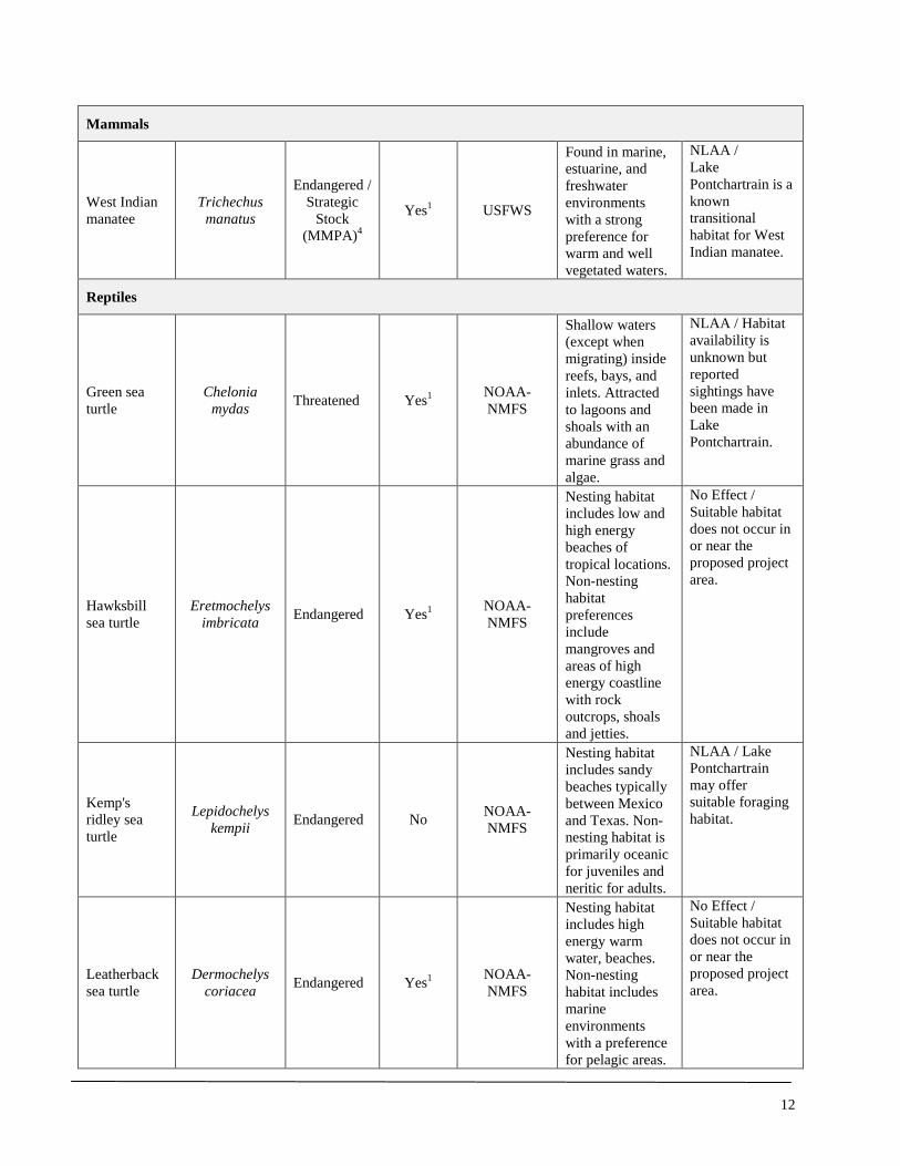
12
Mammals
West Indian manatee
Trichechus manatus
Endangered / Strategic
Stock (MMPA)4
Yes1 USFWS
Found in marine, estuarine, and freshwater environments with a strong preference for warm and well vegetated waters.
NLAA / Lake Pontchartrain is a known transitional habitat for West Indian manatee.
Reptiles
Green sea turtle
Chelonia mydas Threatened Yes1 NOAA-
NMFS
Shallow waters (except when migrating) inside reefs, bays, and inlets. Attracted to lagoons and shoals with an abundance of marine grass and algae.
NLAA / Habitat availability is unknown but reported sightings have been made in Lake Pontchartrain.
Hawksbill sea turtle
Eretmochelys imbricata Endangered Yes1 NOAA-
NMFS
Nesting habitat includes low and high energy beaches of tropical locations. Non-nesting habitat preferences include mangroves and areas of high energy coastline with rock outcrops, shoals and jetties.
No Effect / Suitable habitat does not occur in or near the proposed project area.
Kemp's ridley sea turtle
Lepidochelys kempii Endangered No NOAA-
NMFS
Nesting habitat includes sandy beaches typically between Mexico and Texas. Non-nesting habitat is primarily oceanic for juveniles and neritic for adults.
NLAA / Lake Pontchartrain may offer suitable foraging habitat.
Leatherback sea turtle
Dermochelys coriacea Endangered Yes1 NOAA-
NMFS
Nesting habitat includes high energy warm water, beaches. Non-nesting habitat includes marine environments with a preference for pelagic areas.
No Effect / Suitable habitat does not occur in or near the proposed project area.
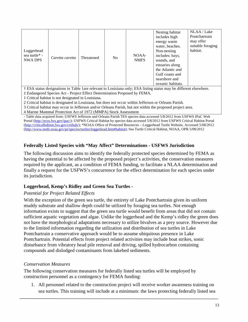
13
Loggerhead sea turtle* - NWA DPS
Caretta caretta Threatened No NOAA-NMFS
Nesting habitat includes high energy warm water, beaches. Non-nesting includes: bays, sounds, and estuaries along the Atlantic and Gulf coasts and nearshore and oceanic habitats.
NLAA / Lake Pontchartrain may offer suitable foraging habitat.
† ESA status designations in Table 1are relevant to Louisiana only; ESA listing status may be different elsewhere. ‡ Endangered Species Act - Project Effect Determination Proposed by FEMA. 1 Critical habitat is not designated in Louisiana. 2 Critical habitat is designated in Louisiana, but does not occur within Jefferson or Orleans Parish. 3 Critical habitat may occur in Jefferson and/or Orleans Parish, but not within the proposed project area. 4 Marine Mammal Protection Act of 1972 (MMPA) Stock Assessment - Table data acquired from: USFWS Jefferson and Orleans Parish TES species data accessed 5/8/2012 from USFWS IPaC Web Portal (http://ecos.fws.gov/ipac/); USFWS Critical Habitat by species data accessed 5/8/2012 from USFWS Critical Habitat Portal (http://criticalhabitat.fws.gov/crithab/); *NOAA Office of Protected Resources – Loggerhead Turtle Website, Accessed 5/08/2012 (http://www.nmfs.noaa.gov/pr/species/turtles/loggerhead.htm#habitat); Sea Turtle Critical Habitat, NOAA, OPR 5/08/2012 Federally Listed Species with “May Affect” Determinations - USFWS Jurisdiction The following discussion aims to identify the federally protected species determined by FEMA as having the potential to be affected by the proposed project’s activities, the conservation measures required by the applicant, as a condition of FEMA funding, to facilitate a NLAA determination and finally a request for the USFWS’s concurrence for the effect determination for each species under its jurisdiction.
Loggerhead, Kemp’s Ridley and Green Sea Turtles - Potential for Project Related Effects With the exception of the green sea turtle, the entirety of Lake Pontchartrain given its uniform muddy substrate and shallow depth could be utilized by foraging sea turtles. Not enough information exists to suggest that the green sea turtle would benefit from areas that did not contain sufficient aquatic vegetation and algae. Unlike the loggerhead and the Kemp’s ridley the green does not have the morphological adaptations necessary to utilize bivalves as a prey source. However due to the limited information regarding the utilization and distribution of sea turtles in Lake Pontchartrain a conservative approach would be to assume ubiquitous presence in Lake Pontchartrain. Potential effects from project related activities may include boat strikes, sonic disturbance from vibratory head pile removal and driving, spilled hydrocarbon containing compounds and dislodged contaminants from lakebed sediments. Conservation Measures The following conservation measures for federally listed sea turtles will be employed by construction personnel as a contingency for FEMA funding:
1. All personnel related to the construction project will receive worker awareness training on sea turtles. This training will include at a minimum: the laws protecting federally listed sea

14
turtles (Endangered Species Act of 1973) as federally threatened or endangered species, a definition of “take” as it applies to the Endangered Species Act, the fines and possible imprisonment for take of a federally listed sea turtle, images of sea turtles as they are likely to be seen in Lake Pontchartrain, vessel work area restrictions and special operating conditions, monitoring requirements, procedures if a sea turtle is sighted within 100-yards of the active work zone and who to call and who will call if a sea turtle is sighted. All personnel will need to sign a worker awareness training sign-in sheet as a record of their attendance and training received. Any new workers that did not receive the training will need to be trained before working in or near construction areas that require in-water work.
2. One person per construction site will be made responsible by their crew lead (if not the lead) to call the phone numbers stated here in the event a sea turtle is sighted. NMFS Baton Rouge Field Office (504) 389-0508 and the LDWF, Natural Heritage Program (225) 765-2821.
3. All construction personnel will be responsible for monitoring water-related activities for the presence of sea turtles as part of their regular duties.
4. The following are special conditions that will be followed in the event a sea turtle is sighted within 100-yards of the project area:
a. All construction personnel will have “Stop Work” authority if they see a sea turtle within 50-feet of a construction activity including moving vessels.
b. All vessels will operate at no-wake/idle speeds within 100-yards of the work area. c. In-water sediment barriers or siltation barriers will need to be re-secured and
monitored. d. Work will only resume without restriction when a sighted sea turtle is greater than
100-yards away from the project area.
Effect Determination Based on the best currently available scientific information for the loggerhead, Kemp’s ridley and green sea turtle’s biological requirements and the required conservation measures identified above, FEMA is suggesting that any project related effects to these species will be discountable and is therefore requesting the NOAA Fisheries Service concurrence for a “May Affect, but Not Likely to Adversely Affect” determination for each of these species. No critical habitat for these species occurs in or near the project area and therefore will not be impacted by project related activities.

15
We would appreciate your review of the above determinations as they pertain to the Endangered Species Act of 1973. If you have any questions regarding this letter or need further clarification please call Mr. Kristiaan Stuart at (504) 762-2361 or email at [email protected]. Sincerely, Tiffany Spann-Winfield
Deputy Environmental Liaison Officer
FEMA LRO, Region VI
CC:
USFWS, Louisiana Ecological Services Office
Corps of Engineers, New Orleans, LA
LDWF, Natural Heritage Program, Baton Rouge, LA
Attachments: Site Visit Species List

16
REFERENCES "Endangered and Threatened Species; Determination of Nine Distinct Population Segments of
Loggerhead Sea Turtles as Endangered or Threatened.” Final Rule. Federal Register 76 (22 September 2011): 58868-58952. Print.
Abadie, S. W. and M. A. Poirrier. 2002. Recent Trends in Water Clarity and Clam Abundance. In Environmental Atlas of the Lake Pontchartrain Basin. USGS (online). Available at: http://pubs.usgs.gov/of/2002/of02-206/env-issues/clam-abundance.html
Collard, S. B. and L. H. Ogren. 1990. Dispersal Scenarios for Pelagic Post-hatchling Sea Turtles. Bulletin of Marine Science 47: 233-243.
Dodd, C. K. 1988. Synopsis of the biological data on the loggerhead sea turtle: Caretta caretta (Linnaeus, 1758). Biological Report 88 (14). Fish and Wildlife Service, U.S. Dept. of the Interior. Washington, D.C.
Heithaus, M. R., J. J. McLash, A. Frid, L. M. Dill and G. J. Marshall. 2002. Novel insights into green sea turtle behaviour using animal-borne video cameras. Journal of Marine Biology Association of the United Kingdom 82: 1049-1050.
Holyoake C., H. Finn, N. Stephens, P. Duignan, C. Salgado, H. Smith, L.Bejder, T. Linke, C. Daniel, K. Moiler, H. N. Lo, G. S. Ham, S. Allen, K. Bryant, and D. McElligott. 2009. Technical Report on the Bottlenose Dolphin (Tursiops aduncus) Unusual Mortality Event within the Swan Canning Riverpark, June-October 2009. Murdoch University, School of Veterinary and Biomedical Sciences. Murdoch, Western Australia.
McClellan, C. M. and A. J. Read. 2007. Complexity and variation in loggerhead sea turtle life history. Biology Letters 3: 592-594.
Morreale, S. J., E. A. Standora. 2005. Western North Atlantic waters: crucial developmental habitat for Kemp’s ridley and loggerhead sea turtles. Chelonian Conservation Biology 4: 872–882.
NMFS. 2007. Kemp’s Ridley Sea Turtle Range (map). Office of Protected Resources, NMFS, NOAA. St. Petersburg, FL.
______. 2012. Biological Opinion - Reinitiation of Endangered Species Act (ESA) Section 7 Consultation on the Continued Implementation of the Sea Turtle Conservation Regulations, as Proposed to Be Amended, and the Continued Authorization of the Southeast U.S. Shrimp Fisheries in Federal Waters under the Magnuson-Stevens Act. NOAA, NMFS, SERO, Protected Resources Division (F/SER3) and Sustainable Fisheries Division (F/SER2), St. Petersburg, FL.
NMFS and USFWS. 2007. Green Sea Turtle (Chelonia mydas). 5-year Review: Summary and Evaluation. National Marine Fisheries Service, Silverspring, MD.
______. 1991. Recovery Plan for U.S. Population of Atlantic Green Turtle. National Marine Fisheries Service, Washington, D.C.
NOAA. 2012. Documented Sea Turtle Strandings in the Northern Gulf of Mexico (AL, LA, MS, and upper TX) from 01/01/12 – 06/24/2012 (map). NOAA, Southeast Regional Office, St. Petersburg, FL.
Seaturtle.org. 1999. NOAA Nabs Turtle Killer. In Marine Turtle Newsletter 83:19-23. Available at http://www.seaturtle.org/mtn/archives/mtn83/mtn83p19.shtml. Accessed 06/05/2012.

17
Shaver, D.J., B. A. Schroeder, R. A. Byles, P. M. Burchfield, J. Pena, R. Marquez, and H. J. Martinez. 2005. Movements and home ranges of adult male Kemp's ridley sea turtles (Lepidochelys kempii) in the Gulf of Mexico investigated by satellite telemetry. Chelonian Conservation and Biology 4(4): 817-827.
USFWS. 2012. IPaC - Information, Planning, and Conservation System. Database Query for: Jefferson and Orleans Parish’s Threatened and Endangered Species Data per Parish. Available online at http://ecos.fws.gov/ipac/. Accessed 5/8/2012.
USGS. 2002. Lake Pontchartrain Basin: Bottom Sediments and Related Environmental Resources. Frank T. Manheim and Laura Hayes (Eds.). U.S. Geological Survey Professional Paper 1634. Available at http://pubs.usgs.gov/pp/p1634/index.htm. Accessed 6/04/2012.
Whitmore, K. A. 2006. Master’s Thesis - Artificial Reef Performance in Lake Pontchartrain, Louisiana. University of New Orleans, New Orleans, LA.
Witherington, B. W. 2002. Ecology of Neonate Loggerhead Turtles Inhabiting Lines of Downwelling Near a Gulf Stream Front. Marine Biology 140(4): 843-853.
Witzell, W.N. 2002. Immature Atlantic loggerhead turtles (Caretta caretta): suggested changes to the life history model. Herpetological Review 33: 266-269.

18
CNO’s Municipal Yacht Harbor Site Visit June 08, 2012, 11:00 – 12:15pm Lake Pontchartrain and Shoreline Conditions: Cloudy, light rain, 82°F, Winds S-SW 8 – 11 mph Table 1. Species Observed List
Common Name Scientific Name Status Observation Type
Fish Longnose gar (juvenile) Lepisosteus osseus Visual Spotted seatrout (juvenile) Cynoscion nebulosus Visual Birds American Crow Corvus brachyrhynchos Visual Killdeer Charadrius vociferus Vocalization Northern Mockingbird Mimus polyglottos Visual Mourning Dove Zenaida macroura Visual Purple Martin Progne subis Visual Bachman’s Sparrow Peucaea aestivalis Visual Yellow-crowned Night-heron Nyctanassa violacea Visual Mammals North American river otter Lontra canadensis Tracks Plants Bermuda grass Cynodon dactylon FACU Visual Bulltongue arrowhead Sagittaria lancifolia OBL Visual
Chinese tallow tree Triadica sebifera Invasive – Noxious1 Visual
Dock Rumex sp. FACW Visual Duckweed Lemna sp. OBL Visual Eastern baccharis Baccharis halimifolia FAC Visual Eastern elderberry Sambucus canadensis NL Visual Lambs quarter Chenopodium album FACU Visual Lotus Lotus sp. UPL Visual Morning glory Convolvulus sp. UPL Visual Mulberry Morus sp. FACU Visual Oleander Nerium oleander NL Visual Palmetto Sabal palmetto FAC Visual
Rush Juncus sp. FACW - OBL Visual
Spurge Euphorbia sp. FAC - FACU Visual
Water oak Quercus nigra FAC Visual
Wetland Indicator Species Designations for Region LRR O: OBL Obligate Wetland Almost always is a hydrophyte, rarely in uplands FACW Facultative Wetland Usually is a hydrophyte but occasionally found in uplands FAC Facultative Commonly occurs as either a hydrophyte or non-hydrophyte FACU Facultative Upland Occasionally is a hydrophyte but usually occurs in uplands UPL Obligate Upland Rarely is a hydrophyte, almost always in uplands NL Not Listed
1 – Listed by US Dept of Agriculture as a Noxious Weed Species in Louisiana

1
June 26, 2012 Mr. Brad Rieck Deputy Field Supervisor Louisiana Ecological Services Office United States Fish and Wildlife Service (DOI) 646 Cajundome Blvd., Suite 400 Lafayette, Louisiana 70506
SUBJECT: Informal Consultation, Request for Endangered Species Act Determination Concurrence for: West Indian manatee, Gulf sturgeon and its critical habitat
City of New Orleans (applicant) Municipal Yacht Harbor Fishing Pier Removal and Replacement (project) FEMA-DR-1603, PW 11698, AIDB 1776
Dear Mr. Rieck: Thank you for the timely response of your June 05, 2012 comment letter, in accordance with the consultation provisions of the Endangered Species Act of 1973 (87 Stat. 884, as amended; 16 U.S.C. 1531 et seq.), detailing the federally listed species and critical habitats known to occur or may have the potential to occur within the proposed project area (Figure 1) (USFWS 2012a). Under Section 7 (a)(2) of the Endangered Species Act, FEMA is requesting the US Fish and Wildlife Service’s (Service) concurrence for a “May Affect, but Not Likely to Adversely Affect” (NLAA) determination for West Indian manatee and Gulf sturgeon and its Critical Habitat given the behavioral attributes and biological needs of each species, existing habitat conditions within the action area (Figure 2), the implementation of project conservation recommendations outlined in your letter and additional mitigation requirements as detailed below. FEMA will initiate informal consultation with NOAA-NMFS regarding federally listed species under its purview separately. A site visit was conducted by FEMA’s New Orleans LRO, Environmental Historic Preservation Department on June 08, 2012 at the City of New Orleans’ Municipal Yacht Harbor. The site visit was conducted by Adam Borden (Lead Environmental Protection Specialist) and Kristiaan Stuart (Environmental Protection Specialist). A reconnaissance level survey was conducted during the site visit to assess available habitat for federally listed species, the presence or absence of sensitive habitat areas including wetlands and determine the proposed project layout plans relative to any sensitive species or habitat areas. Based on our site visit we concur with the federally listed species and critical habitat under USFWS jurisdiction that your letter identified as having the potential to occur within the project’s action area, namely West Indian manatee and Gulf sturgeon.
U.S. Department of Homeland Security Federal Emergency Management Agency Louisiana Recovery Office #1 Seine Court, Room 1065 New Orleans, Louisiana 70114 (504) 762-2000 office (504) 762-2410 fax

2
FEMA – 1603-DR-LA AIDB #1776
City of New Orleans Municipal Yacht Harbor Pier Replacement
Figure 1 Project Vicinity
Map Area
Project Area
Map data from USGS 1:100,000 Ponchatoula & New Orleans Topo

3
FEMA – 1603-DR-LA AIDB #1776
City of New Orleans Municipal Yacht Harbor Pier Replacement
Figure 2 Project Area – Aerial View
17th Street Canal
Original Pier Location
Proposed Pier Location
Wetland
Breakwater Park
West End Park
Breakwater
Breakwater Drive Municipal Yacht Harbor
Action Area
Scale 600-ft 300-ft

4
Site Conditions Site conditions were assessed during the reconnaissance survey on June 08, 2012. Meteorological conditions that day included low clouds with light rain, air temperature at 82°F, and medium winds S-SW at 8 – 11 mph. A list of all species encountered was taken during the site visit (see Attachments).
Original Pier Location The first location assessed was the original pier location where remnants (mostly vertical piles) of the pier still remain. The pier piles were submerged in water ranging in depth of approximately 6-inches to several feet. The submerged portions of the piles were covered in filamentous algae and did not appear to have any bivalves attached to them. As with most piers it is likely these piles offer anchoring and feeding habitat for invertebrates and feeding habitat for small fishes and shore birds that feed on these animals. A Black-crowned Night-heron for example was observed on the shore line using the pier structure for cover and feeding habitat. The substrate around the original pier started on the shore line as large boulder and cobble sized fragments of concrete armoring and became smaller to mostly cobble sized pieces with gravels interspersed between. Beyond a depth of approximately 3.0-ft the substrate could not be identified due to water turbidity. There were no signs of floating or anchored-submerged aquatic vegetation within visual range or evidenced in aerial imagery around the original pier location.
The substrate of Lake Pontchartrain largely consists of muck with hard and sandy substrates being a limiting factor for many benthic invertebrate species (Whitmore 2006). According to Ross et al. (2008) subadult and adult sturgeon predominantly utilize shallow waters with sandy substrates with a high potential prey abundance of benthic invertebrates. Areas not consistent with a thick muddy bottom in Lake Pontchartrain would be in areas with increased fluvial velocities such as river mouths and tidal inlets where sediment sorting is more likely to occur and fluvial morphological features such as shoals are more likely to be present. Based on aerial measurements from GoogleEarth (2011) the original pier site is located approximately 2,250-ft north of the 17th Street Canal outflow gates (Figure 2). With an operational outflow velocity of 4.2 knots that extends to the end of the breakwater wall (unpublished data) it is probable that the substrate in the outfall area is moderately different than surrounding areas outside of the outfall thalweg. The upland areas surrounding the original pier location is consistent with a public park setting with predominantly ruderal habitat areas including ornamental plantings, cultivar escapees, paved parking areas, street lighting and paved roadways. There were no signs on the shoreline substrate, the pier pilings or utility poles of new or old migratory bird nests or evidence of accumulations of white-wash that would suggest this site in particular is being used extensively by large shore birds (e.g. egrets and herons) or other migratory bird species (e.g. Osprey and Bald Eagles).
Proposed Pier Location The area around the proposed pier location includes parking areas, boat launch facility, an open grassy area of Breakwater Park and a breakwater wall that extends north into Lake Pontchartrain for approximately 160-feet and then westward for an additional 400-feet. Like the original pier location the upland habitat areas are either maintained as open recreational fields or are ruderal areas with little to no native vegetation. Approximately 300-feet to the west of the breakwater wall is a constructed drainage with an associated freshwater emergent wetland that runs from north to south

5
and was created to drain storm runoff from Breakwater Drive. The north end of the drainage appeared to have a small, approximately 6-inch culvert, that drained the ditch into Lake Pontchartrain but this area has been filled in with soil and the direct connection no longer exists. The littoral area between the northern margin of Breakwater Park and Lake Pontchartrain is predominantly boulder sized recycled concrete armoring with course gravels and bivalve shells comprising the interstitial spaces. The larger substrate represented the predominant size class in the wetted littoral margin. No shore birds were seen utilizing this area for foraging or cover during the site visit. The larger concrete substrate also follows the outer lakeside margin of the breakwater wall. This substrate was covered with filamentous algae and did not have any signs of attached bivalve invertebrates. There were no signs of natant, anchored-submerged or emergent aquatic vegetation within visual range or evidenced in aerial imagery around the proposed pier location. There are several oak trees (Quercus nigra) lining Breakwater Drive. These medium sized oak trees could be used for nesting and perching habitat for bird species ranging from a Red-shouldered Hawk sized bird and smaller. There was no evidence of nests or white-wash that would suggest perching or pecking habitat utilization in these trees. Action Description
Land Operations Land based operations will include the use of heavy equipment such as cranes to remove and install landside pier pilings, excavation equipment to remove soil to create a grade suitable for the concrete ramp portion of the proposed new pier, dump trucks to deliver sands and gravels and haul away debris and excavated soils, concrete mixing / delivery trucks, flat bed or low-boy tractor trailers to deliver heavy equipment to the site and pier structural components, front end loaders to move soils and debris from the site to dump trucks. Heavy equipment has the potential to leak and spill hydrocarbon based compounds (e.g. fuels, lubricants, brake and antifreeze fluids) during normal operations and require appropriate spill prevention and cleanup methods and materials. Heavy equipment will also produce noise above baseline conditions from running engines, earth moving actions, removing and delivering facility components and loading and unloading the heavy equipment from transport vehicles. Staging areas will need to be established for stockpiling refuse and debris related to pier removal and installation and materials needed to create the concrete ramp and wooden pier facility. Any earthen materials staged onsite have the potential to escape as fugitive dust or as sediment. Sediment generated during rain events has the potential to enter Lake Pontchartrain if sediment control is not implemented. Areas where ground disturbing activities such as excavated areas and areas that may be disturbed from heavy equipment also have the potential to release sediment to Lake Pontchartrain if adequate erosion mitigations are not implemented. Any pipe or conduit material staged onsite has the potential to be used by animals for temporary shelter, hiding habitat or curiosity. The larger the inside diameter of the pipe typically the larger the animal it can stow.
Water Operations Project activities will include the use of powered and likely unpowered (barge) water vessels fitted with a crane to remove pier pilings and various structural attachments from the original pier facility and for the placement of new pier pilings at the proposed new pier location. Powered water vessels
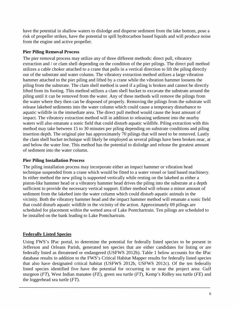
6
have the potential in shallow waters to dislodge and disperse sediment from the lake bottom, pose a risk of propeller strikes, have the potential to spill hydrocarbon based liquids and will produce noise from the engine and active propeller.
Pier Piling Removal Process The pier removal process may utilize any of three different methods: direct pull, vibratory extraction and / or clam shell depending on the condition of the pier pilings. The direct pull method utilizes a cable choker attached to a crane that pulls in a vertical direction to lift the piling directly out of the substrate and water column. The vibratory extraction method utilizes a large vibration hammer attached to the pier piling and lifted by a crane while the vibration hammer loosens the piling from the substrate. The clam shell method is used if a piling is broken and cannot be directly lifted from its footing. This method utilizes a clam shell bucket to excavate the substrate around the piling until it can be removed from the water. Any of these methods will remove the pilings from the water where they then can be disposed of properly. Removing the pilings from the substrate will release lakebed sediments into the water column which could cause a temporary disturbance to aquatic wildlife in the immediate area. The direct pull method would cause the least amount of impact. The vibratory extraction method will in addition to releasing sediment into the nearby waters will also emanate a sonic field that could disturb aquatic wildlife. Piling extraction with this method may take between 15 to 30 minutes per piling depending on substrate conditions and piling insertion depth. The original pier has approximately 70 pilings that will need to be removed. Lastly the clam shell bucket technique will likely be employed as several pilings have been broken near, at and below the water line. This method has the potential to dislodge and release the greatest amount of sediment into the water column.
Pier Piling Installation Process The piling installation process may incorporate either an impact hammer or vibration head technique suspended from a crane which would be fitted to a water vessel or land based machinery. In either method the new piling is supported vertically while resting on the lakebed as either a piston-like hammer head or a vibratory hammer head drives the piling into the substrate at a depth sufficient to provide the necessary vertical support. Either method will release a minor amount of sediment from the lakebed into the water column which could disturb aquatic animals in the vicinity. Both the vibratory hammer head and the impact hammer method will emanate a sonic field that could disturb aquatic wildlife in the vicinity of the action. Approximately 69 pilings are scheduled for placement within the wetted area of Lake Pontchartrain. Ten pilings are scheduled to be installed on the bank leading to Lake Pontchartrain.
Federally Listed Species Using FWS’s IPac portal, to determine the potential for federally listed species to be present in Jefferson and Orleans Parish, generated ten species that are either candidates for listing or are federally listed as threatened or endangered (USFWS 2012b). Table 1 below accounts for the IPac database results in addition to the FWS’s Critical Habitat Mapper results for federally listed species that also have designated critical habitat (USFWS 2012b, USFWS 2012c). Of the ten federally listed species identified five have the potential for occurring in or near the project area: Gulf sturgeon (FT), West Indian manatee (FE), green sea turtle (FT), Kemp’s Ridley sea turtle (FE) and the loggerhead sea turtle (FT).
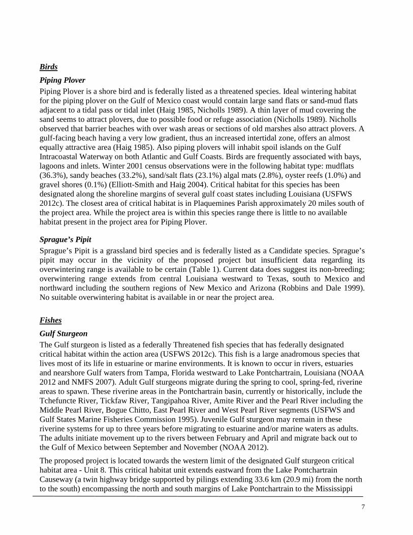
7
Birds Piping Plover Piping Plover is a shore bird and is federally listed as a threatened species. Ideal wintering habitat for the piping plover on the Gulf of Mexico coast would contain large sand flats or sand-mud flats adjacent to a tidal pass or tidal inlet (Haig 1985, Nicholls 1989). A thin layer of mud covering the sand seems to attract plovers, due to possible food or refuge association (Nicholls 1989). Nicholls observed that barrier beaches with over wash areas or sections of old marshes also attract plovers. A gulf-facing beach having a very low gradient, thus an increased intertidal zone, offers an almost equally attractive area (Haig 1985). Also piping plovers will inhabit spoil islands on the Gulf Intracoastal Waterway on both Atlantic and Gulf Coasts. Birds are frequently associated with bays, lagoons and inlets. Winter 2001 census observations were in the following habitat type: mudflats (36.3%), sandy beaches (33.2%), sand/salt flats (23.1%) algal mats (2.8%), oyster reefs (1.0%) and gravel shores (0.1%) (Elliott-Smith and Haig 2004). Critical habitat for this species has been designated along the shoreline margins of several gulf coast states including Louisiana (USFWS 2012c). The closest area of critical habitat is in Plaquemines Parish approximately 20 miles south of the project area. While the project area is within this species range there is little to no available habitat present in the project area for Piping Plover.
Sprague’s Pipit Sprague’s Pipit is a grassland bird species and is federally listed as a Candidate species. Sprague’s pipit may occur in the vicinity of the proposed project but insufficient data regarding its overwintering range is available to be certain (Table 1). Current data does suggest its non-breeding; overwintering range extends from central Louisiana westward to Texas, south to Mexico and northward including the southern regions of New Mexico and Arizona (Robbins and Dale 1999). No suitable overwintering habitat is available in or near the project area.
Fishes Gulf Sturgeon The Gulf sturgeon is listed as a federally Threatened fish species that has federally designated critical habitat within the action area (USFWS 2012c). This fish is a large anadromous species that lives most of its life in estuarine or marine environments. It is known to occur in rivers, estuaries and nearshore Gulf waters from Tampa, Florida westward to Lake Pontchartrain, Louisiana (NOAA 2012 and NMFS 2007). Adult Gulf sturgeons migrate during the spring to cool, spring-fed, riverine areas to spawn. These riverine areas in the Pontchartrain basin, currently or historically, include the Tchefuncte River, Tickfaw River, Tangipahoa River, Amite River and the Pearl River including the Middle Pearl River, Bogue Chitto, East Pearl River and West Pearl River segments (USFWS and Gulf States Marine Fisheries Commission 1995). Juvenile Gulf sturgeon may remain in these riverine systems for up to three years before migrating to estuarine and/or marine waters as adults. The adults initiate movement up to the rivers between February and April and migrate back out to the Gulf of Mexico between September and November (NOAA 2012).
The proposed project is located towards the western limit of the designated Gulf sturgeon critical habitat area - Unit 8. This critical habitat unit extends eastward from the Lake Pontchartrain Causeway (a twin highway bridge supported by pilings extending 33.6 km (20.9 mi) from the north to the south) encompassing the north and south margins of Lake Pontchartrain to the Mississippi

8
Sound. This critical habitat area provides juvenile, subadult and adult feeding, resting and passage habitat for Gulf sturgeon from the Pascagoula and Pearl Rivers subpopulations. Lake Pontchartrain in particular provides essential winter habitat for the Pearl River Gulf sturgeon subpopulation (USFWS & NMFS 2003). The critical habitat constituents for the Gulf sturgeon identified by USFWS and NMFS (2003) include:
1. Abundant prey items within riverine habitats for larval and juvenile life stages, and within estuarine and marine habitats and substrates for juvenile, subadult, and adult life stages;
2. Riverine spawning sites with substrates suitable for egg deposition and development, such as limestone outcrops and cut limestone banks, bedrock, large gravel or cobble beds, marl, soapstone or hard clay;
3. Riverine aggregation areas, also referred to as resting, holding, and staging areas, used by adult, subadult, and/or juveniles, generally, but not always, located in holes below normal riverbed, depths, believed necessary for minimizing energy expenditures during fresh water residency and possibly for osmoregulatory functions;
4. A flow regime (i.e. the magnitude, frequency, duration, seasonality, and rate-of-change of fresh water discharge over time) necessary for normal behavior, growth, and survival of all life stages in the riverine environment, including migration, breeding site selection, courtship, egg fertilization, resting, and staging; and necessary for maintaining spawning sites in suitable condition for egg attachment, egg sheltering, resting, and larvae staging;
5. Water quality, including temperature, salinity, pH, hardness, turbidity, oxygen content, and other chemical characteristics, necessary for normal behavior, growth, and viability of all life stages;
6. Sediment quality, including texture and other chemical characteristics, necessary for normal behavior, growth, and viability of all life stages; and
7. Safe and unobstructed migratory pathways necessary for passage within and between riverine, estuarine, and marine habitats (e.g. a river unobstructed by any permanent structure, or a dammed river that still allows for passage).
Of the critical habitat constituents listed above, list items 5 - 7 are pertinent to the proposed project as it relates to Gulf sturgeon critical habitat.
Pallid Sturgeon The pallid sturgeon is federally listed as an Endangered fish species and currently does not have federally designated critical habitat. This species inhabits the bottoms of large river systems including the Missouri and Mississippi Rivers from Montana to Louisiana and the Atchafalaya River. In the Mississippi River pallid sturgeon tend to select main channel habitats. Food habits of this species range from aquatic insects to fish depending on life stage. The species can be long lived with females reaching sexual maturity later than male. Spawning appears to occur between June and August, and females may not spawn each year (USFWS 2007a). The pallid sturgeon being known to only occupy the Mississippi and Atchafalaya River systems in Louisiana is outside of the potential for occurring in Lake Pontchartrain with the exception of stochastic flooding events necessitating the release of waters through Bonnet Carré Spillway from the Mississippi River into Lake Pontchartrain. There is no data to suggest that pallid sturgeons would survive in brackish, estuarine waters such as Lake Pontchartrain as they are known to be an obligate freshwater species (Cech and Doroshov 2004).

9
Mammals The West Indian manatee and its subspecies (Florida and Antillean) are federally listed under the Endangered Species Act of 1973 as Endangered and does have federally designated critical habitat that is located in the southwestern and eastern margins of Florida (USFWS 2012c). The Florida subspecies (T. m. latirostris) is known to occur in Lakes Maurepas and Pontchartrain during the summer months, typically June through September, and various waterways within the Lake Pontchartrain Basin including the Amite, Blind, Tchefuncte, and Tickfaw Rivers. The known and historical range of the Florida subspecies extends from Norfolk, Virginia south and westward along the Atlantic seaboard to Beaumont, Texas. In warmer months this subspecies has been observed as far north as Massachusetts (USFWS 2007b). Sightings in Louisiana, representing the western limits of their range in the Gulf of Mexico, are regarded as rare but increasing. The West Indian manatee has been known to occupy nearshore marine environments, inshore estuaries and salt marshes and warm freshwater environments including: coastal tidal rivers and streams, mangrove swamps, freshwater springs and backwater bayou areas (USFWS 2007b). Foraging habitat in coastal and riverine habitats includes vegetated bottoms and shallow grass beds, with ready access to deep channels. In cooler months manatees will seek warmer waters including anthropogenic induced sources (USFWS 2007b).
Reptiles Five species of sea turtles were identified as having the potential to occur in Jefferson and/or Orleans Parish (Table 1) (USFWS 2012b). Based on personal communication with fisheries biologist Eric Hawk (NMFS-SERO), stranding data from NMFS’ Sea Turtle Stranding and Salvage Network (NMFS 2012) and a confirmed report of a Lake Pontchartrain shrimp trawler ensnaring a Kemp’s Ridley sea turtle (seaturtle.org 1999); the following Threatened and Endangered sea turtle species are uncommon yet should be assumed to be present in Lake Pontchartrain: green sea turtle, Kemp’s Ridley sea turtle and the loggerhead sea turtle. Lake Pontchartrain may offer foraging habitat for the Kemp’s Ridley and loggerhead sea turtles as shrimp is one of their known prey items and is abundant in Lake Pontchartrain.

10
Table 1 - Candidate, Threatened or Endangered Species Known to Occur in Jefferson and/or Orleans Parish
Common Name
Scientific Name
Federal Status†
Critical Habitat
Agency Jurisdiction
(FEMA)
Habitat Requirements
Determination‡ / Rationale
Birds
Piping Plover
Charadrius melodus Threatened Yes3 USFWS
Shore bird that breeds in the Great Lakes and northern plains regions and overwinters on the coastlines of the Gulf of Mexico. Preferred overwintering habitat is coastal sand dunes and algal matt areas.
No Effect / Suitable overwintering habitat (P = 0.1) for this species is not found in or near the proposed project area. Closest designated Critical Habitat is > 20 miles south of proposed project location.
Sprague's Pipit
Anthus spragueii Candidate No USFWS
Grassland bird that overwinters during its non-breeding season from western Louisiana to Mexico and southwestern states.
No Effect / Project area is outside the suggested overwintering range of this species.
Fishes
Gulf sturgeon
Acipenser oxyrinchus
desotoi Threatened Yes USFWS
Anadromous species that spends most of its life in marine habitats and spawns in riverine systems. Found in a variety of substrate areas based on age class of species.
NLAA / Project area is located in designated critical habitat. Project activities will not have a significant impact on critical habitat constituents. Effects may include temporary disturbance.
Pallid sturgeon
Scaphirhynchus albus Endangered No USFWS
A freshwater obligate species. Prefers large, free-flowing turbid river bottoms. No information exists on preferred spawning habitat.
No Effect / No suitable habitat present.

11
Mammals
West Indian manatee
Trichechus manatus
Endangered / Strategic
Stock (MMPA)4
Yes1 USFWS
Found in marine, estuarine, and freshwater environments with a strong preference for warm and well vegetated waters.
NLAA / Lake Pontchartrain is a known transitional habitat for West Indian manatee.
Reptiles
Green sea turtle
Chelonia mydas Threatened Yes1 NOAA-
NMFS
Shallow waters (except when migrating) inside reefs, bays, and inlets. Attracted to lagoons and shoals with an abundance of marine grass and algae.
NLAA / Habitat availability is unknown but reported sightings have been made in Lake Pontchartrain.
Hawksbill sea turtle
Eretmochelys imbricata Endangered Yes1 NOAA-
NMFS
Nesting habitat includes low and high energy beaches of tropical locations. Non-nesting habitat preferences include mangroves and areas of high energy coastline with rock outcrops, shoals and jetties.
No Effect / Suitable habitat does not occur in or near the proposed project area.
Kemp's Ridley sea turtle
Lepidochelys kempii Endangered No NOAA-
NMFS
Nesting habitat includes sandy beaches typically between Mexico and Texas. Non-nesting habitat is primarily oceanic.
NLAA / Lake Pontchartrain may offer suitable foraging habitat.
Leatherback sea turtle
Dermochelys coriacea Endangered Yes1 NOAA-
NMFS
Nesting habitat includes high energy warm water, beaches. Non-nesting habitat includes marine environments with a preference for pelagic areas.
No Effect / Suitable habitat does not occur in or near the proposed project area.

12
Loggerhead sea turtle* Caretta caretta Threatened No NOAA-
NMFS
Nesting habitat includes high energy warm water, beaches. Non-nesting includes: bays, sounds, and estuaries along the Atlantic and Gulf coasts and nearshore and oceanic habitats.
NLAA / Lake Pontchartrain may offer suitable foraging habitat.
† ESA status designations in Table 1are relevant to Louisiana only; ESA listing status may be different elsewhere. ‡ Endangered Species Act - Project Effect Determination Proposed by FEMA. 1 Critical habitat is not designated in Louisiana. 2 Critical habitat is designated in Louisiana, but does not occur within Jefferson or Orleans Parish. 3 Critical habitat may occur in Jefferson and/or Orleans Parish, but not within the proposed project area. 4 Marine Mammal Protection Act of 1972 (MMPA) Stock Assessment - Table data acquired from: USFWS Jefferson and Orleans Parish TES species data accessed 5/8/2012 from USFWS IPaC Web
Portal (http://ecos.fws.gov/ipac/); USFWS Critical Habitat by species data accessed 5/8/2012 from USFWS Critical Habitat Portal (http://criticalhabitat.fws.gov/crithab/); *NOAA Office of Protected Fisheries – Loggerhead Turtle Website, Accessed 5/08/2012 (http://www.nmfs.noaa.gov/pr/species/turtles/loggerhead.htm#habitat)
Federally Listed Species with “May Affect” Determinations - USFWS Jurisdiction The following discussion aims to identify the federally protected species determined by FEMA as having the potential to be affected by the proposed project’s activities, the conservation measures required by the applicant, as a condition of FEMA funding, to facilitate a NLAA determination and finally a request for the USFWS’s concurrence for the effect determination for each species under its jurisdiction.
West Indian Manatee Potential for Project Related Effects The existing habitat in and around the action area does not contain the aquatic vegetation component necessary for suitable foraging habitat for the West Indian manatee. However, this species is known to occur in Lake Pontchartrain during its summer migration (June through September) (USFWS 2012a) and may be more inclined to utilize near shore areas in the late spring to the early summer months where water temperatures may be higher (Kinnaird 1983). Sources of anthropogenic generated warm water sources have been known to be utilized by manatees in Florida (USFWS 2001). Outflow from the 17th Street Canal may deliver warmer waters to Lake Pontchartrain than the temperature of the lake itself which may be desirable to the West Indian manatee. Manatees are also known to be curious animals and have been known to approach swimmers and water craft. This type of behavior could draw it in too close to the action area and put a manatee at risk. While the likelihood of project personnel coming within close range of a West Indian manatee in Lake Pontchartrain are rare the possibility does exist and can become increasingly more likely based on the season during which time construction will take place, the environmental attributes of the action area as stated and the known behavior of manatees in general.

13
Conservation Measures The following conservation measures for West Indian manatee will be employed by construction personnel as a contingency for FEMA funding:
1. All personnel related to the construction project will receive worker awareness training on the West Indian manatee. This training will include at a minimum: the laws protecting the West Indian manatee (Marine Mammal Protection Act, 1972 and the Endangered Species Act of 1973) as a federally endangered species, a definition of “take” as it applies to the Endangered Species Act, the fines and possible imprisonment for take of a West Indian manatee, images of the West Indian manatee as it is likely to be seen in Lake Pontchartrain, vessel work area restrictions and special operating conditions, monitoring requirements, procedures if a manatee is sighted within 100-yards of the active work zone and who to call and who will call if a manatee is sighted. All personnel will need to sign a worker awareness training sign-in sheet as a record of their attendance and training received. Any new workers that did not receive the training will need to be trained before working in or near construction areas that require in-water work.
2. Informational signs will be posted in visible areas in any construction area where in-water work occurs including all project related vessels. The signs will have an image of a manatee as it is likely to be seen in Lake Pontchartrain, the federal listing status of the manatee, possible punishment for take of a manatee and phone numbers to immediately call in the event a manatee is seen: USFWS’s Lafayette Field Office (337) 291-3100 and the LDWF, Natural Heritage Program (225) 765-2821. These informational signs will be weather proofed (laminated) and large enough so that they can be read from a distance of 20-feet. Signs will be posted prior to and for the duration of the construction project.
3. One person per construction site will be made responsible by their crew lead (if not the lead) to call the phone numbers stated above in the event a manatee is sighted.
4. All construction personnel will be responsible for monitoring water-related activities for the presence of manatees as part of their regular duties.
5. The following are special conditions that will be followed in the event a manatee is sighted within 100-yards of the project area:
a. All construction personnel will have “Stop Work” authority if they see a manatee within 50-feet of a construction activity including moving vessels.
b. All vessels will operate at no-wake/idle speeds within 100-yards of the work area. c. In-water sediment barriers or siltation barriers will need to be re-secured and
monitored. d. Work will only resume without restriction when a sighted manatee is greater than
100-yards away from the project area.
Effect Determination If construction activities occur within the known seasonal window that manatees may be present in Lake Pontchartrain (June through September) and the conservation measures listed above are implemented FEMA suggests that effects of project related activities are discountable and is therefore requesting concurrence from the Service for a “May Affect, but Not Likely to Adversely

14
Affect” determination for the West Indian manatee. If however construction activities occur during the year when manatees are not present in Lake Pontchartrain (October through May) FEMA would then make a “No Effect” determination.
Gulf Sturgeon Potential for Project Related Effects Unmitigated actions that may lead to direct effects to the Gulf sturgeon include: increased turbidity and acoustic related disturbances from pile removal and installation actions, disturbance from vessels in shallow waters that are likely to proximally and temporarily increase turbidity from dislodging bottom sediments during normal operations, a potential to decrease localized dissolved oxygen as a result of sediment disturbance and potential harm from spilled hydrocarbon based fuels and lubricants. The entirety of Lake Pontchartrain represents a shallow aquatic habitat with a maximum depth of 5 meters and therefore project actions would not restrict the movement of Gulf sturgeon which prefers shallow depths and could at will avoid the action area (Whitmore 2006, USGS 2002 & Ross et al. 2008).Therefore potential effects as a result of these actions would be limited to temporary disturbances where a Gulf sturgeon in the vicinity of the project could avoid suspended sediments and acoustic disturbances derived from project activities. It is unlikely that prey resources (predominantly benthic invertebrates) would be disturbed as a result of the proposed project actions based on existing substrate and prey habitat suitability (Ross et al. 2008 & Whitmore 2006). The placement of the new pier would not represent a temporary or long term obstruction for sturgeon passage to or from freshwater spawning areas.
Conservation Measures The following conservation measures for Gulf sturgeon will be employed by construction personnel as a contingency for FEMA funding:
1. All personnel related to the construction project will receive worker awareness training on the Gulf sturgeon. This training will include at a minimum: the laws protecting the Gulf sturgeon (Endangered Species Act of 1973) as a federally endangered species, a definition of “take” as it applies to the Endangered Species Act § 3.19, the fines and possible imprisonment for take of a Gulf sturgeon, images of the Gulf sturgeon as it is likely to be seen in Lake Pontchartrain. All personnel will need to sign a worker awareness training sign-in sheet as a record of their attendance and training received. Any new workers that did not receive the training will need to be trained before working in or near construction areas.
2. A spill prevention and emergency response plan (SPERP) will be required for all construction contractor groups. The SPERP will need to identify at a minimum: emergency contact numbers for local, state and federal environmental and public health agencies, material safety data sheets (MSDS) for all hazardous substances, hazardous material inventory, spill prevention plan, spill response plan/emergency response plan, spill response equipment (e.g. absorbent pads, disposal containers) and reporting requirements.
3. Sediment control features (BMPs) will be implemented on land to limit sediment delivery to Lake Pontchartrain. Sediment control features will be required around all spoil and unclean gravel, sand and/or soil stock piles. Sediment control features may include but will not be limited to: sediment (silt) fence, straw waddles (fiber rolls), straw bales, sandbag barriers, plastic sheeting, storm drain inlet protection and street sweeping/vacuuming. As with any

15
stormwater control methods the implementation of the appropriate controls will be dictated by the type and amount of sediment being controlled and the forecasted environmental conditions. Monitoring of sediment control features will be required prior to and during rain events to ensure control features are installed correctly and are functioning as necessary.
4. In-water silt barriers (turbidity curtains) will be utilized at the pier removal site and the new pier location during in-water work activities. Silt barriers will need to be installed in a manner that contains the dislodged lakebed sediment to the immediate work area.
5. Barge decks that receive removed pilings and lakebed sediments will be fitted with containment basins made of plastic sheeting draped over straw bale sidewalls. Disposal of all debris and containment basin will be conducted to standards of local, state and federal laws.
6. Erosion control will be necessary for any ground disturbing activities (e.g. excavated areas to receive concrete fill, ground disturbed by heavy equipment). Choice of erosion control measure will be employed based on the type and duration of disturbance. For example, fiber rolls may be used to control sediment runoff around excavated sites that will be filled with concrete, areas of broken ground due to heavy equipment may receive mulch or hydroseeding to control sediment runoff as needed.
7. Any floating debris will be trapped by the silt barrier and removed from the water. 8. In-water work will only be conducted when waters are calm enough to allow for the efficacy
of the silt barrier system. 9. Preserved wood used for pier piles and attachments will need to meet EPA standards for in-
saltwater (or brackish water) application. 10. All BMPs identified above may be subject to additional requirements based on US Army
Corps of Engineer’s Rivers and Harbors Act § 10 and Clean Water Act permitting requirements.
Effect Determination Based on the best currently available scientific information for the Gulf sturgeon’s biological requirements and the required conservation measures identified above, FEMA is suggesting that any project related effects to the Gulf sturgeon will be discountable and is therefore requesting the Service’s concurrence for a “May Affect, but Not Likely to Adversely Affect” determination for the Gulf sturgeon. FEMA is also requesting the Service’s concurrence that the mitigated actions as described will not destroy or adversely modify designated critical habitat (Unit 8) for the Gulf sturgeon.

16
We would appreciate your review of the above determinations as they pertain to the Endangered Species Act of 1973. If you have any questions regarding this letter or need further clarification please call Mr. Kristiaan Stuart at (504) 762-2361 or email at [email protected]. Sincerely, Tiffany Spann-Winfield
Deputy Environmental Liaison Officer
FEMA LRO, Region VI
CC:
NOAA-NMFS, Southeast Regional Office
Corps of Engineers, New Orleans, LA
LDWF, Natural Heritage Program, Baton Rouge, LA
Attachments: Site Visit Species List
17
REFERENCES
Cech, J. J. Jr. and S. I. Doroshov. 2004. Environmental Requirements, Preferences, and Tolerance Limits of North American Sturgeons. In Sturgeons and Paddlefish of North America, G.T.O. LeBreton, F. W. H. Beamish and S. R. McKinley (Eds.). Fish & Fisheries Series, Vol. (27), 73-86.
Elliott-Smith, E. and S. M. Haig. 2004. Piping Plover (Charadrius melodus), The Birds of North America Online (A. Poole, Ed.). Ithaca: Cornell Lab of Ornithology; Retrieved from the Birds of North America Online: http://bna.birds.cornell.edu/bna/species/002doi:10.2173/bna.2
Haig, S.M. 1985. The Status of the Piping Plover in Canada. Report to the Committee on the Status of Endangered Wildlife in Canada (COSEWIC), National Museum of Canada, Ottawa, Ontario.
Kinnaird, M. F. 1983. Evaluation of potential management strategies for the reduction of boat-related mortality of manatees. Research Report No. 3, Florida Cooperative Fish and Wildlife Research Unit, U.S. Fish and Wildlife Service.
NMFS. 2007. Gulf Sturgeon Range (map). Office of Protected Resources, Southeast Regional Office. December 2007.
National Oceanic and Atmospheric Administration (NOAA). 2012. Office of Protected Fisheries – Gulf Sturgeon (Acipenser oxyrinchus desotoi). Available online at http://www.nmfs.noaa.gov/pr/species/fish/gulfsturgeon.htm#distribution. Accessed 5/08/2012.
Nicholls, J.L. 1989. Distribution and other ecological aspects of Piping Plovers (Charadrius melodus) wintering along the Atlantic and Gulf coasts. MS Thesis. Auburn University, Auburn, Alabama. 164 pp.
NMFS. 2012. NOAA-NMFS Southeast Fisheries Science Center. Sea Turtle Stranding and Salvage Network (STSSN), Sea Turtle Stranding Data for Louisiana. Available at Sea Turtle Stranding and Salvage Network (STSSN). http://www.sefsc.noaa.gov/species/turtles/strandings.htm. Accessed 06/05/2012.
Robbins, M. B. and B. C. Dale. 1999. Sprague's Pipit (Anthus spragueii), The Birds of North America Online (A. Poole, Ed.). Ithaca: Cornell Lab of Ornithology; Retrieved from the Birds of North America Online. Available online at http://bna.birds.cornell.edu/bna/species/439doi:10.2173/bna.439. Accessed 5/4/2012.
Ross, S. T., W.T. Slack, R. J. Heise, M. A. Dugo, H. Rogillio, B. R. Bowen, P. Mickle and R. W. Heard. 2008. Estuarine and Coastal Habitat Use of Gulf Sturgeon (Acipenser oxyrinchus desotoi) in the North-Central Gulf of Mexico. Estuaries and Coasts 32:360-374. DOI 10.1007/s12237-008-9122-z.
Seaturtle.org. 1999. NOAA Nabs Turtle Killer. In Marine Turtle Newsletter 83:19-23. Available at http://www.seaturtle.org/mtn/archives/mtn83/mtn83p19.shtml. Accessed 06/05/2012.
USFWS. 2001. Florida Manatee Recovery Plan (Trichechus manatus latirostris), Third Revision. Southeast Region, Atlanta, GA.

18
______. 2007a. Pallid Sturgeon (Scaphirhynchus albus) 5-Year Review Summary and Evaluation. U.S. Fish and Wildlife Service, Pallid Sturgeon Recovery Coordinator, Billings, Montana.
______. 2007b. West Indian Manatee (Trichechus manatus) 5-Year Review: Summary and Evaluation. Southeast Region, Jacksonville Ecological Services Office, Jacksonville, FL.
______. 2012a. Endangered Species Act Comment Letter Regarding Municipal Yacht Harbor Pier Replacement Project (Letter, Dated June 05, 2012). Lafayette, LA.
______. 2012b. IPaC - Information, Planning, and Conservation System. Database Query for: Jefferson and Orleans Parish’s Threatened and Endangered Species Data per Parish. Available online at http://ecos.fws.gov/ipac/. Accessed 5/8/2012.
______. 2012c. Critical Habitat Portal - FWS Critical Habitat for Threatened & Endangered Species. USFWS Critical Habitat Portal - Geospatial Database Queried for Critical Habitat by Species – Gulf Sturgeon, Piping Plover and West Indian Manatee. Available online at http://criticalhabitat.fws.gov/crithab/. Accessed 5/8/2012.
U.S. Fish and Wildlife Service and Gulf States Marine Fisheries Commission. 1995. Gulf Sturgeon Recovery Plan. Atlanta, Georgia. 170 pp.
USFWS & NMFS. 2003. Endangered and Threatened Wildlife and Plants; Designation of Critical Habitat for the Gulf Sturgeon; Final Rule. Federal Register: Vol. 68 (No. 53), Rules and Regulations, p. 13370.
USGS. 2002. Lake Pontchartrain Basin: Bottom Sediments and Related Environmental Resources. Frank T. Manheim and Laura Hayes (Eds.). U.S. Geological Survey Professional Paper 1634. Available at http://pubs.usgs.gov/pp/p1634/index.htm. Accessed 6/04/2012.
Waring G. T., Josephson E., Fairfield C. P., Maze-Foley K., eds. 2007. West Indian Manatees Stock Assessment – Florida and Antilles Stocks (2000, Appendix V). In U.S. Atlantic and Gulf of Mexico Marine Mammal Stock Assessments -- 2006. NOAA Tech Memo NMFS NE 201; 378 p.
Whitmore, K. A. 2006. Master’s Thesis - Artificial Reef Performance in Lake Pontchartrain, Louisiana. University of New Orleans, New Orleans, LA.

19
CNO’s Municipal Yacht Harbor Site Visit June 08, 2012, 11:00 – 12:15pm Lake Pontchartrain and Shoreline Conditions: Cloudy, light rain, 82°F, Winds S-SW 8 – 11 mph Table 1. Species Observed List
Common Name Scientific Name Status Observation Type
Fish Longnose gar (juvenile) Lepisosteus osseus Visual Spotted seatrout (juvenile) Cynoscion nebulosus Visual Birds American Crow Corvus brachyrhynchos Visual Killdeer Charadrius vociferus Vocalization Northern Mockingbird Mimus polyglottos Visual Mourning Dove Zenaida macroura Visual Purple Martin Progne subis Visual Bachman’s Sparrow Peucaea aestivalis Visual Yellow-crowned Night-heron Nyctanassa violacea Visual Mammals North American river otter Lontra canadensis Tracks Plants Bermuda grass Cynodon dactylon FACU Visual Bulltongue arrowhead Sagittaria lancifolia OBL Visual
Chinese tallow tree Triadica sebifera Invasive – Noxious1 Visual
Dock Rumex sp. FACW Visual Duckweed Lemna sp. OBL Visual Eastern baccharis Baccharis halimifolia FAC Visual Eastern elderberry Sambucus canadensis NL Visual Lambs quarter Chenopodium album FACU Visual Lotus Lotus sp. UPL Visual Morning glory Convolvulus sp. UPL Visual Mulberry Morus sp. FACU Visual Oleander Nerium oleander NL Visual Palmetto Sabal palmetto FAC Visual
Rush Juncus sp. FACW - OBL Visual
Spurge Euphorbia sp. FAC - FACU Visual
Water oak Quercus nigra FAC Visual
Wetland Indicator Species Designations for Region LRR O: OBL Obligate Wetland Almost always is a hydrophyte, rarely in uplands FACW Facultative Wetland Usually is a hydrophyte but occasionally found in uplands FAC Facultative Commonly occurs as either a hydrophyte or non-hydrophyte FACU Facultative Upland Occasionally is a hydrophyte but usually occurs in uplands UPL Obligate Upland Rarely is a hydrophyte, almost always in uplands NL Not Listed
1 – Listed by US Dept. of Agriculture as a Noxious Weed Species in Louisiana

From: Stuart, Kristiaan (CTR)To: "Farabee, Michael V MVN"Subject: RE: CWA 404/RHA 10 permiting for pier "removal" (UNCLASSIFIED)Date: Wednesday, July 11, 2012 09:35:00
Yes, I have them detailed in the mechanics of the various potential actions. Thank you though forbeing thorough. I do appreciate it.
Regards,Kristiaan
-----Original Message-----From: Farabee, Michael V MVN [mailto:[email protected]]Sent: Wednesday, July 11, 2012 9:27 AMTo: Stuart, Kristiaan (CTR)Subject: RE: CWA 404/RHA 10 permiting for pier "removal" (UNCLASSIFIED)
Classification: UNCLASSIFIEDCaveats: NONE
Yes that all seems correct, and I must just make sure that you don't forget the regulatory authority ofthe LA Dept. of Natural Resources, Office of Coastal Management. I know we discussed it, that's notwhat your e-mail covers, but it's simply so you don't overlook their authority in the Coastal Zone.
Thanks,
Michael V. FarabeeNew Orleans DistrictRegulatory BranchChief, Eastern Evaluation Section
(504) 862-2292(504) 862-2117 -fax-
-----Original Message-----From: Stuart, Kristiaan (CTR) [mailto:[email protected]]Sent: Wednesday, July 11, 2012 8:56 AMTo: Farabee, Michael V MVNSubject: CWA 404/RHA 10 permiting for pier "removal"
Michael-
Thank you for your time yesterday discussing FEMA's interest in funding the removal and replacementof CNO's Municipal Yacht Harbor's fishing pier (30.027935°, -90.120575°, WGS84) as it relates to RHASect. 10 and Coastal Zone requirements. As I am preparing the EA for this project I am reviewing the"No Action Alternative" for the CWA 404, 401, 303d/RHA 10 requirements. It occurred to me that eventhough the applicant is responsible for the removal of the pier, the removal itself without thereplacement component would not require a CWA 404 (no net addition of dredge or fill) but still mayrequire a RHA Sect 10 permit (if one was never originally issued) due to the following statement in theRHA: " .or the accomplishment of any other work affecting the course, location, condition, or physicalcapacity of such waters is unlawful unless.". Am I correct in this interpretation?

Thanks again Michael for your assistance.
Regards,
Mr. Kristiaan Stuart (CTR)
Fluor - TRS Contractor
Federal Emergency Management Agency
1 Seine Court
New Orleans, LA 70114
(504) 762-2361 <tel:%28504%29%20762-2445> (Desk)
E-mail: [email protected] <mailto:[email protected]>
Classification: UNCLASSIFIEDCaveats: NONE

United States Department of the Interior
FISH AND WILDLIFE SERVICE 646 Cajundome Blvd.
Suite 400 Lafayette. Louisiana 70506
July 24, 2012
Ms. Tiffany Spann-Winfield Federal Emergency Management Agency #1 Seine Court, Room 1065 New Orleans, LA 70114
Dear Ms. Spann-Winfield:
Please reference your June 26, 2012, letter, received June 28, 2012, requesting concurrence that the City of New Orleans' proposed Municipal Yacht Harbor Fish Pier removal and replacement located in Orleans Parishes, Louisiana is not likely to adversely affect the endangered West Indian manatee (Trichechus manatus) and the threatened gulf sturgeon (Acipenser oxyrhynchus desotoi).. The Fish and Wildlife Service (Service) has reviewed the information you provided, and offers the follo\Ying comments' in accordancewith the provisions of the Endangered Species Act (ESA) of 1973 (87 Stat. 884, as amended; 16U:S.C. 1531 et seq.) and .the Fish and Wildlife Coordination Act (48 S,tat: 401, a~amended; 16 U.S.C. 661 et seq.).
According to the information provided, the habitat in and around the action area does not contain aquatic vegetation necessary for suitable foraging habitat for manatees. To avoid impacts to manatees, the following conservation measures will be employed by construction personnel as a contingency for FEMA funding: (1) All personnel related to the construction project will receive worker awareness training on the West Indian manatee. This training will include at a minimum: the laws protecting manatees (Marine Manunal Protection Act, 1972 and the Endangered Species Act of 1973 [ESA]) as a federally endangered species, a definition of "take" as it applies to the ESA, the fines and possible imprisonment for take of a West Indian manatee, images of !1lanatpf"';; as: they are likely to be seen in Lake Pontchartrain, vessel work area restrictions and special operating conditions, monitoring requirements, procedures if a manatee is sighted within 100-yards of the active work zone and who to call if a manatee is sighted. All personnel will need to sign a worker awareness training sign-in sheet as a record of their attendance and training received. Any new workers that did not receive the training will need to be trained before working in or near construction areas that require in-water work. (2) Informational signs will be posted in visible areas in any construction area where in-water work occurs including all project related vessels. The signs will have an image of a manatee as it is likely to be seen in Lake Pontchartrain, the federal listing status of the manatee, possible punishmen.t for take of a manatee and phone numbers to immediately call in the event a manatee is see: USFWS's Lafayette Ecological Services Office (3-37) 291-3100 ,and the .LDWF, Natural Heritage Program (225) 7652821. These informational signs will be weather proofed and larege_enough so th~t they can be read from a distance of 20-Jeet. Signs will be postedprior to and for the duration of th~
TAKE PRIDE-iJ=: 1 lNAMERlCA~

construction project. (3) One person per construction site will be made responsible by their crew lead to call the phone numbers stated above in the event a manatee is sighted. (4) All construction personnel will be responsible for monitoring water-related activities for the presence of manatees as part of their regular duties. (5) The following are special conditions that will be followed in the event a manatee is sighted within IOO-yards of the project area: (a) All construction personnel will have "Stop Work" authority if they see a manatee within 50-feet ofa construction activity including moving vessels. (b) All vessels will operate at no-wake/idle speeds within IOO-yards of the work area. ( c) In-water sediment barriers or sil tation barriers will need to be re-secured and monitored. (d) Work will only resume without restriction when a sighted manatee is greater than I OO-yards away from the project area.
Based on the information provided, the Service concurs with the determination that the project is not likely to adversely affect the West Indian manatee.
According to the information, the placement of the new pier would not represent a temporary or long term obstruction for Gulf sturgeon passage to or from freshwater spawning areas. The potential impacts for sturgeon would be limited to temporary disturbances in the vicinity of the project area due to suspended sediment and acoustic disturbances derived from project activities. The following measures for Gulf sturgeon will be employed by construction personnel as a contingency for FEMA funding: (1) All personnel related to the construction project will receive worker awareness training on the Gulf sturgeon. This training will include at a minimum: the laws protecting the Gulf sturgeon (ESA) as a federally endangered species, a definition of"take " as it applies to the ESA, the fines and possible imprisonment for take of a Gulf sturgeon, images of the sturgeon as it is likely to be seen in Lake Pontchartrain. All personnel will need to sign a worker awareness training sign-in sheet as a record of their attendance and training received. Any new workers that did not receive the training will need to be trained before working in or near construction areas. (2) A spill prevention and emergency response plan (SPERP) will be required for all construction contractor groups. The SPERP will need to identify at a minimum: emergency contact numbers for local, state and federal environmental and public health agencies, material safety data sheets (MSDS) for all hazardous substances, hazardous material inventory, spill prevention plan, spill response plan/emergency response plan, spill response equipment (e.g. absorbent pads, disposal containers) and reporting requirements. (3) Sediment control features (BMPs) will be implemented on land to limit sediment delivery to Lake Pontchartrain. Sediment control features will be required around all spoil and unclean gravel, sand and/or soil stock piles. Sediment control features may include but will not be limited to: sediment (silt) fence, straw waddles (fiber rolls), straw bales, sandbag barriers, plastic sheeting, storm drain inlet protection and street sweeping/vacuuming. As with any stormwater control methods the implementation of the appropriate controls will be dictated by the type and amount of sediment being controlled and the forecasted environmental conditions. Monitoring of sediment control features will be required prior to and during rain events to ensure control features are installed correctly and are functioning as necessary. (4) In-water silt barriers (turbidity curtains) will be utilized at the pier removal site and the new pier location during in-water work activities. Silt barriers will need to be installed in a manner that contains the dislodged lake bed sediment to immediate work area. (5) Barge decks that receive removed piling and lakebed sediments will be fitted with containment basins made of plastic sheeting draped over straw bale sidewalls. Disposal of all debris and containment basin will be conducted to standards of local, state and
2

. . /
federal laws. (6) Erosion control will be necessary for any ground disturbing activities (e.g. excavated areas to receive concrete fill, ground disturbed by heavy equipment). Choice of erosion control measure will be employed based on the type and duration of disturbance. (7) Any floating debris will be trapped by the silt barrier and removed from the water. (8) In-water work will only be conducted when waters are calm enough to allow for the efficacy of the silt barrier system. (9) Preserved wood used for pier piles and attachments will need to meet EPA standards for in-saltwater (or brackish water) application. (10) All BMPs identified above may be subject to additional requirements based on u.s. Army Corps of Engineer's Rivers and Harbors Act § 10 and Clean Water Act permitting requirements.
Based on the information provided, the Service concurs with the determination that these projects are not likely to adversely affect the gulf sturgeon or its critical habitat.
If you have any questions regarding this letter, please contact Amy Trahan (337/291-3126) of this office.
Brad Rieck Deputy Field Supervisor Louisiana Ecological Services Office
cc: LDWF, Natural Heritage Program, Baton Rouge, LA
3

Appendix D
Public Notice & Draft FONSI

FEMA PUBLIC NOTICE OF AVAILABILITY
Draft Environmental Assessment and Draft Finding of No Significant Impact for the City of New Orleans - Municipal Yacht Harbor Fishing Pier Project
Orleans Parish, Louisiana
Interested parties are hereby notified that the Federal Emergency Management Agency (FEMA) has prepared a Draft Environmental Assessment (EA) and a Draft Finding of No Significant Impact (FONSI) for the proposed restroom replacement with upgrades to current codes and standards, and demolition and reconstruction of the Municipal Yacht Harbor Fishing Pier (Fishing Pier) in a new location.
The City of New Orleans (City) has submitted an application for FEMA Public Assistance funding being administered in response to FEMA-1603-DR-LA, Hurricane Katrina, which was signed as a Presidential Disaster Declaration on August 29, 2005. The Fishing Pier, which provided a safe outdoor recreational opportunity to the general public, was originally built on the western side of Breakwater Drive in the West End neighborhood north-northwest of West End Park. Due to the overwhelming storm damage to the Fishing Pier from Hurricane Katrina the City in consultation with FEMA determined that the original pier was damaged beyond repair. To replace the Fishing Pier in its original location would put it in the direct path of the 17th Street Canal’s outflow. The City believes this would cause a detrimental impact to recreational fishing opportunities which is one of the main purposes of the pier. The City suggested an alternative location, out of the direct path of the 17th Street Canal, adjacent to the perimeter of the breakwater wall located at the north end of Breakwater Drive at the follow geographical coordinates: 30.029225°, -90.119590° (Lat., Long., WGS 84). It is the City’s belief that this location will facilitate in a better recreational fishing experience for the general public.
In accordance with NEPA (42 U.S.C. 4371 et seq.), and associated environmental statutes, a Draft EA was prepared to evaluate the proposed action’s potential impacts on the human and natural environment. The Draft EA summarizes the purpose and need for the proposed action, the site selection process, the affected environment, and the potential environmental consequences associated with the proposed action. The Draft FONSI is FEMA’s finding that the proposed action will not have a significant effect on the human and natural environment.
The public notice will be published in the local newspaper, The Advocate, on the following dates: November 23, 24, 26, 27, and 28, 2012. It will also be published in another local newspaper, The Times-Picayune, on the following dates: November 23, 25, 28, 30 and December 02, 2012. The comment period will be 15 days – beginning on November 23, 2012 and concluding December 7, 2012. Written comments on the EA or related matters can be emailed to [email protected], faxed to FEMA’s Louisiana Recovery Office at (504) 762-2323; or mailed to FEMA Louisiana Recovery Office, 1 Seine Court, New Orleans, Louisiana 70114. The public notices will announce the availability of the EA for public review at the Orleans Parish Main Library at 219 Loyola Avenue, New Orleans, LA 70112, (hours are 10 a.m. - 6 p.m., Mon. - Thurs., 10 a.m. - 5 p.m., Fri. & Sat.). The EA can also be viewed and downloaded from FEMA’s website at: http://www.fema.gov/environmental-planning-and-historic-preservation-program/environmental-documents-public-notices-3.

Based on FEMA’s findings to date, no significant adverse environmental effects are anticipated. However, if FEMA receives new information that results in a change from no adverse effects then FEMA would revise the findings and issue a second public notice allowing time for additional comments.
If no substantive comments are received, the Draft EA and associated Draft FONSI will become final and this initial Public Notice will also serve as the final Public Notice.

U.S. Department of Homeland Security Louisiana Recovery Office
1 Seine Ct. New Orleans, LA 70114
DRAFT FINDING OF NO SIGNIFICANT IMPACT (FONSI)
Draft Environmental Assessment Municipal Yacht Harbor Fishing Pier
Orleans Parish, Louisiana FEMA-1603-DR-LA
Introduction
As a result of damages from Hurricane Katrina on August 29, 2005, the Federal Emergency Management Agency (FEMA) was authorized under a Presidential disaster declaration (FEMA-1603-DR-LA) to provide Federal assistance to designated disaster areas in Louisiana. The Robert T. Stafford Disaster Relief and Emergency Assistance Act (PL 93288) Section 406 authorizes FEMA’s Public Assistance (PA) Program to provide financial and other forms of assistance to State and local governments to support response, recovery, and mitigation efforts following Presidentially declared disasters.
In accordance with the National Environmental Policy Act (NEPA), the President’s Council on Environmental Quality (CEQ) regulations for implementing NEPA (40 CFR 1500-1508), and FEMA’s NEPA implementing regulations (44 CFR 10 et seq.), a Draft Environmental Assessment (DEA) has been prepared. The purpose of the DEA is to analyze the potential environmental impacts associated with the relocation of the Municipal Yacht Harbor Fishing Pier and to determine whether to prepare an Environmental Impact Statement (EIS) or Finding of No Significant Impact (FONSI). The proposed project aims to restore community services lost on August 29, 2005, as a result of Hurricane Katrina.
Proposed Action The Municipal Yacht Harbor Fishing Pier was damaged from storm surge resulting from Hurricane Katrina to an extent that it qualified for replacement. According to the City of New Orleans (Applicant), the replacement pier would better meet the needs of the public and the purpose of the fishing pier if it were to be located out of the path of flow from the 17th Street Canal and located approximately 490 ft to the north-northeast of the original pier location, adjacent to an existing breakwater wall north of Breakwater Drive. The project also involves the replacement of a restroom structure that had been leveled by storm surge and flotsam during Hurricane Katrina. The restroom replacement will be located at the structures original footprint but will be elevated to meet current floodplain regulations.

Municipal Yacht Harbor Fishing Pier Draft Finding of No Significant Impact
FEMA-1603-DR-LA Page 2
Conditions Based upon the studies and consultations undertaken in the DEA, several conditions must be met and mitigation measures taken by the applicant prior to and during project implementation.
Federally Protected Species and Critical Habitat Conservation Measures
West Indian manatee (FE) Conservation Measures The following conservation measures during the West Indian manatee summer migration (June 01 through September 30) will be employed by construction personnel as a contingency for FEMA funding:
1. All personnel related to the construction project will receive worker awareness training on the West Indian manatee. This training will include at a minimum: the laws protecting the West Indian manatee (Marine Mammal Protection Act, 1972 and the Endangered Species Act of 1973) as a federally endangered species, a definition of “take” as it applies to the Endangered Species Act, the fines and possible imprisonment for take of a West Indian manatee, images of the West Indian manatee as it is likely to be seen in Lake Pontchartrain, vessel work area restrictions and special operating conditions, monitoring requirements, procedures if a manatee is sighted within 100-yards of the active work zone and who to call and who will call if a manatee is sighted. All personnel will need to sign a worker awareness training sign-in sheet as a record of their attendance and training received. Any new workers that did not receive the training will need to be trained before working in or near construction areas that require in-water work.
2. Informational signs will be posted in visible areas in any construction area where in-water work occurs including all project related vessels. The signs will have an image of a manatee as it is likely to be seen in Lake Pontchartrain, the federal listing status of the manatee, possible punishment for take of a manatee and phone numbers to immediately call in the event a manatee is seen: USFWS’s Lafayette Field Office (337) 291-3100 and the LDWF, Natural Heritage Program (225) 765-2821. These informational signs will be weather proofed (laminated) and large enough so that they can be read from a distance of 20-feet. Signs will be posted prior to and for the duration of the construction project.
3. One person per construction site will be made responsible by their crew lead (if not the lead) to call the phone numbers stated above in the event a manatee is sighted.
4. All construction personnel will be responsible for monitoring water-related activities for the presence of manatees as part of their regular duties.
5. The following are special conditions that will be followed in the event a manatee is sighted within 100-yards of the project area:
a. All construction personnel will have “Stop Work” authority if they see a manatee within 50-feet of a construction activity including moving vessels.

Municipal Yacht Harbor Fishing Pier Draft Finding of No Significant Impact
FEMA-1603-DR-LA Page 3
b. All vessels will operate at no-wake/idle speeds within 100-yards of the work area. c. In-water sediment barriers or siltation barriers will need to be re-secured and
monitored. d. Work will only resume without restriction when a sighted manatee is greater than
100-yards away from the project area.
The following conservation measures for the West Indian manatee will be employed by construction personnel, regardless of season, as a contingency for FEMA funding:
1. All construction personnel will be responsible for monitoring water-related activities for the presence of manatees as part of their regular duties.
2. The following are special conditions that will be followed in the event a manatee is sighted within 100-yards of the project area:
a. All construction personnel will have “Stop Work” authority if they see a manatee within 50-feet of a construction activity including moving vessels.
b. All vessels will operate at no-wake/idle speeds within 100-yards of the work area. c. In-water sediment barriers or siltation barriers will need to be re-secured and
monitored. d. Work will only resume without restriction when a sighted manatee is greater than
100-yards away from the project area.
Gulf sturgeon (FT) Conservation Measures The following conservation measures for Gulf sturgeon will be employed by construction personnel as a contingency for FEMA funding:
1. All personnel related to the construction project will receive worker awareness training on the Gulf sturgeon. This training will include at a minimum: the laws protecting the Gulf sturgeon (Endangered Species Act of 1973) as a federally endangered species, a definition of “take” as it applies to the Endangered Species Act § 3.19, the fines and possible imprisonment for take of a Gulf sturgeon, images of the Gulf sturgeon as it is likely to be seen in Lake Pontchartrain. All personnel will need to sign a worker awareness training sign-in sheet as a record of their attendance and training received. Any new workers that did not receive the training will need to be trained before working in or near construction areas.
2. A spill prevention and emergency response plan (SPERP) will be required for all construction contractor groups. The SPERP will need to identify at a minimum: emergency contact numbers for local, state and federal environmental and public health agencies, material safety data sheets (MSDS) for all hazardous substances, hazardous material inventory, spill prevention plan, spill response plan/emergency response plan,
Municipal Yacht Harbor Fishing Pier Draft Finding of No Significant Impact
FEMA-1603-DR-LA Page 4
spill response equipment (e.g. absorbent pads, disposal containers) and reporting requirements.
3. Sediment control features (BMPs) will be implemented on land to limit sediment delivery to Lake Pontchartrain. Sediment control features will be required around all spoil and unclean gravel, sand and/or soil stock piles. Sediment control features may include but will not be limited to: sediment (silt) fence, straw waddles (fiber rolls), straw bales, sandbag barriers, plastic sheeting, storm drain inlet protection and street sweeping/vacuuming. As with any stormwater control methods the implementation of the appropriate controls will be dictated by the type and amount of sediment being controlled and the forecasted environmental conditions. Monitoring of sediment control features will be required prior to and during rain events to ensure control features are installed correctly and are functioning as necessary.
4. In-water silt barriers (turbidity curtains) will be utilized at the pier removal site and the new pier location during in-water work activities. Silt barriers will need to be installed in a manner that contains the dislodged lakebed sediment to the immediate work area.
5. Barge decks that receive removed pilings and lakebed sediments will be fitted with containment basins made of plastic sheeting draped over straw bale sidewalls. Disposal of all debris and containment basin will be conducted to standards of local, state and federal laws.
6. Erosion control will be necessary for any ground disturbing activities (e.g. excavated areas to receive concrete fill, ground disturbed by heavy equipment). Choice of erosion control measure will be employed based on the type and duration of disturbance. For example, fiber rolls may be used to control sediment runoff around excavated sites that will be filled with concrete, areas of broken ground due to heavy equipment may receive mulch or hydroseeding to control sediment runoff as needed.
7. Any floating debris will be trapped by the silt barrier and removed from the water. 8. In-water work will only be conducted when waters are calm enough to allow for the
efficacy of the silt barrier system. 9. Preserved wood used for pier piles and attachments will need to meet EPA standards for
in-saltwater (or brackish water) application. 10. All BMPs identified above may be subject to additional requirements based on US Army
Corps of Engineer’s Rivers and Harbors Act § 10 and Clean Water Act permitting requirements.
Loggerhead (FT), Kemp’s Ridley (FE), and Green Sea Turtles (FT) Conservation Measures The following conservation measures for federally listed sea turtles will be employed by construction personnel as a contingency for FEMA funding:

Municipal Yacht Harbor Fishing Pier Draft Finding of No Significant Impact
FEMA-1603-DR-LA Page 5
1. All personnel related to the construction project will receive worker awareness training on sea turtles. This training will include at a minimum: the laws protecting federally listed sea turtles (Endangered Species Act of 1973) as federally threatened or endangered species, a definition of “take” as it applies to the Endangered Species Act, the fines and possible imprisonment for take of a federally listed sea turtle, images of sea turtles as they are likely to be seen in Lake Pontchartrain, vessel work area restrictions and special operating conditions, monitoring requirements, procedures if a sea turtle is sighted within 100-yards of the active work zone and who to call and who will call if a sea turtle is sighted. All personnel will need to sign a worker awareness training sign-in sheet as a record of their attendance and training received. Any new workers that did not receive the training will need to be trained before working in or near construction areas that require in-water work.
2. One person per construction site will be made responsible by their crew lead (if not the lead) to call the phone numbers stated here in the event a sea turtle is sighted. NMFS Baton Rouge Field Office (504) 389-0508 and the LDWF, Natural Heritage Program (225) 765-2821.
3. All construction personnel will be responsible for monitoring water-related activities for the presence of sea turtles as part of their regular duties.
4. The following are special conditions that will be followed in the event a sea turtle is sighted within 100-yards of the project area:
a. All construction personnel will have “Stop Work” authority if they see a sea turtle within 50-feet of a construction activity including moving vessels.
b. All vessels will operate at no-wake/idle speeds within 100-yards of the work area. c. In-water sediment barriers or siltation barriers will need to be re-secured and
monitored. d. Work will only resume without restriction when a sighted sea turtle is greater than
100-yards away from the project area.
Archeological Artifacts
1) Fill or borrow material used must be sourced from sites that do not contain any buried cultural materials (i.e., wells, cisterns, foundations, basements, prehistoric Indian artifacts, human burials, and the like). If during the course of work, archaeological artifacts (prehistoric or historic) or human remains are discovered, City of New Orleans and/or its contractors must immediately stop work in the vicinity of the discovery and take all reasonable measures to avoid or minimize harm to the finds. The Applicant and GOHSEP must inform the FEMA Public Assistance program, who would in turn contact the FEMA Historic Preservation staff. The Applicant must not proceed with work until FEMA completes the necessary reviews required by Section 106 of NHPA. In addition, if unmarked graves are present, compliance with the Louisiana Unmarked Human Burial Sites Preservation Act is required. In that situation, the Applicant must notify the local

Municipal Yacht Harbor Fishing Pier Draft Finding of No Significant Impact
FEMA-1603-DR-LA Page 6
law enforcement agency within 24 hours of the discovery, and notify FEMA and the Louisiana Division of Archaeology at (225) 342-8170 within 72 hours of the discovery. Failure to comply with these stipulations may jeopardize FEMA funding of the project.
2) If human bone or unmarked grave(s) are present with the project area, compliance with the Louisiana Unmarked Human Burial Sites Preservation Act (R.S. 8:671 et seq.) is required. The applicant shall notify the law enforcement agency of the jurisdiction where the remains are located within twenty-four hours of the discovery. The applicant shall also notify FEMA and the Louisiana Division of Archaeology at 225-342-8170 within seventy-two hours of the discovery.
3) If during the course of work, archaeological artifacts (prehistoric or historic) are discovered, the applicant shall stop work in the vicinity of the discovery and take all reasonable measures to avoid or minimize harm to the finds. The applicant shall inform their Public Assistance (PA) contacts at FEMA, who will in turn contact FEMA Historic Preservation (HP) staff. The applicant will not proceed with work until FEMA HP completes consultation with the SHPO.
General Construction
1) Construction traffic should be closely monitored and controlled as appropriate. All construction activities would be conducted in a safe manner in accordance with OSHA work zone traffic safety requirements.
2) To alert motorists and pedestrians of project activities, appropriate signage and barriers would be on site prior to and during construction activities. During construction activities, the construction site(s) would be fenced off to discourage trespassers.
3) LDEQ has stormwater general permits for construction areas equal to or greater than one acre. It is recommended that the LDEQ Water Permit Division be contacted at (225) 219-3181 to determine whether the proposed improvements require one of these permits. The contractor is required to implement BMPs that meet the LDEQ permitting specifications for storm water discharge regulated under Section 402 of the CWA.
4) Any changes or modifications to the proposed project would require a revised USACE determination. Off-site locations of activities such as borrow, disposals, haul-and detour-roads and work mobilization site developments may be subject to the USACE regulatory requirements.
5) The applicant is responsible for coordinating with and obtaining any required section 9, 10 and/or 404 permit(s) from the United States Army Corps of Engineers (USACE) prior to initiating work. All coordination pertaining to these activities should be documented and copies forwarded to the State and FEMA as part of the permanent project files

Municipal Yacht Harbor Fishing Pier Draft Finding of No Significant Impact
FEMA-1603-DR-LA Page 7
6) The project has been found by the Louisiana Department of Natural Resources (LDNR) to be inside the Louisiana Coastal Zone; therefore, they require that a complete Coastal Use Permit Application package (Joint Application Form, locality maps, project illustration plats with plan and cross section views, etc.) along with the appropriate application fee be submitted to their office prior to construction.
Hazardous Materials and Spill Response
1) If any solid or hazardous wastes, or soils and/or groundwater contaminated with hazardous constituents are encountered during the project, notification to LDEQ’s Single-Point-of-Contact (SPOC) at (225) 219-3640 is required. Additionally, precautions should be taken to protect workers from these hazardous constituents.
2) In the event of a spill of hazardous chemicals including petro-chemicals into a waterway or that may come in contact with a waterway the EPA Region 6 – Spill Hotline 866-372-7745 (866-EPA-SPILL) will be called by the acting construction site supervisor.
Floodplain Conditions
1) By Memorandum of 1/4/12 from Frank Pagano, Mitigation Division Director of FEMA Region 6 to John Connolly, Senior Public Assistance Advisor, Louisiana Recovery Office, the 2008 Preliminary Digital Flood Insurance Rate Map (DFIRM) elevation is required for the restroom structure. Applicant is required to coordinate with the local floodplain administrator regarding floodplain permit(s) prior to the start of any activities. All coordination pertaining to these permit(s) should be documented to the local floodplain administrator and copies provided to LA GOHSEP and FEMA as part of the permanent project files. Per 44 CFR 9.11 (d)(9), contents, materials and equipment, where possible, disaster-proofing of the building and/or elimination of such future losses should occur by relocation of those building contents, materials and equipment outside or above the base floodplain.
Conclusion
The results of these evaluations, as well as consultations and input from other federal and state agencies, are presented in the EA. Based on the information analyzed, FEMA has determined that the implementation of the proposed action would not result in significant adverse impacts to the quality of the natural and human environment. In addition, the proposed project does not appear to have the potential for significant cumulative effects when combined with past, present and reasonably foreseeable future actions. As a result of this FONSI, an EIS will not be prepared (per 44 CFR Part 10) and the proposed project as described in the EA may proceed.
Public Review and Comment The public notice will be published in the local newspaper, The Advocate, on the following dates: November 23, 24, 26, 27, and 28, 2012. It will also be published in another local
Municipal Yacht Harbor Fishing Pier Draft Finding of No Significant Impact
FEMA-1603-DR-LA Page 8
newspaper, The Times-Picayune, on the following dates: November 23, 25, 28, 30 and December 02, 2012. The comment period will be 15 days – beginning on November 23, 2012 and concluding December 7, 2012. Written comments on the EA or related matters can be emailed to [email protected], faxed to FEMA’s Louisiana Recovery Office at (504) 762-2323; or mailed to FEMA Louisiana Recovery Office, 1 Seine Court, New Orleans, Louisiana 70114. The public notices will announce the availability of the EA for public review at the Orleans Parish Main Library at 219 Loyola Avenue, New Orleans, LA 70112, (hours are 10 a.m. - 6 p.m., Mon. - Thurs., 10 a.m. - 5 p.m., Fri. & Sat.). The EA can also be viewed and downloaded from FEMA’s website at: http://www.fema.gov/environmental-planning-and-historic-preservation-program/environmental-documents-public-notices-3.
_______________________________ _________________ Katherine Zeringue Date Environmental Liaison Officer Louisiana Recovery Office, New Orleans FEMA-1603/1607-DR-LA __________________________________ _________________ Andre Cadogan Date Deputy Director for Operations Louisiana Recovery Office, New Orleans FEMA-1603/1607-DR-LA