Cloud Classification SDH
12
INDIANA STATE UNIVERSITY CLIMATE LABORATORY CLOUD CLASSIFICATION CAMERON DOUGLAS CRAIG Indiana State University Climate Laboratory Department of Geography, Geology and Anthropology Indiana State University Terre Haute, Indiana Y R O T A R O I B N A D L I A E N T A A M S I T L A C T E Y T U I S N R I E V Exploring the Skies Above Indiana Through Weather and Climate
-
Upload
puji-riyan-hernandes -
Category
Documents
-
view
214 -
download
0
description
cloud
Transcript of Cloud Classification SDH

INDIANA STATE UNIVERSITY
CLIMATE LABORATORY
CLOUD CLASSIFICATION
CAMERON DOUGLAS CRAIGIndiana State University Climate Laboratory
Department of Geography, Geology and AnthropologyIndiana State University
Terre Haute, Indiana
YR
OT
AR
O
I
B
N
A
D
L
I
A
E
N
T
A
A
M
SI
TL
AC
T
E
Y
T
U
IS
N
RI
EV
Exploring the Skies Above IndianaThrough Weather and Climate

Indiana State University Climate LaboratoryDepartment of Geography, Geology and Anthropology
Indiana State UniversityTerre Haute, Indiana 47809
Clouds
Clouds are an important aspect in the function of the atmosphere. The amount of solar energy that reaches the Earth’s surface is partially determined by the amount of cloud cover within a day. Clouds are also a key indicator of what the weather will be.
This booklet will present the ten basic cloud types derived from the classification of Luke Howard (1772-1864). There are essentially three basic cloud forms—stratiform, cumuliform, and cirrus. These forms are defined from the Latin as what they appear. For example, stratus in Latin is translated as layered. Clouds that exhibit a layering effect will contain the root stratus. Cumuliform describes the cloud’s appearance as being stacked. Finally, cirrus clouds are defined as ‘hair-like.’
Within each cloud form, clouds are further defined by the altitude for which they normally exist. These altitudes are: high (above 20,000 ft.), middle (6,500-20,000 ft.), and low (below 6,500 ft.). Cloud forms that exist in high altitudes are defined with the prefix ‘cirro-.’ For example, if the cloud is layered and is found in high altitudes, it is labeled ‘cirrostratus.’ Clouds that are found in the middle altitude are given the prefix ‘alto-.’ Low altitude clouds are simply labeled by their root (stratus and cumulus).
There are three cloud types that are similar to the basic clouds forms; however, their added features give them a separate definition. Clouds that have precipitation are given the Latin prefix, ‘nimbo-,’ or suffix, ‘-nimbus.’ For cumulus clouds that have vertical extent and have precipitation, they are labeled as ‘cumulonimbus.’ Stratus clouds that produce precipitation are called ‘nimbostratus.’ Cumulus clouds that are stacked and layered are labeled as ‘stratocumulus.’
In the following pages, each cloud type is categorized according to the basic form (low to high altitude). Learning the different cloud types is relatively easy if you notice the patterns—size and height. It is important to remember that these are basic cloud types and it is possible that nature can provide several different cloud combinations within a single day or even hour. However, these combinations refer back to the basic cloud types.

Stratiform
Stratus clouds exhibit a layered appearance. This appearance is caused by relatively weak winds above the surface of the Earth. As the wind blows, cloud droplets are spread across the sky giving a layering aspect.
Stratus clouds (figure1) are typical of the stratiform definition, layered, at the low altitude. It is this cloud that provides for a ‘gloomy day.’
Altostratus clouds (figure 2) are found within the middle altitude. When the Sun shines behind this cloud, the cloud appears milky and fibrous.
Cirrostratus clouds (figure 3) are found in the higher altitudes. A halo can be found around the Sun or Moon when viewed through this cloud.
Figure 1. Stratus. Photo by Cameron D. Craig.

Figure 3. Cirrostratus. Photo from NOAA Photo Library.
Figure 2. Altostratus. Photo by Cameron D. Craig.

Cumuliform
Cumuliform clouds are defined by their ‘stacked’ appearance. These clouds, in the common description, are puffy-white with flat bottoms. When children draw clouds, these are the clouds they think of first. With cumuliform clouds, size decreases with altitude.
Cumulus clouds (figure 4) are just as they are defined—large and puffy-white. These clouds are typical of a fair day.
Altocumulus clouds (figure 5) are smaller than cumulus and are often positioned in rows. These clouds can often display a ‘mackerel’ sky.
Cirrocumulus clouds (figure 6) are the smallest of this class of cloud. Like the altocumulus clouds, cirrocumulus are sometimes positioned in rows.
Figure 4. Cumulus. Photo from NOAA Photo Library.

Figure 6. Cirrocumulus. Photo by Cameron D. Craig.
Figure 5. Altocumulus. Photo from NOAA Photo Library.
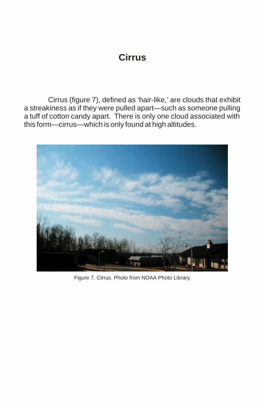
Cirrus
Cirrus (figure 7), defined as ‘hair-like,’ are clouds that exhibit a streakiness as if they were pulled apart—such as someone pulling a tuff of cotton candy apart. There is only one cloud associated with this form—cirrus—which is only found at high altitudes.
Figure 7. Cirrus. Photo from NOAA Photo Library.

Clouds of Precipitationand
Vertical Extent
Nimbostratus (figure 8) is a low altitude cloud that is layered in appearance and has precipitation. Essentially, it is the same as a stratus cloud but with precipitation. The precipitation intensity for this cloud will be light or a drizzle and extend over a long period of time.
The only cloud that has vertical extent, which covers all altitudes is considered the ‘King of the Clouds’—the cumulonimbus (figures 9 and 10). This cloud often exhibits an ‘anvil’ top and is associated with thunderstorms and heavy rain as the label suggests.
Figure 8. Nimbostratus. Photo by Cameron D. Craig.

Figure 10. Cumulonimbus. Photo by Cameron D. Craig.
Figure 9. Cumulonimbus. Photo from NOAA Photo Library.

Stratocumulus
The stratocumulus cloud (figure 11) is the last of the ten cloud types and form at low altitudes. This cloud is a mix between stacked and layered clouds that are grayish and whitish in color and have dark undersides. At times, the Sun can peek through these clouds and then be totally obscured.
Figure 11. Stratocumulus. Photo from NOAA Photo Library.
References
Hidore, John J. and Oliver, John E. Climateology: An Atmospheric Science. New York: MacMillan Publishing, 1993.
Trewartha, Glenn T. An Introduction to Climate. New York: McGraw-Hill Book Co., 1954.
NOAA Photo Library. http://www.noaa.gov/