Climate change impacts on coastal and pelagic environments in the southeastern Bay of Biscay
26
CLIMATE RESEARCH Clim Res Vol. 48: 307–332, 2011 doi: 10.3354/cr00914 Published August 30 1. INTRODUCTION According to the projections of global climate models provided by the Intergovernmental Panel on Climate Change (IPCC) Fourth Assessment Report (AR4, IPCC 2007), under future greenhouse gas (GHG) emission scenarios, a warming of the mean surface air and sea of the Bay of Biscay (for locations, see Fig. 1a), especially in the upper layers of the water column, is expected by the end of the 21 st century (Meehl et al. 2007). A direct consequence of seawater warming is the thermal ex- pansion of oceans, together with a rise in the ther- mosteric mean sea level (Reid et al. 2009), which may affect the coastal zones of the bay. Extensive literature covers future threats of global climate change expected for the next century over the world oceans (e.g. Reid et al. 2009) and coasts (see reviews by Nicholls et al. 2007 and FitzGerald et al. 2008). However, the resolution of all of the atmosphere– ocean general circulation models (AOGCMs) is insufficient for predicting changes in © Inter-Research 2011 · www.int-res.com *Email: [email protected] Climate change impacts on coastal and pelagic environments in the southeastern Bay of Biscay Guillem Chust 1, *, Ángel Borja 2 , Ainhoa Caballero 2 , Xabier Irigoien 2 , Jon Sáenz 3 , Roberto Moncho 1 , Marta Marcos 4 , Pedro Liria 2 , Julia Hidalgo 5 , Mireia Valle 2 , Victoriano Valencia 2 1 AZTI-Tecnalia, Marine Research Division, Txatxarramendi ugartea z/g, 48395 Sukarrieta, Spain 2 AZTI-Tecnalia, Marine Research Division, Herrera kaia portualdea z/g, 20110 Pasaia, Spain 3 Department of Applied Physics II, University of the Basque Country, Bilbao, Spain 4 IMEDEA (CSIC-UIB), Miquel Marquès, 07190 Esporles, Spain 5 Labein-Tecnalia, Environment Unit, C/Geldo - Parque Tecnológico de Bizkaia, Edificio 700, 48160 Derio, Spain ABSTRACT: The impacts of global climate change on the Basque coast and the pelagic systems within the southeastern Bay of Biscay are reviewed. Climate projections under greenhouse gas emis- sion scenarios indicate that this area will experience changes in climate throughout the 21st century, including warming of surface air (especially heat wave episodes), intensification of extreme daily rainfall (10%), warming of the upper 100 m of the ocean layer (1.5 to 2.05°C), and sea level rise (SLR; 29 to 49 cm). Observations made in the bay throughout the 20th century for air temperature and mean sea level are in agreement with these projections. Trends in ocean-climatic historical observa- tions within the area, including sea temperature, precipitation, upwelling/downwelling, turbulence and wave climate, are also reviewed. The main impacts on the coast are expected to be from SLR, especially in low-lying areas (mostly urbanised) within estuaries. Sandy beaches are also expected to undergo significant mean shoreline retreats of between 25 and 40% of their width. As the sea level rises, the natural migration of saltmarshes and intertidal seagrasses landward will be constrained, in most cases, by existing anthropogenic fixed boundaries. Empirical relationships between the distrib- ution and dynamics of the long-term biological measures (plankton, primary production, benthos, and fisheries) on the one hand, and ocean-climatic variability on the other, indicate that pelagic and coastal water ecosystems will be affected by ocean warming, increased stratification, shifts in anom- aly patterns and streamflow regimes. The largest uncertainties are associated with the lack of down- scaled projections within the bay on ocean circulation, ocean-meteorological indices, wave climate and ocean acidification. KEY WORDS: Climate change · Bay of Biscay · Basque Country · Coast · Sea level · Temperature · Precipitation · Saltmarsh · Review Resale or republication not permitted without written consent of the publisher Contribution to CR Special 27 ‘Climate change in the NW Iberian Peninsula’ OPEN PEN ACCESS CCESS
Transcript of Climate change impacts on coastal and pelagic environments in the southeastern Bay of Biscay
CLIMATE RESEARCHClim Res
Vol. 48: 307–332, 2011doi: 10.3354/cr00914
Published August 30
1. INTRODUCTION
According to the projections of global climate modelsprovided by the Intergovernmental Panel on ClimateChange (IPCC) Fourth Assessment Report (AR4, IPCC2007), under future greenhouse gas (GHG) emissionscenarios, a warming of the mean surface air and sea ofthe Bay of Biscay (for locations, see Fig. 1a), especiallyin the upper layers of the water column, is expected bythe end of the 21st century (Meehl et al. 2007). A direct
consequence of seawater warming is the thermal ex-pansion of oceans, together with a rise in the ther-mosteric mean sea level (Reid et al. 2009), which mayaffect the coastal zones of the bay. Extensive literaturecovers future threats of global climate change expectedfor the next century over the world oceans (e.g. Reid etal. 2009) and coasts (see reviews by Nicholls et al. 2007and FitzGerald et al. 2008). However, the resolution ofall of the atmosphere– ocean general circulation models(AOGCMs) is insufficient for predicting changes in
© Inter-Research 2011 · www.int-res.com*Email: [email protected]
Climate change impacts on coastal and pelagicenvironments in the southeastern Bay of Biscay
Guillem Chust1,*, Ángel Borja2, Ainhoa Caballero2, Xabier Irigoien2, Jon Sáenz3, Roberto Moncho1, Marta Marcos4, Pedro Liria2, Julia Hidalgo5, Mireia Valle2,
Victoriano Valencia2
1AZTI-Tecnalia, Marine Research Division, Txatxarramendi ugartea z/g, 48395 Sukarrieta, Spain2AZTI-Tecnalia, Marine Research Division, Herrera kaia portualdea z/g, 20110 Pasaia, Spain
3Department of Applied Physics II, University of the Basque Country, Bilbao, Spain4IMEDEA (CSIC-UIB), Miquel Marquès, 07190 Esporles, Spain
5Labein-Tecnalia, Environment Unit, C/Geldo - Parque Tecnológico de Bizkaia, Edificio 700, 48160 Derio, Spain
ABSTRACT: The impacts of global climate change on the Basque coast and the pelagic systemswithin the southeastern Bay of Biscay are reviewed. Climate projections under greenhouse gas emis-sion scenarios indicate that this area will experience changes in climate throughout the 21st century,including warming of surface air (especially heat wave episodes), intensification of extreme dailyrainfall (10%), warming of the upper 100 m of the ocean layer (1.5 to 2.05°C), and sea level rise (SLR;29 to 49 cm). Observations made in the bay throughout the 20th century for air temperature andmean sea level are in agreement with these projections. Trends in ocean-climatic historical observa-tions within the area, including sea temperature, precipitation, upwelling/downwelling, turbulenceand wave climate, are also reviewed. The main impacts on the coast are expected to be from SLR,especially in low-lying areas (mostly urbanised) within estuaries. Sandy beaches are also expected toundergo significant mean shoreline retreats of between 25 and 40% of their width. As the sea levelrises, the natural migration of saltmarshes and intertidal seagrasses landward will be constrained, inmost cases, by existing anthropogenic fixed boundaries. Empirical relationships between the distrib-ution and dynamics of the long-term biological measures (plankton, primary production, benthos,and fisheries) on the one hand, and ocean-climatic variability on the other, indicate that pelagic andcoastal water ecosystems will be affected by ocean warming, increased stratification, shifts in anom-aly patterns and streamflow regimes. The largest uncertainties are associated with the lack of down-scaled projections within the bay on ocean circulation, ocean-meteorological indices, wave climateand ocean acidification.
KEY WORDS: Climate change · Bay of Biscay · Basque Country · Coast · Sea level · Temperature · Precipitation · Saltmarsh · Review
Resale or republication not permitted without written consent of the publisher
Contribution to CR Special 27 ‘Climate change in the NW Iberian Peninsula’ OPENPEN ACCESSCCESS

Clim Res 48: 307–332, 2011
ocean current circulation in the southeastern Bay ofBiscay (Fig. 1). Likewise, the location of the IberianPeninsula, within a transitional zone between oceanictemperate and the dry subtropical climate (Barry &Chorley 2003), makes it difficult to predict the futureclimate regime (especially precipitation) over the area.Downscaling data from global climate models to repre-sent smaller areas is important in obtaining accurateclimate projections at regional scales (e.g. Penduff etal. 2010), and for defining local adaptation strategies toclimate change.
The vulnerability of the Basque coast and its marineenvironment to potential change in present climateregimes is increased by the demographic pressure, theoverexploitation of resources and the high human useof the marine space. The coastal zone supports 60% ofthe overall population of the Basque Country (2.1 mil-lion inhabitants) and 33% of the industrial activities(Cearreta et al. 2004), including other activities, such asfisheries, tourism and renewable energies (Galparsoroet al. 2010). This coast is dominated by rocky substrata
with vertical cliffs intercalated with small estuaries withsandy beaches; it is exposed to the prevailing wind andwave directions (N and NW), produced by the evolutionof the North Atlantic low pressure systems (González etal. 2004). Hence, the sea cliffs and hilly relief limit andconfine the extent of the sandy beaches, saltmarshes,urban settlements and industrial zones along the coast.Concerning specifically the environmental and biologi-cal conservation of intertidal systems, the demographicand urban pressure on the Basque coast has led to ex-tensive loss, squeeze and degradation of the littoralhabitats during the 20th century (Chust et al. 2009).Similarly, fishing stocks within the bay can also be vulnerable to climate change (Clemmesen et al. 2007),especially when they are overexploited (Planque et al.2010). An efficient adaptation of these human activities,in response to global climate change, requires an inte-grated understanding of regional climatic changes tolocal impacts on habitats and species.
Hence, the objective of this paper was to review thescientific literature on climate change impacts within
the Basque coastal systems and the pelagicenvironment, within the regional context ofthe Bay of Biscay (Fig. 1). An integrated ‘state-of-the-art’ review of the climate change in thearea, based upon the main studies undertakento date, is presented. Climatic observationsthroughout the recent past (most within the20th century), together with the regional cli-mate change scenarios for the 21st century,are reviewed. Subsequently, the anticipatedimpacts according to these scenarios oncoastal systems (sandy shores, estuaries, salt-marshes and biodiversity) and on the pelagicenvironment (primary production and fish-eries) are presented, together with the ob-served trends and variability throughout thepast decades. The main conclusions are thenpresented, summarising the review.
308
(a)
(b)
12°W 10° 8° 6° 4° 2° 0°
42°
44°
46°
48°
50°
52°N
IRELANDUNITED KINGDOM
FRANCE
SPAIN
Bay of Biscay
Cantabrian Sea Cap Breton
GaliciaBasque Country
Aquitaine
Brest
BilbaoSantanderGijónLa Coruña
4000 m
2000 m
2000
m
200
m
1000
m
200 m1000 m
4000
m
2000
m
200
m
100
0 m
Adour River
Oviedo
Vigo
Newlyn
Biscarrosse
StJean de Luz
StMary’s
SAN SEBASTIANBILBAO
0 10 20
Scale (km)
Barbadunestuary
Butrónestuary
Oka estuary Lea
estuary
Artibaiestuary
Oria estuary
Urolaestuary
Debaestuary
Bidasoa estuary
Oiartzun estuary
Nervión estuary
Urumeaestuary
Zarautz
OrioBizkaia province
Gipuzkoa province
HondarribiaOuter
Nervión
Bilbao
Oceanographic
Buoy
Gernika
Station D2
CANTABRIAN SEA
NN
(b)
Fig. 1. (a) Bay of Biscay and (b) Basque Country. Alllocations cited in the text and the most important
features are shown

Chust et al.: Climate change in the SE Bay of Biscay
2. CLIMATIC VARIABILITY AND TRENDS
2.1. Air temperature and atmospheric variability
2.1.1. Observations in the 20th century
Brunet et al. (2007) used the Spanish Daily AdjustedTemperature Series (SDATS) dataset to identify themain patterns of spatial and temporal variability ofdaily maximum and minimum temperature over Spain.A very important latitudinal gradient of variabilityexists over the Iberian Peninsula. During the period1901–2005, the trend in the annual temperature of thenorthern part of the Iberian Peninsula was about0.13°C decade–1 (dec–1), with a 95% confidence inter-val lying between 0.09 and 0.16°C dec–1. This trend inthe annual temperature is much higher during the lastpart (1973–2005) of the instrumental period, with acentral estimate of the trend given by 0.51°C dec–1,with a 95% confidence interval of 0.36–0.69°C dec–1.The analysis performed in terms of percentiles showedan increase in the number of hot days and a decreasein the number of cold days, with a 99% confidencelevel (Brunet et al. 2007). Other studies (Sáenz et al.2001b) showed similar trends (0.2–0.3°C dec–1) duringwinter, for a denser set of stations over land loca -tions along the Cantabrian coast (reference period1950–1996).
Aravena et al. (2009a) used monthly anomalies oftemperatures and teleconnection indices (1997–2006)and found a significant correlation between air tem-perature over the Basque Country and the NorthAtlantic Oscillation (NAO) index. This result is not consistent with previous results obtained by otherresearchers who focused upon longer winter tempera-ture series (Pozo-Vázquez et al. 2001, Sáenz et al.2001a, Castro Díez et al. 2002, Frías et al. 2005). There-fore, it seems that the relationship between the NAOand the temperature over the area is dependent uponseason or the length of the time series being analysed.
Following Sáenz et al. (2001b), winter temperatureover southwestern Europe is dependent on the vari-ability of the sensible heat fluxes under average circu-lations, with eddy (baroclinic) heat fluxes playing nosignificant role in the temperature variability. Con-versely, variability in precipitation is driven by vari-ability in baroclinic disturbances over the area and thestructure of the Atlantic storm track. This explains thedifferent sensitivity of temperature and precipitation toteleconnection indices over the area. However, recentstudies have emphasised that a small fraction of thepredictability of winter precipitation over the Canta -brian coast might depend in a non-linear way on thestate of the El Niño Southern Oscillation (ENSO)events (Frías et al. 2010).
2.1.2. Projections for the 21st century
Based upon future projections of climate at a 50 ×50 km2 horizontal resolution, provided by the EU pro-ject PRUDENCE (Christensen et al. 2007a) for differentIPCC emissions scenarios (Nakicenovic et al. 2000),Abanades et al. (2007) analysed the expected changeof several climatic variables. They showed that the seasonal mean temperature anomaly, for the period2071–2100 compared to the period 1961–1990, overthe Basque Country will vary from 5 to 7°C in summerand 3 to 4°C in winter for the A2 scenario. In thecoastal area, these values will reduce to 2°C for the A1scenario, both in summer and winter, and 3°C in sum-mer and 1°C in winter for the B1 scenario. Dependingupon the season, the maximum temperature anomalieswill vary between 1.5 and 2.5°C in winter and 4.5 to7°C in summer. During the last third of the 21st cen-tury, the increase of the monthly maximum tempera-ture is expected to be 1.5°C at the coast and 3.5°C in -land. The increase in monthly minimum temperatures(Tmin) during the same period will probably rangebetween 1 and 1.5°C at the coast and 2.5 to 3°C inland.
Abanades et al. (2007) identified a positive trend inthe daily thermal oscillation (Tmax – Tmin), with dailymaximum temperatures increasing more than themean and minimum temperatures. In the last third ofthe century, for the A2 scenario, the increase in maxi-mum temperatures will be 0.5°C higher than those ofthe mean temperatures, whereas daily minimum tem-peratures will be 0.4°C lower than those of the meantemperatures. These changes will be weaker duringwinter and more pronounced during spring and summer, particularly along the southern parts of theCantabrian coast.
The 2 m air temperature and humidity outputs in theBasque Country have been studied (authors’ unpubl.data) using 6 Regional Climate Models (RCMs) fromthe ENSEMBLES project (Hewitt 2005), which per-formed simulations for Europe at 25 × 25 km2 horizon-tal resolution for the A1B emission scenario (Nakicen-ovic et al. 2000). The control period was 1978– 2000. Inwinter, the 10th percentile of the minimum tempera-ture showed a positive trend (Fig. 2a) with an increaseof up to 3°C at the end of the century with a maximumstandard deviation of 0.9°C. The range in the 10th per-centile of minimum temperatures within the controlperiod is –5.5 to –2.0°C; in turn, for the period 2070–2099, this value will range from –3.5 to 1.0°C. All of themodels showed a 50% decrease in the number of frostdays (Tmin < 0°C) at the end of the century. Conse-quently, both the duration and frequency of cold waveswill decrease. Cold-wave episodes (6 consecutive dayshaving temperatures lower than the seasonal tempera-ture for the control period by 5°C) are expected to dis-
309

Clim Res 48: 307–332, 2011
appear beyond 2020. In summer, a positive trend of the90th percentile of daily maximum temperature isexpected (Fig. 2b), with an increase of up to 3°C and amaximum standard deviation of 1.4°C. The range ofthe 90th percentile of maximum temperatures in thecontrol period is 34 to 38°C; for the last 3 decades itwas 37 to 45°C. Heat-wave episodes (6 consecutivedays having temperatures higher than the seasonaltemperature for the control period by 5°C), will in -crease in duration and, to a lesser extent, occurrence.In the control period, only 12% of the days in the sum-mer could be considered as a heat wave episode. Nev-ertheless, the rate of change is likely to increase be -tween 2020 and 2050, when the number of heat wavesis expected to increase to 16%, with further increasesto 22% by the end of the century.
2.2. Mean and extreme precipitation
2.2.1. Observations in the 20th century
Global warming could cause a regime change inaverage and extreme rainfall at regional and locallevels (Allan & Soden 2008, O’Gorman & Schneider2009). However, due to the high natural variability ofprecipitation, it is difficult to observe these changesduring the short time series of available observations
(Rodrigo et al. 1999). Over the Iberian Peninsula, totalannual precipitation generally showed no significantchanges during the 20th century, except for the mostsouthern areas (deCastro et al. 2005). During the sec-ond half of that century, some northern inland areasshowed a decrease in annual rainfall, for example atthe station of Oviedo (–7 ± 3 [SE] mm yr–1; Serrano etal. 1999, Mossmann et al. 2004, De-Luis et al. 2008),especially in spring and winter (Lopez-Bustins et al.2008; Table 1). The decrease in rainfall is particularlymarked in March (Serrano et al. 1999, Mossmann2002), as in the rest of western Europe (Kiely et al.1998), and could be due to an increase in the NAOindex (Bárdossy & Caspary 1990, Hurrell 1995), sinceit causes a decrease in the frequency of Atlantic low-pressure systems crossing southern Europe duringMarch (Visbeck et al. 2001, Mossmann 2002). How-ever, this was not observed in the Basque Country,where mean rainfall did not change between 1961and 2000 (–1 ± 3% dec–1; Fig. 3), a result derivedusing monthly and daily data from 132 meteorologicalstations (Moncho et al. 2009). These results are consis-tent with a similar analysis undertaken by Trigo et al.(2008). The NAO is probably not the main factoraffecting precipitation over the northern coast of theIberian Peninsula (Trigo et al. 2008, Aravena et al.2009a), particularly during the winter season (Sáenzet al. 2001c).
310
Fig. 2. Time-series of (A) 10th percentile of winter minimum temperature and (B) 90th percentile of summer maximum temperature for 6 regional climate models compared with observations during the control period (1978–2000)

Chust et al.: Climate change in the SE Bay of Biscay
Regarding extreme events, a significant increase (4to 8%) in heavy rainfall over the 20th century has beenobserved in northern Europe (Mokhov et al. 2005,Khon et al. 2007; see Table 1). Over the Iberian Penin-sula, some studies have reported a slight tendency toan increase in light-rain days and a decrease in heavy-rain days for observatories located over the region(Gallego et al. 2006), together with an increase in dryspells in autumn and a decrease in summer. However,reanalysis of climate showed no significant changesover the Iberian Peninsula, revealing discrepanciesbetween the different reanalyses (Zolina et al. 2004).
2.2.2. Projections for the 21st century
According to different regional projections of climatechange for the 21st century, changes in the mean andextreme precipitation regimes are expected over most
of Europe (Christensen et al. 2007b), with an annualprecipitation increase (10 to 40%) in northern Europe,and decreases (10 to 20%) in the Mediterranean basin.Over the northern Iberian Peninsula, a decrease inannual rainfall of 10 to 30% is expected according tothe A2 scenario, and 15 to 20% under the A1B scenario(Rummukainen et al. 2004, Christensen et al. 2007b),with high uncertainty (Tapiador et al. 2007). The aver-age summer rainfall for 2070–2100 will decline overmost of Europe, being more important in France, Spainand Portugal (25 to 75%; Déqué et al. 2007, Gou -banova & Li 2007). In the south of Europe, a decreasein the average rainfall in winter and spring is alsoexpected (Goubanova & Li 2007, De-Luis et al. 2008).
The projections for 2070–2100 in intense precipita-tion indicate a significant increase over almost allEuropean regions, even where the average precipita-tion is expected to decrease (Semenov & Bengtsson2002, Semmler & Jacob 2004, Goubanova & Li 2007).
However, for the Iberian Penin-sula there is no consensus onthe changes in ex treme precipi-tation for 2070–2100. On theone hand, Semmler & Jacob(2004) predicted a decrease of50% in extreme rainfall withinreturn periods of 10 and 20 yr,compared to 1961–1990. How-ever, Goubanova & Li (2007)found an increase of 10–20%for extreme rainfall (30 yr re -turn period) by the 21st cen-tury, in comparison to the pe -riod 1970–1999. The location ofthe Iberian Peninsula withina transitional climate regimebetween oceanic temperateand the dry subtropical climate(Barry & Chorley 2003) makes itdifficult to predict future rain-fall over the area.
311
Location Period Precipitation Observed change Source
Igeldo 1951–1995 Annual NS Serrano et al. (1999)Oviedo 1921–1995 Annual –7 ± 3 mm yr–1 Serrano et al. (1999)Basque Country 1961–2000 Annual –1 ± 3% decade–1 (NS) Moncho et al. (2009)Basque Country 1961–2000 Winter and spring –0.3 ± 0.6% decade–1 (NS) Moncho et al. (2009)Iberian Peninsula 1958–2000 Winter <0 (NS) Lopez-Bustins et al. (2008)Northern Spain 1958–2000 Winter <0 Lopez-Bustins et al. (2008)Northern Spain 1961–1990 September <0 Mosmann et al. (2004)Northern Europe 1901–2000 Extreme +6 ± 4% Mokhov et al. (2005), Khon et al. (2007)Iberian Peninsula 1958–1997 Extreme <0 Gallego et al. (2006)
Table 1. Changes in regimes of precipitation within the Iberian Peninsula and northern Europe for the 20th century. Changes are statistically significant (5% significance level) except where noted. NS: not significant
700
900
1100
1300
1500
1700
1900
1960 1965 1970 1975 1980 1985 1990 1995 2000
An
nu
al p
reci
pita
tion
(mm
)
Annual data
Monthly dataLineal (Annualdata)
Fig. 3. Time-series of annual precipitation in the Basque Country for 1961–2000, recon-structed with monthly and annual available data. Grey dashed lines: 95% confidence
interval. Modified after Moncho et al. (2009)

Clim Res 48: 307–332, 2011
For the Basque Country, Moncho (2009) used 4RCMs (METNO-HIRHAM, UCLM-PROMES, KNMI-RAKMO2 and CNRM-RM4.5), under the A1B scenario,extracted from the ENSEMBLES project (Niehörsteret al. 2008), to assess rainfall projections throughoutthe 21st century. The average of the simulated trendsfor the period 1961–2050, according to the calibrated climate models, gives a slight decrease (–0.7 ± 0.3%dec–1; p < 0.05). With a return period of 50 yr for ameteorological station on average, the 2 models(METNO and UCLM) that best fit the 1961–2000 refer-ence period show an increase of 12 ± 1% in daily rain-fall for the period 2001–2050, with respect to 1961–2000. The KNMI model projects an increase in extremerainfall for the period from 2051–2100 of 7.7 ± 0.7%.Thus, these results suggest that extreme precipitationover the Basque Country may be expected to increaseby around 10% throughout the 21st century. Thedecrease in the mean precipitation in the BasqueCountry for the 21st century, together with the in -crease in the extreme regime, could be due to in -creased influence of the Mediterranean by the expan-sion of the Hadley cell (Hu & Fu 2007, Lu et al. 2007).
2.3. Sea temperature
2.3.1. Observations in the 20th century
A great part of the heat excess produced in theatmosphere in the 20th century, as a result of anthro-pogenic activities and from natural events, has beenexchanged with the ocean; this is due to the high specific heat of water. In the world ocean, the meantemperature from the surface to a 700 m depth hasincreased 0.17°C between 1969 and 2008 (Levitus et al.2009). This temperature rise has not been geographi-cally homogeneous. In particular, the temperature
increase that occurred in the Atlantic Ocean (0.30°C)within the 1969–2008 period is more than twice thatobserved in the Indian (0.11°C) or Pacific Oceans(0.12°C; Levitus et al. 2009).
Within the Bay of Biscay, the sea surface tempera-ture (SST) decreased at a rate of 0.01°C yr–1 from1867–1910; subsequently, it began to increase until1945 (0.02°C yr–1), when another cooling period re -mained until 1974 (0.01°C yr–1). From 1974–2007, thetemperature increased at a rate of 0.02°C yr–1 (deCastroet al. 2009; Table 2). Based on different sources of mea-surements, Koutsikopoulos et al. (1998) found thatbetween 1972 and 1993, the Bay of Biscay SST showedan increase of 0.064°C yr–1 (Table 2). In general, seatemperature is highly dependent upon spatial andtemporal scales. Besides the long-term trends, sea tem-perature follows its own natural cycles (e.g. daily andseasonal cycles, 11 yr cycle of solar activity, 18.6 yrlunar nodal cycle). Therefore, it is possible to observeopposing trends when different time periods are considered. In addition, when longer time series are considered, natural cycles can be determined andremoved from the time series in order to compute thelong-term change. With regard to the spatial variabil-ity, Koutsikopoulos et al. (1998) concluded that withinthe Bay of Biscay and for the analysed time period, thehighest SST increase occurred in the southeastern part.Different results were obtained by Gómez-Gesteira etal. (2008) for the period 1985–2005. In this case, theSST warming rate was higher to the north, being thehighest in the northwestern Bay of Biscay.
For the southeastern Bay of Biscay, the SST timeseries recorded on a daily basis at the Aquarium of SanSebastián (see Fig. 1b) for the period 1947–2001 indi-cates a decreasing trend in the mean annual tempera-ture; this is due to the warm periods at the end of the1940s and the 1960s (Borja et al. 2000). However, Kout-sikopoulos et al. (1998), investigating a series com-
312
Location Time period Method Rate Source(°C yr–1)
Open water of 1867–1910 Satellite and reconstructed SST –0.01 deCastro et al. (2008b)Bay of Biscay 1910–1945 Satellite and reconstructed SST 0.02 deCastro et al. (2008b)
1945–1974 Satellite and reconstructed SST –0.01 deCastro et al. (2008b)1974–2007 Satellite and reconstructed SST 0.02 deCastro et al. (2008b)1972–1993 Vessels and meteorological buoys 0.064 Koutsikopoulos et al. (1998)
San Sebastián 1947–1977 Thermometer –0.023 González et al. (2008);Goikoetxea et al. (2009)
San Sebastián 1977–2007 Thermometer 0.026 González et al. (2008); Goikoetxea et al. (2009)
Station D2 1986–2008 CTD 0.01 Revilla et al. (2010)Santander 1992–2003 CTD 0.02–0.03 González-Pola et al. (2005)
Table 2. Annual mean rates of sea surface temperature (SST) within the Bay of Biscay, according to different locations, methodsand authors (for locations, see Fig. 1). All measurements at surface depth, except santander (200 to 1000 m). CTD: conductivity,
temperature and depth casts

Chust et al.: Climate change in the SE Bay of Biscay
mencing in the 1970s cool period and extending until1993, found an increasing temperature trend for thesoutheastern Bay of Biscay. Of several SST time series,the monthly and seasonal analyses indicate increasingtrends for 1971–1998, or for some specific sub-periodssuch as 1991–1995 (Lavín et al. 1998), 1986–1990(Valencia 1993) and 1986–2003 (ICES 2004). This pat-tern shows that increasing trends are related more tomild winter SST periods than to very high summer SSTvalues (Koutsikopoulos et al. 1998, Borja et al. 2000).As for seasonal variability, the highest temperature rise(0.08°C yr–1), corresponding to the 1985–2006 period,was observed in spring (deCastro et al. 2009). Addi-tionally, recent studies have revealed an SST increaseover the last 3 decades in San Sebastián and at anotherstation (D2) also located on the continental shelf of thesoutheastern Bay of Biscay. The SST time seriesrecorded in San Sebastián reflects a decrease of 0.23°Cfrom 1947–1977, together with an increase of 0.026°Cyr–1 from 1977–2007 (Gon zález et al. 2008, Goikoet xeaet al. 2009, Table 2). At the D2 offshore station (seeFig. 1b), the SST from 1986– 2008 showed an increaseof 0.01°C yr–1 (Revilla et al. 2010; Table 2).
In relation to the temperature of the intermediatewaters of the southeastern Bay of Biscay, measured offthe coast of Santander (see Fig. 1a), the Eastern NorthAtlantic Central Water and the Mediterranean Waterwarmed up from 0.02°C yr–1 to 0.03°C yr–1, from 1992–2003 (González-Pola et al. 2005, Table 2).
2.3.2. Projections for the 21st century
According to the AOCGMs, global ocean warming isexpected to evolve more slowly than increases inglobal mean surface air temperature (Meehl et al.2007). In particular, warming in the ocean will progressfrom near the surface and in the northern mid-latitudesearly in the 21st century, to gradual penetration down-ward during this century. In the Bay of Biscay, Chust etal. (2010) estimated the future sea temperature trends(from the surface to 100 m depth), using the outputsfrom a set of selected AOGCMs for this region, under3 different scenarios. Thus, under the more optimisticscenario, the temperature will increase at a rate of0.003°C yr–1 during the 21st century. This scenario(committed scenario), which assumes a GHG concen-tration constant at the levels existing since 2000, is notrealistic, since the emission of GHGs has increasedsince 2000; however, it indicates that the sea tempera-ture will continue to increase even if the emissionscease. The A1B scenario considers an increase in theGHG concentration during the first half of the centuryand a decrease during the second half. In this scenario,the expected increase will be on the order of 0.015°C
yr–1 for the period 2001– 2099 (Fig. 4). In contrast, theA2 scenario does not anticipate an increasing use ofmore efficient technologies during the second half ofthe century; as a consequence, the concentration of theGHGs will increase throughout the 21st century,together with the sea temperature (0.02°C yr–1; Fig. 4).These projections are subjected to some uncertaintiesarising from different sources, i.e. the remarkably dif-ferent results depending on the selected AOGCM.Nevertheless, if a partially or totally anthropogenic origin of the rise in ocean temperature over the lastdecades is assumed, this is a first step in the predictionof future temperature within the area of study.
2.4. Sea level rise
2.4.1. Observations in the 20th century
Long-term global mean sea level variations areattributed to steric changes caused by variations in thethermohaline properties of the ocean and to mass addition or subtraction by changes in water reservoirs,mainly ice sheets, glaciers and ice caps. Based uponhistorical tide gauge records, the global mean SLR rateduring the 20th century has been estimated to be 1.7 ±0.5 mm yr–1 (Church & White 2006). More recent esti-mates have obtained an averaged sea level trend of1.6 ± 0.2 mm yr–1 for the period 1961–2003; of this,0.8 ± 0.1 mm yr–1 is caused by thermal expan sion(Domingues et al. 2008), although uncertainties remain
313
Fig. 4. Projected annual sea temperature (upper 100 m layer)for the 21st century under the special report on emissions scenarios (SRES) A1B (solid line) and SRES A2 (broken line).
Modified from Chust et al. (2010)

Clim Res 48: 307–332, 2011
regarding the contribution of the mass changes (Caze -nave et al. 2009). The sea level changes are regionallyvariable, as has been shown on the basis of the analy-ses of tide gauge records (e.g. Douglas 1992, Lambeck2002, Church et al. 2004) and from the global coverageof satellite altimetry in open oceans (Bindoff et al.2007). In some regions, the SLR is higher than theglobal mean; in others, a fall in sea level is occurring(Cazenave & Nerem 2004).
Within the Bay of Biscay, severalstudies based upon tide gauge recordshave consistently shown a rise in sealevel (Table 3, and see Fig. 1a for locations): 2.12 mm yr–1 at Santander,2.51 mm yr–1 at La Coruña and 2.91 mmyr–1 at Vigo, during the period 1943–2001 (Marcos et al. 2005); 1.77 ±0.12 mm yr–1 during 1915–2005 atNew lyn, south western UK (Araújo &Pugh 2008), and 1.73 ± 0.52 mm yr–1
during 1968–2006 at St. Mary’s, south-western UK (Haigh et al. 2009). Thelong tide gauge data series for Brest,located within the northern part ofthe Bay of Biscay (Fig. 1a), has alsorevealed that SLR is accelerating (anSLR of 1.3 ± 0.5 mm yr–1 between 1890–1980, and of 3.0 ± 0.5 mm yr–1 during1980– 2004; Wöppelmann et al. 2006).Such acceleration is in agreement withthe rates obtained in the open watersof the Bay of Biscay since 1993,when operational satellite altimetrycommenced, by Marcos et al. (2007)(3.09 mm yr–1 during 1993– 2002) andCaballero et al. (2008) (2.7 mm yr–1 dur-
ing 1993– 2005). Along the Basque coast, indirect ap -proaches, such as foraminifera-based transfer func-tions (Pascual & Rodrí guez-Lázaro 2006), have identi-fied a rate of rise of 2 mm yr–1 during the 20th century(Leorri et al. 2008, Leorri & Cearreta 2009). Theseresults are consistent with the tide gauge records overthat area according to the periods of time (St. Jean deLuz: 2.09 mm yr–1 from 1942–2006; Bilbao: 2.98 mmyr–1 from 1993–2005; Chust et al. 2009; Fig. 5).
314
Location Method Time Rate (±SE) Sourceperiod (mm yr–1)
Vigo Tide gauge 1943–2001 2.91 ± 0.09 Marcos et al. (2005)La Coruña Tide gauge 1943–2001 2.51 ± 0.09 Marcos et al. (2005)Santander Tide gauge 1943–2004 2.08 ± 0.33 Chust et al. (2009)Santander Tide gauge 1993–2004 2.67 ± 3.24 Chust et al. (2009)Bilbao Tide gauge 1993–2005 2.98 ± 1.08 Chust et al. (2009)Socoa/St Jean de Luz Tide gauge 1942–2006 2.09 ± 0.42 Chust et al. (2009)Brest Tide gauge 1890–1980 1.3 ± 0.5 Wöppelmann et al. (2006)Brest Tide gauge 1980–2004 3.0 ± 0.5 Wöppelmann et al. (2006)Newlyn Tide gauge 1915–2005 1.77 ± 0.12 Araújo & Pugh (2008)St. Mary’s Tide gauge 1968–2006 1.73 ± 0.52 Haigh et al. (2009)Open water of Bay of Biscay Satellite altimeters and tide gauge 1993–2002 3.09 ± 0.21 Marcos et al. (2007)Open water of Bay of Biscay Satellite altimeters 1993–2005 2.7 Caballero et al. (2008)Basque coast Foraminifera-based transfer functions 20th century 2.0 Leorri et al. (2008)Basque coast Foraminifera-based transfer functions 20th century 1.9 Leorri & Cearreta (2009)
Table 3. Annual mean rates of sea level rise within the Bay of Biscay and southwestern UK, according to different locations, methods and authors (for locations, see Fig. 1)
1940 1960 1980 2000 2020 2040 2060 2080 2100
Ano
mal
y (c
m)
–20
0
20
40
60
St. Jean de Luz Santander Bilbao SRES A2 + MinMelt SRES A1B + MaxMelt
Fig. 5. Observed annual mean sea level series (large circles and diamonds) for thetide gauges of Santander, St. Jean de Luz and Bilbao, and projected levels (lines)for the 21st century under 2 Intergovernmental Panel on Climate Change (IPCC)climate scenarios. Mean sea levels are given as anomalies with respect to thelevel at Santander in 2004. Expected global sea level rise from the melting of icesheets and glaciers is between 4 cm (MinMelt) and 20 cm (MaxMelt) by the end ofthe 21st century (Meehl et al. 2007). The mean sea level of all data sets is with
reference to the level in 2004. Modified from Chust et al. (2009, 2010)

Chust et al.: Climate change in the SE Bay of Biscay
2.4.2. Projections for the 21st century
In the Bay of Biscay, Chust et al. (2010) computedthermosteric sea level variations for the 21st centuryfrom temperature outputs of the AOGCM projec-tions within the area for 2 climate scenarios. Salinitychanges were excluded in that study since the aver-aged salinity over the upper 100 m of the water columnis not expected to change throughout the 21st cen-tury. The results of the study have shown that from2001–2099, the SLR within the Bay of Biscay is esti-mated at between 28.5 and 48.7 cm (Fig. 5), as a resultof regional thermal expansion and global ice melting(4–20 cm), under scenarios A1B and A2 of the IPCCAR4. These regionally projected SLRs are similar toglobal estimates under the same scenarios (A1B: 21–48 cm, A2: 23–51 cm; Meehl et al. 2007). However, theaccelerated decline of polar ice sheet mass indicatesthat global SLR could be significantly larger (Nicholls& Cazenave 2010) than those projected by the IPCCAR4, with estimated rises of 0.8 m (Pfeffer et al. 2008)and 0.5 to 1.4 m (Rahmstorf 2007).
2.5. Hydroclimatic variability and anomaly patterns:observations in the 20th century
The annual cycle of the shelf waters within thesoutheastern Bay of Biscay is characterised by changesin the relative prevalence of downwelling and up -welling mechanisms (Valencia et al. 2004). Hence,within this area and during the period 1958–1976,there was weak mean annual downwelling (–200 m3
s–1 km–1), or even low upwelling (130 m3 s–1 km–1;Fig. 6). However, after 1977, the mean annual down-welling values were established at around –300 m3 s–1
km–1, with the lowest values (–500 to –600) occurringwithin the period 1998–2002. Thesehigh downwelling value periods co -incide with high turbulence (>400 m3
s–3). After 2003, there is less down-welling and a decrease in turbulence(Fig. 6).
The relief of the southeastern part ofthe Bay of Biscay results in a strongcontinental influence over the Basquecoast. Comparatively, the southernBay of Biscay has marked thermalzoning, from a cold southwesternpart (Galicia) where the oceanic in -fluence is greater, towards the innerpart where continental influence isstronger. The intensity and frequencyof upwelling events decreases south-eastward as tempera ture and stratifi-
cation increase (Va lencia et al. 2004). On a seasonal basis, the cycle in SST varies from the southwest to-wards the southeast (Lavín et al. 2006). In Galicia, thetemperature range from summer to winter is reducedmore, as upwelling cools the water in summer. In thesoutheastern part of the bay, in contrast, there is moreinfluence from the land climate and the shelf waters areless saline, colder in winter, and warmer in summer(Valencia et al. 2003, 2004, Alvarez et al. 2010).
In terms of atmosphere–ocean interaction, couplingmechanisms between climate and water mass proper-ties and circulation have been documented for the re-gion (Pérez et al. 2000, García-Soto et al. 2002, Pingree2005). Although the NAO greatly influences the circu-lation in the north Atlantic, its influence is less signifi-cant in the northeastern Atlantic, especially in the intergyre zone and the inner Bay of Biscay (Trigo et al.2002). The most influential atmospheric pattern seemsto be the East Atlantic (EA) pattern, particularly for thesoutheastern Bay of Biscay, by means of the influence ofa low pressure centre to the west of the British Isles.Several studies have demonstrated that over the areaadjacent to the Bay of Biscay, the EA pattern is relatedto (inter alia) the variability of precipitation related theposition of the Atlantic storm track (Rogers 1997), win-ter land temperature through heat fluxes (Sáenz et al.2001b), anchovy recruitment (Borja et al. 2008), au-tumn-winter temperature, evaporation and moisturetransport (Valencia et al. 2009), and upwelling patterns(Borja et al. 2008, Alvarez et al. 2010). Hence, the posi-tive phase of the EA index after 1997 can explain thetrend in the up welling–downwelling pattern in thesoutheastern Bay of Biscay (Borja et al. 2008).
In terms of atmosphere–sea interaction, significantcoupling between oceanographic and meteorologicaldata is observed for the southeastern part of the Bayof Biscay, showing that the atmospheric temperature
315
–700
–600
–500
–400
–300
–200
–100
0
100
200
19
58
19
61
19
64
19
67
19
70
19
73
19
76
19
79
19
82
19
85
19
88
19
91
19
94
19
97
20
00
20
03
20
06
Up
- o
r d
ow
nwel
ling
(m3
s–1
km–1
)
200
250
300
350
400
450
500
Turb
ule
nce
(m3
s–3)
Up- or downwellingTurbulence
Fig. 6. Up- and downwelling and turbulence annual mean time series for the south-east area of the Bay of Biscay (data updated from Valencia et al. 2004)

Clim Res 48: 307–332, 2011
significantly influences the variability in SST and, to alesser degree, the thermal bulk of the water column(Fontán et al. 2008, Goikoetxea et al. 2009).
Within the last decade, frequent seasonal anomalypatterns of oceano-meteorological variables have beenobserved in the southeastern Bay of Biscay (Fontán etal. 2008, Goikoetxea et al. 2009). These authors con-cluded that the duality of cold winters and long warmsummers prevails in comparison with the seasonalcycle of the temperate Atlantic areas. Moreover, theperiod 2003–2005 was characterised by the prevalenceof warm spring and summer seasons, with cold autumnand winter periods. Exceptional events such as thoseduring the last decade (González-Pola et al. 2005,Somavilla et al. 2009) are explained not only by airtemperature fluctuations, but also by other meteoro -logical and physical parameters such as irradiance,turbulence and upwelling events (Borja et al. 2000,Goikoetxea et al. 2009).
In addition to the thermal anomaly patterns, othervariables also indicate shifts with respect to the averageseasonal patterns. For instance, although the Basquecoast is characterised by downwelling conditions in autumn, upwelling conditions prevailed in the autumnof 2005. Similar results were obtained by Borja et al.(2008) and deCastro et al. (2008a,b), who noted thatthe positive phase of the EA was directly related toufavourable upwelling conditions along the eastern(Borja et al. 2008) and northwestern (deCastro et al.2008) coasts of the Bay of Biscay.
Although frequent seasonal anomalies are evident,few anomalies in terms of annual average values canbe identified (Fontán et al. 2008). Hence, despite sev-eral regime shifts and anomaly patterns for differentocean– meteorological indices (e.g. ENSO, NAO, EA)throughout the last decades, only limited consolidatedtrends can be reported for the southeastern Bay of Bis-cay; this is probably related to the counteracting effectof some extreme conditions, i.e. the very warm summerin 2003 compared to the very cold winter in 2005(González-Pola et al. 2005, Fontán et al. 2008, Somav-illa et al. 2009). Although the observed rise in SST canresult in an increase in thermal stratification, the stormevents and wave climate prevailing during recentdecades have produced turbulent mixing and thermalhomogeneity.
2.6. Wave climate
2.6.1. Observations in the 20th century
Waves are generated directly by wind forcing; assuch, global climate change can affect regional waveclimates. In the North Atlantic, for example, the inter-
annual evolution of wave heights is related, at leastpartially, to climatic factors, such as the NAO index(The WASA Group 1998, Wolf & Woolf 2005). Woolf etal. (2003) found that most of the interannual variabilityof winter wave climate around the British Isles can berelated to the NAO. According to Lionello & Galati(2008), the EA pattern (Wallace & Gutzler 1981) has agreater influence on the variability of waves than theNAO over the western Mediterranean. Dupuis et al.(2006) reported that the wave height recorded at a sta-tion located in the southern Bay of Biscay (Biscarosse)did not show any significant correlation with the NAO,whilst wave periods were positively correlated.
Several studies have investigated the evolution ofwave climate in the northern part of the North AtlanticOcean (e.g. Grevemeyer et al. 2000). Most of thesestudies, based on observations, indicated a general upward trend in wave heights (e.g. Dupuis et al. 2006,Debernard & Røed 2008). In contrast, numerical modelsbased upon reanalysis (The WASA Group 1998), havesuggested that wave height over most of the northeastAtlantic and in the North Sea has decreased from1955–1994. However, the present intensity of stormsand wave climate seems to be similar to that observedover the last 100 yr (The WASA Group 1998).
The analysis of the period 1980–1998 within theeastern Bay of Biscay (off Biscarosse, France) hasshown that wave heights tend to decrease (Dupuis etal. 2006). In turn, an analysis of the longest time series(40 yr) for the area, on storm surges and wave heightsin Santander, has suggested that these extreme eventshave intensified over the last decade (F. Méndez pers.comm.).
2.6.2. Projections for the 21st century
Empirical projection models for the Cantabrian coastindicate that wave heights (both the mean regime andextreme events) will increase by 2050 (Ministerio deMedio Ambiente 2006). In particular, significant waveheights exceeding 12 h yr–1 (Hs12) are expected toincrease from 0.26 to 0.30 cm yr–1 along the Basquecoast. Extreme events with wave heights HST50 (signif-icant wave heights with a 50 yr return period) willincrease only slightly. The prevailing direction of thewaves is also expected to change and to be more west-erly. The potential intensification of storms will affectBasque coastal areas that are more exposed to the pre-vailing wind and wave directions (NW) (González et al.2004), i.e. the east part of Gipuzkoa and the westernpart of Bizkaia. Although these new wave climate re -gimes may affect the morphology of the coasts, the reli-ability of these projections is still uncertain (Cendreroet al. 2005).
316

Chust et al.: Climate change in the SE Bay of Biscay
3. IMPACTS ON COASTAL AREAS AND BIODIVERSITY
3.1. Coastal flooding
SLR and the intensification of extreme wave climateevents during the 21st century are considered to beamong the major threats to coastal ecosystems(Nicholls et al. 2007, FitzGerald et al. 2008, Defeo et al.2009). An increase in mean sea level induces a higherrisk of the flooding of low-lying coastal areas, erosionof sandy beaches and barrier island coasts, intrusionof saltwater and the loss of wetlands, amongst othereffects (Wolanski & Chappell 1996, Morris et al. 2002,Crooks 2004, Pascual & Rodríguez-Lázaro 2006, Fitz-Gerald et al. 2008, Kirwan & Murray 2008a, Kirwan etal. 2008, Poulter & Halpin 2008, Gesch 2009). These climate-change-driven threats will probably exacer-bate several existing pressures along the coastal regionssuch as the concentration of population (McGranahanet al. 2007) and the increasing rate of urbanisation(European Environment Agency 2006), causing degra-dation, fragmentation and habitat loss (Fahrig 2003,Halpern et al. 2008).
Evidence of the impacts of SLR throughout the 20thcentury is relatively scarce (Williams et al. 1999, 2003,Denslow & Battaglia 2002, Jokiel & Brown 2004, DeSantis et al. 2007), compared with the future threatsexpected for the next 100 yr (see re -views by Nicholls et al. 2007 andFitzGerald et al. 2008). To establishclear evidence of SLR effects at thehabitat level is difficult in most casesbecause of the overwhelming anthro-pogenic changes, and be cause of thedifficulty of differentiating be tweennatural processes (such as wave action)and the effect of SLR on the beachretreat (FitzGerald et al. 2008). Forinstance, a loss of 3 ha of sandybeaches and saltmarshes within theeastern Basque coast has been de tectedusing historical data and attributed to10 cm SLR from 1954– 2004, whilst thesimulated effect was 11 ha over the50 yr period (Chust et al. 2009).
Concerning future threats, efforts havebeen concentrated upon large low-lyingareas and deltas (e.g. Ericson et al.2006, McGranahan et al. 2007). How-ever, on steep coasts, such as the Basqueand the remainder of the Cantabriancoast, the sea cliffs and hilly relief limitthe extent of the sandy beaches, salt-marshes, urban settlements and indus-
trial zones along the coast. Therefore, these confinedhabitats and infrastructures are vulnerable to smallvariations in sea level and wave climate (Michael 2007,Vinchon et al. 2009). Within this context, Chust et al.(2010) used a high-resolution digital terrain model toassess the potential impact of the estimated SLR by2099 (49 cm, see section 2.4.) on natural and artificialcoastal habitats in this area. Similar approaches wereapplied previously by Webster et al. (2004, 2006) alongthe coast of New Brunswick (Canada). The flood riskmap generated for the Gipuz koa coast indicates that111 ha of the supralittoral area may be affected by theend of the 21st century (Fig. 7). Whilst the effects ofSLR are concentrated in low-lying areas within theinner estuaries, extreme waves predicted with a 50 yrreturn period will affect mainly sandy beaches, har-bours and urban areas ex posed to high energy waves(author’s unpubl. data, see Fig. 7).
The regime of flood events in the Basque Countrywill change also due to the expected decrease in meanprecipitation and the increase of extreme rainfall forthe 21st century (see section 2.2.). The rivers drainingto the Basque coast are torrential in character, withvery short time lags between the precipitation andresulting river discharge. Thus, lower river flow andhigher intensity floods are expected, as well as changesin the water properties of the estuarine waters. Sincethe major concentrations of suspended matter take
317
Fig. 7. Flood-risk map expected for a 49 cm sea level rise in 2100 (blue) and ex-treme wave climate for a 50 yr return period (orange), in Zarautz (Basque coast,
Spain; authors’ unpubl. data)
Clim Res 48: 307–332, 2011
place during intense rainfall, following dry periods(Uriarte et al. 2004), the new expected precipitation re -gime will induce intensification of these conditions. Asa consequence, the estuarine ecosystems will be sub-jected to more contrasting periods of lower river flowwaters to higher hydrodynamic, turbid waters. If theseexpected rainfall regimes and temperature increasesalso take place in adjacent areas, nearby rivers suchas the Adour (France), which can affect the Basquecoastal waters during large fresh water discharges(Ferrer et al. 2009, Petus et al. 2010), could shift froma nival regime to a nival-pluvial regime.
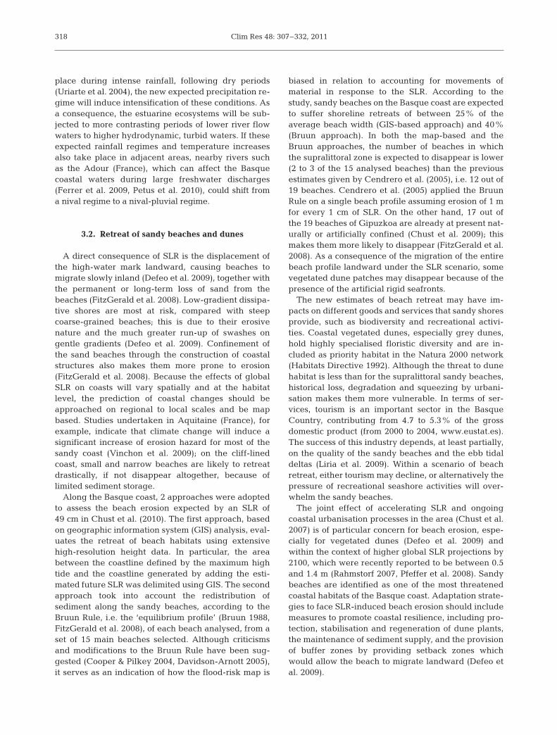
3.2. Retreat of sandy beaches and dunes
A direct consequence of SLR is the displacement ofthe high-water mark landward, causing beaches tomigrate slowly inland (Defeo et al. 2009), together withthe permanent or long-term loss of sand from thebeaches (FitzGerald et al. 2008). Low-gradient dissipa-tive shores are most at risk, compared with steepcoarse-grained beaches; this is due to their erosivenature and the much greater run-up of swashes ongentle gradients (Defeo et al. 2009). Confinement ofthe sand beaches through the construction of coastalstructures also makes them more prone to erosion(FitzGerald et al. 2008). Because the effects of globalSLR on coasts will vary spatially and at the habitatlevel, the prediction of coastal changes should beapproached on regional to local scales and be mapbased. Studies undertaken in Aquitaine (France), forexample, indicate that climate change will induce asignificant increase of erosion hazard for most of thesandy coast (Vinchon et al. 2009); on the cliff-linedcoast, small and narrow beaches are likely to retreatdrastically, if not disappear altogether, because of limited sediment storage.
Along the Basque coast, 2 approaches were adoptedto assess the beach erosion expected by an SLR of49 cm in Chust et al. (2010). The first approach, basedon geographic information system (GIS) analysis, eval-uates the retreat of beach habitats using extensivehigh-resolution height data. In particular, the areabetween the coastline defined by the maximum hightide and the coastline generated by adding the esti-mated future SLR was delimited using GIS. The secondapproach took into account the redistribution of sediment along the sandy beaches, according to theBruun Rule, i.e. the ‘equilibrium profile’ (Bruun 1988,FitzGerald et al. 2008), of each beach analysed, from aset of 15 main beaches selected. Although criticismsand modifications to the Bruun Rule have been sug-gested (Cooper & Pilkey 2004, Davidson-Arnott 2005),it serves as an indication of how the flood-risk map is
biased in relation to accounting for movements ofmaterial in response to the SLR. According to thestudy, sandy beaches on the Basque coast are expectedto suffer shoreline retreats of between 25% of the average beach width (GIS-based approach) and 40%(Bruun approach). In both the map-based and theBruun approaches, the number of beaches in whichthe supralittoral zone is expected to disappear is lower(2 to 3 of the 15 analysed beaches) than the previousestimates given by Cendrero et al. (2005), i.e. 12 out of19 beaches. Cendrero et al. (2005) applied the BruunRule on a single beach profile assuming erosion of 1 mfor every 1 cm of SLR. On the other hand, 17 out ofthe 19 beaches of Gipuzkoa are already at present nat-urally or artificially confined (Chust et al. 2009); thismakes them more likely to disappear (FitzGerald et al.2008). As a consequence of the migration of the entirebeach profile landward under the SLR scenario, somevegetated dune patches may disappear because of thepresence of the artificial rigid seafronts.
The new estimates of beach retreat may have im -pacts on different goods and services that sandy shoresprovide, such as biodiversity and recreational activi-ties. Coastal vegetated dunes, especially grey dunes,hold highly specialised floristic diversity and are in -cluded as priority habitat in the Natura 2000 network(Habitats Directive 1992). Although the threat to dunehabitat is less than for the supralittoral sandy beaches,historical loss, degradation and squeezing by urbani-sation makes them more vulnerable. In terms of ser-vices, tourism is an important sector in the BasqueCountry, contributing from 4.7 to 5.3% of the grossdomestic product (from 2000 to 2004, www.eustat.es).The success of this industry depends, at least partially,on the quality of the sandy beaches and the ebb tidaldeltas (Liria et al. 2009). Within a scenario of beachretreat, either tourism may decline, or alternatively thepressure of recreational seashore activities will over-whelm the sandy beaches.
The joint effect of accelerating SLR and ongoingcoastal urbanisation processes in the area (Chust et al.2007) is of particular concern for beach erosion, espe-cially for vegetated dunes (Defeo et al. 2009) andwithin the context of higher global SLR projections by2100, which were recently reported to be between 0.5and 1.4 m (Rahmstorf 2007, Pfeffer et al. 2008). Sandybeaches are identified as one of the most threatenedcoastal habitats of the Basque coast. Adaptation strate-gies to face SLR-induced beach erosion should includemeasures to promote coastal resilience, including pro-tection, stabilisation and regeneration of dune plants,the maintenance of sediment supply, and the provisionof buffer zones by providing setback zones whichwould allow the beach to migrate landward (Defeo etal. 2009).
318

Chust et al.: Climate change in the SE Bay of Biscay
3.3. Estuaries, saltmarshes and wetlands
3.3.1. Relationship between climate and estuarinespecies
Long-term series of estuarine biological data fromthe Basque Country are scarce, starting in 1989 for theNervión and Barbadún estuaries (see Fig. 1b for loca-tions) (Borja et al. 2006) and in 1995 for the remainder(Borja et al. 2004b). Using these data, Pérez et al.(2009) studied the temporal trends in Basque estuarinesoft-bottom macrofaunal communities, explained byanthropogenic, climatic and sedimentological factors.As these estuaries have been polluted historically(Cearreta et al. 2004), this has affected of benthic com-munities in recent years (Borja et al. 2009). Overall,sediments are the most relevant factor, ex plaining17.2% of benthic variability in the species density,whilst anthropogenic variables (pollutants) explain16.9% and climatic variables represent only 15.4% ofthe variability (Fig. 8). Hence, substratum and pollu-tion explain most of the variability of these altered systems, with climate factors being less relevant forthe Basque benthic estuarine communities.
On the other hand, in the case of plankton communi-ties, climatic variables seem to play an important role,even in historically-polluted estuaries, such as that ofNervión. Hence, Villate et al. (2008) described for theOka estuary a chain of effects from the NAO to chloro-phyll: air temperature inversely followed the NAOindex, water temperature followed air temperature,and chlorophyll a (chl a) followed water temperature.Aravena et al. (2009a) described similar relationshipsin both the Oka and Nervión estuaries, including river
discharge and rainfall. Related to zooplankton,Aravena et al. (2009b) recorded several species ofAcartia copepods in the Nervión estuary between 1998and 2005. A. clausi dominated the euhaline stretch ofthe estuary until 2003, when it was displaced from theinner part by A. tonsa, due to environmental changes.The de crease in A. clausi abundance in low-salinitywaters was related to a significant decrease of dis-solved oxygen saturation levels, whereas the increasein temperature was linked to a significant increase ofA. tonsa. A. margalefi and A. discaudata were scarceover the entire period, but they were valuable indica-tors of hydrological changes associated with climatefactors.
3.3.2. Sea level rise and estuarine habitats
The impacts of SLR in estuaries could lead tochanges in the extent of the low-lying areas, the migra-tion of saltmarshes landward, salinisation of aquifersand changes in sediment and nutrient transport (Crooks2004, FitzGerald et al. 2008). Elevation relative tomean sea level is a critical variable for the establish-ment and maintenance of biotic coastal communitiesand a threat to biodiversity (Kirwan & Murray 2008b,Kirwan et al. 2008), as has been detected in the pastfor the Basque Country (Pascual & Rodríguez-Lázaro2006). In tidal areas, this elevation determines theduration and frequency at which coastal habitats aresubmerged, this being one of the factors controllingthe productivity of macrophyte communities (Morris etal. 2002). The SLR is already causing the retreat ofcoastal forests (Williams et al. 1999, 2003, DeSantis etal. 2007), the loss of saltmarshes (Denslow & Battaglia2002, Chust et al. 2009), coral reef bleaching (Jokiel& Brown 2004) and the loss of goods and services(Costanza et al. 1997, Schröter et al. 2005, Michael2007).
Along the Basque coast, a study of the impacts of49 cm in SLR on the Gipuzkoa estuaries was under-taken by Chust et al. (2010). This study revealed that3.9 ha of wetlands and saltmarshes (i.e. 6.5% of thesurface) may be affected (Fig. 7). The impact assess-ment of such an approach is useful in assessing rela-tively large areas at high resolution and is reliable forhard substrata. However, marshes are dynamic sys-tems which respond to SLR according to a balance be -tween accretion and subsidence, bioproductivity anddecomposition, erosion and vegetative stabilisation,and tidal prism and drainage efficiency (Morris et al.2002, FitzGerald et al. 2008, Reeve & Karunarathna2009). In essence, the vertical accretion, as defined asnet vertical growth of the marsh, results from both min-eral sediment influx and the production of organic
319
0
20
40
60
80
100
Bar
bad
ún
Out
er N
ervi
ón
Inne
r Ner
vión
But
rón
Oka Lea
Art
ibai
Uro
la
Oria
Uru
mea
Oia
rtzu
n
Bid
asoa
Varia
nce
exp
lain
ed (%
)
Not explained Interaction Pollutants Sediment Climate
Fig. 8. Partition of the variance explained by different natural (cli-mate, sediment) and anthropogenic (pollutants) factors, togetherwith the interactions of those factors, in soft-bottom benthic com-
munities in Basque estuaries (data from Pérez et al. 2009)

Clim Res 48: 307–332, 2011
matter; this, in turn, determines the future evolution ofthe marsh in response to SLR (Morris et al. 2002). Salt-marshes are capable of being near equilibrium in rela-tion to rates of SLR (Friedrichs & Perry 2001), whilstunder specific conditions, they could lag by severaldecades (Kirwan & Murray 2008b). An average accre-tion rate of 3.7 mm yr−1, as calculated for the Basquemarshes in the 20th century by Leorri et al. (2008), sug-gests that these marshes are potentially able to adjustto the projected SLR rates.
On the other hand, when the accretion is below therate of SLR, which can take place within mudflats, thehabitat suitable for vegetation can be reduced in somecases—e.g. where the coastal margin is squeezedbetween the fixed landward boundary (artificial ornatural) and the SLR, i.e. the so-called‘coastal squeeze’ effect (Schleupner2008). To test the case of a natural fixedboundary, a species-specific habitatmodel was developed for the intertidalseagrass Zostera noltii in the Oka estu-ary (Basque coast, see Fig. 1b), usingecological niche factor analysis (Valleet al. 2010). The dependence of thisseagrass on the inundation frequencyof tides (Fig. 9), together with a high-resolution bathymetry generated byan airborne LiDAR system, enabledthese authors to map the present habi-tat suitability and estimate the future scenarios. The area of suitable habitat(with a probability of presence >50%)for Z. noltii in the Oka estuary isexpected to be reduced by 40% bythe end of the 21st century, as a con -
sequence of the future SLR (author’s unpubl. data,Fig. 10). This result suggests that migration of the sea-grass landward, following the SLR, can be limited bythe estuarine profile (Fig. 9). The habitat distribution ofthis seagrass also depends upon the hydrodynamicconditions and grain size features. Thus, ongoingresearch in numerical modelling on future sedimentredistribution should enhance the reliability of habitatloss estimates.
The projected rise in air temperature in the BasqueCountry (section 2.1) and sea temperatures within theBay of Biscay (section 2.3) might also interact nega-tively with SLR, having implications in terms of the lossof coastline biodiversity. On the one hand, the warm-ing of marine waters may cause the migration of
320
Phra
gmite
sJu
ncus
Hal
imio
neSp
artin
aG
raci
laria
Zost
era
Y D
ata
Profile (m)0 200 400 600 800 1000 1200
Hei
ght
(m)
–4
–2
0
2
4
6
Low Tide
High Tide
MudflatsSaltmarshes
Main channel
Fixedboundary
(A) (B)
+ Sea level rise
+ Sea level rise
Fig. 9. (A) Height profile derived from bathymetric data of intertidal habitats in the inner Oka estuary (Basque coast). High tideand low tide are the observed mean spring tide values for the Bilbao I tide gauge station. (B) Height distribution of main intertidalflora of the innermost Oka estuary (Phragmites australis, Juncus maritimus, salt marshes dominated by Halimione portulacoidesand Salicornia sp., Spartina maritima, Gracilaria sp., Zostera noltii). Plots show the median, 10th, 25th, 75th and 90th percentilesas vertical boxes with error bars, and outliers (crosses). Height data were extracted from bathymetric LiDAR system acquired
in June 2007
Fig. 10. Habitat suitability for Zostera noltii in the Oka estuary (Basque coast)(A) at present (2008) and (B) expected by the end of the 21st century as a conse-quence of future sea level rise. Habitat suitability is classified into 3 probabilityranges of occurrence: 0 to 33% (yellow), 34 to 66% (red) and 67 to 100%
(blue) (authors’ unpubl. data)
Chust et al.: Climate change in the SE Bay of Biscay
intertidal species with a narrow niche tohigher latitudes. On the other hand, theeventual loss of small saltmarshes leads tofragmentation of the estuarine habitatpatches along the coast, thereby reducingthe potential connectivity between localpopulations (Fahrig 2003). Thus, similarto the contraction of alpine species dis -tribution, estuarine species populationswith narrow niches, with limited disper-sal potential (Defeo et al. 2009) and withfragmented habitat by historical urbani-sation in a particular area, may be at localextinction risk under climate change.
Wetlands and marshes in the Basqueestuaries are also squeezed by croplandsand pastures that lie within the originalupper intertidal zone. In the area, these croplands areprotected by walls and drained to be used for agricul-ture purposes, since they lie below the present maxi-mum astronomic high tide level. Hence, these humanactivities are vulnerable to the SLR expected by 2100,especially when extreme events, such as high tides andriver floods, occur simultaneously. Likewise, if agricul-ture activity continues to decline, as throughout the20th century (Cearreta et al. 2004), these areas may beabandoned and may be susceptible to recolonisationby marsh communities (Garbutt et al. 2006, Mar-quiegui & Aguirrezabalaga 2009). On the basis ofthese latter socio-economic and climate change sce-narios, saltmarshes and wetlands might in crease, aspredicted for other areas (Titus et al. 2009).
3.4. Coastal benthic communities
3.4.1. Relationships between climate and benthos
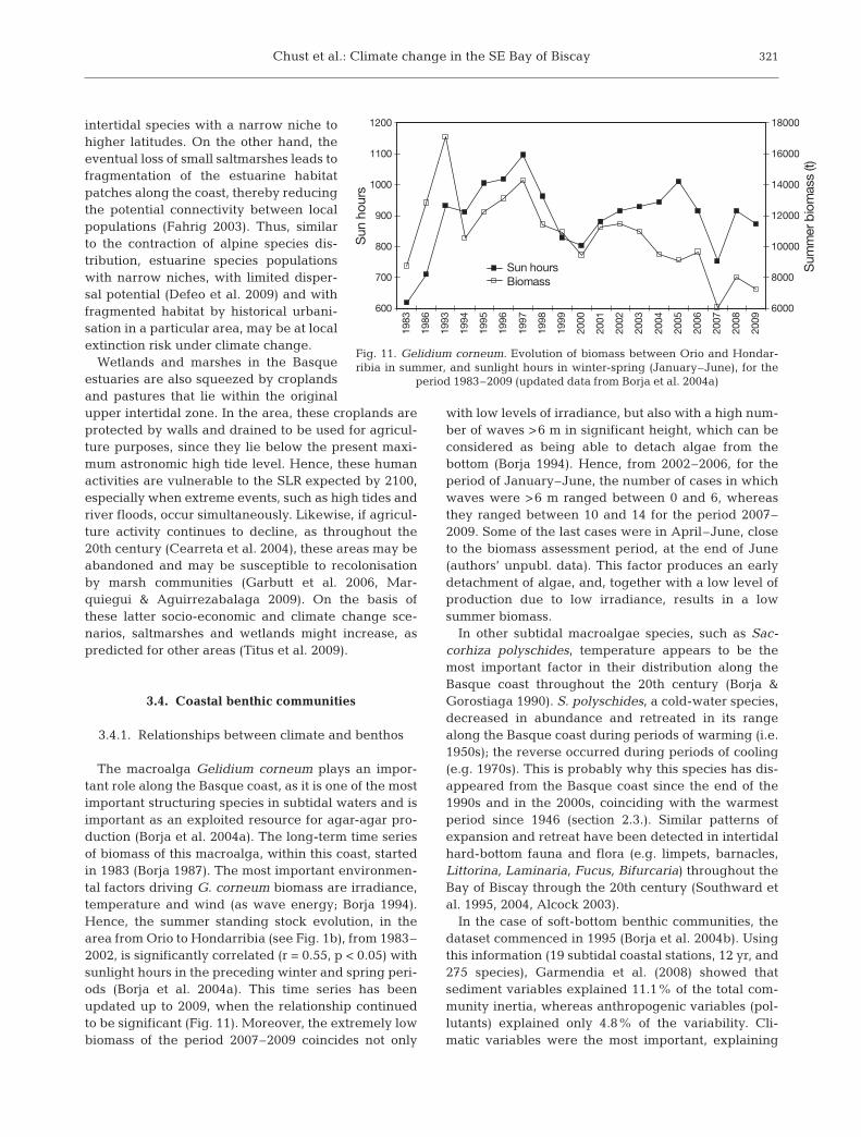
The macroalga Gelidium corneum plays an impor-tant role along the Basque coast, as it is one of the mostimportant structuring species in subtidal waters and isimportant as an exploited resource for agar-agar pro-duction (Borja et al. 2004a). The long-term time seriesof biomass of this macroalga, within this coast, startedin 1983 (Borja 1987). The most important environmen-tal factors driving G. corneum biomass are irradiance,temperature and wind (as wave energy; Borja 1994).Hence, the summer standing stock evolution, in thearea from Orio to Hondarribia (see Fig. 1b), from 1983–2002, is significantly correlated (r = 0.55, p < 0.05) withsunlight hours in the preceding winter and spring peri-ods (Borja et al. 2004a). This time series has beenupdated up to 2009, when the relationship continuedto be significant (Fig. 11). Moreover, the extremely lowbiomass of the period 2007–2009 coincides not only
with low levels of irradiance, but also with a high num-ber of waves >6 m in significant height, which can beconsidered as being able to detach algae from the bottom (Borja 1994). Hence, from 2002–2006, for theperiod of January–June, the number of cases in whichwaves were >6 m ranged between 0 and 6, whereasthey ranged between 10 and 14 for the period 2007–2009. Some of the last cases were in April–June, closeto the biomass assessment period, at the end of June(authors’ unpubl. data). This factor produces an earlyde tach ment of algae, and, together with a low level ofproduction due to low irradiance, results in a low summer biomass.
In other subtidal macroalgae species, such as Sac-corhiza polyschides, temperature appears to be themost important factor in their distribution along theBasque coast throughout the 20th century (Borja &Gorostiaga 1990). S. polyschides, a cold-water species,decreased in abundance and retreated in its rangealong the Basque coast during periods of warming (i.e.1950s); the reverse occurred during periods of cooling(e.g. 1970s). This is probably why this species has dis-appeared from the Basque coast since the end of the1990s and in the 2000s, coinciding with the warmestperiod since 1946 (section 2.3.). Similar patterns ofexpansion and retreat have been detected in intertidalhard-bottom fauna and flora (e.g. limpets, barnacles,Littorina, Laminaria, Fucus, Bifurcaria) throughout theBay of Biscay through the 20th century (Southward etal. 1995, 2004, Alcock 2003).
In the case of soft-bottom benthic communities, thedataset commenced in 1995 (Borja et al. 2004b). Usingthis information (19 subtidal coastal stations, 12 yr, and275 species), Garmendia et al. (2008) showed that sediment variables explained 11.1% of the total com-munity inertia, whereas anthropogenic variables (pol-lutants) explained only 4.8% of the variability. Cli-matic variables were the most important, explaining
321
600
700
800
900
1000
1100
1200
1983
1986
1993
1994
1995
1996
1997
1998
1999
2000
2001
2002
2003
2004
2005
2006
2007
2008
2009
Sun
hou
rs
6000
8000
10000
12000
14000
16000
18000
Sum
mer
bio
mas
s (t)
Sun hoursBiomass
Fig. 11. Gelidium corneum. Evolution of biomass between Orio and Hondar-ribia in summer, and sunlight hours in winter-spring (January–June), for the
period 1983–2009 (updated data from Borja et al. 2004a)

Clim Res 48: 307–332, 2011
17% of the total variability. Of the latter, the mostimportant variables were river flow (explaining 49.2%of the variability), precipitation (7.3%), winter NAO(6.9%), sunshine (6.6%) and EA (5.9%). Hence, it seemsthat although in Basque estuaries, sedimentologicaland anthropogenic factors determine benthic abun-dance (see above), in coastal waters climatic variablesgenerally explain most of the variability of such abun-dance. Only in areas more affected by pollution (e.g.near wastewater discharges), are anthropogenic fac-tors determining the evolution of benthic abundance.
3.4.2. Predictions in benthos changes
Investigations into the prediction of the effects of climate change on coastal benthos, within the Bay of Biscay, are concentrated within the northern part ofthe bay (Southward et al. 1995, 2005). Southward et al.(1995) predicted a general shift of warm water speciesto the north, together with a retreat of the cold waterspecies. Additionally, they predicted the definitive de -cline in some species, such as the native oyster Ostreaedulis, which is already under threat from pollutionand introduced pathogens, and will likely be replacedby warmer water species from the genus Crassostrea,as has already been detected in the Basque Country.
Using a graphical model (with the summer and win-ter limits of temperature for benthic species), Alcock(2003) predicted changes in 18 intertidal species until2050. In general, for those warm water species (e.g.Patella rustica, Pollicipes pollicipes) with a present geo -graphical limit on the Basque or French coasts, expan-sion to the north of the British Isles and to the south ofthe North Sea is predicted. Species presently extend-ing to the south of the British Isles (e.g. Osilinus linea-tus, Gibbula umbilicalis, Balanus perforatus, Patelladepressa) will expand to southern Norway. In turn,cold water species (e.g. Patella vulgata, Nucella lapil-lus, Semibalanus balanoides, Pelvetia canaliculata,Fucus vesiculosus, F. serratus, Laminaria hyperborea),which are present only in the western and northernparts of the Bay of Biscay, will disappear completelyfrom the bay by 2025. In some cases, such as N. lapil-lus, this has already been detected. This species wasidentified in the 1980s off the Barbadun estuary (Borjaet al. 1982), and began disappearing from the Basquecoast in the 1990s, with the increase in sea temperature.
On the other hand, using robust supervised classifi-cation methods, as applied to fish recruitment (Fernan-des et al. 2010), prediction of the summer Gelidiumcorneum biomass was attempted, taking into accountsun hours, waves, winds, NAO and EA. Data from1993–2009 showed that EA and sun hours are the fac-tors which best explain the variability in the summer
biomass. Hence, scenarios considering low sun hours(<929) in winter and spring, together with mean EAvalues (0 to 0.7), predicted 80% of probability of havinglow Gelidium biomass (<7000 t) and 20% of probabilityof moderate biomass (7000– 8000 t).
3.5. Urban coastal environment
The main climate drivers that could affect urbanenvironments are the increase (decrease) of heat (cold)stress in summer (winter), a change in precipitationpatterns, SLR and increasing extreme weather events,such as storms and flooding (Wilbanks et al. 2007). Theimpacts of global climate change on urban environ-ments depend markedly on the geographical locationand the industrial development of human settlements.In Europe, the main climate drivers that could affectcoastal urban environments are wind-driven wavesand storms, together with the SLR (Alcamo et al. 2007).The main impacts of these drivers on urban areas areflooding, coastal defence failures and the damaging ofinfrastructures; likewise, rising water tables could im -pede the drainage and cause salinisation of ground -water (Nicholls et al. 2007, Devoy 2008).
Along the Basque coast, urban areas are locatedmostly within the estuaries; of the 45% of the estuarineareas lost following the post-Flandrian retreat, 90%was due to land reclamation (Rivas & Cendrero 1994).The purposes of the landfill of estuarine areas, whichbegan in the 17th century, were socioeconomic, viz.agriculture, industrial installations, residential areasand transport infrastructure, amongst others (Díez etal. 2000). Although the coastal municipalities occupy14.6% of the total surface of the Basque Country,60.4% of the total housing is concentrated within suchareas. The population density at the coast is 4 timeshigher than that of the Basque Country as a whole.With regard to the infrastructure, there are 17 ports, anairport, several roads and rail links and around 30sewage treatment plant within this region. Thus, cli-mate drivers, mainly the frequency of the storms andthe SLR (Cendrero et al. 2005), could affect the socioe-conomic activities of the Basque coast.
Assuming a scenario of 49 cm in SLR for 2099 (sec-tion 2.4.), the artificial area in the Gipuzkoan coast thatcould be flooded is 35.2 ha (Chust et al. 2010). Agreater part of these areas are those which have beenreclaimed since the 17th century, including industrial,residential, harbour and transport infrastructure, suchas roads and an airport. Their vulnerability will behigher at high tides and during sea storms (Fig. 7).Amongst the affected areas, those located within estu-aries will be even more vulnerable, since besides SLRand high tides, they will also be exposed to river floods.
322

Chust et al.: Climate change in the SE Bay of Biscay
At present, the predicted flooded areas are protectedby defences against flooding; these will not be over-topped with the projected SLR, providing that thedefences do not fail. Nevertheless, the flood defenceswill support a higher water volume and consequentlymay suffer more erosion.
Harbour infrastructures and external dykes are alsothought to be affected by climate change. The com-bined action of sea level and wave height rise willincrease the overtopping of the piers located alongthe Cantabrian coast; in some cases their stability willdiminish. Assuming a standard dyke, the overtopping(water volume exceeding the height of the dyke abovesea level) over the main external dykes of the Basquecoast will increase by at least 30% from the beginningto the end of the 21st century (authors’ unpubl. data).This result was obtained under a scenario of sea leveland significant wave height (exceeding 12 h yr–1) rise.In the case of the main harbours of the Basque coast,the sole impact of SLR will imply a smaller distancebetween the levels of the highest astronomical tide andthat of their piers, towards the end of the 21st century(Chust et al. 2010); in time, this may diminish the func-tionality of the piers. If the geometry of the navigationchannel is modified, this could also affect navigationinto the harbours (Acinas 2002). The rising seawatertables would also increase salt water intrusion; hence,it could threaten drainage systems and the groundwa-ter such as those of Gernika, which are occasionallycontaminated by salt water (B. G. Bikuña, M. Moso,J. Arrate, S. Lujan unpubl. data).
4. IMPACTS ON THE PELAGIC ENVIRONMENT
4.1. Chlorophyll and primary production
4.1.1. Long-term trends
Most of the time-series measurements of phyto-plankton in the Bay of Biscay are coastal or estuarine.Furthermore, all of them cover <25 yr, which makes itdifficult to extract long-term trends. The results fromcoastal time series differ locally. Off Gijon, a decreasein primary production has been observed over the last10 yr (Valdés et al. 2007, Llope et al. 2007), whereas anincrease has been observed off La Coruña, around thearea of the Galician upwelling (Valdés et al. 2007).In turn, regarding long-term trends in chl a, Bode et al.(2009) did not identify any evidence for significantchange at 2 locations, in Galicia and the central Can -tabrian Sea, over the past 10 to 20 yr. Along the Basquecoast, a significant (p < 0.05) slight de crease in surfacechl a was observed from 1986– 2008 (Revilla et al. 2010;Fig. 12). This decrease is consistent with the concep-
tual model of Richardson & Schoeman (2004) thatdescribes the effect of increasing temperature inmarine waters with seasonal stratification and limitednutrient concentrations, such as that within the southeastern part of the Bay of Biscay. In turn, whenstudying the water column (0 to 100 m water depth), asignificant chl a increase was found for the period1986–2009, especially in the photic layer (0 to 50 m)with values of 6.2 × 10⁻³ µg l–1 yr–1 (M. Revilla pers.comm.). In this period, the deepening of the subsurfacemaximum of chlorophyll was from 10 m in 1986 to 30 min the years 2000–2009, explaining this incoherencybetween the decrease in surface and the increase insubsurface layers (M. Revilla pers. comm.).
Offshore in the Bay of Biscay, a 10 yr study of theoptical properties derived from the SeaWIFS sensorhas suggested a significant increase in chl a within thisarea (Van trepotte & Mélin 2010). Actually, the longesttime series (from 1957) covering oceanic waters is thecontinuous plankton recorder (CPR) survey line, link-ing the UK to Galicia. The phytoplankton colour indexindicates a clear increase in primary productivity in theareas that encompass offshore waters in the Bay of Biscay (Edwards et al. 2009). This increase in primaryproductivity does not appear to have been transferredto the higher trophic levels, as CPR data suggest thatzooplankton concentration is stable or has declined, asalso observed in coastal time series (Valdés et al. 2007).
4.1.2. Predictions in plankton changes
Global models are in agreement in forecasting along-term decrease of primary production in the NorthAtlantic, including the Bay of Biscay (Steinacher et al.2009). However, such global models generally do notperform well in coastal areas such as those of the Bayof Biscay (Steinacher et al. 2009). On the other hand,higher-resolution regional models also predict anincrease in the total annual stratified days for the bay(Lowe et al. 2009), which would result in a decrease innutrients and net primary production. Such forecastsmust be considered with caution, since in the Bay ofBiscay, nutrient concentration is also heavily depen-dent upon river discharges, and at present no regionalmodels on variation in river discharges for the overallarea are available.
4.2. Fish stocks
4.2.1. Relationships between climate and fishes
The population dynamics of practically all species ofcommercial interest within the Bay of Biscay are influ-
323
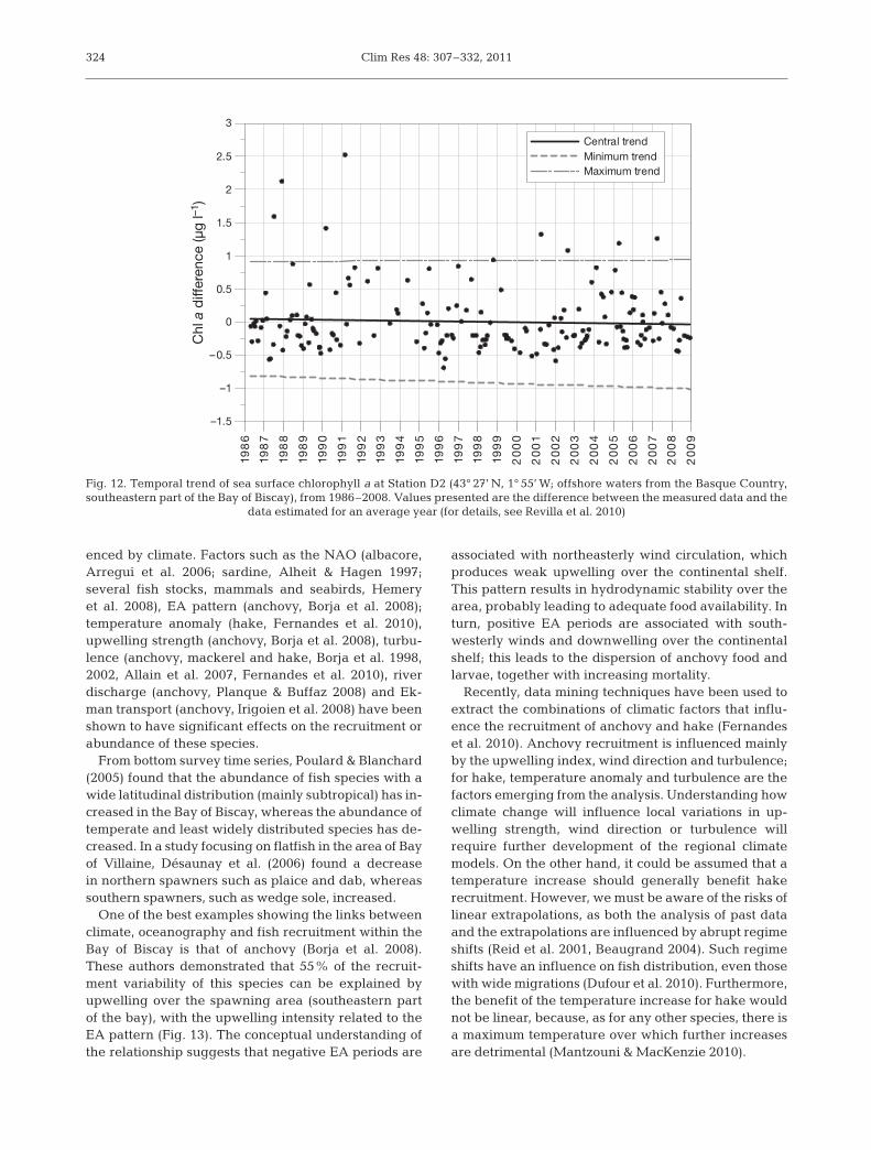
Clim Res 48: 307–332, 2011
enced by climate. Factors such as the NAO (albacore,Arregui et al. 2006; sardine, Alheit & Hagen 1997; several fish stocks, mammals and seabirds, Hemeryet al. 2008), EA pattern (anchovy, Borja et al. 2008);temperature anomaly (hake, Fernandes et al. 2010),upwelling strength (anchovy, Borja et al. 2008), turbu-lence (anchovy, mackerel and hake, Borja et al. 1998,2002, Allain et al. 2007, Fernandes et al. 2010), riverdischarge (anchovy, Planque & Buffaz 2008) and Ek -man transport (anchovy, Irigoien et al. 2008) have beenshown to have significant effects on the recruitment orabundance of these species.
From bottom survey time series, Poulard & Blanchard(2005) found that the abundance of fish species with awide latitudinal distribution (mainly subtropical) has in-creased in the Bay of Biscay, whereas the abundance oftemperate and least widely distributed species has de-creased. In a study focusing on flatfish in the area of Bayof Villaine, Désaunay et al. (2006) found a decreasein northern spawners such as plaice and dab, whereassouthern spawners, such as wedge sole, increased.
One of the best examples showing the links betweenclimate, oceanography and fish recruitment within theBay of Biscay is that of anchovy (Borja et al. 2008).These authors demonstrated that 55% of the recruit-ment variability of this species can be explained byupwelling over the spawning area (southeastern partof the bay), with the upwelling intensity related to theEA pattern (Fig. 13). The conceptual understanding ofthe relationship suggests that negative EA periods are
associated with northeasterly wind circulation, whichproduces weak upwelling over the continental shelf.This pattern results in hydrodynamic stability over thearea, probably leading to adequate food availability. Inturn, positive EA periods are associated with south-westerly winds and downwelling over the continentalshelf; this leads to the dispersion of anchovy food andlarvae, together with increasing mortality.
Recently, data mining techniques have been used toextract the combinations of climatic factors that influ-ence the recruitment of anchovy and hake (Fernandeset al. 2010). Anchovy recruitment is influenced mainlyby the upwelling index, wind direction and turbulence;for hake, temperature anomaly and turbulence are thefactors emerging from the analysis. Understanding howclimate change will influence local variations in up-welling strength, wind direction or turbulence will require further development of the regional climatemodels. On the other hand, it could be assumed that atemperature increase should generally benefit hake recruitment. However, we must be aware of the risks oflinear extrapolations, as both the analysis of past dataand the extrapolations are influenced by abrupt regimeshifts (Reid et al. 2001, Beaugrand 2004). Such regimeshifts have an influence on fish distribution, even thosewith wide migrations (Dufour et al. 2010). Furthermore,the benefit of the temperature increase for hake wouldnot be linear, because, as for any other species, there isa maximum temperature over which further increasesare detrimental (Mantzouni & Mac Kenzie 2010).
324
198
6
198
7
198
8
198
9
199
0
199
1
199
2
199
3
199
4
199
5
199
6
199
7
199
8
199
9
20
00
20
01
20
02
20
03
20
04
20
05
20
06
20
07
20
08
20
09
–1.5
–1
–0.5
0
0.5
1
1.5
2
2.5
3
Chl
a d
iffer
ence
(µg
l–1 )
Central trendMinimum trendMaximum trend
Fig. 12. Temporal trend of sea surface chlorophyll a at Station D2 (43° 27’ N, 1° 55’ W; offshore waters from the Basque Country,southeastern part of the Bay of Biscay), from 1986–2008. Values presented are the difference between the measured data and the
data estimated for an average year (for details, see Revilla et al. 2010)

Chust et al.: Climate change in the SE Bay of Biscay
4.2.2. Predictions on fish changes
The projected increase in sea temperature over theBay of Biscay (section 2.3.), a weakening in the Atlanticthermohaline circulation and an increase in stratifica-tion, together with other changes described in previoussections, will change the geographical distribution ofspecies (Clemmesen et al. 2007). These changes willresult in: (1) shifts of fish populations, with the invasionof alien species and disappearance of native species;and (2) direct influence on survivorship, reproduction,dispersal, fertility and the behaviour of individualsand, thus, on abundance and distribution, as alsostated for other marine areas (Drinkwater et al. 2010).
Studies focusing on diadromous fish species (Las-salle & Rochard 2009) have predicted that river basinsin the Bay of Biscay may no longer be suitable for anumber of species (e.g. Petromyzon marinus, Salmosalar, Lampetra fluviatilis, Alosa alosa, Platichthys fle-sus). Although it is very difficult to judge at a globallevel who the main losers and winners will be fromchanges in fish and fisheries as a result of climatechange, Brander (2010) provided some recommenda-tions on short-, medium- and long-term managementfor fisheries. These can be summarised in an adapta-tion to changing climate, future monitoring and re -search, all of which must be linked closely to respon-sive, flexible and reflexive management systems.
5. CONCLUDING REMARKS
The trend in annual air temperature throughout the20th century (1901–2005) in the northern region of theIberian Peninsula was, within a 95% interval, between0.09 and 0.16°C dec–1. This trend was much higher
during the period 1973–2005, with an estimatedincrease of 0.51°C dec–1. Projections from regional cli-mate models for the 21st century, under GHG emissionscenarios, indicate warming of surface air over theBasque Country. In particular, heat wave episodes willin crease in duration, and the 90th percentile of dailymaximum temperature is expected to increase duringsummer by 3 ± 0.9°C. Air surface warming will in -crease the temperature of the upper sea surface layers,especially in the coastal areas. According to the projec-tions, the temperature of the upper 100 m of the watercolumn in the Bay of Biscay will increase by between1.5 and 2.05°C during the 21st century; this is in agree-ment with the SST warming trend since the 1970s. Theconsequence of such warming is thermal expansion ofthe ocean and, hence, SLR. In particular, the projec-tions (A1B and A2 scenarios) of SLR in the bay indicatean increase of between 29 and 49 cm from 2001–2099,as a result of regional thermal expansion and global icemelt. This is in agreement with the long-term tidegauge records and satellite-derived measurementsin the Bay of Biscay, consistently showing an SLRthroughout the 20th century.
SLR is predicted to flood 111 ha of the supralittoralarea of the Gipuzkoan coast, concentrated within low-lying areas within the inner estuaries, whilst extremewaves predicted with a 50 yr return period will mainlyaffect sandy beaches, harbours and some urban areas.Wetlands and saltmarshes are expected to be affectedto a lesser degree, since their dynamic response interms of accretion may balance the future rate ofSLR. Future research should focus on modelling theestuarine sediment morphodynamics according to theexpected sea level by the end this century. Sandybeaches, which are expected to under go mean shore-line retreats of between 25 and 40% of their width, are
325
Fig. 13. Comparison between the total annual upwelling (March to July), Eastern Atlantic (EA) index (March to July) and the Bay of Biscay anchovy recruitment index, between 1967 and 2005 (modified from Borja et al. 2008)

Clim Res 48: 307–332, 2011
identified as one of the main vul nerable littoral ele-ments. For artificial surfaces, the expected main im -pacts are erosion or failure of coastal defences, flood-ing of urban areas in estuaries, damage to drainagesystems and the salinisation of groundwater. The pro-jected warming of the air and sea along the Basquecoast might also interact negatively with SLR, e.g.through loss of coastal biodiversity, especially for thoseestuarine populations of species with narrow niches,with limited dispersal potential and with artificiallyfragmented habitat.
The future impacts of ocean warming on pelagic andcoastal water ecosystems are subjected to different pos-itive and negative feedbacks. The distribution and dy-namics of most of the biological elements reviewed (i.e.chl a, plankton and benthic species communities andpopulations, natural habitats, fisheries) are affected byocean-climatic variability. Observations of biologicalindicators within the study area are somewhat shortterm (<25 yr) or ‘snapshots’, which makes it difficult toextract any long-term trends. However, if the Atlanticthermohaline circulation is weakened and stratificationis increased during the 21st century, as expected bysome projections, these changes will result in shifts offish populations, invasion by alien species, disappear-ance of some native species, and direct influence onsurvivorship, reproduction, dispersal, fertility and be-haviour of individuals and, thus, on abundance and dis-tribution. The projections for the 21st century over thisarea indicate a slight decrease in the mean pre -cipitation (–0.7 ± 0.3% dec–1) and a slight increase inextreme daily rainfall (10%). This pattern may have implications for those marine species dwelling orspawning in estuarine waters. In particular, the regimeof flood events in the coast of the area studied is ex-pected to change slightly and the estuarine ecosystemswill be subjected to more extremes, e.g. from lowerstreamflow (during dry spells), to higher hydrody-namic, turbid (suspended matter charged) waters (during heavy rainfall events). Future research shouldfocus on projecting changes on current circulation, up-welling/downwelling, climatic indices (i.e. EA, NAO),wave climate and acidification within the bay, in orderto better assess the future potential impacts on pelagicand coastal water ecosystems.
Acknowledgements. This study was supported by the Depart-ment of Environment, Regional Planning, Agriculture andFisheries (DERPAF) of the Basque Government (K-Egokitzenand EKLIMA21 projects, Etortek Funding Program); like-wise, by the Ministry of Environment and Rural and Marine Environment of the Spanish Government (Project Ref.: 0.39/SGTB/ 2007/4.1), and the Ministry of Science and Innovation(Project Ref.: CGL2008-03321). We acknowledge the contri-bution of M. Collins (School of Ocean and Earth Science, Uni-versity of Southampton and AZTI-Tecnalia), A. Fontán and
M. González (AZTI-Tecnalia) for providing useful comments;I. Galparsoro and J. M. Garmendia (AZTI-Tecnalia) for pro-viding data for generating the Z. noltii habitat model; andF. J. Méndez (Universidad de Cantabria) for providing waveheight scenarios. This is contribution 529 from AZTI-TecnaliaMarine Research Division.
LITERATURE CITED
Abanades JC, Cuadrat JM, de Castro M, Fernández F andothers (2007) El cambio climático en España. Estado desituación. Spanish Ministry of Environment, Madrid
Acinas RA (2002) Cambio climático y subida del nivel mediodel mar. Impacto sobre la costa. Ing Territ 61:60–67
Alcamo J, Moreno JM, Nováky B, Bindi M and others (2007)Europe. In: Parry ML, Canziani OF, Palutikof JP, van derLinden PJ, Hanson CE (eds) Climate change 2007:impacts, adaptation and vulnerability. Contribution ofWorking Group II to the Fourth Assessment Report of theIntergovernmental Panel on Climate Change. CambridgeUniversity Press, Cambridge, p 541–580
Alcock R (2003) The effects of climate change on rocky shorecommunities in the Bay of Biscay, 1895–2050. PhD thesis,University of Southampton
Alheit J, Hagen E (1997) Long-term climate forcing of Euro-pean herring and sardine populations. Fish Oceanogr6:130–139
Allain G, Petitgas P, Lazure P, Grellier P (2007) Biophysicalmodelling of larval drift, growth and survival for the pre-diction of anchovy (Engraulis encrasicolus) recruitment inthe Bay of Biscay (NE Atlantic). Fish Oceanogr 16:489–505
Allan RP, Soden BJ (2008) Atmospheric warming and theamplification of precipitation extremes. Science 321:1481–1484
Alvarez I, Gómez-Gesteira M, deCastro M, Gómez-GesteiraJL, Dias JM (2010) Summer upwelling frequency alongthe western Cantabrian coast from 1967 to 2007. J MarSyst 79:218–226
Araújo IB, Pugh DT (2008) Sea levels at Newlyn 1915–2005:analysis of trends for future flooding risks. J Coast Res24:203–212
Aravena G, Villate F, Iriarte A, Uriarte I, Ibáñez B (2009a)Influence of the North Atlantic Oscillation (NAO) on climatic factors and estuarine water temperature on theBasque coast (Bay of Biscay): comparative analysis ofthree seasonal NAO indices. Cont Shelf Res 29:750–758
Aravena G, Villate F, Uriarte I, Iriarte A, Ibáñez B (2009b)Response of Acartia populations to environmental vari-ability and effects of invasive congenerics in the estuary ofBilbao, Bay of Biscay. Estuar Coast Shelf Sci 83:621–628
Arregui I, Arrizabalaga H, Kirby DS, Martin-Gonzalez JM(2006) Stock-environment-recruitment models for NorthAtlantic albacore (Thunnus alalunga). Fish Oceanogr 15:402–412
Bárdossy A, Caspary HJ (1990) Detection of climate change inEurope by analysing European atmospheric circulationpatterns from 1881 to 1989. Theor Appl Climatol 42:155–167
Barry RG, Chorley RJ (2003) Atmosphere, weather, and cli-mate, 8th edn. Routledge, London
Beaugrand G (2004) The North Sea regime shift: evidence,causes, mechanisms and consequences. Prog Oceanogr60: 245–262
Bindoff NL, Willebrand J, Artale V, Cazenave A and others(2007) Observations: oceanic climate change and sealevel. In: Solomon S, Qin D, Manning M, Chen Z and oth-
326

Chust et al.: Climate change in the SE Bay of Biscay
ers (eds) Climate change 2007: the physical science basis.Contribution of Working Group I to the Fourth AssessmentReport of the Intergovernmental Panel on Climate Change.Cambridge University Press, Cambridge, p 387–429
Bode A, Anadón R, Cabanas JM, Carballo R and others (2009)Year-to-year variability in inorganic nutrients, primaryproduction and phytoplankton biomass off NW Spain from1990 to 2007. ICES CM 2009/ D:13 ICES, Copenhagen
Borja A (1987) Cartografía, evaluación de la biomasa y arrib-azones del alga Gelidium sesquipedale (Clem.) Born. etThur. en la costa guipuzcoana (N España). Invest Pesq51:199–224
Borja A (1994) Factores ambientales que influyen en al gen-eración, desprendimiento de biomasa, crecimiento y pro-ducción en praderas naturales de Gelidium sesquipedale(Clem.) Born. et Thur. en el País Vasco (N de España). SciMar 58:251–260
Borja A, Gorostiaga JM (1990) Distribución geográfica deSaccorhiza polyschides (Light.) Batt. en la costa vasca. Suposible relación con la temperatura. Actas 6° SimposioIbérico Estudios Bentos Marino, Palma de Mallorca 1,p 1–8
Borja A, Fernández JA, Orive E (1982) Estudio sobre zonaciónen el intermareal rocoso del entorno del estuario delNervión. Bull Cent Etud Rech Sci Biarritz 14:55–82
Borja A, Uriarte A, Egaña J, Motos L, Valencia V (1998) Rela-tionships between anchovy (Engraulis encrasicolus) re -cruitment and environment in the Bay of Biscay (1967–1996). Fish Oceanogr 7:375–380
Borja Á, Egaña J, Valencia V, Franco F, Castro R (2000)1947–1997, estudio y validación de una serie de datosdiarios de temperatura del agua del mar en San Sebastián,procedente de su Aquarium. Ozeanografika 3:139–152
Borja A, Uriarte A, Egaña J (2002) Environmental factors andrecruitment of mackerel, Scomber scombrus L. 1758, alongthe north-east Atlantic coasts of Europe. Fish Oceanogr11:116–127
Borja A, Aguirrezabalaga F, Martínez J, Sola JC, García-Arberas L, Gorostiaga JM (2004a) Benthic communities,biogeography and resources management. In: Borja A,Collins M (eds) Oceanography and marine environment ofthe Basque Country. Elsevier Oceanogr Ser 70: 455–492
Borja A, Franco J, Valencia V, Bald J, Muxika I, Belzunce MJ,Solaun O (2004b) Implementation of the European WaterFramework Directive from the Basque Country (northernSpain): a methodological approach. Mar Pollut Bull 48:209–218
Borja Á, Muxika I, Franco J (2006) Long-term recovery of soft-bottom benthos following urban and industrial sewagetreatment in the Nervión estuary (southern Bay of Biscay).Mar Ecol Prog Ser 313:43–55
Borja A, Fontán A, Sáenz J, Valencia V (2008) Climate,oceanography, and recruitment: the case of the Bay of Biscay anchovy (Engraulis encrasicolus). Fish Oceanogr17: 477–493
Borja A, Muxika I, Rodríguez JG (2009) Paradigmaticresponses of marine benthic communities to differentanthropogenic pressures, using M-AMBI, within the Euro-pean Water Framework Directive. PSZNI: Mar Ecol 30:214–227
Brander K (2010) Impacts of climate change on fisheries.J Mar Syst 79:389–402
Brunet M, Jones PD, Sigró J, Saladié O and others (2007)Temporal and spatial temperature variability and changeover Spain during 1850–2005. J Geophys Res 112:D12117doi:10.1029/2006JD008249
Bruun P (1988) The Bruun rule of erosion by sea-level rise:
a discussion of large-scale two- and three-dimensionalusages. J Coast Res 4:627–648
Caballero A, Pascual A, Dibarboure G, Espino M (2008) Sealevel and eddy kinetic energy variability in the Bay of Bis-cay, inferred from satellite altimeter data. J Mar Syst 72:116–134
Castro-Díez Y, Pozo-Vázquez D, Rodrigo FS, Esteban-ParraMJ (2002) NAO and winter temperature variability insouthern Europe. Geophys Res Lett 29:1160 doi: 10.1029/2001GL014042
Cazenave A, Nerem RS (2004) Present-day sea level change:observations and causes. Rev Geophys 42:RG3001 doi:10.1029/2003RG000139
Cazenave A, Dominh K, Guinehut S, Berthier E and others(2009) Sea level budget over 2003–2008: a reevaluationfrom GRACE space gravimetry, satellite altimetry andArgo. Global Planet Change 65:83–88
Cearreta A, Irabien MJ, Pascual A (2004) Human activitiesalong the Basque coast during the last two centuries: geo-logical perspective of recent anthropogenic impact on thecoast and its environmental consequences. In: Borja A,Collins M (eds) Oceanography and marine environment ofthe Basque Country. Elsevier Oceanogr Ser 70:27–50
Cendrero A, Sánchez-Arcilla A, Zazo C (2005) Impacts oncoastal areas. In: Moreno JM (ed) Impacts of the cli -matic change in Spain. Ministry of Environment, Madrid,p 451–504
Christensen JH, Carte TR, Rummukainen M, Amanatidis G(2007a) Evaluating the performance and utility of regionalclimate models: the PRUDENCE project. Clim Change81:2–6
Christensen JH, Hewitson B, Busuioc A, Chen A and others(2007b) Regional climate projections. In: Solomon S, QinD, Manning M, Chen Z and others (eds) Climate change:the physical science basis. Contribution of Working GroupI to the Fourth Assessment Report of the Intergovernmen-tal Panel on Climate Change. Cambridge University Press,Cambridge, p 847–940
Church JA, White NJ (2006) A 20th century acceleration inglobal sea-level rise. Geophys Res Lett 33:L01602 doi:10.1029/2005GL024826
Church JA, White NJ, Coleman R, Lambeck K, Mitrovica JX(2004) Estimates of the regional distribution of sea levelrise over the 1950–2000 period. J Clim 17:2609–2625
Chust G, Galparsoro I, Borja A, Franco J, Beltrán B, Uriarte A(2007) Detección de cambios recientes en la costa vascamediante ortofotografía. Lurralde 30:59–72
Chust G, Borja Á, Liria P, Galparsoro I, Marcos M, CaballeroA, Castro R (2009) Human impacts overwhelm the effectsof sea-level rise on Basque coastal habitats (N Spain) be -tween 1954 and 2004. Estuar Coast Shelf Sci 84:453–462
Chust G, Caballero A, Marcos M, Liria P, Hernández C, BorjaÁ (2010) Regional scenarios of sea level rise and impactson Basque (Bay of Biscay) coastal habitats, throughout the21st century. Estuar Coast Shelf Sci 87:113–124
Clemmesen C, Potrykus A, Schmidt J (2007) Climate changeand European fisheries. European Parliament, DirectorateGeneral Internal Policies of the Union, Brussels, p 1–133
Cooper JAG, Pilkey OH (2004) Sea level rise and shorelineretreat: time to abandon the Bruun rule. Glob PlanetChange 43:157–171
Costanza R, d’Arge R, de Groot R, Farber S and others (1997)The value of the world’s ecosystem services and naturalcapital. Nature 387:253–260
Crooks S (2004) The effect of sea-level rise on coastal geo -morphology. Ibis 146:18–20
Davidson-Arnott RGD (2005) Conceptual model of the effects
327

Clim Res 48: 307–332, 2011
of sea level rise on sandy coasts. J Coast Res 21:1166–1172Debernard JB, Røed LP (2008) Future wind, wave and storm
surge climate in the northern seas: a revisit. Tellus Ser ADyn Meteorol Oceanogr 60:427–438
deCastro M, Martín-Vide J, Alonso S (2005) The climate ofSpain: past, present and scenarios for the 21st century. InMoreno JM (ed) A preliminary assessment of the impactsin Spain due to the effects of climate change. Ministry ofthe Environment, Madrid, p 1–64
deCastro M, Gómez-Gesteira M, Alvarez I, Cabanas JM,Prego R (2008a) Characterization of fall-winter upwellingrecurrence along the Galician western coast (NW Spain)from 2000 to 2005: dependence on atmospheric forcing.J Mar Syst 72:145–158
deCastro M, Gómez-Gesteira M, Lorenzo MN, Alvarez I, Crespo AJC (2008b) Influence of atmospheric modes oncoastal upwelling along the western coast of the IberianPeninsula, 1985 to 2005. Clim Res 36:169–179
deCastro M, Gómez-Gesteira M, Alvarez I, Gómez-GesteiraJL (2009) Present warming within the context of cooling–warming cycles observed since 1854 in the Bay of Biscay.Cont Shelf Res 29:1053–1059
Defeo O, McLachlan A, Schoeman DS, Schlacher TA and others (2009) Threats to sandy beach ecosystems: areview. Estuar Coast Shelf Sci 81:1–12
De-Luis M, González-Hidalgo JC, Longares LA, Stepánek P(2009) Seasonal precipitation trends in the MediterraneanIberian Peninsula in second half of 20th century. Int J Climatol 29:1312–1323
Denslow JS, Battaglia LL (2002) Stand composition and struc-ture across a changing hydrologic gradient: Jean LafitteNational Park, Louisiana, USA. Wetlands 22:738–752
Déqué M, Rowell DP, Lüthi D, Giorgi F and others (2007)An intercomparison of regional climate simulations forEurope: assessing uncertainties in model projections. ClimChange 81:53–70
DeSantis LRG, Bhotika S, Williams K, Putz FE (2007) Sea-level rise and drought interactions accelerate forestdecline on the Gulf Coast of Florida, USA. Glob ChangeBiol 13:2349–2360
Désaunay Y, Guérault D, Le Pape O, Poulard JC (2006)Changes in occurrence and abundance of northern/south-ern flatfishes over a 20-year period in a costal nursery area(Bay of Vilaine) and on the eastern continental shelf of theBay of Biscay. Sci Mar 70 (Suppl 1):193–200
Devoy RJN (2008) Coastal vulnerability and the implicationsof sea-level rise for Ireland. J Coast Res 24:325–341
Díez I, Secilla A, Santolaria A, Gorostiaga JM (2000) Thenorth coast of Spain. In: Sheppard C (ed) Seas at the mil-lennium: an environmental evaluation, Vol 1. PergamonPress, Amsterdam, p 135–150
Domingues CM, Church JA, White NJ, Gleckler PJ, WijffelsSE, Barker PM, Dunn JR (2008) Improved estimates ofupper-ocean warming and multi-decadal sea-level rise.Nature 453:1090–1093
Douglas BC (1992) Global sea level acceleration. J GeophysRes 97:12699–12706
Drinkwater KF, Beaugrand G, Kaeriyama M, Kim S and oth-ers (2010) On the processes linking climate to ecosystemchanges. J Mar Syst 79:374–388
Dufour F, Arrizabalaga H, Irigoien X, Santiago J (2010) Cli-mate impacts on albacore and bluefin tunas migrationsphenology and spatial distribution. Prog Oceanogr 86:283–290
Dupuis H, Michel D, Sottolichio A (2006) Wave climate evolu-tion in the Bay of Biscay over two decades. J Mar Syst63:105–114
Edwards M, Beaugrand G, John AWG, Johns DG, Licandro P,McQuatters-Gollop A, Reid PC (2009) Ecological statusreport: results from the CPR survey 2007/2008. SAHFOSTech Rep 6. SAHFOS, Plymouth, p 1–12 ISSN 1744-0
Ericson JP, Vorosmarty CJ, Dingman SL, Ward LG, MeybeckM (2006) Effective sea-level rise and deltas: causes ofchange and human dimension implications. Glob PlanetChange 50:63–82
European Environment Agency (2006) The changing faces ofEurope’s coastal areas. EEA Rep No 6/2006. EuropeanEnvironment Agency, Copenhagen
Fahrig L (2003) Effects of habitat fragmentation on bio -diversity. Annu Rev Ecol Evol Syst 34:487–515
Fernandes JA, Irigoien X, Goikoetxea N, Lozano JA, Inza I,Pérez A, Bode A (2010) Fish recruitment prediction, usingrobust supervised classification methods. Ecol Model 221:338–352
Ferrer L, Fontán A, Mader J, Chust G and others (2009)Low-salinity plumes in the oceanic region of the BasqueCountry. Cont Shelf Res 29:970–984
FitzGerald DM, Fenster MS, Argow BA, Buynevich IV (2008)Coastal impacts due to sea-level rise. Annu Rev EarthPlanet Sci 36:601–647
Fontán A, Valencia V, Borja A, Goikoetxea N (2008) Oceano-meteorological conditions and coupling in the southeast-ern Bay of Biscay, for the period 2001–2005: a comparisonwith the past two decades. J Mar Syst 72:167–177
Frías MD, Fernández J, Sáenz J, Rodríguez-Puebla C (2005)Operational predictability of monthly average maximumtemperature over the Iberian Peninsula using DEMETERsimulations and downscaling. Tellus Ser A Dyn MeteorolOceanogr 57:448–463
Frías MD, Herrera S, Cofiño AS, Gutiérrez JM (2010) Assess-ing the skill of precipitation and temperature seasonalforecasts in Spain: windows of opportunity related toENSO events. J Clim 23:209–220
Friedrichs CT, Perry JE (2001) Tidal salt marsh morpho -dynamics: a synthesis. J Coast Res Spec Issue 27:7–37
Gallego MC, García JA, Vaquero JM, Mateos VL (2006)Changes in frequency and intensity of daily precipitationover the Iberian Peninsula. J Geophys Res 111:D24105doi: 10.1029/2006JD007280
Galparsoro I, Borja Á, Legorburu I, Hernández C, Chust G,Liria P, Uriarte A (2010) Morphological characteristics ofthe Basque continental shelf (Bay of Biscay, northernSpain); their implications for Integrated Coastal ZoneManagement. Geomorphology 118:314–329
Garbutt RA, Reading CJ, Wolters M, Gray AJ, Rothery P(2006) Monitoring the development of intertidal habitatson former agricultural land after the managed realign-ment of coastal defences at Tollesbury, Essex, UK. MarPollut Bull 53:155–164
García-Soto C, Pingree RD, Valdés L (2002) Navidad develop-ment in the southern Bay of Biscay: climate changeand swoddy structure from remote sensing and in situmeasurements. J Geophys Res 107:3118 doi:10.1029/2001JC001012
Garmendia M, Borja A, Muxika I (2008) Long-term environ-mental, climatic and anthropogenic factors affecting sub -tidal soft-bottom benthic communities, within the Basquecoast. Rev Invest Mar 2:1–28
Gesch DB (2009) Analysis of lidar elevation data for improvedidentification and delineation of lands vulnerable to sea-level rise. J Coast Res Spec Issue 53:50–59
Goikoetxea N, Borja Á, Egaña J, Fontán A, González M,Valencia V (2009) Trends and anomalies in sea surfacetemperature, observed over the last 60 years, within the
328

Chust et al.: Climate change in the SE Bay of Biscay
southeastern Bay of Biscay. Cont Shelf Res 29:1060–1069Gómez-Gesteira M, de Castro M, Alvarez I, Gómez-Gesteira
JL (2008) Coastal sea surface temperature warming trendalong the continental part of the Atlantic Arc (1985–2005).J Geophys Res 113:C04010 doi: 10.1029/2007JC004315
González M, Uriarte A, Fontán A, Mader J, Gyssels P (2004)Marine dynamics. In: Borja A, Collins M (eds) Oceano -graphy and marine environment of the Basque Country.Elsevier Oceanogr Ser 70:133–157
González M, Mader J, Fontán A, Uriarte A, Ferrer L (2008)Análisis de la tendencia de la temperatura superficial delagua del mar en Donostia-San Sebastián a partir del estudiode la serie del Aquarium (1946–2007). Rev Invest Mar 4:1–7
González-Pola C, Lavín A, Vargas-Yáñez M (2005) Intensewarming and salinity modification of intermediate watermasses in the southeastern corner of the Bay of Biscay forthe period 1992–2003. J Geophys Res 110:C05020 doi:10.1029/2004JC002367
Goubanova K, Li L (2007) Extremes in temperature and pre-cipitation around the Mediterranean basin in an ensembleof future climate scenario simulations. Glob Planet Change57:27–42
Grevemeyer I, Herbert R, Essen HH (2000) Microseismologi-cal evidence for a changing wave climate in the northeastAtlantic Ocean. Nature 408:349–351
Habitats Directive (1992) Council Directive 92/43/EEC of 21May 1992 on the conservation of natural habitats and ofwild fauna and flora. European Union, Brussels
Haigh I, Nicholls R, Wells N (2009) Mean sea level trendsaround the English Channel over the 20th century andtheir wider context. Cont Shelf Res 29:2083–2098
Halpern BS, Walbridge S, Selkoe KA, Kappel CV and others(2008) A global map of human impact on marine eco -systems. Science 319:948–952
Hemery G, D’Amico F, Castege I, Dupont B, D’Elbee J,Lalanne Y, Mouches C (2008) Detecting the impact ofoceano-climatic changes on marine ecosystems using amultivariate index: the case of the Bay of Biscay (NorthAtlantic-European Ocean). Glob Change Biol 14:27–38
Hewitt CD (2005) The ENSEMBLES Project: providingensemble-based predictions of climate changes and theirimpacts. EGGS Newsl 13:22–25
Hu Y, Fu Q (2007) Observed poleward expansion of theHadley circulation since 1979. Atmos Chem Phys 7:5229–5236
Hurrell JW (1995) Decadal trends in the North Atlantic Oscil-lation: regional temperatures and precipitation. Science269:676–679
ICES (2004) The Annual ICES Ocean Climate Status Sum-mary 2003/2004. ICES Cooperative Research Report, No.269, Copenhagen
IPCC (Intergovernmental Panel on Climate Change) (2007)Climate change 2007: the physical science basis. Sum-mary for policymakers. In: Alley R, Berntsen T, BindoffNL, Chen Z and others (eds) Contribution of WorkingGroup I to the Fourth Assessment Report of the Intergov-ernmental Panel on Climate Change, IPCC Secretariat,Geneva, p 1–21
Irigoien X, Cotano U, Boyra G, Santos M and others (2008)From egg to juvenile in the Bay of Biscay: spatial patternsof anchovy (Engraulis encrasicolus) recruitment in a non-upwelling region. Fish Oceanogr 17:446–462
Jokiel PL, Brown EK (2004) Global warming, regional trendsand inshore environmental conditions influence coralbleaching in Hawaii. Glob Change Biol 10:1627–1641
Khon VC, Mokhov II, Roeckner E, Semenov VA (2007)Regional changes of precipitation characteristics in north-
ern Eurasia from simulations with global climate model.Glob Planet Change 57:118–123
Kiely G, Albetison JD, Parlange MB (1998) Recent trends indiurnal variation of precipitation at Valentia on the westcoast of Ireland. J Hydrol (Amst) 207:270–279
Kirwan ML, Murray AB (2008a) Ecological and morphologicalresponse of brackish tidal marshland to the next century ofsea level rise: Westham Island, British Columbia. GlobPlanet Change 60:471–486
Kirwan ML, Murray AB (2008b) Tidal marshes as disequilib-rium landscapes? Lags between morphology and Holo -cene sea level change. Geophys Res Lett 35:L24401 doi:10.1029/2008GL036050
Kirwan ML, Murray AB, Boyd WS (2008) Temporary vegeta-tion disturbance as an explanation for permanent loss oftidal wetlands. Geophys Res Lett 35:L05403 doi: 10.1029/2007GL032681
Koutsikopoulos C, Beillois P, Leroy C, Taillefer F (1998) Tem-poral trends and spatial structures of the sea surface tem-perature in the Bay of Biscay. Oceanol Acta 21:335–344
Lambeck K (2002) Sea level change from mid Holocene torecent time: an Australian example with global implica-tions. In: Mitrovica JX, Vermeersen BLA (eds) Ice sheets,sea level and the dynamic Earth. Geodyn Ser 29. Ameri-can Geophysical Union, Washington, DC, p 33–50
Lassalle G, Rochard E (2009) Impact of twenty-first centuryclimate change on diadromous fish spread over Europe,North Africa and the Middle East. Glob Change Biol 15:1072–1089
Lavín A, Valdés L, Gil J, Moral M (1998) Seasonal and inter-annual variability in properties of surface water off Santander, Bay of Biscay, 1991–1995. Oceanol Acta 21:179–190
Lavín A, Valdés L, Sanchez F, Abaunza P and others (2006)The Bay of Biscay: the encountering of the ocean and theshelf. In: Robinson AR, Brink K (eds) The sea, Vol 14B. Theglobal coastal ocean. Interdisciplinary Regional Studiesand Syntheses. Harvard University Press, Cambridge, MA,p 933–1001
Leorri E, Cearreta A (2009) Recent sea-level changes in thesouthern Bay of Biscay: transfer function reconstructionsfrom salt-marshes compared with instrumental data. SciMar 73:287–296
Leorri E, Horton BP, Cearreta A (2008) Development of aforaminifera-based transfer function in the Basque marshes,N. Spain: implications for sea-level studies in the Bay ofBiscay. Mar Geol 251:60–74
Levitus S, Antonov J, Boyer T, Locarnini RA, Garcia HE, Mishonov AV (2009) Global ocean heat content 1955–2008 in light of recently revealed instrumentation prob-lems. Geophys Res Lett 36:L07608 doi:10.1029/ 2008 GL037155
Lionello P, Galati MB (2008) Links of the significant waveheight distribution in the Mediterranean Sea with thenorthern hemisphere teleconnection patterns. Adv Geosci17:13–18
Liria P, Garel E, Uriarte A (2009) The effects of dredging oper-ations on the hydrodynamics of an ebb tidal delta: OkaEstuary, northern Spain. Cont Shelf Res 29:1983–1994
Llope M, Anadón R, Sostres JA, Viesca L (2007) Nutrientsdynamics in the southern Bay of Biscay (1993–2003): win-ter supply, stoichiometry, long-term trends, and theireffects on the phytoplankton community. J Geophys Res112:C07029 doi:10.1029/2006JC003573
Lopez-Bustins JA, Martin-Vide J, Sanchez-Lorenzo A (2008)Iberia winter rainfall trends based upon changes in tele-connection and circulation patterns. Glob Planet Change
329

Clim Res 48: 307–332, 2011
63:171–176Lowe JA, Howard T, Pardaens A, Tinker J and others (2009)
UK climate projections science report: marine and coastalprojections. Met Office Hadley Centre, Exeter
Lu J, Vecchi GA, Reichler T (2007) Expansion of the Hadleycell under global warming. Geophys Res Lett 34:L06805doi: 10.1029/2006GL028443
Mantzouni I, MacKenzie B (2010) Productivity responses of awidespread marine piscivore, Gadus morhua, to oceanicthermal extremes and trends. Proc R Soc Lond B Biol Sci277:1867–1874
Marcos M, Gomis D, Monserrat S, Álvarez-Fanjul E, Pérez B,García-Lafuente J (2005) Consistency of long sea-leveltime series in the northern coast of Spain. J Geophys Res110:C03008 doi:10.1029/2004JC002522
Marcos M, Woepelmann G, Bosch W, Savcenko R (2007)Decadal sea level trends in the Bay of Biscay from tidegauges, GPS and TOPEX. J Mar Syst 68:529–536
Marquiegui MA, Aguirrezabalaga F (2009) Colonization pro-cess by macrobenthic infauna after a managed coastalrealignment in the Bidasoa estuary (Bay of Biscay, NEAtlantic). Estuar Coast Shelf Sci 84:598–604
McGranahan DA, Balk D, Anderson B (2007) The rising tide:assessing the risks of climate change and human settle-ments in low elevation coastal zones. Environ Urban 19:17–39
Meehl GA, Stocker TF, Collins WD, Friedlingstein P and oth-ers (2007) Global climate projections. In: Solomon S, QinD, Manning M, Chen Z and others (eds) Climate change2007: the physical science basis. Contribution of WorkingGroup I to the Fourth Assessment Report of the Inter -governmental Panel on Climate Change. Cambridge Uni-versity Press, Cambridge, p 749–844
Michael JA (2007) Episodic flooding and the cost of sea-levelrise. Ecol Econ 63:149–159
Ministerio de Medio Ambiente (2006) Impactos en la costaespañola por efecto del cambio climático. Fase III. Estrategias frente al cambio climático en la costa. OficinaEs pa ñola de Cambio Climático, Ministry of Environment,Madrid
Mokhov ER, Semenov VA, Khon VCh (2005) Extreme precip-itation regimes in Northern Eurasia in the 20th centuryand their possible changes in the 21st century. Dokl EarthSci 403:767–770
Moncho R (2009) Validación y calibración de los modelosregionales del clima para el estudio de las precipitacionesintensas del País Vasco. MSc thesis, Universitat de València
Moncho R, Chust G, Caselles V (2009) Análisis de la precip-itación del País Vasco en el período 1961–2000 mediantereconstrucción espacial. Nimbus 23-24:149–170
Morris JT, Sundareshwar PV, Nietch CT, Kjerfve B, CahoonDR (2002) Responses of coastal wetlands to rising sealevel. Ecology 83:2869–2877
Mossmann VLF (2002) Análisis espacial y temporal de las tendencias de las precipitaciones en la España peninsular.PhD thesis, Universidad de León
Mosmann V, Castro A, Fraile R, Dessens J, Sánchez JL (2004)Detection of statistically significant trends in the summerprecipitation of mainland Spain. Atmos Res 70:43–53
Nakicenovic N, Alcamo J, Davis G, de Vries B and others(2000) IPCC special report on emissions scenarios. Cam-bridge University Press, Cambridge
Nicholls RJ, Cazenave A (2010) Sea-level rise and its impacton coastal zones. Science 328:1517–1520
Nicholls RJ, Wong PP, Burkett VR, Codignotto JO and others(2007) Coastal systems and low-lying areas. In: Parry ML,
Canziani OF, Palutikof JP, van der Linden PJ, Hanson CE(eds) Climate change 2007: impacts, adaptation and vul-nerability. Contribution of Working Group II to the FourthAssessment Report of the Intergovernmental Panel on Cli-mate Change. Cambridge University Press, Cambridge,p 315–356
Niehörster F, Fast I, Huebener H, Cubasch U (2008) Thestream one ENSEMBLES projections of future climatechange. Ensembles Tech Rep 3
O’Gorman PA, Schneider T (2009) The physical basis forincreases in precipitation extremes in simulations of 21st-century climate change. Proc Natl Acad Sci USA 106:14773–14777
Pascual A, Rodríguez-Lázaro J (2006) Marsh developmentand sea level changes in the Gernika Estuary (southernBay of Biscay): foraminifers as tidal indicators. Sci Mar 70:101–117
Penduff T, Juza M, Brodeau L, Smith GC and others (2010)Impact of global ocean model resolution on sea-level vari-ability with emphasis on interannual time scales. OceanSci 6:269–284
Pérez FF, Pollard RT, Read JF, Valencia V, Cabanas M, RíosAF (2000) Climatological coupling of the thermohalinedecadal changes in Central Water of the Eastern NorthAtlantic. Sci Mar 64:347–353
Pérez L, Borja A, Rodríguez JG, Muxika I (2009) Long-termenvironmental, anthropogenic and climatic factors ex -plaining spatial and temporal distribution of soft-bottombenthic communities within the Basque estuaries. RevInvest Mar 14:1–22
Petus C, Chust G, Gohin F, Doxaran D, Froidefond JM,Sagarminaga Y (2010) Estimating turbidity and total sus-pended matter in the Adour River plume (South Bay ofBiscay) using MODIS 250-m imagery. Cont Shelf Res 30:379–392
Pfeffer WT, Harper JT, O’Neel S (2008) Kinematic constraintson glacier contributions to 21st-century sea-level rise. Science 321:1340–1343
Pingree R (2005) North Atlantic and North Sea climatechange: curl up, shut down, NAO and ocean colour. J MarBiol Assoc UK 85:1301–1315
Planque B, Buffaz L (2008) Quantile regression models for fishrecruitment–environment relationships: four case studies.Mar Ecol Prog Ser 357:213–223
Planque B, Fromentin JM, Cury P, Drinkwater KF, Jennings S,Perry RI, Kifani S (2010) How does fishing alter marinepopulations and ecosystems sensitivity to climate? J MarSyst 79:403–417
Poulard JC, Blanchard F (2005) The impact of climate changeon the fish community structure of the eastern continentalshelf of the Bay of Biscay. ICES J Mar Sci 62:1436–1443
Poulter B, Halpin PN (2008) Raster modelling of coastal flood-ing from sea-level rise. Int J Geogr Inf Sci 22:167–182
Pozo-Vázquez D, Esteban-Parra MJ, Rodrigo FS, Castro-DíezY (2001) A study of NAO variability and its possible non-linear influences on European surface temperature. ClimDyn 17:701–715
Rahmstorf S (2007) A semi-empirical approach to projectingfuture sea-level rise. Science 315:368–370
Reeve DE, Karunarathna H (2009) On the prediction of long-term morphodynamic response of estuarine systems to sealevel rise and human interference. Cont Shelf Res 29:938–950
Reid PC, Borges MD, Svendsen E (2001) A regime shift in theNorth Sea circa 1988 linked to changes in the North Seahorse mackerel fishery. Fish Res 50:163–171
Reid PC, Fischer AC, Lewis-Brown E, Meredith MP and oth-
330

Chust et al.: Climate change in the SE Bay of Biscay
ers (2009) Chapter 1. Impacts of the oceans on climatechange. Adv Mar Biol 56:1–150
Revilla M, Borja Á, Fontán A, Franco J, González M, ValenciaV (2010) A two-decade record of surface chlorophyll ‘a’and temperature in offshore waters of the Basque country(southeastern Bay of Biscay). Rev Invest Mar 17:14–20
Richardson AJ, Schoeman DS (2004) Climate impact onplankton ecosystems in the Northeast Atlantic. Science305: 1609–1612
Rivas V, Cendrero A (1994) Human influence in a low-hazardcoastal area: an approach to risk assessment and proposalof mitigation strategies. J Coast Res 12(Spec Issue 12):289–298
Rodrigo FS, Esteban-Parra MJ, Pozo-Vázquez D, Castro-DiezY (1999) A 500-year precipitation record in southern Spain.Int J Climatol 19:1233–1253
Rogers JC (1997) North Atlantic storm track variability and itsassociation to the North Atlantic Oscillation and climatevariability of northern Europe. J Clim 10:1635–1647
Rummukainen M, Bergström S, Persson G, Rodhe J, Tjern-ström M (2004) The Swedish regional climate modellingprogramme, SWECLIM: a review. Ambio 33:176–182
Sáenz J, Zubillaga J, Rodríguez-Puebla C (2001a) Interannualwinter temperature variability in the north of the IberianPeninsula. Clim Res 16:169–179
Sáenz J, Rodríguez-Puebla C, Fernández J, Zubillaga J (2001b)Interpretation of interannual winter temperature varia-tions over Southwestern Europe. J Geophys Res 106:20641–20651
Sáenz J, Zubillaga J, Rodríguez-Puebla C (2001c) Interannualvariability of winter precipitation in northern Iberian Pe -ninsula. Int J Climatol 21:1503–1530
Schleupner C (2008) Evaluation of coastal squeeze and itsconsequences for the Caribbean island Martinique. OceanCoast Manag 51:383–390
Schröter D, Cramer W, Leemans R, Prentice IC and others(2005) Ecosystem service supply and vulnerability to globalchange in Europe. Science 310:1333–1337
Semenov VA, Bengtsson L (2002) Secular trends in daily pre-cipitation characteristics: greenhouse gas simulation witha coupled AOGCM. Clim Dyn 19:123–140
Semmler T, Jacob D (2004) Modeling extreme precipitationevents—a climate change simulation for Europe. GlobPlanet Change 44:119–127
Serrano A, Mateos VL, García, JA (1999) Trend analysis ofmonthly precipitation over the Iberian Peninsula for theperiod 1921–1995. Phys Chem Earth B Hydrol OceansAtmos 24: 85–90
Somavilla R, González-Pola C, Rodriguez C, Josey SA,Sánchez RF, Lavín A (2009) Large changes in the hydro-graphic structure of the Bay of Biscay after the extrememixing of winter 2005. J Geophys Res 114:C01001 doi:10.1029/2008JC004974
Southward AJ, Hawkins SJ, Burrows MT (1995) Seventyyears’ observations of changes in distribution and abun-dance of zooplankton and intertidal organisms in thewestern English Channel in relation to rising sea tem -perature. J Therm Biol 20:127–155
Southward AJ, Langmead O, Hardman-Mountford NJ, AikenJ and others (2005) Long-term oceanographic and eco -logical research in the western English Channel. Adv MarBiol 47:1–105
Steinacher M, Joos F, Frolicher TL, Bopp L and others (2009)Projected 21st century decrease in marine productivity:a multi-model analysis. Biogeosci Discuss 6:7933–7981
Tapiador FJ, Sánchez E, Gaertner MA (2007) Regionalchanges in precipitation in Europe under an increased
greenhouse emissions scenario. Geophys Res Lett 34:L06701 doi: 10.1029/2006GL029035
The Wasa Group (1998) Changing waves and storm in theNortheast Atlantic? Bull Am Meteorol Soc 79:741–760
Titus JG, Anderson KE, Cahoon DR, Gesch DB, Gill SK,Gutierrez BT, Robert E (2009) Coastal sensitivity to sea-level rise: a focus on the Mid-Atlantic Region. A report bythe U.S. Climate Change Science Program and the Sub-committee on Global Change Research, Washington, DC
Trigo RM, Osborn TJ, Corte-Real JM (2002) The NorthAtlantic Oscillation influence on Europe: climate impactsand associated physical mechanisms. Clim Res 20:9–17
Trigo RM, Valente MA, Trigo IF, Miranda PMA, Ramos AM,Paredes D, García-Herrera R (2008) The impact of NorthAtlantic wind and cyclone trends on European precipita-tion and significant wave height in the Atlantic. Ann NYAcad Sci 1146:212–234
Uriarte A, Collins M, Cearreta A, Bald J, Evans G (2004) Sed-iment supply, transport and deposition: contemporary andLate Quaternary evolution. In: Borja A, Collins M (eds)Oceanography and marine environment of the BasqueCountry. Elsevier Oceanogr Ser 70:97–131
Valdés L, López-Urrutia A, Cabal J, Alvarez-Ossorio M andothers (2007) A decade of sampling in the Bay of Biscay:What are the zooplankton time series telling us? ProgOceanogr 74:98–114
Valencia V (1993) Estudio de la variación temporal de lahidrografía y el plancton en la zona nerítica frente a SanSebastián. Resultados 1988–1990. Inf Téc (Dep AgricPesca Gobierno Vasco) 52:1–105
Valencia V, Borja A, Fontán A, Pérez FF, Ríos AF (2003) Tem-perature and salinity fluctuations in the Basque Coast (SEBay of Biscay) from 1986 to 2000 related to the climaticfactors. ICES Mar Sci Symp 219:340–342
Valencia V, Franco J, Borja Á, Fontán A (2004) Hydrographyof the southeastern Bay of Biscay. In: Borja A, Collins M(eds) Oceanography and marine environment of the BasqueCountry. Elsevier Oceanogr Ser 70:159–194
Valencia V, Fontán A, Borja Á, Sáenz S (2009) Recent climaticchanges in the SE Bay of Biscay affecting pelagic andcoastal ecosystems. ICES CM 2009 / Theme Session G:11(Abstract). Available at http://www.ices.dk/ iceswork/ asc/2009/Theme%20sessions/Abstracts/Theme%20Session%20G%20ed.pdf
Valle M, Borja Á, Galparsoro I, Garmendia JM, Chust G(2010) Estudio del hábitat idóneo para Zostera noltii y sumodificación bajo un escenario de cambio climático en elestuario del Oka. Rev Invest Mar 17:1–12
Vantrepotte V, Mélin F (2010) Temporal variability in Sea -WiFS derived apparent optical properties in Europeanseas. Cont Shelf Res 30:319–334
Villate F, Aravena G, Iriarte A, Uriarte I (2008) Axial variabil-ity in the relationship of chlorophyll a with climatic factorsand the North Atlantic Oscillation in a Basque coast estu-ary, Bay of Biscay (1997–2006). J Plankton Res 30: 1041–1049
Vinchon C, Aubie S, Balouin Y, Closset L, Garcin M, Idier D,Mallet C (2009) Anticipate response of climate change oncoastal risks at regional scale in Aquitaine and LanguedocRoussillon (France). Ocean Coast Manag 52:47–56
Visbeck MH, Hurrell JW, Polvani L, Cullen HM (2001) TheNorth Atlantic oscillation: past, present, and future. ProcNatl Acad Sci USA 98:12876–12877
Wallace JM, Gutzler DS (1981) Teleconnections in the geo -potential height field during the Northern Hemispherewinter. Mon Weather Rev 109:784–812
Webster TL, Forbes DL, Dickie S, Shreenan R (2004) Usingtopographic lidar to map flood risk from storm-surge
331

Clim Res 48: 307–332, 2011332
events for Charlottetown, Prince Edward Island, Canada.Can J Rem Sens 30:64–76
Webster TL, Forbes DL, MacKinnon E, Roberts D (2006)Flood-risk mapping for storm-surge events and sea-levelrise using lidar for southeast New Brunswick. Can J RemSens 32:194–211
Wilbanks TJ, Romero P, Lankao M, Bao F and others (2007)Industry, settlement and society. In: Parry ML, CanzianiOF, Palutikof JP, van der Linden PJ, Hanson CE (eds) Cli-mate change 2007: impacts, adaptation and vulnerability.Contribution of Working Group II to the Fourth Assess-ment Report of the Intergovernmental Panel on Cli -mate Change. Cambridge University Press, Cambridge,p 357–390
Williams K, Ewel KC, Stumpf RP, Putz FE, Workman TW(1999) Sea-level rise and coastal forest retreat on the westcoast of Florida, USA. Ecology 80:2045–2063
Williams K, MacDonald M, Sternberg L (2003) Interactions of
storm, drought, and sea-level rise on coastal forest: a casestudy. J Coast Res 19:1116–1121
Wolanski E, Chappell J (1996) The response of tropical Aus-tralian estuaries to a sea level rise. J Mar Syst 7:267–279
Wolf J, Woolf D (2005) Waves and climate change in the Seaof the Hebrides. Proc 15th Int Offshore Polar Eng Conf 3:100–107
Woolf DK, Cotton PD, Challenor PG (2003) Measurements ofthe offshore wave climate around the British Isles by satel-lite altimeter. Philos Trans R Soc Lond A Math Phys EngSci 361:27–31
Wöppelmann G, Pouvreau N, Simon B (2006) Brest sea levelrecord: a time series construction back to the early eigh-teenth century. Ocean Dyn 56:487–497
Zolina O, Kapala A, Simmer C, Gulev SK (2004) Analysis ofextreme precipitation over Europe from different reanaly-ses: a comparative assessment. Glob Planet Change 44:129–161
Submitted: April 12, 2010; Accepted: July 31, 2010 Proofs received from author(s): August 22, 2011