CLBMON-55 Revelstoke Reservoir Macrophyte … · Select Study Sites . ... Image of the SPOT...
94
APPENDICES APPENDIX 1: Figures APPENDIX 2: Photographs APPENDIX 3: Tables & Charts APPENDIX 4: Site Description APPENDIX 5: Macrophyte Ecology APPENDIX 6: Basemaps APPENDIX 7: Safety & Environmental Management Plan APPENDIX 8: Sample Field Forms
Transcript of CLBMON-55 Revelstoke Reservoir Macrophyte … · Select Study Sites . ... Image of the SPOT...

APPENDICES APPENDIX 1: Figures
APPENDIX 2: Photographs
APPENDIX 3: Tables & Charts
APPENDIX 4: Site Description
APPENDIX 5: Macrophyte Ecology
APPENDIX 6: Basemaps
APPENDIX 7: Safety & Environmental Management Plan
APPENDIX 8: Sample Field Forms
APPENDIX 1 Figures
Figure A-1: Conceptual Impact Model to Assess Potential Impacts of Dam Operations on Reservoir Ecology
Figure A-2: Area Map Index
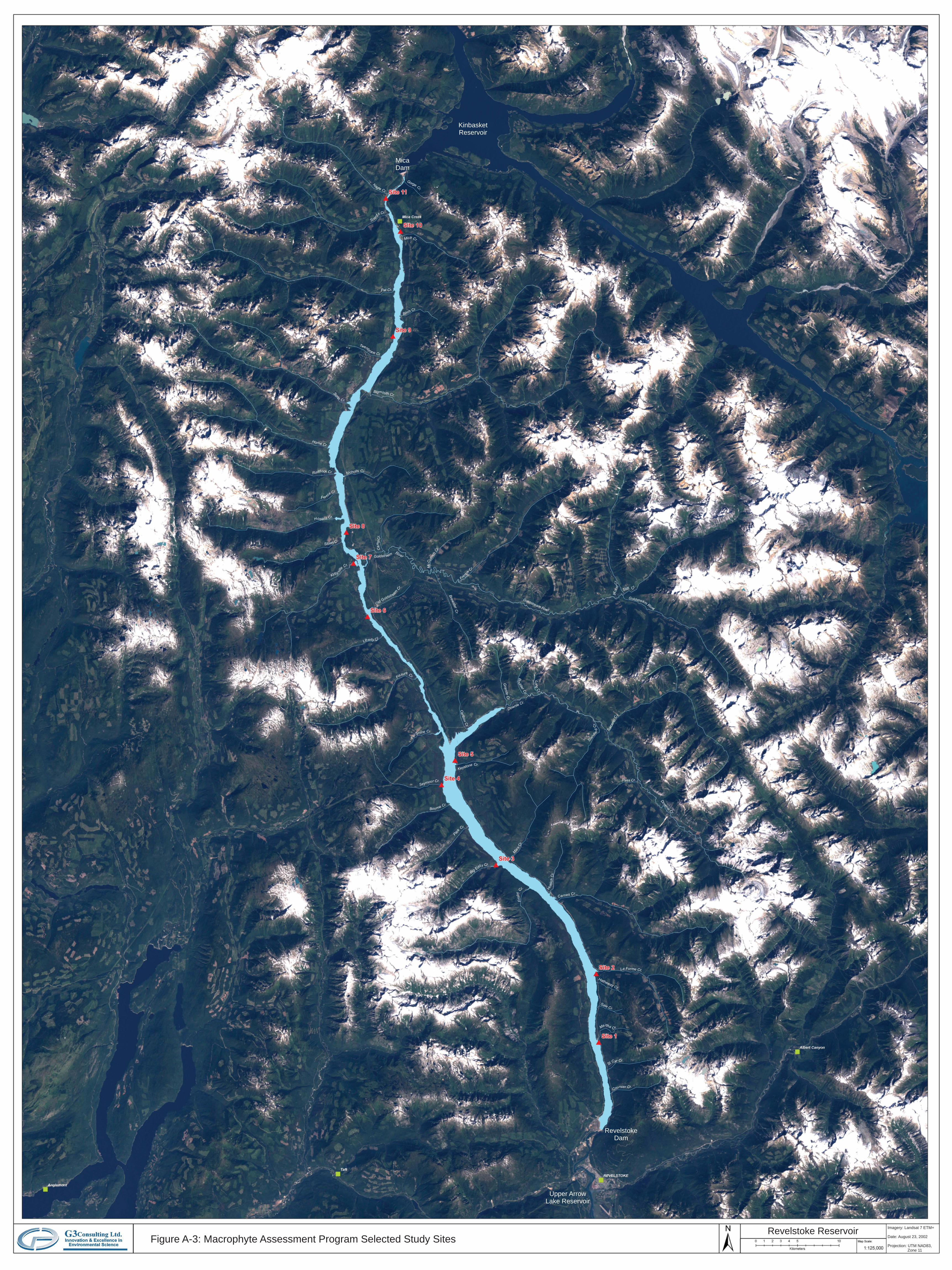
Figure A-3: Macrophyte Assessment Program Select Study Sites
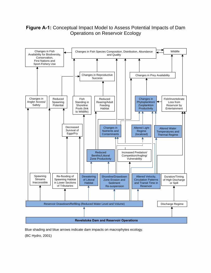
Figure A-1: Conceptual Impact Model to Assess Potential Impacts of Dam Operations on Reservoir Ecology
Blue shading and blue arrows indicate dam impacts on macrophytes ecology.
(BC Hydro, 2001)
Changes in Fish Availability for Biodiversity,
Conservation, First Nations and Sport-Fishery Use
Changes in Fish Species Composition, Distribution, Abundance and Quality
Wildlife
Reduced Rearing/Adult
Feeding Habitat
Fish/Invertebrate Loss from
Reservoir by Entertainment
Changes in Reproductive Success
Changes in Prey Availability
Changes in Angler Access/
Safety
Reduced Spawning Potential
Fish Standing in Shoreline Pools (link to Wildlife)
Changes in Phytoplankton/
Zooplankton Productivity
Decreased Survival of Eggs/Fry
Changes in Nutrients and Contaminants
Altered Light Regime
(localized)
Altered Water Temperatures and Thermal Regime
Reduced Benthic/Littoral
Zone Productivity
Increased Predation/ Competition/Angling/
Vulnerability
Spawning Streams
Inaccessible
Re-flooding of Spawning Habitat in Lower Sections
of Tributaries
Dewatering of Littoral Habitat
Shoreline/Drawdown Zone Erosion and
Sediment Re-suspension
Altered Velocity, Circulation Patterns and Transit Time in
Reservoir
Duration/Timing of High Discharge
or Spill
Reservoir Drawdown/Refilling (Reduced Water Level and Volume) Discharge Regime
Revelstoke Dam and Reservoir Operations

Imagery: Landsat 7 ETM+
Date: August 23, 2002
Projection: UTM NAD83,Zone 11
Figure A-2: Area Map Index
Upper ArrowLake Reservoir
KinbasketReservoir
MicaDam
RevelstokeDam
Coursier Cr.
St Cyr Cr.
La Forme Cr.
Martha C r.
Sale Cr.
Hatheway Cr.
Carnes Cr.
Hold
ich
Cr.
Mar
sC
r.
Keystone Cr.
Gra
nite
Cr.
Carib
ou
Cr.
Bo
uld
erC
r.
Lo
ng
Cr.
Downie Cr.
Sta
ndar
dC
r.
Pass Cr.
Sor
cere
rC
r.
Dow
nie
Cr.
OldGoldstre
amCr.
Frenc
hCr.
Wood
Cr.
Stitt Cr.
GoldstreamRiver
Goldstream River
GoldstreamRiver
Nicholls Cr.
B mig outh Cr.
Birch Cr.
Mica Cr.
Gorge Cr.
Frisby
Cr.
BigEddy Cr.
Bourne Cr.
Seymour Cr.
For
tynine Cr.
Bre
wste
rC
r.
Imagery: Landsat 7 ETM+
Date: August 23, 2002
Projection: UTM NAD83,Zone 11
Figure A-3: Macrophyte Assessment Program Selected Study SitesRevelstoke Reservoir

APPENDIX 2 Photos
Photo 1: Image of the SPOT Satellite (Satellite Pour l’Observation de la Terre)
Photo 2: Cessna plane used for Revelstoke Reservoir overview flight
Photo 3: Jet boat used for in situ macrophyte community assessments
Photo 4: Macrophyte sampling rake
Photo 5: Aqua-tiller used to collect deeper water macrophyte samples
Photo 6: Differential GPS & Sounder
Photo 7: YSI in situ water quality meter (6600-ORP-M)
Photo 8: SS Petite Ponar sediment grab
Photo 9: Recording macrophyte bed underwater
Photo 10: Preparing macrophytes in the field for shipment to taxonomy lab
Photo 11: Site 1 (October 2009)
Photo 12: Site 2 (October 2009)
Photo 13: Site 3 (October 2009)
Photo 14: Site 4 (October 2009)
Photo 15: Site 5 (October 2009)
Photo 16: Site 6 (October 2009)
Photo 17: Site 7 (October 2009)
Photo 18: Site 8 (October 2009)
Photo 19: Site 9 (October 2009)
Photo 20: Site 10 (October 2009)
Photo 21: Site 11 (October 2009)

Appendix 2: Methodology
Photo 1: Image of the SPOT Satellite(Satellite Pour l’Observation de la Terre)
Photo 2: Cessna plane used for RevelstokeReservoir overview flight
Photo 3: Jet boat used for macrophytecommunity assessments
in situ
Photo 5: Aqua-tiller used to collect deeper watermacrophyte samples
Photo 6: Differential GPS & Sounder
Photo 4: Macrophyte sampling rake

Appendix 2: Methodology (Con’d)
Photo 7: YSI water quality meter (in situ 6600-ORP-M)
Photo 8: SS Petite Ponar sediment grab
Photo 9: Recording macrophyte bed underwater Photo 10: Preparing macrophytes in the field forshipment to taxonomy lab

Appendix 2: Potential Long-term Monitoring Sites (Overview)
Photo 11: Site 1 (October 2009)
Photo 13: Site 3 (October 2009)
Photo 16: Site 6 (October 2009)Photo 15: Site 5 (October 2009)
Photo 12: Site 2 (October 2009)
Photo 14: Site 4 (October 2009)
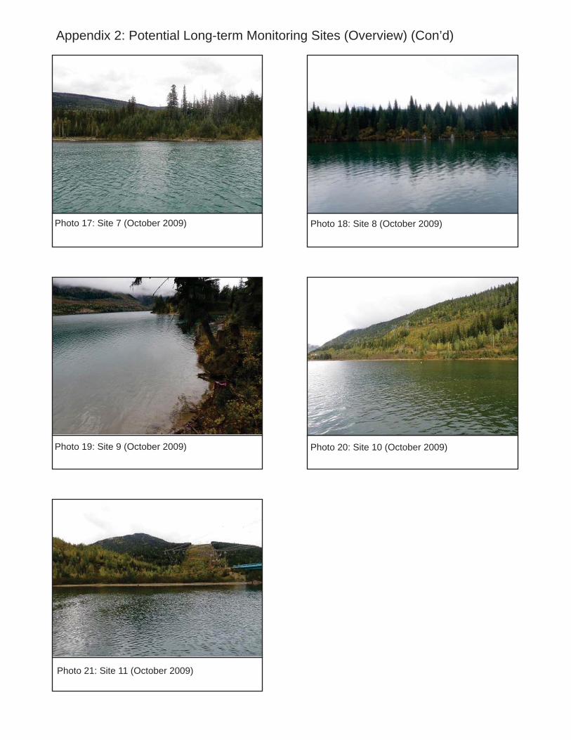
Appendix 2: Potential Long-term Monitoring Sites (Overview) (Con’d)
Photo 17: Site 7 (October 2009)
Photo 19: Site 9 (October 2009)
Photo 21: Site 11 (October 2009)
Photo 18: Site 8 (October 2009)
Photo 20: Site 10 (October 2009)

APPENDIX 3 CHARTS & TABLES
CHARTS
Chart 1: Monthly Turbine Flow & Revelstoke Reservoir Elevation (January 1984‐December 2009)
Chart 2: Revelstoke Dam Daily Turbine Flow & Reservoir Elevation (January‐December 2009)
Chart 3: Annual Mean, Maximum & Minimum Temperature (Revelstoke, 1984‐2009)
Chart 4: Annual Total Precipitation (Revelstoke, 1984‐2009)
Chart 5: Annual Mean Wind Speed (Revelstoke, 1984‐2009)
Chart 6: Macrophyte Percent (%) Coverage & Taxa Richness (Revelstoke Reservoir, October 2009)
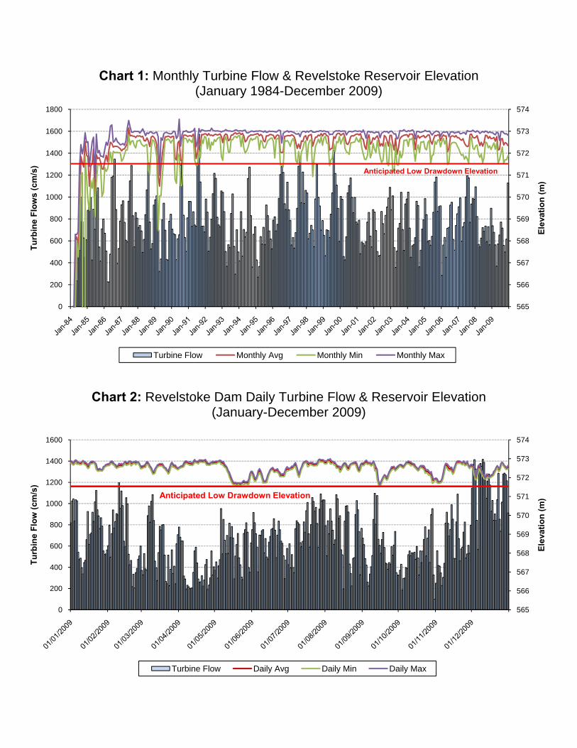
Chart 1: Monthly Turbine Flow & Revelstoke Reservoir Elevation (January 1984-December 2009)
Chart 2: Revelstoke Dam Daily Turbine Flow & Reservoir Elevation (January-December 2009)
565
566
567
568
569
570
571
572
573
574
0
200
400
600
800
1000
1200
1400
1600
1800
Elev
atio
n (m
)
Turb
ine
Flow
s (c
m/s
)
Turbine Flow Monthly Avg Monthly Min Monthly Max
Anticipated Low Drawdown Elevation
565
566
567
568
569
570
571
572
573
574
0
200
400
600
800
1000
1200
1400
1600
Elev
atio
n (m
)
Turb
ine
Flow
(cm
/s)
Turbine Flow Daily Avg Daily Min Daily Max
Anticipated Low Drawdown Elevation

Chart 3: Annual Mean, Maximum & Minimum Temperature (Revelstoke, 1984-2009)
Chart 4: Annual Total Precipitation (Revelstoke, 1984-2009)
-40.0
-30.0
-20.0
-10.0
0.0
10.0
20.0
30.0
40.0
50.019
84
1985
1986
1987
1988
1989
1990
1991
1992
1993
1994
1995
1996
1997
1998
1999
2000
2001
2002
2003
2004
2005
2006
2007
2008
2009
Temperature (°C)
Mean Temperature (˚C) Maximum Temperature (˚C) Minimum Temperature (˚C)
0.00
200.00
400.00
600.00
800.00
1000.00
1200.00
1400.00
1984
1985
1986
1987
1988
1989
1990
1991
1992
1993
1994
1995
1996
1997
1998
1999
2000
2001
2002
2003
2004
2005
2006
2007
2008
2009
Total Precipitation (mm)

Chart 5: Annual Mean Wind Speed (Revelstoke, 1984-2009)
0.0
1.0
2.0
3.0
4.0
5.0
6.0
7.0
8.019
84
1985
1986
1987
1988
1989
1990
1991
1992
1993
1994
1995
1996
1997
1998
1999
2000
2001
2002
2003
2004
2005
2006
2007
2008
2009
Mean
Wind Speed (km
/h)

Chart 6: Macrophyte Percent (%) Coverage & Taxa Richness (Revelstoke Reservoir, October 2009)
% Coverage Taxa Richness Taxa Richness Not Applicable (i.e., No Macrophytes Observed) Taxa Richness Calculated but % Coverage Not Estimated
0
1
2
3
4
0
10
20
30
40
50
60
70
80
90
100
S C N S C N S C N S C N S C N S C N S C N S C N S C N S C N S C N S C N S C N S C N S C N S C N S C N S C N
A B C A B C A B C A B C A B C A B C
Site 1 Site 2 Site 3 Site 4 Site 5 Site 6
Taxa
Ric
hnes
s
% C
over
age
0
1
2
3
4
0
10
20
30
40
50
60
70
80
90
100
S C N S C N S C N S C N S C N S C N S C N S C N S C N S C N S C N S C N S C N S C N S C N
A B C A B C A B C A B C A B C
Site 7 Site 8 Site 9 Site 10 Site 11
Taxa
Ric
hnes
s
% C
over
age
TABLES
Table 1: Climate Characteristics; Revelstoke Reservoir (1984‐2009)
Table 2: Polygons Detected by SPOT & Aerial Observations (Revelstoke Reservoir)
Table 3: Transect Point Depths and Elevations (Revelstoke Reservoir)
Table 4: Long‐Term Site Elevations (Revelstoke Reservoir, 2009)
Table 5: Transect Point Locations (UTM NAD83, Zone 11)
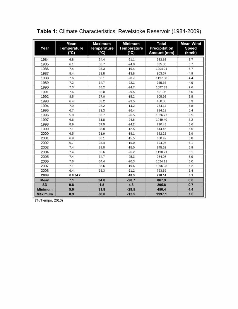
Table 1: Climate Characteristics; Revelstoke Reservoir (1984-2009)
Year Mean
Temperature (°C)
Maximum Temperature
(°C)
Minimum Temperature
(°C)
Total Precipitation Amount (mm)
Mean Wind Speed (km/h)
1984 6.8 34.4 -21.1 983.65 6.7
1985 6.1 36.7 -24.0 835.38 6.7
1986 7.4 35.3 -19.4 1004.21 5.7
1987 8.4 33.8 -13.8 903.67 4.9
1988 7.6 36.1 -20.7 1197.08 4.4
1989 7.2 34.7 -22.1 965.36 4.9
1990 7.3 35.2 -24.7 1087.33 7.6
1991 7.6 32.0 -29.5 501.06 6.0
1992 8.5 37.0 -15.2 605.98 6.5
1993 6.4 33.2 -23.5 450.36 6.3
1994 7.9 37.2 -14.2 764.14 6.8
1995 6.7 33.3 -26.4 894.18 5.4
1996 5.0 32.7 -26.5 1026.77 6.5
1997 6.6 31.8 -24.6 1049.40 6.2
1998 8.9 37.9 -24.2 790.43 6.6
1999 7.1 33.8 -12.5 644.46 6.5
2000 6.5 31.9 -18.1 682.23 5.9
2001 6.9 36.1 -15.5 660.49 6.8
2002 6.7 35.4 -15.0 694.07 6.1
2003 7.4 38.0 -15.0 945.52 5.9
2004 7.4 35.6 -26.2 1190.21 5.1
2005 7.4 34.7 -25.3 984.08 5.9
2006 7.8 34.4 -20.3 1024.11 6.0
2007 7.1 35.6 -19.6 1096.23 6.2
2008 6.4 33.3 -21.2 793.89 5.4
2009 6.8 34.7 -18.3 790.14 6.1 Mean 7.1 34.8 -20.7 867.9 6.0
SD 0.8 1.8 4.8 205.8 0.7 Minimum 5.0 31.8 -29.5 450.4 4.4 Maximum 8.9 38.0 -12.5 1197.1 7.6
(TuTiempo, 2010)

Table 2: Polygons Detected by SPOT & Aerial Observations (Revelstoke Reservoir, 2009)
Area # Polygons Detected by
SPOT
Polygon(s) Observed
during Overview
Flight?
Location (UTM NAD83, Zone 11) Polygon Centre
Point
Overview Flight Observations
1 1 Yes 416800 E 5659200 N
Polygon detected by SPOT was confirmed as a community; however, it was observed as much larger, extending from Revelstoke Dam to the first polygon detected by satellite.
2 1 Yes 416100 E 5664000 NPolygon detected by SPOT was confirmed as a community.
3 2
No 415700 E 5667200 NThe two (2) polygons detected by SPOT were not observed in situ. Conversely, one large and several small communities observed in situ on the western side of the reservoir were not detected by satellite.
No 415700 E 5667400 N
4 1 Yes 415700 E 5674700 N
Polygon detected by SPOT was confirmed as a community; however, there were several other communities observed on both sides of the reservoir that were not detected by satellite.
5 1 Yes 411500 E 5681300 N
Polygon detected by SPOT was confirmed as a community; however, large and small communities observed along the reservoir’s eastern shore were not detected by satellite.
6 1 Yes 410300 E 5682900 N
Polygon detected by SPOT was confirmed as a community; however, several communities along the reservoir’s eastern shore were not detected by satellite.
7 1 Yes 403800 E 5687800 NPolygon detected by SPOT was confirmed as a community.
8 0 N/A Several communities observed in situ were not detected by SPOT.
9 3
Yes 397700 E 5696000 N Polygons detected by SPOT were confirmed as communities; however, there were a few additional communities observed in situ that were not detected by satellite.
Yes 397500 E 5696600 N
Yes 397500 E 5697400 N
10 5
Yes 398900 E 5699400 NFour (4) of five (5) polygons detected by SPOT were confirmed as communities; however, there were two (2) large communities observed along the reservoir’s western shore that were not detected by satellite.
Yes 398900 E 5700200 N
No 398600 E 5700700 N
Yes 398200 E 5702300 N
Yes 398100 E 5702700 N
11 0 N/A Several communities observed in situ were not detected by SPOT.
12 0 N/A Several communities observed in situ were not detected by SPOT.
13 2
Yes 388600 E 5717400 NTwo (2) polygons detected by SPOT were confirmed as communities; however, there were several communities observed along both sides of the reservoir that were not detected by satellite.
Yes 388500 E 5717600 N

Table 2: Polygons Detected by SPOT & Aerial Observations (Revelstoke Reservoir, 2009) (Con’d)
Area # Polygons Detected by
SPOT
Polygon(s) Observed
during Overview
Flight?
Location (UTM NAD83, Zone 11) Polygon Centre
Point
Overview Flight Observations
14 4
Yes 387300 E 5722700 N Three (3) of four (4) polygons detected by SPOT were confirmed as communities, with the last polygon being a large silt plume. One (1) of the confirmed communities was found to have shallow macrophytes and many exposed stumps. A large community observed in situ was not detected by satellite.
Yes 386700 E 5723900 N
Yes 386800 E 5724600 N
No 388100 E 5724800 N
15 5
Yes 385800 E 5727700 N
Polygons detected by SPOT were confirmed as communities; however, several other large and small communities observed in situ were not detected by satellite.
Yes 385800 E 5728200 N
Yes 384500 E 5729400 N
Yes 384800 E 5729400 N
Yes 385600 E 5729300 N
16 1 Yes 384200 E 5735500 N
Polygon detected by SPOT was confirmed as a community; however, another large community observed along the reservoir’s western shore was not detected by satellite.
17 1 Yes 383700 E 5737800 NPolygon detected by SPOT was confirmed as a community.
18 4
Yes 386000 E 5743300 N One (1) of four (4) polygons detected by SPOT was confirmed as a community, albeit comprised of macrophytes and silt. Remaining polygons were observed as silt plumes. One (1) small community observed in situ was not detected by satellite.
No 388700 E 5744100 N
No 388700 E 5744500 N
No 388600 E 5744700 N
19 7
Yes 389700 E 5748200 N
Four (4) of seven (7) polygons detected by SPOT were confirmed as communities, with the remaining three (3) polygons found to be rocky areas where macrophytes may exist, but are too deep to see during overview flight. One (1) small community observed in situ was not detected by satellite.
Yes 389900 E 5748400 N
No 391400 E 5748600 N
No 391400 E 5749000 N
No 391400 E 5749200 N
Yes 391500 E 5750700 N
Yes 391600 E 5751800 N
20 2 Yes 391600 E 5756200 N Polygons detected by SPOT were
confirmed as communities, albeit with extensive silt runoff from feeder creek. Yes 391600 E 5756700 N
21 2 Yes 392200 E 5758700 N Polygons detected by SPOT were
confirmed as communities; however, a large community observed in situ was not detected by satellite. Yes 392600 E 5759700 N
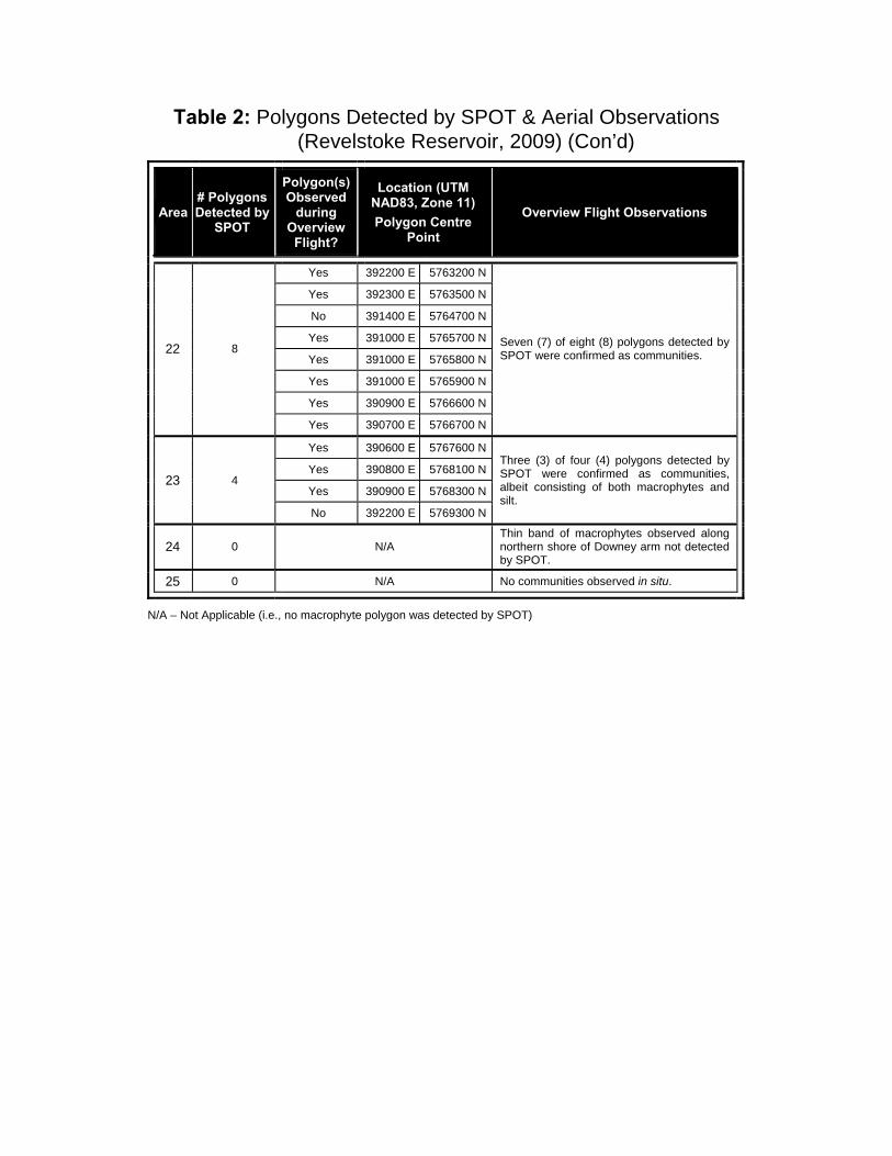
Table 2: Polygons Detected by SPOT & Aerial Observations (Revelstoke Reservoir, 2009) (Con’d)
Area # Polygons Detected by
SPOT
Polygon(s) Observed
during Overview
Flight?
Location (UTM NAD83, Zone 11) Polygon Centre
Point
Overview Flight Observations
22 8
Yes 392200 E 5763200 N
Seven (7) of eight (8) polygons detected by SPOT were confirmed as communities.
Yes 392300 E 5763500 N
No 391400 E 5764700 N
Yes 391000 E 5765700 N
Yes 391000 E 5765800 N
Yes 391000 E 5765900 N
Yes 390900 E 5766600 N
Yes 390700 E 5766700 N
23 4
Yes 390600 E 5767600 NThree (3) of four (4) polygons detected by SPOT were confirmed as communities, albeit consisting of both macrophytes and silt.
Yes 390800 E 5768100 N
Yes 390900 E 5768300 N
No 392200 E 5769300 N
24 0 N/A Thin band of macrophytes observed along northern shore of Downey arm not detected by SPOT.
25 0 N/A No communities observed in situ.
N/A – Not Applicable (i.e., no macrophyte polygon was detected by SPOT)

Table 3: Transect Point Depths and Elevations (Revelstoke Reservoir)
Site Point ID Depth (m) Elevation (m) Site Point ID Depth (m) Elevation (m)
1
C/A 0.3 572.2
7
C/A 0.4 572.2
C/B 1.8 570.7 C/B 0.6 572.0
C/C 4.6 567.9 C/C 0.5 572.1
N/A 0.3 572.2 N/A 0.4 572.2
N/B 1.8 570.7 N/B 0.8 571.8
N/C 4.6 567.9 N/C 0.4 572.2
S/A 0.3 572.2 S/A 0.4 572.2
S/B 1.8 570.7 S/B 0.6 572.0
S/C 3.0 569.5 S/C 0.0 572.6
2
C/A 1.9 570.6
8
C/A 0.6 572.0C/B 2.0 570.5 C/B 2.0 570.6C/C 2.2 570.3 C/C 1.2 571.4N/A 1.7 570.8 N/A 0.6 572.0N/B 2.0 570.5 N/B 2.3 570.3N/C 1.5 571.0 N/C 1.6 571.0S/A 2.1 570.4 S/A 1.0 571.6S/B 2.1 570.4 S/B 2.1 570.5S/C 2.3 570.2 S/C 0.9 571.7
3
C/A 0.3 572.3
9
C/A 1.3 571.4
C/B 1.1 571.5 C/B 2.9 569.8
C/C 1.8 570.8 C/C 4.1 568.6
N/A 0.3 572.3 N/A 0.9 571.8
N/B 1.3 571.3 N/B 1.8 570.9
N/C 1.3 571.3 N/C 3.2 569.5
S/A 0.2 572.4 S/A 1.1 571.6
S/B 1.8 570.8 S/B 3.4 569.3
S/C 3.4 569.2 S/C 5.0 567.7
4
C/A 2.5 570.1
10
C/A 0.4 572.3C/B 3.0 569.6 C/B 1.6 571.1C/C 4.1 568.5 C/C 0.8 571.9N/A 1.2 571.4 N/A 0.4 572.3N/B 3.2 569.4 N/B 0.5 572.2N/C 3.4 569.2 N/C 0.8 571.9S/A 2.3 570.3 S/A 1.0 571.7S/B 3.8 568.8 S/B 1.0 571.7S/C 4.3 568.3 S/C 0.9 571.8
5
C/A 0.7 571.9
11
C/A 0.2 572.5
C/B 0.5 572.1 C/B 1.2 571.5
C/C 1.5 571.1 C/C 0.3 572.4
N/A 0.7 571.9 N/A 0.1 572.6
N/B 1.0 571.6 N/B 1.6 571.1
N/C 1.9 570.7 N/C 0.3 572.4
S/A 0.4 572.2 S/A 0.1 572.6
S/B 0.7 571.9 S/B 1.4 571.3
S/C 1.3 571.3 S/C 0.3 572.4
6
ALL/C 12.2 560.4
C/A 0.6 572.0
C/B 2.9 569.7
N/A 0.8 571.8
N/B 4.8 567.8
S/A 0.8 571.8
S/B 3.3 569.3

Table 4: Long-Term Site Elevations (Revelstoke Reservoir, 2009)
Site Transect Mean Site Elevation
(m) Mean Macrophyte Bed Elevation (m)
Macrophyte Bed Minimum-Maximum Elevation (m)
1
South 570.5 569.9 569.4 / 570.7
Centre 570.3 570.1 568.1 / 571.9
North 570.4 569.5 567.8 / 571.0
Mean 570.4 569.8 567.8 / 571.9
2
South 570.6 570.4 570.3 / 570.4
Centre 570.7 570.5 570.3 / 570.6
North 570.9 570.6 570.5 / 570.8
Mean 570.7 570.5 570.3 / 570.8
3
South 570.5 568.0 567.6 / 568.3
Centre 571.6 571.3 571.3 / 571.4
North 571.5 571.1 571.0 / 571.1
Mean 571.2 570.1 567.6 / 571.4
4
South 569.4 569.1 568.3 / 570.7
Centre 570.0 568.9 566.6 / 570.2
North 570.1 569.8 569.1 / 571.0
Mean 569.8 569.3 566.6 / 571.0
5
South 571.9 571.7 570.9 / 572.2
Centre 571.8 571.8 571.1 / 571.9
North 571.6 571.4 570.4 / 571.9
Mean 571.8 571.6 570.4 / 572.2
6
South 566.0 570.8 569.6 / 571.8
Centre 567.2 N/A N/A
North 565.7 570.1 567.8 / 572.3
Mean 566.3 570.4 567.8 / 572.3
7
South 572.2 572.0 571.9 / 572.2
Centre 572.0 572.0 565.6 / 572.2
North 571.9 572.0 571.8 / 572.3
Mean 572.0 572.0 571.8 / 572.3
8
South 571.0 571.0 570.4 / 572.5
Centre 571.0 571.0 570.4 / 572.5
North 570.8 570.8 570.1 / 572.5
Mean 570.9 570.9 570.1 / 572.5
9
South 569.5 568.8 567.7 / 571.0
Centre 570.5 569.4 568.2 / 571.6
North 571.3 571.0 569.5 / 571.8
Mean 570.4 569.7 567.7 / 571.8

Table 4: Long-Term Site Elevations (Revelstoke Reservoir, 2009) (Con’d)
Site Transect Mean Site Elevation
(m) Mean Macrophyte Bed Elevation (m)
Macrophyte Bed Minimum-Maximum Elevation (m)
10
South 571.9 571.7 571.7 / 571.7
Centre 571.7 572.3 571.9 / 572.5
North 572.1 572.3 572.3 / 572.3
Mean 571.9 572.1 571.7 / 572.5
11
South 572.0 572.0 571.3 / 572.6
Centre 572.1 572.1 571.5 / 572.5
North 571.9 571.9 571.1 / 572.6
Mean 572.0 572.0 571.1 / 572.6

Table 5: Transect Point Locations (UTM NAD83, Zone 11)
Site Point ID Easting Northing Site Point ID Easting Northing
1
C/A 416192 5666417
7
C/A 386708 5723997
C/B 416161 5666410 C/B 386711 5723993
C/C 416121 5666397 C/C 386726 5723967
N/A 416180 5666444 N/A 386730 5724009
N/B 416149 5666440 N/B 386736 5724003
N/C 416104 5666421 N/C 386762 5723977
S/A 416202 5666387 S/A 386686 5723987
S/B 416180 5666380 S/B 386687 5723981
S/C 416139 5666356 S/C 386696 5723958
2
C/A 415844 5674680
8
C/A 385910 5727821C/B 415824 5674699 C/B 385843 5727809C/C 415797 5674736 C/C 385805 5727800N/A 415866 5674703 N/A 385902 5727841N/B 415849 5674713 N/B 385851 5727828N/C 415837 5674728 N/C 385798 5727822S/A 415816 5674655 S/A 385912 5727798S/B 415802 5674679 S/B 385859 5727787S/C 415784 5674712 S/C 385812 5727770
3
C/A 403774 5687788
9
C/A 391474 5751301
C/B 403806 5687775 C/B 391476 5751292
C/C 403824 5687753 C/C 391482 5751282
N/A 403786 5687816 N/A 391489 5751309
N/B 403807 5687797 N/B 391494 5751299
N/C 403837 5687772 N/C 391496 5751293
S/A 403771 5687763 S/A 391453 5751285
S/B 403788 5687748 S/B 391465 5751280
S/C 403809 5687745 S/C 391477 5751270
4
C/A 397345 5697241
10
C/A 392364 5763646C/B 397361 5697250 C/B 392352 5763644C/C 397369 5697257 C/C 392331 5763641N/A 397331 5697279 N/A 392368 5763662N/B 397347 5697287 N/B 392353 5763660N/C 397360 5697295 N/C 392334 5763655S/A 397354 5697209 S/A 392365 5763625S/B 397370 5697222 S/B 392354 5763625S/C 397381 5697232 S/C 392340 5763625
5
C/A 398942 5700273
11
C/A 390615 5767802
C/B 398917 5700267 C/B 390612 5767785
C/C 398859 5700264 C/C 390613 5767767
N/A 398905 5700319 N/A 390634 5767801
N/B 398879 5700313 N/B 390634 5767782
N/C 398863 5700309 N/C 390633 5767764
S/A 398945 5700210 S/A 390595 5767804
S/B 398919 5700214 S/B 390595 5767789
S/C 398889 5700219 S/C 390594 5767771
6
ALL/C 388475 5717466
C/A 388447 5717452
C/B 388458 5717450
N/A 388462 5717479
N/B 388469 5717476
S/A 388461 5717434
S/B 388466 5717443

APPENDIX 4 Site Descriptions
(Sites 1 – 11)
Site Layout
Macrophyte Community General Characteristics
Sediment Characteristics
Distance from Shore (m) C S
N
Revelstoke Reservoir Macrophyte Study Imagery: Google Earth Image Date: 2005 Projection: UTM NAD83, Zone 11 SPOT Satellite Image: September 2009 Bathymetric Assessment: October 2009
Depth with Distance from Shore
416000 416050 416100 416150 416200 416250
5666
200
56
6625
0
5666
300
56
6635
0
566
6400
56
6645
0
5666
500
5
6665
50
56
6660
0
N
C
S
151 m 151 m
5666
200
56
6625
0
5666
300
56
6635
0
566
6400
56
6645
0
5666
500
5
6665
50
56
6660
0
Area 2
416000 416050 416100 416150 416200 416250
0 5 10 15 20 25 50 75 100
Meters
103 m
72 m
Dep
th (m
)
Site One
Sampling Sites
Macrophyte Communities Observed
In Situ
Macrophyte Communities Predicted by NDVI Study Transects
Polygon Dimensions (E-lines)
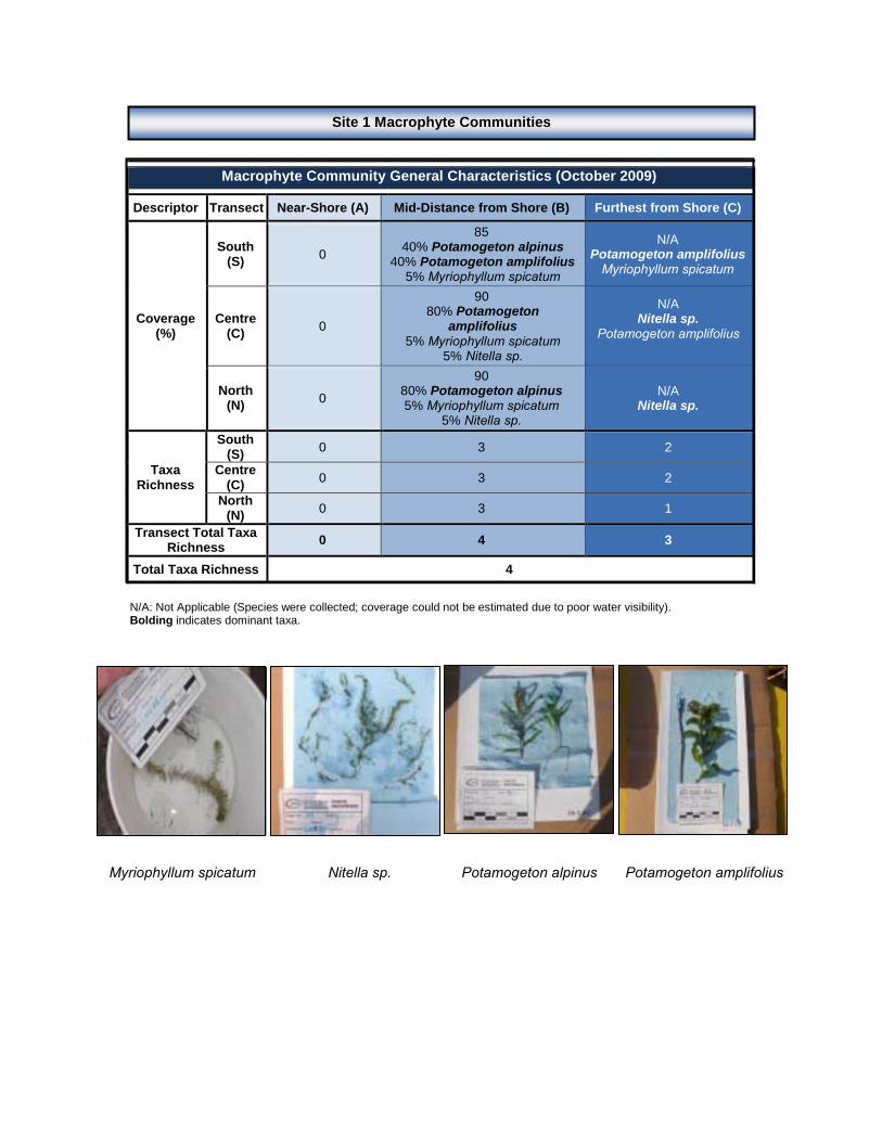
N/A: Not Applicable (Species were collected; coverage could not be estimated due to poor water visibility). Bolding indicates dominant taxa.
Myriophyllum spicatum Nitella sp. Potamogeton alpinus Potamogeton amplifolius
Macrophyte Community General Characteristics (October 2009)
Descriptor Transect Near-Shore (A) Mid-Distance from Shore (B) Furthest from Shore (C)
Coverage (%)
South (S) 0
85 40% Potamogeton alpinus
40% Potamogeton amplifolius 5% Myriophyllum spicatum
N/A Potamogeton amplifolius
Myriophyllum spicatum
Centre (C) 0
90 80% Potamogeton
amplifolius 5% Myriophyllum spicatum
5% Nitella sp.
N/A Nitella sp.
Potamogeton amplifolius
North (N) 0
90 80% Potamogeton alpinus 5% Myriophyllum spicatum
5% Nitella sp.
N/A Nitella sp.
Taxa Richness
South (S) 0 3 2
Centre (C) 0 3 2
North (N) 0 3 1
Transect Total Taxa Richness 0 4 3
Total Taxa Richness 4
Site 1 Macrophyte Communities

Near-Shore Sediments Furthest from Shore (Grab)
Secchi disk depth (m): 1.2 (bottom Centre Transect mid-depth)
Field Observations
Near-Shore (A) Grey-Brown. Gritty. Odourless. Gravels, sand and cobbles.
Mid-Distance from Shore (B)
Black. Water. Gritty. Odourless. Abundant small organic debris; sticks, bark pieces; mixture of sand and gravel. Heterogeneous composition.
Furthest from Shore (C) Dark Brown. Loose. Silky; Gritty. Odourless. Abundant debris; trace of gravels. Homogeneous throughout.
Sonde Profiles at the South, Centre & North Mid-Distance from Shore Transects (October 2009) Transect Parameter Temperature
(°C) Conductivity
(µS/cm) pH Redox (mV)
Turbidity (NTU)
DO (%)
DO (mg/L)
South Mid-
Distance from Shore
(S/B)
Mean 12.9 98 7.89 188 42.3 90.3 9.53
SD 0.0 0 0.01 1 1.6 1.0 0.09
Min 12.9 98 7.88 186 40.0 89.3 9.44
Max 12.9 98 7.91 189 43.4 91.4 9.64
Centre Mid-
Distance from Shore
(C/B)
Mean 13.0 98 8.01 185 44.2 90.8 9.57
SD 0.0 1 0.02 1 0.2 0.2 0.03
Min 13.0 98 7.98 185 44.0 90.5 9.53
Max 13.0 99 8.04 186 44.5 91.1 9.60
North Mid-
Distance from Shore
(N/B)
Mean 12.6 98 7.81 191 40.5 89.2 9.50
SD 0.0 0 0.00 0 0.0 0.0 0.00
Min 12.6 98 7.81 191 40.5 89.2 9.50
Max 12.6 98 7.81 191 40.5 89.2 9.50
Site 1 Sediment Characteristics
Site 1 Water Quality

S I T E T W O
N
C
S
Revelstoke Reservoir Macrophyte Study Imagery: Google Earth Image Date: 2005 Projection: UTM NAD83, Zone 11SPOT Satellite Image: September 2009 Bathymetric Assessment: October 2009
Area 4
415650 415700 415750 415800 415850 415900 415950
5674
500
5
6745
50
56
7460
0
567
4650
5674
700
5674
750
5
6748
00
567
4850
5674
900
56
7495
0
0 5 10 15 20 25 50 75 100
Meters
122 m
112 m
103 m
92 m
5674
500
5
6745
50
56
7460
0
567
4650
5674
700
5674
750
5
6748
00
567
4850
5674
900
567
4950
Distance from Shore (m)
Depth with Distance from Shore
Legend Field Samples Macrophyte Communities Observed In Situ Macrophyte Communities Predicted by
SPOT Satellite
C
S
N
Dep
th (m
)
Sampling Sites
Macrophyte Communities Observed
In Situ
Macrophyte Communities Predicted by NDVI Study Transects
Polygon Dimensions (E-lines)

Bolding indicates dominant taxa.
Nitella sp. Potamogeton alpinus Potamogeton amplifolius
Macrophyte Community General Characteristics (October 2009)
Descriptor Transect Near-Shore (A) Mid-Distance from Shore (B) Furthest from Shore (C)
Coverage (%)
South (S)
90 Potamogeton
amplifolius90
Potamogeton amplifolius <5
Potamogeton alpinus
Centre (C)
90 Potamogeton
amplifolius90
Potamogeton amplifolius <5
Nitella sp.
North (N) 0 90
Potamogeton amplifolius90
Potamogeton amplifolius
Taxa Richness
South (S) 1 1 1
Centre (C) 1 1 1
North (N) 0 1 1
Transect Total Taxa Richness 1 1 1
Total Taxa Richness 3
Site 2 Macrophyte Communities

Near-Shore Sediments Furthest from Shore (Grab)
Secchi disk depth (m): 2.0 (bottom Centre Transect mid-depth)
Field Observations
Near-Shore (A) Grey-Brown. Odourless. Gravels and cobbles with little sand.
Mid-Distance from Shore (B)
Black-Grey. Watery. Thick like pudding. Silky; Gritty. Light odour of rotten egg. No woody debris but many macrophyte roots. Homogeneous throughout.
Furthest from Shore (C) Dark Brown. Loose; Watery. Gravelly. Odourless. Some small sticks and twigs; mixture of gravels, sand and clay, all about equal dominance. Homogeneous throughout.
Sonde Profiles at the South, Centre & North Mid-Distance from Shore Transects (October 2009)
Transect Parameter Temperature (°C)
Conductivity (µS/cm) pH Redox
(mV) Turbidity
(NTU) DO (%)
DO (mg/L)
South Mid-
Distance from Shore
(S/B)
Mean 14.7 95 8.01 199 0.3 91.8 9.32
SD 0.0 1 0.02 2 0.9 0.4 0.05
Min 14.5 95 7.98 195 -0.4 91.2 9.26
Max 14.7 96 8.05 201 2.0 92.4 9.38
Centre Mid-
Distance from Shore
(C/B)
Mean 14.7 95 8.01 198 1.8 92.9 9.43
SD 0.1 1 0.05 3 2.3 0.9 0.07
Min 14.4 93 7.91 195 -0.3 91.0 9.31
Max 14.7 95 8.08 203 5.9 94.1 9.54
North Mid-
Distance from Shore
(N/B)
Mean 14.6 96 7.94 213 0.4 93.1 9.46
SD 0.1 0 0.02 2 0.9 0.8 0.06
Min 14.4 96 7.92 210 -0.2 91.5 9.35
Max 14.7 96 7.96 215 2.1 93.6 9.50
Site 2 Sediment Characteristics
Site 2 Water Quality
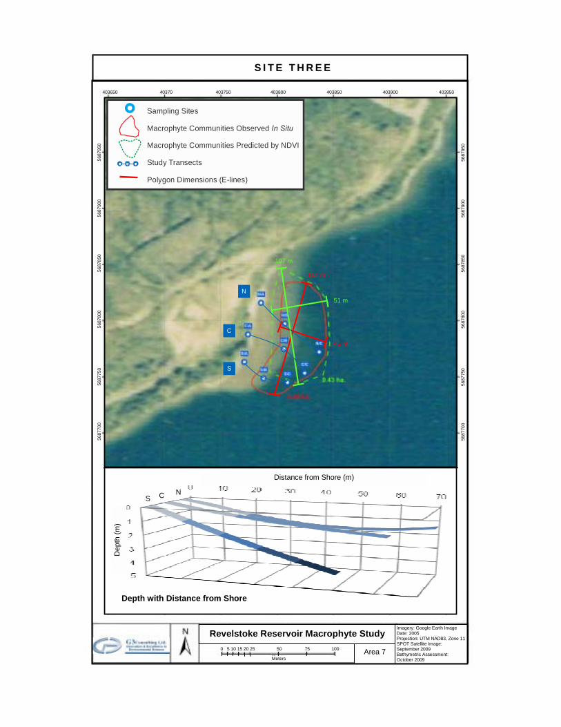
S I T E T H R E E
N
C
S
Revelstoke Reservoir Macrophyte Study Imagery: Google Earth Image Date: 2005 Projection: UTM NAD83, Zone 11SPOT Satellite Image: September 2009 Bathymetric Assessment: October 2009
Area 7
403650 40370 403750 403800 403850 403900 40395056
8755
0
568
7600
5687
650
5687
700
5
6877
50
5
6878
00
56
8785
0
568
7900
5687
950
0 5 10 15 20 25 50 75 100
Meters
51 m
104 m
45 m
107 m
403650 40370 403750 403800 403850 403900 403950
5687
550
5
6876
00
56
8765
0
56
8770
0
568
7750
568
7800
5687
850
5
6879
00
56
8795
0
Depth with Distance from Shore
Dep
th (m
)
Distance from Shore (m)
C S N
Sampling Sites
Macrophyte Communities Observed
In Situ
Macrophyte Communities Predicted by NDVI Study Transects
Polygon Dimensions (E-lines)
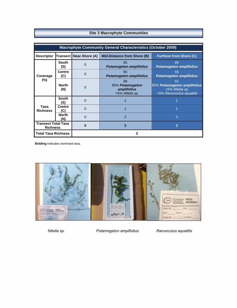
Bolding indicates dominant taxa. Nitella sp. Potamogeton amplifolius Ranunculus aquatilis
Macrophyte Community General Characteristics (October 2009)
Descriptor Transect Near-Shore (A) Mid-Distance from Shore (B) Furthest from Shore (C)
Coverage (%)
South (S) 0 85
Potamogeton amplifolius85
Potamogeton amplifolius Centre
(C) 0 65 Potamogeton amplifolius
65 Potamogeton amplifolius
North (N) 0
88 85% Potamogeton
amplifolius <5% Nitella sp.
91 85% Potamogeton amplifolius
<5% Nitella sp. <5% Ranunculus aquatilis
Taxa Richness
South (S) 0 1 1
Centre (C) 0 1 1
North (N) 0 2 3
Transect Total Taxa Richness 0 2 3
Total Taxa Richness 3
Site 3 Macrophyte Communities

Near-Shore Sediments Furthest from Shore (Grab)
Secchi disk depth (m): 1.1 (bottom Centre Transect mid-depth)
Field Observations
Near-Shore (A) Dark Brown-Grey. Thick like pudding. Silky; Gritty. Smell of rotten egg.
Mid-Distance from Shore (B)
Dark Brown-Grey. Thick like pudding. Silky; Gritty. Smell of rotten egg. Abundant macrophyte roots; small woody debris; flakes of some kind of silica. Homogeneous throughout.
Furthest from Shore (C) Dull Grey. Loose. Gritty; Gravelly. Smell of rotten egg. Very little debris; small piece of Chara spp.; few macrophyte roots. Heterogeneous composition.
Sonde Profiles at the South, Centre & North Mid-Depth Transects (October 2009)
Transect Parameter Temperature (°C)
Conductivity (µS/cm) pH Redox
(mV) Turbidity
(NTU) DO (%)
DO (mg/L)
South Mid-
Distance from Shore
(S/B)
Mean 13.6 96 7.84 187 -0.4 98.9 10.30
SD 0.1 0 0.01 1 0.5 0.3 0.03
Min 13.5 96 7.82 186 -1.1 98.6 10.26
Max 13.6 96 7.85 187 0.1 99.3 10.33
Centre Mid-
Distance from Shore
(C/B)
Mean 13.6 95 7.93 182 -0.1 99.0 10.29
SD 0.0 0 0.02 2 0.7 0.6 0.07
Min 13.5 95 7.90 179 -1.5 98.4 10.23
Max 13.6 96 7.96 184 0.8 99.8 10.39
North Mid-
Distance from Shore
(N/B)
Mean 13.6 96 7.96 180 0.6 98.4 10.23
SD 0.1 0 0.02 2 0.1 0.7 0.08
Min 13.2 95 7.93 178 0.5 97.5 10.15
Max 13.6 96 8.00 184 0.7 100.3 10.44
Site 3 Sediment Characteristics
Site 3 Water Quality

S I T E F O U R
N
C
S
Revelstoke Reservoir Macrophyte Study Imagery: Google Earth Image Date: 2005 Projection: UTM NAD83, Zone 11SPOT Satellite Image: September 2009 Bathymetric Assessment: October 2009
Area 9
397250 397300 397350 397400 397450 397500 56
9705
0
569
7100
5697
150
5
6972
00
56
9725
0
56
9730
0
569
7350
5
6974
00
56
9745
0
0 5 10 15 20 25 50 75 100
Meters
71 m
142 m
38 m
Depth with Distance from Shore
Dep
th (m
)
Distance from Shore (m)
C S
N
5697
050
5
6971
00
56
9715
0
569
7200
5697
250
5697
300
5
6973
50
569
7400
5697
450
Sampling Sites
Macrophyte Communities Observed
In Situ
Macrophyte Communities Predicted by NDVI Study Transects
Polygon Dimensions (E-lines)
62 m

N/A: Not Applicable (Species were collected; coverage could not be estimated due to poor water visibility). Bolding indicates dominant taxa.
Potamogeton amplifolius
Macrophyte Community General Characteristics (October 2009)
Descriptor Transect Near-Shore (A) Mid-Distance from Shore (B) Furthest from Shore (C)
Coverage (%)
South (S)
70 Potamogeton
amplifolius80
Potamogeton amplifolius 0
Centre (C)
85 Potamogeton
amplifolius60
Potamogeton amplifolius 0
North (N) 0 50
Potamogeton amplifoliusN/A
Potamogeton amplifolius
Taxa Richness
South (S) 1 1 0
Centre (C) 1 1 0
North (N) 0 1 1
Transect Total Taxa Richness 1 1 1
Total Taxa Richness 1
Site 4 Macrophyte Communities

Near-Shore Sediments Furthest from Shore (Grab)
Secchi disk depth (m): 2.5
Field Observations Near-Shore (A) Brown-Grey. Gritty. Odourless. Gravels, sand and cobbles.
Mid-Distance from Shore (B)
Dull Grey. Thick like pudding. Silky. Smell of rotten egg. Abundant macrophyte roots, small woody debris and macrophyte pieces. Homogeneous throughout.
Furthest from Shore (C) Dull Grey. Loose; Watery. Silky with cobbles. Smell of rotten egg. Abundant small debris (e.g., macrophyte root pieces, wood flakes). Not homogeneous throughout. Silty layer on top of gravels and cobbles.
Sonde Profiles at the South, Centre & North Mid-Depth Transects (October 2009)
Transect Parameter Temperature (°C)
Conductivity (µS/cm) pH Redox
(mV) Turbidity
(NTU) DO (%)
DO (mg/L)
South Mid-
Distance from Shore
(S/B)
Mean 13.7 100 7.91 200 638.4 99.7 10.34
SD 0.0 0 0.02 1 22.1 0.4 0.03
Min 13.7 100 7.89 199 627.5 98.8 10.26
Max 13.8 100 7.93 201 688.6 100.0 10.36
Centre Mid-
Distance from Shore
(C/B)
Mean 13.7 100 7.92 202 16.6 97.4 10.11
SD 0.2 0 0.05 2 11.2 1.3 0.15
Min 13.1 100 7.79 201 -6.3 95.0 9.85
Max 13.8 100 7.95 206 21.9 98.8 10.39
North Mid-
Distance from Shore
(N/B)
Mean 13.6 100 8.01 198 0.4 97.8 10.17
SD 0.3 1 0.05 2 0.1 0.2 0.07
Min 13.0 100 7.96 197 0.2 97.5 10.11
Max 13.7 102 8.10 203 0.6 98.3 10.34
Site 4 Sediment Characteristics
Site 4 Water Quality

S I T E F I V E
N
C
S
Revelstoke Reservoir Macrophyte Study Imagery: Google Earth Image Date: 2005 Projection: UTM NAD83, Zone 11SPOT Satellite Image: September 2009 Bathymetric Assessment: October 2009
Area 10
398700 398750 398800 398850 398900 398950 399000
5700
100
5
7001
50
57
0020
0
57
0025
0
570
0300
5
7003
500
5
7004
00
570
0450
5700
500
0 5 10 15 20 25 50 75 100
Meters
90 m
191 m
113 m
236 m
Dep
th (m
)
Distance from Shore (m) C N
5700
100
5
7001
50
57
0020
0
57
0025
0
570
0300
5
7003
500
5
7004
00
570
0450
5700
500
Depth with Distance from Shore
S
Sampling Sites
Macrophyte Communities Observed
In Situ
Macrophyte Communities Predicted by NDVI Study Transects
Polygon Dimensions (E-lines)

Bolding indicates dominant taxa.
Eleocharis acicularis Myriophyllum spicatum Nitella sp. Potamogeton amplifolius
Macrophyte Community General Characteristics (October 2009)
Descriptor Transect Near-Shore (A) Mid-Distance from Shore (B) Furthest from Shore (C)
Coverage (%)
South (S)
100 Eleocharis acicularis
95 70% Eleocharis acicularis
20% Potamogeton amplifolius <10% Nitella sp.
100 90% Potamogeton
amplifolius 10% Myriophyllum
spicatum
Centre (C)
100 Eleocharis acicularis
100 Eleocharis acicularis
85 Potamogeton
amplifolius
North (N)
60 50% Eleocharis
acicularis 10% Potamogeton
amplifolius
90 Potamogeton amplifolius
100 50% Potamogeton
amplifolius 50% Myriophyllum
spicatum
Taxa Richness
South (S) 1 3 2
Centre (C) 1 1 1
North (N) 2 1 2
Transect Total Taxa Richness 2 3 2
Total Taxa Richness 4
Site 5 Macrophyte Communities

Near-Shore Sediments Furthest from Shore (Grab)
Secchi disk depth (m): 0.5 (bottom Centre Transect mid-depth)
Field Observations
Near-Shore (A) Brown. Gritty. Odourless. Sand with some gravel.
Mid-Distance from Shore (B)
Dull Grey. Loose. Gritty; Gravelly. Odourless. Top layer of grass with fine sands underneath. Homogeneous throughout.
Furthest from Shore (C) Black. Thick like pudding. Silky. Smell of rotten egg. Lots of macrophyte roots, dead macrophytes and woody debris. Homogeneous throughout.
Sonde Profiles at the South, Centre & North Mid-Depth Transects (October 2009)
Transect Parameter Temperature (°C)
Conductivity (µS/cm) pH Redox
(mV) Turbidity
(NTU) DO (%)
DO (mg/L)
South Mid-
Distance from Shore
(S/B)
Mean 14.0 102 7.95 150 3.2 90.9 9.38
SD 0.0 0 0.02 1 0.0 0.0 0.01
Min 14.0 102 7.93 149 3.2 90.9 9.37
Max 14.0 102 7.98 151 3.2 90.9 9.38
Centre Mid-
Distance from Shore
(C/B)
Mean 12.0 NA 7.88 135 NA NA NA
SD 0.0 NA 0.02 2 NA NA NA
Min 13.5 NA 7.90 179 NA NA NA
Max 13.6 NA 7.96 184 NA NA NA
North Mid-
Distance from Shore
(N/B)
Mean 13.5 102 7.91 222 2.2 103.1 10.73
SD 0.1 0 0.05 9 1.4 0.7 0.06
Min 13.5 102 7.83 199 0.9 102.0 10.63
Max 13.6 102 7.97 230 4.7 104.1 10.81
Site 5 Sediment Characteristics
Site 5 Water Quality
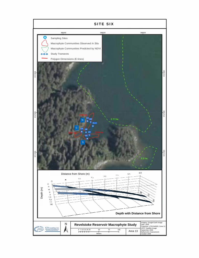
S I T E S I X
N
C
S
Revelstoke Reservoir Macrophyte Study Imagery: Google Earth Image Date: 2005 Projection: UTM NAD83, Zone 11 SPOT Satellite Image: September 2009 Bathymetric Assessment: October 2009
Area 13
388400 388500 388600
0 5 10 15 20 25 50 75 100
Meters
Depth with Distance from Shore
Dep
th (m
)
Distance from Shore (m)
C
S
N
5
5
7174
00
5
7175
00
5717
600
Legend Field Samples Macrophyte Communities Observed In Situ Macrophyte Communities Predicted by
SPOT Satellite
571
7400
571
7500
57
1760
0
Sampling Sites
Macrophyte Communities Observed
In Situ
Macrophyte Communities Predicted by NDVI Study Transects
Polygon Dimensions (E-lines)
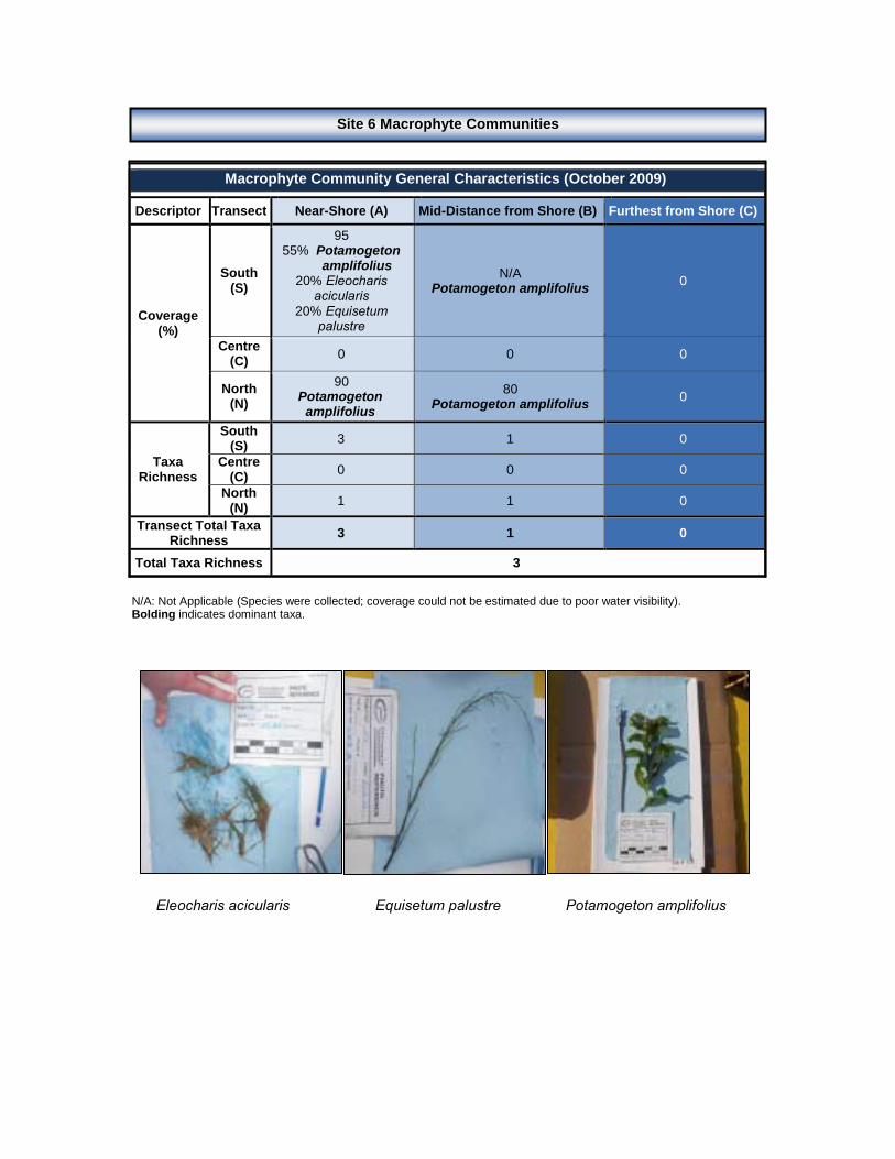
N/A: Not Applicable (Species were collected; coverage could not be estimated due to poor water visibility). Bolding indicates dominant taxa. Eleocharis acicularis Equisetum palustre Potamogeton amplifolius
Macrophyte Community General Characteristics (October 2009)
Descriptor Transect Near-Shore (A) Mid-Distance from Shore (B) Furthest from Shore (C)
Coverage (%)
South (S)
95 55% Potamogeton
amplifolius 20% Eleocharis
acicularis 20% Equisetum
palustre
N/A Potamogeton amplifolius 0
Centre (C) 0 0 0
North (N)
90 Potamogeton
amplifolius80
Potamogeton amplifolius 0
Taxa Richness
South (S) 3 1 0
Centre (C) 0 0 0
North (N) 1 1 0
Transect Total Taxa Richness 3 1 0
Total Taxa Richness 3
Site 6 Macrophyte Communities

Near-Shore Sediments Furthest from Shore (Grab)
Secchi disk depth (m): 2.9 (bottom Centre Transect mid-depth)
Field Observations
Near-Shore (A) Brown. Silky. Odourless. Gravels with sand and cobbles.
Mid-Distance from Shore (B)
Dull Grey. Loose. Gritty. Smell of rotten egg. Thick layer of woody debris over top of layer of sand and clay. Heterogeneous composition.
Furthest from Shore (C) Dull Grey. Thick like pudding. Silky. Smell of rotten egg. Little debris. Homogeneous throughout.
Sonde Profiles at the South, Centre & North Mid-Depth Transects (October 2009)
Transect Parameter Temperature (°C)
Conductivity (µS/cm) pH Redox
(mV) Turbidity
(NTU) DO (%)
DO (mg/L)
South Mid-
Distance from Shore
(S/B)
Mean 11.9 104 7.89 184 1.2 98.0 10.59
SD 0.8 2 0.08 2 0.4 1.2 0.10
Min 10.4 103 7.84 181 0.5 96.0 10.50
Max 12.3 108 8.03 186 1.6 98.9 10.74
Centre Mid-
Distance from Shore
(C/B)
Mean 12.0 104 7.85 185 1.9 98.8 10.66
SD 0.6 2 0.06 3 0.1 1.0 0.23
Min 10.9 103 7.75 183 1.8 97.7 10.46
Max 12.3 107 7.89 190 2.1 100.1 11.02
North Mid-
Distance from Shore
(N/B)
Mean 12.2 103 8.03 184 1.7 98.2 10.54
SD 0.5 1 0.04 4 0.2 0.8 0.08
Min 10.4 103 7.99 179 1.4 96.3 10.44
Max 12.3 108 8.10 195 2.1 99.5 10.76
Site 6 Sediment Characteristics
Site 6 Water Quality
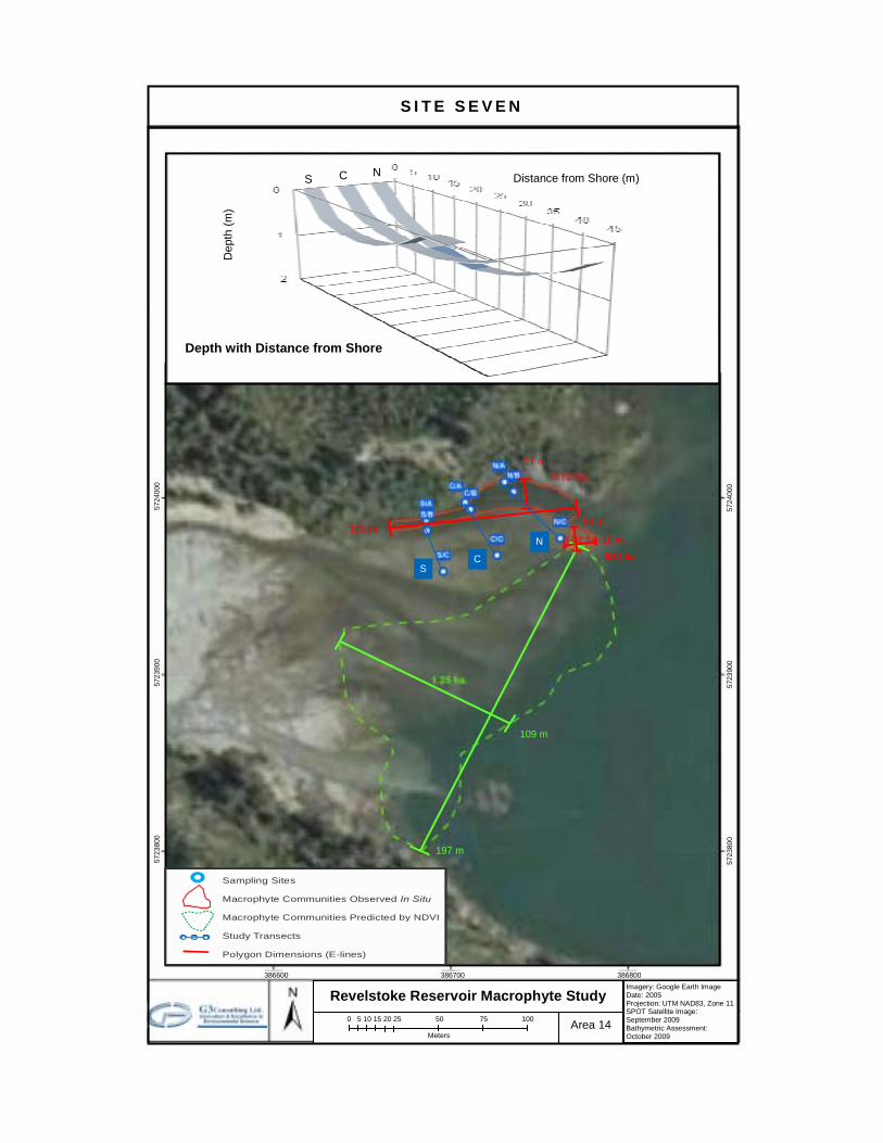
S I T E S E V E N
N
C S
Revelstoke Reservoir Macrophyte Study Imagery: Google Earth Image Date: 2005 Projection: UTM NAD83, Zone 11SPOT Satellite Image: September 2009 Bathymetric Assessment: October 2009
Area 14
386600 386700 386800
0 5 10 15 20 25 50 75 100
Meters
109 m
108 m
17 m
197 m
Dep
th (m
)
Distance from Shore (m) C N
Depth with Distance from Shore
S
572
3800
572
3900
572
4000
Legend Field Samples Macrophyte Communities Observed In Situ Macrophyte Communities Predicted by
SPOT Satellite
572
3800
572
3900
572
4000
Sampling Sites
Macrophyte Communities Observed
In Situ
Macrophyte Communities Predicted by NDVI Study Transects
Polygon Dimensions (E-lines)
18 m
14 m
0.02 ha.
Bolding indicates dominant taxa. Eleocharis acicularis Potamogeton amplifolius
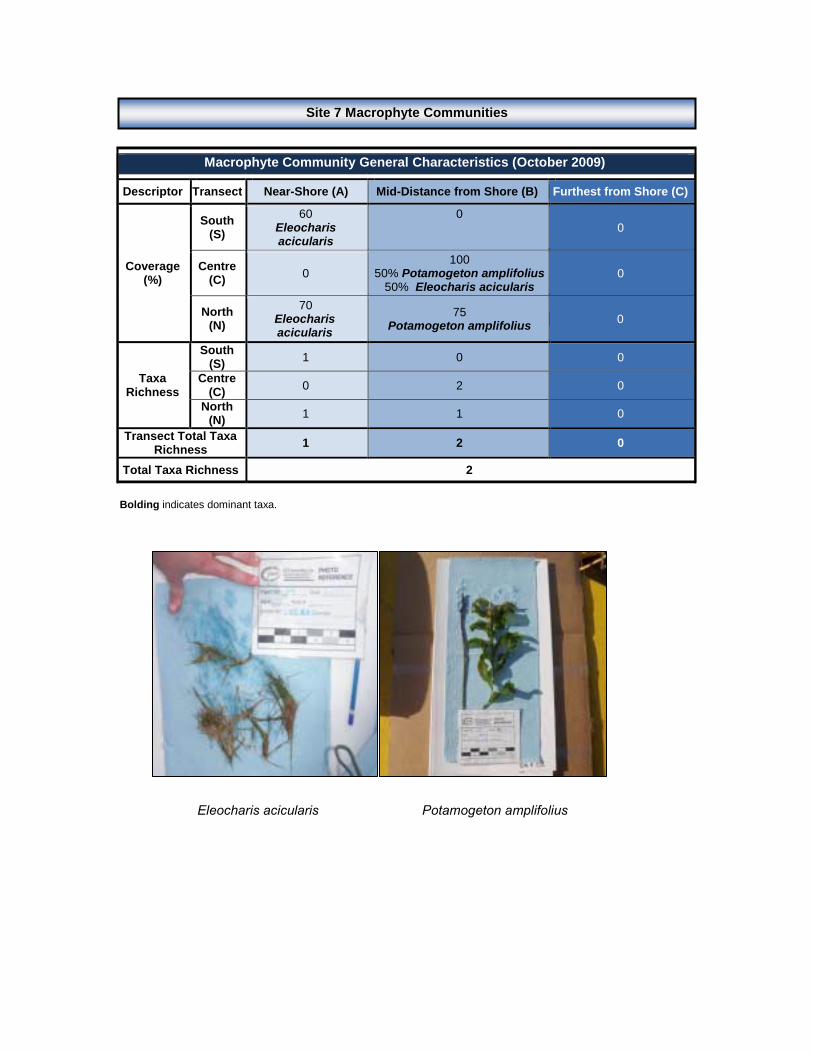
Macrophyte Community General Characteristics (October 2009)
Descriptor Transect Near-Shore (A) Mid-Distance from Shore (B) Furthest from Shore (C)
Coverage (%)
South (S)
60 Eleocharis acicularis
0
0
Centre (C) 0
100 50% Potamogeton amplifolius
50% Eleocharis acicularis 0
North (N)
70 Eleocharis acicularis
75 Potamogeton amplifolius 0
Taxa Richness
South (S) 1 0 0
Centre (C) 0 2 0
North (N) 1 1 0
Transect Total Taxa Richness 1 2 0
Total Taxa Richness 2
Site 7 Macrophyte Communities

Near-Shore Sediments Furthest from Shore (Grab)
Secchi disk depth (m): 0.6 (bottom Centre Transect mid-depth)
Field Observations
Near-Shore (A) Grey-Brown. Gritty. Odourless. Gravels with sand and few cobbles.
Mid-Distance from Shore (B)
Dull Grey-Green. Thick like pudding. Silky. Odourless. Few small macrophyte roots. Homogeneous throughout.
Furthest from Shore (C) Dull Grey. Loose. Gritty. Odourless. Small layer of debris (e.g., grass roots) on top of silt and clay. Heterogeneous composition.
Sonde Profiles at the South, Centre & North Mid-Depth Transects (October 2009)
Transect Parameter Temperature (°C)
Conductivity (µS/cm) pH Redox
(mV) Turbidity
(NTU) DO (%)
DO (mg/L)
South Mid-
Distance from Shore
(S/B)
Mean 10.2 85 7.78 180 4.2 98.4 11.06
SD 0.4 2 0.12 11 6.0 1.5 0.16
Min 9.7 82 7.54 158 -0.5 96.4 10.86
Max 10.7 87 8.04 192 16.6 100.9 11.36
Centre Mid-
Distance from Shore
(C/B)
Mean 10.3 85 7.88 188 1.6 99.9 11.20
SD 0.1 1 0.01 2 5.5 2.1 0.22
Min 10.2 84 7.87 186 -6.5 96.9 10.87
Max 10.4 86 7.89 189 5.7 101.6 11.38
North Mid-
Distance from Shore
(N/B)
Mean 11.3 90 7.70 118 0.4 95.9 10.51
SD 0.1 4 0.04 1 0.4 0.2 0.02
Min 11.2 85 7.67 117 0.1 95.8 10.49
Max 11.3 92 7.74 119 0.8 96.2 10.53
Site 7 Sediment Characteristics
Site 7 Water Quality

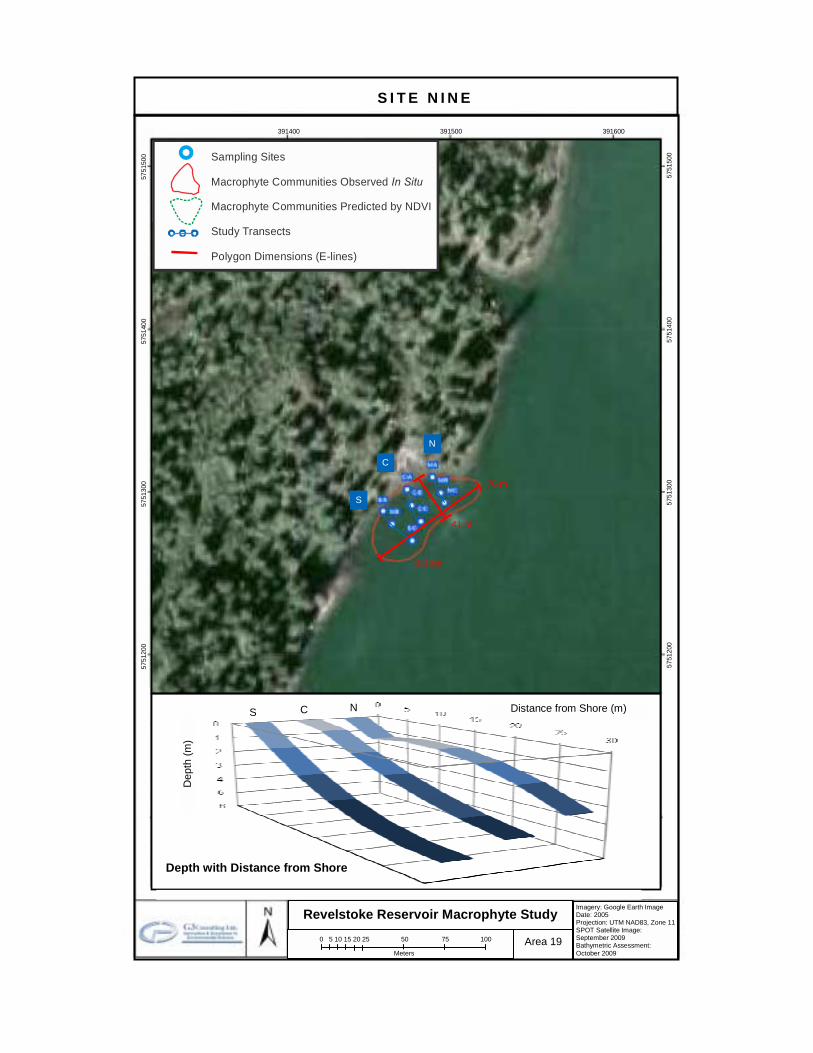
S I T E E I G H T
N
C
S
Revelstoke Reservoir Macrophyte Study Imagery: Google Earth Image Date: 2005 Projection: UTM NAD83, Zone 11SPOT Satellite Image: September 2009 Bathymetric Assessment: October 2009
Area 15
385600 385700 385800 385900 386000 57
2740
0
572
7500
5
7276
00
572
7700
5
7278
00
572
7900
5
7280
00
0 10 20 30 40 50 100 150 200
Meters
279 m
93 m
Depth with Distance from Shore
Dep
th (m
)
Distance from Shore (m)C
S N
5727
400
5
7275
00
572
7600
5
7277
00
572
7800
5
7279
00
572
8000
164 m
69 m
Legend Field Samples
Macrophyte Communities Observed In Situ
Macrophyte Communities Predicted
385600 385700 385800 385900 386000
Sampling Sites
Macrophyte Communities Observed
In Situ
Macrophyte Communities Predicted by NDVI Study Transects
Polygon Dimensions (E-lines)

Bolding indicates dominant taxa. Nitella sp. Potamogeton alpinus Potamogeton amplifolius Potamogeton foliosus
Macrophyte Community General Characteristics (October 2009)
Descriptor Transect Near-Shore (A) Mid-Distance from Shore (B) Furthest from Shore (C)
Coverage (%)
South (S)
100 50% Nitella sp.
50% Potamogeton amplifolius
90 Potamogeton foliosus
100 70% Potamogeton foliosus
30% Nitella sp.
Centre (C)
100 Potamogeton
amplifolius
100 50% Potamogeton foliosus
50% Nitella sp.
100 70% Nitella sp.
20% Potamogeton alpinus 10% Potamogeton foliosus
North (N)
100 50% Nitella sp.
50% Potamogeton amplifolius
90 30% Potamogeton amplifolius
30% Nitella sp. 30% Potamogeton foliosus
100 50% Nitella sp.
50% Potamogeton alpinus
Taxa Richness
South (S) 2 1 2
Centre (C) 1 2 3
North (N) 2 3 2
Transect Total Taxa Richness 2 3 3
Total Taxa Richness 4
Site 8 Macrophyte Communities

Near-Shore Sediments Furthest from Shore (Grab)
Secchi disk depth (m): 2.0 (bottom Centre Transect mid-depth)
Field Observations Near-Shore (A) Brown. Gritty. Odourless. Sand.
Mid-Distance from Shore (B)
Rusty Brown-Black. Gel-like. Very silky. Slight smell of rotten egg. Very little debris. Not homogeneous throughout. Black layer (rotten egg smell) on top of rusty brown layer (odourless).
Furthest from Shore (C) Black. Thick like pudding. Very silky. Smell of rotten egg. Lots of macrophyte roots and pieces. Homogeneous throughout.
Sonde Profiles at the South, Centre & North Mid-Depth Transects (October 2009)
Transect Parameter Temperature (°C)
Conductivity (µS/cm) pH Redox
(mV) Turbidity
(NTU) DO (%)
DO (mg/L)
South Mid-
Distance from Shore
(S/B)
Mean 12.0 102 7.88 196 2.2 98.9 10.66
SD 0.0 0 0.02 1 0.9 0.5 0.06
Min 11.9 102 7.87 194 1.5 98.3 10.58
Max 12.0 102 7.91 198 3.5 99.4 10.73
Centre Mid-
Distance from Shore
(C/B)
Mean 12.0 102 7.84 197 7.3 97.8 10.54
SD 0.0 0 0.02 1 0.1 0.1 0.02
Min 11.9 102 7.81 196 7.3 97.7 10.52
Max 12.0 102 7.85 198 7.4 97.9 10.56
North Mid-
Distance from Shore
(N/B)
Mean 12.0 102 7.58 195 16.4 97.5 10.52
SD 0.1 0 0.03 1 4.6 0.3 0.04
Min 11.9 102 7.82 194 12.5 97.3 10.49
Max 12.0 102 7.88 196 21.5 97.8 10.56
Site 8 Sediment Characteristics
Site 8 Water Quality
S I T E N I N E
N
C
S
Revelstoke Reservoir Macrophyte Study Imagery: Google Earth Image Date: 2005 Projection: UTM NAD83, Zone 11SPOT Satellite Image: September 2009 Bathymetric Assessment: October 2009
Area 19
391400 391500 391600
0 5 10 15 20 25 50 75 100
Meters
41 m
76 m
Depth with Distance from Shore
Dep
th (m
)
Distance from Shore (m) C S N
5751
100
5
7511
50
5
7512
00
5
7513
00
5
7514
00
5751
500 Legend
Field Samples Macrophyte Communities Observed In Situ Macrophyte Communities Predicted by
SPOT Satellite
57
5120
0
5
7513
00
5
7514
00
5751
500
Sampling Sites
Macrophyte Communities Observed
In Situ
Macrophyte Communities Predicted by NDVI Study Transects
Polygon Dimensions (E-lines)

N/A: Not Applicable (Species were collected; coverage could not be estimated due to poor water visibility). Bolding indicates dominant taxa. Nitella sp. Potamogeton amplifolius
Macrophyte Community General Characteristics (October 2009)
Descriptor Transect Near-Shore (A) Mid-Distance from Shore (B) Furthest from Shore (C)
Coverage (%)
South (S)
95 90% Nitella sp.
5% Potamogeton alpinus
70 60% Nitella sp.
10% Potamogeton alpinus
N/A Nitella sp.
Centre (C)
80 Nitella sp.
90 80% Nitella sp.
10% Potamogeton alpinus
N/A Nitella sp.
North (N)
95 90% Nitella sp.
5% Potamogeton alpinus
90 80% Nitella sp.
10% Potamogeton alpinus
N/A Nitella sp.
Transect Mean Coverage of
Macrophytes (%) 90 83 N/A
Centre (C) 1 2 1
North (N) 2 2 1
Transect Total Taxa Richness 2 2 1
Total Taxa Richness 2
Site 9 Macrophyte Communities

Near-Shore Sediments Furthest from Shore (Grab)
Secchi disk depth (m): 2.9 (bottom Centre Transect mid-depth)
Field Observations
Near-Shore (A) Brown. Gritty. Odourless. Sand.
Mid-Distance from Shore (B)
Black. Thick like pudding. Silky. Odourless. Little debris and some macrophyte roots. Homogeneous throughout.
Furthest from Shore (C) Black. Thick like pudding. Silky. Odourless. Abundant woody debris and Nitella sp. at the surface. Homogeneous throughout.
Sonde Profiles at the South, Centre & North Mid-Depth Transects (October 2009)
Transect Parameter Temperature (°C)
Conductivity (µS/cm) pH Redox
(mV) Turbidity
(NTU) DO (%)
DO (mg/L)
South Mid-
Distance from Shore
(S/B)
Mean 8.0 148 7.89 188 0.7 92.9 11.02
SD 0.0 0 0.01 1 0.7 0.4 0.05
Min 7.9 148 7.88 187 -0.5 92.5 10.96
Max 8.0 148 7.91 189 1.8 93.8 11.12
Centre Mid-
Distance from Shore
(C/B)
Mean 8.0 148 7.91 188 1.1 93.3 11.06
SD 0.0 0 0.00 0 0.3 0.4 0.04
Min 7.9 148 7.90 188 0.6 93.0 11.02
Max 8.0 148 7.91 188 1.2 93.9 11.13
North Mid-
Distance from Shore
(N/B)
Mean 8.0 148 7.91 190 2.3 94.2 11.16
SD 0.0 0 0.02 0 1.8 0.8 0.10
Min 8.0 148 7.89 189 0.7 93.4 11.06
Max 8.0 148 7.94 190 5.2 95.4 11.31
Site 9 Sediment Characteristics
Site 9 Water Quality

S I T E T E N
N
C
S
Revelstoke Reservoir Macrophyte Study Imagery: Google Earth Image Date: 2005 Projection: UTM NAD83, Zone 11SPOT Satellite Image: September 2009 Bathymetric Assessment: October 2009
Area 22
392200 392300 392400
0 5 10 15 20 25 50 75 100
Meters
79 m
41 m
Dep
th (m
)
Distance from Shore (m) C N
Depth with Distance from Shore
S
5763
500
576
3600
57
6370
0
Legend Field Samples Macrophyte Communities Observed In Situ Macrophyte Communities Predicted by
SPOT Satellite
5763
500
576
3600
57
6370
0
Sampling Sites
Macrophyte Communities Observed
In Situ
Macrophyte Communities Predicted by NDV Study Transects
Polygon Dimensions (E-lines)
Sampling Sites
Macrophyte Communities Observed
In Situ
Macrophyte Communities Predicted by NDVI Study Transects
Polygon Dimensions (E-lines)
35 m
17 m
203 m
344 m

Bolding indicates dominant taxa. Eleocharis acicularis Nitella sp. Potamogeton alpinus
Macrophyte Community General Characteristics (October 2009)
Descriptor Transect Near-Shore (A) Mid-Distance from Shore (B) Furthest from Shore (C)
Coverage (%)
South (S)
100 Nitella sp.
100 95% Nitella sp.
5% Potamogeton alpinus 0
Centre (C)
100 Nitella sp. 0 0
North (N)
100 90% Nitella sp. 10% Eleocharis
acicularis
90 Eleocharis acicularis
10 Nitella sp.
Taxa Richness
South (S) 1 2 0
Centre (C) 1 0 0
North (N) 2 1 1
Transect Total Taxa Richness 2 3 1
Total Taxa Richness 3
Site 10 Macrophyte Communities

Near-Shore Sediments Furthest from Shore (Grab)
Secchi disk depth (m): 1.6 (bottom Centre Transect mid-depth)
Field Observations Near-Shore (A) Grey. Odourless. Cobbles with gravels, sand and boulders.
Mid-Distance from Shore (B)
Black, Dull Grey. Loose, thick like pudding. Silky; Gritty. Odourless. Small woody debris and macrophyte roots. Not homogeneous throughout. Black layer thick like pudding and silky on top of dull grey layer, gritty, with sand and mica.
Furthest from Shore (C) Dull Grey. Loose. Gritty. Odourless. Some woody debris and lots of mica. Homogeneous throughout.
Sonde Profiles at the South, Centre & North Mid-Depth Transects (October 2009)
Transect Parameter Temperature (°C)
Conductivity (µS/cm) pH Redox
(mV) Turbidity
(NTU) DO (%)
DO (mg/L)
South Mid-
Distance from Shore
(S/B)
Mean 7.5 129 7.86 221 2.2 97.1 11.65
SD 0.0 0 0.01 1 2.4 0.2 0.02
Min 7.5 129 7.85 220 0.8 96.9 11.63
Max 7.5 129 7.87 221 5.8 97.3 11.67
Centre Mid-
Distance from Shore
(C/B)
Mean 7.4 129 7.87 222 1.6 96.5 11.61
SD 0.0 1 0.01 1 0.4 0.2 0.03
Min 7.3 127 7.86 221 1.3 96.3 11.57
Max 7.4 130 7.88 223 2.2 96.7 11.63
North Mid-
Distance from Shore
(N/B)
Mean 7.5 128 8.02 218 1.3 97.9 11.75
SD 0.0 0 0.03 1 0.1 0.1 0.02
Min 7.5 128 8.00 217 1.2 97.8 11.73
Max 7.5 128 8.05 219 1.4 98.0 11.76
Site 10 Sediment Characteristics
Site 10 Water Quality

S I T E E L E V E N
N C S
Revelstoke Reservoir Macrophyte Study Imagery: Google Earth Image Date: 2005 Projection: UTM NAD83, Zone 11SPOT Satellite Image: September 2009 Bathymetric Assessment: October 2009
Area 22
390500 390600 390700
0 5 10 15 20 25 50 75 100
Meters
348 m
104 m
Dep
th (m
)
Distance from Shore (m)
C N
Depth with Distance from Shore
S
576
7500
576
7600
576
7700
57
6780
0
576
7850
5767
900
Legend Field Samples Macrophyte Communities Observed In Situ Macrophyte Communities Predicted by
SPOT Satellite
576
7500
576
7600
576
7700
57
6780
0
79 m
Sampling Sites
Macrophyte Communities Observed
In Situ
Macrophyte Communities Predicted by NDV Study Transects
Polygon Dimensions (E-lines)
410 m

Bolding indicates dominant taxa.
Eleocharis acicularis Nitella sp.
Macrophyte Community General Characteristics (October 2009)
Descriptor Transect Near-Shore (A) Mid-Distance from Shore (B) Furthest from Shore (C)
Coverage (%)
South (S)
30 Eleocharis acicularis
100 Nitella sp.
80 40% Nitella sp. 40% Eleocharis
acicularis
Centre (C)
20 Eleocharis acicularis
100 Nitella sp.
100 50% Nitella sp. 50% Eleocharis
acicularis
North (N)
5 Eleocharis acicularis
100 Nitella sp.
70 60% Nitella sp. 10% Eleocharis
acicularis
Taxa Richness
South (S) 1 1 2
Centre (C) 1 1 2
North (N) 1 1 2
Transect Total Taxa Richness 1 1 2
Total Taxa Richness 2
Site 11 Macrophyte Communities
Near-Shore Sediments Furthest from Shore (Grab)
Secchi disk depth (m): 1.2 (bottom Centre Transect mid-depth)
Field Observations Near-Shore (A) Brown. Silky. Smell of rotten egg. Little sand, gravels and cobbles.
Mid-Distance from Shore (B)
Black. Thick like pudding. Silky. Smell of rotten egg. Macrophyte roots. Homogeneous throughout.
Furthest from Shore (C) Light Brown. Gel-like. Silky. Odourless. Macrophyte roots. Not homogeneous throughout, grey streaks observed.
Sonde Profiles at the South, Centre & North Mid-Depth Transects (October 2009)
Transect Parameter Temperature (°C)
Conductivity (µS/cm) pH Redox
(mV) Turbidity
(NTU) DO (%)
DO (mg/L)
South Mid-
Distance from Shore
(S/B)
Mean 7.9 129 7.94 230 3.9 99.4 11.84
SD 0.0 0 0.01 0 0.2 1.0 0.06
Min 7.8 129 7.93 230 3.7 97.6 11.74
Max 7.9 129 7.94 230 4.1 100.2 11.91
Centre Mid-
Distance from Shore
(C/B)
Mean 7.3 131 7.98 229 23.6 97.0 11.67
SD 0.0 0 0.01 1 0.1 0.5 0.05
Min 7.3 131 7.97 229 23.5 96.5 11.62
Max 7.4 131 7.99 230 23.6 97.4 11.72
North Mid-
Distance from Shore
(N/B)
Mean 7.2 132 7.96 229 55.9 96.4 11.65
SD 0.0 0 0.01 1 1.0 0.4 0.05
Min 7.2 132 7.95 228 54.6 96.1 11.61
Max 7.2 132 7.98 229 57.0 97.0 11.71
Site 11 Sediment Characteristics
Site 11 Water Quality

APPENDIX 5 Macrophyte Ecology

MACROPHYTE DESCRIPTOR DEFINITIONS (USDA, 2010)
Morphology Active Growth Period: seasonal period when the plant has their most active growth (i.e., spring; spring & fall; spring & summer; spring,
summer & fall; summer; summer & fall; fall; fall, winter & spring; year-round).
Growth Rate: growth rate after successful establishment relative to other species with the same growth habit.
Growth Form: growth form that most enhances plant ability to stabilize soil (i.e., bunch, colonizing, multiple stems, rhizomatous, single crown, single stem, stoloniferous, thicket forming).
C:N Ratio: percentage (%) of organic carbon divided by the percentage (%) of total nitrogen in organic material (low: <23; medium: 23 – 59; high: >59).
Nitrogen Fixation: amount of nitrogen fixed by the plant in monoculture (None: 0 lb N/acre/year; 0<Low<85; Medium: 85-160; High: >160).
Foliage Texture: general texture of the plant’s foliage relative to other species with the same growth habit (i.e., fine, medium, coarse).
Foliage Porosity Summer: how porous the foliage is during the summer months (i.e., porous, moderate, dense).
Foliage Porosity Winter: how porous the foliage is during the summer months (i.e., porous, moderate, dense).
Toxicity: toxicity of the plant to either humans or livestock (i.e., none, slight, moderate, severe).
Shape & Orientation: growth form or predominant shape of an individual plant.
Fall Conspicuous: leaves or fruits are conspicuous during autumn.
Known Allelopath: plant species has been shown to be allelopathic to at least one other species.
Growth Requirements Adaptated to Coarse Textured Soils: coarse textured surface layers include sand and loamy sand.
Adaptated to Fine Textured Soils: fine textured surface layers include sandy clay, silty clay and clay.
Adaptated to Med Textured Soils: medium textured surface layers include silt, sandy clay loam, sandy loam, silty clay loam, silt loam, clay loam and loam.
Anaerobic Tolerance: relative tolerance to anaerobic environments (i.e., none, low, medium, high).
Cold Stratification Required: the seed germination percentage of this plant increases significantly with cold stratification.
Fertility Requirement: relative level of nutrition (N, P, K) required for plant normal growth and development (i.e., low, medium, high).
Shade Tolerance: relative tolerance to shade conditions (i.e., intolerant, intermediate, tolerant).
Temperature, Minimum: lowest air temperature (°F) recorded in the plant’s historical range.
Precipitation, Minimum: minimum tolerable rainfall (in inches), expressed as the average annual minimum precipitation that occurs 20% of the time (i.e., the probability of it being this dry in any given year is 20%) at the driest climate station within the known geographical range of the plant.
Precipitation, Maximum: maximum tolerable rainfall (in inches), expressed as the annual average precipitation of the wettest climate station within the known geographical range of the plant.
Reproduction Bloom Period: seasonal period when the plant blooms the most (i.e., spring, early spring, mid spring, late spring, summer, early
summer, mid-summer, late summer, fall, winter, late winter, indeterminate).
Fruit/Seed Abundance: amount of seed produced by the plant compared to other species with the same growth habit (i.e., none, low, medium, high).
Fruit/Seed Period: season in which the earliest fruit or seed of the fruit/seed period is visually obvious (i.e., spring, summer, fall, winter, year-round).
Seed Spread Rate: rate the plant can spread compared to other species with the same growth habit (i.e., none, slow, moderate, rapid).
Seedling Vigor: expected seedling survival percentage of the plant compared to other species with the same growth habit (i.e., low, medium, high).
Vegetative Spread Rate: rate can this plant can spread compared to other species with the same growth habit (i.e., none, slow, moderate, rapid).

Potamogeton amplifolius, Tuck. Largeleaf Pondweed
Native Status Duration United States, Canada Perennial
Threatened & Endangered Information Maryland Endangered, Extirpated Tennessee Threatened
Habitat Lakes and ponds. Will grow in clear water as deep as 6 m.
Growth Habit Forb/herb (i.e., vascular plant without significant woody tissue above or at the ground)
Active Growth Period Flower Color Fruit/Seed Color Summer & Fall Green Orange Growth Rate Flower Conspicuous Fruit/Seed Conspicuous Rapid No No Growth Form Foliage Texture Toxicity Rhizomatous Fine None Shape and Orientation Foliage Color Fall Conspicuous Prostrate Green No C:N Ratio Foliage Porosity Summer Known Allelopath Medium Porous No Nitrogen Fixation Foliage Porosity Winter None Porous r Adapted to Coarse Textured Soils Cold Stratification Required Temperature, Minimum (°F) No No -33
Adapted to Fine Textured Soils pH, Min-Max Precipitation, Min-Max No 5.5->7.0 12-55 Adapted to Medium Textured Soils Fertility Requirement
No Medium Anaerobic Tolerance Shade Tolerance High Intolerant r Bloom Period Propagated by Bare Root Seed Spread Rate Mid Summer Yes Slow Fruit/Seed Abundance Propagated by Sprigs Seedling Vigor Medium Yes Medium Fruit/Seed Period Propagated by Seed Vegetative Spread Rate Summer-Fall Yes Rapid Fruit/Seed Persistence Propagated by Tubers No No
Classification Kingdom Plantae – Plants Subkingdom Tracheobionta – Vascular plants Superdivision Spermatophyta – Seed plants Division Magnoliophyta – Flowering plants Class Liliopsida – Monocotyledons Subclass Alismatidae Order Najadales Family Potamogetonaceae – Pondweed family Genus Potamogeton L. – pondweed
Mor
phol
ogy/
Ph
ysio
logy
G
row
th
Req
uire
men
ts
Rep
rodu
ctio
n G
ener
al D
escr
iptio
n
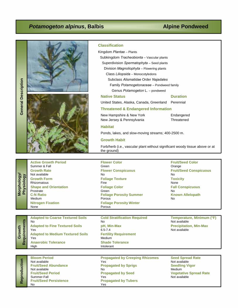
Potamogeton alpinus, Balbis Alpine Pondweed
Native Status Duration United States, Alaska, Canada, Greenland Perennial
Threatened & Endangered Information New Hampshire & New York Endangered New Jersey & Pennsylvania Threatened
Habitat Ponds, lakes, and slow-moving streams; 400-2500 m.
Growth Habit Forb/herb (i.e., vascular plant without significant woody tissue above or at the ground)
Active Growth Period Flower Color Fruit/Seed Color Summer & Fall Green Orange Growth Rate Flower Conspicuous Fruit/Seed Conspicuous Not available No No Growth Form Foliage Texture Toxicity Rhizomatous Fine None
Shape and Orientation Foliage Color Fall Conspicuous Prostrate Green No C:N Ratio Foliage Porosity Summer Known Allelopath Medium Porous No Nitrogen Fixation Foliage Porosity Winter None Porous r Adapted to Coarse Textured Soils Cold Stratification Required Temperature, Minimum (°F) No No Not available
Adapted to Fine Textured Soils pH, Min-Max Precipitation, Min-Max Yes 6.5-7.4 Not available Adapted to Medium Textured Soils Fertility Requirement
Yes Medium Anaerobic Tolerance Shade Tolerance High Intolerant r Bloom Period Propagated by Creeping Rhizomes Seed Spread Rate Not available Yes Not available Fruit/Seed Abundance Propagated by Sprigs Seedling Vigor Not available No Medium Fruit/Seed Period Propagated by Seed Vegetative Spread Rate Summer-Fall Yes Not available Fruit/Seed Persistence Propagated by Tubers No Yes
Classification Kingdom Plantae – Plants Subkingdom Tracheobionta – Vascular plants Superdivision Spermatophyta – Seed plants Division Magnoliophyta – Flowering plants Class Liliopsida – Monocotyledons Subclass Alismatidae Order Najadales Family Potamogetonaceae – Pondweed family Genus Potamogeton L. – pondweed
Mor
phol
ogy/
Ph
ysio
logy
G
row
th
Req
uire
men
ts
Rep
rodu
ctio
n G
ener
al D
escr
iptio
n

Potamogeton foliosus, Raf. Leafy Pondweed
Native Status Duration United States, Alaska, Canada, Hawaii, Puerto Rico Perennial
Threatened & Endangered Information Maryland Endangered New Hampshire Endangered
Habitat Shallow to >4' deep water; in soft sediment
Growth Habit Forb/herb (i.e., vascular plant without significant woody tissue above or at the ground)
Active Growth Period Flower Color Fruit/Seed Color Spring & Summer Green Brown
Growth Rate Flower Conspicuous Fruit/Seed Conspicuous Moderate No No Growth Form Foliage Texture Toxicity Single Crown Fine None Shape and Orientation Foliage Color Fall conspicuous Prostrate Green No C:N Ratio Foliage Porosity Summer Known Allelopath Medium Porous No Nitrogen Fixation Foliage Porosity Winter None Porous r Adapted to Coarse Textured Soils Cold Stratification Required Temperature, Minimum (°F) No No -38
Adapted to Fine Textured Soils pH, Min-Max Precipitation, Min-Max No 5.5-7.0 12-55
Adapted to Medium Textured Soils Fertility Requirement No Medium Anaerobic Tolerance Shade Tolerance High Intolerant r Bloom Period Propagated by Bare Roots Seed Spread Rate Late Spring Yes Moderate Fruit/Seed Abundance Propagated by Sprigs Seedling Vigor Medium Yes Medium Fruit/Seed Period Propagated by Seed Vegetative Spread Rate Summer Yes Slow Fruit/Seed Persistence Propagated by Tubers No No
Classification Kingdom Plantae – Plants Subkingdom Tracheobionta – Vascular plants Superdivision Spermatophyta – Seed plants Division Magnoliophyta – Flowering plants Class Liliopsida – Monocotyledons Subclass Alismatidae Order Najadales Family Potamogetonaceae – Pondweed family Genus Potamogeton L. – pondweed
Mor
phol
ogy/
Ph
ysio
logy
G
row
th
Req
uire
men
ts
Rep
rodu
ctio
n G
ener
al D
escr
iptio
n
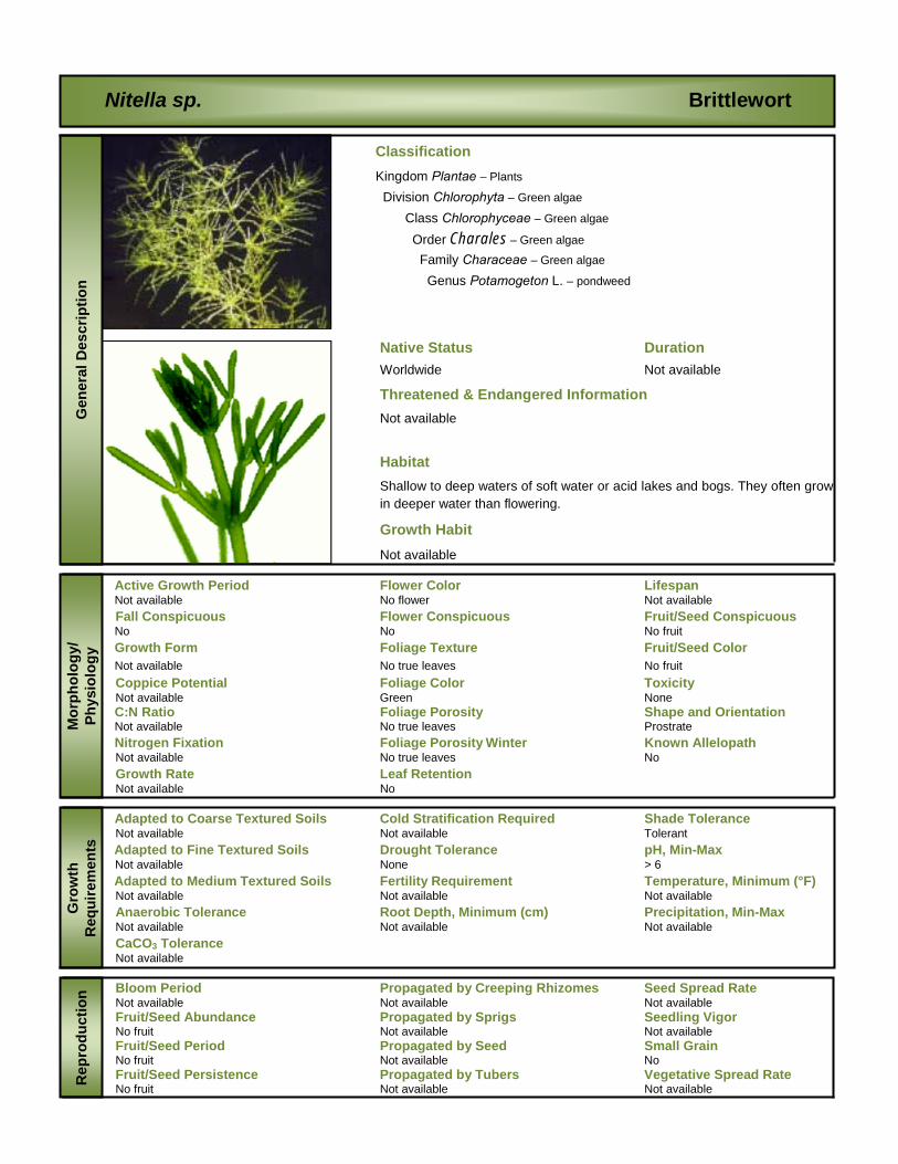
Nitella sp. Brittlewort
Native Status Duration Worldwide Not available
Threatened & Endangered Information Not available
Habitat Shallow to deep waters of soft water or acid lakes and bogs. They often grow in deeper water than flowering.
Growth Habit Not available
Active Growth Period Flower Color Lifespan Not available No flower Not available Fall Conspicuous Flower Conspicuous Fruit/Seed Conspicuous No No No fruit Growth Form Foliage Texture Fruit/Seed Color Not available No true leaves No fruit Coppice Potential Foliage Color Toxicity Not available Green None C:N Ratio Foliage Porosity Shape and Orientation Not available No true leaves Prostrate Nitrogen Fixation Foliage Porosity Winter Known Allelopath Not available No true leaves No Growth Rate Leaf Retention Not available No r Adapted to Coarse Textured Soils Cold Stratification Required Shade Tolerance Not available Not available Tolerant
Adapted to Fine Textured Soils Drought Tolerance pH, Min-Max Not available None > 6 Adapted to Medium Textured Soils Fertility Requirement Temperature, Minimum (°F)
Not available Not available Not available Anaerobic Tolerance Root Depth, Minimum (cm) Precipitation, Min-Max Not available Not available Not available CaCO3 Tolerance Not available r Bloom Period Propagated by Creeping Rhizomes Seed Spread Rate Not available Not available Not available Fruit/Seed Abundance Propagated by Sprigs Seedling Vigor No fruit Not available Not available Fruit/Seed Period Propagated by Seed Small Grain No fruit Not available No Fruit/Seed Persistence Propagated by Tubers Vegetative Spread Rate No fruit Not available Not available
Classification Kingdom Plantae – Plants Division Chlorophyta – Green algae Class Chlorophyceae – Green algae Order Charales – Green algae Family Characeae – Green algae Genus Potamogeton L. – pondweed
Mor
phol
ogy/
Ph
ysio
logy
G
row
th
Req
uire
men
ts
Rep
rodu
ctio
n G
ener
al D
escr
iptio
n
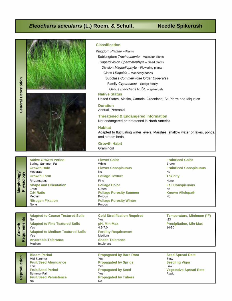
Eleocharis acicularis (L.) Roem. & Schult. Needle Spikerush
Native Status United States, Alaska, Canada, Greenland, St. Pierre and Miquelon
Duration Annual, Perennial
Threatened & Endangered Information Not endangered or threatened in North America
Habitat Adapted to fluctuating water levels. Marshes, shallow water of lakes, ponds, and stream beds.
Growth Habit Graminoid
Active Growth Period Flower Color Fruit/Seed Color Spring, Summer, Fall White Brown Growth Rate Flower Conspicuous Fruit/Seed Conspicuous Moderate No No Growth Form Foliage Texture Toxicity Rhizomatous Fine None Shape and Orientation Foliage Color Fall Conspicuous Erect Green No C:N Ratio Foliage Porosity Summer Known Allelopath Medium Porous No Nitrogen Fixation Foliage Porosity Winter None Porous r Adapted to Coarse Textured Soils Cold Stratification Required Temperature, Minimum (°F) No Yes -23
Adapted to Fine Textured Soils pH, Min-Max Precipitation, Min-Max Yes 4.5-7.0 14-50 Adapted to Medium Textured Soils Fertility Requirement
Yes Medium Anaerobic Tolerance Shade Tolerance Medium Intolerant r Bloom Period Propagated by Bare Root Seed Spread Rate Mid Summer Yes Slow Fruit/Seed Abundance Propagated by Sprigs Seedling Vigor Low Yes Low Fruit/Seed Period Propagated by Seed Vegetative Spread Rate Summer-Fall Yes Rapid Fruit/Seed Persistence Propagated by Tubers No No
Classification Kingdom Plantae – Plants Subkingdom Tracheobionta – Vascular plants Superdivision Spermatophyta – Seed plants Division Magnoliophyta – Flowering plants Class Liliopsida – Monocotyledons Subclass Commelinidae Order Cyperales Family Cyperaceae – Sedge family Genus Eleocharis R. Br. – spikerush
Mor
phol
ogy/
Ph
ysio
logy
G
row
th
Req
uire
men
ts
Rep
rodu
ctio
n G
ener
al D
escr
iptio
n

Myriophyllum spicatum, L. Eurasian Watermilfoil
Native Status Duration United States, Alaska, Canada Perennial
Threatened & Endangered Information Not endangered or threatened in North America
Habitat Lakes, ponds, sloughs, irrigation ditches and other water bodies
Growth Habit Forb/herb (i.e., vascular plant without significant woody tissue above or at the ground)
Active Growth Period Flower Color Fruit/Seed Color Spring & Summer Pink Orange-red Growth Rate Flower Conspicuous Fruit/Seed Conspicuous Rapid No No Growth Form Foliage Texture Toxicity Rhizomatous Fine None Shape and Orientation Foliage Color Fall Conspicuous Prostrate Green No C:N Ratio Foliage Porosity Summer Known Allelopath Medium Porous No Nitrogen Fixation Foliage Porosity Winter Yes Porous r Adapted to Coarse Textured Soils Cold Stratification Required Temperature, Minimum (°F) Yes No Not available
Adapted to Fine Textured Soils pH, Min-Max Precipitation, Min-Max Yes 5.4-11.0 Not available Adapted to Medium Textured Soils Fertility Requirement
Yes Medium Anaerobic Tolerance Shade Tolerance High Intolerant r Bloom Period Propagated by Creeping Rhizomes Seed Spread Rate Not available Yes Rapid Fruit/Seed Abundance Propagated by Sprigs Seedling Vigor Not available No Not available Fruit/Seed Period Propagated by Seed Vegetative Spread Rate Not available Yes Rapid Fruit/Seed Persistence Propagated by Tubers No No
Classification Kingdom Plantae – Plants Subkingdom Tracheobionta – Vascular plants Superdivision Spermatophyta – Seed plants Division Magnoliophyta – Flowering plants Class Magnoliopsida – Dicotyledons Subclass Rosidae Order Haloragales Family Haloragaceae – Water Milfoil family Genus Myriophyllum L. – watermilfoil
Mor
phol
ogy/
Ph
ysio
logy
G
row
th
Req
uire
men
ts
Rep
rodu
ctio
n G
ener
al D
escr
iptio
n

Ranunculus aquatilis, L. White Water Crowfoot
Native Status Duration United States, Alaska, Canada Perennial
Threatened & Endangered Information NA
Habitat Ponds, slugging streams, sloughs, water-filled ditches
Growth Habit Forb/herb (i.e., vascular plant without significant woody tissue above or at the ground)
Active Growth Period Flower Color Fruit/Seed Color Not available White Not available Growth Rate Flower Conspicuous Fruit/Seed Conspicuous Not available Not available Not available Growth Form Foliage Texture Toxicity Not available Not available None Shape and Orientation Foliage Color Fall Conspicuous Not available Green Not available C:N Ratio Foliage Porosity Summer Known Allelopath Medium Porous Not available Nitrogen Fixation Foliage Porosity Winter Not available Not available r Adapted to Coarse Textured Soils Cold Stratification Required Temperature, Minimum (°F) No Not available Not available
Adapted to Fine Textured Soils pH, Min-Max Precipitation, Min-Max Yes 5.5-8.0 Not available Adapted to Medium Textured Soils Fertility Requirement
Yes Medium Anaerobic Tolerance Shade Tolerance Not available Intolerant r Bloom Period Propagated by Creeping Rhizomes Seed Spread Rate Not available Yes Not available Fruit/Seed Abundance Propagated by Sprigs Seedling Vigor Not available Not available Not available Fruit/Seed Period Propagated by Seed Vegetative Spread Rate Not available Yes Rapid Fruit/Seed Persistence Propagated by Tubers Not available Not available
Classification Kingdom Plantae – Plants Subkingdom Tracheobionta – Vascular plants Superdivision Spermatophyta – Seed plants Division Magnoliophyta – Flowering plants Class Magnoliopsida – Dicotyledons Subclass Magnoliidae Order Ranunculales Family Ranunculaceae – Buttercup family Genus Ranunculus L. – buttercup
Mor
phol
ogy/
Ph
ysio
logy
G
row
th
Req
uire
men
ts
Rep
rodu
ctio
n G
ener
al D
escr
iptio
n

Equisetum palustre, L. Marsh Horsetail
Native Status Duration United States, Alaska, Canada Perennial
Threatened & Endangered Information Connecticut Special Concern New Hampshire, New York, Vermont Threatened
Habitat Shallow water of marshes and swamps, stream banks and forests
Growth Habit Forb/herb (i.e., vascular plant without significant woody tissue above or at the ground)
Active Growth Period Flower Color Fruit/Seed Color Spring & Summer Green Brown Growth Rate Flower Conspicuous Fruit/Seed Conspicuous Rapid No No Growth Form Foliage Texture Toxicity Rhizomatous Fine None Shape and Orientation Foliage Color Fall Conspicuous Erect Green No C:N Ratio Foliage Porosity Summer Known Allelopath High Porous No Nitrogen Fixation Foliage Porosity Winter None Porous r Adapted to Coarse Textured Soils Cold Stratification Required Temperature, Minimum (°F) Yes No -33
Adapted to Fine Textured Soils pH, Min-Max Precipitation, Min-Max Yes 4.5-6.0 30-55 Adapted to Medium Textured Soils Fertility Requirement
Yes Medium Anaerobic Tolerance Shade Tolerance High Intolerant r Bloom Period Propagated by Bar Roots Seed Spread Rate Late Spring No None Fruit/Seed Abundance Propagated by Sprigs Seedling Vigor None Yes Not available Fruit/Seed Period Propagated by Seed Vegetative Spread Rate Summer No Rapid Fruit/Seed Persistence Propagated by Tubers No No
Classification Kingdom Plantae – Plants Subkingdom Tracheobionta – Vascular plants Division Equisetophyta – Horsetails Class Equisetopsida Order Equisetales Family Equisetaceae – Horsetail family Genus Equisetum L. – horsetail
Mor
phol
ogy/
Ph
ysio
logy
G
row
th
Req
uire
men
ts
Rep
rodu
ctio
n G
ener
al D
escr
iptio
n

APPENDIX 6 Basemaps Area Index
Site Maps
Inset Map (Available upon request)
Contact BC Hydro
Water Licence Requirements

APPENDIX 7 Safety & Environmental
Management Plan

Safety & Environmental Management Plan
Revelstoke Macrophyte Assessments
Field Operations (2009 Field Season)

Field Safety Plan Revelstoke Macrophyte Assessments 2009 Field Season
1
G3 Consulting Ltd.
INTRODUCTION _________________________________________________ 2 1.0 RADIO & COMMUNICATION PROTOCOL ________________________ 3
1.1 Radio Frequencies ______________________________________________________ 3 Frequencies: ____________________________________________________________ 3 Key issues _____________________________________________________________ 3 Implementation __________________________________________________________ 3 Safety _________________________________________________________________ 3
2.0 FIELD EMERGENCY PROCEDURES ____________________________ 5 2.1 Roles & Responsibilities __________________________________________________ 5
2.2 Spill Management Procedures _____________________________________________ 5 2.2.1 Preventing Spills in the Field ___________________________________________ 5 2.2.2 Dealing with a Spill __________________________________________________ 6
3.0 SAFETY PLAN ______________________________________________ 7 3.1 Life Threatening Work Place Emergency _____________________________________ 7
3.2 Extreme Danger, Life Threatening Injuries: ___________________________________ 8 3.2.1 Helicopter Available for Evacuation ______________________________________ 8 3.2.2 Helicopter Not Available for Evacuation __________________________________ 8 3.2.3 If No Evacuation Is Available ___________________________________________ 8 3.2.4 If No Radio Contact Is Established ______________________________________ 8 3.2.5 Minor Emergency Care _______________________________________________ 9
3.3 Tailgate Meetings _______________________________________________________ 9
3.4 Check-In Procedures ___________________________________________________ 10
4.0 WATER/RESERVOIR RESCUE ________________________________ 11 4.1 Rescue Equipment (Optional) _____________________________________________ 11
4.2 Rescue Procedures ____________________________________________________ 11
5.0 FIELD MOBILITY & ACTIVITIES _______________________________ 12 5.1 Boat Safety ___________________________________________________________ 12
5.2 Fixed Wing Aircraft Safety _______________________________________________ 12 5.2.1 Pre Flight Procedure ________________________________________________ 12 5.2.2 Training __________________________________________________________ 13 5.2.3 Aerial Survey Procedure _____________________________________________ 13 5.2.4 Pre-flight Operations / Job Planning ____________________________________ 14 5.2.5 Approved Fixed Wing Aircraft and Pilot __________________________________ 14
6.0 ASSOCIATED RISKS ________________________________________ 16 Log Booms ____________________________________________________________ 16 Swimming _____________________________________________________________ 16 Generators & Motors ____________________________________________________ 16
7.0 EMERGENCY PHONE PROCEDURES __________________________ 17 7.1 Handheld Radios (Where Applicable) ______________________________________ 17
Marine VHF RADIO _____________________________________________________ 17
8.0 EMERGENCY TELEPHONE NUMBERS (PROJECT SPECIFIC) ______ 18

Field Safety Plan Revelstoke Macrophyte Assessments 2009 Field Season
2
G3 Consulting Ltd.
Introduction As part of the CLBMON-55 Revelstoke reservoir macrophyte study project G3 will be conducting a field component during the end of September (week of Sept 21 or Sept 28). G3 will notify BC Hydro the week before the field study takes place so that they may notify other interested personnel in the Revelstoke area. The field study will take place over a five (5) day period and include the following tasks:
1. Conduct an aerial reconnaissance flight over the reservoir using a fixed wing aircraft chartered from Silver Tip Aviation out of Revelstoke B.C;
2. Using the G3 scientific study boat G3 will collect representative macrophyte species from up to 12 sites along the entire length of reservoir. Prior to each days field sampling, G3 will notify BC Hydro of area it will be working in; and,
3. Traverse the 12 study sites using the study boat mapping each using a GPS Sonar.
Field Safety Plan Revelstoke Macrophyte Assessments 2009 Field Season
3
G3 Consulting Ltd.
1.0 Radio & Communication Protocol Radio frequencies are unsecured, allowing public and industry monitoring of transmissions. For this reason the following radio protocol will be followed to maintain a professional, functional line of communication between field crews and transportation/monitoring service providers (aircrafts, boat, etc.) or other stations as required. Once permission to use the BCH F1 and F2 has been granted my BC Hydro, all G3 field radios will have this channel programmed into their channel list.
1.1 Radio Frequencies
G3 will operate on industry or Marine two-way VHF radio frequencies within the study area.
Frequencies:
Channel F1: General communication (frequency 165.930)
Channel F2: Contacting the repeater and in Emergency communication (frequency 165.300)
Air service providers often monitor radio frequencies, however their channels may not be the same as those used by field crews and radio communication is not always a successful.
Key issues
Operating Names will be assigned for each group;
Location Codes will be assigned to each survey site;
radio communication will be kept to the minimum pertinent information
required for safe work planning and,
SAFETY CONCERNS WILL OVERRIDE THIS PROTOCOL IMMEDIATELY.
Implementation
each field crew will be identified with a unique field name;
where appropriate, the Aircraft Pilot will supply an appropriate call sign if communication is required;
location codes will be assigned according to sample/reach sites and field
members will communicate with office personnel using these codes; and.
radios will be tested during field operations to ensure operating condition and will be returned at the end of each day to the Safety Officer for proper
charging and testing.
Safety
during any type of medical or perceived emergency radio protocol will be adjusted and site specific data will be given directly over the air;
data is to be directed to the pilot, other field crews or other operating stations by their given field operating name,
information should include (in this order):

Field Safety Plan Revelstoke Macrophyte Assessments 2009 Field Season
4
G3 Consulting Ltd.
Group Operating Name,
Location, (location point ) as well as:
Water System Name, geographic Location
Nature of Emergency
Assistance Required

Field Safety Plan Revelstoke Macrophyte Assessments 2009 Field Season
5
G3 Consulting Ltd.
2.0 FIELD EMERGENCY PROCEDURES In accordance with G3 Field Protocol, a Safety Officer will be assigned for the duration of the field program. The Safety Officer will make final decisions on issues regarding individuals or group safety as related to work tasks. In addition the Safety Officer will be responsible for the Spill Management (Section 2.2) and ensuring any and all BMP’s are followed when conducting field activities. Activities will be abandoned if deemed, by the Safety Officer, as too great a risk. The safety officer will possess a fist aid and transportation certificate valid for the number of personnel under their supervision. The field portion of this program may require use of boats and four-wheel drive vehicles in remote areas. Work will involve water quality measurements and associated work around flowing water, reservoirs and the potential for wildlife encounters. Appropriate personal gear (i.e. footwear, waders, life vest, rainwear and appropriate clothing, etc.) is the responsibility of each individual crew member. Personnel will not be permitted to participate in field activities if the Safety Officer deems equipment to be inadequate. For the duration of the field study three (3) G3 personnel (1 field biologist and 2 field technicians) will conducting the field work. Due to the large number of expected crew (including several BC Hydro staff) a forth G3 personnel may accompany the field crews to navigate the boat and assist in boat safety procedures. The Field Biologist will be responsible for the overall field study, crew safety, and completion of the required work. Each field technician will assist in the collection and processing of macrophytes, water quality data and operation of equipment.
2.1 Roles & Responsibilities
It is the Safety Officers responsibility to ensure each crew has reviewed this EAP prior to field is equipped with the following supplies:
WCB Level I First Aid Kit and associated supplies. Each G3 crew member will have completed the WCB level one first aid and transportation requirements;
Hand Held Radio (appropriate map/code );
Survival Gear;
Rescue gear (as required);
Bear Knowledge and Bear Spray (if deemed necessary);
Signaling Device; and,
THIS EMERGENCY ACTION PLAN
Any concerns regarding safety should be addressed directly to the Safety Officer.
2.2 Spill Management Procedures
Field work will involve the re-fueling of equipment (boat, generators etc.) in addition to managing this equipment over a sensitive waterbody (Revelstoke Reservoir). The procedures below are to be followed to prevent and manage a spill should one occur.
2.2.1 Preventing Spills in the Field
The refueling of boats and or equipment while on the water is prohibited. Any and all refueling will take at an appropriate fueling station or at a distance >100 m from the shoreline.

Field Safety Plan Revelstoke Macrophyte Assessments 2009 Field Season
6
G3 Consulting Ltd.
Any portable fuel containers used in the field must be <20 L and be CSA (or equivlent) approved.
Fuel containers will not be left unattended at any time while on the water.
An appropriately sized spill kit will kept with the boat during the course of the field work.
2.2.2 Dealing with a Spill
If a spill does occur while in the field the following procedures will be implemented by the Safety Officer to ensure proper containment and clean-up:
Assess sa fety – Ensure the spill does not pose a health safety risk to crew
members.
Contain and Clean the Spill – Locate the spill kit and contain the spill using spill booms (if in water), ditches and spill rags. All of the contaminated soil and rags
should be put into buckets.
Report the Spill – If the spill is on land and greater then 10 L, report the spill to the Provincial Emergecy Program (PEP). Notify BC Hydro and G3 Head office of
any spill that occurs on site. All spill into a waterbody are to be reported to the PEP and BC Hydro.
Prevent Future Spills – Assess how and why the spill occurred and rectify the
problem so that its does not occur in the future.

Field Safety Plan Revelstoke Macrophyte Assessments 2009 Field Season
7
G3 Consulting Ltd.
3.0 Safety Plan In the event of an emergency the Safety Plan is to be followed according to criteria described below. A first aid/rescue post is to be established at a readily accessible site (e.g., vehicle, launch site, etc.) it is the Safety Officers responsibility to ensure that this post is appropriately stocked and supplies are maintained in good condition. As Highway 23 is the closest and most direct route from Revelstoke reservoir to the town of Revelstoke, it will be used for any emergency that requires transportation from the field site to Revelstoke. If an ambulance is not require for transportation, G3 will use the field truck (2008 Toyota Tundra) equipped with spine board and blankets, to transport any injured personnel.
Contents of the first aid/rescue post include: Level 1 first aid kit and spine board; survival gear;
VHF and/or satellite phone (optional); swift water rescue equipment (where applicable); and, rescue/extraction equipment (e.g., ax, winch, etc.).
This post is to serve as the emergency gathering point in the event of crew separation at the work site. A log will be maintained at this site to leave and receive messages in the event that communication by radio/phone is not established. A copy of this Plan is to remain at the post at all times.
At all time you must know: WHERE YOU ARE; WHERE YOU ARE IN RELATION TO THE POST;
NEAREST BOAT/TRUCK ACCESS; and, LOCATION OF NEAREST FIRST AID/RESCUE EQUIPMENT.
3.1 Life Threatening Work Place Emergency
In the event of a LIFE THREATENING work place emergency.
Cease work action;
Identify danger;
Assess situation;
Make area safe to administer or offer help;
Begin life saving first aid;
Stabilize victim; and,
Radio crew members and contact Revelstoke Emergency Services or other available station for assistance / evacuation.
Tell Them:
LOCATION
DETAILS OF INJURY
ASSISTANCE REQUIRED

Field Safety Plan Revelstoke Macrophyte Assessments 2009 Field Season
8
G3 Consulting Ltd.
3.2 Extreme Danger, Life Threatening Injuries:
Circumstances will determine the appropriate action.
3.2.1 Helicopter Available for Evacuation
DO NOT MOVE FROM REPORTED LOCATION.
Remain Calm;
At First Aid Attendants discretion of patients stability, transport patient to:
Nearest First Aid Post; or,
Nearest Hospital.
3.2.2 Helicopter Not Available for Evacuation
DO NOT MOVE FROM REPORTED LOCATION UNLESS UNSAFE.
Remain Calm;
Stabilize victim. You may be there for several minutes to several hours. In all
cases prepare mentally and physically for several hours or overnight.
Relay Radio to nearest radio station, to send transportation and first aid attendant.
3.2.3 If No Evacuation Is Available
Remain Calm;
Stabilize victim;
MAKE ALL EFFORTS TO CONTACT OR ARRANGE EVACUATION;
DO NOT MOVE FROM REPORTED LOCATION UNLESS UNSAFE;
Maintain scheduled radio reports every 15 minutes with the other group or nearest radio. Keep help informed of situation. Keep radio use to minimum safe
level to save battery and aid rescue attempts; and,
Use Survival Gear to await help, prepare a signal device to attract attention from passing; boats or aircrafts.
3.2.4 If No Radio Contact Is Established
Stabilize Victim;
Remain Calm;
MAKE ALL EFFORTS TO CONTACT OR ARRANGE EVACUATION;
DO NOT MOVE FROM LOCATION UNLESS UNSAFE TO REMAIN;
Use Survival Gear to await help, prepare a signal device to attract attention from passing, boats or aircrafts; and,
The Safety Plan will be implemented and a search will begin within the designated time. If you are not heard from an emergency will be assumed and assistance will be sent.

Field Safety Plan Revelstoke Macrophyte Assessments 2009 Field Season
9
G3 Consulting Ltd.
3.2.5 Minor Emergency Care
Sprains, twists, small cuts.
Coordinate crew consolidation, return to predetermined established safety point (i.e. the vehicle or launch point);
Crew size will never be below two (2) persons;
If necessary a first aid attendant will accompany the injured worker to the nearest first aid post or hospital;
Complete applicable WCB and field notes pertaining to the events; and,
Report incident to the G3 Head Office as soon as possible.
During evacuation or in the event of a rescue time delay (where safety permits):
All G3 crew will be advised of the situation immediately and offer assistance.
Inform G3 Head office of all details and action taken or needed.
Maintain communication with the G3 Richmond office.
After evacuation to medical center you must:
Inform remaining crew and rescuers of evacuation completion.
Inform G3 Head Office of all details and action taken or needed.
Complete applicable WCB and field notes pertaining to the events.
Report Incident to BC Hydro Project Contact at: http://www.bchydro.com/ex/contractor_safety/?WT.mc_id=incident username = contractor; pwd = safety
3.3 Tailgate Meetings
Tailgate meetings are an important aspect of field work. They are used to review safety procedures, project objectives and timelines, focus and discuss daily activities and benchmarks and a means by which to discuss and review project progress and any
issues, complications or findings.
Tailgate meetings would be held each morning before commencement of field work. Each day’s work plan would be discussed and crew obligations, QA/QC criteria, and
specific expectations outlined. The safety officer would provide input as to any specific safety issues or concerns and overview any procedures need for the day (e.g., boat protocol, aircraft procedures, etc.). Each field personnel will be provided a waterproof
field book in which daily activities will be noted and specific instructions listed.
Additional evening tailgates would be held to review and compare daily objectives with those identified in the morning and to identify any follow-up or action items for the next
day (e.g., purchase of supplies, re-testing, shipment of samples, etc.). Tailgate discussions would be recorded by the field coordinator for reference.

Field Safety Plan Revelstoke Macrophyte Assessments 2009 Field Season
10
G3 Consulting Ltd.
3.4 Check-In Procedures
During the field work all crew members will remain together and in close contact with each other. Everyone will leave the launch point and return to it together and the end of each day. To ensure management is aware that each day was successful and that each
personnel is accounted for, the crew leader will report to the office manager and the end of each day by 7pm, once all crew members have returned to the hotel. Status reports and data uploads will also be given to the office manager with crew check-ins.
In the event that a check-in is not completed, all attempts will be made to contact the field crew via cell phones and hotel staff. If no contact can be established by 10pm G3 will contact Revelstoke emergency authorities and report them missing with their last know
location and the location of all the study sites.
Field Safety Plan Revelstoke Macrophyte Assessments 2009 Field Season
11
G3 Consulting Ltd.
4.0 W ATER/RESERVOIR RESCUE In the event of a water rescue the Safety Officer will coordinate the rescue team until the point at which a professional SAR Tech. of higher qualification arrives on site.
To reduce the chance of requiring swift water rescue, personal floatation devices (PFDs) are to be worn by ALL crew members when working near any fast moving water (common in the upper reach of the reservoir). Throw bags will be situated at each sample site as required. PFDs must be worn by all crew members while in the boat at all times.
4.1 Rescue Equipment (Optional)
In the event that strong currents are observed at a sample site, equipment designed specifically for swift water rescue will be located at either the on shore the first aid/rescue
post (where applicable) or on the sampling boat.
Rescue Equipment includes:
Throw bag;
assorted 1" rescue webbing;
1 Rescue life jacket;
assorted prussic slings;
assorted locking carabiners; and,
Level 1 first aid kit.
THIS EQUIPMENT IS TO BE USED FOR RESCUE PURPOSES ONLY.
4.2 Rescue Procedures
Swift water rescue requires special training and skills. In-stream rescues are to be conducted by appropriately trained field members only (i.e., Swift Water Rescue Technician 1). Rescue procedures are to be conducted in accordance to Swift Water
Rescue procedures described in the Swift Water Rescue Training (SRT) course. Refer to SRT literature for appropriate procedures.
REMEMBER:
THROW Throw bag first;
ROW Assist with a boat or raft; and,
GO Properly equipped swimming rescue as final resort.

Field Safety Plan Revelstoke Macrophyte Assessments 2009 Field Season
12
G3 Consulting Ltd.
5.0 FIELD MOBILITY & ACTIVITIES During the field portion of any program mobility and transportation of crew members and equipment will be facilitated through the use of a variety of means, including but not limited to:
two and four wheel drive vehicles;
motorized boats; and,
fixed wing aircraft.
Each of these means of transport has certain inherent risks associated with use. To minimize these risks each means of transportation is to be operated and/or used in accordance with manufacturer’s specifications and established guidelines (e.g., Coast Guard, Department of Transportation, WCB, etc.).
5.1 Boat Safety Boats and rafts are to be used in accordance to Canadian Coast Guard regulations. Specifically boats will be equipped with a minimum of the following equipment:
PFDs for all passengers;
15 m floating line;
paddles/oars; navigation lights when operated at night;
a signaling device (i.e., flares); and,
a bailer.
In addition to this equipment, boats will be equipped with a marine VHF radio (hand held),
survival gear and a first aid kit. In accordance to swift water procedures life jackets will be worn in the boat at all times it is operating within a reservoir. Boats are to be used for the sole purpose of field work and related activities. Excessive speed and/or dangerous use
of boats is prohibited.
5.2 Fixed Wing Aircraft Safety
During the course of the aerial survey all BC Hydro SOP’s (OSH 407, SOP Scientific Aerial Survey’s etc.) will be strictly adhered to and reviewed with field crew prior to
conducting any field work. Helicopters will not be used during the study unless required for emergency procedures (injury, evacuation etc.).
G3 will contract a plane and pilot approved by BC Hydro for the purpose of conducting an
aerial survey of Revelstoke Reservoir. The pilot will explain safety in and around aircraft and proper procedures for flight. The pilot will have ultimate authority over safety issues pertaining to aircraft use.
This standard operating procedure (SOP) will establish governance for Scientific Aerial Survey. It will apply to the scientific aerial surveys utilizing a fixed wing aircraft for conducting a visual and photographic survey of Revelstoke Reservoir.
5.2.1 Pre Flight Procedure
1. All flights must be approved by the Manager, Aircraft Operations Department, or
their delegate, prior to the flight taking place.
Field Safety Plan Revelstoke Macrophyte Assessments 2009 Field Season
13
G3 Consulting Ltd.
2. All flights must be in compliance with Canadian Aviation Regulations (CARs) and Provincial (WorkSafe BC) regulations.
3. A Fixed Wing Aircraft Booking Form must be completed by the requesting manager and forwarded to the Manager, Aircraft Operations Department, for approval.
4. A Risk Assessment and Hazard Barrier plan for scientific aerial surveys will be completed by the Manager, Aircraft Operations Department.
5. Emergency surveys (If required) may be pre-authorized in advance by submitting
an emergency flight request on the standard Helicopter or Fixed Wing Aircraft Booking Form, with details of the approved flight crew and aircraft. The flight crew would normally consist of an experienced scientific flight coordinator familiar
with the area and an approved experienced pilot. The Fixed Wing Aircraft Booking Form must be returned to the Manager, Aircraft Operations Department, the next working day for review.
5.2.2 Training
1. Prior to commencing any scientific work using a fixed wing aircraft, all workers involved shall be adequately trained and familiar with the WorkSafe BC Occupational Health and Safety Regulations(OHS), Canadian Aviation
Regulations (CARs) and will review this Safety Plan.
2. All non-BC Hydro personnel or BC Hydro passengers on board will receive a Flight Safety Briefing and review of Crew Resource Management (CRM)
principles from the pilot prior to embarking on the flight.
3. The pilot must have documented proof of training in Pilot Decision Making (PDM) and Emergency Procedures. Documented proof will be listed on the pilot
database available on the Aircraft Operations website.
5.2.3 Aerial Survey Procedure
1. Scientific aerial survey flights should be limited to five (5) hours on survey, with a maximum eight (8) hours of flight time per day.
2. Workers performing aerial surveys must complete a person check at regular intervals as determined by the flight plan
3. Aircraft selection must meet or exceed the requirements set out in this procedure
4. All patrols that include flights over remote areas must have an approved BC Hydro Emergency Preparedness kit on board when the flight commences. The emergency kit will have enough supplies to support all persons on board in case
of an emergency landing in a remote area.
5. All low level aerial surveys must have an initial reconnaissance flight prior to a detailed survey being started if:
a. The pilot and crew are not familiar with the area(s) to be surveyed; or
b. The area(s) have not been flown within the past 6 months.

Field Safety Plan Revelstoke Macrophyte Assessments 2009 Field Season
14
G3 Consulting Ltd.
6. When flying or working over water (i.e. aquatic vegetation survey) all flight crew must wear an approved PFD (Personal Floatation Device).
7. In the case it is known that no flight hazards exist, the reconnaissance flight may be waived by any of the two listed below who are in agreement;
a. Area Manager or delegate
b. General Manager.
5.2.4 Pre-flight Operations / Job Planning
Always ask the question – Can the job or task be completed using other methods?
The following factors should be considered as part of job planning:
Aircraft Selection
Pilot Selection
Pilot and Crew Pre-Flight Discussions
Flight approvals
Weather Check
Aircraft Pre-flight Checks
Person Check Procedure
Route Planning
Flight Following Coordination – ability to track aircraft
Flight Mapping
Flight hazards reviewed
Crew Health (mentally and physically fit with mind on task)
Crew Experience
PDM – Pilot Decision Making TrainingSecurity during flight – equipment properly stowed, flight permits in place if required
Communications Equipment check
Personal Protective Equipment (PPE) as required -All required safety gear available
5.2.5 Approved Fixed Wing Aircraft and Pilot
For the aerial survey of Revelstoke Reservoir, G3 has contracted Silver Tip Aviation of
Revelstoke, BC. Silver Tip is a BC Hydro approved aviation company that uses Cessna 182’s for all of its aerial survey’s. Silver Tip pilots have been pre-screened by BC Hydro and possess the following experience and training:
Documented Aerial Survey experience
Documented Aerial Survey training
Documented PDM ( Pilot Decision Making) training

Field Safety Plan Revelstoke Macrophyte Assessments 2009 Field Season
15
G3 Consulting Ltd.
Must meet all requirements of OSH 407
Documented Mountain Flying training
Documented Mountain Flying experience

Field Safety Plan Revelstoke Macrophyte Assessments 2009 Field Season
16
G3 Consulting Ltd.
6.0 ASSOCI ATED RISKS There are several risks associated with the nature of certain field portions of any program. For this reason it is imperative that field members use their best judgment and remain vigilant in their application of safety protocols. If a question or uncertainty related to field safety arises, it is the responsibility of each crew member to consult the Safety Officer or this SAFETY PLAN document. Certain risks associated with field work can be limited through application of common sense and judgment. Remember where you are and think about the risk involved in the work task and the potential outcome in the event of an emergency. Emergency resources may be limited, requiring absolute caution during all aspects of field work.
Log Booms
When working for extended periods of time on logs and/or related booms field members must use caulk boots. In accordance with swift water protocols a PFD must be worn when working on log booms or logs within a river.
Swimming
Swims (if required) are to be conducted by experienced field members equipped with appropriate dry suits and floatation devices. Crew members are not to conduct swims alone unless accompanied by a drift raft equipped with appropriate rescue equipment
and experienced personnel.
Generators & Motors
Never refuel a running motor. Be sure that the appropriate fuel type is used when refueling.
Alert other crew members when starting a generator, particularly when using power tools or related electrical appliances.

Field Safety Plan Revelstoke Macrophyte Assessments 2009 Field Season
17
G3 Consulting Ltd.
7.0 EM ERGENCY PHONE PROCEDURES The nature of field work may require the use of boats and ATVs in remote areas. In the event of an emergency be sure to identify the following points to the response team:
the situation involves stranded/injured field member(s) (in the lake, up a road) requiring a search and rescue; and/or,
the situation involves injured field member(s) requiring assistance from the first
aid/rescue post (e.g., field camp, truck, etc.).
In the event of an emergency:
Describe the nature of the accident in sufficient detail to assist in appropriate response. Keep details to the essential points. Speak slowly and clearly to avoid confusion. Be decisive in your actions and requests and have your request repeated back to you for confirmation. Provide the following information to the response team:
1. Nature of emergency (Medical, Accident, Storm/Weather, etc.);
2. Number of persons involved;
3. Type of assistance required (Paramedic, SAR Team, Heli/Air evacuation, Emergency towing, etc.).
4. Field location; and,
5. Site Description (as viewed from the air, water, road, etc.)
Remember to use logic. If the field team is known to at a specific location, assistance and searches should focus on that area first.
7.1 Handheld Radios (Where Applicable)
Ensure all crew members are familiar with radio operation and know where the radio is
located. Establish the following:
an appropriate relay station (i.e., nearest party); and,
approximate range of radio signal; and,
barriers to radio use (i.e., valleys, mountains, etc.).
Marine VHF RADIO
In the event that satellite telephone connection is not available during an emergency situation follow these procedures:
1. Place an appropriate PAN PAN or MAY DAY on channel ____ (VHF 16 if marine) third party and/or Coast Guard should respond; if no response,
2. Request help on channel ______. This is the operating/hailing channel used in
the study area. Have your message relayed to the appropriate response team and repeated back to you for confirmation.

Field Safety Plan Revelstoke Macrophyte Assessments 2009 Field Season
18
G3 Consulting Ltd.
8.0 EMERGENCY TELEPHONE NUMBERS (Project Specific)
G3 Consulting Ltd. 604-451-1020
After Hours line 604-780-2906
Regional Hospital 911
Regional RCMP (250) 837-5255
Regional Search & Rescue (250) 837-4448
Regional Fire (250) 837-2884 Regional BC Hydro Contact Eva-Maria Boehringer, M.Sc., MRM, RPBio Natural Resource Specialist BC Hydro Generation Water License Requirements 601 - 18th Street Castlegar, BC V1N 2N1 Phone: (250) 365-4566 (PAX 54566) Fax: (250) 365-4589 Cell: (604) 319-1085 Revelstoke Plant Manager 250-814-6627
Spill Reporting (PE) 1-800-663-3456
Accommodation (G3 Field Crew)
Remember: Safety First

APPENDIX 8 Sample Field Forms Biophysical Observation Form
In Situ Sediment Data Form

Biophysical Observation Form Date (yy/mm/dd) Proj. No. Site Location UTMs Recorder
914
Biophysical Observations
Zone Transect Depth (m) Transect Distance
(m)
Substrate Vegetation
Dominant Sub Dominant Dominant Sub DominantType % Type %
A
1
2
3
B
1
2
3
C
1
2
3
Zone Bottom Substrate Bed Material
Type Symbol Type Symbol Class Symbol Size Description Nearest to Shore A Rocky Shore-Bedrock R-b Fines F <2 mm Smaller than a ladybug Mid-distance from Shore B Rocky Shore-Rubble R-r Gravels G 2-64 mm Ladybug to tennis ball Furthest from Shore C Unconsolidated Shore-Cobble Gravel UG Cobbles C 64-256 mm Tennis ball to basketball
Boulders B >256 mm Larger than a basketball Rock R >4000 mm Includes boulders and blocks >4 m and bedrock Anthropogenic A Riprap or other structures

Site Location: Date: UTMs: Sketch Artist:
Sketch:
Comments:

IN SITU SEDIMENT
DATA FORM
GROSS SEDIMENT CHARACTERISTICS
Colour (check): black dark brown brown-green gray-green blue-gray dull gray other: Consistency (describe & check): gel-like loose watery thick like pudding falls apart into fluffy pellets other: Texture (check): silky talcomy gritty gravelly other:
Smell (check): odourless rotten egg acrid chlorine oil creosote other:
Description of Debris Present:
Other Comments:
GROSS CHARACTERISTICS OF VERTICAL PROFILE
Penetration Depth of Grab (cm):
Homogeneous throughout? Yes No If not, describe (include any horizontal streaks of brown or black; presence of varves or other obvious vertical layers; presence of thin oxidized layer on surface):
Other Comments:
ATTENTIONThis form is intended to be used by the individual or entity representing G3 Consulting Ltd. and may contain information that is privileged, confidential, and exempt from disclosure. If you are not the intended user of this document, or an employee or agent responsible for its care, please return it to G3 Consulting Ltd., or notify us immediately. Thank you.
G3 Consulting Ltd., 206-8501 162nd Street., Surrey, BC, V4N 1B2 Tel: (604) 598-8501