Classification of Wetlands and Deepwater Habitats of the United
142
FWS/OBS-79/31 DECEMBER 1979 Reprinted 1992 Classification of Wetlands and Deepwater Habitats of the United States U .S . Department of the Interior Fish and Wildlife Service
Transcript of Classification of Wetlands and Deepwater Habitats of the United

FWS/OBS-79/31DECEMBER 1979Reprinted 1992
Classification ofWetlands and
Deepwater Habitatsof the United States
U.S . Department of the Interior
Fish and Wildlife Service

The Biological Services Program was established within the U .S . Fish andWildlife Service to supply scientific information and methodologies on keyenvironmental issues which have an impact on fish and wildlife resources andtheir supporting ecosystems . The mission of the Program is as follows :
1 .
To strengthen the Fish and Wildlife Service in its role as a primary sourceof information on natural fish and wildlife resources, particularly withrespect to environmental impact assessment .
2 .
To gather, analyze, and present information that will aid decisionmakersin the identification and resolution of problems associated with major landand water use changes .
3 .
To provide better ecological information and evaluation for Departmentof the Interior development programs, such as those relating to energydevelopment .
Information developed by the Biological Services Program is intended for usein the planning and decisionmaking process, to prevent or minimize the impactof development on fish and wildlife . Biological Services research activities andtechnical assistance services are based on an analysis of the issues, the decision-makers involved and their information needs, and an evaluation of the state-of-the-art to identify information gaps and determine priorities . This is a strategy toassure that the products produced and disseminated will be timely and useful .
Biological Services projects have been initiated in the following areas :
Coal extraction and conversion
Power plants
Geothermal, mineral, and oil shale development
Water resource analysis, including stream alterations and western waterallocation
Coastal ecosystems and Outer Continental Shelf development
Systems and inventory, including National Wetlands Inventory, habitatclassification and analysis, and information transfer
The Program consists of the Office of Biological Services in Washington, D.C.,which is responsible for overall planning and management; National Teams whichprovide the Program's central, scientific, and technical expertise, and which arrange for contracting of Biological Services studies with States, universities, con-sulting firms, and others ; Regional staff who provide a link to problems at theoperating level ; and staff at certain Fish and Wildlife Service research facilitieswho conduct inhouse research studies .

CLASSIFICATION OF WETLANDS AND DEEPWATERHABITATS OF THE UNITED STATES
By
Lewis M. CowardinU.S . Fish and Wildlife Service
Northern Prairie Wildlife Research CenterJamestown, North Dakota 58401
Virginia CarterU.S . Geological SurveyReston, Virginia 22092
Francis C . GoletDepartment of Natural Resources Science
University of Rhode IslandKingston, Rhode Island 02881
and
Edward T . LaRoeU.S . National Oceanographic and Atmospheric Administration
Office of Coastal Zone ManagementWashington, D.C . 20235
Performed for
U.S . Department of the InteriorFish and Wildlife Service
Office of Biological ServicesWashington, D.C . 20240
For sale by the Superintendent of Documents, U.S . Government Printing OfficeWashington, D.C . 20402
FWS/OBS-79/31December 1979

Library of Congress Cataloging in Publication Data
United States, Fish and Wildlife ServiceClassification of wetlands and deepwater habitats of the United States .(Biological services program ; FWS/OBS-79/31)1 . Wetlands-United States-Classification . 2 . Wetland ecology-United
States . 3 . Aquatic ecology-United States. I . Cowardin, Lewis M. II. Title.III . Series: United States . Fish and Wildlife Service . Biological servicesprogram ; FWS/OBS-79/31 .QH76.U54a 79/31 [QH104] 574.5'0973s [574.5'2632] 79-607795

ForewardWetlands and deepwater habitats are essential breeding, rearing, and feeding grounds for many species of fish
and wildlife . They may also perform important flood protection and pollution control funtions . Increasing Nationaland international recognition of these values has intensified the need for reliable information on the status and ex-tent of wetland resources. To develop comparable information over large areas, a clear definition and classificationof wetlands and deepwater habitats is required .The classification system contained in this report was developed by wetland ecologists, with the assistance of many
private individuals and organizations and local, State, and Federal agencies . An operational draft was published inOctober 1977, and a notice of intent to adopt the system for all pertinent Service activities was published December12, 1977 (42 FR 62432) .The Fish and Wildlife Service is officially adopting this wetland classification system . Future wetland data bases
developed by the Service, including the National Wetlands Inventory, will utilize this system . A one-year transitionperiod will allow for training of Service personnel, amendment of administrative manuals, and further developmentof the National Wetlands Inventory data base . During this period, Service personnel may continue to use the oldwetland classification described in Fish and Wildlife Service Circular 39 for Fish and Wildlife Coordination Act reports,wetland acquisition priority determinations, and other activities in conjunction with the new system, where immediateconversion is not practicable .Upon completion of the transition period, the Circular 39 system will no longer be officially used by the Fish and
Wildlife Service except where applicable laws still reference that system or when the only information available isorganized according to that system and cannot be restructured without new field surveys .Other Federal and State agencies are encouraged to convert to the use of this system . No specific legal authorities
require the use of this system-or any other system for that matter . However, it is expected that the benefits ofNational consistency and a devel9ping wetland data base utilizing this system will result in acceptance and use bymost agencies involved in wetland management . Training can be provided to users by the Service, depending onavailability of resources . Congressional committees will be notified of this adoption action and will be encouragedto facilitate general adoption of the new system by amending any laws that reference the Circular 39 system .This is a new system and users will need to study and learn the terminology . The Service is preparing a document
to aid in comparing and translating the new system to the Service's former classification system . In the coming year,the Fish and Wildlife Service, in conjunction with the Soil Conservation Service, also plans to develop initial listsof hydrophytic plants and hydric soils that will support interpretation and use of this system .We believe that this system will provide a suitable basis for information gathering for most scientific, educational,
and administrative purposes ; however, it will not fit all needs. For instance, historical or potentially restorable wetlandsare not included in this system, nor was the system designed to accommodate all the requirements of the many recentlypassed wetland statutes . No attempt was made to define the proprietary or jurisdictional boundaries of Federal, State,or local agencies . Nevertheless, the basic design of the classification system and the resulting data base should assistsubstantially in the administration of these programs .This report represents the most current methodology available for wetland classification and culminates a long-
term effort involving many wetland scientists . Although it may require revision from time to time, it will serve uswell in the years ahead . We hope all wetland personnel in all levels of government and the private sector come toknow it and use it for the ultimate benefit of America's wetlands .
Lynn A. Greenwalt, DirectorU.S . Fish and Wildlife Service

PrefaceSince its publication in 1979, Classification of Wetlands and DeepwaterHabitats ofthe United States has been used
in the National inventory of wetlands conducted by the U.S . Fish and Wildlife Service . The system has been widelyused throughout the United States and is often cited in the scientific literature . There has also been considerableinternational interest in use of the classification .Copies from the first printing have been expended and demand requires this reprinting. We have taken this oppor-
tunity to correct a number of minor typographical errors, bring plant names into conformity with the National ListofScientific Plant Names (U.S . Dept. Agriculture 1982), and to upgrade the quality of plates as well as furnish addi-tional plates . No changes have been made that either alter the structure of the classification or the meaning of thedefinitions . Such major revisions must be deferred until certain prerequisite tasks are accomplished .Completion of the list of hydrophytes and other plants occurring in wetlands and the list of hydric soils (see page
3) has been a task of far greater complexity than we envisioned when writing the classification . These lists havereceived extensive review and are being prepared as computer data bases . In addition, the lists will contain a greatdeal of ancillary information that will make possible the development of methodologies for their use in both the delinea-tion and classification of wetlands . When the lists and methodologies are completed, reviewed, and tested we willrevise the classification and use the lists to add precision to the definitions . At the same time, we will address specifictechnical problems that have arisen during application of the classification .The plates at the end of this publication are included primarily to illustrate a variety of examples of wetland classifica-
tion . We have attempted to include photographs from various regions of the country insofar as possible ; however,final selection of plates was based on the availability of both high-quality photographs and the detailed field datarequired for accurate classification . While on sabbatical leave from the University of Rhode Island in 1985, Dr . FrankGolet took numerous photographs of Alaskan wetlands . Addition of many of these and several photographs fromother regions helps somewhat to correct a regional imbalance .We acknowledge the assistance of Dr . J . Henry Sather who served as editor for the reprinting. He spent many
hours compiling minor errors and inconsistencies and preparing final copy for the printer . We thank Mr . Jon Hall,National Wetlands Inventory Coordinator for the Alaska region, for his assistance to Dr . Golet during his stay in Alaska.
Lewis M. CowardinVirginia CarterFrancis C . GoletEdward T . LaRoe
September 24, 1985

ContentsPage
Abstract . . . . . . . . . . . . . . . . . . . . . . . . . . . . . . . . . . . . . . . . . . . . . . . . . . . . . . . . . . . 1Wetlands and Deepwater Habitats . . . . . . . . . . . . . . . . . . . . . . . . . . . . . . . . . . . . .Concepts and Definitions . . . . . . . . . . . . . . . . . . . . . . . . . . . . . . . . . . . . . . . . . . .
3Wetlands . . . . . . . . . . . . . . . . . . . . . . . . . . . . . . . . . . . . . . . . . . . . . . . . . . . . . . .
3Deepwater Habitats . . . . . . . . . . . . . . . . . . . . . . . . . . . . . . . . . . . . . . . . . . . . . .
3Limits . . . . . . . . . . . . . . . . . . . . . . . . . . . . . . . . . . . . . . . . . . . . . . . . . . . . . . . . . . .
3The Classification System . . . . . . . . . . . . . . . . . . . . . . . . . . . . . . . . . . . . . . . . . . . .
4Hierarchical Structure . . . . . . . . . . . . . . . . . . . . . . . . . . . . . . . . . . . . . . . . . . . . . .
4Systems and Subsystems . . . . . . . . . . . . . . . . . . . . . . . . . . . . . . . . . . . . . . . . . .
4Marine System . . . . . . . . . . . . . . . . . . . . . . . . . . . . . . . . . . . . . . . . . . . . . . . . .
4Estuarine System . . . . . . . . . . . . . . . . . . . . . . . . . . . . . . . . . . . . . . . . . . . . . .
4Riverine System . . . . . . . . . . . . . . . . . . . . . . . . . . . . . . . . . . . . . . . . . . . . . . .
7Lacustrine System . . . . . . . . . . . . . . . . . . . . . . . . . . . . . . . . . . . . . . . . . . . . .
9Palustrine System . . . . . . . . . . . . . . . . . . . . . . . . . . . . . . . . . . . . . . . . . . . . . .
10Classes, Subclasses, and Dominance Types . . . . . . . . . . . . . . . . . . . . . . . . . . .
10Rock Bottom . . . . . . . . . . . . . . . . . . . . . . . . . . . . . . . . . . . . . . . . . . . . . . . . . .
13Unconsolidated Bottom . . . . . . . . . . . . . . . . . . . . . . . . . . . . . . . . . . . . . . . . . .
14Aquatic Bed . . . . . . . . . . . . . . . . . . . . . . . . . . . . . . . . . . . . . . . . . . . . . . . . . . .
15Reef . . . . . . . . . . . . . . . . . . . . . . . . . . . . . . . . . . . . . . . . . . . . . . . . . . . . . . . . . . 16Streambed . . . . . . . . . . . . . . . . . . . . . . . . . . . . . . . . . . . . . . . . . . . . . . . . . . . .
16Rocky Shore . . . . . . . . . . . . . . . . . . . . . . . . . . . . . . . . . . . . . . . . . . . . . . . . . . .
17Unconsolidated Shore . . . . . . . . . . . . . . . . . . . . . . . . . . . . . . . . . . . . . . . . . . .
18Moss-Lichen Wetland . . . . . . . . . . . . . . . . . . . . . . . . . . . . . . . . . . . . . . . . . . .
19Emergent Wetland . . . . . . . . . . . . . . . . . . . . . . . . . . . . . . . . . . . . . . . . . . . . .
19Scrub-Shrub Wetland . . . . . . . . . . . . . . . . . . . . . . . . . . . . . . . . . . . . . . . . . . .
20Forested Wetland . . . . . . . . . . . . . . . . . . . . . . . . . . . . . . . . . . . . . . . . . . . . . .
20Modifiers . . . . . . . . . . . . . . . . . . . . . . . . . . . . . . . . . . . . . . . . . . . . . . . . . . . . . . .
21Water Regime Modifiers . . . . . . . . . . . . . . . . . . . . . . . . . . . . . . . . . . . . . . . .
21Water Chemistry Modifiers . . . . . . . . . . . . . . . . . . . . . . . . . . . . . . . . . . . . . .
22Salinity Modifiers . . . . . . . . . . . . . . . . . . . . . . . . . . . . . . . . . . . . . . . . . . . . .
22pH Modifiers . . . . . . . . . . . . . . . . . . . . . . . . . . . . . . . . . . . . . . . . . . . . . . . . .
23Soil Modifiers . . . . . . . . . . . . . . . . . . . . . . . . . . . . . . . . . . . . . . . . . . . . . . . . . .
23Special Modifiers . . . . . . . . . . . . . . . . . . . . . . . . . . . . . . . . . . . . . . . . . . . . . . .
24Regionalization for the Classification System . . . . . . . . . . . . . . . . . . . . . . . . . . . .
24Use of the Classification System . . . . . . . . . . . . . . . . . . . . . . . . . . . . . . . . . . . . . . .
26Hierarchical Levels and Modifiers . . . . . . . . . . . . . . . . . . . . . . . . . . . . . . . . . . . .
27Relationship to Other Wetland Classifications . . . . . . . . . . . . . . . . . . . . . . . . . .
27Acknowledgments . . . . . . . . . . . . . . . . . . . . . . . . . . . . . . . . . . . . . . . . . . . . . . . . . . . 31References . . . . . . . . . . . . . . . . . . . . . . . . . . . . . . . . . . . . . . . . . . . . . . . . . . . . . . . 31Appendix A . Scientific and common names of plants . . . . . . . . . . . . . . . . . . . . .
35Appendix B . Scientific and common names of animals . . . . . . . . . . . . . . . . . . . .
38Appendix C . Glossary of terms . . . . . . . . . . . . . . . . . . . . . . . . . . . . . . . . . . . . . . . .
40Appendix D . Criteria for distinguishing organic
soils from mineral soils . . . . . . . . . . . . . . . . . . . . . . . . . . . . . . . . .
42Appendix E. Artificial key to the Systems . . . . . . . . . . . . . . . . . . . . . . . . . . . . . .
44Artificial key to the Classes . . . . . . . . . . . . . . . . . . . . . . . . . . . . . . .
44

No.
1
Distribution of Subclasses within the classification hierarchy.2
Salinity modifiers used in this classification system .3
pH modifiers used in this classification system .4
Comparison of wetland types described in U.S . Fish and Wildlife Service Circular39 with some of the major components of this classification system .
5
Comparison of the zones of Stewart and Kantrud's (1971) classification with the waterregime modifiers used in the present classification system .
No.
Tables
Figures
1
Classification hierarchy of wetlands and deepwater habitats, showing Systems, Sub-systems, and Classes . The Palustrine System does not include deepwater habitats .
2
Distinguishing features and examples of habitats in the Marine System .3
Distinguishing features and examples of habitats in the Estuarine System .4
Distinguishing features and examples of habitats in the Riverine System .5
Distinguishing features and examples of habitats in the Lacustrine System .6
Distinguishing features and examples of habitats in the Palustrine System .7
Ecoregions of the United States after Bailey (1976) with the addition of 10 Marineand Estuarine Provinces proposed in our classification .
8
Comparison of the Water Chemistry Subclasses of Stewart and Kantrud (1972) withWater Chemistry Modifiers used in the present classification system .

Classification of Wetlands and DeepwaterHabitats of the United States
by
Lewis M. Cowardin
U.S . Fish and Wildlife ServiceNorthern Prairie Wildlife Research Center
Jamestown, North Dakota 58401
Virginia Carter
U.S . Geological Survey, Reston, Virginia 22092
Francis C. Golet
Department of Natural Resources ScienceUniversity of Rhode Island, Kingston, Rhode Island 02881
and
Edward T LaRoe
U.S . National Oceanographic andAtmospheric AdministrationOffice of Coastal Zone Management
Washington, D.C . 20235
Abstract
This classification, to be used in a new inventory ofwetlands and deepwater habitats ofthe UnitedStates, is intended to describe ecological taxa, arrange them in a system useful to resource managers,furnish units for mapping, and provide uniformity of concepts and terms. Wetlands are defined byplants (hydrophytes), soils (hydric soils), and frequency of flooding . Ecologically related areas of deepwater, traditionally not considered wetlands, are included in the classification as deepwater habitats.Systems form the highest level of the classification hierarchy; five are defined-Marine, Estuarine,
Riverine, Lacustrine, and Palustrine . Marine and Estuarine Systems each have two Subsystems, Sub-tidal and Intertidal ; the Riverine System has four Subsystems, Tidal, Lower Perennial, Upper Peren-nial, and Intermittent ; the Lacustrine has two, Littoral and Limnetic; and the Palustrine has noSubsystems .Within the Subsystems, Classes are based on substrate material and flooding regime, or on vegetative
life form . The same Classes may appear under one or more of the Systems or Subsystems . Six Classesare based on substrate and flooding regime : (1) Rock Bottom with a substrate of bedrock, boulders,or stones ; (2) Unconsolidated Bottom with a substrate of cobbles, gravel, sand, mud, or organic material ;(3) Rocky Shore with the same substrates as Rock Bottom ; (4) Unconsolidated Shore with the samesubstrates as Unconsolidated Bottom ; (5) Streambed with any of the substrates ; and (6) Reef witha substrate composed of the living and dead remains of invertebrates (corals, mollusks, or worms) .The bottom Classes, (1) and (2) above, are flooded all or most of the time and the shore Classes, (3)and (4), are exposed most of the time . The Class Streambed is restricted to channels of intermittentstreams and tidal channels that are dewatered at low tide . The life form of the dominant vegetationdefines the five Classes based on vegetative form : (1) Aquatic Bed, dominated by plants that growprincipally on or below the surface of the water; (2) Moss-Lichen Wetland, dominated by mosses orlichens ; (3) Emergent Wetland, dominated by emergent herbaceous angiosperms ; (4) Scrub-ShrubWetland, dominated by shrubs or small trees; and (5) Forested Wetland, dominated by large trees.The Dominance Type, which is named for the dominant plant or animal forms, is the lowest level
of the classification hierarchy. Only examples are provided for this level; Dominance Types must bedeveloped by individual users of the classification .Modifying terms applied to the Classes or Subclasses are essential for use of the system. In tidal
areas, the type and duration of flooding are described by four Water Regime Modifiers : subtidal,irregularly exposed, regularly flooded, and irregularly flooded . In nontidal areas, eight Regimes areused : permanently flooded, intermittently exposed, semipermanently flooded, seasonally flooded,saturated, temporarily flooded, intermittently flooded, and artificially flooded . A hierarchical system

of Water Chemistry Modifiers, adapted from the Venice System, is used to describe the salinity ofthe water. Fresh waters are further divided on the basis of pH. Use of a hierarchical system of soilmodifiers taken directly from U.S . soil taxonomy is also required . Special modifiers are used whereappropriate : excavated, impounded, diked, partly drained, farmed, and artificial.Regional differences important to wetland ecology are described through a regionalization that com-
bines a system developed for inland areas by R . G . Bailey in 1976 with our Marine and Estuarineprovinces .The structure of the classification allows it to be used at any of several hierarchical levels . Special
data required for detailed application of the system are frequently unavailable, and thus data gather-ing may be prerequisite to classification . Development of rules by the user will be required for speckmap scales . Dominance Types and relationships of plant and animal communities to environmentalcharacteristics must also be developed by users of the classification . Keys to the Systems and Classesare furnished as a guide, and numerous wetlands and deepwater habitats are illustrated and classified .The classification system is also compared with several other systems currently in use in the UnitedStates.
The U.S . Fish and Wildlife Service conducted an inven-tory of the wetlands of the United States (Shaw andFredine 1956) in 1954 . Since then, wetlands have under-gone considerable change, both natural and man related,and their characteristics and natural values have becomebetter defined and more widely known. During this inter-val, State and Federal legislation has been passed toprotect wetlands, and some Statewide wetland surveyshave been conducted .In 1974, the U.S . Fish and Wildlife Service directed its
Office of Biological Services to design and conduct a newNational inventory of wetlands . Whereas the single pur-pose of the 1954 inventory was to assess the amount andtypes of valuable waterfowl habitat, the scope of the newproject is considerably broader (Montanari and Townsend1977) . It will provide basic data on the characteristics andextent of the Nation's wetlands and deepwater habitatsand should facilitate the management of these areas ona sound, multiple-use basis .Before the 1954 inventory was begun, Martin et al .
(1953) had devised a wetland classification system to serveas a framework for the National inventory . The resultsof the inventory and an illustrated description of the 20wetland types were published as U.S . Fish and WildlifeService Circular 39 (Shaw and Fredine 1956). This cir-cular has been one of the most common and most influen-tial documents used in the continuous battle to preservea critically valuable but rapidly diminishing Nationalresource (Stegman 1976) . However, the shortcomings ofthis work are well known (e.g ., see Leitch 1966 ; Stewartand Kantrud 1971) .In attempting to simplify their classification, Martin et
al. (1953) not only ignored ecologically critical differences,such as the distinction between fresh and mixosaline in-land wetlands but also placed dissimilar habitats, such asforests of boreal black spruce (Picea mariana) and of
southern cypress-gum (Taxodium distichum-Nyssaaquatica) in the same category, with no provisions in thesystem for distinguishing between them . Because of thecentral emphasis on waterfowl habitat, far greater atten-tion was paid to vegetated areas than to nonvegetatedareas . Probably the greatest single disadvantage of theMartin et al . system was the inadequate definition of types,which led to inconsistencies in application .Numerous other classifications of wetlands and deep-
water habitats have been developed (Stewart and Kan-trud 1971 ; Golet and Larson 1974 ; Jeglum et al. 1974 ;Odum et al . 1974 ; Zoltai et al. 1975 ; Millar 1976), but mostof these are regional systems and none wouldfully satisfyNational needs . Because of the weaknesses inherent inCircular 39, and because wetland ecology has becomesignificantly better understood since 1954, the U.S . Fishand Wildlife Service elected to construct a new Nationalclassification system as the first step toward a new Na-tional inventory . The new classification, presented here,has been designed to meet four long-range objectives : (1)to describe ecological units that have certain homogeneousnatural attributes ; (2) to arrange these units in a systemthat will aid decisions about resource management ; (3) tofurnish units for inventory and mapping ; and (4) to pro-vide uniformity in concepts and terminology throughoutthe United States .
Scientific and common names of plants (Appendix A)and animals (Appendix B) were taken from various sourcescited in the text. No attempt has been made to resolvenomenclatorial problems where there is a taxonomicdispute . Many of the terms used in this classification havevarious meanings even in the scientific literature and insome instances our use of terms is new . We have provideda glossary (Appendix C) to guide the reader in our usageof terms .

WETLANDS AND DEEPWATERHABITATS
Concepts and Definitions
Marshes, swamps, and bogs have been well-known termsfor centuries, but only relatively recently have attemptsbeen made to group these landscape units under the singleterm "wetlands ." This general term has grown out of aneed to understand and describe the characteristics andvalues of all types of land, and to wisely and effectivelymanage wetland ecosystems. There is no single, correct,indisputable, ecologically sound definition for wetlands,primarily because of the diversity of wetlands and becausethe demarcation between dry and wet environments liesalong a continuum . Because reasons or needs for defin-ing wetlands also vary, a great proliferation of definitionshas arisen . The primary objective of this classification isto impose boundaries on natural ecosystems for the pur-poses of inventory, evaluation, and management .
Wetlands
In general terms, wetlands are lands where saturationwith water is the dominant factor determining the natureof soil development and the types of plant and animal com-munities living in the soil and on its surface . The singlefeature that most wetlands share is soil or substrate thatis at least periodically saturated with or covered by water.The water creates severe physiological problems for allplants and animals except those that are adapted for lifein water or in saturated soil .WETLANDS are lands transitional between terrestrial
and aquatic systems where the water table is usually ator near the surface or the land is covered by shallow water.Forpurposes ofthis classification wetlands must have oneor more of the following three attributes: (1) at leastperiodically, the land supports predominantly hydro-phytes;' (2) the substrate is predominantly undrainedhydric soil;2 and (3) the substrate is nonsoil and issaturated with water or covered by shallow water at sometime during the growing season ofeach year .The term wetland includes a variety of areas that fall
into one offive categories : (1) areas with hydrophytes andhydric soils, such as those commonly known as marshes,swamps, and bogs ; (2) areas without hydrophytes but withhydric soils-for example, flats where drastic fluctuationin water level, wave action, turbidity, or high concentra-
'The U.S . Fish and Wildlife Service is preparing a list of hydro-phytes and other plants occurring in wetlands of the UnitedStates .'The U.S . Soil Conservation Service is preparing a preliminarylist of hydric soils for use in this classification system .
tion of salts may prevent the growth of hydrophytes; (3)areas with hydrophytes but nonhydric soils, such asmargins of impoundments or excavations where hydro-phytes have become established but hydric soils have notyet developed; (4) areas without soils but with hydrophytessuch as the seaweed-covered portion of rocky shores; and(5) wetlands without soil and without hydrophytes, suchas gravel beaches or rocky shores without vegetation .Drained hydric soils that are now incapable of support-
ing hydrophytes because of a change in water regime arenot considered wetlands by our definition . These drainedhydric soils furnish a valuable record of historic wetlands,as well as an indication of areas that may be suitable forrestoration .Wetlands as defined here include lands that are iden-
tified under other categories in some land-use classifica-tions . For example, wetlands and farmlands are notnecessarily exclusive . Many areas that we define as wet-lands are farmed during dry periods, but if they are nottilled or planted to crops, a practice that destroys thenatural vegetation, they will support hydrophytes .
Deepwater Habitats
Limits
DEEPWATER HABITATS are permanentlyflooded landslying below the deepwater boundary of wetlands . Deep-water habitats include environments where surface wateris permanent and often deep, so that water, rather thanair, is the principal medium within which the dominantorganisms live, whether or not they are attached to thesubstrate . As in wetlands, the dominant plants are hydro-phytes ; however, the substrates are considered nonsoilbecause the water is too deep to support emergent vegeta-tion (U.S . Soil Conservation Service, Soil Survey Staff1975).Wetlands and deepwater habitats are defined separately
because traditionally the term wetland has not includeddeep permanent water ; however, both must be consideredin an ecological approach to classification. We define fivemajor Systems : Marine, Estuarine, Riverine, Lacustrine,and Palustrine . The first four of these include both wetlandand deepwater habitats but the Palustrine includes onlywetland habitats .
The upland limit of wetland is designated as (1) the boun-dary between land with predominantly hydrophytic coverand land with predominantly mesophytic or xerophyticcover ; (2) the boundary between soil that is predominant-ly hydric and soil that is predominantly nonhydric ; or (3)in the case of wetlands without vegetation or soil, theboundary between land that is flooded or saturated atsome time during the growing season each year and landthat is not .

The boundary between wetland and deepwater habitatin the Marine and Estuarine Systems coincides with theelevation of the extreme low water of spring tide ; per-manently flooded areas are considered deepwater habitatsin these Systems . The boundary between wetland anddeepwater habitat in the Riverine and Lacustrine Systemslies at a depth of 2 m (6.6 feet) below low water; however,if emergents, shrubs, or trees grow beyond this depth atany time, their deepwater edge is the boundary .The 2-m lower limit for inland wetlands was selected
because it represents the maximum depth to which emer-gent plants normally grow (Welch 1952 ; Zhadin and Gerd1963 ; Sculthorpe 1967) . As Daubenmire (1968:138) stated,emergents are not true aquatic plants, but are "amphib-ious," growing in both permanently flooded and wet,nonflooded soils . In their wetland classification forCanada, Zoltai et al . (1975) also included only areas withwater less than 2 m deep .
THE CLASSIFICATION SYSTEMThe structure of this classification is hierarchical,
progressing from Systems and Subsystems, at the mostgeneral levels, to Classes, Subclasses, and DominanceTypes . Figure 1 illustrates the classification structure tothe class level . Table 1 lists the Classes and Subclassesfor each System and Subsystem. Artificial keys to theSystems and Classes are given in Appendix E . Modifiersfor water regime, water chemistry, and soils are appliedto Classes, Subclasses, and Dominance Types . Specialmodifiers describe wetlands and deepwater habitats thathave been either created or highly modified by man orbeavers .
Hierarchical Structure
Systems and Subsystems
The term SYSTEM refers here to a complex of wetlandsand deepwater habitats that share the influence of similarhydrologic, geomorphologic, chemical, or biological fac-tors . We further subdivide Systems into more specificcategories called SUBSYSTEMS.The characteristics of the five major Systems-Marine,
Estuarine, Riverine, Lacustrine, and Palustrine-havebeen discussed at length in the scientific literature andthe concepts are well recognized ; however, there is fre-quent disagreement as to which attributes should be usedto bound the Systems in space . For example, both the limitof tidal influence and the limit of ocean-derived salinityhave been proposed for bounding the upstream end ofthe
Estuarine System (Caspers 1967) . As Bormann and Likens(1969) pointed out, boundaries of ecosystems are definedto meet practical needs .
Marine SystemDefinition . The Marine System (Fig . 2) consists of the
open ocean overlying the continental shelf and its asso-ciated high-energy coastline . Marine habitats are exposedto the waves and currents of the open ocean and the waterregimes are determined primarily by the ebb and flow ofoceanic tides . Salinities exceed 30°loo, with little or nodilution except outside the mouths of estuaries . Shallowcoastal indentations or bays without appreciable fresh-water inflow, and coasts with exposed rocky islands thatprovide the mainland with little or no shelter from windand waves, are also considered part of the Marine Systembecause they generally support typical marine biota.Limits . The Marine System extends from the outer
edge of the continental shelf shoreward to one of threelines : (1) the landward limit of tidal inundation (extremehigh water of spring tides), including the splash zone frombreaking waves ; (2) the seaward limit of wetland emer-gents, trees, or shrubs; or (3) the seaward limit of theEstuarine System, where this limit is determined by fac-tors other than vegetation . Deepwater habitats lyingbeyond the seaward limit of the Marine System are out-side the scope of this classification system .Description . The distribution of plants and animals in
the Marine System primarily reflects differences in fourfactors : (1) degree of exposure of the site to waves ; (2)texture and physicochemical nature of the substrate; (3)amplitude of the tides ; and (4) latitude, which governswater temperature, the intensity and duration of solarradiation, and the presence or absence of ice .Subsystems.Subtidal.-The substrate is continuously submerged .Intertidal.-The substrate is exposed and flooded by
tides ; includes the associated splash zone .Classes . Rock Bottom, Unconsolidated Bottom, Aquatic
Bed, Reef, Rocky Shore, and Unconsolidated Shore .
Estuarine SystemDefinition . The Estuarine System (Fig . 3) consists of
deepwater tidal habitats and adjacent tidal wetlands thatare usually semienclosed by land but have open, partlyobstructed, or sporadic access to the open ocean, and inwhich ocean water is at least occasionally diluted by fresh-water runofffrom the land. The salinity may be periodical-ly increased above that of the open ocean by evaporation .Along some low-energy coastlines there is appreciable dilu-tion of sea water . Offshore areas with typical estuarineplants and animals, such as red mangroves (Rhizophora

Fig. 1. Classification hierarchy of wetlands and deepwater habitats, showing Systems, Subsystems, and Classes . The PalustrineSystem does not include deepwater habitats .
System Subsystem Class
Rock BottomSubtidal Unconsolidated Bottom
Aquatic BedReef
MarineAquatic Bed
Intertidal - ReefRocky ShoreUnconsolidated Shore
Rock BottomSubtidal Unconsolidated Bottom
Aquatic BedReef
Estuarine Aquatic BedReefStreambed
Intertidal Rocky ShoreUnconsolidated ShoreEmergent WetlandScrub-Shrub WetlandForested Wetland
Rock BottomUnconsolidated BottomH Aquatic Bed
Tidal Streambedx Rocky Shore
Unconsolidated ShoreW Emergent Wetland
a Rock BottomW Unconsolidated BottomWQ Lower Perennial Aquatic BedQ Rocky Shorez Riverine Unconsolidated Shore
Emergent WetlandQz Rock Bottom
Unconsolidated BottomH Upper Perennial Aquatic BedW Rocky Shore
Unconsolidated Shore
Intermittent Streambed
Rock BottomLimnetic Unconsolidated Bottom
Aquatic BedLacustrine
Rock BottomUnconsolidated Bottom
Littoral Aquatic BedRocky ShoreUnconsolidated ShoreEmergent Wetland
Rock BottomUnconsolidated BottomAquatic BedUnconsolidated ShorePalustrine Moss-Lichen WetlandEmergent WetlandScrub-Shrub WetlandForested Wetland
Table 1 . Distribution ofSubclasses within the classification hierarchy.
Class/SubclassMarine
ST ITEstuarineST IT TI
System and Subsystema
RiverineLP UP IN
LacustrineLM LT
Palustrine
Rock BottomBedrock X X X X X X XRubble X X X X X X X
Unconsolidated BottomCobble-Gravel X X X X X X X XSand X X X X X X X XMud X X X X X X X XOrganic X X X X X X
Aquatic BedAlgal X X X X X X X X X XAquatic Moss X X X X X XRooted Vascular X X X X X X X X X XFloating Vascular X X X X X X X X
ReefCoral X XMollusk X XWorm X X X X
StreambedBedrock X X XRubble X X XCobble-Gravel X X XSand X X XMud X X XOrganic X X XVegetated X
Rocky ShoreBedrock X X X X X XRubble X X X X X X
Unconsolidated ShoreCobble-Gravel X X X X X X XSand X X X X X X XMud X X X X X X XOrganic X X X X X X XVegetated X X X X X
Moss-Lichen WetlandMoss XLichen x
Emergent WetlandPersistent X XNonpersistent X X X X X X
Scrub-Shrub WetlandBroad-leaved Deciduous X XNeedle-leaved Deciduous X XBroad-leaved Evergreen X XNeedle-leaved Evergreen X XDead X X

mangle) and eastern oysters (Crassostrea virginica), arealso included in the E stuarine System . 3
Limits . The Estuarine System extends (1) upstream andlandward to where ocean-derived salts measure less than0.5 01oo during the period of average annual low flow ; (2)to an imaginary line closing the mouth of a river, bay, orsound; and (3) to the seaward limit of wetland emergents,shrubs, or trees where they are not included in (2) . TheEstuarine System also includes offshore areas of contin-uously diluted sea water .
Description . The Estuarine System includes both es-tuaries and lagoons . It is more strongly influenced by itsassociation with land than is the Marine System. In termsof wave action, estuaries are generally considered to below-energy systems (Chapman 1977:2) .Estuarine water regimes and water chemistry are
affected by one or more of the following forces : oceanictides, precipitation, freshwater runoff from land areas,evaporation, and wind . Estuarine salinities range fromhyperhaline to oligohaline (Table 2) . The salinity may bevariable, as in hyperhaline lagoons (e.g ., Laguna Madre,Texas) and most brackish estuaries (e.g ., Chesapeake Bay,Virginia-Maryland); or it may be relatively stable, as insheltered euhaline embayments (e.g ., Chincoteague Bay,Maryland) or brackish embayments with partly obstructedaccess or small tidal range (e.g ., Pamlico Sound, NorthCarolina) . (For an extended discussion of estuaries andlagoons see Lauff 1967 .)
Subsystems .Subtidal.-The substrate is continuously submerged .Intertidal.-The substrate is exposed and flooded by
tides ; includes the associated splash zone .
'The Coastal Zone Management Act of 1972 defines an estuaryas "that part of a river or stream or other body of water havingunimpaired connection with the open sea, where the sea-wateris measurably diluted with freshwater derived from landdrainage ." The Act further states that "the term includes estuary_type areas ofthe Great Lakes." However, in the present systemwe do not consider areas of the Great Lakes as Estuarine .
aST= Subtidal, IT = Intertidal, TI = Tidal, LP = Lower Perennial, UP = Upper Perennial, IN = Intermittent, LM= Limnetic,LT= Littoral .
Classes. Rock Bottom, Unconsolidated Bottom, AquaticBed, Reef, Streambed, Rocky Shore, UnconsolidatedShore, Emergent Wetland, Scrub-Shrub Wetland, andForested Wetland .
Riverine System
Definition . The Riverine System (Fig . 4) includes allwetlands and deepwater habitats contained within a chan-nel, with two exceptions : (1) wetlands dominated by trees,shrubs, persistent emergents, emergent mosses, orlichens, and (2) habitats with water containing ocean-derived salts in excess of 0.501oo. A channel is "an openconduit either naturally or artificially created whichperiodically or continuously contains moving water, orwhich forms a connecting link between two bodies ofstanding water" (Langbein and Iseri 1960:5) .
Limits . The Riverine System is bounded on the land-ward side by upland, by the channel bank (includingnatural and man-made levees), or by wetland dominatedby trees, shrubs, persistent emergents, emergent mosses,or lichens . In braided streams, the system is bounded bythe banks forming the outer limits of the depression withinwhich the braiding occurs .The Riverine System terminates at the downstream end
where the concentration of ocean-derived salts in thewater exceeds 0.5 01oo during the period of annual averagelow flow, or where the channel enters a lake . It terminatesat the upstream end where tributary streams originate,or where the channel leaves a lake . Springs discharginginto a channel are considered part of the Riverine System .
Description . Water is usually, but not always, flowingin the Riverine System . Upland islands or Palustrine wet-lands may occur in the channel, but they are not includedin the Riverine System . Palustrine Moss-Lichen Wet-lands, Emergent Wetlands, Scrub-Shrub Wetlands, andForested Wetlands may occur adjacent to the RiverineSystem, often on a floodplain . Many biologists have sug-gested that all the wetlands occurring on the river flood-plain should be a part of the Riverine System because they
Table 1 . Continued .
System and Subsystema
Marine Estuarine Riverine Lacustrine Palustrine
Class/Subclass ST IT ST IT TI LP UP IN LM LT
Forested WetlandBroad-leaved Deciduous X XNeedle-leaved Deciduous X XBroad-leaved Evergreen X XNeedle-leaved Evergreen X XDead X X

Fig . 2 . Distinguishing features and examples of habitats in the Marine System . EHWS = extreme high water of spring tides;ELWS = extreme low water of spring tides.
consider their presence to be the result of river flooding.However, we concur with Reid and Wood (1976:72,84) whostated, "The floodplain is a flat expanse of land border-ing an old river . . . . Often the floodplain may take the formof a very level plain occupied by the present stream chan-nel, and it may never, or only occasionally, be flooded . . . .It is this subsurface water [the ground water] that con-trols to a great extent the level of lake surfaces, the flowof streams, and the extent of swamps and marshes ."
Subsystems . The Riverine System is divided into fourSubsystems : the Tidal, the Lower Perennial, the UpperPerennial, and the Intermittent . Each is defined in termsof water permanence, gradient, water velocity, substrate,and the extent of floodplain development . The Subsystemshave characteristic flora and fauna (see Illies and Botosa-neau 1963; Hynes 1970 ; Reid and Wood 1976) . All fourSubsystems are not necessarily present in all rivers, andthe order of occurrence may be other than that givenbelow.Tidal.-The gradient is low and water velocity fluctuates
under tidal influence . The streambed is mainly mud withoccasional patches of sand . Oxygen deficits may sometimesoccur and the fauna is similar to that in the Lower Peren-
nial Subsystem . The floodplain is typically well developed .Lower Perennial.-The gradient is low and water veloc-
ity is slow. There is no tidal influence, and some waterflows throughout the year . The substrate consists mainlyof sand and mud . Oxygen deficits may sometimes occur,the fauna is composed mostly of species that reach theirmaximum abundance in still water, and true planktonicorganisms are common. The gradient is lower than thatof the Upper Perennial Subsystem and the floodplain iswell developed.Upper Perennial.-The gradient is high and velocity of
the water fast . There is no tidal influence and some waterflows throughout the year. The substrate consists of rock,cobbles, or gravel with occasional patches of sand . Thenatural dissolved oxygen concentration is normally nearsaturation . The fauna is characteristic of running water,and there are few or no planktonic forms . The gradientis high compared with that of the Lower Perennial Sub-system, and there is very little floodplain development .Intermittent .-In this Subsystem, the channel contains
flowing water for only part of the year . When the wateris not flowing, it may remain in isolated pools or surfacewater may be absent.
Seaward LieMt of Marine System -mss"UPLAND MARINE
INTERTIDAL SUBTIDAL INTERTIDAL SUBTIDAL
w w w w ea0
p W t C p W p Mm M V J 0 M Q J 1 rp (~ S m
v) m to ~m
t!) = mv) fo F"
m o~O O O OZ 2 2 Z 0
EHWS
bELWS
d d d
a IRREGULARLY FLOODED
b REGULARLY FLOODED
c IRREGULARLY EXPOSED
d SUBTIDAL

Fig . 3 . Distinguishing features and examples of habitats in the Estuarine System . EHWS = extreme high water of spring tides ;ELWS = extreme low water of spring tides .
Classes. Rock Bottom, Unconsolidated Bottom, AquaticBed, Streambed, Rocky Shore, Unconsolidated Shore, andEmergent Wetland (nonpersistent) .
Lacustrine System
Definition . The Lacustrine System (Fig . 5) includes wet-lands and deepwater habitats with all of the followingcharacteristics : (1) situated in a topographic depressionor a dammed river channel ; (2) lacking trees, shrubs, per-sistent emergents, emergent mosses or lichens withgreater than 30°10 areal coverage ; and (3) total area ex-ceeds 8 ha (20 acres) . Similar wetland and deepwaterhabitats totaling less than 8 ha are also included in theLacustrine System if an active wave-formed or bedrockshoreline feature makes up all or part of the boundary,or if the water depth in the deepest part of the basin ex-ceeds 2 m (6.6 feet) at low water . Lacustrine waters maybe tidal or nontidal, but ocean-derived salinity is alwaysless than 0.5 0/oo .
Limits . The Lacustrine System is bounded by uplandor by wetland dominated by trees, shrubs, persistent
s IRREGULARLY FLOODED
b REGULARLY FLOODED
c IRREGULARLY EXPOSED
d SUSTIDAL
emergents, emergent mosses, or lichens . LacustrineSystems formed by damming a river channel are boundedby a contour approximating the normal spillway elevationor normal pool elevation, except where Palustrine wet-lands extend lakeward of that boundary. Where a riverenters a lake, the extension of the Lacustrine shorelineforms the Riverine-Lacustrine boundary .
Description . The Lacustrine System includes perma-nently flooded lakes and reservoirs (e.g., Lake Superior),intermittent lakes (e.g ., playa lakes), and tidal lakes withocean-derived salinities below 0.50 1oo (e .g., Grand Lake,Louisiana) . Typically, there are extensive areas of deepwater and there is considerable wave action . Islands ofPalustrine wetland may lie within the boundaries of theLacustrine System .
Subsystems.Limnetic. -All deepwater habitats within the Lacus-
trine System ; many small Lacustrine Systems have noLimnetic Subsystem .
Littoral.-All wetland habitats in the LacustrineSystem . Extends from the shoreward boundary of the

10
Table 2 . Salinity Modifiers used in this classification system .
,Coastal Modifiers are used in the Marine and Estuarine Systems .'Inland Modifiers are used in the Riverine, Lacustrine, and Palustrine Systems .'The term Brackish should not be used for inland wetlands or deepwater habitats .
system to a depth of 2 m (6.6 feet) below low water orto the maximum extent of nonpersistent emergents, ifthese grow at depths greater than 2 m.
Classes. Rock Bottom, Unconsolidated Bottom, AquaticBed, Rocky Shore, Unconsolidated Shore, and EmergentWetland (nonpersistent) .
Palustrine SystemDefinition . The Palustrine System (Fig . 6) includes all
nontidal wetlands dominated by trees, shrubs, persistentemergents, emergent mosses or lichens, and all such wet-lands that occur in tidal areas where salinity due to ocean-derived salts is below 0.5 0 1oo . It also includes wetlandslacking such vegetation, but with all of the following fourcharacteristics : (1) area less than 8 ha (20 acres) ; (2) ac-tive wave-formed or bedrock shoreline features lacking ;(3) water depth in the deepest part of basin less than 2 mat low water ; and (4) salinity due to ocean-derived saltsless than 0.5 01oo .
Limits . The Palustrine System is bounded by upland orby any of the other four Systems .Description . The Palustrine System was developed to
group the vegetated wetlands traditionally called by suchnames as marsh, swamp, bog, fen, and prairie, which arefound throughout the United States . It also includes thesmall, shallow, permanent or intermittent water bodiesoften called ponds . Palustrine wetlands may be situatedshoreward of lakes, river channels, or estuaries ; on riverfloodplains; in isolated catchments ; or on slopes . They mayalso occur as islands in lakes or rivers . The erosive forcesof wind and water are of minor importance except dur-ing severe floods .The emergent vegetation adjacent to rivers and lakes
is often referred to as "the shore zone" or the "zone ofemergent vegetation" (Reid and Wood 1976), and is gen-erally considered separately from the river or lake . As anexample, Hynes (1970:85) wrote in reference to riverinehabitats, "We will not here consider the long list of emer-gent plants which may occur along the banks out of the
current, as they do not belong, strictly speaking, to therunning water habitat." There are often great similaritiesbetween wetlands lying adjacent to lakes or rivers andisolated wetlands of the same class in basins without openwater.Subsystems . None .Classes. Rock Bottom, Unconsolidated Bottom, Aquatic
Bed, Unconsolidated Shore, Moss-Lichen Wetland, Emer-gent Wetland, Scrub-Shrub Wetland, and ForestedWetland .
Classes, Subclasses, and Dominance Types
The CLASS is the highest taxonomic unit below the Sub-system level . It describes the general appearance of thehabitat in terms of either the dominant life form of thevegetation or the physiography and composition of thesubstrate-features that can be recognized without the aidof detailed environmental measurements . Vegetation isused at two different levels in the classification . The lifeforms-trees, shrubs, emergents, emergent mosses, andlichens-are used to define Classes because they arerelatively easy to distinguish, do not change distributionrapidly, and have traditionally been used as criteria forclassification ofwetlands . 4 Other forms of vegetation, suchas submerged or floating-leaved rooted vascular plants,free-floating vascular plants, submergent mosses, andalgae, though frequently more difficult to detect, are used
40ur initial attempts to use familiar terms such as marsh, swamp,bog, and meadow at the Class level were unsuccessful primarilybecause of wide discrepancies in the use ofthese terms in variousregions of the United States. In an effort to resolve that difficulty,we based the Classes on the fundamental components (life form,water regime, substrate type, water chemistry) that give rise tosuch terms . We believe that this approach will greatly reduce themisunderstandings and confusion that result from the use of thefamiliar terms.
Coastal Modifiers , Inland Modifiers' Salinity (parts per thousand)
Approximatespecific conductance(uMhos at 25°C)
Hyperhaline Hypersaline >40 >60,000Euhaline Eusaline 30.0-40 45,000-60,000Mixohaline (Brackish) Mixosalinel 0.5-30 800-45,000Polyhaline Polysaline 18.0-30 30,000-45,000Mesohaline Mesosaline 5.0-18 8,000-30,000Oligohaline Oligosaline 0 .5-5 800- 8,000
Fresh Fresh <0.5 <800

a TEMPORARILY FLOODEDb SEASONALLY FLOODEDc SEMIPERMANENTLY FLOODEDd INTERMITTENTLY EXPOSEDa PERMANENTLY FLOODED
Fig . 4 . Distinguishing features and examples of habitats in the Riverine System .
to define the Class Aquatic Bed. Pioneer species that brief-ly invade wetlands when conditions are favorable aretreated at the Subclass level because they are transientand often not true wetland species .Use of life forms at the Class level has two major advan-
tages: (1) extensive biological knowledge is not requiredto distinguish between various life forms, and (2) it hasbeen established that various life forms are easily recog-nizable on a great variety of remote sensing products (e.g.,Radforth 1962 ; Anderson et al . 1976) . If vegetation (ex-cept pioneer species) covers 30% or more of the substrate,we distinguish Classes on the basis of the life form of theplants that constitute the uppermost layer of vegetationand that possess an areal coverage 30% or greater. Forexample, an area with 50% areal coverage of trees overa shrub layer with a 60% areal coverage would be classifiedas Forested Wetland ; an area with 20% areal coverageof trees over the same (60%) shrub layer would beclassified as Scrub-Shrub Wetland . When trees or shrubsalone cover less than 30% of an area but in combinationcover 30% or more, the wetland is assigned to the ClassScrub-Shrub . When trees and shrubs cover less than 30%of the area but the total cover of vegetation (except
pioneer species) is 30% or greater, the wetland is assignedto the appropriate Class for the predominant life formbelow the shrub layer . Finer differences in life forms arerecognized at the SUBCLASS level . For example, ForestedWetland is divided into the Subclasses Broad-leaved Decid-uous, Needle-leaved Deciduous, Broad-leaved Evergreen,Needle-leaved Evergreen, and Dead . Subclasses arenamed on the basis of the predominant life form .
If vegetation covers less than 30% of the substrate, thephysiography and composition of the substrate are theprincipal characteristics used to distinguish Classes . Thenature of the substrate reflects regional and local varia-tions in geology and the influence ofwind, waves, and cur-rents on erosion and deposition of substrate materials .Bottoms, Shores, and Streambeds are separated on thebasis of duration of inundation . In the Riverine, Lacus-trine, and Palustrine Systems, Bottoms are submergedall or most of the time, whereas Streambeds and Shoresare exposed all or most of the time . In the Marine andEstuarine Systems, Bottoms are Subtidal, whereasStreambeds and Shores are Intertidal . Bottoms, Shores,and Streambeds are further divided at the Class level onthe basis of the important characteristic of rock versus

12
UPLAND
LITTORAL
Fig. 5.
LACUSTRINE
unconsolidated substrate . Subclasses are based on finerdistinctions in substrate material unless, as withStreambeds and Shores, the substrate is covered by, orshaded by, an areal coverage ofpioneering vascular plants(often nonhydrophytes) of 30% or more ; the Subclass isthen simply "vegetated." Further detail as to the type ofvegetation must be obtained at the level of DominanceType . Reefs are a unique class in which the substrate itselfis composed primarily of living and dead animals .Subclasses of Reefs are designated on the basis ofthe typeof organism that formed the reef.The DOMINANCE TYPE is the taxonomic category sub-
ordinate to Subclass . Dominance Types are determinedon the basis of dominant plant species (e.g ., Jeglum et al .1974), dominant sedentary or sessile animal species (e.g .,Thorson 1957), or dominantplant and animal species (e.g .,Stephenson and Stephenson 1972) . A dominant plantspecies has traditionally meant one that has control overthe community (Weaver and Clements 1938:91), and thisplant is also usually the predominant species (Cain andCastro 1959:29) . When the Subclass is based on life form,we name the Dominance Type for the dominant speciesor combination of species (codominants) in the same layer
LIMNETIC
a TEMPORARILY FLOODEDb SEASONALLY FLOODEDc SEMIPERMANENTLY FLOODEDd INTERMITTENTLY EXPOSEDe PERMANENTLY FLOODED
Distinguishing features and examples of habitats in the Lacustrine System .
PALUSTRINE UPLAND
of vegetation used to determine the Subclass . 5 For exam-ple, a Needle-leaved Evergreen Forested Wetland with70% areal cover of black spruce (Picea mariana) and 30%areal cover of tamarack (Larix laricina) would be desig-nated as a Picea mariana Dominance Type . When therelative abundance of codominant species is nearly equal,the Dominance Type consists of a combination of speciesnames . For example, an Emergent Wetland with aboutequal areal cover of common cattail (Typha latifolia) andhardstem bulrush (Scirpus acutus) would be designateda Typha latifolia-Scirpus acutus Dominance Type .When the Subclass is based on substrate material, the
Dominance Type is named for the predominant plant or
SPercent areal cover is seldom measured in the application of thissystem, but the term must be defined in terms of area . We sug-gest 2 m2 for herbaceous and moss layers, 16 m2 for shrublayers, and 100 m2 for tree layers (Mueller-Dombois and Ellen-berg 1974:74) . When percent areal coveris the key for establishingboundaries between units of the classification, it may occasion-ally be necessary to measure cover on plots, in order to maintainuniformity ofocular estimates made in the field or interpretationsmade from aerial photographs.

UPLAND PALUSTRINE UPLAND
PALUSTRINE
UPLAND
f
Seepage Zone
Rock Bottom
0Z
WW
sedentary or sessile macroinvertebrate species, withoutregard for life form. In the Marine and Estuarine Systems,sponges, alcyonarians, mollusks, crustaceans, worms, asci-dians, and echinoderms may all be part of the communityrepresented by the Macoma balthica Dominance Type .Sometimes it is necessary to designate two or more co-dominant species as a Dominance Type . Thorson (1957)recommended guidelines and suggested definitions forestablishing community types and dominants on levelbottoms .
Definition . The Class Rock Bottom includes all wetlandsand deepwater habitats with substrates having an arealcover of stones, boulders, or bedrock 75% or greater andvegetative cover of less than 30% . Water regimes arerestricted to subtidal, permanently flooded, intermittentlyexposed, and semipermanently flooded .Description. The rock substrate of the rocky benthic or
bottom zone is one of the most important factors in deter-mining the abundance, variety, and distribution of organ-isms . The stability ofthe bottom allows a rich assemblage
I 4 W., e s--,--*0WHOO
O HZ OO m0Z
b b
a TEMPORARILY FLOODED
b SEASONALLY FLOODED
c SEMIPERMANENTLY FLOODED
d INTERMITTENTLY EXPOSED
e PERMANENTLY FLOODED
f SATURATED
PALUSTRINE UPLAND
0WmUf-<a
0ZJF-W3
ZW
W
W
h-ZWI.-cod1¢WaZOZ
m
Fig. 6 . Distinguishing features and examples of habitats in the Palustrine System .
0ZJF-W
ZW0¢W
W
I.-ZW
Wa
13
HIGH WATER
AVERAGE WATER
LOW WATER''
ofplants and animals to develop . Rock Bottoms are usuallyhigh-energy habitats with well-aerated waters . Tempera-ture, salinity, current, and light penetration are also im-portant factors in determining the composition ofthe ben-thic community. Animals that live on the rocky surfaceare generally firmly attached by hooking or suckingdevices, although they may occasionally move about overthe substrate . Some may be permanently attached bycement . A few animals hide in rocky crevices and underrocks, some move rapidly enough to avoid being sweptaway, and others burrow into the finer substrates betweenboulders . Plants are also firmly attached (e.g ., by hold-fasts), and in the Riverine System both plants and animalsare commonly streamlined or flattened in response to highwater velocities .
Subclasses and Dominance Types.Bedrock.-Bottoms in which bedrock covers 75% or
more of the surface .Rubble.-Bottoms with less than 75% areal cover of
bedrock, but stones and boulders alone, or in combinationwith bedrock, cover 75% or more of the surface .Examples of Dominance Types for these two Subclasses
in the Marine and E stuarine Systems are the encrusting
m J H0 0 H Z¢2 Z W Z W Wy < < 3 H
J W J ym H ¢ H Nw W Z ¢¢ 3 OW W W0 0
¢ a

1 4
sponges Hippospongia, the tunicate Cnemidocarpa, thesea urchin Strongylocentrotus, the sea star Pisaster, thesea whip Muricea, and the American lobster Homarusamericanus . Examples of Lacustrine, Palustrine, andRiverine Dominance Types are the freshwater spongesSpongilla and Heteromeyenia, the pond snail Lymnaea,the mayfly Ephemerella, various midges of the Chirono-midae, the caddisfly Hydropsyche, the leech Helobdella,the riffle beetle Psephenus, the chironomid midge Eukief-feriella, the crayfish Procambarus, and the black flySimulium .Dominance Types for Rock Bottoms in the Marine and
Estuarine Systems were taken primarily from Smith(1964) and Ricketts and Calvin (1968), and those for RockBottoms in the Lacustrine, Riverine, and PalustrineSystems from Krecker and Lancaster (1933), Stehr andBranson (1938), Ward and Whipple (1959), Clarke (1973),Hart and Fuller (1974), Ward (1975), Slack et al . (1977),and Pennak (1978) .
Unconsolidated BottomDefinition . The Class Unconsolidated Bottom includes
all wetland and deepwater habitats with at least 25°70 coverof particles smaller than stones, and a vegetative coverless than 30°70 . Water regimes are restricted to subtidal,permanently flooded, intermittently exposed, and semi-permanently flooded .
Description . Unconsolidated Bottoms are characterizedby the lack of large stable surfaces for plant and animalattachment . They are usually found in areas with lowerenergy than Rock Bottoms, and may be very unstable . Ex-posure to wave and current action, temperature, salinity,and light penetration determines the composition anddistribution of organisms.Most macroalgae attach to the substrate by means of
basal hold-fast cells or discs ; in sand and mud, however,algae penetrate the substrate and higher plants can suc-cessfully root if wave action and currents are not toostrong . Most animals in unconsolidated sediments livewithin the substrate, e .g., Macoma and the amphipodMelita. Some, such as the polychaete worm Chaetopterus,maintain permanent burrows, and others may live on thesurface, especially in coarse-grained sediments .In the Marine and Estuarine Systems, Unconsolidated
Bottom communities are relatively stable . They vary fromthe Arctic to the tropics, depending largely on temper-ature, and from the open ocean to the upper end of theestuary, depending on salinity . Thorson (1957) summarizedand described characteristic types of level-bottom com-munities in detail.In the Riverine System, the substrate type is largely
determined by current velocity, and plants and animalsexhibit a high degree of morphologic and behavioral adap-tation to flowing water. Certain species are confined tospecific substrates and some are at least more abundant
in one type of substrate than in others . According to Hynes(1970:208), "The larger the stones, and hence the morecomplex the substratum, the more diverse is the inverte-brate fauna." In the Lacustrine and Palustrine Systems,there is usually a high correlation, within a given waterbody, between the nature of the substrate and the numberof species and individuals . For example, in the profundalbottom of eutrophic lakes where light is absent, oxygencontent is low, and carbon dioxide concentration is high,the sediments are ooze-like organic materials and speciesdiversity is low . Each substrate type typically supportsa relatively distinct community of organisms (Reid andWood 1976:262).
Subclasses and Dominance Types.Cobble-Gravel.-The unconsolidated particles smaller
than stones are predominantly cobble and gravel, althoughfiner sediments may be intermixed . Examples of Domi-nance Types for the Marine and Estuarine Systems arethe mussels Modiolus and Mytilus, the brittle star Am-phipholis, the soft-shell clam Mya, and the Venus clamSaxidomus. Examples for the Lacustrine, Palustrine, andRiverine Systems are the midge Diamesa, stonefly-midgeNemoura-Eukiefferiella (Slack et al . 1977), chironomidmidge-caddisfly-snail Chironomus-Hydropsyche-Physa(Krecker and Lancaster 1933), the pond snail Lymnaea,the mayfly Baetis, the freshwater sponge Eunapius, theoligochaete worm Lumbriculus, the scud Gammarus, andthe freshwater mollusks Anodonta, Elliptio, andLampsilis .
Sand.-The unconsolidated particles smaller thanstones are predominantly sand, although finer or coarsersediments may be intermixed . Examples of DominanceTypes in the Marine and Estuarine Systems are the wedgeshell Donax, the scallop Pecten, the tellin shell Tellina, theheart urchin Echinocardium, the lugworm Arenicola, thesand dollar Dendraster, and the sea pansy Renilla . Ex-amples for the Lacustrine, Palustrine, and RiverineSystems are the snail Physa, the scud Gammarus, theoligochaete worm Limnodrilus, the mayfly Ephemerella,the freshwater mollusks Elliptio and Anodonta, and thefingernail clam Sphaerium.
Mud.-The unconsolidated particles smaller thanstones are predominantly silt and clay, although coarsersediments or organic material may be intermixed . Organisms living in mud must be able to adapt to low oxygenconcentrations . Examples of Dominance Types for theMarine and Estuarine Systems include the terebellid wormAmphitrite, the boring clam Platyodon, the deep-seascallop Placopecten, the quahogMercenaria, the macomaMacoma, the echiurid worm Urechis, the mud snailNassarius, and the sea cucumber Thyone . Examples ofDominance Types for the Lacustrine, Palustrine, andRiverine Systems are the sewage worm Tubifex, fresh-water mollusks Anodonta, Anodontoides, and Elliptio, thefingernail clams Pisidium and Sphaerium, and the midgeChironomus .

Organic.-The unconsolidated material smaller thanstones is predominantly organic . The number of speciesis limited and faunal productivity is very low (Welch 1952) .Examples of Dominance Types for Estuarine and MarineSystems are the soft-shell clam Mya, the false angel wingPetricola pholadiformis, the clam worm Nereis, and themud snail Nassarius . Examples for the Lacustrine, Palus-trine, and Riverine Systems are the sewage worm Tubifex,the snail Physa, the harpacticoid copepod Canthocamptus,and the oligochaete worm Limnodrilus .Dominance Types for Unconsolidated Bottoms in the
Marine and Estuarine Systems were taken predominant-ly from Miner (1950), Smith (1964), Abbott (1968), andRicketts and Calvin (1968) . Dominance Types for Uncon-solidated Bottoms in the Lacustrine, Riverine, and Palus-trine Systems were taken predominantly from Kreckerand Lancaster (1933), Stehr and Branson (1938), Johnson(1970), Brinkhurst and Jamieson (1972), Clarke (1973),Hart and Fuller (1974), Ward (1975), and Pennak (1978) .
Aquatic BedDefinition . The Class Aquatic Bed includes wetlands
and deepwater habitats dominated by plants that growprincipally on or below the surface of the water for mostof the growing season in most years . Water regimes in-clude subtidal, irregularly exposed, regularly flooded,permanently flooded, intermittently exposed, semiperm-anently flooded, and seasonally flooded .Description . Aquatic Beds represent a diverse group of
plant communities that requires surface water for opti-mum growth and reproduction . They are best developedin relatively permanent water or under conditions of re-peated flooding . The plants are either attached to thesubstrate or float freely in the water above the bottomor on the surface .
Subclasses and Dominance Types .Algal.-Algal Beds are widespread and diverse in the
Marine and Estuarine Systems, where they occupy sub-strates characterized by a wide range of sediment depthsand textures . They occur in both the Subtidal and Inter-tidal Subsystems and may grow to depths of 30 m (98 feet) .Coastal Algal Beds are most luxuriant along the rockyshores of the Northeast and West . Kelp (Macrocystis) bedsare especially well developed on the rocky substrates ofthe Pacific Coast. Dominance Types such as the rockweedsFucus and Ascophyllum and the kelp Laminaria are com-mon along both coasts . In tropical regions, green algae,including forms containing calcareous particles, are morecharacteristic; Halimeda and Penicillus are common ex-amples . The red alga Laurencia, and the green algaeCaulerpa, Enteromorpha, and Ulva are also commonEstuarine and Marine dominance types ; Enteromorphaand Ulva are tolerant of fresh water and flourish near theupper end of some estuaries . The stonewort Chara is alsofound in estuaries.
15
Inland, the stoneworts Chara, Nitella, and Tolypella areexamples of algae that look much like vascular plants andmay grow in similar situations . However, meadows ofChara may be found in Lacustrine water as deep as 40 m(131 feet) (Zhadin and Gerd 1963), where hydrostaticpressure limits the survival of vascular submergents(phanaerogams) (Welch 1952) . Other algae bearing lessresemblance to vascular plants are also common . Mats offilamentous algae may cover the bottom in dense blankets,may rise to the surface under certain conditions, or maybecome stranded on Unconsolidated or Rocky Shores .
Aquatic Moss. -Aquatic mosses are far less abundantthan algae or vascular plants . They occur primarily in theRiverine System and in permanently flooded and inter-mittently exposed parts of some Lacustrine systems . Themost important Dominance Types include genera such asFissidens, Drepanocladus, and Fontinalis . Fontinalis maygrow to depths as great as 120 m (394 feet) (Hutchinson1975) . For simplicity, aquatic liverworts of the genusMar-supella are included in this Subclass .
Rooted Vascular.-Rooted Vascular Beds include alarge array of vascular species in the Marine and Estu-arine Systems . They have been referred to by others astemperate grass flats (Phillips 1974); tropical marinemeadows (Odum 1974) ; and eelgrass beds, turtlegrassbeds, and seagrass beds (Akins and Jefferson 1973 ;Eleuterius 1973 ; Phillips 1974) . The greatest number ofspecies occur in shallow, clear tropical, or subtropicalwaters of moderate current strength in the Caribbean andalong the Florida and Gulf Coasts . Principal DominanceTypes in these areas include turtle grass (Thalassic testu-dinum), shoalgrass (Halodule wrightii), manatee grass(Cymodoceafliformis), widgeon grass (Ruppia maritima),sea grasses (Halophila spp .), and wild celery (Vallisneriaamericana) .Five major vascular species dominate along the tem-
perate coasts of North America : shoalgrass, surf grasses(Phyllospadix scouleri, P. torreyi), widgeon grass, and eel-grass (Zostera marina) . Eelgrass beds have the most ex-tensive distribution, but they are limited primarily to themore sheltered estuarine environment . In the lower salin-ity zones of estuaries, stands of widgeon grass, pondweed(Potamogeton), and wild celery often occur, along withnaiads (Najas) and water milfoil (Myriophyllum) .In the Riverine, Lacustrine, and Palustrine Systems,
rooted vascular aquatic plants occur at all depths withinthe photic zone . They often occur in sheltered areas wherethere is little water movement (Wetzel 1975) ; however,they also occur in the flowing water of the RiverineSystem, where they may be streamlined or flattened inresponse to high water velocities . Typical inland generainclude pondweds, horned pondweed (Zannichelliapalustris), ditch grasses (Ruppia), wild celery, and water-weed (Elodea) . The riverweed (Podostemum ceratophyl-lum) is included in this class despite its lack of trulyrecognizable roots (Sculthorpe 1967) .

16
Some of the rooted vascular species are characterizedby floating leaves. Typical dominants include water lilies(Nymphaea, Nuphar), floating-leafpondweed (Potamoge-ton natans), and water shield (Brasenia schreberi) . Plantssuch as yellow water lily (Nuphar luteum) and watersmartweed (Polygonum amphibium), which may standerect above the water surface or substrate, may be con-sidered either emergents or rooted vascular aquatic plants,depending on the life form adopted at a particular site .Floating Vascular.-Beds of floating vascular plants
occur mainly in the Lacustrine, Palustrine, and RiverineSystems and in the fresher waters of the Estuarine Sys-tem . The plants float freely either in the water or on itssurface . Dominant plants that float on the surface includethe duckweeds (Lemna, Spirodela), water lettuce (Pistiastratiotes), water hyacinth (Eichhornia crassipes), waternut (Trapa natans), water ferns (Salvinia spp .), and mos-quito ferns (Azolla). These plants are found primarily inprotected portions of slow-flowing rivers and in theLacustrine and Palustrine Systems . They are easily movedabout by wind or water currents and cover a large areaof water in some parts of the country, particularly theSoutheast. Dominance Types for beds floating below thesurface include bladderworts (Utricularia), coontails(Ceratophyllum), and watermeals (Wolffia) (Sculthorpe1967 ; Hutchinson 1975).
ReefDefinition . The Class Reef includes ridge-like or mound-
like structures formed by the colonization and growth ofsedentary invertebrates. Water regimes are restricted tosubtidal, irregularly exposed, regularly flooded, andirregularly flooded .Description . Reefs are characterized by their elevation
above the surrounding substrate and their interferencewith normal wave flow ; they are primarily subtidal, butparts of some reefs may be intertidal as well . Althoughcorals, oysters, and tube worms are the most visibleorganisms and are mainly responsible for reef formation,other mollusks, foraminifera, coralline algae, and otherforms of life also contribute substantially to reef growth .Frequently, reefs contain far more dead skeletal materialand shell fragments than living matter .
Subclasses and Dominance Types .Coral.-Coral Reefs are widely distributed in shallow
waters of warm seas, in Hawaii, Puerto Rico, the VirginIslands, and southern Florida. They were characterizedby Odum (1971) as stable, well-adapted, highly diverse,and highly productive ecosystems with a great degree ofinternal symbiosis. Coral Reefs lie almost entirely withinthe Subtidal Subsystem of the Marine System, althoughthe upper part of certain Reefs may be exposed . Examplesof Dominance Types are the corals Porites, Acropora, andMontipora . The distribution of these types reflects prim-
arily their elevation, wave exposure, the age of the Reef,and its exposure to waves .
Mollusk.-This Subclass occurs in both the Intertidaland Subtidal Subsystems of the Estuarine System . TheseReefs are found on the Pacific, Atlantic, and Gulf Coastsand in Hawaii and the Caribbean . Mollusk Reefs maybecome extensive, affording a substrate for sedentary andboring organisms and a shelter for many others . Reefmollusks are adapted to great variations in water level,salinity, and temperature, and these same factors controltheir distribution. Examples of Dominance Types for thisSubclass are the oysters Ostrea and Crassostrea (Smith1964 ; Abbott 1968 ; Ricketts and Calvin 1968).
Worm.-Worm Reefs are constructed by large col-onies of Sabellariid worms living in individual tubes con-structed from cemented sand grains . Although they donot support as diverse a biota as do Coral and MolluskReefs, they provide a distinct habitat which may coverlarge areas. Worm Reefs are generally confined to tropicalwaters, and are most common along the coasts ofFlorida,Puerto Rico, and the Virgin Islands . They occur in boththe Intertidal and Subtidal Systems of the Marine andEstuarine Systems where the salinity approximates thatof sea water . The reefworm Sabellaria is an example ofa Dominance Type for this Subclass (Ricketts and Calvin1968).
StreambedDefinition. The Class Streambed includes all wetland
contained within the Intermittent Subsystem of the River-ine System and all channels of the Estuarine System orof the Tidal Subsystem of the Riverine System that arecompletely dewatered at low tide . Water regimes arerestricted to irregularly exposed, regularly flooded, irreg-ularly flooded, seasonally flooded, temporarily flooded, andintermittently flooded .Description . Streambeds vary greatly in substrate and
form depending on the gradient of the channel, the veloc-ity of the water, and the sediment load. The substratematerial frequently changes abruptly between riffles andpools, and complex patterns ofbars may form on the con-vex side of single channels or be included as islands withinthe bed of braided streams (Crickmay 1974). In mountain-ous areas the entire channel may be cut through bedrock .In most cases streambeds are not vegetated because ofthe scouring effect of moving water, but, like Uncon-solidated Shores, they may be colonized by "pioneering"annuals or perennials during periods of low flow or theymay have perennial emergents and shrubs that are tooscattered to qualify the area for classification as Emer-gent Wetland or Scrub-Shrub Wetland .Subclasses and Dominance Types .Bedrock.-This Subclass is characterized by a bedrock
substrate covering 75% or more of the stream channel .

It occurs most commonly in the Riverine System in highmountain areas or in glaciated areas where bedrock is ex-posed . Examples of Dominance Types are the mollusk An-cylus, the oligochaete worm Limnodrilus, the snail Physa,the fingernail clam Pisidium, and the mayflies Caenis andEphemerella .
Rubble.-This Subclass is characterized by stones,boulders, and bedrock that in combination cover more than75% of the channel . Like Bedrock Streambeds, RubbleStreambeds are most common in mountainous areas andthe dominant organisms are similar to those of Bedrockand are often forms capable of attachment to rocks in flow-ing water .
Cobble-Gravel.-In this Subclass at least 25% of thesubstrate is covered by unconsolidated particles smallerthan stones; cobbles or gravel predominate . The Subclassoccurs in riffle areas or in the channels ofbraided streams .Examples of Dominance Types in the Intermittent Subsys-tem of the Riverine System are the snail Physa, the oligo-chaete worm Limnodrilus, the mayfly Caenis, the midgeChironomus, and the mosquito Anopheles . Examples ofDominance Types in the Estuarine System or Tidal Sub-system of the Riverine System are the mussels Modiolusand Mytilus .
Sand.-In this Subclass, sand-sized particles predom-inate among the particles smaller than stones . SandStreambed often contains bars and beaches interspersedwith Mud Streambed or it may be interspersed withCobble-Gravel Streambed in areas of fast flow or heavysediment load . Examples of Dominance Types in theRiverine System are the scud Gammarus, the snails Physaand Lymnaea, and the midge Chironomus; in theEstuarine System the ghost shrimp Callianassa is a com-mon Dominance Type.
Mud.-In this Subclass, the particles smaller thanstones are chiefly silt or clay . Mud Streambeds are com-mon in arid areas where intermittent flow is characteristic of streams oflow gradient. Such species as tamarisk(Tamarix gallica) may occur, but are not dense enoughto qualify the area for classification as Scrub-ShrubWetland . Mud Streambeds are also common in the Estu-arine System and the Tidal Subsystem of the RiverineSystem . Examples of Dominance Types for Mud Stream-beds include the crayfish Procambarus, the pouch snailAplexa, the fly Tabanus, the snail Lymnaea, the finger-nail clam Sphaerium, and (in the Estuarine System) themud snail Nassarius .
Organic . -This Subclass is characterized by channelsformed in peat or muck . Organic Streambeds are commonin the small creeks draining Estuarine Emergent Wetlands with organic soils . Examples of Dominance Typesare the mussel Modiolus in the Estuarine System and theoligochaete worm Limnodrilus in the Riverine System .
Vegetated.-These streambeds are exposed longenough to be colonized by herbaceous annuals or seedlingherbaceous perennials (pioneer plants) . This vegetation,
1 7
unlike that of Emergent Wetlands, is usually killed byrising water levels or sudden flooding . A typical Domi-nance Type is Panicum capillare .Dominance Types for Streambeds in the Estuarine Sys-
tem were taken primarily from Smith (1964), Abbott(1968), and Ricketts and Calvin (1968) and those forstreambeds in the Riverine System from Krecker and Lan-caster (1933), Stehr and Branson (1938), van der Schalie(1948), Kenk (1949), Cummins et al . (1964), Clarke (1973),and Ward (1975) .
Rocky ShoreDefinition . The Class Rocky Shore includes wetland en-
vironments characterized by bedrock, stones, or boulderswhich singly or in combination have an areal cover of 75%or more and an areal coverage by vegetation of less than30% . Water regimes are restricted to irregularly exposed,regularly flooded, irregularly flooded, seasonally flooded,temporarily flooded, and intermittently flooded .Description . In Marine and Estuarine Systems, Rocky
Shores are generally high-energy habitats which lie ex-posed as a result of continuous erosion by wind-drivenwaves or strong currents . The substrate is stable enoughto permit the attachment and growth of sessile or seden-tary invertebrates and attached algae or lichens . RockyShores usually display a vertical zonation that is a func-tion of tidal range, wave action, and degree of exposureto the sun . In the Lacustrine and Riverine Systems, RockyShores support sparse plant and animal communities .
Subclasses and Dominance Types .Bedrock.-These wetlands have bedrock covering 75%
or more of the surface and less than 30% areal coverageof macrophytes .
Rubble.-These wetlands have less than 75% arealcover of bedrock, but stones and boulders alone or in com-bination with bedrock cover 75% or more of the area . Theareal coverage of macrophytes is less than 30% .Communities or zones of Marine and Estuarine Rocky
Shores have been widely studied (Lewis 1964 ; Ricketts andCalvin 1968; Stephenson and Stephenson 1972). Each zonesupports a rich assemblage of invertebrates and algae orlichens or both . Dominance Types of the Rocky Shoresoften can be characterized by one or two dominant generafrom these zones .The uppermost zone (here termed the littorine-lichen
zone) is dominated by periwinkles (Littorina andNerita)and lichens . This zone frequently takes on a dark, or evenblack appearance, although abundant lichens may lend acolorful tone . These organisms are rarely submerged, butare kept moist by sea spray. Frequently this habitat isinvaded from the landward side by semimarine generasuch as the slater Ligia .The next lower zone (the balanoid zone) is commonly
dominated by mollusks, green algae, and barnacles of thebalanoid group . The zone appears white . Dominance Types

18
such as the barnacles Balanus, Chthamalus, and Tetra-clita may form an almost pure sheet, or these animals maybe interspersed with mollusks, tube worms, and algae suchas Pelvetia, Enteromorpha, and Ulva .The transition between the littorine-lichen and balanoid
zones is frequently marked by the replacement of theperiwinkles with limpets such as Acmaea and Siphonaria .The limpet band approximates the upper limit of theregularly flooded intertidal zone .In the middle and lower intertidal areas, which are
flooded and exposed by tides at least once daily, lie anumber of other communities which can be characterizedby dominant genera. Mytilus and gooseneck barnacles(Pollicipes) form communities exposed to strong waveaction. Aquatic Beds dominated byFucus andLaminarialie slightly lower, just above those dominated by corallinealgae (Lithothamnion) . The Laminaria Dominance Typeapproximates the lower end of the Intertidal Subsystem ;it is generally exposed at least once daily . The Lithotham-nion Dominance Type forms the transition to the SubtidalSubsystem and is exposed only irregularly .In the Palustrine, Riverine, and Lacustrine Systems
various species of lichens such as Verrucaria spp. and Der-matocarpon fluviatile, as well as blue-green algae, fre-quently form characteristic zones on Rocky Shores . Thedistribution of these species depends on the duration offlooding or wetting by spray and is similar to the zona-tion of species in the Marine and Estuarine Systems (Hut-chinson 1975). Though less abundant than lichens, aquaticliverworts such as Marsupella emarginata var . aquaticaor mosses such as Fissidens Julianus are found on theRocky Shores of lakes and rivers . Ifaquatic liverworts ormosses cover 30% or more of the substrate, they shouldbe placed in the Class Aquatic Bed . Other examples ofRocky Shore Dominance Types are the caddisfly Hydro-psyche and the fingernail clam Pisidium .
Unconsolidated ShoreDefinition. The Class Unconsolidated Shore includes all
wetland habitats having three characteristics : (1) uncon-solidated substrates with less than 75% areal cover ofstones, boulders, or bedrock ; (2) less than 30% areal coverof vegetation other than pioneering plants ; and (3) anyof the following water regimes : irregularly exposed,regularly flooded, irregularly flooded, seasonally flooded,temporarily flooded, intermittently flooded, saturated, orartificially flooded. Intermittent or intertidal channels ofthe Riverine System and intertidal channels of the Estu-arine System are classified as Streambed .Description . Unconsolidated Shores are characterized
by substrates lacking vegetation except for pioneeringplants that become established during brief periods whengrowing conditions are favorable . Erosion and depositionby waves and currents produce a number of landformssuch as beaches, bars, and flats, all of which are included
in this Class . Unconsolidated Shores are found adjacentto Unconsolidated Bottoms in all Systems ; in the Palus-trine and Lacustrine Systems, the Class may occupy theentire basin . As in Unconsolidated Bottoms, the particlesize of the substrate and the water regime are the impor-tant factors determining the types of plant and animalcommunities present . Different substrates usually supportcharacteristic invertebrate fauna. Faunal distribution iscontrolled by waves, currents, interstitial moisture, salin-ity, and grain size (Hedgpeth 1957 ; Ranwell 1972 ; Riedland McMahan 1974).
Subclasses and Dominance Types .Cobble-Gravel.-The unconsolidated particles smaller
than stones are predominantly cobble and gravel. Shellfragments, sand, and silt often fill the spaces between thelarger particles . Stones and boulders may be found scat-tered on some Cobble-Gravel Shores . In areas of strongwave and current action these shores take the form ofbeaches or bars, but occasionally they form extensive flats.Examples of Dominance Types in the Marine and Estu-arine Systems are: the acorn barnacle Balanus, the limpetPatella, the periwinkle Littorina, the rock shell Thais, themussels Mytilus and Modiolus, and the Venus clam Sax-idomus . In the Lacustrine, Palustrine, and Riverine Sys-tems examples of Dominance Types are the freshwatermollusk Elliptio, the snails Lymnaea and Physa, the toadbug Gelastocoris, the leech Erpodella, and the springtailAgrenia .
Sand.-The unconsolidated particles smaller thanstones are predominantly sand which may be either cal-careous or terrigenous in origin . They are prominentfeatures of the Marine, Estuarine, Riverine, and Lacus-trine Systems where the substrate material is exposed tothe sorting and washing action of waves. Examples ofDominance Types in the Marine and Estuarine Systemsare the wedge shell Donax, the soft-shell clam Mya, thequahog Mercenaria, the olive shell Oliva, the blood wormEuzonus, the beach hopper Orchestia, the pismo clamTivela stultorum, the mole crab Emerita, and the lugwormArenicola. Examples ofDominance Types in the Riverine,Lacustrine, and Palustrine Systems are the copepodsParastenocaris and Phyllognathopus, the oligochaeteworm Pristina, the freshwater mollusks Anodonta andElliptio, and the fingernail clams Pisidium andSphaerium .
Mud.-The unconsolidated particles smaller thanstones are predominantly silt and clay . Anaerobic condi-tions often exist below the surface. Mud Shores have ahigher organic content than Cobble-Gravel or SandShores. They are typically found in areas of minor waveaction. They tend to have little slope and are frequentlycalled flats . Mud Shores support diverse populations oftube-dwelling and burrowing invertebrates that includeworms, clams, and crustaceans (Gray 1974) . They are com-

monly colonized by algae and diatoms which may form acrust or mat .
Irregularly flooded Mud Shores in the Estuarine Systemhave been called salt flats, pans, or pannes . They aretypically high in salinity and are usually surrounded by,or lie on the landward side of, Emergent Wetland (Mar-tin et al . 1953, Type 15) . In many arid areas, Palustrineand Lacustrine Mud Shores are encrusted or saturatedwith salt . Martin et al . (1953) called these habitats inlandsaline flats (Type 9) ; they are also called alkali flats, saltflats, and salt pans . Mud Shores may also result fromremoval of vegetation by man, animals, or fire, or fromthe discharge of thermal waters or pollutants .Examples of Dominance Types in the Marine and Estu-
arine Systems include the fiddler crab Uca, the ghostshrimp Callianassa, the mud snails Nassarius andMacoma, the clam worm Nereis, the sea anemone Cerian-thus, and the sea ,cucumber Thyone . In the Lacustrine,Palustrine, and Riverine Systems, examples of DominanceTypes are the fingernail clam Pisidium, the snails Aplexaand Lymnaea, the crayfish Procambarus, the harpacticoidcopepods Canthocamptus andBryocamptus, the fingernailclam Sphaerium, the freshwater mollusk Elliptio, theshore bug Saldula, the isopod Asellus, the crayfish Cam-barus, and the mayfly Tortopus .
Organic.-The unconsolidated material smaller thanstones is predominantly organic soils of formerly vege-tated wetlands . In the Marine and Estuarine Systems,Organic Shores are often dominated by microinvertebratessuch as foraminifera, and by Nassarius, Littorina, Uca,Modiolus, Mya, Nereis, and the false angel wing Petricolapholadiformis . In the Lacustrine, Palustrine, and River-ine Systems, examples of Dominance Types are Cantho-camptus, Bryocamptus, Chironomus, and the backswim-mer Notonecta .
Vegetated.-Some nontidal shores are exposed for asufficient period to be colonized by herbaceous annuals orseedling herbaceous perennials (pioneer plants) . Thisvegetation, unlike that of Emergent Wetlands, is usuallykilled by rising water levels and may be gone before thebeginning of the next growing season . Many of the pioneerspecies are not hydrophytes but are weedy mesophytesthat cannot tolerate wet soil or flooding . Examples ofDominance Types in the Palustrine, Riverine, and Lacus-trine Systems are cocklebur (Xanthium strumarium) andbarnyard grass (Echinochloa crusgalli) .Dominance Types for Unconsolidated Shores in the Mar-
ine and Estuarine Systems were taken primarily fromSmith (1964), Morris (1966), Abbott (1968), Ricketts andCalvin (1968), and Gosner (1971) . Dominance Types forUnconsolidated Shores in the Lacustrine, Riverine, andPalustrine Systems were taken primarily from Stehr andBranson (1938), Kenk (1949), Ward and Whipple (1959),Cummins et al . (1964), Johnson (1970), Ingram (1971),Clarke (1973), and Hart and Fuller (1974).
Moss-Lichen Wetland
19
Definition . The Moss-Lichen Wetland Class includesareas where mosses or lichens cover substrates other thanrock and where emergents, shrubs, or trees make up lessthan 3007o of the areal cover . The only water regime issaturated .
Description . Mosses and lichens are important compo-nents ofthe flora in many wetlands, especially in the north,but these plants usually form a ground cover under a domi-nant layer of trees, shrubs, or emergents . In some in-stances higher plants are uncommon and mosses or lichensdominate the flora . Such Moss-Lichen Wetlands are notcommon, even in the northern United States where theyoccur most frequently .
Subclasses and Dominance Types .Moss.-Moss Wetlands are most abundant in the far
north . Areas covered with peat mosses (Sphagnum spp .)are usually called bogs (Golet and Larson 1974 ; Jeglumet al . 1974 ; Zoltai et al . 1975), whether Sphagnum orhigher plants are dominant . In Alaska, Drepanocladus andthe liverwort Chiloscyphusfragilis may dominate shallowpools with impermanent water; peat moss and othermosses (Campylium stellatum, Aulacomnium palustre,and Oncophorus wahlenbergii) are typical of wet soil inthis region (Britton 1957 ; Drury 1962) .
Lichen.-Lichen Wetlands are also a northernSubclass . Reindeer moss (Cladina rangiferina) forms themost important Dominance Type . Pollett and Bridgewater(1973) described areas with mosses and lichens as bogsor fens, the distinction being based on the availability ofnutrients and the particular plant species present. Thepresence of Lichen Wetlands has been noted in the Hud-son Bay Lowlands (Sjors 1959) and in Ontario (Jeglum etal . 1974) .
Emergent WetlandDefinition . The Emergent Wetland Class is charac-
terized by erect, rooted, herbaceous hydrophytes, ex-cluding mosses and lichens . This vegetation is present formost of the growing season in most years . These wetlandsare usually dominated by perennial plants . All waterregimes are included except subtidal and irregularlyexposed .
Description . In areas with relatively stable climatic con-ditions, Emergent Wetlands maintain the same appear-ance year after year . In other areas, such as the prairiesof the central United States, violent climatic fluctuationscause them to revert to an open water phase in some years(Stewart and Kantrud 1972) . Emergent Wetlands arefound throughout the United States and occur in allSystems except the Marine. Emergent Wetlands areknown by many names, including marsh, meadow, fen,prairie pothole, and slough . Areas that are dominated by

20
pioneer plants which become established during periodsof low water are not Emergent Wetlands and should beclassified as Vegetated Unconsolidated Shores or Vege-tated Streambeds .Subclasses and Dominance Types.Persistent.-Persistent Emergent Wetlands are domi-
nated by species that normally remain standing at leastuntil the beginning of the next growing season . ThisSubclass is found only in the Estuarine and PalustrineSystems .Persistent Emergent Wetlands dominated by saltmarsh
cordgrass (Spartina alternifora), saltmeadow cordgrass(S . patens), big cordgrass (S. cynosuroides), needlerush(Juncos roemerianus), narrow-leaved cattail (Typhaangustifolia), and southern wild rice (Zizaniopsis miliacea)are major components of the Estuarine systems of theAtlantic and Gulf Coasts of the United States . On thePacific Coast, common pickleweed (Salicornia virginica),sea blite (Suaeda californica), arrow grass (Triglochinmaritimum), and California cordgrass (Spartinafoliosa)are common dominants .Palustrine Persistent Emergent Wetlands contain avast
array of grasslike plants such as cattails (Typha spp.),bulrushes (Scirpus spp .), saw grass (Cladium jamaicense),sedges (Carex spp .) ; and true grasses such as reed(Phragmites australis), manna grasses (Glyceria spp.),slough grass (Beckmannia syzigachne), and whitetop(Scolochloa festucacea). There is also a variety of broad-leaved persistent emergents such as purple loosestrife(Lythrum salicaria), dock (Rumex mexicanus), water-willow (Decodon verticillatus), and many species of smart-weeds (Polygonum) .
Nonpersistent.-Wetlands in this Subclass are domi-nated by plants which fall to the surface of the substrateor below the surface of the water at the end of the growing season so that, at certain seasons of the year, thereis no obvious sign of emergent vegetation . For example,wild rice (Zizania aquatica) does not become apparent inthe North Central States until midsummer and fall, whenit may form dense emergent stands . Nonpersistent emer-gents also include species such as arrow arum (Peltandravirginica), pickerelweed (Pontederia cordata), and arrow-heads (Sagittaria spp .) . Movement of ice in Estuarine,Riverine, or Lacustrine Systems often removes all tracesof emergent vegetation during the winter . Where thisoccurs, the area should be classified as NonpersistentEmergent Wetland .
Scrub-Shrub WetlandDefinition . The Class Scrub-Shrub Wetland includes
areas dominated by woody vegetation less than 6 m(20 feet) tall . The species include true shrubs, young trees,and trees or shrubs that are small or stunted because ofenvironmental conditions . All water regimes except sub-tidal are included .
Description . Scrub-Shrub Wetlands may represent asuccessional stage leading to Forested Wetland, or theymay be relatively stable communities . They occur only inthe Estuarine and Palustrine Systems, but are one of themost widespread classes in the United States (Shaw andFredine 1956). Scrub-Shrub Wetlands are known by manynames, such as shrub swamp (Shaw and Fredine 1956),shrub carr (Curtis 1959), bog (Heinselman 1970), and poco-sin (Kologiski 1977) . For practical reasons we have alsoincluded forests composed of young trees less than 6 mtall .Subclasses and Dominance Types .Broad-leaved Deciduous.-In Estuarine System Wet-
lands the predominant deciduous and broad-leaved treesor shrubs are plants such as sea-myrtle (Baccharis halimifolia) and marsh elder (Iva frutescens) . In the PalustrineSystem typical Dominance Types are alders (Alms spp .),willows (Salix spp.), buttonbush (Cephalanthus occiden-talis), red osier dogwood (Cornus stolonifera), honeycup(Zenobia pulverulenta), spirea (Spiraea douglasii), bogbirch (Betula pumila), and young trees of species such asred maple (Acer rubrum) or black spruce (Picea mariana).
Needle-leaved Deciduous.-This Subclass, consistingof wetlands where trees or shrubs are predominantlydeciduous and needle-leaved, is represented by young orstunted trees such as tamarack or bald cypress (Taxodiumdistichum) .
Broad-leaved Evergreen.-In the Estuarine System,vast wetland acreages are dominated by mangroves(Rhizophora mangle, Languncularia racemosa, Conocarpus erectus, and Avicennia germinans) that are less than6 m tall . In the Palustrine System, the broad-leaved ever-green species are typically found on organic soils . North-ern representatives are labrador tea (Ledum groenlan-dicum), bog rosemary (Andromeda glaucophylla), boglaurel (Kalmia polifolia), and the semi-evergreen leather-leaf(Chamaedaphne calyculata). In the south, fetterbush(Lyonia lucida), coastal sweetbells (Leucothoe axillaris),inkberry (Ilex glabra), and the semi-evergreen black ti-ti(Cyrilla racemifora) are characteristic broad-leavedevergreen species.
Needle-leaved Evergreen.-The dominant species inNeedle-leaved Evergreen Wetlands are young or stuntedtrees such as black spruce or pond pine (Pines serotina) .
Dead.-Dead woody plants less than 6 m tall dominateDead Scrub-Shrub Wetlands. These wetlands are usual-ly produced by a prolonged rise in the water table resultingfrom impoundment of water by landslides, man, orbeavers . Such wetlands may also result from various otherfactors such as fire, salt spray, insect infestation, air pollu-tion, and herbicides .
Forested WetlandDefinition. The Class Forested Wetland is characterized
by woody vegetation that is 6 m tall or taller . All waterregimes are included except subtidal .

Description . Forested Wetlands are most common inthe eastern United States and in those sections of the Westwhere moisture is relatively abundant, particularly alongrivers and in the mountains . They occur only in the Palus-trine and Estuarine Systems and normally possess anoverstory of trees, an understory of young trees or shrubs,and a herbaceous layer . Forested Wetlands in the Estu-arine System, which include the mangrove forests ofFlorida, Puerto Rico, and the Virgin Islands, are knownby such names as swamps, hammocks, heads, and bottoms.These names often occur in combination with speciesnames or plant associations such as cedar swamp orbottomland hardwoods .
Subclasses and Dominance Types .Broad-leaved Deciduous.-Dominant trees typical of
Broad-leaved Deciduous Wetlands, which are representedthroughout the United States, are most common in theSouth and East . Common dominants are species such asred maple, American elm (Mmus americana), ashes (Frax-inus pennsylvanica and F. nigra), black gum (Nyssasylvatica), tupelo gum (N. aquatica), swamp white oak(Quercus bicolor), overcup oak (Q. lyrata), and basket oak(Q . michauxii) . Wetlands in this subclass generally occuron mineral soils or highly decomposed organic soils .
Needle-leaved Deciduous.-The southern representa-tive of the Needle-leaved Deciduous Subclass is baldcypress (Taxodium distichum), which is noted for its abilityto tolerate long periods of surface inundation . Tamarackis characteristic of the Boreal Forest Region, where itoccurs as a dominant on organic soils. Relatively few otherspecies are included in this Subclass .
Broad-leaved Evergreen.-In the Southeast, Broad-leaved Evergreen Wetlands reach their greatest develop-ment . Red bay (Persea borbonia), loblolly bay (Gordonialasianthus), and sweet bay (Magnolia virginiana) areprevalent, especially on organic soils . This Subclass alsoincludes red mangrove, black mangrove (Avicennia ger-minans), and white mangrove (Languncularia racemosa),which are adapted to varying levels of salinity .
Needle-leaved Evergreen. -Black spruce, growing onorganic soils, represents a major dominant of the Needle-leaved Evergreen Subclass in the North. Though blackspruce is common on nutrient-poor soils, Northern whitecedar (Thuja occidentalis) dominates northern wetlandson more nutrient-rich sites . Along the Atlantic Coast,Atlantic white cedar (Chamaecyparis thyoides) is one ofthe most common dominants on organic soils . Pond pineis a common needle-leaved evergreen found in the South-east in association with dense stands of broad-leavedevergreen and deciduous shrubs .
Dead.-Dead Forested Wetlands are dominated bydead woody vegetation taller than 6 m (20 feet) . Like DeadScrub-Shrub Wetlands, they are most common in, oraround the edges of, man-made impoundments and beaverponds. The same factors that produce Dead Scrub-ShrubWetlands produce Dead Forested Wetlands .
Modifiers
21
To fully describe wetlands and deepwater habitats, onemust apply certain Modifiers at the Class level and at lowerlevels in the classification hierarchy. The Modifiersdescribed below were adapted from existing classificationsor were developed specifically for this system.
Water Regime Modifiers
Precise description ofhydrologic characteristics requiresdetailed knowledge of the duration and timing of surfaceinundation, both yearly and long-term, as well as an under-standing of groundwater fluctuations . Because such in-formation is seldom available, the water regimes that, inpart, determine characteristic wetland and deepwaterplant and animal communities are described here in onlygeneral terms . Water regimes are grouped under two ma-jor headings, Tidal and Nontidal .
Tidal Water Regime Modifiers are used for wetlands anddeepwater habitats in the Estuarine and Marine Systemsand Nontidal Modifiers are used for all nontidal parts ofthe Palustrine, Lacustrine, and Riverine Systems . TheTidal Subsystem of the Riverine System and tidally in-fluenced parts of the Palustrine and Lacustrine Systemsrequire careful selection ofWater Regime Modifiers . Wedesignate subtidal and irregularly exposed wetlands anddeepwater habitats in the Palustrine, Riverine, and Lacus-trine Systems as permanently flooded-tidal rather thansubtidal, and Palustrine, Riverine, and Lacustrine wet-lands regularly flooded by the tide as regularly flooded.If Palustrine, Riverine, and Lacustrine wetlands are on-ly irregularly flooded by tides, we designate them by theappropriate nontidal Water Regime Modifier with theword tidal added, as in seasonally flooded-tidal .
TidalThe water regimes are largely determined by oceanic
tides.Subtidal . The substrate is permanently flooded with
tidal water .Irregularly Exposed . The land surface is exposed by
tides less often than daily .Regularly Flooded . Tidal water alternately floods and
exposes the land surface at least once daily .Irregularly Flooded . Tidal water floods the land surface
less often than daily .The periodicity and amplitude of tides vary in different
parts of the United States, mainly because of differencesin latitude and geomorphology. On the Atlantic Coast, twonearly equal high tides are the rule (semidiurnal) . On theGulf Coast, there is frequently only one high tide and onelow tide each day (diurnal) ; and on the Pacific Coast there

22
are usually two unequal high tides and two unequal lowtides (mixed semidiurnal).Individual tides range in height from about 9.5 m (31
feet) at St . John, New Brunswick (U.S . National Oceanicand Atmospheric Administration 1973) to less than 1 m(3.3 feet) along the Louisiana coast (Chabreck 1972) . Tidesof only 10 cm (4.0 inches) are not uncommon in Louisi-ana . Therefore, though no hard and fast rules apply, thedivision between regularly flooded and irregularly floodedwater regimes would probably occur approximately atmean high water on the Atlantic Coast, lowest level ofthe higher high tide on the Pacific Coast, and just abovemean tide level of the Gulf Coast . The width of the inter-tidal zone is determined by the tidal range, the slope ofthe shoreline, and the degree of exposure of the site towind and waves .
NontidalThough not influenced by oceanic tides, nontidal water
regimes may be affected by wind or seiches in lakes . Waterregimes are defined in terms of the growing season, whichwe equate to the frost-free period (see the U.S . Depart-ment of Interior National Atlas 1970:110-111 for gen-eralized regional delineation) . The rest of the year isdefined as the dormant season, a time when even extendedperiods of flooding may have little influence on the devel-opment of plant communities .Permanently Flooded . Water covers the land surface
throughout the year in all years . Vegetation is composedof obligate hydrophytes.Intermittently Exposed . Surface water is present
throughout the year except in years of extreme drought .Semipermanently Flooded . Surface water persists
throughout the growing season in most years . When sur-face water is absent, the water table is usually at or verynear the land surface .Seasonally Flooded . Surface water is present for ex-
tended periods especially early in the growing season, butis absent by the end of the season in most years . Whensurface water is absent, the water table is often near theland surface .Saturated . The substrate is saturated to the surface for
extended periods during the growing season, but surfacewater is seldom present .Temporarily Flooded. Surface water is present for brief
periods during the growing season, but the water tableusually lies well below the soil surface for most of theseason . Plants that grow both in uplands and wetlandsare characteristic of the temporarily flooded regime .Intermittently Flooded . The substrate is usually ex-
posed, but surface water is present for variable periodswithout detectable seasonal periodicity . Weeks, months,or even years may intervene between periods of inunda
tion . The dominant plant communities under this regimemay change as soil moisture conditions change . Someareas exhibiting this regime do not fall within our defini-tion of wetland because they do not have hydric soils orsupport hydrophytes .
Artificially Flooded . The amount and duration of flood-ing is controlled by means of pumps or siphons in com-bination with dikes or dams. The vegetation growing onthese areas cannot be considered a reliable indicator ofwater regime . Examples of artificially flooded wetlandsare some agricultural lands managed under a rice-soybeanrotation, and wildlife management areas where forests,crops, or pioneer plants may be flooded or dewatered toattract wetland wildlife . Neither wetlands within orresulting from leakage from man-made impoundments,nor irrigated pasture lands supplied by diversion ditchesor artesian wells, are included under this modifier.
Water Chemistry Modifiers
The accurate characterization of water chemistry inwetlands and deepwater habitats is difficult, both becauseof problems in measurement and because values tend tovary with changes in the season, weather, time of day,and other factors . Yet, very subtle changes in waterchemistry, which occur over short distances, may have amarked influence on the types of plants or animals thatinhabit an area . A description of water chemistry, there-fore, must be an essential part ofthis classification system .The two key characteristics employed in this system are
salinity and hydrogen-ion concentration (pH). All habitatsare classified according to salinity, and freshwater habitatsare further subdivided by pH levels .
Salinity ModifiersDifferences in salinity are reflected in the species com-
position of plants and animals . Many authors have sug-gested using biological changes as the basis for subdividingthe salinity range between sea water and fresh water(Remane and Schlieper 1971) . Others have suggested asimilar subdivision for salinity in inland wetlands (Moyle1946 ; Bayly 1967; Stewart and Kantrud 1971) . Since thegradation between fresh and hypersaline or hyperhalinewaters is continuous, any boundary is artificial, and fewclassification systems agree completely.Estuarine and Marine waters are a complex solution of
salts, dominated by sodium chloride (NaCl) . The termhaline is used to indicate the dominance of ocean salt. Therelative proportions of the various major ions are usuallysimilar to those found in sea water, even if the water isdiluted below sea water strength. Dilution of sea waterwith fresh water and concentration of sea water byevaporation result in a wide range of recorded salinitiesin both surface water and interstitial (soil) water .

We have modified the Venice System, suggested at a"Symposium on the Classification of Brackish Waters"in 1958, for use in the Marine and Estuarine Systems(Table 2) . The System has been widely used during recentyears (Macan 1961, 1963 ; Burbank 1967 ; Carriker 1967 ;Reid and Wood 1976), although there has been somecriticism of its applicability (den Hartog 1960 ; Price andGunter 1964) .The salinity ofinland water is dominated by four major
cations, calcium (Ca), magnesium (Mg), sodium (Na), andpotassium (K) ; and three major anions, carbonate (C03 ),sulfate (S04 ), and chloride (Cl) (Wetzel 1975) . Salinity isgoverned by the interactions between precipitation, sur-face runoff, groundwater flow, evaporation, and some-times evapotranspiration by plants . The ionic ratios ofinland waters usually differ appreciably from those in thesea, although there are exceptions (Bayly 1967) . The greatchemical diversity of these waters, the wide variation inphysical conditions such as temperature, and often therelative impermanence of surface water, make it extreme-ly difficult to subdivide the inland salinity range in a mean-ingful way . Bayly (1967) attempted a subdivision on thebasis of animal life ; Moyle (1945) and Stewart and Kan-trud (1971) have suggested two very different divisionson the basis of plant life . We employ a subdivision thatis identical to that used in the Estuarine and MarineSystems (Table 2) .The term saline is used to indicate that any of a num-
ber of ions may be dominant or codominant . The termbrackish has been applied to inland waters of intermediatesalinity (Remane and Schlieper 1971 ; Stewart and Kan-trud 1971), but is not universally accepted (see Bayly1967:84) ; therefore, mixosaline is used here . In some in-land wetlands, high soil salinities control the invasion orestablishment of many plants . These salinities are ex-pressed in units of specific conductance as well as percentsalt (Ungar 1974) and they are also covered by the salin-ity classes in Table 2 .
pH ModifiersAcid waters are, almost by definition, poor in calcium
and often generally low in other ions, but some very softwaters may have a neutral pH (Hynes 1970). It is difficultto separate the effects of high concentrations of hydrogenions from low base content, and many studies suggest thatacidity may never be the major factor controlling the pre-sence or absence of particular plants and animals . Never-theless, some researchers have demonstrated a goodcorrelation between pH levels and plant distribution (Sj6rs1950 ; Jeglum 1971) . Jeglum (1971) showed that plants canbe used to predict the pH of moist peat.There seems to be little doubt that, where a peat layer
isolates plant roots from the underlying mineral substrate,the availability of minerals in the root zone strongly in-fluences the types of plants that occupy the site . For thisreason, many authors subdivide freshwater, organic wet-
Soil Modifiers
Table 3 . pH Modifiers used in thisclassification system .
23
lands into mineral-rich and mineral-poor categories (Sj6rs1950 ; Heinselman 1970 ; Jeglum 1971 ; Moore and Bellamy1974) . We have instituted pH modifiers for freshwaterwetlands (Table 3) because pH has been widely used toindicate the difference between mineral-rich and mineral-poor sites, and because it is relatively easy to determine .The ranges presented here are similar to those of Jeglum(1971), except that the upper limit of the circumneutrallevel (Jeglum's mesotrophic) was raised to bring it intoagreement with usage of the term in the United States .The ranges given apply to the pH of water . They wereconverted from Jeglum's moist-peat equivalents by adding0 .5 pH units .
Soil is one of the most important physical componentsof wetlands . Through its depth, mineral composition,organic matter content, moisture regime, temperatureregime, and chemistry, it exercises a strong influence overthe types of plants that live on its surface and the kindsof organisms that dwell within it . In addition, the natureof soil in a wetland, particularly the thickness of organicsoil, is of critical importance to engineers planning con-struction of highways or buildings . For these and otherreasons, it is essential that soil be considered in theclassification of wetlands.According to the U.S . Soil Conservation Service, Soil
Survey Staff (1975 :1-2), soil is limited to terrestrial situa-tions and shallow waters ; however, "areas are not con-sidered to have soil if the surface is permanently coveredby water deep enough that only floating plants arepresent . . . ." Since emergent plants do not grow beyonda depth of about 2 m in inland waters, the waterward limitof soil is virtually equivalent to the waterward limit ofwetland, according to our definition . Wetlands can thenbe regarded as having soil in most cases, whereas deep-water habitats are never considered to have soil .The most basic distinction in soil classification in the
United States is between mineral soil and organic soil (U.S .Soil Conservation Service, Soil Survey Staff 1975). TheSoil Conservation Service recognizes nine orders ofmineral soils and one order of organic soils (Histosols) inits taxonomy. Their classification is hierarchical and per-mits the description of soils at several levels of detail . Forexample, suborders of Histosols are recognized accordingto the degree of decomposition of the organic matter .
Modifier
pH of Water
Acid
<5.5Circumneutral
5.5-7.4Alkaline
>7.4

24
We use the Modifiers mineral and organic in thisclassification . Mineral soils and organic soils are differen-tiated on the basis of specific criteria that are enumeratedin soil taxonomy (U.S . Soil Conservation Service, SoilSurvey Staff 1975:13-14, 65) . These criteria are restatedin our Appendix D for ready reference. If a more detailedclassification is desired, the U.S . Soil Conservation Ser-vice classification system should be used .
Many wetlands and deepwater habitats are man-made,and natural ones have been modified to some degree bythe activities of man or beavers . Since the nature of thesemodifications often greatly influences the character ofsuch habitats, special modifying terms have been includedhere to emphasize their importance. The following Mod-ifiers should be used singly or in combination whereverthey apply to wetlands and deepwater habitats.
ExcavatedLies within a basin or channel excavated by man .
ImpoundedCreated or modified by a barrier or dam which pur-
posefully or unintentionally obstructs the outflow ofwater .Both man-made dams and beaver dams are included.
Diked
Special Modifiers
Created or modified by a man-made barrier or dikedesigned to obstruct the inflow of water .
Partly DrainedThe water level has been artificially lowered, but the
area is still classified as wetland because soil moisture issufficient to support hydrophytes . Drained areas are notconsidered wetland if they can no longer supporthydrophytes .
FarmedThe soil surface has been mechanically or physically
altered for production of crops, but hydrophytes willbecome reestablished if farming is discontinued .
ArtificialRefers to substrates classified as Rock Bottom, Uncon-
solidated Bottom, Rocky Shore, and Unconsolidated Shorethat were emplaced by man, using either natural materialssuch as dredge spoil or synthetic materials such as dis-carded automobiles, tires, or concrete . Jetties and break-waters are examples of Artificial Rocky Shores . Man-madereefs are an example of Artificial Rock Bottoms.
REGIONALIZATION FOR THECLASSIFICATION SYSTEM
In this classification system, a given taxon has no par-ticular regional alliance ; its representatives may be foundin one or many parts of the United States . However,regional variations in climate, geology, soils, and vegeta-tion are important in the development of different wetlandhabitats ; and management problems often differ greatlyin different regions . For these reasons, there is a needto recognize regional differences . Regionalization isdesigned to facilitate three activities: (1) planning, whereit is necessary to study management problems and poten-tial solutions on a regional basis ; (2) organization andretrieval of data gathered in a resource inventory; and (3)interpretation of inventory data, including differences inindicator plants and animals among the regions .We recommend the classification and map (Fig . 7) of
Bailey (1976) to fill the need for regionalization inland .Bailey's classification of ecoregions is hierarchical . Theupper four levels are domain (defined as including sub-continental areas of related climates), division (defined asincluding regional climate at the level of Koppen's [1931]types), province (defined as including broad vegetationaltypes), and section (defined as including climax vegeta-tion at the level of Kdchler's [1964] types) . On the map,the boundaries between the different levels are designatedby lines of various widths and the sections are numberedwith a four-digit code ; digits 1 through 4 represent thefirst four levels in the hierarchy . The reader is referredto Bailey (1976, 1978) for detailed discussion and descrip-tion of the units appearing on his map, reproduced in ourFig . 7 .The Bailey system terminates at the ocean, whereas the
present wetland classification includes Marine and Estu-arine habitats . Many workers have divided Marine andEstuarine realms into series of biogeographic provinces(e.g., U.S . Senate 1970 ; Ketchum 1972) . These provincesdiffer somewhat in detail, but the broader concepts aresimilar. Figure 7 shows the distribution of 10 Marine andEstuarine provinces that we offer for North America ." Arctic Province extends from the southern tip ofNew-
foundland (Avalon Peninsula), northward around Canadato the west coasts of the Arctic Ocean, Bering Sea, andBaffin and Labrador basins. It is characterized by thesouthern extension of floating ice, the 4°C summer iso-therm, and Arctic biota ." Acadian Province extends along the Northeast Atlan-
tic Coast from the Avalon Peninsula to Cape Cod and ischaracterized by a well developed algal flora and borealbiota . The shoreline is heavily indented and frequentlyrocky. It has a large tidal range and is strongly influencedby the Labrador Current.
" Virginian Province extends along the Middle Atlan-tic Coast from Cape Cod to Cape Hatteras . The province

Qf
M2a
zaz0
JQU
M2
M282
M2a1
taro
LO-0m
C
M415
9. FJORD
U
URe
1220
rgFJOR D
M24103 cvi z
LOU ISIA,Vl
700Km
4110
~ I. ARCTIC
GP
0v?~
INLAND ECOREGIONS
za02
WES'
e
0
BOUNDARIES OF
DOMAIN
DIVISION
PROVINCE
-------------SECTION
BOUNDARIES OF10 MARINE AND ESTUARINE
PROVINCES
oROVINCE
Fig. 7. Ecoregions of the United States after Bailey (1976) with the addition of 10 Marine and Estuarine Provinces proposed inour classification .
aDomains, Divisions, Provinces, and Sections used on Bailey's (1976) map and described in detail in Bailey (1978) . Highlandecoregions are designated M mountain, P plateau, and A altiplano.
1000 Polar1200 Tundra
1210 Arctic Tundra1220 Bering Tundra
M1210 Brooks Range1300 Subarctic
1310 Yukon Parkland1320 Yukon Forest
M1310 Alaska Range2000 Humid Temperate
2100 Warm Continental2110 Laurentian Mixed Forest
2111 Spruce-Fir Forest2112 Northern Hardwoods-Fir Forest2113 Northern Hardwoods Forest2114 Northern Hardwoods-Spruce Forest
M2110 Columbia ForestM2111 Douglas-fir ForestM2112 Cedar-Hemlock-Douglas-fir Forest
2200 Hot Continental2210 Eastern Deciduous Forest
2211 Mixed Mesophytic Forest2212 Beech-Maple Forest2213 Maple-Basswood Forest + Oak Savanna2214 Appalachian Oak Forest2215 Oak-Hickory Forest
2300 Subtropical2310 Outer Coastal Plain Forest
2311 Beech-Sweetgum-Magnolia-PineOak2312 Southern Floodplain Forest
2320 Southeastern Mixed Forest
2000 Humid Temperate2400 Marine
2410 Willamette-Puget ForestM2410 Pacific Forest (in conterminous U .S.)
M2411 Sitka Spruce-Cedar-Hemlock ForestM2412 Redwood ForestM2413 Cedar-Hemlock-Douglas-fir ForestM2414 California Mixed Evergreen ForestM2415 Silver fir-Douglas-fir Forest
M2410 Pacific Forest (in Alaska)
2500 Prairie2510 Prairie Parkland
2511 Oak-Hickory-Bluestem Parkland2512 Oak + Bluestem Parkland
2520 Prairie Brushland2521 Mesquite-Buffalo Grass2522 Juniper-Oak-Mesquite2523 Mesquite-Acacia
2530 Tall-Grass Prairie2531 Bluestem Prairie2532 Wheatgrass-Bluestem-Needlegrass2533 Bluestem-Grama Prairie
2600 Mediterranean (Dry-summer Subtropical)2610 California Grassland
M2610 Sierran ForestM2620 California Chaparral
3000 Dry3100 Steppe
3110 Great Plains-Shortgrass Prairie3111 Grama-Needlegrass-Wheatgrass3112 Wheatgrass-Needlegrass3113 Grama-Buffalo Grass
25
3000 Dry3100 SteppeM3110 Rocky Mountain Forest
M3111 Grand-fir-Douglas-fir ForestM3112 Douglas-fir ForestM3113 Ponderosa Pine-Douglas-fir Forest
3120 Palouse GrasslandM3120 Upper Gila Mountains Forest3130 Intermountain Sagebrush
3131 Sagebrush-Wheatgrass3132 Lahontan Saltbush-Greasewood3133 Great Basin Sagebrush3134 Bonneville Saltbush-Greasewood3135 Ponderosa Shrub Forest
P3130 Colorado PlateauP3131 Juniper-Pinyon Woodland + Sagebrush
Saltbush MosaicP3132 Gram-Galleta Steppe + Juniper-Pinyon
Woodland Mosaic3140 Mexican Highland Shrub SteppeA3140 Wyoming Basin
A3141 Wheatgrass-Needlegrass-SagebrushA3142 Sagebrush-Wheatgrass
3200 Desert3210 Chihuahuan Desert
3211 Grama-Tobosa3212 Tarbush-Creosote Bush
3220 American Desert3221 Creosote Bush3222 Creosote Bush-Bur Sage
4000 Humid Tropical4100 Savanna
4110 Everglades4200 RainforestM4210 Hawaiian Islands

26
is transitional between the Acadian and CarolinianProvinces. The biota is primarily temperate, but has someboreal representatives . The Labrador Current occasionallyextends down to Cape Hatteras and winter temperaturesmay approach 4°C . The tidal range is moderate .
" Carolinian Province is situated along the South Atlan-tic Coast from Cape Hatteras to Cape Kennedy. It con-tains extensive marshes and well developed barrierislands . Waters are turbid and productive . The biota istemperate but has seasonal tropical elements . The GulfStream is the primary influence, and winter temperaturesreach a minimum of 10°C ; summer temperatures aretropical (in excess of 20°C). The tidal range is small tomoderate .
" West Indian Province extends from Cape Kennedy toCedar Key, Florida, and also includes the southern Gulfof Mexico, the Yucatan Peninsula, Central America, andthe Caribbean Islands . The shoreland is usually low-lyinglimestone with calcareous sands and marls, except forvolcanic islands. The biota is tropical and includes reef cor-als and mangroves . Minimum winter temperatures areabout 20°C and the tidal range is small .
" Louisianian Province extends along the northerncoast of the Gulf of Mexico from Cedar Key to Port Aran-sas, Texas . The characteristics of the province are similarto those of the Carolinian, reflecting the past submergenceof the Florida Peninsula . The biota is primarily temper-ate and the tidal range is small ." CalifornianProvince extends along the Pacific Coast
from Mexico northward to Cape Mendocino . The shore-land is strongly influenced by coastal mountains and thecoasts are rocky . Freshwater runoff is limited . In thesouthern part volcanic sands are present; marshes andswamps are scarce throughout the province . The climateis Mediterranean and is influenced by the California Cur-rent. The biota is temperate, and includes well developedoffshore kelp beds . The tidal range is moderate.*Columbian Province extends along the northern Pacific
Coast from Cape Mendocino to Vancouver Island . Moun-tainous shorelands with rocky foreshores are prevalent.Estuaries are strongly influenced by freshwater runoff.The biota is primarily temperate with some boreal com-ponents, and there are extensive algal communities . Theprovince is influenced by both the Aleutian and Califor-nia Currents . The tidal range is moderate to large.
" Fjord Province extends along the Pacific Coast fromVancouver Island to the southern tip of the AleutianIslands . Precipitous mountains, deep estuaries (some withglaciers), and a heavilyindented shoreline subject to wintericing are typical of the coast . The biota is boreal to sub-Arctic . The province is influenced by the Aleutian andJapanese Currents, and the tidal range is large .*Pacific Insular Province surrounds all the Hawaiian
Islands . The coasts have precipitous mountains and waveaction is stronger than in most of the other provinces . The
biota is largely endemic and composed of tropical and sub-tropical forms. The tidal range is small .Use of Bailey's sections for the Riverine, Lacustrine,
and Palustrine Systems and the Provinces defined abovefor the Marine and Estuarine Systems provides a regionallocator for any wetland in the United States .
USE OF THE CLASSIFICATIONSYSTEM
This System was designed for use over an extremelywide geographic area and for use by individuals and organ-izations with varied interests and objectives . The classi-fication employs 5 System names, 8 Subsystem names,11 Class names, 28 Subclass names, and an unspecifiednumber of Dominance Types . It is, of necessity, a com-plex System when viewed in its entirety, but use of theSystem for a specific purpose at a local site should be sim-ple and straightforward . Artificial keys to the Systemsand Classes (Appendix E) are furnished to aid the userof the classification, but reference to detailed definitionsin the text is also required. The purpose of this sectionis to illustrate how the System should be used and someof the potential pitfalls that could lead to its misuse .Before attempting to apply the System, the user should
consider four important points:(1) Information about the area to be classified must be
available before the System can be applied . This informa-tion may be in the form of historical data, aerial photo-graphs, brief on-site inspection, or detailed and intensivestudies . The System is designed for use at varying degreesof detail . There are few areas for which sufficient infor-mation is available to allow the most detailed applicationof the System . If the level of detail provided by the datais not sufficient for the needs of the user, additional datagathering is mandatory .
(2) Below the level of Class, the System is open-endedand incomplete . We give only examples of the vast numberof Dominance Types that occur . The user may identifyadditional Dominance Types and determine where thesefit into the classification hierarchy . It is also probable thatas the System is used the need for additional Subclasseswill become apparent .
(3) One of the main purposes of the new classificationis to ensure uniformity throughout the United States . Itis important that the user pay particular attention to thedefinitions in the classification . Any attempt at modifica-tion of these definitions will lead to lack of uniformity inapplication .
(4) One of the principal uses of the classification systemwill be the inventory and mapping of wetlands and deep-water habitats . A classification used in the mapping isscale-specific, both for the minimum size of units mapped
and for the degree of detail attainable . It is necessary forthe user to develop a specific set of mapping conventionsfor each application and to demonstrate their relationshipto the generalized classification described here . For ex-ample, there are a number of possible mapping conven-tions for a small wetland basin 50 m (164 feet) in diam-eter with concentric rings ofvegetation about the deepestzone . At a scale of 1:500 each zone may be classified andmapped ; at 1:20,000 it might be necessary to map the en-tire basin as one zone and ignore the peripheral bands ;and at 1:100,000 the entire wetland basin may be smallerthan the smallest mappable unit, and such a small-scalemap is seldom adequate for a detailed inventory and mustbe supplemented by information gathered by sampling.In other areas, it may be necessary to develop mappingconventions for taxa that cannot be easily recognized ; forinstance, Aquatic Beds in turbid waters may have to bemapped simply as Unconsolidated Bottom .
Hierarchical Levels and Modifiers
We have designed the various levels of the system forspecific purposes, and the relative importance ofeach willvary among users . The Systems and Subsystems are mostimportant in applications involving large regions or theentire country . They serve to organize the Classes intomeaningful assemblages of information for data storageand retrieval .The Classes and Subclasses are the most important part
of the system for many users and are basic to wetlandmapping . Most Classes should be easily recognizable byusers in a wide variety of disciplines . However, the Classdesignations apply to average conditions over a period ofyears, and since many wetlands are dynamic and subjectto rapid changes in appearance, the proper classificationof a wetland will frequently require data that span a periodof years and several seasons in each of those years .The Dominance Type is most important to users in-
terested in detailed regional studies. It may be necessaryto identify Dominance Types in order to determine whichmodifying terms are appropriate, because plants andanimals present in an area tend to reflect environmentalconditions over a period of time . Water regime can bedetermined from long-term hydrologic studies where theseare available . The more common procedure will be toestimate this characteristic from the Dominance Types .Several studies have related water regimes to the pres-ence and distribution of plants or animals (e.g ., Stephen-son and Stephenson 1972 ; Stewart and Kantrud 1972 ;Chapman 1974) .
Similarly, we do not intend that salinity measurementsbe made for all wetlands except where these data are re-quired; often plant species or associations can be used toindicate broad salinity classes . Lists of halophytes havebeen prepared for both coastal and inland areas (e.g .,
27
Duncan 1974; MacDonald and Barbour 1974; Ungar 1974),and a number of floristic and ecological studies havedescribed plants that are indicators of salinity (e.g., Pen-found and Hathaway 1938 ; Moyle 1945 ; Kurz and Wagner1957 ; Dillon 1966 ; Anderson et al . 1968 ; Chabreck 1972 ;Stewart and Kantrud 1972 ; Ungar 1974) .In areas where the Dominance Types to be expected
under different water regimes and types of water chem-istry conditions have not been identified, detailed regionalstudies will be required before the classification can be ap-plied in detail . In areas where detailed soil maps areavailable, it is also possible to infer water regime andwater chemistry from soil series (U.S . Soil ConservationService, Soil Survey Staff 1975) .Some of the Modifiers are an integral part of this system
and their use is essential; others are used only for detailedapplications or for special cases . Modifiers are never usedwith Systems and Subsystems ; however, at least oneWater Regime Modifier, one Water Chemistry Modifier,and one Soil Modifier must be used at all lower levels inthe hierarchy . Use of the Modifiers listed under mixosalineand mixohaline (Table 2) is optional but these finercategories should be used whenever supporting data areavailable . The user is urged not to rely on single observa-tions of water regime or water chemistry . Such measure-ments give misleading results in all but the most stablewetlands . If a more detailed Soil Modifier, such as soilorder or suborder (U.S . Soil Conservation Service, SoilSurvey Staff 1975) can be obtained, it should be used inplace of the Modifiers, mineral and organic. SpecialModifiers are used where appropriate .
Relationship to OtherWetland Classifications
There are numerous wetland classifications in use in theUnited States . Here we relate this system to three pub-lished classifications that have gained widespread accep-tance . It is not possible to equate these systems directlyfor several reasons : (1) the criteria selected for establish-ing categories differ ; (2) some of the classifications arenot applied consistently in different parts of the country;and (3) the elements classified are not the same in variousclassifications .The most widely used classification system in the United
States is that of Martin et al. (1953) which was republishedin U.S . Fish and Wildlife Service Circular 39 (Shaw andFredine 1956). The wetland types are based on criteriasuch as water depth and permanence, water chemistry,life form of vegetation, and dominant plant species . InTable 4 we compare some of the major components of oursystem with the type descriptions listed in Circular 39 .In response to the need for more detailed wetland
classification in the glaciated Northeast, Golet and Lar-son (1974) refined the freshwater wetland types of
28
Table 4. Comparison ofwetland types described in U.S . Fish and Wildlife Service Circular 39 with some ofthe majorcomponents of this classification system.
Circular 39 type and references for examples of typical vegetationClassification of
Classes
wetlands and deepwater habitats
WaterWater regimes chemistry
Type 1-Seasonally flooded basins or flatsWet meadow (Dix and Smeins 1967 ; Stewart and Emergent Wetland Temporarily Flooded FreshKantrud 1972) Forested Wetland Intermittently Mixosaline
Bottomland hardwoods (Braun 1950) FloodedShallow-freshwater swamps (Penfound 1952)
Type 2-Inland fresh meadowsFen (Heinselman 1963) Emergent Wetland Saturated FreshFen, northern sedge meadow (Curtis 1959) Mixosaline
Type 3-Inland shallow fresh marshesShallow marsh (Stewart and Kantrud 1972 ; Golet and Emergent Wetland Semipermanently FreshLarson 1974) Flooded Mixosaline
Seasonally FloodedType 4-Inland deep fresh marshesDeep marsh (Stewart and Kantrud 1972 ; Golet and Emergent Wetland Permanently Flooded FreshLarson 1974) Aquatic Bed Intermittently Mixosaline
ExposedSemipermanentlyFlooded
Type 5-Inland open fresh waterOpen water (Golet and Larson 1974) Aquatic Bed Permanently Flooded FreshSubmerged aquatic (Curtis 1959) Unconsolidated Intermittently Mixosaline
Bottom ExposedType 6-Shrub swampsShrub swamp (Golet and Larson 1974) Scrub-Shrub All nontidal regimes FreshShrub-carr, alder thicket (Curtis 1959) Wetland except Permanently
FloodedType 7-Wooded swampsWooded swamp (Golet and Larson 1974) Forested Wetland All nontidal regimes FreshSwamps (Penfound 1952 ; Heinselman 1963) except Permanently
FloodedType 8-BogsBog (Dansereau and Segadas-vianna 1952 ; Heinselman 1963) Scrub-Shrub Saturated FreshPocosin (Penfound 1952 ; Kologiski 1977) Wetland (acid only)
Forested WetlandMoss-LichenWetland
Type 9-Inland saline flatsIntermittent alkali zone (Stewart and Kantrud 1972) Unconsolidated Seasonally Flooded Eusaline
Shore Temporarily Flooded HypersalineIntermittentlyFlooded
Type 10-Inland saline marshesInland salt marshes (Ungar 1974) Emergent Wetland Semipermanently Eusaline
FloodedSeasonally Flooded
Type 11-Inland open saline waterInland saline lake community (Ungar 1974) Unconsolidated Permanently Flooded Eusaline
Bottom IntermittentlyExposed
Type 12-Coastal shallow fresh marshesMarsh (Anderson et al . 1968) Emergent Wetland Regularly Flooded MixohalineEstuarine bay marshes, estuarine river marshes Irregularly Flooded Fresh(Stewart 1962) Semipermanently
Fresh and intermediate marshes (Chabreck 1972) Flooded-Tidal

Table 4 . Continued .
Circular 39 type and references for examples of vegetation
Type 13-Coastal deep fresh marshes
Circular 39 by writing more detailed descriptions and sub-dividing classes on the basis of finer differences in plantlife forms . Golet and Larson's classes are roughly equi-valent to Types 1-8 of Circular39, except that they restrictType 1 to river floodplains. The Golet and Larson systemdoes not recognize the coastal (tidal) fresh wetlands ofCircular 39 (Types 12-14) as a separate category, butclassifies these areas in the same manner as nontidalwetlands . In addition to devising 24 subclasses, they alsocreated 5 size categories, 6 site types giving a wetland'shydrologic and topographic location ; 8 cover types(modified from Stewart and Kantrud 1971) expressing thedistribution and relative proportions of cover and water;3 vegetative interspersion types ; and 6 surroundinghabitat types . Since this system is based on the classesof Martin et al. (1953), Table 4 may also be used to com-pare the Golet and Larson system with the one described
Classification of wetlands and deepwater habitatsWater
Classes
Water regimes
chemistry
29
here . Although our system does not include size categoriesand site types, this information will be available from theresults of the new inventory of wetlands and deepwaterhabitats of the United States .Stewart and Kantrud (1971) devised a new classifica-
tion system to better serve the needs of researchers andwetland managers in the glaciated prairies . Their systemrecognizes seven classes of wetlands which are distin-guished by the vegetational zone occupying the central ordeepest part and covering 5% or more of the wetlandbasin . The classes thus reflect the wetland's water regime ;for example, temporary ponds (Class II) are those wherethe wet-meadow zone occupies the deepest part of thewetland . Six possible subclasses were created, based ondifferences in plant species composition that are correlatedwith variations in average salinity of surface water . Thethird component of classification in their system is the
Marsh (Anderson et al . 1968)Estuarine bay marshes, estuarine river marshes(Stewart 1962)
Fresh and intermediate marshes (Chabreck 1972)
Emergent Wetland Regularly FloodedSemipermanentlyFlooded-Tidal
MixohalineFresh
Type 14-Coastal open fresh waterEstuarine bays (Stewart 1962) Aquatic Bed Subtidal Mixohaline
Unconsolidated Permanently FreshBottom Flooded-Tidal
Type 15-Coastal salt flatsPanne, slough marsh (Redfield 1972) Unconsolidated Regularly Flooded HyperhalineMarsh pans (Pestrong 1965) Shore Irregularly Flooded Euhaline
Type 16-Coastal salt meadowsSalt marsh (Redfield 1972 ; Chapman 1974) Emergent Wetland Irregularly Flooded Euhaline
MixohalineType 17-Irregularly flooded salt marshesSalt marsh (Chapman 1974) Emergent Wetland Irregularly Flooded EuhalineSaline, brackish, and intermediate marsh (Eleuterius 1972) Mixohaline
Type 18-Regularly flooded salt marshesSalt marsh (Chapman 1974) Emergent Wetland Regularly Flooded Euhaline
MixohalineType 19-Sounds and baysKelp beds, temperate grass flats (Phillips 1974) Unconsolidated Subtidal EuhalineTropical marine meadows (Odum 1974) Bottom Irregularly Exposed MixohalineEelgrass beds (Akins and Jefferson 1973 ; Eleuterius 1973) Aquatic Bed Regularly Flooded
Unconsolidated Irregularly FloodedShore
Type 20-Mangrove swampsMangrove swamps (Walsh 1974) Scrub-Shrub Irregularly Exposed HyperhalineMangrove swamp systems (Kuenzler 1974) Wetland Regularly Flooded EuhalineMangrove (Chapman 1976) Forested Wetland Irregularly Flooded Mixohaline
Fresh

30
cover type, which represents differences in the spatial rela-tion of emergent cover to open water or exposed bottomsoil . The zones of Stewart and Kantrud's system arereadily related to our water regime modifiers (Table 5),and the subclasses are roughly equivalent to our WaterChemistry Modifiers (Fig. 8).Wetlands represent only one type of land and the classi-
fication ofthis part separate from the rest is done for prac-tical rather than for ecological reasons (Cowardin 1978) .Recently there has been a flurry of interest in a holisticapproach to land classification (in Land ClassificationSeries, Journal of Forestry, vol. 46, no . 10) . A numberof classifications have been developed (e.g ., Radford 1978)or are under development (e.g., Driscoll et al . 1978). Parts
STEWART AND KANTRUD
FRESH
APPROXIMATESPECIFIC
CONDUCTANCES
Table 5 . Comparison ofthe zones ofStewart andKantrud's(1971) classification with the Water Regime Modifiersused in the present classification system.
Zone
Water Regime Modifier
Wetland-low-prairie
Non-wetland by our definitionWet meadow
Temporarily floodedShallow marsh
Seasonally floodedDeep marsh
Semipermanently floodedIntermittently exposed
Intermittent-alkali
Intermittently flooded (with eusalineor hypersaline water)
Permanent-open-
Permanently flooded (with mixo-water
haline water)Fen (alkaline bog)
Saturated
THIS CLASSIFICATION
FRESH
Fig . 8 . Comparison of the water chemistry subclasses of Stewart and Kantrud (1972) with Water Chemistry Modifiers used inthe present classification system.
(1972)
SALINE
(pMhos)
HYPERSALINE60,000
EUSALINE45,000
POLYSALINE30,000
SUBSALINE
15,000 MESOSALINE
BRACKISH8,000
MIXOSALINE5,000
MODERATELY BRACKISHOLIGOSALINE
2,000
SLIGHTLY BRACKISH800
500

of this wetland classification can be incorporated intobroader hierarchical land classifications.A classification system is most easily learned through
use. To illustrate the application of this system, we haveclassified a representative group of wetlands and deep-water habitats of the United States (Plates 1-86 ; pages46-131).
ACKNOWLEDGMENTS
The breadth and complexity of preparing this classifica-tion caused us to solicit help and advice from individualstoo numerous to list here . Frequently the recommenda-tions were in conflict and we take responsibility for thedecisions we have made but acknowledge all suggestionsincluding those not accepted . Several meetings werecrucial in formulating the present classification and inmodifying earlier drafts . We thank those who attendedthe formative meeting at Bay St . Louis, Mississippi,January 1975 ; The National Wetland Classification andInventory Workshop at College Park, Maryland, July1975 ; and the review panels assembled at Sapelo Island,Georgia, and at St. Petersburg, Florida. We also thankthose individuals and agencies who responded to distribu-tion of the operational draft. Special credit is due theregional coordinators of the National Wetlands Inventoryand P. B. Reed, who have furnished continuing consulta-tion on application of the system . Martel Laboratoriesfield-tested the system and furnished specific criticisms .We were advised by J. Everett on geomorphology, K. K.Young and 0. Carter on soil taxonomy, R. P. Novitzki onhydrology, and R.H. Chabreck on coastal wetland ecology.M. L. Heinselman and R. H. Hofstetter helped with dif-ficult problems of peatland ecology and terminology . R. L.Kologiski aided with botanical problems . J. H. Montanari,W. 0. Wilen, and the entire National Wetlands Inventorystaff furnished encouragement and logistic support. Thestaffof the Northern Prairie Wildlife Research Center con-tributed substantially to completion of the classification .Art work and graphics were prepared by J. Rodiek, R. L.Duval, andC. S. Shaiffer . J. H. Sather worked closely withus and served as editor on previous drafts .
REFERENCES
Abbott, R. T. 1968 . Seashells of North America. Golden Press,New York . 280 pp .
Akins, G. J., and C. Q. Jefferson. 1973 . Coastal wetlands ofOregon . Oregon Coastal Conservation and Development Com-mission, Florence, Oregon . 159 pp .
Anderson, J. R., E . E. Hardy, J. T. Roach, and R. E. Witmer.1976 . Aland use and land cover classification system for usewith remote sensor data. U.S . Geol . Surv. Prof. Pap. 964. 28 pp .
Anderson,R. R., R. G. Brown, andR. D. Rappleye . 1968 . Waterquality and plant distribution along the upper Patuxent River,Maryland . Chesapeake Sci. 9:145-156 .
31
Bailey, R. G. 1976 . Ecoregions ofthe United States, U.S . ForestService, Ogden, Utah . (Map only; scale 1:7,500,000 .)
Bailey, R. G. 1978 . Ecoregions of the United States . U.S . ForestService, Intermountain Region, Ogden, Utah . 77 pp .
Bayly, I. A. E. 1967. The general biological classification ofaquatic environments with special reference to those ofAustralia. Pages 78-104 in A. H. Weatherley, ed . Australianinland waters and their fauna. Australian National UniversityPress, Canberra .
Black, C. A. 1968 . Soil plant relationships. John Wiley & Sons,Inc., New York . 792 pp .
Bormann, F. H., and G. E. Likens, 1969 . The watershed-eco-system concept and studies of nutrient cycles . Pages 49-76 inG. M. VanDyne, ed . The ecosystem concept in natural resourcemanagement . Academic Press, New York .
Braun, E. L. 1950 . Deciduous forests ofeastern North America.Hafner Publishing Co ., New York and London . 596 pp.
Brinkhurst, R. 0., andB. G. M. Jamieson . 1972 . Aquatic oligo-chaetes of the world. University of Toronto Press, Toronto. 860PP .
Britton, M. E. 1957 . Vegetation of the Arctic tundra . OregonState Univ. Biol . Colloq . 18 :26-61 .
Burbank, W. D. 1967 . Evolutionary and ecological implicationsof the zoogeography, physiology and morphology of Cyanthura(Isopoda). Pages 564-573 in G. H. Lauff, ed . Estuaries. Am .Assoc. Adv. Sci. Publ . 83 .
Cain, S. A., and G. M. de Oliveira Castro . 1959 . Manual ofvege-tation analysis . Harper & Brothers, New York . 325 pp .
Carriker, M. R. 1967 . Ecology of estuarine benthic invertebrates :a perspective . Pages 442-487 in G. H. Lauff, ed. Estuaries . AmAssoc. Adv. Sci. Publ . 83 .
Caspers, H. 1967 . Estuaries : analysis of definitions and biologicalconsiderations . Pages 6-8 in G. H. Lauff, ed . Estuaries. Am .Assoc. Adv. Sci . Publ. 83 .
Chabreck, R. H. 1972 . Vegetation, water and soil characteristicsof the Louisiana coastal region . La . Agric. Exp. Stn. Bull . 664.72 pp .
Chapman, V. J. 1974 . Salt marshes and salt deserts ofthe world.2nd supplemented edition . J. Cramer, Lehre. 392 pp.
Chapman, V. J. 1976 . Mangrove vegetation . J. Cramer, Leuter-hausen . 447 pp .
Chapman, V. J. 1977. Introduction . Pages 1-30 in V. J. Chap-man, ed. Wet coastal ecosystems . Ecosystems of the world 1.Elsevier Scientific Publishing Co ., New York.
Clarke, A. H. 1973 . The freshwater mollusks of the Canadian In-terior Basin. Malacologia 13(1-2):1-509 .
Cowardin, L. M.1978. Wetland classification in the United States .J. For. 76(10) :666-668 .
Crickmay, C. H. 1974. The work of the river. The MacMillanPress, Ltd., London . 271 pp .
Cummins, K. W., C. A. Tryon, Jr., andR. T. Hartman, editors .1964 . Organism-substrate relationships in streams. Pyma-tuning Lab. Ecol., Univ . Pittsburg Spec. Publ . 4. 145 pp.
Curtis, J. T. 1959 . The vegetation ofWisconsin. The Universityof Wisconsin Press, Madison. 657 pp .
Dansereau, P., and F. Segadas-vianna . 1952 . Ecological studyof the peat bogs of eastern North America. I . Structure andevolution of vegetation . Can. J. Bot. 30 :490-520.
Daubenmire, R. 1968 . Plant communities . Harper & Row, NewYork . 300 pp .

32
den Hartog, C. 1960 . Comments on the Venice-system for theclassification of brackish water. Int. Rev. gesamten Hydrobiol.45:481-485 .
Dillon, 0. W. 1966 . Gulf coast marsh handbook . U.S . Soil Con-servation Service, Alexandria, Louisiana. n.p.
Dix. R. L., and F. E. Smeins. 1967. The prairie, meadow, andmarsh vegetation ofNelson County, North Dakota . Can. J. Bot.45:21-58 .
Driscoll, R. S., J. W. Russell, and M. C. Meier. 1978 . Recom-mended national land classification system for renewableresource assessments. U.S . Forest Service, Rocky MountainForest and Range Experiment Station, Fort Collins, Colorado.(Unpublished manuscript)
Drury, W. H., Jr . 1962 . Patterned ground and vegetation onsouthern Bylot Island, Northwest Territories, Canada. HarvardUniv . Gray Herb . Contrib. 190. 111 pp .
Duncan,W. H. 1974 . Vascular halophytes of the Atlantic and Gulfcoasts of North America north of Mexico . Pages 23-50 in R.J. Reimold and W. H. Queen, eds. Ecology of halophytes .Academic Press, Inc., New York.
Eleuterius, L. M. 1972 . The marshes of Mississippi . Castanea37:153-168 .
Eleuterius, L. M. 1973. The distribution of certain submergedplants in Mississippi Sound and adjacent waters . Pages 191-197in J. L. Christmas, ed. Cooperative Gulf of Mexico estuarineinventory and study. Mississippi Gulf Coast Research Labora-tory, Ocean Springs.
Golet, F. C., and J. S. Larson . 1974. Classification of freshwaterwetlands in the glaciated Northeast. U.S . Fish Wildl. Serv .,Resour . Publ . 116. 56 pp .
Gosner, K. L. 1971 . Guide to identification of marine and estu-arine invertebrates : Cape Hatteras to the Bay of Fundy. JohnWiley & Sons, Inc., New York. 693 pp .
Gray, I . E. 1974 . Worm and clam flats . Pages 204-243 in H. T.Odum, B. J. Copeland, and E. A. McMahan, eds. Coastalecological systems of the United States . Vol. 2. The Conserva-tion Foundation, Washington, D.C .
Hart, C. W., Jr ., and S . L. H. Fuller, editors. 1974 . Pollutionecology of freshwater invertebrates. Academic Press, Inc., NewYork . 389 pp .
Hedgpeth, J. W. 1957 . Classification of marine environments .Pages 17-28 in J. W. Hedgpeth, ed . Treatise on marine ecologyand paleoecology ; Vol. 1-Ecology. Geol . Soc. Am . Mem. 67 .
Heinselman, M. L. 1963 . Forest sites, bog processes, and peat-land types in the Glacial Lake Agassiz Region, Minnesota. Ecol .Monogr. 33(4):327-374 .
Heinselman, M. L. 1970 . Landscape evolution, peatland types,and the environment in the Lake Agassiz Peatlands NaturalArea, Minnesota, Ecol . Monogr . 40(2):235-261 .
Hutchinson, G. E . 1975 . A treatise on limnology . Vol. 3. Lim-nological botany. John Wiley & Sons, New York. 660 pp .
Hynes, H. B. N. 1970 . The ecology of running waters . Univer-sity of Toronto Press, Toronto. 555 pp.
Illies, J., and L. Botosaneau . 1963 . Problems et methodes de laclassification et de la zonation ecologique des aux courantes,considerees surtout du point de vue faunistique . Int. Assoc.Theor. Appl . Limnol. Commun . 12 . 57 pp .
Ingram, W. M. 1971 . Survival of fresh-water mollusks duringperiods of dryness. Nautilis 54(3):84-87 .
Jeglum, J. K. 1971 . Plant indicators of pH and water level inpeatlands at Candle Lake, Saskatchewan . Can. J. Bot. 49 :1661-1676 .
Jeglum, J. K., A. N. Boissonneau, and V. G. Haavisto . 1974.Toward a wetland classification for Ontario. Can. For. Serv .Inf. Rep. 0-X-215. 54 pp.
Johnson, R. I. 1970 . The systematics and zoogeography of theUnionidae (Mollusca: Bivalvia) of the Southern Atlantic SlopeRegion. Harvard Univ . Mus. Comp . Zool . Bull . 140(6):263-450.
Kenk, R. 1949 . The animal life oftemporary and permanent pondsin southern Michigan. Univ . Mich . Mus. Zool . Misc . Publ . 71 .66 pp .
Ketchum, B. H., editor . 1972 . The water's edge : critical problemsof the coastal zone . MIT Press, Cambridge, Mass . 393 pp .
Kologiski, R. L. 1977 . The phytosociology of the Green Swamp,North Carolina . N.C . Agric. Exp. Stn. Tech . Bull. 250. 10 1 pp.
K6ppen,W. 1931 . Grundriss der Klimakunde . Walter de Gruyter& Co., Berlin . 388 pp .
Krecker, F. H., and L. Y. Lancaster. 1933 . Bottom shore faunaof western Lake Erie : a population study to a depth of six feet .Ecology 14:79-83 .
Kiichler, A. W. 1964 . Potential natural vegetation of the con-terminous United States. Am . Geogr. Soc. Spec . Publ. 36 . 116PP .
Kuenzler,E. J . 1974. Mangrove swamp systems. Pages 346-371in H. T. Odum, B. J. Copeland, and E. A. McMahan, eds.Coastal ecological systems of the United States . Vol. 1 . TheConservation Foundation, Washington, D.C .
Kurz, H., andK. Wagner . 1957. Tidal marshes of the Gulf andAtlantic coasts of northern Florida and Charleston, SouthCarolina . Fla. State Univ. Stud . 24. 168 pp .
Langbein,W. B., andK. T. Iseri . 1960 . General introduction andhydrologic definitions manual of hydrology. Part 1 . Generalsurface-water techniques. U.S . Geol . Surv. Water-Supply Pap.1541-A . 29 pp .
Lauff, G. H., editor . 1967 . Estuaries. Am. Assoc. Adv. Sci . Publ.83 .
Leitch, W. G. 1966 . Historical and ecological factors in wetlandinventory. Trans. N. Am. Wildl. Nat. Resour . Conf. 31 :88-96 .
Lewis, J. R. 1964 . The ecology of rocky shores. English Univer-sities Press Ltd., London. 323 pp .
Liu, T. K. 1970 . A review of engineering soil classificationsystems. Pages 362-382 in Special procedures for testing soiland rock for engineeringpurposes . Am . Soc. Test. Mater. Spec.Tech . Publ . 479. 630 pp.
Macan, T. T. 1961 . Factors that limit the range of freshwateranimals. Biol . Rev. 36:151-198 .
Macan, T. T. 1963 . Freshwater ecology . John Wiley & Sons . Inc.,New York. 338 pp .
MacDonald, K. B., andM. B. Barbour. 1974. Beach and saltmarshvegetation ofthe North American Pacific coast . Pages 175-233in R. J. Reimold andW. H. Queen, eds. Ecology of halophytes.Academic Press, Inc., New York.
Martin, A. C., N. Hotchkiss, F. M. Uhler, andW. S Bourn. 1953 .Classification ofwetlands of the United States . U.S . Fish Wildl .Serv., Spec . Sci . Rep.-Wildl. 20 . 14 pp .
Millar, J. B. 1976 . Wetland classification in western Canada: aguide to marshes and shallow open water wetlands in thegrasslands and parklands ofthe Prairie Provinces . Can. Wildl .Serv. Rep. Ser. 37 . 38 pp .
Miner, R. W. 1950 . Field book of seashore life . G. P. Putnam'sSons, New York. 888 pp .
Montanari, J. H., and J. E. Townsend . 1977 . Status of the Na-tional Wetlands Inventory . Trans. N. Am . Wildl. Nat. Resour .Conf . 42:66-72 .

Moore, P. D., and D. J. Bellamy. 1974 . Peatlands . Springer-Verlag, Inc., New York. 221 pp .
Morris, P. A. 1966 . A field guide to shells of the Pacific Coastand Hawaii . Houghton Mifflin Company, Boston . 297 pp .
Moyle, J. B. 1945 . Some chemical factors influencing the distribu-tion of aquatic plants in Minnesota. Am. Midl . Nat. 34(2):402-420.
Moyle, J. B. 1946 . Some indices of lake productivity. Trans. Am .Fish . Soc. 76 :322-334 .
Mueller-Dombois, D., andH. Ellenberg. 1974. Aims and methodsof vegetation ecology. John Wiley & Sons, New York. 547 pp .
Odum, E. P.1971. Fundamentals of ecology . W. B. Saunders Co .,Philadelphia . 544 pp .
Odum, H. T. 1974 . Tropical marine meadows. Pages 442-487 inH. T. Odum, B. J. Copeland, andE. A. McMahan, eds. Coastalecological systems of the United States. Vol. 1. The Conserva-tion Foundation, Washington, D.C .
Odum, H. T., B. J. Copeland, andE . A. McMahan, editors. 1974 .Coastal ecological systems of the United States . The Conser-vation Foundation, Washington, D.C . 4 Vol.
Penfound, W. T. 1952 . Southern swamps and marshes. Bot. Rev.18 :413-436 .
Penfound, W. T., and E. S. Hathaway. 1938. Plant communitiesin the marshlands of southeastern Louisiana. Ecol . Monogr .8:1-56 .
Pennak, R. W. 1978. Fresh-water invertebrates of the UnitedStates . 2nd Edition. John Wiley & Sons, New York . 803 pp .
Pestrong, R. 1965 . The development of drainage patterns on tidalmarshes. Stanford Univ . Publ. Geol . Sci . 10 :1-87 .
Phillips, R. C. 1974 . Temperate grass flats . Pages 244-314 in H.T. Odum, B. J. Copeland, and E. A. McMahan, eds. Coastalecological systems ofthe United States . Vol. 2 . The Conserva-tion Foundation, Washington, D.C .
Pollett, F. C., and P. B. Bridgewater. 1973 . Phytosociology ofpeatlands in central Newfoundland . Can. J. For. Res. 3(3) :433-442.
Price, J. B., and G. Gunter . 1964 . Studies of the chemistry offresh and low salinity waters in Mississippi and the boundarybetween fresh and brackish water. Int. Rev. gesamten Hydro-biol . 49 :629-636 .
Radford, A. E . 1978. Natural area classification systems: a stand-ardized scheme for basic inventory of species, community andhabitat diversity. Pages 243-279 in Proceedings of the NationalSymposium, Classification, Inventory, and Analysis of Fish andWildlife Habitat. U.S . Fish and Wildlife Service, Washington,D.C .
Radforth, N.W. 1962 . Organic terrain and geomorphology. Can.Geogr. 6(3-4) :166-171 .
Ranwell, D. S. 1972. Ecology of salt marshes and sand dunes.Chapman and Hall, London . 258 pp .
Redfield, A. C. 1972 . Development of a NewEngland salt marsh.Ecol. Monogr . 42(2):201-237.
Reid, G. K., and R. D. Wood . 1976 . Ecology ofinland waters andestuaries. D. Van Nostrand and Co ., New York . 485 pp .
Remane, A., and C. Schlieper. 1971 . Biology of brackish water.Wiley Interscience Division, John Wiley & Sons, New York .372 pp .
Ricketts, E. F., and J. Calvin . 1968. Between Pacific tides, 4thed . Revised by J. W. Hedgpeth . Stanford University Press,Stanford, California. 614 pp .
Riedl, R., andE. A. McMahan. 1974 . High energy beaches. Pages180-251 inH. T. Odum, B. J. Copeland, and E . A. McMahan,
33
eds. Coastal ecological systems of the United States . Vol. 1 .The Conservation Foundation, Washington, D.C .
Sculthorpe, C. D. 1967 . The biology of aquatic vascular plants .Edward Arnold Ltd., London . 610 pp.
Shaw, S. P., and C . G. Fredine. 1956 . Wetlands of the UnitedStates . U.S . Fish Wildl. Serv ., Circ. 39 . 67 pp .
Sj6rs, H. 1950 . On the relation between vegetation and elec-trolytes in north Swedish mire waters . Oikos 2:241-258 .
Sj6rs, H. 1959 . Bogs and fens in the Hudson Bay lowlands . J.Arctic Inst . Am . 12(1):2-19.
Slack, K. V., J . W. Nauman, and L. J. Tilley . 1977 . Benthicinvertebrates in an arctic mountain stream, Brooks Range,Alaska . J. Res. U.S . Geol. Surv . 5:519-527 .
Smith, R. I. 1964. Key to marine invertebrates ofthe Woods HoleRegion . Contribution No . 11 of the Systematic-Ecology Pro-gram, Marine Biological Laboratory, Woods Hole, Massachu-setts. 208 pp .
Stegman, J. L. 1976 . Overview of current wetland classificationand inventories in the United States and Canada : U.S . Fishand Wildlife Service . Pages 102-120 in J. H. Sather, ed.National wetland classification and inventory workshop pro-ceedings-1975, University of Maryland. U.S. Fish and Wild-life Service, Washington, D.C .
Stehr, W. C., and J. W. Branson. 1938 . An ecological study ofan intermittent stream . Ecology 19(1):294-354 .
Stephenson, T. A., andA. Stephenson . 1972 . Life between tide-marks on rocky shores. W. H. Freeman and Co ., San Francisco .425 pp .
Stewart, R. E . 1962 . Waterfowl populations in the upper Ches-apeake Region . U.S . Fish Wildl. Serv ., Spec. Sci. Rep.-Wildl.65 . 208 pp .
Stewart, R. E ., andH. A. Kantrud. 1971 . Classification ofnaturalponds and lakes in the glaciated prairie region . U.S. Fish . Wildl .Serv., Resour. Publ . 92 . 57 pp .
Stewart, R. E ., and H. A. Kantrud. 1972 . Vegetation of prairiepotholes, North Dakota, in relation to quality of water and otherenvironmental factors. U.S . Geol . Surv . Prof. Pap. 585-D. 36 pp .
Thorson, G. 1957 . Bottom communities . Pages 461-534 in J. W.Hedgpeth, ed . Treatise on marine ecology and paleoecology.Geol . Soc. Am. Mem. 67 . Vol. 1 .
Ungar, I . A. 1974. Inland halophytes ofthe United States . Pages235-305 in R. J. Reimold and W. H. Queen, eds. Ecology ofhalophytes . Academic Press, New York. 605 pp .U.S . Department of Agriculture . 1982 . National list of scientificplant names. Vol. 1, List of plant names; Vol. 2, Synonymy .U.S . Soil Conservation Service, SCS-TP-159, Washington, D.C .Vol. 1-416pp., Vol. 2-438 pp .
U.S . Department of Interior. 1970 . National atlas of the UnitedStates. U.S . Geological Survey, Washington, D.C . 417 pp .
U.S . National Oceanic and Atmospheric Administration . 1973 .Tide tables-high andlowpredictions 1974 : East coast of Northand South America. U.S . Government Printing Office, Wash-ington, D.C . 288 pp .
U.S . Senate . 1970 . The National Estuarine Pollution Study.Report of the Secretary of Interior to the United States Con-gress pursuant to Public Law 89-753, The Clean Water Restora-tion Act of 1966 . U.S . Senate Doe. No . 91-58. U.S . GovernmentPrinting Office, Washington, D.C . 633 pp .
U.S . Soil Conservation Service, Soil Survey Staff. 1975 . Soil Tax-onomy: a basic system of soil classification for making and inter-preting soil surveys. U.S . Soil Conservation Service . Agric.Handb. 436. 754 pp .

34
van der Schalie, H. 1948 . The land and freshwater mollusks ofPuerto Rico . Univ. Mich . Mus. Zool . Misc . Publ. 70 . 134 pp .
Walker, D. A. 1983 . A hierarchical tundra vegetation classifica-tion especially designed for mapping in northern Alaska . Pages1332-1337 in Permafrost : Fourth International Conference Pro-ceedings, 17-22 July, 1983, University of Alaska, Fairbanks,Alaska . National Academy Press, Washington, D.C .
Walsh, G. E. 1974 . Mangroves: a review . Pages 51-174 in R. J.Reimold and W. H. Queen, eds. Ecology of halophytes .Academic Press, Inc., New York .
Ward, H. B., and G. C. Whipple.1959. Freshwater biology . JohnWiley and Sons, Inc., New York . 1248 pp .
Ward, J. V. 1975 . Bottom fauna-substrate relationships in a north-ern Colorado trout stream : 1945 and 1974 . Ecology 56 :1429-1434 .
Weaver, J. E ., and F. E. Clements . 1938 . Plant ecology, 2nd ed .McGraw-Hill Book Company, Inc., New York . 601 pp .
Weber, C. I ., editor . 1973 . Biological field and laboratory methodsfor measuring the quality of surface waters and effluents . U.S .Environmental Protection Agency, Office of Research andDevelopment, Environmental Monitoring Series. EPA 67014-73-001 .
Welch, P. S. 1952 . Limnology, 2nd ed . McGraw-Hill, NewYork.538 pp.
Wetzel, R. G. 1975 . Limnology. W. B. Saunders Co ., Philadel-phia . 658 pp .
Zhadin, V. I., and S. V. Gerd . 1963 . Fauna and flora of the rivers,lakes and reservoirs ofthe U.S .S .R . Oldbourne Press, London .626 pp.
Zoltai, S. C., F. C. Pollett, J. K. Jeglum, andG. D. Adams. 1975 .Developing a wetland classification for Canada . Proc . N. Am .For. Soil s Conf. 4:497-511 .

Scientific nameaAcer rubrum L .Alisma plantago-aquatica L .Alnus spp .A . rugosa (DuRoi) Spreng.A . tenuifolia Nutt .Alopecurus aequalis Sobol .Andromeda glaucophylla LinkArctophila fulva (Trin .)Anderss .
Aristida stricta Michx.Ascophyllum spp .A . nodosum (L .) LeJol.Aulacomnium palustre(Hedw.) Schwaegr .
Avicennia germinans (L .) L .Azolla spp .Baccharis halimifolia L .Beckmannia syzigachne
(Steud .) FernaldBetula nana L .B. pumila L .Brasenia schreberi
J . F . Gmel .Calamagrostis canadensis(Michx .) Beauv .
Calopogon spp .Caltha palustris L .Campylium stellatum (Hedw.)C . Jens
Carex spp .C. aquatilis Wahlenb.C. atherodes Spreng.C. bipartita All .C. lacustris Willd .C. lasiocarpa Ehrh .C. lyngbyei Hornem .C. paleacea Schreb .ex Wahlenb .
C. plurifora HultenC. ramenskii Kom.C. rarifora (Wahlenb .)J . E . Smith
C. rostrata J . Stokes
Scientific and Common Namesof Plants
Common namebRed maple(Water plantain)AldersSpeckled alderThinleaf alderFoxtailBog rosemary
Pendent grass(Three-awn)(Rockweeds)Knotted wrack
(Moss)Black mangroveMosquito fernsSea-myrtle
Slough grassDwarf birchBog birch
Water shield
BluejointGrass pinksMarsh marigold
(Moss)Sedges(Sedge)Slough sedge(Sedge)(Sedge)(Sedge)(Sedge)
(Sedge)(Sedge)(Sedge)
(Sedge)Beaked sedge
aTaxonomy of vascular plants is according to the National Listof Scientific Plant Names (U .S . Dept . Agriculture 1982).'General common names that refer to a higher taxon and namesfor which there is little agreement are shown in parentheses .
APPENDIX A
Scientific namea
Cassiope tetragona (L.)D. Don
Caulerpa spp.Cephalanthus occidentalis L.Ceratophyllum spp .Chamaecyparis thyoides (L .)B .S.P .
Chamaedaphne calyculata (L.)Moench
Chara spp .Chenopodium glaucum L.Chiloscyphus fragilis (Roth)Schiffn .
Chondrus crispus StackhouseCladina spp .C. rangiferina (L .) HarmCladium jamaicense CrantzColocasia esculenta (L .) ScottConocarpus erectus L .Cornus stolonifera Michx .Cymodocea filiformis (Kuetz)
CorrellCyperus spp .Cyrilla racemifora L .Decodon verticillatus (L .)
ElliottDendranthema arcticum (L .)
Tzvel .Dermatocarpon fuviatileG . H . Web) Th . Fr .
Distichlis spicata (L .) GreeneDrepanocladus spp.Dryas integrifolia VahlEchinochloa crusgalli (L .)Beauv.
Eichhornia crassipes (Mart .)Solms
Eleocharis sp .E . palustris (L .) Roem. &
J . A . SchultesElodea spp .Elymus arenarius L.Empetrum nigrum L .Enteromorpha spp .Eriophorum spp .E . russeolum Fr.E . vaginatum L .Fissidens spp .
Common nameb
Lapland cassiope(Green algae)ButtonbushCoontails
Atlantic white cedar
Leatherleaf(Stoneworts)(Goosefoot)
(Liverwort)Irish mossReindeer mosses(Reindeer moss)Saw grassTaroButtonwoodRed osier dogwood
Manatee grassNut sedgesBlack ti-ti
Water willow
Arctic daisy
(Lichen)(Salt grass)(Moss)(Dryas)
Barnyard grass
Water hyacinth(Spike rush)
(Spike rush)Water weeds(Lyme grass)Crowberry(Green algae)Cotton grasses(Cotton grass)(Cotton grass)(Moss)
3 5

36
Scientific namea Common nameb Scientific namea Common namebF. julianus (Mont.) Schimper (Moss) Nuphar luteum (L .) Sibth . &Fontinalis spp . (Moss) J . E . Smith (Yellow water lily)Fraxinus nigra Marshall Black ash Nymphaea spp . (Water lilies)F . pennsylvanica Marshall (Red ash) N. odorata Soland . in Ait . (White water lily)Fucus spp . Rockweeds Nyssa aquatica L . Tupelo gumF. spiralis L . (Rockweed) N. sylvatica Marshall Black gumF. vesiculosus L . (Rockweed) Oncophorus wahlenbergiiGlyceria spp . Manna grasses Brid. (Moss)Gordonia lasianthus (L .) Panicum capillare L . Old witch grassJ . Ellis Loblolly bay Pedicularis sp. (Lousewort)
Habenaria spp . (Orchids) Peltandra virginica (L .)Halimeda spp . (Green algae) Kunth Arrow arumHalodule wrightii Aschers . Shoal grass Pelvetia spp . (Rockweeds)Halophila spp . (Sea grass) Penicillus spp . (Green algae)Hippuris tetraphylla L.f . (Mare's tail) Persea borbonia (L .) Spreng. Red bayHydrilla verticillata Royle (Hydrilla) Phragmites australis (Cav .)Ilex glabra (L .) Gray Inkberry Trin . ex Steud. ReedI. verticillata (L .) Gray Winterberry Phyllospadix scouleri Hook . (Surfgrass)Iva frutescens L . Marsh elder P. torreyi S . Wats . (Surfgrass)Juncus spp . Rushes Picea mariana (Mill .) B.S.P . Black spruceJ. gerardii Loiseleur Black grass P. sitchensis (Bong.) Carriere Sitka spruceJ. militaris Bigel. Bayonet rush Pinus contorta Dougl .J. roemerianus Scheele Needlerush ex Loudon Lodgepole pineKalmia angustifolia L . Sheep laurel P . palustris Mill . Longleaf pineK. polifolia Wangenh . Bog laurel P . serotina Michx . Pond pineKochia scoparia (L .) Schrad . Summer cypress Pistia stratiotes L . Water lettuceLanguncularia racemosa (L .) Plantago maritime L . Seaside plantainC . F . Gaertn . White mangrove Podostemum ceratophyllum
Laminaria spp . (Kelps) Michx . RiverweedLarix laricina (DuRoi) Polygonum spp . SmartweedsK. Koch Tamarack P. amphibium L . Water smartweed
Laurencia spp . (Red algae) P. bistorta L . BistortLedum decumbens (Ait .) Narrowleaf Labrador Pontederia cordata L . PickerelweedSmall tea Potamogeton spp . Pondweeds
L . groenlandicum Oeder Labrador tea P. gramineus L . (Pondweed)Lemna spp . (Duckweeds) P. natans L. Floating-leafL . minor L . Common duckweed pondweedLeucothoe axillaris (Lam.) Populus balsamifera L . Balsam poplarD . Don Coastal sweetbells P. deltoides W. Bartram
Ligusticum scothicum L . Beach lovage ex Marshall CottonwoodLithothamnion spp . Coralline algae Potentilla anserina L . SilverweedLycopodium alopecuroides L . Foxtail clubmoss P . fruticosa L . Shrubby cinquefoilLyonia lucida (Lam.) K. Koch Fetterbush P . palustris (L .) Scop. Marsh cinquefoilLythrum salicaria L. Purple loosestrife Puccinellia grandis Swallen (Alkali grass)Macrocystis spp . (Kelps) Quercus bicolor Willd . Swamp white oakMagnolia virginiana L . Sweet bay Q . lyrata Walter Overcup oakMarsupella spp . (Liverworts) Q . michauxii Nutt . Basket oakM. emarginata (Ehrenberg) Ranunculus pallasii Schlecht. (Crowfoot)Dumortier (Liverwort) R . trichophyllus D . Chaix White water
Myrica gale L . Sweet gale crowfootMyriophyllum spp. Water milfoils Rhizophora mangle L . Red mangroveM. spicatum L . (Water milfoil) Rhododendron maximum L. Great laurelNajas spp . Naiads Rhynchospora spp . Beak rushesNelumbo lutea (Willd .) Pers . American lotus Rubus chamaemorus L. CloudberryNitella spp. (Stoneworts) Rumex maritimus L . Golden dock

Scientific name' Common nameb Scientific name'
37
Common namebR . mexicanus Meisn . (Dock) Suaeda californica S . Wats . (Sea blite)Ruppia spp . Ditch grasses Tamarix gallica L . TamariskR. maritima L. Widgeon grass Taxodium distichum (L .)Sagittaria spp . Arrowheads L . C . Rich . Bald cypressSalicornia spp . Glassworts Thalassia testudinumS. europaea L. (Samphire) K. D . Koenig Turtle grassS. virginica L . (Common pickleweed) Thuja occidentalis L . Northern white cedarSalix spp . Willows Tolypella spp . (Stoneworts)S. alaxensis (Anderss .) Coville Feltleaf willow Trapa natans L. Water nutS. fuscescens Anderss . Alaska bog willow Triglochin maritimum L . Arrow grassS. ovalifolia Trautv . Ovalleaf willow Typha spp . CattailsS. planifolia Pursh Diamondleaf willow T. angustifolia L . Narrow-leaved cattailS. reticulata L . Netleaf willow T. latifolia L. Common cattailSalvinia spp . Water ferns Ulmus americana L . American elmSarcobatus vermiculatus Ulva spp . Sea lettuce(Hook.) Torr . Greasewood Utricularia spp . Bladderworts
Scirpus spp . Bulrushes U. macrorhiza LeConte (Bladderwort)S. acutus Muhl . ex Bigel . Hardstem bulrush Vaccinium corymbosum L . Highbush blueberryS. americanus Pers . Common threesquare V. oxycoccos L . Small cranberryS . robustus Pursh (Bulrush) V. uliginosum L . Bog blueberryScolochloa festucacea V. vitis-idaea L . Mountain cranberry(Willd .) Link Whitetop Vallisneria americana Michx . Wild celery
Solidago sempervirens L. Seaside goldenrod Verrucaria spp . (Lichens)Sparganium hyperboreum Wolffia spp. WatermealsLaest. (Bur-reed) Woodwardia virginica (L .)
Spartina alternijlora J . E . Smith Virginia chain-fernLoiseleur Saltmarsh cordgrass Xanthium strumarium L . (Cocklebur)
S. cynosuroides (L .) Roth Big cordgrass Xyris spp. Yellow-eyed grassesS . foliosa Trin . California cordgrass Xyris smalliana Nash (Yellow-eyed grass)S . patens (Ait .) Muhl . Saltmeadow Zannichellia palustris L . Horned pondweed
cordgrass Zenobia pulverulentaSphagnum spp. Peat mosses (W . Bartram) Pollard HoneycupSpiraea beauverdiana Zizania aquatica L . Wild riceC . K . Schneid . Alaska spiraea Zizaniopsis miliacea (Michx .)
S . douglasii Hook . (Spiraea) Doell & Aschers . Southern wild riceSpirodela spp . Big duckweeds Zostera marina L . EelgrassStellaria spp . (Chickweed) Zosterella dubia (Jacq .) Small Water stargrass

38
APPENDIX B
Scientific and Common Namesof Animals
Scientific name Common namea Scientific name Common namea
Acmaea spp . Limpets Homarus americanusAcropora spp . Staghorn corals Milne-Edwards American lobsterAgrenia spp . Springtails Hydropsyche spp. CaddisfliesAmphipholis spp . Brittle stars Lampsilis spp . Freshwater mollusksAmphitrite spp . Terebellid worms Ligia spp . SlatersAncylus spp. Freshwater mollusks Limnodrilus spp . Oligochaete wormsAnodonta spp . Freshwater mollusks Littorina spp . PeriwinklesAnodontoides spp . Freshwater mollusks Lumbriculus spp . Oligochaete wormsAnopheles spp . Mosquitos Lymnaea spp. Pond snailsAplexa spp . Pouch snails Macoma spp . MacomasArenicola spp . Lugworms M. balthica (Linne) Baltic macomaAsellus spp . Isopods Melita spp. AmphipodsBaetis spp . Mayflies Mercenaria spp. QuahogsBalanus spp . Acorn barnacles Modiolus spp . MusselsBryocamptus spp . Harpacticoid Montipora spp . Corals
copepods Muricea spp . Sea whipsCaenis spp . Mayflies Mya spp . Soft-shell clamsCallianassa spp . Ghost shrimp Mytilus spp. MusselsCambarus spp. Crayfishes Nassarius spp . Mud snailsCanthocamptus spp . Harpacticoid Nemoura spp . Stone flies
copepods Nereis spp . Clam wormsCerianthus spp . Sea anemones Nerita spp . NeritesChaetopterus spp . Polychaete worms Notonecta spp . Back swimmersChironomus spp . Midges Oliva spp . Olive shellsChironomidae Midges Orchestia spp . Beach hoppersChthamalus spp . Acorn barnacles Ostrea spp . OystersCnemidocarpa spp . Tunicates Parastenocaris spp . CopepodsCrassostrea spp . Oysters Patella spp . LimpetsC. virginica (Geml.) Eastern oyster Pecten spp . ScallopsDendraster spp . Sand dollars Petricola pholadiformis Lam. False angel wingDiamesa spp . Midges Phyllognathopus viguieriDonax spp . Wedge shells Maryek CopepodEchinocardium spp . Heart urchins Physa spp. SnailsElliptio spp . Freshwater mollusks Pisaster spp. Sea starsEmerita spp . Mole crabs Pisidium spp . Fingernail clamsEphemerella spp . Mayflies Placopecten spp . Deep-sea scallopsErpobdella spp . Leeches Platyodon spp . Boring clamsEukiefferiella spp . Midges Pollicipes spp . Gooseneck barnaclesEunapius spp . Freshwater sponges Porites spp . CoralsEuzonus spp . Blood worms Pristina spp . Oligochaete wormsGammarus spp. Scuds Procambarus spp . CrayfishGelastocoris spp . Toad bugs Psephenus spp . Riffle beetlesGordonia ventalina L . Common sea fan Renilla spp . Sea pansiesHelobdella spp . Leeches Sabellaria spp . Reef wormsHeteromeyenia spp . Horse sponges Saldula spp . Shore bugsHippospongia spp. Encrusting sponges Saxidomus spp . Venus clams
Simulium spp . Black fliesSiphonaria spp . False limpets
'Most common names refer only to general groupings. Sphaerium spp . Fingernail clams

Scientific name Common names Scientific name Common names
Spongilla spp. Freshwater sponges Thyone spp . Sea cucumbersStrongylocentrotus spp . Sea urchins Tivela stultorum (Mawe) Pismo clamTabanus spp . Flies Tortopus spp . MayfliesTellina spp . Tellin shells Tubifex spp . Sewage wormsTetraclita spp . Acorn barnacles Uca spp . Fiddler crabsThais spp. Rock shells Urechis spp . Echiurid worms

40
acid Term applied to water with a pH less than 5.5 .alkaline Term applied to water with a pH greater than 7.4.bar An elongated landform generated by waves and currents,
usually running parallel to the shore, composed predominant-ly of unconsolidated sand, gravel, stones, cobbles, or rubble andwith water on two sides.
beach A sloping landform on the shore of larger water bodies,generatedbywaves and currents and extending from the waterto a distinct break in landform or substrate type (e .g., a fore-dune, cliff, or bank).
brackish Marine and Estuarine waters with Mixohaline salin-ity. The term should not be applied to inland waters (see page25) .
boulder Rock fragments larger than 60 .4 cm (24 inches) indiameter .
broad-leaved deciduous Woody angiosperms (trees or shrubs)with relatively wide, flat leaves that are shed during the coldor dry season; e.g., black ash (Fraxinus nigra) .
broad-leaved evergreen Woody angiosperms (trees or shrubs)with relatively wide, flat leaves that generally remain greenand are usually persistent for a year or more ; e.g ., red man-grove (Rhizophora mangle).
calcareous Formed of calcium carbonate or magnesium car-bonate by biological deposition or inorganic precipitation in suf-ficient quantities to effervesce carbon dioxide visibly whentreated with cold 0.1 normal hydrochloric acid . Calcareous sandsare usually formed ofa mixture of fragments of mollusk shell,echinoderm spines and skeletal material, coral, foraminifera,and algal platelets (e .g ., Halimeda).
channel "An open conduit either naturally or artificially createdwhich periodically or continuously contains moving water, orwhich forms a connecting link between two bodies of standingwater" (Langbein and Iseri 1960:5).
channel bank The sloping land bordering a channel. The bankhas steeper slope than the bottom of the channel and is usual-ly steeper than the land surrounding the channel .
circumneutral Term applied to water with a pH of 5.5 to 7.4 .codominant Two or more species providing about equal arealcover which in combination control the environment .
cobbles Rock fragments 7.6 cm (3 inches) to 25 .4 cm (10 inches)in diameter .
deciduous stand Aplant community where deciduous trees orshrubs represent more than 50% of the total areal coverageof trees or shrubs.
dominant The species controlling the environment.dormant season That portion ofthe year when frosts occur (seeU.S . Department of Interior, National Atlas 1970:110-111 forgeneralized regional delineation) .
emergent hydrophytes Erect, rooted, herbaceous angiospermsthat may be temporarily to permanently flooded at the basebut do not tolerate prolonged inundation of the entire plant ;e.g ., bulrushes (Scirpus spp.), saltmarsh cordgrass.
emergent mosses Mosses occurring in wetlands, but generallynot covered by water.
eutrophic lake Lake that has a high concentration of plantnutrients such as nitrogen and phosphorus .
APPENDIX C
Glossary of Terms
evergreen stand Aplant community where evergreen trees orshrubs represent more than 50% of the total areal coverageof trees and shrubs. The canopy is never without foliage ;however, individual trees or shrubs may shed their leaves(Mueller-Dombois and Ellenberg 1974) .
extreme high water of spring tides The highest tide occurringduring a lunar month, usually near the new or full moon . Thisis equivalent to extreme higher high water of mixed semidiurnaltides.
extreme low water of spring tides The lowest tide occurringduring a lunar month, usually near the new or full moon. Thisis equivalent to extreme lower low water of mixed semidiurnaltides.
flat A level landform composed of unconsolidated sediments-usually mud or sand. Flats may be irregularly shaped orelongate and continuous with the shore, whereas bars aregenerally elongate, parallel to the shore, and separated fromthe shore by water.
floating plant A non-anchored plant that floats freely in thewater or on the surface ; e.g ., water hyacinth (Eichhorniacrassipes) or common duckweed (Lemna minor).
floating-leaved plant A rooted, herbaceous hydrophyte withsome leaves floating on the water surface ; e.g., white waterlily (Nymphaea odorata), floating-leaved pondweed (Potamoge-ton natans). Plants such as yellow water lily (Nuphar luteum)which sometimes have leaves raised above the surface are con-sidered floating-leaved plants or emergents, depending on theirgrowth habit at a particular site .
floodplain "a flat expanse of land bordering an old river . . . "(see Reid and Wood 1976 :72, 84) .
fresh Term applied to water with salinity less than 0.5°loodissolved salts .
gravel Amixture composed primarily of rock fragments 2mm(0.08 inch) to 7.6 cm (3 inches) in diameter . Usually containsmuch sand .
growing season The frost-free period of the year (see U.S .Department of Interior, National Atlas 1970:110-111 forgeneralized regional delineation).
haline Term used to indicate dominance of ocean salt .herbaceous With the characteristics ofan herb ; a plant with nopersistent woody stem above ground.
histosols Organic soils (see Appendix D).hydric soil Soil that is wet long enough to periodically produceanaerobic conditions, thereby influencingthe growth of plants .
hydrophyte, hydrophytic Any plant growing in water or on asubstrate that is at least periodically deficient in oxygen as aresult of excessive water content.
hyperhaline Term to characterize waters with salinity greaterthan 40°loo, due to ocean-derived salts.
hypersaline Term to characterize waters with salinity greaterthan 40°loo, due to land-derived salts.
macrophytic algae Algal plants large enough either as individ-uals or communities to be readily visible without the aid ofoptical magnification .
mean high water The average height ofthe high water over 19years.

mean higher high tide The average height ofthe higher of twounequal daily high tides over 19 years.
mean low water The average height of the low water over 19years.
mean lower low water The average height of the lower of twounequal daily low tides over 19 years.
mean tide level Aplane midway between mean high water andmean low water.
mesohaline Term to characterize waters with salinity of 5 to180/oo, due to ocean-derived salts .
mesophyte, mesophytic Any plant growing where moisture andaeration conditions lie between extremes . (Plants typically foundin habitats with average moisture conditions, not usually dryor wet.)
mesosaline Term to characterize waters with salinity of 5 to18° loo, due to land-derived salts.
mineral soil Soil composed of predominantly mineral rather thanorganic materials (see page 44) .
mixohaline Term to characterize water with salinity of 0.5 to30 0 /oo, due to ocean salts . The term is roughly equivalent tothe term brackish .
mixosaline Term to characterize waters with salinity of 0.5 to30 °loo, due to land-derived salts .
mud Wet soft earth composed predominantly of clay and silt-fine mineral sediments less than 0.074 mm in diameter (Black1968 ; Liu 1970).
needle-leaved deciduous Woody gymnosperms (trees or shrubs)with needle-shaped or scale-like leaves that are shed duringthecold or dry season ; e.g ., bald cypress (Taxodium distichum) .
needle-leaved evergreen Woody gymnosperms with green,needle-shaped, or scale-like leaves that are retained by plantsthroughout the year ; e.g ., black spruce (Picea mariana) .
nonpersistent emergents Emergent hydrophytes whose leavesand stemsbreak down at the end of the growing season so thatmost above-ground portions ofthe plants are easily transportedby currents, waves, or ice . The breakdown may result from nor-mal decay or the physical force of strong waves or ice. At cer-tain seasons of the year there are no visible traces ofthe plantsabove the surface of the water; e.g., wild rice (Zizania aquatica),arrow arum (Peltandra virginica).
obligate hydrophytes Species that are found only in wetlands-e.g., cattail (Typha latifolia) as opposed to ubiquitous speciesthat grow either in wetland or on upland-e .g., red maple (Acerrubrum).
oligohaline Term to characterize water with salinity of 0.5 to5.0 01oo, due to ocean-derived salts .
oligosaline Term to characterize water with salinity of 0.5 to5.0 °loo, due to land-derived salts .
organic soil Soil composed of predominantly organic rather thanmineral material . Equivalent to Histosol (see page 44).
persistent emergent Emergent hydrophytes that normally re-main standing at least until the beginning of the next growingseason ; e.g ., cattails (Typha spp.) or bulrushes (Scirpus spp.).
photic zone The upper water layer down to the depth of effec-tive light penetration where photosynthesis balances respira-
41
tion. This level (the compensation level) usually occurs at thedepth of 1% light penetration and forms the lower boundaryof the zone of net metabolic production .
pioneer plants Herbaceous annual and seedling perennial plantsthat colonize bare areas as a first stage in secondary succession .
polyhaline Term to characterize water with salinity of 18 to30°/oo, due to ocean salts .
polysaline Term to characterize water with salinity of 18 to30°loo, due to land-derived salts .
saline General term for waters containing various dissolved salts .We restrict the term to inland waters where the ratios of thesalts often vary; the term haline is applied to coastal waterswhere the salts are roughly in the same proportion as foundin undiluted sea water (see page 25).
salinity The total amount of solid material in grams containedin 1 kg of water when all the carbonate has been converted tooxide, the bromine and iodine replaced by chlorine, and all theorganic matter completely oxidized.
sand Composed predominantly of coarse-grained mineral sedi-ments with diameters larger than 0.074 mm (Black 1968) andsmaller than 2 mm (Liu 1970 ; Weber 1973).
shrub A woody plant which at maturity is usually less than 6m(20 feet) tall and generally exhibits several erect, spreading,or prostrate stems and has a bushy appearance ; e.g., speckledalder (Alnus rugosa) or buttonbush (Cephalanthus occidentalis).
sound A body of water that is usually broad, elongate, andparallel to the shore between the mainland and one or moreislands.
spring tide The highest high and lowest low tides during thelunar month.
stone Rock fragments larger than 25 .4 cm (10 inches) but lessthan 60 .4 cm (24 inches) .
submergent plant Avascular or nonvascular hydrophyte, eitherrooted or nonrooted, which lies entirely beneath the water sur-face, except for flowering partsin some species; e.g ., wild celery(Vallisneria americana) or the stoneworts (Chara spp.) .
terrigenous Derived from or originating on the land (usuallyreferring to sediments) as opposed to material or sedimentsproduced in the ocean (marine) or as a result of biologic activity(biogenous) .
tree A woody plant which at maturity is usually 6 m (20 feet)or more in height and generally has a single trunk, unbranchedfor 1 m or more above the ground, and a more or less definitecrown; e.g., red maple (Acer rubrum), northern white cedar(Thuja occidentalis) .
water table Theupper surface ofa zone of saturation . No watertable exists where that surface is formed by an impermeablebody (Langbein and Iseri 1960 :21) .
woody plant A seed plant (gymnosperm or angiosperm) thatdevelops persistent, hard, fibrous tissues, basically xylem; e.g.,trees and shrubs .
xerophyte, xerophytic Any plant growing in a habitat in whichan appreciable portion of the rooting medium driesto the wilt-ing coefficient at frequent intervals . (Plants typicallyfound invery dry habitats .)

42
The criteria for distinguishing organic soils from mineralsoils in the United States (U.S . Soil Conservation Service,Soil Survey Staff 1975:13-14, 65) are quoted here so thatthose without ready access to acopy of the Soil Taxonomymay employ this information in the classification ofwetlands:
For purposes of taxonomy, it is necessary, first, to definethe limits thatdistinguish mineral soil material from organicsoil material and, second, to define the minimum part of asoil that should be mineral if the soil is to be classified asa mineral soil .Nearly all soils contain more than traces of both mineral
and organic components in some horizons, but most soils aredominantly one or the other . The horizons that are less thanabout 20 to 35 percent organic matter by weight have prop-erties that are more nearly those ofmineral than of organicsoils . Even with this separation, the volume oforganic matterat the upper limit exceeds that of the mineral material inthe fine-earth fraction .
MINERAL SOIL MATERIALMineral soil material either
1. Is never saturated with water for more than a few daysand has <20 percent organic carbon by weight ; or2. Is saturated with water for long periods or has beenartificially drained, and hasa. Less than 18 percent organic carbon by weight if 60 per-cent or more of the mineral fraction is clay;b. Less than 12 percent organic carbon by weight if themineral fraction has no clay ; orc. A proportional content of organic cabon between 12 and18 percent if the clay content of the mineral fraction is be-tween zero and 60 percent.Soil material that has more organic carbon than the
amounts just given is considered to be organic material .
DISTINCTION BETWEEN MINERAL SOILS ANDORGANIC SOILSMost soils are dominantly mineral material, but many
mineral soilshave horizons of organic material . For simplicityin writing definitions of taxa, a distinction between what ismeant by a mineral soil and an organic soil is useful. In amineral soil, the depth of each horizon is measured from thetop of the first horizon of mineral material . In an organicsoil, the depth of each horizon is measured from the baseof the aerial parts of the growing plants or, if there is nocontinuous plant cover from the surface of the layer oforganic materials. To apply the definitions of many taxa,therefore, one must first decide whether the soil is mineralor organic.
If a soil has both organic and mineral horizons, the relativethickness ofthe organic and the mineral soil materials mustbe considered . At some point one must decide that themineral horizons are more important . This point is arbitrary
APPENDIX D
Criteria for Distinguishing OrganicSoils from Mineral Soils
and depends in part on the nature ofthe materials . A thicklayer of sphagnum has a very low bulk density and containsless organic matter than a thinner layer of well-decomposedmuck . It is much easier to measure thickness of layers in thefield than it is to determine tons of organic matter per hec-tare . The definition of a mineral soil, therefore, is based onthickness of the horizons or layers, but the limits of thick-ness must vary with the kinds of materials . The definitionthatfollows is intended to classify as mineral soils those thathave no more organic material than the amount permittedin the histic epipedon, which is defined later in this chapter .To determine whether a soil is organic or mineral, the
thickness of horizons is measured from the surface of thesoil whether that is the surface of a mineral or an organichorizon . Thus, any 0 horizon at the surface is considered anorganic horizon, if it meets the requirements oforganic soilmaterial as defined later, and its thickness is added to thatof any other organic horizons to determine the total thick-ness of organic soil materials .
DEFINITION OF MINERAL SOILSMineral soils, in this taxonomy, are soils that meet one of
the following requirements:1. Mineral soil material <2 mm in diameter (the fine-earthfraction) makes up more than half the thickness of the up-per 80 cm (31 in .);2. The depth to bedrock is <40 cm and the layer or layersof mineral soil directly above the rock either are 10 cm ormore thick or have half or more ofthe thicknessofthe over-lying organic soil material ; or3. The depth to bedrock is 240 cm, the mineral soil materialimmediately above the bedrock is 10 cm or more thick, andeither
a. Organic soil material is <40 cm thick and is decomposed(consisting of hemic or sapric materials as defined later)or has a bulk density of 0.1 or more ; orb. Organic soil material is <60 cm thick and either is un-decomposed sphagnum or moss fibers or has abulk densitythat is <0 .1 .
ORGANIC SOIL MATERIALSOrganic soil materials and organic soils
1. Are saturated with water for long periods or are arti-ficially drained and, excluding live roots, (a) have 18 percentor more organic carbon if the mineral fraction is 60 percentor more clay, (b) have 12 percent or more organic carbonif the mineral fraction has no clay, or (c) have a proportionalcontent of organic carbon between 12 and 18 percent if theclay content of the mineral fraction is between zero and 60percent; or2. Are never saturated with water for more than afew daysand have 20 percent or more organic carbon .
Item 1 in this definition covers materials that have beencalled peats and mucks. Item 2 is intended to include whathas been called litter or 0 horizons. Not all organic soil

materials accumulate in or under water. Leaf litter may reston a lithic contact and support a forest. The only soil in thissituation is organic in the sense that the mineral fraction isappreciably less than half the weight and is only a smallpercentage of the volume of the soil .
DEFINITION OF ORGANIC SOILSOrganic soils (Histosols) are soils that
1. Have organic soil materials that extend from the surfaceto one of the following :
a . A depth within 10 cm or less of a lithic or paralithic con-tact, provided the thickness of the organic soil materialsis more than twice that of the mineral soil above the con-tact ; orb. Any depth if the organic soil material rests on frag-mental material (gravel, stones, cobbles) and the intersticesare filled with organic materials, or rests on a lithic or para-lithic contact ; or
2. Have organic materials that have an upper boundarywithin 40 cm of the surface anda. Have one of the following thicknesses :(1) 60 cm or more if three-fourths or more of the volume
is moss fibers or the moist bulk densityis <0.1 g per cubiccentimeter (6 .25 lbs per cubic foot) ;(2) 40 cm or more if
(a) The organic soil material is saturated with waterfor long periods (>6 months) or is artificially drained;and(b) The organic material consists of sapric or hemicmaterials or consists of fibric materials that are lessthan three-fourths moss fibers by volume and have amoist bulk density of 0.1 or more ; and
b. Have organic soil materials that(1) Do not have a mineral layer as much as 40 cm thickeither at the surface or whose upper boundary is withina depth of 40 cm from the surface ; and(2) Do not have mineral layers, taken cumulatively, asthick as 40 cm within the upper 80 cm .It is a general rule that a soil is classed as an organic
soil (Histosol) either if more than half of the upper 80 cm(32 in .) [sic] of soil is organic or if organic soil material ofany thickness rests on rock or on fragmental materialhaving interstices filled with organic materials .Soils that do not satisfy the criteria for classification as
organic soils are mineral soils .
43

44
APPENDIX E
Artificial Keys to the Systems and Classes
Key to the Systems
1 . Water regime influenced by oceanic tides, and salinity due to ocean-derived salts 0.5 0 /oo or greater.2 . Semi-enclosed by land, but with open, partly obstructed or sporadic access to the ocean . Halinity wide-ranging
because of evaporation or mixing of seawater with runoff from land . . . . . . . . . . . . . . . . . . . . . . . ESTUARINE2 . Little or no obstruction to open ocean present . Halinity usually euhaline ; little mixing of water with runoff
from land . . . . . . . . . . . . . . . . . . . . . . . . . . . . . . . . . . . . . . . . . . . . . . . . . . . . . . . . . . . . . . . . . . . . . . . . . . . . . . . . . .33 . Emergents, trees, or shrubs present . . . . . . . . . . . . . . . . . . . . . . . . . . . . . . . . . . . . . . . . . . . . . . . . ESTUARINE3 . Emergents, trees, or shrubs absent . . . . . . . . . . . . . . . . . . . . . . . . . . . . . . . . . . . . . . . . . . . . . . . . . . . . MARINE
1 . Water regime not influenced by ocean tides, or if influenced by oceanic tides, salinity less than 0.50/oo.4 . Persistent emergents, trees, shrubs, or emergent mosses cover 30% or more of the area . . . . . PALUSTRINE4 . Persistent emergents, trees, shrubs, or emergent mosses cover less than 30% of substrate but nonpersistent
emergents may be widespread during some seasons of year . . . . . . . . . . . . . . . . . . . . . . . . . . . . . . . . . . . . . . . 55 . Situated in a channel ; water, when present, usually flowing . . . . . . . . . . . . . . . . . . . . . . . . . . . . . . RIVERINE5 . Situated in a basin, catchment, or on level or sloping ground; water usually not flowing . . . . . . . . . . . . 6
6 .
Area 8 ha (20 acres) or greater . . . . . . . . . . . . . . . . . . . . . . . . . . . . . . . . . . . . . . . . . . . . . . . . . LACUSTRINE6 . Area less than 8 ha . . . . . . . . . . . . . . . . . . . . . . . . . . . . . . . . . . . . . . . . . . . . . . . . . . . . . . . . . . . . . . . . . . . . .7
7 . Wave-formed or bedrock shoreline feature present or water depth 2 m (6.6 feet)or more . . . . . . . . . . . . . . . . . . . . . . . . . . . . . . . . . . . . . . . . . . . . . . . . . . . . . . . . . . . . . . . . . . .LACUSTRINE
7 . No wave-formed or bedrock shoreline feature present and water less than 2 m deep . PALUSTRINE
Key to the Classes
l . During the growing season of most years, areal cover by vegetation is less than 30% .2 . Substrate a ridge or mound formed by colonization of sedentary invertebrates (corals, oysters,
tube worms) . . . . . . . . . . . . . . . . . . . . . . . . . . . . . . . . . . . . . . . . . . . . . . . . . . . . . . . . . . . . . . . . . . . . . . . . . . . .REEF2 . Substrate of rock or various-sized sediments often occupied by invertebrates but not formed by colonization
of sedentary invertebrates . . . . . . . . . . . . . . . . . . . . . . . . . . . . . . . . . . . . . . . . . . . . . . . . . . . . . . . . . . . . . . . . . . . .33 . Water regime subtidal, permanently flooded, intermittently exposed, or semipermanently flooded . Substrate
usually not soil . . . . . . . . . . . . . . . . . . . . . . . . . . . . . . . . . . . . . . . . . . . . . . . . . . . . . . . . . . . . . . . . . . . . . . . . . . .44 . Substrate of bedrock, boulders, or stones occurring singly or in combination covers 75% or more of the
area . . . . . . . . . . . . . . . . . . . . . . . . . . . . . . . . . . . . . . . . . . . . . . . . . . . . . . . . . . . . . . . . . . . . . . .ROCK BOTTOM4 . Substrate of organic material, mud, sand, gravel, or cobbles with less than 75% areal cover of stones,
boulders, or bedrock . . . . . . . . . . . . . . . . . . . . . . . . . . . . . . . . . . . . . . . . . . . . . . . UNCONSOLIDATED BOTTOM3 . Water regime irregularly exposed, regularly flooded, irregularly flooded, seasonally flooded, temporarily
flooded, intermittently flooded, saturated, or artificially flooded . Substrate often a soil . . . . . . . . . . . . . . 55 . Contained within a channel that does not have permanent flowing water (i .e ., Intermittent Subsystem
of Riverine System or Intertidal Subsystem of Estuarine System) . . . . . . . . . . . . . . . . . . . . STREAMBED5 . Contained in a channel with perennial water or not contained in a channel . . . . . . . . . . . . . . . . . . . . . 6
6 . Substrate of bedrock, boulders, or stones occurring singly or in combination covers 75% or more ofthe area . . . . . . . . . . . . . . . . . . . . . . . . . . . . . . . . . . . . . . . . . . . . . . . . . . . . . . . . . . . . . . . . .ROCKY SHORE
6 . Substrate of organic material, mud, sand, gravel, or cobbles; with less than 75% ofthe cover consistingof stones, boulders, or bedrock . . . . . . . . . . . . . . . . . . . . . . . . . . . . . . . . . . . . UNCONSOLIDATED SHORE
1 . During the growing season of most years, percentage of area covered by vegetation 30% or greater .7 . Vegetation composed of pioneering annuals or seedling perennials, often not hydrophytes, occurring only at
time of substrate exposure . . . . . . . . . . . . . . . . . . . . . . . . . . . . . . . . . . . . . . . . . . . . . . . . . . . . . . . . . . . . . . . . . . .88 . Contained within a channel that does not have permanent flowing water . . . . . STREAMBED (VEGETATED)8 . Contained within a channel with permanent water, or not contained
in a channel . . . . . . . . . . . . . . . . . . . . . . . . . . . . . . . . . . . . . . . . . . . . . . UNCONSOLIDATED SHORE (VEGETATED)

45
7 . Vegetation composed of algae, bryophytes, lichens, or vascular plants that are usually hydrophyticperennials . . . . . . . . . . . . . . . . . . . . . . . . . . . . . . . . . . . . . . . . . . . . . . . . . . . . . . . . . . . . . . . . . . . . . . . . . . . . . . . . . .9
9 . Vegetation composed predominantly of nonvascular species . . . . . . . . . . . . . . . . . . . . . . . . . . . . . . . . . . 1010 . Vegetation macrophytic algae, mosses, or lichens growing in water or the
splash zone of shores . . . . . . . . . . . . . . . . . . . . . . . . . . . . . . . . . . . . . . . . . . . . . . . . . . . . .AQUATIC BED10 . Vegetation mosses or lichens usually growing on organic soils and always outside the splash zone
of shores . . . . . . . . . . . . . . . . . . . . . . . . . . . . . . . . . . . . . . . . . . . . . . . . . . . . . .MOSS-LICHEN WETLAND
9 . Vegetation composed predominantly of vascular species . . . . . . . . . . . . . . . . . . . . . . . . . . . . . . . . . . . . . 1111 . Vegetation herbaceous . . . . . . . . . . . . . . . . . . . . . . . . . . . . . . . . . . . . . . . . . . . . . . . . . . . . . . . . . . . . .12
12 . Vegetation emergents . . . . . . . . . . . . . . . . . . . . . . . . . . . . . . . . . . . . . . . . . . EMERGENT WETLAND12 . Vegetation submergent, floating-leaved, or floating . . . . . . . . . . . . . . . . . . . . . . . . AQUATIC BED
11 . Vegetation trees or shrubs . . . . . . . . . . . . . . . . . . . . . . . . . . . . . . . . . . . . . . . . . . . . . . . . . . . . . . . . . .1313 . Dominants less than 6 m (20 feet) tall . . . . . . . . . . . . . . . . . . . . . . . . . . SCRUB-SHRUB WETLAND13 .
Dominants 6 m tall or taller
. . . . . . . . . . . . . . . . . . . . . . . . . . . . . . . . . . . . . FORESTED WETLAND

46

47
Plate 2.-Classification : SYSTEM Marine, SUBSYSTEM Subtidal, CLASS Reef, SUBCLASS Coral, WATER REGIME Subtidal, WATERCHEMISTRY Euhaline . This underwater photograph shows corals (Acropora and Porites) as well as several species of gorgonians.(Monroe County, Florida; August 1970 ; Photo by E. T. LaRoe)

Plate 3.-Two habitats are shown here . Classification of landward (lighter) zone : SYSTEM Marine, SUBSYSTEM Intertidal, CLASSRocky Shore, SUBCLASS Bedrock, WATER REGIME Irregularly Flooded, WATER CHEMISTRY Euhaline . Classification of seaward(darker) zone : SYSTEM Marine, SUBSYSTEM Intertidal, CLASS Aquatic Bed, SUBCLASS Algal, DOMINANCE TYPE Fucus spiralis,WATERREGIME Regularly Flooded, WATER CHEMISTRY Euhaline . Subordinate plants in the aquatic bed include rockweed (Focusvesiculosus), knotted wrack (Ascophyllum nodosum), and Irish moss (Chondrus crispus) . This photo was taken at low tide . (NewportCounty, Rhode Island ; July 1977 ; Photo by F. C . Golet)

Plate 4.-Two habitats are shown here . Classification of landward (lighter) zone : SYSTEM Marine, SUBSYSTEM Intertidal, CLASSRocky Shore, SUBCLASS Rubble, WATERREGIME Irregularly Flooded, WATERCHEMISTRY Euhaline . Classification of seaward (darker)zone : SYSTEM Marine, SUBSYSTEM Intertidal, CLASS Aquatic Bed, SUBCLASS Algal, DOMINANCE TYPE Fucus vesiculosusAscophyllumnodosum, WATERREGIME Regularly Flooded, WATER CHEMISTRY Euhaline . Most stones are larger than 30 .5 cm (12 in) in diameter.(Washington County, Rhode Island ; July 1977 ; Photo by F. C. Golet)

Plate 5.-Classification : SYSTEM Marine, SUBSYSTEM Intertidal, CLASS Unconsolidated Shore, SUBCLASS Sand, WATER REGIMESRegularly Flooded (seaward from the woman to the breaking waves) and Irregularly Flooded (landward from the woman to thebase ofthe sand dunes), WATERCHEMISTRY Euhaline. Lines ofwrack (dead Fucus spp., Ascophyllum nodosum, and Zostera marina)on the beach mark the landward limit ofvarious high tides during the past several days. The photo was taken at low tide . (ParkerRiver National Wildlife Refuge, Essex County, Massachusetts ; September 1985 ; Photo by F. C. Golet)

Plate 6.-Classification : SYSTEM Marine, SUBSYSTEM Intertidal, CLASS Unconsolidated Shore, SUBCLASS Sand, WATER REGIMES
Regularly Flooded (lower two-thirds of beach) and Irregularly Flooded (upper one-third of beach near base of cliffs), WATERCHEMISTRY Euhaline . (Point Reyes National Seashore, Marin County, California; August 1975 ; Photo by V. Carter)

52
Plate 7.-Classification : SYSTEM Estuarine, SUBSYSTEM Subtidal, CLASS Unconsolidated Bottom, SUBCLASS Sand, WATER REGIMESubtidal, WATER CHEMISTRY Mixohaline . An irregularly flooded persistent-emergent wetland dominated by saltmarsh cordgrass(Spartina alterniflora) and saltmeadow cordgrass (Spartina patens) is shown in the right background (Washington County, RhodeIsland ; July 1977 ; Photo by F . C. Golet)

Plate 8.-Classification : SYSTEM Estuarine, SUBSYSTEM Subtidal, CLASS Unconsolidated Bottom, SUBCLASS Mud, WATERREGIMESubtidal, WATERCHEMISTRY Mixohaline . This site lies within the Fjord Biogeographic Province . Glacier-mantled mountains plungesteeply into water more than 180 m (600 ft) deep . (Lynn Canal, Haines Borough, Alaska; June 1985 ; Photo by F. C. Golet)
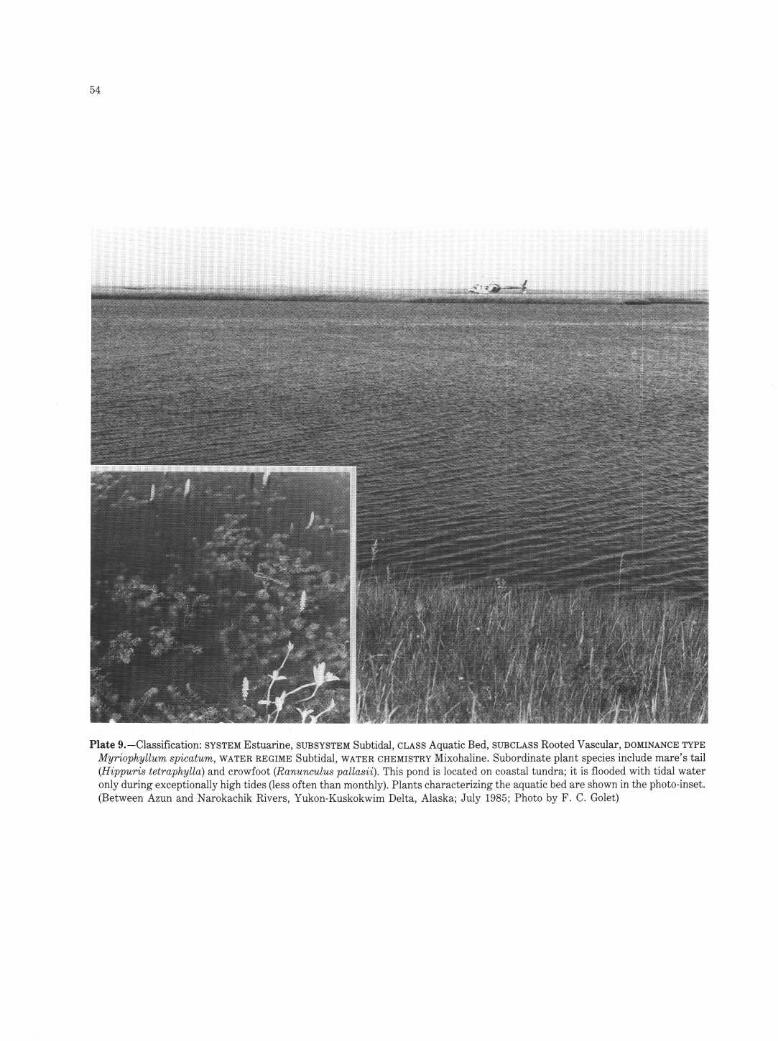
Plate 9.-Classification : SYSTEM Estuarine, SUBSYSTEM Subtidal, CLASS Aquatic Bed, SUBCLASS Rooted Vascular, DOMINANCE TYPEMyriophyllum spicatum, WATER REGIME Subtidal, WATERCHEMISTRY Mixohaline . Subordinate plant species include mare's tail(Hippuris tetraphylla) and crowfoot (Ranunculus pallasii) . This pond is located on coastal tundra ; it is flooded with tidal wateronly during exceptionally high tides (less often than monthly). Plants characterizing the aquatic bed are shown in the photo-inset .(Between Azun and Narokachik Rivers, Yukon-Kuskokwim Delta, Alaska; July 1985 ; Photo by F. C . Golet)

55
Plate 10.-Classification: SYSTEM Estuarine, SUBSYSTEM Intertidal, CLASS Reef, SUBCLASS Mollusk, DOMINANCE TYPE Crassostreavirginica, WATER REGIME Regularly Flooded, WATERCHEMISTRY Mixohaline . An individual red mangrove (Rhizophora mangle)has become established on this oyster reef . (Rookery Bay Sanctuary, Collier County, Florida ; January 1978 ; Photo by E . T. LaRoe)

Plate 11.-Classification : SYSTEM Estuarine, SUBSYSTEM Intertidal, CLASS Streambed, SUBCLASS Mud, WATERREGIME RegularlyFlooded, WATERCHEMISTRY Mixohaline . This photo was taken at low tide ; at high tide, the entire channel is flooded . The channelis flanked by irregularly flooded persistent-emergent wetland supporting such plants as : lyme grass (Elymus arenarius), beachlovage (Ligusticum scothicum), silverweed (Potentilla anserina), sedges (Carex ramenskii, C. bipartita), ovalleaf willow (Salixovalifolia), and Arctic daisy (Dendranthema arcticum) . This site lies 100 mfrom Angyoyaravak Bay, on the Bering Sea. (TutakokeRiver area, Yukon-Kuskokwim Delta, Alaska ; July 1985 ; Photo by F. C. Golet)

57
Plate 12 .-Two habitats lie at the edge of this manmade breakwater . Classification of upper (lighter) zone : SYSTEM Estuarine, SUB-SYSTEM 1ntertidal, CLASS Rocky Shore, SUBCLASS Rubble, WATER REGIME Irregularly Flooded, WATER CHEMISTRY Euhaline,SPECIAL MODIFIER Artificial . Classification of lower (darker) zone : SYSTEM Estuarine, SUBSYSTEM Intertidal, CLASS Aquatic Bed,SUBCLASS Algal, DOMINANCE TYPE Fucus vesiculosus, WATERREGIME Regularly Flooded, WATERCHEMISTRY Euhaline, SPECIALMODIFIER Artificial . (Washington County, Rhode Island ; July 1977 ; Photo by F. C. Golet)

58
Plate 13 .-Classification : SYSTEM Estuarine, SUBSYSTEM Intertidal, CLASS Unconsolidated Shore, SUBCLASS Cobble-Gravel, WATERREGIMES Regularly Flooded (darker zone at edge of water) and Irregularly Flooded (remainder of shore), WATER CHEMISTRYEuhaline . Mean tidal range in this area ofthe Arctic Ocean is approximately 15 cm (6 in) . (Mikkelsen Bay, North Slope Borough,Alaska; July 1985 ; Photo by F. C. Golet)

Plate 14 .-Classification : SYSTEM Estuarine, SUBSYSTEM Intertidal, CLASS Unconsolidated Shore, SUBCLASS Mud, WATER REGIME
Regularly Flooded, WATERCHEMISTRY Mixohaline . Turnagain Arm, a large bay off Cook Inlet, is 4-7 km (2 .5-4 mi) wide at thislocation . Mean tidal range is 9.2 m(30 ft), and the entire area shown here is dewatered at low tide . (Municipality of Anchorage,Alaska; June 1985 ; Photo by F. C. Golet)

60
Plate 15.-Classification: SYSTEM Estuarine, SUBSYSTEM Intertidal, CLASS Unconsolidated Shore, SUBCLASS Mud, WATER REGIMEIrregularly Flooded, WATER CHEMISTRY Mixohaline, SOIL Mineral. Alkali grass (Puccinellia grandis) grows in widely scatteredclumps at the right-hand edge of the photo. Mean tidal range at Fire Island (background left) is 7.4 m (24.4 ft) . The cracks onthese mud flats are evidence of the irregularly flooded tidal regime . (Municipality of Anchorage, Alaska ; June 1985 ; Photo byF. C. Golet)

61
Plate 16.-Classification: SYSTEM Estuarine, SUBSYSTEM Intertidal, CLASS Emergent Wetland, SUBCLASS Persistent, DOMINANCETYPE Spartina alterniflora, WATER REGIME Regularly Flooded, WATER CHEMISTRY Mixohaline, SOIL Mineral. Saltmarsh cord-grass is the only plant growing in the regularly flooded zone of this salt marsh. Saltmeadow cordgrass (Spartina patens), seasidegoldenrod (Solidago sempervirens), and the sedge, Carex paleacea, grow at the landward edge of the marsh. The photo was takenat high tide . (Essex County, Massachusetts ; September 1985 ; Photo by F. C . Golet)

Plate 17.-Classification: SYSTEM Estuarine, SUBSYSTEM Intertidal, CLASS Emergent Wetland, SUBCLASS Persistent, DOMINANCETYPE Spartina foliosa, WATER REGIME Regularly Flooded, WATER CHEMISTRY Mixohaline, SOIL Mineral. The most common sub-ordinate plants are glassworts (Salicornia spp.) . This wetland borders an irregularly flooded emergent wetland dominated byglasswort . The photo was taken at high tide . (San Mateo County, California ; August 1976 ; Photo by V. Carter)

63
Plate 18.-Classification: SYSTEM Estuarine, SUBSYSTEM Intertidal, CLASS Emergent Wetland, SUBCLASS Persistent, DOMINANCETYPE Carex lyngbyei, WATER REGIME Regularly Flooded, WATERCHEMISTRY Mixohaline, SOIL Organic. The photo was taken atlow tide . (Coos County, Oregon ; May 1977 ; Photo by D. D. Peters)

Plate 19.-Classification : SYSTEM Estuarine, SUBSYSTEM Intertidal, CLASS Emergent Wetland, SUBCLASS Persistent, DOMINANCETYPE Triglochin maritimum, WATERREGIME Irregularly Flooded, WATERCHEMISTRY Mixohaline, SOIL Mineral . Subordinate plantsinclude samphire (Salicornia europaea) and seaside plantain (Plantago maritima). This stand is located at the seaward edge ofthe irregularly flooded zone where it is inundated by most, but not all, high tides. Water depth is less than 5 cm (2 in) . Slightlymore elevated stands of Triglochin maritimum contain little or no standing water between periods of inundation . (Municipalityof Anchorage, Alaska; June 1985 ; Photo by F. C. Golet)

Plate 20.-Classification : SYSTEM Estuarine, SUBSYSTEM Intertidal, CLASS Emergent Wetland, SUBCLASS Persistent, DOMINANCETYPE Phragmites australis, WATERREGIME Irregularly Flooded, WATERCHEMISTRY Mixohaline, SOIL Mineral. Saltmeadow cord-grass (Spartina patens) and saltmarsh cordgrass (Spartina alterniflora) are subordinate species. (Washington County, RhodeIsland ; July 1977 ; Photo by F. C. Golet)

66
Plate 21 .-Classification: SYSTEM Estuarine, SUBSYSTEM Intertidal, CLASS Emergent Wetland, SUBCLASS Persistent, DOMINANCETYPE Scirpus americanus, WATER REGIME Regularly Flooded, WATERCHEMISTRY Mixohaline, SOIL Organic. Subordinate speciesinclude saltmeadow cordgrass (Spartina patens) and saltmarsh cordgrass (Spartina alterniflora) ; these appear as a fringe at thewater's edge . (Dorchester County, Maryland ; June 1974 ; Photo by V. Carter)
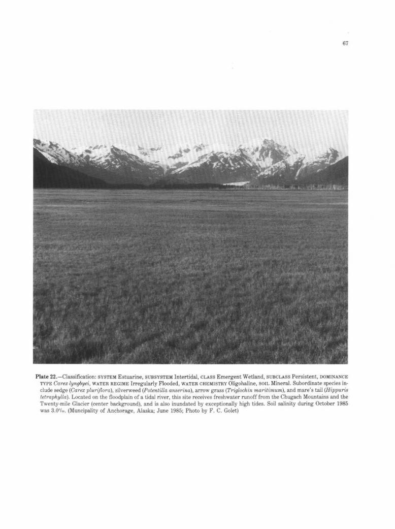
Plate 22.-Classification: SYSTEM Estuarine, SUBSYSTEM Intertidal, CLASS Emergent Wetland, SUBCLASS Persistent, DOMINANCETYPE Carex lyngbyei, WATER REGIME Irregularly Flooded, WATERCHEMISTRY Oligohaline, SOIL Mineral. Subordinate species in-clude sedge (Carex pluriflora), silverweed (Potentilla anserina), arrow grass (Triglochin maritimum), and mare's tail (Hippuristetraphylla). Located on the floodplain of a tidal river, this site receives freshwater runoff from the Chugach Mountains and theTwenty-mile Glacier (center background), and is also inundated by exceptionally high tides . Soil salinity during October 1985was 30loo. (Muncipality of Anchorage, Alaska; June 1985 ; Photo by F. C . Golet)

68
Plate 23 .-Classification : SYSTEM Estuarine, SUBSYSTEM Intertidal, CLASS Emergent Wetland, SUBCLASS Nonpersistent, DOMINANCETYPE H2pp2Gr2S tetraphylla, WATERREGIME Regularly Flooded, WATER CHEMISTRY Mixohaline, SOIL Mineral. This stand of mare'stail lies at the landward limit of the regularly flooded zone, where the substrate is covered with several centimeters of waterat high tide . The Azun River, source of the tidal water, is just visible at the right-hand edge of the photo. (Mouth of Azun River,Yukon-Kuskokwim Delta, Alaska; July 1985 ; Photo by F. C. Golet)

Plate 24.-Classification : SYSTEM Estuarine, SUBSYSTEM Intertidal, CLASS Scrub-Shrub Wetland, SUBCLASS Broad-leaved Deciduous,DOMINANCE TYPE Ivafru.tescens, WATER REGIME Irregularly Flooded, WATERCHEMISTRY Mixohaline, SOIL Mineral. Subordinateplants growing beneath the marsh elder are black grass (Juncos gerardii), salt grass (Distichlis spicata), and saltmeadow cord-grass (Spartina patens) . This wetland lies toward the landward edge of an irregularly flooded persistent-emergent wetland dominatedby saltmarsh cordgrass (Spartina alterniflora), saltmeadow cordgrass, and salt grass (background) . (Washington County, RhodeIsland ; July 1977 ; Photo by F. C. Golet)

Plate 25 .-Classification : SYSTEM Estuarine, SUBSYSTEM Intertidal, CLASS Scrub-Shrub Wetland, SUBCLASS Broad-leaved Evergreen,DOMINANCE TYPE Rhizophora mangle, WATER REGIMES Regularly Flooded (along waterways) and Irregularly Flooded (at somedistance from waterways), WATER CHEMISTRY Oligohaline, SOIL Organic. This mangrove swamp is located in the southern partof the Florida Everglades . (Dade County, Florida ; December 1975 ; Photo by V. Carter)

Plate 26.-Classification : SYSTEM Riverine, SUBSYSTEM Tidal, CLASS Aquatic Bed, SUBCLASS Rooted Vascular, DOMINANCE TYPE
Myriophyllum spicatumHydrilla verticillata-Heteranthera dubia, WATERREGIME Permanently Flooded-Tidal, WATERCHEMISTRY
Fresh-Circumneutral . (Prince Georges County, Maryland ; October 1985 ; Photo by V. Carter)

72
Plate 27.-Two habitats are shown here . Classification of nonvegetated zone : SYSTEM Riverine, SUBSYSTEM Tidal, CLASS Uncon-solidated Shore, SUBCLASS Mud, WATER REGIME Regularly Flooded, WATER CHEMISTRY Fresh-Circumneutral . Classification ofvegetated zone : SYSTEM Riverine, SUBSYSTEM Tidal, CLASS Emergent Wetland, SUBCLASS Nonpersistent, DOMINANCE TYPEPeltandra virginica, WATER REGIME Regularly Flooded, WATERCHEMISTRY Fresh-Circumneutral, SOIL Mineral. The photo wastaken at low tide . (Cecil County, Maryland ; July 1972 ; Photo by V. Carter)

73
Plate 28.-Classification: SYSTEM Riverine, SUBSYSTEMLower Perennial, CLASS Unconsolidated Bottom, SUBCLASS Cobble-Gravel,WATER REGIME Permanently Flooded, WATER CHEMISTRY Fresh. The channel bottom is composed primarily of gravel and sand .The stream meanders through a grassy annual floodplain which is flanked by a more elevated floodplain supporting cottonwoods(Populus deltoides) . (Crook County, Wyoming; May 1985 ; Photo by F. C. Golet)

Plate 29.-Classification : SYSTEM Riverine, SUBSYSTEM Lower Perennial, CLASS Unconsolidated Bottom, SUBCLASS Sand, WATERREGIME Permanently Flooded, WATER CHEMISTRY Fresh. Channel meanders, a typical feature of lower perennial streams, areespecially well developed along this section of the Yellowstone River. (Yellowstone National Park, Park County, Wyoming; May1985 ; Photo by F. C. Golet)

75
Plate 30.-Classification : SYSTEM Riverine, SUBSYSTEM Lower Perennial, CLASS Aquatic Bed, SUBCLASS Rooted Vascular, DOMINANCETYPE Nymphaea odorata, WATER REGIME Permanently Flooded, WATER CHEMISTRY Fresh-Circumneutral, SPECIAL MODIFIER
Excavated. This channel was dug by man in an unsuccessful attempt to drain the wetland. Plants in the Palustrine wetland borderingthe channel include sedge (Carex lasiocarpa), sweet gale (Myrica gale), leatherleaf(Chamaedaphne calyculata), and Atlantic whitecedar (Chamaecyparis thyoides) . (Washington County, Rhode Island ; July 1977 ; Photo by F. C. Golet)
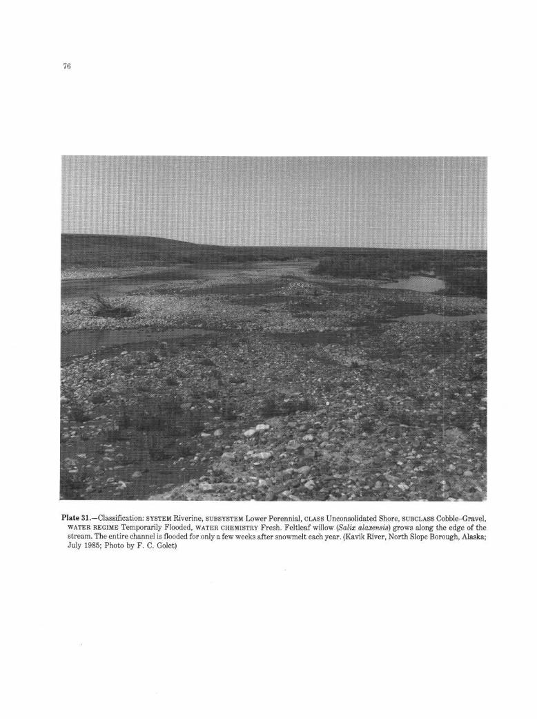
Plate 31.-Classification : SYSTEM Riverine, SUBSYSTEM Lower Perennial, CLASS Unconsolidated Shore, SUBCLASS Cobble-Gravel,WATER REGIME Temporarily Flooded, WATER CHEMISTRY Fresh. Feltleaf willow (Salix alaxensis) grows along the edge of thestream . The entire channel is flooded for only a few weeks after snowmelt each year . (Kavik River, North Slope Borough, Alaska;July 1985 ; Photo by F. C. Golet)

77
z
Plate 32.-Classification : SYSTEM Riverine, SUBSYSTEM Lower Perennial, CLASS Unconsolidated Shore, SUBCLASS Sand, WATERREGIME Seasonally Flooded, WATER CHEMISTRY Mixosaline, SOIL Mineral. Young tamarisk (Tamarix gallica) plants are scatteredover this sand flat . (Socorro County, New Mexico ; April 1978 ; Photo by P. B. Reed)

78
Plate 33.-Classification : SYSTEM Riverine, SUBSYSTEM Lower Perennial, CLASS Emergent Wetland, SUBCLASS Nonpersistent,DOMINANCE TYPE Peltandra virginica-Pontederia cordata, WATERREGIME Semipermanently Flooded, WATER CHEMISTRY Fresh-Circumneutral, SOIL Mineral . This wetland lies in a bay ofthe Chicopee River. (Hampden County, Massachusetts ; July 1970 ; Photoby R. C. Smardon)

79
Plate 34.-Two habitats are shown here . Classification of channel: SYSTEM Riverine, SUBSYSTEM Upper Perennial, CLASS RockBottom, SUBCLASS Bedrock, WATER REGIME Permanently Flooded, WATER CHEMISTRY Fresh. Classification of shore: SYSTEMRiverine, SUBSYSTEM Upper Perennial, CLASS Rocky Shore, SUBCLASS Bedrock, WATER REGIME Seasonally Flooded, WATER
CHEMISTRY Fresh. (Penobscot County, Maine; October 1977 ; Photo by R. W. Tiner)

80
Plate 35.-Classification : SYSTEM Riverine, SUBSYSTEM Upper Perennial, CLASS Rock Bottom, SUBCLASS Rubble, WATERREGIMEPermanently Flooded, WATER CHEMISTRY Fresh. Many of the boulders in this river exceed 1 m (3 .3 ft) in diameter. (Matanuska-Susitna Borough, Alaska ; June 1985 ; Photo by F. C. Golet)

81
Plate 36.-Classification : SYSTEM Riverine, SUBSYSTEM Upper Perennial, CLASS Unconsolidated Bottom, SUBCLASS Cobble-Gravel,WATER REGIME Permanently Flooded, WATERCHEMISTRY Fresh-Circumneutral . (Washington County, Rhode Island ; July 1977;Photo by F. C. Golet)

82
Plate 37.-Classification : SYSTEM Riverine, SUBSYSTEM Upper Perennial, CLASS Unconsolidated Shore, SUBCLASS Cobble-Gravel,WATERREGIME Temporarily Flooded, WATERCHEMISTRY Fresh. This high-gradient mountain stream arises in the Alaska Range.The gravel piled at the left-hand edge of the photo had accumulated in the channel during flood stage and was bulldozed to itspresent position to prevent flooding of a highway just downstream . (Fairbanks North Star Borough, Alaska ; July 1985 ; Photoby F. C. Golet)

Plate 38.-Classification : SYSTEM Riverine, SUBSYSTEM Intermittent, CLASS Streambed, SUBCLASS Sand, WATER REGIME Inter-mittently Flooded, WATER CHEMISTRY Mixosaline . The average annual discharge for this river, the Rio Salado, is 14.6 hm3/yr(11,880 acre-ft/yr) . (Socorro County, New Mexico ; April 1978 ; Photo by P. B. Reed)
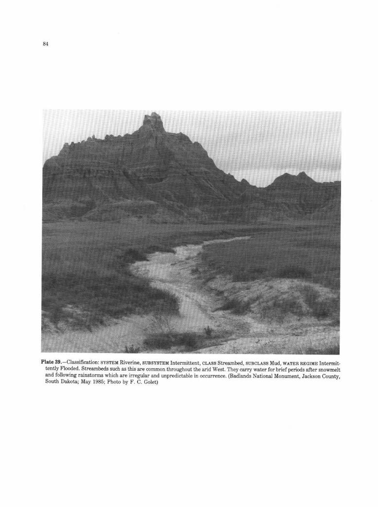
Plate 39.-Classification: SYSTEM Riverine, SUBSYSTEM Intermittent, CLASS Streambed, SUBCLASS Mud, WATERREGIME Intermit-tently Flooded. Streambeds such as this are common throughout the arid West. They carry water for briefperiods after snowmeltand following rainstorms which are irregular and unpredictable in occurrence . (Badlands National Monument, Jackson County,South Dakota ; May 1985; Photo by F. C. Golet)

Plate 40.-Classification : SYSTEM Lacustrine, SUBSYSTEM Limnetic, CLASS Unconsolidated Bottom, SUBCLASS Mud, WATERREGIME
Permanently Flooded, WATER CHEMISTRY Fresh. In the narrow Littoral zone of Yellowstone Lake, where water is less than 2
m (6 .6 ft) deep, the bottom consists primarily of gravel and sand . (Yellowstone National Park, Teton County, Wyoming; May1985 ; Photo by F. C. Golet)

86
Plate 41 .-Classification : SYSTEM Lacustrine, SUBSYSTEM Limnetic, CLASS Aquatic Bed, SUBCLASS Rooted Vascular, DOMINANCETYPE Nymphaea odorata, WATER REGIME Permanently Flooded, WATER CHEMISTRY Fresh-Circumneutral . Subordinate plantsin the Aquatic Bed include bladderworts (Utricularia spp .). Yellow-eyed grass (Xyris smalliana) grows on floating mats of peatalong the shore (foreground) . Water depth in this 0.8-ha (2-acre) bog lake exceeds 3 m(10 ft) . (Washington County, Rhode Island ;July 1977; Photo by F. C. Golet)

Plate 42 .-Classification : SYSTEM Lacustrine, SUBSYSTEM Littoral, CLASS Unconsolidated Shore, SUBCLASS Cobble-Gravel, WATERREGIME Seasonally Flooded, WATER CHEMISTRY Fresh. At the time of photography, the level of Yellowstone Lake was near itsseasonal low point . Due to snowmelt, the level of the lake rises to a peak in early July and then slowly declines until the followingspring . This entire beach is inundated each summer . (Yellowstone National Park, Teton County, Wyoming; May 1985 ; Photoby F. C. Golet)

Plate 43.-Classification : SYSTEM Lacustrine, SUBSYSTEM Littoral, CLASS Unconsolidated Shore, SUBCLASS Sand, WATERREGIMEIntermittently Flooded, WATERCHEMISTRY Fresh. Water levels in the Great Lakes generally fluctuate little during a single year,but they may rise and fall considerably over a period of several years. The water level in Lake Michigan was at an all-time highwhen this photo was taken. As a result of long-term changes in lake levels and seiches produced by storms, lake waters inundatepart or all of this beach on an irregular basis . (Indiana Dunes National Lakeshore, Porter County, Indiana; May 1985 ; Photoby F. C. Golet)

89
Plate 44.-Classification : SYSTEM Lacustrine, SUBSYSTEM Littoral, CLASS Uncoi:solidated Shore, SUBCLASS Mud, WATERREGIMESTemporarily Flooded and Seasonally Flooded, WATER CHEMISTRY Fresh, SOIL Mineral, SPECIAL MODIFIER Impounded. The flatsexposed along the shore of this reservoir are temporarily flooded ; the seasonally flooded zone is still inundated at the time ofthis spring photograph . (Park County, Wyoming; May 1985 ; Photo by F. C. Golet)

Plate 45 .-Classification : SYSTEM Lacustrine, SUBSYSTEM Littoral, CLASS Unconsolidated Shore, SUBCLASS Mud, WATER REGIMESeasonally Flooded, WATER CHEMISTRY Hypersaline . (Salt Lake County, Utah ; June 1973 ; Photo by V. Carter)

Plate 46.-Two habitats are shown here . Classification of exposed areas: SYSTEM Lacustrine, SUBSYSTEM Littoral, CLASS Uncon-solidated Shore, SUBCLASS Mud, WATERREGIMES Intermittently Flooded (light-colored soil) and Seasonally Flooded (darker soilalong water's edge), WATER CHEMISTRY Mixosaline, SOIL Mineral. Classification of inundated areas: SYSTEM Lacustrine, SUB-
SYSTEM Littoral, CLASS Unconsolidated Bottom, SUBCLASS Mud, WATER REGIME Semipermanently Flooded, WATERCHEMISTRYMixosaline, SOIL Mineral. Greasewood (Sarcobatus vermiculatus), salt grass (Distichlis spicata), and rushes (Juncos spp.) are scatteredacross the flats . Because annual precipitation averages only about 18 cm (7 in) here, these wetlands are heavily dependent uponsnowpack in the surrounding mountains as a source of water. (Saguache County, Colorado ; Photo by R. M. Hopper)

Plate 47.-Classification : SYSTEM Lacustrine, SUBSYSTEM Littoral, CLASS Unconsolidated Shore, SUBCLASS Organic, WATER REGIMESeasonally Flooded, WATER CHEMISTRY Fresh. This beach is only 15 m (50 ft) long and 2 m (6-7 ft) wide . Such organic shoresare common in certain areas of the Yukon-Kuskokwim Delta, and many are considerably larger than the one shown here . Evidenceof the decline in lake levels over the summer can be seen in the series of low ridges in the peat. Surrounding vegetation includessedge (Carex lyngbyei), bluejoint (Calamagrostis canadensis), and willows (Salix spp .) . (Talik River area, Yukon-Kuskokwim Delta,Alaska; July 1985 ; Photo by F. C. Golet)

Plate 48.-Classification : SYSTEM Lacustrine, SUBSYSTEM Littoral, CLASS Emergent Wetland, SUBCLASS Nonpersistent, DOMINANCETYPE Nelumbo lutea, WATER REGIME Permanently Flooded, WATER CHEMISTRY Fresh-Circumneutrai, SOIL Mineral, SPECIALMODIFIER Impounded. Subordinate plants are duckweeds (Lemna spp .) and bald c;gpress (Taxodium distichum) . (Obion County,Tennessee; September 1975 ; Photo by V. Carter)

94
Plate 49 .-Classification: SYSTEM Lacustrine, SUBSYSTEM Littoral, CLASS Emergent Wetland, SUBCLASS Nonpersistent, DOMINANCETYPE Juncus militaris, WATER REGIME Semipermanently Flooded, WATER CHEMISTRY Fresh-Circumneutral, SOIL Mineral. Subor-dinate plants include common threesquare (Scirpus americanus) and pickerelweed (Pontederia cordata) . During the spring, emergentvegetation is not evident at this site, and waves break on the gravel shore visible in the foreground. (Washington County, RhodeIsland ; July 1977 ; Photo by F. C. Golet)

95
Plate 50.-Classification : SYSTEM Palustrine, CLASS Unconsolidated Bottom, SUBCLASS Sand, WATERREGIME Intermittently Ex-posed, WATERCHEMISTRY Fresh-Alkaline . Rushes (Juncos spp.), spike rush (Eleocharis sp .), and smartweed (Polygonum sp .) growin shallow water along the shore of this 0.4-ha (1-acre) pond which occupies a depression amidst sand dunes on the southern shoreof Lake Michigan . (Indiana Dunes National Lakeshore, Porter County, Indiana; May 1985 ; Photo by F. C . Golet)

96
Plate 51 .-Classification : SYSTEM Palustrine, CLASS Unconsolidated Bottom, SUBCLASS Mud, WATERREGIME Permanently Flooded,WATER CHEMISTRY Fresh-Circumneutral, SPECIAL MODIFIER Impounded. This beaver pond is situated in the San Juan Moun-tains. (Gunnison County, Colorado ; Photo by R. M. Hopper)

97
Plate 52.-Classification: SYSTEM Palustrine, CLASS Unconsolidated Bottom, SUBCLASS Mud, WATER REGIME SemipermanentlyFlooded, WATER CHEMISTRY Mesosaline, SOIL Mineral. This photo was taken during drouth conditions ; the bottom is being in-vaded by pioneer species including summer cypress (Kochia scoparia), golden dock (Rumex maritimus), andgoosefoot (Chenopodiumglaucum) . (Stutsman County, North Dakota ; August 1961 ; Photo by R . E. Stewart)

98
Plate 53.-Classification : SYSTEM Palustrine, CLASS Unconsolidated Bottom, SUBCLASS Mud, WATER REGIME SemipermanentlyFlooded, WATERCHEMISTRY Fresh-Alkaline, SOIL Mineral, SPECIAL MODIFIER Impounded. Asparse stand of water plantain (Alismaplantago-aquatica) appears along the edge of the impoundment . (Billings County, North Dakota; July 1970 ; Photo by J. T. Lokemoen)

Plate 54.-Classification : SYSTEM Palustrine, CLASS Aquatic Bed, SUBCLASS Rooted Vascular, DOMINANCE TYPE Ranunculustrichophyllus, WATER REGIME Semipermanently Flooded, WATERCHEMISTRY Oligosaline, SOIL Mineral. (Stutsman County, NorthDakota ; August 1966 ; Photo by R. E . Stewart)

10 0
Plate 55.-Classification: SYSTEM Palustrine, CLASS Moss-Lichen Wetland, SUBCLASS MOSS, WATER REGIME Saturated, WATERCHEMISTRY Fresh-Acid, SOIL Organic. The dominant plant is peat moss (Sphagnum spp .). Subordinate plants include reindeermoss (Cladina spp .), leatherleaf(Chamaedaphne calyculata), crowberry (Empetrum nigrum), and cottongrass (Eriophorum spp .) .(Campobello Island International Park, Maine-Canada ; June 1976 ; Photo by V. Carter)

Plate 56.-Classification: SYSTEM Palustrine, CLASS Moss-Lichen Wetland, SUBCLASS Moss, WATER REGIME Saturated, WATERCHEMISTRY Fresh. Peat moss (Sphagnum spp .) is the dominant plant. Subordinate plants include sedges (Carex rariflora, C. aquatilis),cottongrass (Eriophorum russeolum), and reindeer moss (Cladina spp .) . While sedges are present, their combined cover is lessthan 30%. Mosses cover 100% of the area . (Narokachik-Azun Rivers area, Yukon-Kuskokwim Delta, Alaska ; July 1985 ; Photoby F. C . Golet)

Plate 57.-Classification : SYSTEM Palustrine, CLASS Emergent Wetland, SUBCLASS Persistent, DOMINANCE TYPE Typha latifolia,WATER REGIME Permanently Flooded, WATER CHEMISTRY Fresh, SPECIAL MODIFIER Impounded. Persistent emergents such asthese cattails remain standing at least until the beginning of the next growing season . Note that the adjacent lake is ice-coveredat the time of photography . (Knox County, Maine; April 1978 ; Photo by P. B . Reed)

Plate 58 .-Classification : SYSTEM Palustrine, CLASS Emergent Wetland, SUBCLASS Persistent, DOMINANCE TYPE Scirpus robustus-Scirpus acutus, WATER REGIME Semipermanently Flooded, WATER CHEMISTRY Mixosaline, SOIL Mineral . (Stutsman County, NorthDakota; August 1962 ; Photo by R. E . Stewart)

Plate 59.-Classification: SYSTEM Palustrine, CLASS Emergent Wetland, SUBCLASS Persistent, DOMINANCE TYPE Cladium jamaicense,WATER REGIME Semipermanently Flooded, WATER CHEMISTRY Fresh-Circumneutral, SOIL Organic. This photo was taken in theFlorida Everglades . (Dade County, Florida; December 1975 ; Photo by V. Carter)

105
Plate 60.-Classification: SYSTEM Palustrine, CLASS Emergent Wetland, SUBCLASS Persistent, DOMINANCE TYPE Carex lasiocar-pa, WATERREGIME Seasonally Flooded, WATER CHEMISTRY Fresh-Circumneutral, SOIL Organic. Subordinate plants include sedges(Carex lacustris, C. rostrata), water smartweed (Polygonum amphibium), bladderwort (Utricularia macrorhiza), bluejoint(Calamagrostis canadensis), and pondweed (Potamogeton gramineus) . (Chippewa National Forest, Beltrami County, Minnesota;June 1972 ; Photo by J. H. Richmann)

Plate 61.-Classification : SYSTEM Palustrine, CLASS Emergent Wetland, SUBCLASS Persistent, DOMINANCE TYPE Eleocharis palustris,WATER REGIME Seasonally Flooded, WATER CHEMISTRY Polysaline, SOIL Mineral. Subordinate plants include water smartweed ,(Polygonum amphibium), slough sedge (Carex atherodes), andfoxtail (Alopecurus aequalis) . (Stutsman County, North Dakota ;August 1962 ; Photo by R. E. Stewart)

Plate 62.-Classification : SYSTEM Palustrine, CLASS Emergent Wetland, SUBCLASS Persistent, WATERREGIME Seasonally Flooded,WATERCHEMISTRY Mixosaline, SOIL Mineral. The principal plants are sedges (Carex spp.), bulrushes (Scirpus spp .), rushes (Jun-cus spp.), and foxtail (Alopecurus aequalis) . This wetland is typical of irrigated hay in the West . Water may be diverted from
rivers or may come from artesian wells as in this photo. (Saguache County, Colorado ; Photo by R. M. Hopper)

Plate 63.-Classification : SYSTEM Palustrine, CLASS Emergent Wetland, SUBCLASS Persistent, DOMINANCE TYPE Carex rarifora-Eriophorum russeolum, WATERREGIME Seasonally Flooded, WATERCHEMISTRY Fresh. Subordinate plants include marsh cinque-foil (Potentilla palustris), bluejoint (Calamagrostis canadensis), Alaska bog willow (Salixfuscescens), crowberry (Empetrum nigrum),dwarf birch (Betula nana), and peat moss (Sphagnum sp .) . This type of patterned wetland is commonly referred to as "stringbog" or "strangmoor." Seasonally flooded troughs alternate with elongated bog-like ridges or "strings ." Strings here rise only30-45 cm (12-18 in) above the troughs. (Manokinak River area, Yukon-Kuskokwim Delta, Alaska ; July 1985 ; Photo by F. C. Golet)

Plate 64.-Classification : SYSTEM Palustrine, CLASS Emergent Wetland, SUBCLASS Persistent, DOMINANCE TYPE Colocasia esculenta,
WATER REGIME Seasonally Flooded, WATER CHEMISTRY Fresh, SOIL Mineral, SPECIAL MODIFIER Farmed. This photograph il-lustrates a Hawaiian taro field . (Kauai County, Hawaii ; September 1972 ; Photo by E. Krider)
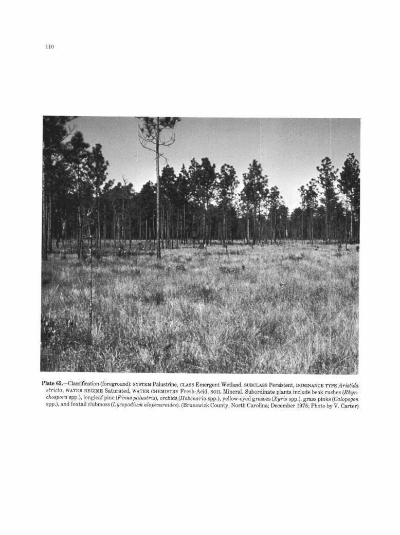
Plate 65 .-Classification (foreground) : SYSTEM Palustrine, CLASS Emergent Wetland, SUBCLASS Persistent, DOMINANCE TYPE Aristidastricta, WATER REGIME Saturated, WATERCHEMISTRY Fresh-Acid, SOIL Mineral. Subordinate plants include beak rushes (Rhyn-chospora spp.), longleaf pine (Pines palustris), orchids (Habenaria spp .), yellow-eyed grasses (Xyris spp.), grass pinks (Calopogonspp.), and foxtail clubmoss (Lycopodium alopecuroides) . (Brunswick County, North Carolina ; December 1975 ; Photo by V. Carter)

Plate 66.-Classification: SYSTEM Palustrine, CLASS Emergent Wetland, SUBCLASS Persistent, WATER REGIME Saturated, WATERCHEMISTRY Fresh. The dominant plants in this montane meadow are sedges (Carex spp.) . (Lassen County, California; August1975 ; Photo by V. Carter)

Plate 67.-Classification : SYSTEM Palustrine, CLASS Emergent Wetland, SUBCLASS Persistent, DOMINANCE TYPE Eriophorumvaginatum, WATER REGIME Saturated, WATER CHEMISTRY Fresh, SOIL Mineral. Subordinate plants include: netleaf willow (Salixreticulate), diamondleaf willow (S. planifolia), dryas (Dryas integrifolia), bistort ( Polygonum bistorta), lousewort (Pedicularissp.), chickweed (Stellaria sp .), and lapland cassiope (Cassiope tetragona) . This type of wetland, referred to by Walker (1983) as"moist tussock sedge dwarf shrub tundra," covers much of the North Slope of Alaska . At this site, permafrost lies within 15cm (6 in) ofthe surface. All of the land in this photo is wetland. (Franklin Bluffs, North Slope Borough, Alaska ; July 1985 ; Photoby F. C. Golet)

Plate 68.-Classification : SYSTEM Palustrine, CLASS Emergent Wetland, SUBCLASS Persistent, DOMINANCE TYPE Carex aquatilis,WATER REGIME Saturated, WATERCHEMISTRY Fresh. Subordinate plants include : narrowleaf Labrador tea (Ledum decumbens),dwarf birch (Betula nana), small cranberry (Vaccinium oxycoccos), crawberry (Empetrum nigrum), peat moss (Sphagnum spp .),and foliose lichens. (Narokachik River area, Yukon-Kuskokwim Delta, Alaska; July 1985 ; Photo by F. C . Golet)

Plate 69 .-Classification: SYSTEM Palustrine, CLASS Emergent Wetland, SUBCLASS Persistent, WATER REGIME Temporarily Flooded,WATERCHEMISTRY Oligosaline, SOIL Mineral, SPECIAL MODIFIER Farmed . All natural vegetation in this wetland has been removed,and water stands in stubble from the previous year's wheat crop . (Stutsman County, North Dakota; March 1967; Photo by H. A.Kantrud)

Plate 70 .-Classification : SYSTEM Palustrine, CLASS Emergent Wetland, SUBCLASS Persistent, WATERREGIME Temporarily Flooded,WATERCHEMISTRY Fresh, SOIL Mineral, SPECIAL MODIFIER Farmed . Principal plants include nut sedge (Cyperus sp .), arrow arum(Peltandra virginica), and barnyard grass (Echinochloa crusgalli) . (Dade County, Florida; January 1978 ; Photo by P. B. Reed)

Plate 71.-Two habitats are shown here . Classification of darker zone (edge of water body): SYSTEM Palustrine, CLASS EmergentWetland, SUBCLASS Nonpersistent, DOMINANCE TYPE Arctophila fulva, WATERREGIME Permanently Flooded, WATERCHEMISTRYFresh. Classification of lighter zone (foreground): SYSTEM Palustrine, CLASS Emergent Wetland, SUBCLASS Persistent, DOMINANCETYPE Carex aquatilis, WATER REGIME Seasonally Flooded, WATER CHEMISTRY Fresh. Marsh marigold (Caltha palustris) is alsopresent in the seasonally flooded zone . This wetland lies on coastal tundra within 2 km (1 .2 mi) of the Arctic Ocean. (BetweenCanning and Kavik Rivers, North Slope Borough, Alaska ; July 1985 ; Photo by F. C. Golet)

Plate 72.-Classification : SYSTEM Palustrine, CLASS Emergent Wetland, SUBCLASS Nonpersistent, DOMINANCE TYPE Hippuristetraphylla, WATER REGIME Permanently Flooded, WATER CHEMISTRY Fresh. A semipermanently flooded persistent-emergentwetland dominated by sedge (Carex lyngbyei) surrounds the Hippuris marsh. Burreed (Sparganium hyperboreum) grows in shallowwater between the Hippuris and the sedges . (Narokachik River area, Yukon-Kuskokwim Delta, Alaska; July 1985 ; Photo byF. C . Golet)

Plate 73 .-Classification : SYSTEM Palustrine, CLASS Emergent Wetland, SUBCLASS Nonpersistent, DOMINANCE TYPE Nuphar luteum,WATER REGIME Semipermanently Flooded, WATERCHEMISTRY Fresh. The principal subordinate plant is common duckweed (Lemnaminor) . (Cass County, Michigan; May 1985 ; Photo by F. C. Golet)

Plate 74.-Classification : SYSTEM Palustrine, CLASS Scrub-Shrub Wetland, SUBCLASS Broad-leaved Deciduous, WATER REGIME
Seasonally Flooded, WATER CHEMISTRY Fresh-Acid, SOIL Organic . The dominant plants are willows (Salix spp.) . Subordinatespecies include Sitka spruce (Picea sitchensis) and lodgepole pine (Pines contorta) . (Coos County, Oregon ; May 1977 ; Photo byD. D . Peters)

Plate 75.-Classificaton: SYSTEM Palustrine, CLASS Scrub-Shrub Wetland, SUBCLASS Broad-leaved Deciduous, DOMINANCE TYPEBetula nana, WATER REGIME Saturated, WATER CHEMISTRY Fresh, SOIL Mineral. Subordinate plants include cotton grass(Eriophorum vaginatum), peat moss (Sphagnum spp .), cloudberry (Rebus chamaemorus), mountain cranberry (Vaccinium vitis-idaea), and narrowleaf Labrador tea (Ledum decumbens) . Shrubs here are less than 20 cm (8 in) tall . This area of moist tundrais underlain by permafrost at a depth of 45 cm (18 in). (Vicinity of Toolik Lake, North Slope Borough, Alaska ; July 1985 ; Photoby F. C. Golet)

Plate 76.-Classification : SYSTEM Palustrine, CLASS Scrub-Shrub Wetland, SUBCLASS Broad-leaved Deciduous, DOMINANCE TYPEAlnus tenuifolia, WATERREGIME Temporarily Flooded, WATER CHEMISTRY Fresh, SOIL Mineral. Subordinate plants include feltleafwillow (Salix alaxensis) and balsam poplar (Populus balsamifera) . Shrubs are nearly 6 m (20 ft) tall, the height that separatesScrub-Shrub from Forested Wetland. This site is flooded only for brief periods after snowmelt and during times of most rapidmelting of nearby glaciers . (Tanana River, Fairbanks North Star Borough, Alaska ; July 1985 ; Photo by F. C. Golet)

12 2
Plate 77.-Classification : SYSTEM Palustrine, CLASS Scrub-Shrub Wetland, SUBCLASS Needle-leaved Deciduous, DOMINANCE TYPELarix laricina, WATER REGIME Seasonally Flooded, WATER CHEMISTRY Fresh. The tamarack saplings are 2-3 m (6 .6-10 ft) talland cover 40-45% of the site . Subordinate plants include : dwarf birch (Betula nana), bluejoint (Calamagrostis canadensis), blackspruce (Picea mariana), leatherleaf (Chamaedaphne calyculata), diamondleaf willow (Salix planifolia), narrowleaf Labrador tea(Ledum decumbens), cotton grass (Eriophorum sp .), bog blueberry (Vaccinium uliginosum), marsh cinquefoil (Potentilla palustris),and shrubby cinquefoil (P. fruticosa) . (Vicinity of Big Delta, Alaska ; July 1985 ; Photo by F. C . Golet)

Plate 78 .-Classification : SYSTEM Palustrine, CLASSScrub-Shrub Wetland, SUBCLASS Broad-leaved Evergreen, DOMINANCE TYPE
Ledum groenlandicum-Kalmia angustifolia-Chamaedaphne calyculata, WATER REGIME Saturated, WATER CHEMISTRY Fresh-Acid, SOIL Organic. Subordinate plants include peat moss (Sphagnum spp.), crowberry (Empetrum nigrum), cloudberry (Rubeschamaemorus), and black spruce (Picea mariana) . (Washington County, Maine; June 1976 ; Photo by V. Carter)

124
Plate 79 .-Classification : SYSTEM Palustrine, CLASS Scrub-Shrub Wetland, SUBCLASS Broad-leaved Evergreen, DOMINANCE TYPELedum decumbens, WATERREGIME Saturated, WATERCHEMISTRY Fresh, SOIL Mineral. Subordinate species include : cloudberry(Rubes chamaemorus), mountain cranberry (Vaccinium vitis-idaea), craneberry (Empetrum nigrum), dwarf birch (Betula nana),reindeer moss (Cladina spp.), sedge (Carex aquatilis), bluejoint(Calamagrostis canadensis), and Alaska spiraea (Spiraea beauver-diana) . Shrubs are less than 20 cm (8 in) tall . Although this site looks like a dry heath, permafrost at a depth of only 15-20 cm(6-8 in) keeps the soil saturated near the surface throughout the growing season. (Talik River area, Yukon-Kuskokwim Delta,Alaska ; July 1985 ; Photo by F. C . Golet)

Plate 80.-Classification : SYSTEM Palustrine, CLASS Scrub-Shrub Wetland, SUBCLASS Broad-leaved Evergreen, DOMINANCE TYPE
Cyrilla racemiflora, WATERREGIME Saturated, WATERCHEMISTRY Fresh-Acid, SOIL Organic. Subordinate plants include : honeycup(Zenobia pulverulenta), leatherleaf (Chamaedaphne calyculata), peat moss (Sphagnum spp .), highbush blueberry (Vaccinium corym-bosum), loblolly bay (Gordonia lasianthus), pondpine (Pines serotina), and highbush blueberry (Vaccinium corymbosum). Locally,these wetlands are referred to as evergreen shrub bogs or "pocosins." (Brunswick County, North Carolina; December 1975 ; Photoby V. Carter)

12 6
Plate 81 .-Classification: SYSTEM Palustrine, CLASS Scrub-Shrub Wetland, SUBCLASS Needle-leaved Evergreen, DOMINANCE TYPEPicea mariana, WATER REGIME Saturated, WATER CHEMISTRY Fresh. Subordinate plants include : dwarf birch (Betula nana), cottongrass (Eriophorum vaginatum), bog blueberry (Vaccinium uliginosum), Labrador tea (Ledum groenlandicum), and peat moss(Sphagnum spp.) . This wetland type, commonly known as "muskeg," is abundant in the forested regions of Alaska ; it also occursin northern New England and in the Great Lakes States . (Vicinity of Coldfoot, Alaska ; July 1985 ; Photo by F. C. Golet)

127
Plate 82.-Classification: SYSTEM Palustrine, CLASS Forested Wetland, SUBCLASS Broad-leaved Deciduous, DOMINANCE TYPE Acerrubrum, WATER REGIME Saturated, WATER CHEMISTRY Fresh-Acid, SOIL Organic. Subordinate plants in this red maple swampinclude black gum (Nyssa sylvatica), highbush blueberry (Vaccinium corymbosum), great laurel (Rhododendron maximum), andwinterberry (Ilex verticillata) . (Washington County, Rhode Island ; June 1977 ; Photo by F. C. Golet)

128
Plate 83.-Two habitats are shown here . Classification ofthe forested area : SYSTEM Palustrine, CLASS Forested Wetland, SUBCLASSNeedle-leaved Deciduous, DOMINANCE TYPE Taxodium distichum, WATERREGIME Permanently Flooded, WATER CHEMISTRY Fresh.Classification of the open area : SYSTEM Palustrine, CLASS Aquatic Bed, SUBCLASS Floating Vascular, DOMINANCE TYPE Pistiastratiotes, WATERREGIME Permanently Flooded, WATERCHEMISTRY Fresh. Emergent plants growing in the bed of water lettuceare arrowheads (Sagittaria spp.) . (Corkscrew Swamp Sanctuary, Collier County, Florida ; January 1978 ; Photo by E . T. LaRoe)
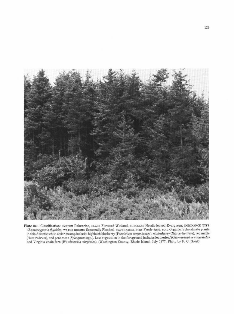
12 9
Plate 84.-Classification : SYSTEM Palustrine, CLASS Forested Wetland, SUBCLASS Needle-leaved Evergreen, DOMINANCE TYPEChamaecyparis thyoides, WATER REGIME Seasonally Flooded, WATERCHEMISTRY Fresh-Acid, SOIL Organic. Subordinate plantsin this Atlantic white cedar swamp include : highbush blueberry (Vaccinium corymbosum), winterberry (Ilex verticillata), red maple(Acer rubrum), and peat moss (Sphagnum spp .) . Low vegetation in the foreground includes leatherleaf (Chamaedaphne calyculata)and Virginia chain-fern (Woodwardia virginica) . (Washington County, Rhode Island ; July 1977 ; Photo by F. C. Golet)

Plate 85 .-Classification : SYSTEM Palustrine, CLASS Forested Wetland, SUBCLASS Needle-leaved Evergreen, DOMINANCE TYPE Piceamariana, WATER REGIME Saturated, WATER CHEMISTRY Fresh, SOIL Mineral. Subordinate plants in this black spruce forest in-clude Labrador tea (Ledum groenlandicum), mountain cranberry (Vaccinium vitis-idaea), crawberry (Empetrum nigrum), andpeat moss (Sphagnum sp .). Permafrost is present within 45 cm (18 in) of the surface . (Vicinity of Glennallen, Alaska ; July 1985 ;Photo by F. C. Golet)
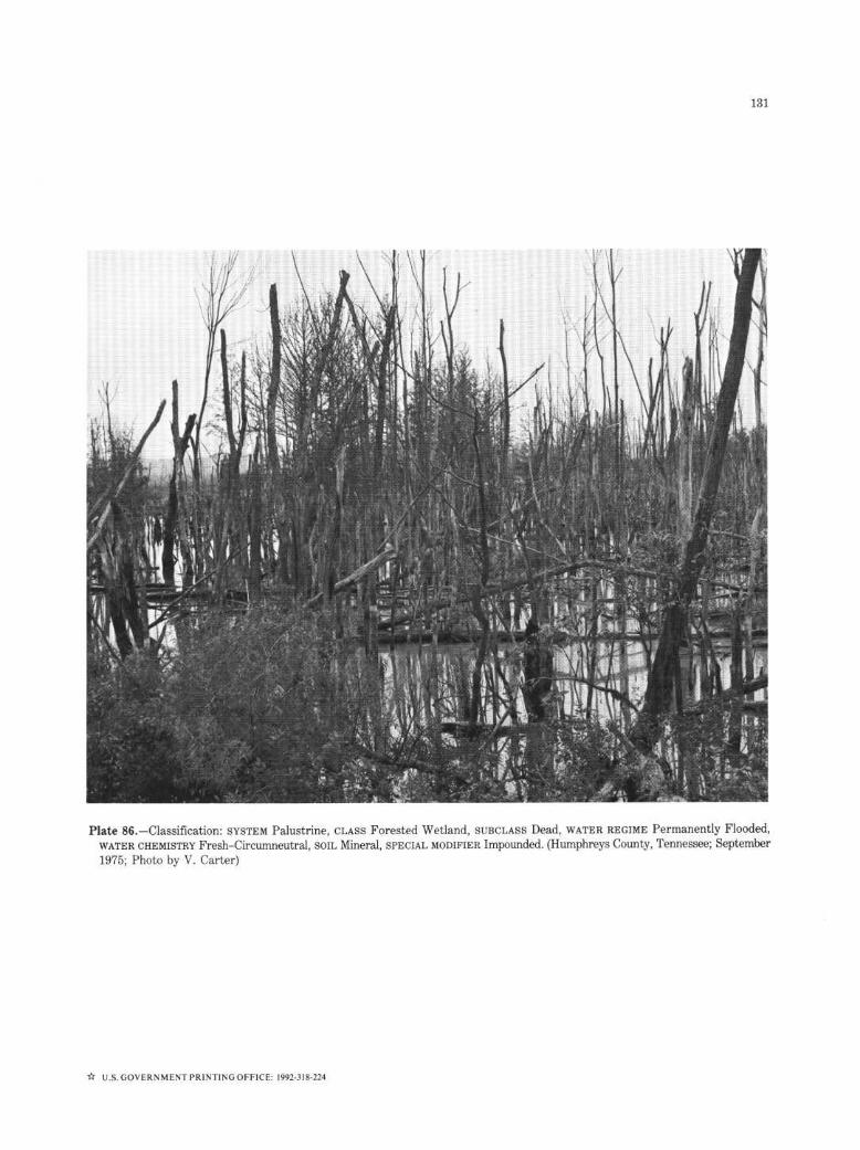
Plate 86 .-Classification : SYSTEM Palustrine, CLASS Forested Wetland, SUBCLASS Dead, WATER REGIME Permanently Flooded,WATER CHEMISTRY Fresh-Circumneutral, SOIL Mineral, SPECIAL MODIFIER Impounded. (Humphreys County, Tennessee ; September1975 ; Photo by V. Carter)
U .S . GOVERNMENT PRINTING OFFICE : 1992-318-224


As the Nation's principal conservation agency, the Department of theInterior has responsibility for most of our nationally owned public lands andnatural resources . This includes fostering the wisest use of our land and waterresources, protecting our fish and wildlife, preserving the environmental andcultural values of our national parks and historical places, and providing forthe enjoyment of life through outdoor recreation . The Department assessesour energy and mineral resources and works to assure that their develop-ment is in the best interests of all our people . The Department also has amajor responsibility for American Indian reservation communities and for peo-ple who live in island territories under U .S . administration .
U .S . Department of the InteriorFish and Wildlife ServiceWashington, D.C . 20240
POSTAGE AND FEES PAIDU. S. DEPARTMENT OF THEINTERIOR
INT-423 U.&MAIL
![2 S.S. Uhlemann *, J.P.R. Sorensen 3, A.R. House , …...44 Groundwater-dependent ecosystems (GDEs) are priority habitats under the European Habitats 45 Directive [EEC , 1992]. Wetlands](https://static.fdocuments.in/doc/165x107/5f0dc0cb7e708231d43bea29/2-ss-uhlemann-jpr-sorensen-3-ar-house-44-groundwater-dependent.jpg)