Clark on the Yellowstone - Foundation's 19th Annual ...
24
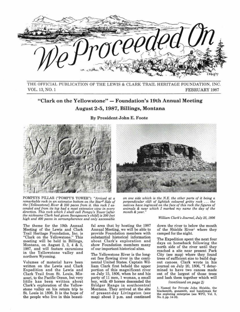
THE OFFICIAL PUBLICATION OF THE LEWIS & CLARK TRAIL HERITAGE FOUNDATION, I NC. VOL. 13, NO. 1 FEBRUARY 1987 "Clark on the Yellowstone" - Foundation's 19th Annual Meeting August 2-5, 1987, Billings, Montana By President John E. Foote POMPEYS PILLAR ("POMPY'S TOWER"): "Arrived at a remarkabl e rock in an extensive bottom on the Stard Side of the [Yellowstone] River & 250 paces from it. this rock I as- cended and from its top had a most extensive view in every direction. This rock which I shall call Pompy's Tower [after the nickname Clark had given Sacagawea's child] is 200 feet high and 400 paces in sercumpherence and only axcessable on one side which is the N.E. the other parts of it being a perpendicular clift of lightish coloured gritty rock . . . the natives have ingraved on the face of this rock the figures of animals & near which I marked my name the day of the month & year." The theme for the 19th Annual Meeting of the Lewis and Cl ark Trail Heritage Foundation, Inc. is "Cl ark on the Yellowstone." This meeting will be held in Billings, Montana, on August 2, 3, 4 & 5, 1987, and will feature excursions in the Yellowstone valley and northern Wyoming. Volumes of material have been written on the Lewis and Clark Expedition and the Lewis and Cl ark Trail from St. Louis, Mis- souri, to the Pacific Ocean, but very little has been written about Cl ark's exploration of the Yellow- stone valley on his return trip to St. Louis in 1806. It is the hope of the people who live in this beauti- ful area th at by hosting the 1987 Annual Meeting, we will be able to provide Foundation members with substantial historical information about Clark 's exp l oratio n and show Foundation members many of our important historical sites. The Yellowstone River is the long- est free flowing river in the conti- nental United States. Captain Wil- liam Clark first beheld the upper portion of this magnificent river on July 15, 1806, when he and his party of 11 men, 1 woman, a small boy, with 49 horses descended the Bridger Range in southcentral Montana. They arrived at the site of present - day Livingston (see map) about 2 p.m. and continued William Clark's Journal, July 25, 1806 down the river to below the mouth of the Shields River 1 where they camped for the night. The Expedition spent the next four days on horseback following the north side of the river until they reached a site near present Park City (see map) where they found trees of sufficient size to build dug- out canoes. Clark wrote in his journal on July 20, 1806, "I detur- mined to h ave two canoes made out of the largest of those trees and lash them together which will (continued on page 2) 1. Named for Priv ate John Shi elds, the blacks mith, gunsmith, and ha ndyman for the exploring enterprise (see WPO, Vol. 5, No. 3, pp. 14-16).
Transcript of Clark on the Yellowstone - Foundation's 19th Annual ...
THE OFFICIAL PUBLICATION OF THE LEWIS & CLARK TRAIL HERITAGE FOUNDATION, INC. VOL. 13, NO. 1 FEBRUARY 1987
"Clark on the Yellowstone" - Foundation's 19th Annual Meeting
August 2-5, 1987, Billings, Montana
By President John E. Foote
POMPEYS PILLAR ("POMPY'S TOWER"): "Arrived at a remarkable rock in an extensive bottom on the Stard Side of the [Yellowstone] River & 250 paces from it. this rock I ascended and from its top had a most extensive view in every direction. This rock which I shall call Pompy's Tower [after the nickname Clark had given Sacagawea's child] is 200 feet high and 400 paces in sercumpherence and only axcessable
on one side which is the N.E. the other parts of it being a perpendicular clift of lightish coloured gritty rock . . . the natives have ingraved on the face of this rock the figures of animals & near which I marked my name the day of the month & year."
The theme for the 19th Annual Meeting of the Lewis and Clark Trail Heritage Foundation, Inc. is "Clark on the Yellowstone." This meeting will be held in Billings, Montana, on August 2, 3, 4 & 5, 1987, and will feature excursions in the Yellowstone valley and northern Wyoming.
Volumes of material have been written on the Lewis and Clark Expedition and the Lewis and Clark Trail from St. Louis, Missouri, to the Pacific Ocean, but very little has been written about Clark's exploration of the Yellowstone valley on his return trip to St. Louis in 1806. It is the hope of the people who live in this beauti-
ful area that by hosting the 1987 Annual Meeting, we will be able to provide Foundation members with substantial historical information about Clark's exploration and show Foundation members many of our important historical sites.
The Yellowstone River is the longest free flowing river in the continental United States. Captain William Clark first beheld the upper portion of this magnificent river on July 15, 1806, when he and his party of 11 men, 1 woman, a small boy, with 49 horses descended the Bridger Range in southcentral Montana. They arrived at the site of present-day Livingston (see map) about 2 p.m. and continued
William Clark's Journal, July 25, 1806
down the river to below the mouth of the Shields River1 where they camped for the night.
The Expedition spent the next four days on horseback following the north side of the river until they reached a site near present Park City (see map) where they found trees of sufficient size to build dugout canoes. Clark wrote in his journal on July 20, 1806, "I deturmined to have two canoes made out of the largest of those trees and lash them together which will
(continued on page 2)
1. Named for Private John Shields, the blacksmith, gunsmith, and handyman for the exploring enterprise (see WPO, Vol. 5, No. 3, pp. 14-16).
THE LEWIS AND CLARK TRAIL HERITAGE FOUNDATION, INC.
Incorporated 1969 under Missouri General Not-For-Profit Corporation Act IRS Exemption Certificate No. 501(C)(3) - Identification No. 51-0187715
President
John E. Foote 1205 Rimhaven Way Billings, MT 59102
OFFICERS - EXECUTIVE COMMITTEE
1st Vice President
H. John Montague 2864 Sudbury Ct.
Marietta, GA 30062
2nd Vice President
Donald F. Nell P.O. Box 577
Bozeman, MT 59715
Edrle Lee Vinson, Secretary P.O. Box 1651
John E. Walker, Treasurer 200 Market St., Suite 1177
Portland, OR 97201 Red Lodge, MT 59068
Ruth E. Lange, Membership Secretary, 5054 S.W. 26th Place, Portland, OR 97201
DIRECTORS
Ruth Backer Cranford, NJ
Harold Billian Villanova, PA
Malcolm S. Buffum Portland, OR Roy D. Craft Stevenson, WA
Winifred C. George St. Louis, MO
Bob Doerk Great Falls, MT
James R. Fazio Moscow, ID
Charles C. Patton Springfield, IL
James P. Ronda Youngstown, OH Ralph H. Rudeen Olympia, WA Bob Saindon Helena, MT Arthur F. Shipley Bismarck, ND
L. Edwin Wang immediate Past President is a Foundation Director
PAST PRESIDENTS - DIRECTORS EX OFFICIO
Edwynne P. Murphy, 1970 St. Louis, Missouri
E.G. Chuinard, M.D., 1971 Tigard, Oregon
John Greenslit, 1972 Lansing, Michigan
Lynn Burris, 1972-1973 Topeka, Kansas Robert E. Lange, 1973-74 Portland, Oregon
Gary Leppart, 1974-75 Butte, Montana
Wilbur P. Werner, 1975-76 Cut Bank, Montana Clarence H. Decker, 1976-77 East Alton, Illinois
Gail M. Stensland, 1977 -78 Fort Benton, Montana
Mitchell Doumit, 1978-79 Cathlamet, Washington
Bob Saindon, 1979-80 Helena, Montana
Irving W. Anderson, 1980-81 Portland, Oregon
V. Strode Hinds, 1981-82 Sioux City, Iowa Hazel Bain, 1982-83 Longview, Washington
Arlen J. Large, 1983-84 Washington, D.C.
William P. Sherman, 1984-85 Portland, Oregon
L. Edwin Wang, 1985-1986 Minneapolis, MN
ABOUT THE FOUNDATION
The purpose of the Lewis and Clark Trail Heritage Foundation, Inc., ls to stlmulate nationally: public Interest in matters relating to the Lewis and Clark Expedition; the contributions to American history made by the expedition members; and events of time and place concerning and following the expedition which are of historical Import to our nation. The Foundation recognizes the value of tourist-oriented programs, and supports activities which enhance the enjoyment and understanding of the Lewis and Clark story. The scope of the activities of the Foundation are broad and diverse, and Include Involvement In pursuits which, in the IUdQment of the Directors are, of historical worth or contemporary social values, and commensurate with the heritage of Lewis and Clark. The activities of the National Foundation are Intended to compliment and supplement those of state and local Lewis and Clark Interest groups. The Foundation may appropriately recognize and honor Individuals or groups for: art works of distinction; achievement In the broad field of Lewis and Clark hlstorlcal research; writing; or deeds which promote the general purpose and scope of activities of the Foundation. Membership In the organization comprises a broad spectrum of Lewis and Clark enthusiasts Including Federal, State, and local government officials, historians, scholars, and others of wide ranging Lewis and Clark Interests. Officers of the Foundation are elected from the membership. The Annual Meeting of the Foundation Is tradltlonally held during August, the birth month of both Meriwether Lewis and William Clark. The meeting place Is rotated among the States, and tours generally are arranged to visit sites In the area of the Annual Meeting which have historic association with the Lewis and Clark Expedi tion.
WE PROCEEDED ON ISSN 0275-6706 E.G. CHU/NARD, M.D., FOUNDER
We Proceeded On is the official publication of the Lewis and Clark Trail Heritage Foundation, Inc. The publication's name is derived from the phrase which appears repeatedly in the collective journals of the famous Expedition.
PUBUCATIONS COMMITTEE
Robert E. Lange, Editor and Committee Chairman, 5054 S.W. 26th Place, Portland, OR 97201
Irving W. Anderson Box LC-196 Lewis & Clark College Portland, OR 97219
E.G. Chuinard 15537 S.W. Summerfield Lane Tigard, OR 97223
Paul R. Cutright 312 Summit Avenue Jenkintown, PA 19046
Donald Jackson Gary E. Moulton
Bob Saindon 172 Briarwood Helena, MT 59601
3920 Old Stage Road Love Library - Univ. Nebraska Colorado Springs, CO 80906 Lincoln, NE 68588
Wiibur P. Werner P.O. Box 428 Cut Bank, MT 59427
-2-
cause them to be Study [sturdy] and fully sufficient to take my small party & Self with what little baggage we have down this river. had handles put in the 3 axes and after Sharpening them with a file fell the two trees which I intended for the two canoes, those trees appeared tolerably Sound and will make canoes of 28 feet in length and about 16 or 18 inches deep and from 16 to 24 inches wide."
During their stay at "canoe camp," they had the misfortune to lose half their horses to an Indian raiding party. While some of the men were working on the canoes, the others were out looking for the horses. The search was ended when it was concluded that the Indians had hurriedly taken the horses down the river.
After four days of building can oes, the Expedition departed on July 24, 1806. Sergeant Pryor and three men were instructed to take the horses overland to the Mandan villages and Clark and the remaining party traveled by canoe. During the day they passed the site of present-day Billings and camped farther down the river.
The following day the party departed at sunrise and proceeded on until 4 p.m. Clark wrote in his journal on July 25, 1806, "arived at a remarkable rock situated in an extensive bottom on the Star4 Side of the river & 250 paces from it. this rock I ascended and from its top had a most extensive view in every direction. This rock which I shall call Pompy's Tower is 200 feet high and 400 paces in secumpherance and only axcessable on one Side which is from the N.E. the other parts of it being a perpendicular clift of lightish coloured gritty rock on the top there is a tolerable soil of about 5 or 6 feet thick covered with short grass. The Indians have made 2 piles of stone on the top of this Tower. The nativs have ingraved on the face of this rock the figures of animals & near which I marked my name and the day of the month & year."
Clark named this remarkable rock after Sacagawea's son whom he affectionately called Pomp. When editing Clark's journals at a later date, Nicholas Biddle inadvertently changed the name from Pompy' s Tower to Pompeys Pillar, the name by which it is presently known.
The party spent eight more days traveling to the mouth of the Yellowstone River which they reached
We Proceeded On, February 1987
on August 3, 1806. It was from here that they proceeded slowly down the Missouri River until Captain Lewis and his party rejoined them.
Although a speech had been prepared should contact be made with the Indian s, no personal contact was ever made in Yellowstone country. The Indians seemed more content to steal the party's horses than to smoke the pipe of peace. The remaining horses under the care of Sergeant Pryor were also stolen forcing him and his men to float down the Yellowstone River in bullboats. 2
During the Yellowstone trip, such an astonding number of animals were s ighted that Clark saw no need to continue recording their exist ence, and was compelled to write in his journal "I shall therefore be silent on the subject further." He concluded that:
"The Rochejhone or Yellow Stone river is large and navagable with but fiew obstructions quite into the rocky Mountains . .. . The country through which it passes from those Mount~ to its junction is Generaly fertile rich open plains.
Members attending the Annual Meeting in Billings can follow Clark's route from Livingston to Billings on Interstate 90 and from Glendive to Billings on Interstate 94. An interesting side trip from Glendive to the mouth of the Yellowstone can be taken by following Montana Highways 16 and 200 and North Dakota Highway 58. The Fort Union Historic Site at the confluence of the Missouri and Yellowstone Rivers would be a recommended stop if you are in this area.
As part of the Annual Meeting, we will spend an evening at Pompeys Pillar Na tional Landmark where we will view Captain William Clark's inscription - "Wm Clark,
2. The journals usually refer to these boats as "Skin canoes". Clark, in his journal for August 8, 1806, describes their construction as follows: "Viz: 2 Sticks of l1A inch diameter ill tied together so as to form a round hoop the size you wish the canoe, or as large as the Skin will allow to cover, two of those hoops are made one for the top or brim and the [other] for the bottom the deapth you wish the canoe, then sticks of the same size are crossed at right angles and fastened with a thong to each hoop and also where each stick crosses each other. then the skin when green is drawn tight over over this fraim and fastened with thongs to the brim or outer hoop so as form a perfect bason. One of those canoes will carry 6 or 8 men and their loads." (Thwaites: V:325-326. - on page 326 Thwaites adds the footnote: "Commonly known as "bull- boats," because made from (bull) buffalo hides.")
We Proceeded On, February 1987
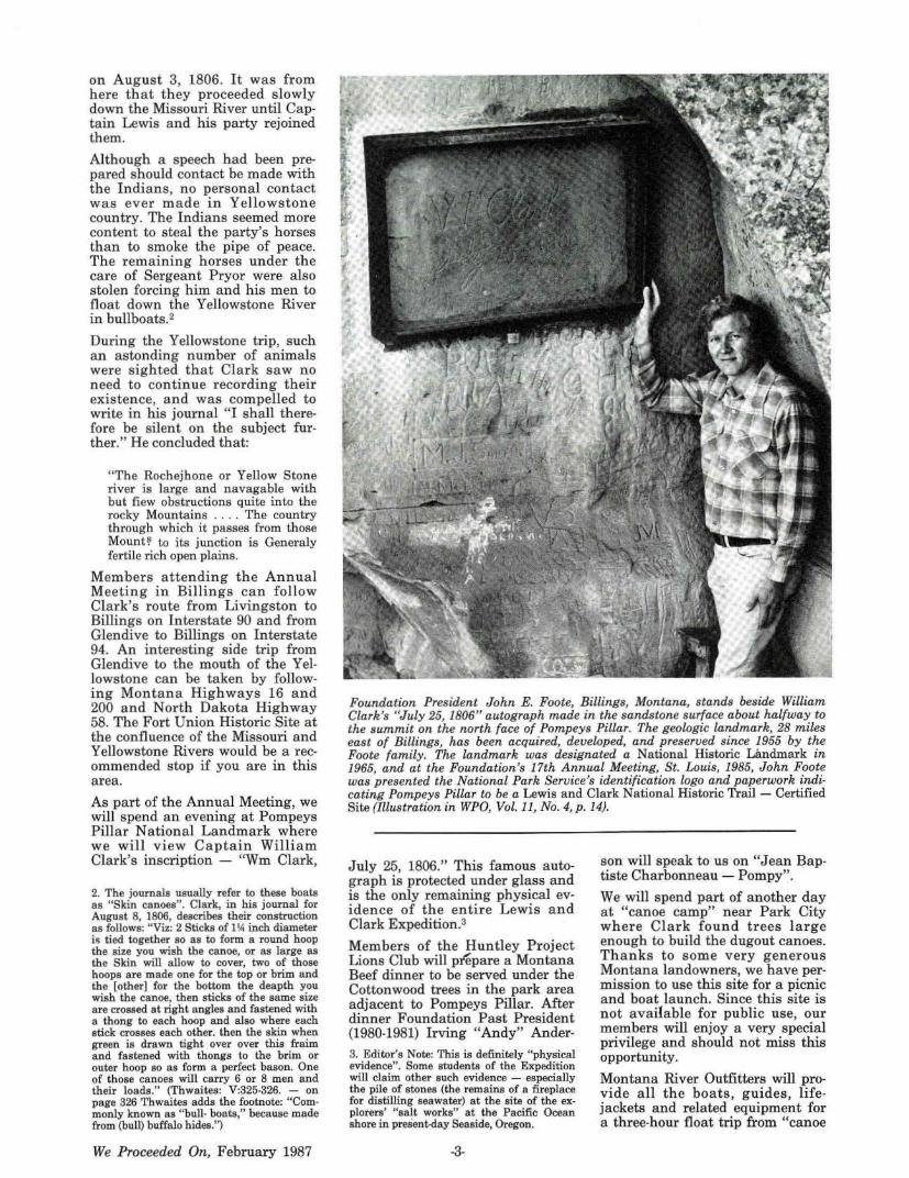
Foundation President John E. Foote, Billings, Montana, stands beside William Clark's "July 25, 1806" autograph made in the sandstone surface about halfway to the summit on the north face of Pompeys Pillar. The geologic landmark, 28 miles east of Billings, has been acquired, developed, and preserved since 1955 by the Foote family. The landmark was designated a National Historic Landmark in 1965, and at the Foundation's 17th Annual Meeting, St. Louis, 1985, John Foote was presented the National Park Service's identification logo and paperwork indicating Pompeys Pillar to be a Lewis and Clark Nationa l Historic Trail - Certified Site (Illustration in WPO, Vol. 11, No. 4, p. 14).
July 25, 1806." This famous autograph is protected under glass and is the only remaining physical evidence of the entire Lewis and Clark Expedition.a
Members of the Huntley Project Lions Club will prepare a Montana Beef dinner to be served under the Cottonwood trees in the park area adjacent to Pompeys Pillar. After dinner Foundation Past President (1980-1981) Irving "Andy" Ander-3. Editor's Note: This is definitely "physical evidence". Some students of the Expedition will claim other such evidence - especially the pile of stones (the remains of a fireplace for distilling seawater) at the site of the explorers' "salt works" at the Pacific Ocean shore in present-day Seaside, Oregon.
-3-
son will speak to us on "Jean J?aptiste Charbonneau - Pompy".
We will spend part of another day at "canoe camp" near Park City wh ere Clark found trees la rge enough to build the dugout canoes. Thanks to some very gener ou s Montana landowners, we have permission to use this site for a picnic and boat la unch. Since this site is not available for public use, our members will enjoy a very special privilege and should not miss this opportunity.
Montana River Outfitters will provide all the boats, guides, lifejackets and related equipment for a three-hour float trip from "canoe
camp" to the community of Laurel. 4 (See map). In addition to this, the members of the Huntley Project Lions Club have agreed to build replicas of the dugout canoes and float them with us to Laurel. Photo opportunities for our members seated in rafts floating on the Yellowstone River and observing the progress of the dugout canoes should be fantastic. An alternate bus tour for those not wishing to partake of the float trip will be provided.
In honor of John Colter, 1st member of the Lewis and Clark Expedition to return to Montana, we will give an interpretation of his exploration of southcentral Montana and northwest Wyoming while we are traveling by bus to Cody, Wyoming. Each Foundation member will be given a copy of Paul Lawrence's booklet John Colter,
4. About eleven miles west of Billings, Montana, on present-day Interstate Highway 94.
D
1
Journey of Discovery which is a product of five years research on Colter and his journey of 1807.5
In Cody we will visit the Buffalo Bill Historical Center, home of the Buffalo Bill Museum, Whitney Gallery of Western Art, Winchester Arms Museum and Plains Indian Museum. Lunch will be served in the Greever Garden which is beautifully landscaped and contains the magnificent sculpture of Sacagawea by Harry Jackson. Peter Hassrick, the Director, will greet us and has indicated that a special Lewis and Clark display will be available for viewing.
Although Clark n ever had any personal contact with Indians in the Yellowstone country, 70 years later on June 25 , 1876, George Armstrong Custer with about 215 troopers under his command were annihilated by as many as 4000 Indian warriors by the Little Big
5. See also WPO, Vol. 9, no. 2, pp. 10-15.
TatmanM !'.'5972
2 3 4 B-4
Horn River. Probably more has been written about this controversial battle than any other in the history of the United States. This site known as the Custer Battlefield National Monument will be toured by our group with lunch being served at the battlefield. Foundation members will get a good interpretation of relations between the whites and Indians on the open plains.
The following schedule shows the sequence of events for the 19th Annual Meeting. A great amount of time has been spent planning for this meeting and we hope all members will make a serious attempt to attend. Friendship shared with fellow Lewis and Clark enthusiasts is what makes our annual meetings so special. The welcome mat is out - so head on out to Big Sky Country in August. Your personal invitation will be forthcoming.
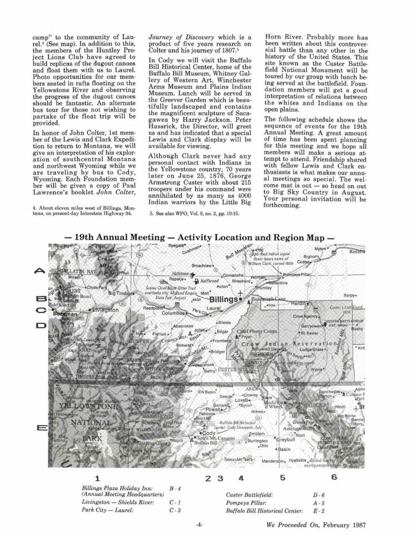
6 Billings Plaza Holiday Inn: (Annual Meeting Headquarters) Custer Battlefield: D - 6
A - 5 E-2
Livingston - Shields River: Park City - Laurel:
C-1
C - 3
-4-
Pompeys Pillar: Buffalo Bill Historical Center:
We Proceeded On, February 1987
"CLARK ON THE YELLOWSTONE" 19th Annual Meeting
LEWIS AND CLARK TRAIL HERITAGE FOUNDATION
August 2-5, 1987 Billings, Montana
SCHEDULE OF EVENTS
August 2, 1987 Sunday
12:00-5:00 p.m. Registration: Atrium, Billings Plaza Holiday Inn
6:30 p.m.
Information will be provided on where to go and what to do in Billings
Wine and Cheese reception: Big Horn Center & Poolside Terrace, Billings Plaza Holiday Inn
Lewis and Clark artists, authors, cartographers and Foundation chapters will have tables at the reception to display and sell their wares
August 3, 1987 Monday
8:30 a.m. General Business Meeting: Gallatin Room, Billings Plaza Holiday Inn -John E. Foote, President, presiding
10:00 a.m. Break
10:30 a.m.
12:00 p.m.
1:30 p.m.
3:30 p.m.
5:00 p.m.
6:30 p.m.
8:30 p.m.
9:00 p.m.
August 4,
9:00 a.m.
11:30 a.m.
12:30 p.m.
Transportation departs Holiday Inn for Custer Battlefield National Monument
Lunch at Custer Battlefield National Monument Welcome and Interpretation by Dennis L. Ditmanson, Superintendent
Visit the Battlefield and the Interpretation Center
Transportation departs for Pompeys Pillar National Landmark
Ascend the Pillar and view Captain Wm. Clark's inscription, the only remaining physical evidence of the entire Lewis and Clark Expedition Welcome and Interpretation by John E. Foote, Owner
Montana beef dinner at Pompeys Pillar National Landmark served by members of the Huntley Project Lions Club Speech: "Jean Baptiste Charbonneau - Pompy", by Irving W. Anderson
Transportation leaves Pompeys Pillar National Landmark
Transportation arrives a t Holiday Inn
1987 Tuesday
Transportation departs Holiday Inn for Buffalo Bill Historical Center, Cody, Wyoming Interpretation of John Colter's exploration of south-central Montana and northwest Wyoming
Lunch in the Greever Garden at Buffalo Bill Historical Center Welcome and Interpretation by Peter H. ·Hassrick, Director
Visit the Buffalo Bill Museum, Winchester Arms Museum, Plains Indian Museum and the Whitney Gallery of Wes tern Art. A special Lewis and
We Proceeded On, February 1987 -5-
3:00 p.m.
5:00 p.m.
6:15 p.m.
7:00 p.m.
8:15 p.m.
Clark display· may be available for viewing
Transportation leaves Cody, Wyoming
Transportation arrives at Holiday Inn
Attitude adjustment hour: Atrium, Billings Plaza Holiday Inn
Buffet dinner, Missouri Room, Billings Plaza Holiday Inn
Program on Yellowstone River with movie "Yellowstone Concerto" by Bill Pryor, Information Officer, Montana Fish, Wildlife and Parks Department
9:00 p.m. Optional program for night owls: "Tuesday Night at the Movies" -Lewis and Clark slides, videos and movies presented by the Lewis and Clark Trail Heri tage Foundation Young Adults Committee
August 5, 1987 Wednesday
8:00 a.m.
9:00 a.m.
9:30 a.m.
10:00 a.m.
11:00 a.m.
1:00 p.m.
4:45 p.m.
5:15 p.m.
6:30 p.m.
7:15 p.m.
NOTES:
General Business Meeting: Gallatin Room, Billings Plaza Holiday Inn by John E. Foote, President, presiding
Board of Directors Meeting, Gallatin Room, Billings Plaza Holiday Inn -H. J ohn Montague, President-elect, presiding
Break
Transportation departs Holiday Inn for Clark's "Canoe Camp"
Lunch at "Canoe Camp" Reenactment of building and launching dugout canoes by members of the Huntley Project Lions Club
Group A departs on Yellowstone River float
Group B departs on land excursion along Yellowstone River
Group B meets Group A at the conclusion of Yellowstone River float
Transportation leaves Laurel, Montana
Transportation arrives at Holiday Inn
Attitude adjustment hour: Montana Center, Billings Plaza Holiday Inn
19th Annual Banquet: Montana Center, Billings Plaza Holiday -Inn John E. Foote, President, presiding Foundation Awards Annual Banquet Address
1. Hoofprints, the publication of Yellowstone Corral of the Wes terners, will feature "Clark of the Yellowstone" in its Spring-Summer, 1987, issue.
2. Members of the Yellowstone Corral of the Westerners will be tour guides for each bus.
President Foote's Message
F or over twelve years we have been privileged to have Past President Bob Lange edit the Lewis and Clark Trail Heritage Foundation quarterly publication We Proceeded On. He has given an unbelievable amount of his time and talent to make this publication one of the most respected quarterly historical journals in the United States.
When Bob announced his retirement plans to the Board of Directors at the Annual Meeting in Portla nd, I knew what was going through everyone's mind - how are we going to replace this man? His avocation for over fifty years has been the study of the Lewis and Clark Expedition. During this long involvement, he has achieved the following:
1970-1982 Member of Oregon (Governor's) Lewis and Clark Trail Committee
1972 First President of Oregon Lewis and Clark Heritage Foundation
1972-1976 Editor of Oregon Lewis and Clark Heritage Foundation's publication Historical Anecdotes
1972 Compiler & Publisher of an annotated Bibliographical Index to the Literature of the Lewis and Clark Expedition
1973-1974 President of the Lewis and Clark Trail Heritage Foundation
1974 Organizer of the Sixth Annual Meeting of the Foundation held in Seaside, Oregon and Pacific County, Washington. The meeting was hosted jointly by the Governors' committees of Oregon and Washington.
1974-1987 Editor of the Lewis and Clark Trail Heritage Foundation publication We Proceeded On
1976 Recipient of the Lewis and Clark Trail Heritage Foundation's Award of Meritorious Achievement "For outstanding contributions in bringing to this nation a greater awareness a nd appreciation of the Lewis and Clark Expedition"
1983 Winner of the Washington State Historical Society's highest award, the Captain Robert Gray Medal for "Distinguished contributions to Washington State and Pacific Northwest History"
1983 Joint recipient, with Ruth Lange, of the Lewis and Clark Trail Heritage Foundation's Distinguished Service Award "For outstanding contributions toward furthering the purpose and objectives of the Lewis and Clark Trail Heritage Foundation, Inc."
In addition to his responsibilities as editor, Bob is presently serving as chairman of the Foundation's Publication Committee. We hope that he will continue to serve on that committee, and that we will frequently see his by-line in our magazine and contributions toward the popular WPO Supplementary Publication program.
Both Bob and the Foundation have been fortunate to have a tremendous amount of help from Bob's wife, Ruth. In addition to being Bob's number one proof
-6-
reader of the We Proceeded On galleys and page proofs, she served for several years (1982-1983) as chairman of the Foundation's Membership Committee. From 1982 to the present, she has been the Foundation's Membership Secretary. Ruth was the joint recipient, with Bob, of the Foundation' s Distinguished Service Award in 1983.
So now the question is not only how do we replace Bob, but how do we replace Bob and Ruth? Answering this question has required a great deal of thought and effort by the Board of Directors, the Editor/ Executive Secretary Selection Advisory Committee, and the Executive Committee. We are fortunate to have an individual in our Foundation who has come forward to accept the challenge - Past President Bob Saindon.
Bob will become the new Editor of We Proceeded On starting with the next issue and will also become the first Executive Secretary of the Foundation. Many of you have had the opportunity to meet Bob through his twelve year involvement with the Lewis and Clark Trail Heritage Foundation and know of his great interest in the Lewis and Clark Expedition.
His accomplishments during this time include the following:
1976 Founder and charter President of the Valley County, Montana Chapter of the Foundation
1976-1981 Editor of the Valley County Chapter's quarterly newsletter "A Squawl of Wind"
1979 Chairman of the Eleventh Annual Meeting in Glasgow, Montana
1979-1980 President of the Lewis and Clark Trail Heritage Foundation
1981 Ch a irman of the Thirteenth Annual Meeting in Helena, Montana
1981 Recipient of the Lewis and Clark Trail Heritage Foundation's Award of Meritorious Achievement
1984-87 Vice Ch airman of the Montana Governor's Lewis and Clark Advisory Council
1985-1987 Chairman of the Montana Lewis and Clark Expedition/ [1989] Centennial Activities Coordinating Committee
1986-1987 Chairman of the Foundation's Lewis and Clark Statehood Centennial Celebrations Committee. The states of South Dakota, North Dakota, Montana, and Washington celebrate 100 years of statehood in 1989. The state of Idaho will hold a similar celebration in 1990.
Bob Saindon has been a frequent and appreciated contributor to the pages of We Proceeded On. His byline has also appeared in Montana, The Magazine of Western History, the quarterly publication of the Montana Historical Society.
Bob Saindon knows that he has a tough assignment. He recently said " It is not without trepidation that I step into the editorship of We Proceeded On. Bob's scholarship and attention to detail pose a formidable challenge to any successor. I am, however, fortunate to be following someone like Bob Lange since he has done such a superb job of paving the way with his
We Proceeded On, February 1987
meticulous organization and established procedures for the publishing of the magazine." I know Bob Saindon will appreciate our words of encouragement as we join in offering him our best wishes for success in his new position. We must also let Bob and Ruth Lange know how much we have appreciated their years of unselfish service to the Lewis and Clark Trail Heritage Foundation. Bob Saindon said "There can't be too much praise for the dedication that Bob
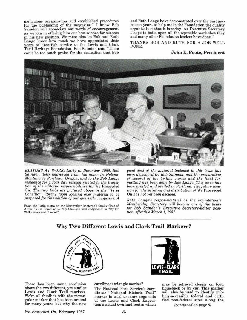
EDITORS AT WORK: Early in December 1986, Bob Saindon (left) journeyed from his home in Helena, Montana to Portland, Oregon, and to the Bob Lange residence for a four day session related to the transition of the editorial responsibilities for We Proceeded On. The two Bobs are pictured above in the "Vi et Consilio"1 library room looking over material to be prepared for this edition of our quarterly magazine. A
From the Latin motto on the Meriwether (maternal) family Coat of Arms. "Vi et Consilio" - " By Strength and Judgment" or "By (or With) Force and Counsel' '.
and Ruth Lange have demonstrated over the past seventeen years to help make the Foundation the quality organization that it is ·today. As Executive Secretary I hope to build upon all the reputable work that they and many other Foundation leaders have done."
THANKS BOB AND RUTH FOR A JOB WELL DONE.
John E. Foote, President
good deal of the material included in this issue has been developed by Bob Saindon, and the preparation of several of the by-line stories and the final formatting has been done by Bob Lange. This issue has been printed and mailed in Portland. The future location for the printing and distribution of We Proceeded On has not yet been decided.
Ruth Lange's responsibilities as the Foundation's Membership Secretary will become one of the tasks for Bob Saindon's Executive Secretary-Editor position, effective March 1, 1987.
Why Two Different Lewis and Clark Trail Markers?
There has been some confusion about the two different, yet similar Lewis and Clark Trail markers. We're all familiar with the rectangular marker that has been around for many years, but why the new
We Proceeded On, February 1987
curvilinear-triangle marker? The National Park Service's curvilinear "National Historic Trail" marker is used to mark segments of the Lewis and Clark Expedition's actual overland routes which
-7-
may be retraced closely on foot, horseback or by car. This marker will also be used to identify publicly-accessible federal and certified non-federal sites along the
(continued on page 8)
overland and waterway segments where interpretation about the Expedition is available.
Readers of We Proceeded On have noted that the magazine frequently reports the certification of "Lewis and Clark National Historic Trail Sites." When such certification is granted, this new marker is supplied for installation at the location by the National Park Service. An application for certification can be applied for by communities, civic bodies, organizations or agencies by writing to: Lewis and Clark National Historic Trail, NPS, Midwest Region, 1709 Jackson Street, Omaha, NE 68102.
The f?-miliar rectangular marker . developed by the congressionally
. created Lewis and Clark Trail Commission (1964-1969) will continue to mark the Lewis and Clark Trail Highway established by state highway agencies to provide a continuous automobile retracemen t experience. While some portions of the highway systems closely retrace or parallel the Expedition route, other portions are often 10 or 20 or more miles from the explorers' historic route and therefore provide an approximate retracement experience.
The familiar symbol or logotype found on both markers was also developed during the tenure of the Lewis and Clark Trail Commission. The logography was prepared for the Commission by Frank R. Davenport, staff artist for the Des Moines (Iowa) Register and Tribune, and was a dopted by the Commission as the official highway marker along the route of the 1804-1806 Expedition, and for other applications for promoting Lewis and Clark history and heritage.
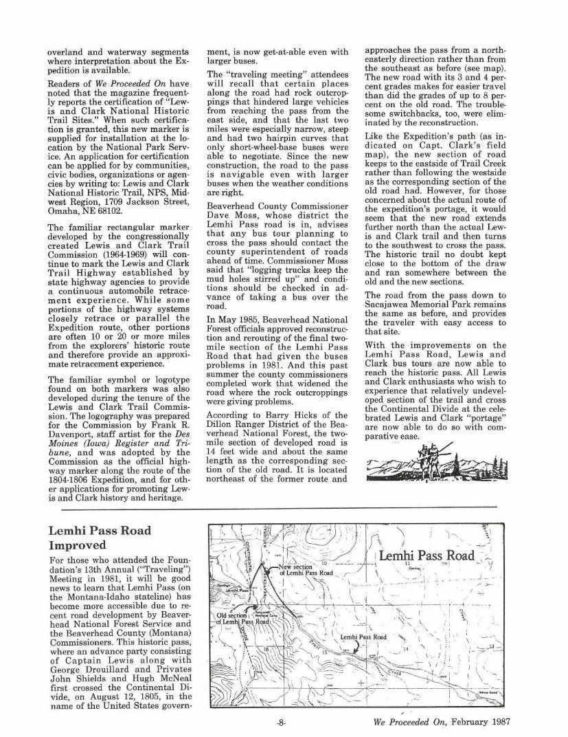
Lemhi Pass Road Improved For those who attended the Foundation's 13th Annual ("Traveling") Meeting in 1981, it will be good news to learn that Lemhi Pass (on the Montana-Idaho stateline) has become more accessible due to recent road development by Beaverhead National Forest Service and the Beaverhead County (Montana) Commissioners. This historic pass, where an advance party consisting of Captain Lewis along with George Drouillard and Privates John Shields and Hugh McNeal first crossed the Continental Divide, on August 12, 1805, in the name of the United States govern-
ment, is now get-at-able even with larger buses.
The "traveling meeting" attendees will recall that certain places along the road had rock outcroppings that hindered large vehicles from reaching the pass from the east side, and that the last two miles were especially narrow, steep and had two hairpin curves that only short-wheel-base buses were able to negotiate. Since the new construction, the road to the pass is navigable even with larger buses when the weather conditions are right.
Beaverhead County Commissioner Dave Moss, whose district the Lemhi Pass road is in, advises that any bus tour planning to cross the pass should contact the county superintendent of roads ahead of time. Commissioner Moss said that "logging trucks keep the mud holes stirred up" and conditions should be checked in advance of taking a bus over the road.
In May 1985, Beaverhead National Forest officials approved reconstruction and rerouting of the final twomile section of the Lemhi Pass Road that had given the buses problems in 1981. And this past summer the county commissioners completed work that widened the road where the rock outcroppings were giving problems.
According to Barry Hicks of the Dillon Ranger District of the Beaverhead National Forest, the twomile section of developed road is 14 feet wide and about the same length as the corresponding section of the old road. It is located northeast of the former route and
-8-
approaches the pass from a northeasterly direction rather than from the southeast as before (see map). The new road with its 3 and 4 percent grades makes for easier travel than did the grades of up to 8 percent on the old road. The troublesome switchbacks, too, were eliminated by the reconstruction.
Like the Expedition's path (as indicated on Capt. Clark's field map), the new section of road keeps to the eastside of Trail Creek rather than following the westside as the corresponding section of the old road had. However, for those concerned about the actual route of the expedition's portage, it would seem that the new road extends further north than the actual Lewis and Clark trail and then turns to the southwest to cross the pass. The historic trail no doubt kept close to the bottom of the draw and ran somewhere between the old and the new sections.
The road from the pass down to Sacajawea Memorial Park remains the same as before, and provides the traveler with easy access to that site.
With the ·improvements on the Lemhi Pass Road, Lewis and Clark bus tours are now able to reach the historic pass. All Lewis and Clark enthusiasts who wish to experience that relatively undeveloped section of the trail and cross the Continental Divide at the celebrated Lewis and Clark "portage" are now able to do so with comparative ease.
. : . -. . . . .. / ..
/ ( . I
I · "
\ --"----·--.-' - -.'.: -- ; ·--·--\ --- . ;-
"" I 1
1\ ' ~ "::_· \ ; I ~I
\ ·, • 1
'• ,. ,. . I . I ~,, ...... ·~. - \ \,,,
: t-??13~ 14 . _, .... t ~ :
I .
We Proceeded On, February 1987
~ -s ....... --.. fu§eview
By Robert E. Lange1
The Journals of the Lewis and Clark Expedition, Volume 2, August 20, 1803 - August 24, 1804, Gary E. Moulton, Editor. University of Nebraska Press, Lincoln, 1986. Volume 2 of projected 11 volumes, map, illustrations, figures, Appendices, Sources Cited, and Index, i-x, 1-612 pages, Publication date, January 27, 1987. $40.00.
The familiar exclamation "Great Joy in Camp" from the Expedition's journals, will be repeated by Lewis and Clark students and enthusiasts. The "joyous" news is that at long last Volume 2 of the projected eleven volumes is off the press and on the way to booksellers and to series subscribers. Over three years h ave elapsed since the elaborate and valuable Atlas (Volume 1) made its appearance (reviewed in WPO, Vol. 9, No. 3, August 1983). The fact that Foundation member and editor Gary E. Moulton and his staff h ave completed Volume 4 and are working on Volume 5 may indicate that the publication of subsequent volumes of the actual journals and other pertinent material may not be too far behind. Perhaps two more volumes may be printed before the end of this year. The multitude of promises, however, made by the Nebraska Press over the past several years concerning the availability of the present volume has been frustrating.
Limited time pri<;>r to the distribution of this issue of We Proceeded On has only allowed this reviewer a cursory inspection and appraisal of the 612 page Volume 2 (which was received in mid-January). As one looks over this volume, one suddenly becomes aware of the monumental task the eleven volume project presents. The quality of Volume 1 (the Atlas Volume) greatly impressed everyone. It can now be said, after perusing Volume 2 that the new edition of the Journals deserves the same enthusiasm and accolade.
Readers who may not have had the opportunity to read and study the earlier eight volume edition edited by historian Reuben G.
1. Fifth President of the Foundation, Editor, We Proceeded On.
We Proceeded On, February 1987
Thwaites, the Original Journals of the Lewis and Clark Expedition, 1804-1806, may question the prudence and necessity of another edition of the journals. The Thwaites work dates to the turn of the century and was published during the years 1904-1905. Considering that the only published record of the exploration was the Biddle/ Allen 1814 narrative based on the manuscript journals , the nearly unabridged Thwaites edition published a hundred years after the explorers' return has been an admirable and useful rendering and annotation of the precious manuscript records of the exploring enterprise.
During the n early eighty years since the Thwaites undertaking, there h ave been discoveries of lost or misplaced documentation done during or immediately following the Expedition. The following materia l was not available to Thwaites: the "Eastern Journal", (Pittsburgh, PA to the Mississippi River, present-day Wood River. Illinois), kept by the Captains; the complete journal of Sergeant John Ordway (both of the aforementioned surfaced in 1914 from among the Biddle papers); and the extensive field notes of William Clark (found in 1953 in a residential attic in St. Paul, Minnesota). In more recent years there has been a wealth of pertinent literature (in both full length books and periodicals), related to various aspects of the exploratory undertaking. There have been two books related to the natural history. There have been book-length dissertations on geography; the medical practice; Thomas Jefferson's interest in the westward expansion of the nation; and the Louisiana Purchase. Added to a ll of th e above is the indispensable Letters of the Lewis and Clark Expedition with R elated Documents, 1783-1854, edited by Donald Jackson, first published in 1962. A second edition with added material followed in 1979. All of this material has been available to Dr. Moulton and has become a part of, or provided annotations for, the new edition. In addition, Moulton has traveled and gained a familiarity with the nation's western geography and the explorers' trail, an experience not undertaken by Thwaites. Foundation members have enjoyed Dr. Moulton's friendship and presence at annual meetings each year.
It is apparent to the reviewer that
-9-
this Volume 2 is of utmost importance for students and enthusiasts of the Expedition, and demands close study of the editor's elaborate "Introduction" and especially of the section titled " Editorial Procedures". The style or format established in this and the volumes to follow needs to be thoroughly comprehended for making full use of this updated account and study of the 180 year old original manuscript journals of the Captains and the several other journal keepers.
Ten pages of "Preface" and fiftysix pages of "Introduction to the Journals" and "Editorial Procedures" set the stage before the brief "Introduction to Volume 2" initiates the study of the five chapters that reproduce and edit the extant journals of the enterprise from August 30, 1803 to August 24, 1804. Between those dates, travel was from P ittsburgh, Pennsylvania to near the mouth of today's Vermillion River (the local Indians' and the Expedition's "Whitestone River") in present-day South Dakota.
Readers will find that Dr. Moulton h as made an ambitious study in his " Introduction" to the much discussed and sometimes controversial subject that concerns the time and place that the various field notes and manuscript journals had their origin. This, in a section called "The Journal Keeping Methods of Lewis and Clark", follows a brief discourse titled "History of the Expedition" . The "Introduction" concludes with a recapitulation labeled " The Editing and Publishing of the Journals".
When this reviewer began th e study of the "Introduction", he was perturbed when he noted that some five pages containing 75 important footnotes were at the conclusion of the 48 page section (a frequent practice of today's publishers, and a real annoyance which involves turning pages and employing two bookmarks, as well as slowing down the comprehension of the material). The fear that a similar format might be employed in the editing and annotation of the journals was soon dispelled. In this volume and the volumes to follow readers will find that the journal entries for nearly every date are conveniently followed by pertinent notes including: editorial comment; information provided by the journalists other than the Captains; and from the wealth of other available Lewis and Clark literature and "aspect" studies.
Following the five chapters of edit-
ed and annotated journals, Volume 2 includes three sections captioned:
"Appendix A: Members of the Expedition" (brief biographical sketches of members of the party known to be associated with the Expedition up to August 24, 1804. Subsequent volumes will include similar biographical material relating to individuals who joined the enterprise after the 1804 date).
"Appendix B: Provenance and Description of the Journals" (with sub-sections titled: "Lewis's and Clark's Journals"; "Enlisted Men's Journals").
"Appendix C: Calendar of Journals and Manuscripts" (with subsections titled: "Abstract of Lewis's and Clark's Journals", "List of Abbreviations", "Major Documents of Lewis and Clark", "Miscellaneous Documents of Lewis and Clark", and "Documents of Enlisted Men").
The three appendices are followed by an extensive bibliography titled: "Sources Cited" (twenty-two pages of valuable references that are referred to throughout the volume).
The 612 page Volume 2 concludes with a twenty-two page "Index".
It was Foundation member and eminent historian Donald Jackson, who, in a 1967 address to the Centennial Conference of the Missouri
Historical Society, was one of the first to formally declare the need for a new edition of the journals. He indicated that it was becoming increasingly difficult to use the multiple published editions of the journals, and "some kind of a standard edition" should be considered. Ten years later, it was The Center for the Great Plains Studies of the University of Nebraska and the University of Nebraska, Lincoln, that undertook the sponsorship of the Lewis and Clark Journal project. The University of Nebraska Press was to be and is the publisher. Donald Jackson served as a consultant and sought the cooperation of institutions which held original Lewis and Clark materials. He also investigated the possibilities of financial support. His activities were successful, and the principal holder of the important manuscripts, the American Philosophical Society, Philadelphia, accepted a co-sponsorship. It was Jackson who wrote the first draft of the proposal that was submitted to the National Endowment for the Humanities. A final proposal in July 1980 resulted in a NEH grant, and that principal financial support has continued to the present. There have been other contributors including our Lewis and Clark Trail Heritage Foundation. Dr. Moulton began the reedited version of the journals in mid-1979.
Editor Moulton's final sentence in his "Introduction" to Volume 2 reads:
"We hope that the new edition will foster a broader knowledge and spark a new enthusiasm for the expedition, its courageous members, and its accomplishments."
In summing up his "Editorial Procedures" section he includes this statement:
"The most important considerations in the annotations have been to substantiate statements in the text and to provide additional information immediately relevant to the expedition. In many areas the editorial staff has turned to the vast literature on the expedition and to numerous scholars and lay people who have graciously offered their assistance in their respective areas of expertise. Our hope is that the new edition will offer the same service to future students of the Lewis and Clark expedition."
This reviewer can attest that the new edition with the exceptional Volume 1 (the Atlas) and now this Volume 2, which begins the study of the journals proper, is a fine beginning for the subsequent volumes and other projected material that will eventually make up the eleven volumes. Every Western Americana library should acquire this new edition of The Journals of Lewis and Clark.
NPS Director Endorses Western Historic Trails Center Concept William Penn Mott, Jr., Director of the National Park Service has endorsed the concept of creating a Western Trails Historical Center as a focal point for interpreting the stories of the trails that played prominent roles in our national westward expansion.
Mott's endorsement followed a presentation by citizens and officials of Council Bluffs, Iowa, who want to establish such a center in that city. Mott did not specifically endorse the Council Bluffs proposal.
Mott feels that a trails center is important because historic trails "are part of our cultural heritage," and that the study of them "helps to tell how we grew, how we developed, and the hardships people went through" to build a nation.
According to an article that appeared in the December 6 issue of the Omaha World-Herald, the center proposed by the citizens of Council Bluffs would focus on the role that the Omaha-Council
Bluffs area played in the western development of the United States.
It is estimated that the center, which would be located on a 400-acre tract bordered by Interstate 80-29 and the Missouri River, would cost $10 to $12 million for land acquisition and construction. Funds for road improvements and other details would be additional. Mott said that any federal funds for the center and technical planning assistance by the Park Service would need Congressional action.
According to the World-Herald: the city of Council Bluffs has agreed to donate some of the land for the center; the Iowa Department of Transportation has agreed to make the necessary road improvements; and the state is committed to building a 1.5 million computerized visitor's center on the Council Bluffs site. It was near Council Bluffs that Lewis and Clark held their first council with Indians on their west-
-10-
ward journey. It was from the name the Captains gave to the meeting site that the present city got its name.
In addition to the Lewis and Clark Trail, the Council Bluffs area is also significant because of the Mormon Pioneer Historic Trail. It was here that the Mormons on their famous trek westward from Nauvoo, Illinois, established their 1846-1847 winter quarters and established a way station for followers on their way to Utah.
Furthermore, in 1844 this historic area was a trail head for the Oregon-California Trail, along with other trail heads - Independence, Missouri (1841); St. Joseph , Missouri (1845); and Nebraska City, Nebraska (1848). Many of the California Gold Rush "49ers" left from Omaha-Council Bluffs. Eventually more emigrants to California and Oregon left from Council Bluffs than from any of the other trail heads.
We Proceeded On, February 1987
Joslyn Art Museum is given Maximilian/Bodmer Collection Unique Lewis and Clark Maps are among the Collection
Those who attended the Foundation's 12th Annual Meeting in Omaha in 1980 will recall the interesting visit to the Joslyn Art Museum where the Maximilian/ Bodmer Collection was on exhibit. At that time the collection was on permanent loan to the Joslyn by InterNorth Inc. Since that time, InterNorth has become Enron Corporation1 and, as of Nov. 10, 1986, the Maximilian/ Bodmer Collection has become the property of the Joslyn Art Museum through a generous Enron donation.
Included in this historic collection, valued at over $14 million are 34 sheets ofredrawn (or traced) Lewis and Clark Expedition maps. Eighteen of these sheets of maps represent about 800 miles of Lewis and Clark cartography that has been lost. Seventeen of those sheets are of the Missouri River from the site of present Omaha to the Mandan Indian villages in present central North Dakota. The other sheet reproduces a 105-mile section of lost Lewis and Clark cartography of the Yellowstone River between the present sites of Forsyth and Glendive, Montana.
The multi-million dollar collection consists of approximately 400 watercolors and sketches by Swiss artist Karl Bodmer (1809-1893) as well as German Prince Maximilian's hand-written journals, maps and other memorabilia from their 1832-1834 expedition to North America, particularly the Missouri River expedition.2
Long praised by historians and art critics as one of the world's most
1. The collection was acquired by Northern Natural Gas Company, Omaha, Nebraska, in 1962 from M. Knoedler & Sons, a New York art dealer. Northern later changed its name to InterNorth Inc. and in 1986, to Enron Corp.
Recent Meeting
January 10, 1987 was the date the STATE OF WASHINGTON LEWIS AND CLARK TRAIL COMMITTEE held a quarterly meeting in Vancouver, Washington . Committee Chairman Clifford Imsland presided at the meeting following a luncheon at the Stage Coach Inn. During the business meeting the two major discussions concerned:
1. The p;roposed Columbia Gorge Interpretive Center planned in an
We Proceeded On, February 1987
significant r ecords of the early American West, the collection portrays in great detail the land and native peoples of the rapidly vanishing frontier. Through the Bodmer art collection, we are able to see the Missouri River scenes and inhabitants much as Lewis and Clark saw them 28 years earlier.
"This generous action by Enron is beyond measure," said James M. McClymond, Chairman of Joslyn's Board of Trustees. "It is the single largest financial and artistic donation in the museum's 55-year history."
In presenting the collection gift, Enron Chairman Kenneth L. Lay said: "By donating the Maximilian/ Bodmer Collection to Joslyn, we can ensure it remains in the public view and resides in a location most appropriate to its historical underpinnings. With Enron's recent relocation of its headquarters and most of its operations to Houston, the board of the Enron Art Foundation felt it appropriate to formally transfer ownership of this collection to Joslyn. We believe it creates a significant historical and artistic endowment for the museum."
According to Henry Flood Robert, Jr., Director of the Joslyn, "The Bodmer Collection constitutes one of the most significant collections of early American Western art and
2. Following their return to Europe, Maximilian published an account of the journey illustrated by a series of hand-colored aquatint engravings based on Bodmer's original watercolors. The Prince's records of the expedition and Bodmer's watercolors and sketches were then placed in storage in Maximilian 's famil y castle, located on the Rhine River in Germany, where they remained virtually unknown for more than a century. The collection was re-discovered at the end of World War II and, in 1959, was sold by Maximilian's heirs to the firm of M. Knoedler & Co.
area just below the U.S. Army Corps of Engineer's Bonneville Dam, near North Bonneville, Washington. Roy Craft reported that there are activities underway to fund the project. He a lso advised that the low profile historical marker to be installed adjacent to the proposed Center at the site occupied by an Indian village at the time of Lewis and Cla rk will be ready for dedication on July 11, 1987.
2. Washington State will observe its 100 years of statehood in 1989,
-11-
history in the world."
Enron is an international energy company involved in natural gas transmission and sales, exploration and production of gas and oil, liquid fuels, and the international trading of hydrocarbons.
The 34 sheets of Lewis and Clark Expedition maps which are among the recently donated collection had been copied especially for the 1833 Missouri River expedition of German Prince Maximilian of Wied by Clark's nephew Benjamin O'Fallon, and some other person.
All of the Maximilian (now called "Clark-Maximilian") maps have been published by the University of Nebraska Press under the able editorship of Gary E. Moulton.3
In Lewis's journal for July 27, 1805, he mentions that Clark had drawn a map of the Missouri River · from its junction with the Mississippi to the Mandans, and had deposited it in a cache below the Great Falls of the Missouri. Sergeant John Ordway and his detachment dug up the cache on July 26, 1806, on their return from the Pacific Ocean and found everything that had been deposited to be in good order.
Gary Moulton believes that the Clark-Maximilian maps may well have been drawn from Clark's original which had been buried below the falls. Since the original was lost before any publication was made of it, the sheets of maps now in the possession of the J oslyn Art Museum are of great importa nce to the study of the Lewis and Clark Expedition.
3. Atlas of the Lewis and Clark Expedition, Gary E. Moulton, ed. University of Nebraska Press. 1983 This is volume I of the Journals of the Lewis and Clark Expedition.
and one of the important events during the centennial celebration will be the Washington Centennial Lewis & Clark Trail Run from the state's eastern border at Clarkston to Ft. Canby State Park (Cape Disappointment) on the Pacific shore. The event will take place April 2nd to 9th, 1989, and consist of a 480-mile, 8-day relay, with about a 50 to 70 mile relay or TREK each day. Each day's TREK will involve no more than ten runners. Preliminary information has been released and organizational
(continued on page lB)
Fort Mandan's Dancing Longitude By Arlen J. Large*
The two-degree difference amounted to less than 100 miles of empty prairie, and it wasn't terribly consequential to the expedition's success. But Lewis, Clark, and Jefferson were men who prided themselves on getting the details right, and together they made a hash of this one_ Exactly how it happened is likely to remain one of the expedition's smaller unsolved mysteries, an intriguing little yarn within one of history's greatest adventure stories.
Meriwether Lewis went to some trouble to get it, that map. At the start of the 19th Century the Mandan Indian villages on the Upper Missouri River in modern North Dakota were already well known as a tribal supermarket, and they obviously would be an important way-station on Lewis's forthcoming expedition to the Pacific Ocean_ David Thompson, a Canadian agent of the North West Company, had mapped the cluster of villages after a visit in the winter of 1797-98. Significantly, Thompson had determined the latitude and longitude of the Mandan and neighboring Hidatsa villages by astronomical sightings, thus fixing their position in the context of the whole North American continent. An official at the British Embassy in Washington possessed a copy of the Thompson map and Lewis, President Jefferson's secretary, wangled permission to make a copy of it.1 The government then commissioned Nicholas King, a Washington surveyor, to draw a composite chart placing the Ma_ndans in a correct relationship with the expedition's starting point at St. Louis and the hoped-for Western terminus at the mouth of the Columbia River, which had already been surveyed by the British Navy. Lewis and his co-captain, William Clark, probably took that composite map with them when they started up the Missouri in May, 1804,2 but in any event they knew about Thompson's Mandan coordinates.
•Editor's note: Arlen J. Large, Jim as his Foundation associates know him, has recently retired, after 30 years, as a staff correspondent for the Washington, D.C. Bureau of the Wall Street Journal. A past president (1983-1984) of the Foundation, Jim has been a frequent contributor to the pages of We Proceeded On. As a traveler of the Lewis and Clark Trail, together with his Wall Street Journal reporting assignments (and his hobbies: astronomy, archaeology, and other natural sciences), he has been in all fifty states and all seven continents (see WPO, Vol. 9, No. 4, p. 3).
l. Gary E. Moulton, Ed., Journals of the Lewis and Clark Expedition, Atlas, (Lincoln: University of Nebraska Press, 1983), Introduction, 5.
So that map fix wasn't just a casual part of the expedition's baggage and it became even more valuable when Lewis and Clark decided to spend their first winter at that spot. Yet at one point Lewis seemed on the verge of throwing away Thompson's longitude for the expedition's winter home in favor of another obtained by a less reliable astronomical method. Interpreted one way, the case of the wavering Mandan longitude might merely have resulted from a lighthearted joke played by the captains on a gullible outsider. On the other hand, there could in fact have been a rare disagreement between the commanders, and for a time there may have been a Lewis longitude and a Clark longitude for the Mandans. President Jefferson only compounded the puzzle by citing both.
As a wilderness surveyor, David Thompson was one of the best. London born, Thompson originally went to Canada as an employe of the Hudson's Bay Company, but in 1797 he switched to the rival Northwesters. On a snowy day in late November of that year, Thompson and a party of nine others headed southward from a North West Company post on the Assiniboine River in present-day Manitoba. The goal was that cluster of Mandan villages at the junction of the Knife River and the Missouri, already a center of tribal commerce where rival Canadian fur traders were trying to elbow each other out. Thompson's task was to put that important place on a map.
He reached the Mandan villages on December 30 after a month of hard slogging over the frozen
2. John Logan Allen, Passage through the Garden, (Urbana: University of Illinois Press, 1975), 98, note 41. The expedition also is thought to have carried maps based on the 1795-97 Missouri River journeys of James Mackay and John Evans, which placed the Mandan villages at about 110 degrees West longitude - grotesquely far to the west in what is now central Montana. This estimate was ignored by Lewis and Clark.
-12-
prairie. Concluding his observations by January 10, 1798, Thompson returned to Manitoba to report that the main village of Mandans should be fixed at 4 7 degrees, 17 minutes, 22 seconds North latitude and 101 degrees 14 minutes, 24 seconds West longitude. a
How did he know that? The sky told him, but that requires some explanation.
The first coordinate, latitude, had always been easy for navigators. The north-south distance from the Earth's equator could be fixed by measuring the height of the sun or any bright star from the horizon and making a quick calculation. Longitude, the east-west coordinate, also was easy in theory. Because the Earth smoothly turns a full 360 degrees in 24 hours, the passage of time also is a measure of distance from an agreed starting point, just as the hands of a clock move predictable distances around the dial. Any starting place would do, but at the time of our story Greenwich, England, was becoming firmly established as a conventional marker for zero longitude. In just four minutes, the turning Earth moves one degree in longitude, or (in North Dakota) nearly 50 miles. Thus when the clock shows noon in Greenwich, an explorer seeing 5:16 a.m. on his theoretical clock at the Mandans would know that he was 101 degrees to the west of that London suburb.
That's the easy theory anyway. Navigators back through ·antiquity had found it terribly hard, however, to make the kind of accurate time comparisons needed to produce good longitudes. Technology finally was catching up to the problem late in the 18th century, with the invention by Englishman John Harrison of a clock that was both reliable and portable. Just set your portable Harrison clock, or chronometer, on Greenwich time
3. Richard Glover, Ed., Dauid Thompson's Narratiue, 1784-1812, (Toronto: The Champlain Society, 1962), 179.
We Proceeded On, February 1987

and keep it there while you wandered the Earth. Comparison with another clock showing your local time would allow a quick calcula· tion of longitude. By 1775, a test of the Harrison chronometer in the Pacific Ocean by Capt. James Cook had firmly established its superiority over older methods requiring astronomical sightings.4
But those Harrison clocks, which looked like oversized pocket watches, proved more useful at sea tha n on land, where travellers were likely to bang them around and get them dirty. David Thompson and other explorers of the North American continent still re· lied mainly on old-fashioned astronomical methods to get longitude. At the Mandan villages, Thompson used a technique called "lunar distances," which measures the position of the always-moving moon against the fixed back· ground of the stars. The distance between the moon and a bright target star (or in the daytime, the sun) will at any given instant look the same to an observer in the wilderness and an observer at Greenwich. Starting in 1767 the British Nautical Almanac and Astronomical Ephemeris carried tables showing Greenwich times when the moon would be at precise distances from various target stars. The explorer would measure those moon-star angles from his unknown location, and note his local time. The difference between the Almanac's predicted Greenwich time and his local time would produce his longitude. At the Knife River, for example, Thompson squinted into his sextant for the angular distance between the moon and such brilliant winter-sky stars as Aldebaran , Pollux, Procyon and Regulus, and between the moon and sun by day.5 His several observations were distilled into the single Mandan longitude cited above, which he later used to fix the position on his sketch-map of the area.
Thompson was a professional at that business. Lewis and Clark, coming up the Missouri six years later, were relative amateurs. True, they carried a modified version of the Harrison chronometer known as "Arnold's watch,"S but for most
(continued on page 14)
4. See Derek Howse, Greenwich time and the discouery of the longitude, (Oxford: Oxford University Press, 1980), 67-72.
5. Sample copies of Thompson's Mandan vill age observations on unpublished work sheets were generously supplied by W. Raymond Wood, professor of anthropology, University of Missouri.
We Proceeded On, February 1987
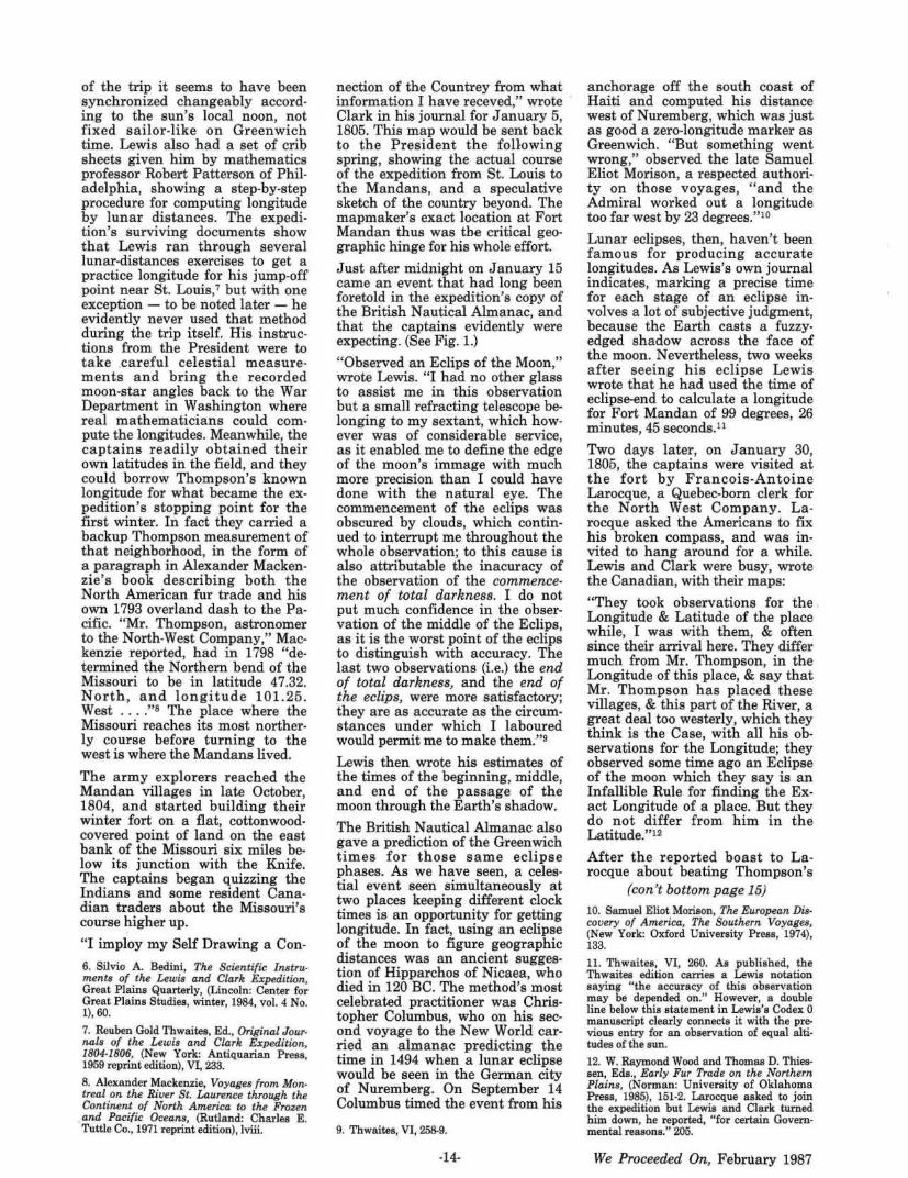
A Page From the British Nautical Almanac and Astronomical Ephemeris
0 B L I Q TJ . I T Y, &c. Obliquily Equation of of the 1805. Ecliptic. Ec~i?oaial
OIOts. D. l\f. s. s.
'-3· '-7· 5:, 8 - J an. r. + 16, 0 z3. z7. 52, 9 Apr. J. + 16, 6 : 3.27.p,2 - J uly 1. - + 17, l 23.z7.51,1 Ott. l. + 17· 4 23• '1.7· 49,z Dec. 3r. - - - - - + 17• 7
S 0 L A R -~ND LUNAR E C L I PS E S IN TH E Y EAR 1805.
Jan. 14. AfOON ulipfed, partly vifible at Gmnwich. H. M. Beginning of the Eclipfe - • - - • - - - r 8. 4:i Bcginnitq of total Darkne[~ - - - - - l 9. 40 0 rifes - - - - • • - - - - • - - - - - l 9. ;3 Ecliptic 8 - - • - - - - - - - - 2 0 . z9 Middle - - - - - - - - - - • - - - - zo. ll qf End of total Darknefs • - • - - - - ar. 19 End of the Eclipfe - - • - - - - - az . 17
Digits ecli.pfcd, 2 0 °. 5z', in N. Part of 9'1 Shadow.
Jan. 30 . SUN eclipfed, i1111f(ib!e at Greenwich. d at 6h. 58', in Long. i o1• I0°.3 3', ]) 's Lat. 1° .21' N.
June 26. SUN tclipfl"d, in-;.iifib!c at Grcewu.1ich. . d a t ll".13', in Long •. J ' · :i."· +i .' j) '.;Lat. ro. 4'{-. N.
July lI. ilfOO"f! cdiJ/i·d, partly vf/ible at G'reemQich. H. M. Bcg1!1ning of chc F.cl ipre - - - - • • • 7. 3-}
}) nfes - - - - - - - - • - - 8. ~ Bc~ inning of tota l D.1rknefs - - S. 13 '!. MiJJlc - - - - • - - • - - - - • - s. 58,: .Ecliptic 8 • - · - • • • • • • • 9• I; End of tora l Darkncfs • • - - - • - - 9 . 4~ I EndofthcEclipfc - - - - - - - - - • 1o. 53I
Digits cdipfcd, 16°. z6', in ~ .. Part of 9 ' s Shadow?"
July 25. SUN eclipfed, ;,;vi/iblt at Gr(enwich. d at 1S b. z1
1, in Long . +·· :i.0 • 44', J) 's Lat. 1°. zS'! S.
Dcc.zo. SUN eclipfad, in"'•iJibl.- 111 r.r~enwich. . d at 1_:z.h. 7'~, iu Long. S·. zS 0 • 46', » 's L at . 47'1-South. 0 will be ccnt r:dh· e.-t ipfod on rhe Meridian at 12h.9'.35' '. in Long; 177 •.36'~ Eafi,andLa t. S5°~S.
-Figure I-An eclipse of the moon is predicted by the British Nautical Almanac and Astronomical Ephemeris for January 14, 1805. With Greenwich astronomical time then reckoned from noon, the eclipse was seen on calendar January 15 at dawn in England and just after midnight at the Mandan villages, where Meriwether Lewis tried to use the time difference to compute his longitude. Examining the eclipse calculations five years later, mathematician Ferdinand Rudolph Hassler thought Lewis was guilty of s loppy arithmetic.
-13-
of the trip it seems to have been synchronized changeably according to the sun's local noon, not fixed sailor-like on Greenwich time. Lewis also had a set of crib sheets given him by mathematics professor Robert Patterson of Philadelphia, showing a step-by-step procedure for computing longitude by lunar distances. The expedition's surviving documents show that Lewis ran through several lunar-distances exercises to get a practice longitude for his jump-off point near St. Louis,7 but with one exception - to be noted later - he evidently never used that method during the trip itself. His instructions from the President were to take careful celestial measurements and bring the recorded moon-star angles back to the War Department in Washington where real mathematicians could compute the longitudes. Meanwhile, the captains readily obtained their own latitudes in the field, and they could borrow Thompson's known longitude for what became the expedition's stopping point for the first winter. In fact they carried a backup Thompson measurement of that neighborhood, in the form of a paragraph in Alexander Mackenzie's book describing both the North American fur trade and his own 1793 overland dash to the Pacific. "Mr. Thompson, astronomer to the North-West Company," Mackenzie reported, had in 1798 "determined the Northern bend of the Missouri to be in latitude 47.32. North, and longitude 101.25 . West .... "s The place where the Missouri reaches its most northerly course before turning to the west is where the Mandans lived.
The army explorers reached the Mandan villages in late October, 1804, and started building their winter fort on a flat, cottonwoodcovered point of land on the east bank of the Missouri six miles below its junction with the Knife. The captains began quizzing the Indians and some resident Canadian traders about the Missouri's course higher up.
"I imploy my Self Drawing a Con-
6. Silvio A. Bedini, The Scientific Instruments of the Lewis and Clark Expedition, Great Plains Quarterly, (Lincoln: Center for Great Plains Studies, winter, 1984, vol. 4 No. 1), 60.
7. Reuben Gold Thwaites, Ed., Original Journals of the Lewis and Clark Expedition, 1804-1806, (New York: Antiquarian Press, 1959 reprint edition), VI, 233.
8. Alexander Mackenzie, Voyages from Montreal on the River St. Laurence through the Continent of North America to the Frozen
. and Pacific Oceans, (Rutland: Charles E. Tuttle Co., 1971 reprint edition), !viii.
nection of the Countrey from what information I have receved," wrote Cla rk in his journal for January 5, 1805. This map would be sent back to the President the following spring, showing the actual course of the expedition from St. Louis to the Mandans, and a speculative sketch of the country beyond. The mapmaker's exact location at Fort Mandan thus was the critical geographic hinge for his whole effort.
Just after midnight on J anuary 15 came an event that had long been foretold in the expedition's copy of the British Nautical Almanac, and that the captains evidently were expecting. (See Fig. L)
"Observed an Eclips of the Moon," wrote Lewis. "I had no other glass to assist me in this observation but a small refracting telescope belonging to my sextant, which however was of considerable service, as it enabled me to define the edge of the moon's immage with much more precision than I could have done with the natural eye. The commencement of the eclips was obscured by clouds, which continued to interrupt me throughout the whole observation; to this cause is also attributable the inacuracy of the observation of the commencement of total darkness. I do not put much confidence in the observation of the middle of the Eclips, as it is the worst point of the eclips to distinguish with accuracy. The last two observations (i.e.) the end of total darkness, and the end of the eclips, were more satisfactory; they are as accurate as the circumstances under which I la boured would permit me to make them."9
Lewis then wrote his estimates of the times of the beginning, middle, and end of the passage of the moon through the Earth's shadow.
The British Nautical Almanac also gave a prediction of the Greenwich times for those same .eclipse phases. As we have seen, a celestial event seen simultaneously at two places keeping different clock times is an opportunity for getting longitude. In fact, using an eclipse of the moon to figure geographic distances was an ancient suggestion of Hipparchos of Nicaea, who died in 120 BC. The method's most celebrated practitioner was Chris· topher Columbus, who on his second voyage to the New World carried an almanac predicting the time in 1494 when a lunar eclipse would be seen in the German city of Nuremberg. On September 14 Columbus timed the event from his
9. Thwaites, VI, 258-9.
-14-
anchorage off the south coast of Haiti and computed his distance west of Nuremberg, which was just as good a zero-longitude marker as Greenwich. "But something went wrong," observed the late Samuel Eliot Morison, a respected authority on those voyages, "and the Admiral worked out a longitude too far west by 23 degrees."10
Lunar eclipses, then, haven't been famous for producing accurate longitudes. As Lewis's own journal indicates, marking a precise time for each stage of an eclipse involves a lot of subjective judgment, because the Earth casts a fuzzyedged shadow across the face of the moon. Nevertheless, two weeks after seeing his eclipse Lewis wrote that he had used the time of eclipse-end to calculate a longitude for Fort Mandan of 99 degrees, 26 minutes, 45 seconds.11
Two days later, on January 30, 1805, the captains were visited at the fort by Francois-Antoine Larocque, a Quebec-born clerk for the North West Company. Larocque asked the Americans to fix his broken compass, and was invited to hang around for a while. Lewis and Clark were busy, wrote the Canadian, with their maps:
"They took observations for the . Longitude & Latitude of the place while, I was with them, & often since their arrival here. They differ much from Mr. Thompson, in the Longitude of this place, & say that Mr. Thompson has placed these villages, & this part of the River, a great deal too westerly, which they think is the Case, with all his observations for the Longitude; they observed some time ago an Eclipse of the moon which they say is an Infallible Rule for finding the Exact Longitude of a place. But they do not differ from him in the Latitude."12
After the reported boast to Larocque about beating Thompson's
(can't bottom page 15) 10. Samuel Eliot Morison, The European Discovery of America, The Southern Voyages, (New York: Oxford University Press, 1974), 133.
11. Thwaites, VI, 260. As published, the Thwaites edition carries a Lewis notation saying "the accuracy of this observation may be depended on." However, a double line below this statement in Lewis's Codex 0 manuscript clearly connects it with the pre· vious entry for an observation of equal altitudes of the sun. 12. W. Raymond Wood and Thomas D. Thiessen, Eds. , Early Fur Trade on the Northern Plains, (Norman: University of Oklahoma Press, 1985), 151-2. Larocque asked to join the expedition but Lewis and Clark turned him down, he reported, "for certain Governmental reasons." 205.
We Proceeded On, February 1987
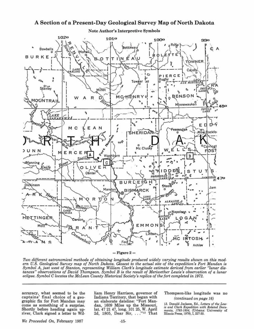
A Section of a Present-Day Geological Survey Map of North Dakota
"' Bowbells 0 r
B U R KE ~J I
0,. ~~nley
j MQ(JNTRAI
Note Author's Interpretive Symbols
1010
Jam ... ....,
-Figure2 -
Two different astronomical methods of obtaining longitude produced widely varying results shown on this modern U.S. Geological Survey map of North Dakota. C/,osest to the actual site of the expedition's Fort Mandan is Symbol A, just west of Stanton, representing William Clark's longitude estimate derived from earlier "lunar distances" observations of David Thompson. Symbol B is the result of Meriwether Lewis's observation of a lunar eclipse. Symbol C locates the McLean County Historical Society's replica of the fort completed in 1972.
accuracy, what seemed to be the captains' final choice of a geographic fix for Fort Mandan may come as something of a surprise. Shortly before heading again upriver, Clark signed a letter to Wil-
We Proceeded On, February 1987
liam Henry Harrison, governor of Indiana Territory, that began with an elaborate dateline: "Fort Mandan, 1609 Miles up the Missouri, lat. 47 21 47, long. 101 25, W. April 2d, 1805, Dear Sir, " 13 That
-15-
Thompson-like longitude was no (continued on page 16)
13. Donald Jackson, Ed., Letters of the Lewis and Clark Expedition with Related Documents, 1783-1854, (Urbana: University of Illinois Press, 1978), I, 227-30.
slip of the pen, because Clark headed another letter of the same date to William Croghan, his brother-in-law, with the same coordinates. Finally, Clark's big map sent back to Washington that month positioned Fort Mandan west of the lOlst meridian,14 just about where those datelines of the April 2 letters would place it. (See Fig. 2:)
Now, Lewis and Clark didn't have access to the written-out Thompson longitude of precisely 101 degrees, 14 minutes, 24 seconds for the main Mandan village, which wasn't published in that form until much later. But an eye-measurement of the Thompson map copied by L.ewis would have made 101 degrees, 25 minutes look about right. Also, it may have been no accident that the longitude heading Clark's letters was the same, digit for digit, as the Thompson coordinate for the Missouri's "Northern bend" reported in Mackenzie's book. Remember, the captains had that book.
Why the apparent change of mind? With no documentary evidence to guide us, the answer can only be speculative. One possibility is simply that somebody's leg was being pulled. Lewis's journal entries for his eclipse calculations have a tentative sound, with nothing like a claim that he was following an "infallible rule" for getting longitude. Except for Larocque's report of the captains' belief in eclipse infallibility, there's no other evidence to back him up. It's not hard to picture the two American officers whiling away a· long winter evening by joshing their North West Company visitor about the shortcomings of one of the firm's surveying wizards. The wild claim of an " infallible rule," if made with a straight face, might easily have left a strong impression on a fur trader who had never heard about the lunar misadventures of Christopher Columbus.
But what if the captains disagreed about the Mandan longitude, with Lewis really believing in his eclipse figure of 99-plus degrees, and Clark holding out for a Thompson-like 101-plus? Clark had noted the occurrence of the eclipse in his own journal, but only in a glancing· way, just as he was later to report with odd detachment the sad fate of Lewis's cherished iron boat. Yet it was Clark who was in charge of making the extensive map to be sent back to Washing-
14. Moulton, Atlas, map 32a.
ton, and of fixing Fort Mandan's place upon it. It's possible that the Thompson longitude simply made more sense to him in the map's entire context than did Lewis's coordinate, far to the east in the present-day North Dakota prairie. You can imagine that red-headed officer stubbornly sticking to his geographic guns, despite the lunar enthusiasm of his younger partner.
An attempt to settle the argument, if there was one, may have been made on February 23, 1805, when Lewis measured the sky-angle between the sun and the moon and began a lunar distances calculation to obtain longitude.15 There's no record of him trying that at any other point during the whole expedition, after leaving St. Louis. Lewis started figuring on the blank side of a sheet of paper on which Clark had written some upriver field notes the previous summer, but after 18 lines the calculation abruptly ends. There's no indication whether it was finished elsewhere, or what his result was, if any.
As the expedition was preparing to leave Fort Mandan in April, it would appear that both captains had agreed on the map coordinates they would send home. Certainly, the agreed latitude of 47 degrees, 21 minutes, 47 seconds North shows up on all the Fort Mandan documents. Also, it's reasonable to assume that Lewis had concurred in the 101 degree, 25 minute West longitude used on Clark's letters and on Clark's big map. If there was an argument, Clark seems to have prevailed. That conclusion is reinforced by a June 25, 1805 letter from President Jefferson to exCongressman (later Secretary of War) William Eustis which began: "I have the pleasure to inform you that one of Capt. Lewis's barges, returned to St. Louis brings us certain information from him. He wintered with the Mandanes, 1609. miles up the Missouri, Lat. 47. Long. 101 degrees with some additional minutes to both numbers, all well .... "16 The president was hewing to the company line.
How strange, then, is the longitude story's final twist. For on February 19, 1806, in his official report to Congress on the expedition's progress, Jefferson wrote: "They entered the Missouri May 14. 1804.
15. Thwaites, VI, 261; Ernest Staples Osgood, Ed., The Field Notes of Captain William Clark, (New Haven: Yale University Press, 1964), 259.
16. Jackson, I, 249.
-16-
and on the 1st of Nov. took up their winter quarters near the Mandan towns, 1609 miles above the mouth of the river, in Lat. 47 degrees 21 minutes 47 seconds N. and Long. 99 degrees 24 minutes 45 seconds W. from Greenwich."17
Jefferson used the orthodox upriver distance and latitude, but h e oddly reverted to Lewis's lunar eclipse longitude. The rather formal report dated April 7, 1805, which Lewis sent to the President from Fort Mandan contained no map coordinates. However, before writing his report to Congress Jefferson would have had time to exa.mine the notebook (called Codex 0 by expedition journal editor Elliott Coues) containing Lewis's astronomical observations, and believed to be among the documents sent back from Fort Mandan in the spring of 1805. That notebook contains the previously-quoted account of the eclipse and the longitudes calculated from it . For some unknown reason Jefferson preferred to give Congress that 99 degree-plus estimate instead of the Clark-Thompson longitude of 101-plus, never mind any agreement the captains may have reached at the scene.
The two-degree difference amounted to less than 100 miles of empty prairie, and it wasn't terribly consequential to the expedition's success. But Lewis, Clark and Jefferson were men who prided themselves on getting the details right, and together they made a hash of this one. Exactly how it happened is likely to remain one of the expedition's smaller unsolved mysteries, an intriguing little yarn within one of history's greatest adventure stories.
17. J ackson, I , 299. Lewis actually computed two longitudes from two stages of the eclipse, getting 99 degrees and arc-minute estimates of 22 and 26; arc-seconds were the same at 45. Jefferson evidently took it upon himself to split the difference at 24 minutes, so that he could report a single longitude to Congress.
We Proceeded On, February 1987
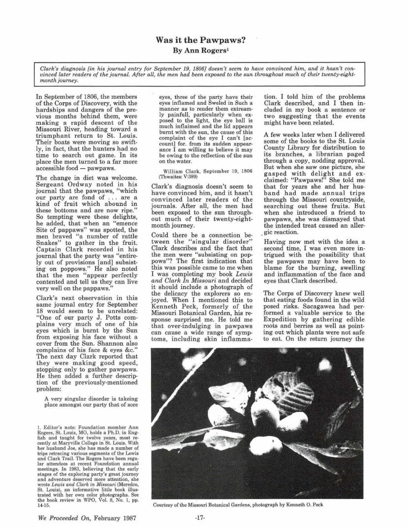
Was it the Pawpaws? By Ann Rogers1
Clark's diagnosis [in his journal entry for September 19, 1806} doesn't seem to have convinced him, and it hasn't convinced later readers of the journal. After all, the men had been exposed to the sun throughout much of their twenty-eightmonth journey.
In September of 1806, the members of the Corps of Discovery, with the hardships and dangers of the previous months behind them, were making a rapid descent of the Missouri River, heading toward a triumphant return to St. Louis. Their boats were moving so swiftly, in fact, that the hunters had no time to search out game. In its place the men turned to a far more accessible food - pawpaws.
The change in diet was welcome. Sergeant Ordway noted in his journal that the pawpaws, "which our party are fond of . . . are a kind of fruit which abound in these bottoms and are now ripe." So tempting were these delights, he added, that when an "emence Site of pappaws" was spotted, the men braved "a number of rattle Snakes" to gather in the fruit. Captain Clark recorded in his journal that the party was "entirely out of provisions [and] subsisting on poppows." He also noted that the men "appear perfectly contented and tell us they can live very well on the pappaws."
Clark's next observation in this same journal entry for September 18 would seem to be unrelated: "One of our party J. Potts complains very much of one of his eyes which is burnt by the Sun from exposing his face without a cover from the Sun. Shannon also complains of his face & eyes &c." The next day Clark reported that they were making good speed, stopping only to gather pawpaws. He then added a further description of the previously-mentioned problem:
A very singular disorder is takeing place amongst our par ty that of sore
1. Editor's note: Foundation member Ann Rogers, St. Louis, MO, holds a Ph.D. in Eng· lish and taught for twelve years, most re· cently at Maryville College in St. Louis. With her husband Joe, she has made a number of trips retracing various segments of the Lewis and Clark Trail. The Rogers have been regular attendees at recent Foundation annual meetings. In 1983, believing that the early stages of the exploring party's great journey and adventure deserved more attention , she wrote Lewis a.nd Cla.rk in Missouri (Meredco, St. Louis), an informative little book illus· trated with her own color photographs. See the book review in WPO, Vol. 8, No. 1, pp. 14-15.
We Proceeded On, February 1987
eyes, three of the party have their eyes inflamed and Sweled in Such a manner as to render them extreamly painfull, particularly when exposed to the light, the eye ball is much inflaimed and the lid appears burnt with the sun, the cause of this complaint of the eye I can't [account] for. from its sudden appearance I am willing to believe it may be owing to the reflection of the sun on the water.
William Clark, September 19, 1806 (Thwaites: V:389)
Clark's diagnosis doesn't seem to have convinced him, and it hasn't convinced later readers of the journals. After all, the men had been exposed to the sun throughout much of their twenty-eightmonth journey.
Could there be a connection between the "singular disorder" Clark describes and the fact that the men were "subsisting on poppows"? The first indication that this was possible came to me when I was completing my book Lewis and Clark In Missouri and decided it should include a photograph of the delicacy the explorers so enjoyed. When I mentioned this to Kenneth Peck , formerly of the Missouri Botanical Garden, his response surprised me. He told me that over-indulging in pawpaws can cause a wide range of symptoms, including skin inflamma-
tion. I told him of the problems Clark described, and I then included in my book a sentence or two suggesting that the events might have been related.
A few weeks later when I delivered some of the books to the St. Louis County Library for distribution to its branches, a librarian paged through a copy, nodding approval. But when she saw one picture, she gasped with delight and exclaimed: "Pawpaws!" She told me that for years she and her husband had made annual trips through the Missouri countryside, searching out these fruits. But when she introduced a friend to pawpaws, she was dismayed that the intended treat caused an aller-
. gic reaction.
Having now met with the idea a . second time, I was even more intrigued with the possibility that the pawpaws may have been to blame for the burning, swelling and inflammation of the face and eyes that Clark described.
The Corps of Discovery knew well that eating foods found in the wild posed risks. Sacagawea had performed a valuable service to the Expedition by gathering edible roots and berries as well as pointing out which plants were not safe to eat. On the return journey the
Courtesy of the Missouri Botanical Gardens, photograph by Kenneth 0. Peck
-17-
captains had obtained bread and roots from the Nez Perces but would not allow their men to gather roots themselves lest they mistakenly collect poisonous hemlock. Sometimes the men had become ill from plants they ate. For example, camus roots eaten in excess caused stomach upsets.
I decided to read more about pawpaws in an attempt to learn if this fruit could have caused the distressful symptoms mentioned in the journals. The pawpaw, found from New York to Nebraska and southward, h as the botanical name Asimina triloba and belongs to the custard apple family. The small tree grows in wooded valleys, preferring the rich soil along streams. Its leaves are very large, and in the spring there are maroon flowers in two sets of three-lobed layers.
Edgar Denison in Missouri Wildflowers says that " the fruit is oblong, 3" to 5" long . . . [and] contains a delicious custard." As described by Oliver Perry Medsger in Edible Wild Plants, the fruits , which mature in autumn, "resemble stubby bananas," while "the sweet edible pulp is bright yellow and surrounds the large brown seeds." Medsger adds that "on the return journey of Lewis and Clark ... an abundance of papaws grew on the banks of the river and supplied them with nourishing food."
But the possibility that discovering "an abundance of papaws" may have been a mixed blessing is suggested by other studies. In Wild Edibles of Missouri, Jan Phillips says that pawpaws, although edible, "are a source of allergic reactions to certain individuals as a result of either eating or touching them." John Tampion in Dangerous Plants lists the fruit among "plants causing dermatitis," usually characterized by a redness, swelling, and itching of the skin. In a book entitled Poisonous Plants of the United States, Walter Conrad Muenscher warns: "Although the fruits are edible, susceptible persons have developed a dermatitis from handling them." Such "poisoning by contact" can be "minor and temporary irritation or a painful irritation and inflammation."
These studies suggest that the men of the Corps of Discovery could have experienced allergic reactions from gathering pawpaws or even from touching the fruit while eating it. The fact that the irrita tion seems, according to Cl~rk's journal, to h ave been confined to the
face and eyes may also be explainable. Two and a half years of h andling boats, chopping wood, a nd performing similar tasks would have made the men's hands calloused and insensitive. But it's easy to imagine the men . in the heat and humidity (September 16 was the hottest day Clark had recorded that year) frequently wiping sweat from their eyes. And in doing this, any allergens on their hands would be transferred to the far more vulnerable area of their eyes.
Inflammation caused by the men handling pawpaws and then conveying the allergens to their faces and eyes may explain the "singular disorder" Clark writes of, especially when we recall that for several days they were gatherin g large quantities of the fruit and eating nothing else. The hypothesis is, I suppose, unprovable. The intriguing question remains: Was it the pawpaws?
Funds Needed To Print NPS L. & C. Brochure Foundation members of record received with the mailing of the November issue of We Proceeded On a copy of the full color National Park Service Lewis and Clark National Historic Trail brochure. The two column box enclosed text titled "About the Enclosure" on page 35 of the November issue of We Proceeded On provided readers and members with information about the Foundation's interest, development and printing of the initial quantity of 10,000 copies of th e brochure.
The purpose of the Foundation's funding for the first 10,000 printing was specifically for the purpose of publicizing the item and to interest states along the Lewis and Clark Trail to enclose the brochure in their tourist promotional mailings . Previously several Trail States have printed their own broch ures describing local Lewis and Clark sites, landmarks, and the explorers' trail route.
The initial printing of 10,000 is now depleted. Readers will recall that it is necessary, because of limited Federal (NPS) funds, for the Foundation to seek private funds or grants to cover the printing and distribution costs of additional printings of the brochure. The proposal is to print one-half million copies at the cost of approximately $50,000.
To accomplish such a printing it
-18-
will be necessary to have firm orders (at the cost of printing and distribution) or grants from interested individuals, institutions, corporations or Foundation s . The task involving such a cooperative effort is a formidable one!
As of this date we are pleased that we had responses to our requests for financial assistance. We have received two substantial grants for which we h ave expressed our gratitude:
The Montana Power Company, Butte Montana, has contributed $3000.
The Lucius N. Littauer Foundation, New York, New York, has contributed $3000.
"Frenchy" Chuinard Home After Heart Surgery Like the hardy men of the Expedition, Past President Dr. "Frenchy" Chuinard is convalescing at his Tigard, Oregon home after by-pass heart surgery. Late in January he entered Portland's Emanuel hospital (where he had practiced orthopedic surgery for many years) for six hours of open heart surgery. All the reports are that he is on the road to recovery and that he has had no complications. "Frenchy" was one of thirteen who met in St. Louis in 1970 a n d formed our Foundation . In 1974, when our Foundation boasted fifty or sixty members and our publication had its beginning, he obtained several grants to fund the early issues. When we were searching for a name, "Frenchy" suggested We Proceeded On, a n almost daily expression in the explorers' journals.
Greetings can be sen t his way at: 15537 S.W. Summerfield Lane, Tigard, Oregon 97224.
Washington Meeting (con't from page 11) activities are underway. Historic celebrat ions are planned a long the route. Since the TREK closely follows the Snake River in southeastern W ash.in gton, and then the Columbia River from Pasco (Sacajawea State Park) to th e Pacific Ocean, th e route is rich in Lewis and Clark history. The Washington State Lewis and Clark Committee will have the important assignment for interpreting the Expedition's history.
The n ext meeting of the Washington Committee will be at Long Beach, April 4, 1987.
We Proceeded On, February 1987
St. Louis Welcomes and Toasts the Lewis and Clark Expedition
A Newly Discovered 1806 Newspaper Account
By James P. Ronda 1
"I think the list of toasts alone is worth the price of admission! And the toasts do indicate the sense of pride in the expedition and at the same time some uncertainty about its significance."
This pertinent observation is from Dr. Ronda's letter to the editor which accompanied his transmittal of the article.
When the Lewis and Clark Expedition returned to St. Louis on September 23, 1806 William Clark recorded that the explorers were "met by all the village and received a harty welcom from it's inhabitants." [Thwaites, ed., Original Journals, 5: 394.] Just how "harty" that welcome was became clear when two days later prominent St. Louis citizens celebrated the expedition's return with a grand dinner and ball. The event was held at the inn operated by William Christy, a noted city businessman, politician , and someone Clark described as "my old acquaintance."
Because St. Louis did not have a newspaper until 1808, the only report of the festivities appeared in the Frankfort, Kentucky Western World for October 11, 1806. It is here reprinted for the first time since 1806. I would like to thank my good friend James Holmberg, Curator of Manuscripts at The Filson Club, Louisville, Kentucky, for helping me obtain a copy of this very rare issue of The Western World.
* * *
Arrival of Captains Lewis and Clark At St. Louis
This desirable and unexpected event, took place on Tuesday, the 23rd of this instant, about the hour of 10 o'clock in the morning. On Monday evening the news reached this place, that Captains Lewis and Clark had arrived at the cantonment; near the mouth of the Missouri; and the great concourse of people that lined the bank of the river at the time of their landing at this place the next day, must be considered as a strong evidence of the respect entertained of those gentlemen for the danger and dif-
1. Foundation Director James P. Ronda needs no introduction to Foundation members and western history enthusiasts. His recent volume Lewis and Clark among the Indians (University of Nebraska Press, 1984, reviewed in WPO, Vol. 11, No. 2); his lectern presence and address at the Foundation's 13th Annual Banquet, Helena, MT, 1981, (transcribed in WPO, Vol. 7, No. 4); and his article "Frazer's Razor: The Ethnohistory of a Common Object" We Proce('ded On (Vol. 7, No: 3), reveal his deep study of the Lewis and Clark Expedition. A productive writer, Dr. Ronda is the author of five full-length books, many scholarly papers and essays, and a frequent reviewer of books relating to western history. He is a popular and dedicated professor of history at Youngstown State University, Youngstown, Ohio. In addition to a busy teaching schedule, Dr. Ronda's new book titled: Astoria and Empire is nearing completion and is to be published by the University of Nebraska Press.
We Proceeded On, February 1987
ficulties they must have encountered in their expedition of discovery. But the citizens of St. Louis, anxious to evince fully their joy at this event, (which cannot but be considered as very interesting to every American) united in celebrating their arrival by a splendid dinner at Christy's Inn, on the 25th, which was succeeded by a Ball in the evening. The respectable number of persons who attended both the dinner and ball, given on the occasion, together with the unanimity which prevailed throughout the company, cannot but be esteemed an h onorable testimony of the respect entertained for those characters who are willing to encounter, fatigue and hunger for the benefit of their fellow citizens: but what is not due to those who penetrate the gloom of unexplored regions, to expel the mists of ignorance which envelope science, and overshadow their country?
The following were the Toasts drank at the Dinner: '
1. The president of the United States - The friend of science, the polar star of discovery, the philosopher and the patriot.
2. The Heads of Department -The pillars that support the world's best hope.
3. The Missouri expedition -May the knowledge of the newly explored regions of the West, be
-19-
the least benefit that we may derive from this painful and perilous expedition.
4. The hardy followers of Captains Lewis and Clark - May they be rewarded by the esteem of their fellow citizens.
5. The United States - Whilst they tolerate a spirit of enquiry, may never forget, that united they stand - but divided they fall.
6. The Territory of Louisiana -Freedom without bloodshed, may her actions duly appreciate the blessing.
7. The memory of Christopher Columbus - May those who imitate his hardihood, perseverence and merit, never have, like him, to encounter public ingratitude.
8. The Federal Constitution -May the Eagle of America convey it to the remotest regions of the globe; and whilst they read they cannot but admire.
9. The memory of the illustrious Washington, the father of America - May his guardian spirit still watch over us, and prove a terror to the engines of despotism.
10. The Capitol of the United States - May the goddess of liberty, never cease to preside there.
11. Peace with all nations; but submission to none.
(continued on page 20)
12. The Commerce of the United States - The basis for the political elevation of America.
13. Agriculture and Industry -The farmer is the best support of government.
14. Our fathers who shed their blood and laid down their lives to purchase our independence - May we emulate their actions, and inherit their virtues.
15. The Missouri - Under the auspices of America, may it prove a vehicle of wealth to all the nations of the world.
16. Our National Council -May the baneful influence of private ambition and political intrigue; be ever expelled thence by the genuine spirit of republicanism.
17. The fair daughters of Louisiana - May they ever bestow their smiles on hardihood and virtuous valor.
After Capts. Lewis and Clark retired:
18. Captains Lewis and Clark -Their perilous services endear them to every American heart.
News from Idaho Chapter Meeting Scheduled
The Idaho Chapter of the Lewis and Clark Trail Heritage Foundation will gather May 2, 1987, in Orofino for its spring meeting, according to chapter president and Foundation director James R. Fazio. The primary agenda item for the meeting will be to "develop a skeletal plan" for the 1990 annual meeting of the Foundation which will be hosted by the chapter.
Governor's Committee In his newsletter to the chapter members and to the Governor's Lewis and Clark Committee, Fazio commented on the rise of public interest in the Lewis and Clark Trail and its importance to Idaho tourism: "There is no question that public interest in the Lewis & Clark Trail route is on the rise. It is a goal of the governor's committee to foster this interest because of the direct link to increased tourist income for the state. It is also a way to h elp protect the trail route from the encroachment of roads, logging or developments of one kind or another. Therefore, it is
heartening to see such excellent news media coverage as provided by Edward W. Stepanek in the Salmon Recorder-Herald following our meeting. We also made it on the radio in Salmon prior to the meeting. Other items lately have appeared in the Lewiston Tribune. To wit:
The Lewis-Clark Economic Development Corporation would like to see a L&C museum built at the confluence of the Snake and Clearwater Rivers. A hotel-convention center developer has offered a parcel of land for the project, and a Spokane architectural firm has volunteered its services.
[The price of the facility is placed at $500,000, with much of it to be raised through grants. The planners think it could be self-supporting once in operation. They also envision "signboards all along the 4,500-mile trail advertising . . . the museum" which they think would be "the first of its kind along the trail." Neither Idaho L&C committee has been invited to participate in the planning of the project.]
Clearwater Forest Plan
Updating chapter and committee members on the Clearwater National Forest Management Plan, Fazio writes: "Word from Jim Bates, supervisor of the Clearwater National Forest, is that the Forest Plan is now scheduled for completion next June. Delays have been caused by a number of factors, but the main one is a hold put on the planning process by the assistant Secretary of Agriculture to study 'cumulative effects' of forest plans in Idaho 'on the timber supply and the potential impacts on local communities.' Also, responses are being prepared by the Forest Service to 3250 letter-writers who expressed opinions on proposed management of the Clearwater. The final plan will be of considerable significance to the future of the Lewis & Clark Trail route through Idaho."
U of I to Repeat L&C Course "Encouraged by the success of last year's summer course titled 'On the Trail of Lewis and Clark,' the University of Idaho will again hold the week-long program in August of 1987," Fazio writes. "On behalf of the L&C Trail committees, I wrote a letter of support for archaeologist Priscilla W egars who is applying for a grant to add a special dimension to the 1987 course. Ms. Wegars has proposed that she accompany the other instructors and include discussion about archaeology, ethics involv-
-20-
ing artifacts and cultural differences, and perhaps even to include a small 'dig' at a known site of historical or prehistorical activity."
Another Idaho-related Lewis and Clark news item - "Smithsonian Tour Program to sponsor L&C tour" - can be found on page 23 of this issue of WPO.
Change of Address A costly part of the distribution and mailing of our quarterly publication, WE PROCEEDED ON is the administration and han.dling of mailed-out copies of the publication that are returned because the addressee has moved. Whether or not members have left a forwarding address with their post office when they moved, WPO is returned to the Foundation. We mail our magazine on a Non-Profit-Organization bulk mail permit (a reduced rate type of Third-Class Mail, at about .052 to .08 per issue dependin·g on the numper of pages, inserts, and total weight). This type of mail is not eligible for forwarding and is returned to the sender (the Foundation). When it is returned we are assessed "Postage Due" at the regular singlepiece Third-Class Rate (anywhere from .56 to .98 depending on weight). If and when we have your' new address (sometimes provided by the post office), we mail out the returned issue to you and this postage costs us the same as the "Postage Due" fee when it was returned. The total cost of such transactions, therefore, costs the Foundation anywhere from $1.12 to $1.96.
If you are about to move, it would be much appreciated if you would provide us with your new address (the USPS has a card for this purpose, their Form 3576) - it will save the Foundation money as well as administration time.
We Proceeded On, February 1987
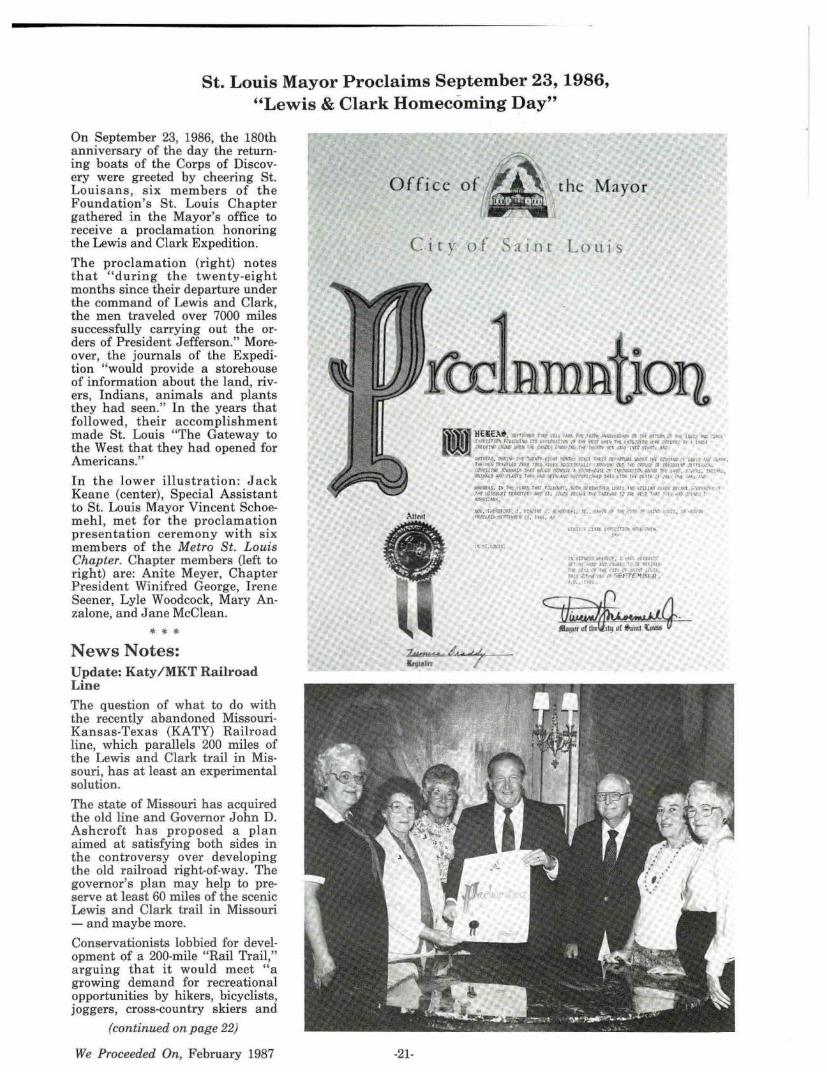
St. Louis Mayor Proclaims September 23, 1986, "Lewis & Clark Homecoming Day"
On September 23, 1986, the 180th anniversary of the day the returning boats of the Corps of Discovery were greeted by cheering St. Louisans , six members of the Foundation's St. Louis Chapter gathered in the Mayor's office to receive a proclamation honoring the Lewis and Clark Expedition.
The proclamation (right) notes that "during the twenty-eight months since their departure under the command of Lewis and Clark, the men traveled over 7000 miles successfully carrying out the orders of President Jefferson." Moreover, the journals of the Expedition "would provide a storehouse of information about the land, rivers, Indians, animals and plants they had seen." In the years that followed, their accomplishment made St. Louis "The Gateway to the West that they had opened for Americans."
In the lower ill us tr a ti on: Jack Keane (center), Special Assistant to St. Louis Mayor Vincent Schoemehl, met for the proclamation presentation ceremony with six members of the Metro St. Louis Chapter. Chapter members (left to right) are: Anite Meyer, Chapter President Winifred George, Irene Seener, Lyle Woodcock, Mary Anzalone, and Jane McClean.
* * * News Notes: Update: Katy /MKT Railroad Line
The question of what to do with the recently abandoned MissouriKansas-Texas (KATY) Railroad line, which parallels 200 miles of the Lewis and Clark trail in Missouri, has at least an experimental solution.
The state of Missouri has acquired the old line and Governor John D. Ashcroft has proposed a plan aimed at satisfying both sides in the controversy over developing the old railroad right-of-way. The governor's plan may help to preserve at least 60 miles of the scenic Lewis and Clark trail in Missouri - and maybe more.
Conservationists lobbied for development of a 200-mile "Rail Trail," arguing that it would meet "a growing demand for recreational opportunities by hikers, bicyclists, joggers, cross-country skiers and
(continued on page 22)
We Proceeded On, February 1987
Office of~ the Mayor l I
C i ty o f Saint Louis
-21-
g HEl£.\li, uf'!Th•' ,,. tu Ir.Ml. h-t 1w .. \.\"'!·'~" ri.~ ,,.,... L'1 M u-.:.' '" i.'·· CVtrl'fC\ J,"UMW 171 l•llf't\~f~"\ CJ :of tlJf """\ !""( fll~,'flQ •lt'f (•tft IN a t411.r MA'l'llt rt..W :i.'-h• ,,. ,~._,, 1"sYf\f. hf f.,lfh .,, ~·l f\"TC r. .. , 4\:
• · f'Q.U, MPt I• I r •. :nJJ ti II.I ,,,i..: Sl\..1 flitJt rtrAl't:,iJf f,..,,,""."t,, '"" , ... , ..., 10.s \\, ~'""· n.:t.. tit\ ;'V.r;'ftff t'Vli: 'ftl 'llf'l ~Yf'51!.il A;it>f'I t\rT r,1, ~t.-'tS ~'f rtf~l;l\1 .'fllt \, Cdlil'tll•.A~U fo..4fll"l..l.f rtt."Vl.t A 0.''lt~ •• , ?\f(l.::MlZC\ Mi'CT r,.1 ,.-,,, • 1: •. u . :\fl .. \~· . A!tlMAL.l "'\'!l r&.A.\15 ltth rrAI <ff\ A\~ • XMIJ~ Tlff~ .iiln. l"H rt.-1'11' ,'I. ~. , '\( ..0.1 ~VI
¥1HfA!. !fl .,,,,,.., •tAU T""I ri;t~Lt\.1 • ~·h llftf~ft"if tk'l'I. 1"111\' •:tUA•l ~ . .... ··~.t ..... tf',. · ~ ·r Tit !d$$.C'UIU f(fdf'O ,...~·SI. '"·U •h~ I fhl -4!..,1..lt r: nif "--·' ld.l t.r 'I ; ...... I ' l,MJllJI~.
'4'\>, Ttrtl'O+l\'' , 1. fll«1lrll' t . ... °"' J~1, '¥. , Wh,,- Jll IP1 •l"' " µf\t I ;:, .. l;f.U~ rtt'CL.l.ijj ~'11,,•t ;•, l'h, 4<1
f\. ;l\.tU .,>!~•"· ; t ~.tft1V I.,~ ... ~~\,,.,._(!'' (&fl;•t ~ \l.'flltf(;r- "'"!\1t.?, tt1,$.(, ~"" ...... <liiH~t'1BlH. ~.r . . ,.,,,

other outdoor enthusiasts," and be a boon to tourism.
Foundation director Winifred C. George of St. Louis who was elected to a steering committee organized to form a coalition of all outdoor groups to keep the trail intact, recently wrote: "I am pushing for naming it L&C Missouri River Trail - who but a few Missouri people know what MKT or KATY is?? EVERYONE WILL RECOGNIZE LEWIS AND CLARK - the historic value can't be overlooked."
The newly formed coalition is known as Lewis and Clark Nature Trail Coalition. This name refers to the Trail section from St. Charles to Augusta, MO. The Trail section from Jefferson City to Rocheport will be called the KATY Missouri River Trail.
Opposing the development of the
railroad line, which was abandoned last summer, are the Missouri Farm Bureau, the Missouri Farmers Association and some local farmers. The opponents argue that security of farm property adjacent to the proposed trail would be in jeopardy. They say that bicycling is merely a fad and that state parks and other conservation areas provide sufficient room for outdoor enthusiasts.
By September 16, Governor Ascroft had received 7307 expressions of concern supporting the rails-totrails idea and 560 expressions of concern against it. Recent developments, however, have put the Governor's plans on hold. It seems that 250 farmers have filed suit to stop development of any trail plan along the old railroad line. This suit is being answered by the Rails- to- Trails Conservancy of Washington, D.C.
By Sept. 16, Governor Ascroft had received 7307 expressions of concern supporting the rails-to-trails idea and 560 expressions of concern against it. However, recent developments have put the governor's plans on hold. It seems that 250 farmers have filed suit to stop development of any trail plan along the old railroad line.
Should the governor's plan survive the law suit, two fragments of the line would be designated for trail development. These are in areas where enthusiasm for trail development is highest. There would be no trail development for the time being where opposition is greatest.
One trail section would extend from St. Charles to Augusta, Mo., and the other from Jefferson City to Rocheport.
Opponents to trail development
Oregon [Governor's] L. & C. Trail Committee and Lewis & Clark College Host Christmas Party
On Friday, December 12, 1986, Oregon Lewis and Clark Committee members (the Governor's Committee); members of the Oregon Lewis and Clark Heritage Foundation; Super· .intendent Franklin Walker and several staff members, Fort Clatsop National Memorial, Astoria, Oregon; and Lewis and Clark College President James A. Gardner and faculty members joined with their wives and guests for a fine Christmas Party. A delicious turkey (with all the trimmings) dinner was served the fifty individuals who gathered in an attrac· tively decorated room in the Lewis and Clark College's Templeton Center. Stephen Dow Beckham, professor of his-
. tory, Lewis and Clark College, acted as master of ceremonies. Dr. Chuinard, chairman of the Oregon Committee presided for a brief committee meeting and introduced guests. Special guests were H. John Montague and Mrs. (Diana) Montague, Marietta, Georgia. (John is 1st vice president of the (national) Lewis and Clark Trail Heritage Foundation.)
Pictured above at the head table are: (from left) Dee and Malcolm Buffum (Malcolm is President of the Oregon Lewis and Clark Heritage Foundation, and is a Director of the na· tional Foundation); Dr. Stephen Beckham (History Depart· ment, Lewis and Clark College); Lewis and Clark College President James A. Gardner; and Committee Chairman "Frenchy" Chuinard and Mrs. (Fritzi) Chuinard. In the low· er right hand picture Dennis and Jan Hagen provided entertainment and led the group in several Christmas carols
-22-
(Dennis is professor of music at George Fox College, Newberg, Oregon and is working on the development of a Lewis and Clark pageant with the Clatsop County Historical Pageant Association).
Following dinner, the group adjourned to the Council Chamber where Dr. Beckham showed slides and told the gathering about his history classes' annual spring learning experience tours which follow the Lewis and Clark Trail from Astoria, Oregon to the Lolo Trail in Idaho.
We Proceeded On, February 1987
are not at all as enthusiastic about the governor's plan as are the proponents. One opponent expressed his disappointment with the plan by saying that "The entire right-of-way will become a trail. The only question is when." Others are not quite so pessimistic. Lowell Mahler, executive director of the Missouri Farm Bureau predicted that the two trail segments (if developed) will be "as far as it goes."
The Lewis and Clark Trail Heritage Foundation has gone on record as supporting trail development, and a recent letter from President John E. Foote to Peter Harnik of Rails to Trails Conservancy in Washington, D.C. reiterates the Foundation's support.
* * * NPS to Collect Visitor's Fees
Superintendent Frank Walker announced that Fort Clatsop National Memorial intends to begin collecting an entrance fee beginning this spring. Walker explained that the United States Congress is presently deciding which of the 134 additional National Park Service sites will either begin collection fees or raise their entrance fees this year. Approximately 60 of the 337 National Park Service areas currently charge entrance or admission fees.
The proposed daily fee at Fort Clatsop would be $1.00 per person and would be collected at the visitor center. Walker explained that visitors under the age of 12 or 62 years old or over as well as educational field trips by school groups would be exempt from the fees. There would also be an annual $3 per person Fort Clatsop pass available primarily for area residents which would admit the cardholder any time during the calendar year. Visitors will also be able to purchase the federal Golden Eagle Passport to all National Parks and Forests and these passes will be honored at the Memorial for entry. The Golden Age and Golden Access Passports will also be available at the Memorial free of charge.
Although Fort Clatsop has never had an entrance fee since its establishment in 1958, the primary reason for this new fee is to help offset at least a small portion of the costs of operating the National Park Service site. Congress has appropriated special funds this year specifically for improvements in park interpretive programs, resource management and research activities. The fee revenues will help offset these new increases.
We Proceeded On, February 1987
Fort Clatsop will benefit directly from the new fees, for example, by being able to offer more ranger programs over a longer period of the year and improve other park operations.
Walker explained that in 1984, entrance and user fees in the National Park System amounted to $21 million or less than 3% of the National Park Service budget for that year. According to Secretary of the Interior Don Hodel, "I think we can do better than that since, as a nation, we must face the reality of the need to balance the federal budget within this decade. Raising park entrance fees would be a very small, but measurable, contribution to that effort. It would put us all on record in support of a reasonable payment for a very special experience and a willingness to support those places and activities that provide direct and personal enrichment."
* * * Smithsonian to Sponsor L&C Tour
The Smithsonian Institution, Washington, D.C. has announced that it has contracted with Triple "O" Outfitters of Pierce, Idaho, to begin the operation in August 1987 of a summer horseback ride and tour over the Lewis and Clark Trail (the Lolo Trail) as part of the Smithsonian's Associate Study Tour Program.
The tour will start on August 8, 1987, in Lewiston, Idaho, with dinner at a local restaurant. Sunday morning after brunch at Lewis and Clark State College campus,1
the tour will proceed to the Nez Perce National Historical Park, near Spaulding; visit Dworshak National Fish Hatchery, near Orofino; stop at the Lochsa River for lunch, near Kamiah; and eventually arrive at Lochsa Lodge, at the Powel~ Ranger Station.
The next six days will be spent alternating between horseback and van travel as the group follows the Lewis and Clark Trail and visits actual campsites described in the Expedition's journals - such as 13 Mile Camp, Snowbank Camp, Full Stomach Camp, and Horse Steak Meadows. The group will return to Lewiston the following Sunday.
The Smithsonian Associates Tour Program started in 1970 and now offers tours worldwide. The tours are for Smithsonian Magazine sub-
1. Lewis and Clark State College, Lewiston, Idaho. Not to be confused with Lewis and Clark College, Portland, Oregon.
-23-
scribers only. This will be the first such tour in Idaho.
The Smithsonian began advertising the Lewis and Clark Trail Ride in its January issue of Smithsonian Magazine, which has an international circulation of over two million. The institution has also produced a brochure describing the trip in detail.
Smithsonian tours include a study tour leader, a nationally recognized expert on the region or topic of the tour. Study tour leader for the Lewis and Clark Trail Ride will be Dr. Herman Viola, Director of the National Anthropological Archives at the Smithsonian Museum of Natural History. Dr. Viola, author of Exploring the West (to be published by the Smithsonian Press in August) is a specialist on Native American cultures. During the trail ride he will give a series of lectures and campfire talks on the Lewis and Clark Expedition, Nez Perce and Salish cultures and the flora and fauna of the Bitterroot Mountains.
Lewis and Clark State College is offering a college credit option to all Smithsonian Associates participating in the trail ride. This will be the first Smithsonian tour with a college credit option.
For those interested in this special horseback trail ride but unable to make this year's tour, you will be interested to learn that the Smithsonian generally runs each of their tours at least three years in a row.
For more information about the Lewis and Clark tour contact Prudence Clendenning, Program Manager, Smithsonian Domestic Tours, 1000 Jefferson Dr. SW, Washington, DC 20560.
* * * Missouri River Trip
There have been several inquiries regarding the availability of Missouri River trips through the scenic and primitive segment of the "Missouri River Breaks" in northcentral Montana. The interest is for a trip that would be prior to the August 2-5, 1987, 19th Annual Meeting at Billings, Montana. As a service to members we have information that Foundation member Bob Singer, Fort Benton, Montana, who operates "Missouri River Outfitters'', has a three day river trip scheduled, July 29, 30, and 31, from Fort Benton to Judith's Landing. Bob and Idella Singer are regular attendees at Foundation Annual Meetings and are active members of the Founda-
tion's Portage Route Chapter, Great Falls, Montana. For further information write: Missouri River Outfitters, P.O. Box 1212, Fort Benton, Montana 59442, or telephone ( 406) 622-3295.
* * * St. Charles L&C Center
Receives NEH Grant
A cash grant of $2850 has been awarded to the Lewis and Clark Center of St. Charles by the Missouri Committee for the Humanities, the state-based arm of the National Endowment for the Humanities.
The grant will be for scholarly research leading to the creation of an exhibit of "The Men of the Lewis and Clark Expedition" to be on permanent display at the museum devoted to the expedition. It will be matched by in-kind donations of services and materials by the Lewis and Clark Center totaling $2900. All MCH grants must be matched by cash, in-kind services or a combination of the two.
Helen C. Jackson, project director and director of the Center, described the exhibit as four individual men dressed in clothing typical of the expedition personnel in a three dimensional setting. Tools of their trade will also be included. The objective, according to the grant application, is "to demonstrate how a diverse group of men of various nationalities, speaking different languages, and practicing a variety of trades blended these differences in cooperation and friendship to bring the expedition to a successful end."
Consultants for the project will be Father William Barnaby Faherty, Professor Emeritus of History , Saint Louis University; George A. Feltz, Curator, St. Charles Historical Society; and Evangeline R. Groth, museum exhibits designer.
It is expected that the exhibit will go on display in March, 1987.
Dr. Walter C. Daniel, Columbia, MO, MCH Chairperson, said the award was given to facilitate the "humanizing of the many diverse personalities who contributed to the successful conduct of this important episode in American history.
"We hope that this will help students and the public generally to better appreciate the humanistic values and the participants brought to this unprecedented undertaking," he said. "In effect, the Lewis and Clark Expedition
opened up the western half of our nation. This region, in turn, has contributed enormously to the development of American culture and standards."
* * * Gonzaga University L&C Seminar
"The Search for Knowledge in 19th Century America: Coues's History of the Expedition Under the Command of Lewis and Clark" is the title of a July 6-31, 1987, seminar to be held on the campus of Gonzaga University in Spokane, Wash. Conducting the 4-week seminar will be Foundation member Dr. Robert C. Carriker.
The Lewis and Clark seminar is one of fifty-one seminars that will be offered at Gonzaga on a variety of texts in the huma.nities. The seminars are sponsored by the National Endowment for the Humanities and will all be held during· the summer of 1987.
The seminars are designed for teachers in grades 7-12 in public, private and parochial schools, but all school personnel in K-12 are eligible to apply by March 2, 1987 (except participants in the NEH summer seminars of 1985 and 1986).
Fifteen teachers selected to partic-
ipate in Dr. Carriker's Lewis and Clark seminar will receive a stipend of $2,000 to cover travel, books and living expenses.
For a full description of the Lewis and Clark seminar contact: Dr. Robert C. Carriker, Gonzaga University, Spokane, WA 99258.
Foundation Gift Memberships If you have someone on your gift list who is interested in American history and the contribution of the Lewis and Clark Expedition to our nation's westward expansion, a membership in the Foundation, which includes the quarterly issues of We Proceeded On, would be an appreciated gift.
The Foundation has an attractive gift membership card which will list you as the sponsor of a membership. Send your gift membership fee together with the name. of the gift recipient and the occasion (friendship, birthday, graduation, or holiday) you wish to honor to the Membership secretary whose address appears on page two.
St. Louis Chapter Works to Preserve Segment of Trail
(Relates to "News Note" on Page 21)
The Metro St. Louis Chapter has taken special interest in the efforts to create a recreational trail that follows much of the Lewis and Clark route across Missouri.
The proposal involves converting about 200 miles of abandoned Missouri-Kansas-Texas (KATY) Railway corridor into a biking and hiking trail. Most of the right-ofway parallels the Missouri River, making the plan especially appealing to those interested in the Lewis and Clark Expedition. Environmentalists are also interested in a route that goes through a particularly beautiful area of Missouri, and bikers are eager to ride a recreation al trail that could be a model for the nation. Opposition to the plan comes from landowners who express concern about vandalism and trespassing on their land.
A public hearing in St. Charles drew such a large crowd that each
-24-
organization was allowed only one speaker. Winifred George spoke for the Lewis and Clark Trail Heritage Foundation, and Ann Rogers spoke as author of a book on Lewis and Clark in Missouri. Both stressed the value of preserving this trail and of calling attention to its historic significance.
Progress has been made. The Department of Natural Resources . and the administration of Gov. John Ashcroft have decided to turn two sections of the roadbed, totaling about 60 miles, into paths for hiking, bicycling and perhaps even cross-country skiing.
But the Metro St. Louis Chapter plans to meet with other interested groups for the purpose of coordinating efforts to have the entire 200-mile corridor turned into a recreational and historic trail, one that follows the trail of Lewis and Clark.
We Proceeded On, February 1987