
Portland Home Magazine | Portland Home Improvements | Portland Home Fashion

MetroscapePage 26
CLACKAMETTE PARK
205
99E
CLACKAMETTEPARK
XX
X
Willamette
River
Clackamas
River
Dahl Beach
99E
CLA
CK
AM
ET
TE
DR
.
McL
OU
GH
LIN
BLV
D.
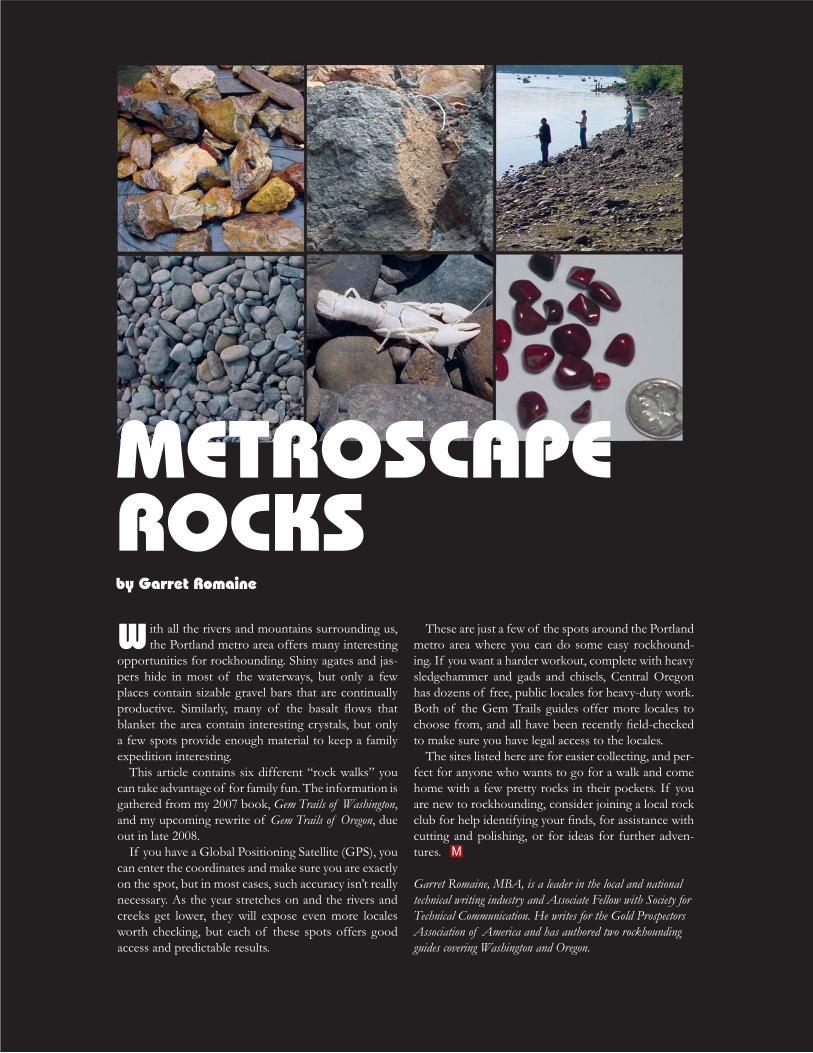
Search gravels for agate and jasper OK during
low water
.3m
i.
Exit 9
Oregon Trail Museum
To Salem
To I-84
Oregon City
L ook for agate and jasper at this easy, urban setting. Grav-els accumulate under the bridge and on most exposed riv-
erbanks in this area. Although the best gravels are along the Clackamas River, many of these rocks are simply reworked from the Willamette drainage. If you get all the way to Me-maloose further up the Clackamas, you can make your own comparison.
There is an interesting collection of material here. Most of the gravels are smooth, round and clean. Look for red and yel-
best way to tell if the jasper is hard enough to slice or polish is to look for small, half-moon shaped craters where it shows fresh chips. These fractures are a sure sign the rock is very hard. If you see a porous surface, with lots of little holes, the rock probably won’t polish up and shine. We call these samples “leaverite” – leave ‘er right where you found ‘er.
The agate here ranges from small, rare pieces of red-or-ange carnelian to more plentiful, and larger, clear pieces. Other forms of quartz, such as a milky-white chalcedony, will also tumble well. Mostly this is gray-to-black river rock, somewhere
multiple species, and these are the hardest pieces that have survived a long river run from valley deposits in Scio, Sweet Home, or the Calapooia drainage. The polish can be striking.
basically looking for lines and angles. You may have to toss
one that is turned to stone.Nearby gravel deposits emerge during low water at various
places. Look for a good spot on the south bank of the Clack-amas between here and the Carver Bridge. Topo maps show many gravel pits in the area, but most are still active.
By late summer the Clackamas River is low, calm, and easy to navigate near the mouth, so a boat, canoe, or kayak expedition might be interesting. You might be able to reach some areas that have seen fewer rockhounds.
Directions:
At Oregon City, follow the signs off I-205 to SE 82nd Ave/McLoughlin. Look for signs to Clackamette Park as you angle to the river. Park in the far lot and work your way up the south bank of the Clackamas.
Material: Tumbler rock
Roads: Easy, any vehicle
Season: Any
GPS: 45.3722, -122.6027; 22 ft
Camping: No but nearby RV park
Tools: Geology pick at most
Nearby: End of Oregon Trail
CLACKAMETTE PARK

Page 27Metroscape
Directions:
From Portland, drive east on OR 224 to Estacada and proceed about 8 more miles to the Memaloose Bridge. Cross over the bridge and immediately look for a place to park. Work your way to the river and start searching the gravels for agate. The jasper runs tan, yellow, and red, with many pieces hard enough to polish. The zeolite locale is further up this road, about 0.65 miles from the turnoff at OR 224.
Material: Agate, quartz, zeolite, calcite
Roads: Easy, any vehicle
Season: Avoid winter
GPS: A: 45.1925, -122.2102; 700 ft B: 45.1954, -122.2198; 989 ft
Camping: Yes (open USFS)
Maps: Mt. Hood National Forest
Tools: Geology pick
Nearby: Bagby Hot Springs
CEDAR BUTTE
Site A Search gravels
for agate and jasper
park
MemalooseBridge
SiteB
zeolites in roadcut
Clackam
asRiver
steeproad
.6
5 mi.
C.G.
212
224
205
3.4 mi.
10m
i.
Estacada
Clackam
as
River
MEMALOOSE
Exit 12
To I-84
To Clackamas
To Fish Creek, Lake Harriet
MEMALOOSE
L ook for agates and jasper in the river gravels near the Mema-loose Bridge, above Estacada. The agate is not plentiful, but it
is hard and ranges to a nice powder blue. Site A is just below the road on a steep trail that leads to the river edge. Stop and park in the pull-out near the bridge. If the water is low enough, look for clear agate and cloudy calcite pieces, plus pale white zeolites in matrix piled up in the river gravels.
There is an old zeolite locale up the road about 0.65 miles from the turnoff leading over bridge, labeled as Site B. Jon Gladwell published this site years ago, and it is just about all mined out. Check the big boulders beneath the cut and you might get lucky.
like zeolites, head back to the highway and continue on up to-wards Ripplebrook to the big bluff where Fish Creek Road heads south and hammer around in the cliffs there.
but there are seams and veins throughout. Check any fresh road cut or slumped material. For tumbler material, look for more big gravel deposits nearby. There are some excellent spots to check, but only a kayaker or rafter could reach them, because they are on the other side of the river.

MetroscapePage 28
NEHALEM RIVER
Nehalem
River
Clear
Ck.
X
CLEAR CREEK
RD.
NW VERNONIA
RD.
TIMBERRD.
.6m
i.
5.1
mi.
all privatethrough here
bridge
Carnelian agate in river gravels
Look for concretions in sandstone outcrops
along road to country club
Clear Creek
To Vernonia 6.2 mi.
To Portland
To Jewell Jct.
Timber Jct.
26
NEHALEM RIVER
Fossil concretions and jasper are common in the Nehalem, but the prized material here is reddish-orange carnelian agate, found scattered
in the gravels of the riverbed. This locale is actually a “back-door” oppor-tunity to collect carnelian from Clear Creek, long known as the primary source for the Nehalem’s best agate. The problem is that most of Clear Creek is off-limits to collecting, being private timberland. The best alter-native now is to check near the mouth of Clear Creek where it enters the Nehalem.
This is a spot to save for later in the season when the water is lower. There are only limited dry gravel accumulations here, so be prepared to put on your rubber boots and slowly walk the shallow river. If it’s warm enough, you can wade in sturdy sandals and short pants. Try to keep the sun in front of you if it happens to be out that day, and the agate should light up like pieces of glass in the murky water.
Some of the private timberland above here opens up during hunting season, but even then the good quarry is not open for collecting. The Mt. Hood Rock Club has organized trips up Clear Creek in the past, so when their schedule comes out each spring, be sure to check. Tim Fisher usually publishes the master schedule on his OreRockOn.com website by the end of March. Barring this, your best bet is to walk the Nehalem below where Clear Creek enters, and wherever else you can get access. I have found car-nelian from Clear Creek all the way to Vinemaple, but I haven’t had good luck past Elsie. There are a lot of fences and private land to steer clear of
productive new gravel bars all the way to the river’s mouth. There are some excellent campsites on the lower Nehalem, so if you just want to explore the river for access points, that could make for a great car trip.
Also search for concretions wherever you go. These are the round sand-stone balls that look like cannonballs. They are formed when some piece of organic material washes around long enough in lime-rich mud to get a coating started. That muddy blob gets continually sloshed in the muck until it forms into a round ball so it can roll better. Concretions sometimes hold an entire crab inside, but most are barren. Cracking them is an art to itself, and you might want to search the Internet for a few tips. When the water is low, you can sometimes spot concretions just waiting to be popped out of the bedrock. Also, keep an eye out for sharp-edged agates and jas-pers, which may be the remnants of Indian artifacts and are legal to add to your collection if you are collecting rocks and minerals to start with.
Directions:
From Portland, drive out US 26 to Timber Junction. Turn north onto Vernonia Road, and start watching for the river alongside. There is a long bridge over Clear Creek, which comes in from the left and is marked by Clear Creek Road. Just past the road there is a bridge across the Nehalem, with a good parking spot and decent river access.
Material: Tumbler
Roads: Easy; any vehicle
Season: Any
GPS: A: 45.8151, -123.2815; 680 ft
Camping: Stub Stewart State Park
Tools: Geology pick; waders
Nearby: Jewell elk herd

Page 29Metroscape
FIVE ISLANDS
FiveIslands
X
WheatlandFerry
Put in here
agate, jasper and petrified wood on all gravel bars
San Salvador Landing
HORSESHOE LK. RD.BLANCHET AVE.
RIV
ER
RD
.
MATHENY
RD.
To Wheatland Ferry3.6 mi.
St. Paul
ST. PAUL HWY.
1.6
mi.
3.4
mi.
3m
i.
(One block to Blanchet Ave.)
1.9 mi.
1.1 mi.2.4 mi.
3.7 mi.7.8
mi.
214
219
219
219
5
Woodburn Willamette
River
To Salem
ToP
ortla
nd
FIVE ISLANDS
Y throughout the gravels of the lower Willamette River. By late sum-mer, the water usually recedes enough to expose extensive gravel bars. However, anything you can reach by car will get picked over fairly fast.
your way to the more remote areas.Four of us launched a pair of two-man canoes at Wheatland Ferry and
get there, because we stopped at every promising gravel bar along the way and did well. Not only were the pieces large, they were plentiful. We found impressive chunks of agate, including a fantastic red-orange
pick up, sometimes quite large, and most of it was hard enough to take an excellent polish. There is primitive camping all along the river here.
-diana Bar just above the take-out point. There, too, we found plentiful, excellent material. In 2007 two kids in McMinnville were featured with
in the Yamhill River drainage. We looked for bones, tusks and teeth on
paleontological permit to legally collect vertebrate fossils, and you should -
all the way to where the Yamhill River empties in might make a lot more sense for better fossils.
Directions:
This is a boat trip only, although there are several gravel deposits accessible by car, and both landings feature some agate picking if you can’t make a river run. If you’re a power boater, take I-5 to San Salvador and put your craft in, zip upriver about six miles, and look for immense gravels on your left. Get out, explore, zip back to the landing and go home. Or, make a weekend of it: drop a car, drive to Wheatland Ferry and put in, and head for Five Islands. If you don’t make it this far on Day 1 it’s no big deal; there is extensive camping on numerous gravel bars and islands. On Day 2, paddle to San Salvador. If you just have a car, take a day trip to Wheatland, search the gravels there, and then drive up to San Salvador. I saw several excellent gravel bars on the canoe trip, and one had tire tracks, while another had a full parking lot, so I know there are more opportunities to search the lower Willamette by car.
Material: Vast agate, jasper; some wood
Roads: Via river only
Season: Late summer
GPS: 45.1762, -123.0144; 75 ft
Camping: Yes: islands are open
Tools: Geology pick; canoe
Nearby: St Paul Rodeo

Page 30 Metroscape
WASHOUGAL RIVER
..
. .. ........
..
... ......
SPO
RT
SMA
N
PAR
K
OA
K P
AR
K
Lacamas
Lake
1414
NW
6TH
AVE
.
SW5T
HAV
E
NE
3RD
AV
E.
EV
ER
GR
EE
NW
AY
17T
H S
T.
WASHOUGALRIVER
RD.
Lacamas C
k.
Columbia
River
Lo
w w
ater
yea
rs e
xpo
se
larg
e g
rave
l bar
s w
ith
ag
ate,
jasp
er, p
etri
fied
wo
od
X
X
Washougal
River
Cam
asW
asho
ugal
To Vancouver WASHOUGAL RIVER
T his area is technically along the Washougal River, but I sus-pect the material comes from older Columbia River gravel
deposits left over from when the river changed channels. There is a small mining district above Washougal with some interesting mineralization, but it is closed to the public and you can’t collect up there. So stick to the river.
The Columbia River contains gravels from British Columbia, Idaho, Montana, and Wyoming, and you would expect that only the hardest and best material would make it this far. Look for gem
that originates far up river. Most of the good agate is smaller in size, but there are zones of larger cobbles and boulders where larger material lurks.
There are two spots that provide access to the gravels in Wash-
the second is Oak Park. Each locale has well-marked paths, limited facilities, and parking. Oak Park is a little closer to the Colum-bia, and it looked like the gravels were more extensive. Southeast Washougal River Road parallels the river going north for a ways, reaching miles into the hills. If you like river drives, go further east and try the back road along the Klickitat River – it curls around and empties into Goldendale, making a nice loop.
This doesn’t have to be a “summer-only” spot, as long as the
more enjoyable wading around looking for pretty rocks can be. Use your own discretion; fall brings salmon carcasses rotting in the shallows. Fascinating as that sight can be on television, it loses some luster up close and personal.
Directions:
Take WA 14 from Vancouver to Washougal. Go into town from the 5th St exit, and wind around town until you are on 3rd and you see a bridge coming up across the Washougal. Take the immediate right, west of the bridge, into Sportsman Park. Oak Park is also along the Washougal, but is accessed via WA 14.
Material: Agate, jasper, petrified wood
Roads: Easy, any vehicle
Season: Avoid winter; fall brings salmon carcasses
GPS: 45.61712, -122.42792; 52ft
Camping: No, try USFS land up the Washougal River
Tools: Geology pick
Nearby: Lacamas Lake