CJ ,ck,/.y .2.ev'k -...
4
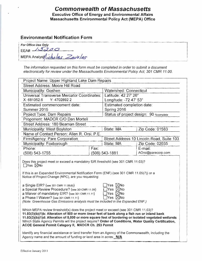
Commonwealth of Massachusetts Executive Office of Energy and Environmental Affairs Massachusetts Environmental Policy Act (MEPA) Office Environmental Notification Form For Office Use Only EEA#: /..5;;z CJ C) MEPAAnalys ,ck,/.y .2.ev'"k The information requested on this form must be completed in order to submit a document electronically for review under the Massachusetts Environmental Policy Act, 301 CMR 11.00. Project Name: Upper Highland Lake Dam Repairs Street Address: Moore Hill Road Municipality: Goshen Universal Transverse Mercator Coordinates: X: 681052.6 Y: 4702892.2 Estimated commencement date: Summer 2015 Project Type: Dam Repairs Watershed: Connecticut Latitude: 42 27' 26" Longitude : -72 47' 53" Estimated completion date: Spring 2016 Status of project design: 90 %complete Proponent: MADCR CIO Dan Mortell Street Address: 180 Beaman Street West I State: MA I Code: 01583 Name of Contact Person: Allen R. Orsi, P.E. Firm/Agen0': Pare Corporation Street Address: 10 Lincoln Road, Suite 103 Municipality: Foxborough State: MA Zip Code: 02035 Phone: Fax: E-mail: (508) 543-1755 (508) 543-1881 [email protected] Does this project meet or exceed a mandatory EIR threshold (see 301 CMR 11.03)? DYes rg]No If this is an Expanded Environmental Notification Form (ENF) (see 301 CMR 11.05(7» or a Notice of Project Change (NPC), are you requesting: a Single EIR? (see 301 CMR 11.06(8)) DYes [giNo a Special Review Procedure? (see 301CMR 11 .09) DYes [giNo a Waiver of mandatory EIR? (see 301 CMR 11.11) DYes [giNo a Phase I Waiver? (see 301 CMR 11 .11) DYes [giNo (Note: Greenhouse Gas Emissions analysis must be included in the Expanded ENF.) Which MEPA review threshold(s) does the project meet or exceed (see 301 CMR 11.03)? 11.03(3)(b)(1)b: Alteration of 500 or more linear feet of bank along a fish run or inland bank 11.03(3)(b)(1)d: Alteration of 5,000 or more square feet of bordering or isolated vegetated wetlands Which State Agency Permits will the project require? Order of Conditions, Water Quality Certification, ACOE General Permit Category II, MADCR Ch. 253 Permit Identify any financial assistance or land transfer from an Agency of the Commonwealth , including the Agency name and the amount of funding or land area in acres: N/A Effective January 20 II
Transcript of CJ ,ck,/.y .2.ev'k -...
Commonwealth of Massachusetts Executive Office of Energy and Environmental Affairs
Massachusetts Environmental Policy Act (MEPA) Office
Environmental Notification Form
For Office Use Only
EEA#: /..5;;z CJ C)
MEPAAnalys ,ck,/.y .2.ev'"k
The information requested on this form must be completed in order to submit a document electronically for review under the Massachusetts Environmental Policy Act, 301 CMR 11.00.
Project Name: Upper Highland Lake Dam Repairs
Street Address: Moore Hill Road
Municipality: Goshen Universal Transverse Mercator Coordinates: X: 681052.6 Y: 4702892.2
Estimated commencement date: Summer 2015 Project Type: Dam Repairs
Watershed: Connecticut Latitude: 42 27' 26" Longitude: -72 47' 53" Estimated completion date: Spring 2016 Status of project design: 90 %complete
Proponent: MADCR CIO Dan Mortell
Street Address: 180 Beaman Street
Municipalit~: West Bo~lston I State: MA I Zi~ Code: 01583 Name of Contact Person: Allen R. Orsi, P .E. Firm/Agen0': Pare Corporation Street Address: 10 Lincoln Road, Suite 103 Municipality: Foxborough State: MA Zip Code: 02035 Phone: Fax: E-mail: (508) 543-1755 (508) 543-1881 [email protected]
Does this project meet or exceed a mandatory EIR threshold (see 301 CMR 11.03)? DYes rg]No
If this is an Expanded Environmental Notification Form (ENF) (see 301 CMR 11.05(7» or a Notice of Project Change (NPC), are you requesting:
a Single EIR? (see 301 CMR 11.06(8)) DYes [giNo a Special Review Procedure? (see 301CMR 11 .09) DYes [giNo a Waiver of mandatory EIR? (see 301 CMR 11.11) DYes [giNo a Phase I Waiver? (see 301 CMR 11 .11) DYes [giNo (Note: Greenhouse Gas Emissions analysis must be included in the Expanded ENF.)
Which MEPA review threshold(s) does the project meet or exceed (see 301 CMR 11.03)? 11.03(3)(b)(1)b: Alteration of 500 or more linear feet of bank along a fish run or inland bank 11.03(3)(b)(1)d: Alteration of 5,000 or more square feet of bordering or isolated vegetated wetlands Which State Agency Permits will the project require? Order of Conditions, Water Quality Certification, ACOE General Permit Category II, MADCR Ch. 253 Permit
Identify any financial assistance or land transfer from an Agency of the Commonwealth, including the Agency name and the amount of funding or land area in acres: N/A
Effective January 20 II
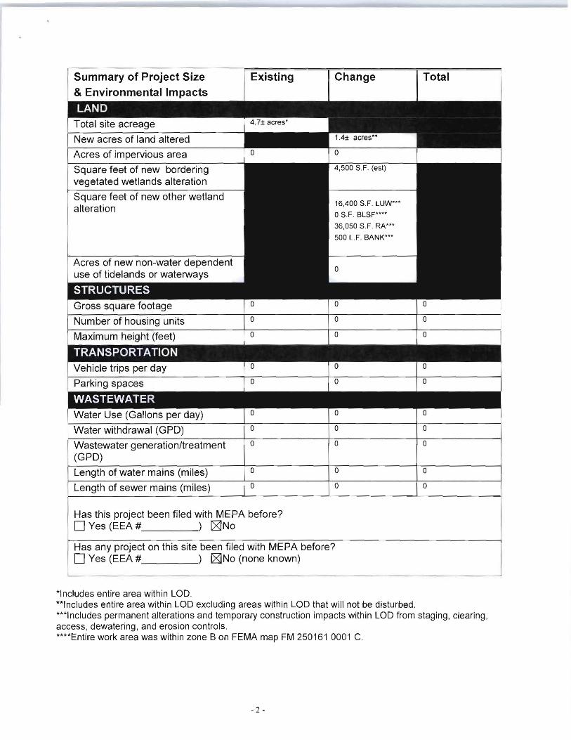
Summary of Project Size & Environmental Impacts
Existing Change Total
New acres of land altered
Acres of impervious area
Square feet of new bordering
o o oWater Use (Gallons per day) o o oWater withdrawal (GPO)
o ooWastewater generation/treatment (GPO)
o oLength of water mains (miles) oLength of sewer mains (miles)
vegetated wetlands alteration
Square feet of new other wetland alteration
Acres of new non-water dependent use of tidelands or waterways
16,400 S.F. LUW'"
oS.F. BLSF····
36,050 S.F. RA'"
500 L.F. BANK'"
Has this project been filed with MEPA before? DYes (EEA # ) [2JNo
Has any project on this site been filed with MEPA before? DYes (EEA # ) [2JNo (none known)
*Includes entire area within LOD. **Includes entire area within LOD excluding areas within LOD that will not be disturbed . ***Includes permanent alterations and temporary construction impacts within LOD from staging, clearing , access, dewatering, and erosion controls. ****Entire work area was within zone B on FEMA map FM 250161 0001 C.
- 2

GENERAL PROJECT INFORMATION - all proponents must fill out this section
PROJECT DESCRIPTION:
Describe the existing conditions and land uses on the project site: The Upper Highland Lake Dam (National 10 MA00058/State 10 2-8-108-2) impounds Upper Highland Lake, an elongated , 50-acre impoundment located north of Moore Hill Road within the Town of Goshen , Massachusetts. The dam is classified as an intermediate sized , high hazard potential (Class II) structure under Commonwealth of Massachusetts dam safety rules and regulations stated in 302 CMR 10.00. The dam consists of an approximately 560 foot long earthen embankment dam with a maximum structural height of approximately 23.5 feet. The dam is comprised of the earthen embankment, the primary spillway, a low level outlet, and a dike embankment. The dam currently impounds water for recreational purposes.
The upstream side of the dam is a vegetated slope of approximately 3H: 1 V for the upper 4-feet before transitioning to a sandy and boulder strewn slope at the waterline. The crest of the dam averages approximately 14-feet wide, with rounded edges at the upstream and downstream sides. The downstream side is comprised of a grassed and vegetated slope of approximately 3H :1V. A section of the downstream slope is supported by a 325-foot long, dry-set stone masonry wall varying in exposed height from 2-feet to 8-feet.
The primary spillway consists of an uncontrolled trapezoidal channel apparently excavated into the right abutment, with a control elevation approximately 4-feet below the embankment crest. The base of the channel is approximately 13.5-feet wide and is set in rock ledge with areas of sand and gravel deposits. The sides of the channel slope at 1 H: 1V, and are wooded with exposed bedrock and boulders present.
The low level outlet, located near the center of the embankment, includes a 12-inch diameter cast iron pipe running from the upstream toe of the slope to a pre-cast concrete chamber downstream of the downstream wall. Flow is regulated via a manual gate valve located within the chamber that is accessible through a manhole. The outlet pipe continues downstream to a concrete headwall near the toe of the dam, where flow is discharged onto a small riprap apron.
The Upper Highland Lake Dike (State 10: MA00059), located on the northern end of the impoundment, is an approximately 330-foot long earthen embankment supported along the majority of the downstream side by a dry set stone masonry wall. The crest width is approximately 12 to 14-feet wide and transitions to the stone wall along the downstream side and a rip rap protected slope along the upstream side.
Wetland resource areas present in the vicinity of the dam include the Banks and Land Under Water associated with Upper Highland Lake and West Branch Mill River; 200-foot Riverfront Area associated with West Branch Mill River; Banks associated with an unnamed intermittent stream crossing beneath the Dike access road ; several Bordering Vegetated Wetlands (BVW) located with in the Dam and Dike project areas; and Bordering Land Subject to Flooding located along Upper Highland Lake and West Branch Mill River.
Describe the proposed project and its programmatic and physical elements: MADCR is proposing repairs at Upper Highland Lake Dam and Dike in order to provide a long-term solution to the noted deficiencies. Several alternatives were considered for the proposed project, and the selected approach represents that which minimizes to the extent practicable resource area alterations. The proposed repair program includes the following elements:
1. Removal of tress and unwanted vegetation within 20 feet of the dam and dike. 2. Stripping the existing upstream slope of the dam, regrading, and providing slope protection to EI 1435.
Slope protection will consist of geotextile fabric , bedding stone, and armor stone, Stone steps will be incorporated to provide recreational opportunities.
3. Removal of the downstream wall at the dam and regrading of the entire slope to a 3H:1V uniform slope. 4. Installing a blanket drain within the extents of the wet portion of the slope (right side) and a toe drain along
the entire downstream toe. 5. Increasing discharge capacity to meet the % PMF spillway design flood requirement. Modifications will
include complete replacement of the low level outlet with a larger outlet that provides uncontrolled discharge capacity, raising the top of the dam to EI. 1447.0, and protecting the dike embankment against overtopping.
6. Regrading of the crest to minimum width with a uniform elevation: The crest will be regraded to provide a minimum width of 12 feet at a uniform elevation of EI. 1447. The upstream 8 feet of the crest will consist of a dense grade access way while the downstream 4 feet will consist of loam and seed.
7. Areas for access and staging during construction : The primary access and staging areas for the dam work is anticipated to be along the existing access road at the left abutment off of Moore Hill Road. A second access way could be established , if required, from the existing parking lot near the right abutment. However, work in this area will
- 3

be limited to reduce impacts to existing site features. 8. Control of water: To enable the safe completion of the work, the level of the impoundment will need to be drawn
down to allow for the installation of a temporary steel frame and fabric type cofferdam; To maintain the base flow, a siphon or other diversion structure will be required to convey flows through the work area to the downstream area. The work completed at the Upper Highland Lake Dike is not anticipated to require and temporary cofferdams or water controls. If required, the newly constructed low level outlet could be utilized to maintain a water level at or near normal pool while the work is being completed at the dike.
The dam site will be accessed from an existing access road off of Moore Hill Road and will include a staging area within a gravel parking lot at the northern end of that access road near the dam. Access to the dike will be via an existing gravel path off Cape Street (Rt. 112). Work at the dike is not anticipated to require water diversion beyond that required for the work at the dam.
Due to the location and nature of this dam repair project, impacts to wetland resource areas are unavoidable. The proposed work will require 500± and O± linear feet of permanent and temporary impacts, respectively, to Bank. These impacts will occur along previously disturbed manmade bank including riprap slopes.
The proposed work will result in apprOXimately 13,900± and 2,500± square feet of permanent and temporary, respectively, Land Under Water (LUW) impacts along the edge of Upper Highland Lake. In order to complete the work in the dry while maintaining flow to the downstream area, the project will require a temporary drawdown along with temporary dewatering of the upstream area with cofferdams.
Approximately 3,650± and O± square feet of permanent and temporary, respectively, Bordering Vegetated Wetland impacts are proposed within the work area. Approximately 850± square feet of permanent Isolated Vegetated Wetland impacts are anticipated within the limits of work. A wetland replication area will be designed to provide 1: 1 mitigation for lost BVW.
A portion of the work area is located Riverfront Area. Wetland impacts are tabulated in the Wetlands, Waterways and Tidelands Section of this ENF.
Describe the on-site project alternatives (and alternative off-site locations, if applicable), considered by the proponent, including at least one feasible alternative that is allowed under current zoning, and the reasons(s) that they were not selected as the preferred alternative: Throughout the evaluation and design phases of this project, a variety of alternatives have been considered to address the identified deficiencies. The following section presents the design alternatives considered.
Alternative 1 - Breach the Dam: The alternative of breaching the dam and restoring the impoundment to a stream channel was rejected by the MADCR who desired to maintain the valuable water resource.
Alternative 2 - Dam improvements (selected approach): It was determined by the MADCR that Upper Highland Lake offered a valuable resource area for the community and that the dam should be restored. The restoration of the dam will allow the impoundment to meet current dam safety regulations and preserve the ecological, aesthetic, and recreational resources provided by Upper Highland Lake. As part of the design development, a number of spillway alternatives were considered, including widening the existing spillway. However, based upon the options considered, the approach shown presents that which represents an option meeting dam safety requirements while reducing overall impacts associated with the project.
Summarize the mitigation measures proposed to offset the impacts of the preferred alternative: Dewatering is proposed in two phases in order to maintain flow downstream throughout the construction . Erosion and sedimentation controls are provided at the limits of work to prevent migration of sediment into resource areas. All areas of temporary disturbance within wetlands will be restored to their pre-construction condition and seeded as appropriate. A replacement wetland will be provided to offset the proposed unavoidable alterations to Bordering Vegetated Wetland . PARE is in the process of selecting potential wetland replication areas on the subject property that will provide 1: 1 mitigation. A Wetland Replication Plan will be provided upcoming wetlands permit application submissions.
If the project is proposed to be constructed in phases, please describe each phase: No phasing of the project is required.
- 4