CIVIL ENGINEERING DESIGN REPORT TO SUPPORT … · Cairns Entertainment Precinct Civil Engineering...
117
CAIRNS ENTERTAINMENT PRECINCT CIVIL ENGINEERING DESIGN REPORT TO SUPPORT THE DEVELOPMENT APPLICATION (STAGE 1) Project Number: Q114012-001 March 2012 Prepared for Cairns Regional Council
Transcript of CIVIL ENGINEERING DESIGN REPORT TO SUPPORT … · Cairns Entertainment Precinct Civil Engineering...

CAIRNS ENTERTAINMENT PRECINCT
CIVIL ENGINEERING DESIGN REPORT
TO SUPPORT THE DEVELOPMENT APPLICATION (STAGE 1)
Project Number: Q114012-001
March 2012 Prepared for Cairns Regional Council

Cairns Entertainment Precinct
Civil Engineering Report to Support the Stage 1 Development Application
Q114012 14 March 2012
Civil Design Report for Stage 1 DA (Ver 3) Pageii
Cardno (Qld) Pty Ltd
ABN 57 051 074 992
Level 1, 280 Sheridan Street
Cairns North Qld 4870
PO Box 1619, Cairns
Queensland 4870 Australia
Telephone: 07 4051 0288
Facsimile: 07 4051 0133
International: +61 7 4051 0288
www.cardno.com.au
Document Control:
Version Date Author Reviewer
Name Initials Name Initials
DRAFT 16 January 2012 Mark Perry Bevan Clayton
1 7 February 2012 Mark Perry Bevan Clayton
2 7 March 2012 Mark Perry Bevan Clayton
3 14 March 2012 Mark Perry MAP Bevan Clayton BNC
"© 2012 Cardno All Rights Reserved. Copyright in the whole and every part of this document belongs to
Cardno and may not be used, sold, transferred, copied or reproduced in whole or in part in any manner or
form or in or on any media to any person without the prior written consent of Cardno.”
Cairns Entertainment Precinct
Civil Engineering Report to Support the Stage 1 Development Application
Q114012 14 March 2012
Civil Design Report for Stage 1 DA (Ver 3) Pageiii
TABLE OF CONTENTS
1 INTRODUCTION 1
1.1 PURPOSE OF REPORT 1
1.2 MATTERS ADDRESSED IN THIS REPORT 1
1.3 OTHER REPORTS BY OTHER CONSULTANTS 2
1.4 MEETINGS HELD WITH COUNCIL AND PORTS NORTH 2
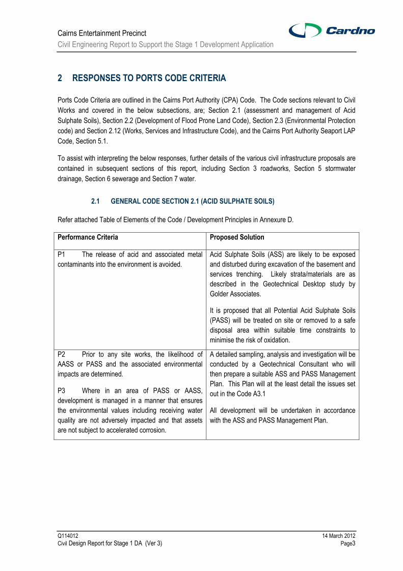
2 RESPONSES TO PORTS CODE CRITERIA 3
2.1 GENERAL CODE SECTION 2.1 (ACID SULPHATE SOILS) 3
2.2 CODE SECTION 2.2 (DEVELOPMENT OF FLOOD PRONE CODE) 4
2.3 CODE SECTION 2.4 (ENVIRONMENTAL PROTECTION CODE) 6
2.4 CODE SECTION 2.12 (WORKS, SERVICES & INFRASTRUCTURE CODE) 7
2.5 CPA SEAPORT LOCAL AREA PLAN CODE SECTION 5.1 8
3 RESPONSES TO STATE PLANNING POLICY PROVISIONS 9
4 ROADWORKS 10
5 FLOODING AND STORM SURGE 12
6 STORMWATER DRAINAGE 13
6.1 GENERAL 13
6.2 EXISTING STORMWATER SYSTEM 13
6.3 CBD PROPOSED DRAINAGE UPGRADE 16
6.4 KEY COMPONENTS OF PROPOSED WORKS 17
6.5 ENVIRONMENTALLY SUSTAINABLE DESIGN (ESD) MATTERS 19
6.6 OTHER ISSUES AND RECOMMENDATIONS 19
7 SEWERAGE INFRASTRUCTURE 21
7.1 PROPOSED SEWERAGE RETICULATION 21
7.2 SEWAGE GENERATION 22
8 WATER SUPPLY & WATER RECYCLING RETICULATION 26
9 GAS SERVICE 27
10 CONSTRUCTION MANAGEMENT OF CIVIL WORKS 28
11 GEOTECHNICAL OVERVIEW 29
12 BULK EARTHWORKS 30
12.1 CONSTRAINTS ON PROCEDURES FOR PERFORMING GROUNDWORKS 30
12.2 MINIMISATION OF IMPACT ON EXTERNAL WATERS 30

Cairns Entertainment Precinct
Civil Engineering Report to Support the Stage 1 Development Application
Q114012 14 March 2012
Civil Design Report for Stage 1 DA (Ver 3) Pageiv
12.3 MANAGEMENT OF ACID SULPHATE SOILS 30
12.4 METHOD OF EXCAVATION BELOW GROUND WATER LEVEL 30
12.5 CONTROL OF QUALITY OF WATER DISCHARGED TO THE ENVIRONMENT 31
12.6 MINIMISATION OF GROUNDWATER DRAWDOWN 31
ANNEXURES:
Annexure A Flooding and Storm Surge Report
Annexure B Minutes of Meeting 12/12/11 with Ports North –Services
Annexure C Figures to Support the Upstream Sewage Generation Calculations
Annexure D Cairns Ports Authority General Code Requirements
Annexure E CBD South Drainage Study (2007 report) Drawing 2005C4N1 - Stormwater
Drainage Plan Grafton street system
Annexure F Water and Wastewater Demand Assessment Report (by SPP Group)
CARDNO DRAWINGS:
DA-C00 Existing Services Plan
DA-C01 Overall Roadworks Plan
DA-C02 Proposed Southern Access Road Plan
DA-C03 Proposed Port Road Plan
DA-C04 Wharf Street Roadworks Plan
DA-C05 Overall Stormwater Drainage Layout Plan
DA-C06 Stormwater Drainage Details Plan
DA-C07 Stormwater Drainage Pit Details
DA-C08 Overall Water Reticulation Layout Plan
DA-C09 Overall Sewerage Reticulation Layout Plan
DA-C10 Continuation of Sewerage Reticulation Layout Plan

Cairns Entertainment Precinct
Civil Engineering Report to Support the Stage 1 Development Application
Q114012 14 March 2012
Civil Design Report for Stage 1 DA (Ver 3) Page1
1 INTRODUCTION
1.1 PURPOSE OF REPORT
This report supports a Development Application for Stage 1 of the Cairns Entertainment Precinct. The report
provides an assessment of civil engineering infrastructure required for the development.
Ports North are the Assessment Manager for the Development Application and the development is governed
by the Cairns Port Authority Land Use Plan. Cairns Regional Council and other relevant government
agencies will be Concurrent Agencies for the Development Application approval process.
The Cairns Entertainment Precinct is situated on 1.5ha of Ports land fronting Wharf Street. The development
is located within the Port of Cairns, situated directly to the west of Cairns CBD. Stage 1 of the development
comprises a Performing Arts Centre, Public Plaza, car parking and restoring Whites Shed. Future stages of
the precinct are proposed to include a museum and an additional 450 seat theatre venue.
1.2 MATTERS ADDRESSED IN THIS REPORT
This report addresses the following civil engineering aspects of the proposed development;
Responses to Code Criteria relating to Civil Works
Flooding
Roadworks & Car Parking
Stormwater Drainage
Sewerage
Water Supply and Water Recycling
Gas
Construction Management of Civil Works
Geotechnical Overview
Bulk Earthworks
The Reponses to Code Criteria noted above relates to the Cairns Port Authority Code, including Section 2.2
(Development of Flood Prone Land Code) and Section 2.12 (Works, Services and Infrastructure Code), and
the Cairns Port Authority Seaport LAP Code, Section 5.1.
Preliminary Design Drawings attached to this report are as follows;
- DA-C00 Existing Services Plan
- DA-C01 Overall Roadworks Plan
- DA-C02 Proposed Southern Access Road Plan
- DA-C03 Proposed Port Road Plan
- DA-C04 Wharf Street Roadworks Plan
- DA-C05 Overall Stormwater Drainage Layout Plan
- DA-C06 Stormwater Drainage Details Plan
- DA-C07 Stormwater Drainage Pit Details

Cairns Entertainment Precinct
Civil Engineering Report to Support the Stage 1 Development Application
Q114012 14 March 2012
Civil Design Report for Stage 1 DA (Ver 3) Page2
- DA-C08 Overall Water Reticulation Layout Plan
- DA-C09 Overall Sewerage Reticulation Layout Plan
- DA-C10 Continuation of Sewerage Reticulation Layout Plan
1.3 OTHER REPORTS BY OTHER CONSULTANTS
Other documents by other consultants which are relied upon in this report and/or provide detailed information
on other specialist issues include the following;
Architectural Plans by Cox Rayner
Landscape Plans by Tract
Traffic Report by Arup
Hydraulic Report by SPP
Electrical & Communications Report by Steensen Varming
Acoustic Report by Acoustic Studio
Maritime Report by Cardno
1.4 MEETINGS HELD WITH COUNCIL AND PORTS NORTH
Agency Date Officers Issue
Cairns Regional Council 9/05/11 Tim Smith Flooding and stormwater issues.
Cairns Regional Council 8/06/11 Tim Smith (J. Jentz – Maunsells)
Proposed stormwater upgrades for the CBD, and previous work undertaken by Maunsells.
Cairns Regional Council (Water & Waste)
24/06/11 Jon Turner, Ricky Hewitt, Ben Millar, Rebecca Smith
Outline of water and sewerage proposals for the Precinct. Initial considerations from Council for services provision.
Cairns Regional Council (Water & Waste)
16/11/11 Ricky Hewitt, G. Asoka Update on sewerage design and options for connection to existing infrastructure.
Cairns Regional Council 8/12/11 Tim Smith
Update on stormwater design and lessons learnt on the lake street drainage construction.
Ports North 12/12/11 Michael Colleton Michael Martin,
Existing and proposed services locations and relocations, and other proposed civil works (minutes of meeting, Appendix B)
Cairns Regional Council 01/03/12 Ricky Hewitt, Grahame Dunstan
Update on proposed CEP sewerage design and planned upgrade works by Council.
Cairns Entertainment Precinct
Civil Engineering Report to Support the Stage 1 Development Application
Q114012 14 March 2012
Civil Design Report for Stage 1 DA (Ver 3) Page3
2 RESPONSES TO PORTS CODE CRITERIA
Ports Code Criteria are outlined in the Cairns Port Authority (CPA) Code. The Code sections relevant to Civil
Works and covered in the below subsections, are; Section 2.1 (assessment and management of Acid
Sulphate Soils), Section 2.2 (Development of Flood Prone Land Code), Section 2.3 (Environmental Protection
code) and Section 2.12 (Works, Services and Infrastructure Code), and the Cairns Port Authority Seaport LAP
Code, Section 5.1.
To assist with interpreting the below responses, further details of the various civil infrastructure proposals are
contained in subsequent sections of this report, including Section 3 roadworks, Section 5 stormwater
drainage, Section 6 sewerage and Section 7 water.
2.1 GENERAL CODE SECTION 2.1 (ACID SULPHATE SOILS)
Refer attached Table of Elements of the Code / Development Principles in Annexure D.
Performance Criteria Proposed Solution
P1 The release of acid and associated metal
contaminants into the environment is avoided.
Acid Sulphate Soils (ASS) are likely to be exposed
and disturbed during excavation of the basement and
services trenching. Likely strata/materials are as
described in the Geotechnical Desktop study by
Golder Associates.
It is proposed that all Potential Acid Sulphate Soils
(PASS) will be treated on site or removed to a safe
disposal area within suitable time constraints to
minimise the risk of oxidation.
P2 Prior to any site works, the likelihood of
AASS or PASS and the associated environmental
impacts are determined.
P3 Where in an area of PASS or AASS,
development is managed in a manner that ensures
the environmental values including receiving water
quality are not adversely impacted and that assets
are not subject to accelerated corrosion.
A detailed sampling, analysis and investigation will be
conducted by a Geotechnical Consultant who will
then prepare a suitable ASS and PASS Management
Plan. This Plan will at the least detail the issues set
out in the Code A3.1
All development will be undertaken in accordance
with the ASS and PASS Management Plan.

Cairns Entertainment Precinct
Civil Engineering Report to Support the Stage 1 Development Application
Q114012 14 March 2012
Civil Design Report for Stage 1 DA (Ver 3) Page4
2.2 CODE SECTION 2.2 (DEVELOPMENT OF FLOOD PRONE CODE)
Refer attached Table of Elements of the Code / Development Principles in Annexure D.
Performance Criteria Proposed Solution
P1 Any development involving the excavation
or filling of land is carried out so as not to have a
“worsening” effect on flood water levels or flow
results either upstream or downstream of the
development site.
The current site is generally level and varies from
about RL 1.8 to RL 2.0AHD which is significantly below
the accepted flood levels. The adopted Q100 level for
the proposed commercial building areas is RL 2.7AHD
for a planning period to 2050 whereas the Performing
Arts building has a planning period to 2100 and a
commensurate Q100 flood level of RL 3.2AHD. The
difference is due to increased sea level predictions
between 2050 and 2100. It should be noted that
White‟s Shed which will be retained on site has a floor
level of RL 2.7AHD.
The site is affected by inundation in three ways:-
(i) Rainfall occurring on the site
(ii) Floodwaters from the sea
(iii) Floodwaters from the CBD
(i) – Rainfall over the site will actually have a reduced
effect on adjacent properties as the site will have a
significant rainwater harvesting storage with some
detention capability and all roof water will be collected
directly into this system. At present the site is poorly
served with drainage collection points and the main
discharge system is in fact collecting all the water from
the CBD Grafton street catchment. This system will be
disconnected from the CBD and be used solely for the
CEP outflows. Excess rainfall or rainfall not captured
by the new drainage system will flow to adjacent
ground areas as presently existing. However this will
be less than at present due to the greater volume of
outflows directed to the new drainage system and
thence directly to the outfall to the sea.
(ii) – When the site is affected by floodwaters from the
sea, inundation to adjacent properties will be affected
to the same extent as the site as flood levels will be
mostly uniform depending on location of inflow through
the sea wall, drainage pits without tide gates and
overland flow from either end of the wharf.
(iii) – At present overflows external to the site from the

Cairns Entertainment Precinct
Civil Engineering Report to Support the Stage 1 Development Application
Q114012 14 March 2012
Civil Design Report for Stage 1 DA (Ver 3) Page5
CBD can occur across the site at low points in Wharf
Street (about RL 1.8) and at the Southern Access
Road (about RL 1.9) initially and then at higher levels
across the Wharf Street boundary generally. Behind
White‟s Shed and to the north, the site is protected by
a levee to at least RL 2.43 whilst the ground levels
along the CEP boundary are at about RL 2.2. In the
Cairns CBD Drainage Upgrade report of May 2006
various storm events for ARIs from 1 to 100 years were
modelled for a fully developed drainage scheme. In
general no overflows are indicated for all events in the
area of the site. However for sea levels at MHWS (RL
0.93) some overflow from surcharging of the
underground stormwater system in Wharf Street might
just occur in the 50 and 100 year events. If sea level is
at HAT then overflow is likely to occur in events greater
than a 10 year event. In both cases though, overflows
would not be great as the pipe involved is only 375mm
dia. assuming main pit covers are bolted down.
At present the CBD drainage passes through the site in
two 900mm dia. pipes. Pits connect to this system in
the Port land and are able to surcharge the site and
adjacent roads. Once the building occurs and the
pipes are relocated this will no longer occur and the
existing pipes will in fact be able to reduce the level of
ponding in the area by discharging greater volumes to
the sea directly.
With development of the site the area available for
ponding and flood storage will be significantly reduced
at the Performing Arts building and also the museum in
the later stages of the project. However it is
considered that the change in CBD drainage and the
increased discharge capacity from the site including
some detention capability will ameliorate this loss.
P2 All buildings and uses have a reasonable
level of flood immunity.
This element has been addressed in the Cardno report
– Flooding and Storm Surge Report dated 12 May
2011 and is appended to this report.
As per the application drawings, new floor levels have
been set to satisfy the recommendations of the report.
The existing White‟s Shed however is at the same level
as the design Q100 level for commercial activities and
therefore has no free board to that event.

Cairns Entertainment Precinct
Civil Engineering Report to Support the Stage 1 Development Application
Q114012 14 March 2012
Civil Design Report for Stage 1 DA (Ver 3) Page6
2.3 CODE SECTION 2.4 (ENVIRONMENTAL PROTECTION CODE)
Refer attached Table of Elements of the Code / Development Principles in Annexure D. Code element
responses to P2, P3, P6 and P7 follow. Other performance criteria are addressed by other consultants.
Performance Criteria Proposed Solution
P2 The environmental values of adjoining
waterways and wetlands are maintained and
protected.
The development of the Cairns Entertainment Precinct
will basically involve 100% coverage of the site. As
such only relatively clean water will be discharged from
the site.
The roofs will collect all rain water into a harvesting
tank as detailed on the Hydraulic Consultant drawings
from where it will discharge to existing underground
stormwater drains and thence to the Inlet.
Areas not roofed such as paths and plazas will only be
collecting rainwater from pedestrian activities which will
be collected and discharged into either existing or new
underground stormwater pipes which will in turn
discharge to the Inlet.
Loading areas for delivery and unloading locations will
all be provided with water quality treatment devices to
remove pollutants as required by current FNQROC
guidelines.
Refer also to the Hydraulic Consultant‟s report on
water quality which in particular describes the use of
quality devices in conjunction with the water harvesting
arrangements.
P3 During the construction and operational
phases effective site management practices are
adopted to ensure there are no adverse impacts on
the ecological values of the adjoining areas.
Refer to Section 12 on Bulk Earthworks for a
description of solutions to water quality control during
the construction phase.
During the operational phase it is not expected that
there will be any particular requirements from a civil
perspective other than normal maintenance activities
for protection of ecological values.
P6 Land management including construction
and ongoing operations are conducted in a manner
that prevents pollutant emissions to waterways.
An EMP will be required for the Construction phase. It
will also include the ASS and PASS management
plans formulated for the treatment of any acid sulphate
soils. Refer also sections above.
P7 Stormwater is of a standard that prevents
contamination of surface and or groundwater.
Stormwater runoff will actually contain fewer pollutants
than existing as most of the site will be covered with

Cairns Entertainment Precinct
Civil Engineering Report to Support the Stage 1 Development Application
Q114012 14 March 2012
Civil Design Report for Stage 1 DA (Ver 3) Page7
either roof or paths and gardens. Any run off from
loading and unloading bays will have water quality
devices installed to minimise pollutant runoff.
Refer also to the Hydraulic Consultant‟s report
2.4 CODE SECTION 2.12 (WORKS, SERVICES & INFRASTRUCTURE CODE)
Refer attached Table of Elements of the Code / Development Principles in Annexure D.
In general, water supply will be connected directly to Council‟s reticulation, sewerage will be connected
directly into Council‟s gravity sewer reticulation, gas will be connected to Origin existing gas pipeline and
stormwater will be partially collected by a rainwater harvesting system as documented by the Hydraulics
Consultant. All other stormwater generated by the site is proposed to be discharged directly to the sea using
existing underground stormwater pipes.
In addition, it is proposed to construct two new outlets at the sea wall to carry stormwater from the Grafton
and Wharf Streets CBD catchments. There are two (2) 1650mm dia. concrete pipes already installed under
Wharf Street which will be extended across the site to discharge through the sea wall in the vicinity of the
northern wharf ramp opposite the southern end of White‟s Shed. The construction will be similar to that
already completed by the Council at the end of Lake Street. Council has discussed proposals to eventually
upgrade its upstream drainage system and also connect pumps to the twin pipes to improve drainage in that
part of the CBD although there is no time frame at this stage.
Performance Criteria Proposed Solution
P1 Land is adequately serviced with water,
waste disposal, telecommunications and energy.
Refer application drawings and Cardno report
P2 Land is provided with internal and external
drainage to an appropriate standard to minimise
runoff and impacts on receiving waters
Refer application drawings indicating roof water
collection to rain harvesting systems. All other roof
and pedestrian areas will be drained to FNQROC
requirements.
Loading dock and waste removal areas will have
water quality devices installed into stormwater lines
discharging to the sea.
P3 Engineering standards for land based
development components meet or exceed those
standards set out in the FNQROC Development
Manual
Engineering infrastructure and services will be
designed in accordance with FNQROC and Ports
North‟s requirements.

Cairns Entertainment Precinct
Civil Engineering Report to Support the Stage 1 Development Application
Q114012 14 March 2012
Civil Design Report for Stage 1 DA (Ver 3) Page8
2.5 CPA SEAPORT LOCAL AREA PLAN CODE SECTION 5.1
Refer attached Table of Elements of the Code / Development Principles in Annexure D. Code Element
responses to P6 to P9 are as follows:-
Performance Criteria Proposed Solution
P6 The design and location of any future uses
minimises any potential impact on the environmental
values of Trinity Inlet or Smith‟s Creek.
As the project is set back from the sea front the only
direct impact will be from discharge of stormwater as
described previously.
Where appropriate, all civil works will be undertaken
in accordance with FNQROC and relevant
environmental requirements.
It is expected that construction of the new main twin
pipe outfalls from the CBD drainage will be in
accordance with the Environmental Management
Plan (EMP) to be provided by the Contractor and
approved prior to any on site work.
P7 Major industrial development, or
development constituting a potential safety risk or
hazard, demonstrates it can meet acceptable safety
standards.
Not applicable.
P8 Development is designed and located such
that an acceptable level of flood immunity is provided.
Refer Section 2.2.
P9 The disturbance of acid sulphate soils or
potential acid sulphate soils is avoided or minimised.
Refer Section 2.1.

Cairns Entertainment Precinct
Civil Engineering Report to Support the Stage 1 Development Application
Q114012 14 March 2012
Civil Design Report for Stage 1 DA (Ver 3) Page9
3 RESPONSES TO STATE PLANNING POLICY PROVISIONS
Various State Planning Policies are applicable to the Cairns Entertainment Precinct project and those relevant to
Civil matters are addressed in the following:
State Planning Policy Proposed Solution
SPP 2/02-Planning and Managing Development
involving Acid Sulfate Soils.
Refer Section 2.1 above.
SPP 1/03-Mitigating the adverse impacts of flood,
bushfire and landslide.
Bushfire and landslide are not applicable. Refer to
Section 2.2 for a response to dealing with flooding
impacts.
SPP 4/11-Protecting wetlands of high ecological
significance in Great Barrier Reef Catchments.
Refer to Section 2.3 above.
SPP 4/10-Healthy Waters. Refer to Section 2.3 above.
State Coastal Plan The new state Coastal Plan and associated planning
policies are due to be adopted by the Government in
the near future. In particular the Coastal plan will
affect deliberations in relation to storm surge and
more particularly sea level rise due to climate
change.
These matters have been addressed specifically in
the earlier report by Cardno in its Flooding and
Storm Surge report dated 12 May 2011 and which is
incorporated into this report at Annexure A.

Cairns Entertainment Precinct
Civil Engineering Report to Support the Stage 1 Development Application
Q114012 14 March 2012
Civil Design Report for Stage 1 DA (Ver 3) Page10
4 ROADWORKS
Traffic issues are being covered by Arup Traffic for the project. Supporting this work, we provide the below
information with respect to roads.
The CEP site is bounded by one Council road (Wharf Street) along its western boundary. The southern and
eastern boundaries are bordered by Ports North controlled roads, referred to as Port Road along the eastern
boundary and the Southern Access Road along the southern boundary. Port Road links the site to the south
to another Council road (Dutton Street) and intersects the Southern Access Road near the south-east corner
of the CEP site.
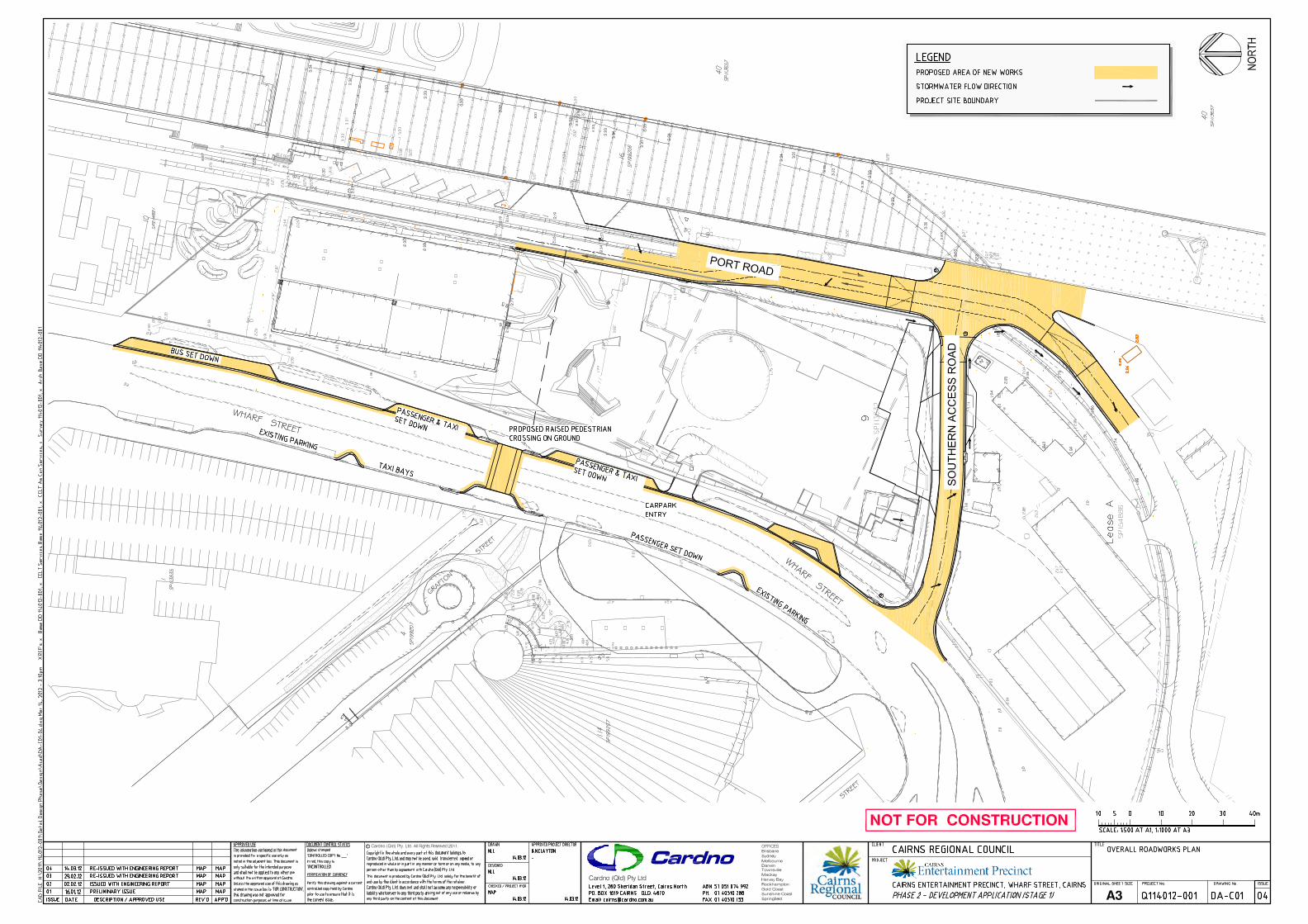
Refer attached Cardno Drawings relating to proposed roadworks as follows;
DA-C01 Overall Roadworks Plan
DA-C02 Proposed Southern Access Road Plan
DA-C03 Proposed Port Road Plan
DA-C04 Wharf Street Roadworks Plan
The proposed works for the CEP, as shown on the enclosed plans, show proposed works on Wharf Street
consisting of a pedestrian crossing across Wharf Street, a vehicle drop off and parking to the Performing Arts
entrance area to the northern end of the site and realigned kerbing at the basement car park entrance and
further to the Southern Access Road. Changes to the western side of Wharf Street are also proposed to
accommodate separation for taxi zones from carparking together with associated kerbing changes.
Stormwater drainage will need to be altered to suit. As a result of the changes there will be a loss of existing
on-street parallel car parks along the Wharf Street.
In order to provide better stormwater immunity to the main entrance and associated footpath along Wharf
Street it is proposed to reconstruct the drop off and parking lane to crossfall to an invert along the through
lane and collect the stormwater in grated kerb inlet pits at the kerb on either side of the pedestrian crossing
which occurs at the low point in Wharf Street. It is further proposed that the crossing be at kerb level and form
a traffic management device similar to the crossing further to the North. Such an arrangement will keep all
foot traffic out of the water flows in the kerb and invert channels. This will be relevant on both sides of Wharf
Street.
Cairns Entertainment Precinct
Civil Engineering Report to Support the Stage 1 Development Application
Q114012 14 March 2012
Civil Design Report for Stage 1 DA (Ver 3) Page11
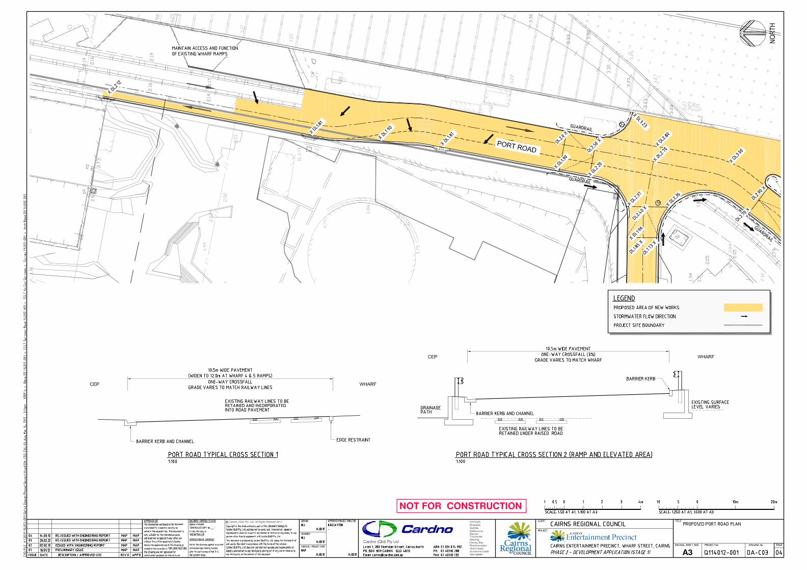
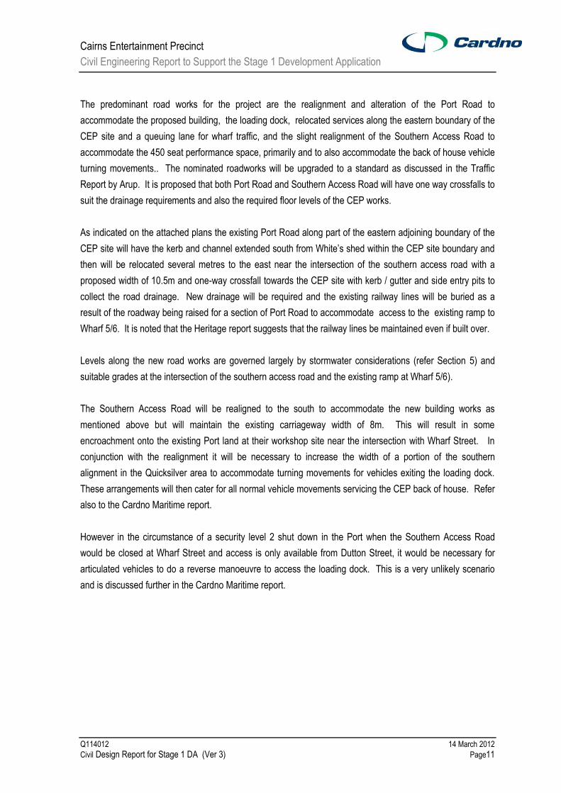
The predominant road works for the project are the realignment and alteration of the Port Road to
accommodate the proposed building, the loading dock, relocated services along the eastern boundary of the
CEP site and a queuing lane for wharf traffic, and the slight realignment of the Southern Access Road to
accommodate the 450 seat performance space, primarily and to also accommodate the back of house vehicle
turning movements.. The nominated roadworks will be upgraded to a standard as discussed in the Traffic
Report by Arup. It is proposed that both Port Road and Southern Access Road will have one way crossfalls to
suit the drainage requirements and also the required floor levels of the CEP works.
As indicated on the attached plans the existing Port Road along part of the eastern adjoining boundary of the
CEP site will have the kerb and channel extended south from White‟s shed within the CEP site boundary and
then will be relocated several metres to the east near the intersection of the southern access road with a
proposed width of 10.5m and one-way crossfall towards the CEP site with kerb / gutter and side entry pits to
collect the road drainage. New drainage will be required and the existing railway lines will be buried as a
result of the roadway being raised for a section of Port Road to accommodate access to the existing ramp to
Wharf 5/6. It is noted that the Heritage report suggests that the railway lines be maintained even if built over.
Levels along the new road works are governed largely by stormwater considerations (refer Section 5) and
suitable grades at the intersection of the southern access road and the existing ramp at Wharf 5/6).
The Southern Access Road will be realigned to the south to accommodate the new building works as
mentioned above but will maintain the existing carriageway width of 8m. This will result in some
encroachment onto the existing Port land at their workshop site near the intersection with Wharf Street. In
conjunction with the realignment it will be necessary to increase the width of a portion of the southern
alignment in the Quicksilver area to accommodate turning movements for vehicles exiting the loading dock.
These arrangements will then cater for all normal vehicle movements servicing the CEP back of house. Refer
also to the Cardno Maritime report.
However in the circumstance of a security level 2 shut down in the Port when the Southern Access Road
would be closed at Wharf Street and access is only available from Dutton Street, it would be necessary for
articulated vehicles to do a reverse manoeuvre to access the loading dock. This is a very unlikely scenario
and is discussed further in the Cardno Maritime report.

Cairns Entertainment Precinct
Civil Engineering Report to Support the Stage 1 Development Application
Q114012 14 March 2012
Civil Design Report for Stage 1 DA (Ver 3) Page12
5 FLOODING AND STORM SURGE
Cardno prepared a Flooding& Storm Surge report issued on 12 May 2011 for the CEP project. A copy is
included as Appendix A of this report. The main intent of the Flood & Storm Surge report was to provide
conclusions for flood advice and establish minimum floor levels and other operating levels for various aspects
of the proposed works.
The recommendations made and subsequently endorsed by Council were minimum floor levels as follows;
3.35m Australian Height Datum (AHD) for the Performing Arts building that requires an ARI 100 year
immunity. Note, this adopts a planning period to year 2100 for determining sea level rise, and adopts
the “desirable” minimum freeboard of 0.15m as per Council requirements.
2.85m AHD for other commercial buildings or facilities including retail that requires an ARI 100 year
immunity. Note, this adopts a planning period to year 2050 for determining sea level rise, and adopts
the “desirable” minimum freeboard of 0.15m as per Council requirements. For some retail uses, it
may be reasonable to adopt the “absolute” minimum freeboard of zero, thus reducing the minimum
floor level to 2.7m AHD.
3.95m AHD for parts of the Museum building that stores collections or archives. This adopts the
average of the range of ARI 200 year values from the publications reviewed in this report as
summarised in Section 3, and is based on a planning period to year 2100 for determining sea level
rise and using a 0.15m freeboard.
In relation to car parking, the following recommendations are provided;
2.1m AHD as a minimum surface level for any above ground car parks for ARI 20 immunity. This
adopts a planning period to year 2050 for determining sea level rise.
3.35m AHD for the bund level protecting an underground car park forming a basement to the
Performing Arts building. This includes a 0.15m freeboard above the ARI 100 year level.

Cairns Entertainment Precinct
Civil Engineering Report to Support the Stage 1 Development Application
Q114012 14 March 2012
Civil Design Report for Stage 1 DA (Ver 3) Page13
6 STORMWATER DRAINAGE
6.1 GENERAL
This section provides a summary of the key components and issues of the stormwater system that impact the
Cairns Entertainment Precinct (CEP) project
Refer attached Cardno Drawings;
DA-C05 Overall Stormwater Drainage Layout Plan
DA-C06 Stormwater Drainage Details Plan
DA-C07 Major Stormwater Drainage Pit Details
Reference is also made to the Flood & Storm Surge report issued on 12 May 2011 for the CEP project which
included a brief discussion on proposed Cairns Business District (CBD) drainage upgrade works.
Of particular importance is the modelling of the existing drainage system and proposed upgraded systems for
improving CBD drainage as per the Cairns CBD Drainage Upgrade reports by Maunsell in 2006 and 2007
which are referred to herein.
6.2 EXISTING STORMWATER SYSTEM
The existing stormwater system is shown on the attached Cardno Drawings DA-C00, DA-C05 and Figure 1-
Existing Pipe Network from the CBD 2006 drainage report shown as Fig 1 below.
The key components of the existing system are as follows;
- Low point in Wharf Street on both sides of the road and associated underground drainage opposite
the main entrance steps to the complex.
- Existing 2x 900mm dia. pipes running W to E through the CEP site and out letting to the Inlet through
the Ports North sea wall.
- Existing 2x 1650mm dia. pipes under Wharf Street only and installed some years ago to
accommodate future infrastructure (currently blanked off, not in use).
Stormwater runoff from the external catchment to the low point in Wharf Street is collected within side entry
sag pits on either side of the road then discharged eventually to Trinity Inlet through existing 2x900mm dia.
pipes running through the CEP site. The level of the invert at these pits is only IL 1.6. The overflow path from
the low point in Wharf Street adjacent to the site extends across Ports land through the CEP site and into the
Ports drainage system before discharging into Trinity Inlet. In flood events there is considerable standing
water over Ports land including the CEP site due to capacity limitations of the existing drainage system and
also the low lying nature of the land and its surrounds being below Highest Astronomical Tide (HAT) level in
some places.
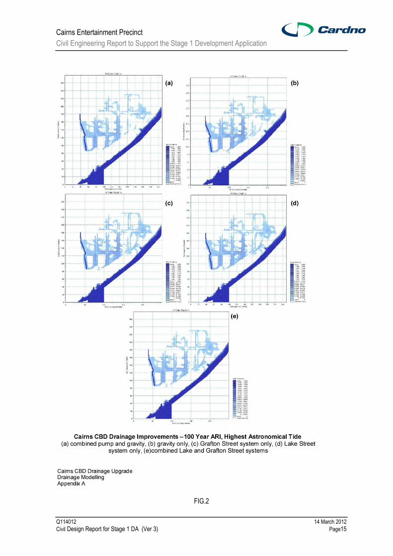
The flood modelling undertaken in the CBD drainage Upgrade reports found that for all the upgrade options
there is no general overflow from the external catchment in the ARI 100 year event for sea levels up to highest
astronomical tide (HAT) of RL 1.78. Fig. 2 shows the maps of inundation taken from the CBD report for the
various upgrade options for HAT sea levels which indicates the only overflow to be in the vicinity of the Hilton
hotel.

Cairns Entertainment Precinct
Civil Engineering Report to Support the Stage 1 Development Application
Q114012 14 March 2012
Civil Design Report for Stage 1 DA (Ver 3) Page14
FIG. 1
The report also found that for the existing drainage system water levels in Grafton Street at the Wharf Street
intersection are lower than the kerb levels at the median in wharf Street for all events for sea levels at MHWS
and also for sea levels up to the maximum HAT. Thus overflows from Wharf Street through the site would
only be due to high water levels in the pipe system surcharging the pits on the eastern side of Wharf Street or
by blockage of the inlet pits. As the inlet pits are grated sag kerb inlets the likelihood of blockage is remote.
Depending on the rearrangement of pipework for the existing and new pits on Wharf Street tide gates used to
prevent tidal intrusion may also prevent surcharging from the western side of Wharf Street. It should be noted
that at times of high rainfall and associated HAT sea level, water levels in the kerb and channelling at the
entrance to the site will be significantly above top of kerb due to the low invert levels existing.
There is a further low point pit along Wharf Street near the southern end of the site which overflows around
the corner and along the Southern Access Road. There would be no change to this situation except that with
the realignment of the kerb and channel overflow would occur at a higher level thus providing better immunity
to the Port area from CBD flooding.
Within Port land, there is a low point midway along the Southern Access Road. This water is collected in an
underground pipe and directed to the sea together with inflows from some other connected pits on Port land
nearby. It is unclear whether there is a flood gate on this system and no record of the outlet pipe size is
available at this point in time. There is no defined overland flow path at this low point, therefore during larger
Cairns Entertainment Precinct
Civil Engineering Report to Support the Stage 1 Development Application
Q114012 14 March 2012
Civil Design Report for Stage 1 DA (Ver 3) Page15
FIG.2

Cairns Entertainment Precinct
Civil Engineering Report to Support the Stage 1 Development Application
Q114012 14 March 2012
Civil Design Report for Stage 1 DA (Ver 3) Page16
rainfall events stormwater ponds before flowing back along the road towards Trinity Inlet then south along the
rail tracks to a sag point along the Port road.
The Port Road running parallel to the wharf along the eastern boundary of the CEP site is effectively an
overland flow path for stormwater through Port land and thus needs to be maintained at existing levels and
grade. There are some pits servicing this road although not significant. White‟s shed has no gutters and roof
water runs directly onto the ground. The water from the eastern side of the shed is collected by pits along
Port road. However roof water from the western side is partially collected by ground level grated inlet pits
which connect to the same pipe system from the Grafton Street CBD system. The balance runs overland
through the site and eventually onto Port Road.
6.3 CBD PROPOSED DRAINAGE UPGRADE
The CBD Drainage Upgrade report (2007) prepared for Council developed preliminary designs for the final
scheme arrangements, including;
- Upgraded gravity schemes in Grafton Street to convey a Q10 event for a tail water level equivalent to
MHWS (Mean High Water Springs);
- Pump station associated with upgraded gravity system to provide a Q100 system via the upgraded
pipe system.
The Lake Street system including pumps has been completed in its entirety and Stage 1 of the Grafton Street
works has also been completed which included the construction of the pipe crossing (2x 1650mm dia. pipes)
as part of the Wharf Street upgrade works.
The report identifies the balance of works in the following staging;
- Stage 2B(a) (now part of Stage 5): Construct the pipes from the existing pipes under Wharf Street
through to the outlet, including the outlet, for the Grafton Street system. Construct the upgraded
drainage system in Hartley Street associated with the Lake Street system and connect to the existing
Grafton Street pipework.
- Stage 4 (now part of Stage 5): Complete the remaining pipe system for the Grafton Street system
including the pumps and the connection of the existing new pipes from stage 2 to the new pipes in
Grafton Street. The performance of the combined system utilising the Lake Street pump station
should be monitored. If the system does not perform satisfactorily, then the pumps should be
installed in the Grafton Street pump station.
However, the staging strategy has since been modified as reflected on the latest Staged Implementation Plan
(refer attached). This now includes all works associated with the Grafton Street drainage upgrade
incorporated as Stage 5.
The proposed Grafton Street system works is shown in the CBD Drainage Upgrade report (2007) (refer plan
attached CCC CBD South Drainage Study, Stormwater Drainage Plan, Grafton Street System - 2005C4N1).
The key impact of the proposed CBD upgrade works on the CEP project is the extension of the existing
2x1650 mm dia. pipes under Wharf Street through the CEP site within a designated services corridor to the
Trinity Inlet. The CEP is proposing to build over this services corridor thus making it impractical to build the
pipes at a later stage.

Cairns Entertainment Precinct
Civil Engineering Report to Support the Stage 1 Development Application
Q114012 14 March 2012
Civil Design Report for Stage 1 DA (Ver 3) Page17
6.4 KEY COMPONENTS OF PROPOSED WORKS
The key components of the stormwater infrastructure can be divided into two groups, the proposed CBD
Drainage Upgrade works and the proposed CEP project drainage works.
CBD Drainage Upgrade Works
The CBD Drainage Upgrade works are outlined in the above section and notably considers a staging upgrade
option which includes two levels of immunity, one at Q10 and the other at Q100. Both options require
extensive modifications to the existing stormwater drainage infrastructure and the extension of the existing 2 x
1650 mm dia. pipes from Wharf Street to Trinity Inlet through the CEP site. Associated with the upgrading
would be alteration of the pipework connecting the pits in Wharf Street to be directed to the pump station.
The proposed pump station location is in the Grafton Street road reserve adjacent to the CPA site. Access to
the pump station can be gained via Grafton Street. The drainage upgrade utilises the existing drainage
system upstream as well as new infrastructure. The location of the Pump Station has some flexibility and will
require further collaboration with stakeholders to determine the most favourable location including
consideration to pedestrian links, visual screening and drainage efficiencies.
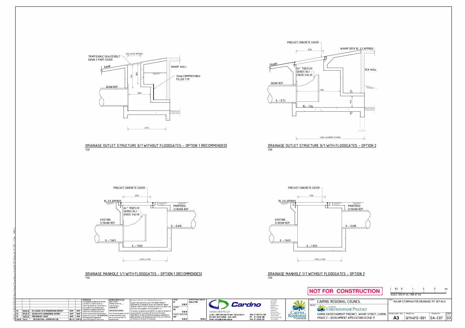
Tide gates are proposed to be installed in the pump station to the outfall line from Grafton Street in the future
upgraded system. Tide flex rubber check valves are proposed in the design plans as installed by Council in
the Lake Street pump station. If the Grafton Street pump station is constructed the valves proposed in these
works could be relocated to the pump station if necessary.
As indicated on the drawings there are two options for the location of the valves. Option 1 is to install them in
the junction pit on Wharf Street and the existing drainage pipes joining the twin 900mm dia. pipes would be
redirected to join the new 1650mm dia. pipes on the western side of Wharf Street. In Option 2, the instance
where the existing twin 900mm dia. pipes crossing Wharf Street are redirected to the new 1650mm dia. pipes,
the valves would need to be installed in the pits at the sea wall. Ports North have advised that this would not
be their preference.
CEP Drainage Works
The proposed key CEP Drainage Works are as follows;
- The existing overland flow path for larger flood events until the Q100 pumps are constructed is
effectively along Wharf Street bordering the site, but initially any overland flow would be at the low
point in Wharf Street near the main entrance to the CEP site. The proposed overland flow path will
be initially ponding in Wharf Street then along Wharf Street in both the south and north directions.
Note the overland flow will occur less frequently because the existing 2x900mm dia, outlet pipes are
being replaced by 2x1650mm dia. outlet pipes.
- Removing the 2x 900mm dia. pipes within the CEP site, but using the existing outlet for these pipes
for internal drainage connection and discharge to Trinity Inlet. A Stormwater Quality Improvement
Device (or other approved water quality control device) is proposed on existing outlets used for the
project. Note that the existing pipe location may or may not suit the final internal hydraulics design in
which case the outlet may need to be relocated. Also the device(s) may be located within the
building rather than at ground level external to it.

Cairns Entertainment Precinct
Civil Engineering Report to Support the Stage 1 Development Application
Q114012 14 March 2012
Civil Design Report for Stage 1 DA (Ver 3) Page18
- Construct 2x 1650mm dia. pipes through the CEP site to accommodate the CBD drainage upgrade
works and replace the removal of the 2x 900mm dia. pipes through the site.
- Accommodate the overflow path and drainage outlets along Port Road at current levels and grades,
however construct kerb & gutter with associated drainage pits along the common Port Road and
CEP boundary.
- Relocate drainage within the Southern Access Road to accommodate the proposed realignment of
this road and a tidal gate on the existing outlet. In order to accommodate the existing overland flow
paths along Port Road to the south, it is proposed to maintain levels on the Southern Access Road to
allow overflows to be directed around the intersection and cross the Southern Access Road slightly
to the west of the intersection of Port Road as indicated on the drawings.
- As raised in our Flood Report for the CEP project, consideration was given to flood and storm tide
immunity for car parking. For underground car parking the bund level protecting access into the
basement should provide a 0.15m freeboard (instead of 0.3m as per the Flood Report) above the
ARI 100 year level as required by Council‟s Drainage Management Plan. Therefore 3.35m AHD is
recommended for the bund level protecting the underground car park forming a basement to the
Performing Arts building. Council‟s Drainage Management Plan provides the opportunity for Council
to accept an “alternative protection measure” if the underground car parks are for visitor parking and
on a constrained site which is the case for the CEP project. Whilst it is currently proposed to provide
a ramp at the recommended level an alternative protection measure for the basement car park
instead of a ramp at trafficable grade is a suitable floodgate system. It should be noted that all
ventilations and other penetrations of the basement will need to be above the recommended flood
protection level of 3.35m AHD.
Another consideration for the project in relation to stormwater is the requirement of the Cityport Infrastructure
Agreement between Ports North and Council which requires the provision of an overland flow path on the
extension of Grafton Street, along the access corridor, as part of the road. A crest level of 2.45m AHD will be
built into this overland flow path. As we understand from Ports North, the Agreement was established to
protect the CBD land from Trinity Inlet Storm Surge. In relation to the CEP Project, the Agreement only
requires the crest level along the overland flow path at the extension of Grafton Street, and therefore does not
extend to the Southern Access Road off Wharf Street or the boundary area to the North of the Grafton Street
extension. Construction of the CEP buildings will mostly automatically create a wall above the RL 2.45 level.
However at the extension of Grafton Street where the main access stairs will be built up to the plaza it would
be possible to construct an overflow path at RL 2.45 (or lower)if required.

Cairns Entertainment Precinct
Civil Engineering Report to Support the Stage 1 Development Application
Q114012 14 March 2012
Civil Design Report for Stage 1 DA (Ver 3) Page19
6.5 ENVIRONMENTALLY SUSTAINABLE DESIGN (ESD) MATTERS
As the CEP project is within100m of Trinity Inlet, it is considered by the GBCA to be a wetland of low
ecological value. In order to obtain a rating, one of the requirements is that the post-development peak
discharge from the project in a 1.5 year ARI (average return interval) event does not exceed the pre-
development peak 1.5 year ARI event discharge. As the site runoff water will mostly be collected via roof
runoff into a water harvesting tank as described in the Hydraulics report a small detention system will be
added to the outlet of the harvesting tank to detain the runoff to the required amount. The 1.5 year ARI event
does not result in a large discharge and preliminary calculations indicate that a 10m3 volume tank will be
sufficient for control of the whole site. This size tank has been included in the plans presented by the
Hydraulics Consultant.
Other requirements to be met relate to water quality and these have been addressed in the section on
response to State Planning Policy issues. In particular the Hydraulic consultant has advised that guidelines
for reductions in Total Suspended solids, Total Phosphorous and Total Nitrogen (TSS/TP/TN) of 80/65/40
based on a Wet Tropics region will be met.
This section relates particularly to stormwater as part of the Civil Engineering Consultancy. Reference should
also be made to the reports prepared by the ESD Consultant, Cundell Johnstone and Partners, and the
Hydraulics consultant, SPP Group.
6.6 OTHER ISSUES AND RECOMMENDATIONS
The following issues and recommendations are provided relating to stormwater;
a) Responsibilities for implementing various infrastructure works.
We consider that the CEP project is obligated to replace the equivalent capacity of the 2x 900mm
dia. pipes which are being disconnected and removed from the site. The balance of drainage
works are a Council responsibility since the proposed CBD drainage upgrade works have been
proposed to improve existing deficiencies within the CBD drainage system which are external to
the CEP site and that the proposed CEP internal drainage is not connecting into the CBD system
instead proposing to connect to existing drainage outlets within Ports land.
The CEP project will be reliant on the CBD drainage works being built in order to provide a
desirable immunity for the project. Also, the CEP project is proposing to build over the 2 x
1650mm dia. pipe extension thus making it impractical to build these pipes at a later stage. The
scope to design and build the 2 x 1650mm dia.is therefore proposed to be undertaken as part of
the CEP project whereas the balance of the CBD Drainage Upgrade Works extending along
Grafton and Hartley Streets could be undertaken independent to the CEP project.
If Q10 immunity to the CEP is accepted, then the Pump Station and other associated Q100
immunity works can be implemented in the future.
The existing road levels in Wharf Street in front of the CEP site at the proposed services corridor
will experience inundation at high tides combined with rainfall unless protected by tide gates and
pumping. Even with the proposed tide gates heavy rain may still cause some inundation.

Cairns Entertainment Precinct
Civil Engineering Report to Support the Stage 1 Development Application
Q114012 14 March 2012
Civil Design Report for Stage 1 DA (Ver 3) Page20
b) Staging of the proposed Grafton Street drainage upgrade.
The two options for consideration are;
- Upgraded gravity schemes in Grafton Street to convey a Q10 event for a tail water level
equivalent to Mean High Water Springs tide;
- Pump station associated with the upgraded gravity system to provide a Q100 system via the
upgraded pipe system.
As indicated in the previous section on drainage there is no general overflow of Wharf Street into
Port‟s land. However depending on the final arrangement of the underground drainage
surcharging of the pipes systems may result in overflows. We consider that by constructing the
Q100 system, the overland flow path through the services corridor is not required as surcharging
flows would be small and if the ground levels were raised to prevent overflows at the CEP
entrance, any excess of Q100 will flow along the Southern Access Road albeit at significant
depths of water and inundation at kerb locations.
If the Q10 upgrade is constructed only as an initial stage, then until the Q100 infrastructure is
constructed, any stormwater flow beyond the capacity of the new 2 x 1650 discharge pipes will
pond then traverse along Wharf Street. Some reduction in water depth problems along the
eastern side of Wharf Street may be obtained if the pits are disconnected from the CBD drainage
system although inundation would still occur at high tides combined with heavy rainfall.
c) A review of the proposed works and funding options of the Grafton Street CBD Drainage Upgrade
if Council consider it warranted.
d) Whether providing a high level overland flow path on the extension of Grafton Street with a crest
level at 2.45m AHD is required as per the City/Port Infrastructure Agreement. The Agreement
only requires this crest level along the overland flow path at the extension of Grafton Street and
as we understand was established to protect the CBD land from Storm Surge.
e) Adopting a floodgate solution to protect the basement car park as an alternative protection
measure instead of the traditional ramping up. Due to difficulties in site access and levels, a
compromise might be considered where a minimum immunity level is set based on say a 50 year
planning period and flood gates installed for any higher level flooding. As the difference in
proposed flood levels between the 50 and 100 year planning periods is due to increased sea
levels due to climate change rather than increased predicted rain events this could be considered
to be a reasonable proposition. Increased pedestrian exits may be required to compensate.
The current proposal is to ramp up the basement entry to provide the required flood immunity.
Cairns Entertainment Precinct
Civil Engineering Report to Support the Stage 1 Development Application
Q114012 14 March 2012
Civil Design Report for Stage 1 DA (Ver 3) Page21
7 SEWERAGE INFRASTRUCTURE
7.1 PROPOSED SEWERAGE RETICULATION
Refer attached Cardno Drawings relating to proposed sewerage works as follows;
DA-C09 Overall Sewerage Reticulation Layout Plan,
DA-C10 Continuation of Sewerage Reticulation Layout Plan
The proposed sewerage infrastructure for the Stage 1 development while accommodating the ultimate
development, are as follows;
Relocate the existing sewer pipe currently aligned East West through the site within the proposed
building envelope. Due to the proposed basement carpark and performing arts building, it is
proposed to relocate the sewer pipe to the services corridor immediately south of White‟s Shed
between Port Road and Wharf Street, and on the southern side of the new Stormwater pipes located
in the same services corridor.
A service will need to be provided across the stormwater pipes to the proposed future Museum
building. This service will be constructed in Stage 1 and plugged at the manhole for future
connection.
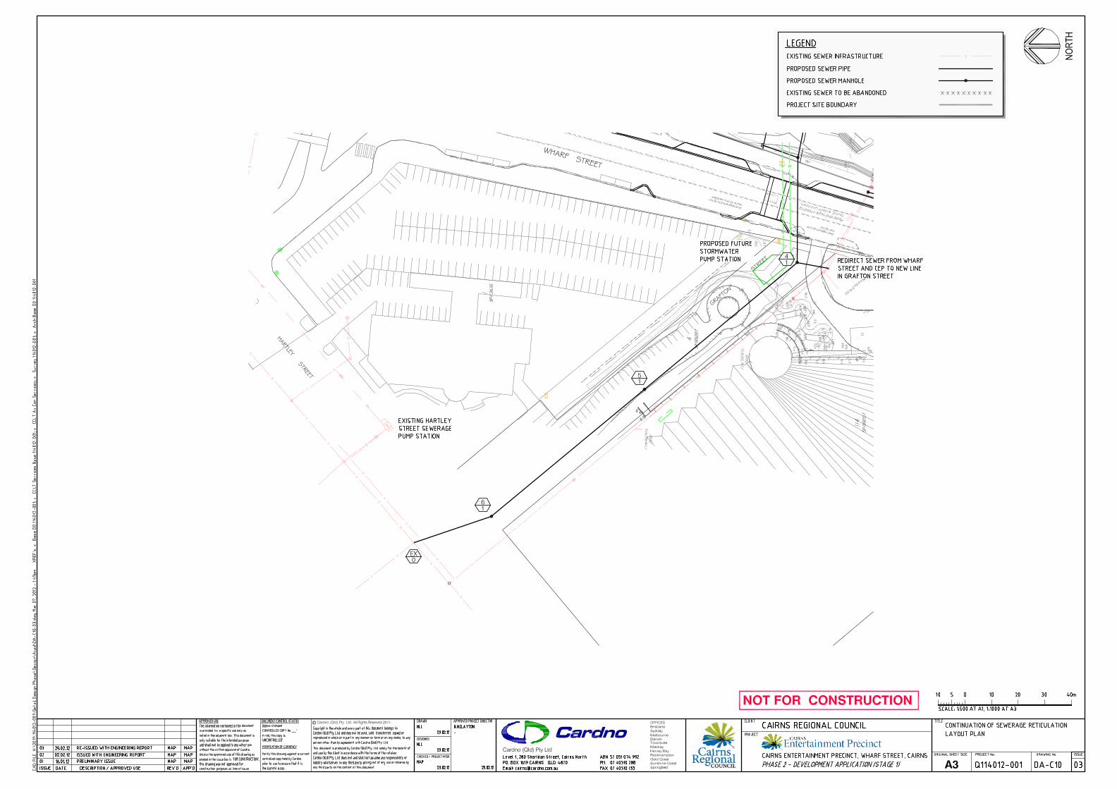
Since the existing 150mm dia. sewer pipe along Grafton Street is located underneath the Convention
Centre building ramp and therefore cannot be reconstructed to the required depth to service the
realigned Port sewer, a new 150mm dia. sewer pipe along Grafton Street is proposed. The new
150mm dia. sewer pipe will accommodate the existing upstream developments on Port land and the
proposed ultimate Entertainment Precinct. Determination of the existing upstream Port sewage
loadings are outlined in the following subsection.
Extend and realign the existing 150mm dia sewer pipe running along the eastern side of Wharf
Street. This sewer pipe is proposed to provide direct connection to the CEP Performing Arts building.
The existing pipe is close (approximately 1.5m) to the CEP basement, therefore a written application
to Council for “Building over or near a sewer” will be required during the design phase.
Requirements of Council for building near an existing sewer will likely require this line to be upgraded
to a SN8 pipe material.
Connect the existing sewer adjacent to the Convention Centre at manhole G8/3 to the new sewer at
proposed manhole 4/1.
Owing to the location and level of the two 1650mm dia. stormwater pipes under Wharf Street, there is
only one option for the new 150mm dia. pipe along Grafton Street which has been shown on the
sewerage plans.
The relocated sewer pipe within the site and the new pipe along Grafton Street are very constrained
in vertical grade as the proposed pipe realignment will traverse a longer distance to the existing pipe
alignment. Our calculations have determined that the realigned and new 150mm dia. pipe

Cairns Entertainment Precinct
Civil Engineering Report to Support the Stage 1 Development Application
Q114012 14 March 2012
Civil Design Report for Stage 1 DA (Ver 3) Page22
constructed at minimum desirable grade as per FNQROC will just reach the 225mm dia. connection
pipe in Hartley Street.
The 225mm dia. pipe in Hartley Street feeds into Pump Station PSG. Council have indicated future
upgrade works to Pump Station PSG and the rising main based on the Northern WWTP Sewerage
Catchment Planning Report to accommodate future loadings. The Planning Report has estimated
the future population density of the Entertainment Precinct site to be a combination of 35-50 and 0-
15 EDU/ha across the site, which is less than the proposed peak usage of the Entertainment
Precinct, however the peak usage of the Entertainment Precinct will typically occur outside of the
peak CBD usage. Sewage generation for the Entertainment Precinct is covered in the following
subsection.
The existing sewerage pipe along the Port Road will be retained and utilised to service the existing
Ports services points to the south east and south of the site. This pipe will be connected to the
proposed relocated 150mm dia. pipe through the services corridor adjacent to Whites Shed. Refer
Annexure C which shows the existing sewerage catchment boundaries.
Council advised that they will be undertaking upgrade works in the near future to increase the capacity of the
existing sewerage pressure system including the Sewerage Pump Station PSG in Hartley Street and the
connecting rising main as per the first phase of the proposed augmentation works. Council indicated they
would like to understand the sewage loadings for the Entertainment Precinct to determine whether this will
have any impact on the proposed upgrade works to the existing system.
The Hydraulic Engineer has determined the sewage loadings for the Entertainment Precinct development
which are contained within a separate report, copy attached in Appendix F of this report. These sewage
loadings have been used to establish the proposed external sewerage works required to service the
development as determined below.
7.2 SEWAGE GENERATION
7.2.1 Sewage Generation from Premises Upstream of the CEP
Sewage generation from premises upstream of the Cairns Entertainment Precinct which enters the existing
sewer line is as follows;
The area of land which is / could possibly be serviced by the existing sewer along the wharf frontage is shown
in Annexure C(Figure 1 (highlighted in blue) and Figure 2).
Based on Department of Natural Resources & Mines – Planning Guidelines for Water Supply and Sewerage
(Chapter 5, Table A) Indicative Average Flows from Commercial/Institutional Developments:
Heavy / light industry development ADWF= 10,000 to 13,500 L/d/ha
Area of land = approx 0.5 ha
ADWF = 5,000 to 6,750 L/d (Adopt 6,750L/d to be conservative)

Cairns Entertainment Precinct
Civil Engineering Report to Support the Stage 1 Development Application
Q114012 14 March 2012
Civil Design Report for Stage 1 DA (Ver 3) Page23
The FNQROC Development Manual specifies;
PWWF = 5 x ADWF = 33,750 L/d = 0.39 L/s
7.2.2 Sewage Generation from Stage 1 of the CEP
Sewage generation from Stage 1 of the Cairns Entertainment Precinct (Performance Space 1 & carparks,
White‟s Shed & public domain spaces), is as follows;
Sewerage generation from the ultimate development of the Entertainment Precinct is based on the Hydraulic
Consultant‟s Water and Waste Water Demand Assessment Report dated 9/12/03 (refer Appendix F).
The Hydraulic Consultant calculated sewage generation based on two different approaches, namely:
1. In terms of an Equivalent Population (EP) in accordance with Cairns Regional Council Trunk
Infrastructure Planning Scheme Policy which is based on Gross Floor Area for Defined Land Uses; and
2. In terms of actual projected waste water generation based on the population expected to be
working, performing and visiting the site.
However the report advises that actual projected demands based on uses is deemed to be the more accurate
assessment.
Approach 1
Equivalent Population (year 2016) = 267 EP
ADWF = EP x 270L/d = 72,090L/d
PWWF = 5 x ADWF = 360,450 L/day = 4.17 L/s
Approach 2
The Hydraulics Consultant, SSP Group, state a peak waste water demand (spike) of 3.2 L/s in their report.
This has been taken to be equivalent to the Peak Wet Weather Flow (PWWF).
PWWF = 3.2 L/s
Total Sewage generation for existing and Stage 1
Using figures of Approach 1
PWWF = 0.39 L/s + 4.17 L/s = 4.56 L/s = 393,984 L/day
ADWF = PWWF/5 = 78,797 L/day
From FNQROC Development manual;
ADWF = 270 L/EP/day
Therefore, Equivalent Population = 78,797/270 = 291.8 EP
Based on FNQROC Development Manual there are 2.8 Equivalent Persons / Equivalent Domestic Connection
(EP/EDC), therefore;

Cairns Entertainment Precinct
Civil Engineering Report to Support the Stage 1 Development Application
Q114012 14 March 2012
Civil Design Report for Stage 1 DA (Ver 3) Page24
EDC = 291.8 / 2.8 = 104
Using figures of Approach 2
PWWF = 0.39 L/s + 3.2 L/s = 3.59 L/s = 310,176 L/day
ADWF = PWWF/5 = 62,035 L/day
From FNQROC Development manual;
ADWF = 270 L/EP/day
Therefore, Equivalent Population = 62,035/270 = 229.8 EP
Based on FNQROC Development Manual there are 2.8 Equivalent Persons / Equivalent Domestic Connection
(EP/EDC), therefore
EDC = 229.8 / 2.8 = 82
For a 150mm dia. sewer pipeline at 1:150 grade, the maximum EDC allowable in accordance with FNQROC
is 259 EDC.
7.2.3 Sewage Generation from the Ultimate Development (Stages 1, 2 & 3)
Sewerage generation from the ultimate development of the Entertainment Precinct is based on the Hydraulic
Consultant, SPP Group‟s Water and Waste Water Demand Assessment Report dated 9/12/03.
The Hydraulic Consultant calculated sewage generation based on two different approaches, namely:
1. In terms of an Equivalent Population (EP) in accordance with Cairns Regional Council Trunk
Infrastructure Planning Scheme Policy which is based on Gross Floor Area for Defined Land Uses; and
2. In terms of actual projected waste water generation based on the population expected to be
working, performing and visiting the site.
Approach 1
Equivalent Population (year 2016) = 267 EP (stage 1) + 23 EP (Stage 2) + 49 EP (Stage 3) =339 EP
ADWF = EP x 270L/d = 91,530L/d
PWWF = 5 x ADWF = 457,650 L/day = 5.3 L/s
Approach 2
Based on the Hydraulic Consultant‟s peak waste water demand (spike) in their report, this has been taken to
be equivalent to the Peak Wet Weather Flow (PWWF).
PWWF = 3.2 L/s (Stage 1) + 1.1 L/s (Stage 2) + 0.85 L/s (Stage 3) = 5.15 L/s
Total sewage generation for existing and Ultimate Development
Using figures of Approach 1
PWWF = 0.39 L/s + 5.3 L/s = 5.69 L/s = 491,616 L/day

Cairns Entertainment Precinct
Civil Engineering Report to Support the Stage 1 Development Application
Q114012 14 March 2012
Civil Design Report for Stage 1 DA (Ver 3) Page25
ADWF = PWWF/5 = 98,323 L/day
From FNQROC Development manual;
ADWF = 270 L/EP/day
Therefore, Equivalent Population = 98,323/270 = 364.2 EP
Based on FNQROC Development Manual there are 2.8 Equivalent Persons / Equivalent Domestic Connection
(EP/EDC), therefore;
EDC = 291.8 / 2.8 = 130
Using figures of Approach 2
PWWF = 0.39 L/s + 5.15 L/s = 5.54 L/s = 478,656 L/day
ADWF = PWWF/5 = 95,731 L/day
From FNQROC Development manual;
ADWF = 270 L/EP/day
Therefore, Equivalent Population = 95731/270 = 355 EP
Based on FNQROC Development Manual there are 2.8 Equivalent Persons / Equivalent Domestic Connection
(EP/EDC), therefore;
EDC = 355 / 2.8 = 127
Total Future Sewage Generation for the Ultimate Development
The SPP Group report advises increased sewage generation over future years based on a 2% average
increase in visitation as outlined in the Business Case Study as follows:
2016 2020 2025 2030 2040
Factor 1 1.082 1.195 1.318 1.607
Total EDC
Approach 1 130 140 155 171 209
Total EDC
Approach 2 127 137 152 167 204
For a 150mm dia. sewer pipeline at 1:150 grade, the max EDC allowable in accordance with FNQROC is 259
EDC.
Therefore a 150mm dia. sewer pipeline to service the ultimate development of the entertainment precinct
(Stages 1, 2 and 3) will meet this criterion to the year 2040 and beyond.

Cairns Entertainment Precinct
Civil Engineering Report to Support the Stage 1 Development Application
Q114012 14 March 2012
Civil Design Report for Stage 1 DA (Ver 3) Page26
8 WATER SUPPLY & WATER RECYCLING RETICULATION
Refer attached Cardno Drawing:DA-C08 Overall Water Reticulation Layout Plan
An existing 225mm dia. water main runs along Wharf Street adjacent to the CEP site. It is proposed to
connect into this system and provide a metering point within the boundary to the Performing Arts building, and
a future separate metering point to the Museum building.
A fire water booster assembly will likely be required to service the Precinct. A fire pump is unlikely to be
required as the pressure on Wharf Street appears to be adequate, however Council will require confirmation
of this once reviewing the water demand as estimated by the Hydraulics Consultant and updating Council‟s
water model of the CBD to confirm pressure and flow capacity requirements.
Council have requested that water recycling infrastructure be accommodated in the project with provision for
future connection to external water recycling pipes yet to be constructed by Council.
The Hydraulics Consultant has determined the water demands for the CEP development in a report titled
Water and Wastewater Demand Assessment, and these have been submitted to Council in order for Council
to insert into the CBD water model and confirm pressures and flows (refer Appendix F for copy of report by
Hydraulics Consultant). A meeting was held with Council‟s Water and Waste personnel to discuss the project
relating to water reticulation and expectations moving forward. While there is comfort in the proposal as put
forward with respect to flows and pressures at the external water connection points, Council require
confirmation of site water demands, the proposed works to support the project and the subsequent impacts on
the external water reticulation.
The existing water main along the edge of the Port Road will need to be relocated outside the CEP boundary
as proposed in the attached proposed water reticulation drawing. Also the existing water main through the
CEP site will be relocated to the services corridor adjacent to White‟s Shed between Port Road and Wharf
Street.

Cairns Entertainment Precinct
Civil Engineering Report to Support the Stage 1 Development Application
Q114012 14 March 2012
Civil Design Report for Stage 1 DA (Ver 3) Page27
9 GAS SERVICE
There is an existing gas pipeline adjacent to the CEP site along the western side of Wharf Street. Origin has
confirmed that the option to use gas is viable. The location of the service connection point will be determined
during the Detailed Design Phase.
Provision of the service to the site will require a road crossing from the existing main located on the western
side of Wharf Street. Origin require confirmation of what appliances (e.g. cooking appliances at the
commercial kitchen, hot water, etc...) will be used by the project to determine if they would cover the cost of
the new service to the site boundary. They will also require this information to provide a design of the service.
Cairns Entertainment Precinct
Civil Engineering Report to Support the Stage 1 Development Application
Q114012 14 March 2012
Civil Design Report for Stage 1 DA (Ver 3) Page28
10 CONSTRUCTION MANAGEMENT OF CIVIL WORKS
There are several important issues that will impact on the construction management of the civil works. These
are listed below and will require appropriate specification in the construction contract to ensure construction
management achieves desirable outcomes during the construction phase.
The following construction management issues are outlined for consideration;
- The existing „live‟ services that are proposed to be relocated will need to remain in operation until the
new services are constructed, tested and connected.
- The Port Road construction will require appropriate management to ensure road access is
maintained for Port traffic during construction. This will be particularly challenging for the raised
section of road at the intersection with the realigned Southern Access Road. One option for
consideration is to utilise the Wharf as an access corridor connecting back to the Port Road via the
existing ramps just south of White‟s Shed. The construction management of these works will need to
be approved by Ports North.
- The construction of the 2 x 1650mm dia. stormwater pipes, pits and outlet will require excavating
below the water table and below the tide level. This will require implementation of safe work
methods by the Contractor. It is recommended that these works are constructed during the Dry
Season when the water table is relatively low and when there is lower chance of storm inundation of
the site.
- Construction of the 2 x 1650mm dia. stormwater outlet will require the partial or total reconstruction
of the northern most wharf ramp adjacent to the CEP site. As this ramp is an important access to the
wharf and separated from the wharf ramp immediately to the south by a security fence on the wharf,
the construction management of this work will require consultation with Ports North to ensure
satisfactory temporary operation. One option if possible is to construct the outlet and rebuild the
ramp outside of cruise ship days.
- Construction of the 2 x 1650mm dia. stormwater outlet through the Seawall piers which are not
currently surveyed and do not line up with the exposed Wharf piers.
- Programming of certain service relocations to allow other early works to be undertaken. For
example, the existing communication services adjacent to Whites Shed will need to be relocated
prior to the trench excavation of the 2 x 1650mm dia. pipes along the services corridor.
- Construction of the realigned Southern Access Road will require temporary alternative access and
appropriate traffic control. This can be achieved by utilising the existing Southern Access Road
except for where the existing and realigned sections overlap in which case the back Port Road could
be used as the sole access.
- The construction of the car park basement will require excavating below the water table. This will
require implementation of safe work methods by the Contractor to provide a safe work environment.
It is recommended that these works are constructed during the Dry Season when the water table is
relatively low and when there is lower chance of storm inundation of the site.
- Construction works on Wharf Street will require appropriate traffic control to manage continuation of traffic operations. This is deemed achievable without major interruption by leaving at least one lane of traffic open with approved traffic controls.

Cairns Entertainment Precinct
Civil Engineering Report to Support the Stage 1 Development Application
Q114012 14 March 2012
Civil Design Report for Stage 1 DA (Ver 3) Page29
11 GEOTECHNICAL OVERVIEW
A Geotechnical Desktop Study by Golders has been undertaken as part of the Concept Design Phase for the
CEP project as follows;
Golder Associates “Geotechnical Desktop Study” (Ref 117672026-001 dated June 2011)
The study provides preliminary information including comments on foundation options, site preparation and
earthworks, potential settlements, basement excavation and Acid Sulphate Soils.
Further geotechnical field investigation will be required in order to provide more comprehensive coverage of
the subsurface soil strength parameters and acid sulphate management.
Cairns Entertainment Precinct
Civil Engineering Report to Support the Stage 1 Development Application
Q114012 14 March 2012
Civil Design Report for Stage 1 DA (Ver 3) Page30
12 BULK EARTHWORKS
12.1 CONSTRAINTS ON PROCEDURES FOR PERFORMING GROUNDWORKS
There are several environmental and engineering issues which will constrain the bulk earthworks excavation.
Salient among these issues are the following:
1) The essential requirement to impose minimal impact on the external waters in performing ground
works.
2) Management of acid sulphate soils by Geotechnical Engineer.
3) Method of excavation below ground water level.
4) The need to dewater excavations which extend to below ground water level.
5) Control of quality of water discharged to the environment during bulk earthworks.
6) Minimisation of groundwater drawdown.
12.2 MINIMISATION OF IMPACT ON EXTERNAL WATERS
It is proposed that impact of the ground works on the external waters of Trinity Inlet will be minimised by the
following systems:
- A barrier of ground will be constantly maintained between the ground works and Trinity Inlet
throughout the performance of the ground works.
- Construction of the relatively minor structural works for the stormwater outlets will be performed with
appropriate erosion and sediment controls to control disposal of material in tidal water.
Early Contractor involvement is proposed to evaluate construction management of the site to confirm the
above approach.
12.3 MANAGEMENT OF ACID SULPHATE SOILS
The materials expected to be encountered during excavation are described in the Geotechnical Desktop
Study by Golders.
It is proposed that all excavated Actual and Potential Acid Sulphate Soils will be lime neutralised prior to their
incorporation in the fill body, or, in the case of surplus materials if any, disposal off site.
A detailed Acid Sulphate Soils Management Plan for the project will need to be prepared by a Geotechnical
Consultant during the Design Phase of the project.
12.4 METHOD OF EXCAVATION BELOW GROUND WATER LEVEL
It is expected that given the nature of the materials present across the site and based on advice by the
Structural Engineering Consultant, the majority of the building works will be piled below the base of the
building. However, the basement car park extends below existing ground surface level and will therefore
require appropriate management of construction below the ground water level. It is therefore best that

Cairns Entertainment Precinct
Civil Engineering Report to Support the Stage 1 Development Application
Q114012 14 March 2012
Civil Design Report for Stage 1 DA (Ver 3) Page31
construction of the bulk earthworks, in particular works below the existing ground level, takes place during the
dry season to minimise construction issues and costs relating to ground water management.
Other works including services trenching may require dewatering to ensure equipment access.
The rate of dewatering will be dependent on the perimeter of the dewatered area as well as the hydraulic
conductivity of the subsurface soils.
The rates of dewatering are proposed to be controlled by measures such as the following.
The areas of bulk excavations below ground water level being undertaken at a given time should be
minimised.
Should excavation to below ground water level be necessary, the excavation and construction should
be undertaken in short lengths which should be individually dewatered to the minimum extent which
will permit construction.
Early Contractor involvement is proposed to evaluate construction management of the site and methodology
for excavation below the ground water level.
12.5 CONTROL OF QUALITY OF WATER DISCHARGED TO THE ENVIRONMENT
Groundwater will be discharged from bulk earthworks excavations in the following circumstances:
Local dewatering for construction of basement and associated works;
Local dewatering for construction of services trenching;
Local dewatering for construction of stormwater outfalls;
In the case of dewatering for excavation of the car park basement or draining from the excavated material
water could be discharged to sediment ponds on site.
The turbidity and pH and other parameters of the detained water should be monitored. The pH could be
controlled by addition of hydrated lime or other approved chemical. The water should be detained in the ponds
until its turbidity, pH and other parameters are acceptable for discharge to the external environment, and
should discharge to the external environment be desirable. The acceptability of the water quality will be
confirmed by testing immediately prior to its discharge to receiving waters.
Early Contractor involvement is proposed to evaluate construction management of the site and methodology
for controlling water quality.
Details of proposed procedures for controlling the quality of water associated with bulk ground works should
be included in the Acid Sulphate Soils Management Plan prepared by the Geotechnical Engineering
Consultant.
12.6 MINIMISATION OF GROUNDWATER DRAWDOWN
It will be necessary to minimise the drawdown of groundwater levels outside the local excavations in order
that PASS materials within the drawdown zone do not become partially oxidised and generate acidity.
Groundwater levels outside the excavations could be monitored by using groundwater monitoring wells as
dewatering and excavation proceed if deemed necessary by the Geotechnical Engineering Consultant.
Construction methodology can also influence the groundwater drawdown extent and duration, therefore
involvement of the Contractor will be required as part of this assessment.

Cairns Entertainment Precinct
Civil Engineering Report to Support the Stage 1 Development Application
Q114012 14 March 2012
Civil Design Report for Stage 1 DA (Ver 3)
ANNEXURE A
Flooding and Storm Surge Report

Cairns Entertainment Precinct
Flooding and Storm Surge Report
Prepared for Cairns Regional Council 12 May 2011
Project Number: Q114012-001


Cairns Entertainment Precinct Flooding and Storm Surge Report
Q114012-001 Version 1 13.05.2011 Page iii
TABLE OF CONTENTS
1 PURPOSE OF REPORT 1
2 REVIEW OF EXISTING DOCUMENATION 1
3 SUMMARY AND COMMENTS 8
4 RECOMMENDATIONS 10
REFERENCES
APPENDICES:
Appendix A Plan DMP2 of Cairns CBD and Environs Drainage Management Plan – Phase 2
Appendix B Queensland Coastal Plan - Annex 3 Storm Tide Inundation Appendix C CBD South Drainage Upgrade - Stage Implementation Plan Appendix D Glossary of Terms –Extract from Storm Tide Threat in Queensland by
Harper

Cairns Entertainment Precinct Flooding and Storm Surge Report
1 PURPOSE OF REPORT
The investigation of flood and storm surge levels in the area of a proposed site of the Cairns Entertainment Precinct (CEP) is required for the project in order to determine the floor level of the proposed buildings and car parks in accordance with a rational basis to minimise or avoid inundation.
The methodology involved has been to research the latest relevant documents which have investigated the height of sea levels in the Cairns area resulting from cyclonic activity, storm surge, green house effects and wave set up, assess the recommended minimum floor levels and review the latest reports used by the Council and other Agencies as relevant to this topic.
2 REVIEW OF EXISTING DOCUMENATION
1) CairnsPlan – Cairns Regional Council
The following items in CairnsPlan are relevant to flooding and storm tide;
a) CairnsPlan (Section 4.5.13 Cityport South Planning Area Code) – This Code specifically refers to the various Precincts within the Cityport South area, but nothing specific in relation to flooding.
b) CairnsPlan Amendment 2007 (Section 4.6.3 Flood Management Code) – Table 1 refers to “Community Uses involving access by the public” to have; i) fill level of immunity to 1 in 100 year ARI Flood (note, the Storm Tide Event wording is
crossed out as an amendment from CairnsPlan 2005), and ii) floor level of immunity 1 in 100 year ARI Flood Event. No guidance is given for community
services requiring post-disaster functions.
c) Included within the CairnsPlan is a Flood Inundation (ARI 100 year) overlay. The overlay indicates submergence of the surrounding area of the proposed CEP site for the ARI 100 year event.
2) State Planning Policy 1/03 : Mitigating the Adverse Impacts of Flood, Bushfire and Landslide
The State Planning Policy (SPP) sets out the State’s interest in ensuring that the natural hazards of flood, bushfire and landslide are adequately considered when making decisions.
Outcome 3 of the SPP states that “wherever practicable, community infrastructure to which the SPP applies is located and designed to function effectively during and immediately after natural hazard events commensurate with a specified level of risk”.
A natural hazard management area (flood) is land inundated by a Defined Flood Event (DFE) and identified in a planning scheme. The Queensland Government’s position is that, generally, the appropriate flood event for determining a natural hazard management area (flood) is the 1% Annual Exceedance Probability (AEP) flood or average return interval (ARI) 100 year flood event.
Q114012-001 Version 1 13.05.2011 Page 1

Cairns Entertainment Precinct Flooding and Storm Surge Report
The SPP defines community infrastructure as including, amongst many other things, Stores of valuable records or items of historic or cultural significance (eg galleries and libraries). Under the SPP 1/03, Cairns Regional Council is obliged to consider the risk to community infrastructure.
Appendix 9 of the SPP 1/03 recommends a solution for the specific outcome 3 for Stores of valuable items etc as having an immunity to a flood level of 0.5% AEP i.e. ARI 200.
3) Cairns CBD and Environs Drainage Management Plan – Phase 1 & Phase 2 Reports
These reports were commissioned for use by the Cairns Regional Council, revision 3 dated 18/01/00. The reports prepared by WBM Oceanics Australia are based on computer modelling of the hydrologic and hydraulic processes involved in determining the volume of stormwater run-off and the magnitude and distribution of flooding.
The computer modelling used the following as its basis for the sea level into which overland flood flows would discharge thus setting the lowest level of flooding. “Hydrologic and hydraulic models of the catchment have been produced to model storm events and a set of criteria adopted for design purposes. A 100 year flow combined with tidal water levels, consisting of a Mean High Water Spring (MHWS) tide superimposed upon a storm surge, to produce a maximum peak of 2.4 AHD, was modelled to provide development control levels within the Chinaman Creek, Fearnley Street Drain, Saltwater Creek and CBD catchments.
The storm tide peak of 2.4 AHD was determined in consultation with Council Officers and consists of a 2.1 AHD 100 year ocean storm tide level (JCV 1979, BPA 1984 and JCU 1992) plus an allowance of 0.3m for Greenhouse effects, wave setup (Saltwater Creek Entrance) and tidal amplification in Trinity Inlet and Smiths Creek”.
The Phase 1 report states that “the storm tide peak was phased to coincide with the peak of the rainfall rather than the peak run-off which would be more conservative. It further states that combining a 100 year storm tide event with a 100 year rainfall event would give a lower probability event and is therefore conservative in that respect. The report goes on to state that as yet there is no definitive rule for combining storm tides and rainfall events, other than it is unlikely that one would occur without the other.
It is noted however that within the tidal reaches, the level of the ocean tide and the presence of a storm surge can have a major influence on flood levels.
The report provides a map of the area with calculated flood levels for various ARI events. The Q100 event based on a 2.4m AHD storm tide with the peak of the storm tide coinciding with the peak of rainfall. A plan of the ARI 100 flood levels is included in the Phase 2 report, and a copy attached in Appendix A.
In addition to determining current flood levels the report also investigated the effect of filling in the flood plain and other mitigation measures such as improving drainage capacities particularly at constrictions at road crossings.
In Appendix G to the report the Esplanade area of Cairns City was given special consideration owing to its proximity to the sea. As part of its scope the report assessed the likely level of wave set-up as 0.3m.
Q114012-001 Version 1 13.05.2011 Page 2

Cairns Entertainment Precinct Flooding and Storm Surge Report
The report also provided the following information on anticipated future sea level rise due to climate change as follows:-
Anticipated future sea level rise (metres) relative to 1990
YEAR LOW BEST ESTIMATE
HIGH
2020 0.05 0.1 0.2 2050 0.10 0.2 0.4 2100 0.15 0.5 0.95
The Phase 2 Report provides the following relevant recommendations;
i) A flood immunity of ARI 100 be adopted for building floor levels with freeboard appropriate for the use. Refer Table 4.1 reproduced below.
ARI Freeboard by Land Use
Minimum Freeboard (mm) Desirable Absolute
Residential 300 150 Commercial 150 0 Industrial 150 0 Permanent Residential Parking 0 0
ii) A plan of the ARI 100 flood levels (refer Appendix A attached), which for the CEP site shows the ARI
100 Flood Level as 2.6m AHD. This level includes the following components; − Ocean storm tide level 2.1m AHD, − Wave set-up 0.3m − Mean sea level rise 0.2m
iii) Advice on immunity for underground car parking which states, “Underground carparks will be permitted but they shall be built as tank (waterproof) structures with an effective weir height at least 300mm above ARI 100 flood level. Where this is not practical for holiday and visitor parking (for example on the entry ramp on small sites) Council may accept alternative protection measures.”
4) CBD South Drainage Upgrade (Staged Implementation Plan) – Cairns Regional Council
Council have commenced upgrade works as part of a staged implementation to the CBD drainage upgrade which includes measures to improve flood immunity of the city. These upgrade works are summarised in the plan titled CBD South Drainage Upgrade Stage Implement Plan, a copy of which is included in Appendix C. Of the 5 stages shown in this plan, Stages 1 and 2 (including 2A, 2B, 2C) have already been constructed, Stages 3 & 4 are programmed to be constructed within the next two years, and Stage 5 identified as future works.
It is noted that the proposed Stage 5 works include a drainage line through the CEP site and a pump station at the end of Grafton Street adjacent to the Convention Centre, which will need to be allowed for in the planning of the CEP project. It is understood that the future Stage 5 drainage infrastructure as shown
Q114012-001 Version 1 13.05.2011 Page 3

Cairns Entertainment Precinct Flooding and Storm Surge Report
on this Plan will accommodate the ARI 100 flow, thus this work will need to be constructed before or concurrently with the CEP development if the overland flow path through the CEP site at this location is compromised.
5) Storm Tide Threat in Queensland : History, prediction and relative risks
This report was authored by B. Harper of the Queensland Department of Environment and Heritage in January 1999.
Harper provides useful definitions as follows:-
HAT in the Cairns area is RL 1.78 and HAT. A storm tide is the effect on coastal water levels of a storm surge combining with the normally occurring astronomical tide. The storm surge is an atmospherically forced ocean response caused by extreme surface winds and low surface pressures associated with severe and/or persistent offshore weather systems. At exposed beachside areas, additional localised increases in water level can occur due to the effects of breaking wave set up.
These effects are indicated below.
The Harper report summarises all available reports up to the 1999 publication date and assesses the methods, risks and predictions possible from the various reports. At the time of the report all of the existing studies assumed a static mean sea level based on the present climate conditions with the exception of the JCU work by Hardy et al., 1987a where early climate change scenarios were considered in the discussion. No information was presented to indicate the extent of the allowance for climate change.
The result of Harper’s report for Cairns based on Hardy et al., 1987a is as follows:-
Storm Tide Relating to AHD (m) Extra Wave Set-Up Allowance (m)
ARI 50 100 500 1000 10,000
2.2 2.5 3.2 3.5 4.5 0.5
Q114012-001 Version 1 13.05.2011 Page 4

Cairns Entertainment Precinct Flooding and Storm Surge Report
6) Queensland Coastal Plan – March 2011
This is a new document prepared by the Queensland Government released recently but does not take legal effect until some unspecified date in mid 2011. The “Coastal Zone” is the area where the policies of the Queensland Coastal Plan apply. The coastal zone includes Queensland’s coastal waters, islands and land below 10 m Australian Height Datum (or mid-tide level) or 5 km from the coast (whichever is greater).
The Qld Coastal Plan includes a ‘State Planning Policy for Coastal Protection’ (SPP). Needless to say, this is a complex document that may require further review and advice from a Planner. However a couple of key points to note:
• A development commitment is subject to the ‘defined storm tide event’ provisions of the SPP (Annex 3), attached in Appendix B. This in turn establishes the ‘coastal hazard area’, and development is not to occur in a coastal hazard area unless consistent with an ‘adaptation strategy’ prepared by the local government, or where no adaptation strategy exists, with a ‘risk assessment’ that indicates the development is acceptable (PO16 to PO21 of Annex 2).
• Part D of the SPP recognises acceptable circumstances for not fully achieving the policy outcomes. This includes ‘overriding need in the public interest, a ‘development commitment’ (as referred to above) or a ‘public benefit asset’ (transport and other infrastructure, etc). ‘Overriding need in the public interest’ is broadly similar in concept, but differently defined, to the term used in the FNQ Regional Plan regulatory provisions.
The summary of salient issues are as follows;
• The site is within the coastal zone applicable to the Queensland Coastal Plan (QCP). • The QCP has adopted an updated sea-level rise figure of 800mm by 2100. • Previously DERM used a sea-level rise figure of 300mm by 2050. • The storm tide event for various community services and the projected sea level rise for the
year of the end of the asset life is detailed in Annex 3 of the QCP (refer Appendix B for the Queensland Coastal Plan Annex 3 Storm Tide Inundation).
7) Queensland Reconstruction Authority – Part 1 Rebuilding in Storm Tide Prone Area (Tully Heads and Hull Heads) - Draft
This Draft document is expected to be finalised mid 2011 and has been developed to support a better rebuild of homes to improve storm tide resilience. Whilst not specific to community buildings, there is some information worth considering for the CEP. The summary of salient issues are as follows;
• It mentions that the Queensland Government now requires that land use planning schemes allow for a sea level rise due to climate change of 0.8m by the year 2100 (as per Item 6 above in the Queensland Coastal Plan).
• Provides an understanding of storm surges and storm tides, including that Storm Surge + Normal Tide = Storm Tide.
• The storm surge during Cyclone Yasi raised the ocean level to more than five metres above the normal tide at Cardwell and up to three metres higher at Clump Point.
• The probability of reoccurrence is less than that adopted in the housing design criteria for cyclonic winds which is a 10% chance of occurrence within any 50 year period.
Q114012-001 Version 1 13.05.2011 Page 5

Cairns Entertainment Precinct Flooding and Storm Surge Report
8) Cityport Infrastructure Agreement (between CRC and Ports North)
The relevant part of this Agreement in relation to flooding is to provide the following overland flow paths;
• On the extension of Grafton St, along the access corridor, as part of the road. A crest level of 2.45m AHD will be built into this overland flow path;
• On the extension of Lake St, along the access corridor, as part of the road/plaza. A crest level of 2.45m AHD will be built into this overland flow path.
It is understood that the primary intent of the crest is to provide a level of protection to the CBD from storm tide influences.
9) Impact of Sea-level Rise and Storm Surges on Coastal Resorts
This report for CSIRO Tourism research dated January 2000 is by K. M. McInnes, K.J.E. Walsh and A.B. Pittock of CSIRO Atmospheric Research.
The report investigates storm surge effects for the current climate and also a scenario of climate change due to global warming. In the latter case the calculated storm tides are adjusted by the mid range estimates for sea-level rise of 0.2m by the year 2050. Upper and lower estimates of 0.4m and 0.1m have been incorporated into the statistical range for return periods.
The predicted storm tide levels take into account the topography of the Cairns area, the tracking of cyclones, cyclone size, intensity and frequency and tides. The figures also include an allowance for wave set up.
In assessing the affect on storm tides by climate change, the authors have considered changes in cyclone intensity and frequency and sea-level rise.
The calculations are a result of a “state-of-the-art” model for storm surge. One thousand storm surge simulations were performed representing 5000 years of cyclone occurrence. Sea-level heights for various return periods under present and enhanced greenhouse climate conditions (about 2050) were obtained and are shown in the following table.
Return Period (Years)
Sea Level Height (metres)
Control Climate Enhanced Greenhouse Climate (Cyclone intensity changes only)
Enhanced Greenhouse Climate (Cyclone intensity and sea-level rise)
1000 3.4 + 0.2 3.9 + 0.25 4.2 (+0.5/-0.4) 500 3.0 + 0.2 3.5 + 0.20 3.8 (+0.4/-0.3) 200 2.6 + 0.2 3.0 + 0.2 3.2 (+0.4/-0.3) 100 2.3 + 0.1 2.6 + 0.1 2.8 (+0.3/-0.2) 50 2.0 + 0.1 2.2 + 0.1 2.4 (+0.3/-0.2)
Q114012-001 Version 1 13.05.2011 Page 6

Cairns Entertainment Precinct Flooding and Storm Surge Report
10) The Frequency of Surge Plus Tide During Tropical Cyclones for Selected Open Coast Locations along the Queensland East Coast
This study is the third in a serious of studies under the heading the Queensland Climate Change and Community Vulnerability to Tropical Cyclones project. The study was commissioned by the Australian Bureau of Meteorology in conjunction with the Queensland Environmental Protection Agency and was carried out by the Marine Modelling Unit of the School of Engineering at James Cook University. Using a very large ensemble of synthetic tropical cyclones representing 3000 years of storms, statistics (return period) of total water level at open coast locations (i.e. overland flooding was not considered) were generated. In addition the effect of greenhouse – induced sea-level rise, and tropical cyclone frequency and intensity changes was incorporated. Wave set-up was not included, nor was run up overtopping and overland flooding. Return period curves for storm surge plus astronomical tide for return periods between 10 and 7000 years were produced together with curves which include various greenhouse scenarios. The curves for Cairns are reproduced below.
The effect of greenhouse climate change was investigated by testing three scenarios. These were:
(a) combined effect for an increase in maximum intensity by 10% and a poleward shift of 1.30; (b) increase in frequency of tropical cyclones of 10%; and (c) mean sea level rise of 300mm.
Thus the ARI 100 storm tide level is RL 2.1m AHD and with 0.3m greenhouse sea level rise is RL 2.4m AHD.
Q114012-001 Version 1 13.05.2011 Page 7

Cairns Entertainment Precinct Flooding and Storm Surge Report
In general, (c) the mean sea level rise is the most important and (b) is insignificant. (a) is more significant with larger return periods. Unfortunately no information is presented as to the selection of 0.3m mean sea level rise nor the time frame involved.
The report notes that the largest storm surges predicted are not the largest possible. The probable maximum water level at a given location would be caused by a tropical cyclone of very severe coastal pressure, a large radius, a landfall point at a distance equal to the radius of the maximum winds to the North, a forward speed of the eye equal to the short wave speed offshore and the shallow water wave speed over the shelf and a tide level close to HAT.
3 SUMMARY AND COMMENTS
The below discussion should be read with consideration to the multiple building immunities that are applicable to the project. Specifically to provide an ARI 100 immunity for the Performing Arts or other commercial buildings, and an ARI 200 immunity for the Museum building. The Queensland Coastal Plan comes into effect mid-2011 and is a legislative document. Based on this and with consideration to the type of development and planning period for each asset on the site, we consider that the requirement for a 0.8m rise in sea level to year 2100 is appropriate for the Performing Arts and Museum buildings. With regard to other commercial buildings including retail that may be located on the site, the Queensland Coastal Plan provides guidance that a 40 year planning period is suitable for this type of development. Based on this we consider that a planning period to year 2050 is appropriate for any commercial or retails buildings which corresponds to a 0.3m rise in sea level. Of the four references reviewed on predictions of storm tide levels in Cairns, the adjusted predicted ARI 100 levels based on using the 0.8m rise in sea level from the Queensland Coastal Plan, are as follows:-
Publication Author Storm Tide (m AHD)
Wave Set-up (m)
Greenhouse (sea level rise) (m)
Total ARI 100 (m AHD)
Harper 2.5 0.5 0.8 3.8 CSIRO 2.6 incl 0.8 3.4 JCU 2.1 0.3 0.8 3.2 CRC 2.1 0.3 0.8 3.2
The Council CBD and Environs Drainage Management Plan advises an ARI 100 level at the project site of 2.6m AHD which allows for a sea level rise of 0.2m, as compared to the 0.8m prediction in the Queensland Coastal Plan by year 2100. As the sea level at the outlets to the various drains has a direct affect on flood levels the adopted ARI 100 flood levels for Cairns should be increased by the difference, i.e. 0.6m. In relation to the wave set-up between the various publications, adopting the lesser wave height of 0.3m is considered appropriate as there will be some protection from the wharf. Therefore, by adopting the Council level in the above table which matches the JCU publication, the predicted ARI 100 level at the site would be 3.2m AHD. The above studies and Council’s requirements are all based on an immunity level with freeboard of 0.0m to 0.3m above a flood level of ARI 100 years. For the Performing Arts building the ARI 100 plus a freeboard level of 0.15m is recommended, thus giving a minimum floor level of RL 3.35m AHD. However, the State Government Planning Policy requires museums to have immunity to the ARI 200 year event.
Q114012-001 Version 1 13.05.2011 Page 8

Cairns Entertainment Precinct Flooding and Storm Surge Report
Harper doesn’t quote storm tide levels for the 200 year event, but it can be interpolated to about RL2.9m AHD. The CSIRO paper provides an ARI 200 year level of 3.2m +0.4/-0.3 based on 0.2m climate change and JCU suggest a level of 2.7m AHD based on 0.3m climate change but excluding wave set up or 3.0m AHD with a 0.3 wave set up as suggested by Harper. Using the 0.8m sea level rise by 2100 in the Queensland Coastal Plan, the difference in level for this criterion should be used to adjust the above flood levels. The following table summarises these levels for the various publications.
Publication Author Storm Tide (m AHD)
Wave Set-up (m)
Greenhouse (sea level rise) (m)
Total ARI 200 (m AHD)
Harper 2.9 0.5 0.8 4.2 CSIRO 3.4 incl 0.8 4.2 JCU 2.4 0.3 0.8 3.5 CRC 2.3 0.3 0.8 3.4
The Australian Standard Code AS 1170 Structural Design Actions : Part O : General Principles suggests most buildings which contain contents of high value to the community be designed for an ARI 1000 wind event. If this return period was adopted, the likely ARI 1000 flood level could be about 3.9 AHD excluding sea level rise. Clearly such a level would result in high levels of submergence of much of Cairns City and presumably significant destruction due to wave action if not by the very severe effect of such an extreme cyclonic event. This should be given further consideration as to whether it would be appropriate for the Museum building for the CEP project. The recent Cyclone Yasi event raised the ocean level to above RL 5.0m AHD on the coastline near Cardwell. The recurrence interval of this cyclone has not been confirmed and published at this stage, however the event was an extreme event and as advised in the Queensland Reconstruction Authority draft document, the probability of reoccurrence is less than that adopted in the housing design criteria for cyclonic winds which is a 10% chance of occurrence within any 50 year period. In assessing the risks and probabilities of such an event, it’s not only the probability of occurrence but also the probability of occurrence at a particular location. In considering the likelihood and consequences of an event the size of Cyclone Yasi or larger reoccurring and passing through Cairns, we suggest consideration be given as to whether further assessment of this issue is required. Regarding flood and storm tide immunity for car parking, the following advice is provided for above ground and basement parking. For above ground car parking Council requires an ARI 20 year immunity. For underground car parking the bund level protecting access into the basement shall provide a 0.3m freeboard above the ARI 100 year level as required by the Council in their drainage management plan (refer Section 2 (3) above). The same document provides the opportunity for Council to accept an “alternative protection measure” if the underground car parks are for visitor parking and on a constrained site which in this case applies to the CEP project, however it does not specify what alternative protection measures are acceptable nor if a lower freeboard is acceptable. We suggest further discussion with Council and the CEP Team may be required on this issue.
Q114012-001 Version 1 13.05.2011 Page 9
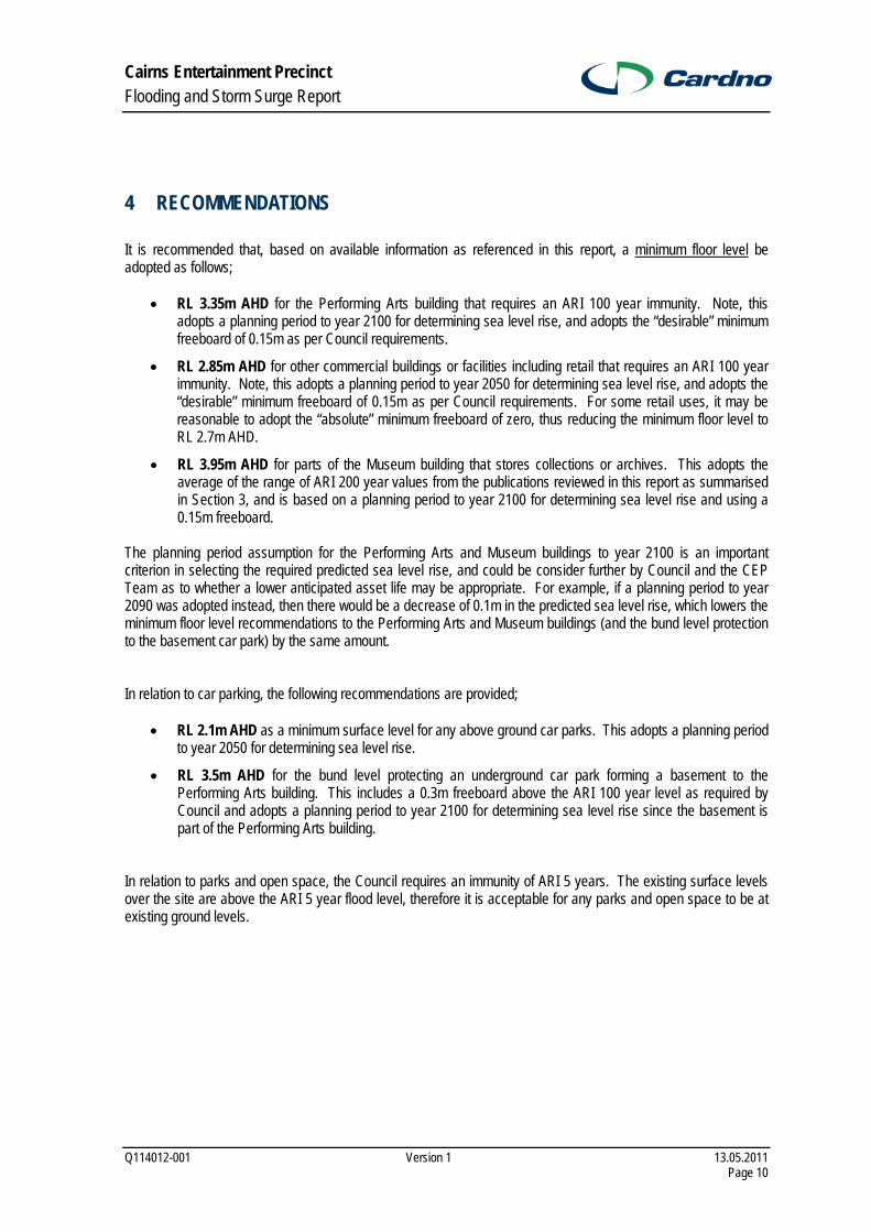
Cairns Entertainment Precinct Flooding and Storm Surge Report
Q114012-001 Version 1 13.05.2011 Page 10
4 RECOMMENDATIONS
It is recommended that, based on available information as referenced in this report, a minimum floor level be adopted as follows;
• RL 3.35m AHD for the Performing Arts building that requires an ARI 100 year immunity. Note, this adopts a planning period to year 2100 for determining sea level rise, and adopts the “desirable” minimum freeboard of 0.15m as per Council requirements.
• RL 2.85m AHD for other commercial buildings or facilities including retail that requires an ARI 100 year immunity. Note, this adopts a planning period to year 2050 for determining sea level rise, and adopts the “desirable” minimum freeboard of 0.15m as per Council requirements. For some retail uses, it may be reasonable to adopt the “absolute” minimum freeboard of zero, thus reducing the minimum floor level to RL 2.7m AHD.
• RL 3.95m AHD for parts of the Museum building that stores collections or archives. This adopts the average of the range of ARI 200 year values from the publications reviewed in this report as summarised in Section 3, and is based on a planning period to year 2100 for determining sea level rise and using a 0.15m freeboard.
The planning period assumption for the Performing Arts and Museum buildings to year 2100 is an important criterion in selecting the required predicted sea level rise, and could be consider further by Council and the CEP Team as to whether a lower anticipated asset life may be appropriate. For example, if a planning period to year 2090 was adopted instead, then there would be a decrease of 0.1m in the predicted sea level rise, which lowers the minimum floor level recommendations to the Performing Arts and Museum buildings (and the bund level protection to the basement car park) by the same amount. In relation to car parking, the following recommendations are provided;
• RL 2.1m AHD as a minimum surface level for any above ground car parks. This adopts a planning period to year 2050 for determining sea level rise.
• RL 3.5m AHD for the bund level protecting an underground car park forming a basement to the Performing Arts building. This includes a 0.3m freeboard above the ARI 100 year level as required by Council and adopts a planning period to year 2100 for determining sea level rise since the basement is part of the Performing Arts building.
In relation to parks and open space, the Council requires an immunity of ARI 5 years. The existing surface levels over the site are above the ARI 5 year flood level, therefore it is acceptable for any parks and open space to be at existing ground levels.

REFERENCES
1. Hardy, T.A., Mason, L., Astorquia, A., August 2004
The Frequency of Surge Plus Tide During Tropical Cyclones for Selected Open Coast Locations Along The Queensland East Coast.
2. Harper, B., Queensland Department of Environments Heritage January 1999.
Storm Tide Threat In Queensland: History, Prediction and Relative Risks.
3. Lawson & Treloar, March 2003. Report on Proposed Lot & Floor Levels For Cyclonic Surge/Tide/Set-Up/Run-Up. Lots 1&2 on RP 732379 and Part of Lots 4& 5 on RP 745129, Palm Cove, Cairns.
4. WBM Oceanics Australia, April 2000.
Cairns CBD and Environs Drainage Management Plan Phase 1 – Final Report.
5. Sinclair Knight Merz, WBM Oceanics Australia, April 2000. Cairns CBD and Environs Drainage Management Plan Phase 2 – Report Rev 8.
6. Lawson and Treloar, March 2001.
Cairns CBD and Environs Drainage Management Plan – Peer Review.
7. Queensland Government. Queensland Coastal Plan (Draft), April 2011.
8. Queensland Government. State Planning Policy Guideline 1/03– Mitigating the Adverse Impacts of Flood, Bushfire and Landslide, June 2003.
9. Queensland Reconstruction Authority. Planning for a stronger, more resilient North Queensland – Part 1 Rebuilding in Storm Tide Prone Areas: Tully Heads and Hull Heads, April 2011 (Draft).
10. K.M. McInnes, K.J.E. Walsh and A.B. Pittock for CSIRO, January 2000. Impact of Sea-level Rise and Storm Surges on Coastal Resorts.

Appendix A
PLAN DMP2 OF CAIRNS CBD AND ENVIRONS DRAINAGE MANAGEMENT PLAN – PHASE 2

DRAWING DMP2

Appendix B
QUEENSLAND COASTAL PLAN - ANNEX 3 STORM TIDE INUNDATION

Queensland Coastal Plan94
Determining storm tide areasA3.1 The storm-tide inundation area is the area of coast
inundated by the defined storm tide event (DSTE) as determined by applying:
For a development commitment, the minimum a) assessment factors outlined in table 3-1, column 1
or
For any other development, the assessment b) factors outlined in table 3-1, column 2.
Annex 3 – Storm-tide inundation areas
Table 3-1 Assessment factors for determining erosion prone areas and storm-tide inundation areas.
Column 1 Column 2
For development subject to a development commitment For development not subject to a development commitment
Planning period equivalent to expected asset life of the • development as outlined in table 3-2
Projected sea level rise of amount outlined in table 3-3, • based on expected asset life
Adoption of the 100-year average recurrence interval • extreme storm event or water level
Increase in cyclone intensity by 10% (relative to maximum • potential intensity) due to climate change.
Planning period: 90 years +•
Projected sea level rise of 0.8 metres by 2100 due to • climate change (relative to 1990 value)
Adoption of the 100-year average recurrence interval • extreme storm event or water level
Increase in cyclone intensity by 10% (relative to maximum • potential intensity) due to climate change.
Table 3-2 Planning period for development subject to development commitment
Type of development Planning period (based on anticipated asset life)
Short-term tourist accommodation 40 years
Residential dwelling, excluding unit blocks of 7+ 50 years
Residential dwelling unit blocks of 7+ 60 years
Industrial building 40 Years
Commercial building (retail) 40 Years
Commercial building (multiple storeys) 60 years
Table 3-3 Projected sea level rise for the year of the end of asset life as per table 3-2
Year of end of planning period Projected sea level rise
Year 2050 0.3 metres
Year 2060 0.4 metres
Year 2070 0.5 metres
Year 2080 0.6 metres
Year 2090 0.7 metres
Year 2100 0.8 metres

Queensland Coastal Plan 95
A3.2 A registered professional engineer Queensland, with expertise in physical coastal processes may determine the coastal hazard area relevant to a proposed development by undertaking a storm-tide inundation assessment consistent with A3.1 and the methodology described in the coastal hazards guideline. The guideline also provides information on how a storm-tide inundation assessment may be modified to be consistent with A3.1.
A3.3 Where a relevant storm-tide inundation assessment referred to in section A3.2 has not been completed in relation to a proposed development, the coastal hazard area is taken to be all land between high water mark and a minimum default DSTE level of:
1.5 metres above the level of HAT for all • development in South East Queensland
or
2 metres above the level of HAT in the rest • of Queensland for development that is not a development commitment.
Table 3-4
Type of infrastructure Recommended storm-tide event level (RSTEL)
Emergency services * 0.2 % annual exceedance probability (AEP)
Emergency shelters see reference 1*
Hospitals and associated facilities 0.2 % AEP
Major switch yards and substations * 0.5 % AEP
Police facilities * 0.5 % AEP
Power stations 0.2 % AEP
Sewerage treatment plants* Storm-tide inundation area
School facilities 0.5 % AEP
Stores of valuable records or items of historic or cultural significance (e.g. galleries and libraries).
0.5 % AEP
Water treatment plants * 0.5 % AEP
State controlled roads, railway lines, stations and • associated facilities
Aeronautical facilities•
Works of an electricity entity not otherwise listed • in this table
Communication network facilities •
No specific recommended storm-tide event level but development proponents should ensure that the infrastructure is optimally located and designed to achieve suitable levels of service, having regard to the processes and policies of the administering government agency.
* The RSTEL applies only to electrical and other equipment that, if damaged by floodwater or debris, would prevent the infrastructure from functioning. This equipment should either be protected from damage or designed to withstand inundation. Also some police and emergency services facilities (e.g. water police and search and rescue operations) are dependent on direct water access. The RSTELs do not apply to these aspects but other operational areas should be located above the RSTEL to the greatest extent feasible. Reference 1* : Design guidelines for Queensland public cyclone shelter posted at <www.distaster.qld.gov.au>.
Recommended storm-tide event levels for essential community service infrastructureTable 3-4 lists recommended storm-tide event levels for essential community infrastructure (included in Community Infrastructure from Schedule 2 of the Sustainable Planning Regulation 2009).

Appendix C
CBD SOUTH DRAINAGE UPGRADE - STAGE IMPLEMENTATION PLAN
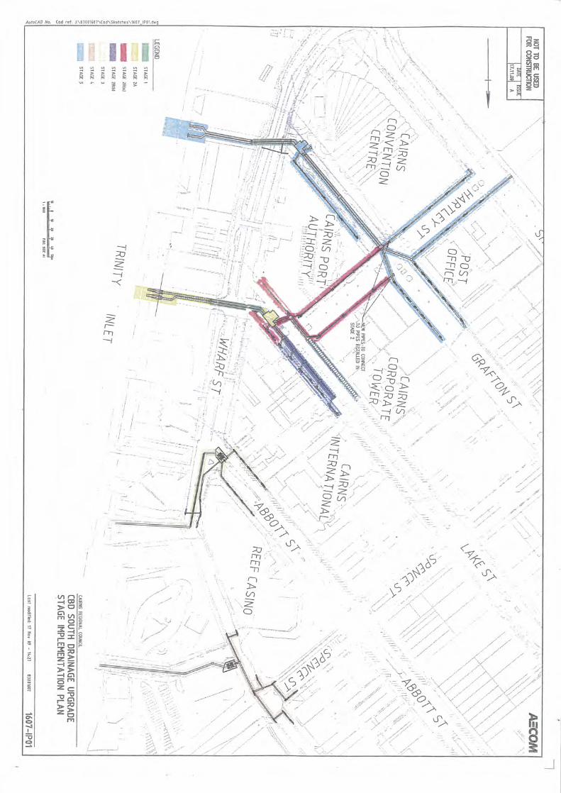

Appendix D
GLOSSARY OF TERMS – EXTRACT FROM STORM TIDE THREAT IN QUEENSLAND BY HARPER


Cairns Entertainment Precinct
Civil Engineering Report to Support the Stage 1 Development Application
Q114012 14 March 2012
Civil Design Report for Stage 1 DA (Ver 3)
ANNEXURE B
Minutes of Meeting 12/12/11 with Ports North - Services

MINUTES OF MEETING
H:\2011\114012\Detail Design Phase\Admin\Minutes of Meeting 121211.doc
Project Title Cairns Entertainment Precinct Project No. Q114012 Meeting Place Ports North Office (2.00pm) Date 12/12/11 Recorded by Bevan Clayton / Mark Perry Sheet 1 Of 1 Purpose of Meeting CEP Services Meeting No.
Attendees
Mark Perry (MP) – Cardno Bevan Clayton (BNC) – Cardno Michael Colleton (MC) – Ports North Michael Martin (MM) – Ports North Rezan (R) - GHD Item Description Action By Date
Reqd
1.0 (MP) Outline of CEP services proposal for water, sewerage, road, stormwater, including relocation of existing PN services.
2.0 (MP) Outline of CEP proposal of roadworks for Southern Access Road (realignment), Port Road and ramped intersection. Proposal for 8m wide pavement for Port Road and 7.5m wide for Southern Access Road. MM noted that roadway needs to accommodate trucks passing. (Also note item 12 below)
MP
3.0 Sewerage – MC – PN would probably prefer separate sewer to CEP Note 4.0 CEP has a lease over PN land so no need for easements. Therefore
can include any services access or other requirements in lease agreement.
Note
5.0 (R) A discussion of electrical issues, relocation of communication services through the services corridor, and street lighting.
Note
6.0 Check sewer depths BNC/MP 7.0 Check seawall drawings for pile locations and resolve pipe location.
Lake Street doesn’t have a grate BNC
8.0 2/900 dia join into 1 pipe. MM will check files for diameter MM 9.0 MM to provide photos of how Lake Street outlet is working. He
indicated some scour issues at the outlet. MM
10.0 MM advised that some current underground pipes aren’t flood gated. MM 11.0 MC noted that loss of flood storage due to the CEP building will
cause longer inundation of Port Road. Continuity of access required during cruise ships which will need to be managed during the re-construction of this ramp.
MC
12.0 MM noted access to northern ramp is important and is separated by security fence from the adjacent ramp to the south, therefore need to consider access continuity during ramp reconstruction. Will need ARUP to confirm turning circles to check truck movements between the new Port Road alignment and the wharf ramps.
ARUP
13.0 Council drove RL2.45m Crest requirement and no one seems to know reason for that level. PN doesn’t have any requirement. The CEP is proposing to direct overland flow through the CEP site (services corridor) at least until the Grafton St Q100 Drainage Pumps are built.
Note
14.0 Contact Tecoma Plumbing – Trevor regarding location of store sewerage connections – 0407 969 505
BNC/MP

Cairns Entertainment Precinct
Civil Engineering Report to Support the Stage 1 Development Application
Q114012 14 March 2012
Civil Design Report for Stage 1 DA (Ver 3)
ANNEXURE C
Figures to Support the Upstream Sewage Generation Calculations


Cairns Entertainment Precinct
Civil Engineering Report to Support the Stage 1 Development Application
Q114012 14 March 2012
Civil Design Report for Stage 1 DA (Ver 3)
ANNEXURE D
Cairns Ports Authority General Code Requirements

VOLUME FIVE: GENERAL CODES
2.0 General Codes
2.1 Assessment & Management of Acid Sulphate Soils Code
Intent The purpose of this code is to — ensure the environmental values and ecological health of
receiving waters are maintained and protected; and identify, assess, contain and/or manage Potential Acid
Sulphate Soils (PASS) and Actual Acid Sulphate Soils (AASS). Applicability
This code applies to development within the Cityport, Seaport or Airport LAPS that — is exempt or assessable development; includes land, soil and sediment at or below 5 metres
Australian Height Datum (AHD) where the natural ground level is less than 20 metres AHD;
involves the following activities – – excavating or otherwise removing 5m3 or more of soil or
sediment; or – filling of land involving 500m3 or more of material with an
average depth of 0.5 metres or greater. This code should be read in conjunction with the Environmental Protection Code and the Landscape Design Code. Elements of the Code
Development Principles
PERFORMANCE CRITERIA ACCEPTABLE SOLUTIONS
General P1 The release of acid and associated metal
contaminants into the environment is avoided.
A1 Acid sulphate soils are not disturbed when excavating or otherwise removing soil or sediment, extracting groundwater or filling land. OR
If acid sulphate soils are disturbed, they are treated and, if required, ongoing management of any disturbed acid sulphate soils and drainage waters is undertaken.
Cairns Port Authority Land Use Plan
5-4 November 2006

VOLUME FIVE: GENERAL CODES
PERFORMANCE CRITERIA ACCEPTABLE SOLUTIONS P2 Prior to any site works, the likelihood of
AASS or PASS and the associated environmental impacts are determined.
A2.1 Sampling and analysis is carried out in accordance with the procedures described in The Guidelines for Sampling and Analysis of Lowland Acid Sulfate Soils (AASS) in Queensland produced by the Department of Natural Resources, Mines & Water.
A2.2 An Acid Sulphate Soil Investigation Report is submitted to and approved by the assessment manager prior to any approval. This report is to include at least the following – the testing results; sampling methods; an assessment of the potential for
acid sulphate soils to be disturbed either through drainage or excavation; and
potential impacts on adjoining areas.
The level of testing should be commensurate with the level of risk.
P3 Where in an area of PASS or AASS, development is managed in a manner that ensures the environmental values including receiving water quality are not adversely impacted and that assets are not subject to accelerated corrosion.
A3.1 Where AASS or PASS is identified, an Acid Sulphate Soils Environmental Management Plan is prepared. The EMP is to detail at least the following – the sampling & analysis procedures
to be adopted; the methods of treating/managing
soils; details of monitoring procedures;
and details of contingency procedures.
A3.2 All development is to be carried out in
accordance with the approved Environmental Management Plan.
Cairns Port Authority Land Use Plan
5-5 November 2006

VOLUME FIVE: GENERAL CODES
2.2 Development of Flood Prone Land Code
Intent The purpose of this code is to ensure that all development has an acceptable level of flood immunity. Applicability
This code applies to development that is — exempt or assessable development; and in the Cityport, Seaport or Airport LAP areas.
This code should be read in conjunction with the Assessment and Management of Acid Sulphate Soils Code and Landscape Design Code. Elements of the Code Development Principles
PERFORMANCE CRITERIA ACCEPTABLE SOLUTIONS
General P1 Any developing involving the excavation
or filling of land is carried out so as not to have a “worsening” effect on flood water levels or flow results either upstream or downstream of the development site.
A1.1 Development does not significantly alter the levels of the site AND/OR
Development does not impact on downstream properties AND/OR
Where sites levels are to be altered, adequate retention and retardation mechanisms are provided to ensure the quantity of water leaving the site is not increased above present volumes and flow rates.
A1.2 Water quality measures are established to ensure the quality of water (surface and sub-surface) is of an equivalent or higher standard than presently exists.
A1.3 A water quality monitoring program is implemented.
Cairns Port Authority Land Use Plan
5-6 November 2006
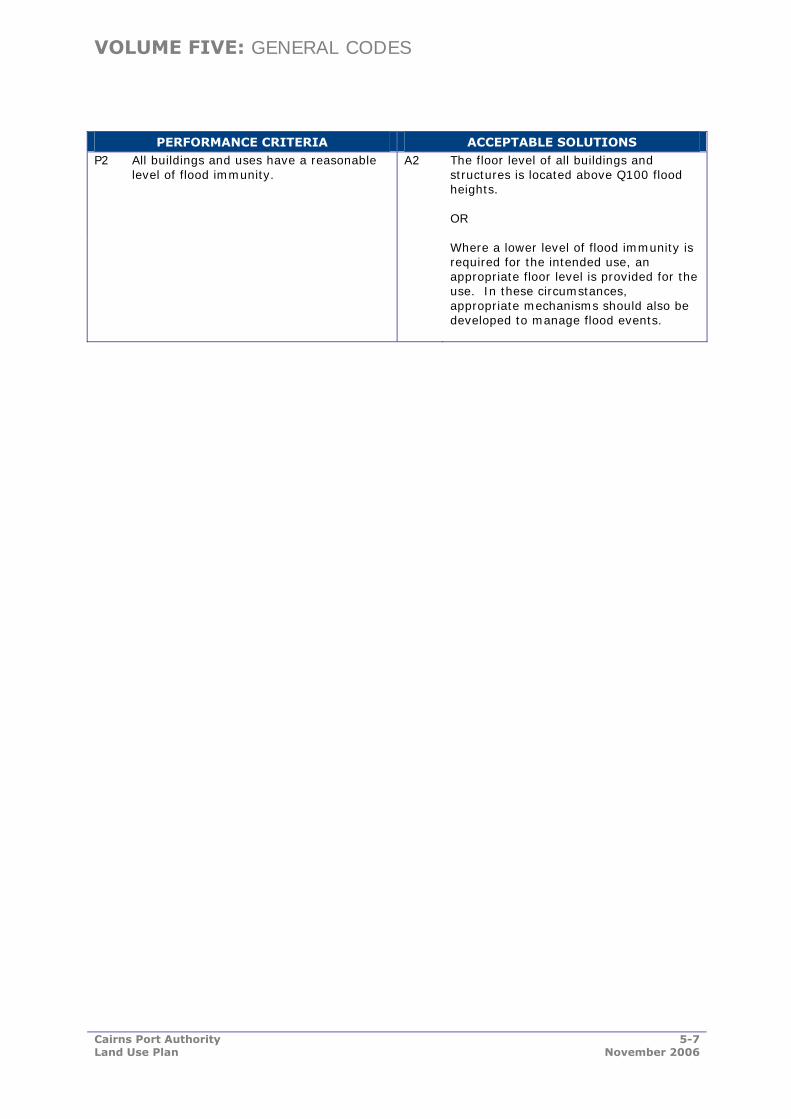
VOLUME FIVE: GENERAL CODES
PERFORMANCE CRITERIA ACCEPTABLE SOLUTIONS P2 All buildings and uses have a reasonable
level of flood immunity. A2 The floor level of all buildings and
structures is located above Q100 flood heights. OR
Where a lower level of flood immunity is required for the intended use, an appropriate floor level is provided for the use. In these circumstances, appropriate mechanisms should also be developed to manage flood events.
Cairns Port Authority Land Use Plan
5-7 November 2006
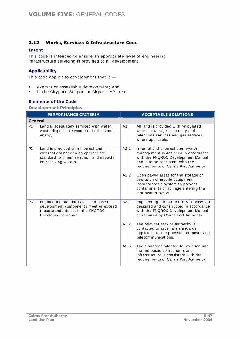
VOLUME FIVE: GENERAL CODES
2.12 Works, Services & Infrastructure Code
Intent This code is intended to ensure an appropriate level of engineering infrastructure servicing is provided to all development. Applicability
This code applies to development that is — exempt or assessable development; and in the Cityport, Seaport or Airport LAP areas.
Elements of the Code
Development Principles
PERFORMANCE CRITERIA ACCEPTABLE SOLUTIONS
General P1 Land is adequately serviced with water,
waste disposal, telecommunications and energy.
A1 All land is provided with reticulated water, sewerage, electricity and telephone services and gas services where applicable.
P2 Land is provided with internal and external drainage to an appropriate standard to minimise runoff and impacts on receiving waters.
A2.1 Internal and external stormwater management is designed in accordance with the FNQROC Development Manual and is to be consistent with the requirements of Cairns Port Authority.
A2.2 Open paved areas for the storage or operation of mobile equipment incorporates a system to prevent contaminants or spillage entering the stormwater system.
P3 Engineering standards for land based development components meet or exceed those standards set in the FNQROC Development Manual.
A3.1 Engineering infrastructure & services are designed and constructed in accordance with the FNQROC Development Manual as required by Cairns Port Authority.
A3.2 The relevant service authority is contacted to ascertain standards applicable to the provision of power and telecommunications.
A3.3 The standards adopted for aviation and marine based components and infrastructure is consistent with the requirements of Cairns Port Authority.
Cairns Port Authority Land Use Plan
5-47 November 2006

VOLUME THREE: SEAPORT LOCAL AREA PLAN
5.0 General Seaport Codes
5.1 Seaport LAP Code
The purpose of this code is to facilitate the achievement of the following desired development outcomes for Seaport — ensure the safe and efficient operation of the Seaport; maintain acceptable levels of impact from port activities on
adjoining non-industrial areas; ensure the waterfront development areas are utilised
efficiently; ensure the amenity of the Seaport is maintained and
enhanced; and ensure development balances economic, social and
environmental factors to minimise adverse impacts on the community and the environment.
Applicability These development principles apply to development that is — exempt or assessable development; and in the Seaport LAP area.
Elements of the Code
Development Principles
PERFORMANCE CRITERIA ACCEPTABLE SOLUTIONS
General P1 Planning areas adjoining the waterfront
and wharfage areas are utilised primarily for port related activities.
A1 No acceptable solution provided. The applicant is to provide a solution which achieves the Performance Criteria.
P2 Public access to the Inlet and Smiths Creek is provided only where it does not impact on the operation of the port, and where it does not present a risk to personal safety.
A2 No acceptable solution provided. The applicant is to provide a solution which achieves the Performance Criteria.
P3 Development is to be designed and constructed to an engineering standard acceptable to Cairns Port Authority.
A3 Development complies with the Works, Services & Infrastructure Code.
P4 Development is located and carried out in a manner that separates and where necessary, provides a physical buffer to incompatible land uses.
A4 No acceptable solution provided. The applicant is to provide a solution which achieves the Performance Criteria.
P5 Development affecting land below high water mark (such as landings, ramps, berthing facilities and retaining walls) is designed and constructed according to relevant standards.
A5 Design and construction is in accordance with the requirements of the Fisheries Act 1994, the Harbours Act 1955 and the Transport Infrastructure Act 1994.
Cairns Port Authority Land Use Plan
3-30 November 2006

VOLUME THREE: SEAPORT LOCAL AREA PLAN
PERFORMANCE CRITERIA ACCEPTABLE SOLUTIONS
Environmental & Risk Management
P6 The design and location of any future uses minimises any potential impact on the environmental values of Trinity Inlet or Smith’s Creek.
A6.1 Development complies with water quality, air quality and noise standards administered through the Environmental Protection Act 1994.
A6.2 Development is undertaken in accordance with the Environmental Protection Code.
A6.3 Where any use has the potential to impact on the environment, the necessary Environmental Management Plans will be prepared and approved prior to any on-site works or commencing the use.
A6.4 Where necessary, all construction and on-site works are undertaken in accordance with an approved Environmental Management Plan for Acid Sulphate Soils.
A7.1 Development compiles with the Industrial Development Code.
P7 Major industrial development, or development constituting a potential safety risk or hazard, demonstrates it can meet acceptable safety standards. A7.2 Development complies with State
Planning Policy 1/02 – Development in the Vicinity of Certain Airports and Aviation Facilities.
P8 Development is designed and located such that an acceptable level of flood immunity is provided.
A8.1 Development complies with the Development of Flood Prone Land Code where applicable.
P9 The disturbance of acid sulphate soils or potential acid sulphate soils is avoided or minimised.
A9.1 Development does not involve excavation works where there is potential or actual acid sulphate soils; or
A9.2 Development complies with the Assessment & Management of Acid Sulfate Soils Code.
Landscaping P10 On-site landscaping assists in creating an
attractive environment and enhancing the amenity of the area.
A10 Development complies with the Landscaping Code.
P11 Landscaping provides a buffer between industrial uses and non-industrial uses.
A11 Development complies with the Landscaping Code.
Development complies with the Industrial Development Code.
Cairns Port Authority Land Use Plan
3-31 November 2006
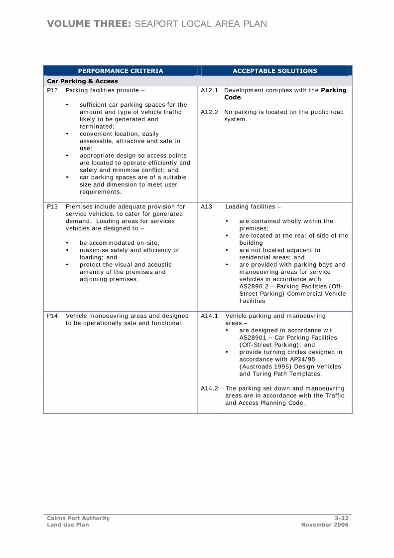
VOLUME THREE: SEAPORT LOCAL AREA PLAN
PERFORMANCE CRITERIA ACCEPTABLE SOLUTIONS
Car Parking & Access P12 Parking facilities provide –
sufficient car parking spaces for the amount and type of vehicle traffic likely to be generated and terminated;
convenient location, easily assessable, attractive and safe to use;
appropriate design so access points are located to operate efficiently and safely and minimise conflict; and
car parking spaces are of a suitable size and dimension to meet user requirements.
A12.1 A12.2
Development complies with the Parking Code. No parking is located on the public road system.
P13 Premises include adequate provision for service vehicles, to cater for generated demand. Loading areas for services vehicles are designed to –
be accommodated on-site; maximise safely and efficiency of
loading; and protect the visual and acoustic
amenity of the premises and adjoining premises.
A13 Loading facilities – are contained wholly within the
premises; are located at the rear of side of the
building are not located adjacent to
residential areas; and are provided with parking bays and
manoeuvring areas for service vehicles in accordance with AS2890.2 – Parking Facilities (Off-Street Parking) Commercial Vehicle Facilities
P14 Vehicle manoeuvring areas and designed
to be operationally safe and functional. A14.1 Vehicle parking and manoeuvring
areas – are designed in accordance wit
AS28901 – Car Parking Facilities (Off-Street Parking); and
provide turning circles designed in accordance with AP34/95 (Austroads 1995) Design Vehicles and Turing Path Templates.
A14.2 The parking set down and manoeuvring
areas are in accordance with the Traffic and Access Planning Code.
Cairns Port Authority Land Use Plan
3-32 November 2006

Cairns Entertainment Precinct
Civil Engineering Report to Support the Stage 1 Development Application
Q114012 14 March 2012
Civil Design Report for Stage 1 DA (Ver 3)
ANNEXURE E
CBD South Drainage Study (2007 report) Drawing 2005C4N1 - Stormwater Drainage Plan Grafton Street System

83002005
5 30
CBD SOUTH DRAINAGE STUDYSTORM WATER DRAINAGE PLAN
GRAFTON STREET SYSTEM
MGC / AS
A.SSCALE 1:200
0 4 8 12 16 20
No.
NUMBER OF PLANS
DESCRIPTION
REVISIONSREV.
prohibited" ©
Unauthorised use of this document in any way is
only be used for the purpose for which it was designed.
property of Cairns City Council . The document may
Copyright :- "This document is and shall remain the
DRAWN
SURVEYED
DATE SIGN
m
DO NOT SCALE
DESIGNED
DATE
CHECKED
CO-ORDINATING ENGINEER (PRE CONSTRUCTION)
Approved for Project Delivery phase on behalf of client
Reviewed by Pre-Construction for compliance with client approvedscope of work and budget
MANAGER PROJECT SERVICES
RECOMMENDED FOR CONSTRUCTION
OTHER
MANAGER PRECINCTS & FACILITIES
MANAGER INFRASTRUCTURE MANAGEMENT
Initial Date
APPROVED FOR CONSTRUCTION
GENERAL MANAGER CITY WORKS AND SERVICES
Environmental Scientists & Project ManagersABN 20 093 846 925
Consulting Engineers, Planners,

Cairns Entertainment Precinct
Civil Engineering Report to Support the Stage 1 Development Application
Q114012 14 March 2012
Civil Design Report for Stage 1 DA (Ver 3)
ANNEXURE F
Water and Wastewater Demand Assessment Report (by SPP Group)
Cairns Entertainment Precinct
Wharf Street, Cairns
Water & Waste Water Demand Assessment Report Prepared By: SPP Group 3a/57 Coronation Drive BRISBANE QLD 4000 Telephone: 07 3846 3077 Facsimile: 07 3844 4665 Email: [email protected]

Cairns Entertainment Precinct – Wharf Street, Cairns Water & Sewer Demand Assessment Report
SPP GROUP 2
Hydraulic Services Consultants
REV. 2
REPORT AUTHORISATION PROJECT: Cairns Entertainment Precinct Report No: BN110080
Date Rev. Comment Report Prepared
by
Report Checked
by
Authorised by
11 Nov 01 Issue for Review TK DC TK
2 Dec 02 Issue to Review TK DC TK
9 Dec 03 Issue for Council Review TK DC TK
This document contains commercial information which has been prepared for the attention of the Client on this project. It is confidential and no information contained in this document shall be released in part or whole to any third party without the approval of SPP Group. Reviewed & Approved for Issue
Troy Kassulke Director

Cairns Entertainment Precinct – Wharf Street, Cairns Water & Sewer Demand Assessment Report
SPP GROUP 3
Hydraulic Services Consultants
REV. 3
CONTENTS
1. INTRODUCTION 6
1.1 General 6
1.2 Report Format 6
1.2.1 General 6
1.3 Assessment Criteria 7
1.3.1 Cairns Regional Council (CRC) 7
1.3.2 Far North Queensland Regional Organisation of Council (FNQROC) 7
1.3.3 Site Specific Demand Principles 7
2. WATER SERVICES DEMAND 9
2.4 Water Demand Based on Authority Planning Guidelines 9
2.4.1 Stage 1 9
2.4.2 Stage 1 Average Daily Water Demand (AD) 9
2.4.3 Stage 1 Mean Day Maximum Month (MDMM) 9
2.4.4 Stage 1 Peak Day (PD) 9
2.4.5 Stage 1 Peak Hour (PH) 9
2.4.6 Stage 2 10
2.4.7 Stage 2 Average Daily Water Demand (AD) 10
2.4.8 Stage 2 Mean Day Maximum Month (MDMM) 10
2.4.9 Stage 2 Peak Day (PD) 10
2.4.10 Stage 2 Peak Hour (PH) 10
2.4.11 Stage 3 10
2.4.1 Stage 3 Average Daily Water Demand (AD) 10
2.4.2 Stage 3 Mean Day Maximum Month (MDMM) 10
2.4.3 Stage 3 Peak Day (PD) 10
2.4.4 Stage 3 Peak Hour (PH) 10
2.4.5 Projected Forecast for Stage 1 11
2.4.1 Projected Stage 1 Average Daily Water Demand (AD) 11
2.4.2 Projected Stage 1 Mean Day Maximum Month (MDMM) 11
2.4.3 Projected Stage 1 Peak Day (PD) 11
2.4.4 Projected Stage 1 Peak Hour (PH) 11
2.5 Water Demand Based on Specific Project Assessment Criteria 12
2.6 Stage 1 Average Daily Water Demand (AD) 12
2.6.1 PAV - Patron Daily Water Demand 12
2.6.2 PAV – Performer and Support Personnel Daily Water Demand 12
2.6.3 PAV - Full Time Staff Daily Water Demand 12
2.6.4 PAV - General Cleaning Water Demand 13
2.6.5 PAV- Cooking Water Demand 13
2.6.6 PAV- Cooling Tower Water Demand 13
2.6.7 Whites Shed - Patron Daily Water Demand 13
2.6.8 Whites Shed - Full Time Staff Daily Water Demand 13
2.6.9 Whites Shed - General Cleaning Water Demand 13
2.6.10 Public Space - General Cleaning Water Demand 13
2.6.11 Stage 1 - Total Average Daily Water Demand (AD) 14
2.6.12 Stage 1 - Projected Forecast 14

Cairns Entertainment Precinct – Wharf Street, Cairns Water & Sewer Demand Assessment Report
SPP GROUP 4
Hydraulic Services Consultants
REV. 3
2.7 Stage 1- Average Continuous Water Demand 14
2.8 Stage 1- Maximum Peak Water Demand 15
2.9 Stage 2 - Average Daily Water Demand (AD) 15
2.9.1 PAV Performance Space 2 - Patron Daily Water Demand 15
2.9.2 PAV Performance Space 2 - Performer & Support Personnel Daily Water Demand 15
2.9.3 PAV Space 2 - Cooling Tower Water Demand 15
2.9.4 Stage 2 - Total Average Daily Water Demand (AD) 16
2.10 Stage 2- Average Continuous Water Demand 16
2.11 Stage 2 - Maximum Peak Water Demand 16
2.12 Stage 1 and 2 – Combined Average Continuous Water Demand 16
2.13 Stage 1 and 2 – Combined Maximum Peak Water Demand 16
2.14 Stage 3 - Average Daily Water Demand (AD) 17
2.14.1 Museum - Patron Daily Water Demand 17
2.14.2 Museum - Full Time Staff Daily Water Demand 17
2.14.3 Museum - General Cleaning Water Demand 17
2.14.4 Museum - Cooling Tower Water Demand 17
2.14.5 Museum – Total Daily Water Demand 17
2.15 Stage 3 – Average Continuous Water Demand 18
2.16 Stage 3 - Maximum Peak Water Demand 18
2.17 Stage 1, 2 and 3 – Combined Average Continuous Water Demand 18
2.18 Stage 1, 2 and 3 – Combined Maximum Peak Water Demand 18
2.19 Stage 1 - Mean Potable Water Monthly Demand (MDMM) 19
2.19.1 Stage 1 - Average Monthly Water Demand 19
2.19.2 Stage 1 – Projected Average Monthly Water Demand 19
2.20 Stage 2 - Mean Potable Water Monthly Demand (MDMM) 19
2.20.1 Stage 2 - Average Monthly Water Demand 19
2.21 Stage 3 - Mean Potable Water Monthly Demand (MDMM) 19
2.21.1 Stage 3 - Average Monthly Water Demand 19
3. WASTEWATER SERVICES 20
3.22 Waste Water Flow Based on Authority Planning Guidelines 20
3.22.1 Stage 1 20
3.22.2 Stage 1 Average Dry Weather Flow (ADWF) 20
3.22.3 Stage 1 Peak Wet Weather Flow (PWWF) 20
3.22.4 Stage 2 20
3.22.1 Stage 2 Average Dry Weather Flow (ADWF) 20
3.22.2 Stage 2 Peak Wet Weather Flow (PWWF) 21
3.22.3 Stage 3 21
3.22.4 Stage 3 Average Dry Weather Flow (ADWF) 21
3.22.5 Stage 3 Peak Wet Weather Flow (PWWF) 21
3.22.6 Projected Forecast for Stage 1 21
3.22.7 Projected Stage 1 Average Daily Waste Water Flow (ADWF) 21
3.22.8 Projected Stage 1 Peak Wet Weather Flow (PWWF) 21
3.23 Waste Water Flow Based on Assessment Criteria 22

Cairns Entertainment Precinct – Wharf Street, Cairns Water & Sewer Demand Assessment Report
SPP GROUP 5
Hydraulic Services Consultants
REV. 3
3.24 Stage 1 Average Daily Waste Water Flow (AD) 22
3.24.1 PAV - Patron Daily Waste Water Flow 22
3.24.2 PAV – Performer and Support Personnel Daily Waste Water Flow 22
3.24.3 PAV - Full Time Staff Daily Waste Water Flow 22
3.24.4 PAV - General Cleaning Waste Water Flow 23
3.24.5 PAV- Cooking Waste Water Flow 23
3.24.6 PAV- Cooling Tower Waste Water Flow 23
3.24.7 Whites Shed - Patron Daily Waste Water Flow 23
3.24.8 Whites Shed - Full Time Staff Daily Waste Water Flow 23
3.24.9 Stage 1 - Total Average Daily Waste Water Flow (ADWF) 23
3.24.10 Stage 1 - Projected Forecast Waste Water Flow 24
3.25 Stage 1- Estimated Continuous Waste Water Flow 24
3.26 Stage 1- Estimated Spike / Peak Waste Water Demand 24
3.27 Stage 2 - Average Daily Waste Water Flow (ADWF) 25
3.27.1 PAV Performance Space 2 - Patron Daily Waste Water Flow 25
3.27.2 PAV Performance Space 2 - Performer & Support Personnel Daily Waste Water Flow 25
3.27.3 PAV Space 2 - Cooling Tower Waste Water Demand 25
3.27.4 Stage 2 - Total Average Daily Waste Water Demand (AD) 25
3.28 Stage 2- Estimated Continuous Waste Water Flow 26
3.29 Stage 2- Estimated Spike / Peak Waste Water Demand 26
3.30 Stage 1 and 2 – Combined Average Waste Water Flow 26
3.31 Stage 1 and 2 – Combined Peak Waste Water Flow 26
3.32 Stage 3 Average Daily Waste Water Flow 27
3.32.1 Museum - Patron Daily Waste Water Flow 27
3.32.2 Museum - Full Time Staff Daily Waste Water Flow 27
3.32.3 Museum - General Cleaning Water Flow 27
3.32.4 Museum - Cooling Tower Water Flow 27
3.32.5 Museum – Total Daily Water Flow 27
3.33 Stage 3 – Estimated Continuous Waste Water Flow 28
3.34 Stage 1, 2 and 3 – Combined Continuous Waste Water Flow 28
3.35 Stage 1 - Mean Waste Water Monthly Flow (MWWMF) 29
3.35.1 Stage 1 - Average Monthly Waste Water Flow 29
3.35.2 Stage 1 – Projected Average Monthly Waste Water Demand 29
3.36 Stage 2 - Mean Waste Water Monthly Flow (MWWMF) 29
3.36.1 Stage 2 - Average Monthly Waste Water Flow 29
3.37 Stage 3 - Mean Monthly Waste Water Flow (MWWMF)) 29
3.37.1 Stage 3 - Average Monthly Waste Water Flow 29

Cairns Entertainment Precinct – Wharf Street, Cairns Water & Sewer Demand Assessment Report
SPP GROUP 6
Hydraulic Services Consultants
REV. 3
1. INTRODUCTION
1.1 General
This report, prepared by SPP Group, provides an assessment of the Water Demand and Waste Water requirements for the proposed Cairns Entertainment Precinct (CEP) – Wharf Street, Cairns.
The report has been prepared to assist the Civil Engineer in providing an assessment to Cairns Regional Council of the projected impact on the existing water and sewer loadings that the new Entertainment Precinct will impose on the proposed new system upgrades.
This report excludes any water demands for Fire Fighting Purposes. Or any demands from the existing Ports Facilities
The desktop assessment of the proposed development Water and Waste water as outlined in this report is based on the following considerations in line with the Business Case Study:
Stage 1
Performance Space 1 and Car Parks, Whites Shed, and Public Domain Spaces
Stage 2
Performance Space 2 addition
Stage 3
Museum Addition
1.2 Report Format
1.2.1 General The report has been presented in two formats. 1. In terms of an Equivalent Population (EP) in accordance with Cairns Regional
Council and Far North Queensland Regional Organisation of Councils Planning Trunk Infrastructure Guidelines which identify First Principle EDU / EP based on GFA for the development.
2. In terms of actual projected water and waste water usage based on specific assessment criteria of uses and population expected to be working, performing or visiting the site from the initial commencement of operation with an expected average annual increase of patronage of 2% in accordance with the Business Case Study.
This section of the assessment shall:
• Identify the average daily water demand (AD)
• Identify the mean monthly water demand (MDMM)
• Identify the peak flow demand in litres / second
• Identify the Average daily sewer discharge (AD)
• Identify the mean monthly sewer discharge (MDMM)
• Identify the peak sewer discharge in litres/second

Cairns Entertainment Precinct – Wharf Street, Cairns Water & Sewer Demand Assessment Report
SPP GROUP 7
Hydraulic Services Consultants
REV. 3
The report shall generally focus on the actual projected demands based on the uses as this is deemed to be a more accurate assessment.
1.3 Assessment Criteria
1.3.1 Cairns Regional Council (CRC) The report has adopted the following CRC first principle basis points.
• Defined Land Use : Place of Assembly
• Unit of Measure: 275 sqm GFA
• Water Supply Demand: 1.0 (EDU) / Unit of Measure
• Waste Water Demand: 1.0 (EDU) / Unit of Measure
• 1 EDU: Equates to 2.8 EP’s
1.3.2 Far North Queensland Regional Organisation of Council (FNQROC) The report has adopted the following FNQROC first principle basis points.
Water Reticulation
• Aver Daily Consumption (AD) : 500l / person / day
• Mean day Max Month MDMM: 1.5 x AD
• Peak Day: 2.25 x AD
• Peak Hour: 1/12 x AD
Sewerage System
• Aver Dry Weather Flow (ADWF) : 270l / EP / day
• Peak Wet Weather Flow (PWWF) : 5 x ADWF
• Peak Dry Weather Flow (PDWF) : C2 x ADWF
1.3.3 Site Specific Demand Principles
Water is utilised and sewer discharge generated by the following processes within the proposed development:
• Potable Requirements for onsite personnel use – The use of water for potable water purposes i.e. water closet flushing, drinking, personal hygiene and general personnel hygiene cleaning requirements and the associated wastewater generated by these processes;
• Food Process Requirements – The use of water in the cooking and cleaning and waste water generated by these processes.
• Mechanical Plant Cooling Waters and the associated waste waters.

Cairns Entertainment Precinct – Wharf Street, Cairns Water & Sewer Demand Assessment Report
SPP GROUP 8
Hydraulic Services Consultants
REV. 3
Demand for relevant / specific uses and anticipated population numbers are as follows:
Stage 1 - Performance Arts Venue (PAV Space 1), Whites Shed, Public Domain Spaces.
Full Time Staff Numbers and Hours of Operation for PAV Space 1:
• 34 persons
Average Performer Numbers:
• Average 75 performers
• Average Musicians 25 person
• Average 25 Stage and BOH support crew
Stage 1 PAV Patron Numbers:
• Performance Space 1 - 1,000 Seat Venue
• Annual Visitation of Performing Arts Venue - 130,000 persons (2016)
• Annual Visitation of Whites Shed - 115,000 persons (2016)
Stage 2 - Performance Arts Venue (Space 2)
Stage 2 PAV Patron Numbers:
• Performance Space 2 - Additional 450 Seat Venue
• Annual Visitation of Performing Arts Venue - Additional 70,000 persons
Average Performer numbers generally for PAV:
• Average 25 performers
• Average 10 Stage and BOH support crew Stage 3 Museum
Full Time Staff Numbers and Hours of Operation for PAC:
• 10 persons
• Annual Visitation of Museum - 300,000 persons

Cairns Entertainment Precinct – Wharf Street, Cairns Water & Sewer Demand Assessment Report
SPP GROUP 9
Hydraulic Services Consultants
REV. 3
2. WATER SERVICES DEMAND
2.4 Water Demand Based on Authority Planning Guidelines
Based on technical requirements form the Cairns Regional Council trunk Infrastructure Planning Scheme Policy and FNQROC Development Manuals for Water Reticulation the potable water demand has been expressed as an Equivalent Population (EP) assessed by the Gross Floor Area (GFA) for Defined Land Uses (DFU) and the corresponding Water Supply Demand (WSD) for the development which has been determined as follows;
2.4.1 Stage 1
Performance Space 1 and Car Parks, Whites Shed, Public Domain Spaces.
DFU GFA Unit of
Measure / WSD Equivalent
Demand Units Equivalent Population
PAV Stage 1 21,400 m2 @ 1.0 / 275m2 78 EDU 218 EP
Whites Shed 1,500m2 @ 1.0 / 275m2 5.5 EDU 15 EP
Public Spaces 3,350m2 @ 1.0 / 275m2 12 EDU 34 EP
Totals 26,250m2 @ 1.0 / 275m2 94.5 EDU 267 EP
2.4.2 Stage 1 Average Daily Water Demand (AD)
Average Daily Water Demand (AD) = EP x 500l / person
= 267 x 500l / person = 133,500 L / day
2.4.3 Stage 1 Mean Day Maximum Month (MDMM)
Mean Day Maximum Month (MDMM) 1.5 x AD = 200,250 L / day
2.4.4 Stage 1 Peak Day (PD)
Peak Day (PD) 2.25 x AD = 300,375 L / day
2.4.5 Stage 1 Peak Hour (PH)
Peak Hour (PH) 1/12 x AD = 11,125 L / hr
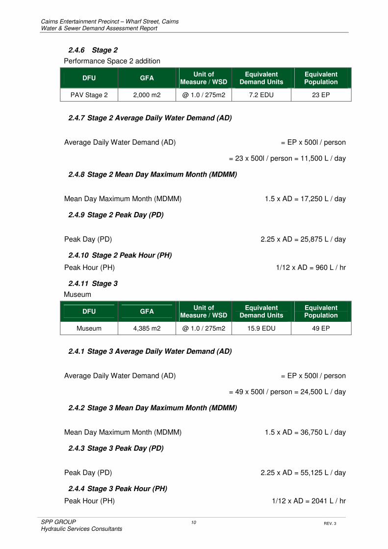
Cairns Entertainment Precinct – Wharf Street, Cairns Water & Sewer Demand Assessment Report
SPP GROUP 10
Hydraulic Services Consultants
REV. 3
2.4.6 Stage 2
Performance Space 2 addition
DFU GFA Unit of
Measure / WSD Equivalent
Demand Units Equivalent Population
PAV Stage 2 2,000 m2 @ 1.0 / 275m2 7.2 EDU 23 EP
2.4.7 Stage 2 Average Daily Water Demand (AD)
Average Daily Water Demand (AD) = EP x 500l / person
= 23 x 500l / person = 11,500 L / day
2.4.8 Stage 2 Mean Day Maximum Month (MDMM)
Mean Day Maximum Month (MDMM) 1.5 x AD = 17,250 L / day
2.4.9 Stage 2 Peak Day (PD)
Peak Day (PD) 2.25 x AD = 25,875 L / day
2.4.10 Stage 2 Peak Hour (PH)
Peak Hour (PH) 1/12 x AD = 960 L / hr
2.4.11 Stage 3
Museum
DFU GFA Unit of
Measure / WSD Equivalent
Demand Units Equivalent Population
Museum 4,385 m2 @ 1.0 / 275m2 15.9 EDU 49 EP
2.4.1 Stage 3 Average Daily Water Demand (AD)
Average Daily Water Demand (AD) = EP x 500l / person
= 49 x 500l / person = 24,500 L / day
2.4.2 Stage 3 Mean Day Maximum Month (MDMM)
Mean Day Maximum Month (MDMM) 1.5 x AD = 36,750 L / day
2.4.3 Stage 3 Peak Day (PD)
Peak Day (PD) 2.25 x AD = 55,125 L / day
2.4.4 Stage 3 Peak Hour (PH)
Peak Hour (PH) 1/12 x AD = 2041 L / hr

Cairns Entertainment Precinct – Wharf Street, Cairns Water & Sewer Demand Assessment Report
SPP GROUP 11
Hydraulic Services Consultants
REV. 3
2.4.5 Projected Forecast for Stage 1
Based on a 2% average increase in visitation to the precinct as outlined in the business case study the Performance Space 1 and Car Parks, Whites Shed, and Public Domain Spaces could expect the follow EP demands.
Total Equivalent Population at
2016 2020 2025 2030 2040
267 EP 289 EP 319 EP 352 EP 429 EP
2.4.1 Projected Stage 1 Average Daily Water Demand (AD)
Average Daily Water Demand (AD) 2020 = 289 x 500l / person = 144,500 L / day
Average Daily Water Demand (AD) 2025 = 319 x 500l / person = 159,500 L / day
Average Daily Water Demand (AD) 2030 = 352 x 500l / person = 176,000 L / day
Average Daily Water Demand (AD) 2040 = 429 x 500l / person = 214,500 L / day
2.4.2 Projected Stage 1 Mean Day Maximum Month (MDMM)
Mean Day Maximum Month (MDMM) 2020 1.5 x AD = 216,750 L / day
Mean Day Maximum Month (MDMM) 2025 1.5 x AD = 239,250 L / day
Mean Day Maximum Month (MDMM) 2030 1.5 x AD = 264,000 L / day
Mean Day Maximum Month (MDMM) 2040 1.5 x AD = 321,750 L / day
2.4.3 Projected Stage 1 Peak Day (PD)
Peak Day (PD) 2020 2.25 x AD = 325,125 L / day
Peak Day (PD) 2025 2.25 x AD = 358,875 L / day
Peak Day (PD) 2030 2.25 x AD = 396,000 L / day
Peak Day (PD) 2040 2.25 x AD = 482,625 L / day
2.4.4 Projected Stage 1 Peak Hour (PH)
Peak Hour (PH) 2020 1/12 x AD = 12,040 L / hr
Peak Hour (PH) 2020 1/12 x AD = 13,290 L / hr
Peak Hour (PH) 2020 1/12 x AD = 14,666 L / hr
Peak Hour (PH) 2020 1/12 x AD = 17,875 L / hr

Cairns Entertainment Precinct – Wharf Street, Cairns Water & Sewer Demand Assessment Report
SPP GROUP 12
Hydraulic Services Consultants
REV. 3
2.5 Water Demand Based on Specific Project Assessment Criteria
The potable water demand is assessed by the number of full time persons and Guests expected to visit the complex on average, the volumes of water each person uses on average, the equipment utilised for the production of meals and the cleaning of same, and the general daily cleaning parameters carried out to maintain the facility.
The development has been provided with a 350KL rainwater storage tank as required under the QDC Requirements for Toilet flushing and Wash down purposes. This tank when factored in to calculations, effectively removes the peak water demand brought on by Patrons and performer uses during large events. The daily volume for toilet flushing and wash down however is still included in calculations as the rainwater will not be available all year round and shall be topped up off the potable towns mains supply during dryer months.
2.6 Stage 1 Average Daily Water Demand (AD)
2.6.1 PAV - Patron Daily Water Demand
Based on the annual expected visitation in the initial year of operation, an average daily patron expectancy of 360 persons / Guests has been determined.
The Total Daily Potable Water Demand for Patron Drinking / Food Prep and Toilet flushing is determined to be 25 litres / Person / Day.
Therefore daily Patron use is as follows: 360 x 25l / person = 9,000 L / day
2.6.2 PAV – Performer and Support Personnel Daily Water Demand
The average daily performer and support personnel expectancy of 125 persons has been determined.
The Total Daily Potable Water Demand for Performers and support Crew for Drinking / Food Prep / Personal Hygiene and Toilet flushing is determined to be 25-45 litres / Person / Day.
Therefore daily Performer and Support Personnel use is as follows:
Performers 75 x 45l / person = 3,375 L / day
Support Personnel 50 x 25l / person = 1250 L / day
Total = 4,625 L / day
2.6.3 PAV - Full Time Staff Daily Water Demand
Full Time Staff of 34 persons has been determined in the Business Case Study.
The Total Daily Potable Water Demand for Full Time Administration and Maintenance Staff for drinking / food prep and toilet flushing is determined to be 25 litres / Person / Day.
Therefore daily full time Admin and Maintenance Staff use is as follows:
34 x 25l / person = 850 L / day

Cairns Entertainment Precinct – Wharf Street, Cairns Water & Sewer Demand Assessment Report
SPP GROUP 13
Hydraulic Services Consultants
REV. 3
2.6.4 PAV - General Cleaning Water Demand
Based on a weekly cleaning regime with expected work patterns during daily shifts it has been determined that the Average Daily Water Demand for General Cleaning to be:
= 1500 L / day
2.6.5 PAV- Cooking Water Demand
Water use for patrons, performers and staff drinking and food preparation has been incorporated into the per person rate in other sections.
2.6.6 PAV- Cooling Tower Water Demand
Water use for Mechanical Plant and Equipment used for the conditioning of room temperatures has been estimated to be:
= 4,500 L / day
2.6.7 Whites Shed - Patron Daily Water Demand
Based on the annual expected visitation in the initial year of operation, an average daily patron expectancy of 300 persons has been determined.
The Total Daily Potable Water Demand for Patron drinking / cooking and toilet flushing is determined to be 15 litres / Person / Day.
Therefore daily Patron use is as follows:
300 x 25l / person = 7,500 L / day
Note: Provision for new fixtures have not been incorporated into the Whites Shed Refurbishment due to Heritage listing constraints. The area will be serviced from facilities in the Lower Plaza Area.
2.6.8 Whites Shed - Full Time Staff Daily Water Demand
Full Time Staff for Whites Shed has been incorporated in to the PAV calculations.
2.6.9 Whites Shed - General Cleaning Water Demand
Based on a weekly cleaning regime with expected work patterns during daily shifts it has been determined that the Average Daily Water Demand for General Cleaning to be:
= 450 L / day
2.6.10 Public Space - General Cleaning Water Demand
Based on a weekly cleaning regime with expected work patterns during daily shifts it has been determined that the Average Daily Water Demand for General Cleaning to be:
= 750 L / day
Note: Provisions for Irrigation demand have not been incorporated into the Public Space Areas as all irrigation shall be provided by Rainwater Harvesting and storage. Potable water shall not be used for top up.

Cairns Entertainment Precinct – Wharf Street, Cairns Water & Sewer Demand Assessment Report
SPP GROUP 14
Hydraulic Services Consultants
REV. 3
2.6.11 Stage 1 - Total Average Daily Water Demand (AD)
User PAV Whites Shed Public Spaces
Patron 9,000 L 7,500 L NA
Performers 4,625 L NA NA
Full Time Staff 850 L NA NA
General Cleaning 1500 L 750 L 450 L
Cooling Towers 4,500 L NA NA
Sub- Totals 20,475 L 8,250 L 450 L
Totals (AD) 29,175 L / Day
2.6.12 Stage 1 - Projected Forecast
Based on a 2% average increase in visitation to the precinct as outlined in the business case study the Performance Space 1 and Car Parks, Whites Shed, and Public Domain Spaces could expect the follow increase in average Daily Water Demands. (AD)
Daily Average water Demand
2016 2020 2025 2030 2040
29,175 L 31,580 L 34,870 L 38,500 L 46,950 L
2.7 Stage 1- Average Continuous Water Demand
Based on the above considerations the continuous rate of water flow to be expected based on the average daily demand can be expressed as follows:
: Q(l/s) = Average Daily Demand x 1.5(Demand Factor) 10 hrs x 3600
= 439763
36000
= 1.22 l/s
It can therefore be determined that the average continuous rate of flow for potable water is 1.2 litres / second.

Cairns Entertainment Precinct – Wharf Street, Cairns Water & Sewer Demand Assessment Report
SPP GROUP 15
Hydraulic Services Consultants
REV. 3
2.8 Stage 1- Maximum Peak Water Demand
Based on the above considerations the peak rate of water flow to be expected based on the average daily demand can be expressed as follows:
: Q(l/s) = Average Daily Demand x 4.22(Peak Factor) 10hr x 3600
= 123120
36000
= 3.4 l/s
It can therefore be determined that the maximum continuous peak rate of flow for potable water is 3.4 litres / second.
Note As previously noted the development has been provided with a large rainwater storage tank as required under the QDC Requirements for Toilet flushing and Wash down purposes. This tank when factored in to calculations, effectively provides a buffer tank and removes the spikes in water demand brought on by Patron and Performer Toilet Flushing during large events.
2.9 Stage 2 - Average Daily Water Demand (AD)
2.9.1 PAV Performance Space 2 - Patron Daily Water Demand
Based on the annual expected visitation in the initial year of operation, an average daily patron expectancy of 200 persons has been determined.
The Total Daily Potable Water Demand for Patron drinking / Food Prep and Toilet flushing is determined to be 15 litres / Person / Day.
Therefore daily Patron use is as follows: 200 x 25l / person = 5,000 L / day
2.9.2 PAV Performance Space 2 - Performer & Support Personnel Daily Water Demand
The average daily performer and support personnel expectancy of persons has been determined.
The Total Daily Potable Water Demand for Performers and support Crew for Drinking / Food Prep / Personal Hygiene and Toilet flushing is determined to be 25-45 litres / Person / Day.
Therefore daily Performer and Support Personnel use is as follows:
Performers 25 x 45l / person = 1,125 L / day
Support Personnel 10 x 25l / person = 250 L / day
Total = 1,375 L / day
2.9.3 PAV Space 2 - Cooling Tower Water Demand
Water use for Mechanical Plant and Equipment used for the conditioning of room temperatures has been estimated to be:
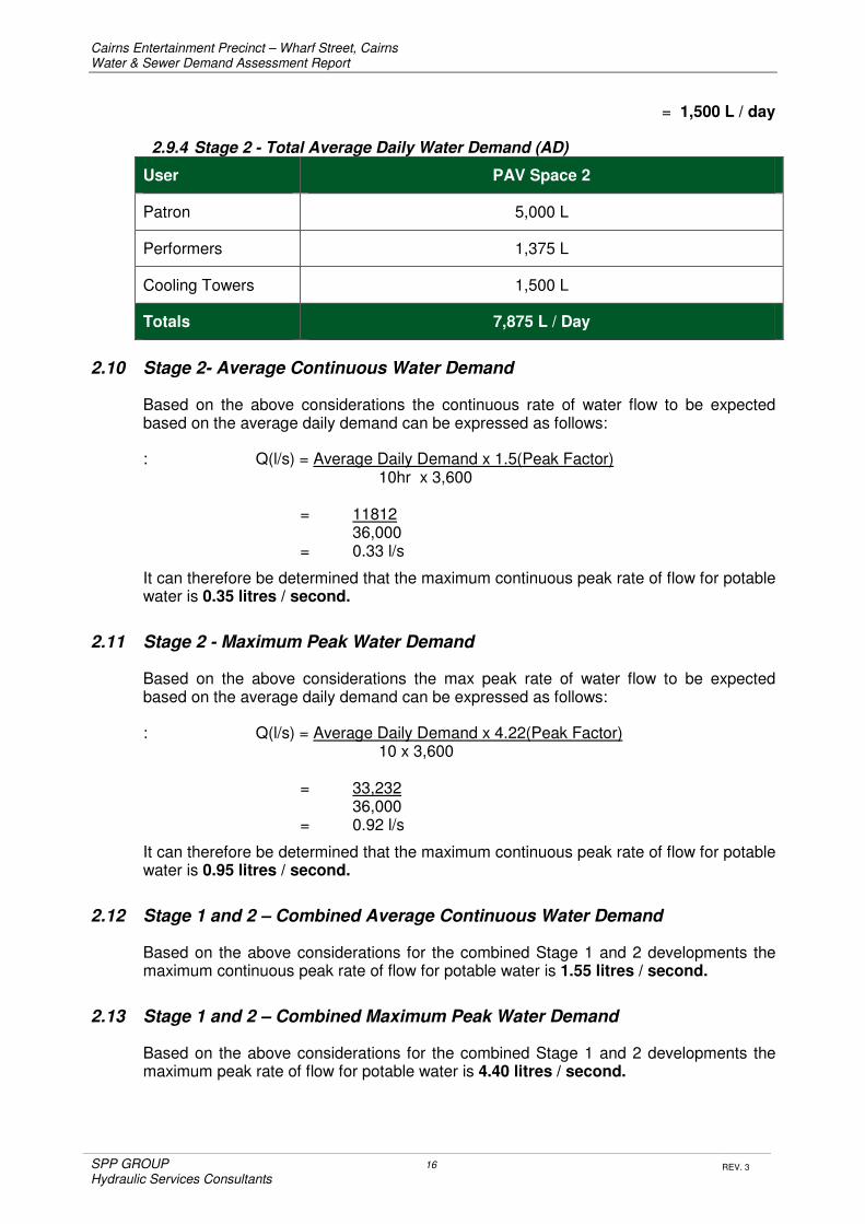
Cairns Entertainment Precinct – Wharf Street, Cairns Water & Sewer Demand Assessment Report
SPP GROUP 16
Hydraulic Services Consultants
REV. 3
= 1,500 L / day
2.9.4 Stage 2 - Total Average Daily Water Demand (AD)
User PAV Space 2
Patron 5,000 L
Performers 1,375 L
Cooling Towers 1,500 L
Totals 7,875 L / Day
2.10 Stage 2- Average Continuous Water Demand
Based on the above considerations the continuous rate of water flow to be expected based on the average daily demand can be expressed as follows:
: Q(l/s) = Average Daily Demand x 1.5(Peak Factor) 10hr x 3,600
= 11812
36,000 = 0.33 l/s
It can therefore be determined that the maximum continuous peak rate of flow for potable water is 0.35 litres / second.
2.11 Stage 2 - Maximum Peak Water Demand
Based on the above considerations the max peak rate of water flow to be expected based on the average daily demand can be expressed as follows:
: Q(l/s) = Average Daily Demand x 4.22(Peak Factor) 10 x 3,600
= 33,232
36,000 = 0.92 l/s
It can therefore be determined that the maximum continuous peak rate of flow for potable water is 0.95 litres / second.
2.12 Stage 1 and 2 – Combined Average Continuous Water Demand
Based on the above considerations for the combined Stage 1 and 2 developments the maximum continuous peak rate of flow for potable water is 1.55 litres / second.
2.13 Stage 1 and 2 – Combined Maximum Peak Water Demand
Based on the above considerations for the combined Stage 1 and 2 developments the maximum peak rate of flow for potable water is 4.40 litres / second.

Cairns Entertainment Precinct – Wharf Street, Cairns Water & Sewer Demand Assessment Report
SPP GROUP 17
Hydraulic Services Consultants
REV. 3
2.14 Stage 3 - Average Daily Water Demand (AD)
2.14.1 Museum - Patron Daily Water Demand
Based on the annual expected visitation in the initial year of operation, an average daily patron expectancy of 850 persons has been determined.
The Total Daily Potable Water Demand for Patron drinking and Toilet flushing is determined to be 4.5 litres / Person / Day.
Therefore daily Patron use is as follows: 850 x 4.5l / person = 3,850 L / day
2.14.2 Museum - Full Time Staff Daily Water Demand
Full Time Staff of 7 persons has been utilised for this Study.
The Total Daily Potable Water Demand for Full Time Administration and Maintenance Staff for drinking / food prep and toilet flushing is determined to be 25 litres / Person / Day.
Therefore daily full time Admin and Maintenance Staff use is as follows:
7 x 25l / person = 175 L / day
2.14.3 Museum - General Cleaning Water Demand
Based on a weekly cleaning regime with expected work patterns during daily shifts it has been determined that the Average Daily Water Demand for General Cleaning to be:
= 500 L / day
2.14.4 Museum - Cooling Tower Water Demand
Water use for Mechanical Plant and Equipment used for the conditioning of room temperatures has been estimated to be:
= 3,000 L / day
2.14.5 Museum – Total Daily Water Demand
User PAV Space 2
Patron 3,850 L
Staff 175 L
General Cleaning 500 L
Cooling Towers 3,000 L
Totals 7,525 L / Day

Cairns Entertainment Precinct – Wharf Street, Cairns Water & Sewer Demand Assessment Report
SPP GROUP 18
Hydraulic Services Consultants
REV. 3
2.15 Stage 3 – Average Continuous Water Demand
Based on the above considerations the average continuous rate of water flow to be expected based on the average daily demand can be expressed as follows:
: Q(l/s) = Average Daily Demand x 1.5(PF) 10 x 3,600
= 11,287
36,000
= 0.31 l/s
It can therefore be determined that the anticipated maximum continuous peak rate of flow for potable water is 0.30 litres / second.
2.16 Stage 3 - Maximum Peak Water Demand
Based on the above considerations the peak rate of water flow to be expected based on the average daily demand can be expressed as follows:
: Q(l/s) = Average Daily Demand x 4.22(PF) 10 x 3,600
= 31,755
36,000
= 0.88 l/s
It can therefore be determined that the anticipated maximum continuous peak rate of flow for potable water is 0.90 litres / second.
2.17 Stage 1, 2 and 3 – Combined Average Continuous Water Demand
Based on the above considerations for the combined Stage 1, 2 and 3 developments the maximum continuous peak rate of flow for potable water is : 1.85 litres / second.
2.18 Stage 1, 2 and 3 – Combined Maximum Peak Water Demand
Based on the above considerations for the combined Stage 1, 2 and 3 developments the maximum peak rate of flow for potable water is : 5.3 litres / second.
Note 1: As previously noted the development has been provided with a large rainwater storage tank as required under the QDC Requirements for Toilet flushing and Wash down purposes. This tank when factored in to calculations, effectively provides a buffer tank and removes the spikes in water demand brought on by Patron and Performer Toilet Flushing during large events
Note 2: As previously noted Provisions for Irrigation demand have not been incorporated as all irrigation shall be provided by Rainwater Harvesting and storage. Potable water shall not be used for top up.

Cairns Entertainment Precinct – Wharf Street, Cairns Water & Sewer Demand Assessment Report
SPP GROUP 19
Hydraulic Services Consultants
REV. 3
2.19 Stage 1 - Mean Potable Water Monthly Demand (MDMM)
2.19.1 Stage 1 - Average Monthly Water Demand
Based on the above considerations the Mean Monthly Water Demand (MDMM) during the initial year of commencement can be expressed as follows:
Q = Av. Daily Water Demand x 30 days / month
= 29,175 x 30
= 875,250 litres / month
It can therefore be determined that the Mean Monthly Water Demand is 875 KL / month.
2.19.2 Stage 1 – Projected Average Monthly Water Demand
Monthly Average water Demand 2016
2020 2025 2030 2040
875 KL 947 KL 1045 KL 1154 KL 1407 KL
2.20 Stage 2 - Mean Potable Water Monthly Demand (MDMM)
2.20.1 Stage 2 - Average Monthly Water Demand
Based on the above considerations the Mean Monthly Water Demand (MDMM) during the initial year of commencement can be expressed as follows:
Q = Av. Daily Water Demand x 30 days / month
= 7,875 x 30
= 236,250 litres / month
It can therefore be determined that the Mean Monthly Water Demand is 236 KL / month.
2.21 Stage 3 - Mean Potable Water Monthly Demand (MDMM)
2.21.1 Stage 3 - Average Monthly Water Demand
Based on the above considerations the Mean Monthly Water Demand (MDMM) during the initial year of commencement can be expressed as follows:
Q = Av. Daily Water Demand x 30 days / month
= 7,525 x 30
= 225,750 litres / month
It can therefore be determined that the Mean Monthly Water Demand is 226 KL / month.

Cairns Entertainment Precinct – Wharf Street, Cairns Water & Sewer Demand Assessment Report
SPP GROUP 20
Hydraulic Services Consultants
REV. 3
3. WASTEWATER SERVICES
3.22 Waste Water Flow Based on Authority Planning Guidelines
Based on technical requirements form the Cairns Regional Council trunk Infrastructure Planning Scheme Policy and FNQROC Development Manuals for Sewer Reticulation the waste water flow has been expressed as an Equivalent Population (EP) assessed by the Gross Floor Area (GFA) for Defined Land Uses (DFU) and the corresponding Waste Water Flow (WWF) for the development which has been determined as follows;
3.22.1 Stage 1
Performance Space 1 and Car Parks, Whites Shed, Public Domain Spaces.
DFU GFA Unit of Measure Equivalent
Demand Units Equivalent Population
PAV Stage 1 21,400 m2 @ 1.0 / 275m2 78 EDU 218 EP
Whites Shed 1,500m2 @ 1.0 / 275m2 5.5 EDU 15 EP
Public Spaces 3,350m2 @ 1.0 / 275m2 12 EDU 34 EP
Totals 26,250m2 @ 1.0 / 275m2 94.5 EDU 267 EP
3.22.2 Stage 1 Average Dry Weather Flow (ADWF)
Average Daily Waste Water Flow = EP x 270l / person
= 267 x 270l / person = 72,090 L / day
3.22.3 Stage 1 Peak Wet Weather Flow (PWWF)
Peak Wet Weather Flow 5 x ADWF = 360,450 L / day
3.22.4 Stage 2
Performance Space 2 addition
DFU GFA Unit of Measure Equivalent
Demand Units Equivalent Population
PAV Stage 2 2,000 m2 @ 1.0 / 275m2 7.2 EDU 23 EP
3.22.1 Stage 2 Average Dry Weather Flow (ADWF)
Average Daily Waste Water Flow = EP x 270l / person
= 23 x 270l / person = 6,210 L / day

Cairns Entertainment Precinct – Wharf Street, Cairns Water & Sewer Demand Assessment Report
SPP GROUP 21
Hydraulic Services Consultants
REV. 3
3.22.2 Stage 2 Peak Wet Weather Flow (PWWF)
Peak Wet Weather Flow 5 x ADWF = 31,050 L / day
3.22.3 Stage 3
Museum
DFU GFA Unit of Measure Equivalent
Demand Units Equivalent Population
Museum 4,385 m2 @ 1.0 / 275m2 15.9 EDU 49 EP
3.22.4 Stage 3 Average Dry Weather Flow (ADWF)
Average Daily Waste Water Flow = EP x 270l / person
= 49 x 270l / person = 13,230 L / day
3.22.5 Stage 3 Peak Wet Weather Flow (PWWF)
Peak Wet Weather Flow 5 x ADWF = 66,150 L / day
3.22.6 Projected Forecast for Stage 1
Based on a 2% average increase in visitation to the precinct as outlined in the business case study the Performance Space 1 and Car Parks, Whites Shed, and Public Domain Spaces could expect the follow EP demands.
Total Equivalent Population at
2016 2020 2025 2030 2040
267 EP 289 EP 319 EP 352 EP 429 EP
3.22.7 Projected Stage 1 Average Daily Waste Water Flow (ADWF)
Average Daily Waste Water Flow (ADWF) 2020 = 289 x 270l / person = 78,030 L / day
Average Daily Waste Water Flow (ADWF) 2025 = 319 x 270l / person = 86,130 L / day
Average Daily Waste Water Flow (ADWF) 2030 = 352 x 270l / person = 95,040 L / day
Average Daily Waste Water Flow (ADWF) 2040 = 429 x 270l / person = 115,830 L / day
3.22.8 Projected Stage 1 Peak Wet Weather Flow (PWWF)
Peak Wet Weather Flow (PWWF) 2020 5 x ADWF = 390,150 L / day
Peak Wet Weather Flow (PWWF) 2025 5 x ADWF = 430,650 L / day
Peak Wet Weather Flow (PWWF) 2030 5 x ADWF = 475,200 L / day
Peak Wet Weather Flow (PWWF) 2040 5 x ADWF = 579,150 L / day

Cairns Entertainment Precinct – Wharf Street, Cairns Water & Sewer Demand Assessment Report
SPP GROUP 22
Hydraulic Services Consultants
REV. 3
3.23 Waste Water Flow Based on Assessment Criteria
The waste water flow is assessed by the number of persons in the building and the volumes of waste water each person uses on average, the equipment utilised for the production of meals and the cleaning of same, and the general daily operational and cleaning parameters carried out to maintain the facility.
The calculation takes in to consideration a percentage of water use which shall be lost through the following uses:
• Drinking Water
• Cooking
• General Cleaning
• Evaporation at Cooling Towers
3.24 Stage 1 Average Daily Waste Water Flow (AD)
3.24.1 PAV - Patron Daily Waste Water Flow
Based on the annual expected visitation in the initial year of operation, an average daily patron expectancy of 360 persons has been determined.
The Total Daily Waste Water Demand for Food Prep and Toilet flushing is determined to be 12.5 litres / Person / Day.
Therefore daily Patron use is as follows: 360 x 20l / person = 7,200 L / day
3.24.2 PAV – Performer and Support Personnel Daily Waste Water Flow
The average daily performer and support personnel expectancy of 125 persons has been determined.
The Total Daily Waste Water Demand for Performers and support Crew for Food Prep / Personal Hygiene and Toilet flushing is determined to be 20- 42.5 litres / Person / Day
Therefore daily Performer and Support Personnel use is as follows:
Performers 75 x 42.5l / person = 3,188 L / day
Support Personnel 50 x 20l / person = 1000 L / day
Total = 4,188 L / day
3.24.3 PAV - Full Time Staff Daily Waste Water Flow
Full Time Staff of 34 persons has been determined in the Business Case Study.
The Total Daily Waste Water Demand for Full Time Administration and Maintenance Staff for food prep and toilet flushing is determined to be 22.5 litres / Person / Day.
Therefore daily full time Admin and Maintenance Staff use is as follows:
34 x 22.5l / person = 765 L / day

Cairns Entertainment Precinct – Wharf Street, Cairns Water & Sewer Demand Assessment Report
SPP GROUP 23
Hydraulic Services Consultants
REV. 3
3.24.4 PAV - General Cleaning Waste Water Flow
Based on a weekly cleaning regime with expected work patterns during daily shifts it has been determined that the Average Daily Waste Water Demand for General Cleaning to be:
= 750 L / day
3.24.5 PAV- Cooking Waste Water Flow
Waste Water discharged for patrons, performers and food preparation has been incorporated into the per person rate in other sections.
3.24.6 PAV- Cooling Tower Waste Water Flow
Waste Water use for Mechanical Plant and Equipment used for the conditioning of room temperatures has been estimated to be:
= 3,000 L / day
3.24.7 Whites Shed - Patron Daily Waste Water Flow
Based on the annual expected visitation in the initial year of operation, an average daily patron expectancy of 300 persons has been determined.
The Total Daily Waste Water Demand for Patron cooking and toilet flushing is determined to be 15 litres / Person / Day.
Therefore daily Patron use is as follows:
300 x20l / person = 6,000 L / day
Note: Provision for new fixtures have not been incorporated into the Whites Shed Refurbishment due to Heritage listing constraints; however the area will be serviced from facilities in the Lower Plaza Area.
3.24.8 Whites Shed - Full Time Staff Daily Waste Water Flow
Full Time Staff for Whites Shed has been incorporated in to the PAV calculations.
3.24.9 Stage 1 - Total Average Daily Waste Water Flow (ADWF)
User PAV Whites Shed Public Spaces
Patron 7,200 L 6,000 L NA
Performers 4,188 L NA NA
Full Time Staff 765 L NA NA
General Cleaning 750 L 450 L NA
Cooling Towers 3,000 L NA NA
Sub- Totals 15,903 L 6,450 L NA
Totals 22,353 L / Day

Cairns Entertainment Precinct – Wharf Street, Cairns Water & Sewer Demand Assessment Report
SPP GROUP 24
Hydraulic Services Consultants
REV. 3
3.24.10 Stage 1 - Projected Forecast Waste Water Flow
Based on a 2% average increase in visitation to the precinct as outlined in the business case study the Performance Space 1 and Car Parks, Whites Shed, and Public Domain Spaces could expect the follow increase in average Daily Waste Water Flow. (ADWF)
Daily Average Waste Water Flow
2016 2020 2025 2030 2040
22,350 L 24,200 L 26,720 L 29,500 L 35,960 L
3.25 Stage 1- Estimated Continuous Waste Water Flow
Based on the above considerations the estimated continuous rate of waste water flow to be expected based on the average daily demand can be expressed as follows:
: Q(l/s) = Average Daily Flow x 1.5(PF) 10hr x 3,600
= 33,530
36,000
= 0.93 l/s
It can therefore be determined that the Average continuous rate of flow for Waste water is 1.0 litre / second.
3.26 Stage 1- Estimated Spike / Peak Waste Water Demand
The operational nature of the completed CEP will create regular spikes in waste water demand during major events.
Internal House Drainage lines shall be sized to accommodate the spike discharges created by toilet and urinal waste streams associated with interval and end of event use.
Allowing for peak occupancy numbers and diversity of operation, and drain time for waste streams to accumulate in internal house drainage networks prior to discharge at the sewer connection the estimated flows when the facility is at peak demand shall be:
Performance Space 1 Spike Waste Water Flow: 3.2 litres / second.
This spike in estimated waste water demand and shall occur for approximately 20-30 minutes and is based on worst case scenario of a full venue with 65% of patrons using the amenities during intervals and or at the end of events. The Performance Space and Whites shed would not necessarily expect spike loads in the same manner hence only worst case venue being the performance space has been included.

Cairns Entertainment Precinct – Wharf Street, Cairns Water & Sewer Demand Assessment Report
SPP GROUP 25
Hydraulic Services Consultants
REV. 3
3.27 Stage 2 - Average Daily Waste Water Flow (ADWF)
3.27.1 PAV Performance Space 2 - Patron Daily Waste Water Flow
Based on the annual expected visitation in the initial year of operation, an average daily patron expectancy of 200 persons has been determined.
The Total Daily Waste Water Demand for Patron Food Prep and Toilet flushing is determined to be 12.5 litres / Person / Day.
Therefore daily Patron use is as follows: 200 x 20 l / person = 4,000 L / day
3.27.2 PAV Performance Space 2 - Performer & Support Personnel Daily Waste Water Flow
The average daily performer and support personnel expectancy of persons has been determined.
The Total Daily Waste Water Demand for Performers and support Crew for Drinking / Food Prep / Personal Hygiene and Toilet flushing is determined to be 20 - 42.5 litres / Person / Day.
Therefore daily Performer and Support Personnel use is as follows:
Performers 25 x 42.5l / person = 1063 L / day
Support Personnel 10 x 20 l / person = 200 L / day
Total = 1,188 L / day
3.27.3 PAV Space 2 - Cooling Tower Waste Water Demand
Waste Water flow for Mechanical Plant and Equipment used for the conditioning of room temperatures has been estimated to be:
= 1,000 L / day
3.27.4 Stage 2 - Total Average Daily Waste Water Demand (AD)
User PAV Space 2
Patron 4,000 L
Performers 1,263 L
Cooling Towers 1,000 L
Totals 6,263 L / Day

Cairns Entertainment Precinct – Wharf Street, Cairns Water & Sewer Demand Assessment Report
SPP GROUP 26
Hydraulic Services Consultants
REV. 3
3.28 Stage 2- Estimated Continuous Waste Water Flow
Based on the above considerations the estimated continuous rate of waste water flow to be expected based on the average daily demand can be expressed as follows:
: Q(l/s) = Average Daily Flow x 1.5(PF) 10hr x 3,600
= 9394
36,000
= 0.26 l/s
It can therefore be determined that the Average continuous rate of flow for Waste water is 0.3 litres / second.
3.29 Stage 2- Estimated Spike / Peak Waste Water Demand
The operational nature of the completed CEP will create regular spikes in waste water demand during major events.
Internal House Drainage lines shall be sized to accommodate the spike discharges created by toilet and urinal waste streams associated with interval and end of event use.
Allowing for peak occupancy numbers and diversity of operation, and drain time for waste streams to accumulate in internal house drainage networks prior to discharge at the sewer connection the estimated flows when the facility is at peak demand shall be:
Performance Space 2 Spike Waste Water Flow: 1.1 litres / second.
3.30 Stage 1 and 2 – Combined Average Waste Water Flow
Based on the above considerations for the combined Stage 1 and 2 developments the Average continuous rate of flow for Waste water is 1.3 litres / second.
3.31 Stage 1 and 2 – Combined Peak Waste Water Flow
Based on the above considerations for the combined Stage 1 and 2 developments the maximum continuous peak rate of flow for Waste water is 4.3 litres / second.

Cairns Entertainment Precinct – Wharf Street, Cairns Water & Sewer Demand Assessment Report
SPP GROUP 27
Hydraulic Services Consultants
REV. 3
3.32 Stage 3 Average Daily Waste Water Flow
3.32.1 Museum - Patron Daily Waste Water Flow
Based on the annual expected visitation in the initial year of operation, an average daily patron expectancy of 850 persons has been determined.
The Total Daily Waste Water Flow for Patron Toilet flushing is determined to be 3.0 litres / Person / Day.
Therefore daily Patron Waste Water is as follows: 850 x 3.0l / person = 2,550 L / day
3.32.2 Museum - Full Time Staff Daily Waste Water Flow
Full Time Staff of 7 persons has been utilised for this Study.
The Total Daily Waste Water Flow for Full Time Administration and Maintenance Staff for food prep and toilet flushing is determined to be 22.5 litres / Person / Day.
Therefore daily full time Admin and Maintenance Staff Waste Water is as follows:
7 x 22.5l / person = 158 L / day
3.32.3 Museum - General Cleaning Water Flow
Based on a weekly cleaning regime with expected work patterns during daily shifts it has been determined that the Average Daily Waste Water Demand for General Cleaning to be:
= 400 L / day
3.32.4 Museum - Cooling Tower Water Flow
Waste Water for Mechanical Plant and Equipment used for the conditioning of room temperatures has been estimated to be:
= 1 980 L / day
3.32.5 Museum – Total Daily Water Flow
User Museum
Patron 2,550 L
Staff 158 L
General Cleaning 400 L
Cooling Towers 1,980 L
Totals 5,088 L / Day

Cairns Entertainment Precinct – Wharf Street, Cairns Water & Sewer Demand Assessment Report
SPP GROUP 28
Hydraulic Services Consultants
REV. 3
3.33 Stage 3 – Estimated Continuous Waste Water Flow
Based on the above considerations the average continuous rate of waste water flow to be expected based on the average daily flow can be expressed as follows:
: Q(l/s) = Average Daily Flow x 1.5(AD) 10 x 3,600
= 21,471
36,000
= 0.212 l/s
It can therefore be determined that the anticipated maximum continuous average rate of flow for Waste water is 0.23 litres / second.
3.34 Stage 1, 2 and 3 – Combined Continuous Waste Water Flow
Based on the above considerations for the combined Stage 1, 2 and 3 developments the average continuous rate of flow for waste water is 1 .53 litres / second.

Cairns Entertainment Precinct – Wharf Street, Cairns Water & Sewer Demand Assessment Report
SPP GROUP 29
Hydraulic Services Consultants
REV. 3
3.35 Stage 1 - Mean Waste Water Monthly Flow (MWWMF)
3.35.1 Stage 1 - Average Monthly Waste Water Flow
Based on the above considerations the Mean Monthly Waste Water Flow (MWWMF) during the initial year of commencement can be expressed as follows:
Q = Av. Daily Waste Water Flow x 30 days / month
= 22,350 x 30
= 670,500 litres / month
It can therefore be determined that the Mean Monthly Water Demand is 670 KL / month.
3.35.2 Stage 1 – Projected Average Monthly Waste Water Demand
Monthly Average water Demand 2016
2020 2025 2030 2040
670 KL 725 KL 800 KL 883 KL 1077 KL
3.36 Stage 2 - Mean Waste Water Monthly Flow (MWWMF)
3.36.1 Stage 2 - Average Monthly Waste Water Flow
Based on the above considerations the Mean Monthly Waste Water Flow (MWWMF) during the initial year of commencement can be expressed as follows:
Q = Av. Daily Water Demand x 30 days / month
= 6,263 x 30
= 187,890 litres / month
Therefore the Estimated Mean Monthly Waste Water Flow is 188 KL / month.
3.37 Stage 3 - Mean Monthly Waste Water Flow (MWWMF))
3.37.1 Stage 3 - Average Monthly Waste Water Flow
Based on the above considerations the Mean Monthly Waste Water Flow (MWWMF) during the initial year of commencement can be expressed as follows:
Q = Av. Daily Waste Water Demand x 30 days / month
= 5,088 x 30
= 152,640 litres / month
Therefore the Estimated Mean Monthly Waste Water Flow is 153 KL / month.

Cairns Entertainment Precinct
Civil Engineering Report to Support the Stage 1 Development Application
Q114012 14 March 2012
Civil Design Report for Stage 1 DA (Ver 3)
CARDNO DRAWINGS