Civil Engineering and Development Department Kwu Tan_Executive Summ… · Figure 4.2 Layout of...
37
Civil Engineering and Development Department Agreement No. CE27/2015(CE) Technical Study on Reclamation at Lung Kwu Tan - Feasibility Study Final Executive Summary 246382/REP/025/01 This report takes into account the particular instructions and requirements of our client. It is not intended for and should not be relied upon by any third party and no responsibility is undertaken to any third party. Job number 246382 Ove Arup & Partners Hong Kong Ltd Level 5 Festival Walk 80 Tat Chee Avenue Kowloon Tong Kowloon Hong Kong www.arup.com
Transcript of Civil Engineering and Development Department Kwu Tan_Executive Summ… · Figure 4.2 Layout of...
Civil Engineering and Development Department
Agreement No. CE27/2015(CE) Technical Study on Reclamation at Lung Kwu Tan - Feasibility Study
Final Executive Summary
246382/REP/025/01
This report takes into account the particular
instructions and requirements of our client.
It is not intended for and should not be relied
upon by any third party and no responsibility
is undertaken to any third party.
Job number 246382
Ove Arup & Partners Hong Kong Ltd
Level 5 Festival Walk
80 Tat Chee Avenue
Kowloon Tong
Kowloon
Hong Kong
www.arup.com

Civil Engineering and Development Department Agreement No. CE27/2015(CE) Technical Study on Reclamation
at Lung Kwu Tan - Feasibility StudyFinal Executive Summary
246382/REP/025/01 |
Contents
Page
1 Introduction 1
1.1 Background 1
1.2 The Study 1
1.3 Main Objectives of the Study 2
1.4 Scope of “Executive Summary” 3
1.5 Structure of the Report 3
1.6 Nomenclature and Abbreviation 3
2 Site Description 5
2.1 North West New Territories 5
2.2 Tuen Mun West 7
2.3 Lung Kwu Tan Study Area 7
3 Land Use Assumptions 12
3.1 Guiding Principles for the “Preliminary Land Use Themes” 12
3.2 Potential Land Uses Included for Assessment 14
4 Engineering and Environmental Assessments 16
4.1 Assessment Assumptions 16
4.2 Potential Reclamation Extent 16
4.3 Marine Traffic 19
4.4 Traffic and Transport 20
4.5 Environmental Assessments 21
4.6 Infrastructure Assessments 31
5 Next Step 33
5.1 Potential Development Theme and Key Constraints on Land Uses for Future Consideration 33
5.2 Future Studies 34
Tables Table 1.1 Abbreviations of Bureaux, Government Departments and Organisations
Table 1.2 Abbreviations for Expressions Adopted in this Report
Figures Figure 1.1 Location of Lung Kwu Tan
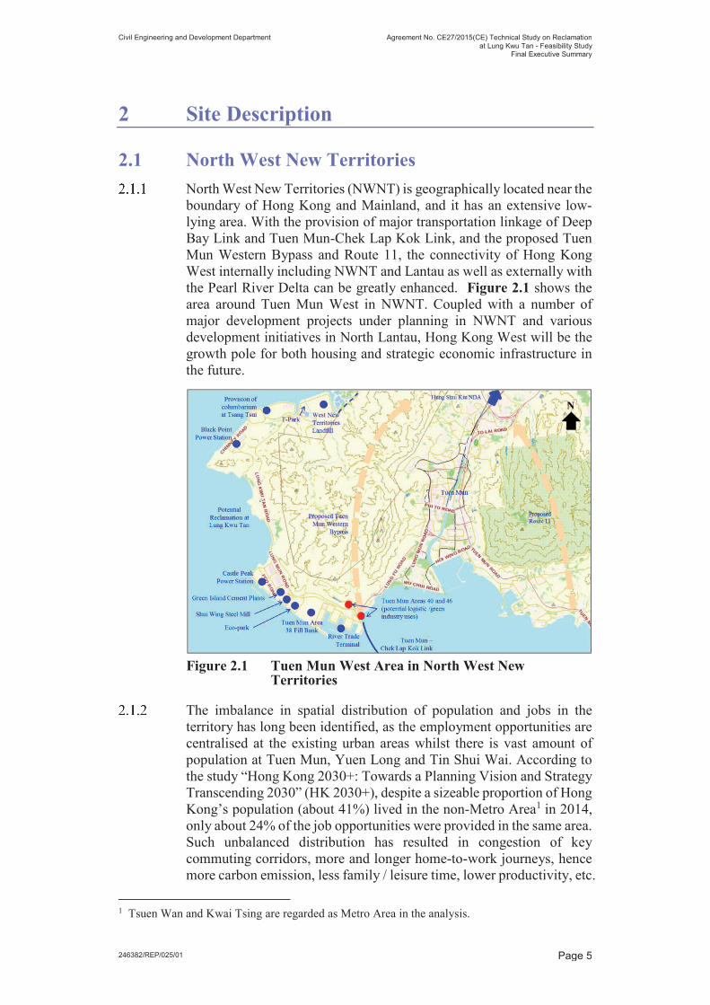
Figure 2.1 Tuen Mun West Area in North West New Territories
Figure 2.2 View of Lung Kwu Tan and Lung Kwu Sheung Tan from Headland
Figure 2.3 Industrial Operations at Lung Kwu Sheung Tan

Civil Engineering and Development Department Agreement No. CE27/2015(CE) Technical Study on Reclamation
at Lung Kwu Tan - Feasibility StudyFinal Executive Summary
246382/REP/025/01 |
Figure 2.4 Location of Lung Kwu Tan Village
Figure 2.5 Lung Kwu Tan Village
Figure 2.6 Clusters of Graves within Study Area
Figure 4.1 Potential Reclamation Extent
Figure 4.2 Layout of Existing Submarine Outfall
Figure 4.3 Key Marine Traffic Movements
Figure 4.4 Major Species Recorded in the Adult Fish Survey
Figure 4.5 Green Channel
Figure 4.6 Location of Lung Kwu Tan Valley SSSI and Fung Shui Woods
Figure 4.7 Air Quality Exceedance Zone
Figure 4.8 Helipads and Noise Buffer Zone
Figure 4.9 Locations of Cultural Heritage Resources
Figure 4.10 Lau Ancestral Hall at Tuk Mei Chung
Figure 4.11 Tin Hau Temple

Civil Engineering and Development Department Agreement No. CE27/2015(CE) Technical Study on Reclamation
at Lung Kwu Tan - Feasibility StudyFinal Executive Summary
246382/REP/025/01 Page 1
1 Introduction
1.1 Background
On 30 October 2015, Civil Engineering and Development Department
(CEDD) of the Government of the Hong Kong Special Administrative
Region commissioned Ove Arup and Partners Hong Kong Limited
(Arup) to provide consultancy services for Agreement No. CE 27/2015
(CE) “Technical Study on Reclamation at Lung Kwu Tan – Feasibility
Study” (the Study).
1.2 The Study
In 2011, CEDD had commissioned Arup under Agreement No.
CE9/2011(CE) “Increasing Land Supply by Reclamation and Rock
Cavern Development cum Public Engagement” Feasibility Study (the
Land Supply Study) to identify suitable locations for reclamation
outside Victoria Harbour and rock cavern development. Lung Kwu Tan
(LKT), with a possible reclamation area of 200 to 300 hectares, was
identified as one of the potential near-shore reclamation sites for further
consideration.
LKT is located at the western side of Tuen Mun (Refer to Figure 1.1).
Its relatively large reclamation area is conducive to comprehensive
planning for mixed and balanced land uses, creating jobs and supporting
the development of Tuen Mun New Town and Hong Kong.
Figure 1.1 Location of Lung Kwu Tan
The public opinions received during the Stage 2 Public Engagement
(PE2) of the Land Supply Study suggested that LKT reclamation site
could be specifically considered for land reserve, residential

Civil Engineering and Development Department Agreement No. CE27/2015(CE) Technical Study on Reclamation
at Lung Kwu Tan - Feasibility StudyFinal Executive Summary
246382/REP/025/01 Page 2
development, utilities uses including solid waste handling and recycling
facilities and power supply facilities, recreational or leisure facilities,
public parks, industrial, and tourism related facilities such as hotels.
Impact on marine ecology, including possible encroachment on habitat
of Chinese White Dolphin (CWD), ecological conservation,
transportation, cost effectiveness and the need to expedite land supply
were major concerns as regards the LKT reclamation.
In addition, the reclamation and the subsequent development at LKT
are subject to various constraints including the development constraints
imposed by the nearby existing industrial facilities / installations and
village-type development, the identified CWD habitat just outside the
site, and the capacity of existing road network in view of the many
developments in Tuen Mun.
In view of the various constraints at LKT which may limit the
development potential of LKT reclamation, this Study was
commissioned to assess the feasible reclamation extent at LKT and to
ascertain key constraints and possible options on future land use before
proceeding with more detailed studies including planning and
engineering study and statutory environmental impact assessment
(EIA).
The findings of the Study will be further investigated, elaborated and
supplemented in the proposed detailed planning and engineering study
for the reclamation proposal in the next stage in order to meet the
requirement stipulated in the relevant planning and environmental
protection ordinances (e.g. Town Planning Ordinance, Foreshore and
Sea-bed (Reclamations) Ordinance, Environmental Impact Assessment
Ordinance (EIAO), etc.) to proceed with the requisite statutory
procedures required for a reclamation project.
1.3 Main Objectives of the Study
1.3.1 The overall objectives of the Study are to ascertain the engineering
feasibility of reclamation at LKT and to provide insight on the possible
land use options for LKT reclamation in consideration of many
development constraints and interfacing projects before taking forward
the reclamation proposal to detailed studies including planning and
engineering study and statutory EIA.
1.3.2 The main objectives of the Study are:-
(a) To determine the feasible extent of reclamation;
(b) To assess the preliminary engineering feasibility for reclamation;
and
(c) To identify the key constraints and possible options on future land
use.

Civil Engineering and Development Department Agreement No. CE27/2015(CE) Technical Study on Reclamation
at Lung Kwu Tan - Feasibility StudyFinal Executive Summary
246382/REP/025/01 Page 3
1.4 Scope of “Executive Summary”
1.4.1 The Executive Summary provides a brief summary on the findings of
the Study based on various assessments, and highlights the key issues
and mitigation measures considered in the assessment. Based on the
findings of the Study, potential development theme for LKT
reclamation and the key constraints on land use are suggested for future
consideration.
1.5 Structure of the Report
1.5.1 The Report is structured as follows:-
(a) Section 1 introduces the Study;
(b) Section 2 describes the Study Area and its surrounding;
(c) Section 3 presents the land use assumptions adopted in the Study for
assessment;
(d) Section 4 presents the results of the engineering and environmental
assessments; and
(e) Section 5 advises the potential development theme of Lung Kwu Tan
reclamation and the key constraints on land use for future
consideration.
1.6 Nomenclature and Abbreviation
1.6.1 Table 1.1 lists out the abbreviated titles of government departments
mentioned in this Report.
Table 1.1 Abbreviations of Government Departments
Abbreviation Full title
CEDD Civil Engineering and Development Department
DSD Drainage Services Department
EPD Environmental Protection Department
WSD Water Supplies Department
1.6.2 Table 1.2 lists out the meaning of abbreviation for expressions adopted
in this Report.
Table 1.2 Abbreviations for Expressions Adopted in this
Report
Abbreviation Full meaning
BPPS Black Point Power Station
C&DMHF Construction and Demolition Materials Handling
Facilities
CPPS Castle Peak Power Station
CWD Chinese White Dolphin
EIA Environmental Impact Assessment

Civil Engineering and Development Department Agreement No. CE27/2015(CE) Technical Study on Reclamation
at Lung Kwu Tan - Feasibility StudyFinal Executive Summary
246382/REP/025/01 Page 4
Abbreviation Full meaning
EIAO Environmental Impact Assessment Ordinance, Cap
499
GI Ground Investigation
HK 2030+ The study of “Hong Kong 2030+: Towards a
Planning Vision and Strategy Transcending 2030”
LKST Lung Kwu Sheung Tan
LKT Lung Kwu Tan
MAI Marine Archaeological Investigation
MTIA Marine Traffic Impact Assessment
NDA New Development Area
NSR Noise Sensitive Receiver
NWNT North West New Territories
PD Principal Datum
PE2 Stage 2 Public Engagement conducted under
Agreement No. CE 9/2011(CE) “Increasing Land
Supply by Reclamation and Rock Cavern
Development cum Public Engagement – Feasibility
Study” (the Land Supply Study)
RTT River Trade Terminal
SAI Site of Archaeological Interest
SS Suspended Sediments (or Solids)
SSSI Site of Special Scientific Interest
STW Sewage Treatment Works
TTIA Traffic and Transport Impact Assessment
WENT West New Territories Landfill
WTW Water Treatment Works
Civil Engineering and Development Department Agreement No. CE27/2015(CE) Technical Study on Reclamation
at Lung Kwu Tan - Feasibility StudyFinal Executive Summary
246382/REP/025/01 Page 5
2 Site Description
2.1 North West New Territories
North West New Territories (NWNT) is geographically located near the
boundary of Hong Kong and Mainland, and it has an extensive low-
lying area. With the provision of major transportation linkage of Deep
Bay Link and Tuen Mun-Chek Lap Kok Link, and the proposed Tuen
Mun Western Bypass and Route 11, the connectivity of Hong Kong
West internally including NWNT and Lantau as well as externally with
the Pearl River Delta can be greatly enhanced. Figure 2.1 shows the
area around Tuen Mun West in NWNT. Coupled with a number of
major development projects under planning in NWNT and various
development initiatives in North Lantau, Hong Kong West will be the
growth pole for both housing and strategic economic infrastructure in
the future.
Figure 2.1 Tuen Mun West Area in North West New Territories
The imbalance in spatial distribution of population and jobs in the
territory has long been identified, as the employment opportunities are
centralised at the existing urban areas whilst there is vast amount of
population at Tuen Mun, Yuen Long and Tin Shui Wai. According to
the study “Hong Kong 2030+: Towards a Planning Vision and Strategy
Transcending 2030” (HK 2030+), despite a sizeable proportion of Hong
Kong’s population (about 41%) lived in the non-Metro Area1 in 2014,
only about 24% of the job opportunities were provided in the same area.
Such unbalanced distribution has resulted in congestion of key
commuting corridors, more and longer home-to-work journeys, hence
more carbon emission, less family / leisure time, lower productivity, etc.
1 Tsuen Wan and Kwai Tsing are regarded as Metro Area in the analysis.

Civil Engineering and Development Department Agreement No. CE27/2015(CE) Technical Study on Reclamation
at Lung Kwu Tan - Feasibility StudyFinal Executive Summary
246382/REP/025/01 Page 6
Addressing this imbalance will be one of the key tasks in HK 2030+. It
is suggested in HK 2030+ to create strategic economic nodes outside
Metro Area to bring about high-impact solutions. With the New
Development Areas (NDAs), some of the future employment can
decentralise to NWNT to strive towards the above goal.
The study “2014 Area Assessments on Industrial Land in the Territory”
suggested that there would be an increasing demand forecast in
industrial floor space in 2018 and 2023 at a territorial level, taking into
account the arising needs for general logistics and warehousing, and the
limited existing industrial stock to meet such demand.
Major studies for developments in NWNT, including Hung Shui Kiu
NDA, housing sites in Yuen Long South and Tuen Mun Areas 40 and
46 development, are being carried out under separate consultancy
studies to explore new employment opportunities and address long-
term housing demand.
Hung Shui Kiu New Development Area
Hung Shui Kiu NDA is one of the areas under planning for short-to-
long term land supply. As a regional economic and civic hub for the
NWNT, it will be the next-generation new town of Hong Kong
complementing the new towns of Tin Shui Wai, Yuen Long and Tuen
Mun for provision of housing, employment opportunities and civic
facilities. With a total population of about 218, 000, Hung Shui Kiu
NDA will provide about 61,000 new flats and 150,000 new job
opportunities.
It has been discussed to turn the existing land inefficient uses which are
largely accommodated in the open area and occupying sizable land,
such as container storage, construction material/ machinery storage, car
repair workshops, recycling yards, rural workshops, and other
brownfield operations to other more beneficial uses. From
development perspective, decanting brownfield operations to make way
for development through comprehensive planning and infrastructure
upgrading is important as a major future source of land supply and to
enhance the utilisation of limited land resource. However, the need for
certain brownfield operations cannot be ignored. Some services are part
and parcel of certain sectors of Hong Kong’s overall economy, and
should be provided locally. More importantly, brownfield operations
offer local business and job opportunities for certain small and medium
enterprises (i.e. SMEs) and low-skilled labour. In this regard, the
Government will take Hung Shui Kiu NDA as a pilot area for
examining the feasibility of accommodating brownfield operations that
are still needed in Hong Kong in a more land efficient manner.
Feasibility studies on technical aspects, operation model and business
viability of the proposed multi-storey buildings for brownfield
operations already commenced.

Civil Engineering and Development Department Agreement No. CE27/2015(CE) Technical Study on Reclamation
at Lung Kwu Tan - Feasibility StudyFinal Executive Summary
246382/REP/025/01 Page 7
Tuen Mun Areas 40 and 46
Tuen Mun Areas 40 and 46 will connect with the Hong Kong-Zhuhai-
Macao Bridge Hong Kong Boundary Crossing Facilities and North
Lantau via Tuen Mun – Chek Lap Kok Link, and will also link up with
the proposed Tuen Mun Western Bypass to other parts of the NWNT.
The enhanced accessibility of Tuen Mun Areas 40 and 46 will provide
opportunities for optimising development potential. Four parcels of
land are identified as Potential Development Areas, which cover a total
area of about 50 hectares.
There is vision to transform Tuen Mun Areas 40 and 46 into a major
economic activity area in the NWNT, capturing the geographical
advantage, enhanced accessibility and opportunity of bridgehead
economy brought by new road infrastructure and development projects.
To capture the geographical advantage, the areas are proposed to be
developed as a modern logistics/green industry hub to address the
demand in Hong Kong and to create job opportunities for the Tuen Mun
District and the Territory.
2.2 Tuen Mun West
The industrial sector plays an important role in supporting the Tuen
Mun New Town with two major industrial clusters in Tuen Mun: one is
at the core of the New Town designated for light industry such as food
manufacturing, and the other one is located to the west of Butterfly Bay
(i.e. to the southeast of LKT) used by special industries such as steel
manufacturing and material recycling. There are also some logistic
firms in the southeast of LKT, taking the location advantage near the
River Trade Terminal (RTT).
Being remote and separated from the major developments and
population centre, groups of special facilities and industrial operations
are gathered at the further west of Tuen Mun near LKT. These facilities
include:
(a) To the north of LKT near Tsang Tsui: West New Territories (WENT)
landfill and its proposed extension, T. Park (or previously known as
Sludge Treatment Facilities), proposed columbarium at Tsang Tsui,
Black Point Power Station (BPPS), and
(b) To the southeast of LKT near Tuen Mun Area 40: Castle Peak Power
Station (CPPS), Green Island Cement Plant, Shui Wing Steel Mill, Eco-
Park, proposed development in Tuen Mun Areas 38 & 49 and 40 & 46,
RTT, aviation fuel depot and cargo working area in Tuen Mun Area 16.
2.3 Lung Kwu Tan Study Area
2.3.1 The Study Area mainly covers the sea area outside the shore of LKT,
namely the bay outside Lung Kwu Sheung Tan (LKST) in the north and
LKT in the south separated by a headland (Refer to Figure 2.2). To the
east of the Study Area lies the vast hilly terrain of Castle Peak Ridge,

Civil Engineering and Development Department Agreement No. CE27/2015(CE) Technical Study on Reclamation
at Lung Kwu Tan - Feasibility StudyFinal Executive Summary
246382/REP/025/01 Page 8
which is used by the People’s Liberation Army for regular military
practices, of restricted access.
2.3.2 The area is accessible by Lung Kwu Tan Road, a north-south single 2-
way carriageway, which links to Nim Wan Road in the north and Lung
Mun Road in the south connecting to Tuen Mun Town Centre. Lung
Mun Road is the only external access linking up the LKT area to Tuen
Mun New Town and thus the rest of the territory. The LKT area is
separated from the major developments and population centre in Tuen
Mun not only geographically by the Castle Peak Ridge but also
physically by the limited transport infrastructure.
2.3.3 The shore stretches from Lan Kok Tsui in the north to the material
handling berth of CPPS in the south. The total length of shoreline is
about 5.3 km including 4.3 km natural shoreline and 1.0 km artificial
shoreline. Two coastal and alluvial plains occur around the shoreline,
and the shorelines within the bays are mostly narrow sandy beaches. On
the seaward side of the beaches is generally shallow water. The seabed
level within the embayment where reclamation is being considered
ranges from approximately 0.2m to 5m below Principal Datum
throughout most of its area, with a general trend of increasing depth
towards the sea.
Figure 2.2 View of Lung Kwu Tan and Lung Kwu Sheung Tan from Headland
2.3.4 The shallow water embayment offers opportunity for near-shore
reclamation. In fact, outside the bays is the heavily trafficked
navigation channel – Urmston Road. Within the bays, there is a
submarine effluent outfall extending from the northern part of LKST to
Urmston Road, and berthing facilities near CPPS. These features help
define the potential reclamation extent.
2.3.5 The LKT area and its surroundings have a wide variety of natural
landscapes of environmental significance / ecological value. Lung Kwu
Tan Valley Site of Special Scientific Interest (SSSI) is located
approximately 400m from the reclamation area, in-between are roads,
villages, field and woodland. This SSSI is widely recognised as one of
the most important butterfly habitats in Hong Kong with a high
diversity of butterfly species recorded.
2.3.6 The reclamation area is also close to Sha Chau and Lung Kwu Chau
Marine Park. It is located about 2km from the reclamation area, and is
known to be the major feeding area for CWD. A CWD Lookout is
stationed at the headland between LKT and LKST. Other well-known

Civil Engineering and Development Department Agreement No. CE27/2015(CE) Technical Study on Reclamation
at Lung Kwu Tan - Feasibility StudyFinal Executive Summary
246382/REP/025/01 Page 9
tourist spots include the Tin Hau Temple, Emperor's Cave ( ) and
Lau Ancestral Hall.
Lung Kwu Sheung Tan
2.3.7 LKST is predominantly occupied by individual industrial installations
such as open storages with temporary structures, light industrial areas,
workshops and recycling operations. These industrial establishments
are mostly composed of low-rise 1-2 storey warehouse-type buildings,
forming the light industry cluster to the north of the Study Area. The
groups of structures within separate private lots are spatially distinct
from neighbouring lots and do not give the impression of an organised
development.
Figure 2.3 Industrial Operations at Lung Kwu Sheung Tan
Lung Kwu Tan
2.3.8 LKT is the main population centre of the area. According to the 2016
Population Census, there was a population of 1,892 people residing in
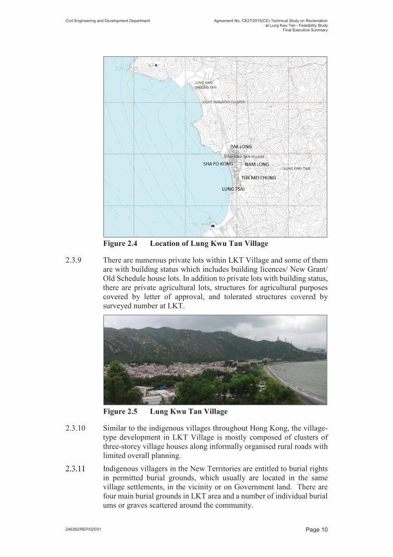
the area and concentrated at LKT Village. LKT Village is a pre-1898
recognised village and is the only residential settlement within the
Study Area. It comprises five geographic places, namely Lung Tsai, Sha
Po Kong, Tuk Mei Chung, Nam Long and Pak Long, adjoining Lung
Kwu Tan Road as shown in Figure 2.4. The Grade 3 Historic Building,
Lau Ancestral Hall, is located at Tuk Mei Chung.
Civil Engineering and Development Department Agreement No. CE27/2015(CE) Technical Study on Reclamation
at Lung Kwu Tan - Feasibility StudyFinal Executive Summary
246382/REP/025/01 Page 10
Figure 2.4 Location of Lung Kwu Tan Village
2.3.9 There are numerous private lots within LKT Village and some of them
are with building status which includes building licences/ New Grant/
Old Schedule house lots. In addition to private lots with building status,
there are private agricultural lots, structures for agricultural purposes
covered by letter of approval, and tolerated structures covered by
surveyed number at LKT.
Figure 2.5 Lung Kwu Tan Village
2.3.10 Similar to the indigenous villages throughout Hong Kong, the village-
type development in LKT Village is mostly composed of clusters of
three-storey village houses along informally organised rural roads with
limited overall planning.
Indigenous villagers in the New Territories are entitled to burial rights
in permitted burial grounds, which usually are located in the same
village settlements, in the vicinity or on Government land. There are
four main burial grounds in LKT area and a number of individual burial
ums or graves scattered around the community.

Civil Engineering and Development Department Agreement No. CE27/2015(CE) Technical Study on Reclamation
at Lung Kwu Tan - Feasibility StudyFinal Executive Summary
246382/REP/025/01 Page 11
Three of the permitted burial grounds are situated around foothills (one
is next to Lung Tsai, and the other two are near Pak Long) and one is
located at upper hills right next to the existing CWD lookout point.
They are part of the LKT community and as observed on-site, they are
all maintained in good condition.
Figure 2.6 Clusters of Graves within Study Area
Opportunities provided by Lung Kwu Tan Reclamation
Knowing the drastic planning change in the NWNT, LKT reclamation
could play a part in the strategic planning of the whole region,
complementary to other developments in the NWNT. For instance, the
new space formed by LKT reclamation could provide decanting sites
for any resumption / relocation of brownfield operations at the NDAs,
and other redevelopment proposals in Tuen Mun.
Due consideration should be given to the unique characteristic of Tuen
Mun West and LKT area, i.e. the existing industrial setting and the
remoteness, when formulating the development plan for LKT
reclamation. The vast area of new land and the long seafront that can be
provided by the reclamation proposal make it a valuable land resource
for certain types of land use.

Civil Engineering and Development Department Agreement No. CE27/2015(CE) Technical Study on Reclamation
at Lung Kwu Tan - Feasibility StudyFinal Executive Summary
246382/REP/025/01 Page 12
3 Land Use Assumptions
3.1 Guiding Principles for the “Preliminary Land
Use Themes”
Considering the opportunities and constraints for the reclamation
proposal, the possible land uses and combination were set out in the
form of “preliminary land use themes” for assessment in the Study. A
set of guiding principles, described below, were established to direct
the formulation of the preliminary land use themes to assist the
assessments and, after completion of the technical and environmental
assessments, to evaluate the relative performance of the preliminary
land use themes. At the end, potential development theme(s) for LKT
reclamation would be identified with due consideration given to the
vision of this reclamation project as well as the site constraints.
Enhance Land Supply to meet Territorial Needs
The sizeable reclamation at LKT would provide ample opportunities to
increase and expedite land supply as the fundamental solution to meet
various land demands of Hong Kong and to complement with other
developments in Tuen Mun West. The opportunities provided by its
location advantages and the marine access of LKT should be captured
to meet the regional and territorial needs and provide new employment
opportunities.
Meet Local Needs
Being a small and remote village cluster, LKT community has limited
economic opportunities with its local business mostly taking place in
mini-stores run by home-makers in daytime. There is no clinic, public
library, post office and market in LKT; the residents have to travel about
15 minutes driving distance to Butterfly Estate in Tuen Mun South for
these community facilities and there is only one bus line running in-
between. Currently, there is no suitable government land in the LKT
area to meet the shortfall of community facilities.
With the proposal of reclamation development, there are opportunities
to improve the livelihood of the locals in three aspects: provision of
more local business opportunities, provision of various new facilities,
and improvement on the accessibility of LKT area with new public
transport services.
Compatibility with Nearby Village and Industries
The existing land uses in LKST and LKT, which fall within the northern
and southern portions of the Study Area respectively, are distinct:
industrial in the north and village housing in the south. The new
developments on the reclamation will adjoin these existing land uses,
and should preferably be compatible with these existing usage.

Civil Engineering and Development Department Agreement No. CE27/2015(CE) Technical Study on Reclamation
at Lung Kwu Tan - Feasibility StudyFinal Executive Summary
246382/REP/025/01 Page 13
The northern portion of the Study Area comprises mainly light
industrial operations. Non-residential developments could be
considered.
In contrast, the southern portion of the Study Area is generally
residential in nature with village-type development just next to the coast
near the reclamation area. Buildings in lower development density
could be compatible with the existing villages.
Minimise Impacts on Existing Road Network and Provision of New Transport Infrastructure
3.1.8 Development inevitably involves movements of goods and people in
one or more mode(s) of transport. The LKT area is linked to the Tuen
Mun New Town by Lung Mun Road and the rest of the territory by
Wong Chu Road and Tuen Mun Road. These three key roads form an
important east-west spine for road traffic associated with the new
development on the reclamation at LKT. These key roads are serving
road traffic in Tuen Mun and the NWNT, and these key roads have only
limited traffic flow capacity to spare for the new development.
The planning of the proposed development on LKT reclamation should
therefore consider the need to minimise impact on these key roads. It
would be more desirable to have land uses at LKT reclamation that can
capitalise the spare capacity of the existing transport infrastructure in
the reverse direction of peak hour flow, or else substantial input would
be required for the strategic transport infrastructure.
Respect the Environment and Minimise Impacts
Besides human needs, reclamation works and the associated
developments must respect the nature and environment, including
terrestrial and marine ecology. This principle is evolved around the
overarching strategic goal of sustainable development.
It is of particular importance for LKT reclamation development, given
the natural resources of environmental significance / ecological value
present in the surroundings. The developments at LKT should pay due
respect to these ecological assets and facilitate their conservation.
For the goodness of the society, impacts on the environment given rise
by any kind of development have to be minimised, confined and
mitigated as much as possible. These include the pollution that would
affect humans, such as noise and deterioration of air quality and water
quality, and disturbance to the terrestrial and marine lives. Apart from
minimising the impact, opportunities should be explored to provide
some form of ecological enhancement to restore the damaged habitat.

Civil Engineering and Development Department Agreement No. CE27/2015(CE) Technical Study on Reclamation
at Lung Kwu Tan - Feasibility StudyFinal Executive Summary
246382/REP/025/01 Page 14
Adopt a Flexible Design and Adaptable Implementation
Programme
Possibility to undertake the whole development in phases should be
explored for earlier commissioning to meet the urgent need of land. It
would be desirable if some part(s) of new development can be
commissioned before the completion of supporting infrastructures such
as water supply and sewage treatment. The land use planning should
therefore take into account the possible phasing and the construction
time required for the land formation and the provision of associated
infrastructures.
The existing road connection to Tuen Mun is at the south of LKT. As
such, it would be more desirable to reclaim the southern portion and
construct the new connecting road to Lung Mun Road first to minimise
traffic impact on the Lung Kwu Tan Road.
Land resumption should be avoided as far as possible. Apart from the
concerns over the impact on the villagers, it would induce uncertainty
to the implementation programme of the development because the
required process may be lengthy.
3.2 Potential Land Uses Included for Assessment
In order to meet the objectives of the Study, preliminary land use
themes were formulated to facilitate the assessments required by this
Study. They were adopted as the development assumptions to identify
possible worst-case scenarios for technical and environmental
assessments in order to assess the development opportunities and
constraints of the LKT reclamation development. These themes were
set out solely for the purposes of preliminary assessments required in
this Study and do not represent the actual proposals. The actual
development proposal for the reclamation will be developed in the
future detailed studies and assessments, including the statutory EIA,
with the involvement of the public.
Major land use types considered include residential and industrial uses,
whilst commercial areas for office space, local retail outlets, etc. were
only considered alongside with the residential / industrial development
to support the future development.
• Residential uses – With the opportunities presented in the reclamation proposal to help address the major territorial needs including housing demands, utilising suitable parts of the reclamation area for housing development should be considered. In fact, under the public engagement activities done under the Land Supply Study, residential development was suggested as a potential land use by the public. A range of housing including private and subsidised housing could be considered to provide a suitable housing mix. The scale and density of the future housing developments should consider the low density village-type housing in the surrounding areas to ensure a compatible development scale.

Civil Engineering and Development Department Agreement No. CE27/2015(CE) Technical Study on Reclamation
at Lung Kwu Tan - Feasibility StudyFinal Executive Summary
246382/REP/025/01 Page 15
• Industrial uses – The success of Hong Kong’s future development hinges on securing the necessary land resources to improve productivity and remain competitive in the Pearl River Delta region. Strong demand has been noted in the territory for industrial estates and science parks within which Hong Kong’s manufacturing as well as research and development sectors can blossom. In addition, there is a growing demand in the territory for the industrial operations with special requirements (i.e. modern logistics and warehousing, green industries and industrial parks proposed in the studies for Hung Shui Kiu NDA and Tuen Mun Areas 40 and 46). Some of them may require marine access. LKT reclamation, if pursued, would offer the opportunity to provide new, dedicated and modern industrial accommodation to cater for the new industrial processes requiring higher standard of accommodation to meet the territorial demand.
Some territorial facilities and installations which have played important
roles in supporting Hong Kong’s growth and prosperity were also
considered. The remote location and neighbouring industrial setting of
LKT provide this reclamation site with a strong potential as solution
space for such uses to serve the territory’s growth. Special uses such as
Construction and Demolition Materials Handling Facilities
(C&DMHF), which are set up for production of recyclable materials
and/or public fill for reclamation and should be equipped with barging
point(s) at seafront for material loading/unloading, were considered in
the Study for assessment purpose. Placing these facilities in relative
isolation from major population centres is one of the options from
strategic town planning perspective.

Civil Engineering and Development Department Agreement No. CE27/2015(CE) Technical Study on Reclamation
at Lung Kwu Tan - Feasibility StudyFinal Executive Summary
246382/REP/025/01 Page 16
4 Engineering and Environmental
Assessments
4.1 Assessment Assumptions
At this very preliminary stage of the project, the assessments were done
based on various assumptions such as reclamation extent, construction
methods and programme, and possible land uses and combination set
out in the preliminary land use themes. The assumptions were
established to facilitate the assessments under reasonably conservative
and possible worst-case scenario, and do not represent the actual
proposals. The actual proposal and details will be developed in detailed
studies in the future, including the subsequent planning and engineering
studies and statutory EIA, with the involvement of the public.
Possible interfacing projects were also identified, with reference to the
best available information regarding the ongoing, committed, planned
and proposed projects at the time of the assessment. The interfacing
issues and the cumulative effects, in particular to the environmental and
traffic conditions during operation, were identified and assessed in
advance, with a view to identify the implication, if any, on the
reclamation proposal due to other interfacing projects.
The aspects investigated and the key findings are summarised in this
Section.
4.2 Potential Reclamation Extent
LKST and LKT together has an extensive coastal area with shallow
seabed level. Reclamation is technically feasible, and the potential
reclamation area is approximately 220 to 250 hectare on plan as shown
in Figure 4.1. It stretches about 3 km in the north-south direction and
700m to 1 km in the east-west direction between the existing shore and
the new reclamation edge. With such a sizeable reclaimed area, there
are countless potential for development.

Civil Engineering and Development Department Agreement No. CE27/2015(CE) Technical Study on Reclamation
at Lung Kwu Tan - Feasibility StudyFinal Executive Summary
246382/REP/025/01 Page 17
Figure 4.1 Potential Reclamation Extent
���� �������� �� ������ ������� ��� �������� �� ���������� ���
��������� ��������������traffic pattern in Urmston Road and the
sightings of CWD. It is limited within the embayment of shallow water
to avoid changing the hydrodynamic regime within the nearby water
bodies, to avoid encroaching upon the key navigation channel and the
key CWD habitat just outside the bay. This extent is preliminary only
and subject to review when the future land uses on the reclamation area,
in particular along the shore, are determined and when detailed studies
and investigation including EIA are������������
Industrial uses might need marine transportation and loading or
unloading of goods at the berths on the waterfront. Straight reclamation
edge was initially proposed in the southern portion of the site that could
allow marine access and berthing of vessels along the seaward edge.
Vertical seawall would be required where berthing facilities are
proposed. To provide sufficient space between the existing marine
traffic using Urmston Road and the vessels berthing at the reclamation
edge, the straight reclamation edge is set back by 100m from the line
joining the Black Point headland in the north and the existing berth at
the CPPS in the south. Dredging might be required to provide adequate
water depth for vessel berthing and manoeuvring along the reclamation
edge.

Civil Engineering and Development Department Agreement No. CE27/2015(CE) Technical Study on Reclamation
at Lung Kwu Tan - Feasibility StudyFinal Executive Summary
246382/REP/025/01 Page 18
An existing effluent outfall, maintained by the Drainage Services
Department (DSD), was identified within the potential reclamation area
at the northern portion. This outfall connects to the North West New
Territories Sewage Tunnel to convey and discharge the treated effluent
from San Wai Sewage Treatment Works (STW) at Urmston Road,
serving the catchments of Yuen Long peripheral area, North Tuen Mun
and the Tuen Mun-Yuen Long Corridor, Tin Shui Wai and Au
Tau/Long Ping.
Considering the importance of the existing submarine outfall to its
catchments and the significant challenges in re-provisioning of this
outfall at the heavily trafficked Urmston Road, the existing outfall
should be retained and kept intact. Reclaiming over the outfall is not
recommended as this would load the outfall and its surrounding soil that
they were not originally designed for. Due to the no-dredging
requirement near the outfall, on-shore berthing is not allowed in the
northern portion of the reclamation site in the preliminary layout.
Figure 4.2 Layout of Existing Submarine Outfall
Desktop study and review of existing ground investigation (GI) records
were undertaken as part of this Study. Additional project-specific
marine GI works were carried out in the Study Area to supplement the
available data and to verify the geological profiles.
Marine clay was found to vary from 5.5 m to 12.5 m in thickness and is
possibly over-consolidated. Alluvium was found to be highly variable
in composition, comprising predominantly clay and sand, with the
sandy strata often being very gravelly. Completely to highly
decomposed granite was reasonably well-graded and comprised
typically silty gravelly-sand. Although the presence of marine deposits

Civil Engineering and Development Department Agreement No. CE27/2015(CE) Technical Study on Reclamation
at Lung Kwu Tan - Feasibility StudyFinal Executive Summary
246382/REP/025/01 Page 19
presents more challenges in terms of consolidation and settlement
control, it is considered feasible to overcome these through the
application of suitable ground treatment methods.
Non-dredged seawall schemes are preferred due to its less potential
impact to water quality. However, the thick in-situ sediments are not
strong and stiff enough to support the seawall above and the reclaimed
land behind the seawall. From preliminary stability analysis, deep
cement mixing is found technically feasible in this site to enhance the
strength and stiffness of these materials to support the seawall.
The actual ground treatment types and seawall scheme are subject to
review taking account of possible cost, programme constraints,
availability of plant, land uses requirements, etc. This will be reviewed
in the detailed studies and the detailed design stage.
4.3 Marine Traffic
The potential reclamation area is located near the heavily trafficked
navigation channel – Urmston Road. Although the reclamation will not
encroach upon this key navigation channel or occupy the water space
frequently used by vessels, there are concerns that the smaller vessels
may choose to navigate away from the new reclamation edge and move
into the deep water channel. Also, if the C&DMHF is to be set up at
LKT reclamation, it would involve a considerable volume of marine
traffic for transportation of materials to and from the facility. The risk
of collision might increase.
A preliminary marine traffic impact assessment (MTIA) was carried out
based on the estimated future marine traffic pattern and the broadbrush
estimate of additional vessel movements associated with the daily
operation of the assumed special uses. The result shows that average
individual risk in the waters around the site was considered to be either
negligible or as low as reasonably practicable. In the next detailed study
stage when the future land uses on the reclamation area and the
associated marine traffic pattern are more certain, a comprehensive
MTIA will need to be carried out and risk control options should be
developed to minimise the impacts. Possible interface issues with other
projects in the vicinity and the cumulative marine traffic impact would
also be studied in the MTIA.

Civil Engineering and Development Department Agreement No. CE27/2015(CE) Technical Study on Reclamation
at Lung Kwu Tan - Feasibility StudyFinal Executive Summary
246382/REP/025/01 Page 20
Figure 4.3 Key Marine Traffic Movements
Marine Department’s radar station, Black Point Radar Station, is
located at the peak of Black Point overseeing the marine traffic at
Urmston Road. The buildings on the reclamation area should adopt
stepped height profile towards the sea and the structures along seafront
should be carefully designed to avoid blocking the radar coverage at
Urmston Road to ensure marine safety.
4.4 Traffic and Transport
The new development at LKT reclamation would likely generate or
attract traffic that use the key roads. A preliminary traffic and transport
impact assessment (TTIA) was undertaken to assess the future traffic
condition, if LKT reclamation development is pursued, within and
around the Study Area.
The development proposal in Tuen Mun Areas 38 and 49, Tuen Mun
Areas 40 and 46, and Tuen Mun Town Centre for industrial, logistic or
residential development would generate additional road traffic on
existing roads such as Lung Mun Road, Lung Fu Road, Wong Chu
Road and Tuen Mun Road. As a result, this would have direct interface
with the LKT development on traffic and transport aspects. On the
other hand, the proposed Tuen Mun Western Bypass and Route 11
should be able to improve the overall traffic condition of Tuen Mun
district.
The preliminary TTIA showed that, being the only external access
linking up the LKT area to Tuen Mun New Town, Lung Mun Road

Civil Engineering and Development Department Agreement No. CE27/2015(CE) Technical Study on Reclamation
at Lung Kwu Tan - Feasibility StudyFinal Executive Summary
246382/REP/025/01 Page 21
would likely have congestion problem with LKT reclamation
development. Widening of Lung Mun Road and upgrading of Siu Lang
Shui Road to provide a bypass route bypassing the critical junction
along Lung Mun Road are therefore proposed based on the preliminary
analyses in this Study. The proposed improvement scheme should be
reviewed and adjusted in the detailed studies, taking into account the
actual traffic demand of the proposed development and the detailed
investigation of the local traffic arrangement during construction stage.
There would be congestion problem at Wong Chu Road and the slip
road connecting northbound traffic at Tuen Mun Road to westbound
traffic at Wong Chu Road. Due to the dense existing development on
both sides of Wong Chu Road, there is no room available for road
improvement works. Building a new slip road connecting Tuen Mun
Road and Hoi Wing Road to provide an alternative route to Tuen Mun
West is a possible measure to mitigate this congestion problem.
However, based on the preliminary assessment done for different
preliminary land use themes, it was revealed that residential
development would generate much higher traffic flow than the
industrial uses, and aggravate the traffic condition in the already critical
traffic flow direction even if only part of the reclamation is reserved for
the purpose. The new slip road off Tuen Mun Road to Hoi Wing Road
would not be enough to alleviate the congestion problem at Wong Chu
Road. A new strategic road between Tuen Mun West and Tuen Mun
Road bypassing the Wong Chu Road was considered necessary. Also,
if extensive residential development was proposed, alternative access
other than Lung Mun Road should be proposed to cater for emergency
situations during which the Lung Mun Road was blocked / closed.
Therefore, significant input on new transport infrastructure is
anticipated if LKT reclamation goes for residential development.
In short, industrial and special uses that generate lower traffic flow in
critical direction during peak hours than residential development are
preferable at LKT reclamation. In particular, uses that can optimise the
marine access provided at reclamation site, which in turn further reduce
the traffic flow, should be given priority to effectively utilise the vast
new land while minimising the burden on the key roads.
4.5 Environmental Assessments
In this Study, various environmental and ecological aspects were
preliminarily investigated based on the assumed potential reclamation
extent and land uses. The review was undertaken to identify the key
issues and constraints in environmental and ecological aspects for
consideration in the future planning of the reclamation development. It
should not be regarded in any form or depth to form part of the statutory
EIA for Designated Project or Preliminary Environmental Review
(PER) for Non-Designated Project.

Civil Engineering and Development Department Agreement No. CE27/2015(CE) Technical Study on Reclamation
at Lung Kwu Tan - Feasibility StudyFinal Executive Summary
246382/REP/025/01 Page 22
Environmental concerns as related to reclamation works mainly include
potential impact on water quality, fisheries resources and marine
ecology, in particular CWD for works in the western waters of Hong
Kong. The potential impacts were preliminarily assessed in the Study
with possible mitigation options suggested. The possible impact on area
of significant ecological value such as marine park and SSSI were
evaluated. As for the future development, the possible impact on air
quality, noise, landscape and visual and cultural heritage which may
impose constraints on future land uses were identified for future
consideration.
Water Quality
The potential reclamation site is located within the North Western
Water Control Zone and adjacent to the boundary of the Deep Bay
Water Control Zone. The potential reclamation site is about 2 km from
Sha Chau and Lung Kwu Chau Marine Park and is close to the
spawning ground for commercial fisheries resources in the northern
Lantau.
Preliminary water quality assessment for both construction and
operation phases were carried out. It was anticipated that no significant
change in the hydrodynamic regime within the north-western waters
would be induced from the potential reclamation in the embayed areas
of LKT and LKST. Based on the modelling result for operation phase
worst case scenario, i.e. highest sewage generation amongst the
preliminary land use themes assuming for secondary instead of tertiary
treatment, there would be no significant change in the contaminant
levels at the nearby water bodies. With proper system to collect and
treat the sewage generated by the development, adverse water quality
impact during operation phase is not anticipated.
The major impact during the construction phase would be the release of
suspended sediments (or solids) (SS) due to the marine construction
works. Construction phase water quality modelling was performed for
the worst case scenario which assumed, on top of filling activities for
reclamation, additional construction works such as 1) dredging works
for berths at the reclamation edge and 2) dredging works for the re-
provisioning of the existing submarine sewage outfall (hypothetical
assumption only) were implemented simultaneously. The quantitative
assessment showed that, with the implementation of environmentally
friendly construction method and mitigation measures such as non-
dredged seawall, leading seawall and slit curtain, SS release due to the
project alone would not result in change in water quality at the
concerned Water Control Zones.
Based on the above, adverse water quality impact is not anticipated at
the nearby water bodies including the Sha Chau and Lung Kwu Chau
Marine Park and the spawning ground for commercial fisheries
resources during the construction and operation phases. The impact on

Civil Engineering and Development Department Agreement No. CE27/2015(CE) Technical Study on Reclamation
at Lung Kwu Tan - Feasibility StudyFinal Executive Summary
246382/REP/025/01 Page 23
fisheries resources and marine ecology due to the water quality change
is expected to be insignificant.
Fisheries Resources
A preliminary fisheries survey was carried out in both dry and wet
seasons within the embayment. Production of adult fish fisheries
resources was surveyed to be low. It was also recorded that majority of
juvenile fish species were of low to moderate catch value.
Figure 4.4 Major Species Recorded in the Adult Fish Survey
Most of fishing activities recorded during the surveys were gillnetting
and handlining. No large fishing vessel was recorded within the
potential reclamation area. Commercial fishing activities observed
were of small scale only, which may be due to the shallow water depth
(less than 5 m) limiting large vessels to operate there. Impact from
marine vessel traffic generated during construction and operation
phases on fishing operation is expected not to be significant.
In summary, the permanent loss of fishing ground from the potential
reclamation would have minor to moderate impact on fisheries
resources.
Marine Ecology
LKT reclamation will cause direct loss of coastal water habitat,
intertidal habitat and stream outlet. Based on information obtained from
literature reviews and site surveys done in the Land Supply Study, no
species of conservation importance were found at the said habitat.
Nonetheless, to mitigate the impact of habitat loss for other marine
organisms such as fishes, mitigation or enhancement measures such as
eco-shoreline could be added to support marine lives.
Eco-shoreline can be implemented at the sheltered area of the
reclamation edge to enhance the ecological condition around the
reclamation site. It provides a sheltered habitat and a higher diversity of
plant species for juvenile terrestrial and marine organisms. It can also
serve as access to the sea side and provide food sources for wildlife.
This will help establish food chain to enhance the ecological
equilibrium locally.
The drainage system, in the form of either open channel or multi-cell
box culvert, will be constructed on the reclamation area (see Section
4.6) to receive surface runoff from the development and the mountains
in the east of the potential reclamation, via the existing stream outlets.
From ecology perspective, open channels are preferred. Being protected

Civil Engineering and Development Department Agreement No. CE27/2015(CE) Technical Study on Reclamation
at Lung Kwu Tan - Feasibility StudyFinal Executive Summary
246382/REP/025/01 Page 24
from the rough sea condition and under the hydrological influence of
both freshwater and seawater, there is an opportunity to establish
mangrove communities inside open channels and apply the eco-
shoreline concept to build the channel walls. These green channels, with
suitable vegetation or eco-friendly features at the base and along the
walls, can optimise the opportunity for ecological enhancement.
Designed at suitable locations, green channels, as illustrated in Figure
4.5, can preserve the existing natural shoreline as well.
Figure 4.5 Green Channel
Chinese White Dolphin
4.5.13 In this Study, a 12-month near-shore dolphin survey involving
theodolite tracking and underwater passive acoustic monitoring was
carried out. CWDs were observed mostly at the Urmston Road and the
Sha Chau and Lung Kwu Chau Marine Park. The potential reclamation
extent is proposed to avoid encroaching upon the critically important
CWD habitat.
Given the LKT reclamation is at a reasonable distance from the marine
park, the direct impact on the marine park is expected to be insignificant.
The major impacts on CWDs from the LKT reclamation could be the
likely disturbance to CWD’s use of the historical habitat at Sha Chau
and Lung Kwu Chau Marine Park and Urmston Road areas, primarily
during the construction phase. Stringent protection and mitigation
measures would need to be developed to avoid and/or minimise the
possible impacts on CWD. The frequency and routes of construction
vessels will need to be prudently planned to avoid / minimise usage of
the CWD hotspots in or around the Urmston Road to avoid physical
impacts to the CWD due to the works.
The fisheries production within the LKT reclamation area appears to be
low, as indicated by the fisheries survey, and therefore the impact on
prey resources of CWD is not expected to be significant
Lung Kwu Tan Valley Site of Special Scientific Interest
Lung Kwu Tan Valley SSSI is located approximately 400m from the
southern portion of the potential reclamation area. The SSSI is about
6.72 hectares in size and covers a valley with natural woodland, hill
slopes and streams flowing into the LKT area. The site is widely

Civil Engineering and Development Department Agreement No. CE27/2015(CE) Technical Study on Reclamation
at Lung Kwu Tan - Feasibility StudyFinal Executive Summary
246382/REP/025/01 Page 25
recognised as one of the most important butterfly habitats in Hong Kong
with a high diversity of butterfly species recorded.
Figure 4.6 Location of Lung Kwu Tan Valley SSSI and Fung Shui Woods
The development confined to the reclamation area should not have any
significant effect to the SSSI as it is far away from the SSSI. However,
outside the reclamation area, it may be of ecological interest to preserve
the existing villages, as any transformation there will inevitably affect
the SSSI and the Fung Shui Woods due to their close vicinity.
Disturbance (e.g. dust and noise) generated during construction phase
might affect the SSSI and the Fung Shui Woods and the utilisation of
these areas by wildlife.
It is of scientific interest that butterflies growth could be affected by the
presence of artificial lights. It is recommended that the development in
the southern portion of the reclamation site should not have strong flood
light. Territorial facilities which may be lit up in the evenings should
avoid sitting at the southern portion of the reclamation close to the SSSI.
Rather, they can sit at the northern portion of the reclamation, where
the facilities would be over 1 km away from the SSSI, and the potential
impact to the wildlife is expected to be low.

Civil Engineering and Development Department Agreement No. CE27/2015(CE) Technical Study on Reclamation
at Lung Kwu Tan - Feasibility StudyFinal Executive Summary
246382/REP/025/01 Page 26
Air Quality
With the heavy industrial setting around LKT, the relatively high
emission from the fixed plant sources, in particular from CPPS and
BPPS, may be a concern.
Previous assessment has identified a small area of air quality
exceedance zone in the southern portion of the potential reclamation
area. The exceedance is mainly due to the emissions from the chimneys
of the neighbouring CPPS. Air sensitive uses are therefore not
recommended to be placed at this air quality exceedance zone. Such
restriction does not exist in the northern portion of the potential
reclamation area due to the shielding effect from Black Point headland.
There are village houses located next to Lung Kwu Tan Road. To avoid
the air quality impact on these houses, the traffic to the new
development on the reclamation area should be directed to the
reclamation site as far as possible without recourse to Lung Kwu Tan
Road.
Figure 4.7 Air Quality Exceedance Zone
Noise
Road Traffic Noise
The most important existing Noise Sensitive Receivers (NSRs) within
the Study Area are the existing village houses located next to Lung Kwu
Tan Road. As for the air quality, the traffic to the new development on
the reclamation area should be directed to the reclamation site without
recourse to Lung Kwu Tan Road to minimise road traffic noise.

Civil Engineering and Development Department Agreement No. CE27/2015(CE) Technical Study on Reclamation
at Lung Kwu Tan - Feasibility StudyFinal Executive Summary
246382/REP/025/01 Page 27
Fixed Plant Source
Various existing fixed plant noise sources were considered in the
assessment. They include BPPS, CPPS, open storage and industrial
operation at LKST. As mitigation measures such as enough buffer
distance are readily available, they should not affect the future land uses
on the reclamation area.
To assess the potential noise impacts on the existing NSRs if a
C&DMHF, which would operate in open-air site, is set up at LKT
reclamation, quantitative assessment was conducted assuming that the
facility was placed in the southern portion of the reclamation site in
front of the existing villages. It was revealed that various mitigation
measures such as using quiet plants in the C&DMHF, and allowing a
buffer zone or building a terraced landscape feature between C&DMHF
and the existing villages should be considered to mitigate the impact.
Helicopter Noise
4.5.26 CPPS, BPPS and Black Point Radar Station are equipped with helipad
to meet operation needs. Helicopters will generate noise when flying
through, approaching, taking-off from or hovering and idling above the
helipads. Due to the close proximity to the reclamation site, the
potential noise impact from the helicopters on future development was
considered.
4.5.27 The buffer zones on the potential reclamation were determined based
on the horizontal distance required for the helicopter to approach and
depart from the helipads, or to hover and idle above the helipads.
Development(s) of noise sensitive use would be subject to height
restriction or should be avoided altogether within the buffer zones due
to the possible exceedance of noise level.

Civil Engineering and Development Department Agreement No. CE27/2015(CE) Technical Study on Reclamation
at Lung Kwu Tan - Feasibility StudyFinal Executive Summary
246382/REP/025/01 Page 28
Figure 4.8 Helipads and Noise Buffer Zone
Landscape and Visual
Landscape Impact
Given its nature and scale, the reclamation proposal would inevitably
involve permanent loss of water bodies and natural seafront
environment in LKT area. The physical loss of those natural resources
will lead to changes on the existing landscape character, changing from
a rural coastal plain landscape setting to an urban landscape area.
Whilst the residual landscape impact on open seawater, inshore marine
water, beaches and inshore water landscape cannot be fully mitigated,
there are plenty of room to provide open space and green channels on
the reclamation area, which may be considered beneficial to the local
community.
Visual Impact
The existing visual character is dominated by the industrial facilities /
operations. Thus, the visual quality of LKT area is considered of low
value. Nonetheless, the new buildings on the reclamation area,
depending on height and massing, may result in loss of sea view to some
of the visual receivers, particularly in LKST and Sha Po Kong.
The building height of the future development should be limited to
below the ridgeline of the surrounding hillslopes and key vantage points.
Stepped building height profile descending from the hillslopes to the
waterfront should be considered in response to the topographical setting.
This would allow the future development to be better integrated with

Civil Engineering and Development Department Agreement No. CE27/2015(CE) Technical Study on Reclamation
at Lung Kwu Tan - Feasibility StudyFinal Executive Summary
246382/REP/025/01 Page 29
the natural surrounding and the existing built-up environment, and
would also help optimise the wind capturing capacity of the future
development. Preliminary visual assessment was carried out, and the
visual impact to the sensitive receivers is considered to be moderate
after mitigation.
Cultural Heritage
Terrestrial Archaeology
The reclamation works would be carried out on the sea and thus is not
expected to directly affect the identified heritage resources including
the LKST Site of Archaeological Interest and LKT Site of
Archaeological Interest.
However, both Sites of Archaeological Interest (SAI) may be affected
by the associated work to occur on land to meet the infrastructure needs
(road improvements, drainage works, utilities, etc.). The archaeological
deposits may be directly and adversely affected by the excavation
works. During the design stage, impacts to the SAI should be avoided
or kept to a minimum.
Figure 4.9 Locations of Cultural Heritage Resources
More specifically at this stage, transformation of existing land uses
within the SAI (i.e. open storage or industrial workshop at LKST and
villages at LKT) will adversely and directly affect the archaeological
deposits during the construction phase unless alternative proposals are
formulated in a way which could avoid subsurface works.
Built Heritage
The reclamation works and the subsequent development would not
affect any built heritage directly. However, the only graded historic

Civil Engineering and Development Department Agreement No. CE27/2015(CE) Technical Study on Reclamation
at Lung Kwu Tan - Feasibility StudyFinal Executive Summary
246382/REP/025/01 Page 30
building known in the Study Area - Lau Ancestral Hall in Tuk Mei
Chung - may be affected by the large scale development within existing
villages. It is recommended to retain the graded historic building onsite
with sufficient buffer from the works.
Figure 4.10 Lau Ancestral Hall at Tuk Mei Chung
Mitigation measure may be required for the potential impact, such as
degradation of its setting, to the Tin Hau Temple. As the connection to
the sea is relevant for the temple dedicated to the goddess of the sea,
open space and view corridor towards the sea should be allowed in front
of the temple for inducing green and open environment and connecting
the temple to the sea visually.
Figure 4.11 Tin Hau Temple
Marine Archaeology
The Marine Archaeological Review of marine archaeological potential
within the Study Area was conducted based on historical evidence and
review of previous Marine Archaeological Investigation (MAI) Studies.

Civil Engineering and Development Department Agreement No. CE27/2015(CE) Technical Study on Reclamation
at Lung Kwu Tan - Feasibility StudyFinal Executive Summary
246382/REP/025/01 Page 31
No actual marine archaeological resources were identified within the
potential reclamation area. However, the two previous MAI studies
taken reference in the baseline review covered very small sections of
the potential reclamation area. It is recommended that MAI will be
carried out in the EIA under EIAO during the next stage of the project
and will need to cover the whole reclamation area and the construction
space.
4.6 Infrastructure Assessments
Needs for some key infrastructures, including drainage, sewerage and
water supply, were broadly assessed in this Study to identify any
constraints on the development or future land use planning.
Drainage
4 no. new drainage structures, in the form of either open channel or
multi-cell box culvert, are recommended to collect the surface runoff
from the reclamation and the existing hillside catchments via
connecting to the four existing surface runoff discharge points along the
shore.
Apart from acting as a storm drain, i.e. dimensioned to provide the
necessary capacity to discharge the runoff collected, an open channel
can be designed as a water feature to enhance the environment within
the development site. In order to maximise the opportunities of
developing mangrove communities on gentle sloping bed, the width of
water space between the natural shoreline and the new reclamation edge
would be roughly 40m. Compared with box culvert, open channel has
down side as it would occupy surface land and have a much greater land
requirement. Therefore, it should be considered and properly placed in
consideration of spatial arrangement of various land uses.
Sewerage
The existing sewerage infrastructure in the vicinity of the potential
reclamation at LKT includes Pillar Point STW and San Wan STW. As
advised by EPD, both STWs have no spare capacity to take up the
sewage flow from the new development at LKT reclamation. A new
on-site STW is therefore required. The new STW should handle the
sewage discharged from the existing villages as well to bring about
environmental enhancement.
The footprint of the STW depends on the estimated sewage flows,
which in turn relate to the land uses and the size of contributing
population, and the treatment level. In order to achieve the objective of
Total Water Management and to minimise the pollutant to water bodies,
consideration should be given to re-use the effluent from STW for non-
potable uses such as toilet flushing, irrigation and street washing.

Civil Engineering and Development Department Agreement No. CE27/2015(CE) Technical Study on Reclamation
at Lung Kwu Tan - Feasibility StudyFinal Executive Summary
246382/REP/025/01 Page 32
The on-site STW requires an outlet at reclamation edge to discharge the
treated effluent. Considering the marine traffic risk involved in carrying
out the marine works for a new submarine outfall laid across the heavily
trafficked Urmston Road, the feasibility of discharging the treated
effluent near shore was investigated. The preliminary water quality
model revealed that discharging at the seawall would not have any
impact on the water sensitive receivers near the reclamation site if the
effluent has gone through a treatment of secondary level or above.
Water Supply
Tuen Mun district is currently served by Tuen Mun Water Treatment
Works (WTW) at Fu Tei in the north of Tuen Mun. As advised by
Water Supplies Department (WSD), it would not have any spare
capacity for the development on LKT reclamation. The capacity of the
existing Tuen Mun WTW should be increased or a new WTW will be
required to cope with the water demand arisen.
Tuen Mun WTW is identified as one of the government facilities that
could be relocated to caverns under the Preliminary Land Use Study for
Lam Tei Quarry and the Adjoining Areas. If pursued, the relocated
WTW could be designed to cater for additional water demand of the
LKT reclamation development. Alternatively, the capacity of the Tuen
Mun WTW can be increased by expanding it in caverns near the
existing WTW. Other waterworks required may include new fresh
water primary service reservoir, fresh water service reservoirs, fresh
water pumping station, trunk transfer and distribution mains.
For flushing water, both seawater and reclaimed water (if territory
treatment is adopted in the new STW) are possible and available sources
locally. Again, new service reservoirs, new pumping station and
distribution mains will be required but the scale of works will be smaller
as compared with freshwater supply.

Civil Engineering and Development Department Agreement No. CE27/2015(CE) Technical Study on Reclamation
at Lung Kwu Tan - Feasibility StudyFinal Executive Summary
246382/REP/025/01 Page 33
5 Next Step
5.1 Potential Development Theme and Key
Constraints on Land Uses for Future
Consideration
The Study assesses that the potential reclamation area at LKT could be
approximately 220 to 250 hectares. Having considered the
opportunities, constraints and potential impacts, it was suggested that
industrial-based development would be more suitable at LKT
reclamation, when compared with residential uses, to fit in the existing
industrial setting of Tuen Mun West and be more likely be synergic
with the industrial developments including logistics, warehousing and
green industry in Tuen Mun West and NWNT. These synergic
developments also provide employment opportunities which would
benefit the local and the region.
Territorial facilities such as C&DMHF and other special uses, which
can optimise the marine access and in turn minimise the traffic flow
added to the road networks in Tuen Mun district, could be considered
at LKT reclamation. These facilities requiring marine access for
transportation of materials and products can only be located near-shore
such as reclamation. LKT reclamation, coupled with its ample size,
would be one of the major sources for such land uses if they are in need.
That said, these facilities should be placed on the northern portion of
the reclamation site adjacent to LKST only, to promote compatibility
with the existing villages at LKT and avoid disturbance to the butterfly
species at Lung Kwu Tan Valley SSSI due to flood lighting in the
evenings.
In contrast, if residential development is pursued even in part of the site,
it would lead to increase in traffic in critical direction and hence severe
traffic congestion. Significant input on new transport infrastructure
would be required.
Sufficient buffer area, such as open space, should be provided between
the existing villages and the new development. Open space and view
corridor toward seaside should be allowed in front of the Tin Hau
Temple for inducing green and open environment and connecting the
temple to the sea visually. Opportunities should be explored to build
green channel for ecological enhancement and beautification, while
meeting the drainage need.
Other key constraints on future land use will include the air quality
exceedance zone at the southern end of the potential reclamation area
adjacent to the CPPS. The future land uses should avoid any air
sensitive use within this exceedance zone.
The building height of the future development should be limited to
below the ridgeline of the surrounding hillslopes and key vantage points,
with due consideration of other restrictions in view of the potential

Civil Engineering and Development Department Agreement No. CE27/2015(CE) Technical Study on Reclamation
at Lung Kwu Tan - Feasibility StudyFinal Executive Summary
246382/REP/025/01 Page 34
helicopter noise, operation of Black Point Radar Station and visual
impact as well.
The locals could benefit from the new development by additional
community facilities in the neighbourhood, and more choices of new
public transport services. New roads provided on reclamation site could,
depending on the management and operation requirement, provide an
alternative route for refuse vehicles to reduce the nuisance from refuse
vehicles on existing residents along Lung Kwu Tan Road.
Land resumption should be avoided as far as possible. Apart from the
concerns over the impact on the villagers, it would induce uncertainty
to the implementation programme of the development. Moreover, it
may be of ecological interest to preserve the existing villages, as any
transformation there will inevitably affect the Lung Kwu Tan Valley
SSSI and the Fung Shui Woods due to their close vicinity. The
subsurface works that may be required during construction will also
adversely and directly affect the archaeological deposits of the LKT
SAI underneath the villages.
5.2 Future Studies
To pursue the reclamation proposal further, more detailed investigation
and assessments should be carried out to firm up the development
proposal and land use planning, covering aspects such as marine traffic,
land traffic and transport, drainage, sewage, etc. Statutory EIA should
be carried out to ascertain the environmental acceptability of the
development proposal and to explore further mitigation / enhancement
measures.
Apart from the needs of the society, views of the local community are
equally important in determining the development theme of the LKT
reclamation. The locals and villages concerned should be engaged in
the process of formulating the land use proposals during the detailed
studies in the next stage.