
Civic Addressing Registry - SARMpub/File/Workshop Notes/Civic Addressing Presentation.pdf · Civic...
42
Civic Addressing Registry Presented by Cynthia Mamer Emergency Management and Fire Safety Branch Ministry of Government Relations Saskatchewan Association of Rural Municipalities 2015 Midterm Convention November 5, 2015
Transcript of Civic Addressing Registry - SARMpub/File/Workshop Notes/Civic Addressing Presentation.pdf · Civic...
Civic Addressing Registry
Presented byCynthia Mamer
Emergency Management and Fire Safety BranchMinistry of Government Relations
Saskatchewan Association of Rural Municipalities2015 Midterm Convention
November 5, 2015
Presenter
Presentation Notes
Hello, my name is Cynthia Mamer, and I am the Civic Addressing Administrator with Emergency Management and Fire Safety Branch of Government Relations. Over the last short 4 months since starting in this position, I’ve had the opportunity to chat with many of you to discuss the enthusiasm over the program as well as the many many questions about civic addressing. I thank everyone for their patience and for their opportunity to speak to you today.

Emergency Management and Fire Safety
Presenter
Presentation Notes
At Emergency Management and Fire Safety, our staff engage in various emergency events, such as structural fires, train derailments, flooding, and windstorms to name a few. Because of this, it is very important to have update to date information at our first point of contact. The Sask911 Call Centre. Civic Addressing is one of many important data sets that allow us to work quickly and efficiently when time is of the essence to human life and property.
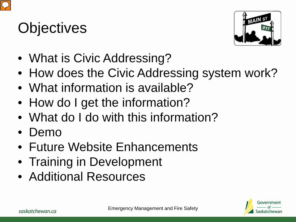
Objectives
• What is Civic Addressing?• How does the Civic Addressing system work?• What information is available?• How do I get the information?• What do I do with this information? • Demo• Future Website Enhancements• Training in Development• Additional Resources
Emergency Management and Fire Safety
Presenter
Presentation Notes
What is Civic Addressing in the context of 911 How does Civic Addressing work….especially in rural areas…what do those numbers mean What kind of information is available to administrators to assist them in understanding the civic addresses within their municipalities

What is Civic Addressing?
Emergency Management and Fire Safety

Civic Addressing
• A standardized system of identifying and locating properties.
• Within the context of 911 services, the location must be associated with human activity.
• This system will assist emergency responders such as police, fire and ambulance in finding your home or business quickly.
• It is also an easy method for other parties such as service and delivery companies to locate a property.
Emergency Management and Fire Safety

Emergency Management and Fire Safety
Presenter
Presentation Notes
In recent weeks, civic addressing has been a hot topic in the media, describing the challenges for emergency services when dealing with multiple street with similar names. Issues such as this emphasises the importance of quality information in civic addresses for public safety.

How does the Civic Addressing system work?
Emergency Management and Fire Safety

Civic Addressing
• Establishes access point location (driveway) for a property
• Consists of the civic number and street name• In an urban environment: based on a named road
system• In a rural environment: based on named road system
(hamlets, organized hamlets) or a township and range road grid system
Emergency Management and Fire Safety

Civic Addressing
A Civic Address consists of the civic number and street name:• 200 Lakeshore Drive• 20119 HWY 982• 19378 Grid Rd 662• 28067 Range Rd 3135• 313525 Township Rd 284• 44036 Range Rd 221A3• 19A029 Range Rd 2072
Emergency Management and Fire Safety
Emergency Management and Fire Safety
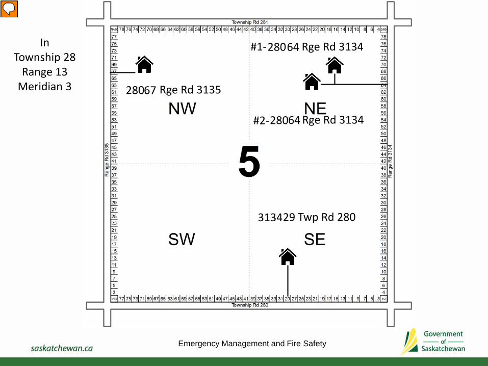
InTownship 28
Range 13 Meridian 3 28067 Rge Rd 3135
313429 Twp Rd 280
28064 Rge Rd 3134#1-
28064 Rge Rd 3134#2-
Presenter
Presentation Notes
Example #1- 28067 Range Road 3135 is 1,340m North from the township road Example #2 – 313447 Township Road 280 is 940m West from the eastern range road
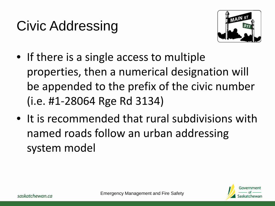
Civic Addressing
• If there is a single access to multiple properties, then a numerical designation will be appended to the prefix of the civic number (i.e. #1-28064 Rge Rd 3134)
• It is recommended that rural subdivisions with named roads follow an urban addressing system model
Emergency Management and Fire Safety
Civic Addressing
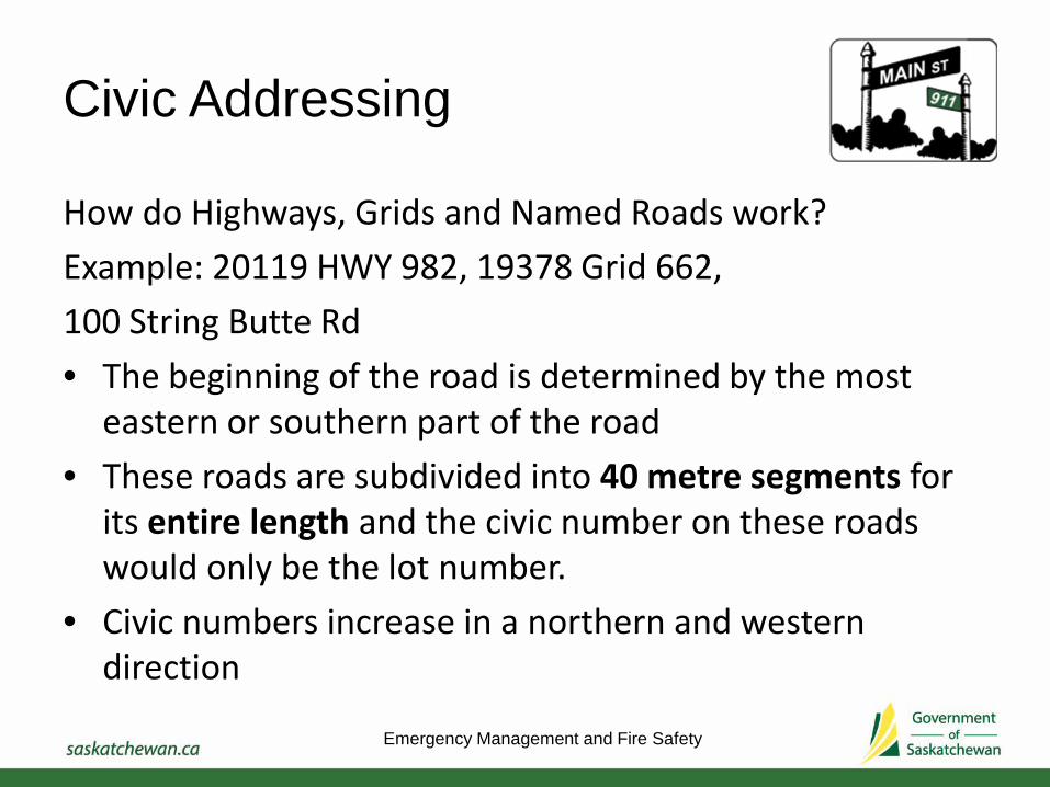
How do Highways, Grids and Named Roads work?Example: 20119 HWY 982, 19378 Grid 662, 100 String Butte Rd• The beginning of the road is determined by the most
eastern or southern part of the road• These roads are subdivided into 40 metre segments for
its entire length and the civic number on these roads would only be the lot number.
• Civic numbers increase in a northern and western direction
Emergency Management and Fire Safety

What information is available?
Emergency Management and Fire Safety

What types of civic addressing information is available?
• Municipality Overview Map
Emergency Management and Fire Safety

What types of civic addressing information is available?
• Civic Address Listing (Excel Spreadsheet)
Emergency Management and Fire Safety
Presenter
Presentation Notes
Legal land descriptions indicate access location, not structural location. Data sharing agreement needs to be signed. Hardcopies available.

What types of civic addressing information is available?
• Civic Address Web Mapping Application (CAR Website)
Emergency Management and Fire Safety

How do I get the information?
Emergency Management and Fire Safety

Register for an online account
Two Step Registration Process1) Create online profile at www.saskaddress.com
– Username: RM333– Password: Clayton#333– Passphrase: name hashtag number
2) Complete an electronic PDF Registration form and submit through email to [email protected] (faxes and scans are also accepted)
Emergency Management and Fire Safety

Register for an online account
Two types of online profiles:1) Viewer: Basic functions such as view, search, and
identify civic addresses2) Editor: Basic functions and additional abilities to
create, remove, edit civic addresses
Emergency Management and Fire Safety

What do I do with the information?

Invalid AddressesThe 999999’s
Three types of invalid addresses1) Unknown civic number, known street
– Example: 999999 Main Street
2) Known civic number, unknown street name– Example: 67 999999
3) Unknown civic number, unknown street name– Example: 999999 999999
Emergency Management and Fire Safety
Presenter
Presentation Notes
The best way to deal the the 999999’s is to understand why they are there. I will describe the reasons why there are 999999’s and what the process would be to resolve them. There are basically three different types of invalid addresses that use 999999’s.
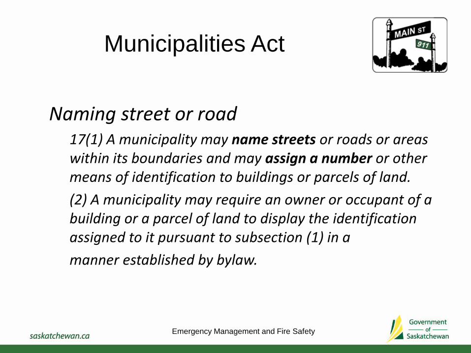
Municipalities Act
Naming street or road17(1) A municipality may name streets or roads or areas within its boundaries and may assign a number or other means of identification to buildings or parcels of land.(2) A municipality may require an owner or occupant of a building or a parcel of land to display the identification assigned to it pursuant to subsection (1) in amanner established by bylaw.
Emergency Management and Fire Safety

Invalid AddressesUnknown Civic Number
Example: 999999 Main Street or 999999 999999
Municipalities have the authority to assign a number.In Hamlets and Organized Hamlets it is recommended that civic numbers can be assigned as per Urban Addressing Standards or by other methods that are consistent within the municipality.Proposal for an Address Assignment System for Urban Areas
Emergency Management and Fire Safety
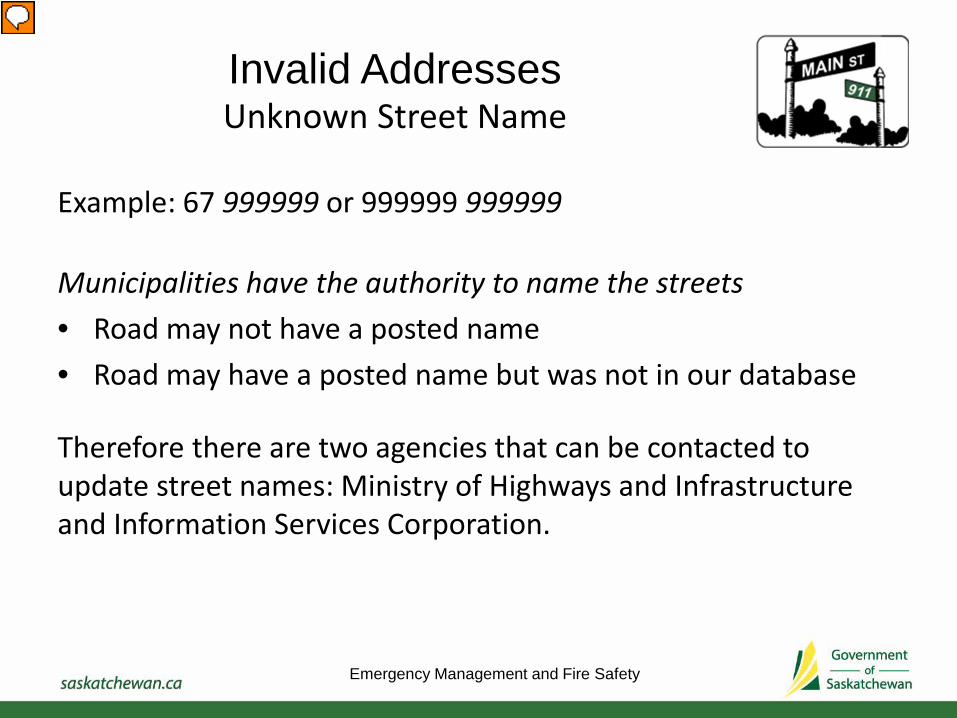
Invalid AddressesUnknown Street Name
Example: 67 999999 or 999999 999999
Municipalities have the authority to name the streets• Road may not have a posted name• Road may have a posted name but was not in our database
Therefore there are two agencies that can be contacted to update street names: Ministry of Highways and Infrastructure and Information Services Corporation.
Emergency Management and Fire Safety
Presenter
Presentation Notes
Two road/street databases were used in the civic addressing data collection.

Updating Street Names
Contact Ministry of Highways and Infrastructure• Provide the updated road name and a map showing exactly
the start and the end of the road that requires the name change. For more information, contact:
Muhammad TubbsumMinistry of Highways and Infrastructure
[email protected](306) 787-4790
Emergency Management and Fire Safety
Presenter
Presentation Notes
Two road/street databases were used in the civic addressing data collection.

Updating Street Names
Contact Information Services CorporationIf the road was created by a survey plan, verify that the street name reflects what is desired by the municipality. If it does not, the road survey plan needs to be amended. Refer to the Street Name Change Guideline for required documentation and fees. For more information contact:
Information Services Corporation1-866-275-4721
Emergency Management and Fire Safety
Presenter
Presentation Notes
Two road/street databases were used in the civic addressing data collection.

What else is there to validate other than the 999999’s?
• Abandoned structures misinterpreted as properties• New developments• Missed properties, hamlets• Multiple access point to one property• Conflicts in known road names vs posted road names
Emergency Management and Fire Safety

Recap
1) Create and update civic numbers where street names are known.
2) Verify road names and contact the appropriate agency to update.
3) Create and update civic numbers where street names have been updated.
4) Add/remove other civic addresses as necessary
Emergency Management and Fire Safety
Presenter
Presentation Notes
Create and update, civic numbers for addresses that have unknown civic numbers an known street names. These mainly occur in hamlets and organized hamlets. Municipalities may put a civic addressing bylaw in place to support this. Provide MHI map indicating updated road name changes. If also on a road survey plan, it needs to be updated at ISC and a bylaw may need to be put in place to indicate the change. Provide MHI list of township and range roads with in municipality. As a result of #2, may also need to repeat #1 Review the rest of the addresses.

Future Website Enhancements
• Simplified website registration process• Improved visualization on the website
– Invalid addresses vs valid addresses– Civic Addresses labelled– Water features and railway lines– Satellite Imagery– Lot, block and Registered Plan numbers and
survey lines
Emergency Management and Fire Safety

Training in Development
• Training User Guide for Editors• Online help tutorial videos• Workshop for Viewers and Editors at SARM Annual
Convention 2016
Emergency Management and Fire Safety

Additional Resources
Saskatchewan Rural Addressing StandardsProposal for an Address Assignment System for Urban AreasCivic Addressing FAQ 2015 Information SheetCivic Addressing Registry System GuideCivic Address Registry Getting Started User Guide for ViewersCivic Address Registry Training Guide for EditorsInformation Services Corporation Street Name Change Guidelines
Emergency Management and Fire Safety

Thank You!
Questions??
Emergency Management and Fire Safety

Cynthia MamerCivic Addressing Administrator
Emergency Management and Fire SafetyMinistry of Government Relations
Provincial Help Line 1-844-407-0077 [email protected]
Emergency Management and Fire Safety

Additional Notes

Civic Addressing
In rural areas, Civic Addressing System uses this township and range road grid system to establish the access point, or number, of a property. The civic number is a combination of two numbers:
1) The nearest township road to the south or range road to the east of the property
2) The addressable lot number where the property access point (driveway) is located.
Emergency Management and Fire Safety

Civic Addressing
Each mile of township and range road is divided into 40m lot intervals producing 80 addressable lots (40 on each side of the road).
• Even numbers (2 to 80) are on the west and south side of the road
• Odd numbers (1 to 79) are on the east and north side of the road.
• Address numbers increase going north and west
Emergency Management and Fire Safety

Example #1
In Township 28 Range 13 West of the 3rd Meridian Civic Address: 28067 Range Rd 3135
Where:280 = the township road name to the south of the property67 = the lot number on the east (odd) side along the road where the access to the property is locatedRange Road 3135 = the street name in which the property is located
Emergency Management and Fire Safety

Example #1
In Township 28 Range 13 West of the 3rd Meridian Civic Address: 28067 Range Rd 3135
The distance to property can be calculated by:
67 x 40m/2 = 1,340m
multiplying the lot number “67” by 40m lot intervals and dividing by 2 (account for even and odd numbers) giving a distance of 1,340m north of township road 280.
Emergency Management and Fire Safety
Presenter
Presentation Notes
The lot number is an indicator of the distance of the property from the township road to the south of the property.
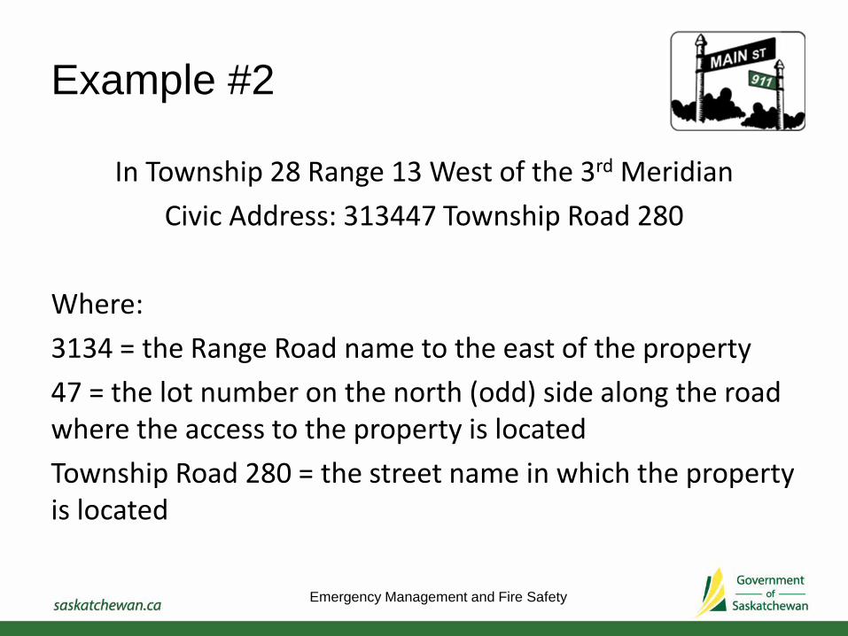
Example #2
In Township 28 Range 13 West of the 3rd Meridian Civic Address: 313447 Township Road 280
Where:3134 = the Range Road name to the east of the property47 = the lot number on the north (odd) side along the road where the access to the property is locatedTownship Road 280 = the street name in which the property is located
Emergency Management and Fire Safety
Example #2
In Township 28 Range 13 West of the 3rd Meridian Civic Address: 313447 Township Road 280
The distance can be calculated by:
47 x 40m/2 = 940m
multiplying the lot number “47” by 40m lot intervals and dividing by 2 (account for even and odd numbers) giving a distance of 940m west of Range Road 3134.
Emergency Management and Fire Safety
Presenter
Presentation Notes
The lot number is an indicator of the distance of the property from the range road to the east of the property.

Emergency Management and Fire Safety
In Township 28 Range 13 West of the 3rd Meridian
Presenter
Presentation Notes
Example #1- 28067 Range Road 3135 is 1,340m North from the township road Example #2 – 313447 Township Road 280 is 940m West from the eastern range road