City Of Owen Sound 10th Street Bridge Evaluation ... · 13.1 Bicycle Movements ... Hydrology and...
64
GUELPH | OWEN SOUND | LISTOWEL | KITCHENER | LONDON | HAMILTON | GTA 1260-2ND AVE. E., UNIT 1, OWEN SOUND ON N4K 2J3 P: 519-376-1805 WWW.GMBLUEPLAN.CA Prepared By: City Of Owen Sound 10th Street Bridge Evaluation - Schedule 'C' Environmental Study Report Version 3 (Phase 4) GMBP File: 215235 October 2018
Transcript of City Of Owen Sound 10th Street Bridge Evaluation ... · 13.1 Bicycle Movements ... Hydrology and...

GUELPH | OWEN SOUND | LISTOWEL | KITCHENER | LONDON | HAMILTON | GTA
1260-2ND AVE. E., UNIT 1, OWEN SOUND ON N4K 2J3 P: 519-376-1805 WWW.GMBLUEPLAN.CA
Prepared By:
City Of Owen Sound
10th Street Bridge Evaluation - Schedule 'C' Environmental Study Report
Version 3 (Phase 4)
GMBP File: 215235 October 2018

CITY OF OWEN SOUND
10TH STREET BRIDGE EVALUATION - SCHEDULE 'C' ENVIRONMENTAL STUDY REPORT
GMBP FILE: 215235
OCTOBER 2018
i
TABLE OF CONTENTS
1. INTRODUCTION ......................................................................................................................................................... 1
2. ENVIRONMENTAL STUDY REPORT STRUCTURE................................................................................................. 2
3. MUNICIPAL CLASS ENVIRONMENTAL ASSESSMENT PLANNING PROCESS .................................................. 4
4. BACKGROUND .......................................................................................................................................................... 6
4.1 Bridge Structure and Design ................................................................................................................................ 6
4.2 Bridge Usage ........................................................................................................................................................ 7
4.3 Prior Consultation ................................................................................................................................................. 8
5. PROJECT STATEMENT ............................................................................................................................................. 8
6. ALTERNATIVE SOLUTIONS (PHASE 2) .................................................................................................................. 9
7. INVENTORY OF ENVIRONMENTS ......................................................................................................................... 10
7.1 Social Environment ............................................................................................................................................ 10
7.1.1 City of Owen Sound Official Plan and Zoning............................................................................................... 10
7.1.2 County of Grey Official Plan.......................................................................................................................... 10
7.1.3 City of Owen Sound Transportation Planning............................................................................................... 11
7.2 Natural Environment ........................................................................................................................................... 12
7.2.1 Natural Heritage Environmental Impact Study.............................................................................................. 12
7.2.2 Hydrology and Hydraulic Analysis ................................................................................................................ 12
7.2.3 Source Water Protection and Climate Change ............................................................................................. 13
7.2.4 Species at Risk (SAR) .................................................................................................................................. 13
7.3 Cultural Environment .......................................................................................................................................... 13
7.3.1 Archaeology .................................................................................................................................................. 13
7.3.2 Built Heritage Resource and Cultural Heritage Landscape Assessment ..................................................... 14
7.4 Technical Environment ....................................................................................................................................... 15
7.4.1 Structural Evaluation ..................................................................................................................................... 15
7.4.2 Geotechnical ................................................................................................................................................. 15
7.4.3 Nearby Buildings ........................................................................................................................................... 15
7.4.4 Utilities and Services ..................................................................................................................................... 16
7.5 Economic Environment ...................................................................................................................................... 16
8. IMPACT, ASSESSMENT AND EVALUATION OF ALTERNATIVES ...................................................................... 17
8.1 Alternative 2 – Rehabilitate the Existing Structure ............................................................................................. 17
8.2 Alternative 3 – Replace the Existing Structure ................................................................................................... 18
8.3 Evaluation of Alternatives and Recommended Solution .................................................................................... 20
9. PHASE 2 CONSULTATION ...................................................................................................................................... 21
9.1 Notice of Project Initiation and Public Information Centre (PIC No.1)................................................................ 21
9.2 Public and Stakeholder Consultation ................................................................................................................. 21
9.3 Agency Consultation .......................................................................................................................................... 22
9.4 Consultation Feedback ....................................................................................................................................... 22

CITY OF OWEN SOUND
10TH STREET BRIDGE EVALUATION - SCHEDULE 'C' ENVIRONMENTAL STUDY REPORT
GMBP FILE: 215235
OCTOBER 2018
ii
9.5 Council Acceptance of the Preferred Solution ................................................................................................... 23
10. PHASE 3 – ALTERNATIVE DESIGN CONCEPTS ............................................................................................. 24
10.1 Traffic Management During Construction ..................................................................................................... 24
Review of Traffic Management Options ................................................................................................................ 24
10.1.1 ......................................................................................................................................................................... 24
10.1.2 Traffic Management Strategies ................................................................................................................. 28
10.2 Traffic Lane Configuration............................................................................................................................. 29
10.3 Pedestrian and Bicycle Movements .............................................................................................................. 29
10.3.1 East�West Pedestrian Movements ......................................................................................................... 29
10.3.2 North�South Pedestrian Movements ...................................................................................................... 31
10.4 Bridge Style ................................................................................................................................................... 35
10.4.1 Pre-cast Concrete Girder .......................................................................................................................... 35
10.4.2 Steel Girder ............................................................................................................................................... 36
10.4.3 Precast Concrete Arch .............................................................................................................................. 36
10.4.4 Cast-In-Place Concrete Arch .................................................................................................................... 37
10.4.5 Evaluation of Alternative Bridge Styles ..................................................................................................... 37
10.5 Bridge Construction Efficiencies ................................................................................................................... 38
10.5.1 Bridge Re-Construction Process and Potential Efficiencies ..................................................................... 38
10.5.2 Rapid Replacement Technology (RRT) .................................................................................................... 39
10.5.3 Contractor Incentives ................................................................................................................................ 40
10.6 Municipal Services and Utilities .................................................................................................................... 40
10.6.1 Watermains ............................................................................................................................................... 40
10.6.2 Sanitary Sewers ........................................................................................................................................ 40
10.6.3 Storm Sewers ........................................................................................................................................... 41
10.6.4 Utilities....................................................................................................................................................... 41
10.7 Construction Implementation and Timing Constraints .................................................................................. 42
11. SUMMARY OF RECOMMENDED DESIGN SOLUTIONS .................................................................................. 43
12. PHASE 3 CONSULTATION ................................................................................................................................. 44
12.1 Notice of Public Consultation and Public Information Centre (PIC No.2) ..................................................... 44
12.2 Consultation: Public, Stakeholder, Agency and First Nations ...................................................................... 44
12.3 Consultation Feedback ................................................................................................................................. 44
13. RE-ASSESSMENT OF ALTERNATIVE DESIGN CONCEPTS........................................................................... 46
13.1 Bicycle Movements ....................................................................................................................................... 46
13.2 Construction Implementation and Timing ..................................................................................................... 47
13.3 Recommended Design Solutions ................................................................................................................. 49
14. COUNCIL RESOLUTION ..................................................................................................................................... 50
15. NEXT STEPS ........................................................................................................................................................ 51

CITY OF OWEN SOUND
10TH STREET BRIDGE EVALUATION - SCHEDULE 'C' ENVIRONMENTAL STUDY REPORT
GMBP FILE: 215235
OCTOBER 2018
iii
FIGURES
FIGURE 1 – Site Location Plan
FIGURE 2 – EA Planning Process
FIGURE 3 – Site Plan
FIGURE 4A – Existing Conditions Plan
FIGURE 4B – Existing Bridge Cross-Section
FIGURE 5 – Downtown Owen Sound: Study Areas – Concurrent Assessments
FIGURE 6 – Alternative Temporary Bridge Crossing Locations
FIGURE 7 – Conceptual Arrangement: Consolidation of Recommended Design Solutions
TABLES
TABLE 1: EVALUATION OF ALTERNATIVES
TABLE 2: SUMMARY OF COMMENTS FROM AGENCIES AND UTILITIES (Phase 2)
TABLE 3: PEDESTRIAN MOVEMENTS: WEST SIDE – EVALUATION OF OPTIONS
TABLE 4: ASSESSMENT OF ALTERNATIVE BRIDGE STYLES
TABLE 5: SUMMARY OF COMMENTS FROM AGENCIES AND UTILITIES (Phase 3)
TABLE 6: CONSTRUCTION IMPLEMENTATION AND TIMING OPTIONS
APPENDICES
APPENDIX A: PROJECT NOTICES
APPENDIX B: PLANNING INFORMATION
APPENDIX C: GEOTECHNICAL, STRUCTURAL AND BRIDGE INSPECTION REPORTS
APPENDIX D: BACKGROUND INFORMATION: NATURAL ENVIRONMENT
APPENDIX E: BACKGROUND INFORMATION: CULTURAL ENVIRONMENT
APPENDIX F: TRANSPORTATION STUDIES
APPENDIX G: SERVICING INFORMATION AND REPORTS
APPENDIX H: PRESENTATION (PIC NO.1: JANUARY 26, 2017) - PHASE 2 CONSULTATION
APPENDIX I: PUBLIC, STAKEHOLDER AND AGENCY COMMENTS (PHASE 2)
APPENDIX J: REVIEW OF TRAFFIC MANAGEMENT STRATEGIES DURING CONSTRUCTION
APPENDIX K: PRESENTATION (PIC NO.2: JULY 10, 2018) - PHASE 3 CONSULTATION
APPENDIX L: PUBLIC, STAKEHOLDER AND AGENCY COMMENTS (PHASE 3)
APPENDIX M: PRESENTATION TO COUNCIL: AUGUST 27, 2018
APPENDIX N: PRESENTATION TO COUNCIL: OCTOBER 1, 2018

PEOPLE | ENGINEERING | ENVIRONMENTS
PAGE 1 OF 51
1. INTRODUCTION
GM BluePlan Engineering Limited (GMBP) was retained by the City of Owen Sound (City) to undertake a Schedule ‘C’ Municipal Class Environmental Assessment (EA) planning process to resolve issues with an aging bridge over the Sydenham River on 10th Street, where shown on Figure 1. The bridge, which was built in 1911, is part of the main east-west arterial route through Owen Sound, receiving the highest traffic volume of any bridge in the City. In addition to being an integral part of the local road network, it functions as a Connecting Link across the Sydenham River for Provincial Highways 6, 10, 21 and 26. It also connects Grey County Roads 1, 5, 15 and 17B.
The purpose of this Environmental Study Report (ESR) is to consolidate the information prepared to address the requirements of the Environmental Assessment Act and to document the planning, consultation and design consideration processes required for the determination of a Preferred Solution, and of a Preferred Design, for the 10th Street Bridge. The ESR is considered as a “living document”, which is updated as the Study progresses through the five (5) Phases of the EA process, depicted on Figure 2. The five main study Phases are summarized as follows:
Phase 1: Identify the Problem or Opportunity.
Phase 2: Identify Alternative Solutions to address the problem or opportunity, taking into consideration the existing environment, and establish the Preferred Solution, taking into account public, First Nations and review agency input.
Phase 3: Examine Alternative Design Concepts for implementing the Preferred Solution and identify the Preferred Design.
Phase 4: Document, in an Environmental Study Report, a summary of the rationale and the planning, design and consultation process of the project and make the documentation available to the public, stakeholders, First Nations and review agencies for comment.
Phase 5: Implementation – Complete contract drawings and documents and proceed to construction and operation.
On February 13th, 2017, City Council approved the Operations Committee recommendation for Bridge Replacement as the Preferred Solution to the Phase 2 process, thus directing the next Phase 3 of the Municipal Class Environmental Assessment; to consider Alternative Design Concepts for the Preferred Design Solutions.
This Version 3 of the ESR (Final Report) updates the previous Version 2 (June 26, 2018) and is completed as part of Phase 4 of the EA Process. It includes a summary of key comments/feedback obtained during the Phase 3 consultation period, commitments to mitigate any remaining negative effects of the project, and a re-assessment of the Recommended Design Alternatives. The documentation provided in this Version of the ESR supports the Recommended Design Solutions which were presented to Council on August 27, 2018 for
10TH STREET BRIDGE EVALUATION - SCHEDULE 'C' ENVIRONMENTAL STUDY REPORT
VERSION 3 (PHASE 4)
CITY OF OWEN SOUND
OCTOBER 2018
GMBP FILE: 215235

CITY OF OWEN SOUND
10TH STREET BRIDGE EVALUATION - SCHEDULE 'C' ENVIRONMENTAL STUDY REPORT
GMBP FILE: 215235
OCTOBER 2018
PAGE 2 OF 51
their consideration. Following additional consultation, Council accepted the Preferred Design Solutions presented herein on October 1, 2018, thus directing Phase 4 of the EA process, finalization of the ESR and issuance of the Notice of Completion. The Notice of Completion was issued on October 4th, 2018.
2. ENVIRONMENTAL STUDY REPORT STRUCTURE
This Version 3 of the Schedule ‘C’ EA Environmental Study Report for the 10th Street Bridge provides a summary of the required documentation and consultation, and outlines the basis for the Preferred Design Solutions recommended by GMBP and accepted by Council on October 1st, 2018. The ESR includes recommendations and/or mitigating measures outlined in the background studies, which were incorporated into the evaluation of Design Alternatives for the Preferred Solution.
Version 3 of the ESR is structured as follows:
Documentation of the EA Process for the 10th Street Bridge makes up the body of the text and includes the following:
PART 1 – ESR Version 1: Phase 2 (Updated)
• A description of the project and its purpose; • Background information including existing conditions; • The range of alternative solutions considered; • Anticipated environmental effects and proposed mitigation; • The assessment and evaluation of alternative solutions; and • The rationale for the selection of a Recommended Solution.
PART 2 – ESR Version 2: Phase 3 Alternative Design Concepts (Updated)
• Background information including existing conditions; • The range of alternative design concepts; • Inventory of environments specific to bridge design elements and considerations; • Anticipated environmental impacts and proposed mitigation; • The assessment and evaluation of alternative design concepts; and • The rationale for a Recommended Preferred Design.
PART 3 – ESR Version 3: Re-Assessment of Alternative Design Concepts and Finalization of the ESR
• A summary of the public and agency feedback provided following the second public consultation period. Comments were addressed within the updated ESR.
• A more detailed discussion on bicycle movement alternatives. • A review and assessment of the construction implementation and timing options. • The rationale for the Recommended Preferred Design for consideration and acceptance by Council. • The preliminary finalization of the preferred design (Figure 7).
Project Notices, including distribution lists and the distribution area (i.e. Notification Area), are provided in Appendix ‘A’. Supporting documentation and background studies that have been completed in support of the EA Process are also provided in the Appendices as follows:

CITY OF OWEN SOUND
10TH STREET BRIDGE EVALUATION - SCHEDULE 'C' ENVIRONMENTAL STUDY REPORT
GMBP FILE: 215235
OCTOBER 2018
PAGE 3 OF 51
Appendix ‘B’:
Planning and Zoning Information relevant to the 10th Street Bridge and surrounding area.
Appendix ‘C’
1. Structural Information related to the existing 10th Street Bridge (i.e. the main bridge and the pedestrian bridge), including engineering reports, available Drawings and inspection reports which outline bridge deficiencies for consideration in restoration and construction feasibility and constraints.
2. Geotechnical Reports related to the 9th Street Bridge to consider sub-surface conditions on the basis that similar conditions are anticipated.
Appendix ‘D’
1. Natural Heritage Environmental Impact Study (EIS) and a List of the Species at Risk to address issues related to the natural environment.
2. Hydrology and Hydraulic Analysis Report to address the design flow and regulatory flood flow conditions for the Sydenham River and to provide recommendations with regard to flood and scour protection along the river banks, including mitigation measures for the protection of the bridge structure and nearby buildings.
Appendix ‘E’
1. Stage 1 Archaeological Assessment to determine the potential for archaeological resources within the Study Area.
2. Cultural Heritage Evaluation and Heritage Impact Assessment Reports to identify impacts of the proposed undertaking on cultural heritage resources specific to the 10th Street Bridge and the abutting building to the southeast of the bridge.
Appendix ‘F’
Transportation Studies were completed to address traffic management within the City and traffic flow optimization along the 10th Street corridor, including the 10th Street Bridge. An evaluation of potential pedestrian movement options was also completed. Appendix ‘G’
Servicing Studies completed for the water distribution system, storm sewer outlet and sanitary sewer system to address potential issues during construction and longer term servicing needs. This includes a Review of the Storm Sewer System (west side) and Sewage Flow Analysis Report (10th Street Siphon), which considers that the reconstruction of the 10th Street Bridge provides an opportunity to divert sewage flows from the aging 10th Street siphon and outlines various options.
Appendix ‘J’
Review of Traffic Management Strategies was completed to address potential issues during construction related to traffic flow through the City with the closure of the main east-west arterial route through Owen Sound and to address detour planning during construction.
The consultation process is documented as follows:
Appendix ‘H’ - Presentation (PIC No.1 – January 26th, 2017): Phase 2 Consultation
Appendix ‘I’ - Public, stakeholder, First Nations and agency comments (Phase 2)
Appendix ‘K’ - Presentation (PIC No.2 – July 10th, 2018): Phase 3 Consultation
Appendix ‘L’ - Public, stakeholder, First Nations and agency comments (Phase 3)
Appendix ‘M’ - Presentation to Council – August 27th, 2018 and Staff Report No. OP-18-040
Appendix ‘N’ – Presentation to Council – October 1, 2018

CITY OF OWEN SOUND
10TH STREET BRIDGE EVALUATION - SCHEDULE 'C' ENVIRONMENTAL STUDY REPORT
GMBP FILE: 215235
OCTOBER 2018
PAGE 4 OF 51
3. MUNICIPAL CLASS ENVIRONMENTAL ASSESSMENT PLANNING PROCESS
Municipal infrastructure projects are subject to the Ontario Environmental Assessment Act (EA Act). The Class Environmental Assessment (Class EA) is an approved self-assessment process under the EA Act for a specific group or “class” of projects. Projects are considered approved subject to compliance with an approved Class EA process. The Municipal Class EA (Municipal Engineers Association October 2000, as amended in 2007, 2011 and 2015) applies to municipal infrastructure projects including roads, water and wastewater.
The Municipal Class EA outlines a comprehensive planning process (illustrated in Figure 2) that provides a rational approach to consider the environmental and technical advantages and disadvantages of alternatives and their trade-offs in order to determine a Preferred Solution to address an identified problem (or opportunity), as well as consultation with agencies, first nations, directly affected stakeholders and the public throughout the process. The key principles of successful environmental assessment planning include:
• Consultation;
• Consideration of a reasonable range of alternatives;
• Consideration of effects on natural, social, cultural, and economic environments and technical components;
• Systematic evaluation;
• Clear documentation; and
• Traceable decision making.
The classification of projects and activities under the Municipal Class EA is as follows:
Schedule A: Includes normal or emergency operational and maintenance activities, which are limited in scale and have minimal adverse environmental effects. These undertakings are pre-approved and the proponent can proceed without further assessment and approval.
Schedule A+: Introduced in 2007, these minor projects are pre-approved. The public is to be advised prior to the implementation of the project.
Schedule B: Includes projects which have the potential for adverse environmental effects. This includes improvements to, and minor expansions of, existing facilities. These projects are approved subject to a screening process which includes consulting with stakeholders who may be directly affected and relevant review agencies.
Schedule C: Includes the construction of new facilities and major expansions to existing facilities. These undertakings have the potential for significant environmental effects and must proceed under the planning and documentation procedures outlined in the Municipal Class EA document.
This Version 3 of the ESR includes documentation of Phases 1, 2 and 3 of the Schedule ‘C’ EA process, which re-affirms the Preferred Solution (Phase 2) and provides a Recommended Design Solution (Phase 3), which is in accordance with the requirements of the Municipal Class EA process as depicted on Figure 2 and described below.
• Phase 1 consists of identifying the problem or opportunity, and an optional (discretionary) public consultation if deemed suitable.
• Phase 2 involves identifying reasonable alternatives to the problem or opportunity, compiling an inventory of the natural, cultural, social, technical and economic environments, evaluating each alternative and recommending a preferred solution that will address the problem, and provide any measures necessary to mitigate potential environmental impacts.

CITY OF OWEN SOUND
10TH STREET BRIDGE EVALUATION - SCHEDULE 'C' ENVIRONMENTAL STUDY REPORT
GMBP FILE: 215235
OCTOBER 2018
PAGE 5 OF 51
• Phase 3 involves identifying reasonable alternative designs for the Preferred Solution, compiling detailed inventories of the natural, social and economic environments, evaluating each Alternative Design in consideration of the ‘environmental’ impacts, and identifying a Recommended Preferred Design that will address the problem, and provide any measures necessary to mitigate potential environmental impacts.
For Schedule ‘B’ or ‘C’ projects, the Preferred Solution (and for Schedule ‘C’ projects the Preferred Design) is to be confirmed by Council. The entire process is documented in a Schedule ‘B’ Project File, or Schedule ‘C’ Environmental Study Report, which is made available for public and agency review during a 30 calendar day period. A Notice of Completion is submitted to review agencies and the public at that time.
For Schedule ‘B’ or ‘C’ projects, if concerns are raised during the 30 calendar day review period, following advertisement of the Notice of Completion, that cannot be resolved through discussions with the City, then members of the public, interested groups or technical agencies may request the Minister of the Environment, Conservation and Parks (MECP) to issue a ‘Part II Order’ for the project. Within the Part II Order request, the Minister may be requested to refer the matter to mediation, impose additional project conditions, and/or request an elevated scope of study. A Part II Order request requires the completion of a ‘Part II Order Request’ Form (i.e. form ID No.012-2206E). The form can be found online on Service Ontario’s Central Forms Repository website (http://www.forms.ssb.gov.on.ca/) by searching ‘Part II Order’ or ‘012-2206E’ (i.e. the form number).
Part II Order requests are submitted to:
Minister Ministry of the Environment, Conservation and Parks Ferguson Block, 77 Wellesley Street West, 11th Floor Toronto, ON M7A 2T5 Fax: 416-314-8452 [email protected]
Copies of the request must also be sent to the Director of the Environmental Assessment and Permissions Branch at the MECP and the City of Owen Sound at the addresses below:
Director, Environmental Assessment and Permissions Branch City of Owen Sound Ministry of the Environment, Conservation and Parks Attn: Clerk 135 St. Clair Avenue West, 1st Floor 808 2nd Avenue East Toronto, ON M4V 1P5 Owen Sound, ON N4K 2H4 [email protected]
The decision whether or not a Part II Order is appropriate or necessary rests with the Minister of the Environment, Conservation and Parks. If no Part II Order request is outstanding by the end of the 30 calendar day review period, the project is considered to have met the requirements of the Class EA, and the City may proceed to design and construct the project subject to resolving any commitments documented in this ESR during the subsequent design phases and obtaining any other outstanding environmental approvals.
For further information regarding Part II Order requests and process, please refer to:
https://www.ontario.ca/environment-and-energy/class-environmental-assessments-part-ii-order

CITY OF OWEN SOUND
10TH STREET BRIDGE EVALUATION - SCHEDULE 'C' ENVIRONMENTAL STUDY REPORT
GMBP FILE: 215235
OCTOBER 2018
PAGE 6 OF 51
PART 1 – ESR VERSION 1: PHASE 2 (UPDATED)
4. BACKGROUND
4.1 Bridge Structure and Design
The 10th Street Bridge crosses the Sydenham River and is located centrally within the City of Owen Sound (Figure 3). The concrete barrel arch bridge is described as a 20.7 meter span reinforced concrete arch structure with sidewalls and wingwalls containing backfill material. The overall length of the structure is 31.3 meters and the overall width is about 19 meters. The overall width includes for a sidewalk spanning the south side of the bridge and about 16.6 meters for the 5-lane road to accommodate traffic. The northerly sidewalk is a separate box beam bridge structure. The existing conditions are depicted on Figure 4A and Figure 4B.
According to the information available, the bridge has been the subject of a number of rehabilitation projects since its inception in 1911, including the following:
a. About 1933 a concrete slab, incorporating sidewalks, was placed over the structure.
b. In 1950, several City bridges were re-faced with pre-placed aggregate concrete. The entire bridge was reportedly re-faced using this procedure, including the underside (i.e. soffit) of the concrete arch, covering any surface defects or signs of structural problems at that time.
c. In 1974, the roadway width was increased by removing the north sidewalk and constructing an additional traffic lane (i.e. a turning lane) where the sidewalk existed. At that time a ‘single tee’ north sidewalk bridge was established.
d. The ‘single tee’ pedestrian bridge was replaced in 2006 with a box beam pedestrian bridge.
e. According to the inspection report (GMBP, 2016), the north exterior soffit was repaired in 2005. This was the last rehabilitation effort that was completed on the structure.
In 1990, GMBP (formerly Gamsby and Mannerow Limited) conducted a comprehensive study of the bridge. A copy of the Report is provided in Appendix ‘C’. Due to the limited documentation available pertaining to the bridge design, part of the Study investigated visible portions of the bridge foundation, which determined that the bridge is likely founded on wooden piles with a concrete pile cap. In addition, two core samples, analyzed as part of the study, indicated that the original concrete was in fair to poor condition, whereas the overlay placed on the soffit in the 1950’s continued to be in good condition. Since the study occurred greater than 25 years ago, it is expected that the original structure, as well as the newer overlay, would have continued to deteriorate. Consistent with this assessment, the most recent bridge inspection completed by GMBP in May 2016 noted an overall deterioration of the structure including multiple shear cracks that had developed through the overlay at critical structural elements of the Bridge. As a result, it was recommended that the City plan for replacement of the structure within the next 5-years.
The north sidewalk, which was originally built in 1974 and was replaced in 2006, is independent of the main structure. This sidewalk is a pre-stressed, pre-cast concrete box girder footbridge that has a clear span of 28 meters and a width of 2.4 meters. The cantilevered look-out platform, which is situated centrally on the north side of the bridge, adds an additional width of 1.0 m. The sidewalk bears on reinforced concrete abutments and footings independent of, but immediately alongside, the original bridge structure.

CITY OF OWEN SOUND
10TH STREET BRIDGE EVALUATION - SCHEDULE 'C' ENVIRONMENTAL STUDY REPORT
GMBP FILE: 215235
OCTOBER 2018
PAGE 7 OF 51
4.2 Bridge Usage
The 10th Street Bridge is considered to be the main arterial route through the City and accommodates a significant volume of traffic. As a result, several studies have historically been completed to assess the traffic volumes along the 10th Street corridor and across the 10th Street Bridge. The 10th Street corridor is primarily comprised of four (4) traffic lanes, two eastbound and two westbound. The existing 10th Street Bridge is comprised of 5-lanes, with the additional lane accommodating a westbound right-turn lane for traffic to 1st Avenue West (northbound). Due to the significance of the structure in accommodating traffic within the City, an assessment of the traffic volume estimates was completed, which is summarized below:
• Approximately 15% to 25% of traffic (depending on the route and principle direction) in Owen Sound is through traffic originating from, and/or destined to, other municipalities in the County and Province (City of Owen Sound Transportation Master Plan, HDR, 2010).
• According to the Owen Sound heavy vehicle cordon counts completed in 2009, the volume of trucks travelling along 10th Street, as the City’s permitted truck route between 2nd Avenue East and 2nd Avenue West, was measured to be approximately 1,500 trucks per day (City of Owen Sound Transportation Master Plan, HDR, 2010).
• The MTO completed spring and summer traffic counts on 10th Street, 3.3 km west of Highway 10/26, in 2012. Although the counts are not necessarily representative of traffic counts through the City’s core, the counts are used to extrapolate the seasonal and daily fluctuations. Based on the information provided in the County of Grey Transportation Master Plan (September 2014), the following estimates are provided:
� Weekday traffic is an estimated 20% to 25% greater than weekend traffic. � Traffic volumes increase by an estimated 15% to 20% in the summer.
• Daily traffic volume counts completed by BTE Engineering in August 2016, summarized in Figure 3 of the Corridor Optimization Study provided in Appendix ‘F’, suggest the following:
� Summer traffic volumes along the 10th Street corridor, between 6th Avenue West and 3rd Avenue West, not including the area in the vicinity of the bridge, are in the range of 20,000 to 25,000 vehicles per day.
� The critical section of the corridor is the crossing of the Sydenham River, between 1st Avenue West and 2nd Avenue East, where the roadway carries an average of over 30,000 vehicles per day across the bridge in the summer. Therefore, in consideration of seasonal and daily fluctuations, it is estimated that the 10th Street Bridge typically accommodates in the range of 20,000 to 30,000 vehicles per day.
• Consistent with the findings presented by BTE, traffic counts obtained by Paradigm in November 2016 suggest that traffic volumes are greatest between 1st Avenue West and 2nd Avenue East (i.e. across the 10th Street Bridge). Mid-week traffic volumes, measure directly east of 1st Avenue West were measured to be approximately 17,000 vehicles per day.
• Based on the traffic counts completed by BTE and Paradigm, peak traffic on the bridge typically occurs in the afternoon. Peak traffic counts are estimated to be in the range of 1,350 to 2,000 vehicles per hour crossing the bridge, subject to seasonal and daily fluctuations.
In summary, the 10th Street Bridge typically accommodates in the range of approximately 20,000 to 30,000 vehicles per day, of which an estimated 10% to 20% is considered to be truck traffic. The volume of traffic is typically greater on weekdays and increases in the summer. Peak traffic typically occurs in the afternoon, at a rate of up to 2,000 vehicles per hour (two-way).

CITY OF OWEN SOUND
10TH STREET BRIDGE EVALUATION - SCHEDULE 'C' ENVIRONMENTAL STUDY REPORT
GMBP FILE: 215235
OCTOBER 2018
PAGE 8 OF 51
4.3 Prior Consultation
Recently, in light of the anticipated works that would be required within the City’s downtown core, including the need for bridge repairs, infrastructure improvements, and improved traffic-flow, the City of Owen Sound completed various Studies to ensure that the broader needs and longer-term goals of the community as a whole would be considered through the assessment, planning and design processes required for the various smaller-scale projects anticipated. One of the relevant themes identified in these reports was to ensure that the downtown core remains a mainstay of the community while maintaining a direct and efficient arterial route and Connecting Link through the City and across the Sydenham River. The findings and recommendations of these previous studies, which are referenced within the following discussions, are outlined in the following Reports/documentation:
• Owen Sound Harbour and Downtown Urban Design Master Plan, prepared by Hough, Woodland, Naylor, Dance, Leinster (June 2001).
• Transportation Master Plan, HDR iTrans (September 2010). • Downtown River Precinct Conceptual and Schematic Design, prepared by Northwood Associates
Landscape Architects Limited (January 2013). • 10th Street Corridor Optimization Study, Schedule B EA (May 2017). • Downtown River Precinct Master Plan and Farmers’ Market Schedule ‘B’ EA Project File (July 10,
2018).
5. PROJECT STATEMENT
A Project Statement for the 10th Street Bridge Environmental Assessment was prepared as follows:
“The 10th Street Bridge is part of the main east-west arterial route through Owen Sound, carrying the highest traffic volumes through the City. In addition to being an integral part of the local road network, the bridge is part of a Provincial Highways Connecting Link and a connection for Grey County Roads. It services significant volumes of heavy truck traffic and is relied upon by commercial and emergency vehicles. Based on the results of biennial bridge inspections, the existing bridge is deteriorating at an advanced rate. As a result, load posting restrictions or closure of the bridge may be required in the near future. This would have significant negative effects on the local and regional transportation system and the economy. Therefore, the proponent wishes to explore opportunities to address the need for the community to continue to provide a high level of service for personal, commercial and emergency vehicles through the City’s downtown corridor, while providing minimal disruption to the community in the coming years”.

CITY OF OWEN SOUND
10TH STREET BRIDGE EVALUATION - SCHEDULE 'C' ENVIRONMENTAL STUDY REPORT
GMBP FILE: 215235
OCTOBER 2018
PAGE 9 OF 51
6. ALTERNATIVE SOLUTIONS (PHASE 2)
Continued unrestricted use of the bridge, with minimal disruption to the local and regional road network, is considered to be the basis for the development of Alternative Solutions to the defined Project Statement. Alternative Solutions are generally described as follows:
Alternative 1 – Do Nothing
The “Do Nothing” alternative maintains existing conditions. It does not address the issues identified in the Project Statement, but is considered as a base-line against which to compare other alternative solutions.
The “Do Nothing” alternative would permit the structure to remain in service until it can no longer perform its intended function. As it continues to deteriorate, maximum load postings would need to be posted, and over time would need to be further reduced. It is estimated that within five to ten years the bridge would have to be closed entirely to vehicular traffic.
The “Do Nothing” alternative may be implemented at any time during the process prior to the commencement of construction. A decision to “Do Nothing” would typically be made when the costs of all other alternatives, both financial and environmental, significantly outweigh the benefits.
Alternative 2 – Rehabilitate the Existing Structure
Rehabilitation of the existing structure would entail completing repairs to the various elements of the bridge that have recently been identified as deficient within the Ontario Structure Inspection Manual (OSIM) Inspection Form (May 2016). Based on the Inspection Report, repairs to the foundation, abutments, wingwalls and decks would be required to extend the useful life of the bridge. Ultimately, the inaccessible foundation components of the structure would limit the useful life of the structure. It is estimated that these repairs would cost the City of Owen Sound greater than $2-million.
Alternative 3 – Replace the Existing Structure
This alternative involves the removal of the existing structure, and replacement with a new one. This alternative would not only address the identified Problem Statement but also would allow for many of the potential opportunities, identified in the previous reports and EAs, to be addressed. It has been estimated that the cost to replace the 5-lane bridge alone, not including any additional features that may be desired (i.e. arch-structure, additional bicycle and pedestrian features, services, utilities etc.), would be in the range of $2.5 to $3.5 million. As per Item 30 of the Table provided in Appendix I in the EA Manual, reconstruction of the bridge structure, which is over 40-years old and has been found to have Cultural Heritage Value (as discussed in Section 7.3.2), would necessitate a Schedule ‘C’ EA Process for a project value greater than $2.4M.

CITY OF OWEN SOUND
10TH STREET BRIDGE EVALUATION - SCHEDULE 'C' ENVIRONMENTAL STUDY REPORT
GMBP FILE: 215235
OCTOBER 2018
PAGE 10 OF 51
7. INVENTORY OF ENVIRONMENTS
7.1 Social Environment
7.1.1 City of Owen Sound Official Plan and Zoning
The Official Plan includes several Goals and Objectives, which generally establish that the 10th Street corridor through the downtown core, including the 10th Street Bridge, consider the following:
i. The City shall establish a coordinated transportation system in accordance with Schedule ‘C’ – Transportation Plan, designed to facilitate the satisfactory movement of both people and goods. The transportation system is intended to facilitate safe and efficient movement of traffic between areas within the City as well as to ensure traffic movement through the City and external linkages with the overall transportation system in the regional setting.
ii. Highways 6, 10, 21 and 26 are Provincial Highways leading into the City (shown on Schedule ‘C’ – Transportation Plan) are under the jurisdiction of the Ministry of Transportation. The Provincial Highway routes as they go through the City are connecting link designations. Connecting link agreements between the Province and City should be maintained for these connecting routes.
iii. Sidewalks shall generally be constructed on both sides of an arterial road and, in the Downtown Area, pedestrian access along sidewalks shall be provided for within wider public spaces with traffic calming and other design initiatives applied to maintain and enhance the pedestrian space while providing for adequate traffic movement.
The Transportation Plan (i.e. Schedule C) and other relevant excerpts from the Official Plan are provided in Appendix ‘B’.
Zoning Map No.7 from the City’s Zoning By-Law is also provided in Appendix ‘B’. This map denotes the lands to the south and northeast of the 10th Street Bridge as Commercial (C1) and to the northwest as Mixed Use Commercial (MC). The Sydenham River is generally identified as Hazard Zone (ZH).
7.1.2 County of Grey Official Plan
The ESR reports were circulated to the Grey County Planning and Development Department. The reports were reviewed in relation to the Provincial Policy Statement (PPS) and the County of Grey Official Plan, with feedback provided in correspondence dated February 3, 2017 and July 18, 2018 (Appendix ‘I’ and Appendix ‘L’). The following Sections of the Official Plan and PPS were outlined for consideration:
i. Schedule A of the Official Plan for the County designates the surrounding lands as ‘Primary Settlement Area’. Section 2.6.3(2) states that ‘Land Use policies and development standards in areas designated Primary Settlement Areas will be in accordance with local Official Plans and/or Secondary Plans’. Therefore, the goals and objectives outlined in the City of Owen Sound Official Plan are considered applicable.
ii. Schedule A also designates a portion of the surrounding lands as “Hazard Lands”. Section 2.8.2(3) states that ‘In Hazard Lands designation buildings and structures are generally not permitted. Minor extensions or enlargements of existing buildings and structures may be permitted subject to the policies of Section 2.8’. Feedback from the GSCA in regards to the Hazards Lands should be considered.
iii. Appendix B of the Official Plan identifies the Sydenham River as a Watercourse. Section 2.8.6(5) of the Official Plan states that ‘No development shall be permitted within 30 meters of the banks of a stream, river, lake or Georgian Bay’. Feedback from the GSCA in regards to this natural feature should be considered.

CITY OF OWEN SOUND
10TH STREET BRIDGE EVALUATION - SCHEDULE 'C' ENVIRONMENTAL STUDY REPORT
GMBP FILE: 215235
OCTOBER 2018
PAGE 11 OF 51
iv. Section 1.7(e) of the PPS: Long-Term Economic Prosperity, states that the long-term economic prosperity should be supported by providing for an efficient, cost-effective, reliable multimodal transportation system that is integrated with adjacent systems and those of other jurisdictions, and is appropriate to address projected needs to support the movement of goods and people.
7.1.3 City of Owen Sound Transportation Planning
The Transportation Master Plan (TMP), completed by HDR iTrans in 2010, included in Appendix ‘F’, reviewed transportation issues on a more global level within the City, but included specific references to issues within the downtown core. Based on the assessment of the existing and future conditions, two key issues were identified, which are applicable to the subject Study Area:
i) The need for an additional east ↔ west crossing of the inner harbour was explored as “Alternative 3 – Multi-Modal Network with Roadway Expansion”. The analyses in the TMP did not support an additional inner harbour crossing; instead concluded that “Alternative 2 – Multi-Modal Network with Maximum Utility of Existing Infrastructure” was the “recommended long-term transportation strategy”. Key advantages were listed as follows:
• Address the issues at the root cause of the current and future transportation challenges; • Satisfy County and City growth objectives; • Encourage alternate travel trips (cycle and transit) while reducing auto trips; • Minimize congestion and the cost of congestion; • Support goods movement and access to employment areas; and • Support traveler visiting needs.
The finding also noted a “Least Preferred”, or greatest Capital Cost associated with an additional inner harbour crossing, coupled with limited public support (S 7.3).
ii) The need for additional capacity on the 10th Street corridor through the downtown would be required in order to address transportation challenges including congestion along this arterial road. As part of the Recommended Long-Term Transportation Strategy, a “Corridor Study” was recommended to assess the functional feasibility of intersection improvements along the 10th Street corridor (S 8.3.1).
Based on the recommendations in the TMP, a Schedule ‘B’ EA process was initiated by the City to consider and evaluate potential physical and operational improvements that might address traffic flow issues along the 10th Street corridor. The “Physical and Operational Improvements to 10th Street Corridor” EA process was completed by BTE Consulting Engineers in May 2017. A copy of the BTE report is provided in Appendix ‘F’. Key findings of that study, as they relate to the 10th Street Bridge ESR include the following:
• That a second structure connecting 1st Avenue East and 1st Avenue West not be provided due partly to the limited benefit the diversion of traffic would have on network operations, and
• Removal of traffic signals at 1st Avenue West would prevent southbound left turn movements at that intersection, resulting in a diversion of traffic to the 2nd Avenue West intersection, which would cause that intersection to fail.
The “Downtown River Precinct” (DRP) Master Plan process was completed by GMBP and the City in the summer of 2018. The associated planning process considered the implementation of one-way pairing of traffic flows northbound on 1st Avenue West and southbound on 1st Avenue East, between 8th Street and 10th Street. The Recommended Preferred Solution to the DRP EA process includes establishing 1st Avenue East and 1st Avenue West as one-way pairs with clockwise rotation. The study areas for these other two EA processes either include or abut the 10th Street Bridge (Figure 5) and, therefore, design alternatives for the 10th Street Bridge take into consideration the findings and recommendations of those EA’s.

CITY OF OWEN SOUND
10TH STREET BRIDGE EVALUATION - SCHEDULE 'C' ENVIRONMENTAL STUDY REPORT
GMBP FILE: 215235
OCTOBER 2018
PAGE 12 OF 51
7.2 Natural Environment
The Study Area is regulated by the Grey Sauble Conservation Authority (GSCA) under Ontario Regulation 151/06: Regulation and Development, Interference with Wetlands and Alterations to Shorelines and Watercourses. As indicated in correspondence from the GSCA dated February 10, 2017, under this regulation a permit will be required for building construction/redesign, site grading, and/or the temporary or permanent placing, dumping, or removal of materials from the Site. A permit would also be required for straightening, changing, diverting or in any way interfering with the river.
7.2.1 Natural Heritage Environmental Impact Study
A “Scoped Existing Conditions and Preliminary Impact Assessment” (EIS) was completed by Azimuth Environmental in October 2017 to consider the natural environment issues, which may relate to the project. A copy of the EIS Report is provided in Appendix ‘D’. The EIS contains the following conclusions:
• No terrestrial Species at Risk (SAR) were detected, and no natural features with potential to function as habitat for terrestrial SAR were observed.
• The Sydenham River has a cold water thermal regime and supports a variety of fish species, with high sensitivity.
• No aquatic SAR concern is present within the Study Area.
• No indication of any Significant Natural Heritage Features was identified.
• Any tree removal should be completed outside of the bird nesting season, April 1 through August 31.
• Bridge replacement should result in no temporary or permanent increase to the existing footprint, below the high water mark.
• All in-water work must occur between July 1 and September 15, in accordance with the cold water fisheries in-water timing window. Sheet piling should be considered to isolate the working area from the river.
It is recommended that the EIS be reviewed at the time of detailed design.
7.2.2 Hydrology and Hydraulic Analysis
Hydrology and hydraulic calculations are used to justify the geometry of the opening below any proposed replacement structure. To support this EA Process, a Hydrology and Hydraulic Analysis Report specific to the 10th Street Bridge, was completed by GMBP (dated December 2016). A copy of the Report is included in Appendix ‘D’. The purpose of the Report is to address the design storm hydrology and the regulatory flood flow conditions for the Sydenham River in relation to the existing bridge structure, and to consider the potential effects of alternatives on flow hydraulics. Recommendations with regard to flood and scour protection along the banks of the Sydenham River, including any mitigation measures recommended to protect the bridge structure and nearby buildings, are also included.
The Report determined that, since the upstream opening of the 10th Street Bridge is constricted by the ‘abutting building’ (i.e. 95/99 10th Street East/994 1st Avenue East), there is a significant increase in the water surface elevation upstream from bridge. Therefore, the hydraulic conditions are affected by both the arch style of the bridge and the building. It was concluded that any increase in the available opening through the 10th Street Bridge cross-section would improve flow hydraulics in terms of a reduction in potential flood hazard and in terms of flow velocity reduction (i.e. scour potential). Improvements to flow hydraulics may be gained with a girder-style bridge and/or by removing the building. Furthermore, the existing bridge has a clear span of 20 meters, therefore the maintenance of a minimum clear span of 20 m is recommended.
A preliminary review of the ESR (Version 1) by the GSCA, provided in correspondence dated February 10th, 2017 (Appendix ‘I’), concluded that the GSCA will require that the flood conveyance of the existing structure remains the same or improves as a result of any works associated with the 10th Street bridge project.

CITY OF OWEN SOUND
10TH STREET BRIDGE EVALUATION - SCHEDULE 'C' ENVIRONMENTAL STUDY REPORT
GMBP FILE: 215235
OCTOBER 2018
PAGE 13 OF 51
7.2.3 Source Water Protection and Climate Change
As part of the EA process, this project was reviewed with respect to the requirements under the Clean Water Act, 2006. Based on a review of the ‘Grey Sauble Source Protection Area Approved Assessment Report’ (October 2015), the Study Area is situated within an Intake Protection Zone (IPZ-2) with a vulnerability score of 4 and an Events Based Area (EBA) for a fuel spill with a threshold for on-site storage of 50,000 L. The GSCA Risk Management Office was consulted via the Phase 3 notification. The GSCA provided comments specific to Source Water Protection on July 3, 2018, included in Appendix ‘D’, which indicate that Source Water Protection is not considered to be a significant issue for this project.
The natural environment also includes potential impacts of the project on Climate Change, and of Climate Change on the project. This project, along with the recommendations of the 10th Street Corridor Optimization Study, intends to reduce travel time and improve traffic safety, which would result in reduced greenhouse gas emissions relative to a “Do Nothing” alternative. Any of the alternatives would at least maintain existing flow environments.
7.2.4 Species at Risk (SAR)
A list of SAR in the Grey County Region is provided in Appendix ‘D’. These species are to be considered with any planned development.
7.3 Cultural Environment
7.3.1 Archaeology
In consideration of Section 1.3.1 of the 2011 Standards and Guidelines for Consultant Archaeologists (S&G) administered by the Ministry of Tourism, Culture and Sport (MTCS), which lists criteria that are indicative of archaeological potential, the study area meets the following criteria indicative of archaeological potential:
• Water sources (i.e. the Sydenham River);
• Early historic transportation routes; • Proximity to early settlements; and • Proximity to heritage structure (i.e. 1002 2nd Avenue East).
ASI Archeological & Cultural Heritage Services (ASI) was retained to complete a Stage 1 Archeological Assessment for the 10th Street Bridge EA. A copy of the Stage 1 Report (February 2017) is provided in Appendix ‘E’. The assessment was conducted under the S&G. In a letter dated June 7, 2017, MTCS confirmed the entry of the Stage 1 Assessment Report into the Ontario Public Register of Archaeological Reports (Appendix ‘E’).
The Stage 1 Report concluded that the Study Area does not retain archaeological potential due to deep and extensive land disturbance associated with the construction and upgrades to the 10th Street Bridge and the surrounding Rights-of-Way. Therefore, no additional archaeological assessments (i.e. Stage 2 Archaeological Assessment) or mitigative measures will be warranted.

CITY OF OWEN SOUND
10TH STREET BRIDGE EVALUATION - SCHEDULE 'C' ENVIRONMENTAL STUDY REPORT
GMBP FILE: 215235
OCTOBER 2018
PAGE 14 OF 51
7.3.2 Built Heritage Resource and Cultural Heritage Landscape Assessment
ASI was retained to conduct a Cultural Heritage Resource Assessment (CHRA) for the Downtown River Precinct Master Plan and Class EA project, which was being completed concurrently with the 10th Street Bridge EA process. A copy of the CHRA Report (January 2017) is provided in Appendix ‘E’. The assessment encompassed the area between 10th Street and 8th Street and 2nd Avenue West to 2nd Avenue East, in the City of Owen Sound and included the 10th Street Bridge. The assessment was completed to satisfy Section 2(d) of the Planning Act which necessitates ‘the conservation of features of significant architectural, cultural, historical, archeological or scientific interest’. The City of Owen Sound also provides cultural heritage policies in Section 7.2 of its Official Plan (2014). Cultural heritage policies relevant to the CHRA are outlined in Appendix ‘B’.
Three cultural heritage resources were identified within and adjacent to the 10th Street Bridge Study Area, as summarized in Table 3 of the CHRA, and described below:
i. 10th Street Bridge: This Built Heritage Resource was identified in the 1907 Fire Insurance Maps as a two-lane stone bridge. This was replaced by the current reinforced concrete bridge in 1911.
ii. 1st Avenue East Alley Landscape: This Cultural Heritage Landscape extends from 8th Street to 10th Street and includes the building at 95/99 10th Street East/994 1st Avenue East building to the southeast of the bridge. This area along the Sydenham River appears as a pathway along the river in early historic mapping. In the 1907 Fire Insurance Maps it is identified as 1st Ave East, with a collection of 1-2 storey wood, brick and stone structures, some of which survive today.
iii. The Sydenham River: Identified as a Cultural Heritage Landscape, the Sydenham River orients the historic town and acted as an important transportation route and water source. Parks, such as Queen’s Park, and trails along the river are important public resources that contribute to the character of the river.
As per the recommendations outlined in the CHRA (January 2017), ASI was subsequently retained to complete Cultural Heritage Evaluation and Heritage Impact Assessments for the 10th Street Bridge and the 1st Avenue East Landscape (ASI March 2017), more specifically the abutting building to the southeast of the bridge (i.e. 95/99 10th Street East/994 1st Avenue East). A copy of the Reports (March 2017) are provided in Appendix ‘E’.
The cultural heritage evaluation for the 10th Street Bridge confirmed that the bridge met two of the criteria contained in Regulation 9/06 of the Ontario Heritage Act. Heritage attributes identified include the following:
• Its historical relationship with Robert McDowall, former City Engineer; and
• Its physical and historical link as a bridge crossing along 10th Street, across the Sydenham River, south of Owen Sound Harbour.
In consideration of the associative nature of the identified heritage attributes, and the continued relationship of a crossing across the Sydenham River at 10th Street, a specific preferred alternative was not identified. However, in consideration of the anticipated bridge replacement, ASI recommended that the heritage attributes associated with its historical relationship with Robert McDowall, former City Engineer, be recognized through the implementation of a commemoration strategy, such as an interpretive plaque.
Furthermore, the bridge works may have an effect on the building, or part thereof, located at 95 and 99 10th Street East and 994 1st Avenue East. As this would have the potential to alter the alley landscape identified along 1st Avenue East, a cultural heritage evaluation of this building was completed by ASI. Based on ASI’s assessment, the subject property was determined to retain no cultural heritage value.

CITY OF OWEN SOUND
10TH STREET BRIDGE EVALUATION - SCHEDULE 'C' ENVIRONMENTAL STUDY REPORT
GMBP FILE: 215235
OCTOBER 2018
PAGE 15 OF 51
7.4 Technical Environment
7.4.1 Structural Evaluation
In 2016, GMBP completed a bridge inspection based on the Ontario Structure Inspection Manual (OSIM). A copy of the Biennial Report is provided in Appendix ‘C’. Based on the OSIM Inspection Form (May 2016), several elements of the bridge were identified as being deficient and, as a result, it was ascertained that repairs to the foundation, abutments, wingwalls and decks would be required in the short-term to further defer projected load-limit postings and to extend the useful life of the bridge. However, while the cost to repair the bridge was estimated to be greater than $2-million, it was anticipated that these repairs, once completed, would only marginally extend the useful life of the structure. The Report concluded that:
‘Given the high cost of rehabilitation and the short extension of lifespan that the rehabilitation would provide, rather than investing in a rehabilitation effort for short term gain, the City target a full replacement of the structure within 5 years’
Comparatively, it is estimated that the cost to replace the 5-lane bridge alone, not including any additional features that may be desired (i.e. arch-structure, additional bicycle and pedestrian features, etc.), would be in the range of $2.5 to $3.5 million. As per Item 30 of the Table provided in Appendix I of the EA Manual, reconstruction of a bridge structure, which is over 40-years old and has been found to have Cultural Heritage Value, would necessitate a Schedule ‘C’ EA Process.
7.4.2 Geotechnical
For preliminary assessment purposes, borehole data completed previously for the 8th Street and 9th Street Bridge replacement projects were referenced to consider sub-surface conditions on the basis that similar overburden characteristics are anticipated. Borehole logs completed as part of these investigations document a unit of primarily sandy silt to silty clay underlying the fill, extending to depths in the range of 20 to 25 m below ground surface. A unit of grey sand, with various proportions of silt and gravel, was noted to overly the bedrock. Bedrock was encountered at a depth of about 37 m (or 144 to 145 m above sea level) in the vicinity of the 8th Street Bridge and a depth of approximately 40 m (or 141 to 142 m above sea level) in the vicinity of the 9th Street Bridge. Based on available mapping, the underlying bedrock is described as grey-brown dolostone of the Fossil Hill Formation.
As outlined in the Geotechnical Investigations previously completed for the 8th Street and 9th Street Bridges, the native soil deposits along the banks of the Sydenham River are not suitable to support conventional spread footings. Therefore, in accordance with the recommendations outlined in these Geotechnical Reports completed for the two proximal upstream bridges, the 8th Street and 9th Street bridges are supported on pile foundations driven to bedrock. A copy of the Geotechnical Report for the 9th Street Bridge is provided in Appendix ‘C’ as a reference.
The City retained Chung & Vander Doelen Engineering Ltd. to drill and sample two boreholes, one directly to the east and one to the west of the existing bridge structure to verify sub-surface soil, bedrock and groundwater conditions prior to construction. This field work was completed in August 2018. The findings will be used to inform the Detailed Design.
7.4.3 Nearby Buildings
Nearby buildings could be affected by any extensive bridge work project. Vibrations caused by machinery movements, pile driving operations, and soil compaction activities are inevitable. Therefore, it would be prudent to have a preconstruction survey of all buildings that are in close proximity to the bridge prior to any significant construction. This survey would document any deficiencies in these buildings before construction, so that any claims of damage as a result of the work could be confirmed.

CITY OF OWEN SOUND
10TH STREET BRIDGE EVALUATION - SCHEDULE 'C' ENVIRONMENTAL STUDY REPORT
GMBP FILE: 215235
OCTOBER 2018
PAGE 16 OF 51
The building located at 95/99 10th Street East/994 1st Avenue East is of particular interest as it abuts the southeast corner of the bridge. Due to the potential for technical and/or structural issues that are anticipated, it is recommended that the City resolve an approach during the detailed design phase.
7.4.4 Utilities and Services
An inventory of the existing utilities and services that are proximal to, and/or incorporated into, the bridge should be completed as part of the design phase. Repairs and/or updates to the overall system including utilities (i.e. hydro, gas, telephone, cable TV, etc) and the City’s existing infrastructure (i.e. municipal watermain, sanitary sewer and storm sewer systems) may be considered for incorporation into the overall design.
7.5 Economic Environment
Recent inspections of the 10th Street Bridge have noted several deficiencies that may ultimately lead to load postings and traffic restrictions in the near future. As this bridge is integral to the community’s transportation systems, both locally and regionally, this bridge will need to continue to provide a high level of service through the City’s downtown corridor. This EA Process ultimately envisions providing a long-term solution to ensure that the community can continue to rely on the bridge to efficiently direct the movement of personal, commercial and emergency vehicles through the City while ensuring that the level of disruption to the community in the short-term (i.e. load postings and/or bridge closure) is kept minimal.
Based on the information available, bridge restoration costs are estimated to be greater than $2-million, in comparison the cost for bridge replacement is estimated to be in the range of $2.5 to $3.5-million. However, it is anticipated that bridge repairs, once completed, would only marginally extend the useful life of the structure, thereby only delaying the requirement for load postings, traffic restrictions, and eventual bridge closure. Therefore, based on the following considerations, bridge replacement was considered the Recommended Solution from an economic perspective.
i) The 10th Street Bridge is an integral part of the City’s transportation system, therefore the economic costs of doing nothing (i.e. Alternative 1), leading to eventual bridge closure, are expected to be significantly greater than the capital costs required to address maintaining the structure;
ii) Bridge replacement is imminent (i.e. bridge restoration will only delay the need to replace the bridge); and
iii) The cost to replace the bridge is only marginally greater than the shorter term alternative solution of bridge restoration.
Bridge replacement costs alone are considered for the EA process, however, replacement of the 10th Street Bridge will trigger additional construction costs related to roads, services and utilities, which are considered in subsequent Sections of this ESR.

CITY OF OWEN SOUND
10TH STREET BRIDGE EVALUATION - SCHEDULE 'C' ENVIRONMENTAL STUDY REPORT
GMBP FILE: 215235
OCTOBER 2018
PAGE 17 OF 51
8. IMPACT, ASSESSMENT AND EVALUATION OF ALTERNATIVES
The process toward the selection of a Recommended Solution involves the following:
i) Identification of the impacts and mitigating measures of an alternative solution on each environment;
ii) Assessment of the degree of impact each alternative would have on each environment; and
iii) An evaluation based on comparative analysis of the alternative which best addresses the Project Statement.
A comparative examination of the advantages and disadvantages of the alternatives was completed. The following Sections summarize the impacts and assessment of each of the alternative solutions on each of the environments. The relative assessment of impacts on each environment for each alternative is colour coded, with red representing a less than favourable net negative impact, yellow representing a moderate no net difference, and green representing a favourable net positive impact. The colour coding assists in the overall evaluation of alternatives, which is presented in Section 8.3.
The ‘Do Nothing’ alternative (i.e. Alternative 1) is not typically carried forward into the evaluation of alternatives because it does not address the problem; normally only alternatives that address the problem are evaluated. Therefore, the alternatives are limited to Alternative 2, bridge restoration, and Alternative 3, bridge replacement.
8.1 Alternative 2 – Rehabilitate the Existing Structure
Social
↓ Rehabilitation would only delay the anticipated requirement for future load postings, traffic restrictions and eventual bridge closure. As a result, use of this road would be disrupted in the short-term due to construction activities required for bridge rehabilitation efforts. Then, within an estimated 5 to 10 years following bridge rehabilitation efforts, use of the bridge would be again disrupted in the form of load-postings and traffic restrictions. Subsequently, within an estimated 20-years road use would again be further disrupted due to a need to either close or replace the bridge. Therefore, in the long-term bridge rehabilitation efforts would result in the most significant disruption to the efficient use of City’s main arterial road.
↓ Rehabilitation would not facilitate the integration of the City’s longer-term vision established for the community in Owen Sound’s Master Plan and in the Master Traffic Plan, including opportunities for improvements to the traffic flow through the 10th Street corridor and improvements to the pedestrian and bicycle route networks.
Net negative impact Natural
• No change to the existing condition would be expected
No net positive or negative impact
Cultural
• No change to the existing condition would be expected.
No net positive or negative impact

CITY OF OWEN SOUND
10TH STREET BRIDGE EVALUATION - SCHEDULE 'C' ENVIRONMENTAL STUDY REPORT
GMBP FILE: 215235
OCTOBER 2018
PAGE 18 OF 51
Technical
↓ While bridge restoration would address the structural issues identified, the useful life of the bridge would still be limited due to the inaccessible foundation components of the structure. Therefore, bridge restoration only provides a short-term solution to the problem identified and on-going bridge restoration efforts would likely be required.
↑ Bridge rehabilitation activities would have limited impacts on the integrity of the abutting building located in the southeast corner of the bridge.
No net positive or negative impact
Economic
• The capital costs to rehabilitate the bridge are only marginally lower than the estimated bridge replacement costs (i.e. for bridge replacement alone).
↓ Bridge rehabilitation would only delay the requirement for bridge replacement, while load postings, traffic restrictions and future bridge closure would still be considered imminent.
↓ On the premise that the short-term capital costs are only marginally lower than those estimated for bridge replacement (i.e. for bridge replacement alone), which is only being delayed, this alternative is considered to ultimately have the greatest capital and maintenance costs as it would ultimately include the costs for both bridge rehabilitation and maintenance efforts, as well as bridge replacement.
Net negative impact
8.2 Alternative 3 – Replace the Existing Structure
Social
↑ Replacement could facilitate the integration of the longer term vision established for the community in the Master Plan for the City and in the Master Traffic Plan, including opportunities for improvements to the traffic flow along the 10th Street corridor and improvements to the pedestrian and bicycle route networks.
↑ In keeping with the City’s ‘Downtown and Harbour Front Master Plan Strategy’, the design may consider streetscape improvements including lighting and orientation signage.
↑ Bridge replacement is considered to best address the goals identified in the Problem Statement: that is providing the longest term solution while minimizing disruption to the community in the coming years.
Net positive impact
Natural
• It is unlikely that bridge replacement would have any direct long-term negative impacts on the existing fisheries habitat.
↑ Mitigation measures recommended for improving flood and scouring protection along the banks of the Sydenham River and protecting the bridge structure and nearby buildings could be better addressed. As per the GSCA opinion stated in correspondence dated February 10th, 2017, ‘any reduction in the backwater flood potential is a benefit to existing development’.
Net positive impact

CITY OF OWEN SOUND
10TH STREET BRIDGE EVALUATION - SCHEDULE 'C' ENVIRONMENTAL STUDY REPORT
GMBP FILE: 215235
OCTOBER 2018
PAGE 19 OF 51
Cultural
• Although the 10th Street Bridge is considered to have cultural heritage value, a preferred alternative was not identified as bridge replacement will ensure that the associative nature of the identified heritage attributes, such as the continued relationship of a crossing across the Sydenham River at 10th Street, will be maintained.
No net positive or negative impact.
Technical
↑ Would provide an opportunity to update and/or repair existing watermains, sanitary sewers and storm sewers, if deemed necessary.
↑ Utility systems in the vicinity of, or within, the bridge structure could be updated (i.e. relocated through conduits under river or ducts under the bridge).
↑ Would provide the longest term solution to the structural issues identified.
Net positive impact
Economic
• Compared to rehabilitating the bridge, bridge replacement would have marginal additional capital and maintenance costs due to the likelihood that bridge replacement would only be delayed, not prevented, by the required rehabilitation efforts.
↑ The City considers the river crossing to be critical to the performance of its transportation system and emergency services, particularly because it is one of three bridges which cross the Sydenham River and provides connectivity in an east-west direction across the City. Therefore, load postings and/or bridge closure associated with the bridge replacement alternative would have significant negative effects on the local transportation system and the economy as a whole. Therefore, the City needs to address the problem in order to ensure that a high level of service for personal, commercial and emergency vehicles through the City’s downtown corridor continues to be provided, with minimal disruption to the traffic system in the coming years.
↑ In March 2018, the City was informed that as part of the 2018-2019 Ministry of Transportation’s Connecting Link Program, they will receive a grant of $3,000,000 to assist with the replacement of the bridge.
Net positive impact
CITY OF OWEN SOUND
10TH STREET BRIDGE EVALUATION - SCHEDULE 'C' ENVIRONMENTAL STUDY REPORT
GMBP FILE: 215235
OCTOBER 2018
PAGE 20 OF 51
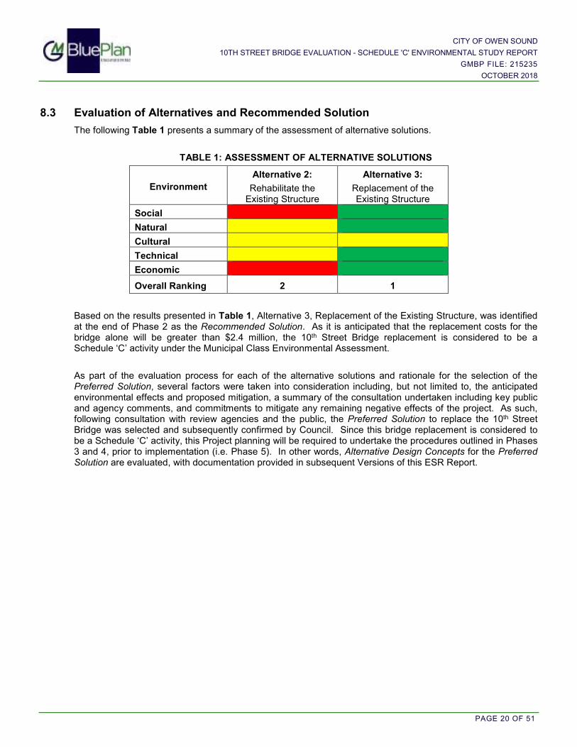
8.3 Evaluation of Alternatives and Recommended Solution
The following Table 1 presents a summary of the assessment of alternative solutions.
TABLE 1: ASSESSMENT OF ALTERNATIVE SOLUTIONS
Environment
Alternative 2:
Rehabilitate the Existing Structure
Alternative 3:
Replacement of the Existing Structure
Social
Natural
Cultural
Technical
Economic
Overall Ranking 2 1
Based on the results presented in Table 1, Alternative 3, Replacement of the Existing Structure, was identified at the end of Phase 2 as the Recommended Solution. As it is anticipated that the replacement costs for the bridge alone will be greater than $2.4 million, the 10th Street Bridge replacement is considered to be a Schedule ‘C’ activity under the Municipal Class Environmental Assessment.
As part of the evaluation process for each of the alternative solutions and rationale for the selection of the Preferred Solution, several factors were taken into consideration including, but not limited to, the anticipated environmental effects and proposed mitigation, a summary of the consultation undertaken including key public and agency comments, and commitments to mitigate any remaining negative effects of the project. As such, following consultation with review agencies and the public, the Preferred Solution to replace the 10th Street Bridge was selected and subsequently confirmed by Council. Since this bridge replacement is considered to be a Schedule ‘C’ activity, this Project planning will be required to undertake the procedures outlined in Phases 3 and 4, prior to implementation (i.e. Phase 5). In other words, Alternative Design Concepts for the Preferred Solution are evaluated, with documentation provided in subsequent Versions of this ESR Report.

CITY OF OWEN SOUND
10TH STREET BRIDGE EVALUATION - SCHEDULE 'C' ENVIRONMENTAL STUDY REPORT
GMBP FILE: 215235
OCTOBER 2018
PAGE 21 OF 51
9. PHASE 2 CONSULTATION
Consultation early in and throughout the process is a key feature of environmental assessment planning. Schedule ‘C’ Municipal Class EA processes have three mandatory points of contact:
i. The Notice of Project Initiation (Consultation - Phase 2); ii. The Notice of Public Consultation (Public Information Centre – Phase 3); and iii. The Notice of Completion of Environmental Study Report (ESR – Phase 4).
As part of the Notice of Project Initiation, first issued on January 10th, 2017, the public was invited to attend a Public Information Centre (i.e. PIC No.1) that was held on January 26th, 2017.
9.1 Notice of Project Initiation and Public Information Centre (PIC No.1)
A Notice of Project Initiation was prepared and first issued on January 10th, 2017. The Notice outlined the evaluation process for each of the alternative solutions and the rationale for the selection of the Recommended Solution (i.e. Phase 2). The Notice was advertised in the Sun Times Newspaper on January 12th and January 14th, 2017. To solicit agency comments and feedback, the Notice was circulated to agencies/groups that were considered to have a potential regulatory role or may have a direct interest in the study on January 11th, 2017. The Notice was also mailed to property owners within and surrounding the Study Area, as well as to individuals engaged in previous project planning, on January 9th, 2017. It is noted that while public notice typically requires that notices be mailed to the Owners of all properties within and abutting the Study Area, considering that many of the units in the buildings are connected and the widespread affect the bridge works could potentially have on the downtown area, an extended notification area was adopted, as outlined in the Figure provided in Appendix ‘A’.
A Public Information Centre (PIC No.1) was held on January 26th, 2017, as part of the City’s Operations Committee meeting. PIC No.1 included a one hour “meet and greet”, open discussion session, followed by a brief presentation by the project team to the committee. A copy of the display panels and the presentation given at PIC No.1 on January 26th, 2017, is provided in Appendix ‘H’. Following the presentation, questions by committee members and the public were addressed by the project team. The sign-in sheet included six members of the public.
9.2 Public and Stakeholder Consultation
With the circulation of the ESR (Version 1), the public was invited to provide comments regarding the Recommended Solution. The public comments received, following the initial consultation efforts, and the agency and stakeholder feedback provided, is included in Appendix ‘I’. Upon receipt of comments, new information was incorporated into the review and assessment of a Recommended Preferred Solution for consideration and acceptance by Council.

CITY OF OWEN SOUND
10TH STREET BRIDGE EVALUATION - SCHEDULE 'C' ENVIRONMENTAL STUDY REPORT
GMBP FILE: 215235
OCTOBER 2018
PAGE 22 OF 51
9.3 Agency Consultation
Agencies with a regulatory role that may require future permits/approvals, or may have a direct interest in the study, were contacted to invite feedback. Comments received are incorporated into the assessment of the Recommended Preferred Solution for consideration and acceptance by Council.
A complete List of Agencies contacted is provided in Appendix ‘A’, but they include the following:
• Grey Sauble Conservation Authority (GSCA) • Ministry of Tourism, Culture and Sport (MTCS) • Grey County Planning and Transportation Departments • Ministry of Transportation • Transportation Canada • Ministry of the Environment and Climate Change • First Nations • Utilities
9.4 Consultation Feedback
With the circulation of the Notice of Project Initiation and associated project information, as well as the invitation to PIC No.1, the public, agency groups, stakeholders, and First Nations groups were encouraged to provide comments regarding the Recommended Solution, to be incorporated into the assessment of the Recommended Preferred Solution for consideration and acceptance by Council on February 13th, 2017. Comments received are provided in Appendix ‘I’. Further, the Scenic City Order of Good Cheer has previously indicated an interest in supporting the construction of a pedestrian bridge across the inner harbour north of the 10th Street Bridge, close to 11th Street.
Comments received from Agency groups and utility companies are summarized below.
TABLE 2: SUMMARY OF COMMENTS FROM AGENCIES AND UTILITIES (Phase 2)
Agency (Issue Date)
Overview of Comments Response and/or
Follow-up Requirements
MOECC (March 20, 2017)
1. Aboriginal Consultation Requirements identified for the Project.
2. Source Water Protection Review Required
1. Correspondence provided on January 12, 2017 (Appendix ‘A’)
2. Consultation with GSCA Risk Management to be completed as part of the Phase 3 consultation process.
Grey County (Feb 3, 2017)
1. County Official Plan generally defers detailed development standards to the Local Official Plan and/or Secondary Plans.
2. Comments regarding the Hazards Lands and the water course (i.e. the Sydenham River) should be received from the Conservation Authority.
3. Transportation services noted that should Grey Road 15 (3rd Avenue East) or any other County Road be used as a detour route, then the Engineering Manager at the County be contacted.
4. Request to be notified of any decision rendered with respect to this project.
1. Noted
2. Noted.
GSCA Comments received February 10, 2017.
3. Matt Mark, Engineering Manager at the County will be included in future notifications.
4. County is on notification list and will receive future Notices.

CITY OF OWEN SOUND
10TH STREET BRIDGE EVALUATION - SCHEDULE 'C' ENVIRONMENTAL STUDY REPORT
GMBP FILE: 215235
OCTOBER 2018
PAGE 23 OF 51
Agency (Issue Date)
Overview of Comments Response and/or
Follow-up Requirements
GSCA (Feb 10, 2017)
Based on a review of the ESR (Version 1) and the appended Hydrology and Hydraulic Evaluation Report, the GSCA provided the following feedback:
1. Under Regulation 151/06, a permit from the GSCA will be required prior to any bridge works and/or any changes to the abutting building.
2. Natural Hazards, as defined in the Provincial Policy Statement, have been identified including flood, erosion and unstable soils, these will need to be further addressed through the EA and permitting process.
3. The flood conveyance of the existing bridge structure, as outlined in the Hydrology and Hydraulic Evaluation Report, should remain the same or improve as a result of any works associated with the bridge.
4. Provided that limited information was available within the ESR (Version 1) pertaining to natural heritage features, further review and comment will be provided as the information becomes available.
1. Noted
2. GSCA permitting requirements noted
3. Noted
4. Noted
Hydro One (Jan 26, 2017)
Clearances between the 10th Street Bridge and Hydro One plant provided. Request to be contacted if any clearance issues arise during the construction planning.
Noted
Further consultation via email dated July 19, 2018 requested comments pertaining to the implications of the nearby high voltage line and other hydro infrastructure, specifically addressing potential measures required to facilitate construction efforts.
Note: Notification and Phase 2 Consultation correspondence is provided in Appendix ‘A’ and Appendix ‘I’, respectively.
9.5 Council Acceptance of the Preferred Solution
The Council of the City of Owen Sound met on February 13th, 2017 to consider the Operations Committee recommendation that the Council accept Alternative 3, to replace the 10th Street Bridge, as the Preferred Solution. Council approved the Committee’s recommendation to select replacement as the Preferred Solution for dealing with the deteriorating structure, thus directing the next Phase 3 of the Municipal Class Environmental Assessment process.

CITY OF OWEN SOUND
10TH STREET BRIDGE EVALUATION - SCHEDULE 'C' ENVIRONMENTAL STUDY REPORT
GMBP FILE: 215235
OCTOBER 2018
PAGE 24 OF 51
PART 2 – ESR VERSION 2: PHASE 3 ALTERNATIVE DESIGN CONCEPTS (UPDATED)
10. PHASE 3 – ALTERNATIVE DESIGN CONCEPTS
With the acceptance by Council of a Preferred Solution to replace the 10th Street Bridge, Phase 3 of the EA process further considers Alternative Design Concepts. In this case, the alternative design concepts consider the following elements:
i) Traffic management during construction; ii) Traffic lane configuration on the new bridge; iii) Pedestrian movements; iv) Bridge style; v) Bridge construction efficiencies; vi) Municipal services and utilities; and vii) Construction implementation.
The following sections document inventories, impacts and evaluations under each of these elements.
10.1 Traffic Management During Construction
10.1.1 Review of Traffic Management Options
Due to seasonal and daily variations, it is estimated that 20,000 to 30,000 vehicles per day cross the 10th Street Bridge. A prevalent question during the Phase 2 Public Consultation (i.e. PIC No.1) was; “What are we going to do with traffic during construction of the bridge?”
The Project Team, including GMBP, BTE, Paradigm Transportation Solutions and City staff reviewed the following options for traffic management during construction:
Option 1: Do Nothing;
Option 2: Maintain lanes on the 10th Street Bridge during construction;
Option 3: Provide an additional temporary bridge crossing; and
Option 4: Optimize existing routes.
The results of the review and analyses are provided in Appendix ‘J’, and are summarized as follows:
Option 1: Do Nothing
Early in the process it was considered that the “Do Nothing” approach to traffic management during construction would not provide an acceptable level of service, therefore, various travel demand management options were initially considered by Paradigm at a high level of review. The Transportation Assessment Brief (November 2017) is provided in Appendix ‘J’. Traffic management options initially considered the retention of two lanes on 10th Street as a remedial measure. Under this scenario, it was estimated that approximately 40% of the existing 10th Street volume between 3rd Avenue West and 3rd Avenue East would still need to be detoured to alternate routes within the downtown core.
Under this condition, a preliminary screening of various traffic management options concluded that several downtown intersections would still experience significant congestion, queuing and delays. Further, traffic congestion would not likely be limited to the beginning and end of the alternate routes. Ultimately, the magnitude of increased traffic volume would significantly impact local businesses and residences. In order to help quantify the magnitude of traffic impact a full “Do Nothing” option would have, Paradigm further modelled

CITY OF OWEN SOUND
10TH STREET BRIDGE EVALUATION - SCHEDULE 'C' ENVIRONMENTAL STUDY REPORT
GMBP FILE: 215235
OCTOBER 2018
PAGE 25 OF 51
this scenario, with the recommendation that “this alternative should not be carried forward...”. Therefore, based on the preliminary assessment of traffic management options a Do Nothing approach to traffic management was not recommended.
Option 2: Maintain Lanes on 10th Street Bridge During Construction
In addition to Paradigm’s traffic management brief (November 2017), which determined that maintaining lanes on the bridge alone would not adequately address traffic management issues during construction, a ‘Constructability Review Report’ (October 2017) was completed by GMBP to evaluate whether it was ‘practical and reasonable to maintain traffic lanes on 10th Street during the bridge construction process’. The Report, provided in Appendix ‘J’, concludes that maintaining traffic lanes on the 10th Street Bridge is not advisable due to the following:
i. Technical (i.e. Structural): There are several unknowns related to the structural condition of the existing bridge, which may affect the structural integrity of the bridge during phased construction.
ii. Safety: There would be significant safety concerns for both construction workers and the driving public in trying to maintain public and vehicular access immediately adjacent to this type of construction project.
iii. Practicality of Implementation: Area available to facilitate construction efforts would be insufficient, for several reasons.
iv. Traffic Flow: It would not sufficiently reduce the impact to traffic flows. Additional provisions to accommodate traffic on the remainder of the existing routes through the downtown core would still be required.
In addition to the technical and safety considerations, which essentially render the Option to maintain traffic lanes on the bridge during construction infeasible, additional economic considerations related to construction efficiencies support the complete removal followed by the complete replacement of the bridge including:
v. Construction Timeline: At minimum the process timeline would essentially be doubled, as the contractor would essentially be building two bridges. There would also be considerable added complications. For example, in water work timing windows would need to be respected for each half of the construction.
vi. Cost: In consideration of the added time and complications associated with the overall construction process, it is estimated that bridge construction and maintenance costs would likely be doubled.
vii. Impacts to Local Businesses: Prolonging the construction process would negatively impact the downtown businesses by extending the duration of the bridge construction efforts and associated traffic management provisions within the City’s core.
Option 3: Provision for an Additional Temporary Bridge Crossing
An evaluation of the feasibility of providing for an additional river crossing to the north of 10th Street was completed by BTE Engineering in their Corridor Optimization Study, and further reviewed as part of this EA process, as detailed in a letter report provided in Appendix ‘J’. Several alternative temporary crossing locations were considered. However, in order to divert a sufficient volume of traffic, a connection between west-side and east-side collector roads would be necessary. Essentially, the only two suitable crossing locations were determined; either directly north of 10th Street, or at 11th Street East or 11th Street West, which could provide a connection between Grey Road 1 on the west side (2nd Avenue West) and Grey Road 15 on the east side (3rd Avenue East), where shown on Figure 6. The following issues were identified:
a. The harbour lands north of 10th Street are under the control of the Federal Government (i.e. Transport Canada Property No.21956), which may not be supportive of a crossing and may have the potential to add significant costs.

CITY OF OWEN SOUND
10TH STREET BRIDGE EVALUATION - SCHEDULE 'C' ENVIRONMENTAL STUDY REPORT
GMBP FILE: 215235
OCTOBER 2018
PAGE 26 OF 51
b. As the considered crossing locations advance northerly from 10th Street, the bridge span would be longer and, therefore, more costly. Furthermore, while traffic related to the traffic flow between the northeast and northwest quadrants of the City may be diverted from 10th Street, a decreasing proportion of traffic diversion from the 10th Street corridor would be expected. Other factors including, but not limited to, dockages for large ships, come into question.
c. A new bridge north of 10th Street would have a visual impact on the harbour.
d. New pedestrian conflicts would be introduced along the harbour trail on the west side and east side of the Sydenham River.
e. Additional traffic signals at each intersection affected by the alteration in traffic patterns would be necessary. This would result in added cost, a potential increase in traffic delays and increased traffic flow on residential streets. For example, a bridge crossing from 11th Street West to connect with 11th Street East would require an estimated 7 new traffic signals to re-route traffic on other streets, as follows:
i. East Side (3 additional signals): 11th Street East at 3rd Avenue, 2nd Avenue and 1st Avenue; ii. West Side (2 additional signals): 11th Street West at 1st Avenue and 2nd Avenue; and iii. Pedestrian crossing of Harbour Trail (2 additional crossing): East and West Side.
f. Modified traffic flows may adversely impact the local road network. Intersection improvements,
including reconstruction to accommodate turning lanes, would be required.
g. Poor soil conditions are known in this area. A temporary bridge would need appropriate foundations, which would add considerable cost.
h. The cost to construct a temporary bridge would be similar to the cost to construct a permanent bridge. Costs associated with a temporary bridge largely would be forfeited.
i. The cost of a new bridge would need to be funded by others (i.e. County or Province). The MTO provided funding for the 10th Street bridge replacement; however, the capital and maintenance costs of a new bridge would be borne by the City tax base.
j. As part of the 2018-2019 Ministry of Transportation’s Connecting Link Program, the Province of Ontario has issued a grant of $3,000,000 to assist with the replacement of the 10th Street Bridge. The grant requires that substantial completion be achieved by December 2020. This would provide insufficient time to plan, design and build another bridge.
Furthermore, although the City’s Transportation Master Plan (September 2010) does not support an additional permanent crossing north of 10th Street, BTE included consideration for a bridge north of 10th Street as part of their Corridor Optimization Study for Physical and Operational Improvements on 10th Street (May 2017). In consideration of the cost and the limited benefit to the transportation network that would be achieved, an additional bridge north of 10th Street was not recommended. Copies of these Transportation Planning Reports are included in Appendix ‘F’.
In consideration of the pending bridge closure, Paradigm was requested to investigate the addition of a bridge north of 10th Street and the potential for this option to address traffic management issues during construction. Paradigm concluded that routing of vehicles to/from the new bridge would be difficult due to limited road options, existing development, and restricted cross-sections/turning radii. Therefore, a temporary or permanent bridge crossing north of 10th Street during construction is not supported.

CITY OF OWEN SOUND
10TH STREET BRIDGE EVALUATION - SCHEDULE 'C' ENVIRONMENTAL STUDY REPORT
GMBP FILE: 215235
OCTOBER 2018
PAGE 27 OF 51
Option 4: Optimize Existing Routes
While a traffic management strategy is required, neither maintaining traffic lanes on the existing bridge during construction nor construction of a temporary bridge crossing north of 10th Street are considered practical and feasible. Therefore, the remaining traffic management option is to optimize the existing routes, as practicable, detouring City traffic across the 9th Street, 8th Street and Jubilee bridges and encouraging through traffic (i.e. traffic not intending Owen Sound as a destination) to use the By-Pass (Springmount ↔ Rockford).
Paradigm Transportation Solutions was retained to complete an assessment of various travel demand management options for 10th Street during bridge construction. The alternatives considered are limited to traffic diversion to the existing road network within the downtown core. As part of the assessment, a baseline condition for all Alternatives was established which assumed that the existing proportion of the traffic which uses the By-Pass would continue to use the By-Pass. Any increase in the use of the By-Pass will lower the traffic volumes within the City’s core during bridge construction, thereby minimizing traffic congestion and delays.
Six traffic demand management options have been considered to date (i.e. Alternatives A through F). The various options included provisions for traffic flow improvement measures including, but not limited to, the following:
i. Conversion to one-way traffic on select streets; ii. Lane re-assignments and/or additions; iii. Addition of turning lanes; iv. Turning restrictions; v. Traffic signal additions/timing changes; and vi. Removal of on-street parking.
Of the Alternatives considered to date, Paradigm has determined that, at minimum, three could provide ‘good’ levels of service throughout the Study Area during construction, including the following:

CITY OF OWEN SOUND
10TH STREET BRIDGE EVALUATION - SCHEDULE 'C' ENVIRONMENTAL STUDY REPORT
GMBP FILE: 215235
OCTOBER 2018
PAGE 28 OF 51
It is recommended that, at minimum, these three alternatives be carried forward for a more detailed cost ↔ benefit analysis during the detailed design phase, which may include consideration for the following:
� Level of traffic congestion and delays: i. Intersections forecast to operate at or over capacity. ii. Traffic queuing (i.e. spill back to one or multiple intersections.
� “Capital’ costs: i. Temporary signalizations to optimize traffic flow. ii. Traffic signal additions. iii. Lane additions and/or re-assignments.
� Practicality of implementation. � Removal of on-street parking. � Social impacts (i.e. residential properties and businesses within the area affected.
Traffic management during construction will continue to be addressed as part of the detailed design phase.
10.1.2 Traffic Management Strategies
As part of the Phase 3 consultation process, public and stakeholder comments focused on concerns related to diverting traffic around the City via the by-pass (Springmount↔Rockford). Comments received suggested that a large diversion of traffic to the By-Pass would have a potentially devastating effect on the downtown businesses. An original estimate of an assumed 40% traffic diversion to the by-pass presented at PIC No.2 was intended to represent the City’s through traffic, referring to trips not intending Owen Sound as a destination. However, the City of Owen Sound Transportation Master Plan (HDR, 2010) estimates that approximately 15% to 25% of traffic in Owen Sound is through traffic, therefore it is more accurately estimated that approximately 20% of the existing traffic volume on 10th Street may be considered through traffic. Encouraging through traffic to use the By-Pass during construction is considered to be beneficial to the local residents and business owners, since unnecessarily overloading the downtown roads system could result in traffic gridlock along the remaining routes, resulting in an overall negative experience. This too should also be avoided.
Ultimately, in order to meet the needs of the local residents, City businesses, local facilities, commuter traffic, and tourists, there needs to be a balance between the need to keep traffic not intending to use Owen Sound as a destination from driving through the City (i.e. encourage use of the By-Pass) while continuing to encourage visits to the City and supporting the local businesses, including the downtown retailers. This will continue to be further evaluated during the detailed design phase and may be done in collaboration with the Owen Sound Downtown Improvement Area (OSDIA) Board.
As noted in the comments received, several strategies could be considered to encourage traffic to proceed through Owen Sound including, but not limited to, the following:
i. Signage: a. Advertising that Downtown Owen Sound is open for business. b. Promoting the City’s varied and unique downtown businesses. c. In order to help visitors navigate the City, signs showing alternative routes through the City that
include the downtown. ii. Waiving of parking fees for the duration of the 10th Street Bridge construction period. iii. Advertising in print, radio and online be arranged to promote visits to the downtown. This would further
encourage locals and tourists to support the downtown area businesses. iv. Deploying public transit strategies.
The City has had much previous experience in applying these types of traffic management strategies during major construction projects.

CITY OF OWEN SOUND
10TH STREET BRIDGE EVALUATION - SCHEDULE 'C' ENVIRONMENTAL STUDY REPORT
GMBP FILE: 215235
OCTOBER 2018
PAGE 29 OF 51
10.2 Traffic Lane Configuration
The City of Owen Sound engaged BTE Engineering to conduct a Corridor Optimization EA for 10th Street, between 9th Avenue East and 8th Avenue West, where shown on Figure 5. The study followed a Municipal Class EA process and included recommendations specific to the number and configuration of traffic lanes to be accommodated by the construction of the new 10th Street Bridge. While the key recommendations relevant to the traffic and pedestrian movements on and adjacent to the 10th Street Bridge are summarized below, the reader is referred to the Appendix ‘F’ for more detailed information specific to the 10th Street Corridor EA. Key recommendations include the following:
i) Additional capacity across the inner harbor is not warranted; ii) A “status quo” with respect to traffic lane configuration on the 10th Street bridge was preferred; and iii) A new 10th street bridge should accommodate a modest widening of the northerly west-bound turning
lane to achieve a standard design width for a turning lane.
Essentially, the Corridor Optimization Environmental Assessment determined that a status quo, with respect to traffic lane configuration and movements across the 10th Street Bridge, is the Preferred Solution.
10.3 Pedestrian and Bicycle Movements
Pedestrian movements are considered to include multiple modes of personal mobility, including walking, and assisted mobility devices. Pedestrian and bicycle movements are considered to be practical, cost-effective, healthy and environmentally sensitive modes of travel. As both are widely recognized as an integral part of a community’s transportation system, communities are encouraged to consider the establishment of safe and pleasant pedestrian and cycling facilities in their plans. The consideration of pedestrian movements includes for the provision of safe access across all four bridge quadrants, with the overall ability for east�west pedestrian movements to interact with the north�south pedestrian movements. The City’s Trails Master Plan and Transportation Master Plan consider a cycling spine network to facilitate an east�west inner-harbour linkage across the north side of the 10th Street Bridge, and a north�south linkage along the west side of the harbour and Sydenham River. A general discussion of each is presented in the following sections.
10.3.1 East����West Pedestrian Movements
A. South Side of Bridge East�west pedestrian movements on the south side of the bridge may be maintained by employing a standard 1.5 metre wide sidewalk across the south side of the vehicular bridge. Separation of the vehicle lane and the pedestrian sidewalk should be achieved with a standard 150mm high curb and a minimum 1.0 meter hard surface boulevard for snow storage and splash protection. This arrangement would maintain the alignment of the 10th Street east-bound through lane. In order to maintain the alignment of 10th Street, consideration to provide for a wider sidewalk and or and separate area for other forms of transportation (i.e. bicycles) would require the acquisition of the privately owned property to the southeast of the bridge.
B. North Side of Bridge In consideration of the preferred traffic lane solution, to maintain a west-bound right turn lane across the 10th Street Bridge, two options are considered to facilitate east � west pedestrian movements on the north side of the bridge. Two separate paths of travel that need to be accommodated are considered as follows:
i. Eastbound�Westbound Urban Pedestrian Movements:
This path of travel considers access across the 10th Street Bridge, connecting the commercial downtown area on the east side with the commercial district on the west side. This path of travel crosses 1st Avenue East and 1st Avenue West.
ii. Inner Harbour Multi-Purpose Trail System:

CITY OF OWEN SOUND
10TH STREET BRIDGE EVALUATION - SCHEDULE 'C' ENVIRONMENTAL STUDY REPORT
GMBP FILE: 215235
OCTOBER 2018
PAGE 30 OF 51
The trail system connection would connect the west harbour walkway with the east harbour walkway on the north side of the bridge. This may be considered as part of a 3-metre wide multi-purpose trail linkage.
The two options, both at grade, include for separate and combined uses of the pedestrian and inner harbour multi-purpose trail system, as shown in Slide 2 and Slide 3, below.
SLIDE 2 (Option 1): Illustration of Separate Urban and Trail
Uses Across 10th Street Bridge
SLIDE 3 (Option 2): Illustration of Combined Urban and Trail Uses Across 10th Street Bridge
Option 1: Separate Urban and Trail Uses
Under this Option, depicted on Slide 2, the urban sidewalk connection across the 10th Street Bridge, from 2nd Avenue East through to 2nd Avenue West, may be a continuous standard 1.5m wide sidewalk across the bridge between the northerly west-bound vehicle lane on 10th Street, and the one-way connecting turn lane. This option would eliminate the lane change from west-bound on 10th Street to the right turn lane on the bridge, thus putting more right turn movements onto 2nd Avenue West, which was not preferred in the Corridor Optimization Study. Furthermore, this option would not allow for southbound traffic on 1st Avenue West between 10th and 11th Street which would transfer all left hand turning traffic to 2nd Avenue West, which also was not supported by the Corridor Optimization Study.
Separation of this pedestrian sidewalk from the vehicle lanes should be achieved with a 150mm high curb and a 1.0 meter minimum hard surface boulevard on each side of the sidewalk for snow storage and splash protection. The use of bollards or New Jersey barriers to further separate the pedestrian and vehicular

CITY OF OWEN SOUND
10TH STREET BRIDGE EVALUATION - SCHEDULE 'C' ENVIRONMENTAL STUDY REPORT
GMBP FILE: 215235
OCTOBER 2018
PAGE 31 OF 51
traffic would also be recommended. A separate 3 metre wide multi-purpose trail would be provided on the north side of the bridge. Provision would need to be made to afford safe pedestrian connections between these two separate pedestrian facilities. This may be achieved with “Stop” signs on 1st Avenue East and on the bridge, or with separate pedestrian signals, however, this would impede traffic flow. The bridge would have to be widened by about 4 metres at additional cost to accommodate the two separate systems. Two separate pedestrian facilities would need to be maintained.
Option 2: Combine Urban and Trail Uses at Grade
As shown on Slide 3, this option generally maintains the status quo, where a 3.0 metre wide multi-purpose trail / sidewalk would be located on the north side of the 10th Street Bridge. Pedestrians would continue to cross at 1st Avenue East at a stop-controlled intersection, and at 1st Avenue West at a signalized intersection, to connect from the east and west commercial areas to the multi-purpose harbour trail. Intended improvements from existing conditions would include removal of the existing north bridge railing, which currently separates, and visually restricts, the vehicle lane from the sidewalk bridge, and elevating the northerly trail/sidewalk relative to the road surface.
In summary, Option 2; generally to maintain the status quo with respect to the north side pedestrian crossing arrangement is supported. The multi-use harbour trail system would be connected across the new 10th Street Bridge by a 3.0m wide multi-use trail, or widened sidewalk, similar to the 8th Street Bridge. This area of the bridge could be further enhanced by providing visual separation of the multi-use Harbour Trail and the sidewalk. This will be further considered during the detailed design phase.
The existing box beam pedestrian bridge, which is separate from the vehicular bridge, would be removed, for reuse elsewhere, or offered up for sale.
10.3.2 North����South Pedestrian Movements
North � south pedestrian movements across the 10th Street Bridge are considered separately for the east side and the west side in the following sections.
A. East Side of Bridge
The distance between 1st Avenue East and 2nd Avenue East, of less than 40 meters, is considered to be too short to accommodate, or require, an additional crossing location on the east side between the bridge and 2nd Avenue East. Furthermore, an additional pedestrian crossing in the vicinity of the bridge would have a negative effect on traffic flow through the 10th Street corridor. Therefore, the north�south pedestrian movements on the east side of the bridge, across 10th Street, may continue to be accommodated at the existing traffic signals at 2nd Avenue East. This proposed configuration reflects existing conditions. Additional pedestrian safety provisions at this downtown intersection, such as stripped pedestrian markers, may be considered in the detailed design phase.
B. West Side of Bridge
A solution to north�south pedestrian movements on the west side of the bridge, along 1st Avenue West, is complicated by several factors, including the following:
a. The City’s Official Plan, the Downtown Master Plan and the Transportation Master Plan each consider the connection of a 3-metre wide separated multi-purpose trail along the west side of the inner harbour and the west bank of the Sydenham River, across 10th Street West at 1st Avenue West. Therefore, the alternatives consider the recommendation for the development of continuous, safe and direct routes that link key attractions (i.e. Market, downtown, library etc.) to the larger trail system.

CITY OF OWEN SOUND
10TH STREET BRIDGE EVALUATION - SCHEDULE 'C' ENVIRONMENTAL STUDY REPORT
GMBP FILE: 215235
OCTOBER 2018
PAGE 32 OF 51
b. Considering the preferred traffic flow solution, there will be a need to cross not only 10th Street, but also the turn lane connection of 1st Avenue East with 1st Avenue West.
c. The preferred solution for traffic flow would involve maintaining the existing traffic signals at 1st Avenue West, so as to not overload the 2nd Avenue West intersection. This set of traffic signals would also permit a safe at-grade pedestrian crossing.
Three alternative approaches to facilitate the connection of the existing multi-purpose harbour trail along the west-side of the Sydenham River in a north�south direction across 10th Street West are considered in the following sections and include the following:
i) Pedestrian underpass, ii) At grade crossing, and iii) Pedestrian overpass.
i) Pedestrian Underpass
A pedestrian underpass was identified as an alternative solution as it would provide separation of vehicular traffic from pedestrian traffic at a busy crossing location. In consideration of the City of Owen Sound Master Plan and the TMP, a pedestrian underpass alternative would achieve the connection of the existing multi-purpose trail system along the west side of the harbour, providing for a continuous and direct route linking the existing harbour trail network to the downtown core. A pedestrian underpass at this intersection was also considered an opportunity to eliminate the at-grade crossing across 10th Street, thereby permitting the removal of traffic signals at 1st Avenue West, which was thought also as an opportunity to help to improve traffic flow along the 10th Street corridor.
In consideration of this alternative, other issues also were identified, as follows:
i) The isolated nature of an under-bridge crossing would lead to additional safety concerns and policing issues.
ii) According to Book 18 of the Ontario Traffic Manual, a vertical clearance of 2.5m is necessary for cyclist operating space. Based on a 100-year high water level for the inner harbour of 177.9 meters above sea level (masl), the underside of the new bridge would be required to accommodate an elevation approximately 180.4masl. Assuming a girder and deck thickness of 1.0m, the road surface across the bridge would be required to reach an elevation of approximately 181.4 masl, an estimated 1.0m higher than the existing road surface elevation. In order to accommodate this rise in elevation, it would be necessary to extend the east and west approaches to the bridge by about 10 metres in each direction. Furthermore, grading adjacent to the buildings fronting on 10th Street, especially between 1st Avenue and 2nd Avenue East, would need to be addressed.
iii) In order to maintain the effective flow area under the bridge, an under-bridge crossing would have to be setback from the river’s edge; encroaching into the 1st Avenue West intersection by about 4 to 5 metres. This encroachment would affect the variety of underground services within this intersection, including watermains, storm sewers, and sanitary sewers.
iv) The Corridor Optimization EA concluded that the traffic signals at 10th Street and 1st Avenue West should remain so as not to overload the 2nd Avenue West intersection. Therefore, the traffic signals would necessarily remain also to provide for a safe at-grade pedestrian crossing.

CITY OF OWEN SOUND
10TH STREET BRIDGE EVALUATION - SCHEDULE 'C' ENVIRONMENTAL STUDY REPORT
GMBP FILE: 215235
OCTOBER 2018
PAGE 33 OF 51
ii) At Grade Crossing (Existing Condition)
An at grade crossing of 10th Street West at 1st Avenue West would be comparable to the existing conditions. Similar to existing conditions, traffic signals would be necessary to permit a safe pedestrian crossing. In consideration of the Corridor Optimization EA which concluded that traffic signals should remain at the 10th Street and 1st Avenue West intersection, so as not to overload the 2nd Avenue West intersection, traffic signals at this intersection would be provided for traffic control purposes regardless.
Poor sight lines at the northwest corner of the bridge were identified as an existing issue that poses a conflict between west-bound right turning traffic and pedestrians crossing 1st Avenue West at this location. Construction of a new bridge would provide an opportunity to improve sight lines at both of the 1st Avenue East and 1st Avenue West intersections, thereby improving pedestrian visibility and safety. The existing north bridge railing, which currently separates the west-bound turning lane and the north pedestrian bridge, would be eliminated.
Public comments received as part of the Phase 3 consultations further re-iterated the pedestrian safety concerns associated with maintaining the pedestrian crossing at the intersection of 10th Street and 1st Avenue West. Additional pedestrian safety provisions, including enhanced pedestrian markings (i.e. crosswalk markings and sidewalk pads), used to heighten driver awareness and increase pedestrian visibility, will be further considered during the detailed design phase.
iii) Pedestrian Overpass
In consideration of the City of Owen Sound Master Plan and the TMP, a pedestrian overpass alternative would achieve the safest, continuous and direct non-vehicular route, connecting the existing multi-purpose trail network along the riverfront to the downtown core and other primary attractions. This alternative would provide a comfortable crossing for pedestrian and bicycle traffic, which would not only be isolated from traffic flow, but also would remain within public view. Furthermore, this alternative might further permit opportunities for visual enhancement within City’s downtown core.
A pedestrian overpass would be required to comply with the Ministry of Transportation (MTO) Standards and the Integrated Accessibility Standards Regulation. The MTO Standards require a minimum vertical clearance of 5 metres for overpasses. The Integrated Accessibility Standards address the requirements for recreational trails. Although there is no specific design guidance provided, the guidelines indicate that consultation is required to establish the following:
i) The slope of the trail; ii) The need for, and location of, ramps on the trail; and iii) The need for, location and design of rest areas, passing areas, viewing areas, trail amenities any other
pertinent feature.
Generally, based on American Standards (ADA) accessible trails would have the following running slope criteria:
i) 5% or less; ii) Up to 8.33% for a maximum of 60 metres; iii) Up to 10% for a maximum of 10 metres; iv) Up to 12.5% for a maximum of 3 metres; v) No more than 30% can exceed 8.33%; and vi) Passing spaces are to be provided every 305m when the width is less than or equal to 1.5m.
Assuming a vehicular bridge deck elevation of 180.5m, the soffit of a pedestrian overpass would be at an approximate elevation of 185.5 masl and, assuming a 0.5m overpass thickness, the overpass deck elevation would be about 186.0 masl. Provided that the existing grade is about elevation 179.0 masl, the vertical
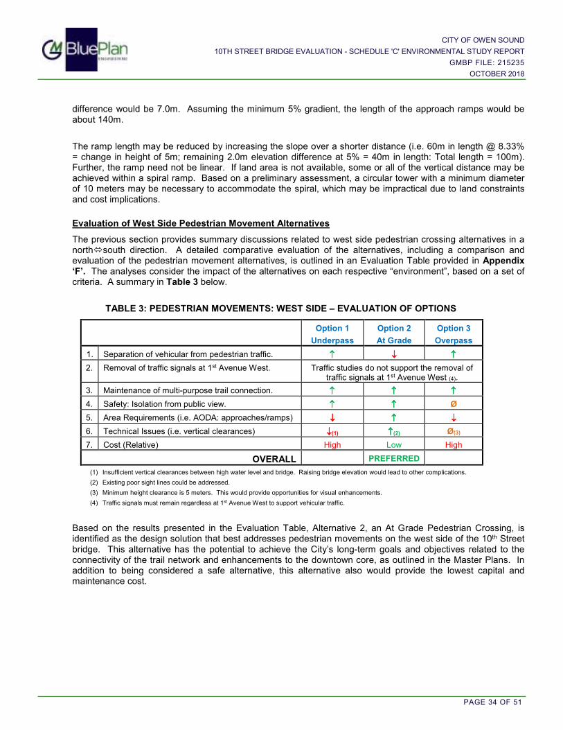
CITY OF OWEN SOUND
10TH STREET BRIDGE EVALUATION - SCHEDULE 'C' ENVIRONMENTAL STUDY REPORT
GMBP FILE: 215235
OCTOBER 2018
PAGE 34 OF 51
difference would be 7.0m. Assuming the minimum 5% gradient, the length of the approach ramps would be about 140m.
The ramp length may be reduced by increasing the slope over a shorter distance (i.e. 60m in length @ 8.33% = change in height of 5m; remaining 2.0m elevation difference at 5% = 40m in length: Total length = 100m). Further, the ramp need not be linear. If land area is not available, some or all of the vertical distance may be achieved within a spiral ramp. Based on a preliminary assessment, a circular tower with a minimum diameter of 10 meters may be necessary to accommodate the spiral, which may be impractical due to land constraints and cost implications.
Evaluation of West Side Pedestrian Movement Alternatives
The previous section provides summary discussions related to west side pedestrian crossing alternatives in a north�south direction. A detailed comparative evaluation of the alternatives, including a comparison and evaluation of the pedestrian movement alternatives, is outlined in an Evaluation Table provided in Appendix ‘F’. The analyses consider the impact of the alternatives on each respective “environment”, based on a set of criteria. A summary in Table 3 below.
TABLE 3: PEDESTRIAN MOVEMENTS: WEST SIDE – EVALUATION OF OPTIONS
Option 1
Underpass
Option 2
At Grade
Option 3
Overpass
1. Separation of vehicular from pedestrian traffic. ↑↑↑↑ ↓↓↓↓ ↑↑↑↑
2. Removal of traffic signals at 1st Avenue West. Traffic studies do not support the removal of traffic signals at 1st Avenue West (4).
3. Maintenance of multi-purpose trail connection. ↑↑↑↑ ↑↑↑↑ ↑↑↑↑
4. Safety: Isolation from public view. ↑↑↑↑ ↑↑↑↑ Ø
5. Area Requirements (i.e. AODA: approaches/ramps) ↓↓↓↓ ↑↑↑↑ ↓↓↓↓
6. Technical Issues (i.e. vertical clearances) ↓↓↓↓(1) ↑↑↑↑(2) Ø(3)
7. Cost (Relative) High Low High
OVERALL PREFERRED
(1) Insufficient vertical clearances between high water level and bridge. Raising bridge elevation would lead to other complications.
(2) Existing poor sight lines could be addressed.
(3) Minimum height clearance is 5 meters. This would provide opportunities for visual enhancements.
(4) Traffic signals must remain regardless at 1st Avenue West to support vehicular traffic.
Based on the results presented in the Evaluation Table, Alternative 2, an At Grade Pedestrian Crossing, is identified as the design solution that best addresses pedestrian movements on the west side of the 10th Street bridge. This alternative has the potential to achieve the City’s long-term goals and objectives related to the connectivity of the trail network and enhancements to the downtown core, as outlined in the Master Plans. In addition to being considered a safe alternative, this alternative also would provide the lowest capital and maintenance cost.

CITY OF OWEN SOUND
10TH STREET BRIDGE EVALUATION - SCHEDULE 'C' ENVIRONMENTAL STUDY REPORT
GMBP FILE: 215235
OCTOBER 2018
PAGE 35 OF 51
10.4 Bridge Style
Bridge style choices relate mostly to choices of materials, construction method and geometry (or aesthetics). The standard range of materials available for construction of the 10th Street Bridge includes concrete and steel, with construction methods limited to pre-fabrication (i.e. pre-cast) or cast-in-place. The variety of bridge geometries is vast, but the systems generally include deck structures supported either from below or from above. Generally, deck structures supported from above (e.g. truss bridges or suspension bridges) generally are used for longer spans than exist at the 10th Street Bridge location. As a result, design alternatives being considered for this bridge are limited to systems which support the structure from below, such as girder and arch styles. Therefore, the following bridge types are considered:
i) Pre-cast concrete girder; ii) Steel girder; iii) Pre-cast concrete arch; and iv) Cast-in-place concrete arch.
The following sections provide brief discussions related to relative cost, quality, construction efficiency and appearance for the various bridge styles under consideration. As previously noted in Section 7.2.2, any increase in the available opening through the 10th Street Bridge cross-section would improve flow hydraulics in terms of a reduction in potential flood hazard and in terms of flow velocity reduction (i.e. scour potential). Improvements to flow hydraulics could be gained with a girder-style bridge.
10.4.1 Pre-cast Concrete Girder
Pre-cast concrete girders (i.e. support beams) are manufactured remotely in a plant, and then transported to the site where cranes hoist them onto the new abutments. The deck and railings are then constructed on the girders. Pre-cast girder bridges are relatively low in cost. Since the girders are manufactured in a plant, there is much greater control over the quality of the concrete and final product, as compared to cast-in-place concrete. Precast girders will reduce construction time relative to a cast-in-place option. Since precast girder bridges are a fairly common style, they tend to have a modest visual appearance. An example of this style is the 9th Street Bridge, as illustrated in the photo below.
Photo 1: Example of a Concrete Girder Bridge (9th Street Bridge)

CITY OF OWEN SOUND
10TH STREET BRIDGE EVALUATION - SCHEDULE 'C' ENVIRONMENTAL STUDY REPORT
GMBP FILE: 215235
OCTOBER 2018
PAGE 36 OF 51
10.4.2 Steel Girder
Similar to precast concrete girders, steel girders are manufactured remotely in a plant. They are treated with a coating and/or paint and then transported to the site where cranes hoist them on to the new abutments. The deck and railings are then constructed on the girders. Steel girders have a shallower profile than concrete girders and therefore, where below bridge clearance is an issue, steel girders can be advantageous. At the subject bridge location, clearance has not been identified as an issue.
Steel girders tend to have a moderate cost. Similar to the pre-cast concrete girder bridge, as the girders are manufactured in a plant, there is much greater control over the quality of the final product and the construction time will be reduced relative to the cast-in-place construction method. Many see these bridge styles as having a very industrial appearance, as illustrated in the photo below.
Photo 2: Example of a Steel Girder Bridge
10.4.3 Precast Concrete Arch
Precast concrete arches are also manufactured remotely in a plant, and then transported to the site where cranes hoist them on to the new abutments. Parapet walls are constructed along each side, so as to retain fill material above the precast arch to support a slab-on-grade deck.
The arches themselves have significant cost, but the foundation is also considered to be expensive. This is due to the relatively flat profile that an arch would need to have for this site, which creates large thrust forces acting the foundations. Due to the poor soil conditions at this site, a very robust system of deep, battered piles would be required to resist these forces. Similar to the precast girder options, being manufactured in a plant allows much greater control over the quality of the concrete (as compared to cast-in-place). Due to a need for more robust foundations, the construction time would be greater than for a girder option. The appearance of the bridge will be similar to the existing arch profile, which may be considered more visually attractive, when viewed from below.
Photo 3: Example of a Concrete Arch Bridge (10th Street Bridge)

CITY OF OWEN SOUND
10TH STREET BRIDGE EVALUATION - SCHEDULE 'C' ENVIRONMENTAL STUDY REPORT
GMBP FILE: 215235
OCTOBER 2018
PAGE 37 OF 51
10.4.4 Cast-In-Place Concrete Arch
The existing bridge is a cast-in-place arch. Replacing it with a similar style of construction is quite feasible with a relatively low cost. However, since construction work would be exposed to the elements (i.e. temperature extremes and/or fluctuations, humidity, etc.) the control over quality (i.e. strength and durability of poured concrete) would be less than that for pre-cast options. The main drawback is the duration of construction. This style would take the longest construction time of any of the style options since, once the foundations are constructed, a robust system of temporary falsework must be constructed across the river to support the concrete forms. The appearance of the bridge will be similar to the existing arch profile, which may be considered more visually attractive, when viewed from below.
10.4.5 Evaluation of Alternative Bridge Styles
The following Table 4 presents a summary of the assessment of alternative Bridge Styles.
TABLE 4: ASSESSMENT OF ALTERNATIVE BRIDGE STYLES
GEOMETRY GIRDER STYLE ARCH STYLE
Construction Material Pre-Cast Concrete
Pre-Fabricated Steel
Pre-Cast Concrete
Cast-in-Place Concrete
1. Relative Cost Low Moderate High Low
2. Quality Plant manufacturing generally provides greater quality control over construction material.
Exposure to elements may impact
strength and durability concrete.
3. Construction Efficiency
Girder bridges typically require less time to construct than arch bridges.
An arch bridge typically takes longer to construct.
Longest construction period relative to
other alternatives.
4. Appearance Modest Industrial Similar to existing arch profile.
5. Natural Environment
A girder bridge provides greater potential to improve flow hydraulics.
An arch bridge may have a more impact on flow hydraulics.
OVERALL - Preferred - 2 3 4
Based on the above discussion of various bridge styles, a pre-cast concrete girder style bridge is recommended. This bridge style is similar to the 9th Street Bridge. As discussed at PIC No.2, opportunities to pursue a ‘twin bridge’ scenario for the City could be considered.
Feedback from the community and the County has identified the ‘opportunity to showcase the Harbour and the Sydenham River for tourists and local residents alike’ (County Comments dated July 18, 2018). The bridge design options discussed above primarily outline the bridge geometry and supporting systems and include some design enhancement features, such as the inclusion of a separate sidewalk and multi-purpose trail along the north side of the bridge.
Provisions to beautify the structure, including landscaping, retaining walls, lighting and bridge enhancements (i.e. railings, viewing platform) are considered in the conceptual design. However, additional opportunities pertaining to the bridge aesthetics will be considered further during the detailed design phase but will ultimately be subject to funding constraints. The provision for future bridge enhancements may also be pursued at a later date, pending funding opportunities.

CITY OF OWEN SOUND
10TH STREET BRIDGE EVALUATION - SCHEDULE 'C' ENVIRONMENTAL STUDY REPORT
GMBP FILE: 215235
OCTOBER 2018
PAGE 38 OF 51
10.5 Bridge Construction Efficiencies
Various construction efficiencies are considered in the following sections, with the goal reasonably to minimize the construction timeline and, as a result, impacts to traffic flow and local businesses. Although some methodologies may increase the speed of construction, there may be trade-offs with the cost and/or quality of the construction. For example, cast-in-place concrete tends to be less expensive to construct, but would take longer to construct, relative to pre-cast. This relationship must be considered carefully, so as to choose the most appropriate balance between these two factors. Given the importance of the 10th Street Bridge to the local economy, choosing a construction method based on construction cost alone may be inappropriate by way of extending the duration of the road closure. Construction methods that streamline construction should be considered for preference for this project and are discussed in the following Sections.
10.5.1 Bridge Re-Construction Process and Potential Efficiencies
Reduced construction time can be achieved by pre-casting bridge components off-site, either prior to or concurrently with other phases of bridge construction. Generally, pre-cast components can be deployed to reduce the construction timeline, and are of good quality, since they usually are manufactured in a quality-controlled plant. However, other factors such as transportation from the plant to the site may significantly add to construction costs. The general process for the bridge re-construction and a review of the potential efficiencies that can be gained during each stage of the process is discussed below.
A. Remove Existing Bridge
The bridge removal process generally will remain the same, with the techniques determined by the contractor. There are few techniques available significantly to reduce the bridge removal timeline.
B. Construct Foundations
Due to poor soil conditions, foundations will include piles driven to bedrock. There are few techniques available significantly to reduce the pile driving timeline. The foundations also will include a concrete pile cap. The pile cap ties together the piles and provides the platform upon which the abutments are supported. Although concrete pile caps could be pre-cast, multiple variables in the pile driving process can result in changes to the configuration of pile tops. Therefore, cast-in-place pile caps are recommended. There are few techniques available significantly to reduce the construction time for cast-in-place pile caps.
C. Construct Abutments
Abutments are the vertical walls that hold back soil and support the bridge deck. Although it is possible to pre-cast bridge abutments, due to the relative complexity of these components, they would have to be fabricated in pieces off-site, transported to the site by specialized truck or barge, hoisted into place and assembled on-site. This process would not significantly reduce construction time relative to cast-in-place. Further, this methodology introduces cold construction joints within these critical elements, which may be subject to penetration by water. As a result, road salt and freeze/thaw cycles may reduce the lifecycle of these components. Therefore, cast-in-place abutments are recommended. There are few techniques available significantly to reduce the construction time for cast-in-place pile caps.
D. Install Girders
Pre-cast concrete girders are considered favoured through the choice of bridge style in Section 10.4. This construction methodology will reduce the construction time relative to a cast-in-place structure.
E. Construct Bridge Deck
Bridge deck construction can be achieved either by cast-in-place methods or pre-cast methods. Generally, a cast-in-place method is used to control the detailed grading requirements for the bridge deck. Therefore, in addition to the speed versus cost trade-off, there may also be a speed versus quality trade-off. Since several details may affect this decision, it is recommended to defer a choice on this item to the project design team at the detailed design phase.

CITY OF OWEN SOUND
10TH STREET BRIDGE EVALUATION - SCHEDULE 'C' ENVIRONMENTAL STUDY REPORT
GMBP FILE: 215235
OCTOBER 2018
PAGE 39 OF 51
F. Install Railings
Railings will need to be in place prior to opening the bridge to traffic for safety reasons. Many of these components can be fabricated off-site and quickly installed; even as the bridge deck is being completed.
10.5.2 Rapid Replacement Technology (RRT)
“Rapid replacement technologies” (RRT) are considered, so as to reduce construction timelines reasonably, thus minimizing the impact on traffic. RRT are most commonly used for reconstruction of secondary road overpasses above expressways. They involve constructing the new superstructure in close proximity to the site. The secondary road is closed while the existing bridge is demolished, and new foundations and abutments are constructed. Demolition work will still impact traffic on the lower expressway, which is no different than with conventional construction techniques. Concurrently, the new structure is constructed nearby, so that it can be moved into place as soon as the new abutments are completed. Methods of moving the superstructure into position vary, but include the “jack and slide” technique, the use of cranes, or the use of specialized vehicles to transport it on the expressway below.
The main advantage of RRT is that the duration of the closure of the expressway below the bridge can be reduced. Since the superstructure is not constructed in place, overhead work above the expressway is eliminated. A secondary advantage is that the duration of the closure of the secondary road can be reduced somewhat, given that the superstructure can be built concurrently with demolition and the construction of foundations and abutments.
Assuming a “jack and slide” technique for the 10th Street Bridge, a large area would have to be prepared on either the north or the south side of the existing bridge. Various site constraints exist in each area including proximity of buildings, steep slopes and high voltage hydro lines. Further, considering the poor soils known to be present in this area, appropriate temporary foundations would have to be constructed to support the new bridge construction. A “jack and slide” technique requires the jacking mechanism to anchor against firm ground, which is not available in a river environment.
An alternate technique would be to construct the superstructure at a different location, either remotely or adjacent to the site, and hoist it into place. However, east of the bridge, high voltage wires cross 10th Street, and building fronts are at the limits of the right-of-way, which restrict a working area. West of the bridge, the fabrication area would likely extend to disrupt access to businesses. Remote fabrication would require costly trucking or barging of multiple over-sized loads. Furthermore, the full bridge would be too heavy to hoist into place at one time and, therefore, for this technique to work, the superstructure would need to be fabricated as multiple spans. This not only would add time and cost, but also would result in multiple linear joints through the new bridge, which ultimately may affect the quality of the structure due to water penetration into the joints.
Ultimately, although there may be some advantages to using RRT in this case, it is important to note that for the 10th Street Bridge, the bridge does not span a busy thoroughfare below, but rather supports the busy thoroughfare. Using RRT in this case would not achieve all of the intended, or usual, benefits, as the impact of construction on marine traffic in the river below is not a significant concern. It is expected that the duration of the road closure could potentially be reduced, but not significantly and at significantly greater cost.

CITY OF OWEN SOUND
10TH STREET BRIDGE EVALUATION - SCHEDULE 'C' ENVIRONMENTAL STUDY REPORT
GMBP FILE: 215235
OCTOBER 2018
PAGE 40 OF 51
10.5.3 Contractor Incentives
Construction contracts generally contain a completion date with a “liquidated damages” penalty clause should the construction extend beyond the completion date. In this case a dollar value is charged against the contractor for each day construction is not substantially complete beyond the specified completion date.
To inspire a contractor to complete the work more quickly, an incentive clause may also be used. In this case additional payment would be made to the contractor for each day in advance of the specified completion date the work is substantially performed.
10.6 Municipal Services and Utilities
10.6.1 Watermains
The existing water distribution system is supplied from the Water Treatment Plant on the east side, and includes feeder mains across each of the four bridges to service the west side. A 150mmØ low pressure (LP) watermain and a 400mmØ high pressure (HP) watermain currently exist across the 10th Street Bridge to service the north westerly quadrant of the City. During construction of the bridge, these two watermains will be removed, which will reduce water supply to the north westerly quadrant, in both the LP and HP zones.
Low Pressure Zone
An overall plan is in place eventually to eliminate the LP zone; replacing it with HP. The existing LP watermains are old and considered in too poor of a condition to accommodate a changeover to the HP system, and it would be too costly to replace all of the LP watermains at one time. Therefore, the City has continued a strategy to reduce the LP zone while maintaining a minimum of three points of supply. In preparation of the bridge replacement project, the City initiated modelling of the system to resolve a plan to maintain an appropriate level of service while working toward the ultimate goal. Since the removal of the 10th Street Bridge will also require the removal of existing watermains on this bridge, and one point of supply to the LP zone, the plan includes the provision for a pressure reducing valve chamber at 14th Street West and 4th
Avenue West to provide a supply from the HP to LP systems at that location. The LP system then would then be maintained with three supply points.
High Pressure Zone
Bridge removal will also require removal of the existing 400mmØ watermain across the bridge. The HP system was extended from 2nd Avenue East to 2nd Avenue West across the 9th Street Bridge during that bridge replacement project. The HP watermain currently ends at a normally closed valve at the 9th Street and 2nd Avenue West intersection. The City has initiated a plan to replace the LP watermain on 2nd Avenue West between 9th Street and 10th Street with a 300mmØ HP watermain, to re-establish the third point of supply to the HP zone. Upon completion of the bridge, a single 600mmØ HP watermain is intended to be extended westerly from 1st Avenue East across the bridge to tie into the HP zone at 1st Avenue West. The remaining LP system would continue to be supplied from pressure reducing valve locations.
10.6.2 Sanitary Sewers
The existing sanitary sewer system drains to the Wastewater Treatment Plant on the east side of the City. Two gravity siphons, one north of 8th Street and one south of 10th Street, and one gravity sewer across the 9th Street Bridge, convey sewage flows from west to east across the Sydenham River. The north-westerly quadrant of the City drains to the West Side Pumping Station (WSPS), which pumps sewage flows southerly to a gravity sewer on 10th Street; combining with other west side sewage flows to the 10th Street siphon. Sewage flows are

CITY OF OWEN SOUND
10TH STREET BRIDGE EVALUATION - SCHEDULE 'C' ENVIRONMENTAL STUDY REPORT
GMBP FILE: 215235
OCTOBER 2018
PAGE 41 OF 51
collected on the east side by the East Side Interceptor Sewer (ESIS), which follows 1st Avenue East from 7th Street East to 10th Street East, where the sewer then shifts alignment to 2nd Avenue East.
The forcemain is located east of the 1st Avenue West sidewalk but angles toward and outlets into a manhole in the middle of the 10th Street and 1st Avenue West intersection. In consideration of the close proximity of the forcemain to the bridge abutments, GMBP prepared a “Sewage Flows Analysis -10th Street Siphon” report, which is provided in Appendix ‘G’. The report considered that the reconstruction of the 10th Street Bridge provides an opportunity to divert sewage flows from the aging 10th Street siphon and considered the following alternatives:
i) Divert WSPS forcemain flows; ii) Divert WSPS forcemain flows plus 10th Street West gravity flows and reduce siphon diameter; and iii) Divert all flows and eliminate siphon
The Report concludes that:
i. It is not possible to achieve gravity drainage from 9th Street to 10th Street, while maintaining a gravity sewer up within the protection of the girders.
ii. Full diversion of flows from the 10th Street Siphon is not technically achievable.
Considering the additional effort required with retrofitting the existing siphon, the uncertainty of an appropriate forcemain crossing location, and the tight time-line available to construct the bridge project, it is recommended to defer these sewage works to a later date.
10.6.3 Storm Sewers
In about 2000, the storm sewer system on 10th Street East was reconstructed in conjunction with the “Big Dig” project. The system services lands along 10th Street East to 9th Avenue East, and outlets to the inner harbour via a 1500mmØ CP storm sewer at the north-easterly corner of the bridge. This system is not expected to be impacted by the bridge construction.
The storm sewer system on the west side was constructed in 1972. The system services lands along 10th Street West to 6th Avenue West, and outlets to the inner harbour via a 675mmØ concrete pipe outlet at the north-westerly corner of the bridge. A review of this system, provided in Appendix ‘G’, concludes that a 900mmØ storm sewer outlet adequately would convey a 10-year design flow. An Oil/Grit Separator (Stormceptor EF12) would provide water quality protection to an “Enhanced” level with 80% total suspended solids (TSS) removal. The detailed design should consider whether smaller OGS units, provided at strategic locations, may be more cost effective.
10.6.4 Utilities
The electrical utility is overhead. High voltage power lines cross 10th Street east of the bridge, and cross the inner harbour north of the bridge. In response to the Notice of Project Initiation, Hydro One provided clearances between the 10th Street Bridge and its services. The response, including a map outlining the clearances, is included in Appendix ‘G’. GMBP has requested further consultation (dated July 19, 2018) specific to the implications of the nearby high voltage line and other hydro infrastructure, requesting comment on potential measures required to facilitate construction efforts. Hydro One will continue to be consulted regarding potential clearance issues during construction planning.
The cable TV and internet providers, and the telephone utility, are not expected to be affected. However, the providers will continue to be contacted through the process.
A natural gas utility main previously crossed the 10th Street Bridge along the north side. However, according to Union Gas, the old NPS 6 steel natural gas bridge crossing was abandoned in 2006 and a new NPS 4 PE

CITY OF OWEN SOUND
10TH STREET BRIDGE EVALUATION - SCHEDULE 'C' ENVIRONMENTAL STUDY REPORT
GMBP FILE: 215235
OCTOBER 2018
PAGE 42 OF 51
main was drilled under the Sydenham River to the south. Union Gas will continue to be consulted regarding potential issues during construction planning.
Traffic signal interconnects will be provided across the new bridge.
10.7 Construction Implementation and Timing Constraints
Project timing can be affected by a variety of issues, which can include the following:
i) “Half Load Season” generally restricts the use of heavy trucks during the Spring season when frost is coming out of the ground. Light preparatory work generally can occur prior to the end of April.
ii) Removals would occur during May, following the spring freshet.
a. Temporary relocations of services may also occur at this time.
b. Contractors generally wish to maintain a hard surface to support heavy equipment and, therefore, it is likely that bridge deck removal would occur firstly, followed by abutment removal down to the waterline.
iii) Steel sheet piling would be driven to separate the working area for the abutments from the river. The natural environment “Preliminary Impact Assessment”, prepared by Azimuth Environmental (Appendix ‘D’), identified the Sydenham River as a cold water fishery. Therefore, all in-water work must occur between July 1 and September 15, in accordance with the coldwater fisheries in-water timing window.
iv) Existing foundations would be removed.
v) New foundation piles would be driven to bedrock on each side.
vi) A pile cap would be poured on top of the piles to support the abutments.
vii) Abutments would be constructed on top of the pile cap.
viii) Girders would be placed on top of abutments.
ix) The bridge deck would be constructed on top of the girders.
x) Services and utilities would be completed.
xi) The concrete work and paving would be completed.
xii) Landscaping.
xiii) Clean up.

CITY OF OWEN SOUND
10TH STREET BRIDGE EVALUATION - SCHEDULE 'C' ENVIRONMENTAL STUDY REPORT
GMBP FILE: 215235
OCTOBER 2018
PAGE 43 OF 51
11. SUMMARY OF RECOMMENDED DESIGN SOLUTIONS
The following summarizes the Recommended Design Solutions, as presented in the previous sections. These recommendations were presented at PIC No.2, and in Version 2 of the ESR, which was made available to the public, stakeholders, agency groups and First Nations for review and Comment.
i. Traffic Management During Construction: Traffic flow during construction would be provided by a diversion of traffic to the by-pass and other existing crossing locations. Details of traffic movements through the downtown would be developed.
ii. Traffic Lane Configuration on the New Bridge: The Corridor Optimization Environmental Assessment determined that a status quo, with respect to traffic lane configuration and movements across the 10th Street Bridge, is the Preferred Solution. A wider north lane would be provided to better accommodate the west bound right turn lane.
iii. Pedestrian Movements:
Pedestrian movements would be maintained similar to existing conditions with a 1.5m wide sidewalk across the south side of the bridge, continuing to utilize the existing traffic signals at 2nd Avenue East, providing a minimum 3.0m wide multi-purpose trail/sidewalk across the north side of the bridge to connect the west side and east side harbour multi-purpose trail, and maintaining an at-grade pedestrian crossing with traffic signals at 1st Avenue West to connect the harbour multi-purpose trail with the River Precinct multi-purpose trail. Sight lines would be improved at the north-westerly corner by eliminating the existing bridge railing and by elevating the north side multi-purpose trail/sidewalk, relative to the bridge deck. The existing 2.0m wide pedestrian bridge would be removed.
iv. Bridge Style:
A pre-cast concrete girder bridge is recommended, using other pre-cast components, where appropriate, to reduce construction time.
v. Bridge Construction Efficiencies: Given the importance of the 10th Street Bridge to the local economy, construction methods that streamline construction and, as a result, impacts to traffic flow and local businesses, should be considered for preference for this project. Quality of the components and cost are also important factors. Consequently, pre-cast concrete girders are considered favoured through the choice of bridge style and a pre-cast bridge deck may be considered further during the detailed design phase.
vi. Municipal Services and Utilities:
Provide for watermain, sanitary sewer, storm sewer and utilities as appropriate.
vii. Construction Implementation
Consider contractor incentives to minimize construction timeline.
The consolidation of the Recommended Design Solutions is illustrated in Figure 7.

CITY OF OWEN SOUND
10TH STREET BRIDGE EVALUATION - SCHEDULE 'C' ENVIRONMENTAL STUDY REPORT
GMBP FILE: 215235
OCTOBER 2018
PAGE 44 OF 51
12. PHASE 3 CONSULTATION
Consultation throughout the process is a key feature of environmental assessment planning. The second mandatory point of contact, the Notice of Public Consultation, was first issued on June 26th, 2018, and invited the public to attend the Pubic Information Centre (i.e. PIC No.2) which was held on July 10th, 2018. Version 2 (Phase 3) of the ESR was provided for review by the public, stakeholders, First Nations and agencies. Comments received during the consultation period are summarized within this Section of the ESR (Version 3).
12.1 Notice of Public Consultation and Public Information Centre (PIC No.2)
The Notice of Public Consultation outlined the process and rationale for the selection of a set of Recommended Design Alternatives (i.e. Phase 3). The Notice was advertised in the Sun Times Newspaper, was posted on the City’s website, and was circulated to agencies/groups that were considered to have a potential regulatory role or may have a direct interest in the study on June 26th, 2018. The Notice was also mailed to property owners within and surrounding the Study Area, as well as to individuals engaged in previous project planning. Consistent with the previous notification efforts, an extended notification area, as outlined in the Figure provided in Appendix ‘A’, was adopted.
The Public Information Centre (PIC No.2), held on July 10th, 2018 as part of the City’s Operations Committee meeting, included a one and a half hour “meet and greet” open discussion session, followed by a presentation by the project team to the committee. A copy of the display panels and the presentation is provided in Appendix ‘K’. Following the presentation, questions by committee members and the public were addressed by the project team. The sign-in sheet included twenty members of the public.
12.2 Consultation: Public, Stakeholder, Agency and First Nations
With the circulation of the ESR (Version 2), the public and stakeholders were invited to provide comments regarding the Recommended Design Alternatives. In addition, consistent with the initial consultation efforts outlined in Section 9 of this ESR, agencies and First Nations groups with a regulatory role that may require future permits/approvals, or may have a direct interest in the project, were contacted to invite feedback.
The public/stakeholder comments received, following the second consultation efforts, and the feedback provided from agency groups, are included in Appendix ‘L’. Upon receipt of comments, new information was incorporated into the review and assessment of a recommended Preferred Design Solution, presented to Council on August 27th, 2018.
12.3 Consultation Feedback
With the circulation of the Notice of Public Consultation and associated project information, as well as the invitation to PIC No.2, the public, agency groups, stakeholders, and First Nations groups were encouraged to provide comments regarding the Recommended Design Alternatives outlined in Version 2 of the ESR. Comments received from Agency groups and utility companies are summarized in the following Table 5.

CITY OF OWEN SOUND
10TH STREET BRIDGE EVALUATION - SCHEDULE 'C' ENVIRONMENTAL STUDY REPORT
GMBP FILE: 215235
OCTOBER 2018
PAGE 45 OF 51
TABLE 5: SUMMARY OF COMMENTS FROM AGENCIES AND UTILITIES (Phase 3)
Agency (Issue Date)
Overview of Comments Response and/or
Follow-up Requirements
GSCA: Risk Management Office (July 3, 2018)
Response to Source Water Protection (SWP) Consultation letter from GMBP dated June 25, 2018.
Confirmation that neither Section 57 (Prohibited Activities) nor Section 58 (Regulated Activities) applies on this project, pursuant to the Clean Water Act, 2006).
Noted
Grey County Planning and Development (July 18, 2018)
Provided a review of the project in relation to the Provincial Policy Statement (PPS) and the County of Grey Official Plan (OP). Comments can be summarized as follows:
1. The alternative design concepts proposed should be reviewed while further considering pedestrian, cyclists, and other multimodal transportation systems as a focal point.
2. A general assessment of pedestrian, cycling, motorized scooters, and other forms of active transportation would be helpful to conduct an overall needs assessment of those using the bridge aside from automobiles.
3. Consideration to include provisions for bicycle movements across the 10th Street Bridge.
4. This is an opportunity to showcase the Harbour and Sydenham River.
Section 7.1 of the ESR has been updated to include the relevant Sections of the PPS and OP outlined by the County.
1. A detailed discussion of the pedestrian movement alternatives, including consideration for the connection of the multi-purpose Harbour Trail system is provided within the ESR.
2. All forms of transportation will continue to be accommodated on the 10th Street Bridge. The provision for both a sidewalk and the Harbour Trail connection on the south side will be an improvement upon existing conditions.
3. A Section outlining the alternative design concepts for bicycle movements has been added to the ESR (Version 3).
4. Noted
Public Health (July 18, 2018)
In consideration of complete streets concepts, which help ensure all road users, including cyclists and pedestrians, are given equal consideration during the planning process, Public Health recommended the following:
1. The Health unit envisions great benefit to connectivity of a pedestrian underpass (north ↔south).
2. Request consideration for a segregated bike route along the 10th Street corridor.
1. In addition to soil conditions and safety, key concerns outlined in the ESR (Version 2) also included bridge design related limitations, including:
a. The required increased bridge deck height and the resulting extension of the approaches (i.e. grading adjacent to buildings along 10th Street).
b. Setback from rivers edge and encroachment into the 1st Avenue West intersection.
2. A Section outlining the alternative design concepts for bicycle movements has been added to the ESR (Version 3).
Fisheries and Oceans Canada (July 2018)
The DFO and MNRF were consulted regarding the potential for relief from the in-water timing window of July 1 to September 15. This would allow for the installation of sheet pile walls prior to the July 1 timeline or in the fall in order to minimize the construction time.
Advised that the DFO would work with the Province (i.e. the MNRF) to discuss the proposal to work inside of the restricted in-water timing window.
Recommended that the Request for Review be submitted as soon as technical drawings and construction sequencing has been planned.
Ministry of Natural Resources and Forestry
(July 2018)
Main concern is for construction activity during the spring migration (mid-March to the end of April) and fall migration (end of September to end of October). Both migration periods are based on water temperature and fish congregation. Acceptable timing windows will be based upon current conditions.
Union Gas (June 28, 2018)
Clearances between the 10th Street Bridge and Hydro One plant were provided. Request to be contacted if any clearance issues arise during the construction planning.
Noted
Rogers Communications (July 9, 2018)
Rogers has aerial and a buried plant in the immediate area of the 10th Street Bridge. Rogers will provide engineering mark-drawings upon request.
Noted
Note: Notification and Phase 3 Consultation correspondence is provided in Appendix ‘A’ and Appendix ‘L’, respectively.
CITY OF OWEN SOUND
10TH STREET BRIDGE EVALUATION - SCHEDULE 'C' ENVIRONMENTAL STUDY REPORT
GMBP FILE: 215235
OCTOBER 2018
PAGE 46 OF 51
PART 3 – ESR VERSION 3: RE-ASSESSMENT OF ALTERNATIVE DESIGN CONCEPTS
13. RE-ASSESSMENT OF ALTERNATIVE DESIGN CONCEPTS
With the acceptance by Council of a Preferred Solution to replace the 10th Street Bridge in February 2017, Phase 3 of the EA process was initiated and considered various Alternative Design Concepts. Following the receipt of comments specific to the Phase 3 public consultation period, new information was incorporated into the review and assessment of a Preferred Design Solution. This was completed by either updating the discussions provided in previous Versions of the ESR or by inclusion in the following Sections of this Report.
13.1 Bicycle Movements
Bicycle movements were addressed in Version 2 of the ESR (Section 10.3), and were primarily considered within the framework of the existing multi-use Harbour Trail to the north of the bridge. However, Grey County and Public Health requested that additional consideration be given to pedestrian, cyclist and other multi-modal transportation systems, both suggesting that ‘pedestrians, cyclists and other multi-modal transportation systems remain a focal point of the project’ (Public Health). The following discussion provides a more in depth assessment for bicycle movements on the 10th Street Bridge, including the potential to integrate with adjacent systems.
Public Health outlined the need to support active communities by ensuring the ‘complete streets’ concepts were considered. Complete streets concepts ensure all road users, including cyclists and pedestrians, are given equal consideration during the planning process. To support the complete streets concept, Public Health and the County of Grey planning staff recommended that consideration be provided for a segregated bicycle route along the 10th Street corridor that would be independent of pedestrian and automobile traffic. As outlined in the County comments, this could be achieved by including markings on the pavement that clearly delineate the space provided for cyclists. The recommended provision for bike lanes along 10th Street is consistent with the Transportation Master Plan (TMP) for the County (September 2014) which outlines a cycling route along the 10th Street corridor between Grey Road 1 (i.e. 2nd Avenue West) and Grey Road 15 (i.e. 3rd Avenue East). A copy of the ‘Potential Active Transportation Connections’ Figure from the TMP for the County is provided in Appendix ‘B’.
Although 10th Street connects Grey County Roads 1 and 15, it is part of the main east-west arterial route through Owen Sound and functions as a Connecting Link across the Sydenham River for Provincial Highways 6, 10, 21 and 26. The existing right-of-way along 10th Street, between the County Road 1 and 15, is 20 meters wide and opportunities to widen the right-of-way are limited due to existing development. The existing road configuration is as follows:
Lane width for vehicular traffic: 4 x 3.5 meters = 14 meters Sidewalk width: 2 x 1.5 meters = 3.0 meters Curb width: 2 x 0.5 meters = 1.0 meter Boulevard width: 2 x 1.0 meters = 2.0 meters
Total = 20 meters
While narrower traffic lanes could be considered as a measure to provide the required space to accommodate bike lanes, given the high volume of truck traffic, the City and likely the MTO would not support narrower lanes on this Connecting Link. Bicycle safety would be a significant issue.
In addition, the complete streets concepts approach recommended by Public Health was considered as Alternative 3 in the Corridor Optimization Study (dated May 2017). As the 10th Street right-of-way may not be widened due to proximity of the existing development to the road, this alternative considered geometric changes to the cross section of 10th Street, including the reduction to three lanes for vehicular traffic, with the

CITY OF OWEN SOUND
10TH STREET BRIDGE EVALUATION - SCHEDULE 'C' ENVIRONMENTAL STUDY REPORT
GMBP FILE: 215235
OCTOBER 2018
PAGE 47 OF 51
additional space being dedicated to bike lanes, wider sidewalks and/or green space. The report concluded that while wider sidewalks and/or cycling lanes could be accommodated within that geometry, the option would further limit capacity on an already congested 10th Street, resulting in a substantial increase in traffic delays over and above existing conditions. Consequently, as 10th Street is currently operating near its capacity and experiences significant traffic congestion and vehicle delays during daytime peak travel times, the complete streets concepts approach was not recommended for the 10th Street Corridor.
Provided that neither narrower lanes nor geometric changes are recommended, the inclusion of bicycle lanes along 10th Street would require that the existing right-of-way be widened. Widening of 10th Street would require that property acquisition(s) occur. The extent of the property acquisitions would be dependent on the desired location of bike lanes. In order to support the bicycle network presented in the TMP for the County, significant property acquisitions and building demolition would be required.
The Downtown River Precinct initiative by the City will include pedestrian and bicycle routes along 1st Avenue West southerly to more appropriate crossing locations at 9th Street Bridge and 8th Street Bridge.
In summary, while pedestrian, cyclist and other multi-modal transportation systems have been accommodated on the 10th Street Bridge to the extent possible, making pedestrian and bicycle transportation systems the focal point for this main arterial route is not supported. Alternative, more appropriate, pedestrian and bicycle routes are being implemented through other initiatives.
13.2 Construction Implementation and Timing
Construction implementation and timing constraints were previously outlined in Version 2 of the ESR (Section 10.7). The timing constraints can be summarized as follows:
i. April: ‘Half Load Session’ which restricts use of heavy trucks due to frost conditions. ii. July 1 to September 15: Timing for in-water work iii. November through March: Winter work season. iv. MTO Grant: Substantial completion must be achieved by December 31, 2020.
Based on the timing constraints identified, two options for construction timing and implementation were previously considered. These were presented at PIC No.2 on July 10th, 2018.
Following PIC No.2, the DFO and MNRF were consulted regarding the potential for relief from the usual in-water timing window in order to minimize the bridge closure period. The MNRF confirmed that the main concern is for construction activity during the spring migration, typically mid-March to the end of April, and the fall migration, which is typically completed by the end of October. Since both migration periods are based on water temperature and fish congregation, acceptable timing windows would be based upon current conditions. Therefore, consultation with the MNRF and DFO confirmed that an alternate in-water timing window may be considered. As a result, Option 2 has been modified to provide for an earlier start date and a third option for construction timing and implementation is considered. Table 6 below summarizes the Construction Implementation and Timing Options.

CITY OF OWEN SOUND
10TH STREET BRIDGE EVALUATION - SCHEDULE 'C' ENVIRONMENTAL STUDY REPORT
GMBP FILE: 215235
OCTOBER 2018
PAGE 48 OF 51
TABLE 6: CONSTRUCTION IMPLEMENTATION AND TIMING OPTIONS
TASK OPTION 1 OPTION 2 OPTION 3
1 Bridge Removal (Deck and Abutments)
2019
July/August
Bridge Closure = 14 months
2020
April
Bridge Closure = 9 months
2019
October
Bridge Closure = 12 months
2 Installation of Sheet Piling (In-water work*)
August/September May November
3 Removal of Existing Foundations October June December
4 Installation of Foundation Piles (driven to bedrock) and Pile Caps
November/December July/August
2020
January/February
5 Installation of Abutments 2020
January to March August/September March/April
6 Girder Placement April October May
7 Construction of Bridge Deck May October/November June
8 Completion of Services/ Utilities June/July November July/August
9 Concrete Work and Paving August November/December September
10 Landscaping September
2021
May October
11 Clean-Up October June November
Estimated Construction Period
16 Months 15 Months 14 Months
i. MNRF and DFO consultation confirmed an alternate in-water timing window may be considered.
ii. Winter Work season (November through March).
While Option 2 provides for the shortest bridge closure period, the tighter timeline and the anticipated bridge works during the winter work season provide for sufficient uncertainty with respect to achieving significant completion prior to the MTO grant deadline of December 31, 2020. Due to the added risk of losing MTO funding should unforeseen project delays occur, Option 2 is not supported. Therefore, Option 3 is recommended as it offers for the shortest bridge closure period while providing additional time to reach ‘significant completion’ should project delays occur. Under Option 3, bridge closure is expected to occur for a 12 month period, commencing in October 2019.

CITY OF OWEN SOUND
10TH STREET BRIDGE EVALUATION - SCHEDULE 'C' ENVIRONMENTAL STUDY REPORT
GMBP FILE: 215235
OCTOBER 2018
PAGE 49 OF 51
13.3 Recommended Design Solutions
Based on the feedback from the community, a re-assessment of the Recommended Design Solutions, as outlined in Section 11 of this Version of the ESR, was completed. Following the re-assessment, the Recommended Preferred Design Solutions presented to Council on August 27th, 2018 remained similar and were as follows:
i. Traffic Management During Construction: Due to the infeasibility associated with maintaining lanes on 10th Street during construction and the construction of an additional bridge crossing north of 10th Street, traffic flow during construction will need to be managed using the existing road network. This will include optimizing existing routes through the downtown core, while continuing to inform travelers not intent on stopping in Owen Sound of the By-Pass as an alternative. A signage plan will be developed to promote the downtown as ‘open for business’. Traffic management alternatives will be further investigated during the detailed design phase.
ii. Traffic Lane Configuration on the New Bridge: The Corridor Optimization Environmental Assessment determined that a status quo, with respect to traffic lane configuration and movements across the 10th Street Bridge, is the Preferred Solution. A wider north lane would be provided to better accommodate the west bound right turn lane.
iii. Pedestrian Movements:
Pedestrian movements would be maintained similar to existing conditions with a 1.5m wide sidewalk across the south side of the bridge, continuing to utilize the existing traffic signals at 2nd Avenue East, providing a minimum 3.0m wide multi-purpose trail/sidewalk across the north side of the bridge to connect the west side and east side harbour multi-purpose trail, and maintaining an at-grade pedestrian crossing with traffic signals at 1st Avenue West to connect the harbour multi-purpose trail with the River Precinct multi-purpose trail. A visually separated sidewalk and multi-purpose Harbour Trail could be considered. Sight lines would be improved at the north-westerly corner by eliminating the existing bridge railing and by elevating the north side multi-purpose trail/sidewalk, relative to the bridge deck. The existing 2.0m wide pedestrian bridge would be removed.
iv. Bridge Style:
A pre-cast concrete girder bridge similar to 9th Street is recommended, using other pre-cast components, where appropriate, to reduce construction time.
v. Bridge Construction Efficiencies: Given the importance of the 10th Street Bridge to the local economy, construction methods that streamline construction and, as a result, impacts to traffic flow and local businesses, should be considered for preference for this project. Quality of the components and cost are also important factors. Consequently, pre-cast concrete girders are considered favoured through the choice of bridge style and a pre-cast bridge deck may be considered further during the detailed design phase.
vi. Municipal Services and Utilities:
Provide for watermain, sanitary sewer, storm sewer and utilities as appropriate.
vii. Construction Implementation Based on an assessment of the bridge construction implementation and timing options, and consultation with the MNRF and DFO which suggest that the in-water timing window may likely be extended, it is recommended bridge construction commence in October 2019 as this option offers the shortest bridge closure period while providing additional time to reach ‘significant completion’ should project delays occur. Under this scenario, bridge closure is expected to occur for a 12 month period.
The consolidation of the Recommended Preferred Design Solutions is illustrated in Figure 7.

CITY OF OWEN SOUND
10TH STREET BRIDGE EVALUATION - SCHEDULE 'C' ENVIRONMENTAL STUDY REPORT
GMBP FILE: 215235
OCTOBER 2018
PAGE 50 OF 51
14. COUNCIL RESOLUTION
On August 27, 2018 GM BluePlan presented the Recommended Design Solutions to City Council. Additional questions/concerns were raised during the presentation, which subsequently were addressed in Staff Report OP-18-040, presented to Council on September 10th, 2018. A copy of the presentation to Council and the Staff Report are included in Appendix ‘M’.
Although Council concurred with the information and analyses provided in the Staff Report on September 10, 2018, Council requested that the review of an additional traffic flow option be completed. In essence, Council requested that an Alternating ‘Fifth Lane’ Option be investigated. This option considered that the northernmost lane on the proposed 5-lane bridge might be a wrap-around lane used to link 1st Avenue West and 1st Avenue East for use as an alternating one-way eastbound lane (AM) and one-way westbound lane (PM). The basis for this option was to address traffic delays and congestion associated with the 10th Street corridor by potentially providing a more efficient movement of traffic between the northeast and northwest quadrants of the City. However, following a more detailed review, this option was not recommended due to the limited effectiveness in reducing traffic volumes along 10th Street, the anticipated increased traffic delays and congestion at the intersection of 10th Street and 2nd Avenue West, and the additional costs associated with necessary improvements in other areas of the roads system. The review and assessment of the Alternating ‘Fifth Lane’ Option was presented to Council by City Staff on October 1, 2018. A copy of the presentation is provided in Appendix ‘N’.
Following the presentation on October 1, 2018, City Council received Staff Report OP-18-040 and approved the Preferred Design Solutions outlined above (i.e. Section 13.3), thus directing the next Phase 4 of the EA process (i.e. finalization of the ESR and placement of the Report on public record). The Notice of Completion was first issued on October 4th, 2018. The Notice initiates the 30 calendar day review period. If there is no Part II Order request received by November 3rd, 2018, the project will proceed to detailed design. A copy of the Notice of Completion is provided in Appendix ‘A’.

CITY OF OWEN SOUND
10TH STREET BRIDGE EVALUATION - SCHEDULE 'C' ENVIRONMENTAL STUDY REPORT
GMBP FILE: 215235
OCTOBER 2018
PAGE 51 OF 51
15. NEXT STEPS
The next steps in this process are summarized as follows:
1. Completion of Phase 4:
i) Address 30-day public review period.
ii) If a Part II Order request in not made during the 30-day public review period, the Preferred Design Solutions to the Schedule ‘C’ EA process may proceed to detailed design and construction.
2. Phase 5: Implementation
i) The detailed design phase will include the completion of contract drawings and documents and proceed to construction. As recommended within the ESR, the following should be completed as part of the detailed design phase:
a. The EIS should be reviewed.
b. The Geotechnical Report for the 10th Street Bridge should be completed.
c. A detailed technical review of the changes or upgrades to the municipal services and utilities that are proposed to be completed in conjunction with the construction of the 10th Street Bridge (i.e. elimination of the 10th Street siphon) should be completed.
d. The required GSCA permits should be sought.
e. Consultation with Transport Canada regarding the encroachment on the federally owned Harbour should continue.
f. Complete a more detailed analysis of the travel demand management options recommended in the Transportation Assessment Brief completed by Paradigm (dated February 15, 2018).
g. Complete a DFO Request for Review regarding relief from the in-water timing window. This submission would include comments from the MNRF, technical drawings, a sediment control plan, details of the fish salvage, and construction sequencing details.
h. Resolve an approach to the existing building located on the southeasterly corner of the bridge.
ii) A pre-construction survey of all buildings that are in close proximity to the bridge should be completed prior to any significant construction. This survey would document any deficiencies in these buildings before construction, so that any claims of damage as a result of the work may be confirmed.
iii) Monitor for Environmental Provisions and Commitments.

FIGURES:

LA
ST
S
AV
ED
B
Y:R
hunter, 8/9/2018 11:14:05 A
M P
LO
TT
ED
B
Y:R
ebecca H
unter - G
M B
lueP
lan 8/9/2018 12:44:50 P
M
Figure No. 1
Plan
ENGINEERING
Blue
NOT TO SCALE
AUGUST 2018
215235
10th Bridge Evaluation
Schedule C EA
City of Owen Sound
SITE
SITE LOCATION PLAN
S
y
d
e
n
h
a
m
R
iv
e
r

LA
ST
S
AV
ED
B
Y:R
hunter, 8/9/2018 11:14:05 A
M P
LO
TT
ED
B
Y:R
ebecca H
unter - G
M B
lueP
lan 8/9/2018 12:44:52 P
M
Figure No. 2
Plan
ENGINEERING
Blue
NOT TO SCALE
AUGUST 2018
215235
10th Bridge Evaluation
Schedule C EA
City of Owen Sound
EA PROCESS
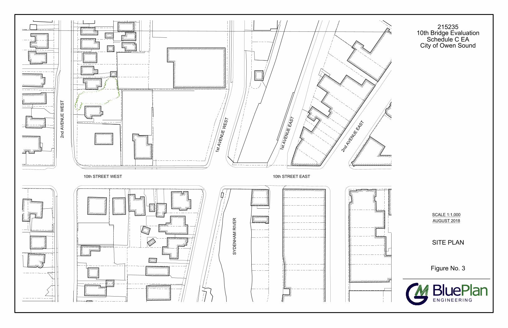
LA
ST
S
AV
ED
B
Y:R
hunter, 8/9/2018 11:14:05 A
M P
LO
TT
ED
B
Y:R
ebecca H
unter - G
M B
lueP
lan 8/9/2018 12:44:54 P
M
Figure No. 3
Plan
ENGINEERING
Blue
SCALE 1:1,000
AUGUST 2018
215235
10th Bridge Evaluation
Schedule C EA
City of Owen Sound
SITE PLAN
10th STREET WEST
2n
d A
VE
NU
E W
ES
T
1
s
t A
V
E
N
U
E
W
E
S
T
1
s
t
A
V
E
N
U
E
E
A
S
T
2
n
d
A
V
E
N
U
E
E
A
S
T
SY
DE
NH
AM
R
IV
ER
10th STREET EAST

S
Y
D
E
N
H
A
M
R
IV
E
R
O
W
E
N
S
O
U
N
D
H
A
R
B
O
U
R
APPROX SPAN 19.53m
LA
ST
S
AV
ED
B
Y:R
hunter, 8/9/2018 11:14:05 A
M P
LO
TT
ED
B
Y:R
ebecca H
unter - G
M B
lueP
lan
8/9/2018 12:44:55 P
M
Figure No. 4A
Plan
ENGINEERING
Blue
SCALE = 1:250
AUGUST 2018
215235
10th Bridge Evaluation
Schedule C EA
City of Owen Sound
EXISTING
CONDITIONS PLAN

Road Level
180.37
0.55m
2.40m
(SIDEWALK)
0.55m
2.49m
(SIDEWALK)
16.66m (5 TRAFFIC LANES)
CL OF 10TH STREET
LA
ST
S
AV
ED
B
Y:R
hunter, 8/9/2018 11:14:05 A
M P
LO
TT
ED
B
Y:R
ebecca H
unter - G
M B
lueP
lan
8/9/2018 12:44:57 P
M
Figure No. 4B
Plan
ENGINEERING
Blue
SCALE 1:1,000
AUGUST 2018
215235
10th Bridge Evaluation
Schedule C EA
City of Owen Sound
EXISTING BRIDGE
CROSS SECTIONS

LA
ST
S
AV
ED
B
Y:R
hunter, 8/9/2018 11:14:05 A
M P
LO
TT
ED
B
Y:R
ebecca H
unter - G
M B
lueP
lan 8/9/2018 12:45:00 P
M
Figure No. 5
Plan
ENGINEERING
Blue
NOT TO SCALE
AUGUST 2018
215235
10th Bridge Evaluation
Schedule C EA
City of Owen Sound
STUDY AREA 1
S
y
d
e
n
h
a
m
R
iv
e
r
STUDY AREA 2
DOWNTOWN OWEN SOUND:
STUDY AREAS -
CONCURRENT
ENVIRONMENTAL
ASSESSMENTS
STUDY AREA 1 - TRAFFIC STUDY
(BTE CONSULTING ENGINEERS)
STUDY AREA 2 - DOWNTOWN
RIVER PRECINCT

LA
ST
S
AV
ED
B
Y:R
hunter, 8/9/2018 11:14:05 A
M P
LO
TT
ED
B
Y:R
ebecca H
unter - G
M B
lueP
lan 8/9/2018 12:45:02 P
M
Figure No. 6
Plan
ENGINEERING
Blue
NOT TO SCALE
AUGUST 2018
215235
10th Bridge Evaluation
Schedule C EA
City of Owen Sound
1
0
th
S
T
R
E
E
T
E
A
S
T
S
y
d
e
n
h
a
m
SITE
ALTERNATE TEMPORARY
BRIDGE CROSSING
LOCATIONS
10th S
TR
E
E
T W
E
S
T
9
th
S
T
R
E
E
T
E
A
S
T
11th S
T
R
E
E
T
W
E
S
T
12th S
T
R
E
E
T
W
E
S
T
1
1
t
h
S
T
R
E
E
T
E
A
S
T
1
2
t
h
S
T
R
E
E
T
E
A
S
T
1
s
t
A
V
E
N
U
E
E
A
S
T
2
n
d
A
V
E
N
U
E
E
A
S
T
3
r
d
A
V
E
N
U
E
E
A
S
T
G
R
E
Y
R
O
A
D
1
5
4
t
h
A
V
E
N
U
E
E
A
S
T
1
st A
V
E
N
U
E
W
E
S
T
2
n
d
A
V
E
N
U
E
W
E
S
T
G
R
E
Y
R
O
A
D
1
3
rd
A
V
E
N
U
E
W
E
S
T
1
st A
V
E
`A
' W
13th S
T
R
E
E
T
W
E
S
T
4th A
V
E
N
U
E
E
A
S
T
2nd A
V
E
N
U
E
E
A
S
T
ALTERNATIVE
TEMPORARY
BRIDGE
LOCATIONS
ALTERNATIVE
TEMPORARY BRIDGE
LOCATIONS
CHI-CHEEMAUN
WINTER DOCKING
LOCATION
1
4
th
S
T
R
E
E
T
W
E
S
T
1
3
t
h
S
T
R
E
E
T
E
A
S
T
R
iv
e
r
A
B
C
D
E
F
G
ALTERNATIVE CROSSING
NOT FEASIBLE (F & G)
LEGEND
FAMILY HEALTH
TEAM BUILDING
NOTE: DETAILED ANALYSIS OF
ALTERNATE BRIDGE CROSSING
LOCATIONS PROVIDED IN APPENDIX J.

10th STREET EAST
1st A
VE
NU
E E
AS
T
1
s
t A
V
E
N
U
E
W
E
S
T
1
s
t
A
V
E
N
U
E
E
A
S
T
S
Y
D
E
N
H
A
M
R
IV
E
R
O
W
E
N
S
O
U
N
D
H
A
R
B
O
U
R
5
.
0
m
5.5m
1
2
.3
m
3.5m
3.5m
3.5m
3.5m
3.5m
3.0m
1
9
°
S
K
E
W
4
.5
m
4.5m
3
.5
m
3
.5
m
5
.3
m
City of Owen Sound
10th Street Bridge Review
215235
Figure No. 7
RECOMMENDED DESIGN
SOLUTIONS
LEGEND
SCALE = 1:500
AUGUST 2018
CONCEPTUAL ARRANGEMENT
\\os-2k8\users_private\rhunter\D
ocum
ents\R
EB
EC
CA
D
WG
S\215235 F
igures-R
LH
.dw
g
LA
ST
S
AV
ED
B
Y:R
hunter, 8/9/2018 11:14:05 A
M P
LO
TT
ED
B
Y:R
ebecca H
unter - G
M B
lueP
lan 8/9/2018 12:45:04 P
M
CONSOLIDATION OF