
City of Monash ROAD MANAGEMENT PLAN 2017 · City of Monash – Road Management Plan 201 7 . Adopted...
44
City of Monash ROAD MANAGEMENT PLAN 2017 Adopted by Council at its Meeting on 30 May 2017 Date of effect of Plan:- 1 July 2017
Transcript of City of Monash ROAD MANAGEMENT PLAN 2017 · City of Monash – Road Management Plan 201 7 . Adopted...

City of Monash
ROAD MANAGEMENT PLAN 2017 Adopted by Council at its Meeting on 30 May 2017 Date of effect of Plan:- 1 July 2017

City of Monash – Road Management Plan 2017
Adopted by Council 30 May 2017 Page 2
Plan Adoption Record
Version Comment Date Adopted Draft Draft Plan accepted by Council for public
consultation 31 August 2004
Version 1 Final Plan adopted by Council 14 December 2004 Version 2 Proposed amendments resulting from
2005 audit 6 June 2006
Version 3 Proposed amendments resulting from 2009 review
27 October 2009
Version 4 Proposed amendments resulting from 2013 review
29 October 2013
Version 5 Amended and adopted by Council following the 2017 review
30 May 2017
Version 5.1 Amended to correct ommissionsomissions
Approval Name Signature Date CEO Andi Diamond
Issued in accordance with the Road Management Act 2004 and Regulation 11, of the
Road Management (General) Regulations 2016.
The master control document is held in the Corporate Records Department and the latest approved version will be available at:
City of Monash City of Monash Council’s Web site Civic Centre Oakleigh Service Centre www.monash.vic.gov.au 293 Springvale Rd 3 Atherton Rd Glen Waverley Oakleigh
City of Monash – Road Management Plan 2017
Adopted by Council 30 May 2017 Page 3
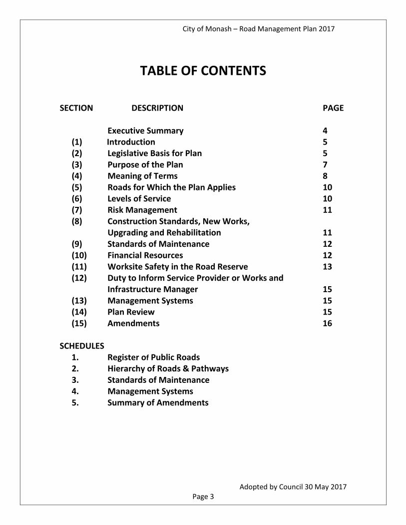
TABLE OF CONTENTS
SECTION DESCRIPTION PAGE
Executive Summary 4 (1) Introduction 5 (2) Legislative Basis for Plan 5 (3) Purpose of the Plan 7 (4) Meaning of Terms 8 (5) Roads for Which the Plan Applies 10 (6) Levels of Service 10 (7) Risk Management 11 (8) Construction Standards, New Works,
Upgrading and Rehabilitation 11 (9) Standards of Maintenance 12 (10) Financial Resources 12 (11) Worksite Safety in the Road Reserve 13 (12) Duty to Inform Service Provider or Works and
Infrastructure Manager 15 (13) Management Systems 15 (14) Plan Review 15 (15) Amendments 16
SCHEDULES
1. Register of Public Roads 2. Hierarchy of Roads & Pathways 3. Standards of Maintenance 4. Management Systems 5. Summary of Amendments

City of Monash – Road Management Plan 2017
Adopted by Council 30 May 2017 Page 4
Executive Summary The Road Management Act 2004 sets a range of principles and activities that Road Authorities need to undertake to provide for the proper management of the road system. The City of Monash is the Road Authority for approximately 734 kilometres of local roads and their associated pathways and other assets. This Road Management Plan has been prepared to document the principles, methods and systems used by the City of Monash in managing the local road system. The Plan has two major components:
• Road Asset Management System – A description of the systems used by Council
to manage all aspects of the road system; • Schedule of Maintenance Standards – A statement of the levels of service that
the City of Monash provides in managing the local road network. The Register of Public Roads is a separate document. The Plan seeks to balance the competing influences that impact on the level of service adopted by Council. These include economic, technical, social, safety and environmental influences. In managing the local road system, Council seeks to establish a reasonable level of service to meet the expectations of road users and the local community. A key driver to the preparation of the Plan is to demonstrate that Council is also managing the risks associated with the use of the various assets in the road reserve. The management of risk drives the allocation of resources within the systems used to provide the reasonable level of service. This Plan is a dynamic document that will be reviewed regularly and checked against the current needs and expectations of the community. Council will review the performance of the Plan on an annual basis through the Budget preparation process.

City of Monash – Road Management Plan 2017
Adopted by Council 30 May 2017 Page 5
ROAD MANAGEMENT PLAN
1. Introduction
Council is responsible road authority for approximately 734 kilometres of local roads and 1,602 kilometres of footpaths and pathways within the City of Monash. These roads have been created over a period of 100 years or so, with the bulk of the roads being constructed in a 30-year period between the 1960’s and 1980’s. The current value of this road infrastructure was valued in 2017 at approximately $710m.
Council is responsible for the Council owned assets on the roads shown on the Register of Public Roads. Road assets include the road pavement, kerb and channel, footpaths, line-marking, local area traffic management devices (LATMs), structures and traffic signs.
Arterial Roads and State Highways and Freeways (State Roads) within the municipality are maintained by VicRoads as detailed in the relevant Code of Practice.
Any roads or portion of roads that:
• are not State Roads for which Council is the Coordinating Road Authority;
• the part of an arterial road that Council is the Responsible Road Authority;
are included on the Register of Public Roads and referred to as Local Roads. The Act also refers to them as Municipal Roads.
Other infrastructure installed in the local roads, such as utility assets, are managed by the relevant infrastructure manager and are not the responsibility of Council. Council maintains the local road system through road management programs. These programs include:
• Maintenance – routine and non-routine maintenance for roads and footpaths.
• Capital Works – road reconstruction program, road re-sheet program, footpath replacement program and retaining wall rehabilitation program.
2. Legislative Basis for Plan This Road Management Plan (referred to hereafter as the ‘Plan’) is prepared in accordance with Division 5, Sections 49 to 55 of the Road Management Act 2004 (referred to hereafter as the ‘Act’). The stated Purpose of the Road Management Act (2004) is to reform the law relating to road management in Victoria and amend related Acts with respect to roads.

City of Monash – Road Management Plan 2017
Adopted by Council 30 May 2017 Page 6
The Act outlines the following principles and activities: 1. Establishes a new statutory framework for the management of the road network
that assists the co-ordination of the various uses of road reserves for roads, paths and other infrastructure located in the road reserve;
2. Sets out certain rights and duties for road users; 3. Establishes the general principles that apply to road management; 4. Provides for the role, functions and powers of a road authority; 5. Provides for the making of Codes of Practice to provide practical guidance in
relation to road management; 6. Facilitates the preparation of Road Management Plans as part of the
management and maintenance system implemented by the road authority to carry out its road management function;
7. Enables the creation/declaration and discontinuation of roads; 8. Provides a process for the declaration and classification of roads and allocation
of responsibility for management and maintenance for roads; 9. Provides for the road authority to prepare and maintain a Register of Public
Roads. The Council is deemed to be the “Co-ordinating Road Authority” for the roads nominated in the Register;
10. Provides for the construction, inspection, maintenance and repair of public roads;
11. Defines the road management functions of road authorities; 12. Defines the road management functions for infrastructure and works managers
in providing and maintaining infrastructure contained within the road reserve; 13. Provides for issues relating to civil liability relating to the management and
maintenance of road related infrastructure; 14. Provides for the mechanisms to enforce and administer the provisions of the Act; 15. Amends related Acts including:
• Transport Act 1983 • Road Safety Act 1986 • Local Government Act 1989
This Plan reflects the purposes and objectives of the Council as defined in the Local Government Act, 1989.
Section 24 of the Act proposes a set of Codes of Practice. These include:
• Preparation of Road Management Plans; • Operational Responsibility for Public Roads; • Clearways on Declared Arterial Roads; • Management of Infrastructure in Road Reserves • Worksite Safety - Traffic Management

City of Monash – Road Management Plan 2017
Adopted by Council 30 May 2017 Page 7
3. Purpose of the Plan
In accordance with Section 50 of the Act, the purposes of a Road Management Plan are having regard to the principal object of road management and the works and infrastructure principals:
1. Establish a management system for the road management functions assigned to Monash City Council as the Road Authority for local roads;
2. Base the system on policy and operational objectives within the resources available, and;
3. Set relevant standards for carrying out management and maintenance functions for the local road system.
The Register of Public Roads for the City of Monash is available separately to this document. The key stakeholders in this Plan include:
• The community in general; • Residents and businesses abutting and using the road network; • Pedestrians including those with a disability and the elderly with restricted
mobility; • Cyclists and other light vehicle users; • Emergency services; and • Utilities with assets in the road reserve.
In preparing this Plan, road users are to be reminded of their obligations under section 17A of the Road Safety Act 1986 as follows:
17A. Obligation of Road Users (1) A person who drives a motor vehicle on a highway must drive in a safe
manner having regard to all the relevant factors. (2) A road user other than a person driving a motor vehicle must use a
highway in a safe manner having regard to all the factors (2A) For the purposes of subsections (1) and (2) and without limiting their
generality, the relevant factors include the following – a) The physical characteristics of the road; b) The prevailing weather conditions; c) The level of visibility;

City of Monash – Road Management Plan 2017
Adopted by Council 30 May 2017 Page 8
d) The condition of any vehicle the person is driving or riding on the highway;
e) The prevailing traffic conditions; f) The relevant road laws and advisory signs; g) The physical and mental condition of the driver or road user.
(3). a road user must:
(a) take reasonable care to avoid any conduct that may endanger the safety or welfare of other road users;
(b) take reasonable care to avoid any conduct that may damage road infrastructure and non-road infrastructure on the road reserve; and
(c) take reasonable care to avoid conduct that may harm the environment of the road reserve.
4. Meaning of Terms Terms used in this Plan have the same meaning as the specific definitions included in Clause 3 of the Road Management Act. Additional terms used include:
• Days – where this term is used to describe service levels, the intent is ‘normal working days’, which excludes weekends and public holidays.
• Drainage – can include overland flow paths along road pavement. During storm periods, for the designated flow path, significant depth of water on the pavement is acceptable
• Emergency Situations – Sudden event or occurrence within the road reserve that creates a life-threatening hazard to road users.
• Financial Management System – ‘Oracle’ Applications is currently used to provide the financial recording and control for Council activities.
• Footpath drainage pit – pits collecting runoff from the footpath and are generally of a low risk of flooding affecting pedestrians and no risk to road users.
• Geographic Information System (GIS) – Spatial related system providing map-based display of asset based features and links to databases relating to information on assets.
• Asset Management Information System (AMIS) – used by Monash to receive, record and issue works. Currently this is based on selected modules of the ‘Confirm’ Asset Management System.
• Pathways – includes footpaths, shared pathways and bicycle paths located within the road reserve.
• Property and Rates System – The ‘Pathway’ Customer Request module is used to record and issue matters reported by the community and refer those relating to road infrastructure assets to the Confirm system.

City of Monash – Road Management Plan 2017
Adopted by Council 30 May 2017 Page 9
• Repair – has the same meaning as per the Road Management Act. • Statutory Line marking - pavement markings (including associated
RRPM’s) to support signage defined as major traffic control items in accordance with Road Safety (Road Rules) Regulations 1999, Schedule2. Parking bays are excluded from this definition for the purposes of this Plan.
• Traffic Signs – Safety signs associated with Major Traffic Control Items
(excluding parking signs); and warning signs – signage to warn drivers of potentially
hazardous conditions, on or adjacent to the road, and of conditions which may require them to take evasive action
• Exceptional Circumstances – Council will make every effort to meet its
commitments under its Road Management Plan. However, there may be situations or circumstances that affect Council's business activities to the extent that it cannot deliver on the service levels of this Plan. These include but are not limited to: natural disasters, such as fires, floods, or storms, or a prolonged labour or resource shortage, due to a need to commit or redeploy Council staff and/or equipment elsewhere.
In the event that the Chief Executive Officer (CEO) of Council has considered the impact of such an event on the limited financial resources of Council and its other conflicting priorities, and determined that this Plan cannot be met, then pursuant to Section 83 of the Wrongs Act, the CEO will write to Council’s Officer in charge of its Plan and inform them that some, or all of the timeframes and responses in Council’s Plan are to be suspended. Once the scope of the event/s have been determined, and the resources committed to the event response have been identified, then there will be an ongoing consultation between Council’s CEO and Council’s Officer responsible for this Plan, to determine which parts of Council’s Plan are to be reactivated and when. Council statements to residents about the suspension or reduction of the services under this Plan will include reference to how the work that will be done has been prioritised, and the period for which it is likely to be affected."

City of Monash – Road Management Plan 2017
Adopted by Council 30 May 2017 Page 10
5. Roads For Which The Plan Applies The provisions of this Plan apply to those local roads and pathways shown in the Register of Public Roads as outlined in Schedule 1. 6. Levels of Service The standards specified under this Plan will maintain the local public road network at the level applicable at the time of publication of this Plan. The levels of service identify the following activities:
• Inspection of Assets – Scheduled Condition Inspection and Non Routine Assessment
• Intervention Standards • Management Controls and Response Times
In terms of the inspection of assets, the following describe the types of inspection carried out:
Type Description Scheduled Defect Inspection Programmed or proactive assessment of the
current defects for an asset in relation to its current serviceability at current usage levels and then compared against stated intervention levels to determine if repair works are required.
Reactive Inspection Identification from a reported defect or unserviceable asset and then compared against stated intervention levels to determine if repair works are required.
Condition Inspection Programmed assessment of the overall condition rating for an asset as a whole. This form of inspection is to assess the entire network at a general high level and is not intended to identify individual defects which is done via the previous two types of inspections. Condition ratings are used to prioritise the capital works program for renewal, rehabilitation and upgrade of road assets.
In Emergency Situations, Council is required to provide a timely response. The sequence of activities for an emergency response is as follows:
• Initial inspection to confirm the extent of the reported defect as soon as practical;

City of Monash – Road Management Plan 2017
Adopted by Council 30 May 2017 Page 11
• If the reported defect exceeds the stated intervention level then reduce the extent of the hazard if possible and consider appropriate temporary measures such as road closure, barricades, warning signs, traffic diversion etc.;
• Inspect site regularly to ensure the hazard reduction measures are maintained; • Carry out repair works within required Levels of Service.
7. Risk Management The Council is committed to effective risk and opportunity management to:
• improve our ability to deliver community priorities, service delivery and outcomes for the City of Monash;
• maximise opportunities and minimise the impact and likelihood of risk; protect its employees, assets, liabilities and its community by avoiding or mitigating losses;
• provide greater certainty for our employees, residents, stakeholders and the community in which we operate by understanding and managing our risks.
The standards of construction and maintenance, as outlined in this Plan, have been determined on the basis of a risk assessment undertaken generally in accordance with the principles of the International Standard ISO31000 - 2009. This standard is reflected in the City of Monash’s Risk and Opportunity Management Framework.
The Best Value Review for the Infrastructure Division used this process to carry out a risk assessment on the operations and activities undertaken by the division. 8. Construction Standards, New Works, Upgrading,
Rehabilitation The standards for construction of new local roads and pathways, and for the expansion, upgrading, renewal and refurbishment of existing local roads and pathways will be in accordance with the standards and specifications adopted by Council from time to time. Standards for construction are generally in accordance with current VicRoads specifications appropriately defined for the City of Monash. The condition rating of road assets is used to inform the priority of capital works to renew, rehabilitate or upgrade these assets.

City of Monash – Road Management Plan 2017
Adopted by Council 30 May 2017 Page 12
9. Standards of Maintenance The standards of maintenance applicable to the local roads and pathways subject to this Plan are detailed in Schedule 3 that encapsulates:
a. The task or work expected to be undertaken; b. The schedule of inspections to be undertaken at specified intervals: c. The circumstances under which intervention action is to be taken with
respect to repair or maintenance needs for defects reported or found on inspection;
d. Provision, as far as practicable, for the unpredictable, i.e. emergencies, natural ‘disasters’; and
the schedule provides the maintenance information for Councils’ assets in the following groupings:
• Roads including road surface & pavement, kerb and channel, drains and pits, fences and other structures, retaining walls, traffic signals and streetlights (Council owned), line marking and signage.
• Pathways maintained by Council.
Council has a number of options to remedy defects and the method chosen is determined through the inspection process. Street furniture are not considered to be part of the road related infrastructure and are therefore not included in this Plan. This Plan acknowledges the importance of understanding and monitoring the linkage between workload indicator and intervention action, as a substantial increase in area of pavement or asset to be maintained can materially impact upon intervention action (and resident satisfaction and duty of care requirements) if not accompanied by a comparable increase in budget and resource allocation or productivity improvement. 10. Financial Resources The commitments and obligations specified in this Plan are matched to the financial resources available to deliver those commitments and obligations. The financial resources allocated for works on local roads and pathways have been established from the Long Term Financial Plan which in turn is informed by the policies and plans associated with the long-term management of the road assets, responses received in customer satisfaction surveys, RMP Reviews and condition surveys previously undertaken. These allocations are considered reasonable having regard to the overall service delivery performance of the Council. The distribution of financial resources is contained within Council’s Management Budget.
City of Monash – Road Management Plan 2017
Adopted by Council 30 May 2017 Page 13
11. Worksite Safety within Road Reserves All construction and maintenance work on local roads and pathways will be undertaken in accordance with the relevant occupational, health and safety legislation, codes of practice and guidelines. For works on State Roads, VicRoads will be considering applications for works within the road reserve. A system of permits and local laws is in place to inform and guide external contractors working in the local road reserve. For the City of Monash, these include:
Obstruction of Footpaths and Roads
Under the provision of Council’s Local Law No. 3, landowners have a responsibility: • To keep the footpath clear of vegetation growing from their property; • To keep the footpath and road clear of items obstructing vision; and • Not to occupy, or conduct works, on any footpath or road for any purpose other
than the lawful movement of vehicular and pedestrian traffic unless otherwise permitted by Council or other appropriate authority.
Nature Strips
The Council does not maintain nature strips. Historically the abutting landowner has undertaken mowing and up-keep as a part of the presentation of their property, in terms of appearance and surface condition. Nature strip trees planted by Council are maintained by Council.
Fencing Adjacent to a Road Reserve
The Council does not contribute to any fencing costs along road reserves/property boundaries.
Vehicle Crossings
Vehicle crossings (driveways) are the responsibility of the property owner (Local Government Act 1989 – Schedule 10 clause 12). The owner must apply to Council for a permit to construct the vehicle crossover, which is to be constructed to meet current Council standards.
Monash Local Law No. 3, Clause 25 requires that “each owner and occupier of land must maintain and keep in good condition any vehicle crossing which services that land.”
For properties fronting Arterial Roads, the property owner must also contact VicRoads to obtain their approval for the proposed vehicle crossover.

City of Monash – Road Management Plan 2017
Adopted by Council 30 May 2017 Page 14
Vehicle Crossing Responsibilities – Property Owner: • Vehicle crossing (driveway) between the road pavement and the property line,
including; o Modified section through the kerb (layback); and o Infill (between pathway crossover and layback) o Infill (between pathway crossover and property boundary).
The owner is responsible for maintaining the vehicle crossing in a safe condition.
Figure 1: Extent of Property Owner Responsibility
The pathway crossover section functions as • an access to the property for the property owner, and • a pathway for pedestrian movements parallel to the road.
Council will inspect the pathway section of the crossover in conjunction with the adjacent scheduled pathway inspections. If there is a defect exceeding intervention levels, then Council will carry out repairs in accordance with this Plan. If it is deemed that the cause of the defect is the responsibility of the property owner, then or Council may at its discretion subsequently seek to recover costs from the property owner concerned.
Infill
Layback
Road Pavement
Pathway crossover
Infill
Property line
Pathway
Channel
Property Owner Responsibility
Kerb &

City of Monash – Road Management Plan 2017
Adopted by Council 30 May 2017 Page 15
12. Duty to Inform Service Provider or Works and
Infrastructure Manager If in the course of meeting it obligations under this Plan, the Council becomes aware that any road and non-road infrastructure for which an external service provider or works and infrastructure manager is responsible:
• Is not in the location shown in the relevant records; or • Appears to be in an unsafe condition; or • Appears to be in need of repair or maintenance,
then Council will convey that information to the relevant service provider of works and infrastructure. 13. Management Systems In carrying out its responsibilities under the Act for the Local Road system, Monash uses a number of integrated systems to record, process, issue and track the various activities being undertaken. These are:
• Accounting Financial System - Oracle • Asset Management Information System – Confirm Asset Management System • Performance Management • Pavement Management System (SMEC) • Geospatial Information System (GIS – ESRI) • Customer Services Management System – Pathway Property system
These are further detailed in Schedule 4. 14. Plan Review This Plan will be reviewed following Council elections in accordance with the Road Management (General) Regulations 2016, having regard to:
• Asset performance following delivery of maintenance program; • The available financial resources of Council; • The level of achievement of asset management strategies against the expected
benefits to road users, stakeholders and the community; and • The consideration of any external factors that are likely to influence the
contents of this Plan.

City of Monash – Road Management Plan 2017
Adopted by Council 30 May 2017 Page 16
Regular internal assessment of performance and standards will be conducted to ensure compliance to the RMP including:
• Scheduled and reactive inspections are carried out in accordance with the RMP
• New or changed risks are assessed appropriately • Condition assessments are recorded .
15. Amendments The amendments between the 2013 Plan and this Plan are summarised in the attached Schedule 5.
City of Monash
ROAD MANAGEMENT PLAN 2017
Schedule 1 – Register of Public Roads

Adopted by Council DRAFT Page 18
Register of Public Roads The City of Monash Register of Public Roads is a map based display of the road system within the municipality. These maps are incorporated into the Corporate GIS System. The City is divided into 31 map areas. The Plan for each map area displays the road system. Roads are differentiated by colours/patterns into the following categories:
• Public Roads o Category 1 o Category 2 o Category 3
• Private Roads (non-public roads) • Boundary Roads (shared responsibility with adjoining Municipalities) • Freeways/Arterial - VicRoads responsibility • Rights of Way (when deemed not public roads) • Other Council roads (part of common property but under Council)
Council may be the Responsible Road Authority for some assets in Arterial roads. These operational responsibilities are defined in the appropriate Code of Practice. The Register is prepared in accordance with the requirements of Section 19 of the Act. The City of Monash is the Coordinating Authority for Public Roads The GIS system includes the following information for those roads for which The City of Monash is the Co-ordinating Road Authority:
• Name of the road • Date of creation as a public road
All municipal public roads for the purpose of this Register are either:
• Category 1 Roads – high usage and around major retail precincts • Category 2 Roads – all other public roads (not category 1 or 3) • Category 3 Roads – Rights of Way (Public)
Copies of the GIS display maps are available for viewing at the Civic Centre, 293 Springvale Road, Glen Waverley and the Oakleigh Service Centre, 3 Atherton Road, Oakleigh.

City of Monash – Road Management Plan 2017
Adopted by Council 30 May 2017 Page 19
The guiding principles that apply to the selection of the roads within the City of Monash that are listed on the Public Roads Register are as follows:
• Principle 1 – A local road that provides primary vehicle access to abutting properties
• Principle 2 – Local Roads are managed and maintained by Council • Principle 3 - Council is not responsible for roads on land that has not been vested
in Council • Principle 4 – Public roads are open to and are required for use by the general
community • Principle 5 – Local Roads do not include:
• Roads, ROWs and laneways that do not provide primary vehicle access to abutting properties; • Private roads and common property roads; • Unused, unconstructed or fenced off ROWs and laneways • Roads in reserves and open space areas; • Bike paths (not within the road reserve), walking tracks and carriageway easements; • Off road car parks and associated access roads.
The Council has determined that those local roads and pathways on the Register of Public Roads are those roads that are:
• Managed and maintained by Council, and; • Considered to be reasonably required for general public use.
The Register of Public Roads establishes a road hierarchy (Refer Schedule 2) and the relevant road categories are used only to differentiate service levels and maintenance standards. The demarcation of asset ownership will be defined by the negotiation of Agreements between the Council and other road authorities in accordance with the Act. These will include agreements with:
• VicRoads and other authorities with road assets; • Adjoining Councils (Knox, Whitehorse, Boroondarra, Stonnington, Glen Eira,
Kingston, Greater Dandenong). Such agreements will define the extent of boundary roads, private roads, arterial roads, other authority roads and structures.
This Plan does not apply to any driveway or pathway providing access from private property to a public road.

Page 20
City of Monash
ROAD MANAGEMENT PLAN 2017
Schedule 2 – Hierarchy of Roads & Pathways

Adopted by Council DRAFT Page 21
The following Table defines the Hierarchy of Roads used within the City of Monash
Table 2.1– Hierarchy of Roads
Classification of Road
Definition Community Understanding
Responsibility Examples
Freeways Multi lane roads carrying traffic through regions or across the city
Roads used for inter-city travel without intersections
VicRoads Monash Freeway
Arterial
Multi lane roads carrying traffic through suburbs Primarily used for inter-suburban travel
Roads used for inter-suburban travel Roads with series of traffic signals
VicRoads – through lanes Monash – service roads
Springvale, Blackburn, High Street Road, Ferntree Gully Road
Category 1 Roads
a) Primarily provide a route between and through residential, industrial and commercial areas and to convey traffic to the arterial network; or b) Roads within major retail precincts that are subject to high pedestrian traffic
Busy roads that provide links between the arterial roads and/or busy roads in major shopping centres
Monash a) Generally are highly trafficked roads. Eg Gallaghers Rd, Wanda St b) Roads in the major retail precincts (Oakleigh, Mt Waverley, Clayton and Glen Waverley). Eg Kingsway
Category 2 Roads
All public roads that are not arterial roads; or Category 1 or 3 public roads. Provide access to properties. Low speed environment.
Provides for travel within the suburbs and access to properties. Expect to be used by cars, pedestrians, bicycles etc
Monash Eg. Petronella Ave, Grenfell Road, (most streets in municipality)
Category 3 Public Road/ Right of Way (ROW’s)
Limited and secondary access to properties Single lane in nature
Limited access for properties and vehicles Walking speed traffic
Monash Lanes for deliveries behind shopping centres eg lane behind Syndal strip shopping centre
Non Public Road (ROW)/ Private Road
Provides limited access to properties Land owned privately
Road may be gated off in providing access to properties
Land owner Pinewood Shopping Centre – Central area, Enterprise Court

City of Monash – Road Management Plan 2017
Adopted by Council DRAFT Page 22
Table 2.2 – Hierarchy of Pathways
Sensitivity Description Frequency of Scheduled Defect Inspection
Surface Type 1 Surface Type 2
High Major Shopping Centres refer to hierarchy schedule
Once in a 1 month period
Once in a 6 month period
Medium Minor Shopping Centres, refer to hierarchy schedule
Once in a 3 month period
Once in a 6 month period
Low All other roads
Once in a 1 year period
As per road pavement inspection schedule
Surface Type 1 –Segmental paving Surface Type 2 – Concrete or asphalt paving Refer also to Schedule 3

City of Monash – Road Management Plan 2017
Adopted by Council DRAFT Page 23
Table 2.3 - Schedule of Pathways of High and Medium Sensitivity (High Sensitivity Sites in Bold)
Map No. Site Description Street Name From To Sensitivity Surface
Type
1
Ashwood Shopping Centre
Warrigal Rd Douglas St High St Rd Medium 1
Yertchuk Av Shops
Yertchuk Av Arthur St No 22 Yertchuk Av
Medium 1
Raymond Street Shops
High St Rd Raymond Street
No. 207 High St Rd
Medium 1
2
Barlyn Rd Shops Barlyn Rd Huntingdale Rd
ROW Medium 2
Andrew St Shops
Andrew St Highbury Rd ROW Medium 1
Essex Rd Shops Essex Rd Huntingdale Rd
No. 15 Essex Rd
Medium 1
Essex Heights shops
Essex Rd No. 52 Essex Rd
Surrey Rd Medium 1
3
Leeds Rd Shops High St Rd Leeds Rd
ROW Medium 1
Tally Ho Shops Blackburn Rd Lucerne St
ROW Medium 1
Syndal Shopping Centre
High St Rd Larch Crs Blackburn Road
Medium 1
Blackburn Rd No 185 High Street Road
Medium 1
4 Willow Avenue Shops
Willow Ave Medina Rd ROW Medium 1
6
Holmesglen Shops
Warrigal Rd Rail Line Batesford Rd Medium 1
Batesford Road Shops
Batesford Rd Woonah St Power Ave ( to ROW)
Medium 1
Cleveland St Shops
Cleveland St High St Rd Mavron St Medium 1 & 2
Jordanville Shops
Huntingdale Rd
Railway Pde Sth
ROW Medium 1 & 2
7 Part
Waverley Rd Shops – at Huntingdale Rd
Huntingdale Rd
No 414 Waverley Rd Medium 2
Waverley Rd Shops – at Stephensons Rd
Waverley Rd No. 335 Stephensons Rd
Medium 1

City of Monash – Road Management Plan 2017
Adopted by Council DRAFT Page 24
Map No. Site Description Street Name From To Sensitivity Surface
Type
7 Cont’d
Wadham Parade Shopping Centre
Wadham Pde Miller Cres No 45 Wadham Pde
Medium 2
Mt Waverley Shopping Centre
Alexander St Full length High 1 Hamilton Pl Full length High 1 Hamilton Walk
Full length High 1
Winbourne Rd
Alexander St Stephensons Rd
High 1 & 2
Virginia St Alexander St Stephensons Rd
High 1 & 2
8
Mt Waverley Shopping Centre
Stephensons Rd
Railway Line No 318 Stephensons Rd
High 1 &2
Syndal Shopping Centre
Blackburn Rd High St Rd Price Av Medium 2
9
Syndal Shopping Centre
Blackburn Rd High St Rd No 260A Blackburn Rd
Medium 1
Glen Waverley North Shops
High St Rd No 676 High Street Rd
No 706 High Street Rd
Medium 1
Glen Waverley Shopping Centre
Kingsway Bogong Av O’Sullivan Rd High 1 Snedden Dve O’Sullivan Rd High St Rd High 1 O’Sullivan Rd Kingsway Springvale Rd High 1 Railway Pde-North
Euneva Av Springvale Rd High 1
Coleman Pde Myrtle St Springvale Rd High 1 Bogong Av Kingsway Myrtle St High 1 Montclair Av Myrtle St Kingsway High 1 High Street Rd
Springvale Rd
Snedden Dv High 1
Springvale Rd High St Rd Kingsway High 1 Glen Waverley South Shops
Springvale Rd Frank St Waverley Rd Medium 2
10 Kerrie Rd Shops Kerrie Rd High St Rd
ROW Medium 2
11 Dominion Ave Shops
Waverley Rd Dominion Ave
ROW Medium 2
13
Stanley Avenue Shops
Stanley Avenue
Ian Gve ROW Medium 2
Bellerive Ave Shops
Bellerive Ave Stephensons Rd
ROW Medium 2

City of Monash – Road Management Plan 2017
Adopted by Council DRAFT Page 25
Map No. Site Description Street Name From To Sensitivity Surface
Type
14 Pinewood Shopping Centre
Centreway Pinewood Dve
No 27 Centreway
Medium 1
Centreway No 47 No 69 Blackburn Rd No 425
Blackburn Rd No 409 Blackburn Rd
Medium 1
15
Glenwood Ave Shops
Glenwood Ave
Waverley Rd Juniper Ave Medium 2
Hampshire Rd Shops
Hampshire Rd (in front of shops)
No 1 Hampshire Rd
No 19B Hampshire
Medium 2
18
Hughesdale Shopping Centre (East side)
Poath Rd Paget St Arthur St Medium 1
19
Warrigal Rd Shops
Warrigal Rd North Rd No 170 Medium 2
Oakleigh Shopping Centre
Drummond St Logie St
Atherton Rd High 2
Atherton Rd Warrigal Rd
Drummond St High 2
Atherton Rd Drummond St
Palmerston Grove
High 1
Atherton Rd Palmerston Gve
Clyde Street High 2
Hanover St Atherton Rd
Burlington St High 1
Chester St Jones St Hanover St
High 1
Portman St Jones St Hanover St
High 1
Jones St Atherton Rd Chester St
High 2
Station St Atherton Rd Portman St
High 2
Eaton Mall Full Length Full Length High 1 Huntingdale Rd Shops
Huntingdale Rd
Croft St North Rd Medium 1
Johnson St Shops
Mill Rd Johnson St No. 1 Mill Rd Medium 1
Johnson St Shops
Johnston St Mill Rd Haughton Rd Medium 2

City of Monash – Road Management Plan 2017
Adopted by Council DRAFT Page 26
Map No. Site Description Street Name From To Sensitivity Surface
Type
20
Huntingdale Rd Shops
Huntingdale Rd
Hargreaves St
North Rd Medium 1
Huntingdale Rd Shops
Huntingdale Rd
No. 240 Huntingdale Rd
No. 248 Huntingdale Rd
Medium 2
East Oakleigh Shopping Centre (State Street)
Huntingdale Rd
No 184 Huntingdale Rd
Princes Hwy Medium 2
Berrima Street Shopping Centre
Berrima St No 9 Berrima St
No 23 Berrima St
Medium 2
21 Shopping Centre
Princes Highway
Clayton Rd Glenbrook Av Medium 1
22 Westerfield Drive Shops
Westerfield Dv
Samada St No 49 Westerfield Dv
Medium 2
23
Brandon Park Shopping Centre
Springvale Rd Ferntree Gully Rd
Magid Av Medium 2
Ferntree Gully Rd
Springvale Rd
Brandon Park Dv
Medium 2
Magid Av Springvale Rd
Brandon Park Dv
Medium 2
Brandon Park Dv
Ferntree Gully Rd
Magid Av Medium 2
Lum Road Shopping Centre
Lum Rd No 200 Brandon Park Dv
No 212 Brandon Park Dv
Medium 2
Shopping Centre
Clunies Ross Dv
No 39 Clunies Ross Dv
Monash Dv Medium 2
26 Clayton Shopping Centre
Clayton Rd Centre Rd No 299 Clayton Rd
High 1
Cooke St Centre Rd
Dunstan St High 2
Dunstan St Cooke St
Clayton Rd High 1 & 2
Carinish Rd Madeleine Rd
Clayton Rd High 2

City of Monash – Road Management Plan 2017
Adopted by Council DRAFT Page 27
Map No. Site Description Street Name From To Sensitivity Surface
Type
27
Clayton Shopping Centre
Clayton Rd Centre Rd
Carinish Rd High 1
Haughton Rd Clayton Rd
Thomas St High 2
Carinish Rd Clayton Rd Mary St High 2 Shopping Centre
Centre Rd No 1459 Centre Rd
No 1485 Centre Rd
Medium 2
Shopping Centre
Clayton Rd No 162 Clayton Rd
No 176 Clayton Rd
Medium 2
28 Gateway Shopping Centre
Springvale Rd Princes Hwy Wilma Av Medium 1 & 2
29
Mackie Rd Shops
Mackie Rd No 71 Mackie Rd
No 81 Mackie Rd
Medium 2
Dunoon Crt Shops
Dunoon Crt Full length Full length Medium 2
Wanda St Shops Wanda St No 36 Wanda St
No 50 Wanda St
Medium 2
30
Shopping Centre
Hansworth St No 114 Hansworth St
No 122 Hansworth St
Medium 2
Waverley Gardens Shopping Centre
Police Rd Hansworth St
Jacksons Rd Medium 2
Hansworth St (east side)
Police Rd No. 181 Hansworth St
Medium 2

City of Monash
ROAD MANAGEMENT PLAN 2017
Schedule 3 – Standards of Maintenance

City of Monash – Road Management Plan 2017
Adopted by Council DRAFT
Page 29
Schedule 3A – Inspection of Road Assets
Asset Scheduled Defect Inspection Reactive Defect Inspection
Road Pavement
• Category 1 (includes assets on arterial roads where Council is the responsible authority) • Category 2 • Category 3
Once in a 2 Year period
Once in a 3 Year period
Once in a 3 Year period
For all categories:
As reported by the community or observed by staff. Assess within 5 days.
Kerb and Channel As per road pavement above) As reported by the community or observed by staff. Assess within 5 days.
Drainage/ Table Drains Stormwater pits are to be inspected at the same frequency as the kerb and channel or, if part of the pathway, the same frequency as the pathway inspection
As reported by the community or observed by staff. Assess within 5 days.
Pathways
• High Sensitivity –Surface Type 1
• High Sensitivity –Surface Type 2
• Medium Sensitivity - Surface Type 1
• Medium Sensitivity – Surface Type 2
• Low Sensitivity (including shared pathways)- Surface Type 1
• Low Sensitivity (including shared pathways) – Surface Type 2
Once in a 1 Month period
Once in a 6 Month period
Once in a 3 Month period
Once in a 6 Month period
Once in a 1 Year period As per road pavement category above
As reported by the community or observed by staff. Assess within 5 days.
Traffic Signs
As per road pavement category above As reported by the community
or observed by staff. Assess within 5 days.
Linemarking, includes reflective pavement markers Statutory linemarking (excluding parking bays)
As per road pavement category above
As reported by the community or observed by staff. Assess within 5 days.
Traffic Management Devices, including speed humps and chicanes
As per the road pavement category above
As reported by the community or observed by staff. Assess within 5 days.
City of Monash – Road Management Plan 2017
Adopted by Council DRAFT
Page 30
Asset Scheduled Defect Inspection Reactive Defect Inspection
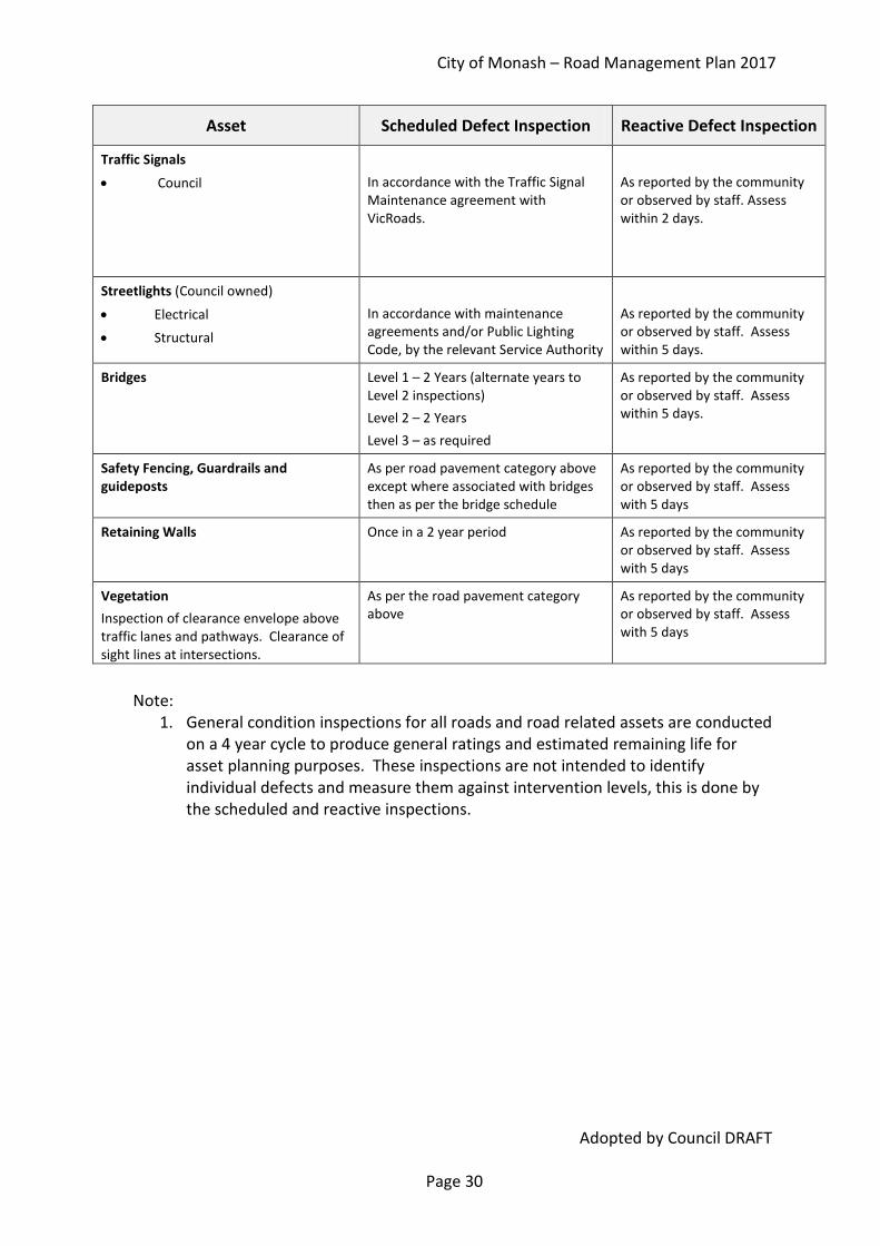
Traffic Signals
• Council
In accordance with the Traffic Signal Maintenance agreement with VicRoads.
As reported by the community or observed by staff. Assess within 2 days.
Streetlights (Council owned)
• Electrical • Structural
In accordance with maintenance agreements and/or Public Lighting Code, by the relevant Service Authority
As reported by the community or observed by staff. Assess within 5 days.
Bridges Level 1 – 2 Years (alternate years to Level 2 inspections) Level 2 – 2 Years Level 3 – as required
As reported by the community or observed by staff. Assess within 5 days.
Safety Fencing, Guardrails and guideposts
As per road pavement category above except where associated with bridges then as per the bridge schedule
As reported by the community or observed by staff. Assess with 5 days
Retaining Walls Once in a 2 year period As reported by the community or observed by staff. Assess with 5 days
Vegetation Inspection of clearance envelope above traffic lanes and pathways. Clearance of sight lines at intersections.
As per the road pavement category above
As reported by the community or observed by staff. Assess with 5 days
Note:
1. General condition inspections for all roads and road related assets are conducted on a 4 year cycle to produce general ratings and estimated remaining life for asset planning purposes. These inspections are not intended to identify individual defects and measure them against intervention levels, this is done by the scheduled and reactive inspections.

City of Monash – Road Management Plan 2017
Adopted by Council DRAFT Page 31
Schedule 3B – Intervention Standards and Management Controls Asset Defect / Hazard Definition Intervention Standard Response Times
Road Pavements – Sealed
1. Potholes Hole in road surface extending into base material
Greater than 300 mm diameter and 50 mm deep
Reactive inspection - Assess – 5 days.
Category 1 – repair within 10 days,
Category 2/3 – repair within 20 days
2. Surface condition Deterioration of road surface requiring repair
Defects include polishing, delamination, ravelling, stripping of greater than 50% of surface.
Category 1 – repair within 3 months.
Category 2/3 – repair within 6 months
3. Pavement Failure Loss of shape and geometry of road structure such as shoving, wheel ruts, depressions
Depth greater than 50 mm over 3 m length and/or extent of movement is causing vehicles to slow or deviate.
Reactive inspection – Assess – 5 days
Category 1 – repair within 20 days,
Category2/3 – repair within 6 months
4. Slippery materials spilt on pavement traffic lanes
Materials, such as oil, have been spilt on the pavement within traffic lanes
Area affected greater than 1m2
Reactive assessment - Assess and reduce hazard – within 12 hours.
Road Pavements - Unsealed
1. Potholes Hole in road surface extending into base material
Greater than 500 mm diameter and 100 mm deep
Reactive inspection - Assess – 10 days,
Repair within 30 days,
2. Pavement Failure Loss of shape and geometry of road structure such as, wheel ruts, depressions
Depth greater than 150 mm over 3 m length.
Reactive inspection - Assess – 10 days,
Repair within 60 days,

City of Monash – Road Management Plan 2017
Adopted by Council DRAFT Page 32
Asset Defect / Hazard Definition Intervention Standard Response Times
Kerb and Channel
1. Displacement Break in bay(s) resulting level difference between sections or change in alignment of K&C along length
Displacement greater than 50 mm
Reactive inspection – Assess within 5 days
Category 1 – repair within 3 months.
Categories 2/3 – repair within 6 months
2. Ponding of water Section of K&C where water collects and does not drain away.
Ponding of greater than 50 mm and the ponding is encroaching into the through lane.
Reactive inspection – Assess within 5 days
Category 1 – repair within 3 months.
Categories 2/3 – repair within 6 months
Drainage
1. Blocked throat (excludes footpath drainage pits)
Entry of pit blocked by debris
Blockage causes water to pond across through lanes to a min depth of 50mm
Category 1 – clear within 10 days.
Category 2/3 – clear within 30 days
2. Broken lintel (excludes footpath drainage pits)
lintel is broken Lintels missing or extensively damaged.
Category 1 - 30 days,
Categories 2/3 – 3 months
3.Missing or damaged pit lid
Reduce hazard within 1 working day, replace within 5 days.

City of Monash – Road Management Plan 2017
Adopted by Council DRAFT Page 33
Asset Defect / Hazard Definition Intervention Standard Response Times
Table Drains Water ponding or deflecting out of the drain
Obstruction in drain
Drain cross sectional area reduced by >50% or water diverting out of drain
Reactive inspection - Assess – 5 days,
Repair within 60 days
Pathways • Concrete
1. Cracking Breaks in pathway other than at joints
Cracks > 10 mm and unstable surface
High & medium sensitivity – repair within 5 days. Low sensitivity – repair within 10 days
Pathways • Concrete
(cont’d)
2. Joint displacement Movement between bays of concrete
Joint displacement between 10 mm and 20 mm
For High and Medium Sensitivity areas – assess hazard and repair within 6 months.
Joint displacement greater than 20 mm
Repair within 5 days
3. Surface condition Deterioration in footpath surface
Slippery surface, Clean and treat within 10 days,
Pathways • Segmental
Paving
1. Depressions Movement in the surface of pathway
Differential movement of greater than 30 mm over a 1 metre straight edge
High & med sensitivity – reduce hazard, reset pavers within 5 days. Low sensitivity – repair within 3 months
2. Joint Displacement Adjacent pavers are at differing levels
Difference in levels of greater than 10 mm
High & medium sensitivity – repair within 5 days. Low sensitivity – repair within 3 months
3. Missing pavers Pavers have been One or more pavers High & medium sensitivity – repair within 5

City of Monash – Road Management Plan 2017
Adopted by Council DRAFT Page 34
Asset Defect / Hazard Definition Intervention Standard Response Times
removed leaving gap days. Low sensitivity – repair within 10 days
Pathways Asphalt
1. Surface undulations
Movement in the surface of pathway
Differential movement of greater than 30 mm over 1 m straight edge or 20 mm over 100 mm straight edge
High & medium sensitivity – repair within 5 days. Low sensitivity – repair within 3 months
2. Surface condition Deterioration in footpath surface
Potholes (300 mm diameter, 20 mm depth)
High and medium sensitivity – repair within 10 days. Low sensitivity – repair within 3 months
Traffic Signs
Safety
1. Missing Sign has been removed from fixing point
Sign cannot be located Statutory - within 5 days, others 30 days
2. Damaged Sign has been damaged to reduce intent of message
Sign message cannot be understood
Statutory1 - within 5 days, others 30 days
3. Illegible Lettering has been altered to reduce intent of message
Sign message cannot be understood
Statutory - within 5 days, others 30 days
1 ‘Statutory’ refers to signs and line marking described in the Road Safety Rules such as speed limit signs, Stop or Give Way signs and Stop lines.

City of Monash – Road Management Plan 2017
Adopted by Council DRAFT Page 35
Asset Defect / Hazard Definition Intervention Standard Response Times
Traffic Management
Devices
1. Failure of shape or function
2. Rough surface within 15 metres of an intersection
Speed hump or special surface no longer performing as designed
Rutting, potholes greater than 300 mm wide and 50 mm deep
Reactive inspection - Assess – 5 days.
Category 1 – repair within 10 days,
Category 2/3 – repair within 20 days
Line marking Statutory (excluding
parking bays)
3. Loss of integrity Paint has faded or been eroded
Less than 50% of paint remaining Statutory – within 12 months
Traffic Signals
1. Signals not operating of or confusing
Signals not operating in accordance with normal sequence Reactive
Assess – same day
For minor repair – 2 days For major repairs – as programmed
2. Lantern Failure Lamp not illuminating Reactive Low Level - 2 days High Level – 7 days
3. Collision damage Physical damage to hardware
Reactive Assess – same day Repair – as programmed
Streetlights (Council owned)
1. Lamp not operating
Lamps are not operating
Reactive
10 days
2. Support pole damaged
Support pole and/or brackets hazardous
Reactive Reduce hazard within one working day, replace within 90 days
Bridges Loss of structural integrity
Structural members damaged
As per the VicRoads ‘Road Structures Inspection Manual’
Assess – 5 days, Minor Repairs – 90 days
Major Repairs – refer to Capital Works program

City of Monash – Road Management Plan 2017
Adopted by Council DRAFT Page 36
Asset Defect / Hazard Definition Intervention Standard Response Times
Safety Fencing, Guardrails & Guide Posts (C il
Damage to guardrail/ fence/post
Physical damage to fence/ guardrail / post structure
Structure no longer performs design function
Reduce hazard within 2 working day, arrange repairs within 90 days
Retaining Walls (Council Responsible)
1. Loss of structural integrity (walls over 1.0m height)
Wall unsound
Loose or unstable elements in the structure
Category 1 – repair within 1 month Category 2 & 3 – repair within 3 months
2. Loose elements Wall elements (bricks, concrete, rock spalls, timber) loose or cracked
Disjointed area greater than 1.0m2 Material across footpath and/or road
Category 1 – repair within 1 month
Category 2 & 3 – repair within 3 months
Roadside Vegetation
1. Overhanging branches Branches
overhanging traffic lanes, pathways
Vegetation encroaching < 4.5 m above traffic lanes and shoulders
Vegetation encroaching <2.5 m above footpath or shared pathway
Reactive inspection – Assess – 5 days
Council responsible vegetation – repair within 5 days
Private vegetation – repair time set out in Local Law 3
2. Line of sight Branches impeding
view Branches impeding line of sight of traffic signs or of approaching traffic at intersections
Reactive inspection – Assess – 5 days
Council responsible vegetation – repair within 5 days
Private vegetation – repair time set out in Local Law 3

City of Monash – Road Management Plan 2017
Adopted by Council DRAFT Page 37

City of Monash
ROAD MANAGEMENT PLAN 2017
Schedule 4 – Management Systems

Asset Management Information Systems Council’s current system is an Asset Management Information System (Confirm) which delivers most of the functionality required of an asset management system. Additional modules are currently being implemented that will deliver all the functionality required of an advanced asset management system.
Confirm is being used to record all asset, works and condition related data and contains the corporate asset register. All data in Confirm is contained in tables that are located in the Oracle database and can be accessed by the corporate GIS. All assets in Confirm are related to sites and each site is categorised as either being a road, a reserve or a building - it is understood that some road and reserve sites will contain building assets, and that some building sites will include roads and gardens.
Council has two asset registers. One is for financial purposes and is in the Financial Management Information System (Oracle). A second central asset register is for all operational and infrastructure related purposes and is contained within the Asset Management Information System (Confirm). The use of a central asset register allows for a consistent approach for:
• asset identification; • recording of condition, faults or corrective action; • the implementation of mobile computing initiatives; and • the display of asset data in the Geographic Information System.
The asset register allows for a hierarchical approach to identifying assets by facilitating the linking of sub-assets to assets. Attributes can be recorded against each asset to support the following asset management functions:
• valuation and depreciation;
• forward cash flow projections; and
• maintenance management.
Road maintenance, refurbishment and renewal is modelled using the Pavement Management System (PMS) which provides alternate programs of works based on assessed road condition and available funds.
Customer Services Management System The City of Monash uses a series of interlinked systems to manage Customer Service requests. The systems used are:
• Pathways Customer Requests System to log on and track customer service requests;
• Confirm works management system to issue and track work orders and record works undertaken on individual road assets.
To manage the various enquiries received and reported to Council, the Pathway system is employed to record the progress of each enquiry. The Customer Service Centre receives

City of Monash – Road Management Plan 2017
Adopted by Council DRAFT Page 40
and registers each enquiry. This is detailed in the Customer Service Strategy 2012 – 2015 (“Pursuing Customer Service Excellence for the City of Monash”) In the case of road related assets, these are referred to the Customer Services Unit of the Infrastructure Division for investigation, assessment and appropriate action. The Customer Service Unit records these in the Confirm Management System. The Pathways and Confirm Systems are electronically linked to enable Council officers to monitor the progress of each enquiry, and provide feedback to members of the community associated with the original enquiry. A process has been established to receive and deal with service requests and other information from users and the community, including information regarding emergency situations occurring outside normal working hours and those circumstances that might develop into claims against the Council or other parties (refer to Sections 115 and 116 of the Act). The Confirm System is also part of the Quality Assured Systems used by the Infrastructure Division. Performance Management and Review Performance monitoring is undertaken on a programmed basis. In general this is undertaken as follows:
• Quarterly Reports to the CEO that include reporting against Key Performance Indicators relating to road assets and their ongoing maintenance.
• Annual reporting included in the Council Annual Report providing information of the achievement against Annual Business Plan targets. These targets include activities and projects that relate to the performance of road related assets.
This performance management system is based on Key Performance Indicators and Business Plan Targets that relate to intervention levels and standards of maintenance. Such indicators and targets are required for Council to meet the requirements of the Act. Key components of measuring the performance of the various management systems against the requirements of the Act include:
• Audits – A program of annual and ad hoc audits are planned for the purposes of ensuring that all management systems deliver the expected levels of service as detailed in this Plan for maintaining the assets related to the road network.
• Amendment of Road Management Plan – Where the adopted Levels of Service are not achievable, the level of service or resource will need to be assessed. The level of service, quantity of works or budget/ resource allocation would be reviewed and an

City of Monash – Road Management Plan 2017
Adopted by Council DRAFT Page 41
amended Plan proposed. The amendment of the Plan would be carried out in accordance with Section 54 of the Act.
• Formal Plan Review – a formal review seeking community input is undertaken after each Council election resulting in a Review Report being available to the public, in accordance with the Regulations
• Resource Review – An annual review of performance will be carried out as part of the preparation of the annual budget process. Matters that may be taken into consideration include: 1. Asset performance following delivery of the maintenance program derived from
long-term trends of defects found and customer requests; 2. Level of achievement of asset management strategies against the expected
benefits to road users and the community through the service plan in the Roads and Footpath Asset Management Plan; and
3. Consideration of external factors that are likely to influence the contents and operation of this Plan.

City of Monash – Road Management Plan 2017
Adopted by Council DRAFT Page 42
City of Monash
ROAD MANAGEMENT PLAN 2017
Schedule 5 – Summary of Amendments

City of Monash – Road Management Plan 2017
Adopted by Council DRAFT Page 43
Summary of Amendments The table below summarises the amendments made to the 2017 Plan from the 2013 Plan. Note that a separate amendment table was not previously recorded on earlier versions but that all earlier versions are available for inspection on request.
Item Section Amendment
1 General Dates and statistics have been updated throughout the document to reflect current information. A number of spelling and punctuation changes.
2 1 Added reference to Council’s role as the Responsible Road Authority for some sections of arterial roads
3 3 The reference to ‘s17A – Obligations of Road Users’ has been updated to reflect the changes introduced by the Road Legislation Amendment Act 2016 s19.
4 4 Meaning of terms updated to reflect current management systems used by Monash.
5 10 The text has been altered to include reference to the Long Term Financial Plan (LTFP) and the relationship between asset planning and the available funds.
6 13 The list of management systems used to support the outcomes of the Road Management Plan has been updated.
7 16 A summary table of amendments (this section) has been included.
8 Schedule 1 Minor edit to the definition of Category 3 Roads has been included
9 Schedule 2 Table 2.1 - A column showing responsible authority has been included. A definition for ‘Freeway’ has been added.
10 Schedule 2 Table 2.2 – Inspection frequency of high and medium sensitivity concrete and asphalt pathways has been increased from yearly to 6 months
11 Schedule 2 Table 2.3 – Surface types for high and medium sensitivity pathways has been updated to reflect newly installed surfaces.
12 Schedule 3 Table 3A –
• The proactive inspection regime to find and repair defects and hazards beyond the intervention levels has been relabelled ‘Defect Inspection’ and the general rating of overall condition for whole road or pathway segments has been relabelled ‘Condition Inspection’ in line with the AustRoad standards and definition.
• Pathway defect inspection intervals for concrete and asphalt pathways in high and medium sensitivity areas has been increased to 6 monthly
• Traffic management devices now specifically included in the

City of Monash – Road Management Plan 2017
Adopted by Council DRAFT Page 44
Item Section Amendment
defect inspection schedule. • Level 3 Bridge inspections has been included. • A note on the defect inspection intervals and tolerance, derived
from the Australian Standard.
13 Schedule 3 Table 3B –
• Road Pavements (sealed) - repair response time improved for surface defects
o Category 1 roads from 12 months to 3 months o Category 2/3 roads from 24 months to 6 months
• Road Pavements (sealed) - repair response time improved for pavement defects
o Category 2/3 roads from 24 months to 6 months • Kerb & Channel - repair response time improved for displacement
defects o Category 1 roads from 12 months to 3 months o Category 2/3 roads from 24 months to 6 months
• Intervention standard for undulations has been increased to 30 mm from 50 mm
• Road Pavements (Unsealed) – the intervention level for pot holes has been improved from 1000 mm diameter to 500 mm diameter and from 150 mm deep to 100 mm deep.
• Pathway (concrete) - repair response time improved for joint displacement defects
o Hazard reduction works program response from 9 months to 6 months
• Traffic management devices specifically included
14 Schedule 3 Table 3C – this table has been removed as all intervention levels are now included in Table 3B
15 Schedule 4 List of management systems used has been updated to include the SMEC Pavement Management System (PMS). The sub-sections on asset accounting and works quality management have been removed as they duplicate information contained in the Asset Management Plan and are not relevant to the RMP.