City of Hope, Idaho Transportation Plan · City of Hope, Idaho Transportation Plan ... the City of...
62
Tate Engineering & Surveying 1103 N. 4 th Street Coeur D’ Alene, Idaho 83814 Phone: 208.676.8708 | Fax: 208.667.2129 City of Hope, Idaho Transportation Plan Assembled By: Nathan D. Herbst, E.I.T. Reviewed By: Robert M. Tate, P.E.
-
Upload
phungkhuong -
Category
Documents
-
view
217 -
download
3
Transcript of City of Hope, Idaho Transportation Plan · City of Hope, Idaho Transportation Plan ... the City of...
Tate Engineering & Surveying 1103 N. 4th Street Coeur D’ Alene, Idaho 83814
Phone: 208.676.8708 | Fax: 208.667.2129
City of Hope, Idaho
Transportation Plan
Assembled By:
Nathan D. Herbst, E.I.T.
Reviewed By: Robert M. Tate, P.E.
Tate Engineering & Surveying 2 City of Hope Transportation Plan
Table of Contents Table of Contents ........................................................................................................................... 2
Introduction.................................................................................................................................... 3 Purpose & Scope..................................................................................................................................... 3
Existing Conditions........................................................................................................................ 3 Road Inventory ....................................................................................................................................... 3
Traffic Impacts............................................................................................................................... 5 Width & Impact on Capacity ................................................................................................................ 5 Development............................................................................................................................................ 5 Tourism & Recreation............................................................................................................................ 6
Specific Issues ................................................................................................................................ 6 Pedestrian Access.................................................................................................................................... 6 Business District Parking....................................................................................................................... 6 Grandview Avenue ................................................................................................................................. 6 Ridgewood Street.................................................................................................................................... 7
Standards........................................................................................................................................ 7
Recommended Plan........................................................................................................................ 9 Alternatives for Improvement ............................................................................................................... 9 Alternative 1: No Cost .......................................................................................................................... 10 Alternative 2: Multi-Purpose Lane on Most Streets.......................................................................... 11 Alternative 3: Turnouts........................................................................................................................ 13 Alternative 4: One-Way Street System............................................................................................... 15 Alternative 5: Signalized System for Grandview............................................................................... 17 Alternative 6: Emergency Routes........................................................................................................ 18
Conclusion/Discussion................................................................................................................. 20 Selected Plan of Action......................................................................................................................... 20 Construction Priorities......................................................................................................................... 20 Budgeting............................................................................................................................................... 20
Appendix A ................................................................................................................................... 21
Appendix B ................................................................................................................................... 49
Tate Engineering & Surveying 3 City of Hope Transportation Plan
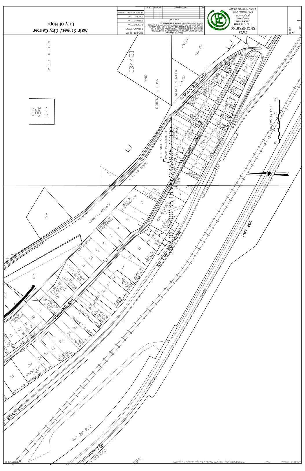
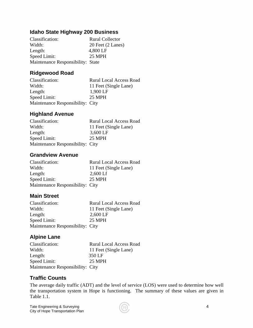
Figure 1.1 – Hope’s Existing Roads
Introduction
Purpose & Scope The City of Hope has approached Tate Engineering & Surveying to analyze the current transportation system. The purpose of this inspection is to determine the following:
• Existing traffic problems • Potential traffic problems • Sufficiency of road signs • Adequacy of current transportation facilities • Possible means of improving facilities
The scope of this transportation report shall address the findings from the analysis performed on the City of Hope’s transportation system and will include:
• Existing Conditions • Traffic Impacts • Specific Issues • Standards • Recommendations for Improvement
Existing Conditions
Road Inventory The roads of City of Hope (see figure 1.1) are as follows:
• Idaho State Highway 200 Business • Ridgewood Road • Highland Avenue • Grandview Avenue • Main Street • Alpine Lane
In the following sections, each street’s existing conditions will be described. This will include classification, width, speed limit, maintenance responsibility, traffic counts, and level of service.
Ridgewood Ave
City of Hope Road Index
Highland Ave
Alpine Lane State Highway 200 Business
Main Street Grandview Ave
N Lake Pend Oreille
Tate Engineering & Surveying 4 City of Hope Transportation Plan
Idaho State Highway 200 Business Classification: Rural Collector Width: 20 Feet (2 Lanes) Length: 4,800 LF Speed Limit: 25 MPH Maintenance Responsibility: State
Ridgewood Road Classification: Rural Local Access Road Width: 11 Feet (Single Lane) Length: 1,900 LF Speed Limit: 25 MPH Maintenance Responsibility: City
Highland Avenue Classification: Rural Local Access Road Width: 11 Feet (Single Lane) Length: 3,600 LF Speed Limit: 25 MPH Maintenance Responsibility: City
Grandview Avenue Classification: Rural Local Access Road Width: 11 Feet (Single Lane) Length: 2,600 Lf Speed Limit: 25 MPH Maintenance Responsibility: City
Main Street Classification: Rural Local Access Road Width: 11 Feet (Single Lane) Length: 2,600 LF Speed Limit: 25 MPH Maintenance Responsibility: City
Alpine Lane Classification: Rural Local Access Road Width: 11 Feet (Single Lane) Length: 350 LF Speed Limit: 25 MPH Maintenance Responsibility: City
Traffic Counts The average daily traffic (ADT) and the level of service (LOS) were used to determine how well the transportation system in Hope is functioning. The summary of these values are given in Table 1.1.
Tate Engineering & Surveying 5 City of Hope Transportation Plan
ADT is defined as the total amount of vehicles that travel on a roadway, in both directions, on any given day. The ADT for each street is considered very low but is typical for a town of this size. Low ADT, in this case, would suggest that there is little congestion on the road. Level of Service is the other value that gives an indication of how well traffic is flowing through the system. If there is high congestion on a street or at an intersection, the rating will go down. A good grade is given to streets and intersections that are free flow and have little delay to pass through an intersection. Bad grades are given to streets that have unstable flow or vehicles require a considerable amount of time to pass through an intersection. Because Hope is small, ADT is small and as a result, LOS is good. However, Hope’s system has a good chance of getting bad LOS grades with very low ADTs. The cause of this problem is from narrow one-lane roads. If too many vehicles travel on a single lane road, there will be a spike in delay (drivers having to pull over and wait for the passerby). If LOS for roads and intersections are of good grades, the transportation system is working well. In Hope’s case, if population or number of vehicles increases, provisions will need to be made to help eminent new congestion and increased delay.
Table 1.1 – Traffic Counts
Road ADT LOS
SH 200 B 102 veh/day A Ridgewood Road 20 veh/day A Highland Avenue 28 veh/day A Grandview Avenue 52 veh/day A Main Street 82 veh/day A Alpine Lane 16 veh/day A *Traffic counts based upon number of households being served and very significantly depending upon local events, i.e. weddings, family activities, etc.
Traffic Impacts
Width & Impact on Capacity Because many of the roads in Hope are one-lane in width, the capacity that each road can handle is extremely limited. Capacity is defined as the volume of cars over a period per lane. Because both direction of travel are shared by one lane, the road could never come close to reaching capacity. By widening the majority of roads in Hope, many of the roads could handle more vehicles in the future. As for now, only a handful of cars can travel on each road at a time, safely.
Development Currently, the roads in Hope have many issues but for the most part, citizens are able to get around despite the frequent delays, one-lane streets, and other potentially dangerous problems.
Tate Engineering & Surveying 6 City of Hope Transportation Plan
Because the population of Hope is small, these issues are not as prominent as they would be if Hope were a larger town. If future development graces its presence in Hope, the population will rise, and the volume on roads could increase, causing frequent problems. With proper design and planning, future development and traffic volume increase can be managed.
Tourism & Recreation The City of Hope lies on a mountainside, on the north side of Lake Pend Oreille. Here, outdoor enthusiasts come to the area from all over to boat, fish, camp, hike, cycle, swim, shop, and just enjoy the natural beauty of the area. With the popularity of Sandpoint (Bonner County Seat) and Lake Pend Oreille increasing, tourism and recreation in the surrounding areas is increasing. With tourism and recreation increasing, Hope could experience increased volume on many of the local roads. Proper planning and design can allow many vacationers to visit while keeping traffic problems to a minimum for local residents.
Specific Issues
Pedestrian Access Across town, pedestrian access consists of sharing the same narrow roads with vehicles. In a few places, there are pedestrian stairs that bypass the roads. These stairs are only bypassing a couple of streets and does not alleviate the problem much. While designing the alternatives for the Hope transportation system, pedestrian mobility and safety will be emphasized. There is an emphasis on providing pedestrian access to the boat launch area as this is being developed as a park.
Business District Parking One concern the City of Hope had with their transportation system was with the lack of parking available for their businesses. SH 200 B allows great access to much of the business district in Hope but it limits parking to businesses because it is against a steep grade and provides no shoulder. The only parking available is parallel parking in front of each business. A small amount of 60° parking is available where SH 200 B meanders slightly, (located near the Main Street and SH 200 B intersection), but it is still not enough for the use by businesses and visitors. When looking into design alternatives for the City of Hope, focus was placed on maximizing parking available to the central business district while creating and maintaining driver and pedestrian safety.
Grandview Avenue Grandview Avenue is viewed as the road in Hope that is most in need of repair. It has one lane that is very narrow, is located near the edge of a steep hillside, and has been found to be
Tate Engineering & Surveying 7 City of Hope Transportation Plan
experiencing fill failure. Fill failure on a road means that the ability for the ground to carry the load of the pavement and all vehicles that drive on the pavement is diminishing slowly and it is unable to hold the road in place. To fix this problem, Grandview Avenue would have to be completely reconstructed. The fill underneath the road would have to either be repaired with compaction or have some of the old fill removed and be replaced with more suitable fill. Each of the alternatives for improvement will focus on this road, so that it is safer and a more effective road for drivers.
Ridgewood Street Ridgewood Street is considered the second in line for needing repair. Like Grandview, the road is one-lane and very narrow, and is on the edge of a steep hillside. Ridgewood, unlike Grandview, has satisfactory fill and will carry loads effectively. Each of the design alternatives will discuss possible improvements to this road.
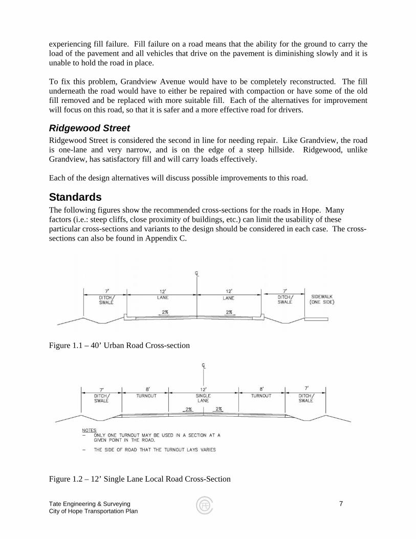
Standards The following figures show the recommended cross-sections for the roads in Hope. Many factors (i.e.: steep cliffs, close proximity of buildings, etc.) can limit the usability of these particular cross-sections and variants to the design should be considered in each case. The cross-sections can also be found in Appendix C.
Figure 1.1 – 40’ Urban Road Cross-section
Figure 1.2 – 12’ Single Lane Local Road Cross-Section
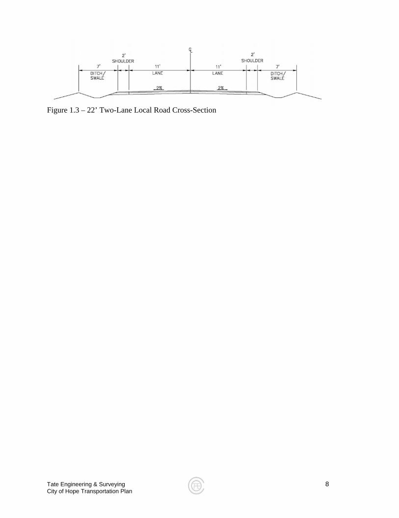
Figure 1.3 – 22’ Two-Lane Local Road Cross-Section
Tate Engineering & Surveying 8 City of Hope Transportation Plan
Tate Engineering & Surveying 9 City of Hope Transportation Plan
Recommended Plan
Alternatives for Improvement Tate Engineering & Surveying took a look at the existing conditions of the City of Hope transportation system and design alternatives were devised to give the City and its citizens various choices on the direction they want to take to fix their current system. Five total design alternatives were created, each providing a plan to improve various traffic related problems. The design alternatives are as follows:
• Alternative 1: No Cost • Alternative 2: Multi-Purpose Lane on Most Streets • Alternative 3: Turn-Outs • Alternative 4: One-Way Street System • Alternative 5: Signalized System on Grandview • Alternative 6: Emergency Routes
In the following sections, each of the design alternatives presented above will be discussed in detail, and advantages, disadvantages, and a cost estimate will be presented.
Tate Engineering & Surveying 10 City of Hope Transportation Plan
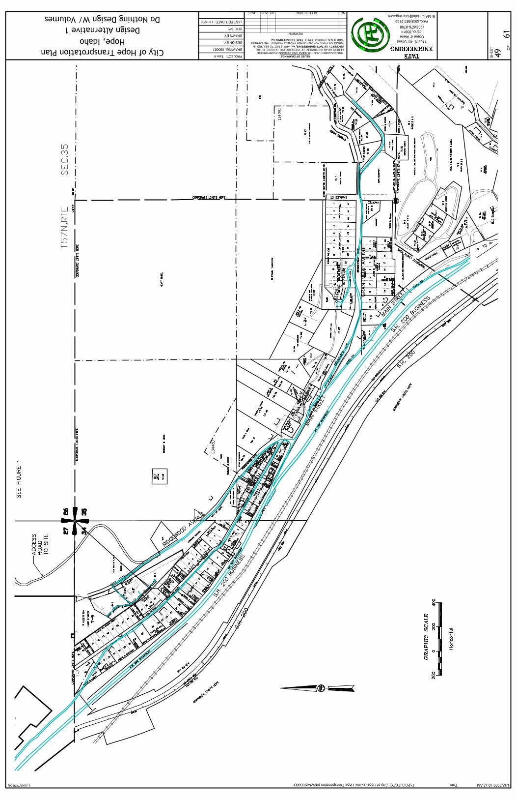
Alternative 1: No Cost
Summary With this no cost alternative, no major improvement would be made to the City’s transportation system, and minimal incurred expense. One recommended task the city should undertake is the replacement or cleaning of traffic signs according to the recommendations given in the City of Hope Sign Inventory Report (See Appendix A). By choosing this alternative, drivers traveling through the city would still experience delay caused by the lack of site distance from narrow, steep, and hilly terrain. In addition, the roads in the City of Hope are very narrow, and there are no shoulders on many of the roads. The problem with driver insecurity and the mobility of larger vehicles (mainly trucks, trailers, RVs, etc.) will remain. In the future, many costly repairs will have to be made from the narrow streets and lack of shoulders. Road degradation will occur from heavier vehicle driving on the edges of the roads. On the other hand, current traffic volumes on many of the streets in the City suggest this could be a viable option, but only for a short term. As the city grows, new traffic problems will arise, including accidents, traffic delays, and driver confusion, and changes to the transportation infrastructure will need to be considered.
Advantages • No major expenditures for construction and other transportation facilities • No impact would be made on home and business owners • No delays caused by construction or new traffic system
Disadvantages • Low pavement life expectancy due to lack of shoulders and turn-outs • Higher delay • High number of on-coming car conflicts • Least maneuverability for large vehicles
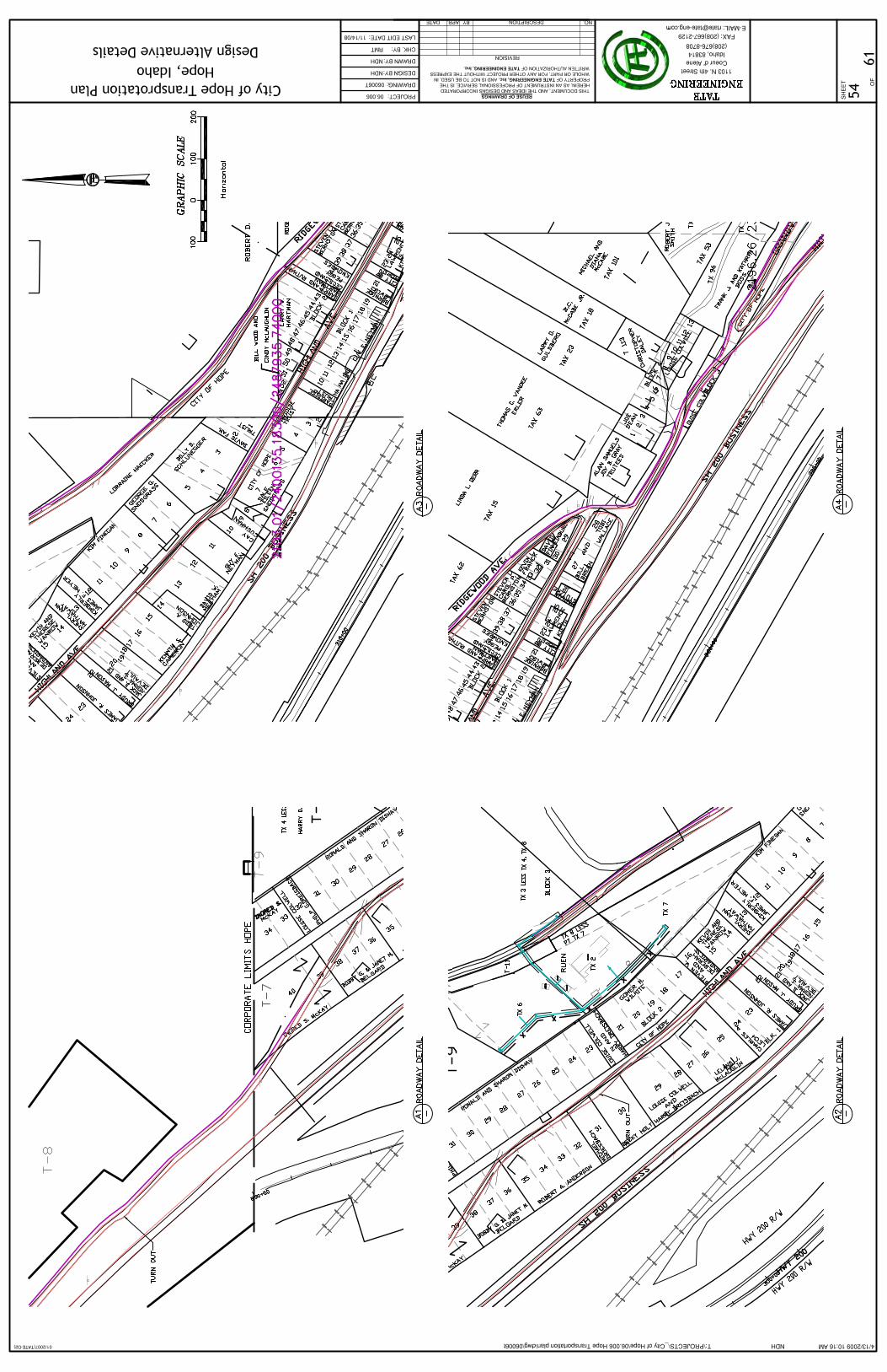
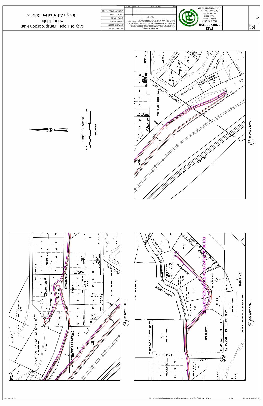
Plan of this alternative is located in Appendix B.
Tate Engineering & Surveying 11 City of Hope Transportation Plan
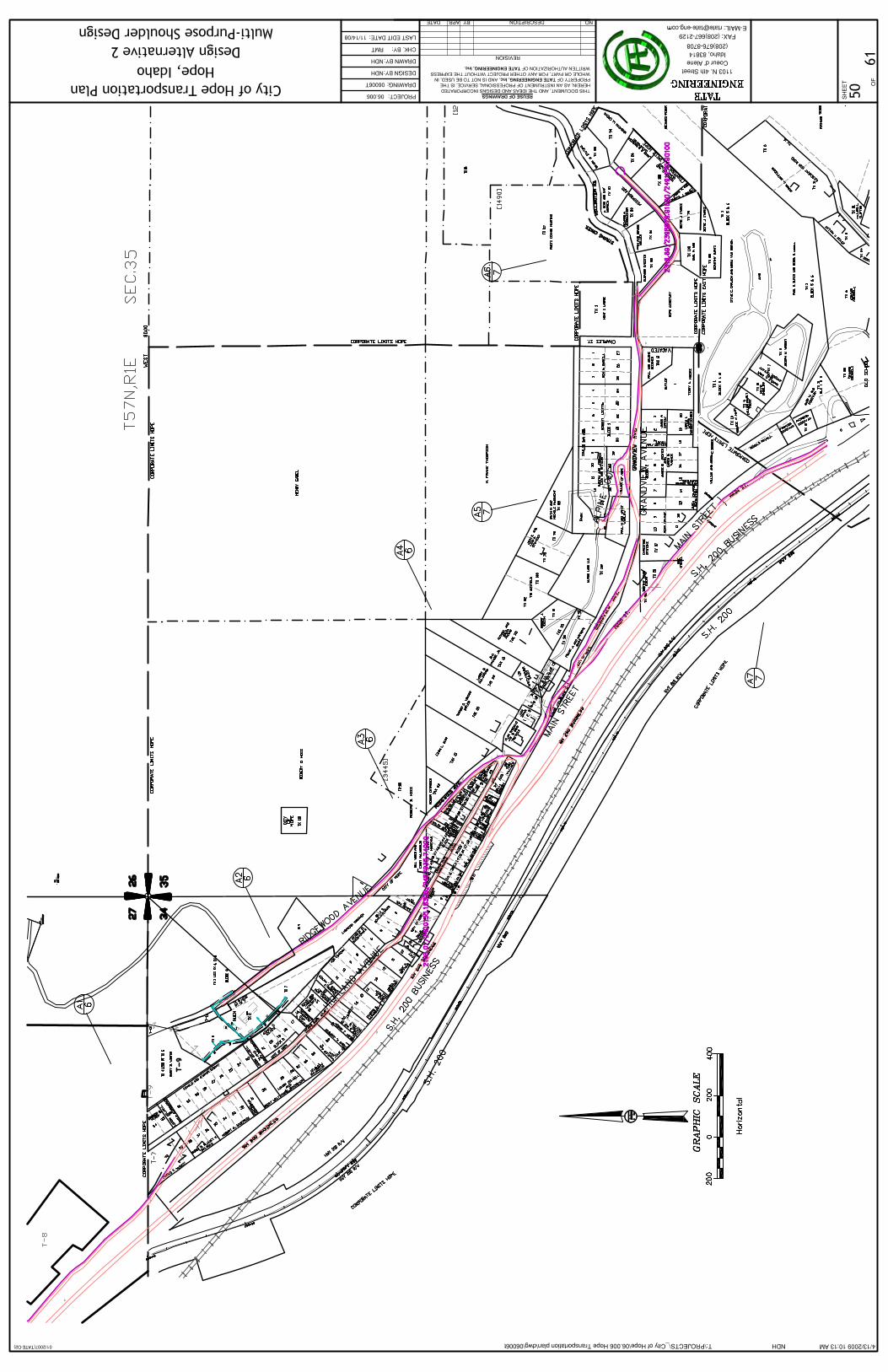
Alternative 2: Multi-Purpose Lane on Most Streets
Summary This alternative offers more maneuverability over the “No Cost” alternative. On each street in Hope, except those with the inability to be widened, will receive a wider than normal shoulders (located on the inside portion of the road or the side opposite of a cliff). These wider-than-normal shoulders (approximately 7 feet in width) would act as a multi-use lane and have two different purposes, firstly as an emergency lane (to allow turnouts), and secondly as a bike and pedestrian lane (for increased pedestrian mobility). As an emergency lane, the multi-purpose lane would allow vehicles to pull over for any oncoming vehicles. This could help reduce delay and dangers from drivers having to either maneuver out of the way of an on coming vehicle, and vehicles coming close to steep hillsides, respectively. As a bike and pedestrian lane, the multi-purpose lane would allow for increased alternatives to using a vehicle within Hope. Because posted speeds and traffic volume are low, pedestrian/bike/car conflicts will be minimal. The lane would also act as a much-needed shoulder to prevent damage to the pavement. With less damage to the edges of the road, less money will be spent on repairing the edge of the roadway and resurfacing.
Advantages • More maneuverability of larger vehicles • Greater driver confidence • Less delay • Less on-coming car conflicts • Low impact to homes and businesses
Disadvantages • High construction cost • Hillsides would need to be carved away • High construction delay possible • Limited space for road widening • Cannot widen Highland in certain places without tearing down buildings
Plan of this alternative is located in Appendix B.
Tate Engineering & Surveying 12 City of Hope Transportation Plan
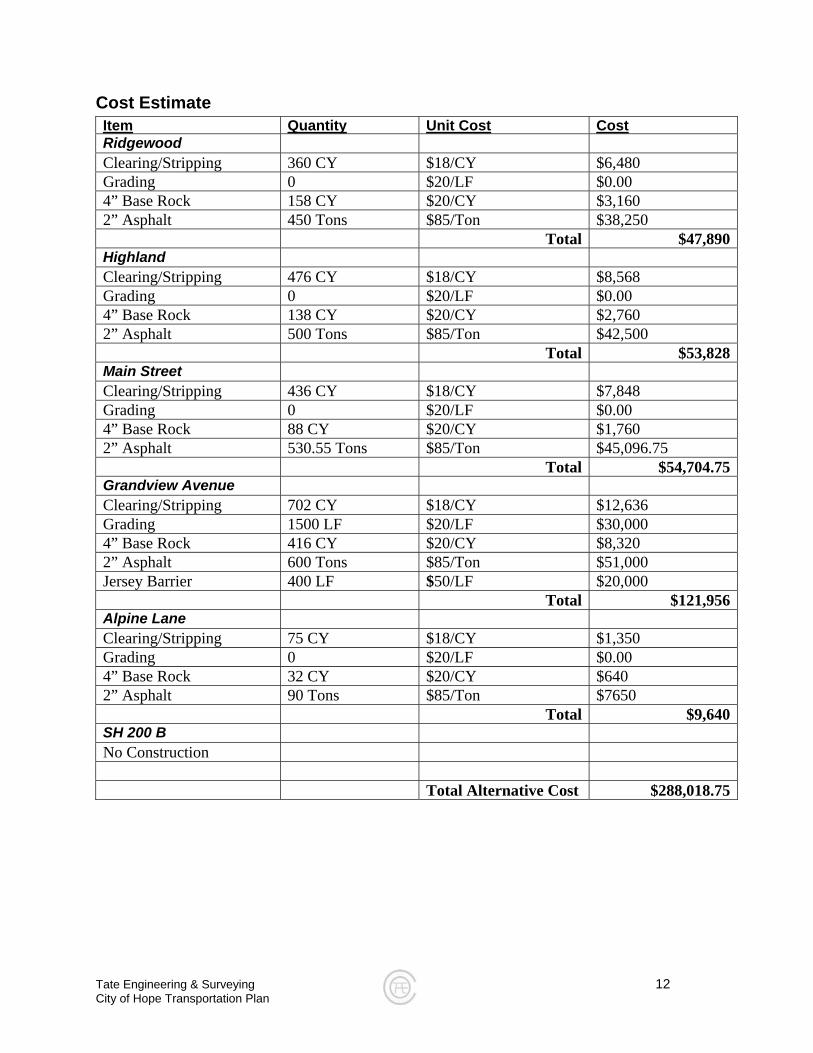
Cost Estimate Item Quantity Unit Cost Cost
Ridgewood Clearing/Stripping 360 CY $18/CY $6,480 Grading 0 $20/LF $0.00 4” Base Rock 158 CY $20/CY $3,160 2” Asphalt 450 Tons $85/Ton $38,250 Total $47,890Highland Clearing/Stripping 476 CY $18/CY $8,568 Grading 0 $20/LF $0.00 4” Base Rock 138 CY $20/CY $2,760 2” Asphalt 500 Tons $85/Ton $42,500 Total $53,828Main Street Clearing/Stripping 436 CY $18/CY $7,848 Grading 0 $20/LF $0.00 4” Base Rock 88 CY $20/CY $1,760 2” Asphalt 530.55 Tons $85/Ton $45,096.75 Total $54,704.75Grandview Avenue Clearing/Stripping 702 CY $18/CY $12,636 Grading 1500 LF $20/LF $30,000 4” Base Rock 416 CY $20/CY $8,320 2” Asphalt 600 Tons $85/Ton $51,000 Jersey Barrier 400 LF $50/LF $20,000 Total $121,956Alpine Lane Clearing/Stripping 75 CY $18/CY $1,350 Grading 0 $20/LF $0.00 4” Base Rock 32 CY $20/CY $640 2” Asphalt 90 Tons $85/Ton $7650 Total $9,640SH 200 B No Construction Total Alternative Cost $288,018.75
Tate Engineering & Surveying 13 City of Hope Transportation Plan
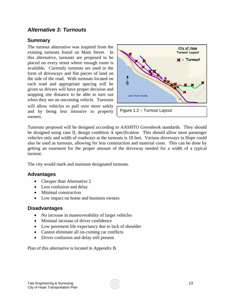
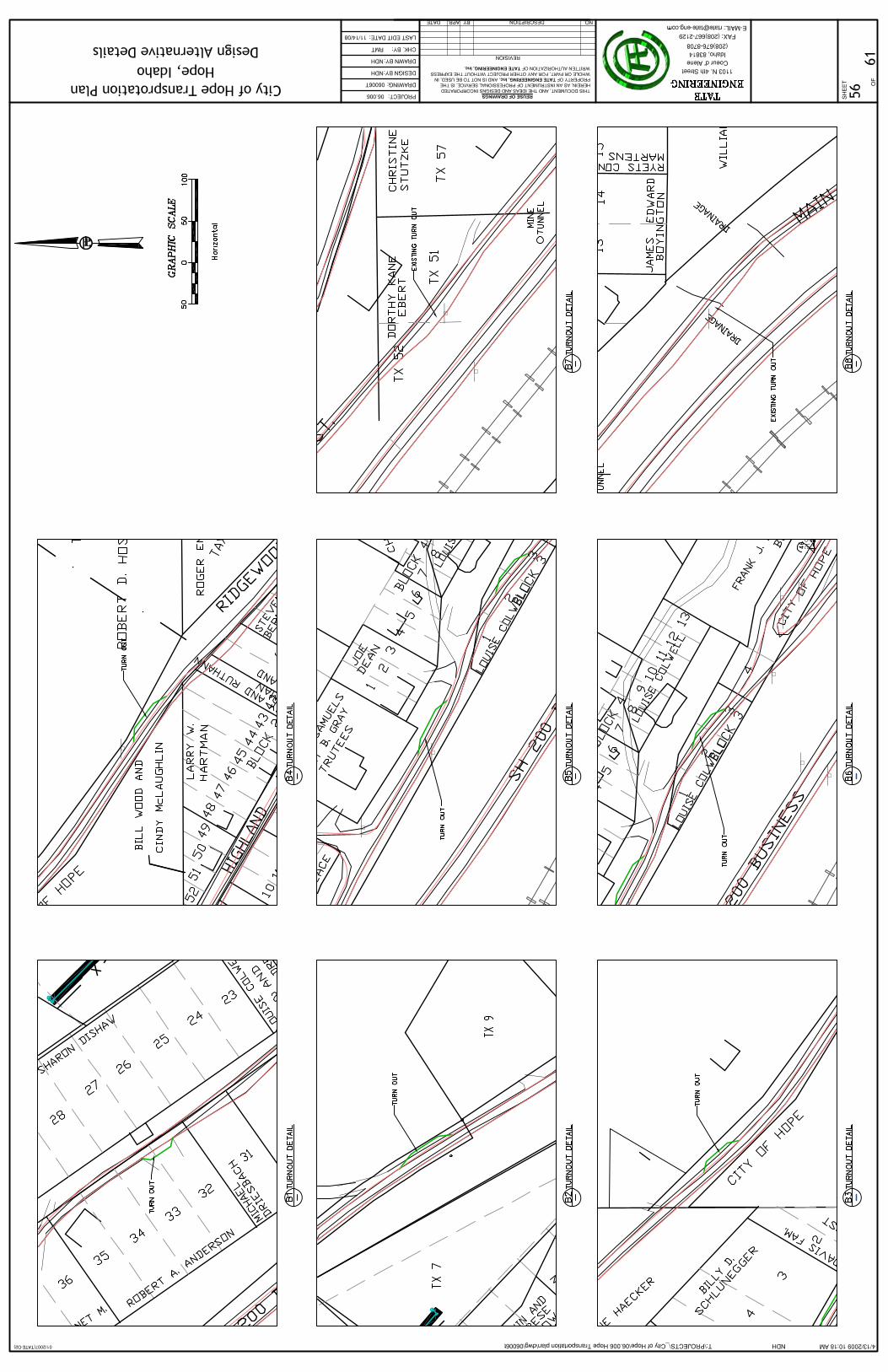
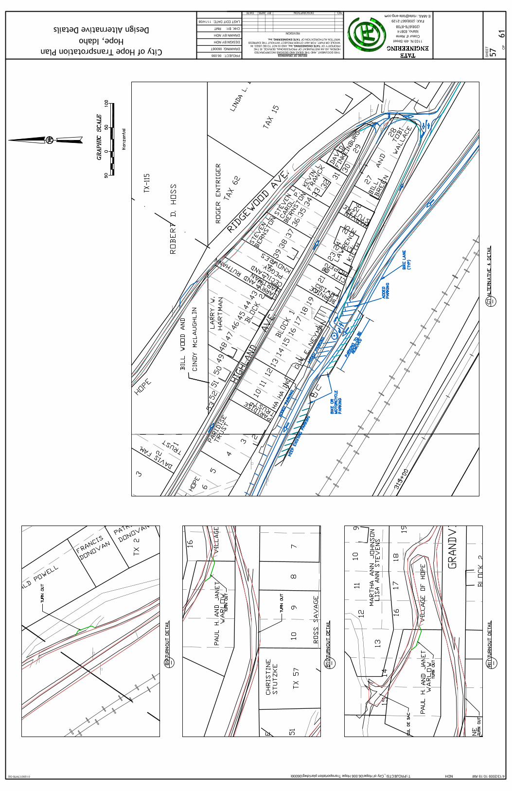
Figure 1.2 – Turnout Layout
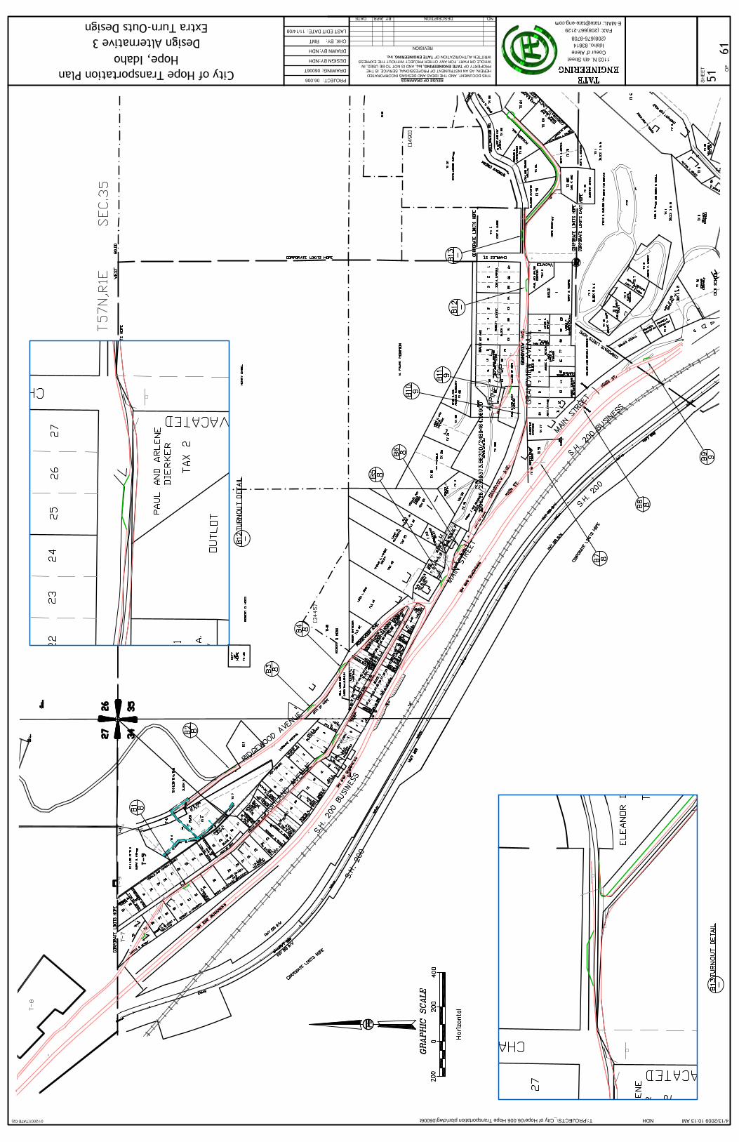
Alternative 3: Turnouts
Summary The turnout alternative was inspired from the existing turnouts found on Main Street. In this alternative, turnouts are proposed to be placed on every street where enough room is available. Currently turnouts are used in the form of driveways and flat pieces of land on the side of the road. With turnouts located on each road and appropriate spacing will be given so drivers will have proper decision and stopping site distance to be able to turn out when they see an oncoming vehicle. Turnouts will allow vehicles to pull over more safely and by being less intrusive to property owners. Turnouts proposed will be designed according to AASHTO Greenbook standards. They should be designed using case II, design condition A specification. This should allow most passenger vehicles only and width of roadways at the turnouts is 18 feet. Various driveways in Hope could also be used as turnouts, allowing for less construction and material costs. This can be done by getting an easement for the proper amount of the driveway needed for a width of a typical turnout. The city would mark and maintain designated turnouts.
Advantages • Cheaper than Alternative 2 • Less confusion and delay • Minimal construction • Low impact on home and business owners
Disadvantages • No increase in maneuverability of larger vehicles • Minimal increase of driver confidence • Low pavement life expectancy due to lack of shoulder • Cannot eliminate all on-coming car conflicts • Driver confusion and delay still present
Plan of this alternative is located in Appendix B.
City of Hope Turnout Layout
- Turnout
Lake Pend Oreille
N
Tate Engineering & Surveying 14 City of Hope Transportation Plan
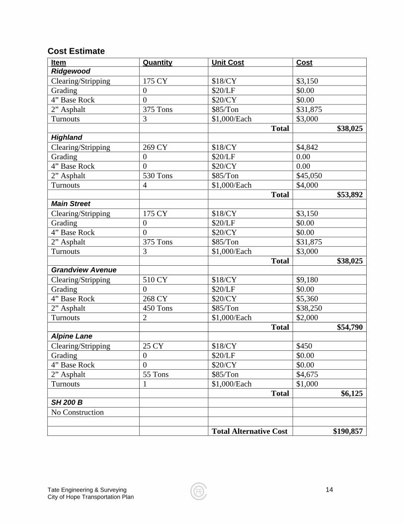
Cost Estimate Item Quantity Unit Cost Cost
Ridgewood Clearing/Stripping 175 CY $18/CY $3,150 Grading 0 $20/LF $0.00 4” Base Rock 0 $20/CY $0.00 2” Asphalt 375 Tons $85/Ton $31,875 Turnouts 3 $1,000/Each $3,000 Total $38,025Highland Clearing/Stripping 269 CY $18/CY $4,842 Grading 0 $20/LF 0.00 4” Base Rock 0 $20/CY 0.00 2” Asphalt 530 Tons $85/Ton $45,050 Turnouts 4 $1,000/Each $4,000 Total $53,892Main Street Clearing/Stripping 175 CY $18/CY $3,150 Grading 0 $20/LF $0.00 4” Base Rock 0 $20/CY $0.00 2” Asphalt 375 Tons $85/Ton $31,875 Turnouts 3 $1,000/Each $3,000 Total $38,025Grandview Avenue Clearing/Stripping 510 CY $18/CY $9,180 Grading 0 $20/LF $0.00 4” Base Rock 268 CY $20/CY $5,360 2” Asphalt 450 Tons $85/Ton $38,250 Turnouts 2 $1,000/Each $2,000 Total $54,790Alpine Lane Clearing/Stripping 25 CY $18/CY $450 Grading 0 $20/LF $0.00 4” Base Rock 0 $20/CY $0.00 2” Asphalt 55 Tons $85/Ton $4,675 Turnouts 1 $1,000/Each $1,000 Total $6,125SH 200 B No Construction Total Alternative Cost $190,857

Figure 1.2 – One Way Streets
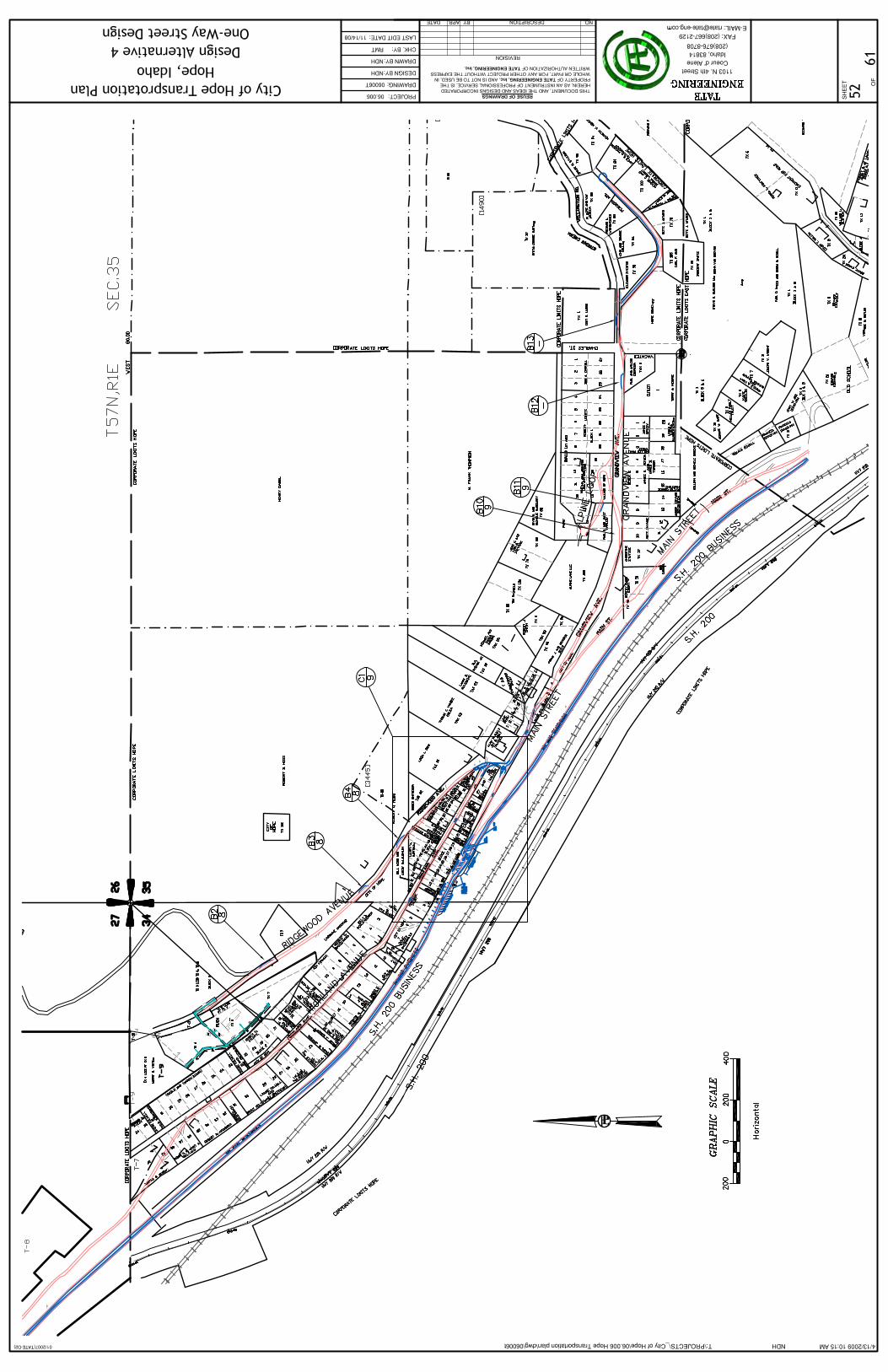
Alternative 4: One-Way Street System
Summary Because Highland and Main run parallel to SH 200 Business, it can be possible to make these streets along with SH 200 Business into one-way streets. In this alternative, SH 200 B would be turned into a one-way street going southeast. Because SH 200 B is a two-lane road currently, one of the lanes would be converted into parking, bike/pedestrian lane, and/or increased shoulder space (which in some areas along the road, there is not any). The combination of Highland and Main Streets would be the other one-way street running northwest. Two intersections in Hope would be changed. They are as follows:
• Intersection of Highland Avenue and Main Street • Intersection of SH 200 B and Main Street
The intersection at Main and Highland would be redesigned to allow a straighter alignment between the two streets. The remaining piece of Main Street that connects to SH 200 B will become a connector between the couplet streets. The one-way streets merge at two places. First at the turn off from SH 200 and the other is in East Hope. Because the terminus of Highland/Main and SH 200 B is in East Hope, some complications could arise because cooperation would have to be established with the City of East Hope and the County. All parties would have to agree on any proposed changes that would be made to the streets in their jurisdiction.
Advantages: • Increased maneuverability for every mode of transportation • Minimal impact to home and business owners • Little on-coming car conflicts • Creation of bike & pedestrian lane, extra parking, and shoulder on SH 200 B
Disadvantages • Could cause long trips for some motorists heading towards Grandview • Drivers might get lost • One turn around point (not including the ones at each end of the loop) • Central turn-around cannot handle two-way traffic or left turns onto SH 200 B • Could affect business performance in a negative way • Has some impact on business and home owners • Increased number of parties involved with planning and construction
City of Hope SH 200 B &
Ridgewood/Main
Connector Street
Ridgewood/Main
SH 200 B
N
Tate Engineering & Surveying 15 City of Hope Transportation Plan
Tate Engineering & Surveying 16 City of Hope Transportation Plan
• Does not solve problems with other streets; other alternatives would need to be considered
Plan of this alternative is located in Appendix B.
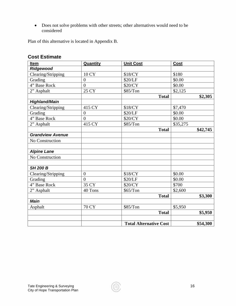
Cost Estimate Item Quantity Unit Cost Cost
Ridgewood Clearing/Stripping 10 CY $18/CY $180 Grading 0 $20/LF $0.00 4” Base Rock 0 $20/CY $0.00 2” Asphalt 25 CY $85/Ton $2,125 Total $2,305Highland/Main Clearing/Stripping 415 CY $18/CY $7,470 Grading 0 $20/LF $0.00 4” Base Rock 0 $20/CY $0.00 2” Asphalt 415 CY $85/Ton $35,275 Total $42,745Grandview Avenue No Construction Alpine Lane No Construction SH 200 B Clearing/Stripping 0 $18/CY $0.00 Grading 0 $20/LF $0.00 4” Base Rock 35 CY $20/CY $700 2” Asphalt 40 Tons $65/Ton $2,600 Total $3,300Main Asphalt 70 CY $85/Ton $5,950 Total $5,950 Total Alternative Cost $54,300
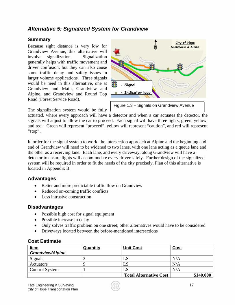
Figure 1.3 – Signals on Grandview Avenue
Alternative 5: Signalized System for Grandview
Summary Because sight distance is very low for Grandview Avenue, this alternative will involve signalization. Signalization generally helps with traffic movement and driver confusion, but they can also cause some traffic delay and safety issues in larger volume applications. Three signals would be need in this alternative, one at Grandview and Main, Grandview and Alpine, and Grandview and Round Top Road (Forest Service Road). The signalization system would be fully actuated, where every approach will have a detector and when a car actuates the detector, the signals will adjust to allow the car to proceed. Each signal will have three lights, green, yellow, and red. Green will represent “proceed”, yellow will represent “caution”, and red will represent “stop”. In order for the signal system to work, the intersection approach at Alpine and the beginning and end of Grandview will need to be widened to two lanes, with one lane acting as a queue lane and the other as a receiving lane. Each lane, and every driveway, along Grandview will have a detector to ensure lights will accommodate every driver safely. Further design of the signalized system will be required in order to fit the needs of the city precisely. Plan of this alternative is located in Appendix B.
Advantages • Better and more predictable traffic flow on Grandview • Reduced on-coming traffic conflicts • Less intrusive construction
Disadvantages • Possible high cost for signal equipment • Possible increase in delay • Only solves traffic problem on one street; other alternatives would have to be considered • Driveways located between the before-mentioned intersections
Cost Estimate Item
N City of Hope
Grandview & Alpine
- Signal
- Indicator loop
Tate Engineering & Surveying 17 City of Hope Transportation Plan
Quantity Unit Cost Cost
Grandview/Alpine Signals 3 LS N/A Actuators 9 LS N/A Control System 1 LS N/A Total Alternative Cost $140,000
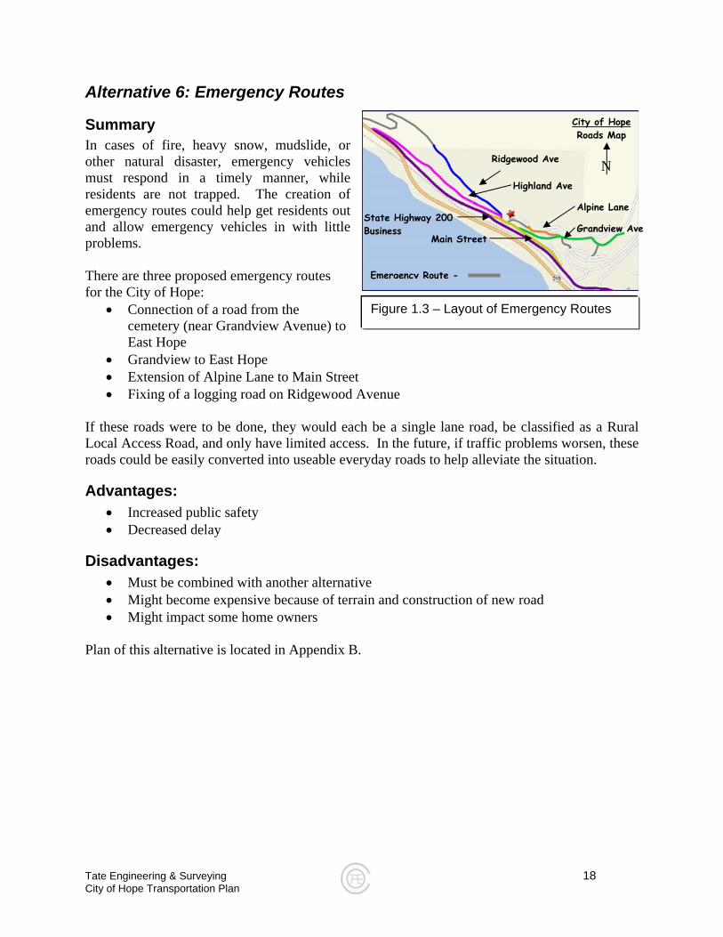
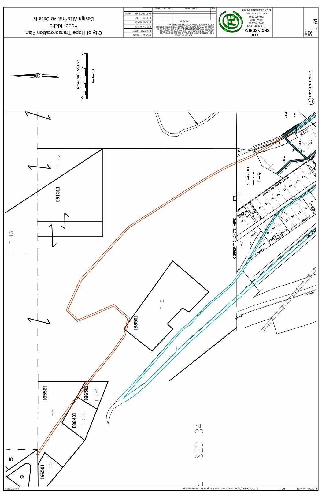
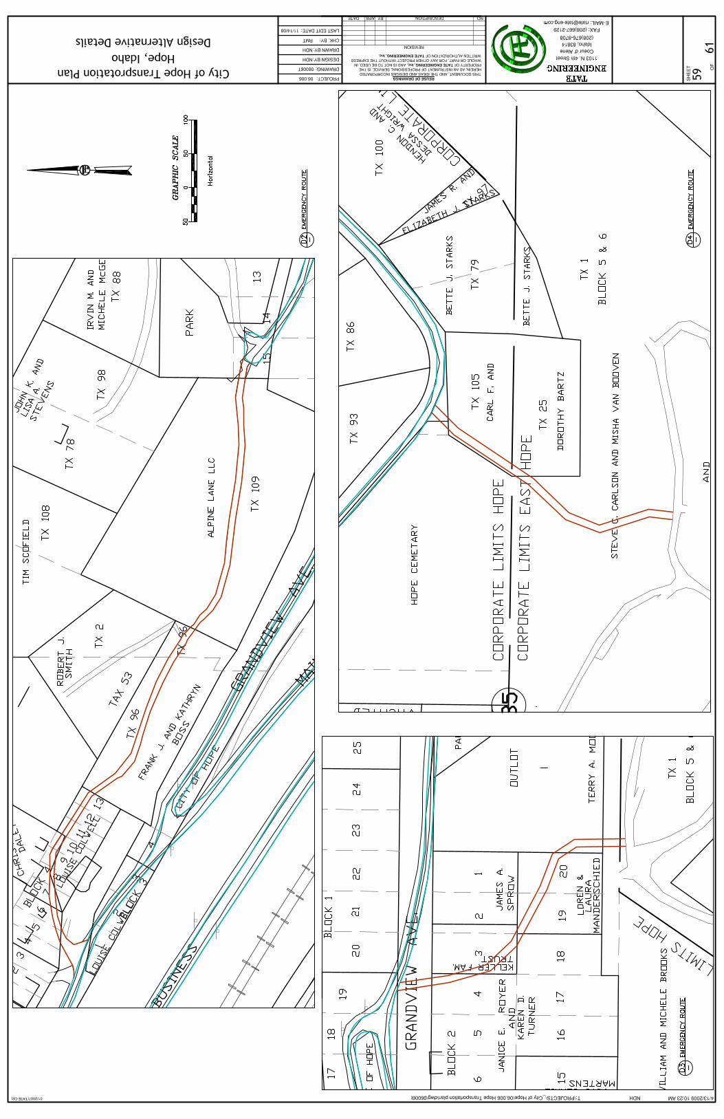
Figure 1.3 – Layout of Emergency Routes
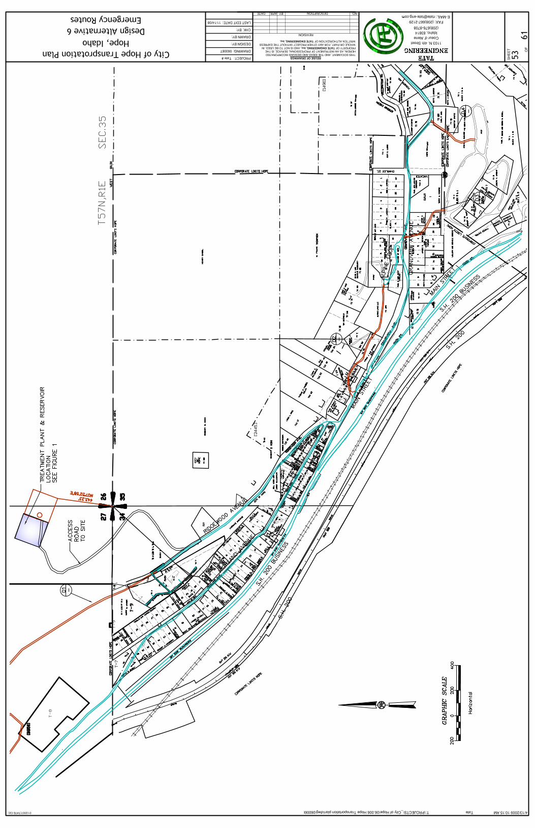
Alternative 6: Emergency Routes
Summary In cases of fire, heavy snow, mudslide, or other natural disaster, emergency vehicles must respond in a timely manner, while residents are not trapped. The creation of emergency routes could help get residents out and allow emergency vehicles in with little problems. There are three proposed emergency routes for the City of Hope:
• Connection of a road from the cemetery (near Grandview Avenue) to East Hope
• Grandview to East Hope • Extension of Alpine Lane to Main Street • Fixing of a logging road on Ridgewood Avenue
If these roads were to be done, they would each be a single lane road, be classified as a Rural Local Access Road, and only have limited access. In the future, if traffic problems worsen, these roads could be easily converted into useable everyday roads to help alleviate the situation.
Advantages: • Increased public safety • Decreased delay
Disadvantages: • Must be combined with another alternative • Might become expensive because of terrain and construction of new road • Might impact some home owners
Plan of this alternative is located in Appendix B.
Ridgewood Ave
Highland Ave
State Highway 200 Business
Alpine Lane
Grandview Ave
City of Hope Roads Map
Emergency Route -
Main Street
N
Tate Engineering & Surveying 18 City of Hope Transportation Plan
Tate Engineering & Surveying 19 City of Hope Transportation Plan
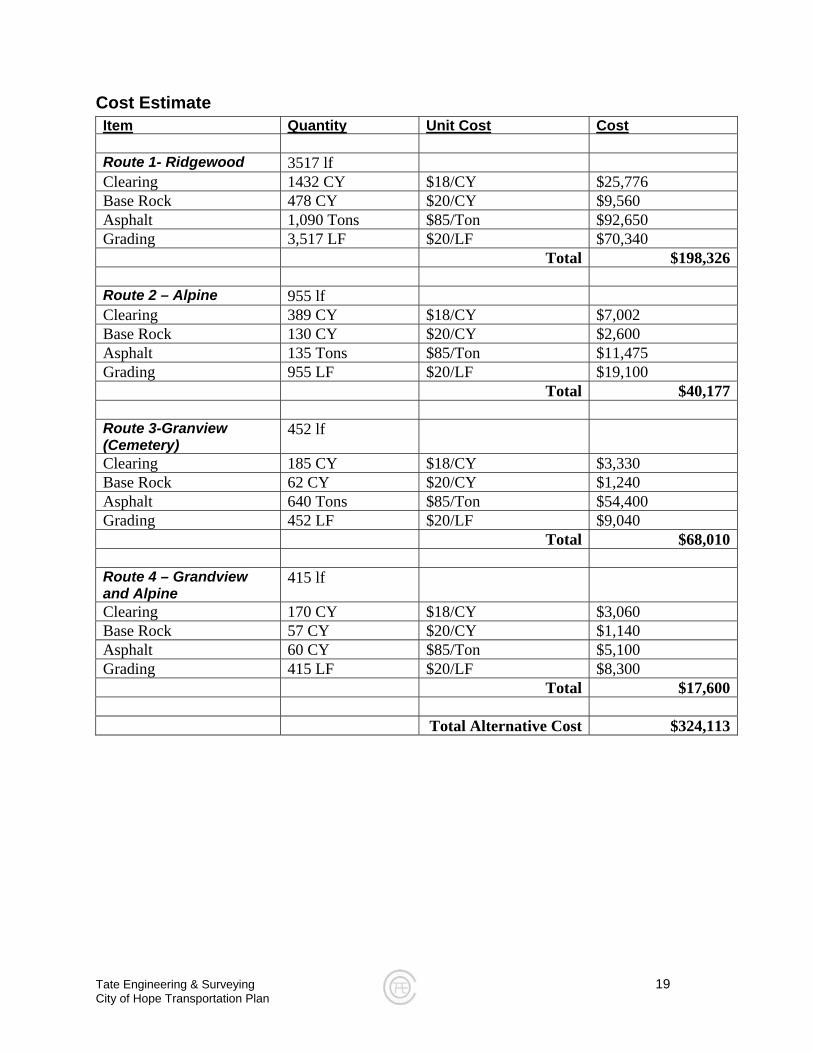
Cost Estimate Item Quantity Unit Cost Cost
Route 1- Ridgewood 3517 lf Clearing 1432 CY $18/CY $25,776 Base Rock 478 CY $20/CY $9,560 Asphalt 1,090 Tons $85/Ton $92,650 Grading 3,517 LF $20/LF $70,340 Total $198,326 Route 2 – Alpine 955 lf Clearing 389 CY $18/CY $7,002 Base Rock 130 CY $20/CY $2,600 Asphalt 135 Tons $85/Ton $11,475 Grading 955 LF $20/LF $19,100 Total $40,177 Route 3-Granview (Cemetery)
452 lf
Clearing 185 CY $18/CY $3,330 Base Rock 62 CY $20/CY $1,240 Asphalt 640 Tons $85/Ton $54,400 Grading 452 LF $20/LF $9,040 Total $68,010 Route 4 – Grandview and Alpine
415 lf
Clearing 170 CY $18/CY $3,060 Base Rock 57 CY $20/CY $1,140 Asphalt 60 CY $85/Ton $5,100 Grading 415 LF $20/LF $8,300 Total $17,600 Total Alternative Cost $324,113
Tate Engineering & Surveying 20 City of Hope Transportation Plan
Conclusion/Discussion
Selected Plan of Action After much discussion with city officials, residents, and business owners, a proposed plan for correcting the City of Hope’s traffic problems was pieced together. The consensus was:
• Turnouts should be used on all one-lane streets (Alternative 3) • Bike and pedestrian traffic should be considered in downtown area • Development of Emergency Routes (Alternative 6)
Construction Priorities Before any major constructions commences, a meeting should be held with city officials, contractor, engineer, and residents and discuss a plan to allow construction to occur while vehicles can travel on the roadways being constructed. Once a construction plan is created, Grandview reconstruction and turnout construction can start. All new utility work should be considered for construction at this time. Striping should be applied at the end of construction and road signs should be added where necessary. Provisions given in the road sign inventory should also be considered at this time.
Budgeting With the adoption of the Plan of Action above, the City of Hope should allocate $436,542 for materials cost, and secure extra funding for contingency.

Tate Engineering & Surveying 21 City of Hope Transportation Plan
Appendix A
City of Hope Sign Inventory Report
Tate Engineering & Surveying 1103 N. 4th Street Coeur D’ Alene, Idaho 83814
Phone: 208.676.8708 Fax: 208.667.2129
City of Hope, Idaho
Sign Inventory
Assembled By:
Nathan D. Herbst, E.I.T.
April 13, 2009
Tate Engineering & Surveying 22 City of Hope Transportation Plan
Tate Engineering & Surveying 23 City of Hope Transportation Plan
Table of Contents Notes ..........................................................................................................................................................24 Dead End Sign...........................................................................................................................................25 Road Closed ¾ Mile Sign .........................................................................................................................25 Slow 20 Mph (Children) Sign....................................................................................................................26 Cemetery Entrance Sign...........................................................................................................................26 Street Name (Grandview & Alpine) Sign.................................................................................................27 Road Ends Sign.........................................................................................................................................27 Yield Sign...................................................................................................................................................28 Speed Limit Sign .......................................................................................................................................28 Dead End Sign...........................................................................................................................................29 Hope Cemetery Sign .................................................................................................................................29 Street Name (Main & Grandview) & Hope Cemetery Sign ....................................................................30 No Parking Anytime Sign .........................................................................................................................30 No Parking Anytime Sign .........................................................................................................................31 Street Name (Main Street), Stop, & Hope Cemetery Sign .....................................................................32 Speed Limit Sign .......................................................................................................................................33 Slow 20 Mph (Children) Sign....................................................................................................................33 Street Name (Main Street) Sign ...............................................................................................................34 Street Name (Highland Ave.) Sign...........................................................................................................34 Street Name (Ridgewood) Sign ...............................................................................................................35 Speed Limit & Not a Through Street Sign ..............................................................................................35 Yield Sign...................................................................................................................................................36 Speed Limit Sign .......................................................................................................................................36 Watch For Children Sign ..........................................................................................................................37 Speed Limit & Hope Cemetery Sign........................................................................................................37 Speed Limit Sign .......................................................................................................................................38 Stop & No Left Turn Sign .........................................................................................................................38 Hope Cemetery Sign .................................................................................................................................39 Street Name (Main) Sign...........................................................................................................................39 Do Not Block Driveway Sign....................................................................................................................40 Speed Limit Sign .......................................................................................................................................40 Mile Marker Sign........................................................................................................................................41 Stop Ahead Sign .......................................................................................................................................41 Business, Arrow, & Sign Street Name (Highland) Sign ........................................................................42 City Limits, Speed Limit, & Special Zoning Sign ...................................................................................43 Speed Limit Sign .......................................................................................................................................44 Speed Limit Sign .......................................................................................................................................44 State Highway Sign W/ Business Designation.......................................................................................45 E. Hope City Limits, Speed Limit, & Special Permits Sign ...................................................................46 Point of Interest, Historical Site, Speed Limit, & Special Permits Sign...............................................47
Tate Engineering & Surveying 24 City of Hope Transportation Plan
Notes
• Tests should be performed on each sign to determine their visibility at night (luminescence). If a sign can not be seen adequately at night under normal conditions, the sign then must be reoriented or replaced.
• Many traffic signs can become dusty and dirty over many years of use; therefore,
each sign should be cleaned to allow better reflection of light.
• Each sign should be inspected to ensure proper connection to post, and posts should be inspected and replaced when they have been subjected to long-term climate conditions or damage from vehicles.
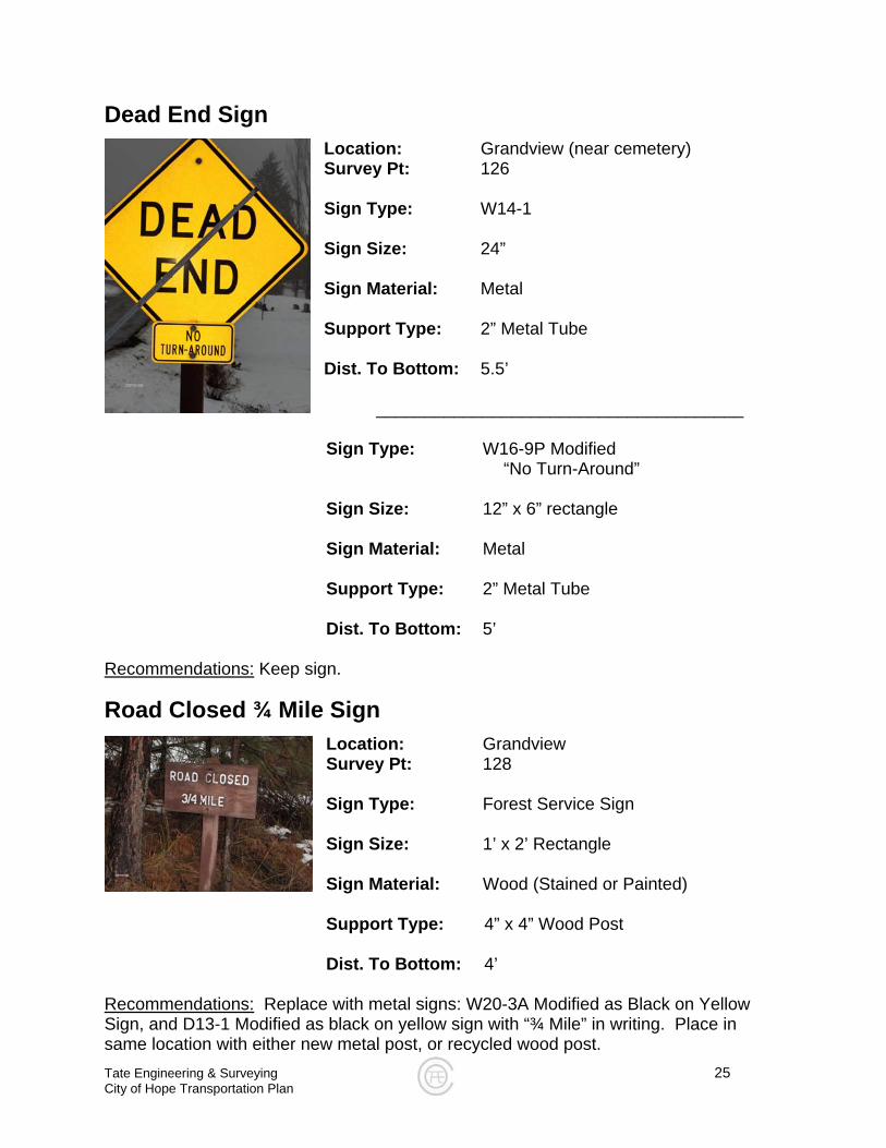
Dead End Sign Location: Grandview (near cemetery) Survey Pt: 126 Sign Type: W14-1 Sign Size: 24” Sign Material: Metal Support Type: 2” Metal Tube Dist. To Bottom: 5.5’ ______________________________________
Sign Type: W16-9P Modified “No Turn-Around” Sign Size: 12” x 6” rectangle Sign Material: Metal Support Type: 2” Metal Tube Dist. To Bottom: 5’
Recommendations:
Keep sign.
Road Closed ¾ Mile Sign Location: Grandview Survey Pt: 128 Sign Type: Forest Service Sign Sign Size: 1’ x 2’ Rectangle Sign Material: Wood (Stained or Painted)
Support Type: 4” x 4” Wood Post Dist. To Bottom: 4’
Recommendations:
Replace with metal signs: W20-3A Modified as Black on Yellow Sign, and D13-1 Modified as black on yellow sign with “¾ Mile” in writing. Place in same location with either new metal post, or recycled wood post. Tate Engineering & Surveying 25 City of Hope Transportation Plan
Tate Engineering & Surveying 26 City of Hope Transportation Plan
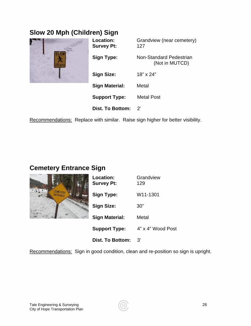
Slow 20 Mph (Children) Sign Location: Grandview (near cemetery)
Survey Pt: 127
Sign Type: Non-Standard Pedestrian (Not in MUTCD)
Sign Size: 18” x 24”
Sign Material: Metal Support Type: Metal Post Dist. To Bottom: 2’
Recommendations: Replace with similar. Raise sign higher for better visibility.
Cemetery Entrance Sign
Location: Grandview Survey Pt: 129 Sign Type: W11-1301 Sign Size: 30” Sign Material: Metal
Support Type: 4” x 4” Wood Post Dist. To Bottom: 3’
Recommendations: Sign in good condition, clean and re-position so sign is upright.
Tate Engineering & Surveying 27 City of Hope Transportation Plan
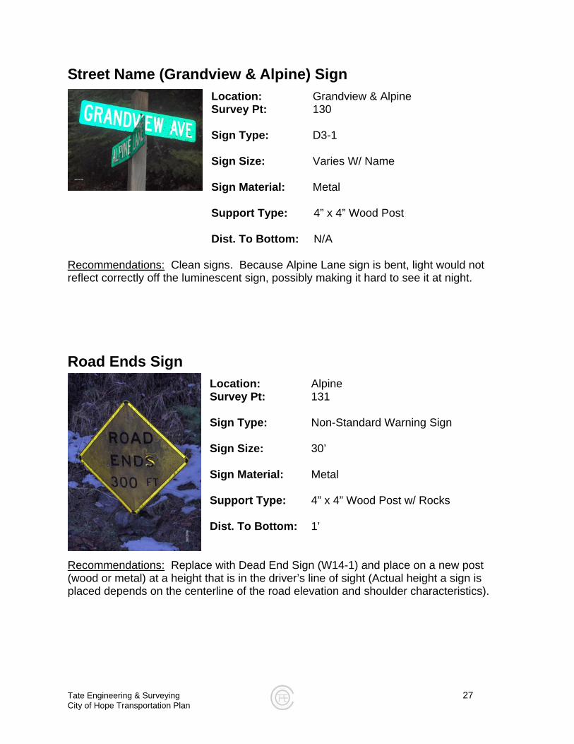
Street Name (Grandview & Alpine) Sign
Location: Grandview & Alpine Survey Pt: 130 Sign Type: D3-1 Sign Size: Varies W/ Name Sign Material: Metal
Support Type: 4” x 4” Wood Post Dist. To Bottom: N/A
Recommendations: Clean signs. Because Alpine Lane sign is bent, light would not reflect correctly off the luminescent sign, possibly making it hard to see it at night.
Road Ends Sign
Location: Alpine Survey Pt: 131 Sign Type: Non-Standard Warning Sign Sign Size: 30’ Sign Material: Metal Support Type: 4” x 4” Wood Post w/ Rocks Dist. To Bottom: 1’
Recommendations: Replace with Dead End Sign (W14-1) and place on a new post (wood or metal) at a height that is in the driver’s line of sight (Actual height a sign is placed depends on the centerline of the road elevation and shoulder characteristics).
Tate Engineering & Surveying 28 City of Hope Transportation Plan
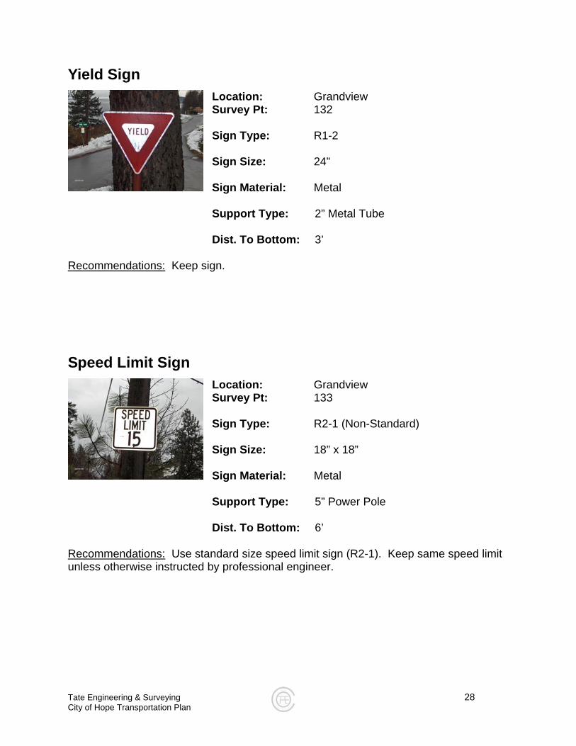
Yield Sign Location: Grandview Survey Pt: 132 Sign Type: R1-2 Sign Size: 24” Sign Material: Metal
Support Type: 2” Metal Tube Dist. To Bottom: 3’
Recommendations:
Keep sign.
Speed Limit Sign Location: Grandview Survey Pt: 133 Sign Type: R2-1 (Non-Standard) Sign Size: 18” x 18” Sign Material: Metal
Support Type: 5” Power Pole Dist. To Bottom: 6’
Recommendations:
Use standard size speed limit sign (R2-1). Keep same speed limit unless otherwise instructed by professional engineer.
Tate Engineering & Surveying 29 City of Hope Transportation Plan
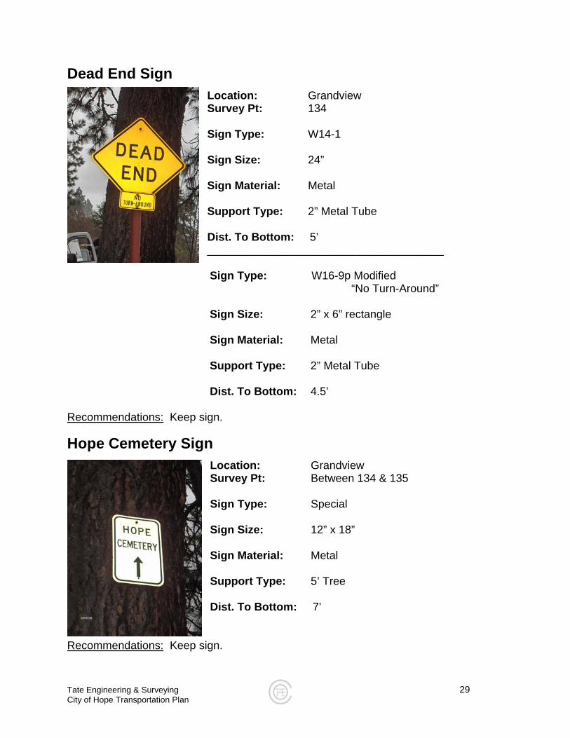
Dead End Sign
Location: Grandview Survey Pt: 134 Sign Type: W14-1 Sign Size: 24” Sign Material: Metal Support Type: 2” Metal Tube Dist. To Bottom: 5’ ______________________________________ Sign Type: W16-9p Modified “No Turn-Around” Sign Size: 2” x 6” rectangle Sign Material: Metal Support Type: 2” Metal Tube Dist. To Bottom: 4.5’
Recommendations: Keep sign.
Hope Cemetery Sign
Location: Grandview Survey Pt: Between 134 & 135 Sign Type: Special Sign Size: 12” x 18” Sign Material: Metal Support Type: 5’ Tree Dist. To Bottom: 7’
Recommendations: Keep sign.
Tate Engineering & Surveying 30 City of Hope Transportation Plan
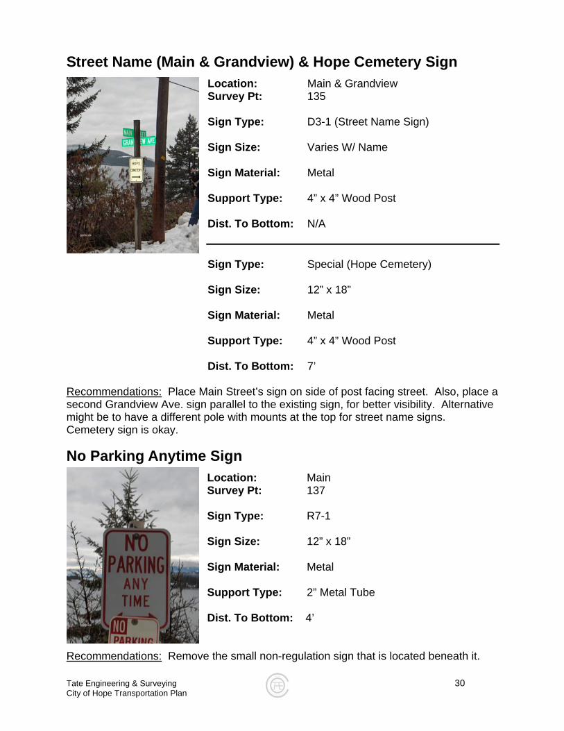
Street Name (Main & Grandview) & Hope Cemetery Sign Location: Main & Grandview Survey Pt: 135 Sign Type: D3-1 (Street Name Sign) Sign Size: Varies W/ Name Sign Material: Metal Support Type: 4” x 4” Wood Post Dist. To Bottom: N/A
Sign Type: Special (Hope Cemetery) Sign Size: 12” x 18” Sign Material: Metal Support Type: 4” x 4” Wood Post Dist. To Bottom: 7’
Recommendations: Place Main Street’s sign on side of post facing street. Also, place a
e. sign parallel to the existing sign, for better visibility. Alternative s at the top for street name signs.
Location: Main Survey Pt: 137 Sign Type: R7-1 Sign Size: 12” x 18” Sign Material: Metal Support Type: 2” Metal Tube Dist. To Bottom: 4’
Recommendations:
second Grandview Avmight be to have a different pole with mountCemetery sign is okay.
No Parking Anytime Sign
Remove the small non-regulation sign that is located beneath it.
Tate Engineering & Surveying 31 City of Hope Transportation Plan
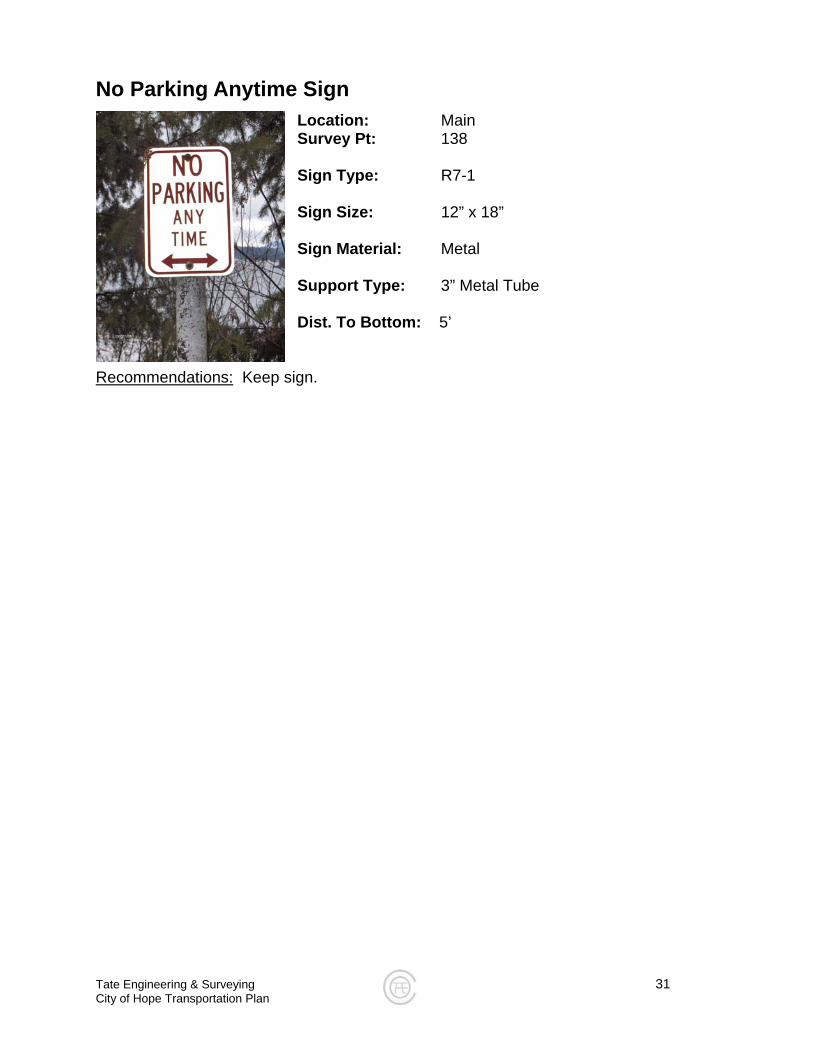
No Parking Anytime Sign Location: Main Survey Pt: 138 Sign Type: R7-1 Sign Size: 12” x 18” Sign Material: Metal Support Type: 3” Metal Tube Dist. To Bottom: 5’
Recommendations:
Keep sign.
Tate Engineering & Surveying 32 City of Hope Transportation Plan
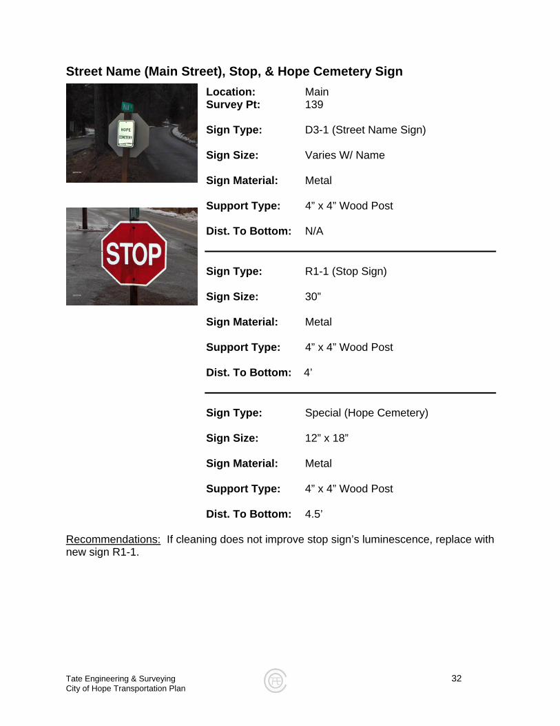
Street Name (Main Street), Stop, & Hope Cemetery Sign
Location: Main Survey Pt: 139 Sign Type: D3-1 (Street Name Sign) Sign Size: Varies W/ Name Sign Material: Metal
Support Type: 4” x 4” Wood Post Dist. To Bottom: N/A Sign Type: R1-1 (Stop Sign) Sign Size: 30” Sign Material: Metal Support Type: 4” x 4” Wood Post Dist. To Bottom: 4’ Sign Type: Special (Hope Cemetery) Sign Size: 12” x 18” Sign Material: Metal Support Type: 4” x 4” Wood Post Dist. To Bottom: 4.5’
Recommendations: If cleaning does not improve stop sign’s luminescence, replace with new sign R1-1.
Tate Engineering & Surveying 33 City of Hope Transportation Plan
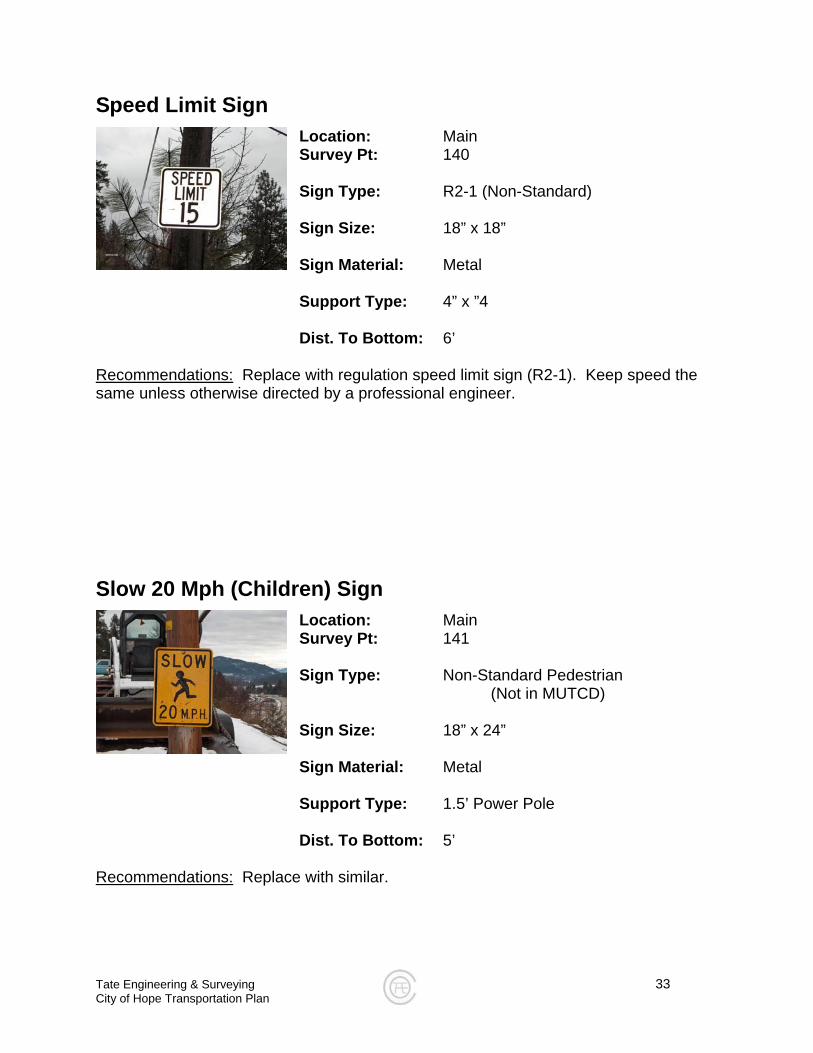
Speed Limit Sign Location: Main Survey Pt: 140 Sign Type: R2-1 (Non-Standard) Sign Size: 18” x 18” Sign Material: Metal
Support Type: 4” x ”4 Dist. To Bottom: 6’
Recommendations:
Replace with regulation speed limit sign (R2-1). Keep speed the same unless otherwise directed by a professional engineer.
Slow 20 Mph (Children) Sign
Location: Main Survey Pt: 141 Sign Type: Non-Standard Pedestrian
(Not in MUTCD) Sign Size: 18” x 24” Sign Material: Metal Support Type: 1.5’ Power Pole Dist. To Bottom: 5’
Recommendations: Replace with similar.
Tate Engineering & Surveying 34 City of Hope Transportation Plan
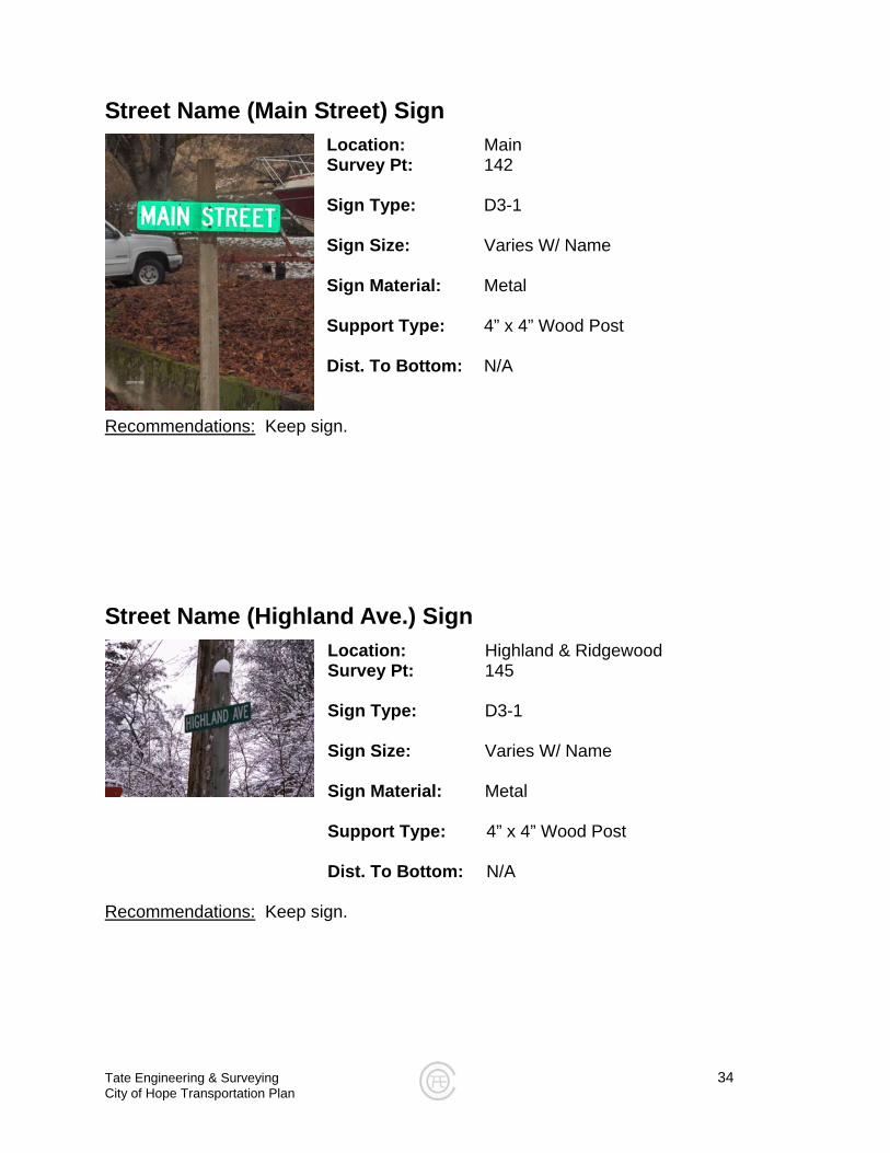
Street Name (Main Street) Sign
Location: Main Survey Pt: 142 Sign Type: D3-1 Sign Size: Varies W/ Name Sign Material: Metal Support Type: 4” x 4” Wood Post Dist. To Bottom: N/A
Recommendations: Keep sign.
Street Name (Highland Ave.) Sign
Location: Highland & Ridgewood Survey Pt: 145 Sign Type: D3-1 Sign Size: Varies W/ Name Sign Material: Metal
Support Type: 4” x 4” Wood Post Dist. To Bottom: N/A
Recommendations: Keep sign.
Tate Engineering & Surveying 35 City of Hope Transportation Plan
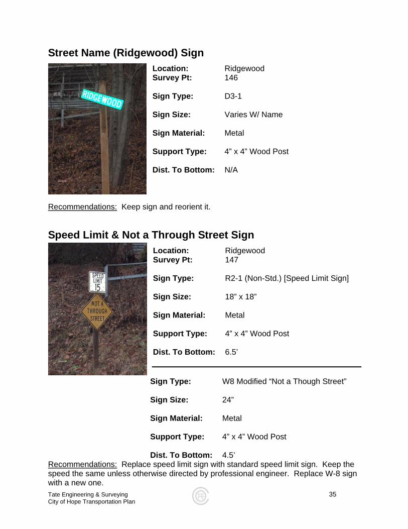
Street Name (Ridgewood) Sign
Location: Ridgewood Survey Pt: 146 Sign Type: D3-1 Sign Size: Varies W/ Name Sign Material: Metal Support Type: 4” x 4” Wood Post Dist. To Bottom: N/A
Recommendations: Keep sign and reorient it.
Speed Limit & Not a Through Street Sign
Location: Ridgewood Survey Pt: 147 Sign Type: R2-1 (Non-Std.) [Speed Limit Sign] Sign Size: 18” x 18” Sign Material: Metal Support Type: 4” x 4” Wood Post Dist. To Bottom: 6.5’
Sign Type: W8 Modified “Not a Though Street” Sign Size: 24” Sign Material: Metal Support Type: 4” x 4” Wood Post Dist. To Bottom: 4.5’
Recommendations: Replace speed limit sign with standard speed limit sign. Keep the speed the same unless otherwise directed by professional engineer. Replace W-8 sign with a new one.

Tate Engineering & Surveying 36 City of Hope Transportation Plan
Yield Sign
Location: Highland Survey Pt: 148 Sign Type: R1-2 Sign Size: 24” Sign Material: Metal Support Type: 3” Circular Wood Post Dist. To Bottom: 4’
Recommendations: Replace sign with new one.
Speed Limit Sign
Location: Highland Survey Pt: 149 Sign Type: R2-1 (Non-Standard) Sign Size: 18” x 18” Sign Material: Metal Support Type: 1.5’ Power Pole Dist. To Bottom: 5’
Recommendations: Replace with standard speed limit sign. Keep speed the same unless otherwise directed by a professional engineer.
Tate Engineering & Surveying 37 City of Hope Transportation Plan
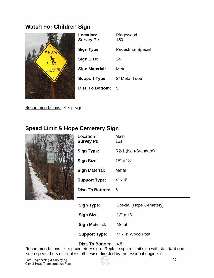
Watch For Children Sign Location: Ridgewood Survey Pt: 150 Sign Type: Pedestrian Special Sign Size: 24” Sign Material: Metal Support Type: 2” Metal Tube Dist. To Bottom: 5’
Recommendations:
Keep sign.
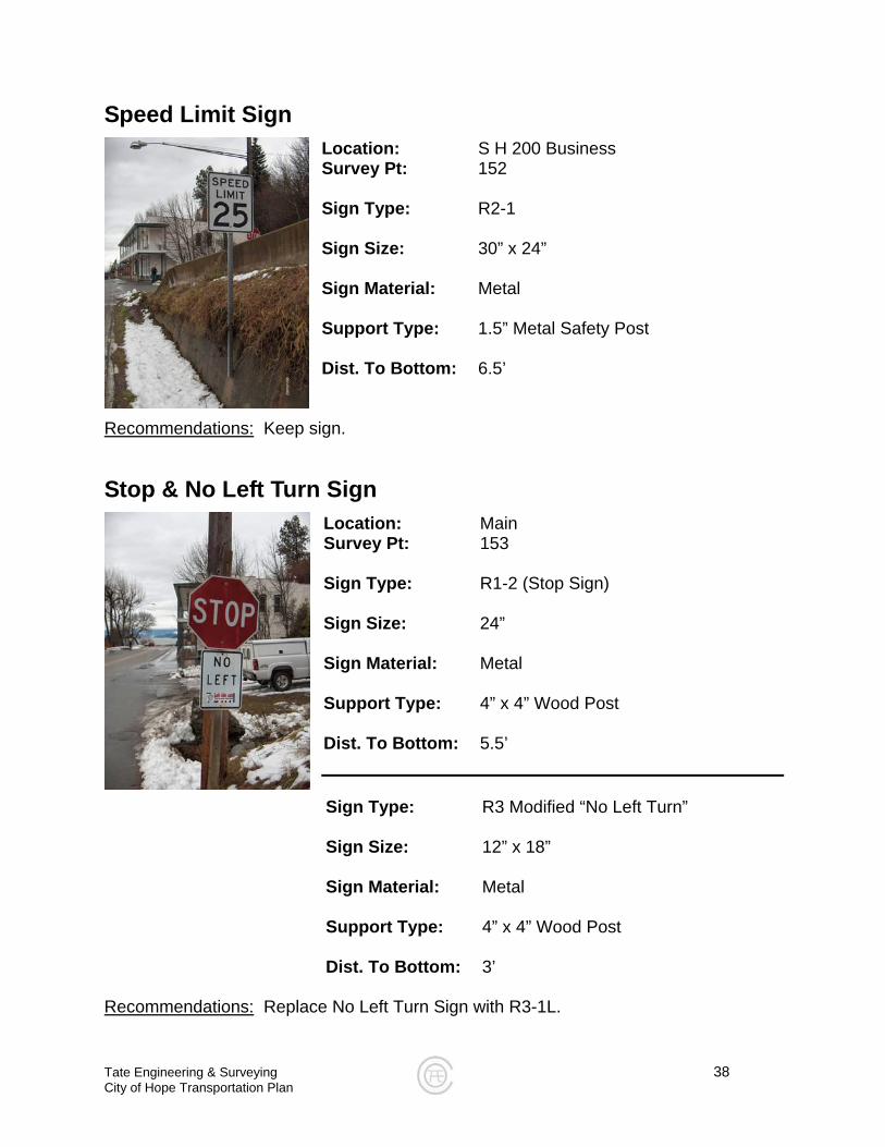
Speed Limit & Hope Cemetery Sign
Location: Main Survey Pt: 151 Sign Type: R2-1 (Non-Standard) Sign Size: 18” x 18” Sign Material: Metal Support Type: 4” x 4” Dist. To Bottom: 6’ Sign Type: Special (Hope Cemetery)
Sign Size: 12” x 18”
Sign Material: Metal
Support Type: 4” x 4” Wood Post
Dist. To Bottom: 4.5’
Recommendations: Keep cemetery sign. Replace speed limit sign with standard one. Keep speed the same unless otherwise directed by professional engineer.
Tate Engineering & Surveying 38 City of Hope Transportation Plan
Speed Limit Sign
Location: S H 200 Business Survey Pt: 152 Sign Type: R2-1 Sign Size: 30” x 24” Sign Material: Metal Support Type: 1.5” Metal Safety Post Dist. To Bottom: 6.5’
Recommendations: Keep sign.
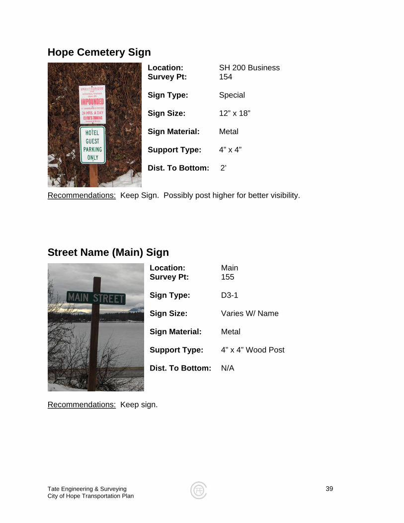
Stop & No Left Turn Sign
Location: Main Survey Pt: 153 Sign Type: R1-2 (Stop Sign) Sign Size: 24” Sign Material: Metal Support Type: 4” x 4” Wood Post Dist. To Bottom: 5.5’ Sign Type: R3 Modified “No Left Turn” Sign Size: 12” x 18” Sign Material: Metal Support Type: 4” x 4” Wood Post Dist. To Bottom: 3’
Recommendations: Replace No Left Turn Sign with R3-1L.
Hope Cemetery Sign
Location: SH 200 Business Survey Pt: 154 Sign Type: Special Sign Size: 12” x 18” Sign Material: Metal Support Type: 4” x 4” Dist. To Bottom: 2’
Recommendations: Keep Sign. Possibly post higher for better visibility.
Street Name (Main) Sign
Location: Main Survey Pt: 155 Sign Type: D3-1 Sign Size: Varies W/ Name Sign Material: Metal Support Type: 4” x 4” Wood Post Dist. To Bottom: N/A
Recommendations: Keep sign.
Tate Engineering & Surveying 39 City of Hope Transportation Plan
Tate Engineering & Surveying 40 City of Hope Transportation Plan
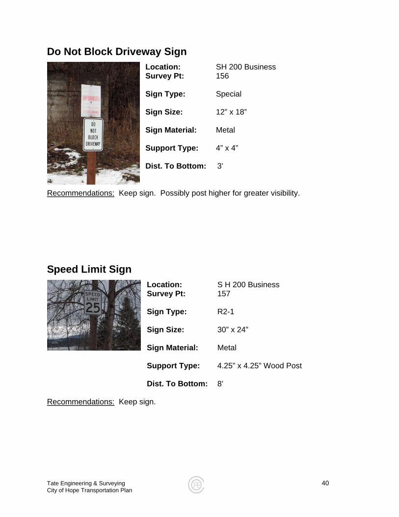
Do Not Block Driveway Sign
Location: SH 200 Business Survey Pt: 156 Sign Type: Special Sign Size: 12” x 18” Sign Material: Metal Support Type: 4” x 4” Dist. To Bottom: 3’
Recommendations: Keep sign. Possibly post higher for greater visibility.
Speed Limit Sign
Location: S H 200 Business Survey Pt: 157 Sign Type: R2-1 Sign Size: 30” x 24” Sign Material: Metal
Support Type: 4.25” x 4.25” Wood Post Dist. To Bottom: 8’
Recommendations: Keep sign.
Tate Engineering & Surveying 41 City of Hope Transportation Plan
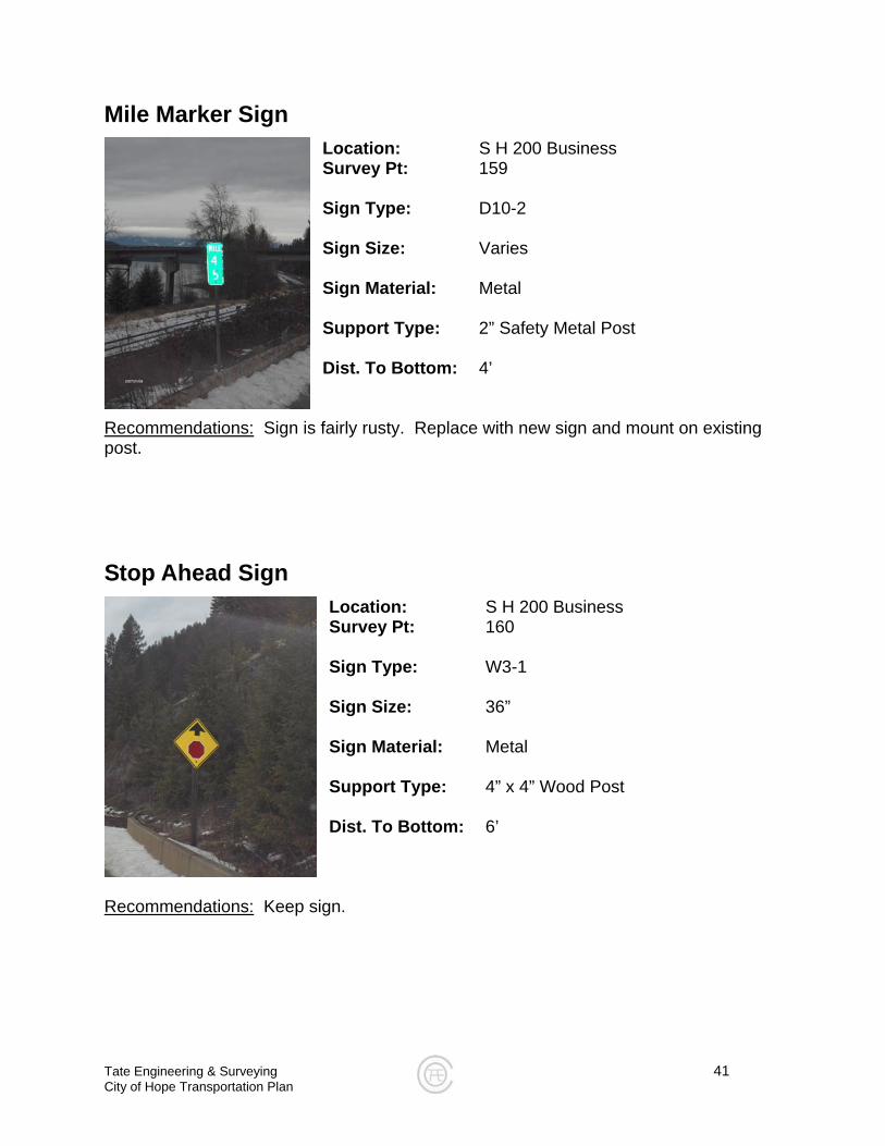
Mile Marker Sign
Location: S H 200 Business Survey Pt: 159 Sign Type: D10-2 Sign Size: Varies Sign Material: Metal Support Type: 2” Safety Metal Post Dist. To Bottom: 4’
Recommendations: Sign is fairly rusty. Replace with new sign and mount on existing post.
Stop Ahead Sign
Location: S H 200 Business Survey Pt: 160 Sign Type: W3-1 Sign Size: 36” Sign Material: Metal Support Type: 4” x 4” Wood Post Dist. To Bottom: 6’
Recommendations: Keep sign.
Tate Engineering & Surveying 42 City of Hope Transportation Plan
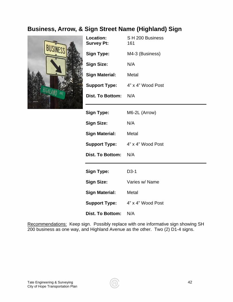
Business, Arrow, & Sign Street Name (Highland) Sign Location: S H 200 Business Survey Pt: 161 Sign Type: M4-3 (Business) Sign Size: N/A Sign Material: Metal Support Type: 4” x 4” Wood Post Dist. To Bottom: N/A
Sign Type: M6-2L (Arrow) Sign Size: N/A Sign Material: Metal Support Type: 4” x 4” Wood Post Dist. To Bottom: N/A Sign Type: D3-1 Sign Size: Varies w/ Name Sign Material: Metal Support Type: 4” x 4” Wood Post Dist. To Bottom: N/A
Recommendations: Keep sign. Possibly replace with one informative sign showing SH 200 business as one way, and Highland Avenue as the other. Two (2) D1-4 signs.
Tate Engineering & Surveying 43 City of Hope Transportation Plan
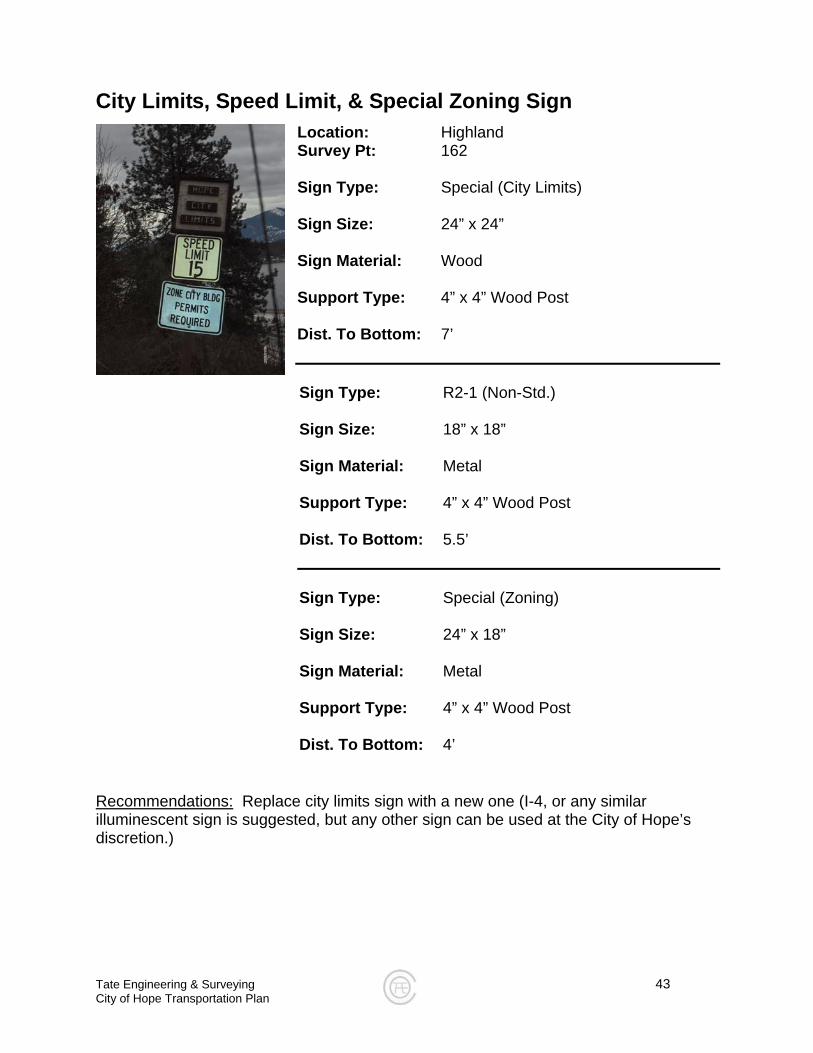
City Limits, Speed Limit, & Special Zoning Sign Location: Highland Survey Pt: 162 Sign Type: Special (City Limits) Sign Size: 24” x 24” Sign Material: Wood Support Type: 4” x 4” Wood Post Dist. To Bottom: 7’
Sign Type: R2-1 (Non-Std.) Sign Size: 18” x 18” Sign Material: Metal Support Type: 4” x 4” Wood Post Dist. To Bottom: 5.5’ Sign Type: Special (Zoning) Sign Size: 24” x 18” Sign Material: Metal Support Type: 4” x 4” Wood Post Dist. To Bottom: 4’
Recommendations: Replace city limits sign with a new one (I-4, or any similar illuminescent sign is suggested, but any other sign can be used at the City of Hope’s discretion.)
Tate Engineering & Surveying 44 City of Hope Transportation Plan
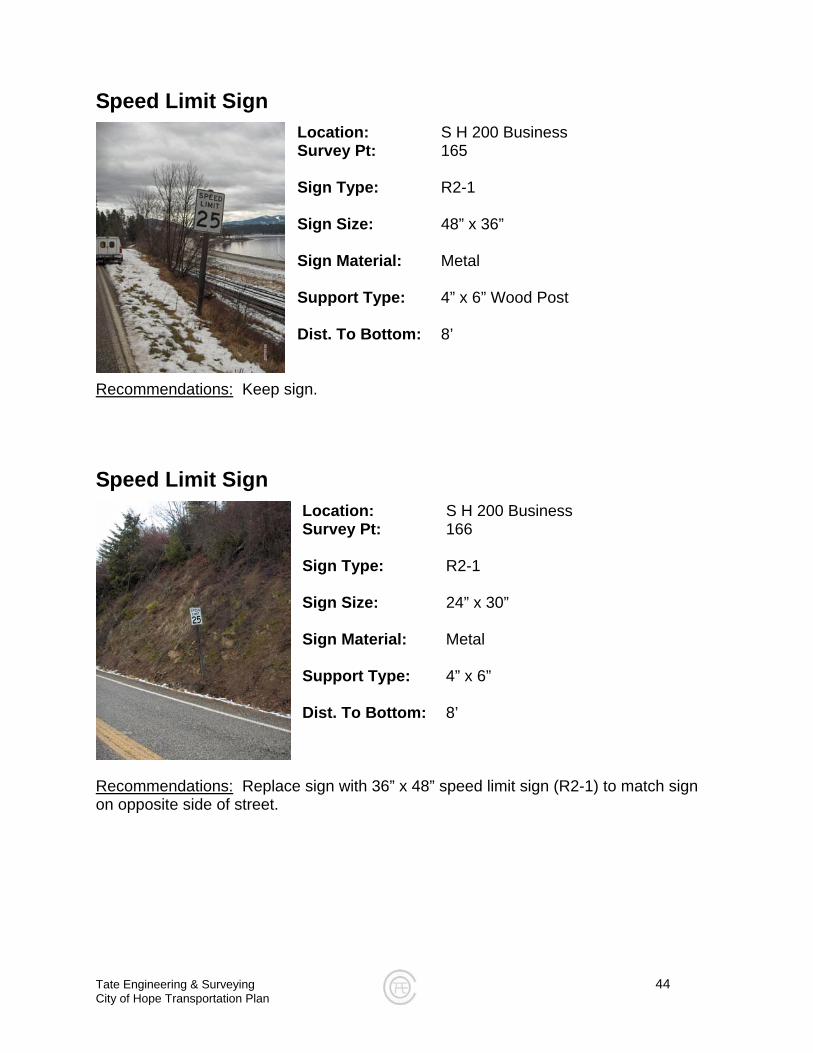
Speed Limit Sign
Location: S H 200 Business Survey Pt: 165 Sign Type: R2-1 Sign Size: 48” x 36” Sign Material: Metal Support Type: 4” x 6” Wood Post Dist. To Bottom: 8’
Recommendations: Keep sign.
Speed Limit Sign Location: S H 200 Business Survey Pt: 166 Sign Type: R2-1 Sign Size: 24” x 30” Sign Material: Metal Support Type: 4” x 6” Dist. To Bottom: 8’
Recommendations:
Replace sign with 36” x 48” speed limit sign (R2-1) to match sign on opposite side of street.
Tate Engineering & Surveying 45 City of Hope Transportation Plan
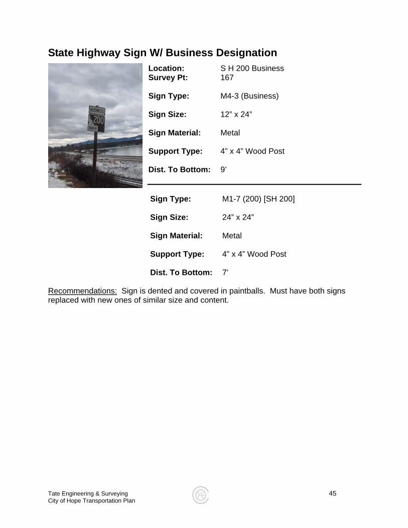
State Highway Sign W/ Business Designation
Location: S H 200 Business Survey Pt: 167 Sign Type: M4-3 (Business) Sign Size: 12” x 24” Sign Material: Metal Support Type: 4” x 4” Wood Post Dist. To Bottom: 9’ Sign Type: M1-7 (200) [SH 200]
Sign Size: 24” x 24” Sign Material: Metal Support Type: 4” x 4” Wood Post Dist. To Bottom: 7’
Recommendations: Sign is dented and covered in paintballs. Must have both signs replaced with new ones of similar size and content.
Tate Engineering & Surveying 46 City of Hope Transportation Plan
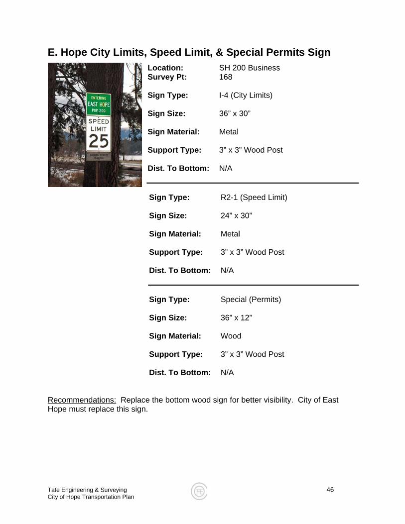
E. Hope City Limits, Speed Limit, & Special Permits Sign
Location: SH 200 Business Survey Pt: 168 Sign Type: I-4 (City Limits) Sign Size: 36” x 30” Sign Material: Metal Support Type: 3” x 3” Wood Post Dist. To Bottom: N/A Sign Type: R2-1 (Speed Limit) Sign Size: 24” x 30” Sign Material: Metal Support Type: 3” x 3” Wood Post Dist. To Bottom: N/A Sign Type: Special (Permits) Sign Size: 36” x 12” Sign Material: Wood Support Type: 3” x 3” Wood Post Dist. To Bottom: N/A
Recommendations: Replace the bottom wood sign for better visibility. City of East Hope must replace this sign.
Tate Engineering & Surveying 47 City of Hope Transportation Plan
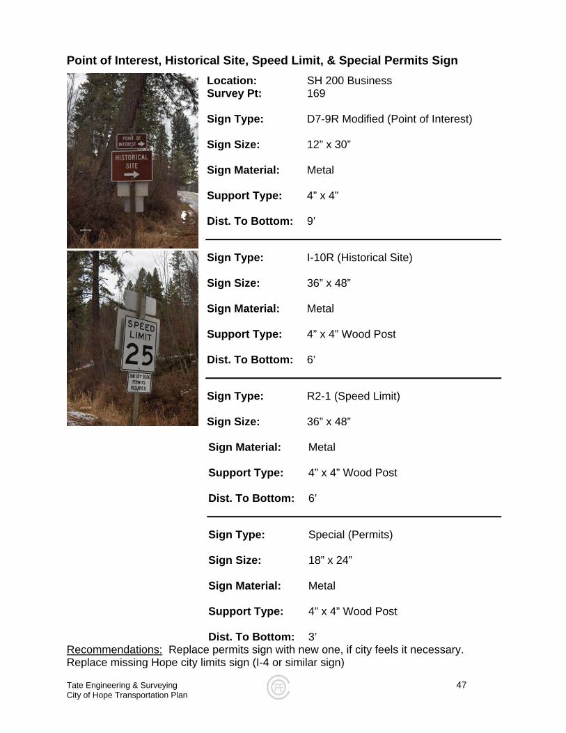
Point of Interest, Historical Site, Speed Limit, & Special Permits Sign
Location: SH 200 Business Survey Pt: 169 Sign Type: D7-9R Modified (Point of Interest) Sign Size: 12” x 30” Sign Material: Metal Support Type: 4” x 4” Dist. To Bottom: 9’ Sign Type: I-10R (Historical Site) Sign Size: 36” x 48” Sign Material: Metal Support Type: 4” x 4” Wood Post Dist. To Bottom: 6’ Sign Type: R2-1 (Speed Limit) Sign Size: 36” x 48”
Sign Material: Metal Support Type: 4” x 4” Wood Post
Dist. To Bottom: 6’
Sign Type: Special (Permits) Sign Size: 18” x 24”
Sign Material: Metal Support Type: 4” x 4” Wood Post Dist. To Bottom: 3’
Recommendations: Replace permits sign with new one, if city feels it necessary. Replace missing Hope city limits sign (I-4 or similar sign)
Tate Engineering & Surveying 48 City of Hope Transportation Plan
Page Left Intentionally Blank
Tate Engineering & Surveying 49 City of Hope Transportation Plan
Appendix B
City of Hope Transportation Alternative Plans
Tate Engineering & Surveying 50 City of Hope Transportation Plan
Appendix C
City of Hope Typical Road Cross-Sections