City of Benicia General PlanF991A639-AAED-4E1A... · 2016-03-15 · 4. Art Goals, Policies, and ......
226
Adopted: June 15, 1999 From 1847 Benicia General Plan Into the 21st Century
Transcript of City of Benicia General PlanF991A639-AAED-4E1A... · 2016-03-15 · 4. Art Goals, Policies, and ......

iCity of Benicia General Plan
Contents
Adopted: June 15, 1999
From 1847Benicia General PlanInto the 21st Century

ii
Contents
City of Benicia General Plan
ACKNOWLEDGMENTS
CommitteeLiaison Members
City CouncilPepe ArteagaCarey CorbaleyJan Cox-GolovichJohn Silva
School BoardDiane DooleyLisa HirshSheli Ryan
City ManagerOtto Giuliani
Planning StaffJohn Bunch,
Planning DirectorBrenda Gillarde,
Principal PlannerDel Lacey,
Graphics Illustrator
Technical AdvisoryCommittee
Mike Alvarez,Parks and CommunityServices Director
Rob Braulik,EconomicDevelopment Director
Ken Hanley,Fire Chief
Heather McLaughlin,City Attorney
Alan Nadritch,Finance Director
Dan Schiada,Assistant Director ofPublic Works
Benicia City CouncilJerry Hayes, MayorSteven Messina,
Vice MayorCarey CorbaleyStephen GizziJan Cox-Golovich
Benicia PlanningCommission
Joe Burek, ChairGary Kalian, Vice ChairTom CampbellGeoffrey HannafinGregg RenfrowNancy SteeleKathy Turner
General PlanOversight Committee
Elizabeth Patterson,Chair
Joe Jacobson,Vice Chair
Ron ArrantsRon AskhamMarilyn BardetBob BermanJoe BurekRon GlasKitty GriffinClint HolzwarthGary KalianLaksmi LagaresAnnie LloydJohn MetzlerReg PageLindy PurdyMike RoetzerGary SalvadoriBonnie SilveriaBob SoteloNancy SteeleEd Swenson
ConsultantsNaphtali Knox & Associates -
Planning ManagerMichael Fornalski - Report
Format, Graphics, MapsDesign, Community &
Environment -Environmental ImpactReport, Public Safety
Joyce Associates -Geotechnical
Environmental Collaborative -Biological Resources
Clearwater Hydrology -Hydrology andWater Quality
Orion EnvironmentalAssociates -Hazardous Materials
Donald Ballanti - Air QualityFehr & Peers Associates -
TransportationBrown-Buntin Associates -
NoiseMogavero Notestine
Associates - CulturalResources andUrban Design
Economic & Planning Systems- Economic and Fiscal
Community Design andPlanning Services, UC Davis- Public Outreach
Jeffery Baird - Work ProgramDaniel Iacofano -
Meeting FacilitationRuss Clifton - Meeting Videos
VolunteersThanks to the many volun-teers who supported thework of GPOC and theformation of the NewGeneral Plan.

iiiCity of Benicia General Plan
Contents
CONTENTS
1. INTRODUCTION ................................................................................... 1
A. WHAT IS THE BENICIA GENERAL PLAN? ........................................... 1
1. Role of the General Plan ........................................................................ 1
2. Legal Requirements ................................................................................ 2
3. The General Plan Process ...................................................................... 2
Public Outreach Program.................................................................... 2
4. Organization of The Plan ........................................................................ 6
Goals, Policies, and Programs .............................................................. 6
Four Chapters ..................................................................................... 6
Maps and Diagrams ............................................................................. 7
Appendix ............................................................................................ 8
Technical Appendix ............................................................................ 8
5. Implementing, Updating, and Amending the General Plan .................. 10
Administering the General Plan ........................................................ 10
Annual Review by Planning Commission ......................................... 11
Amending the Plan ............................................................................ 11
6. Relation to Other Plans ........................................................................ 12
B. REGIONAL SETTING ............................................................................. 13
1. Location in the Region ......................................................................... 13
2. Physical Setting .................................................................................... 14
Gateways ........................................................................................... 16
C. THE PLANNING AREA .......................................................................... 17
1. Planning Area Boundary ....................................................................... 17
2. City Limits ............................................................................................ 19
3. Areas of Interest ................................................................................... 19
iv
Contents
City of Benicia General Plan
2. COMMUNITY DEVELOPMENT ANDSUSTAINABILITY .................................................................................. 21
What is Sustainable Development? ................................................... 22
A. LAND USE AND GROWTH MANAGEMENT ...................................... 23
LAND USE ................................................................................................. 23
1. Residential Land ................................................................................... 24
Low Density Residential .................................................................... 25
Medium Density Residential ............................................................. 25
High Density Residential ................................................................... 26
2. Commercial Land ................................................................................. 26
Downtown Commercial ................................................................... 26
General Commercial ......................................................................... 27
Community Commercial ................................................................... 27
Business and Professional Offices ..................................................... 27
Waterfront Commercial .................................................................... 27
3. Mixed Use ............................................................................................ 27
Downtown Mixed Use ...................................................................... 27
Lower Arsenal Mixed Use ................................................................. 28
4. Industrial Land ..................................................................................... 28
General Industrial ............................................................................. 28
Limited Industrial .............................................................................. 28
Water-related Industrial ..................................................................... 29
5. Public and Quasi-public Land .............................................................. 29
6. Open Space .......................................................................................... 29
Marsh................................................................................................. 31
General Open Space ......................................................................... 31
Parks .................................................................................................. 31
GROWTH MANAGEMENT ........................................................................ 32
B. ECONOMIC DEVELOPMENT ............................................................... 37
1. Economic Opportunities and Challenges ............................................ 37
Benicia’s Competitive Strengths ....................................................... 38
Benicia’s Competitive Challenges ..................................................... 39
Benicia’s Fiscal Status ........................................................................ 39
2. Economic Development Goals, Policies, and Programs ....................... 41
Citywide Economic Development .................................................... 41

vCity of Benicia General Plan
Contents
Industrial Development .................................................................... 43
Port Development ............................................................................. 45
Historic Arsenal ................................................................................. 46
Downtown ........................................................................................ 47
Other Commercial Development ..................................................... 50
C. CIRCULATION ........................................................................................ 52
1. County and Regional Transportation Framework ................................ 52
Congestion Management Agency ...................................................... 52
Metropolitan Transportation Commission ........................................ 52
2. The Movement of People ..................................................................... 53
Pedestrian and Bicycle Movement .................................................... 53
Public Transit ..................................................................................... 53
Automobile Movement ..................................................................... 55
3. Circulation System ............................................................................... 55
Freeways ........................................................................................... 57
Arterial Streets ................................................................................... 57
Collector Streets ................................................................................ 58
Local Streets ...................................................................................... 58
4. Existing and Future Traffic Conditions ................................................. 58
Freeways ........................................................................................... 58
City Street Network .......................................................................... 59
5. Parking Conditions ............................................................................... 65
6. Freight and Goods Movement .............................................................. 66
Truck Facilities .................................................................................. 66
Freight Rail Facilities ......................................................................... 66
Port Facilities ..................................................................................... 66
7. Circulation Goals, Policies, and Programs ............................................ 66
D. COMMUNITY SERVICES ....................................................................... 77
1. Public and Quasi-public ....................................................................... 77
Public and Quasi-public Goals, Policies, and Programs............................. 77
2. Parks and Recreation ............................................................................ 79
Standards ........................................................................................... 79
Existing Parks .................................................................................... 79
Future Park Development ................................................................. 83
Parks and Recreation Goals, Policies, and Programs ................................. 84
Benicia State Parks ............................................................................ 87

vi
Contents
City of Benicia General Plan
3. Schools ................................................................................................. 88
Existing Facilities .............................................................................. 88
Future Facilities ................................................................................. 88
Schools Goals, Policies, and Programs ...................................................... 89
4. Water .................................................................................................... 90
Water Supply ..................................................................................... 90
Water Quality .................................................................................... 90
Waste Water Treatment ...................................................................... 91
Water Goals, Policies, and Programs ......................................................... 91
5. Recycling Goals, Policies, and Programs .............................................. 94
6. Utilities ................................................................................................. 94
Power and Energy Use ...................................................................... 94
Telecommunications ......................................................................... 94
Utilities Goals, Policies, and Programs ...................................................... 95
3. COMMUNITY IDENTITY ................................................................ 97
A. HISTORIC RESOURCES ......................................................................... 97
1. Native American Period........................................................................ 98
2. Hispanic Period .................................................................................... 98
3. American Period................................................................................... 98
4. Archaeological Sites ........................................................................... 100
5. Historic Buildings, Sites, and Areas ..................................................... 100
Waterfront ....................................................................................... 100
Arsenal ............................................................................................ 101
Downtown ...................................................................................... 102
6. Historic Preservation.......................................................................... 102
7. Historic and Archaeological Resources Goals, Policies,and Programs .................................................................................... 105
B. CULTURAL RESOURCES ..................................................................... 106
1. Community Cultural Facilities and Activities ..................................... 106
2. Cultural Goals, Policies and Programs ................................................ 107
3. The Art Community ............................................................................ 108
4. Art Goals, Policies, and Programs ....................................................... 109
C. VISUAL CHARACTER ........................................................................... 110
1. What is Visual Character? ................................................................... 110

viiCity of Benicia General Plan
Contents
2. The Look and Feel of Benicia ............................................................. 110
Natural Features .............................................................................. 110
The Human Landscape ................................................................... 110
3. Scenic Views, Streets, and Gateways .................................................. 111
Scenic Views.................................................................................... 111
Waterfront ....................................................................................... 111
Scenic Streets and Gateways ........................................................... 113
Planning in Scenic Corridors .......................................................... 115
4. Architectural and Landscape Features ............................................... 115
Southampton ................................................................................... 115
Industrial Areas ................................................................................ 115
Downtown ...................................................................................... 116
Arsenal District ............................................................................... 117
Visual Character Goals, Policies, and Programs ...................................... 117
D. OPEN SPACE AND CONSERVATION OF RESOURCES.................... 122
1. Regional and Subregional Open Space and Trails .............................. 123
Open Space ..................................................................................... 123
Regional and Subregional Trails and Paths ...................................... 124
2. Regional and Subregional Open Space and Trails Goals,Policies, and Programs ........................................................................ 125
3. Biotic Resources ................................................................................. 127
Plant Life ......................................................................................... 127
Wildlife ............................................................................................ 131
Special Status Species and Sensitive Natural Communities ............ 132
4. Biotic Resources Goals, Policies, and Programs ................................. 133
5. Water Resources ................................................................................. 135
6. Water Resources Goals, Policies, and Programs ................................. 136
7. Mineral Resources .............................................................................. 137
Soils ................................................................................................. 137
8. Mineral Resource Goals, Policies, and Programs ................................ 138
9. Energy Conservation Goals, Policies, and Programs .......................... 138
4. COMMUNITY HEALTH AND SAFETY .................................... 141
A. HEALTHY COMMUNITY .................................................................... 141
1. Dimensions of Optimal Health .......................................................... 141
2. Healthy Community Goals, Policies, and Programs ............................ 142
viii
Contents
City of Benicia General Plan
B. HAZARDS TO THE COMMUNITY ...................................................... 145
1. Geologic ............................................................................................. 145
Seismic Hazards ............................................................................... 145
Slope Stability Hazards .................................................................... 146
2. Flood Hazards ..................................................................................... 148
FEMA Flood Maps ........................................................................... 148
Stormwater Master Plan/Flood Control Improvements .................. 148
Sea Level Rise .................................................................................. 151
3. Fire Hazards ........................................................................................ 151
4. Hazardous Materials and Waste .......................................................... 151
Hazardous Sites ............................................................................... 151
Hazardous Material and Waste Handlers ......................................... 153
Toxic Air Contaminant Sources ....................................................... 153
Hazardous Building Materials .......................................................... 153
5. Utility Hazards .................................................................................... 154
Electric Power ................................................................................. 154
Natural Gas ...................................................................................... 154
Water Supply ................................................................................... 156
Waste Water ..................................................................................... 156
6. Air Quality/Contamination ................................................................. 156
C. RESPONSES TO HAZARDS .................................................................. 158
1. Community Right-to-know ................................................................. 158
2. Emergency Response Plans and Procedures ...................................... 158
Emergency Operations Plan ............................................................ 158
Evacuation Routes ........................................................................... 159
3. Public Safety Services ......................................................................... 159
Crime .............................................................................................. 159
Police Services ................................................................................ 159
Fire Services .................................................................................... 159
4. Medical Services ................................................................................. 160
5. Community Hazards Goals, Policies, and Programs ........................... 160
D. NOISE .................................................................................................... 170
1. Human Reaction to Noise .................................................................. 170
Communication Interference.......................................................... 171
Sleep Interference ........................................................................... 171

ixCity of Benicia General Plan
Contents
Physiological responses .................................................................. 171
Annoyance ...................................................................................... 171
2. Noise in the Community .................................................................... 172
Existing Noise Levels ...................................................................... 172
Projected Noise Levels .................................................................... 172
3. Performance Standards for Noise-Sensitive Uses ............................... 176
Transportation Noise Sources ......................................................... 176
Stationary Noise Sources................................................................. 177
4. Community Noise Goals, Policies, and Programs ............................... 179
GLOSSARY.................................................................................................... 181
ABBREVIATIONS ........................................................................................ 181
GLOSSARY ................................................................................................... 183

x
Contents
City of Benicia General Plan
LIST OF FIGURES
Figure 1-1. Regional Setting ................................................................................ 14
Figure 1-2. Generalized Topography ................................................................... 15
Figure 1-3. Gateways ........................................................................................... 18
Figure 1-4. Benicia Planning Area ........................................................................ 20
Figure 2-1. General Plan Land Use Catagories Within City Limits ...................... 23
Figure 2-2. Industrial Properties to which Policy 2.3.1 (Master Plan) Applies ... 36
Figure 2-3. City of Benicia General Fund Revenues ............................................ 40
Figure 2-4. Bicycle and Multi-Use Circulation Diagram ...................................... 54
Figure 2-5. Circulation Diagram .......................................................................... 56
Figure 2-6. Intersection Mitigations .................................................................... 62
Figure 2-7. Public/Quasi-public Facilities ............................................................ 78
Figure 2-8. Parks and Open Space....................................................................... 80
Figure 3-1. Historic Sites ..................................................................................... 99
Figure 3-2. Vistas and Views .............................................................................. 112
Figure 3-3. Biological Resources ....................................................................... 128
Figure 3-4. Hydrology and Mineral Resources .................................................. 139
Figure 4-1. Ground Shaking Amplification ........................................................ 147
Figure 4-2. Areas with Potential Landslide and Liquefaction Hazards .............. 149
Figure 4-3. Flood Hazards .................................................................................. 150
Figure 4-4. Fire Hazards ..................................................................................... 152
Figure 4-5. Transmission Lines and Critical Facilities ....................................... 155
Figure 4-6. Existing Noise Contours ................................................................. 173
Figure 4-7. Future Noise Contours .................................................................... 175
xiCity of Benicia General Plan
Contents
LIST OF TABLES
Table 1-1. Background Reports in the Technical Appendix................................. 8
Table 1-2. Relation of General Plan Chapters to State-mandated Elements ........ 9
Table 1-3. List of Other Plans and Documents Examined ................................. 12
Table 2-1. Zoning District Equivalents for General Plan ResidentialLand Use Categories .......................................................................... 24
Table 2-2. Residential Land Within City Limits in Gross Acres, as of 1995 ........ 25
Table 2-3. Commercial Land (in gross acres) Within City Limits, as of 1995 ..... 26
Table 2-4. Industrial Land (in acres) within City Limits, as of 1995 .................. 28
Table 2-5. Existing Public and Quasi-public Facilities WithinCity Limits, 1995................................................................................ 30
Table 2-6. Park Standards ................................................................................... 31
Table 2-7. Classification of Bicycle Facilities ..................................................... 53
Table 2-8. Level of Service Criteria for Signalized Intersections ....................... 60
Table 2-9. Level of Service Criteria for Stop-controlled Intersections .............. 60
Table 2-10. Existing (1995) and Future Intersection Levels of Service (LOS) ...... 61
Table 2-11. Intersection LOS: Future Conditions with and withoutIntersection Improvements .............................................................. 63
Table 2-12. Streets That May Exceed Existing (1997) Capacity with FutureGrowth Under this General Plan ...................................................... 65
Table 2-13. Existing and Future Parks and Recreation Facilities withinCity Limits, 1995................................................................................ 81
Table 2-14. Amount of Park Land per Capita ....................................................... 82
Table 2-15. School Enrollment and Capacity, 1997–1998.................................... 88
Table 2-16. School Enrollment, 1997 and Projected ............................................ 89
Table 4-1. Decibel Levels of Common Noises ................................................. 170
Table 4-2. Summary of Measured Exterior Noise Levels and EstimatedDay-Night Average Levels (Ldn) in Areas Containing NoiseSensitive Land Uses ......................................................................... 174
Table 4-3. Maximum Allowable Noise Exposure for New Noise-SensitiveUses From Transportation Noise Sources........................................ 176
Table 4-4. Noise Level Performance Standards for Noise-sensitiveLand Uses which may be affected by Stationary Noise Sources ..... 178

xii
Contents
City of Benicia General Plan

1City of Benicia General Plan
1. INTRODUCTION
Benicia has a long history of big ideas. Originally the city was to be a major port; thenit was the state capital; later it was a transportation hub. An increase in population andjobs that started in the 1970s is expected to continue, though at a slower pace,through 2015. During this period of expansion, it is vital that Benicia’s future bemanaged wisely to preserve and enhance its many attractive qualities.
This chapter details the planning, legal, and physical framework for the BeniciaGeneral Plan. Specifically it describes the role of the plan, its legal footing, its organiza-tion, Benicia’s relationship to the region, and a description of the planning area.
A. WHAT IS THE BENICIA GENERAL PLAN?
1. ROLE OF THE GENERAL PLAN
The Benicia General Plan is the principal policy document for guiding futureconservation and development in the city. It reflects the community’s sharedvalues and determination of what Benicia is and should continue to be—anuncommonly special place.
The Plan has a long-term horizon, addressing an approximately 15– to 20–yeartime frame. At the same time, it brings overall direction to the day-to-day decisionsof the City Council, its commissions, and City staff.
The General Plan determines what kind of urban development should take placeand where and when, and who in the City will be charged with getting it done.The Plan—
• Expresses the desires of Benicia residents in regard to the physical, social,economic, cultural, and environmental character of the city;
• Serves as a comprehensive guide for making decisions about land use, economicdevelopment, road improvements, and protecting natural resources and thepublic health and safety;
• Provides the legal foundation for all zoning, subdivision, and public facilitiesordinances, decisions, and projects—all of which must be consistent with theGeneral Plan.

2
Chapter 1. Introduction
City of Benicia General Plan
The general plan is to be considered and used as a whole. One section is not tobe stressed while ignoring others; rather all of the sections should be used to-gether, with flexibility. Used in this way, the Plan will become a powerful tool forensuring consistency of City actions, while remaining responsive to changingneeds and times.
2. LEGAL REQUIREMENTS
The general plan is a State-mandated blueprint for physical development. Thegeneral plan derives its authority as the summit of land use regulations from theCalifornia Government Code. The City Council adopts the general plan by resolu-tion as a legal document.
Seven general plan “elements” are required by law: Land Use, Circulation, Housing,Conservation, Open Space, Safety, and Noise. How these elements are incorpo-rated into the organization of this General Plan is explained in Section 4, below,and in Table 1-2. When optional subjects are added to a general plan (for example,“economic development” and “health”), they have the same status as a mandatedelement. All general plan elements carry equal weight (Sierra Club v. Board ofSupervisors [1981] 126 Cal.App.3d 698). No single section, chapter, or subjectsupersedes any other.
3. THE GENERAL PLAN PROCESS
In late 1992, the Benicia City Council formed a citizens’ task force to review theGeneral Plan and report its findings. As a result, in late 1993, a General Plan TaskForce Report was issued. The report stated that many of the policies and programsin the General Plan had not been revised since 1979, had already been imple-mented, or were no longer relevant to current or future conditions.
In June 1994, the City Council adopted a resolution directing that preparations beginfor a comprehensive update of the General Plan. Accordingly, the Council formed a 17-member citizens’ General Plan Oversight Committee (GPOC) to work with City staff todesign the update process. GPOC was charged with facilitating public outreach, moni-toring the update process to be sure it is on time and within budget, providingvolunteer assistance, and assisting in community workshops and forums.
Consultants were engaged to develop a work program for a General Plan Update.The work program was presented to and accepted by the City Council in Novem-ber 1994. The City Council adopted a budget for the work and directed staff andthe GPOC to retain consultants to assist GPOC in undertaking the actual update.
PUBLIC OUTREACH PROGRAM
This General Plan is built on issues defined by the community—issues that fo-cused on what should be preserved and what should change. Some of those
3City of Benicia General Plan
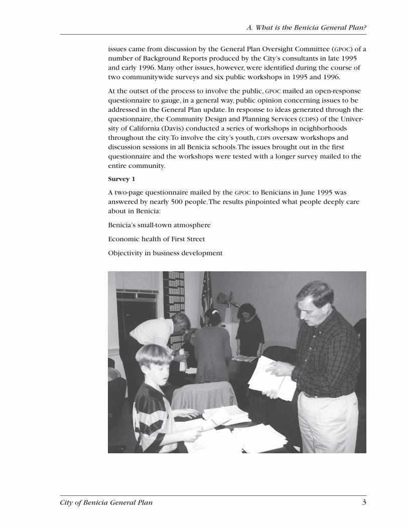
issues came from discussion by the General Plan Oversight Committee (GPOC) of anumber of Background Reports produced by the City’s consultants in late 1995and early 1996. Many other issues, however, were identified during the course oftwo communitywide surveys and six public workshops in 1995 and 1996.
At the outset of the process to involve the public, GPOC mailed an open-responsequestionnaire to gauge, in a general way, public opinion concerning issues to beaddressed in the General Plan update. In response to ideas generated through thequestionnaire, the Community Design and Planning Services (CDPS) of the Univer-sity of California (Davis) conducted a series of workshops in neighborhoodsthroughout the city. To involve the city’s youth, CDPS oversaw workshops anddiscussion sessions in all Benicia schools. The issues brought out in the firstquestionnaire and the workshops were tested with a longer survey mailed to theentire community.
Survey 1
A two-page questionnaire mailed by the GPOC to Benicians in June 1995 wasanswered by nearly 500 people. The results pinpointed what people deeply careabout in Benicia:
Benicia’s small-town atmosphere
Economic health of First Street
Objectivity in business development
A. What is the Benicia General Plan?

4
Chapter 1. Introduction
City of Benicia General Plan
Workshops
In the summer of 1995, the General Plan Oversight Committee hosted six publicworkshops on the General Plan update. More than a hundred Benicians from allareas of town attended the workshops. Major concerns were:
• cultural resources
• quality of life
• small town character; and
• the waterfront.
Workshop participants generally supported:
• First Street and tourism;
• a diversified economy;
• opportunities to live and work in town; and
• infill development, rather than expansion.
Youth Outreach
Students of all ages were involved in the process of identifying what is importantto people living in Benicia. Different methods for garnering responses, ideas, andconcerns were used for each age group.
Elementary school students were asked to draw pictures of the things theyconsidered “important.” The drawings centered on themes of environmentalquality and recreational facilities. Middle school students were organized intosmall groups; each group was given a 24-exposure disposable camera to photo-graph representations of their ideas. The resulting collage of photos expressedconcerns about pollution, increased housing construction, traffic congestion,parking, and historic preservation. They desired more green space and recre-ational facilities for their age group. High school students responded to a two-page survey; results of the survey yielded that almost half of the high schoolstudents would live in Benicia as an adult; 65 percent wanted to raise a familyhere; and 89 percent felt safe in the city.

5City of Benicia General Plan
Survey 2
A second survey was mailed to 11,000 households and businesses in Benicia inJanuary 1996. Nearly 3,000 completed surveys were returned, which gave thesurvey results a high level of confidence. The following 10 issues received thehighest level of support (69% or greater) as being important to the community:
1. Feeling safe in residential areas at night2. Feeling safe Downtown at night3. Good public schools4. Balance growth to ensure maintaining Benicia’s quality of life5. Small town atmosphere6. Growth should maintain small-town character7. Citizens need a voice in growth decisions8. Attract businesses that sustain environmental quality9. Pedestrian-friendly streets in the Downtown and other commercial areas10. Library facilities
A number of issues raised by the survey were opposed, although with the excep-tion of Sky Valley (two-thirds of Benicians do not want residential development inSky Valley) the levels of opposition were not as great (generally only 20 to 30percent), in contrast to the very high levels of support (70 to 90 percent) for the10 issues listed above. Refer to Appendix A for more detailed survey results.
The City’s consultants and citizen groups prepared 11 background reports at theend of 1995. GPOC began in February 1996 to use that information, the results of acommunitywide survey taken in January 1996, and a series of community work-shops held during the summer to identify the issues to be faced in updating theBenicia General Plan. An Issues, Goals, and Policies (IGPs) report was preparedJanuary 21, 1997 and reviewed by the GPOC, Planning Commission, and CityCouncil. These reviews ensured that the IGPs document contained goals andpolicies for what are the most significant issues for the community.
The City’s consultants then prepared a Goals, Policies, and Programs report (June 6)and a Preferred Alternatives Report (June 30) which incorporated additions andchanges made by the GPOC, the consultants, City staff, Planning Commission, and CityCouncil since the IGPs report of January 21, 1997. The Preferred Alternatives Reportwas reviewed by the City Council on August 6, and with their comments in hand, theconsultants began drafting the General Plan and an environmental impact report.
This Draft General Plan is the outcome of a process which began with the TaskForce (1992–93) and the Work Program (1994). It is a process in which theGeneral Plan Oversight Committee (GPOC) held more than one hundred meetingsand, with public participation, identified the Goals, Policies, and Programs (GPPs)which are the heart of this General Plan.
A. What is the Benicia General Plan?

6
Chapter 1. Introduction
City of Benicia General Plan
4. ORGANIZATION OF THE PLAN
GOALS, POLICIES, AND PROGRAMS
“Goals” are “end-state”; they are the long-range answers to what the City wants toaccomplish to resolve a particular issue. Policies are medium- or short-rangestatements that guide day-to-day decision-making so there is continuing progresstoward the attainment of goals. Programs are the actions taken to implement aspecific policy or group of policies. The hierarchy of goal, policy, and program isoutlined below.
GOAL: A general, overall, and ultimate purpose, aim, orend toward which the City will direct effort.
POLICY: A specific statement of principle which implies clear com-mitment but is not mandatory. A general direction that theCity elects to follow, in order to meet its goals.
Program: An action, activity, or strategy carried out in response toadopted policy or group of policies.
Explanatory text appears before and after some of the goals, policies, and pro-grams but is not part of the goal, policy or program.
FOUR CHAPTERS
The Benicia General Plan is organized into four chapters, a glossary, an Appendix,and a Technical Appendix. The chapters are 1: Introduction; 2: Community Devel-opment and Sustainability; 3: Community Identity; and 4: Community Health andSafety.
Chapter 2 includes four sections:
• Land Use defines the ultimate building envelope” for the City, and establishesthe overarching goals for the community’s development. Land Use also definesthe seventeen land use categories used in the General Plan and identifies thoseproperties where changes occurred to the prior (1993) General Plan land uses.
• Economic Development addresses land development in all the business andcommercial sectors of the City.
• Circulation looks at how freeways affect Benicia, in-town traffic, and masstransit.
• Community Services discusses public facilities and provision of public services.
Chapter 3 covers three topics:
• Historic and Cultural Resources addresses preservation of historic areas andbuilding community spirit.
• Visual Character deals with maintaining Benicia’s small town atmosphere,preserving scenic views, and enhancing the City’s appearance.

7City of Benicia General Plan
• Open Space and Conservation of Resources focuses on protection and enhance-ment of the natural environment including open space, water and air, and plantsand animals.
Chapter 4 contains four sections:
• Healthy Communities promotes ways to live more healthfully.
• Hazards to the Community identifies dangers to the community per the State-mandated safety element.
• Responses to Hazards contains the community’s emergency response plans andthe safety goals, policies and programs.
• Noise focuses on the sources and effects of sounds in the community, per theState-mandated noise element.
The Benicia Housing Element (1993) is a stand-alone document, but is part of thisGeneral Plan and should be consulted accordingly. The Housing Element containsthe City’s goals, policies and programs related to the maintenance and develop-ment of housing in Benicia.
DIAGRAMS
The City’s land use diagram, which is attached separately at the back of thisdocument, is an integral part of the General Plan. The diagram graphically ex-presses the Plan’s development policies by showing the desired arrangement andlocation of land uses. The diagram is required to be consistent with the GeneralPlan text (and its goals, policies, and programs).
In keeping with past practice, the City of Benicia has again prepared a site-specific land use diagram to avoid confusion about designations for individualparcels. While the boundaries between land use districts usually follow propertylines or streets, the land use diagram should not be used to calculate parcelacreages or lot size dimensions. The Assessors’ Parcel Books can be used for thatpurpose.
The land use diagram and the general plan text together specify the “populationdensity” (number of people and dwelling units per net acre) of residentially-designated land and the “building intensity” for all other designations. Buildingintensity is expressed in terms of floor area ratio (FAR), which is the ratio of grossfloor area to the total site area. The land use diagram also shows the location ofexisting and proposed parks, public schools, and other municipal services.
The circulation diagram diagram shows current and proposed arterials, collectors,and local streets, as well as bikeways and rail lines. The roadway system has beentested against the planned level of development and has been found to be ad-equate. More discussion about the relationship between land use and circulationis found in Chapter 2C of this General Plan.
A. What is the Benicia General Plan?
8
Chapter 1. Introduction
City of Benicia General Plan
Together, the land use and circulation diagrams illustrate the managed growth ofthe City for the next 15 to 20 years. The General Plan also contains other diagramsto illustrate the policies and programs in the Plan.
APPENDIX
The Appendix contains information on Growth Management and HazardousSubstances. While important to a thorough understanding of the General Plan, theAppendix is not adopted as policy by the City.
TECHNICAL APPENDIX
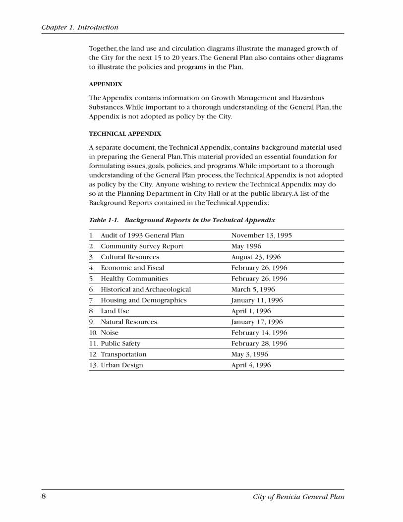
A separate document, the Technical Appendix, contains background material usedin preparing the General Plan. This material provided an essential foundation forformulating issues, goals, policies, and programs. While important to a thoroughunderstanding of the General Plan process, the Technical Appendix is not adoptedas policy by the City. Anyone wishing to review the Technical Appendix may doso at the Planning Department in City Hall or at the public library. A list of theBackground Reports contained in the Technical Appendix:
Table 1-1. Background Reports in the Technical Appendix
1. Audit of 1993 General Plan November 13, 1995
2. Community Survey Report May 1996
3. Cultural Resources August 23, 1996
4. Economic and Fiscal February 26, 1996
5. Healthy Communities February 26, 1996
6. Historical and Archaeological March 5, 1996
7. Housing and Demographics January 11, 1996
8. Land Use April 1, 1996
9. Natural Resources January 17, 1996
10. Noise February 14, 1996
11. Public Safety February 28, 1996
12. Transportation May 3, 1996
13. Urban Design April 4, 1996

9City of Benicia General Plan
Table 1-2. Relation of General Plan Chapters to State-mandated Elements
GENERAL PLANMANDATED ELEMENTS Chapter* Pages
LAND USE ELEMENT Population Density & 2 23–31Building Intensity
Land Use Diagram 2 Rear Pocket
Distribution of Housing, 2 Rear PocketBusiness, Industry,and Open Space
Distribution of Recreation 2 Rear PocketFacilities, Educational Fac-ilities, and Public Buildings
Flood Areas 4 148–150
Mineral Resources 3 137–139
Implementation 2 32–35, 41–51,67–77, 84–8789–90, 92–95
CIRCULATION ELEMENT Description of Existing 2 52–66System
Diagram of Existing System 2 54, 56
Description of Proposed 2 58–65System
Diagram of Proposed System 2 54, 56
Utilities 2, 4 90–91, 154–156
Implementation 2 67–76, 168
CONSERVATION ELEMENT Water, Rivers, Harbors 2, 3 90, 122–124, 129
Forests 3 130
Soils 4 137, 145–148
Mineral Resources 3 137
Implementation 2, 3 92–94, 133–134136, 138
OPEN SPACE ELEMENT Description 3 122–125
Trails System 2, 3 80, 124–125
Management of Resources 2, 3 90–91, 135, 137
Areas for Outdoor Recreation 2, 3 79–83
Preservation for Public 3 147, 149Health, Safety 150, 152
Implementation 2, 3 84–86, 125–127133–134, 136
A. What is the Benicia General Plan?

10
Chapter 1. Introduction
City of Benicia General Plan
Table 1-2. Relation of General Plan Chapters to State-mandated Elements
(continued)
GENERAL PLANMANDATED ELEMENTS Chapter* Pages
SAFETY ELEMENT Seismic Risk 4 145–146
Slope Instability/Geologic 4 146–148Hazards
Flooding 4 148–151
Fire Hazard 4 151
Emergency Response/ 4 158–159Evacuation Routes
Hazardous Materials 4, G 151–153, G1–G18
Implementation 4 160–169
NOISE ELEMENT Noise Sources and Problems 4 170–172
Noise Contours 4 173, 175
Noise Attenuation 4 176, 178
Implementation 4 179–180
* Letters refer to the Appendices
5. IMPLEMENTING, UPDATING, AND AMENDING THE GENERAL PLAN
ADMINISTERING THE GENERAL PLAN
Once adopted, a general plan does not remain static. State law permits up to fourgeneral plan amendments per mandatory element per year (Government Code§65358[b]). Most amendments propose a change in the land use designation of aparticular property which equates to a change to the land use element. As time passes,the City may decide that it also is necessary to revise portions of the text to reflectland use diagram changes or other changing circumstances or philosophy.
While some degree of flexibility is desirable in the planning process, basic to itsvery existence is that it possess some degree of stability. Without the expectationof stability, it cannot serve as a comprehensive and long-term guide to localdevelopment. Therefore, although the City may decide to amend this plan, theprimary position of the City will be to implement it as adopted. This will honorboth the principle of stability and the extraordinary degree of community partici-pation that went into the formation of the plan.
Generally it is recommended that the City comprehensively review the Plan everyfive years to determine whether it is still in step with community values andconditions.

11City of Benicia General Plan
ANNUAL REVIEW BY PLANNING COMMISSION
State law provides direction on how cities can maintain the plan as a contempo-rary policy guide: Government Code §65400[b] requires each planning agency toreport annually to the Office of Planning and Research and the California Depart-ment of Housing and Community Development (HCD) on “the status of the planand progress in its implementation, including the progress in meeting its share ofregional housing needs determined pursuant to Section 65584…”. In addition, theplanning agency is required annually to review the City’s Capital ImprovementsProgram for consistency with the General Plan (Government Code §65103[c]).
AMENDING THE PLAN
Anyone wishing to amend the General Plan would follow the procedure generallyoutlined below. (More detailed information on processing and timing is availablefrom the Planning Department.)
1. Prior to filing an application, the prospective applicant should discuss theproposed amendment with City staff. This will clarify the process and identifyany concerns the City may have about the proposed changes.
2. The next step in the process is to file an official application with the PlanningDepartment and pay any necessary processing fees. An application mustinclude a development plan of sufficient detail that potential environmentaleffects could be ascertained.
3. City staff reviews the application for completeness and then schedules it for apublic hearing before the Planning Commission. A public notice is sent to allproperty owners within 300 feet of the subject property and a legal notice isalso placed in the official newspaper.
4. The Planning Department staff will prepare a report for the Planning Commis-sion which discusses the proposed amendment, any environmental effectsthat may result from the amendment, and any comments received from Citydepartments or outside agencies. The report advises the Planning Commis-sion whether it should recommend the amendment to the City Council forapproval or denial.
5. The amendment is then set for public hearing before the City Council, accom-panied by another staff report and the Planning Commission recommendation.
A. What is the Benicia General Plan?

12
Chapter 1. Introduction
City of Benicia General Plan
6. RELATION TO OTHER PLANS
As part of the General Plan update, a number of plans and studies were examinedand reviewed. The General Plan Task Force Report (item 1), the two ConservationPlans (items 2 and 3), and the Economic Development Strategy (item 4) wereamong the more influential documents in setting the scope and tone of thegeneral plan update process.
Table 1-3. List of Other Plans and Documents Examined
Plan or Document Date
1. General Plan Task Force Report December 1993
2. Downtown Historic Conservation Plan November 1990
3. Arsenal Historic Conservation Plan November 1993
4. Economic Development Strategy, Benicia Economic January 17, 1995Development Board
5. Benicia Industrial Design Guidelines March 10, 1989
6. Preliminary Master Circulation Study August 1990
7. Citywide Traffic Improvement Funding Report (Omni Means) January 1992
8. Water System Master Plan November 1990
9. SkyValley Benicia Specific Plan April 10, 1992
10. Benicia Zoning Ordinance (as amended): May 1994
11. Benicia Subdivision Ordinance November 1993
12. Parks, Trails, and Open Space Master Plan June 1994
13. Benicia State Park Recreation Area June 1991
14. Benicia Capitol State Historic Park June 1991
15. Benicia/Solano County Economic/Community Profile August 1995
16. Tri-City and County Open Space Plan March 1994
17. Gateway to the Inland Coast: The Story of the Carquinez Strait 1996
18. Carquinez Strait Resource Plan September 1997
19. Delta Estuary, California’s Inland Coast May 1991
20. Solano County Land Use and Circulation Element July 1994
21. Solano Congestion Management Program November 1993
22. Bay Area Ridge Trail Plan 1992
23. Bay Trail: Planning for a Recreational Ring Around San Francisco 1989
24. Special Area Plan – Tri-City and County Regional Park 1994and Open Space Preservation Plan
25. Waterfront Plan 1975
26. Special Area Plan for Waterfront Area 1977
27. Urban Waterfront Restoration Plan 1980

13City of Benicia General Plan
B. REGIONAL SETTING
1. LOCATION IN THE REGION
Benicia is approximately 35 miles northeast of San Francisco and 57 miles south-west of Sacramento. It lies on the north shore of the Carquinez Strait, where thecombined flow of the Sacramento and San Joaquin rivers have cut a deep gorgethrough the coast range. The Strait is a crucial link in Northern California’s inlandwaterway, connecting San Pablo Bay and San Francisco Bay to the west with theSacramento and San Joaquin river delta to the east. Through the Strait, ocean-goingships can reach the Port of Benicia, or can continue on to the Central Valley portsof Sacramento and Stockton.
The city is built on a peninsula of land that reaches south from the main body ofSolano County and creates a prominent bend in the Carquinez Strait. From thispeninsula, highway and railroad bridges span the Strait to connect Benicia withthe Contra Costa County cities of Martinez and Concord. This is the one placewhere both trucks and railroad cars can cross the San Francisco Bay/SacramentoRiver waterway. The rail line and I-680 provide easy access to Benicia from thenorth and south; I-780 (which the city straddles) provides access from the west.
Although part of Solano County, Benicia is closely linked to Contra Costa Countyacross the Strait. Views from Benicia encompass the Strait, the foothills of north-ern Contra Costa County, and Mt. Diablo in the distance. Many Benicia residentswork and shop in Contra Costa County.
B. Regional Setting
14
Chapter 1. Introduction
City of Benicia General Plan
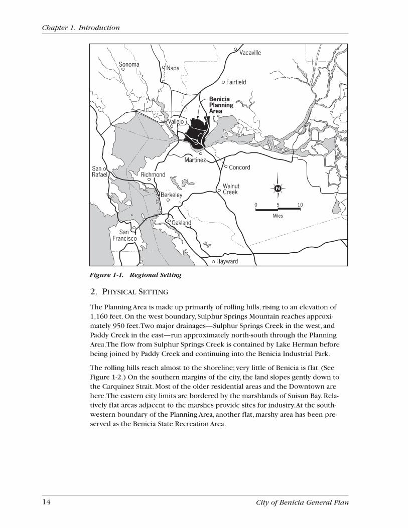
2. PHYSICAL SETTING
The Planning Area is made up primarily of rolling hills, rising to an elevation of1,160 feet. On the west boundary, Sulphur Springs Mountain reaches approxi-mately 950 feet. Two major drainages—Sulphur Springs Creek in the west, andPaddy Creek in the east—run approximately north-south through the PlanningArea. The flow from Sulphur Springs Creek is contained by Lake Herman beforebeing joined by Paddy Creek and continuing into the Benicia Industrial Park.
The rolling hills reach almost to the shoreline; very little of Benicia is flat. (SeeFigure 1-2.) On the southern margins of the city, the land slopes gently down tothe Carquinez Strait. Most of the older residential areas and the Downtown arehere. The eastern city limits are bordered by the marshlands of Suisun Bay. Rela-tively flat areas adjacent to the marshes provide sites for industry. At the south-western boundary of the Planning Area, another flat, marshy area has been pre-served as the Benicia State Recreation Area.
BeniciaPlanningArea
Fairfield
Vacaville
NapaSonoma
SanRafael
Oakland
Hayward
Berkeley
Richmond
Vallejo
MartinezConcord
WalnutCreek
SanFrancisco
0 105
Miles
Figure 1-1. Regional Setting

15City of Benicia General Plan
Figure 1-2. Generalized Topography
SOUTHAMPTON ROAD
C A R Q U I N E Z S T R A I T
Su
is
un
Ba
y
L akeHerman
S o u t h a m p t o nB a y
RE
SE
RV
OIR
ROAD
PANORAMA
DR
IVE
LAKEHERMAN ROAD
EAST2ND
STREET
PA
RK
RO
AD
IND
US
TR
IAL
W
AY
BAY
SH
OR
E
PARK
RO
AD
DRIVEROSE
RO
AD
MILITARY WEST
EASTMILITARY
1S
TS
TR
EE
T
ADAMSSTGRANT ST
E
5T
H
E.
2N
DS
TR
EE
T
ST
RE
ET
DRIVE
HA
ST
ING
S
W.
7T
H
ST
HILLCRESTAVENUE
INTERSTATE 780
INT
ER
STAT
E 680
S O L A N OC O
UN
TY
C O N T R AC O
ST
AC
OU
NT
Y
Planning AreaBoundary
Sphere of Influence
City Limits
Elevation Ranges:
0–100 ft.
100–200 ft.
200–300 ft.
300–400 ft.
400–500 ft.
500–600 ft.
600–700 ft.
700–800 ft.
800–900 ft.
900–1000 ft.
>1000 ft.
L E G E N D
800 0 800 1600
S C A L E
GENERALIZEDTOPOGRAPHY
B. Regional Setting
16
Chapter 1. Introduction
City of Benicia General Plan
Several key natural features have influenced the pattern of existing development:
• The Carquinez Strait and Suisun Bay, which provide an extensive, accessibleshoreline that is bracketed on both east and west by marsh preserves. Theshoreline is divided between residential, recreational, and industrial uses.
• Low hills above the Downtown that interrupt lines of sight to the newer devel-opment in the hill areas north of I-780. This interruption creates separate “visualbasins”—contributing to the small town feel and scale of Benicia. The topogra-phy frames a “water-oriented” area containing the Downtown, central Benicia,and portions of Southampton which lie below the main ridgeline.
• Steep hillsides, high promontories, and canyons north of the main ridgelinefacing the Carquinez Strait that define three distinct areas: (1) an “upland” areadirectly behind the main ridgeline, which is largely developed; (2) the “lake” areawhere the hills slope inward towards Lake Herman; and (3) a “northern” areacomprised of the watershed of Sulphur Springs Creek, which until the early1990s was considered for residential development.
• A pronounced terrace, directly in line with the Benicia-Martinez Bridge, thatseparates the northbound and westbound freeways. This terrace defines twodistinct industrial areas: community uses and import-export activities to thesouthwest, and major industrial uses to the northeast. The northeast industrialarea is also contained by the hills below Lake Herman Road to the north, theslopes above East Second Street to the west, and Suisun Bay to the east.
GATEWAYS
Benicia’s identity is strengthened by the experience of entering the city throughdistinct gateways: four by land and one by water. Each of these gateways providesa different view of the city:
Lake Herman Road: Provides the visitor with views of the lake and rollinghills. Arriving from this direction the newcomer mightsee Benicia as largely undeveloped.
Northern Gateway: On I-680 at Lake Herman Road. Presents Benicia as anindustrial city to visitors passing through the heart of theindustrial park.
Southern Gateway: Crossing the bridge from Martinez on I-680, showsBenicia as a Bay Area crossroads, where major rail andhighway crossings link the two shores of the CarquinezStrait.
Western Gateway: On I-780, introduces the traveler to the green marsh-lands in the Benicia State Recreation Area and water-oriented housing.
17City of Benicia General Plan
C. The Planning Area
Marina/Port Gateway: Welcomes those coming by small boat or by ship andprovides a waterfront view of Benicia revealing itssmall town “human scale” and historic character.
The view from each of these gateways is influenced both by topography and landuse. Whether Benicia is seen as a city of industry, open space, or residentialneighborhoods can depend on the vantage point of the observer. Future develop-ment near each of these gateways will have important effects on the image ofBenicia. (See Figure 1-3.)
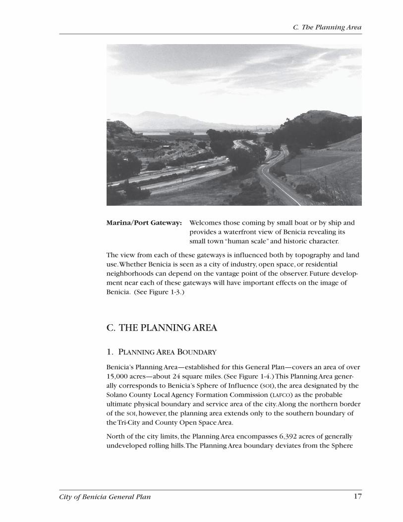
C. THE PLANNING AREA
1. PLANNING AREA BOUNDARY
Benicia’s Planning Area—established for this General Plan—covers an area of over15,000 acres—about 24 square miles. (See Figure 1-4.) This Planning Area gener-ally corresponds to Benicia’s Sphere of Influence (SOI), the area designated by theSolano County Local Agency Formation Commission (LAFCO) as the probableultimate physical boundary and service area of the city. Along the northern borderof the SOI, however, the planning area extends only to the southern boundary ofthe Tri-City and County Open Space Area.
North of the city limits, the Planning Area encompasses 6,392 acres of generallyundeveloped rolling hills. The Planning Area boundary deviates from the Sphere

18
Chapter 1. Introduction
City of Benicia General Plan
Figure 1-3. Gateways
Marina and PortGate
way
Planning AreaBoundary
City Limits
Gateway
S o u t h a m p t o nB a y
B E N I C I A
C A R Q U I N E Z S T R A I T
S O L A N O C O U N T Y
C O N T R A C O S T A C O U N T Y
L E G E N D
800 0 800 1600
S C A L E
SOUTHAMPTON ROAD
HAS
TIN
GS
DRIV
E
ROSE DRIVE
PANORAMA
DRIVE
C HELSEA
HILLS
DRIVE
RESERVOIR
ROAD
G o
o
d y e a rS
l ou
gh
Su
is
un
Ba
y
1st S
TREE
T
MILITARY WESTMILITARY EAST
W. 7th STREET
E. 2nd STREET
E. 5
th S
TREE
T
HILLCREST
GRANT ST.
PARK ROAD
E. 2nd STREET
LAKE HERMAN ROAD
INDU
STRI
AL W
AY
INTE
RSTA
TE 6
80
INTERSTATE 780
LakeHerman
S T A T EP A R K
BAYSHORE
ROAD
Western
LakeHerman
Road
Northern
Southern
GATEWAYS
COLUMBUS PARKWAY
ADAMS ST.
INDUSTRIALWAY

19City of Benicia General Plan
of Influence boundary to include a small area east of I-680 and to follow theboundary of the Tri-City and County Open Space on the north, rather than thestraight line drawn by LAFCO. Much of this land is used for cattle grazing or openspace. The eastern portion of the Planning Area includes a 242-acre Class I hazard-ous waste disposal site which is being prepared for permanent closure.
The Planning Area also includes a portion of Sulphur Springs Mountain, which hasbeen designated as a Mineral Resource Area. However, Syar Quarry is outside ofthe Benicia Sphere of Influence, and the Planning Area.
2. CITY LIMITS
Benicia’s 1995 City limits covers a total of 14 square miles, including about 1.2square miles of open water and 12.8 square miles of land. The land area alsoincludes some areas of seasonal or permanent wetlands. Nearly all of the existingresidential, commercial, and industrial development in the Planning Area is locatedwithin the City limits. Approximately 53 percent of the land within the City wasdeveloped as of 1995.
3. AREAS OF INTEREST
The City has identified several Areas of Interest outside the SOI that have a directphysical and social influence on the City’s planning but are not considered forannexation: (1) the Benicia-Vallejo buffer area adjoining Benicia’s west City Limits,between I-780 and Lake Herman Road; (2) an area adjacent to and west of theBenicia State Recreation Area; (3) an area between the railroad line and I-680 andnorth of Lake Herman Road; and (4) the Carquinez-Strait region. The City hasincluded these areas in its Planning Area and will request that it be notified of allplanning decisions affecting these “Areas of Interest.”
C. The Planning Area

20
Chapter 1. Introduction
City of Benicia General Plan
Figure 1-4. Benicia Planning Area
INDUSTRIALWAY
Planning AreaBoundary
Urban GrowthBoundary
Sphere of Inf luence
City Limits
S o u t h a m p t o nB a y
B E N I C I A
C A R Q U I N E Z S T R A I T
S O L A N O C O U N T Y
C O N T R A C O S T A C O U N T Y
L E G E N D
800 0 800 1600
S C A L E
SOUTHAMPTON ROAD
HAS
TIN
GS
DRIV
E
ROSE DRIVE
PANORAMA
DRIVE
C HELSEA
HILLS
DRIVE
RESERVOIR
ROAD
G o
o
d y e a rS
l ou
gh
Su
is
un
Ba
y
1st S
TREE
T
MILITARY WESTMILITARY EAST
W. 7th STREET
E. 2nd STREET
E. 5
th S
TREE
T
HILLCREST
GRANT ST.
PARK ROAD
E. 2nd STREET
LAKE HERMAN ROAD
INDU
STRI
AL W
AY
INTE
RSTA
TE 6
80
INTERSTATE 780
LakeHerman
S T A T EP A R K
BAYSHORE
ROAD
PLANNING AREA
COLUMBUS PARKWAY
ADAMS ST.

21City of Benicia General Plan
2. COMMUNITYDEVELOPMENT ANDSUSTAINABILITYCommunity development and sustainability are at the heart of the goals devel-oped in this General Plan. Community development refers to all aspects ofdevelopment including: (1) new residential and commercial development, such asnew housing or an office building; (2) economic development such as jobs,income, fiscal health, and expansion and attraction of businesses; and (3) relation-ships between different areas of the city and how those areas serve the needs ofthe community. Sustainable development has become a popular planning expres-sion used abundantly but often not understood. Sustainable development repre-sents an approach to community development that Benicia residents and busi-nesses want to achieve with this General Plan. A brief definition of sustainabledevelopment is provided below.

22
Chapter 2. Community Development and Sustainability
City of Benicia General Plan
WHAT IS SUSTAINABLE DEVELOPMENT?1
One of the first governing bodies in the United States to develop a definition forsustainable development that fits the vision of this Plan was the Minnesota Statelegislature. They define sustainable development as that which “maintains or enhanceseconomic opportunity and community well-being while protecting and restoring thenatural environment upon which people and economies depend. Sustainable develop-ment meets the needs of the present without compromising the ability of futuregenerations to meet their own needs.”
“Sustainability” in this General Plan conveys long-term interdependent economic andenvironmental goals that promote efficient land use. It is a way of thinking and actingresponsibly with respect to environmental, social, and economic issues at ever-widening levels of awareness or “integration.” That is, what is done at the project orlocal level can affect all levels of the environment, including the local community,neighboring regions, the country, and the world.
Sustainable development implies urban areas that reflect a long-term economichorizon; result in efficient land use patterns that are not overly energy-intensive; havesufficient linkages to the local and regional economy to assure long-term job creationand economic vitality; support ecologically sensitive design features; and value thepublic realm.
The concept of creating a sustainable community in Benicia is a primary goal andobjective of the General Plan. The concept affects all chapters of the Plan and allaspects of the community. While it is assumed that this Plan cannot radically changethe nature of Benicia, the goal and intent is to create a more livable and sustainablecommunity over time.
1 This definition is taken in part from “Sustainable Development: Concept Definition, Urban DevelopmentPrinciples, and Stapleton Opportunities and Constraints” prepared for the Stapleton RedevelopmentFoundation by Economic & Planning Systems, Inc. (January 1994).

23City of Benicia General Plan
A. LAND USE AND GROWTH MANAGEMENT
The primary function of this section is to designate land for specific types andamounts of development and to set the overall development framework for the City.Areas of the City are generally categorized according to their suitability for residential,commercial, industrial, or public/quasi-public use. In addition, the City has designatedland for open space that should not be developed because of its importance forhealth, safety, agriculture, or recreation.
The land use section provides background information on the location and extent ofexisting land uses in Benicia, defines each land use category used in the plan, anddescribes the changes that this plan makes to the 1993 General Plan. A land use planmap covering the entire planning area is provided in the back pocket of this docu-ment and is adopted as City policy as part of this General Plan.
The Growth Management section establishes the overarching goals for developmentin Benicia. It defines and seeks to preserve those characteristics that make Benicia atruly unique and special place.
LAND USE
The pattern of general plan land uses is reflected in the pocket diagram at theback of the document. The largest category is industrial (31%), followed closelyby parks/open space (25%) and residential (21%). Non-industrial/commercial usesrepresent a relatively small portion (3%). This pattern indicates the community’spriorities in terms of types of land uses within the city limits. The new generalplan slightly shifts the existing pattern of land use in the northern area toward
A. Land Use and Growth Management
Figure 2-1. General Plan Land Use Catagories Within City Limits
Residential1,733 Acres (21%)
Total Land Area = 8,163 Acres
Commercial381 Acres (5%)
Industrial2,578 Acres (31%)
Transportation (e.g., freeways)1,195 Acres (15%)
Public/Quasi-public230 Acres (3%)
Parks/Open Space2,046 Acres (25%)
LAND USE CATEGORIES
Sources: City of Benicia; Knox and Associates

24
Chapter 2. Community Development and Sustainability
City of Benicia General Plan
more open space (refer to Appendix B - Land Use Changes). This reflects thecommunity’s desire to contain development and grow at a slower rate.
It is the intent of this General Plan that land be used efficiently to reduce traffic,preserve land at urban fringes, reduce infrastructure costs, and minimize the loss offarmland, wetlands, and open space. By doing these things, it is hoped that Benicia canavoid the costs of sprawl and erosion of the quality of life.
For each category of land, the General Plan must establish standards of populationdensity and building intensity. For residential land, the Plan will stipulate densities inhousing units per gross acre. Potential population density will be obtained by multi-plying the number of units per acre by the number of persons per unit (three per-sons/unit for low density, two persons/unit for medium and high density. In the eventof a discrepancy between residential units per acre and persons per acre, the unitdensity—and not the population density—will govern.)
For nonresidential uses, the Plan specifies a maximum Floor Area Ratio (FAR), calcu-lated as the ratio of gross floor area to site area.
The specific uses mentioned in each definition of the land use categories are intendedto be general and illustrative (as opposed to specific and all-inclusive).
1. RESIDENTIAL LAND
The General Plan has three residential land use categories. Each of the General Planresidential land use designations is intended to correspond to a specific zoningdescribed in the Benicia Zoning Ordinance.
Table 2-1. Zoning District Equivalents for General Plan Residential Land Use
Categories
GENERAL DENSITY RANGE DENSITY RANGE
PLAN ZONING (UNITS/ (PERSONS/
CATEGORY DISTRICT GROSS ACRE) GROSS ACRE)
Low Density RS 0.1–7 0.3–21
Medium Density RM 8–14 16–28
High Density RH 15–21 30–42
Source: City of Benicia
The City may apply a lower density in certain cases (for example, if environmentalconstraints make it physically impossible to construct the minimum density in a givenland use category). Densities higher than the upper limit can be achieved through theuse of density bonuses for lower-income housing. This applies to any developmentwith a residential component.
25City of Benicia General Plan
Table 2-2. Residential Land Within City Limits in Gross Acres, as of 1995
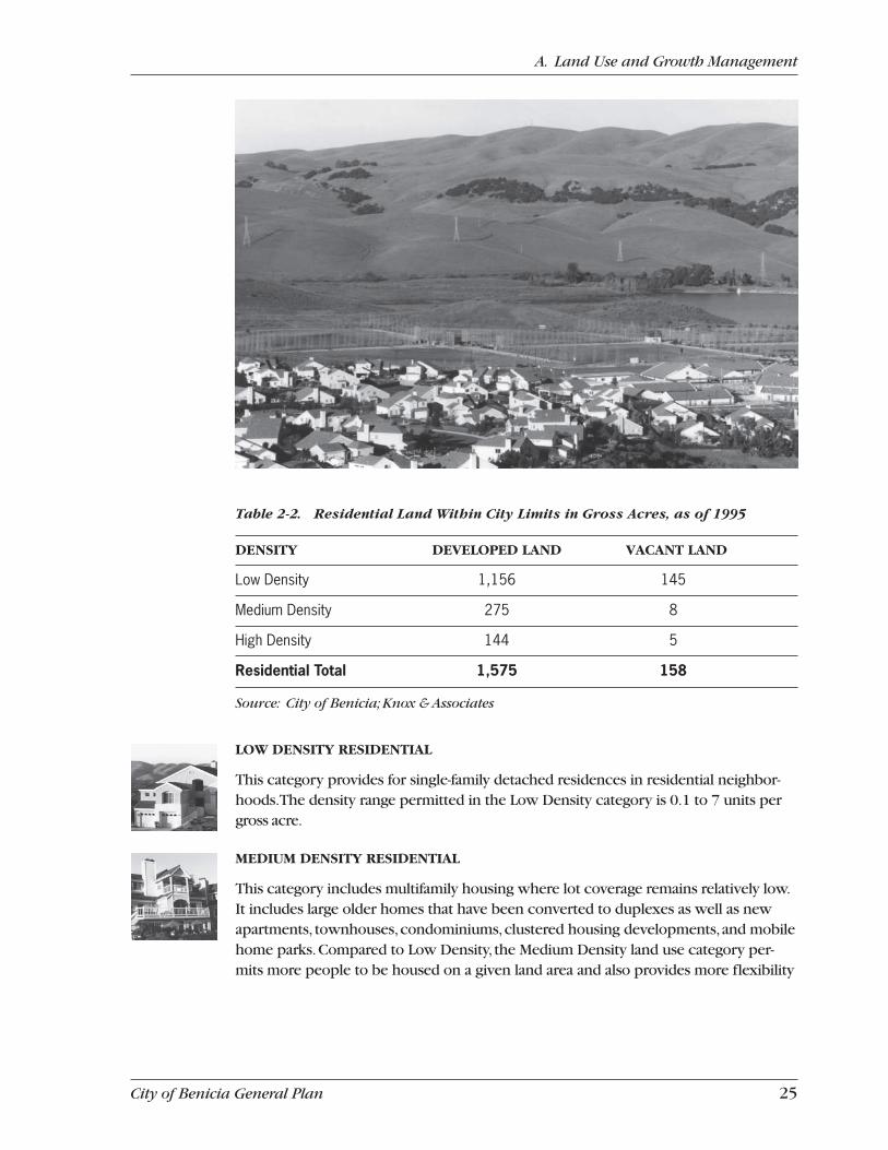
DENSITY DEVELOPED LAND VACANT LAND
Low Density 1,156 145
Medium Density 275 8
High Density 144 5
Residential Total 1,575 158
Source: City of Benicia; Knox & Associates
LOW DENSITY RESIDENTIAL
This category provides for single-family detached residences in residential neighbor-hoods. The density range permitted in the Low Density category is 0.1 to 7 units pergross acre.
MEDIUM DENSITY RESIDENTIAL
This category includes multifamily housing where lot coverage remains relatively low.It includes large older homes that have been converted to duplexes as well as newapartments, townhouses, condominiums, clustered housing developments, and mobilehome parks. Compared to Low Density, the Medium Density land use category per-mits more people to be housed on a given land area and also provides more flexibility
A. Land Use and Growth Management

26
Chapter 2. Community Development and Sustainability
City of Benicia General Plan
in the location and arrangement of buildings than is possible in most single-familydetached developments. The density range permitted in the Medium Density categoryis 8 to 14 units per gross acre.
HIGH DENSITY RESIDENTIAL
This category permits a density range of 15 to 21 units per acre. High Density Residen-tial is intended to increase housing opportunities by permitting more housing to bebuilt on a parcel(s).
2. COMMERCIAL LAND
The Benicia General Plan separates commercial land into five categories:(1) Community Commercial (previously called Neighborhood Commercial),(2) General Commercial, (3) Downtown Commercial, (4) Waterfront Commercial, and(5) Business and Professional Office. Each of these categories is intended to accommo-date a particular scale and intensity of commercial use and corresponds to a particularzoning category. Each category has a permissible floor area ratio (FAR) and restrictionson uses. Table 2-3 shows the breakdown of commercial land into these five categories.
Table 2-3. Commercial Land (in gross acres) Within City Limits, as of 1995
CATEGORY FAR DEVELOPED VACANT
LAND LAND
Downtown 2.0–2.4 19 5
General 1.2 51 102
Community (formerly 1.2 6 0“Neighborhood”)
Office 0.8–1.2 16 6
Waterfront 0.8–1.2 8 8
Commercial Total 101 280
Source: City of Benicia; Knox & Associates
DOWNTOWN COMMERCIAL
This category encourages a wide variety of retail businesses, restaurants, and lodging isencouraged. Offices and residences are encouraged above the first floor in order toestablish a greater variety, intensity, and efficiency of use.2 A higher intensity ofdevelopment Downtown is envisioned by permitting a maximum FAR of 2.4—higherthan in the other commercial districts. The 2.4 FAR, however, is permitted only ifhousing is included; the maximum non-residential FAR is 2.0.
2 Resolution No. 87-31, 2/17/87

27City of Benicia General Plan
GENERAL COMMERCIAL
This category is intended to provide shopping and services for the community asa whole and for visitors coming from the freeways. Solano Square, SouthamptonCenter, and Parkway Plaza are designated General Commercial. A small commer-cial center at East Fifth Street and Military East is also designated General Com-mercial to provide for auto service and parts, retail sales, and similar uses. GeneralCommercial is intended to allow a wide range of commercial development, withthe intensity of development limited by a maximum FAR of 1.2.
COMMUNITY COMMERCIAL
This category (previously called Neighborhood Commercial) is intended to apply toconvenience commercial centers which are limited in size. Uses include retail andquasi-public uses. Community Commercial is the most restrictive of the commercialcategories and has a maximum FAR of 1.2.
BUSINESS AND PROFESSIONAL OFFICES
This designation is intended to allow small-scale offices to serve as a buffer betweenresidential uses and more intensive commercial areas. Offices in this category typicallygenerate lower traffic volumes than offices in other commercial or industrial districts.A maximum FAR of 0.8 is allowed (increased to 1.2 if housing is included).
WATERFRONT COMMERCIAL
This category is intended to accommodate development with both a water orienta-tion and historic character to create a pedestrian-scale commercial and residentialarea. Multifamily residences and live/work spaces are permitted in Waterfront Com-mercial. The commercial component is restricted to retail shops and services thatdirectly support marina and boating activities or restaurants overlooking the water. Amaximum FAR of 1.2 is permitted for projects that include housing above the groundfloor; otherwise the FAR is limited to 0.8.
3. MIXED USE
DOWNTOWN MIXED USE
This category includes residential, retail, office, public and quasi-public uses. Itspurpose is to encourage a mix of compatible uses adjacent to the Downtown, upgrad-ing of existing buildings, preservation and adaptive reuse of historic buildings, andintroduction of new, compatible mixed use buildings. “Mixed use” includes themixing of permitted activities within the same building or within separate buildingson the same site or on contiguous sites. Design standards will be developed to ensurethat mixed use development is compatible with and contributes to the character ofthe street, the Downtown, and adjoining neighborhoods. The Downtown Mixed Usecategory permits a maximum FAR of 2.0.
A. Land Use and Growth Management

28
Chapter 2. Community Development and Sustainability
City of Benicia General Plan
LOWER ARSENAL MIXED USE
This category includes residential, live/work, office, retail, public and quasi-public, andlimited industrial uses. The purpose of this category is to continue to encourage a mixof compatible uses in areas of the Lower Arsenal; to promote the upgrading of existingbuildings, and the preservation and adaptive reuse of historic buildings; and to allownew, compatible buildings to house mixed use. The Lower Arsenal Mixed Use cat-egory permits a maximum FAR of 2.0.
4. INDUSTRIAL LAND
Before 1987, industrial land was designated either Heavy Industrial or Light Industrial.Since 1987, Benicia’s industrial land has been divided into three General Plan LandUse categories: (1) General Industrial; (2) Limited Industrial; and (3) Water-relatedIndustrial. Table 2-4 shows how the industrial land is divided among these categories.
Table 2-4. Industrial Land (in acres) within City Limits, as of 1995
CATEGORY FAR DEVELOPED VACANT
LAND LAND
General Industrial 0.7 1,006 714
Limited Industrial 0.7 29 559
Water-related 0.7 178 92
INDUSTRIAL TOTAL 1,213 1,365
Source: City of Benicia; Knox & Associates
GENERAL INDUSTRIAL
The General Industrial land use category is the least restrictive of the three categoriesand is intended to allow a great deal of flexibility for industrial development. Over halfof the Benicia Industrial Park is designated General Industrial. This includes nearly allof the Industrial Park north of I-780 and east of East Second Street. This categoryincludes manufacturing, assembly, and packaging of goods and products from ex-tracted, raw, and previously prepared materials and related industrial and commercialservices. The maximum FAR permitted in this category is 0.7.
LIMITED INDUSTRIAL
This category includes manufacturing, assembly, and packaging of goods primarilyfrom previously prepared (not raw) materials; wholesale, distribution, and storagefacilities (including auto import, export, and storage); research and developmentfacilities; and related industrial and commercial services. As it pertains to refining-related activities, this category also includes such uses as: fabrication areas, packaging

29City of Benicia General Plan
A. Land Use and Growth Management
facilities (dry and liquid), quality control laboratories, and refining accessory uses suchas maintenance shops, storage areas, shipping/distribution facilities and offices.
Several areas of the Benicia Industrial Park which border other types of land use aredesignated Limited Industrial to provide a buffer between the General Industrial areasand the rest of the City. Lower levels of traffic—particularly from heavy trucks—areexpected in the Limited Industrial areas than in the General Industrial category. TheLimited Industrial category permits a maximum FAR of 0.7.
WATER-RELATED INDUSTRIAL
This category includes port terminals and water-dependent, related industrial usessuch as warehousing and storage; support transportation services; and ship mainte-nance and repair. The Water-related Industrial category is intended to protect the Portof Benicia from intrusion by non-water-dependent uses, to promote its long-termdevelopment, and to provide back-up land for port-related activities. The Water-relatedIndustrial category permits a maximum FAR of 0.7.
5. PUBLIC AND QUASI-PUBLIC LAND
This category is intended to provide for a variety of uses serving the public includingeducation, police, fire, water, and sewer. (Park and recreation facilities are included as aseparate category under Open Space.) The Public/Quasi-public land use categoryallows facilities for City administration, safety, and health services; public and privateschools; public utilities; and other public/quasi-public facilities. Facilities serving thepublic are scattered throughout the city. (Refer to Table 2-5 on the following page).
The maximum FAR for public/quasi-public facilities is established on a case-by-casebasis through the use permit process of the Benicia Zoning Ordinance. If a use permitdoes not set a maximum FAR, then the maximum FAR of the abutting zoning districtapplies.
6. OPEN SPACE
State planning law requires cities to plan for “open space for the preservation ofnatural resources, the managed production of resources, outdoor recreation, andpublic health and safety.” The General Plan Land Use Diagram (found in the backpocket of this Plan) recognizes three categories of open space to meet these require-ments:

30
Chapter 2. Community Development and Sustainability
City of Benicia General Plan
Table 2-5. Existing Public and Quasi-public Facilities Within City Limits, 1995
FACILITY ACREAGE
Administration
City Hall 3.0
Post Office 1.9
School District Offices 6.0
Cultural/Recreational Facilities
Library 0.8
Senior Center 0.3
Girl Scout House 0.5
Boy Scout House 0.5
Swim Club (Private) 1.6
Clocktower, Commandant’s House 7.0
B.D.E.S. Meeting Hall 0.5
Public Access Trails 6.9
Tennis Court 0.3
Veteran’s Hall 0.5
Municipal Utilities
Water Treatment Plant 30.0
Sewage Treatment Plant 7.0
Corporation Yard 7.0
Building Maintenance Yard 0.2
Public Safety
Police Station (part of City Hall complex)
Fire Station #1 0.5
Fire Station #2 0.6
Public Schools
Elementary 44.4
Benicia Middle School 18.7
Benicia High School 35.0
Private School 2.0
Child Care Centers 2.4
Churches 25.4
Cemeteries 32.7
Other Facilities 10.5
Total Public/Quasi-Public 246.2
Source: City of Benicia; Knox & Associates

31City of Benicia General Plan
MARSH
“Marsh” permits only educational and scientific research, low impact hiking, fishing,bird-watching, and similar activities offering public access to the shoreline.
GENERAL OPEN SPACE
General Open Space includes urban open space, such as publicly-owned open space,land dedicated for permanent open space in residential subdivisions, and open spacefor public health and safety, such as hillsides with slopes over 30 percent; and ruralopen space, such as open space for managed production of resources (such as mineralresources), and open space for conservation of natural resources (such as the LakeHerman watershed). Allowable open space uses include agriculture, horticulture,passive recreation, and mineral extraction in State-designated mineral resource areasonly. General Open Space may lie inside or outside the Urban Growth Boundary.
PARKS
Parks provide land for the more intensive recreational uses. There are three park typesin Benicia.
Regional Park: A Regional Park generally serves one or more communities andaccommodates a variety of activities designed to enhance the use and experienceof the natural environment. Uses may include trails, nature centers, picnic areas,and camping, if appropriate.
Community Park: A community park is designed to serve several neighborhoods.Community parks should accommodate a wide variety of activities and meet theneeds of diverse users.
Neighborhood Park: A neighborhood park is designed to serve a residentialpopulation in close proximity to the park. Neighborhood parks should accommo-date a variety of activities including playground activities, picnicking, and lawngames.3
Table 2-6. Park Standards
PARK TYPE ACRES/1,000 SERVICE AREA SIZE (ACRES)
PEOPLE
Regional Park 10.0 One hour travel 250–1,000
Community Park 2.5 Within 3 miles of all residences 30–100
Neighborhood Park 3.5 Within 1/2 mile of all residences 2–15
Source: Benicia General Plan, 1993; Parks, Trails and Open Space Master Plan, Revised
1994
A. Land Use and Growth Management
3 Parks, Trails, and Open Space Master Plan, pp. 3-1 through 3-3.
revised 11.4.03 (Measure K)

32
Chapter 2. Community Development and Sustainability
City of Benicia General Plan
GROWTH MANAGEMENT
The preceding pages describing the different land use categories and changes set thestage for how Benicia is to develop over the next 15-20 years. The Growth Manage-ment section creates the connection between land uses and growth by establishingthe overarching goals, policies and programs for development in Benicia.
To reinforce these policy statements the plan defines an urban growth boundary(refer to Glossary.)
Urban Growth Boundary (UGB) is coterminous with the city limit line around theproperty at the end of Bantry Way (Zocchi property) to Lake Herman Road; it followsLake Herman Road east to the western side of the 20-acre property owned byNorthgate Christian Fellowship, then turns northwest and traces that property’sboundary back to Lake Herman Road, then follows Lake Herman Road east to Inter-state 680. At Interstate 680, the boundary turns north along the freeway, then westaround the area identified as Area 9 on the Land Use Changes diagram. It then contin-ues north on Interstate 680, then turns east to the north end of the 1999 City Limit onGoodyear Road.
The Urban Growth Boundary is an officially adopted and mapped line that separatesthe City’s urban area from its surrounding greenbelt of open lands. It is a growthmanagement tool that seeks to contain, control, direct, or phase growth in order topromote more compact, contiguous urban development. No urban development isallowed beyond the UGB except for public parks and public or private recreation usesthat do not require urban facilities or services as defined in Policy 2.1.5.
Benicia’s UGB reflects the City’s commitment to focus growth and prevent urbansprawl. It recognizes the City’s limited ability to extend services (i.e., sewer, water,police, etc.) and its desire to protect agricultural and ecologically sensitive land.
In addition, the UGB will help preserve key land forms which separate Benicia physi-cally and visually from adjacent communities; protect and maintain the rural quality ofLake Herman Road and areas adjacent to it; concentrate future development in areaswhere services and infrastructure can be provided more cost effectively; strengthenFirst Street as the City’s central commercial zone; guard against community healthrisks by avoiding encroachment into lands affected by the IT Panoche HazardousWaste Disposal Facility; and prevent encroachment into and avoid land use conflictswith areas designated as a mineral resource area of regional significance (SyarQuarry).
GOAL 2.1: Preserve Benicia as a small-sized city.
“Small-sized city” refers to Benicia’s open and uncluttered space, safe neighborhoodsand streets, pedestrian-friendly streets, the “Main Street” character of First Street, openvistas of hills and water, historic sites and buildings, strong sense of community and
revised 11.4.03 (Measure K)

33City of Benicia General Plan
civic pride, good schools, well developedcommunity facilities including parks and alibrary, low-crime, small town atmosphere,and numerous community-wide celebra-tions, cultural events, and family-orientedactivities.
POLICY 2.1.1: Ensure that newdevelopment iscompatible withadjacent existingdevelopment anddoes not detractfrom Benicia’s smalltown qualities andhistoric heritage,(and to the extentpossible, contributesto the applicablequality of life factors noted above).
“Compatible” means “capable of existing together without detrimental effects.” Thispolicy applies broadly and citywide to residential and nonresidential uses. Its purposeis to ensure harmonious development in terms of intensity, and architectural character.It is not intended to restrict new buildings or additions to exact duplications of stylesor heights; nor is it intended to limit new uses or densities to those found in adjacentexisting development. This policy also is not intended to restrict the conversion ofsingle-family dwellings to apartments if the parcel is zoned for multifamily use and ifthere are other multifamily uses nearby.
Program 2.1.A: Adopt development guidelines that retain the scale and charac-ter of the city, preserve public view corridors, and reflect thesubdivision and development patterns within existing neigh-borhoods.
POLICY 2.1.2: Make efficient use of land in new development areas consistentwith the surrounding neighborhood.
POLICY 2.1.3: Maintain a visual and physical separation from the cities ofFairfield and Vallejo.
POLICY 2.1.4: Strive to preserve significant areas of vegetation and openspace when approving development projects.
“Significant” can mean, for example, a single specimen tree, vegetation serving ashabitat, or a grove of several native trees which enhance the canopy and scenicbeauty of a neighborhood.
A. Land Use and Growth Management

City of Benicia General Plan
POLICY 2.1.5: An Urban Growth Boundary is established as shown on theGeneral Plan Land Use Diagram in order to separate the City’surban area from its surrounding greenbelt of open lands and tomaintain lands near Lake Herman and north of Lake HermanRoad in permanent agriculture/open space use. No urbandevelopment is allowed beyond the Urban Growth Boundary.“Urban development” shall mean development requiring one ormore basic municipal services including, but not limited to,water service, sewer, improved storm drainage facilities, firehydrants and other physical public facilities and services.
Policy 2.1.6: No urban development beyond the Urban Growth Boundaryshall be served by City water and/or sewer services.
Policy 2.1.7: The City shall promote compact urban development within theUGB and shall encourage development of public, semi-public,active recreational, and all other uses deemed desirable for thecommunity inside the UGB.
Policy 2.1.8: Prior to December 31, 2023, the Urban Growth Boundarydesignated on the Land Use Diagram, this policy, Policies 2.1.5,2.1.6, and 2.1.7 and the definition of Urban Growth Boundaryin the Glossary, may be amended only by a vote of the peopleor pursuant to the procedures set forth below:
Exception I - Takings. the City Council may amend the Urban Growth Boundary if itfinds, by at least a four-fifths vote and based on substantial evidence in the record,that:
(1) The application of the Urban Growth Boundary policies would constitute anunconstitutional taking of a landowner’s property, and
(2) The amendment and associated land use designation will allow additionalland uses only as necessary to avoid said unconstitutional taking of thelandowner’s property.
Exception II - Housing Supply. The City may grant an exception from the require-ments of the Initiative where it determines that doing so is necessary to complywith State law governing the provision of housing. The City may do so only if itfirst makes each of the following findings based on substantial evidence in therecord:
(1) A specific provision of State law requires the City to accommodate theproposed housing, and
(2) No feasible alternative exists that would allow for the required units to bebuilt without siting some or all of them outside the Urban Growth Boundary.
Exception III - Reorganization. The General Plan may be reorganized, readopted indifferent text and/or format, and individual provisions may be renumbered or
Chapter 2. Community Development and Sustainability
33A revised 11.4.03 (Measure K)
City of Benicia General Plan 33B
A. Land Use and Growth Management
with the requirements of State law, but Land Use Element policies relating to theUrban Growth Boundary shall continue to be included in the General Plan untilDecember 31, 2023, unless earlier repealed or amended pursuant to the proce-dures set forth above or by the voters of the City.
revised 11.4.03 (Measure K)
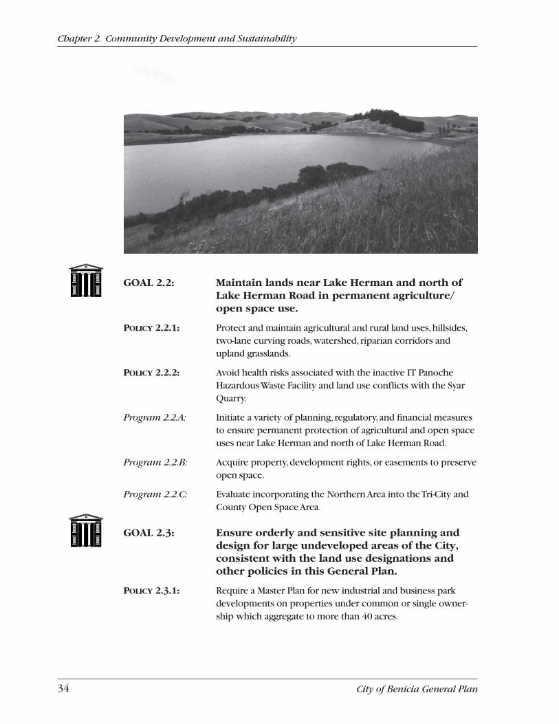
34
Chapter 2. Community Development and Sustainability
City of Benicia General Plan
GOAL 2.2: Maintain lands near Lake Herman and north ofLake Herman Road in permanent agriculture/open space use.
POLICY 2.2.1: Protect and maintain agricultural and rural land uses, hillsides,two-lane curving roads, watershed, riparian corridors andupland grasslands.
POLICY 2.2.2: Avoid health risks associated with the inactive IT PanocheHazardous Waste Facility and land use conflicts with the SyarQuarry.
Program 2.2.A: Initiate a variety of planning, regulatory, and financial measuresto ensure permanent protection of agricultural and open spaceuses near Lake Herman and north of Lake Herman Road.
Program 2.2.B: Acquire property, development rights, or easements to preserveopen space.
Program 2.2.C: Evaluate incorporating the Northern Area into the Tri-City andCounty Open Space Area.
GOAL 2.3: Ensure orderly and sensitive site planning anddesign for large undeveloped areas of the City,consistent with the land use designations andother policies in this General Plan.
POLICY 2.3.1: Require a Master Plan for new industrial and business parkdevelopments on properties under common or single owner-ship which aggregate to more than 40 acres.

35City of Benicia General Plan
A. Land Use and Growth Management
Master plans will encourage the best and most effective use of the properties and willgive the City an idea of how and when the various parcels or parts of parcels will bedeveloped and when public facilities will be needed. The industrial properties towhich this policy is most likely to apply are listed below and are shown on Figure 2-2.The five industrial properties as of 1995 are: The Seeno properties; the Exxon undevel-oped area; Pine Lake north of I-780; the Port south of the bridge; and the Port north ofthe bridge.
The master plan requirement also applies to other large properties, which are notlisted or mapped below but which may in the future be purchased or assembled fordevelopment or private redevelopment. Such master planning may be initiated by thePlanning Commission, the City Council, or private property owners.
Program 2.3.A: Ensure adequate funding is available for the long-term mainte-nance of undeveloped areas preserved when approving landdivisions.
POLICY 2.3.2: Support land divisions where existing buildings with historicor architectural significance are retained and/or improvedrather than demolished.
GOAL 2.4: Ensure that development pays its own way.
State law allows cities to assess fees to ensure that development pays for itself; how-ever the law also requires a nexus between fees imposed on developers and thepublic improvements funded by those fees.
POLICY 2.4.1: Ensure any new development to be fiscally and financiallysound and pay its own way with respect to City and SchoolDistrict capital improvements.
The objective is that neither the City nor the School District will be expected orrequired to use general funds to provide capital improvements for private develop-ment unless a project produces substantial public benefits and amenities in which theCity or School District may want to participate.
Program 2.4.A: Monitor development to ensure it does not overburden theCity’s infrastructure.

36
Chapter 2. Community Development and Sustainability
City of Benicia General Plan
Figure 2-2. Industrial Properties to which Policy 2.3.1 (Master Plan) Applies,
as of 1999
INDUSTRIAL WAY
S o u t h a m p t o nB a y
B E N I C I A
C A R Q U I N E Z S T R A I T
S O L A N O C O U N T Y
C O N T R A C O S T A C O U N T Y
800 0 800 1600
S C A L E
SOUTHAMPTON ROAD
HAS
TIN
GS
DRI
VE
ROSE DRIVE
PANORAMA
DRIVE
CHELSEAH
ILLSD
RIVE
RESERVOIRROAD
G o
o
d y e a rS
l ou
gh
Su
is
un
Ba
y
1st S
T
MILITARY WEST
W. 7th STREET
E. 2nd STREET
HILLCREST
PARK ROAD
E. 2nd STREET
INDU
STRI
AL W
AY
INTE
RSTA
TE 6
80
INTERSTATE 780
LakeHerman
S T A T EP A R K
BAYSHOREROAD
INDUSTRIAL LAND —OVER 40 ACRES
CHELSEAH
ILLSD
RIVE
PANORAMA
DRIVE
L E G E N D
COLUMBUS PARKWAY
ADAMS
LAKE HERMAN ROAD
Sphere of Inf luence
Planning Area Boundary
City Limits
MILITARY EASTGRANT ST.
E. 5
th S
TREE
T

37City of Benicia General Plan
B. ECONOMIC DEVELOPMENT
This section of the plan contains five subsections that direct the more urban aspectsof how the community should develop. Each subsection focuses on a particular typeor area of economic development within the community: industrial development,port development, the Historic Arsenal area, the Downtown area, and other commer-cial development.
The Economic Development section begins with a discussion of the City’s economicstrengths and challenges, followed by goals, policies and programs for each of the fivetypes or areas of economic development. Background information about eacheconomic development area or type precedes the goals, policies and programs forthat subsection.
1. ECONOMIC OPPORTUNITIES AND CHALLENGES
Benicia is a unique community that offers a “small town” residential and commercialenvironment in the foreground of a large industrial concentration. While Benicia ispart of the Solano County market, its location along the Carquinez Strait, views of thewater, and its active Port give the City more economic development opportunitiesthan some of its landlocked competitors. The City also has a strong historic andcultural base, and the historic buildings in the Downtown and Arsenal area add toBenicia’s charm and distinction.
B. Economic Development

38
Chapter 2. Community Development and Sustainability
City of Benicia General Plan
The City of Benicia enjoys many economic advantages over similarly-sized cities in thegreater Bay Area. It has a significant concentration of economic activity in the Port andthe Benicia Industrial Park (BIP), which includes the Exxon Refinery. These are consid-ered “heavy industrial” uses and provide a strong economic base for the City. Inaddition, businesses that support the refinery industry need to be located nearby, andmany choose Benicia given its location and large concentration of like businesses.
The tax revenues that the BIP and other heavy industrial uses generate allow the Cityto provide a relatively high level of public services, including its own library system. Asa result, the Economic Development Goals, Policies, and Programs emphasize theimportance of protecting existing heavy industrial uses.
Many also believe, however, that Benicia can capitalize on its central location bydiversifying its economy and attracting more high-technology firms and tourists.Although a radical shift in the types of businesses that locate in the city over the next20 years is not expected, more non-industrial activities are desired in the future.Measures to increase the diversity of industries and land uses therefore can also befound in the Economic Development Goals, Policies, and Programs.
BENICIA’S COMPETITIVE STRENGTHS
From an economic standpoint, Benicia has many competitive strengths. The fact thatthe City’s industrial vacancy rate is about 6 percent validates this position; othersurrounding communities have industrial vacancies from 10 to 17 percent. The Cityhas a well-developed industrial park (BIP), which is geographically compact andtopographically separated from the rest of the City. The Port, leased, owned, andoperated by Benicia Industries, is over 200 acres and complements many of theactivities found in the BIP. The Exxon refinery has drawn over the years a series ofsupport and related industries to the City which together represent an importantagglomeration of economic activity. One advantage of the BIP’s size and location isthat businesses perceive that their industrial activities will be buffered from potentialconflicts with other uses. Exxon owns about 400 acres of land west and south oftheir facility.
In summary, Benicia’s assets that attract businesses include:
• Central location (i.e., highway accessibility to markets in the Bay Area, Sacramento,and Northern California).
• Presence of major manufacturing and refineries that attract similar types of busi-nesses.
• Historic buildings and places.
• View of the water and hills.
• Some developable commercial vacant parcels (although high-priced).
• Private redevelopment potential and mixed use projects.
• Good transportation and access.

39City of Benicia General Plan
• Supportive local government/business climate.
• Municipal fiscal soundness.
• Highly skilled, reliable, dependable, and productive labor force.
• Quality of life (e.g., low crime, good public schools, warm climate, etc.)
BENICIA’S COMPETITIVE CHALLENGES
The City also faces a number of weaknesses in attracting businesses. These include thefollowing, many of which are mentioned in the City’s 1995 Economic DevelopmentStrategy (Resolution 95-10):
• No public transportation in the BIP industrial area.
• Limited vacant industrial and commercial sites.
• Limited very high and low income housing.
• High rent for Downtown real estate.
• Reliance on one type of industry for major business tax revenues.
Although development fees in Benicia may be higher than in other regions inCalifornia and nearby states, they are comparable to the average fees in SolanoCounty and other competitive markets. Industrial and residential fees are onlyslightly higher than the average, and retail fees are slightly lower than the average.
While it is important to keep development costs low, it is equally important toprovide adequate infrastructure and maintain it. A significant number of industri-ally-zoned parcels require investment in infrastructure in the next 20 years ifthese sites are to be competitive. This infrastructure could be provided by the Cityor by developers. Either way, Benicia will need to facilitate the creative financingmechanisms to provide infrastructure in a timely fashion. There is also a need toinvest in existing infrastructure that cannot be funded through developmentimpact fees or special assessments under existing law (Government Code §66000et seq., popularly known as AB 1600). A funding program (e.g., for a landscape andlighting district) should be developed to ensure annual maintenance and replace-ment of infrastructure to keep the city’s non-residential areas competitive.
Although the lack of higher value or executive housing may be a perceivedweakness to some in the community, the lack of housing available to those whowork in Benicia will have a much greater impact on economic development inthe long run. The greater the amount of housing for workers in the BIP, the morecompetitive the City will be.
BENICIA’S FISCAL STATUS
All communities have their weaknesses and strengths. While Benicia has severalperceived economic weaknesses, it also has many economic strengths. Overall, theCity’s economy, while focused on a few industries, is strong and competitive.
B. Economic Development

40
Chapter 2. Community Development and Sustainability
City of Benicia General Plan
The City worked hard to reduce or hold constant expenditures over the five years1990–1995 in order to respond to the loss of revenues from property tax diversionsto the State and from a reduction in other revenues. Once the outstanding debt fromthe community park development is repaid and the General Plan update is complete,the Finance Department projects positive fiscal balances starting in 1997–98. Futureincreases in property taxes may be limited unless additional capacity for developmentis created. The City will need to work hard to retain existing businesses, to attract newsales-tax generating uses, and to continue its cost containment measures.
A review of per capita expenditures for cities of similar size shows that Benicia resi–dents enjoy a high level of municipal services, which is a direct result of the amountof revenues generated by industry. To continue to enjoy these services, the City willneed to protect and enhance business and economic activity in both the BIP and Portareas. It will also need to encourage economic expansion in the Downtown andArsenal areas. Figure 2-3 shows the projected General Fund Revenues for 1999-2000.
Figure 2-3. City of Benicia General Fund Revenues
License & Permits
Other Revenue
Charges for Current Services
Revenue from Other Agencies
Use of Money / Property
Fines, Forfeitures & Penalties
Other Taxes
Property Tax $7,158,360
GENERAL FUND REVENUES
Sales and Use Tax
Utility User's Tax
$213,750
$1,315,515
$713,445
$1,306,950
$185,000
$126,000
$1,075,400
$2,985,000
$2,133,800
Sources: City of Benicia Municipal Budget 1999/2000

41City of Benicia General Plan
2. ECONOMIC DEVELOPMENT GOALS, POLICIES, AND PROGRAMS
Benicia has an aggressive economic development program and has attracted severallarge companies to the Benicia Industrial Park (BIP) and elsewhere in the City. AnEconomic Development Strategy was adopted by the City in 1995. The Strategyfocuses on (1) business retention and expansion, and (2) business attraction andincentives, and (3) outlines a set of policies and recommended actions. Studies haveshown that businesses wishing to expand chose to stay in Benicia rather than moveout of state.4 Reviews of recent expansion or new leases within the BIP confirm thatthese economic development efforts are working.
The City’s Economic Development Department also recently created an IndustrialDevelopment Authority to issue tax-exempt revenue bonds.5 Bonds have been issuedto assist major employers and space users and keep them in the City. The City alsocreated a local hiring service to help connect local business with local labor.
The goals, policies, and programs in this section address several points: They supportcontinued internal growth and development of the industrial park and its port; theypromote diversification of Benicia’s economy; and they seek to expand appropriatecommercial activity in the Arsenal and Downtown.
CITYWIDE ECONOMIC DEVELOPMENT
GOAL 2.5: Facilitate and encourage new uses and develop-ment which provide substantial and sustainablefiscal and economic benefits to the City and thecommunity while maintaining health, safety, andquality of life.
Sustainable development maintains or enhances economic opportunity and commu-nity well-being while protecting and restoring the natural environment upon whichpeople and economies depend. Sustainable development meets the needs of thepresent without compromising the ability of future generations to meet their ownneeds.
This goal is the heart of the entire General Plan. It is a citywide expression of urbandevelopment policy. Nearly every policy and program in the General Plan, in somemanner, serves to implement this goal.
B. Economic Development
4 “1st Quarter 1995 Industrial Market Overview, Greater East Bay Market,” Grubb & Ellis ResearchServices Group (June 1995).
5 These are private activity bonds that are sold to fund a specific project that has a dedicated privaterevenue source with which to repay the bonds and interest. The interest on the bonds is not taxable,and thus encourages the private market to purchase public bond issues. This is a typical publicfunding mechanism.

42
Chapter 2. Community Development and Sustainability
City of Benicia General Plan
POLICY 2.5.1: Diversify the mix of economic development programs in thecity to include new programs that address Downtown revital-ization, tourism, waterfront development, and clusters of relatedbusinesses.
Program 2.5.A: Consider developing a labor force database as part of theBusiness Attraction, Expansion, and Retention Program whichincludes information on labor force costs by occupation andindustry sector, turnover rates, productivity, reliability, and otherfactors. Maintain and update the database annually.
Program 2.5.B: Target business attraction efforts toward firms that pay highwages and with jobs that relate to the skills and educationlevels of Benicia residents.
Program 2.5.C: Evaluate future uses on a cost/revenue basis, taking into ac-count economic diversity for the long term and environmentaland community costs and benefits.
Program 2.5.D: Continue to offer incentives for locating in Benicia to busi-nesses that maximize jobs or long-term net revenues to the Cityof Benicia, or both.
Program 2.5.E.: Develop business incentives that can be used to attract newbusinesses (e.g., fee deferral program, use of public financingwhen appropriate) and performance criteria to ensure thatbenefits are generated in line with incentives provided.
Program 2.5.F: Continue to maintain and update an economic developmentstrategy which focuses on both the acquisition of new busi-nesses and retention of existing businesses.
Program 2.5.G: Continue to implement the programs and actions proposed inthe City’s latest Economic Development Strategy.
Program 2.5.H: Develop an “economic development web page” for Beniciawith pertinent economic and demographic information, andprofiles of key development sites and vacant buildings availablefor new businesses.
Program 2.5.I: Conduct a bi-annual review of fee burdens for key land uses inBenicia and competing jurisdictions in the region to ensurethat Benicia’s fees are sufficient and competitive and do notcreate a deterrent to beneficial development.
Program 2.5.J: Expand the City’s economic development strategy to addressthe potential for eco-tourism (e.g., related to marshlands),recreation, artists, cultural, and historic elements. Conduct astudy of the relative merits and strengths of each of these assetsin Benicia.

43City of Benicia General Plan
INDUSTRIAL DEVELOPMENT
As of 1995 there were 1,213 developed acres of industrial land in the city, occupying42 percent of all developed land. A large part of the existing industrial acreage islocated within the Benicia Industrial Park and is categorized as General Industrial use.This is where the heavy industrial uses are located, as well as industrial uses that havea large space demand.
There are approximately 600 companies within the BIP, with combined employmentin excess of 6,500 workers. The top 10 employers in the BIP provided a total of 2,250jobs in 1997, or about 22 percent of the total estimated employment in Benicia. Thelargest employer in the Industrial Park, with 400 employees, is Exxon Company USA, apetroleum refinery. Other large employers include: Corey Delta Construction, Under-ground Construction, West Coast Beauty Supply, Alamillo Steel, Rockridge Technology,and the Coca-Cola Bottling Company.
The second largest category of existing industrial land is 270 acres zoned for water-related industrial use. This category applies to the Benicia Port area, most of which isowned by Benicia Industries.
The remaining existing industrial land (29 acres) is developed for Limited Indus-trial uses. These include industrial office centers and research and development(“R&D”) facilities.
GOAL 2.6: Attract and retain a balance of different kinds ofindustrial uses to Benicia.
POLICY 2.6.1: Preserve industrial land for industrial purposes and certaincompatible “service commercial” and ancillary on-site retailuses.
“Compatible,” as defined in the California General Plan Glossary, means “capable ofexisting together without conflict or detrimental effects.” Compatibility will often bedecided on a case-by-case basis by the Planning Commission and City Council.
“Service commercial” uses are those that accommodate citywide and regional servicesthat usually are inappropriate in neighborhood or pedestrian-oriented shopping areas.Such services generally require automotive access for customer convenience, servic-ing of vehicles or equipment, loading or unloading, or parking of commercial vehicles.
POLICY 2.6.2: Other land uses should not adversely affect existing industrialand commercial land uses.
Program 2.6.A: Where General Plan amendments propose to convert industrialland to non-industrial or non-commercial uses, require thepreparation of a fiscal and economic impact analysis to ensurethat the conversion does not adversely affect the city’s long-term economic development, or the economic vitality ofexisting industrial/commercial uses.
B. Economic Development

44
Chapter 2. Community Development and Sustainability
City of Benicia General Plan
Program 2.6.B: Develop criteria for evaluating whether a proposed non-industrial/non-commercial use would impact the viability ofexisting industrial/commercial uses. Use the criteria to evaluatenon-industrial and non-commercial projects proposed in theIndustrial Park.
POLICY 2.6.3: Facilitate continued development of the Industrial Park. Espe-cially encourage general industrial uses to locate in the basinnortheast of Downtown (around Industrial Way between EastSecond and the freeway).
Program 2.6.C: For lands designated limited industrial, reduce the length oftime and number of steps required for development proposalsto proceed, consistent with CEQA, community developmentpolicies and ordinances, and the design review process forgeneral industrial lands.
POLICY 2.6.4: Link any expansion of Industrial land use to the provision ofinfrastructure and public services that are to be developed andin place prior to the expansion.
Program 2.6.D: Continue to update the overall capital improvements programand infrastructure financing plan for the Industrial Park andother major industrial areas.
Program 2.6.E: Develop Industrial Park infrastructure and public servicesstandards, as approved by the City Council. (See also Program2.28.A.)
POLICY 2.6.5: Establish and maintain a land buffer between industrial/commercial uses and existing and future residential uses forreasons of health, safety, and quality of life.
Program 2.6.F: Use topography, landscaping, and distance as a buffer betweenIndustrial Park uses and residential uses.
A buffer is “adequate” to the extent that it physically and psychologically separatesuses or properties so as to shield, reduce, or block one set of properties from noise,light, or other nuisances generated on or by the other set of properties. Buffers will bedetermined on a case by case basis.
GOAL 2.7: Attract and retain industrial facilities that providefiscal and economic benefits to—and meet thepresent and future needs of—Benicia.
POLICY 2.7.1: Attempt to attract high-wage and high-revenue producingcompanies to Benicia.

45City of Benicia General Plan
This policy applies to emerging occupations such as secondary materials industry,wine industry, alternative transportation, environmental technology, fitness, andtourism. The intent of this policy is to encourage Benicia’s participation in studies bythe Solano Economic Development Corporation (SEDCORP) related to attracting high-tech jobs and marketing efforts targeted to Benicia.
Program 2.7.A: Conduct a study of the City’s competitiveness for high-wagebusinesses. Based on the results, determine which types ofhigh-wage businesses could realistically be attracted to Beniciaand develop an appropriate business attraction strategy.
PORT DEVELOPMENT
As discussed in this section the Port of Benicia has two aspects – the Port as a pri-vately operated business and the Port as an important geographic locale in Benicia.The goals, policies, programs are intended to address both aspects of the port.
The Port of Benicia is partially owned by the City and partially owned by BeniciaIndustries, Inc., a private company. The City leases portions of the Port to BeniciaIndustries, who in turn leases facilities within the Port to industrial tenants on por-tions of the approximately 644 acres it controls in Benicia. In 1999, Benicia Industriesspecializes in the shipment of automobiles and petroleum products.
GOAL 2.8: Maintain the viability of the Port now and in thefuture to benefit the City of Benicia.
POLICY 2.8.1: Avoid encroachment by future incompatible uses, and wherepossible, reduce encroachment from existing incompatibleuses, in concert with Policy 2.11.1.
Program 2.8.A: Ensure that definitions of “water-related industrial” and “water-front” land uses are consistent with “water dependent” uses asdefined in the Seaport Plan.
Refer to Appendix D for discussion of Seaport Plan and related tidelands issues.
GOAL 2.9: Ensure adequate land for port activity.
Program 2.9.A: Work with the Port to evaluate the future level of port activityand need for land in order to sustain an economically viablePort operation.
POLICY 2.9.1: Encourage and create opportunities and methods for coopera-tive planning of the Port, Arsenal, and Pine Lake.
Rather than just reacting to specific development proposals, the planning should be“pro-active” and “master-planning” in nature. The primary criteria are that the processis conducted in public and that all stakeholders are represented. At a minimum,
B. Economic Development

46
Chapter 2. Community Development and Sustainability
City of Benicia General Plan
“stakeholders” should include City officials, representatives of Benicia Industries, andthe general public. Depending on the particular planning project, stakeholders mightalso include representatives of Caltrans, the Art Community, and the Chamber ofCommerce.
“Master Planning” for these areas would evaluate, among other things, the historicpreservation of buildings, public access, circulation, affordable housing, live-workspace, infrastructure needs (train station, new bridge ramps and interchanges, andferry service), potential for economic development and revenue enhancement for theCity, reconsideration of uses in the lower Arsenal, restrictions on hazardous materialsand waste, and improving the public process for project approval.
GOAL 2.10: Provide for carefully-defined visual and physicalpublic access where security and safety consider-ations permit.
This goal is not intended to conflict with other goals and policies encouraging portviability and industrial growth.
Program 2.10.A: Explore the feasibility of public access to and providing recre-ation use in the Port in a manner which does not compromisethe economic viability or safe operation of the Port.
For a discussion of public trust lands in relation to the Port, refer to Appendix E.
HISTORIC ARSENAL
The Arsenal area is characterizedby older, historic buildings, and amultiplicity of uses and tenants,including studios, small profes-sional offices, and small industrialactivities, such as cabinet making.The Arsenal fronts on the Port ofBenicia and is a distinct areawithin the Benicia Industrial Park.
Many buildings in the Arsenal areaare not used—or areunderutilized—and could beconverted to various uses. A number of the buildings, however, do not meet thecurrent Uniform Building and Fire Codes and would be costly to convert or upgrade.The area also needs infrastructure improvements (including roads and signs) to createa distinct sense of place.
The artist community in the lower Arsenal is a small yet strong economic force in theCity that should be supported and expanded while considering its context in, and the

47City of Benicia General Plan
operating needs of, the Port. This part of the City is a mixed-use area. The Arsenal addscharacter and diversity to the City and allows for alternative living and workingarrangements quite different from those available in other parts of the community.
GOAL 2.11: Encourage the retention and continued evolutionof the lower Arsenal into a historic/cultural/commercial/industrial center of mutually compat-ible uses.
The “lower Arsenal” is south of I-780, between the freeway and the water-relatedindustrial lands.
POLICY 2.11.1: Retain and expand the mix of compatible and balanced uses inthe lower Arsenal area.
POLICY 2.11.2: Continue to allow live/work uses in the lower Arsenal where itcan be demonstrated that adequate buffers exist, includingnoise buffers, and that the presence of residents would notsignificantly constrain industrial operations, including the flowof goods and materials.
POLICY 2.11.3: Support the development of the Pine Lake area as an attractive,aesthetic gateway with a water feature.
The Pine Lake area is located immediately north of I-780 and west of Park Road.
Program 2.11.A: Require protection of dramatic views of the strait and theincorporation of a gateway/water feature into any developmentplans for the Pine Lake area.
A Development Agreement has been adopted for the Pine Lake area. Refer to Appen-dix F.
DOWNTOWN
The major commercial concentration in the City is Downtown. Nineteen acres ofdeveloped commercial uses around the First Street Corridor stretching to the water-front are designated Downtown Commercial. This designation was created specificallyfor the First Street Corridor area and is meant to emphasize the importance of FirstStreet as the Downtown. The area has a mixture of office, retail, and residential devel-opment.
While the Downtown shares many of the problems faced by older downtownsthroughout the country (e.g., vacant lots, underutilized land, and competition fromsuburban shopping centers), its natural features and historical significance greatlyincrease its potential for economic development. Major points of interest include thethird State Capital of California, the western terminus of the Transcontinental Railroad(the train depot is being renovated), and an accessible waterfront with striking views
B. Economic Development

48
Chapter 2. Community Development and Sustainability
City of Benicia General Plan
of the Carquinez Strait and surrounding hills. The area is acommunity gathering place that attracts tourists and localresidents to its historic sites, shops, restaurants, farmers’market, and special events. Adjoining the Downtown are amarina and several medium density condominiumdevelopments.
The General Plan encourages development of the Down-town in a manner that preserves its small-town character-istics. The Downtown provides a human scale and mix ofbuilding types; open, scenic vistas; a relaxed and pleasant“sidewalk” atmosphere; and minimum vehicular traffic. Itoffers social and recreational opportunities and points ofinterest to residents and visitors. The historic character ofDowntown is enhanced by adjacent alleys, residentialstreets that lead to the waterfront, specialty and antiquestores, a waterfront promenade, and a fishing pier at theend of First Street.
The intent of the following goals and policies is to allow amix of uses in the Downtown , including residential;
provide easy circulation by transit and on foot; develop smooth, functional connec-tions to other parts of the community; provide nighttime activities to create saferstreets; make a commitment to public life Downtown by providing public gatheringspaces; recognize the historical importance of the area; improve surrounding neigh-borhoods; cultivate a unique identity that will attract visitors; invest public funds instreet improvements, housing, public transit, and cultural activities; actively recruitprivate investment and incentives to encourage development on First Street; andencourage cooperation in the management of the Downtown area.
GOAL 2.12: Strengthen the Downtown as the City’s centralcommercial zone.
POLICY 2.12.1: Emphasize retail sales and service businesses along First Street,preferring retail commercial on the street level and encourag-ing other commercial, office, and housing as important support-ing uses on upper floors.
Program 2.12.A: Consider improvements to Solano Square to make it morepedestrian friendly.
Program 2.12.B: Work to attract economically viable businesses that will createnight-life Downtown such as restaurants, cafes, movie theaters,and other entertainment uses.
Program 2.12.C: Continue business recruitment and marketing efforts forDowntown. Provide promotional information on Benicia’s
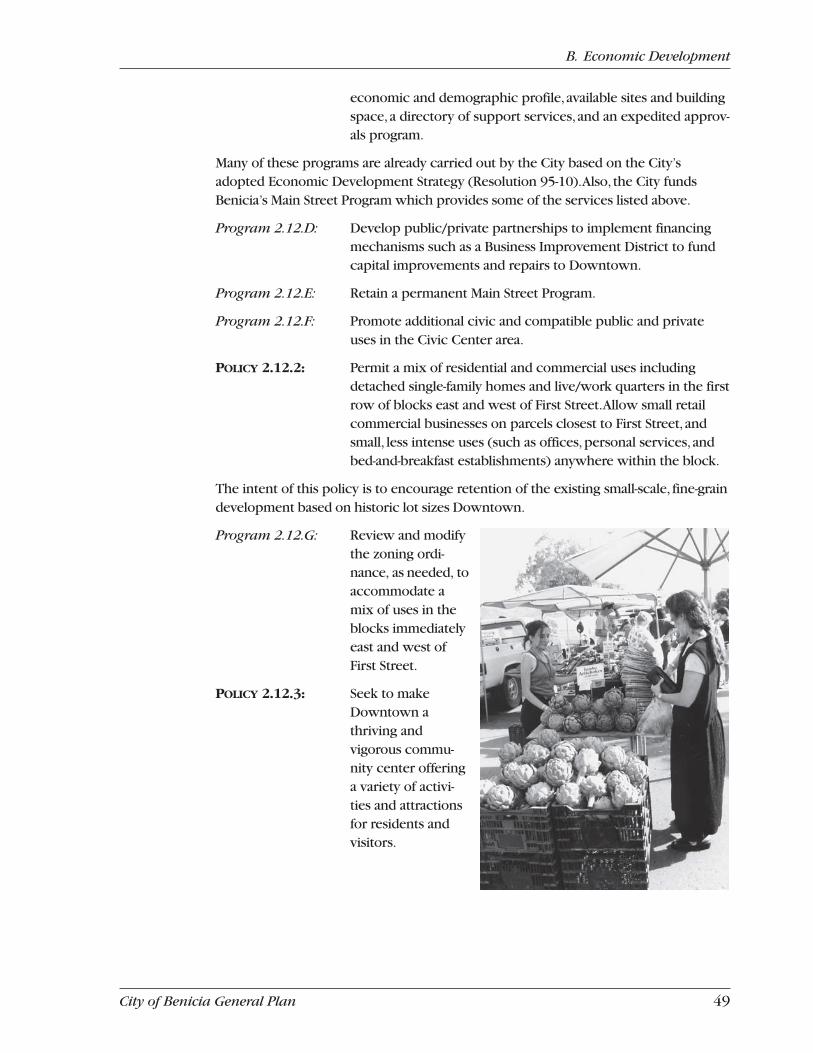
49City of Benicia General Plan
economic and demographic profile, available sites and buildingspace, a directory of support services, and an expedited approv-als program.
Many of these programs are already carried out by the City based on the City’sadopted Economic Development Strategy (Resolution 95-10). Also, the City fundsBenicia’s Main Street Program which provides some of the services listed above.
Program 2.12.D: Develop public/private partnerships to implement financingmechanisms such as a Business Improvement District to fundcapital improvements and repairs to Downtown.
Program 2.12.E: Retain a permanent Main Street Program.
Program 2.12.F: Promote additional civic and compatible public and privateuses in the Civic Center area.
POLICY 2.12.2: Permit a mix of residential and commercial uses includingdetached single-family homes and live/work quarters in the firstrow of blocks east and west of First Street. Allow small retailcommercial businesses on parcels closest to First Street, andsmall, less intense uses (such as offices, personal services, andbed-and-breakfast establishments) anywhere within the block.
The intent of this policy is to encourage retention of the existing small-scale, fine-graindevelopment based on historic lot sizes Downtown.
Program 2.12.G: Review and modifythe zoning ordi-nance, as needed, toaccommodate amix of uses in theblocks immediatelyeast and west ofFirst Street.
POLICY 2.12.3: Seek to makeDowntown athriving andvigorous commu-nity center offeringa variety of activi-ties and attractionsfor residents andvisitors.
B. Economic Development
50
Chapter 2. Community Development and Sustainability
City of Benicia General Plan
Program 2.12.H: Continue to promote special events in the Downtown such asa farmers’ market, street fairs, art and music festivals. Encourageevents that remain open in the early evening. (See policies inNoise section.)
Program 2.12.I: Work with existing restaurants and cafes to provide sidewalkfood service where the service will not impede pedestrian flowand where adequate sidewalk space exists.
Program 2.12.J: Maintain public parks, streets, and sidewalks located Down-town in a clean and safe condition.
Program 2.12.K: As the budget allows, provide amenities such as additionalbenches along First Street and in adjacent public areas; drinkingfountains, public art, shade trees and arbors.
POLICY 2.12.4: Create a social, recreational, and economic anchor at thewaterfront end of First Street.
Program 2.12.L: Use the Urban Waterfront Restoration Plan to guide the plan-ning and development of public waterfront improvements;when siting private development; and when designing publicaccess between commercial uses and the waterfront.
Program 2.12.M: Investigate the feasibility of a multi-use Community Center.
Program 2.12.N: By the end of the year 2000, decide on the feasibility of restor-ing three City-owned structures: —the former Southern PacificRailway Depot and Jurgensen’s Saloon, and the Von PfisterAdobe.
Program 2.12.O: Establish a permanent public green on the waterfront south ofB Street at Second Street.
This public green is included in the City’s 1990 Waterfront plan as a “marina green.”
Program 2.12.P: Investigate the possibility of developing a west side marina.
Program 2.12.Q: Develop a “tourist-oriented web page” that includes photos andinformation about Benicia as a tourist destination, such asinformation on lodging, historic places, restaurants, artistsgalleries and studios, and recreational and natural resources.
Program 2.12.R: Continue to support promotional maps for visitors that identifylocations of restaurants, services, specialty retail, recreational,and other facilities that cater to visitors and tourists.
OTHER COMMERCIAL DEVELOPMENT
Within the City in 1995, about 86 acres were developed for commercial use. Over halfof that acreage is designated for “general commercial”—a broad designation that

51City of Benicia General Plan
includes stores or services that are meant to serve the entire community plus thepublic traveling through the area. Areas designated for general commercial include asection in the lower Arsenal, an area around East Fifth Street and Military East, SolanoSquare, and Southampton Road. The other major commercially developed area is the19 acre Downtown, which was discussed in the previous section.
Only three acres are developed for “neighborhood commercial” uses in the entire city.The remaining developed commercial acreage is used for office (nine acres) andwaterfront commercial (four acres). In general, the city’s existing commercial uses arelimited in size, acreage, intensity, and sales volume.
GOAL 2.13: Support the economic viability of existing com-mercial centers.
POLICY 2.13.1: Direct new commercial ventures first, towards Downtown, andsecond, to other existing economic centers (instead of dispers-ing resources to new areas).
Program 2.13.A: As part of the Business Attraction, Expansion, and RetentionProgram, maintain an available commercial space and sitedatabase with information on size, lease rates, tenant improve-ments, etc., and make it readily available to prospective busi-nesses.
POLICY 2.13.2: Preclude extension of the existing commercial developmenteast along Military East and south along East Fifth Street.
B. Economic Development

52
Chapter 2. Community Development and Sustainability
City of Benicia General Plan
C. CIRCULATION
Government Code §65302(b) states that the general plan shall include a circulationelement consisting of the general location and extent of existing and proposed majorthoroughfares, transportation routes, terminals, and other local public utilities andfacilities, all correlated with the land use element of the plan. The requirement forcorrelation is particularly important, since it recognizes the close connections be-tween the different elements of the general plan.
The circulation element describes facilities for the movement of people and goodsthroughout the City. It includes a plan of the streets, highways, rail, and water transpor-tation facilities designed to serve the community. It also discusses county and regionaltransportation planning programs and the future of transportation in Benicia. The lastsection presents the circulation goals, policies, and programs.
1. COUNTY AND REGIONAL TRANSPORTATION FRAMEWORK
The City’s authority over the provision of transportation services in Benicia is deter-mined by regulations at the local, State and federal level. The City’s transportationdecisions are coordinated on a countywide level through Solano County’s CongestionManagement Program (CMP) and the Solano Transportation Authority (STA). Regionaltransportation decisions for the nine county Bay Area are made by the MetropolitanTransportation Commission (MTC), which derives its powers from State and federaltransportation funding programs.
CONGESTION MANAGEMENT AGENCY
The STA is the designated congestion management agency (CMA) for SolanoCounty and the cities. State law requires the Authority to adopt and implement aCongestion Management Program (CMP), which contains the procedures formanaging congestion created by growth and identifies all transportation projectsproposed for State and federal funding, for seven-year planning periods.
METROPOLITAN TRANSPORTATION COMMISSION
MTC is the agency designated with the decision-making authority for the Bay Area forregional transportation issues. MTC prepares a Regional Transportation Plan whichdescribes transportation investments in the Bay Area for the next 20 years. Thesetransportation investments are directed at the “Metropolitan Transportation System”(MTS) which includes the regionally significant components of the Bay Area’s transpor-tation network. Components of the MTS located in Benicia include the freeways, East2nd Street, Lake Herman Road, Military between I-780 and East 2nd St., the Port ofBenicia, Benicia Transit Services, and the Union Pacific rail line. State and federalstatutes require that MTC find a project or program consistent with the RegionalTransportation Plan before allocating certain State funds and any federal funds for thatproject or program.

53City of Benicia General Plan
C. Circulation
2. THE MOVEMENT OF PEOPLE
PEDESTRIAN AND BICYCLE MOVEMENT
Certain areas of Benicia are very walkable. The Downtown, lower Arsenal, and water-front areas provide closely spaced land uses and relatively flat topography, as well as apleasant physical environment. The northern residential and industrial areas are lesspedestrian-friendly, with hilly terrain and longer distances between uses.
Bikeways are classified based on the Caltrans classification system for off-road (Class I)and on-road (Class II and Class III) facilities, as described in Table 2-7.
Table 2-7. Classification of Bicycle Facilities
CLASS I Bicycle Path Paved path separated from automobiletraffic by a curb and landscaped strip,or routed through an open space area.Motorized vehicles are prohibited; maybe combined with pedestrian trail.
CLASS II Bicycle Lane Paved extension of a roadway desig-nated exclusively for bicyclists.
CLASS III Bicycle Route Signed routes where bicycles shareroadways with vehicular traffic; noseparate right-of-way is provided forbicyclists.
Benicia’s Bicycle and Multi-Use Trail System is shown in Figure 2-4. This system, whichshows both existing and planned future facilities, was developed for the Benicia Parks,Trails and Open Space Master Plan in 1994. The City’s existing bicycle facilities serveprimarily the waterfront, western Downtown, and northern residential areas. Exten-sions and connections are planned along most of the arterial roadways and somecollector streets, as well as off-road alignments, to provide a fully connected system.
PUBLIC TRANSIT
Three forms of public transit serve Benicia residents: buses, passenger rail and ferries.The following provides an overview of the services currently available in Benicia.
Bus Transit
Benicia Transit is an intercity fixed-route service which provides service to the ferryterminal, the Lemon/Curtola Park and Ride stop in Vallejo, and the Sun Valley Mall aswell as the Pleasant Hill BART station in Contra Costa County.
In addition to its fixed-route transit services, Benicia funds a local Dial-a-Rideprogram open to the general public. The service is provided under contract with atransportation services company. Benicia also participates in the intercity “Run

54
Chapter 2. Community Development and Sustainability
City of Benicia General Plan
Figure 2-4. Bicycle and Multi-Use Circulation Diagram
INDUSTRIAL EXTENSION
STATE PARKROAD
PARKWAY
GATE
GATE
GATE
S o u t h a m p t o nB a y
C A R Q U I N E Z S T R A I T
SOUTHAMPTON ROAD
R
OSE DRIVE
PA
NORAMADRIV
E
CHE
LS
EA
HIL
LS
DR
IVE
Su
is
un
Ba
y
1st S
TR
EE
T
MILITARY WEST
MILITARY EAST
W. 7th S
TR
EE
T
E. 2nd S
TRE
ET
E. 5
th S
TR
EE
T
PARK ROAD
E. 2nd STREET
LAKE HERMAN ROAD
IND
US
TR
IAL
WAY
LakeHerman
HA
ST
ING
SD
RIV
E
WEST K STREET
EAST H STREET
WEST J STREET
INDUSTRIAL WAY
WARWICK DRIVE
SEAVIEW
KE
AR
NEY
McALLISTE
R
780
BAYSHOR
E
ROAD
CAM
BRIDGE DRIVE
680
WE
ST
5T
H
EAST 2ND - PARKCONNECTOR
HILLCREST
EAST E STREET
OAK STREET
ARGUELLO
CH
ANNELR
OA
D
TU
RN
ER
LARKIN
SOLANO
COLUMBUS
800 0 800 1600
S C A L E
Legend: Existing Future
Class III Bikeway
Class II Bikeway
Class I Bikeway
Improved /Interpretive Trails
Bay Trail
BICYCLE AND MULTI-USE TRAILCIRCULATION SYSTEM
n/a
680
Source: Benicia Parks, Trails and Open Space Master Plan

55City of Benicia General Plan
About” paratransit service running primarily between Vallejo and Benicia. Since1991, Caltrans has operated a daily Benicia-Martinez Bridge shuttle bus betweenthe Park-and-Ride lot at the I-780/East 2nd St. interchange and the Martinez AMTRAK
station. It is anticipated that this service will be discontinued on completion ofthe second bridge span.
Passenger Rail Service
There is commuter rail service operating through Solano County, and many Beniciaresidents commute to work via BART trains in Contra Costa County, using BeniciaTransit to travel to the Pleasant Hill BART station.
Ferry Transit
Benicia commuters have access to ferry service via Benicia Transit to the Vallejo FerryTerminal. The ferry operates between the ferry terminals in Vallejo and San Francisco.
AUTOMOBILE MOVEMENT
Street system
The original settlement of Benicia was surveyed by Jasper O’Farrell (who also laid outthe street system in San Francisco). A five-mile stretch of shoreline was selected, and agrid system of streets was superimposed with little relation to topography. All north-south streets in the original settlement have 80-foot wide rights-of-way, while the east-west streets have alternating 60- and 80-foot-wide rights-of-way. North-south streetswere extended beyond the shoreline and into the water. Street names are alphabeticalin the east-west direction and numbered in the north-south direction.
In the mid-1960’s, an east-west freeway (I-780) was constructed generally between “O”and “S” Streets. New development north of the freeway subsequently abandoned thegrid system to minimize grading and street slope.
3. CIRCULATION SYSTEM
Figure 2-5 shows the existing and future circulation system for Benicia. It will serveexisting traffic as well as new traffic from development allowed under this GeneralPlan. The system includes five basic roadway types: Freeways, Major Arterials, MinorArterials, Collectors and Local Streets. The system includes several roadway connec-tions and extensions which do not exist as of 1997, including:
1. A second Benicia-Martinez Bridge Span (not shown on Figure 2-5);2. Public road connections through the lower Arsenal and Port areas, to include
Bayshore Road (minor arterial), Adams Street (major arterial), and Oak Street(minor arterial);
3. A Bayshore Road connection between Park Road and Industrial Way (minorarterial);
4. A new east-west connector roadway between East Second Street and Park Road(minor arterial); and
C. Circulation

56
Chapter 2. Community Development and Sustainability
City of Benicia General Plan
Figure 2-5. Circulation Diagram
INDUSTRIAL EXTENSION
STATE PARKROAD
PARKWAY
GATE
GATE
GATE
800 0 800 1600
S C A L E
S o u t h a m p t o nB a y
C A R Q U I N E Z S T R A I T
SOUTHAMPTON ROAD
R
OSE DRIVE
PA
NORAMADRIV
E
CH
EL
SE
AH
ILL
SD
RIV
E
Su
is
un
Ba
y
1st S
TR
EE
T
MILITARY WEST
MILITARY EAST
W. 7th S
TR
EE
T
E. 2nd S
TRE
ET
E. 5
th S
TR
EE
T
PARK ROAD
E. 2nd STREET
LAKE HERMAN ROAD
IND
US
TR
IAL
WAYLake
Herman
HA
ST
ING
SD
RIV
E
WEST K STREET
EAST H STREET
WEST J STREET
INDUSTRIAL WAY
WARWICK DRIVE
SEAVIEW
KE
AR
NEY
McALLISTE
R
Legend:Freeway
Major Arterial
Minor Arterial
Collector
Local Street
Railroad
780
BAYSHOR
E
ROAD
CAM
BRIDGE DRIVE
680
WE
ST
5T
H
EAST 2ND - PARKCONNECTOR
HILLCREST
EAST E STREET
680
OAK ST.
ARGUELLO
CH
ANNELR
OA
D
TU
RN
ER
LARKIN
SOLANO
COLUMBUS
GATE
ADAMS ST.
(Second BridgeSpan Not Shown)
GENERAL PLAN CIRCULATION SYSTEM
5
3
2
2
4
1
Future new/extended arterial alignments (illustrative only):
1. Second Benicia-Martinez Bridge span.
2. Public Bayshore Road connection through port area.
3. Bayshore Road connection between Park Road andIndustrial Way
4. East-west connector roadway between East Second Streetand Park Road
5. Extension of Industrial Way north to Lake Herman Road.

57City of Benicia General Plan
5. Extension of Industrial Way north to Lake Herman Road (minor arterial).
Following is a description of the different roadway types in the Circulation System.
FREEWAYS
Freeways are intended to serve regional and sub-regional travel. In Benicia, thelocation of freeways relative to the rest of the street network results in some (but notextensive) freeway use by residents or employees for intra-city travel.
Interstate Highways I-680 and I-780 serve north-south and east-west travel respectively,through and within Benicia. Each are four-lane facilities through Benicia.I-680 (six travel lanes) crosses the Benicia–Martinez bridge to the south. Caltrans plansto add a second bridge span which would result in five travel lanes in each direction(northbound and southbound).
ARTERIAL STREETS
Arterial streets link residential, commercial, and industrial districts with the highwaysystem. They serve primarily through-travel as opposed to providing direct access toadjacent land uses. A Major Arterial is a roadway which connects freeways to minorarterials, other major arterials, and collector streets. A Minor Arterial is a roadwaywhich connects major arterials to collectors and local streets. Arterials generallyprovide two to four travel lanes. Major and minor arterials in the General Plan Circula-tion System (see Figure 2-5) include:
Major Arterials Minor Arterials
East Second Street Rose Drive
Industrial Way Park Road (except major arterial section)
Lake Herman Road Oak Street
Military East – Military West Bayshore Road
Adams Street Hillcrest Ave., btwn E. 2nd and E. 5th Sts.
Southampton Road East Fifth Street
West Seventh Street New Park - East Second Connector Road
Columbus Parkway First St. between Military and East “H” St.
State Park Road Cambridge Drive
Park Road between Industrial Way Panorama Drive from Southamptonand Bayshore Road Road to Rose Drive
Chelsea Hills Drive
Hastings Drive
West Seventh Street from West “K” Streetto Military West
C. Circulation

58
Chapter 2. Community Development and Sustainability
City of Benicia General Plan
COLLECTOR STREETS
Collector streets are generally two lanes wide and connect local streets to minor andmajor arterials. Collector streets generally do not form a continuous system; otherwisethere would be a tendency to use them as arterials. The Benicia General Plan providesfor collectors to serve the marina, various industrial areas, and most residential dis-tricts. The collectors in the General Plan Circulation System (see Figure 2-5) include:
Channel Road Larkin Drive between Turner and Panorama
Kearny Street West “K”/West J” Street (west of First Street)
McAllister Street West 5th St./Sherman Dr. (north of Military)
Arguello Street First Street South of East “H” Street
Solano Drive East “H” Street(Hastings to Larkin)
Turner Drive East “D” Street between First Street and East Second
Warwick Drive East “E” Street between East 2nd andEast 5th Streets
Seaview Drive E. Second Street btwn East “H” and East “D” Streets
LOCAL STREETS
The function of local streets is to provide access directly to abutting property. Futurelocal streets are not shown on the Circulation System map because they are typicallylaid out in accordance with City standards as part of the subdivision design process.They play an important secondary role as locations for utilities, easements, open spacefor light and air, and firebreaks between buildings. Local streets are not intended tocarry through-traffic from one part of the community to another.
4. EXISTING AND FUTURE TRAFFIC CONDITIONS
FREEWAYS
The existing Level of Service (LOS) on freeways is monitored by the Solano Transporta-tion Authority as part of their Congestion Management Program (CMP). LOS is ex-pressed using a letter from A to F, with LOS A being best and LOS F being worst. (SeeGlossary for a more complete explanation of LOS). The 1995 CMP identifies LOS Fconditions at the Benicia-Martinez Bridge toll plaza, LOS C/D conditions on I-680, andLOS C conditions on I-780.
The most recent study of future freeway traffic volumes is the I-680/I-80/I-780 TriangleArea Traffic Study Traffic Operations Report (1997). This report describes 1995 trafficvolumes and projects future (2010) volumes for several scenarios which combinedifferent sets of freeway improvements. The “No Build” scenario, which assumes theonly improvement would be the scheduled Benicia - Martinez Bridge span which

59City of Benicia General Plan
C. Circulation
represents the “worst case” for future conditions. For this case, the study indicates thatpeak hour freeway operations would be poor in the future (LOS D/E), although vol-umes would remain within the existing lane-capacity for all segments except I-780between Southampton Road and Columbus Parkway in the AM peak hour.
Freeways serve both locally- and regionally-generated traffic and have a profoundeffect on communities. It is City policy to encourage Caltrans to maintain the currentnumber of lanes on I-680 and I-780 through the city, except for spot widenings thatmay be necessary to smooth traffic at ramps. These policies are consistent with othersin this General Plan which call for promoting alternative commute methods and abetter jobs/housing balance to minimize freeway travel demand. The intent of theGeneral Plan is not to create greater traffic congestion by rejecting all freeway widen-ing, but to address the realities of growing travel demand through site-specific im-provements, land use policies that minimize travel demand, and high occupancyvehicle (HOV) travel.
CITY STREET NETWORK
On the local, non-freeway road network in Benicia, traffic conditions are best repre-sented by the operating level of intersections, because intersections are the primarysource of delay and “bottlenecks.” Traffic operations at intersections are described interms of Level of Service (LOS). LOS D is generally accepted as the standard for inter-section operation and has been adopted as the standard for Benicia. (See Policy2.20.1.)
Tables 2-8 and 2-9 describe the different LOS designations A to F, for signalized andstop-controlled intersections.
There are 24 key intersections in Benicia. Table 2-10 shows existing and projectedservice levels. As of 1995, four intersections operated at LOS D, and another fouroperated at LOS E or F. The LOS E/F intersections are all located at I-780 ramps. The restof the intersections operated at LOS C or better. Of the eight intersections operating atLOS D or worse, five are stop-controlled intersections. A check of the Caltrans signalwarrant criterion for peak hour volumes at intersections shows that installation of asignal is warranted at two of these intersections: East Second Street/I-780 WestboundRamps and East Fifth Street/I-780 Eastbound Ramps. Both of these intersections arescheduled to be signalized in the City’s current Capital Improvement Program. Signal-ization would improve the existing LOS to C or better at these intersections.
Future traffic volumes at the study intersections were projected based on the land usechanges in this General Plan. The traffic projection methodology is described in theGeneral Plan DEIR Transportation chapter. Table 2-11 contains the future service levelswhich would result from these volumes, assuming no intersection improvementswere made. While this General Plan involves a reduction in land use intensity in manyareas relative to the previous general plan, the projected land uses at buildout wouldstill cause unacceptable conditions (LOS D or worse) at 14 of the 24 intersections. (Anadditional eight intersections are already at LOS D or worse, as noted above).

60
Chapter 2. Community Development and Sustainability
City of Benicia General Plan
Table 2-8. Level of Service Criteria for Signalized Intersections
LEVEL OF SERVICE (LOS) VOLUME-TO-CAPACITY RATIO
A 0.00 - 0.60
B 0.61 - 0.70
C 0.71 - 0.80
D 0.81 - 0.90
E 0.91 - 1.00
F >1.00
Source: Transportation Research Board, Circular 212, Interim Materials on Highway
Capacity
Table 2-9. Level of Service Criteria for Stop-controlled Intersections
LEVEL OF SERVICE (LOS) AVERAGE STOPPED DELAY PER
VEHICLE (IN SECONDS)
A 0 to 5.0 seconds
B 5.1 to 10.0 seconds
C 10.1 to 20.0 seconds
D 20.1 to 30.0 seconds
E 30.1 to 45.0 seconds
F more than 45 seconds
Source: Transportation Research Board, Highway Capacity Manual, 1994
The City’s policy is to maintain intersection operation at LOS D or better, except whereimprovements would be infeasible or undesirable due to considerations of right-of-way, impacts of neighboring properties, aesthetics, or community character. Thus, theimprovements included in this General Plan attempt to provide LOS D or better at the24 intersections, wherever possible.
Figure 2-6 shows the intersection improvements which would be required to improveall intersections to at least LOS D. Table 2-11 shows the projected level of service at thestudy intersections with the improvements. Of the 22 intersections which requireimprovement, 14 would require the installation of a signal, and all 22 would requirelane additions on some or all approaches. Some of the lane recommendations may notbe feasible due to physical constraints; however, more detailed operational studies ofthese intersections can be performed as the need for the improvements draws near,

61City of Benicia General Plan
Table 2-10. Existing (1995) and Future Intersection Levels of Service (LOS)
EXISTING SERVICE LEVEL FUTURE SERVICE LEVEL
INTERSECTION CONTROL V/C DELAY LOS V/C DELAY LOS
TYPE (SEC.) (SEC.)
1. Columbus Parkway/Rose Drive Signal 0.82 D 1.75 F
2. Southampton/Hastings One-way Stop 15/3 C/A 28/4 D/A
3. Southampton/Military West Signal 0.46 A 0.58 A
4. Southampton/Chelsea Hills Signal 0.74 C 1.09 F
5. West Seventh/I-780 WB On/Off Signal 1.01 F 1.72 F
6. West Seventh/I-780 EB On/Off Signal 0.60 A 1.07 F
7. First / Military Signal 0.53 A .76 C
8. East Second/I-780 WB On/Off One-way Stop 81/22 F/D */* F/F
9. East Second/I-780 EB On/Off Signal 0.63 B 1.28 F
10. East Second/Military East Signal 0.63 B 1.57 F
11. East Fifth/I-780 WB On/Off One-way Stop 259/66 F/F */* F/F
12. East Fifth/I-780 EB On/Off One-way Stop 35/4 E/A */* F/F
13. East Fifth/Military East Signal 0.80 D 1.23 F
14. East Second/Rose Drive Signal 0.58 A 1.91 F
15. East Second/Industrial Two-way Stop 29/7 D/B */* F/F
16. Bayshore/Park Four-way Stop 28 D * F
17. Bayshore/I-680 SB On WB Left Yield 5/1 A/A */* F/F
18. Bayshore/I-680 NB Off One-way Stop 6/3 B/A */* F/F
19. Industrial/Park Four-way Stop 14 C * F
20. Industrial/I-680 SB Off One-way Stop 5/1 A/A */28 F/D
21. Industrial/I-680 NB On One-way Stop 8/4 B/A */* F/F
22. Lake Herman/East Second Two-way Stop 9/4 B/A */* F/F
23. Lake Herman/I-680 SB On/Off One-way Stop 9/1 B/A */* F/F
24. Lake Herman/I-680 NB On/Off Two-way Stop /2 A/A */* F/F
For signalized intersections, the volume/capacity ratio is given. For side street stop-controlled intersections, two delays andservice levels are given: the delay for the worst movement, and the average intersection delay. For four-way stops, theaverage intersection delay is given.
* = very long delays (over two minutes)
C. Circulation

62
Chapter 2. Community Development and Sustainability
City of Benicia General Plan
Figure 2-6. Intersection Mitigations
STO
P
Southampton
Hastings
Military
Southampton
Southampton
ChelseaHills
Driveway
W. Seventh
I-780 EBOn/Off
First
Military
Driveway
STO
P
E. Second
I-780 WBOff
I-780 WBOn
Free
E. Second
Military
STO
PE. Fifth
I-780 WBOff
STO
P
E. Fifth
I-780 EBOn
I-780 EBOff
9 E. Second & I-780EB On/Off
2 Southampton &Hastings
6 W. Seventh & I-780EB On/Off
10 E. Second & Military 11 E. Fifth & I-780WB On/Off
12 E. Fifth & I-780EB On/Off
7 First & Military 8 E. Second & I-780WB On/Off
4 Southampton &Chelsea Hills
21 Industrial & I-680NB On
14 E. Second & Rose
18 Bayshore & I-680NB Off
22 Lake Herman &E. Second
23 Lake Herman & I-680SB On/Off
24 Lake Herman & I-680NB On/Off
19 Industrial & Park 20 Industrial & I-680SB Off
16 Bayshore & Park
I-780 WBOn
INTERSECTION MITIGATIONS1 Columbus Pkwy &
Rose Dr.
W. Seventh & I-780WB On/Off
Not to Scale
Key: = Stop Sign
= Signal
STOP
Rose
Columbus Pkwy.
I-780 EBOn/Off
5
3 Southampton &Military West
13 E. Fifth & Military
Bayshore & I-680SB On
17
15 E. Second/Industrial
E. Fifth
Military
E. Second
Rose
STOP
STOP
Industrial
E. Second
I-680 SB On
Bayshore
STO
P
Industrial
I-680 NB On
STOP
I-680 NB Off
Bayshore
STOP
STOP
E. Second
LakeHerman
Lopes
STOP
STOP STO
P
STO
P
Park
Industrial
STOP
I-680 SB On
LakeHerman
I-680 SB Off
STOP
STOP STO
P
STO
P
Park
Bayshore
STOP
Industrial
I-680 SB Off
STOP
STOP
I-680 NB On/Off
LakeHerman
Goodyear
W. Seventh
I-780 WBOff
I-780 WBOn
E. Second
I-780 EBOff/On
New SignalRequired
New SignalRequired
New SignalRequired
= Pre-Mitigation
= Post-Mitigation
New Signal Required New Signal Required
New SignalRequired
New SignalRequired
New SignalRequiredNew Signal
Required
Free
Free
Free
New SignalRequired
Free
New SignalRequired
New SignalRequired
Free
New SignalRequired
FreeFree
Free
New SignalRequired
Free Free
Free
Free
*
*
** Not a striped lane, but space
available for a right turn queue.

63City of Benicia General Plan
Table 2-11. Intersection LOS: Future Conditions with and without Intersection
Improvements
EXISTING WITHOUT IMPROVEMENTS WITH IMPROVEMENTS
INTERSECTION CONTROL V/C DELAY LOS V/C DELAY LOS
TYPE (SEC.) (SEC.)
1. Columbus Parkway/Rose Drive Signal 1.75 F 0.89 D
2. Southampton/Hastings One-way Stop 23/4 D/A 0.71 C
3. Southampton/Military West Signal 0.58 A 0.59 A
4. Southampton/Chelsea Hills Signal 1.09 F 0.82 D
5. West Seventh/I-780 WB On/Off Signal 1.72 F 0.84 D
6. West Seventh/I-780 EB On/Off Signal 1.07 F 0.76 D
7. First/Military Signal 0.76 C 0.76 C
8. East Second/I-780 WB On/Off One-way Stop */* F/F D
9. East Second/I-780 EB On/Off Signal 1.28 F 0.87 D
10. East Second/Military East Signal 1.57 F 0.83 D
11. East Fifth/I-780 WB On/Off One-way Stop */* F/F D
12. East Fifth/I-780 EB On/Off One-way Stop */* E/F D
13. East Fifth/Military East Signal 1.23 F 0.88 D
14. East Second/Rose Drive Signal 1.91 F 0.89 D
15. East Second/Industrial Two-way Stop */* F/F D
16. Bayshore/Park Four-way Stop * F D
17. Bayshore/I-680 SB On ramp WB Left Yield */* F/F C
18. Bayshore/I-680 NB Off ramp One-way Stop */* F/F D
19. Industrial/Park Four-way Stop * F D
20. Industrial/I-680 SB Off ramp One-way Stop */28 F/D D
21. Industrial/I-680 NB On ramp One-way Stop */* F/F B
22. Lake Herman/East Second Two-way Stop */* F/F D
23. Lake Herman/I-680 SB On/Off One-way Stop */* F/F C
24. Lake Herman/I-680 NB On/Off Two-way Stop */* F/F B
For signalized intersections, the volume/capacity ratio is given. For side street stop-controlled intersections, two delays andservice levels are given: the delay for the worst movement, and the average intersection delay. For four-way stops, theaverage intersection delay is given.
* = very long delays (over two minutes)
C. Circulation

64
Chapter 2. Community Development and Sustainability
City of Benicia General Plan
and alternative solutions may be identified (e.g., signal cycle length or phasingchanges, adding capacity at a different intersection approach, coordinating timing atadjacent signals, etc.)
It should be emphasized that this improvement analysis is based on an estimate ofconditions with reasonably foreseeable development allowed by this General Plan, tothe year 2015—almost 20 years from now. As such, it constitutes long-range planninginformation, which will need to be supplemented by ongoing traffic counts andstudies by the City to ensure that the appropriate improvements are developed andimplemented when needed.
Future Arterial Widths
The definitions for arterials and collectors, noted earlier in this section, are sum-marized below:
• A major arterial is two to four lanes wide and connects freeways to minor arterials,other major arterials, and collectors.
• A minor arterial is two to four lanes wide and connects major arterials to collectorsand local streets.
• A collector street is generally two lanes wide and connects local streets to minorand major arterials.
Projected future volumes on Benicia’s arterials were analyzed to determine wherewidening or other changes may be needed. (The DEIR Transportation Chapter includesa table of arterial capacities which was used for this analysis). Table 2-12 shows thearterial segments which may exceed capacity with development allowed in thisGeneral Plan. As with the intersection improvements described above, this analysisprovides long-range planning information, which will need to be supplemented byongoing traffic counts and studies by the City.
Although the projected traffic volumes indicate the need for some roads to be wid-ened, road widening may have deleterious effects, and alternatives should be studiedbefore new widening projects are added to the City’s Capital improvement Program.
Most of the improvements called for above would provide much greater capacity thanneeded. In most locations, only an additional 10 to 20 percent in traffic-carryingcapacity is needed. A road widening from two to four lanes adds 100 percent capacity.
The City has recognized the need to provide smooth and reasonably convenienttraffic flow, through General Plan policies such as maintaining LOS D where feasible. Atthe same time, the community is wary of the downside of over-sizing roads andintersections—a less pleasant environment for pedestrians and bicyclists, a tendencyto draw new traffic to locations where excess capacity is provided, and a disincentiveto use alternative travel modes such as carpooling and transit.
The General Plan promotes non-auto travel modes through policies and programsaimed at enhancing the pedestrian, bicycle, and transit experience. These policies

65City of Benicia General Plan
would be undermined if the road network offered excess capacity. As traffic conges-tion grows on city roads, the City will consider alternatives to widening, such as “spotwidening” at congestion points, aggressive Travel Demand Management programs,rerouting traffic, prohibiting certain turning movements during peak hours, andcoordinating traffic signals.
Table 2-12. Streets That May Exceed Existing (1997) Capacity with Future
Growth Under this General Plan
ROADWAY SEGMENT IN CAPITAL
IMPROVEMENT PROGRAM?
Lake Herman Road East of the I-680 NB Ramps No
East Second Street Between Lake Herman Road Yesand existing four-lane section (southeast half only)
East Second Street Between I-780 WB Ramps Yesand Military East
East Fifth Street Between I-780 WB Ramps Yesand Military East
Industrial Way Between Lake Herman Road No(along new extension)and the I-680 ramps
Bayshore Road Between I-680 SB Ramp Noand Industrial Way6
Military West Between West Fifth and YesWest Second
Military East Between East Second and NoEast Fifth
West Seventh Between Chelsea Hills and YesMilitary West7
Park Road Between Industrial and YesBayshore
5. PARKING CONDITIONS
Benicia generally has good parking conditions, with adequate on-street and off-streetparking provided for local uses.
C. Circulation
6 A future extension between Park Road and Industrial Way would extend through Exxon and would bedifficult to build to four lanes. Also, any widening of the existing Sulphur Springs Creek two-lane bridgewould be very costly. It is likely that a four-lane facility could extend only between the I-680 south-bound ramp and Park Road. The remaining portion would remain two lanes.
7 Any widening of West 7th at the I-780 interchange would require a new bridge, at significant cost.

66
Chapter 2. Community Development and Sustainability
City of Benicia General Plan
6. FREIGHT AND GOODS MOVEMENT
Three types of transportation facilities move freight and goods in Benicia. They aretruck, rail, and port facilities.
TRUCK FACILITIES
Trucks are used for freight transport primarily in Benicia’s industrial area along thenorthern I-680 corridor, and in the Port area adjacent to the Bridge. Freeway signsdirect Benicia Industrial Park traffic to use I-680 exits.
As development allowed in the General Plan takes place, truck traffic will increase inthe industrial and Port areas, and to a lesser extent in other growth areas.
FREIGHT RAIL FACILITIES
Freight rail facilities in Benicia center on the main Union Pacific Railroad line fromSacramento. This line once terminated at the foot of First Street, but now crosses theCarquinez Strait on a bridge paralleling the Benicia-Martinez Bridge to Martinez andthe East Bay. Rail spur lines serve Benicia’s industrial park area to the north and thePort area along the southern waterfront. Rail service along the waterfront terminatesbefore reaching East 5th Street.
The spur line through the Benicia Industrial Park and the Arsenal area is used mostfrequently by auto carriers and by Exxon.
Caltrans and Union Pacific have negotiated an agreement for complete rebuilding ofboth tracks. The agreement will allow increased passenger rail service withoutinterfering with freight trains.
PORT FACILITIES
Benicia has a natural deep water channel adjacent to the shore along the CarquinezStrait. This channel permits container ships, fuel tankers, and freighters with fairlydeep draft (up to about 35 feet) to dock at Benicia’s Port.
The Port of Benicia, which is leased and owned by Benicia Industries (a privatecompany), has a 2,400-foot deep-water pier which provides berthing for three ships.This lease and the Bay Area Seaport Plan are discussed in Appendix D. There is also anexisting petroleum service dock northeast of the Port of Benicia pier.
7. CIRCULATION GOALS, POLICIES, AND PROGRAMS
The goals, policies, and programs that follow deal comprehensively with the needs ofand recommendations for pedestrian and bicycle circulation; transit, rail, and ferryservice; reducing traffic congestion; parking; needs in special areas of the city (indus-trial park, Pine Lake, and Lower Arsenal); and proposals for freeway modifications.

67City of Benicia General Plan
GOAL 2.14: Enhance Benicia’ssmall-town atmo-sphere of pedes-trian-friendlystreets and neigh-borhoods.
POLICY 2.14.1: Give priority to pedes-trian safety, access, andtransit over automobilespeed and volume.
Program 2.14.A: Reexamine City stan-dards to allow thedevelopment of localstreets with the mini-mum pavement widthneeded in residential areas, at the same time assuring thatemergency access is maintained and that pedestrian andvehicular safety are preserved.
Program 2.14.B: Consider physical and operational changes to reduce speeds(e.g., narrow lane widths and signal timing), and increase trafficspeed enforcement.
Program 2.14.C: Consider residential streets with textured pavements andparallel parking.
Program 2.14.D: Where feasible redesign corner radii to corners with tight radiito slow vehicles and alert drivers to pedestrians in crosswalks.
Program 2.14.E: Consider reducing lane widths, as one method of both slowingtraffic and making room for parking, wider sidewalks, or bikelanes.
Program 2.14.F: Where feasible, provide pedestrian sidewalks in all residentialareas along both sides of the street.
Some exceptions may be made where alternate paths exist, such as along alley streets,and where undesirable environmental impacts may result.
Program 2.14.G: Evaluate the feasibility of finishing sidewalks along streetswhere they are currently lacking.
Program 2.14.H: Identify areas where sight distance for vehicle drivers andpedestrian safety can be improved with signs, tree placement,landscaping, parking policy, building design, and streetscape.Prepare a program and schedule for implementing theseimprovements.
C. Circulation
68
Chapter 2. Community Development and Sustainability
City of Benicia General Plan
Program 2.14.I: Identify areas where crosswalk safety can be improved throughbetter lighting and striping, prohibiting right turns on red atspecific intersections, installing pedestrian-activated pushbuttons for signals, installing a textured or raised paving mate-rial, and employing crossing guards for school children. Pre-pare a program and schedule for implementing these improve-ments.
POLICY 2.14.2: Discourage street widenings and the removal of on-streetparking to ease traffic flow.
GOAL 2.15: Provide a comprehensive system of pedestrianand bicycle routes which link the various compo-nents of the community: employment centers,residential areas, commercial areas, schools,parks, and open space.
POLICY 2.15.1: Make pedestrian and bicycle circulation, and safety improve-ments a high priority for transportation funding, utilizing locallygenerated revenues and State and federal grants.
Program 2.15.A: Construct public improvements that accommodate and en-hance pedestrian and bicycle access.
Program 2.15.B: Provide additional trails along the shoreline.
Program 2.15.C: Provide proper signing for improved trails, fire break trails, andinterpretive trails.
Program 2.15.D: Improve safety and pedestrian movement by building curbextensions that narrow the overall width required by pedestri-ans to cross the street at major pedestrian waiting areas atstreet intersections, sidewalks, and landscaped areas.
Program 2.15.E: Identify areas where adequate lighting for pedestrians in urbanareas is needed. Install additional lighting as appropriate.
Program 2.15.F: Widen the Rose Drive/State Park Road at I-780 overpass toaccommodate pedestrians and bicycle traffic.
Program 2.15.G: Create a protected landscaped sidewalk for West 7th Streetbetween I-780 and Military West.
POLICY 2.15.2: Encourage the development of pedestrian paths in hill areas asa way to link neighborhoods to schools, parks, employmentcenters, and convenience commercial destinations.
Program 2.15.H: Continue to implement the pedestrian pathway system in theCity’s Parks, Trails and Open Space Master Plan especially

69City of Benicia General Plan
linkages between the City’s residential neighborhood andcommercial districts.
Program 2.15.I: Facilitate the connection of future Benicia-Martinez Bridgepedestrian/bike lanes to the city pedestrian/bike network.Connect paths from existing and proposed regional trailsystems to the Boundary Hills and Benicia-Martinez Bridge.
Program 2.15.J: Improve pedestrian and bike access between Downtown andSouthampton.
GOAL 2.16: Ensure access needs of individuals with disabili-ties.
POLICY 2.16.1: Provide for adequate public access in all forms (walks, build-ings, transportation) in conformance with the Americans forDisabilities Act (ADA).
Program 2.16.A: In places that accommodate the public, remove barriers toaccess or provide alternative services when barriers cannot beremoved.
Program 2.16.B: Require that publicly sponsored programs, activities andtransportation facilities are accessible to individuals withdisabilities (including employees).
POLICY 2.16.2: Encourage private entities to maintain places of business thatare physically accessible to all.
Program 2.16.C: Assess the cost and feasibility of Policy 2.16.2, including anychanges in opportunities or costs for businesses to occupyhistoric structures.
GOAL 2.17: Provide an efficient, reliable, and convenienttransit system.
POLICY 2.17.1: Continue to provide transit service to all—and subsidizedparatransit service to all qualified—potential users, includingyouth, the elderly and the disabled, modifying routes andschedules as demand changes.
Program 2.17.A: Preserve the personal service provided by Dial-a-Ride.
Program 2.17.B: Subsidize transit at a level justified by a cost/benefit study.
Program 2.17.C: Institute a continuing program to evaluate the transit system toensure it meets the public’s needs.
Program 2.17.D: Allow preferential parking for public transit vehicles.
C. Circulation

70
Chapter 2. Community Development and Sustainability
City of Benicia General Plan
Program 2.17.E: Set local priorities and needs for future service, taking intoaccount funding uncertainties for Benicia’s and other transitsystems.
Program 2.17.F: Improve inter-modal coordination of transit services.
Program 2.17.G: Provide attractive and pedestrian-friendly transit stops andbuses, including bike racks on buses.
Program 2.17.H: Provide transit shelters with good visibility and benches, thusenhancing the pedestrian-transit interface.
POLICY 2.17.2: Consider nontraditional use of the existing transit system fortours, shuttles, and special events, (e.g., First Street shuttle, FirstStreet to Community Park shuttle, First Street to Arsenal shuttle,State Park shuttle).
Program 2.17.I: Optimize the use of existing transit equipment.
Program 2.17.J: Consider a shuttle service between large commercial centers.
POLICY 2.17.3: Coordinate transit service and trip reduction efforts with otheragencies.
Program 2.17.K: Provide intercity bus service to Vallejo and Fairfield commensu-rate with available funding.
Program 2.17.L: Coordinate school district/city bus schedules for optimumefficiency.
Program 2.17.M: Coordinate transit planning with the Contra Costa Transporta-tion Authority (CCTA) and Solano County, and coordinate futuremass transit planning with all other regional efforts.
Program 2.17.N: Participate in Major Investment Studies (MIS) to assure thattransit alternatives are fully considered.
GOAL 2.18: Encourage the provision of convenient rail ser-vice to Benicia with a station near the BeniciaBridge.
POLICY 2.18.1: Work with BART, Caltrans, BCDC, the Solano TransportationAuthority, and MTC in planning a rail station near the Benicia-Martinez Bridge.
Program 2.18.A: Consider mixed use, commercial and industrial uses thatcomplement the train station.
Program 2.18.B: Plan for convenient auto and transit access to and auto parkingat the train station to encourage its use.

71City of Benicia General Plan
GOAL 2.19: Promote a regional (San Francisco, Oakland,Alameda) and local (Martinez, Port Costa, andCrockett) ferry service.
When the waterfront area adjacent to the Benicia Marina is developed and the num-ber of visitors to the foot of First Street increases, a weekend ferry service betweenBenicia and the historic town of Port Costa or Martinez along the northern shores ofContra Costa County may be feasible.
POLICY 2.19.1: Work with MTC to establish ferry service. Communicateregularly with them regarding plans and funding for ferryservice.
Program 2.19.A: Identify ferry service market potential and terminal locationoptions.
GOAL 2.20: Provide a balanced street system to serve automo-biles, pedestrians, bicycles, and transit, balancingvehicle-flow improvements with multi-modalconsiderations.
POLICY 2.20.1: Maintain at least Level of Service D on all city roads, streetsegments, and intersections.
Exceptions may be allowed where measures required to achieve LOS D are infeasiblebecause of right-of-way needs, impact on neighboring properties, aesthetics, orcommunity character.
Program 2.20.A: Identify areas where it would be beneficial to reduce and divertthrough vehicular traffic from local residential streets. Imple-ment appropriate neighborhood traffic control programs inthese areas.
Program 2.20.B: Locate new development where there is adequate existing orplanned future road and highway capacity and where localresidential streets will not be significantly impacted.
Program 2.20.C: Encourage use of alleys for commercial loading activities whenit will not block driveways or mid-block access to the street.
POLICY 2.20.2: Seek alternatives to road widenings
Program 2.20.D: Continue to identify and implement acceptable alternatives toin-town roadway widening, extensions, and large intersections.
Program 2.20.E: Identify streets where traffic should be slowed.
Program 2.20.F: Consider lane narrowing, driver education, traffic speed alerttrailers, and other traffic calming remedies.
Program 2.20.G: Advertise the use of transit, bicycling, and walking for commut-ing, shopping, recreation, and school trips.
C. Circulation

72
Chapter 2. Community Development and Sustainability
City of Benicia General Plan
Program 2.20.H: Reserve right-of-way for new alternate transportation facilitiesthat contribute to street and roadway congestion relief.
Program 2.20.I: Coordinate traffic signal improvements and synchronizationand continue to implement timing changes.
Program 2.20.J: Develop adequate funding for keeping streets, alleys andsidewalks in good repair.
Program 2.20.K: Identify and prioritize transportation facilities maintenanceprojects for roadways, sidewalks, and off-street trails and paths.
Program 2.20.L: Identify areas of the city that are pedestrian-unfriendly anddevelop corrective plans.
POLICY 2.20.3: Maintain Lake Herman Road as a rural, two-lane, curving scenicroute.
GOAL 2.21: Encourage Benicia residents and employees touse alternatives to the single-occupant automo-bile.
POLICY 2.21.1: Provide and promote a range of travel alternatives to the use ofthe private automobile.
“Design Strategies for Encouraging Alternatives to Auto Use Through Local Develop-ment Review,” prepared by ABAG and BAAQMD, provides a number of site planningstrategies for commercial and residential development that aim at reducing auto useby making pedestrian and bicycle travel more attractive.
Program 2.21.A: Advertise the benefits of Transportation Demand Management(TDM) measures and conduct public outreach programs toeducate the public about options available within the city.
Program 2.21.B: Implement Transportation Control Measures (TCMs) appropri-ate to Benicia.
POLICY 2.21.2: Encourage new development patterns that facilitate bicycling,walking, and transit for commute, shopping, recreation, andschool trips.
Program 2.21.C: Consider denser, mixed-use developments, particularly in theDowntown area.
Program 2.21.D: Consider the feasibility of extending East Second Street fromEast “L” Street to East “K” Street.
GOAL 2.22: Alleviate traffic congestion near school sites.
POLICY 2.22.1: Work closely with the School District in addressing trafficcongestion near schools.

73City of Benicia General Plan
Program 2.22.A: Develop a plan jointly with the School District for reducingtraffic congestion at and near school sites.
Program 2.22.B: Encourage the School District to continue the comprehensivecrossing guard program.
Program 2.22.C: Adjust phasing/timing of signal lights on routes to schools, andconsider providing increased crossing guards and/or policedirection of traffic.
Program 2.22.D: Encourage the School District to implement citywide busingand promote carpools for trips to school.
Program 2.22.E: Promote School District provision of adequate off-street park-ing, drop-off and pickup facilities, and designated carpoolparking at each school.
Program 2.22.F: Study the need for and feasibility of a pedestrian bridge linkingthe middle school and high school.
GOAL 2.23: Ensure adequate parking while maintainingaesthetic landscape features.
POLICY 2.23.1: Provide adequate on-street and off-street parking.
Program 2.23.A: Continue to allow on-street parking where needed for abuttinguses (e.g., Military East).
Program 2.23.B: Preserve and improve the East Second and “E” Street parkinglot. Consider double-deck parking if need warrants.
Program 2.23.C: Allow flexible parking requirements for uses smaller than 2,000square feet.
Program 2.23.D: Update parking requirements based on actual local parkinggeneration studies wherever, appropriate, and consider parkingproximity to transit corridors.
POLICY 2.23.2: Reduce the visibility of parking lots.
Program 2.23.E: Allow future parking to be divided into smaller lots withgenerous internal and perimeter landscaping.
Program 2.23.F: Recommend parking to be located behind or alongside (butnot in front of) buildings, where possible.
GOAL 2.24: Continue to provide safe and direct access to theIndustrial Park.
POLICY 2.24.1: Continue to ensure public access to private roads in theindustrial and Port areas.
C. Circulation

74
Chapter 2. Community Development and Sustainability
City of Benicia General Plan
Program 2.24.A: Investigate establishment of Industrial Park bus service.
Program 2.24.B: Investigate alternate routes that would better accommodateaccess from the freeway to the Port and Industrial Park.
Program 2.24.C: Identify solutions to circulation problems associated with trucktraffic by maintaining a database of truck-related citizen orbusiness complaints in combination with truck counts andaccident data.
GOAL 2.25: Improve auto and non-auto access into the OldArsenal, without disrupting existing neighbor-hood, historic, and environmental values.
POLICY 2.25.1: Consider alternative modes of transportation to the auto inplanning new access and in improving existing routes into theArsenal.
Program 2.25.A: Improve access into the Arsenal from I-680.
Program 2.25.B: Depending on City’s determination of need and impacts,decide whether to connect the Lower Arsenal with the Down-town, such as through East “H” Street, including bike, pedestrian,and emergency access.
It is important to link the Lower Arsenal area with Downtown for economicdevelopment and maximum utilization of the waterfront, historic, and culturalassets. There are two alternatives: (1) open the gate and allow access over the hillto the Lower Arsenal; and (2) open the gate and allow access via Bayshore Road.
The City will investigate alternative alignments, mindful of “H” Street residents’concerns about through-traffic and Benicia Industries’ concerns about Portsecurity.
GOAL 2.26: Ensure that scenic and environmental amenitiesof I-680 and I-780 are not compromised.
POLICY 2.26.1: Promote theuse offreeway right-of-way foralternativecommutemethods(e.g., car poollanes, transit,and off-roadbike paths).

75City of Benicia General Plan
POLICY 2.26.2: Encourage the preservation of I-780 as four lanes, but supportspot widenings at selected locations (e.g., the approach to theBenicia-Martinez Bridge on/off merge lanes) to address futurecapacity problems while still maintaining a four-lane mainlinefreeway.
POLICY 2.26.3: Support Caltrans’ Benicia–Martinez Bridge project, advocatingthe following: (1) continued toll collection in the northbounddirection with the toll plaza located at the southern end of thebridge; (2) elimination of existing lane merge problems at the I-680/I-780 interchange; (3) retaining direct access to existinginterchanges at East 2nd and East 5th Streets, (4) accommodat-ing rail transit on the bridge in the future, and (5) only widen I-680 upon evaluation of alternatives.
POLICY 2.26.4: Ensure that the Benicia–Martinez Bridge project adequatelyreflects the community’s concerns.
Program 2.26.A: Continue to monitor and comment on Caltrans planningactivities and documentation as the bridge planning processcontinues.
GOAL 2.27: Ensure an active community deliberation processin response to Caltrans proposals now and in thefuture.
POLICY 2.27.1: Monitor Caltrans’ planning process for I-680 and I-780 improve-ments and communicate the City’s concerns and priorities toCaltrans.
POLICY 2.27.2: Ensure the continuation of the following City policies indiscussions with Caltrans about changes to I-680 and I-780:
A) Preserve the Lake Herman interchange vista look-out andrest area.
B) Relocate the Industrial interchange northbound off-rampand southbound on-ramp from the south end of the Sul-phur Creek overcrossing at Bayshore Road to the north endat Industrial Way.
C) Use the existing toll building at the existing Benicia-Martinez Bridge for a passenger train station for the UP railline. Provide adequate access to and automobile parking atthe station. Provide for the station to accommodate a lightrail passenger line on the new bridge.
D) Preserve direct access to and from I-780 at East Second andEast Fifth Streets.
C. Circulation
76
Chapter 2. Community Development and Sustainability
City of Benicia General Plan
E) Preserve the existing westbound exit from I-780 at Colum-bus Parkway and ensure that existing commercial buildingsare not removed.
F) Keep I-780 four lanes. Support spot widenings at selectedlocations (e.g., the approach to the Benicia-Martinez Bridgeon/off merge lanes) to address future capacity problemswhile still maintaining a four-lane mainline freeway.
G) Only support the widening of I-680 to six lanes uponevaluation of alternatives.
H) Do not permit sound walls or retaining walls along I-780.Permit sound walls and retaining walls that the communitybelieves would provide benefits that outweigh drawbacks.
POLICY 2.27.3: Ensure that the Benicia residential and business community isinformed about Caltrans’ project planning activities, and solicitpublic input on Caltrans projects.
Program 2.27.A: Review existing plans and work with Caltrans to developproposals that reflect the consensus.
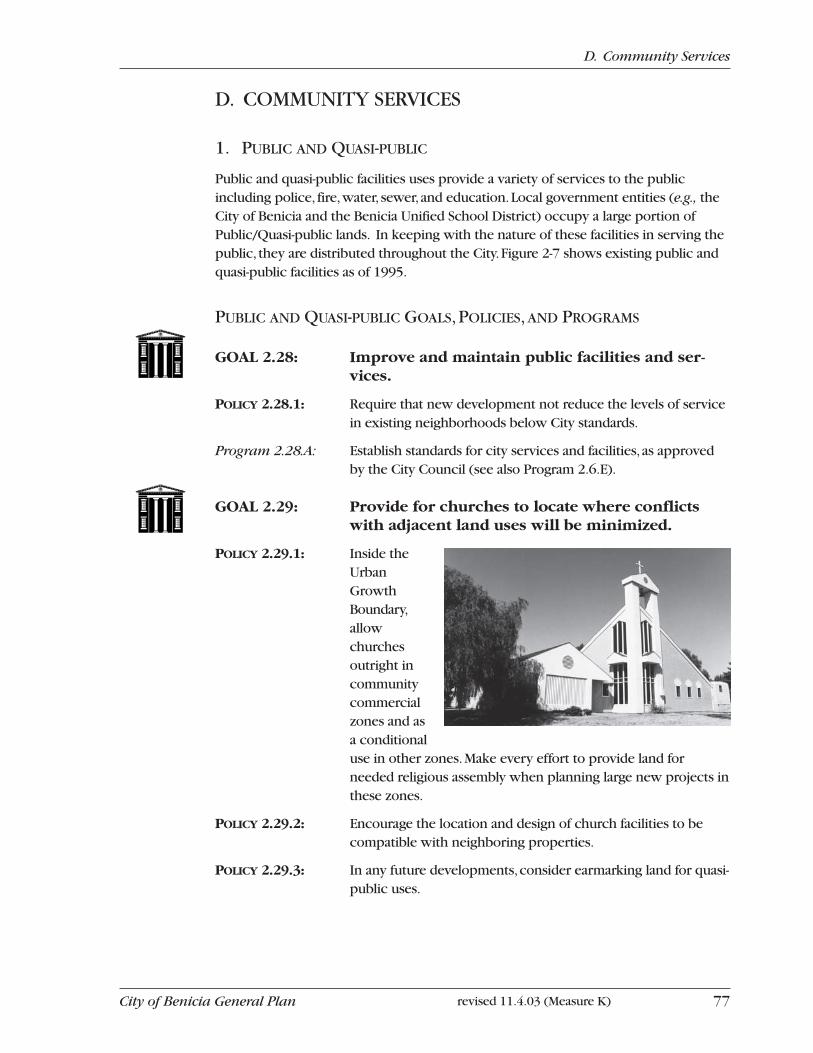
77City of Benicia General Plan
D. Community Services
D. COMMUNITY SERVICES
1. PUBLIC AND QUASI-PUBLIC
Public and quasi-public facilities uses provide a variety of services to the publicincluding police, fire, water, sewer, and education. Local government entities (e.g., theCity of Benicia and the Benicia Unified School District) occupy a large portion ofPublic/Quasi-public lands. In keeping with the nature of these facilities in serving thepublic, they are distributed throughout the City. Figure 2-7 shows existing public andquasi-public facilities as of 1995.
PUBLIC AND QUASI-PUBLIC GOALS, POLICIES, AND PROGRAMS
GOAL 2.28: Improve and maintain public facilities and ser-vices.
POLICY 2.28.1: Require that new development not reduce the levels of servicein existing neighborhoods below City standards.
Program 2.28.A: Establish standards for city services and facilities, as approvedby the City Council (see also Program 2.6.E).
GOAL 2.29: Provide for churches to locate where conflictswith adjacent land uses will be minimized.
POLICY 2.29.1: Inside theUrbanGrowthBoundary,allowchurchesoutright incommunitycommercialzones and asa conditionaluse in other zones. Make every effort to provide land forneeded religious assembly when planning large new projects inthese zones.
POLICY 2.29.2: Encourage the location and design of church facilities to becompatible with neighboring properties.
POLICY 2.29.3: In any future developments, consider earmarking land for quasi-public uses.
revised 11.4.03 (Measure K)
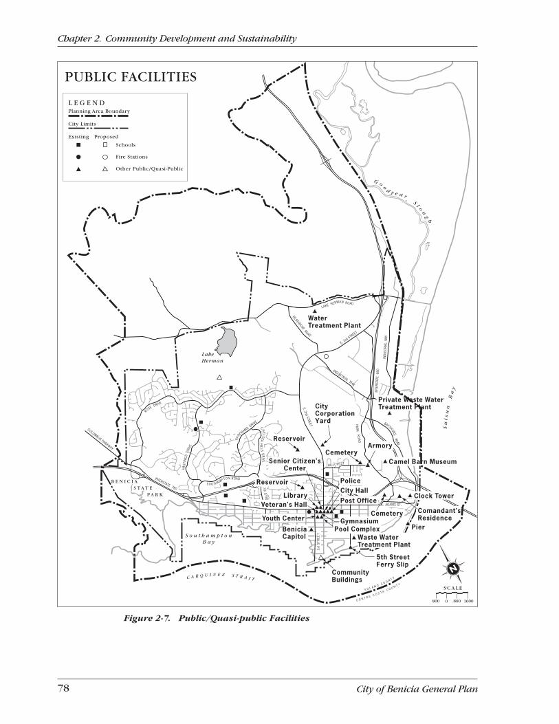
78
Chapter 2. Community Development and Sustainability
City of Benicia General Plan
Figure 2-7. Public/Quasi-public Facilities
INDUSTRIAL WAY
LAKE HERMAN ROAD
S o u t h a m p t o nB a y
B E N I C I A
C A R Q U I N E Z S T R A I T
S O L A N O C O U N T Y
C O N T R A C O S T A C O U N T Y
800 0 800 1600
S C A L E
SOUTHAMPTON ROAD
HAS
TIN
GS
DRI
VE
ROSE DRIVE
PANORAMA
DRIVE
CHELSEAH
ILLSD
RIVE
RESERVOIRROAD
G o
o
d y e a rS
l ou
gh
Su
is
un
Ba
y
1st
STR
EET
MILITARY WEST
W. 7th STREET
E. 2nd STREET
HILLCREST
PARK ROAD
E. 2nd STREET
INDU
STRI
AL W
AY
INTE
RSTA
TE 6
80
INTERSTATE 780
LakeHerman
S T A T EP A R K
BAYSHOREROAD
PUBLIC FACILITIES
CHELSEAH
ILLSD
RIVE
PANORAMA
DRIVE
Cemetery
Planning Area Boundary
City Limits
Existing Proposed
Schools
Fire Stations
Other Public/Quasi-Public
L E G E N D
Reservoir
COLUMBUS PARKWAY
ADAMS ST.
Armory
CityCorporationYard
Camel Barn Museum
Private Waste WaterTreatment Plant
BeniciaCapitol
Clock Tower
Comandant'sResidence
Cemetery
Waste WaterTreatment Plant
WaterTreatment Plant
Library
Senior Citizen'sCenter
Veteran's Hall
Youth Center
Pool Complex
Post OfficeCity HallPolice
Gymnasium
CommunityBuildings
Reservoir
5th StreetFerry Slip
Pier
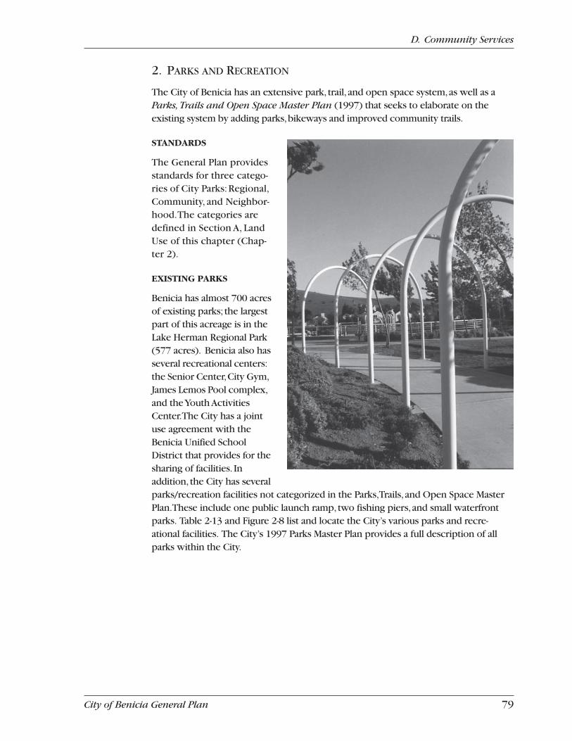
79City of Benicia General Plan
2. PARKS AND RECREATION
The City of Benicia has an extensive park, trail, and open space system, as well as aParks, Trails and Open Space Master Plan (1997) that seeks to elaborate on theexisting system by adding parks, bikeways and improved community trails.
STANDARDS
The General Plan providesstandards for three catego-ries of City Parks: Regional,Community, and Neighbor-hood. The categories aredefined in Section A, LandUse of this chapter (Chap-ter 2).
EXISTING PARKS
Benicia has almost 700 acresof existing parks; the largestpart of this acreage is in theLake Herman Regional Park(577 acres). Benicia also hasseveral recreational centers:the Senior Center, City Gym,James Lemos Pool complex,and the Youth ActivitiesCenter. The City has a jointuse agreement with theBenicia Unified SchoolDistrict that provides for thesharing of facilities. Inaddition, the City has severalparks/recreation facilities not categorized in the Parks, Trails, and Open Space MasterPlan. These include one public launch ramp, two fishing piers, and small waterfrontparks. Table 2-13 and Figure 2-8 list and locate the City’s various parks and recre-ational facilities. The City’s 1997 Parks Master Plan provides a full description of allparks within the City.
D. Community Services

80
Chapter 2. Community Development and Sustainability
City of Benicia General Plan
Figure 2-8. Parks and Open Space
INDUSTRIALWAY
PARKS AND OPEN SPACE
1
32
PARK PLANNING DISTRICTS
▲
?
▲
▲▲
20
26
2
▲
▲
▲
14
OPENSPACE
OPENSPACE
OPENSPACE
▲
▲
▲
▲
13
29
7
8
27
1
▲▲
Planning Area Boundary
City Limits
Existing Planned
City Parks
Bicycle Routes/Lanes
Paved Community Trails
Improved Community Trails
Staging Areas (Major/Minor)
Open Space
Vacant Lots
Future Industrial
L E G E N D
800 0 800 1600
S C A L E
12 10
9
11
32
18
19
1716
2125
2423 22
30
28
15
34
631
5
????
?
?
?
S o u t h a m p t o nB a y
B E N I C I A
C A R Q U I N E Z S T R A I TS O L A N O C O U N T Y
C O N T R A C O S T A C O U N T Y
SOUTHAMPTON ROAD
HAS
TIN
GS
DR I
VE
ROSE DRIVE
PANORAMA
DRIVE
CHELSEA
HILLS
DRIVE
RESERVOIRROAD
G
o o d y e a r
Sl o
ug
h
Su
is
un
Ba
y
1st S
TREE
T
MILITARY WEST
MILITARY EAST
W. 7th STREET
E. 2nd STREET
E. 5
th S
TREE
T
HILLCREST
GRANT ST.
PARK ROAD
E. 2nd STREET
LAKE HERMAN ROAD
INDU
STRI
AL W
AY
INTE
RSTA
TE 6
80
INTERSTATE 780
LakeHerman
S T A T EP A R K
BAYSHORERO
AD
COLUMBUS PKWY.
ADAMS ST.33

81City of Benicia General Plan
Table 2-13. Existing and Future Parks and Recreation Facilities within City
Limits, 1995
MAP NO.* FACILITY NAME ACRES
1. Lake Herman Regional Park 577.02. Benicia Community Park 50.03. Channing Circle Park 2.54. Gateway Park 0.55. Jack London Park 7.76. Park Solano 2.07. Frank Skillman Park 3.08. Southampton Park 6.09. Benicia Views II 0.510. Willow Glen Park 4.511. Matthew Turner Park (West 12th Street) 2.512. West 9th Street Park 6.013. Point Benicia Spit 0.314. Turnbull Park 0.315. Clocktower —16. Francesca Terrace 5.017. Duncan Graham Park 2.018. Overlook Park 3.519. Bridgeview Park 4.520. City Park 4.521. Civic Center Park 3.522. Benicia Senior Citizens’ Center —23. Benicia City Gymnasium —24. James Lemos Pool Complex —25. Youth Activity Center —26. Fitzgerald Field 4.027. Little League Field 4.028. Ethelree Saraiva Park 0.529. Park D-7 (future) 3.530. Bottle Hill Park (future) 0.531. Hastings Drive Neighborhood Park (future) 10.032. Perth Way Neighborhood Park (future) 8.033. St. Catherine’s Wood Neighborhood Park (future) 0.5SUBTOTAL 716.8
Benicia State Recreation Area 469.0Benicia State Capital Historic Park 1.5
Source: Parks, Trails, and Open Space Master Plan
* These numbers refer to locations on Figure 2-8.
D. Community Services

82
Chapter 2. Community Development and Sustainability
City of Benicia General Plan
PARK AND RECREATION FACILITY NEEDS
The Parks, Trails and Open Space Master Plan evaluated the existing park and recre-ation system to determine future needs for Benicia. The analysis was conducted forthe City as a whole, and for three districts divided along census tract boundaries (seeinset in Figure 2-8):
• District 1 is the Downtown and Old Town area, bounded on the north by MilitaryStreet.
• District 2 is the Southampton subdivision. This district accounts for almost 70percent of the City’s population.
• District 3 is the eastern part of the City. It includes a few older residential areas onthe east side of East Second Street, but most of it is developed for industrial uses.
Overall Population
The Parks Master Plan compared acreages of existing and planned park land inrelation to both the existing and projected population of the City. Using the standardper acre shown in Table 2-14, the City has more than adequate regional parkland, butis deficient in community and neighborhood parks. The Parks Master Plan identifieda shortfall of 35 acres of neighborhood park and 18 acres of community park in 2010.
Table 2-14. Amount of Existing Park Land per Capita
PARK TYPE ACRES ACRES/1,000 STANDARD
PEOPLE (ACRES/1,000
PEOPLE)
Regional Park 577 20 10
Community Park 50 2 2.5
Neighborhood Parks 59 2 3.5
Recreational Facilities 8 0.3 —
Totals 694 24.3
District Population
Using the standards shown in Table 2-14 in the Land Use section, the Parks MasterPlan found differing parkland needs by district. District 1 has an adequate park landthrough 2010. District 2 will be deficient by 33 acres of neighborhood park land inthe year 2010. District 3 will be deficient by 5 acres of neighborhood park land in theyear 2010. Thus most parkland deficiency is in District 2.
83City of Benicia General Plan
Distance
The Parks Master Plan used a half-mile mile radius standard to evaluate each neigh-borhood park. Using this standard, major service gaps were found in the western andsouthwestern portions of District 2, and the eastern tip of Downtown (District 1).
Facility Type and Description
The number of recreational facilities provided in the City and in each district wascompared with the recreational facility standards to determine which areas weredeficient in given facilities. The evaluation determined that there will be a citywidedeficiency of six tennis courts by 2010 (four in District 2; two in District 3).
FUTURE PARK DEVELOPMENT
Several sites are shown on Table 2-13 as future parks. A brief description follows.
Park D-7. (Map No. 29). This 3.5-acre neighborhood park is planned for the northeast-ern portion of the Southampton development. Proposed uses range from a commu-nity center, public pool, and tennis courts, to volleyball courts, playgrounds, andcroquet courts.
Bottle Hill Park. (Map No. 30). This 0.5-acre neighborhood park, in the southeasternportion of the Downtown area, will provide panoramic views of the Carquinez Strait,and sheltered areas for a tot lot, and picnic facilities.
Hastings Drive Neighborhood Park. (Map No. 31). This proposed 10-acre park islocated in the Southampton open space in the central western portion of theSouthampton development. The site contains a small drainage channel and is sur-rounded by existing homes. The topography in the area would necessitate terracingfor facilities. The park will include a multi-purpose playing field, tennis court, basket-ball courts, playground, grass play area, picnic area, path, and benches.
Perth Way Neighborhood Park. (Map No. 32). Perth Way Neighborhood Park is aproposed 8-acre neighborhood park located in the open space in the eastern portionof the Southampton development. The site is relatively flat, but high in elevation,providing views toward Suisun Bay. Planned facilities include a multi-purpose playingfield, tennis court, basketball court, playground, grass play area, picnic area, path, andbenches.
St. Catherine’s Wood Neighborhood Park. (Map No. 33). This 0.5-acre neighborhoodpark, located directly north of Solano Square at First Street, will include a playground,an entry plaza, and a seating area.
D. Community Services

84
Chapter 2. Community Development and Sustainability
City of Benicia General Plan
PARKS AND RECREATION GOALS, POLICIES, AND PROGRAMS
Goals, policies, and programs in this section call for adding parks and recreationfacilities while maintaining and improving existing parks and recreation facilities.
GOAL 2.30: Maintain and improve existing parks and recre-ation programs.
POLICY 2.30.1: Enhance existing city recreation facilities and programs.
Program 2.30.A: Develop programs that promote higher and better use ofBenicia’s recreation facilities and programs.
Recreation facilities include parks and buildings.
Program 2.30.B: Conduct periodic surveys about ways to improve City recre-ation facilities and programs.
Program 2.30.C: Direct the Parks, Recreation & Cemetery Commission toannually audit and recommend additions to and updates of theParks Master Plan.
Program 2.30.D: Establish cooperative relationships with public agencies andapplicable public interest groups in developing plans for parksand recreation programs.
Program 2.30.E: Distribute special park features (e.g., gazebos, bandstands,fountains, sculpture, overlooks, etc.) at key locations in neigh-borhood and community parks to enhance neighborhoodcharacter, provide a focus for a park, or create a place forviewing.
Program 2.30.F: Continue to share City park facilities with the School Districtand consolidate park and school lands wherever feasible.
Program 2.30.G: Develop a process to evaluate existing facilities and determinetheir utilization.
POLICY 2.30.2: Increase resident awareness of the available recreationalopportunities in the city.
Program 2.30.H: Develop public information materials (including a color mapand table of citywide recreation facilities), and a comprehensivesign system about parks and recreational opportunities.
POLICY 2.30.3: Incorporate water conservation into park planning and design.
Program 2.30.I: Use primarily native plant species and other drought tolerantplants in all parks and open space areas.
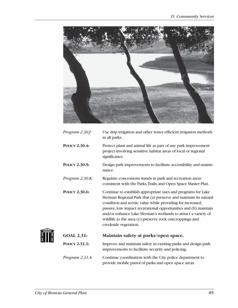
85City of Benicia General Plan
Program 2.30.J: Use drip irrigation and other water efficient irrigation methodsin all parks.
POLICY 2.30.4: Protect plant and animal life as part of any park improvementproject involving sensitive habitat areas of local or regionalsignificance.
POLICY 2.30.5: Design park improvements to facilitate accessibility and mainte-nance.
Program 2.30.K: Regulate concessions stands in park and recreation areasconsistent with the Parks, Trails, and Open Space Master Plan.
POLICY 2.30.6: Continue to establish appropriate uses and programs for LakeHerman Regional Park that (a) preserve and maintain its naturalcondition and scenic value while providing for increased,passive, low impact recreational opportunities and (b) maintainand/or enhance Lake Herman’s wetlands to attract a variety ofwildlife to the area; (c) preserve rock outcroppings andcreekside vegetation.
GOAL 2.31: Maintain safety at parks/open space.
POLICY 2.31.1: Improve and maintain safety in existing parks and design parkimprovements to facilitate security and policing.
Program 2.31.A: Continue coordination with the City police department toprovide mobile patrol of parks and open space areas.
D. Community Services

86
Chapter 2. Community Development and Sustainability
City of Benicia General Plan
Program 2.31.B: Continue coordination with the City fire department regardingfire season warning and control, emergency vehicle access,support facilities, and response.
Program 2.31.C: Continue to coordinate with neighborhood watch programs toprovide added security at parks, along trails, and in the openspace areas.
Program 2.31.D: Coordinate with the Benicia Unified School District regardingsafety concerns at joint use facilities.
GOAL 2.32: Expand the City’s park system to accommodatefuture community needs.
POLICY 2.32.1: Establish new parks/recreation areas.
Program 2.32.A: Ensure that lands dedicated for park land are of sufficient insize to accommodate the uses and facilities proposed, gradedfor those uses, and free of hazardous and toxic waste materialsfor each park site.
Program 2.32.B: Regularly monitor County, State, and federal funding sourcesand apply for loans and grants to acquire, develop, and rehabili-tate park land and facilities.
Program 2.32.C: Identify and incorporate the needs of neighborhoods in devel-oping new parks and facilities.
POLICY 2.32.2: Continue to develop and enhance recreational benefits of theshoreline and seek public access along the waterfront.
Program 2.32.D: Explore public access on private waterfront through collabora-tive planning or a development review process.

87City of Benicia General Plan
BENICIA STATE PARKS
The State Department of Parks and Recreation maintains and operates two parks inBenicia: the State Capitol Historic Park and the Benicia State Recreation Area. The 1.5acre State Capitol Historic Park is located on the corner of First and West G Streets. Itincludes the building used as California’s State Capitol from 1853–1854, the Fischer-Hanlon House, associated historic structures and Victorian Garden. The 469-acreBenicia State Recreation Area is located in western Benicia along the Benicia-Vallejoborder, southwest of I-780. This recreation area is predominantly marsh but alsoprovides extensive hiking, jogging, and biking trails, a fishing area, and picnic areas.(See Chapter 3, Section D, for more information on trails in the Planning Area.)
GOAL 2.33: Assure long-term maintenance of the State Parks.
By itself, the City may not be able to assure maintenance of a State park. This impliesworking with the State to achieve the goal.
Program 2.33.A: Develop a Strategic Plan for addressing State park issues.
Program 2.33.B: Work with the State to maintain and improve both parks andidentify needed improvements.
For example, utility lines that cross the State Recreation Area should be re-routed.
Program 2.33.C: Work with the State to keep the State Recreation Area open tothe public for day use.
Program 2.33.D: Work with the State to assure that the Capital maintains maxi-mum opening hours for public enjoyment and use.
D. Community Services
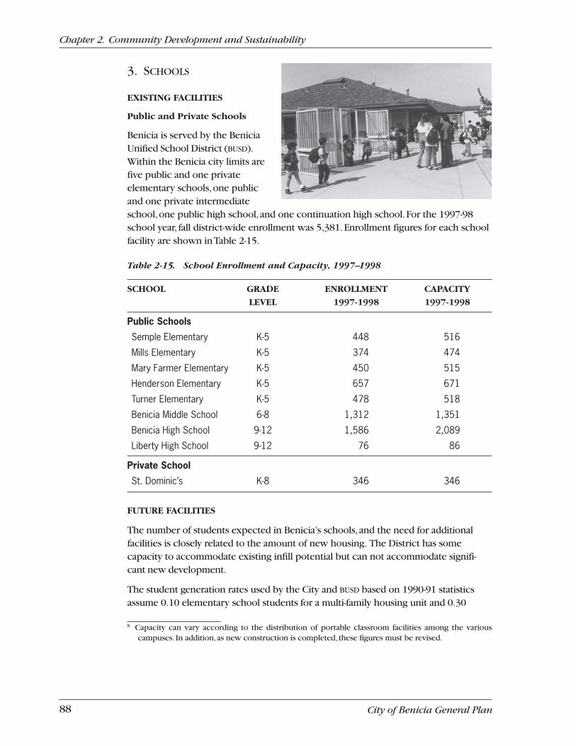
88
Chapter 2. Community Development and Sustainability
City of Benicia General Plan
3. SCHOOLS
EXISTING FACILITIES
Public and Private Schools
Benicia is served by the BeniciaUnified School District (BUSD).Within the Benicia city limits arefive public and one privateelementary schools, one publicand one private intermediateschool, one public high school, and one continuation high school. For the 1997-98school year, fall district-wide enrollment was 5,381. Enrollment figures for each schoolfacility are shown in Table 2-15.
Table 2-15. School Enrollment and Capacity, 1997–1998
SCHOOL GRADE ENROLLMENT CAPACITY
LEVEL 1997-1998 1997-1998
Public Schools
Semple Elementary K-5 448 516
Mills Elementary K-5 374 474
Mary Farmer Elementary K-5 450 515
Henderson Elementary K-5 657 671
Turner Elementary K-5 478 518
Benicia Middle School 6-8 1,312 1,351
Benicia High School 9-12 1,586 2,089
Liberty High School 9-12 76 86
Private School
St. Dominic’s K-8 346 346
FUTURE FACILITIES
The number of students expected in Benicia’s schools, and the need for additionalfacilities is closely related to the amount of new housing. The District has somecapacity to accommodate existing infill potential but can not accommodate signifi-cant new development.
The student generation rates used by the City and BUSD based on 1990-91 statisticsassume 0.10 elementary school students for a multi-family housing unit and 0.30
8 Capacity can vary according to the distribution of portable classroom facilities among the various campuses. In addition, as new construction is completed, these figures must be revised.

89City of Benicia General Plan
elementary school students for a single family housing unit. For middle school, therates are 0.045 for a multi-family unit and 0.14 for a single-family unit. For high school,the rates are 0.055 for a multi-family unit and 0.16 for a single-family unit.
Based on these generation rates the following table illustrates existing and projectedenrollment to Year 2002.
Table 2-16. School Enrollment, 1997 and Projected
SCHOOL ACTUAL ACTUAL PROJECTED PROJECTED
1997 1998 2000 2002
Public Schools
K–5 2,425 2,407 2,407 2,348
6–8 1,303 1,312 1,350 1,420
9–12 1,550 1,662 1,938 2,014
PUBLIC SCHOOL TOTAL 5,278 5,381 5,682 5,782
Private School 346 346 346 346
Source: Benicia Unified School District; St. Dominic’s Priory School
Given limited residential buildout in the City, no new schools are anticipated. Thehigh school is developing a progressive capacity master plan for the expansion offacilities to make room for new students on the existing 47-acre site. Increasingly,school districts rely on development permit fees to generate funds for new schoolfacilities. Based on 1997 fee rates, the District calculates that about one-third of thecost of the new school facilities needed to serve new development generated by thisPlan would be funded.
SCHOOLS GOALS, POLICIES, AND PROGRAMS
Goals in this section stress City/School District cooperation.
GOAL 2.34: Ensure adequate school facilities to serve allresidential areas.
POLICY 2.34.1: Approve new residential projects only if adequate schoolfacilities are available or will be available when needed.
Program 2.34.A: Continue to work with the School District to identify appropri-ate sites if needed for future expansion and new constructionof public schools.
D. Community Services

90
Chapter 2. Community Development and Sustainability
City of Benicia General Plan
GOAL 2.35: Cooperate with the School District to provideopportunities for citizen use of the schools.
POLICY 2.35.1: Continue to seek innovative ways for the City to use schoolfacilities and grounds jointly with the School District.
Program 2.35.A: Continue to maintain and implement the joint-use agreementbetween the City and BUSD.
Program 2.35.B: Maintain zoning that, in the event any schools are closed orrelocated, will support the reuse of closed school sites forpublic or quasi-public uses.
4. WATER
Sulphur Springs Creek Water-shed and Lake Herman
Sulphur Springs Creek and itsmain tributary, Paddy Creek, formthe largest watershed within thePlanning Area. Of the approxi-mately 18 square mile watershedarea, the upper six square mileslies outside of the Planning Area inthe Vallejo Sphere Of Influence. Paddy Creek, which drains a three square milewatershed, joins the lower reach of Sulphur Springs Creek just below the LakeHerman outlet.
The Lake Herman reservoir on Sulphur Springs Creek stores watershed runoff alongwith excess water from the North Bay Aqueduct, a component of the State WaterProject and the City’s principal potable water supply. The reservoir is typically filledduring the spring and drawn down during the summer and fall. Both the City andExxon draw on the reservoir during periods of high demand.
WATER SUPPLY
Benicia has a long history of having a local shortage of fresh water. Benicia’s potablewater is currently supplied by the California State Water Project (SWP) through theNorth Bay Aqueduct (and the City of Vallejo in the event of a water shortage). TheCity’s Water Treatment Plant is located on Lake Herman Road and was expanded in1989.
WATER QUALITY
Water quality problems typical of commercial and residential land uses affect aquatichabitat and stormwater discharge throughout the urbanized portions of the PlanningArea. Lake Herman, which is the City’s back-up water supply, is considered a
91City of Benicia General Plan
eutrophic water body by the Regional Water Quality Control Board (RWQCB).Eutrophic waters are characterized by high nutrient loads, excessive algal and aquaticvascular plant growth, low water clarity, and reduced oxygen concentrations inbottom waters. However, the City also stores good quality North Bay Aqueduct waterin Lake Herman, and the current mixture of water in the lake is deemed sufficient tomeet water quality standards.
While no specific data are available on water quality for other surface waters inBenicia, it is reasonable that water quality in other minor creeks and drainages wouldbe similar to that found in other urbanized portions of the Bay Area, since Benicia issubject to the same point and non-point sources as other jurisdictions.
Groundwater
The Public Safety Background Report lists a number of confirmed and potentialgroundwater contamination sites throughout the City. However, Benicia’s reliance onimported SWP water for its municipal water supply means that the groundwaterquality problem sites have little significant impact on drinking water quality. Instead,they have the potential to affect water quality in local creeks and the receiving watersin the Carquinez Strait and Suisun Bay, since groundwater eventually flows to surfacelocations.
Groundwater contamination upstream from Lake Herman could reach the City’swater supply. Two upstream contamination sites have been identified at Syar Quarryand the Hastings Mercury Mine. While these sites appear to be of relatively lowerconcern than downstream sites, they should be monitored.
WASTE WATER TREATMENT
Benicia’s sewer system dates from the time when sanitary sewers and storm drainsflowed together into the Carquinez Strait. Separation of sanitary from storm waterflows was completed and interceptors were constructed to carry waste water to theWaste Water Treatment Plant (WWTP) at the lower end of East Fifth Street.
In June 1996, Benicia residents passed a bond measure to upgrade the City’s wastewa-ter treatment plant (WWTP). The upgrade will (a) increase the WWTP’s firm capacity tosufficiently serve existing development and projected infill development withinexisting City Limits, (b) eliminate excessive noise, odors, and the use of gaseouschlorine from the Plant, (c) address problems with deteriorating equipment andfacilities, and (d) create a flood wall along the southern and eastern borders of thePlant.
WATER GOALS, POLICIES, AND PROGRAMS
Goals, policies, and programs focus on meeting the needs of the existing and futuredevelopment envisioned by this Plan with an adequate supply of high quality drinkingwater and sufficient wastewater treatment capacity.
D. Community Services

92
Chapter 2. Community Development and Sustainability
City of Benicia General Plan
GOAL 2.36: Ensure an adequate water supply for current andfuture residents and businesses.
POLICY 2.36.1: Approve development plans only when a dependable andadequate water supply to serve the development is assured.
POLICY 2.36.2: Continue to pursue and secure adequate water sources of thehighest quality available.
Program 2.36.A: Pursue use of reclaimed wastewater—especially for majorindustrial users—where feasible.
POLICY 2.36.3: Implement measures to reduce water consumption.
Program 2.36.B: Initiate water conservation programs and conduct droughtcontingency planning.
Program 2.36.C: Continue to implement City-adopted water conservation BestManagement Practices (BMP). (see Glossary)
Program 2.36.D: Continue to require development to utilize adopted Citystandards for low-water-use landscaping.
POLICY 2.36.4: Encourage public and private uses to minimize water use andto recycle processed water whenever and wherever feasible.
Program 2.36.E: Promote the retrofitting of public buildings with water conser-vation features.
Program 2.36.F: Assist hospitality-related businesses to actively promote waterconservation.
GOAL 2.37: Identify and preserve groundwater resources.
POLICY 2.37.1: Work with the RWQCB to protect groundwater quality.
POLICY 2.37.2: Ensure the cleanup of groundwater contamination resultingfrom the IT Panoche Hazardous Waste Facility.
GOAL 2.38: Protect water quality.
POLICY 2.38.1: Continue to require the use of feasible and practical BestManagement Practices (BMP) to protect receiving waters fromadverse effects of construction and urban runoff.
Program 2.38.A: Continue the Storm Water Pollution Prevention Program(SWPPP) and the Industrial Pretreatment Program, and continueto implement the Erosion Control Ordinance.
Such measures would include providing water conservation literature to visitors andtourists and installing a full range of water-conserving fixtures in hotels and restau-rants.

93City of Benicia General Plan
D. Community Services
GOAL 2.39: Provide safe drinking water and improve its tasteand odor.
POLICY 2.39.1: Ensure that water quality goals are consistently met.
Program 2.39.A: Continue to cooperate in regional efforts by organizations suchas the CALFED Program to improve the quality of the City’ssource water.
Program 2.39.B: Continue to optimize treatment operations in conjunction withthe implementation of the City’s five- and 10-year CapitalImprovements Programs.
Program 2.39.C: Educate the public about City efforts to improve the taste andodor of its drinking water.
GOAL 2.40: Ensure adequate wastewater treatment capacity toserve all development shown in the General Plan.
POLICY 2.40.1: Approve changes in land use designations for new develop-ment only if adequate wastewater treatment capacity is as-sured.
POLICY 2.40.2: Promote use of reclaimed wastewater where feasible.
Program 2.40.A: Prepare, adopt, and implement a sewer maintenance andreplacement program.
Program 2.40.B: Continue to implement the City’s Wet Weather ManagementPlan.
POLICY 2.40.3: Encourage developments with projected high strength dis-charges to reduce pollutants directly to the City’s wastewatersystem.
Program 2.40.C: Educate developers about recycling and other technologicalmethods where feasible.
Program 2.40.D: Continue to pursue the City’s Pollution Prevention Program forall users of the City’s wastewater system including commercial,industrial, and residential.
Program 2.40.E: Continue to pursue the City’s pretreatment program forindustrial dischargers.
GOAL 2.41: Minimize WWTP operational upsets, potential dis-charge of inadequately treated wastewater, andthe emission of odor and noise.
POLICY 2.41.1: Continue efforts to replace the gaseous chlorine system with aless hazardous chemical (such as a liquid chlorine system) that

94
Chapter 2. Community Development and Sustainability
City of Benicia General Plan
will address the potential safety impacts to the neighborhoodsurrounding the WWTP.
POLICY 2.41.2: Continue to work with neighbors to implement programs thatminimize odor, noise, and potential safety impacts to theneighborhood surrounding the WWTP.
5. RECYCLING GOALS, PROGRAMS, AND POLICIES
GOAL 2.42: Enhance the recycling of solid waste.
POLICY 2.42.1: Strive to accomplish the mandated objectives of the CaliforniaIntegrated Waste Management Act.
Program 2.42.A: Adopt and implement a Source Reduction and Recycling Plan(SRRP) and Hazardous Household Waste Plan (HHWP) whichinclude components for waste characterization, source reduc-tion, recycling, composting, special waste diversion, education,public information, disposal facility capacity, funding, and thesafe use, disposal, and recycling of household hazardous materi-als.
Program 2.42.B: Encourage local recycling facilities to be available to the public.
Program 2.42.C: Pursue establishment of curbside service that would pick upand compost yard waste and make it available to City residentsfor a reasonable cost.
6. UTILITIES
The City of Benicia owns and operates its own water and wastewater treatmentplants. Additionally, the City owns a seven acre corporation yard, where maintenanceequipment is stored and maintained.
POWER AND ENERGY USE
Benicia’s principal sources of power come from natural gas and electricity suppliedby the Pacific Gas and Electric Company. The regional supply system which feedsBenicia is a closed loop system; thus interruption of any single trunk line would notresult in a complete blackout. No reliable estimate of future demand for power ispossible due to variables of energy availability and the effects of the economy on newconstruction. No immediate limitations on supply capability are forecast.
TELECOMMUNICATIONS
Telephone communication is generally provided by Pacific Bell to Benicia. CenturyCable provides television cable for subscribers in Benicia.

95City of Benicia General Plan
D. Community Services
Growth and change in the telecommunications field has resulted in unprecedenteddemand for new commercial antenna and associated equipment. The antennas andassociated structures can pose aesthetic problems because of their size, location, ornumber. The City controls antennas and similar structures through the use permitprocess.
UTILITIES GOALS, POLICIES, AND PROGRAMS
GOAL 2.43: Allow installation of telecommunications equip-ment and distribution networks that maintainand protect health, safety, and quality of life andavoid visual clutter.
POLICY 2.43.1: Minimize the visual impacts of siting exposed commercialantenna structures in scenic corridors and residential andhistoric districts.
Program 2.43.A: Establish design requirements for commercial antennas andassociated equipment and distribution networks.

96
Chapter 2. Community Development and Sustainability
City of Benicia General Plan

97
Subhead
City of Benicia General Plan
3. COMMUNITY IDENTITY
Benicia is committed to preserving and enhancing its unique geographic and culturalinheritance. It is located at the gate of California’s great waterways. The City’s heritageand resources are described in Gateway to the Inland Coast: The Story of theCarquinez Strait by Andrew Neal Cohen, (1996, California State Lands Commission);Great Expectations: The Story of Benicia California, by Richard Dillon (1980, BeniciaHeritage Books); and Benicia: Portrait of an Early California Town, by RobertBruegmann (1980, 101 Productions).
A. HISTORIC RESOURCES
Benicia has a rich and fascinating past: historic buildings, archaeological sites, and thetraditions and folkways of the community’s diverse residents. These resources—allpart of Benicia’s cultural heritage—provide continuity with the past, create jobs,improve housing, offer a pleasing visual setting, enhance the quality of life, and havethe potential to draw thousands of visitors. Appendix B of the Historical and Archeo-logical Background Report (March 1996) lists Benicia’s historic landmarks, resources,and buildings. Figure 3-1 is a diagram of Benicia’s historical sites.

98
Chapter 3. Community Identity
City of Benicia General Plan
1. NATIVE AMERICAN PERIOD
The Vallejo-Benicia area was originally settled by the Southern Patwin group of NativeAmericans. The Southern Patwin inhabited areas west of the Sacramento River andnorth of the Carquinez Strait. By the beginning of the 20th century, the SouthernPatwin were extinct.
The Patwin were a hunting and gathering society that depended mostly on acornsand marine supplies for sustenance. They settled next to water. The nearest Patwinvillages definitely located are on the Napa River and near Fairfield, and there aremortar sites at the Benicia State Recreation Area. Although early explorers reportedseeing villages on the north shore of the Carquinez Strait and mapped a village at thehead of Southampton Bay, it remains unclear if this region was regularly inhabited,how it was utilized, and who used it.
2. HISPANIC PERIOD
Between the 1820s and 1840s, the Spanish parceled out the land around Benicia inlarge land grants to officers and their families. A large Spanish land grant—the Soscoeland grant of Rancho Suscol—covered what were to become the future sites of bothVallejo and Benicia. Rancho Suscol was obtained by General Mariano Vallejo in 1844from Governor Micheltorena.
This land ownership pattern lasted until the Mexican-American War, after whichCalifornia was granted to the United States as part of the Treaty of Guadalupe Hidalgo.California was admitted into the union in 1850.
3. AMERICAN PERIOD
In 1846, Robert Baylor Semple, an immigrant from Kentucky, arrested General MarianoVallejo and persuaded his prisoner to deed him half-interest in a tract of RanchoSuscol. Semple founded Benicia that same year, named in honor of General Vallejo’swife.
The Benicia Arsenal, located on a large tract of land east of the community and over-looking the Strait, was acquired between 1847 and 1849 by the federal governmentfor use as a military reservation. Several army installations preceded the Arsenal, whichwas named the “Benicia Arsenal” in 1852. It was one of five permanent arsenals in thecountry and the first on the Pacific Coast.
In 1850, Benicia and Monterey were the first two cities in the State of California toincorporate. Also in 1850, Benicia was named the government seat for Solano County.Soon thereafter, Benicia was established as a port of entry by the United States Con-gress. On February 4, 1853, the State Legislature voted to move into Benicia’s new CityHall and make it the State Capital.

99
Subhead
City of Benicia General Plan
A. Historic Resources
Benicia was the State Capital for only a year. In 1854 the Legislature was persuaded torelocate to Sacramento. In 1859, the county seat was moved from Benicia to Fairfield.
Benicia was also home to the earliest of California’s educational institutions. Severalschools were established in Benicia in the mid-19th century, including DominicanCollege and Mills College, though both campuses were relocated by 1900. Benicia washome to the state’s first official Masonic Hall, built in 1850, and the depot and shops ofthe Pacific Mail Steamship Company—the first large industrial enterprise in California.
In the late 1800s, Benicia was a center for agricultural and mineral production. Thefirst railroad ferry west of the Mississippi River began service in 1879 at the foot of
HISTORICAL SITES
S o u t h a m p t o nB a y
B E N I C I A
C A R Q U I N E Z S T R A I T
SOUTHAMPTON ROAD
HAS
TIN
GS
DRIV
E
ROS
ED
RIVE
CHELS
EAH
I LLS
1st
ST
MILITARY WESTMILITARY E.
W. 7th STREET
E. 2nd STREET
E. 5
th S
TREE
THILLCREST
GRANT
PARK ROAD
INTERSTATE 780S T A T E
P A R K
ADAMS ST.
BAYS
HO
R E
RO
AD
CHELSEA
HILLS
DRIVE
PAN
ORA
MA
DRIV
E
ST.
COLUMBUS
PKWY.
2
800 0 800 1600
S C A L E
Downtown Historic District
40
3938
29
26 25
2219
17
18
1516
14
11
12
10
1. Guard House2. Clock Tower3. Commandant’s Home4. Camel Barns5. Powder Magazine6. Post Hospital7. Post Cemetery8. St. Dominic’s Cemetery9. “Benicia Boy”10. Pacific Mail Docks11. St. Dominic’s Church12. St. Augustine’s College Site13. Mizner Homesite
14. St. Mary’s School Site15. Captain Walsh Home16. St. Catherine’s Academy Site17. First Protestant Church Site18. Masonic Temple19. St Paul’s Church20. St. Paul’s Rectory21. Mills College Site22. Peabody Hospital Site23. “California House” Site24. “Bella Union Saloon”25. Early Capital26. Fischer-Hanlon House
27. “Solano Hotel” Site28. What-Not Shop29. “Salt Box” House30. “Washington House”31. Gold!32. Tannery Sites33. Jurgensen’s Saloon34. Pony Express35. Cannery Sites36. Transcontinental Railroad Depot37. Train-Ferry Docks Site38. Turner Shipyards Site39. Corbett-Choynski Fight Site40. Commodore Jones Point
3331 30
37 36
28
35
27
34
32
23 2421 20
13
7
98
6
54
31
4
Figure 3-1. Historic Sites

100
Chapter 3. Community Identity
City of Benicia General Plan
First Street. By 1880, one-third of all leather produced in California was manufacturedat three locations in Benicia, primarily at the foot of First Street.
4. ARCHAEOLOGICAL SITES
One known archaeological resource is an underwater site at the Matthew TurnerShipyard State Park. There lie the remains of the Stamboul, originally designed andbuilt on the east coast to ship ice from New England to India, then converted to awhaling ship. The park is a National Register of Historic Places District.
Six other archaeological sites may also exist within Benicia’s City Limits. One may belocated in the vicinity of Lake Herman Road and the Suisun Bay marsh. The otherpotential sites are located in the Arsenal and Downtown.
5. HISTORIC BUILDINGS, SITES, AND AREAS
WATERFRONT
Much of Benicia’s history wasinfluenced by its location along theCarquinez Strait, where the riversof the Central Valley that flow intoSan Francisco Bay shaped thetranscontinental railway and theinternational shipping trade.Benicia’s waterfront and transpor-tation activity molded its social,commercial, and military history.Primary industries—tanneries,canneries, and shipyards—locatedalong the waterfront.
The waterfront has been thesubject of several governmentalplans. A Special Area Plan for theBenicia Waterfront was completedin 1977 by the San Francisco BayConservation and DevelopmentCommission. The Benicia UrbanWaterfront Restoration Plan wasprepared by the City in 1991 forthe California State Coastal Conser-vancy Urban Waterfront Program.The Plan focused on the 24 acresof Downtown bounded by the

101
Subhead
City of Benicia General Plan
Carquinez Strait to the south and west, F and B Streets to the north, and the marina tothe east. It sought a balance between the needs to preserve the history of the area, topreserve open space, to enhance access to the waterfront, and to create new activitiesand commerce.
ARSENAL
The Benicia Arsenal was established in 1852 on 345 acres. The buildings were devel-oped to serve the needs of different Army sections that used the land. Residential areasand quarters were scattered throughout the site. Along with 24 frame, brick, and stonestructures built between 1854 and 1911, there are many newer buildings constructedduring World War II.
The Arsenal was deactivated in 1963 and the Defense Department transferred owner-ship to the City of Benicia in 1965. The federal government transferred public trustlands within the Arsenal’s waterfront to the State. The State granted these lands toBenicia to be managed according to the terms of the grant and consistent with thepublic trust doctrine, a common law generally immune from legislative change.
At first the City leased land and buildings to Benicia Industries, Inc. Eventually theCity transferred title to much of the Arsenal to Benicia Industries to develop theIndustrial Park and operate the Port. The City, however, retained ownership of severalof the most historically significant structures, including the Commandant’s house, theClocktower building, the Camel Barns, and one of the original powder magazines.
The Arsenal area includes four distinct historic districts included on the NationalRegister of Historic Places, and is also registered as State Historical Landmark No. 176.To preserve these historic resources, the City adopted the Arsenal Historic Conserva-tion Plan in 1993. This plan includes goals, objectives, design guidelines, and criteria toguide development and alterations to existing structures.
Recently remodeled live/work spaces accommodate part of the Benicia arts commu-nity. Thus the Arsenal includes a mix of residential, commercial, and industrial usessimilar to the historic mix of uses during its long period of military use.
A. Historic Resources

102
Chapter 3. Community Identity
City of Benicia General Plan
DOWNTOWN
Benicia’s Downtown, centered on First Street from the waterfront to Military, is thehistoric and cultural heart of the City. Settlement in the Downtown area began soonafter the town was platted in 1847. Streets were laid out without regard to topographyin a rectangular grid that extended into the water. Growth intensified when the StateCapitol was briefly located in Benicia from 1853–1854. Through the remainder of the19th century, development spread north from the waterfront, concentrated along tworidges of land that ran south from the highlands, to the Strait.
Recognizing the importance of Benicia’s historic Downtown, the City created anexpanded historic district and adopted the Downtown Historic Conservation Plan in1990 (amended 1992). The Downtown Historic District includes properties alongboth sides of First Street from Solano Square (Military) to the waterfront, and forseveral blocks to the east and west of First Street. The district was created not only topreserve historic buildings, but to help maintain and enhance the variety of activitiesthat make up the historic quality of the area.
6. HISTORIC PRESERVATION
Downtown has been recognized by Benicia as a historic district since 1969. However,its boundaries originally encompassed only 150 feet on either side of First Street fromA Street to Military. This area represented the historic commercial spine of Downtown,but it omitted much of the surrounding historic residential neighborhood, the devel-opment of which was inextricably linked to First Street.
103
Subhead
City of Benicia General Plan
In 1987, the City enacted a provision within its zoning ordinance for a special historicoverlay district that could be combined with any underlying zoning district. In 1989,based on extensive surveys and documentation by volunteers, consultants, andhistorians, the City identified two potential historic districts: one encompasses theDowntown commercial and residential area centered along First Street, and the otherfalls within the boundaries of the former Benicia Arsenal. In 1990 and 1993, the cityprepared and adopted conservation plans for the Downtown and Arsenal historicoverlay districts respectively.
GOAL 3.1: Maintain and enhance Benicia’s historic charac-ter.
POLICY 3.1.1: Encourage reuse of historic buildings; if feasible, encouragerelocation rather than demolition.
Program 3.1.A: Continue to maintain a current inventory of historic andarchitectural resources in the city.
POLICY 3.1.2: Enhance the economic potential of historic and architecturalassets.
POLICY 3.1.3: Preserve historic trees and landscapes. (Refer to the ArsenalHistoric Conservation Plan, November 1993, for guidance onhistoric trees and landscaping.)
Program 3.1.B: Become a Certified Local Government (CLG) by applying to theState Department of Historic Preservation. (See explanationbelow.)
The CLG program gives local authorities the ability to designate local historic districts,structures, and sites and to have more direct participation in federal and statewidehistoric preservation programs. CLGs are eligible for special matching grants forprojects that further local historic preservation objectives.
Completion of an historic resources inventory and creation of a local Historic Preser-vation Commission would qualify Benicia as a CLG. Benicia would then be eligible forfederal funds that are available only to CLG cities.
Program 3.1.C: Define the boundaries necessary to preserve the historicalsignificance of the Camel Barn complex.
Program 3.1.D: Continue to work and cooperate with the Benicia HistoricalSociety on historic preservation issues.
POLICY 3.1.4: Promote the preservation and enhancement of historic neigh-borhoods, commercial areas, and governmental districts.
POLICY 3.1.5: Permit new development, remodeling and building renovationin historic districts when consistent with the policies of theapplicable Historic Conservation Plan.
A. Historic Resources

104
Chapter 3. Community Identity
City of Benicia General Plan
POLICY 3.1.6: Promote restoration of public and privately-owned historic andarchitecturally significant properties.
Significant City-owned structures in danger of deterioration include the CommandingOfficer’s Quarters, Powder Magazine, Railroad Depot, and Von Pfister Adobe. Otherhistoric and architecturally significant properties where restoration efforts should befocused are the Arsenal area and the Camel Barn complex and sites.
Program 3.1.E: Develop a program for inspections of historic structures.
Program 3.1.F: Seek public and private funding for historic preservation andmaintenance.
Program 3.1.G: Develop a program for property tax incentives.
The City can encourage the rehabilitation of privately owned historic buildings byproviding potential buyers with information about California’s Mills Act and federalInvestment Tax Credits.
Program 3.1.H: Consider waiving or reducing building permit fees for qualifiedwork necessary to rehabilitate or restore historic structures.
Program 3.1.I: Publicize opportunities and incentives for historic preservationto owners of historic buildings.
Program 3.1.J: Continue to assist owners of historic homes in lower-incomeareas with low interest loans through Community Develop-ment Block Grants (CDBG), when available.
Program 3.1.K: Establish a Historic Preservation Commission.
Program 3.1.L: Adopt and maintain a landmarks ordinance.
Program 3.1.M: Inform title companies that properties in Benicia may beaffected by historic preservation regulations.

105
Subhead
City of Benicia General Plan
7. HISTORIC AND ARCHAEOLOGICAL RESOURCES GOALS, POLICIES, AND
PROGRAMS
Goals, policies, and programs in this section deal with protecting archaeologicalresources; preserving and restoring Benicia’s historic assets; and ensuring that newdevelopment and additions are compatible with historic assets.
GOAL 3.2: Protect archaeological (including underwater)sites and resources.
POLICY 3.2.1: Ensure the protection and preservation of artifacts in known,and as yet unidentified, areas.
Program 3.2.A: Work with the California Archaeological Inventory to developan inventory of existing and potential archaeological sites.
Program 3.2.B: Refer development proposals that may adversely affect archaeo-logical sites to the California Archaeological Inventory.
Program 3.2.C: Develop City regulations regarding inspections, code enforce-ment, and regulation of pot hunters.
Program 3.2.D: Require that all sites with archaeological resources likely to bedisturbed by a proposed project be analyzed by a qualifiedarchaeologist and an appropriate program developed tomitigate any impacts from the project.
A. Historic Resources

106
Chapter 3. Community Identity
City of Benicia General Plan
B. CULTURAL RESOURCES
Benicia is a city with history,character, and a good quality oflife. This “cultural landscape” isevidenced by the original townplan, the historic buildings, thealleys, and the remnants of piersand shipyards. “Quality of life” is areflection of how people work,play, travel, and live. Based on theJanuary 1996 community survey,the consensus in Benicia is thatthe quality of life is worth pre-serving.
Benicia’s lifestyle is active anddiversified around the
community’s many assets: First Street, the parks, an abundance of recreational activi-ties, the Marina, the Library, and the Arsenal. Public and private organizations sponsoractivities for every interest area. Many schools, churches, and the Senior Center offertheir facilities to support community cultural activities.
Whether formal or informal, all community activities contribute to Benicia’s identityand quality of life. The contribution may be impossible to quantify, but it is necessaryto keep in mind, not only for its short-term benefit to the local economy but ulti-mately, to the community’s long-term sustainability.
1. COMMUNITY CULTURAL FACILITIES AND ACTIVITIES
Benicia enjoys a variety of public and privately owned cultural facilities that aremanaged by the City and other organizations (see Figure 2-7 for a diagram of publiclyowned facilities). The civic complex includes the City Hall, the Police Department, ayouth center, a senior center, a post office, and a public library. Other City-ownedfacilities include two houses used by the Boy Scouts and Girl Scouts, the Clocktower,the Commandant’s House, and the Camel Barn complex in the Arsenal. Privatelyowned recreational and cultural facilities include the Southampton Swim Club andB.D.E.S. Meeting Hall.
Benicia is also home to several historic museums: the former State Capitol Building,the Camel Barn complex, and the Fire Museum.

107
Subhead
City of Benicia General Plan
2. CULTURAL GOALS, POLICIES AND PROGRAMS
This section sets goals for community recognition of the existence and value ofBenicia’s cultural resources and programs. Special attention is given to the Library,Camel Barn Museum, and community-wide special events.
GOAL 3.3: Increase public awareness of cultural resourcesand activities.
POLICY 3.3.1: Preserve and enhance cultural organizations, resources andactivities.
Program 3.3.A: Utilize the City’s web page and other information sources toadvertise cultural activities.
Program 3.3.B: Continue City funding of cultural activities and the Camel Barnmuseum.
Program 3.3.C: Require periodic reports of the results of City funding.
Program 3.3.D: Investigate the creation of a City-appointed cultural commis-sion.
Program 3.3.E: Develop promotional materials that increase communityawareness of the Camel Barn museum.
Program 3.3.F Expand the museum to include other historic buildings.
GOAL 3.4 Support the library and the services it provides tothe community.
POLICY 3.4.1: Maintain and expand library services.
Program 3.4.A: Keep the library up-to-date with electronic and other techno-logical developments.
Program 3.4.B: Plan for expanding library services into existing unfinishedbasement space as needs dictate.
POLICY 3.4.2: New development will be required to underwrite additionallibrary materials.
Program 3.4.C: Maintain an adequate “book fee.” (See Glossary for definition.)
GOAL 3.5: Promote events with wide community attraction.
POLICY 3.5.1: Support community-wide and special events, such as arts in thepark, a farmers’ market, and open studios.
POLICY 3.5.2: Plan special events while keeping in mind the need to mini-mize noise and traffic congestion.
B. Cultural Resources

108
Chapter 3. Community Identity
City of Benicia General Plan
3. THE ART COMMUNITY
Benicia’s vibrant arts community is one of itsprominent assets. The availability of large openspaces in the Arsenal buildings draws accom-plished artists and arts-related businesses to theLower Arsenal.
The history of Benicia’s art community dates backto the post Korean War era. Artists exhibited andsold works from the Railroad Depot Gallery andthe Tipton Tea Room on First Street.
Since then many diversified activities and eventshave become an established part of the artcommunity. Among the most notable are:
• the Benicia Old Town Theater Group, which began providing high-quality theatricalproductions in 1964;
• establishment of several renowned glass studios;
• establishment of Benicia Community Arts in 1980, which serves as an umbrella artsorganization; and
• the Camel Barn Museum, established in 1982.
In 1984, a Mayor’s Committee on Culture was appointed to assess Benicia’s culturalheritage and resources, evaluate existing programs, and make recommendations forthe future of arts and culture in the community. Recommendations included establish-ing a cultural commission and a center for library and cultural activities; creating afunding structure for cultural pursuits; and inclusion of an arts and culture section inthe General Plan.
A direct result of the Mayor’s Committee on Culture was the establishment of ArtsBenicia in 1988. This organization administers arts-related issues for Benicia, and tocoordinate, fund, and publicize arts for public benefit. The group was instrumental inthe adoption of the Live/Work Ordinance, which changed zoning to allow artists tolive and work in their Arsenal studios.
In 1993, Arts Benicia opened a gallery in converted warehouse space in the Arsenal.The gallery is a nucleus for the evolving Arsenal community.
Of the 1984 Mayor’s Committee recommendations, the library and an art gallery havebeen built and the Art in Public Places Program has been initiated. However, the issuesof establishing a cultural commission and a funding structure have yet to be ad-dressed.

109
Subhead
City of Benicia General Plan
4. ART GOALS, POLICIES, AND PROGRAMS
This section sets goals for recognition of theexistence and value of Benicia’s art community. Itcalls for supporting and promoting the arts, andinstalling art in public places.
GOAL 3.6: Support and promotethe arts as a majorelement in Benicia’scommunity identity.
POLICY 3.6.1: Attract and retain art-relatedbusinesses.
POLICY 3.6.2: Continue to allow andencourage live/work spacesfor artists.
Program 3.6.A: Evaluate where live/work spaces are allowed and what restric-tions are placed on them.
Program 3.6.B: Encourage expansion of art retailing on First Street.
POLICY 3.6.3: Enhance public places with art.
Program 3.6.C: Work with developers and builders to incorporate public artinto projects, where applicable.
B. Cultural Resources

110
Chapter 3. Community Identity
City of Benicia General Plan
C. VISUAL CHARACTER
1. WHAT IS VISUAL
CHARACTER?
This section is concernedwith the location, mass,and arrangement of thevarious components ofdevelopment. Visualcharacter combineselements of city planning,architecture, and land-scape architecture, andattempts to give form, interms of both beauty andfunction, to selected urbanareas or to whole cities.
This section focuses onhow Benicia looks andfeels. It attempts to trans-late an intangible sense ofplace into tangible policiesand programs that willkeep Benicia a fine placeto live, to work, and toraise a family.
2. THE LOOK AND FEEL OF BENICIA
NATURAL FEATURES
Benicia is a place of immense natural variety and beauty. The city is connected by saltwater to the Golden Gate and the Pacific Ocean. Marshes along the Carquinez Straitcradle a rich variety of life. Rolling hills rise dramatically from the water’s edge. Thehills and the water inevitably become a component of the human landscape bothvisually and ecologically. They provide the natural qualities that contemporary devel-opment seeks.
THE HUMAN LANDSCAPE
The form that settlement in Benicia took over its 150 years is no less dramatic. Thegrid pattern of streets in the south portion of town reflects a mercantile orientation.

111
Subhead
City of Benicia General Plan
The rectangular blocks and lots were simple to lay out and easily accommodated avariety of uses. The scale reflected a time when commerce was conducted in smallerincrements and manufacturing was primarily by hand. The mix of uses reflected thepractical needs of daily life and the three miles per hour one could manage on foot.By contrast, the curvilinear and auto-oriented street patterns of Southampton wouldnot have been possible without contemporary engineering capabilities.
Streets, plazas, squares, and formal open spaces such as City Park are the living roomsof the community. They are the places where random personal contacts can reinforcesocial, political, and commercial relationships.
The City’s industrial park is largely separated from most of residential Benicia byintervening hills. Large expanses of paved areas surround buildings of a size and formvastly different from the residential districts. From an urban design perspective, whatis most important about this industrial area is that it is relatively homogenous andcompletely separate from the rest of the community.
The Exxon Refinery is an exception. Because it is built among the hills, as opposed tomost of the industrial area, individual structures are visible as one moves along thesurrounding roads and from some residential areas and the Downtown. The color ofthe pipelines reinforces their connection to the refinery even as they move outbeyond the complex and across the landscape.
3. SCENIC VIEWS, STREETS, AND GATEWAYS
SCENIC VIEWS
Benicia is rich with views and vistas; views of the water, of the hills, and of the com-munity from within and from external locations define Benicia’s community character.Figure 3-2 identifies the more important views and vistas.
In addition, there are a number of framed streetscape views, such as along First Street,that warrant preservation or enhancement. Such streetscape views are more urban,intimate, and enclosing as opposed to grand, sweeping views of the hills, water, andcity.
WATERFRONT
The Carquinez Strait and Benicia’s waterfront form the entire southern boundary ofthe City. The shoreline is a unifying visual element, continuous from bridge to bridge,that can be enjoyed from the many hillside and hilltop vantage points in town. Thewaterfront provides Benicia with a sense of identity and place, and it recalls thetown’s history as an early and important riverfront community. The views across theStrait to the undeveloped hills of Contra Costa County offer an invaluable reminder ofwhat California once looked like. Benicia’s waterfront is a natural and historic re-source, and is an essential element of the community’s identity.
C. Visual Character

112
Chapter 3. Community Identity
City of Benicia General Plan
Mot
hbal
lFl
eet
S o u t h a m p t o nB a y
B E N I C I A
C A R Q U I N E Z S T R A I T
S O L A N O C O U N T Y
C O N T R A C O S T A C O U N T Y
800 0 800 1600
S C A L E
SOUTHAMPTON ROAD
HAS
TIN
GS
DRI
VE
ROSE
DRIVE
RESERVOIRROAD
G o
o
d y e a rS
l ou
gh
Su
is
un
Ba
y
1st S
TREE
T
MILITARY WEST
W. 7th STREET
HILLCREST
PARK ROAD
E. 2nd STREET
INDU
STRI
AL
WAY
INTE
RSTA
TE 6
80
INTERSTATE 780
LakeHerman
S T A T EP A R K
BAYSHOREROAD
VISTAS AND VIEWS
CHELSEAH
ILLSD
RIVE
PANORAMADR
IVE
L E G E N D
COLUMBUS PARKWAY
ADAMS
LAKE HERMAN ROAD
Planning AreaBoundary
City Limits
MILITARY EASTGRANT
ST.
E. 5
th S
TREE
T
Views
INDUSTRIAL
WAY
Lights onDistant Shore
Panorama
Views fromBenicia State
Park
VistaPoint
Figure 3-2. Vistas and Views

113
Subhead
City of Benicia General Plan
SCENIC STREETS AND GATEWAYS
A variety of scenic resources can be viewed from three principal routes:
• I-780 between Glen Cove Road and the Benicia-Martinez Bridge;
• I-680 between Morrow Lane and the Benicia-Martinez Bridge; and
• Lake Herman Road.
Along these scenic routes are four natural gateways to the community. (A diagram ofthe gateways can be found on Figure 1-3.) The topography and road configurationleading to each gateway tend to block views into the community. After passingthrough the gateways, various parts of the community are revealed. Undevelopedhillsides and landscaped slopes leading up to the gateways add a rural feeling and helpseparate Benicia from neighboring communities. The features of each of the scenicroads and their gateways are discussed below.
Interstate Freeway 780 between Glen Cove Road and Pine Lake
Gateway. There is a southern gateway to Benicia where I-780 climbs from the I-680intersection and crests in the vicinity of the basin of former Pine Lake. A magnificentview over the hilltops of Benicia to the distant Carquinez Bridge opens up as onemoves west through this gateway.
The western gateway to Benicia on I-780 is formed by open, low hillsides, freewaylandscaping, and the Southampton Marsh in the vicinity of the Columbus Parkwayinterchange. Views into the community open up as one moves east, past the BoundaryHills.
Outward Views. The experience of moving along I-780, where views alternate be-tween broad vistas and close containment, is particularly exciting. Benicia’s residentialcharacter is established by views along this route; and views to and across theCarquinez Strait to the steep, wooded slopes of northern Contra Costa County imparta rural image.
Visual Corridor. The experience of traveling from west to east along I-780 reveals theimportance of the Boundary Hills which extend from Dillim Point on the CarquinezStrait to north of Lake Herman Road (refer to Figure 1-2.) The Boundary Hills, formedof a composite of close and distant hilltops and hillsides, visually separate Benicia fromVallejo. They first become apparent along I-780 at the Glen Cove interchange. TheBoundary Hills also can be seen from various places along I-780 inside Benicia.
Between the former Pine Lake and East Second Street one can see vacant land and theedges of development. Between East Second Street and Southampton Road (WestSeventh), views are generally contained by open, undeveloped hillsides. A notablewooded slope exists at the north side of the highway west of East Second Street. Theoverall impression of Benicia from the I-780 corridor is one of a relatively low densityresidential community.
C. Visual CharacterC. Visual Character

114
Chapter 3. Community Identity
City of Benicia General Plan
Interstate Freeway 680 between Morrow Lane and the Benicia-Martinez Bridge
Open Space Gateway. The northern gateway to Benicia occurs on this route wherethe road passes under the Lake Herman Road overpass and around the point of landmarking the interchange. The visual experience is enhanced by the open hillsides tothe west which, as the gateway is passed, recede to reveal Benicia’s major industrialarea.
Outward Views. The views along this route establish an initial image of Benicia as aplace where a high quality environment for manufacturing and import/export activi-ties is provided. It becomes immediately clear that industrial activities are containedby natural topographic boundaries within the basin formed by the hills below LakeHerman Road on the north, the slopes above East Second Street to the west, the mainridgeline to the south, and Suisun Bay to the east. To the east, the “mothball fleet” canbe seen in Suisun Bay.
Visual Corridor. When traveling from north to south, this route is marked by steepgrassy slopes dotted with oaks and cattle on the west, and the expanse of SuisunMarsh on the east. Once the Benicia City Limits are reached, views briefly open up onboth sides of the road; however, the focus is directly on several large storage tanks onthe north side of the main ridge. When traveling from south to north, the focus iswestward on the rolling hills above and below Lake Herman Road.
A viaduct carries the highway from its high point on the main ridge at the south tothe lower grade below. Outward views are generally unobstructed along the viaduct.Between the industrial park interchange (north side of the viaduct) and Lake HermanRoad, the visual corridor is contained on the east by the Union Pacific Railroad berm,and on the west by slopes between Park Road and the highway. Industrial Parklandscaping has enhanced the corridor along part of this western edge.
Lake Herman Road
Open Space Gateway. The northwestern gateway to Benicia occurs on this routewhere the road passes through the Boundary Hills west of Lake Herman. Steep, highridges rise at both sides along the road, near the 300 foot elevation, suddenly revealinga breathtaking view down and across Lake Herman to the Carquinez Strait beyond. Anactive quarry is located on the south facing slope of the hill along the north side ofthe road.
Visual Corridor. The Lake Herman Road corridor conveys a rural image for Beniciawhich is unusual so close to an urban area. The visual experience between the naturalportals of the Boundary Hills and Lake Herman is enhanced by unique rocky ridgesprojecting upward from the grassy slopes south of the road and by riparian vegetationalong the creek feeding into Lake Herman. Open hillsides within the City-ownedproperty surrounding Lake Herman form a pleasant backdrop to the lake on thesouth. Lower, open slopes of the rolling hills north of Lake Herman Road complete thevisual experience.

115
Subhead
City of Benicia General Plan
PLANNING IN SCENIC CORRIDORS
Preservation
“Preservation” means maintaining identified sight lines and minimizing visible devel-opment on any land that would block public views. Key visual features visible fromthe identified scenic highways are listed below.
• Carquinez Strait
• Suisun Marsh
• Boundary Hills
• Lower open slopes (along I-780)
• Former Pine Lake basin
• Reservoir Hill
• Arsenal Cemetery
• Significant rocky ridges
• Significant clusters of riparian trees
• Lake Herman
• Rolling hills (adjacent to I-680 north of Lake Herman Road)
4. ARCHITECTURAL AND LANDSCAPE FEATURES
Buildings shape public spaces, and the details of their street faces have much to dowith the success and viability of the streets and spaces they border.
In the last 30-40 years, while attention has been given to the visual character ofbuildings, emphasis has been on convenience for the automobile. An example is thepreponderance of garage doors in the newer residential areas.
SOUTHAMPTON
Southampton displays a typical late 20th century streetscape with curvilinear streetpatterns. Vehicles are parked at curbside much less frequently than occurs Downtownbecause of the lower density and greater number of available garage spaces anddriveways. The building fronts are dominated by garage doors and large lawns.
INDUSTRIAL AREAS
The older industrial areas developed in response to wartime activities. They arecharacterized by large scale, horizontal, boxy buildings, and roads built for temporaryuse. The pavement in some areas is random and chaotic, with little consideration forpedestrian safety or comfort. In addition, landscaping and screening of unattractiveuses is inadequate, and overhead utilities are unattractive.
C. Visual Character
116
Chapter 3. Community Identity
City of Benicia General Plan
DOWNTOWN
Landscape Features
The block of West J Street between First and West Second Street has a splendid standof vintage palm trees, which were often planted to give importance to major streets in19th century California towns. This planting continues across First Street and alongthe East J Street frontage of St. Paul’s Church grounds. Palm trees also distinguish thefront yards of older residences such as the Riddell-Fish house. Other specimen, or non-native trees occur in older landscaped settings such as the grounds of the former StateCapitol and the Fischer-Hanlon house next door.
Architectural Features
Downtown Benicia has three broad categories of buildings: commercial, institutional(including civic and religious structures), and residential. The commercial buildings areclustered along First Street for the most part. Older institutional buildings are foundgenerally on or within a block of First Street, while 20th century examples are morewidely dispersed. Residential buildings are represented principally on the east-weststreets, although some are located on First Street as well.
The old portion of Benicia is characteristic of 19th century and early 20th centuryAmerican neighborhoods. The area is dominated by east/west streets that typicallyhave vertical curbs, parallel on-street parking, and parkway planter strips with treesbetween the sidewalk and curb.
Building fronts are dominated by porches and a vertical massing of windows. Uses aremixed, with some streets having office, retail, and housing on the same block.
Commercial buildings in the 19th and early 20th centuries were often built withoffices on the upper floors and additional space for storage. Another common com-mercial type was more residential in character and had apartments on the upper flooror floors. The strictly commercial buildings typically had a block-like form with raisedparapets that concealed the actual roof, which was often pitched. The mixed residen-tial and commercial buildings often revealed pitched or gable roofs. On First Streetmany residences were converted to commercial use but retained the outward charac-teristics of a residential building. Although ground floors were often remodeled, onetypical 19th and early 20th century shopfront design that can still be found on FirstStreet has recessed entrance doors flanked by polygonal show windows, so that muchof the shopfront is glazed.
Institutional, civic, and religious buildings, because of their public nature, were gener-ally larger and more monumental than residential buildings, but frequently similar incharacter and form. Whether used for government offices, museums, or organizationsof a quasi-civic nature such as the I.D.E.S. or the I.O.O.F., they were built in the domi-nant styles of their period. Although churches, their associated parochial buildings, andtheir educational institutions also followed stylistic trends to a certain degree, theirdesigns tended to fall within the general styles of Classical or Gothic Revival in the19th and early 20th centuries.

117
Subhead
City of Benicia General Plan
Residential buildings Downtown exhibit the range of styles mentioned above as wellas typical forms or plans. One house type that occurs very frequently Downtown isthe pyramidal roofed, single-story cottage with a rectangular or square plan. This basicform was used for several styles including Classic Revival, Italianate, and Stick/Eastlake.Decorative detail, when present, was mainly confined to porches. Some of the cot-tages which now appear totally devoid of detail may always have been so.
ARSENAL DISTRICT
Landscape Features
The open space, landscape features, and urban design elements recognized as contrib-uting to the Arsenal District include the former Barracks Parade Ground, the MilitaryCemetery, the rolling hills that form the setting for the Storehouses (Camel Barns),Ammunition Shops, and Magazines on the northern part of the district; and notabletrees of great age or size such as the eucalyptus trees near the site of the formerBenicia Barracks north of the old Post Hospital building. The specimen trees andornamental landscaping surrounding the officers’ quarters on the ridgetop havespecial significance, along with the mature street trees which line Jefferson Street andthe ornamental specimen trees which mark the Military Cemetery. Additionally, theembankment above Adams and Washington Streets was historically planted with corkoak trees to form the original passage that provided a formal entrance to theClocktower.
Architectural Features
The Arsenal District has a more limited range of historical building types and architec-tural styles than does the Downtown, largely because the buildings were constructedby the federal government on a military reservation. However, this controlled situa-tion did not mean that the buildings were not well designed or constructed. In fact,the Arsenal has some of the state’s most architecturally distinguished buildings,notably the Storehouse and Ammunition Shop (Camel Barns), Clocktower, PowderMagazine, Shops, and the Officers’ Residences.
The two broad categories or historic buildings in the Arsenal Historic District are themilitary/industrial buildings that comprise most of the district’s historic structures andthe residential buildings where military personnel were formerly quartered. The latterare concentrated in the middle zone of the district between the Jefferson Streetembankment and the freeway. The military/industrial buildings are more scattered, butare principally in the areas south of Adams Street and north of the freeway.
VISUAL CHARACTER GOALS, POLICIES, AND PROGRAMS
This section provides goals, policies, and programs that will maintain and reinforceBenicia’s small-town character. In doing so, the goals, policies, and programs focus onpreserving natural features and vistas, designating and maintaining scenic roads andhighways, identifying and enhancing the gateways to the city, and improving thestreetscape.
C. Visual Character
118
Chapter 3. Community Identity
City of Benicia General Plan
While this section focuses solely on visual character and community design, there areother sections in the General Plan where related goals, policies and programs appear.The most significant are listed below.
Growth Management Goal 2.1Policy 2.1.1Program 2.1.A
Economic Development Program 2.6.FPolicy 2.11.3Program 2.12.HProgram 2.12.JProgram 2.12.KProgram 2.12.O
Circulation Goal 2.14Policy 2.20.3
Historic Resources Goal 3.1Policy 3.1.5
GOAL 3.7: Maintain and reinforce Benicia’s small-townvisual characteristics.
POLICY 3.7.1: Ensure that new development is compatible with the surround-ing architectural and neighborhood character.
POLICY 3.7.2: Encourage “place-making”—the arrangement of built elementsto create indoor or outdoor spaces that are recognizable andsuitable for a specific function or functions.
“Place making” and “place definition” are among the most important functions ofurban design. “Place” can be manifested in many forms: a street closed off for aneighborhood or regional fair; a cafe on the sidewalk or in a courtyard adjacent to it; afront porch where neighbors gather; or a small intimate patio or porch on the privateside of the building where one can take a respite from urban life.
Program 3.7.A: Develop design guidelines for public works and private devel-opment that encourage place-making.
Program 3.7.B: Prepare a citywide urban design plan that addresses landscap-ing, street trees, landmarks, gateway definitions, vista preserva-tion/enhancement, and protection of shoreline and hillsides.
Program 3.7.C: Develop citywide requirements for screening service entrancesand equipment.
Program 3.7.D: Develop a schedule and financing plan for undergroundingpower and telephone lines.
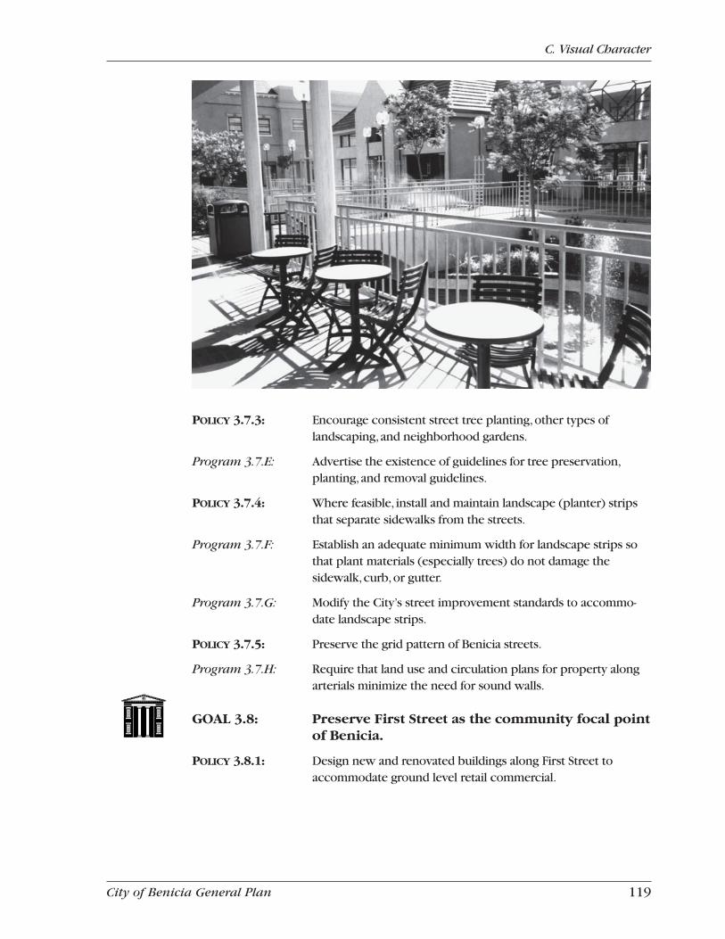
119
Subhead
City of Benicia General Plan
POLICY 3.7.3: Encourage consistent street tree planting, other types oflandscaping, and neighborhood gardens.
Program 3.7.E: Advertise the existence of guidelines for tree preservation,planting, and removal guidelines.
POLICY 3.7.4: Where feasible, install and maintain landscape (planter) stripsthat separate sidewalks from the streets.
Program 3.7.F: Establish an adequate minimum width for landscape strips sothat plant materials (especially trees) do not damage thesidewalk, curb, or gutter.
Program 3.7.G: Modify the City’s street improvement standards to accommo-date landscape strips.
POLICY 3.7.5: Preserve the grid pattern of Benicia streets.
Program 3.7.H: Require that land use and circulation plans for property alongarterials minimize the need for sound walls.
GOAL 3.8: Preserve First Street as the community focal pointof Benicia.
POLICY 3.8.1: Design new and renovated buildings along First Street toaccommodate ground level retail commercial.
C. Visual Character
120
Chapter 3. Community Identity
City of Benicia General Plan
Program 3.8.A: Develop urban design improvements to unify Solano Squarewith City Park and the Civic Center.
POLICY 3.8.2: In the transition areas east and west of First Street, encouragethe adaptive re-use, rather than replacement, of existing residen-tial structures.
GOAL 3.9: Protect and enhance scenic roads and highways.
POLICY 3.9.1: Preserve vistas along I-780 and I-680.
Program 3.9.A: Inventory scenic resources along I-780 and I-680.
Program 3.9.B: Investigate and apply for State Scenic highway designation ofInterstate Highways I-780 and I-680.
Program 3.9.C: Develop a sign enforcement program along the freeways.
The State scenic highway law calls for careful coordination in planning, design,construction, and regulation of land use and development on the band of land “gener-ally adjacent” to the freeway. The benefits of the designation to the community are thatthe State will officially refer to the freeways as scenic highways in its publications; thefreeways will be eligible for “special scenic conservation treatment” and will receivespecial signage; and the law will prevent the placement of Caltrans facilities in theright-of-way without City approval.
POLICY 3.9.2: Work with the State to complete and maintain landscaping of I-680 and I-780.
First priority should be planting the various unfinished cut banks facing I-680 and I-780. Planting that blocks views from I-780 to the Carquinez Strait should be avoided.Ground cover and shrubs are appropriate for purposes of erosion control and appear-ance.
Program 3.9.D: Preserve the trees on the northern edge of former Pine Lake.
POLICY 3.9.3: Orient individual building/business signage toward city streets,not toward I-780.
POLICY 3.9.4: Develop the City’s five identified gateways to provide a sense ofentry and exit.
Program 3.9.E: Prepare land use and design guidelines to direct the nature andcharacter of development at the city’s five gateways.
POLICY 3.9.5: Establish definable neighborhoods in future development andrevitalization projects.
GOAL 3.10: Enhance the streetscape along Military East andWest.

121
Subhead
City of Benicia General Plan
Program 3.10.A: Develop a concept and streetscape plan for Military.
GOAL 3.11: Enhance the East Side.
POLICY 3.11.1: Focus public investment toward undergrounding utilities,completing sidewalks, adding walking paths, park amenities,landscaping, and street trees on the East Side.
GOAL 3.12: Improve the appearance of the Industrial Park.
POLICY 3.12.1: Encourage additional attractive, quality development in indus-trial areas.
Program 3.12.A: Continue to implement and revise as necessary the IndustrialDesign Guidelines.
Program 3.12.B: Adopt an ordinance establishing minimum standards foroutdoor storage and yard maintenance within public view.
GOAL 3.13: Improve urban design qualities of the waterfrontand public access to the shoreline.
POLICY 3.13.1: Enhance waterfront vistas.
Program 3.13.A: Incorporate public visual areas in new development.
POLICY 3.13.2: Improve pedestrian amenities along waterfront streets andwalkways.
POLICY 3.13.3: Take advantage of water orientation for recreation and indus-trial uses.
Program 3.13.B: Develop a plan for public and pedestrian access to and alongthe waterfront and shoreline.
Program 3.13.C: Complete the pathway system from Point Benicia along theentire shoreline to the intersection of West Second and GStreet.
Program 3.13.D: Use privately dedicated walkways to link to the waterfront.
C. Visual Character
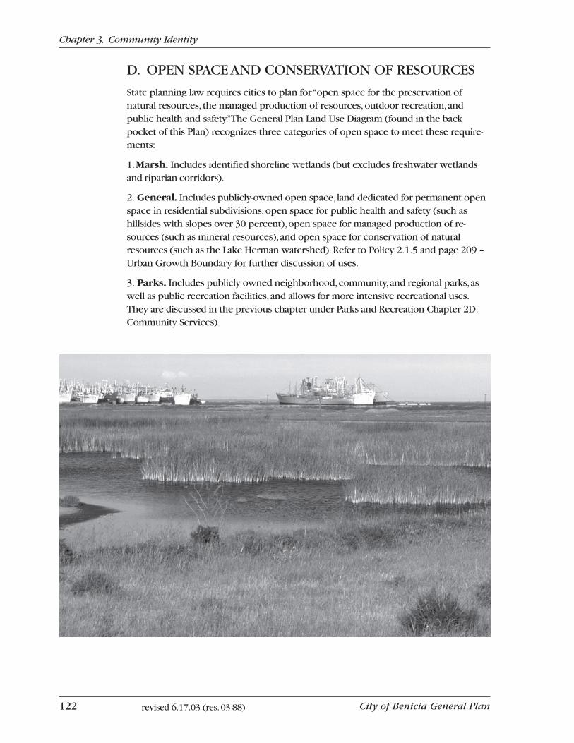
122
Chapter 3. Community Identity
City of Benicia General Plan
D. OPEN SPACE AND CONSERVATION OF RESOURCES
State planning law requires cities to plan for “open space for the preservation ofnatural resources, the managed production of resources, outdoor recreation, andpublic health and safety.” The General Plan Land Use Diagram (found in the backpocket of this Plan) recognizes three categories of open space to meet these require-ments:
1. Marsh. Includes identified shoreline wetlands (but excludes freshwater wetlandsand riparian corridors).
2. General. Includes publicly-owned open space, land dedicated for permanent openspace in residential subdivisions, open space for public health and safety (such ashillsides with slopes over 30 percent), open space for managed production of re-sources (such as mineral resources), and open space for conservation of naturalresources (such as the Lake Herman watershed). Refer to Policy 2.1.5 and page 209 –Urban Growth Boundary for further discussion of uses.
3. Parks. Includes publicly owned neighborhood, community, and regional parks, aswell as public recreation facilities, and allows for more intensive recreational uses.They are discussed in the previous chapter under Parks and Recreation Chapter 2D:Community Services).
revised 6.17.03 (res. 03-88)

123
Subhead
City of Benicia General Plan
1. REGIONAL AND SUBREGIONAL OPEN SPACE AND TRAILS
OPEN SPACE
(A Parks and Open Space diagram is provided in Chapter 2D under Parks and Recre-ation.)
Tri-City and County Open Space
Benicia is part of the Tri-City and County Cooperative Planning Area that encompasses10,000 acres of open space in unincorporated Solano County between Benicia,Fairfield, and Vallejo. The Tri-City and County Regional Park and Open Space Preser-vation Plan (adopted 1993) is incorporated in the Benicia General Plan as a SpecialArea Plan. The Tri-City and County Plan reserves the Cooperative Planning Area forcontinuing agricultural and other open space uses and establishes a framework forregional park planning.
Southampton Open Space
The undeveloped open space areas within the Southampton subdivision offer physi-cal separation between houses and visual relief from development. Portions of thisopen space have trails that are used for hiking, jogging, and walking.
Some parts of the Southampton Open Space are “residual” open space areas that weretoo steep for development or recreational use. Though many of these open spaceareas are not connected, there is habitat value to resident wildlife. Corridors could beestablished to permit wildlife access, and efforts could be made to restore native flora.
Benicia-Vallejo Open Space Buffer
The hills and ridges at the western edge of the Planning Area, also known as the“boundary hills,” are designated open space to maintain a permanent visual andphysical separation from Vallejo. The boundary hills begin at Dillon Point onSouthampton Bay Natural Preserve and extend north, incorporating Lake HermanRoad. This area is protected through a 1979 Benicia/Vallejo “Memorandum of Under-standing to Preserve the Buffer Zone.” The two cities agreed that the buffer zoneshould be inviolate, with no urban development.
Lake Herman Regional Park
Lake Herman Regional Park is an existing 577-acre lake and open space area located atthe northernmost edge of the city. Allowed passive activities in the park includefishing, hiking, and picnicking. Boating is prohibited since the lake is a secondarywater supply for the city. A trail system connects Lake Herman with nearby BeniciaCommunity Park.
Northern Area
An area between Lake Herman and the Tri-City and County Open Space is currentlydesignated as open space, but is largely privately held and has faced developmentpressure.
D. Open Space and Conservation of Resources

124
Chapter 3. Community Identity
City of Benicia General Plan
Benicia State Park
Benicia State Recreation Areaextends from the shoreline ofSouthampton Bay along thePlanning Area boundary to thewest and to Interstate I-780 on thenorth. It includes the tidal flats ofSouthampton Bay, as well as sometrails and recreation areas.
Marsh and Shoreline
Benicia has important marsh andshoreline open space resources allalong Carquinez Strait and SuisunBay. These resources includeSouthampton Bay Natural Preserve(formerly Southampton Marsh) inBenicia State Recreation Area,small parks and shoreline accesspoints along the residentiallydeveloped areas west of Down-town, the Downtown waterfrontand Marina, and marsh areas alongthe Industrial Park. The bioticvalues of these areas are described later in this chapter under the Water Environmentand Biotic Resources. These areas are also important for the recreation opportunitiesthey provide.
REGIONAL AND SUBREGIONAL TRAILS AND PATHS
Benicia has a comprehensive system of bikeways and paved community trails.Bikeways are classified and identified in Chapter 2C: Circulation and a Bicycle andMulti-use Trails diagram is provided in the same chapter (Figure 2-4).
The Parks, Trails, and Open Space Master Plan (adopted in December 1997) proposesnew trails to link the City’s parks by foot, bicycle, horseback, and wheelchair. TheMaster Plan’s proposed network of bikeways and trails is extensive and the ParksMaster Plan serves as a guiding vision for General Plan bikeway and trail planning.(Refer to the Master Plan for a detailed description of city trails and paths.)
Interpretive Trails
Interpretive Trails are paved and located where there are ecological or historicalresources of educational value. Signs provide information about significant features. Aninterpretive trail is proposed as part of Lake Herman Regional Park.

125
Subhead
City of Benicia General Plan
Bay and Ridge Trails
The San Francisco Bay Trail is a proposed 400-mile network that will circle San Fran-cisco and San Pablo Bays, passing through all nine Bay Area counties. Benicia is one ofthe Bay Area cities along the pathway.
Benicia’s Waterfront Trail is already signed as a part of the Bay Trail. It begins at theBenicia Marina and follows the commercial district on First Street, winds through thecommunity and forks at Benicia State Recreation Area. The southern fork ends atSouthampton Bay Natural Preserve where it connects with a trail to Glen Cove inVallejo.
The proposed Bay Trail will enter Benicia from the south on the new Benicia-MartinezBridge. As yet, there is no clear plan as to how bicyclists and pedestrians will connectto the Waterfront Trail from the bridge.
The Bay Area Ridge Trail is a second regional trail that will ultimately circle San Fran-cisco and San Pablo Bays, following the hills and ridges that ring the Bay. In Benicia,this trail follows the same route as the Bay Trail along the Waterfront, and will requirethe same connection from the Benicia-Martinez Bridge.
Staging Areas
The Parks Master Plan proposes staging areas to link the City’s parks and open spaces.“Staging areas” are gathering points adjacent to major trails and accessible to majorroads. Major staging areas are to provide a full range of facilities for the trail userincluding on-site parking and rest rooms. Minor staging areas are to serve short localtrails and are located in neighborhood parks.
2. REGIONAL AND SUBREGIONAL OPEN SPACE AND TRAILS GOALS,POLICIES, AND PROGRAMS
The following goals, policies, and programs have a broad reach. They are designed toprotect and provide access to open space and the waterfront and provide buffersbetween urban communities.
GOAL 3.14: Provide a buffer between Benicia and adjacentcommunities.
POLICY 3.14.1: Continue to implement the provisions of the Tri-City andCounty Cooperative Plan for Agriculture and Open SpacePreservation and the 1979 Benicia/Vallejo Memorandum ofUnderstanding to Preserve the Buffer (often referred to as theBenicia-Vallejo Open Space Buffer).
The Tri-City and County Cooperative Plan for Agriculture and Open Space Preserva-tion has been adopted by the City and is incorporated in this General Plan by refer-ence.
D. Open Space and Conservation of Resources

126
Chapter 3. Community Identity
City of Benicia General Plan
GOAL 3.15: Provide buffers throughout the community.
POLICY 3.15.1: Preserve and protect, through a variety of methods, a pattern ofopen space buffers and greenbelts throughout the PlanningArea.
Program 3.15.A: Identify and evaluate open spaces (by function, location, size,connectivity, and views of open space).
Program 3.15.B: Adopt an open space preservation program aimed at acquiringor assisting in acquiring rights to open space within the Plan-ning Area.
Program 3.15.C: Utilize existing land trusts.
POLICY 3.15.2: Preserve public views of public open space and maintainexisting vistas (including the Northern Area vistas) whereverpossible.
Program 3.15.D: Where applicable, require that new developments include viewcorridors that allow viewing open space from public roadwaysand public use areas.
POLICY 3.15.3: Avoid creating difficult-to-use residual open space in newdevelopment areas.
Program 3.15.E: Evaluate each proposed open space area to ensure it is largeenough to meet its intended purpose.
POLICY 3.15.4: Use open space as a buffer against natural or man-made haz-ards.
Program 3.15.F: Require open space buffers around known hazardous areas,such as the Exxon Refinery and the IT site.
POLICY 3.15.5: Encourage the landscaping of existing open spaces, and land-scape new open spaces with native plants.
POLICY 3.15.6: Restore and maintain natural landscapes in a natural manner.
Program 3.15.G: Develop a landscape master plan for open space areas.
GOAL 3.16: Preserve key land forms which separate Beniciaphysically and visually from adjacent communi-ties.
POLICY 3.16.1: Maintain visual and physical separation from Vallejo andFairfield.
Program 3.16.A: Use the westernmost parcels designated as open space toprovide a buffer with Vallejo.

127
Subhead
City of Benicia General Plan
POLICY 3.16.2: Work with Vallejo to minimize visible development along theBoundary Hills.
POLICY 3.16.3: Allow no additional access roads between Columbus Parkwayand Lake Herman Road.
GOAL 3.17: Link regional and local open spaces.
POLICY 3.17.1: Attempt to link existing regional and local open spaces usingtrails and open space corridors.
Program 3.17.A: Acquire open space corridors that link existing regional andlocal open spaces, where feasible.
“Acquire” may mean purchase, lease, or easement.
Program 3.17.B: Construct trails in open space corridors linking regional andlocal open spaces.
GOAL 3.18: Protect agricultural use.
POLICY 3.18.1: Preserve rangeland north of Lake Herman Road.
Program 3.18.A: Investigate land trusts and other mechanisms to ensure conti-nuity of agricultural uses in the northern portion of the Plan-ning Area.
3. BIOTIC RESOURCES
Biotic resources within the Benicia Planning Area include plant life, wildlife, specialstatus species, and water bodies. Figure 3-3 shows the sensitive biological resourcesfound in Benicia.
PLANT LIFE
Vegetation in the Planning Area is dominated by a cover of non-native grassland andsuburban landscape, bordered by important marshlands at Southampton and SuisunBays. Most of the rolling hills south of the Rose Drive area are developed with urbanand suburban uses, interspersed with grassland covered slopes and a few undevel-oped ravines. These large expanses of open space could be restored with nativegrasses, oaks and other flora. The lands east of East Second Street and north of I-780have been highly disturbed by past military and existing industrial uses. Grasslandscover most of the rangeland to the north of East Second Street and the Lake HermanRoad area throughout the northeastern hills. Major creeks, drainages, and the fringe ofLake Herman in the undeveloped Northern Area support freshwater marsh andriparian vegetation, which varies from cattail to willow forest and scrub. Scatteredoaks occur in the northeastern hills, primarily on the north and east-facing slopes west
D. Open Space and Conservation of Resources
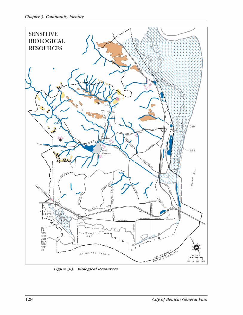
128
Chapter 3. Community Identity
City of Benicia General Plan
✶
✶
800 0 800 1600
S C A L E
G oo
d y e a rS
l ou
gh
G oo
d y e a rS
l ou
gh
SENSITIVEBIOLOGICALRESOURCES
S o u t h a m p t o nB a y
C A R Q U I N E Z S T R A I T
S O L A N O C O U N T Y
C O N T R A C O S T AC O U N T Y
SOUTHAMPTON ROAD
HA
ST
ING
SD
RIV
E
ROSE DRIVE
PA
NORAMADRIV
E
CHE
LS
EA
HIL
LS
DR
IVE
RESERVO
IR
ROAD
Su
is
un
Ba
y
1st S
TR
EE
T
MILITARY WESTMILITARY EAST
W. 7th S
TR
EE
T
E. 2nd S
TRE
ET
E. 5
th S
TR
EE
T
HILLCREST
GRANT ST.
PARK ROAD
E. 2nd STREET
ROAD
IND
US
TR
IAL
WAY
INT
ER
STA
TE
680
INTERSTATE 780
LakeHerman
S T A T EP A R K
BAYSHO
RE
RO
AD
▲▲▲
▲▲
▲▲ ▲
▲
▲ ▲▲▲▲
▲▲▲▲▲▲
▲▲▲▲
▲▲▲▲▲▲ ▲▲
CT
SMSSSSSCCRCBRSMASBBDTPCT
SSS
CBR
COLUMBUS PKWY.
ADAMS ST.
INDUSTRIAL
WAY
LAKE HERMAN
B E N I C I A
Sulfer Springs Creek
Pad
dy
Cre
ek
Figure 3-3. Biological Resources

129
Subhead
City of Benicia General Plan
of I-680. Small areas of northern coastal scrub, freshwater seeps, remnant nativegrasslands, and stands of eucalyptus also occur in the northern portion of the PlanningArea.
The various vegetative communities in the Planning Area are summarized below. Withthe exception of the description of developed areas and eucalyptus stands, each of thedescriptions conforms with the classification system developed by the CaliforniaDepartment of Fish and Game (CDFG) (1986).
Non-native Grassland
Non-native grasslands occupy most of the Planning Area: introduced grasses andbroadleaf weeds (e.g., fennel, artichoke, and star thistle) which quickly recolonizedisturbed areas. Intensive grazing, dry land farming, and other disturbance haveeliminated most of the historic range lands in the Planning Area.
Developed Areas
Ornamental landscaping has been planted throughout developed areas and aroundrural residences in the northern portion of the Planning Area. Weedy grassland occu-pies vacant lots and heavily disturbed areas, including much of the industrial area.Most species used in landscaping are non-native ornamentals—a wide variety of trees,shrubs, groundcover, and turf. Blue Gum Eucalyptus has been planted as windbreaksand forms woodlands in several locations.
Northern Coastal Salt Marsh and Coastal Brackish Marsh
Marshland natural communities occur along the Carquinez Strait and Suisun Baywhere soils are subject to regular inundation by salt and brackish water. Species aresegregated by elevation and degree of inundation. Populations of several special-statusplants occur in the marshlands. This vegetation is generally absent along the devel-oped shoreline of Carquinez Strait from the State Recreation Area at Southampton Bay
Special Status Species OccurancesCallipe Silverspot Butterfly Sighting
Golden Eagle Nest Location
General Occurence Records in Suitable Habitat– Generalized areas where the indicated species have
been recorded as occuringSalt Marsh Harvest Mouse
Suisun Shrew
Suisun Song Sparrow
California Clapper Rail
California Black Rail
Suisun Marsh Aster
Soft Bird's-Beak
Delta Tule Pea
Congdon's Tar Plant (Note: There is a strong likelihoodthat this area has been mapped by the CNDDB in aninaccurate location.)
Planning Area Boundary
City Limits
Sensitive Natural Communities/Unique VegetationMarshland/Northern Coastal Salt Marsh/Coastal Brackish MarshCoast Live Oak Woodland
Valley Needlegrass Grassland
Riparian(Willow Riparian Forest/Willow Scrub)
Golden Violet Population (Callipe Silverspot Host Plant)
Eucalyptus Grove (Raptor Roosting & Nesting Substrate)
Wetlands/Other WatersPalustrine/Riverine (Streams, Channels, Ponds, Lakes)
Estuarine (Tidal Marshland, Mudflats)
L E G E N D
✶▲
SMSSSSSCCRCBRSMASBBDTPCT
Legend to Figure 3-3 on previous page
D. Open Space and Conservation of Resources

130
Chapter 3. Community Identity
City of Benicia General Plan
Natural Preserve to just east of the Benicia Bridge, although emergent marshlandvegetation occurs near the entrance to the Benicia marina and forms a small stand justeast of Tyler Street.
The Southampton Bay Natural Preserve, on the southwestern border of the city, andthe Suisun Marsh northeast of the city are protected from encroachment by develop-ment. The Suisun Marsh is the largest remaining wetland around the San Francisco Bayand the largest brackish area in the United States. It comprises more than 10 percentof California’s total wetland area. Both of these marshes provide wintering habitat forwaterfowl on the Pacific Flyway and are vital to fish and wildlife production.
In 1977, the California Legislature passed the Suisun Marsh Preservation Act to pre-serve and enhance the quality and diversity of marsh habitats, and to assure retentionof upland areas adjacent to the Suisun Marsh in uses compatible with its protection.This legislation protects the Marsh by implementing policies and programs set forthin the Suisun Marsh Protection Plan prepared by the San Francisco Bay Conservationand Development Commission. Development in these shoreline areas is prohibited,with the exception of minor fill to protect the shoreline, improve its appearance, orprovide public access and recreation. A portion of the Secondary Management Area(SMA) of the Suisun Marsh is within the General Plan Planning Area. The SMA is in-cluded in the Suisun Marsh Preservation Act, but has less stringent developmentrestrictions.
In addition to salt water and brackish water marshes, freshwater marshes, typicallydominated by narrow-leaf cattail, occur at drainages and the fringe of freshwaterbodies, including portions of Lake Herman and several stock ponds. Freshwater marshspecies also dominate at numerous freshwater seeps in the Planning Area.
Coastal Live Oak Woodland
Over 120 acres of oak woodland—dominated by coast live oak—occurs in thenortheastern portion of the Planning Area. This includes an extensive stand along theupstream half of Paddy Creek and adjacent slopes, scattered stands along a north-south ridgeline in the Paddy Creek watershed, and large continuous stands on the eastand northeast-facing slope along the I-680 corridor north of the Lake Herman Roadinterchange. The understory is generally poorly developed or composed of non-nativegrassland.
Willow Riparian Forest and Willow Scrub
Riparian vegetation occurs along stream courses and the eastern fringe of LakeHerman, with trees and shrubs forming stands of riparian forest and willow scrub.Well-developed riparian corridors, primarily willows, occur along Sulphur Springs andPaddy Creeks. Intensive grazing and trampling by cattle has eliminated understoryspecies and severely limits regeneration of natural forest and scrub.

131
Subhead
City of Benicia General Plan
Valley Needlegrass Grassland
Remnant native grasslands are found in the Northern Area, forming valley needlegrassgrassland communities which are interspersed with areas dominated by non-nativespecies.
Northern Coastal Scrub
A few stands of this natural community are scattered in grassland areas. Most consistof thickets of coyote brush.
WILDLIFE
Although native vegetation within the Planning Area has been substantially altered, themarshlands and extensive tracts of undeveloped land contribute to a diverse assem-blage of resident and migrant wildlife. Habitat types of particular importance towildlife include the marshlands and open water Carquinez Strait and Suisun Bay, areasof well-developed riparian forest and scrub, and oak woodlands. In general, eachhabitat differs in its relative value to specific species, as summarized below.
Urbanized Habitat
In general, urbanized areas have low to poor wildlife habitat value. The diversity ofurban wildlife depends on the extent and type of landscaping, remaining open spaceand proximity to natural habitat. Trees and shrubs used for landscaping provide nestsites and cover for wildlife adapted to developed areas. Urban areas provide habitat forseveral species of native mammals (squirrel, raccoon, and skunk). Urbanization nowseparates most of the shoreline habitat along the southern and southeastern edge ofthe city from the undeveloped rolling hills in the Northern Area.
Tidal and Marshland Habitat
Carquinez Strait and Suisun Bay are of regional importance to fish and wildlife, provid-ing habitat for aquatic plants and animals, open water habitat for birds, and serving asthe major movement corridor between San Pablo Bay and the Delta. Delta waterssupport game fish, such as largemouth bass, catfish, and sunfish, as well as non-gameand forage fish.
The salt and brackish marshlands form the transition between open water and uplandhabitat. Special-status species known to be associated with marshland in the PlanningArea include: salt marsh harvest mouse, Suisun shrew, California clapper rail, Californiablack rail, Suisun song sparrow, and salt marsh yellowthroat. For many of these species,the upper limits of the marshland and the remaining adjacent upland habitat areessential retreats during extreme high tides. Protection of an adequate buffer topreserve sufficient retreat habitat is essential to maintaining the value of the marsh-lands. Much of this zone has been developed with industrial uses along the southernand eastern edge of Benicia. The importance of this buffer is recognized in the SuisunMarsh Protection Plan through establishment of a “secondary management area” for aportion of the Planning Area.
D. Open Space and Conservation of Resources

132
Chapter 3. Community Identity
City of Benicia General Plan
Grassland Habitat
Native and nonnative grasslands support a variety of mammals, birds, and reptiles, andprovide foraging for raptors. Many species use the grassland for only part of theirhabitat, foraging in the grassland and seeking protection in the limited tree and scrubcover. Grassland habitat in the northern portion of the Planning Area supports thecallippe silverspot butterfly, a special-status insect.
Freshwater Marsh and Riparian Habitat
Freshwater aquatic habitats and the associated riparian and marsh vegetation are ofhigh value to wildlife, providing a source of drinking water, protective cover, andmovement corridors. Riparian forest and scrub provides nesting and roosting fornumerous resident birds, and stopovers for migrant songbirds. The streams, ponds, andLake Herman provide aquatic habitat for amphibians. Dense riparian growth providesessential cover in the open grasslands for larger mammals, such as striped skunk,raccoon, opossum, and black-tailed deer.
Oak Woodland Habitat
These provide important cover for a greater diversity of wildlife than found in theadjacent grasslands. The abundant seed crops (acorns and madrone, poison oak, andtoyon berries) are an important food source for black-tailed deer, woodpeckers, andother wildlife.
Rock Outcrops
Rock outcrops in the grassland and oak woodlands of the Northern Area provide aunique habitat for wildlife. Outcrops occur in the Paddy Creek watershed and thedense woodlands in the northeastern hills. The crest of Sulphur Springs Mountainforms an exposed bluff with cliffs and ledges just west of the Planning Area. Theseland forms provide perches for raptors and ledges for nests.
Eucalyptus Habitat
Although native to Australia, this naturalized species provides important nestinghabitat for raptors and other birds, and cover for larger mammals. Eucalyptus in theopen grasslands—where protective cover and perching habitat is scarce—emphasizesthe importance of the dense tree stands to birds and larger mammals.
SPECIAL STATUS SPECIES AND SENSITIVE NATURAL COMMUNITIES
Special-status species1 are plants and animals legally protected under State or federalEndangered Species Acts or other regulations, plus other species considered rareenough by the scientific community and trustee agencies to warrant special consider-
1 Special-status species include: officially designated (rare, threatened, or endangered) and candidate spe-cies for listing by the CDFG; officially designated (threatened or endangered) and candidate species forlisting by the US Fish and Wildlife Service (USFWS); species considered to be rare or endangered underthe conditions of Section 15380 of the CEQA Guidelines; and other species considered sensitive or ofspecial concern due to limited distribution or lack of adequate information.

133
Subhead
City of Benicia General Plan
ation. Species with legal protection under the Endangered Species Acts often repre-sent major constraints to development, particularly when they are wide ranging orhighly sensitive to habitat disturbance and where proposed development would resultin a “take”2 of these species.
The primary information source on the distribution of special-status species in Califor-nia is the California Natural Diversity Data Base (CNDDB) inventory, which is main-tained by the Natural Heritage Division of CDFG. A record search indicates several plantand animal species with special-status in the Planning Area, mostly in the tidal marsh-land habitat.
4. BIOTIC RESOURCES GOALS, POLICIES, AND PROGRAMS
GOAL 3.19: Preserve and enhance habitat for special-statusplants and animals.
POLICY 3.19.1: Protect essential habitat of special-status plant and animalspecies.
Program 3.19.A: Require biological assessments in sensitive habitat areas as partof environmental review of proposed development.
Program 3.19.B: Require retention of essential habitat for special status species.If infeasible, require adequate mitigation for loss of specialstatus species and/or habitat in compliance with State andfederal regulations.
GOAL 3.20: Protect and enhance native vegetation and habi-tats.
POLICY 3.20.1: Protect native grasslands, oak woodlands, and riparian habitat.
POLICY 3.20.2: Restore native vegetation, such as birch grasses and oaks,wherever possible for open spaces of existing developed areas.
Program 3.20.A: Encourage community groups to carry out native plant restora-tion efforts.
Program 3.20.B: Limit the loss of native vegetation or require mitigation, or both.
Program 3.20.C: Require native and compatible non-native plant species, espe-cially drought-resistant species, to the extent possible in land-scaping new development and public areas.
2 “Take” as defined by the Federal Endangered Species Act (FESA) means “to harass, harm, pursue, hunt,shoot, wound, kill, trap, capture, or collect” a threatened or endangered species.
D. Open Space and Conservation of Resources

134
Chapter 3. Community Identity
City of Benicia General Plan
POLICY 3.20.3: Encourage preservation of existing trees. Especially preserveand protect mature, healthy trees whenever practicable, par-ticularly where such trees are of significant size or are ofsignificant aesthetic value to the immediate vicinity or to thecommunity as a whole.
Program 3.20.D: Strive to incorporate existing mature, healthy trees into pro-posed developments.
POLICY 3.20.4: Require protection of movement corridors.
Program 3.20.E: Require preservation of open space corridors between LakeHerman, Sulphur Springs Mountain, the Northern Area, thenortheast hills, the Benicia State Recreation Area, and themarshlands east of I-680.
GOAL 3.21: Permanently protect and enhance wetlands sothat there is no net loss of wetlands within theBenicia Planning Area.
POLICY 3.21.1: Encourage avoidance and enhancement of sensitive wetlandsas part of future development.
Program 3.21.A: Continue to require wetland delineation and mitigation as partof environmental review of proposed development.
POLICY 3.21.2: Require replacement for wetlands eliminated as a result ofdevelopment at a higher wetlands value and acreage than thearea eliminated.
Replacement ratios are initially determined by State and federal agencies. The Citydesires to take an aggressive approach in promoting wetland enhancement. If theCity desires a higher ratio, a nexus must be established between the loss and thedesired replacement ratio.
Program 3.21.B: Continue to coordinate with the California Department of Fishand Game, United States Fish and Wildlife Service, and theUnited States Army Corps of Engineers in reviewing proposedwetland modifications.
POLICY 3.21.3: Encourage development of a Suisun Marsh interpretive centernear the I-680/Lake Herman Road interchange.
Program 3.21.C: Work with responsible agencies to develop the Suisun Marshinterpretive center near Lake Herman Road and I-680.
POLICY 3.21.4: Restore and increase marshland areas.
Program 3.21.D: Prepare a Local Protection Program (LPP) for the portion of theSuisun Marsh Secondary Management Area within the BeniciaGeneral Plan Planning Area.
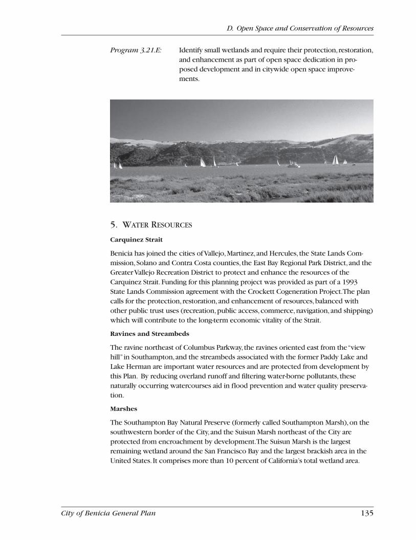
135
Subhead
City of Benicia General Plan
Program 3.21.E: Identify small wetlands and require their protection, restoration,and enhancement as part of open space dedication in pro-posed development and in citywide open space improve-ments.
5. WATER RESOURCES
Carquinez Strait
Benicia has joined the cities of Vallejo, Martinez, and Hercules, the State Lands Com-mission, Solano and Contra Costa counties, the East Bay Regional Park District, and theGreater Vallejo Recreation District to protect and enhance the resources of theCarquinez Strait. Funding for this planning project was provided as part of a 1993State Lands Commission agreement with the Crockett Cogeneration Project. The plancalls for the protection, restoration, and enhancement of resources, balanced withother public trust uses (recreation, public access, commerce, navigation, and shipping)which will contribute to the long-term economic vitality of the Strait.
Ravines and Streambeds
The ravine northeast of Columbus Parkway, the ravines oriented east from the “viewhill” in Southampton, and the streambeds associated with the former Paddy Lake andLake Herman are important water resources and are protected from development bythis Plan. By reducing overland runoff and filtering water-borne pollutants, thesenaturally occurring watercourses aid in flood prevention and water quality preserva-tion.
Marshes
The Southampton Bay Natural Preserve (formerly called Southampton Marsh), on thesouthwestern border of the City, and the Suisun Marsh northeast of the City areprotected from encroachment by development. The Suisun Marsh is the largestremaining wetland around the San Francisco Bay and the largest brackish area in theUnited States. It comprises more than 10 percent of California’s total wetland area.
D. Open Space and Conservation of Resources

136
Chapter 3. Community Identity
City of Benicia General Plan
Both of these marshes provide wintering habitat for waterfowl on the Pacific Flywayand are vital to fish and wildlife production. They are protected by this Plan.
In 1977, the California Legislature passed the Suisun Marsh Preservation Act to pre-serve and enhance the quality and diversity of marsh habitats, and to assure retentionof upland areas adjacent to the Suisun Marsh in uses compatible with its protection.This legislation protects the Marsh by implementing policies and programs set forthin the Suisun Marsh Protection Plan prepared by the San Francisco Bay Conservationand Development Commission. Development in these shoreline areas is prohibited,with the exception of minor fill to protect the shoreline, improve its appearance, orprovide public access and recreation. A portion of the Secondary Management Area(SMA) of the Suisun Marsh is within the General Plan Planning Area. The SMA is in-cluded in the Suisun Marsh Preservation Act, but has less stringent developmentrestrictions.
6. WATER RESOURCES GOALS, POLICIES, AND PROGRAMS
(Goals, policies, programs for marshes are found in the prior section: Biotic Re-sources.)
GOAL 3.22: Preserve water bodies.
POLICY 3.22.1: Avoid development that will degrade existing lakes andstreams.
Program 3.22.A: Require that all development in watersheds flowing into lakesand unchannelized streams include features to preserve run-offwater quality.
Program 3.22.B: Require a minimum setback of 25 feet from the top of bank ofstreams and ravines. Do not allow development within thesetback.
GOAL 3.23: Preserve Lake Herman as a municipal waterresource.
POLICY 3.23.1: Ensure the biological, chemical, and physical integrity of LakeHerman.
Program 3.23.A: Continue to monitor water quality in Lake Herman and atupstream sources of potential pollution.
POLICY 3.23.2: Prohibit uses that would adversely affect water quality (such asmotorized boats or swimming).
GOAL 3.24: Protect watersheds.
POLICY 3.24.1: Identify the Benicia watersheds to preserve.

137
Subhead
City of Benicia General Plan
D. Open Space and Conservation of Resources
7. MINERAL RESOURCES
Mineral resources consist of surface soils for agricultural uses or domestic gardens andsubsurface materials such as mined rock or minerals. State planning law requires thegeneral plan to identify mineral resources and provide for their continued availability.The one mineral resource area in the Planning Area which is required to be protectedand preserved for extraction is shown on Figure 3-4.
SOILS
The Department of Agriculture’s Soil Survey of Solano County identifies the predomi-nant soil in the Planning Area as the Dibble and Altamont Series of expansive clayformations. These soils have the greatest limitations for the types of plants which canbe grown without special soil treatment and are best suited to open rangeland orrecreational purposes if left undeveloped. The amount of rainfall and low permeabilityof the soils contribute to the limited variety of natural vegetation supported. Past useof the unurbanized land in the Planning Area has been for grazing.
The Northern Area, particularly along Paddy Creek, is comprised of the richer, RinconSeries of clay loams which is capable of more intensive agriculture. These are alluvialsoils formed from erosion of the sedimentary rocks of surrounding slopes. Accordingto the Soil Survey, the predominant soil types are suitable for management of smallbirds such as quail and doves and for impounding water for waterfowl habitat or fish.
SUBSURFACE RESOURCES
The only regionally significant mineral resource in the Planning Area is a deposit ofigneous rock from which aggregate is produced. The aggregate is used in the manu-facture of asphaltic concrete, Portland cement concrete, rip-rap, drain rock and roadbase.
The Sulphur Springs Mountain Deposit was designated by the State of California as aMineral Resource of Regional Significance pursuant to the Surface Mining and Recla-mation Act (SMARA). An active quarry within the deposit exists along Lake HermanRoad west of Lake Herman in the boundary hills between Benicia and Vallejo, outsideof the Planning Area. Quarrying there has resulted in a cut face, which is visible fromthe Lake Herman area. To the extent possible given the requirements of the SurfaceMining and Reclamation Act (SMARA), City policy discourages further expansion of thevisible cut in an eastern direction.
Several abandoned mercury mines exist in the Sulphur Springs Mountain area. Thesemines have not been in production since the mid 1940s.

138
Chapter 3. Community Identity
City of Benicia General Plan
8. MINERAL RESOURCE GOALS, POLICIES, AND PROGRAMS
GOAL 3.25: Conserve and, where appropriate, develop themineral resources of regional significance withinthe Planning Area.
POLICY 3.25.1: Maintain in open space the mineral resource area of regionalsignificance designated on Sulphur Springs Mountain until amineral resource extraction and reclamation plan that ad-dresses all potentially significant impacts of extraction has beenapproved by the responsible agencies.
GOAL 3.26: Minimize environmental impacts of mineralproduction.
POLICY 3.26.1: Minimize exposure of the quarry face from residential areas.
POLICY 3.26.2: Allow extraction of mineral resources within the Planning Areabut beyond the currently permitted quarry area on SulphurSprings Mountain, only upon approval by the appropriateagencies.
POLICY 3.26.3: Maintain a variable ridgeline and natural landform representa-tive of the scenic character of the Planning Area.
Program 3.26.A: Work with adjacent jurisdictions to establish mineral resourcemanagement measures.
POLICY 3.26.4: Prohibit extraction of mineral resources outside the State-designated mineral resource area, and permit extraction ofmineral resources inside the State-designated mineral resourcearea only if applicable policies, mitigation measures, perfor-mance standards, rules, and regulations are met.
POLICY 3.26.5: Require mitigations, setbacks, buffers, and scrdÏ6ing.
POLICY 3.26.6: Require that residential buildings to be constructed within2,000 feet of the ultimate mineral extraction boundary beanalyzed by a qualified engineer to ensure economicallyfeasible measures that minimize the amplification of groundvibration.
9. ENERGY CONSERVATION GOALS, POLICIES, AND PROGRAMS
Developing and maintaining urban areas, including the open space within developedareas, utilizes energy in various forms. For development projects, there are “indirect”energy costs involved in the manufacture of building materials, and there are “direct”
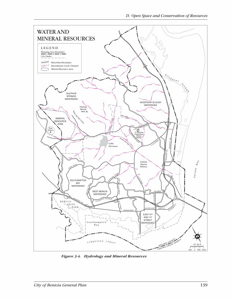
139
Subhead
City of Benicia General Plan
800 0 800 1600
S C A L E
IT PanocheHazardous
WasteFacility
EXXONBeniciaRefinery
HastingsMerang
Mine ✖
SyarQuarry
✖
Planning Area Boundary
City Limits
Watershed Boundary
Intermittent Creek Channel
Mineral Resource Area
S o u t h a m p t o nB a y
B E N I C I A
C A R Q U I N E Z S T R A I T
S O L A N O C O U N T Y
C O N T R A C O S TAC O U N T Y
L E G E N D
SOUTHHAMPTON ROAD
HA
ST
ING
SD
RIV
E
ROSE DRIVE
PA
NORAMADRIV
E
CHE
LS
EA
HIL
LS
DR
IVE
RESERVO
IR
ROAD
G o
o
d y e a rS
l ou
gh
Su
is
un
Ba
y
1st S
TR
EE
T
MILITARY WEST
MILITARY EAST
W. 7th S
TR
EE
T
E. 2nd S
TRE
ET
E. 6
th S
TR
EE
T
HILLCREST
GRANT ST.
PARK ROAD
E. 2nd STREET
LAKE HERMAN ROAD
IND
US
TR
IAL
WAY
INT
ER
STA
TE
680
City Limits
INTERSTATE 780
LakeHerman
S T A T EP A R K
JEFFERSON
ST.
BAYSHOR
ER
OA
D
WATER ANDMINERAL RESOURCES
SULPHURSPRINGS
WATERSHED
GOODYEAR SLOUGHWATERSHED
SOUTHAMPTONBAY
WATERSHED
WEST BENICIAWATERSHED
EAST 3RD
AND "H"STREET
WATERSHED
Sulfer Springs
Creek
Sulfer Springs Creek
Pad
dy
Cre
ekMINERALRESOURCE
ZONE
Figure 3-4. Hydrology and Mineral Resources
D. Open Space and Conservation of Resources

140
Chapter 3. Community Identity
City of Benicia General Plan
costs involved in the ongoing operation (heating, lighting, etc.) of the project. TheState has adopted comprehensive energy conservation standards (“Title 24”) whichmust be incorporated into all new development projects, including remodelings.Those standards are implemented in Benicia through the building permit reviewprocess. The State conducts periodic audits of local building departments to ensurethat energy standards are being properly administered.
GOAL 3.27: Improve energy efficiency.
POLICY 3.27.1: Promote energy conservation in all new development andduring rehabilitation of existing homes.
Program 3.27.A: Distribute information on weatherization and energy conserva-tion.
Program 3.27.B: Implement State energy conservation requirements in newhousing.

141City of Benicia General Plan
4. COMMUNITY HEALTHAND SAFETY
A. HEALTHY COMMUNITY
1. DIMENSIONS OF OPTIMAL HEALTH
A comprehensive definition of a healthy community is described by the followingcategories:
Physical Environment. This category focuses on a clean environment, fitness,nutrition, safety, and medical care. Specific issues include affordable and safe housing,parks and open space, streets, and sanitation.
Social Environment. Friends, families, and communities fall under this category.Specific issues include hunger, food bank utilization, school lunches, homelessness,substance abuse, cost of living, earned wages, percent of the population in poverty,and broader issues of social justice.
142
Chapter 4. Community Health and Safety
City of Benicia General Plan
Emotional Health. Stress management and care during individual emotional crisesaffect the community’s overall emotional health as do community balance (racial,economic, age), resource distribution, and participation in decision-making.
Intellectual Environment. Education, career development, and personal achieve-ment fall under this category. Education issues include drop-out rates, graduation rates,continuing education programs, and other educational opportunities. Career develop-ment deals with issues such as unemployment rates, job types and availability, com-mute distance, and economic development.
Spiritual. This category deals with sense of purpose, love, hope, and charity.
The comprehensiveness of the above factors requires that broad segments of thecommunity participate in addressing health issues and finding and implementingsolutions to improve local health care.
2. HEALTHY COMMUNITY GOALS, POLICIES, AND PROGRAMS
GOAL 4.1: Make community health and safety a high prior-ity for Benicia.
POLICY 4.1.1: Strive to protect and enhance the safety and health of Benicianswhen making planning and policy decisions.
POLICY 4.1.2: Promote a wide range of health-related services.
Such services will address the physical environment and social climate.
Program 4.1.A: Develop a citizen input planning process with the HumanServices Fund Board to address locally identified communityhealth and health-related concerns.
POLICY 4.1.3: All City departments should attempt to address the underlyingcauses of health, social, and safety issues.
Program 4.1.B: Promote measurable health goals and work with health-relatedagencies to monitor their implementation.
For example, work with “California Healthy Cities” on a project to reduce measurablythe sale of cigarettes to children.
POLICY 4.1.4: Compile available information pertinent to the health andsafety of Benicians.
Program 4.1.C: Require the Human Services Fund Board to report annually tothe City Council and public on the health, well-being, and safetyof the community, along with recommendations for improve-ments.
POLICY 4.1.5: Clarify City role in providing health services.

143City of Benicia General Plan
Program 4.1.D: Inventory health needs, identify holes in the network, and focuson those issues not being addressed.
Program 4.1.E: Delegate a formal group (e.g., Human Services Fund Board) tobe responsible for community health promotion, and requirethe group to coordinate with a broad range of communityrepresentatives.
Program 4.1.F: Expand the role of the City staff person liaison to the HumanServices Fund Board, as needed to support additional tasksassigned to the Board.
GOAL 4.2: Improve access to medical, mental health, andsocial services for all Benicians, including theelderly and low-income.
POLICY 4.2.1: Fully utilize and coordinate available resources and effortsthrough the City’s Human Services Fund Board and othergovernmental and non-governmental agencies.
Program 4.2.A: Work with existing health care providers, neighboring cities,and the county, State and federal governments.
Program 4.2.B: Provide and maintain affordable transportation services to andfrom health facilities (in and out of town), especially for theelderly and disabled.
GOAL 4.3: Attract additional health services to Benicia.
POLICY 4.3.1: Promote preventive health care in line with the Child and AdultPreventive Care Guidelines published by the US Public HealthService (1994).
The guidelines recommend tests, examinations, immunizations, and other preventivemeasures for all ages.
Program 4.3.A: Support the development of a “Center for Human Services”.
POLICY 4.3.2: Evaluate the need for and feasibility of new medical facilities inBenicia including a branch of the County Health and SocialServices Department.
Program 4.3.B: Promote prenatal care, health care for children, teen activities,education and counseling, and intergenerational activities.
Program 4.3.C: Investigate the feasibility of utilizing existing City buildings todeliver health-related services, and expand the scope of thebuildings’ uses in conjunction with established neighborhoodgroups.
A. Healthy Community
144
Chapter 4. Community Health and Safety
City of Benicia General Plan
POLICY 4.3.3: Promote establishment of demonstration gardens at schools,churches, fire stations, and other sites.
Program 4.3.D: Consider utilizing vacant City property for gardening of fruitsand vegetables.
GOAL 4.4: Reduce the incidence of substance abuse andstrive for a drug-free community.
POLICY 4.4.1: Support the development of the education of all age groups inthe prevention of substance abuse.
Program 4.4.A: Include law enforcement, the School District, and proprietorsof nicotine, alcohol, and prescription drugs in planning andoperating substance abuse prevention programs.
Program 4.4.B: Identify at-risk populations and work to develop programs andservices to address their needs.
POLICY 4.4.2: Promote safe driving by youth.
GOAL 4.5: Establish after-school programs and other con-structive activities for youth.
Program 4.5.A: Work with the School District on appropriate after-schoolyouth activities.
GOAL 4.6: Prevent and reduce crime in the community.
POLICY 4.6.1: Encourage building designs that help to reduce crime.
Program 4.6.A: Review the design of new and rehabilitated buildings for waysto increase resident safety.
POLICY 4.6.2: Develop a corrective action plan to deal with high crime areas.
Program 4.6.B: Strengthen and expand neighborhood watch programs. Includebusinesses.
Program 4.6.C: Promote the education of citizens on how not to be a victim.
POLICY 4.6.3: Maintain an adequate officer-to population ratio in all areas, asapproved by the City Council.

145City of Benicia General Plan
B. HAZARDS TO THE COMMUNITY
1. GEOLOGIC
Within Benicia, the most significant geologic hazards are those associated with land-slides, debris flows, and ground shaking during earthquakes. Other significant geologichazards include the potential for settlement of structures constructed on filled bayland, expansive soils, cut and fill slopes, and flooding. These and other possible hazardsare discussed below. A list of geological web site internet addresses is provided inAppendix H.
SEISMIC HAZARDS
Earthquakes
Benicia lies within a seismically active region. The principal faults in the area arecapable of generating large earthquakes that could produce strong to violent groundshaking in Benicia.
In the event of an earthquake, seismic risk to a structure will depend on the character-istics of the earthquake, the distance to the earthquake epicenter, the subsurfaceconditions underlying the structure and its immediate vicinity, and the characteristicsof the structure. It is impossible to predict precisely when, where, or exactly whatkind and amount of movement will occur on local faults. However, the intensity ofground shaking can be amplified by local geologic conditions. Areas most susceptibleto a significant amplification of ground shaking are underlain by soft sediments suchas Bay Mud. In several areas along the Benicia waterfront, fill and buildings have beenplaced over Bay Mud. These areas are likely to experience substantially strongerground shaking than areas underlain by bedrock. Figure 4-1 shows ground shakingamplification in the Planning Area.
Unreinforced Masonry Buildings
Most susceptible to earthquake damage are older structures (those constructed before1950) and unreinforced masonry buildings (URMs). Structural damage occurs in olderwood frame structures as a result of poorly designed foundations or a lack of struc-tural bonding between the foundation and the building. The risk of structural damagecan often be significantly reduced by securely attaching the structure to the founda-tion. Shear walls and other structural reinforcements are useful in improving resis-tance to earthquakes.
URMs—buildings constructed with brick, cinder block, or stone without steel rein-forcement—were common in California in the early part of the 20th century. URMs areprone to collapse during large earthquakes, but can often be brought up to acceptableearthquake design standards by adding structural reinforcement.
The risk associated with URMs is addressed in Benicia’s Seismic Hazards IdentificationProgram (Chapter 15.60, Benicia Municipal Code). The program requires that the City
B. Hazards to the Community

146
Chapter 4. Community Health and Safety
City of Benicia General Plan
notify owners and tenants of URMs of the hazards. The notification by the City wascompleted in 1990.
Liquefaction
Liquefaction occurs in granular materials as a result of ground shaking, and is oftenfollowed by sudden local settling or slope failure. The potential for liquefaction isconsidered to be highest in areas underlain by saturated, unconsolidated, granularsediments. Within Benicia, the areas most at risk from liquefaction are along the Baymargin and in the flat-lying valley bottoms, in areas underlain by Bay Mud or Alluvium.Figure 4-2 shows areas with potential liquefaction hazard.
Although liquefaction often causes severe damage to structures, structural collapse isuncommon. The risk to public safety from liquefaction, therefore, is relatively low.Structures can be protected from liquefaction through the use of special foundations.
Earthquake-related Ground Failure
Various forms of ground failure occur during or immediately following an earthquake,as a result of ground shaking. The nature and severity of these effects are determinedby the magnitude and duration of shaking and the local geologic and groundwaterconditions. Earthquake-related ground failures include lateral spreading, lurch crack-ing, and landsliding.
Fault Rupture
The Green Valley fault is the only active fault known in the Planning Area. Faultrupture is likely to occur along the Green Valley fault as a result of an earthquakethere. The risk of fault rupture elsewhere in the Planning Area is very low.
SLOPE STABILITY HAZARDS
Landslides
Landslides are significant geologic hazards in the Planning Area. Since the 1906earthquake, damage from landslides has far exceeded that from earthquakes. Land-slides are relatively rare in the developed portions of Benicia, but are numerous in thehilly, undeveloped areas. A map of the landslides in the Planning Area is shown on theLandslide Map, Plate 2 of the Public Safety Background Report, February 28, 1996.Another reference is the Department of Mines and Geology Open File Report 86-17“Landslide Hazards in the Benicia Valley Area.” Figure 4-2 shows areas with potentiallandslide hazard.
Landslides can cause extensive damage to buildings, roadways, or other facilitieslocated on the landslide, and often result in large property losses. Because landslidesare slow moving, people are rarely injured or killed. Landslides often result frompoorly placed or poorly drained fill.
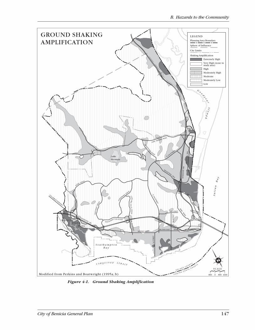
147City of Benicia General Plan
Figure 4-1. Ground Shaking Amplification
800 0 800 1600
S C A L E
Modified from Perkins and Boatwright (1995a, b)
INDUSTRIALW
AY
Planning Area Boundary
Sphere of Influence
City Limits
Shaking Amplification
Extremely High
Very High (none instudy area)
High
Moderately High
Moderate
Moderately Low
Low
S o u t h a m p t o nB a y
B E N I C I A
C A R Q U I N E Z S T R A I T
S O L A N OC O U N T Y
C O N T R A C O S T AC O U N T Y
SOUTHAMPTON ROAD
HA
ST
ING
SD
RIV
E
ROSE DRIVE
PA
NORAMADRIV
E
CHE
LS
EA
HIL
LS
DR
IVE
RESER
VOIR
ROAD
Go
o
dy
ea
rS
lo
ug
h
Su
is
un
Ba
y
1st S
TR
EE
T
MILITARY WESTMILITARY EAST
W. 7th S
TR
EE
T
E. 2nd S
TRE
ET
E.
5th
ST
RE
ET
HILLCREST
GRANT ST.
PARK ROAD
E. 2nd STREET
LAKE HERMAN ROAD
IND
US
TR
IAL
WA
Y
INT
ER
STA
TE
680
INTERSTATE 780
LakeHerman
S T A T E
P A R K
BAYSHO
RE
ROAD
GROUND SHAKINGAMPLIFICATION
COLUMBUS PARKWAY
ADAMS ST.
LEGEND
B. Hazards to the Community

148
Chapter 4. Community Health and Safety
City of Benicia General Plan
Debris Flows
Debris flows are fast moving, highly fluid landslides. Debris flows originate wherehillside swales filled with unstable colluvium on steep slopes become saturatedduring a period of very heavy rainfall. Once the colluvium slides a short distance, thesoil loses its structure, liquefies, and moves rapidly down the swale or ravine, comingto rest in the near-level valley bottom.
A large number of debris flows were mapped in the Planning Area, mostly in the hillyregion northeast of Lake Herman Road.
The risk of loss of property or life as a result of debris flows can be reduced. The mosteffective strategy is to avoid placing structures or facilities in debris flow paths. Wherestructures exist within areas at risk of debris flows, measures can be taken to stabilizethe debris flow source areas through retaining walls, regrading, or subdrainage,constructing basins to retain debris, or diverting debris away from structures.
2. FLOOD HAZARDS
Flooding that causes damage to lands and property within the Planning Area occursprimarily in response to severe rainstorms coincident with near-saturated soil condi-tions or high tides, or both. The most recent severe flooding occurred in February1986 when the area received 7.66 inches of nearly continuous rainfall in nine days.
FEMA FLOOD MAPS
Based on the results of a revised hydrologic study commissioned by the City in 1987,The Federal Emergency Management Agency (FEMA), prepared a revised Flood Insur-ance Study and Flood Insurance Rate Map (FIRM) in 1989. Flood hazard zones delin-eated for Benicia and adjacent portions of Solano County within the Planning Area areshown in Figure 4-3.
The figure shows low-lying areas subject to flooding during a 100-year storm:(1) the lower reaches of the Sulphur Springs Creek Watershed downstream of LakeHerman; (2) the lands flanking the Benicia shoreline east of East 3rd Street; and (3) thewetlands associated with Benicia State Park on Southampton Bay. A “100-year storm”means that in any year there is one chance out of 100 for a serious flood to occur.
STORMWATER MASTER PLAN/FLOOD CONTROL IMPROVEMENTS
Since adoption of the 1982 and 1989 Stormwater Master Plans, the City has com-pleted over 40 storm drainage improvement projects (see Appendix A of the PublicSafety Background Report, February 28, 1996). These improvements have significantlyreduced the spot flooding which formerly occurred in Benicia. Two large stormwaterdetention basins were constructed as part of the Southampton D-Unit subdivisionswhich have helped to minimize flooding problems Downtown.

149City of Benicia General Plan
Figure 4-2. Areas with Potential Landslide and Liquefaction Hazards
800 0 800 1600
S C A L E
INDUSTRIALW
AY
Planning Area Boundary
Sphere of Influence
City Limits
Potential Landslideand Debris FlowHazards
Potential Liquefaction,Lateral Spreading andSettlement Hazards
Alquist-Priolo SpecialStudies Zone
Green Valley Fault
S o u t h a m p t o nB a y
B E N I C I A
C A R Q U I N E Z S T R A I T
S O L A N OC O U N T Y
C O N T R A C O S T AC O U N T Y
SOUTHAMPTON ROAD
HA
ST
ING
SD
RIV
E
ROSE DRIVE
PA
NORAMADRIV
E
CHE
LS
EA
HIL
LS
DR
IVE
RESER
VOIR
ROAD
Go
od
ye
ar
Sl
ou
gh
Su
is
un
Ba
y
1st S
TR
EE
T
MILITARY WESTMILITARY EAST
W. 7th S
TR
EE
T
E. 2nd S
TRE
ET
E.
5th
ST
RE
ET
HILLCREST
GRANT ST.
PARK ROAD
E. 2nd STREET
LAKE HERMAN ROAD
IND
US
TR
IAL
WA
Y
INT
ER
STA
TE
680
INTERSTATE 780
LakeHerman
S T A T EP A R K
BAYSHO
RE
RO
AD
GEOLOGIC HAZARDS
COLUMBUS PARKWAY
ADAMS ST.
LEGEND
B. Hazards to the Community

150
Chapter 4. Community Health and Safety
City of Benicia General Plan
Figure 4-3. Flood Hazards
E.
5th
ST
RE
ET
800 0 800 1600
S C A L E
Planning Area Boundary
City Limits
FEMA 100-Year Flood Hazard Zone
S o u t h a m p t o nB a y
B E N I C I A
C A R Q U I N E Z S T R A I T
S O L A N O C O U N T Y
C O N T R A C O S TAC O U N T Y
L E G E N D
SOUTHAMPTON ROAD
HA
ST
ING
SD
RIV
E
ROSE DRIVE
PA
NORAMADRIV
E
CHE
LS
EA
HIL
LS
DR
IVE
RESERVO
IR
ROAD
G o
o
d y e a rS
l ou
gh
Su
is
un
Ba
y
1st S
TR
EE
T
MILITARY WESTMILITARY EAST
W. 7th S
TR
EE
T
E. 2nd S
TRE
ET
HILLCREST
PARK ROAD
E. 2nd STREET
LAKE HERMAN ROAD
IND
US
TR
IAL
WAY
INT
ER
STA
TE
680
City Limits
INTERSTATE 780
LakeHerman
S T A T EP A R K
BAYSHOR
ER
OA
D
FLOOD HAZARD
Source: Federal Emergency Management Administration
INDUSTRIALW
AY
COLUMBUS PARKWAY
GRANT ST. ADAMS ST.
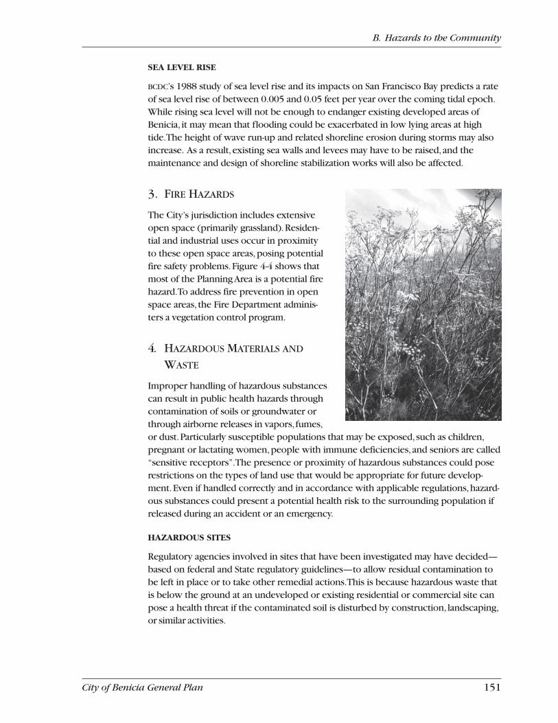
151City of Benicia General Plan
B. Hazards to the Community
SEA LEVEL RISE
BCDC’s 1988 study of sea level rise and its impacts on San Francisco Bay predicts a rateof sea level rise of between 0.005 and 0.05 feet per year over the coming tidal epoch.While rising sea level will not be enough to endanger existing developed areas ofBenicia, it may mean that flooding could be exacerbated in low lying areas at hightide. The height of wave run-up and related shoreline erosion during storms may alsoincrease. As a result, existing sea walls and levees may have to be raised, and themaintenance and design of shoreline stabilization works will also be affected.
3. FIRE HAZARDS
The City’s jurisdiction includes extensiveopen space (primarily grassland). Residen-tial and industrial uses occur in proximityto these open space areas, posing potentialfire safety problems. Figure 4-4 shows thatmost of the Planning Area is a potential firehazard. To address fire prevention in openspace areas, the Fire Department adminis-ters a vegetation control program.
4. HAZARDOUS MATERIALS AND
WASTE
Improper handling of hazardous substancescan result in public health hazards throughcontamination of soils or groundwater orthrough airborne releases in vapors, fumes,or dust. Particularly susceptible populations that may be exposed, such as children,pregnant or lactating women, people with immune deficiencies, and seniors are called“sensitive receptors”. The presence or proximity of hazardous substances could poserestrictions on the types of land use that would be appropriate for future develop-ment. Even if handled correctly and in accordance with applicable regulations, hazard-ous substances could present a potential health risk to the surrounding population ifreleased during an accident or an emergency.
HAZARDOUS SITES
Regulatory agencies involved in sites that have been investigated may have decided—based on federal and State regulatory guidelines—to allow residual contamination tobe left in place or to take other remedial actions. This is because hazardous waste thatis below the ground at an undeveloped or existing residential or commercial site canpose a health threat if the contaminated soil is disturbed by construction, landscaping,or similar activities.
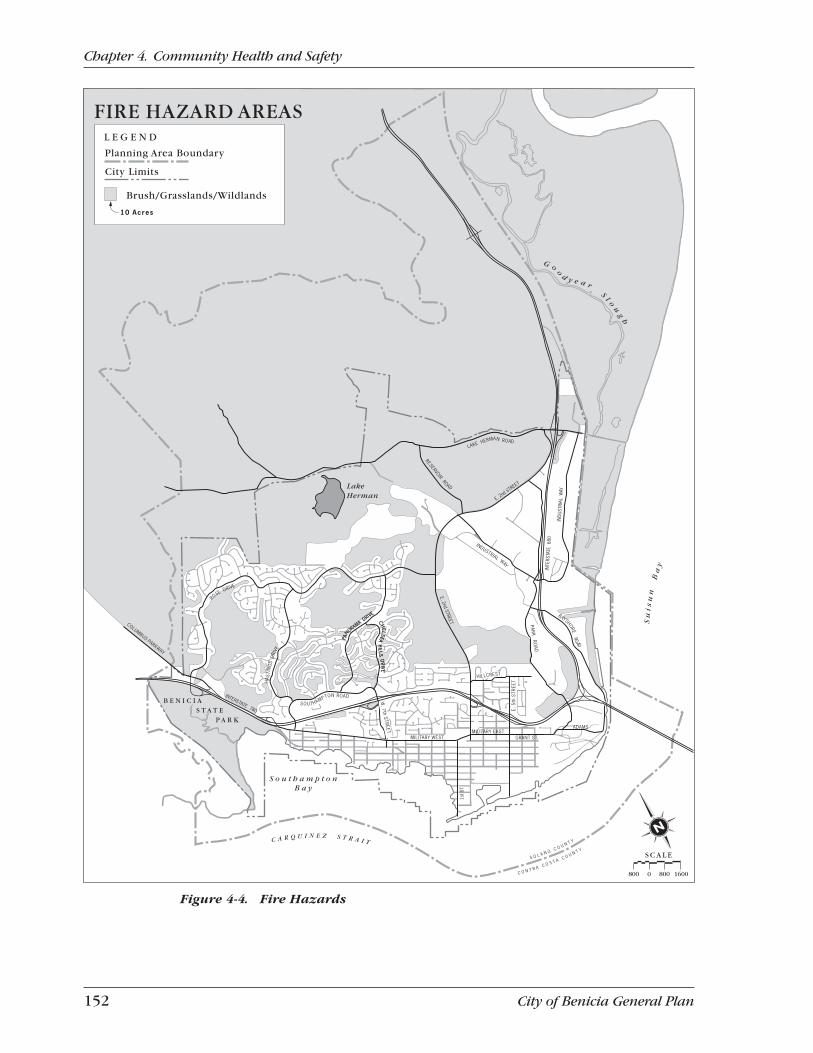
152
Chapter 4. Community Health and Safety
City of Benicia General Plan
Figure 4-4. Fire Hazards
INDUSTRIAL WAY
S o u t h a m p t o nB a y
B E N I C I A
C A R Q U I N E Z S T R A I T
S O L A N O C O U N T Y
C O N T R A C O S T A C O U N T Y
800 0 800 1600
S C A L E
SOUTHAMPTON ROAD
HAS
TIN
GS
DRI
VE
ROSE DRIVE
PANORAMA
DRIVE
CHELSEAH
ILLSD
RIVE
RESERVOIRROAD
G o
o
d y e a rS
l ou
gh
Su
is
un
Ba
y
1st S
T
MILITARY WEST
W. 7th STREET
E. 2nd STREET
HILLCREST
PARK ROAD
E. 2nd STREET
INDU
STRI
AL W
AY
INTE
RSTA
TE 6
80
INTERSTATE 780
LakeHerman
S T A T EP A R K
BAYSHOREROAD
FIRE HAZARD AREAS
CHELSEAH
ILLSD
RIVE
PANORAMA
DRIVE
L E G E N D
COLUMBUS PARKWAY
ADAMS
LAKE HERMAN ROAD
Planning Area Boundary
City Limits
MILITARY EASTGRANT ST.
E. 5
th S
TREE
T
Brush/Grasslands/Wildlands
10 Acres

153City of Benicia General Plan
General locations of identified known or suspected hazardous substances and wastesites in Benicia are shown in Appendix G. There are 57 identified hazardous wastesites in the Planning Area. With four exceptions—the IT Panoche Hazardous WasteDisposal Facility (Site 1), the Braito Landfill (Site 2), the landfill at the Benicia State Parksite (Site 54), and the leaking underground storage tank at 510 West J Street (Site 36)—all of the sites are located within Downtown or in industrial areas of Benicia.
HAZARDOUS MATERIAL AND WASTE HANDLERS
Hazardous substances are commonly used and handled within Benicia under a widevariety of permitted activities and land uses. The potential for contamination at a sitewhich handles hazardous substances depends on the type of business, types andquantities of hazardous substances, handling and management practices, control andspill containment systems, adequacy of accident prevention and safety programs,training programs and emergency response plans, and adjacent land uses. Whenhandled properly and when used in compliance with permitting and other regulatoryrequirements, hazardous substances do not necessarily pose a human health concernor a threat to the environment. Nevertheless, the nature of hazardous materials impliesan inherent risk to human health and the environment.
Benicia has a wide range of industries. Toxic hazards from any industry typicallyinclude hazards to employees relating to chemical use during the manufacturingprocesses, or inadvertent or accidental spillage during transport and handling, whichcould also potentially release toxic chemicals to the soil or groundwater. Other toxichazards include inadvertent releases of airborne substances, including toxic gases,fumes, or dust, which could expose workers or the community to health hazards. Inaddition to toxic hazards, public health and safety concerns relate to the potential forfire and explosive hazards and transportation-related accidents.
TOXIC AIR CONTAMINANT SOURCES
As of April 1996, there were 38 inventoried sources of known Toxic Air Contaminants(TACs) in Benicia. They ranged from small dry cleaning operations to major refineries.The names and addresses of TAC sources in Benicia as well as a listing of the BAAQMD
TAC inventory for sources within Benicia can be found in Table 8 and Appendix D ofthe Public Safety Background Report.
HAZARDOUS BUILDING MATERIALS
Some building materials commonly used in older buildings could present a publichealth risk if disturbed during an accident or during demolition of an existing build-ing. These materials include asbestos, electrical equipment such as transformers andfluorescent light ballasts that contain polychlorinated biphenyls (PCBs), fluorescentlights containing mercury vapors, and lead based paints. If they are in a deterioratedcondition, asbestos and lead based paint present a health risk to building occupants. Ifremoved during demolition, these materials require special disposal procedures.
B. Hazards to the Community

154
Chapter 4. Community Health and Safety
City of Benicia General Plan
5. UTILITY HAZARDS
Utility networks provide water, energy, and information. These networks are widelydistributed geographically, so access to all components of a network in an emergencymay be difficult. The sections below discuss the transmission networks in place withinthe Planning Area and evaluate expected performance in emergencies. Figure 4-5shows the location of these transmission lines and critical facilities in the PlanningArea.
ELECTRIC POWER
Pacific Gas & Electric Company (PG&E) supplies electric power to the Planning Area. A230 kilovolt transmission line enters the Planning Area from the west, roughly parallel-ing Lake Herman Road, and terminates at the Bahia substation near East Second Streetand Industrial Way. This substation provides power to most of Benicia. A 115 kilovolttransmission line roughly parallels the western edge of the Planning Area. A substationlocated near Glen Cove, outside the Planning Area, provides power to a portion ofwestern Benicia.
Failure of electrical power systems during or after an emergency may result from atemporary imbalance within the system or damage to its components. The systemshave a high degree of redundancy, allowing for restoration of power before completerepairs are made. The most vulnerable component appears to be high voltage trans-mission substations. Steel lattice high voltage transmission towers generally performwell in response to ground shaking. However, tower failure may occur as a result ofground displacement of the tower foundations from earthquake-induced landslidingor liquefaction. Towers and lines could also be damaged in a fire.
NATURAL GAS
PG&E also supplies natural gas to the Planning Area. A major transmission pipelinetraverses the northwestern corner of the Planning Area, with a pipeline branching offand paralleling Lake Herman Road, terminating in the vicinity of Industrial Way.Another pipeline enters the Planning Area from the west via I-780, continues alongMilitary West Street to terminate at First Street, with short branches on K Street toWest Thirteenth Street, and West Seventh Street to Southampton Road. Smaller diam-eter distribution lines run throughout the developed portion of the Planning Area.
Disruption to natural gas service may result from severe ground shaking and perma-nent ground deformation in areas of unconsolidated sediments and fill. Although somedamage to transmission lines may result from landslides or liquefaction, the majority ofthe damage is expected within the distribution system. Areas along the Bay margin,underlain by Bay mud, alluvium, and old fill, are particularly susceptible to damage.
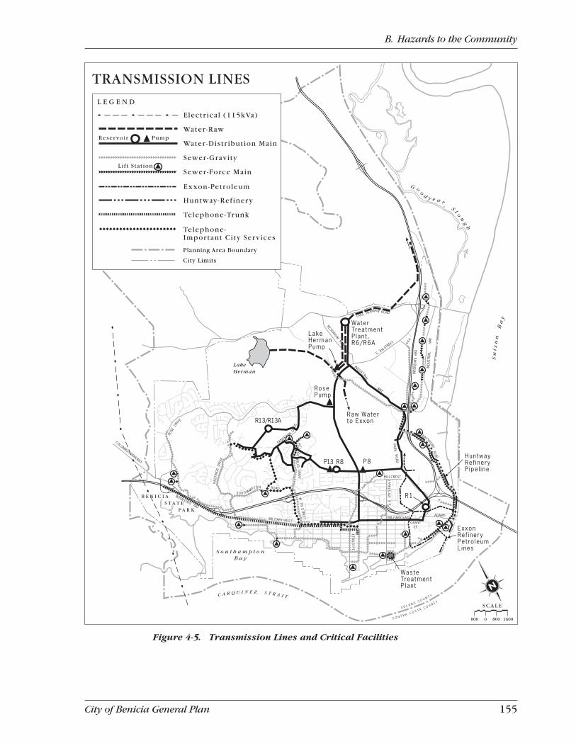
155City of Benicia General Plan
Figure 4-5. Transmission Lines and Critical Facilities
S o u t h a m p t o nB a y
B E N I C I A
C A R Q U I N E Z S T R A I T
S O L A N O C O U N T Y
C O N T R A C O S T A C O U N T Y
800 0 800 1600
S C A L E
SOUTHAMPTON ROAD
HAS
TIN
GS
DRI
VE
ROSE
DRIVE
RESERVOIRROAD
G o
o
d y e a rS
l ou
gh
Su
is
un
Ba
y
1st S
TREE
T
MILITARY WEST
W. 7th STREET
HILLCREST
PARK ROAD
E. 2nd STREET
INDU
STRI
AL
WAY
INTE
RSTA
TE 6
80
INTERSTATE 780
LakeHerman
S T A T EP A R K
BAYSHOREROAD
TRANSMISSION LINES
CHELSEAH
ILL SD
RIVE
PANORAMADR
IVE
L E G E N D
COLUMBUS PARKWAY
ADAMS
LAKE HERMAN ROAD
MILITARY EASTGRANT
ST.
E. 5
th S
TREE
T
INDUSTRIAL
WAY
Electr ical (115kVa)
Water -Raw
Water -Distr ibut ion Main
Sewer-Gravity
Sewer -Force MainLif t Stat ion
Exxon-Petroleum
Huntway-Ref iner y
Telephone-Trunk
Telephone-Important City Services
Reservoir Pump
Planning Area Boundary
City Limits
Raw Waterto Exxon
LakeHermanPump
R1
P8P13 R8
R13/R13A
RosePump
WaterTreatmentP lant ,R6/R6A
WasteTreatmentP lant
ExxonRef ineryPetro leumLines
HuntwayRef ineryP ipe l ine
B. Hazards to the Community

156
Chapter 4. Community Health and Safety
City of Benicia General Plan
WATER SUPPLY
The water treatment plant located near Lake Herman Road produces drinking waterfor areas within the City limits. Water is supplied to the treatment plant through theCordelia Transmission Main that runs along I-680 from Cordelia to Lake Herman Road,and from there to the treatment plant.
Disruption to the water supply may result from damage to pipelines, water treatmentplants, storage tanks, reservoirs, or the distribution network. Damage to supply anddistribution pipelines typically results from earthquake-related ground deformationsuch as landsliding, lurching, or liquefaction. Damage to storage tanks and reservoirsmay result from severe ground shaking, resulting in deformation of the tank or con-nections, and possible loss of the contents. Damage to reservoirs may result frompermanent ground deformation within or adjacent to the dam or shoreline. An ad-equate water supply needs to be available through normal means for firefighting.Water treatment plants have generally performed well in past disasters.
WASTE WATER
Damage to waste water collection and treatment systems may result from damage tothe collection network and treatment facilities. The risks that face the waste watercollection system also apply to the underground natural gas and potable waternetworks. In general, damage to pipes is related to the amount of permanent grounddeformation.
The Benicia Waste Water Treatment Plant is located within an area of alluvium near thewaterfront, and ground shaking during a large, local earthquake may result in somedamage. The collection network may suffer damage in areas subject to soft sedimentdeformation, such as parts of Downtown and along the waterfront, or areas subject tolandsliding or fill settlement, such as in the hilly areas.
6. AIR QUALITY/CONTAMINATION
Air Quality in Benicia
Benicia is within the Bay Area Air Quality Management District (BAAQMD). The Districtoperates a network of monitoring sites throughout the Bay Area. The BAAQMD main-tains a site in Benicia to monitor sulfur dioxide. From 1990 to 1994, the Beniciamonitoring site did not record any violations of the State or federal standards for sulfurdioxide.
The closest multi-pollutant monitoring site is in Vallejo. From 1990 to 1994, the Stateand federal standards for carbon monoxide, nitrogen dioxide, and sulfur dioxide weremet every day at the Vallejo monitoring site. The federal standard for ozone was alsomet, although the more stringent State standard for ozone was exceeded from one tothree days per year.

157City of Benicia General Plan
Because of the relatively strong winds and the movement of air between the Bay Areaand the Central Valley through the Carquinez Strait, Benicia does not experience airpollution problems as severe as those found in other more confined parts of the BayArea.
Air quality forecasts are expected to continue to improve through 2000. The longestforecasts available, however, do not demonstrate attainment of all state and federal airquality standards.
Standards
Both the US Environmental Protection Agency (EPA) and the California Air ResourcesBoard have established ambient air quality standards for common pollutants. Theseambient air quality standards establish levels of contaminants which represent safelevels that avoid specific adverse health effects associated with each pollutant. Thefederal and State ambient standards were developed independently with differingpurposes and methods, although both processes attempt to avoid health-relatedeffects. In general, the California state standards are more stringent.
Another group of substances known as Toxic Air Contaminants (TACs), are injurious insmall quantities and are regulated despite the absence of criteria documents. No safeambient levels have been established for TACs. The identification, regulation andmonitoring of TACs is relatively recent compared to that for criteria pollutants.
B. Hazards to the Community

158
Chapter 4. Community Health and Safety
City of Benicia General Plan
C. RESPONSES TO HAZARDS
1. COMMUNITY RIGHT-TO-KNOW
California first adopted its “Community Right-to-know” program in 1985 to overseethe handling of hazardous materials by local regulatory agencies; a succession of Statestatutes amended the program in 1986 and 1989. In 1986, Congress enacted theSuperfund Amendments and Reauthorization Act, Title III: The Emergency Plan-ning and Community Right-to-Know Act (EPCRA). Together, these statutes establishrequirements relating to emergency responses to hazardous materials releases orthreatened releases, and to avoidance of accidents involving certain hazardous materi-als. The basic requirements of Community Right-to-know include:
• Immediate reporting of releases of hazardous materials.
• Submission and update of a Hazardous Materials Business Plan and inventory asrequired by the local administering agency.
• Notification to the local administering agency of the handling of specified quantitiesof hazardous material and submission of a Risk Management Prevention Program onrequest.
• Annual submission by manufacturing facilities of a Toxic Chemical Release Report(Form R) if threshold amounts of certain toxic chemicals are made, processed, orused.
• Requirements for hazardous materials storage imposed by local administeringagencies and Cal-OSHA standards.
2. EMERGENCY RESPONSE PLANS AND PROCEDURES
Recent disasters in California have tested communities’ emergency preparedness. The1989 Loma Prieta Earthquake, the 1991 Oakland Hills Fire, the 1993 chemical releaseat a Richmond refinery, and the 1994 Northridge earthquake all demonstrated theneed for preparedness in government operations, transportation and evacuationroutes, utility lifelines, and emergency alert and notification.
EMERGENCY OPERATIONS PLAN
The City of Benicia maintains an Emergency Operations Plan (EOP) adopted by theCity Council in 1989. It is a “multi-hazard” plan that identifies procedures for varioustypes of emergencies. It is intended to ensure that City government can continue tofunction in the event of a disaster. The EOP provides guidance for the community’sresponse to extraordinary situations and disasters. It provides an overview of opera-tional concepts, identifies components of the City Emergency Management Organiza-tion, and describes the overall responsibilities of federal, State, County and City offi-cials in an emergency. The plan is periodically updated, and drills evaluating theeffectiveness of the plan are conducted from time to time. The EOP designates the City
159City of Benicia General Plan
Manager as the Director of Emergency Services, responsible for overall emergencymanagement in the City. The Fire Chief is designated as the Assistant Director ofEmergency Services, responsible for maintaining the Plan and for the operation of theCity Emergency Operations Center (EOC).
EVACUATION ROUTES
In an emergency, the major arterials identified in Chapter 2C, Circulation, would serveas the principal routes for evacuating people to undeveloped areas north of the City.These arterials would also serve as the principal routes for moving emergency equip-ment and supplies. Of particular importance are those routes which parallel I-780 inthe event the freeway overpasses collapse or are blocked. Evacuation routes relatingto site-specific plans are contained in Appendix H of the EOP.
3. PUBLIC SAFETY SERVICES
CRIME
Benicia has a relatively low crime rate. Benicia’s crime rate appears to have generallyheld steady since the mid-1980s, although there have been annual fluctuations.
POLICE SERVICES
The City of Benicia Police Department provides police services to City residents. Inaddition to its responsibilities within the City Limits, the Department provides firstresponse service to areas within the City’s Sphere of Influence. The Departmentshares responsibility for policing the Benicia Industrial Park with private guardsemployed by individual industries in the park. The Department operates out of asingle station in the civic complex.
FIRE SERVICES
City Fire Protection Standards
Each fire jurisdiction has independent authority to adopt and administer its own firecode (Health & Safety Code §13869). Most do so by adopting all or portions of theUniform Fire Code (UFC), with additions or deletions appropriate to the jurisdiction.
The City’s Fire Department has adopted the standards defined in the latest edition ofthe California Uniform Fire Code, with a few local amendments to these standards.
Fire Department Services
The Benicia Fire Department provides fire suppression, fire prevention, basic andadvanced life support (ALS) medical services, technical rescue services, disaster pre-paredness, and weed abatement services for all areas within the City Limits and somenearby areas outside the city. The Department has two fire stations, with a total of twoengines and one rescue squad staffed 24 hours per day. Future growth may requireadditional fire stations.
C. Responses to Hazards

160
Chapter 4. Community Health and Safety
City of Benicia General Plan
The City maintains mutual aid agreements with several agencies. An interagencyagreement encompasses mutual responses with all other fire departments in SolanoCounty. The City also has a contract with the State Office of Emergency Services (OES);the City has agreed to staff a State-owned engine at Station Two in exchange for an OES
commitment to respond as needed. In addition to these contracts, the City has specificagreements for special hazards with the Cordelia Fire Protection District, the ContraCosta Fire Protection District for emergency responses on the Benicia - MartinezBridge, and the Napa County Hazardous Materials Team.
In addition to fire protection services, the Fire Department responds to certainemergency incidents such as rail accidents, spills of hazardous materials, or similaraccidents. The Benicia Fire Department and Exxon have joint responsibility for fireprotection at the Exxon refinery. Primary fire protection at the refinery is provided bythe refinery fire brigade, which is composed of firefighters and trained EmergencyMedical Technicians (EMTs). All technicians and operating team supervisors at therefinery are trained in industrial fire fighting.
In order to ensure an effective response to hazardous materials incidents, industrialbusinesses using hazardous materials are required to prepare a business plan whichidentifies hazardous materials used in the operation of the business and the means foraddressing potentially hazardous situations. In addition to detailed descriptions ofmaterials used on a business site, the business plan must contain a description of howand where the hazardous materials are handled, sufficient for fire, safety, health andother appropriate agencies to prepare for emergency response (Health & Safety Code§25501[e]). These plans are discussed in Chapter 5 of the Public Safety BackgroundReport.
4. MEDICAL SERVICES
There are no hospitals located in the city. Residents most commonly use Sutter SolanoMedical Center and Kaiser Permanente, both in Vallejo. Nearby hospitals includeKaiser-Martinez, Mt. Diablo Hospital, and Contra Costa Regional Medical Center inContra Costa County. Benicia does have a number of medical offices and clinics withinthe City limits.
5. COMMUNITY HAZARDS GOALS, POLICIES, AND PROGRAMS
GOAL 4.7: Ensure that existing and future neighborhoodsare safe from risks to public health that couldresult from exposure to hazardous materials.
POLICY 4.7.1: Actively recruit industries and businesses that sustain environ-mental quality and have sound, responsible environmentalpractices and policies, such as “best available control technol-
161City of Benicia General Plan
ogy” (BACT), source reduction, reduced use of hazardous materi-als in production, and reduced waste.
POLICY 4.7.2: Establish a “Community Right-to-know” program to promotegeneral public understanding of Benicia’s toxics problems asthey affect current and future generations.
The Federal Environmental Protection Agency, under the Emergency Planning Com-munity Right to Know Act (EPCRA) and the Superfund Amendments ReauthorizationAct (SARA) Title 3, 1986, mandated the right of the public to information which wouldaffect emergency response and preparedness for “credible worst case scenarios” frompotential industrial hazards. (Superfund Amendments Reauthorization Act, Title 3: TheEmergency Planning and Community Right-to-Know Act, enacted by Congress in1986).
Program 4.7.A: Using documents that are already publicly available, makeavailable in the Library a list of all known contaminated sites inBenicia, their chemical contents and conditions, and howcontamination occurred.
Program 4.7.B: Provide readers with easy directions on how to access informa-tion about contaminated sites in Benicia.
Program 4.7.C: Consider establishing an ad hoc environmental task force tocollect and disseminate information on environmentallysensitive sites in Benicia.
The task force would help to gather information on community toxic problems toinform and safeguard public health and safety.
Program 4.7.D: Identify, inventory, and then update sources of hazards inBenicia.
Program 4.7.E: Assess and evaluate Benicia’s preparedness to respond tohazard emergencies.
This program should be a part of the “Community Right-to-know” program andconform with the Emergency Planning Community Right-to-know Act (EPCRA).
POLICY 4.7.3: Protect existing and future development from contaminatedsites, hazardous landfill waste and debris, chemical spills, andother hazards including unexploded ordnance and explosivewaste.
Information on unexploded ordnance on Arsenal properties can be found in the ArmyArchives Search Report for the Benicia Arsenal and other federal documents.
Program 4.7.F: Work with state and federal agencies to require that unautho-rized hazardous substances be removed from neighborhoodsor that other appropriate measures are taken to ensure that
C. Responses to Hazards

162
Chapter 4. Community Health and Safety
City of Benicia General Plan
such substances do not present health risks to the neighbor-hood.
POLICY 4.7.4: Promote enforcement of regulatory requirements over theentire term of monitoring of identified hazardous sites withinthe City Limits, especially sites located in residential neighbor-hoods and near school playing fields and parks.
POLICY 4.7.5: Require that all sites known or suspected to have unexplodedordnance and/or a toxic history be tested and remediatedbefore any development can occur.
POLICY 4.7.6: Prohibit residential development on any land formerly operatedas landfill or dump, including land formerly owned or used bythe military for military wastes, until the waste and contamina-tion is removed with proper agency oversight, or remediated asrequired by the appropriate regulatory agencies.
POLICY 4.7.7 Where environmental testing has been required by Stateregulatory agencies but is not yet completed withhold Cityapprovals for site grading and other construction activities untila site evaluation is available that provides a reasonable basis fordetermining that it is safe to commence such activities.
GOAL 4.8: Protect sensitive receptors from hazards.
Program 4.8.A: Identify sensitive receptors in the community and developmethods of protection.
Program 4.8.B: Establish guidelines to separate sensitive receptors from thosewho carry, use, process, store or generate hazardous material,including ordnance.
POLICY 4.8.1: Evaluate potential hazards and environmental risks to sensitivereceptors before approving development.
GOAL 4.9: Ensure clean air for Benicia residents.
POLICY 4.9.1: Establish whether a significant air pollution problem exists inBenicia and the City’s role in resolving it.
Program 4.9.A: Prepare a review of existing air quality information and datasources, the quality and extent of this data, and existing regula-tory requirements.
Program 4.9.B: Consult with the staff of the BAAQMD and prepare recommenda-tions for actions that the City will take to reduce identified airquality problems toward meeting ambient air quality standards.

163City of Benicia General Plan
GOAL 4.10: Support improved regional air quality.
POLICY 4.10.1: Support implementation of Bay Area Clean Air Plan.
The Bay Area Clean Air Plan provides a strategy for attaining all the air quality stan-dards in the nine-county Bay Area Air Quality Management District. Benicia woulddemonstrate consistency with the Bay Area Clean Air Plan by implementing Transpor-tation Control Measures (TCMs) including expanding employer assistance programs,improving bicycle access and facilities, improving arterial traffic management, estab-lishing transit use incentives, and adopting a local clean air plan, policies, and pro-grams.
Program 4.10.A: Coordinate air quality planning efforts with other local, re-gional, and State agencies.
Program 4.10.B: Require that projects with identified significant air qualityimpacts include all feasible mitigation measures needed toreduce impacts to less than significant levels.
POLICY 4.10.2: Encourage designs and land use strategies that reduce automo-bile use and promote mixed use, jobs/housing balance,telecommuting, bicycle, and pedestrian facilities, and transit.
GOAL 4.11: Minimize harm from geologic hazards.
Program 4.11.A: Require geotechnical engineering reports to address sitestability and building foundation integrity for projects involvingsubstantial grading.
Program 4.11.B: Develop guidelines for site-specific geologic and geotechnicalreports.
Program 4.11.C: Require peer review of geotechnical engineering reports if it isdetermined that City staff does not have the technical expertiseto review such reports.
Program 4.11.D: Prepare a planning-level geologic hazards map of the PlanningArea as needed.
Program 4.11.E: Update the geologic hazards map as new information becomesavailable.
Program 4.11.F: Develop a Planning Area data base of geologic information foruse when making planning decisions and as a resource for thecommunity.
Program 4.11.G: Continue and expand the Unreinforced Masonry buildingprogram (URM).
Program 4.11.H: Consider financial assistance for retrofitting of unreinforcedmasonry buildings.
C. Responses to Hazards

164
Chapter 4. Community Health and Safety
City of Benicia General Plan
POLICY 4.11.1: Promote public awareness of earthquake-related hazards andsafety that includes training the populace to provide stop-gapemergency services following earthquakes.
Program 4.11.I: Consider implementing a citizen earthquake response systembased on the San Francisco model.
The San Francisco model involves hands-on training and practice by all citizens onhow to respond during an earthquake. Funding may come from private contributions.
GOAL 4.12: Accommodate runoff from existing and futuredevelopment.
Flooding problems exist along Sulphur Springs Creek in the Industrial Park. Futureupstream development in the Paddy Creek watershed could exacerbate existingflooding. There are many localized flooding problems within the City south of I-780. Anew citywide storm drain master plan is needed, and funding will have to be identi-fied before improvements can be implemented.
POLICY 4.12.1: Regulate runoff from new development so that post-develop-ment site peak flow rates are no greater than pre-developmentlevels.
POLICY 4.12.2: Upgrade existing drainage facilities as necessary to correctlocalized drainage problems.
POLICY 4.12.3: Ensure that new development pays its fair share cost of drain-age system improvements.
Program 4.12.A: Prepare a new citywide storm drain master plan.
Program 4.12.B: Adopt a combination of drainage improvement fees and othermechanisms to fund drainage improvements.
Program 4.12.C: Accelerate implementation of the existing Storm Drain MasterPlan.
POLICY 4.12.4: Where practicable, discourage the use of storm drain systems,and promote stormwater management strategies which maxi-mize opportunities for absorption of rainfall, overland convey-ance of runoff, non-reservoir surface storage, and other mea-sures that reduce development-induced impacts on peak flowrates.
GOAL 4.13: Prevent property damage caused by flooding.
POLICY 4.13.1: Continue to implement the floodplain management policycurrently followed by the City.
Program 4.13.A: Require all potential developers in the Sulphur Springs Creek

165City of Benicia General Plan
floodplain to provide flood hazard mitigation measures thatensure the subject properties are not at risk of flooding duringthe FEMA-designated 100-year base flood.
POLICY 4.13.2: Promote non-structural solutions to flood problems, wherefeasible.
Program 4.13.B: Where appropriate, promote the use of stormwater retentionbasins rather than standard engineering modifications tonatural channels.
Program 4.13.C: Encourage use of meandering drainage channels in all newdevelopments and wherever channels are replaced.
GOAL 4.14: Prevent ground and surface water contamination.
Program 4.14.A: Inform businesses and the public of current technology andstandards for preventing ground and surface water contamina-tion, and regulations governing hazardous material use, storage,and disposal, plus agency reporting requirements.
Program 4.14.B: Continue to communicate with State, regional, and localagencies and legislatures to relay information on Benicia’scurrent and potential water quality contamination concerns,particularly regarding hazardous waste sites, existing and closedlandfills, new and existing waste-generating industries andcommercial operations, and City waste disposal and water/sewage treatment facilities.
POLICY 4.14.1: Implement non-point source pollution strategies.
Program 4.14.C: Provide information to the public on provisions of the City’sStormwater Pollution Prevention Plan (SWPPP) program andpreparation of SWPPPs for all construction projects of five acresor more. Implement Best Management Practices (BMPs) forstormwater runoff and erosion controls for all development.
Program 4.14.D: Conduct an outreach program to industry and residents onhow to reduce storm water-related pollution.
GOAL 4.15: Reduce fire hazards.
POLICY 4.15.1: Promote the creation and maintenance of natural and artifi-cially constructed firebreaks between development and openspace areas through the use of fire resistive landscaping, weedabatement, discing, and other methods.
Program 4.15.A: Develop a Fire Hazards Response Plan for the urban wild landinterface area.
C. Responses to Hazards

166
Chapter 4. Community Health and Safety
City of Benicia General Plan
Program 4.15.B: Conduct a fire-hazard outreach program to neighborhoodgroups, the elderly, and the handicapped.
Program 4.15.C: Continue and expand routine fire inspections for businesses forcompliance with the Uniform Fire Code and the California FireCode.
Program 4.15.D: Continue the yearly weed abatement program.
POLICY 4.15.2: Promote the use of fire-resistant landscaping in public andprivate developments.
GOAL 4.16: Require hazardous materials and hazardous wastemanagement handling and disposal proceduresthat are protective of human health and the envi-ronment.
POLICY 4.16.1: Support the Solano County Hazardous Waste Management Planand its goals, policies, and implementation guidelines forhazardous waste reduction, hazardous waste facility siting,hazardous waste handling and disposal, public education andinvolvement, and program coordination with regulatoryrequirements.
Program 4.16.A: As part of the permitting process, ensure that the Countyreviews the design and operating plans for handling anddisposal of hazardous wastes for existing and proposed newbusinesses.
Program 4.16.B: Contact the Solano County Environmental ManagementDepartment annually to confirm that hazardous waste genera-tors in Benicia have been granted permits for handling hazard-ous substances in compliance with federal and State laws, thatthey dispose of their wastes in accordance with applicablelaws, and that they have filed Hazardous Materials ManagementPlans and Risk Management and Prevention Plans.
Program 4.16.C: Continue reviewing monitoring records for new and existinghazardous waste storage areas for compliance with federal andState law.
POLICY 4.16.2: Continue, promote, and expand the City’s Household Hazard-ous Waste Program.
Program 4.16.D: Promote use of Benicia’s and Pacheco’s “drop-off” facilities.
POLICY 4.16.3: Control water runoff that comes from hazardous substancehandling or that enters hazardous substance handling areas.

167City of Benicia General Plan
Program 4.16.E: Investigate the potential for the collection and testing ofindustrial area surface runoff prior to discharge to preventdischarge of hazardous substances into the environment.
GOAL 4.17: Minimize hazardous waste generation.
POLICY 4.17.1: Ensure enforcement of Title 22, §67100 of the California Codeof Regulations regarding preparation and implementation ofsource reduction plans by hazardous waste generators.
Program 4.17.A: Contact the Solano County Environmental ManagementDepartment each September to confirm that new businesseshave filed their source reduction plans, if applicable.
Program 4.17.B: Situate all new hazardous material storage and handling areas tominimize the possibility of environmental contamination in theevent of an accidental spill.
Program 4.17.C: Enclose areas where hazardous liquids are handled to minimizeany rain or moisture coming into contact with hazardoussubstances.
GOAL 4.18: Ensure the proper and thorough clean-up ofhazardous waste sites including the Rose Drive/Braito landfill area.
POLICY 4.18.1: Monitor and participate in the remedial planning process formajor hazardous waste sites within the City and monitorimplementation of any selected remedial actions to ensure thathuman health and the environment are protected over the longterm.
Program 4.18.A: Continue to work with the California Department of ToxicSubstances Control (DTSC) to expedite the proper and thoroughclean-up of waste in the Rose Drive area.
GOAL 4.19: Ensure the best possible closure of IT, consider-ing the long-term health effects upon sensitivereceptors in the community.
Program 4.19.A: For the IT site, continue to communicate Benicia’s position thatthe only acceptable closure plan is a groundwater-divide-basedalternative (i.e., a closure plan based on removing waste andcontamination that lie outside the main site drainage).
C. Responses to Hazards

168
Chapter 4. Community Health and Safety
City of Benicia General Plan
GOAL 4.20: Reduce health and safety hazards associated withhazardous materials users, hazardous waste gen-erators, and hazardous waste disposal sites andtoxic air contaminants.
POLICY 4.20.1: Establish buffer zones between sensitive land uses and thoseland uses which involve the significant use, storage, or disposalof hazardous materials, hazardous waste, or toxic air contami-nants.
Program 4.20.A: Maintain and designate land along East Second Street for non-residential purposes.
Program 4.20.B: Follow siting criteria for Treatment, Storage, and Disposal (TSD)facilities contained in the Solano County Hazardous WasteManagement Plan. (22 California Code of Regulations (CCR)§66260-18; State Health and Safety Code §25201.)
Program 4.20.C: Evaluate the potential for requiring risk assessment for any newTSD facility, and if indicated by the risk assessment, require alarger buffer zone that will be protective of human health.
Program 4.20.D: Review building applications for any proposed TSD facilities toensure that the requirements of the Solano County HazardousWaste Management Plan are met.
Program 4.20.E: Coordinate with Solano County Environmental ManagementDepartment to ensure enforcement of community Right-toknow laws (Chapter 6.95 of the Health and Safety Code,§25500, et seq.).
Program 4.20.F: Enforce the Hazardous Waste Property and Border ZoneProperty Law (Health and Safety Code, Article 11, §25520through §25241).
GOAL 4.21: Reduce significant hazards associated with pipe-lines, and high voltage transmission lines.
Program 4.21.A: Continue to implement existing adopted policies governingdevelopment near pipelines.
Program 4.21.B: Set back all residential uses, schools, and public buildings atleast 150 feet from the edge of 230 kilovolt electric transmis-sion line easements.
GOAL 4.22: Update and maintain the City’s Emergency Re-sponse Plan.

169City of Benicia General Plan
POLICY 4.22.1: Provide an early community alert and notification system andsafe evacuation plan for emergency incidents.
Program 4.22.A: Provide the public with information and training on what to dountil help arrives in emergency situations.
Program 4.22.B: Develop a siren system to alert and notify the community in anemergency.
Program 4.22.C: Request voluntary donations from identified sources of hazardsto implement the Emergency Response Plan.
Program 4.22.D: Consider a City radio station to inform residents in the event ofan emergency.
POLICY 4.22.2: Develop at least two exit routes, where feasible, for newdevelopments. One of the exits could be a pedestrian route.
POLICY 4.22.3: Provide the public with information on specified emergencyevacuation routes.
Program 4.22.E: Provide an evacuation route from the Arsenal in addition toMilitary East.
C. Responses to Hazards

170
Chapter 4. Community Health and Safety
City of Benicia General Plan
D. NOISE
The principal noise generator in Benicia is vehicular traffic. People are most sensitiveto noise levels which disturb their comfort at home.
The Noise section describes the existing and projected future noise environments inBenicia so that harmful and annoying sound levels can be avoided or minimized.Major noise sources are identified, estimated noise levels throughout the communityare reported, the effects of noise on the community are discussed, and ways to mini-mize unwanted noise are outlined.
1. HUMAN REACTION TO NOISE
Three qualities characterize the subjective effect of noise on the listener: (1) thefrequency of the noise, (2) the intensity of the noise, and (3) the time-varying charac-ter of the noise.
Researchers have grappled with how to translate objective measurements of soundinto directly correlated measures of public reaction to noise. The descriptors ofcommunity noise in current use are the results of these efforts and represent simpli-fied, practical measurement tools to gauge community response.
Table 4-1 shows the decibel levels of common noises.
Table 4-1. Decibel Levels of Common Noises
20 Soft whisper
40 Quiet office, living room, bedroom—away from traffic.
50 Light traffic at a distance, refrigerator, gentle breeze.
60 Average conversation, air conditioner at 20 feet, sewing machine.
65 Quiet typewriter.
70 Busy traffic, office tabulator, noisy restaurant.(This level may begin to affect hearing if one is constantly exposed.)
75 Vacuum cleaner.
80 Subway, heavy city traffic, ringing alarm clock at two feet, average factory noise.(Dangerous if exposure continues for more than eight hours.)
85 Truck traffic, noisy home appliances (washing machine, blender, food processor),power lawn mower. (Dangerous, even if exposure is less than eight hours.)
95 Noisy factory, shop tools.
100 Elevated train, chain saw, pneumatic drill.(Dangerous, even if exposure is less than two hours.)
120 Rock concert in front of speakers, sandblasting, thunderclap.(Danger is immediate.)
140 Jet airplane at 200 feet, gunshot blast.(Any length of exposure is extremely dangerous.)
171City of Benicia General Plan
The known effects of noise on people include hearing loss (not generally a factor withcommunity noise), communication interference, sleep interference, physiologicalresponses, and annoyance. Although the wide range of individual reactions to noisemakes it extremely difficult to measure how noise affects individual health, medicalstudies suggest a correlation between noise and mental stress.
A decibel is a unit of measurement which indicates the relative amplitude of a sound.The zero on the decibel scale is based on the lowest sound level that the healthy,unimpaired human ear can detect. Sound levels in decibels are calculated on alogarithmic basis. An increase of 10 decibels represents a ten-fold increase in acousticenergy, while 20 decibels is 100 times more intense, 30 decibels is 1,000 times moreintense, etc. There is a relationship between the subjective noisiness or loudness of asound and its intensity. Each 10 decibel increase in sound level is perceived as ap-proximately a doubling of loudness over a fairly wide range of intensities.
COMMUNICATION INTERFERENCE
Communication interference is one of the primary environmental noise problems,and includes speech interference and interference of activities such as watchingtelevision. Normal conversational speech is in the range of 60 to 65 dB, and any noisein this range or louder may interfere with speech.
SLEEP INTERFERENCE
Sleep interference is a major noise concern. Noise can make it difficult to fall asleep,can create momentary disturbances of natural sleep patterns by causing shifts fromdeep to lighter stages, and can cause awakening.
Extensive research has been conducted on the effect of noise on sleep disturbance.Recommended values for desired sound levels in residential bedroom space range from25 to 45 dB with 35 to 40 dB being the norm. The National Association of Noise ControlOfficials published data on the probability of sleep disturbance with various single eventnoise levels. Based on experimental sleep data related to noise exposure, a 75 dB interiornoise level event will cause noise-induced awakening in 30 percent of all cases.
PHYSIOLOGICAL RESPONSES
Physiological responses are those measurable effects of noise on people which arerealized as changes in pulse rate, blood pressure, etc. While such effects can be in-duced and observed, it is not known to what extent these physiological responsescause harm. Generally, physiological responses are a reaction to a loud, short-termnoise such as a rifle shot or a very loud jet overflight.
ANNOYANCE
Annoyance is the most difficult of all noise responses to describe. Annoyance is a veryindividual characteristic and can vary widely from person to person. What one personconsiders tolerable can be quite unbearable to another. The level of annoyance
D. Noise
172
Chapter 4. Community Health and Safety
City of Benicia General Plan
depends on the characteristics of the noise (i.e., loudness, frequency, time, and dura-tion), and how much activity interference (e.g., speech interference and sleep interfer-ence) results from the noise. However, the level of annoyance is also a function of theattitude of the receiver. Personal sensitivity to noise varies widely. It has been esti-mated that 2 to 10 percent of the population is highly susceptible to noise not of theirown making, while approximately 20 percent are unaffected by noise. Attitudes areaffected by the relationship between the person and the noise source. (Is it our dog orthe neighbor’s?) Whether we believe that someone is trying to abate the noise willalso affect our level of annoyance.
The following conclusions have been established through extensive study:1. Except in carefully controlled laboratory experiments, an increase of only one
dBA cannot be perceived by humans.2. Outside of the laboratory, a three dBA increase is considered to be just noticeable.3. A change of five dBA is required before any noticeable change in community
reaction would be expected.4. A 10 dBA increase is subjectively heard as a doubling of loudness and would most
certainly cause community response.
2. NOISE IN THE COMMUNITY
EXISTING NOISE LEVELS
Once noise levels are computed or measured, they can be mapped. Noise levels aremapped as contours. Each contour line indicates an area on the inside of the linewhich has a higher noise level than the contour’s value; the area on the outside of theline has a lower noise level than the contour’s value. Because local topography, vegeta-tion, or intervening structures may significantly affect noise exposure at a particularlocation, the noise contours should not be considered site-specific. Figure 4-6 showsexisting noise contours in Benicia.
These noise contours were formulated based on a community noise survey con-ducted in October and November 1995. The results indicated that typical exteriornoise levels in noise sensitive areas (i.e., nursing homes, churches, theaters, residentialuses, parks, libraries, and schools) are in the range of 51 dB to 63 dB L
dn. Traffic on local
roadways and I-680 and I-780, industrial activities, and neighborhood activities are thecontributing factors for background noise levels in the majority of the study area.Table 4-2 is a summary of the survey.
PROJECTED NOISE LEVELS
Traffic on I-680 and I-780 is expected to increase through the year 2015. The hourlytraffic flow and mix of trucks and private automobiles during a typical 24-hour periodis not expected to change. No major increase in railroad operation is expected tooccur in the near future. Figure 4-7 indicates future noise contours.
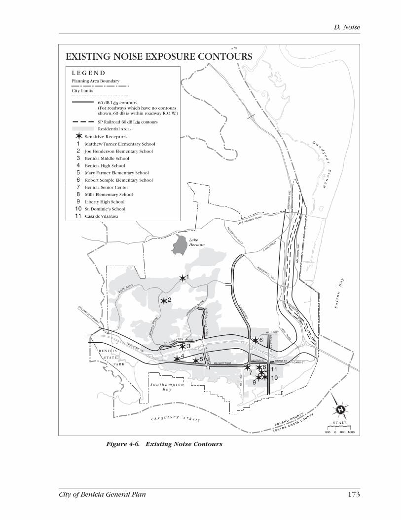
173City of Benicia General Plan
D. Noise
Figure 4-6. Existing Noise Contours
800 0 800 1600
S C A L E
INDUSTRIALW
AY
COLUMBUS PARKWAY
E.
5th
ST
RE
ET
GRANT ST.ADAMS ST.
S o u t h a m p t o nB a y
B E N I C I A
C A R Q U I N E Z S T R A I T
S O L A N O C O U N T Y
C O N T R A C O S T AC O U N T Y
SOUTHAMPTON ROAD
HA
ST
ING
SD
RIV
E
ROSE DRIVE
PA
NORAMADRIV
E
CHE
LS
EA
HIL
LS
DR
IVE
RESERVO
IR
ROAD
Go
o
dy
ea
rS
lo
ug
h
Su
is
un
Ba
y
1st S
TR
EE
T
MILITARY WESTMILITARY E.
W. 7 th
ST
RE
ET
E. 2nd S
TRE
ET
HILLCREST
PARK ROAD
E. 2nd STREET
LAKE HERMAN ROAD
IND
US
TR
IAL
WAY
INT
ER
STA
TE
680
INTERSTATE 780
LakeHerman
S T A T E
P A R K
BAYSHORE
RO
AD
Planning Area Boundary
City Limits
60 dB Ldn contours(For roadways which have no contoursshown, 60 dB is within roadway R.O.W.)
SP Railroad 60 dB Ldn contours
Residential Areas
Sensitive Receptors
Matthew Turner Elementary School
Joe Henderson Elementary School
Benicia Middle School
Benicia High School
Mary Farmer Elementary School
Robert Semple Elementary School
Benicia Senior Center
Mills Elementary School
Liberty High School
St. Dominic's School
Casa de Vilarrasa
123456789
1011
L E G E N D
✶
EXISTING NOISE EXPOSURE CONTOURS
2✶
1✶
3✶4✶ 5✶
6✶
7✶
9✶ 10✶8✶ 11✶
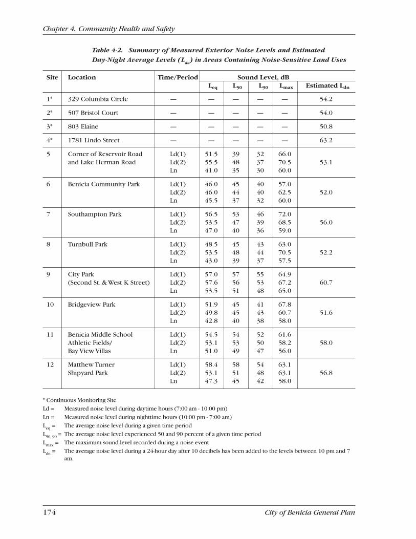
174
Chapter 4. Community Health and Safety
City of Benicia General Plan
Table 4-2. Summary of Measured Exterior Noise Levels and Estimated
Day-Night Average Levels (Ldn
) in Areas Containing Noise-Sensitive Land Uses
Site Location Time/Period Sound Level, dBLeq L50 L90 Lmax Estimated Ldn
1* 329 Columbia Circle — — — — — 54.2
2* 507 Bristol Court — — — — — 54.0
3* 803 Elaine — — — — — 50.8
4* 1781 Lindo Street — — — — — 63.2
5 Corner of Reservoir Road Ld(1) 51.5 39 32 66.0and Lake Herman Road Ld(2) 55.5 48 37 70.5 53.1
Ln 41.0 35 30 60.0
6 Benicia Community Park Ld(1) 46.0 45 40 57.0Ld(2) 46.0 44 40 62.5 52.0Ln 45.5 37 32 60.0
7 Southampton Park Ld(1) 56.5 53 46 72.0Ld(2) 53.5 47 39 68.5 56.0Ln 47.0 40 36 59.0
8 Turnbull Park Ld(1) 48.5 45 43 63.0Ld(2) 53.5 48 44 70.5 52.2Ln 43.0 39 37 57.5
9 City Park Ld(1) 57.0 57 55 64.9(Second St. & West K Street) Ld(2) 57.6 56 53 67.2 60.7
Ln 53.5 51 48 65.0
10 Bridgeview Park Ld(1) 51.9 45 41 67.8Ld(2) 49.8 45 43 60.7 51.6Ln 42.8 40 38 58.0
11 Benicia Middle School Ld(1) 54.5 54 52 61.6Athletic Fields/ Ld(2) 53.1 53 50 58.2 58.0Bay View Villas Ln 51.0 49 47 56.0
12 Matthew Turner Ld(1) 58.4 58 54 63.1Shipyard Park Ld(2) 53.1 51 48 63.1 56.8
Ln 47.3 45 42 58.0
* Continuous Monitoring Site
Ld = Measured noise level during daytime hours (7:00 am - 10:00 pm)
Ln = Measured noise level during nighttime hours (10:00 pm - 7:00 am)
Leq = The average noise level during a given time period
L50, 90 = The average noise level experienced 50 and 90 percent of a given time period
Lmax = The maximum sound level recorded during a noise event
Ldn = The average noise level during a 24-hour day after 10 decibels has been added to the levels between 10 pm and 7am.
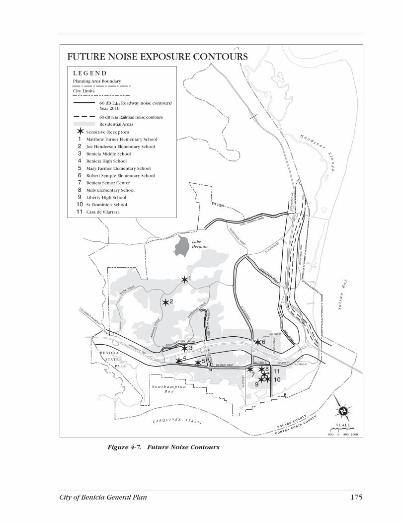
175City of Benicia General Plan
Figure 4-7. Future Noise Contours
800 0 800 1600
S C A L E
INDUSTRIALW
AY
COLUMBUS PARKWAY
E.
5th
ST
RE
ET
GRANT ST.ADAMS ST.
Planning Area Boundary
City Limits
60 dB Ldn Roadway noise contours/Year 2010
60 dB Ldn Railroad noise contours
Residential Areas
Sensitive Receptors
Matthew Turner Elementary School
Joe Henderson Elementary School
Benicia Middle School
Benicia High School
Mary Farmer Elementary School
Robert Semple Elementary School
Benicia Senior Center
Mills Elementary School
Liberty High School
St. Dominic's School
Casa de Vilarrasa
S o u t h a m p t o nB a y
B E N I C I A
C A R Q U I N E Z S T R A I T
S O L A N O C O U N T Y
C O N T R A C O S TAC O U N T Y
SOUTHAMPTON ROAD
HA
ST
ING
SD
RIV
E
ROSE DRIVE
PA
NORAMADRIV
E
CHE
LS
EA
HIL
LS
DR
IVE
RESERVO
IR
ROAD
G o o d y e a r
Sl
ou
gh
Su
is
un
Ba
y
1st S
TR
EE
T
MILITARY WESTMILITARY E.
W. 7 th
ST
RE
ET
E. 2nd S
TRE
ET
HILLCREST
PARK ROAD
E. 2nd STREET
LAKE HERMAN ROAD
IND
US
TR
IAL
WAY
INT
ER
STA
TE
680
City Limits
INTERSTATE 780
LakeHerman
S T A T E
P A R K
BAYSHORE
RO
A
D
123456789
1011
L E G E N D
✶
FUTURE NOISE EXPOSURE CONTOURS
2✶
1✶
3✶4✶ 5✶
6✶
7✶
9✶ 10✶8✶ 11✶
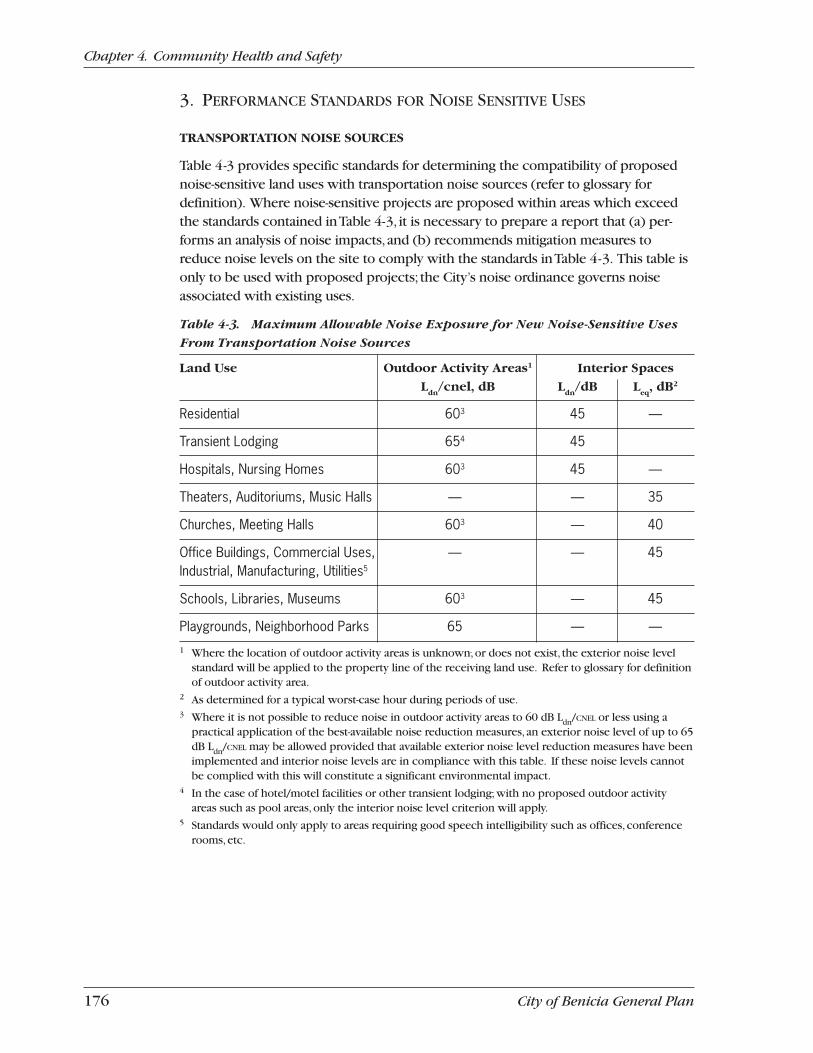
176
Chapter 4. Community Health and Safety
City of Benicia General Plan
3. PERFORMANCE STANDARDS FOR NOISE SENSITIVE USES
TRANSPORTATION NOISE SOURCES
Table 4-3 provides specific standards for determining the compatibility of proposednoise-sensitive land uses with transportation noise sources (refer to glossary fordefinition). Where noise-sensitive projects are proposed within areas which exceedthe standards contained in Table 4-3, it is necessary to prepare a report that (a) per-forms an analysis of noise impacts, and (b) recommends mitigation measures toreduce noise levels on the site to comply with the standards in Table 4-3. This table isonly to be used with proposed projects; the City’s noise ordinance governs noiseassociated with existing uses.
Table 4-3. Maximum Allowable Noise Exposure for New Noise-Sensitive Uses
From Transportation Noise Sources
Land Use Outdoor Activity Areas1 Interior Spaces
Ldn
/cnel, dB Ldn
/dB Leq
, dB2
Residential 603 45 —
Transient Lodging 654 45
Hospitals, Nursing Homes 603 45 —
Theaters, Auditoriums, Music Halls — — 35
Churches, Meeting Halls 603 — 40
Office Buildings, Commercial Uses, — — 45Industrial, Manufacturing, Utilities5
Schools, Libraries, Museums 603 — 45
Playgrounds, Neighborhood Parks 65 — —
1 Where the location of outdoor activity areas is unknown, or does not exist, the exterior noise levelstandard will be applied to the property line of the receiving land use. Refer to glossary for definitionof outdoor activity area.
2 As determined for a typical worst-case hour during periods of use.3 Where it is not possible to reduce noise in outdoor activity areas to 60 dB Ldn/CNEL or less using a
practical application of the best-available noise reduction measures, an exterior noise level of up to 65dB Ldn/CNEL may be allowed provided that available exterior noise level reduction measures have beenimplemented and interior noise levels are in compliance with this table. If these noise levels cannotbe complied with this will constitute a significant environmental impact.
4 In the case of hotel/motel facilities or other transient lodging, with no proposed outdoor activityareas such as pool areas, only the interior noise level criterion will apply.
5 Standards would only apply to areas requiring good speech intelligibility such as offices, conferencerooms, etc.

177City of Benicia General Plan
STATIONARY NOISE SOURCES
Table 4-4 provides specific performance standards for determining the compatibilityof proposed noise-sensitive land uses with stationary noise sources. The performancestandards are for new noise-sensitive developments which may be affected by anexisting stationary noise source. The performance standards also apply to new devel-opments that include a stationary noise source which may affect an existing noise-sensitive development.
The intent of these performance standards is both to prevent new noise sources fromencroaching on existing noise-sensitive developments and to prevent new noise-sensitive developments from encroaching on existing uses.
Noise sources evaluated relative to the performance standards in Table 4-4 should beconsidered with respect to their standard daily or weekly operating conditions. Noisesources may produce unusual noise levels due to temporary equipment malfunction,or unusual atmospheric conditions. Noise levels associated with these infrequentconditions are exempt from the performance standards contained in Table 4-4. Inaddition, the performance standards are not to be applied to safety signals or warningdevices. In the event an acoustical study is required of an applicant, refer to Appen-dix I: “Requirements for an Acoustical Analysis.”
D. Noise

178
Chapter 4. Community Health and Safety
City of Benicia General Plan
Table 4-4. Noise Level Performance Standards for Noise-Sensitive Land Uses
Which May Be Affected by Stationary Noise Sources
Land Use Exterior Hourly Leq’
dB Interior Hourly Leq’
dB
Daytime Nighttime Daytime Nighttime
7 a.m. to 10 p.m. 10 p.m. to 7 a.m. 7 a.m. to 10 p.m. 10 p.m. to 7 a.m
Residential 55 50 40 35
Transient Lodging 55 50 40 35
Hospitals — — 40 35
Nursing Homes 55 50 40 35
Theaters, Auditoriums — — 35 35
Churches 55 50 40 40
Schools 55 50 45 45
Libraries 55 50 45 45
Stationary noise sources include industrial operations, outdoor recreation facilities, HVAC units, loadingdocks, etc.
The above standards may be adjusted upwards to allow for an increase in the existing ambient hourlyL
eq caused by a proposed project. An increase of less than 3dB is permitted, even if the standards in
Table 4-4 are exceeded; an increase of 3dB or greater constitutes a significant environmental impact,unless the increase does not cause the standards in Table 4-4 to be exceeded.
The noise level standards contained above shall be applied to a typical hour of operation. When a peakhour of operation is expected to occur consistently during daily or weekly operations, the standardsshall also be applied to those operations.
Each of the noise standards specified above shall be lowered by five dB for tonal noises (humming, high-pitched tones, speech music, or recurring impulsive noises). This lowering of the standard does notapply to residential units established in conjunction with industrial or commercial caretaker dwellings.(See Glossary for definition of tonal noise).
The City may choose to apply the noise level performance standards at designated outdoor activityareas, in lieu of the property line.
The above standards do not apply to safety signals or warning devices.
For noise sources that occur on an infrequent basis and are considered to be safety equipment (such asflaring or pressure relief valves), a maximum noise level of 75 dB is acceptable, as measured from thereceiver’s property line. Noise levels which are projected to exceed this maximum are considered asignificant environmental impact.
Where outdoor activity areas do not exist and/or are not expected to be affected, the City may chooseto only apply the interior noise level criteria. For example, in the case of single family residences whichdo not have second story patios or outdoor activity areas, the City may choose to only apply an interiornoise level standard at the second story interior spaces.
179City of Benicia General Plan
D. Noise
4. COMMUNITY NOISE GOALS, POLICIES, AND PROGRAMS
GOAL 4.23: Reduce or eliminate the effects of excessive noise.
POLICY 4.23.1: Evaluate the compatibility of proposed projects with respect toexisting and future transportation noise levels by utilizingTables 4-3 and 4-4.
Program 4.23.A: Investigate and implement techniques to reduce traffic noise.
POLICY 4.23.2: Use noise dampening building standards, site design, landscap-ing, and setbacks instead of sound walls, wherever possible.
POLICY 4.23.3: Use available techniques such as building insulation, berms,building design and orientation, buffer yards, and staggeredoperating hours to minimize noise at the source.
POLICY 4.23.4: Control development of noise-sensitive land uses in areasexposed to existing or projected noise which exceed the levelsspecified in Tables 4-3 and 4-4 unless the project includesspecific, effective mitigation measures to reduce interior andexterior noise levels to those specified in Tables 4-3 and 4-4.
Program 4.23.B: Investigate conditioning construction of live/work units with arequirement to record a “notice of special restrictions” whichwould acknowledge the noisy nature of existing adjacentindustrial uses.
POLICY 4.23.5: Accommodate roadway improvement projects for build-out ofthe General Plan by recognizing that existing noise-sensitiveuses may be exposed to increased noise levels from roadwayrepairs, increased traffic, and increased travel speeds. When it isnot practical to reduce traffic noise levels to those in Table 4-4,the following criteria will be used as a test of significance forthe environmental review of roadway improvement projects:
(a) Where existing noise levels are less than 60 dB Ldn
at theoutdoor activity area of a noise-sensitive use, a 5 dB L
dn increase
in noise levels due to a roadway improvement project will beconsidered significant;
(b) Where existing noise levels range between 60 and 65 dBL
dn at the outdoor activity area of a noise-sensitive use, a 3 dB L
dn
increase in noise levels due to a roadway improvement projectwill be considered significant; and
(c) Where existing noise levels are greater than 65 dB Ldn
at theoutdoor activity area of a noise-sensitive use, a 1.5 dB L
dn

180
Chapter 4. Community Health and Safety
City of Benicia General Plan
increase in noise levels due to a roadway improvement projectwill be considered significant.
Program 4.23.C: If needed, revise the City’s noise ordinance and consider incor-porating the noise level performance standards in Table 4-4.
POLICY 4.23.6: Attempt to reduce noise in areas already highly impacted byexcessive noise.
Program 4.23.D: Identify sources of noise in the community (such as flightpatterns, construction noise, traffic, railroads, industrial, andamplified sound). Develop measures to reduce excessive noiseto acceptable levels.
181
Subhead
City of Benicia General Plan
GLOSSARY
ABBREVIATIONSABAG Association of Bay Area
Governments
ADA Americans with Disabilities Act
ADT Average daily trips made byvehicles or persons in a 24-hourperiod
AFDC Aid for Families withDependent Children (federalprogram)
BAAQMD Bay Area Air QualityManagement District
BACT Best available controltechnology
BART Bay Area Rapid Transit
BCDC Bay Area Conservation andDevelopment Commission
BIP Benicia Industrial Park
BMR Below-market-rate dwelling unit
BMP Best Management Practices
BUSD Benicia Unified School District
CA California
CBD Central Business District
CCR California Code of Regulations
CDBG Community Development BlockGrant
CEQA California EnvironmentalQuality Act
CIP Capital Improvements Program
CLG Certified Local Government
CMP Congestion ManagementProgram
CNEL Community Noise EquivalentLevel
COG Council of Governments
dB Decibel
DEIR Draft Environmental ImpactReport
DRC Design Review Commission
DTSC Department of ToxicSubstances Control
EIR Environmental Impact Report(State)
EOC Emergency Operations Center
EOP Emergency Operations Plan
EPCRA Emergency Planning andCommunity Right-to-Know Act
FAR Floor Area Ratio
FEMA Federal EmergencyManagement Agency

182
Glossary
City of Benicia General Plan
GPOC General PlanOversight Committee
GPPs Goals, Policies, and Programs
HCD Housing and CommunityDevelopment Department ofthe State of California.
HETF Housing Element Task Force
HUD U S Department of Housing andUrban Development
HHWP Hazardous Household WasteProgram
IGPs Issues, Goals, and Policies
I.O.O.F. International Order of OddFellows
IT International TechnologyCorporation
LAFCO Local Agency FormationCommission
LOS Level of Service
MTC Metropolitan TransportationCommission
OES Office of Emergency Services
OSHA Occupational Health and SafetyAdministration
PCB Polychlorinated Biphenyl
PG&E Pacific Gas & Electric
PD Planned Development
R & D Research and Development
RMPP Risk Management PreventionProgram
RWQCB Regional Water Quality ControlBoard
§ Section
SMARA Surface Mining and ReclamationAct
SOI Sphere of Influence
TAC Toxic Air Contaminants
TSD Treatment, Storage, andDisposal (facility)
TSM Transportation SystemsManagement
UBC Uniform Building Code
UFC Uniform Fire Code
UGB Urban Growth Boundary
UPRR Union Pacific Railroad
URM Unreinforced Masonry Building
WWTP Waste Water Treatment Plant

183
Subhead
City of Benicia General Plan
Access/Egress / Apartment
GLOSSARY
Agriculture • Use of land for theproduction of food and fiber, includingthe growing of crops and/or the grazingof animals on natural prime or improvedpasture land.
Air Pollution • Concentrations ofsubstances found in the atmosphere thatexceed naturally occurring quantities andare undesirable or harmful in some way.
Alley • A narrow service way, eitherpublic or private, that provides a perma-nently reserved but secondary means ofpublic access not intended for generaltraffic circulation. Alleys typically arelocated along rear property lines.
Alquist-Priolo Act, Earthquake FaultZone • A state designated seismichazard zone along traces of potentiallyand recently active faults, in whichspecialized geologic investigations mustbe prepared prior to approval of certaintypes of new development.
Alluvium • Sediment deposited byflowing water, as in a riverbed, floodplain, or delta.
Ambient • Surrounding on all sides;used to describe measurements ofexisting conditions with respect to traffic,noise, air and other environments.
Analysis • The examination of asubject, particularly its component partsand their interrelationships.
Annex, v. • To incorporate a land areainto an existing district or municipality,with a resulting change in the boundariesof the annexing jurisdiction.
Apartment • (1) One or more rooms ofa building used as a place to live, in abuilding containing at least one other
Access/Egress • The ability to enter asite from a roadway and exit a site onto aroadway by motorized vehicle.
Acres, Gross • The area of a lot or siteincluding easements and right-of-way tobe dedicated, but excluding existingpublic rights-of-way.
Acres, Net • The portion of a site thatcan actually be built upon. The followinggenerally are not included in the netacreage of a site: public or private roadrights-of-way, public open space, waterbodies and flood ways.
Adverse Impact • A negative conse-quence for the physical, social, or eco-nomic environment resulting from anaction or project.
Affordability Requirements •Provisions established by a public agencyto require that a specific percentage ofhousing units in a project or develop-ment remain affordable to very low- andlow- income households for a specifiedperiod.
Affordable Housing • Housing ca-pable of being purchased or rented by ahousehold with very low, low, or moder-ate income, based on a household’s abilityto make monthly payments necessary toobtain housing. Housing units for moder-ate income must sell or rent for amonthly cost not greater than 30 percentof area median income.
Agency • The governmental entity,department, office, or administrative unitresponsible for carrying out regulations.
Agricultural Preserve • Land desig-nated for agriculture or conservation. (See“Williamson Act.”)

184
Glossary
City of Benicia General Plan
unit used for the same purpose. (2) Aseparate suite, not owner occupied, thatincludes kitchen facilities and is designedfor and rented as the home, residence, orsleeping place of one or more personsliving as a single housekeeping unit.
Appropriate • An act, condition, orstate that is considered suitable.
Archaeological • Relating to thematerial remains of past human life,culture, or activities.
Architectural Control; ArchitecturalReview • Regulations and proceduresrequiring the exterior design of struc-tures to be suitable, harmonious, and inkeeping with the general appearance,historic character, and/or style of sur-rounding areas. A process used to exer-cise control over the design of buildingsand their settings. (See “Design Review.”)
Area; Area Median Income • As usedin State of California housing law withrespect to income eligibility limitsestablished by the US Department ofHousing and Urban Development (HUD),“area” means metropolitan area or non-metropolitan county. In non-metropolitanareas, the “area median income” is thehigher of the county median familyincome or the statewide non-metropoli-tan median family income.
Area of Interest • That area having adirect physical and social influence on acity’s planning area but not appropriatefor annexation.
Arterial • Streets that link residential,commercial, and industrial districts withthe highway system. They serve primarilythrough-travel as opposed to providingdirect access to adjacent land uses.
Arterial (Major) • A roadway whichconnects freeways to minor arterials andcollector streets. Major arterials generallyprovide four to six lanes.
Arterial (Minor) • A roadway whichconnects major arterials to collectors andlocal streets. Minor arterials generallyprovide two to four travel lanes.
Assisted Housing • Generally multi-family rental housing, but sometimessingle-family ownership units, whoseconstruction, financing, sales prices, orrents have been subsidized by federal,state, or local housing programs includ-ing, but not limited to Federal Section 8(new construction, substantial rehabilita-tion, and loan management set-asides),Federal Sections 213, 236, and 202,Federal Section 221(d)(3) (below-marketinterest rate program), Federal Section101 (rent supplement assistance), CDBG,FmHA Section 515, multi-family mortgagerevenue bond programs, local redevelop-ment and in lieu fee programs, and unitsdeveloped pursuant to local inclusionaryhousing and density bonus programs. ByJanuary 1, 1992, all California HousingElements are required to address thepreservation or replacement of assistedhousing that is eligible to change tomarket rate housing by 2002.
Attainment • Compliance with Stateand federal ambient air quality standardswithin an air basin.
Base Flood • In any given year, a 100-year flood that has a one percent likeli-hood of occurring, and is recognized as astandard for acceptable risk.
Below-market-rate (BMR) • (1) Anyhousing unit specifically priced to besold or rented to low- or moderate-income households for an amount less

185
Subhead
City of Benicia General Plan
than the fair-market value of the unit.Both the State of California and the USDepartment of Housing and UrbanDevelopment set standards for determin-ing which households qualify as “lowincome” or “moderate income.” (2) Thefinancing of housing at less than prevail-ing interest rates.
Best Management Practices • Apolicy, program, practice, rule, regulation,or ordinance for which sufficient data areavailable to indicate that identifiedobjectives can be met; that the practice istechnically and economically reasonableand not environmentally or sociallyunacceptable; and that the practice is nototherwise unreasonable for most of thestated industry organizations to carry out.
Bicycle Path (Class I facility) • Apaved route not on a street or roadwayand expressly reserved for bicyclestraversing an otherwise unpaved area.Bicycle paths may parallel roads buttypically are separated from them bylandscaping.
Bicycle Lane (Class II facility) • Acorridor expressly reserved for bicycles,existing on a street or roadway in addi-tion to any lanes for use by motorizedvehicles.
Bicycle Route (Class III facility) •A facility shared with motorists andidentified only by signs, a bicycle routehas no pavement markings or lanestripes.
Bikeways • A term that encompassesbicycle lanes, bicycle paths, and bicycleroutes.
Book Fee • A charge the City makes inassociation with the granting of buildingpermits to provide money for City Libraryacquisition of books.
Buffer Zone • An area of land separat-ing two distinct land uses that acts tosoften or mitigate the effects of one landuse on the other.
Building • Any structure used orintended for supporting or sheltering anyuse or occupancy.
Building Height • The vertical dimen-sion measured from the finished grade atall points on the site to a warped planean equal height above all points on thesite.
Buildout; Build-out • Development ofland to its full potential or theoreticalcapacity as permitted under current orproposed planning or zoning designa-tions. (See “Carrying Capacity (3).”)
Business Park • (See “Industrial Park.”)
Business Services • A subcategory ofcommercial land use that permits estab-lishments primarily engaged in renderingservices to other business establishmentson a fee or contract basis, such as adver-tising and mailing; building maintenance;personnel and employment services;management and consulting services;protective services; equipment rental andleasing; photo finishing; copying andprinting; travel; office supply; and similarservices.
CALFED • A joint State and federal pro-gram to develop a long-term solution toBay-Delta water resources and endan-gered species issues.
California Environmental QualityAct (CEQA) • A State law requiring Stateand local agencies to regulate activitieswith consideration for environmentalprotection. If a proposed activity has thepotential for a significant adverse envi-ronmental impact, an Environmental
Appropriate / California Environmental Quality Act (CEQA)

186
Glossary
City of Benicia General Plan
Impact Report (EIR) must be preparedand certified as to its adequacy beforetaking action on the proposed project.General Plans require the preparation ofa “program EIR.”
California Housing Finance Agency(CHFA) • A State agency, established bythe Housing and Home Finance Act of1975, which is authorized to sell revenuebonds and generate funds for the devel-opment, rehabilitation, and conservationof low-and moderate-income housing.
Caltrans • California Department ofTransportation.
Capital Improvements Program(CIP) • A program, administered by a cityor county government and reviewed byits planning commission, which sched-ules permanent improvements, usuallyfor a minimum of five years in the future,to fit the projected fiscal capability of thelocal jurisdiction. The program generallyis reviewed annually, for conformance toand consistency with the general plan.
Carrying Capacity • Used in determin-ing the potential of an area to absorbdevelopment: (1) The level of land use,human activity, or development for aspecific area that can be accommodatedpermanently without an irreversiblechange in the quality of air, water, land, orplant and animal habitats. (2) The upperlimits of development beyond which thequality of human life, health, welfare,safety, or community character within anarea will be impaired. (3) The maximumlevel of development allowable undercurrent zoning. (See “Buildout.”)
Census • The official decennial enu-meration of the population conducted bythe federal government.
Channelization • The straighteningand/or deepening of a watercourse forpurposes of storm-runoff control or easeof navigation. Channelization oftenincludes lining of stream banks with aretaining material such as concrete.
Character • Special physical character-istics of a structure or area that set itapart from itssurroundings and contribute to itsindividuality.
Circulation Element • One of theseven State-mandated elements of a localgeneral plan, it contains adopted goals,policies, and implementation programsfor the planning and management ofexisting and proposed thoroughfares,transportation routes, and terminals, aswell as local public utilities and facilities,all correlated with the land use elementof the general plan.
Circulation System • A network oftransit, automobile, bicycle and pedes-trian rights-of-way that connect originsand destinations.
City • City with a capital “C” generallyrefers to the government or administra-tion of the City of Benicia. City with alower case “c” may mean any city, or mayrefer to the geographical area of a city(e.g., the city’s bikeway system.)
Community Noise Equivalent Level(CNEL) • The average equivalent soundlevel during a 24-hour day, obtained afteraddition of approximately five decibels tosound levels in the evening from 7:00p.m. to 10:00 p.m. and ten decibels tosound levels in the night before 7:00 a.m.and after 10:00 p.m.
Collector • Streets which link arterialsand local streets that are generally twolanes in width.

187
Subhead
City of Benicia General Plan
Commercial • A land use classificationthat permits facilities for the buying andselling of commodities and services.
Commercial Strip • Commercialdevelopment, usually one store deep, thatfronts on a major street for a distance ofone city block or more. Includes indi-vidual buildings on their own lots, with orwithout on-site parking, and small linearshopping centers with shallow on-siteparking in front of the stores.
Community Center • A public facilityin which educational, therapeutic and/orrecreational programs are provided.
Community Development BlockGrant (CDBG) • A grant program admin-istered by the US Department of Housingand Urban Development (HUD) on aformula basis for entitlement communi-ties, and by the State Department ofHousing and Community Development(HCD) for non-entitled jurisdictions. Thisgrant allots money to cities and countiesfor housing rehabilitation and communitydevelopment, including public facilitiesand economic development.
Community Noise Equivalent Level(CNEL) • A 24-hour energy equivalentlevel derived from a variety of single-noise events, with weighting factors of 5and 10 dBA applied to the evening (7 PMto 10 PM) and nighttime (10 PM to 7 AM)periods, respectively, to allow for thegreater sensitivity to noise during thesehours.
Community Park • Land with fullpublic access intended to provide recre-ation opportunities beyond those sup-plied by neighborhood parks. Communityparks are larger in scale than neighbor-hood parks but smaller than regionalparks. They serve people within a threemile radius.
Community Service Area • A geo-graphic subarea of a city or county usedfor the planning and delivery of parks,recreation, and other human servicesbased on an assessment of the serviceneeds of the population in that subarea.
Compatible • Capable of existingtogether without conflict or ill effects.
Composting • The treatment of solidorganic refuse through aerobic, biologicdecomposition.
Concurrency • Installation and opera-tion of facilities and services needed tomeet the demands of new developmentsimultaneous with the development.
Condominium • A structure of two ormore units, the interior spaces of whichare individually owned; the balance of theproperty (both land and building) isowned in common by the owners of theindividual units. (See “Townhouse.”)
Congestion Management Plan(CMP) • A mechanism employing growthmanagement techniques, including trafficlevel of service requirements, standardsfor public transit, trip reduction programsinvolving transportation systems manage-ment and jobs/ housing balance strate-gies, and capital improvement program-ming, for the purpose of controlling and/or reducing the cumulative regionaltraffic impacts of development. AB 1791,effective August 1, 1990, requires all cities,and counties that include urbanizedareas, to adopt by December 1, 1991, andannually update a Congestion Manage-ment Plan.
Conservation • The management ofnatural resources to prevent waste,destruction, or degradation. (See “Conser-vation Element.”)
California Housing Finance Agency (CHFA) / Conservation

188
Glossary
City of Benicia General Plan
Conservation Element • One of theseven State-mandated elements of a localgeneral plan, it contains adopted goals,policies, and implementation programsfor the conservation, development, anduse of natural resources including waterand its hydraulic force, forests, soils, riversand other waters, harbors, fisheries,wildlife, minerals, and other naturalresources.
Consistency, Consistent With •Free from significant variation or contra-diction. The various diagrams, text, goals,policies, and programs in the general planmust be consistent with each other, notcontradictory or preferential. The term“consistent with” is used interchangeablywith “conformity with.” The courts haveheld that the phrase “consistent with”means “agreement with; harmoniouswith.” Webster defines “conformity with”as meaning harmony, agreement whenused with “with.” The term “conformity”means in harmony therewith or agree-able to (§58 Ops.Cal.Atty. Gen. 21, 25[1975]). California State law also requiresthat a general plan be internally consis-tent and also requires consistencybetween a general plan and implementa-tion measures such as the zoning ordi-nance.
County • County with a capital “C”generally refers to the government oradministration of a county. County with alower case “c” may mean any county, ormay refer to the geographical area of acounty (e.g., the county’s road system.)
Criterion • A standard upon which ajudgment or decision may be based. (See“Standards.”)
Critical Facility • Facilities housing orserving many people, that are necessary
in the event of an earthquake or flood,such as hospitals, fire, police, and emer-gency service facilities, utility “lifeline”facilities, such as water, electricity, and gassupply, sewage disposal, and communica-tions and transportation facilities.
Cul-de-sac • A short street or alley withonly a single means of ingress and egressat one end and with a large turnaround atits other end.
Cumulative Impact • As used in CEQA,the total impact resulting from theaccumulated impacts of individualprojects or programs over time.
dB • Decibel; a unit used to express therelative intensity of a sound as it is heardby the human ear.
dBA • The “A-weighted” scale formeasuring sound in decibels; weighs orreduces the effects of low and highfrequencies in order to simulate humanhearing. Every increase of 10 dBAdoubles the perceived loudness thoughthe noise is actually ten times moreintense.
Density, Residential • The number ofpermanent residential dwelling units peracre of land. Densities specified in theGeneral Plan are expressed in units pergross acre of land (excluding waterbodies). (See “Acres, Gross.”)
Density Bonus • The allocation ofdevelopment rights that allow a parcel toaccommodate additional square footageor additional residential units beyond themaximum for which the parcel is zoned,usually in exchange for the provision orpreservation of an amenity at the samesite or at another location. Under Califor-nia law, a housing development thatprovides 20 percent of its units for lowerincome households, or ten percent of its

189
Subhead
City of Benicia General Plan
units for very low-income households, or50 percent of its units for seniors, isentitled to a density bonus. (See “Develop-ment Rights, Transfer of.”)
Density, Control of • A limitation onthe occupancy of land. Density can becontrolled through zoning in the follow-ing ways: use restrictions, minimum lot-size requirements, floor area ratios, landuse-intensity ratios, setback and yardrequirements, minimum house-sizerequirements, ratios comparing numberand types of housing units to land area,limits on units per acre, and other means.Allowable density often serves as themajor distinction between residentialdistricts.
Density Transfer • A way of retainingopen space by concentrating densities–usually in compact areas adjacent toexisting urbanization and utilities–whileleaving unchanged historic, sensitive, orhazardous areas. In some jurisdictions, forexample, developers can buy develop-ment rights of properties targeted forpublic open space and transfer theadditional density to the base number ofunits permitted in the zone in which theypropose to develop.
Design Review • The comprehensiveevaluation of a development and itsimpact on neighboring properties andthe community as a whole, from thestandpoint of site and landscape design,architecture, materials, colors, lighting,and signs, in accordance with a set ofadopted criteria and standards. InBenicia’s Design Review system, projectsare reviewed against certain standardsand guidelines by the Design ReviewCommission and the Planning Depart-ment. (See “Architectural Control.”)
Detention Dam/Basin/Pond •Dams may be classified according to thebroad function they serve, such asstorage, diversion, or detention. Detentiondams are constructed to retard floodrunoff and minimize the effect of suddenfloods. Detention dams fall into two maintypes. In one type, the water is tempo-rarily stored, and released through anoutlet structure at a rate that will notexceed the carrying capacity of thechannel downstream. Often, the basinsare planted with grass and used for openspace or recreation in periods of dryweather. The other type, most often calleda Retention Pond, allows for water to beheld as long as possible and may or maynot allow for the controlled release ofwater. In some cases, the water is allowedto seep into the permeable banks orgravel strata in the foundation. This lattertype is sometimes called a Water-Spread-ing Dam or Dike because its main pur-pose is to recharge the undergroundwater supply. Detention dams are alsoconstructed to trap sediment. These areoften called Debris Dams.
Developable Land • Land that issuitable as a location for structures andthat can be developed free of hazards to,and without disruption of, or significantimpact on, natural resource areas.
Developer • An individual who orbusiness that prepares raw land for theconstruction of buildings or causes to bebuilt physical building space for useprimarily by others, and in which thepreparation of the land or the creation ofthe building space is in itself a businessand is not incidental to another businessor activity.
Conservation Element / Developer

190
Glossary
City of Benicia General Plan
Development • The physical extensionand/or construction of urban land uses.Development activities include: subdivi-sion of land; construction or alteration ofstructures, roads, utilities, and otherfacilities; installation of septic systems;grading; deposit of refuse, debris, or fillmaterials; and clearing of natural vegeta-tive cover (with the exception of agricul-tural activities). Routine repair andmaintenance activities are exempted.
Development Agreement • Alegislatively-approved contract between ajurisdiction and a person having legal orequitable interest in real property withinthe jurisdiction (California GovernmentCode §5865 et. seq.) that “freezes” certainrules, regulations, and policies applicableto development of a property for aspecified period of time, usually inexchange for certain concessions by theowner.
Development Fee • (See “Impact Fee.”)
Development Rights • The right todevelop land by a land owner whomaintains fee-simple ownership over theland or by a party other than the ownerwho has obtained the rights to develop.Such rights usually are expressed interms of density allowed under existingzoning. For example, one developmentright may equal one unit of housing ormay equal a specific number of squarefeet of gross floor area in one or morespecified zone districts. (See “Develop-ment Rights, Transfer of [TDR].”)
Development Rights, Transfer of(TDR) • Also known as “Transfer ofDevelopment Credits,” a program that canrelocate potential development fromareas where proposed land use orenvironmental impacts are consideredundesirable (the “donor” site) to another
(“receiver”) site chosen on the basis of itsability to accommodate additional unitsof development beyond that for which itwas zoned, with minimal environmental,social, and aesthetic impacts. (See “Devel-opment Rights.”)
Disability • Physical or mental impair-ment that substantially limits one or moreof the major life activities of an individual,or a record of such impairment, or beingregarded as having such an impairment.
Discourage, v. • To advise or persuadeto refrain from.
Distribution Use • (See “WarehousingUse.”)
District • (1) An area of a city or countythat has a unique character identifiable asdifferent from surrounding areas becauseof distinctive architecture, streets, geo-graphic features, culture, landmarks,activities, or land uses. (2) A portion of theterritory of a city or coun–ty withinwhich uniform zoning regulations andrequirements apply; a zone.
Diversity • Differences among other-wise similar elements that give themunique forms and qualities. E.g., housingdiversity can be achieved by differencesin unit size, tenure, or cost.
Duplex • A detached building undersingle ownership that is designed foroccupation as the residence of twofamilies living independently of eachother.
Dwelling Unit • A room or group ofrooms (including sleeping, eating, cook-ing, and sanitation facilities, but not morethan one kitchen), that constitutes anindependent housekeeping unit, occu-pied or intended for occupancy by onehousehold on a long-term basis.

191
Subhead
City of Benicia General Plan
Easement • Usually the right to useproperty owned by another for specificpurposes or to gain access to anotherproperty. For example, utility companiesoften have easements on the privateproperty of individuals to be able toinstall and maintain utility facilities.
Easement, Conservation • A tool foracquiring open space with less than full-fee purchase, whereby a public agencybuys only certain specific rights from theland owner. These may be positive rights(providing the public with the opportu-nity to hunt, fish, hike, or ride over theland) or they may be restrictive rights(limiting the uses to which the landowner may devote the land in the future.)
Ecology • The interrelationship ofliving things to one another and theirenvironment; the study of such interrela-tionships.
Economic Development Board(EDB) • The agency charged withidentifying, investigating, and promotingeconomic needs, opportunities, andinterests in Benicia.
Ecosystem • An interacting systemformed by a biotic community and itsphysical environment.
Elderly Persons age 62 and older. (See“Seniors.”)
Emergency Shelter • A facility thatprovides immediate and short-termhousing and supplemental services forthe homeless. Supplemental services mayinclude food, counseling, and access toother social programs. (See “Homeless”and “Transitional Housing.”)
Emission Standard • The maximumamount of pollutant legally permitted tobe discharged from a single source, eithermobile or stationary.
Encourage, v. • To stimulate or foster aparticular condition through direct orindirect action by the private sector orgovernment agencies.
Endangered Species • A species ofanimal or plant is considered to be en–dangered when its prospects for survivaland reproduction are in immediatejeopardy from one or more causes.
Enhance, v. • To improve existingconditions by increasing the quantity orquality of beneficial uses or features.
Environment • CEQA defines environ-ment as “the physical conditions whichexist within the area which will beaffected by a proposed project, includingland, air, water, mineral, flora, fauna, noise,and objects of historic or aestheticsignificance.”
Environmental Impact Report(EIR) • A report complying with theCalifornia Environmental Quality Actwhich assesses all the environmentalcharacteristics of an area and determineswhat effects or impacts will result if thearea is altered or disturbed by a proposedaction. (See “California EnvironmentalQuality Act.”)
Environmental Impact Statement(EIS) • Under the National Environmen-tal Policy Act, a statement on the effect ofdevelopment proposals and other majoractions that significantly affect theenvironment.
Erosion • (1) The loosening andtransportation of rock and soil debris bywind, rain, or running water. (2) Thegradual wearing away of the upper layersof earth.
Exaction • A contribution or paymentrequired as an authorized preconditionfor receiving a development permit;
Development / Exaction

192
Glossary
City of Benicia General Plan
usually refers to mandatory dedication(or fee in lieu of dedication) require-ments found in many subdivision regula-tions.
Fair Market Rent • The rent, includingutility allowances, determined by theUnited States Department of Housing andUrban Development for purposes ofadministering the Section 8 ExistingHousing Program.
Family • (1) Two or more personsrelated by birth, marriage, or adoption[US Bureau of the Census]. (2) An indi-vidual or a group of persons livingtogether who constitute a bona fidesingle-family housekeeping unit in adwelling unit, not including a fraternity,sorority, club, or other group of personsoccupying a hotel, lodging house orinstitution of any kind [California].
Farmland • Refers to eight classifica-tions of land mapped by the US Depart-ment of Agriculture Soil ConservationService. The five agricultural classifica-tions defined below–except GrazingLand–do not include publicly ownedlands for which there is an adoptedpolicy preventing agricultural use.
Grazing Land • Land on which theexisting vegetation, whether grownnaturally or through management, issuitable for grazing or browsing oflivestock. This classification does notinclude land previously designated asPrime Farmland, Farmland of StatewideImportance, Unique Farmland, or Farm-land of Local Importance, and heavilybrushed, timbered, excessively steep, orrocky lands which restrict the access andmovement of livestock.
Fault • A fracture in the earth’s crustforming a boundary between rockmasses that have shifted.
Feasible • Capable of being accom-plished in a successful manner within areasonable time taking into accounteconomic, environmental, social, andtechnological factors.
Finding(s) • The result(s) of an investi-gation and the basis upon which deci-sions are made. Findings are used bygovernment agents and bodies to justifyaction taken by the entity.
Fiscal Impact Analysis • A projectionof the direct public costs and revenuesresulting from population or employ-ment change to the local jurisdiction(s)in which the change is taking place.Enables local governments to evaluaterelative fiscal merits of general plans,specific plans, or projects.
Fiscal Impact Report (FIR) • A reportprojecting the public costs and revenuesthat will result from a proposed programor development. (See “Fiscal ImpactAnalysis.”)
Flood, 100-Year • The magnitude of aflood expected to occur on the averageevery 100 years, based on historical data.The 100-year flood has a 1/100, or onepercent, chance of occurring in any givenyear.
Flood Insurance Rate Map(FIRM) • For each community, the officialmap on which the Federal InsuranceAdministration has delineated areas ofspecial flood hazard and the risk pre-mium zones applicable to that commu-nity.
Flood Plain • The relatively level landarea on either side of the banks of astream regularly subject to flooding. Thatpart of the flood plain subject to a onepercent chance of flooding in any givenyear is designated as an “area of special

193
Subhead
City of Benicia General Plan
flood hazard” by the Federal InsuranceAdministration.
Floodway • The channel of a river orother watercourse and the adjacent landareas that must be reserved in order todischarge the “base flood” withoutcumulatively increasing the water surfaceelevation more than one foot. No devel-opment is allowed in floodways.
Floor Area Ratio (FAR) • The grossfloor area permitted on a site divided bythe total net area of the site, expressed indecimals to one or two places. Forexample, on a site with 10,000 net sq. ft.of land area, a FAR of 1.0 will allow amaximum of 10,000 gross sq. ft. ofbuilding floor area to be built. On thesame site, a FAR of 1.5 would allow 15,000sq. ft. of floor area; an FAR of 2.0 wouldallow 20,000 sq. ft.; and a FAR of 0.5 wouldallow only 5,000 sq. ft. Also commonlyused in zoning, FARs typically are appliedon a parcel-by-parcel basis.
Freeway • A high-speed, high-capacity,limited-access transportation facilityintended to serve regional and sub-regional travel. At times they are also usedfor intra-city travel in large cities.
Gateway • A point along a roadwayentering a city or county at which amotorist gains a sense of having left theenvirons and of having entered the cityor county.
General Plan • A compendium of cityor county policies regarding long-termdevelopment, in the form of maps andaccompanying text. The General Plan is alegal document required of each localagency by the State of California Govern-ment Code §65300 et seq. and adoptedby the City Council or Board of Supervi-sors. In California, the General Plan has 7
mandatory elements. (See Chapter 1 ofthis Plan which explains how elementsare in the format of this General Plan.)
Geologic Review • The analysis ofgeologic hazards, including all potentialseismic hazards, surface ruptures, lique-faction, landsliding, mudsliding, and thepotential for erosion and sedimentation.
Geological • Pertaining to rock or solidmatter.
Goal • A general, overall, and ultimatepurpose, aim, or end toward which theCity or County will direct effort.
Grasslands • Land reserved for pastur-ing or mowing, in which grasses are thepredominant vegetation.
Greenhouse Effect • The warming ofthe Earth’s atmosphere due to accumu-lated carbon dioxide and other gases inthe upper atmosphere. These gasesabsorb energy radiated from the Earth’ssurface, “trapping” it in the same manneras glass in a greenhouse traps heat.Potential sea-level rise is a concern.
Ground Failure • Ground movementor rupture caused by strong shakingduring an earthquake. Includes landslide,lateral spreading, liquefaction, andsubsidence.
Ground Shaking • Ground movementresulting from the transmission of seismicwaves during an earthquake.
Groundwater • Water under theearth’s surface, often confined to aquiferscapable of supplying wells and springs.
Growth Management • (See Appen-dix A.)
Guidelines • General statements ofpolicy direction around which specificdetails may be later established.
Fair Market Rent / Guidelines

194
Glossary
City of Benicia General Plan
Habitat • The physical location or typeof environment in which an organism orbiological population lives or occurs.
Handicapped • A person determinedto have a physical impairment or mentaldisorder expected to be of long orindefinite duration. Many such impair-ments or disorders are of such a naturethat a person’s ability to live indepen-dently can be improved by appropriatehousing conditions.
Hazardous Material • Any substancethat, because of its quantity, concentra-tion, or physical or chemical characteris-tics, poses a significant present or poten-tial hazard to human health and safety orto the environment if released into theworkplace or the environment. The termincludes, but is not limited to, hazardoussubstances and hazardous wastes.
High Occupancy Vehicle (HOV) •Any vehicle other than a driver-onlyautomobile (e.g., a vanpool, a bus, or twoor more persons to a car).
Highway • High-speed, high-capacity,limited-access transportation facilityserving regional and county-wide travel.Highways may cross at a different gradelevel.
Hillsides • Land that has an averagepercent of slope equal to or exceedingfifteen percent.
Historic; Historical • An historicbuilding or site is one that is noteworthyfor its significance in local, state, ornational history or culture, its architec-ture or design, or its works of art, memo-rabilia, or artifacts.
Historic Preservation • The preserva-tion of historically significant structuresand neighborhoods until such time as,and in order to facilitate, restoration and
rehabilitation of the building(s) to aformer condition.
Homeless • Persons and families wholack a fixed, regular, and adequate night-time residence. Includes those staying intemporary or emergency shelters or whoare accommodated with friends or otherswith the understanding that shelter isbeing provided as a last resort. CaliforniaHousing Element law, ß65583(c)(1)requires all cities and counties to addressthe housing needs of the homeless. (See“Emergency Shelter” and “TransitionalHousing.”)
Hotel • A facility in which guest roomsor suites are offered to the general publicfor lodging with or without meals and forcompensation, and where no provision ismade for cooking in any individual guestroom or suite. (See “Motel.”)
Household • All those persons–relatedor unrelated–who occupy a singlehousing unit. (See “Family.”)
Households, Number of • The countof all year-round housing units occupiedby one or more persons. The concept ofhousehold is important because theformation of new households generatesthe demand for housing. Each newhousehold formed creates the need forone additional housing unit or requiresthat one existing housing unit be sharedby two households. Thus, householdformation can continue to take placeeven without an increase in population,thereby increasing the demand forhousing.
Housing, Inclusionary • Regulationsthat increase housing choice by provid-ing the opportunity to construct morediverse and economical housing to meetthe needs of low- and moderate-income

195
Subhead
City of Benicia General Plan
families. Often such regulations require aminimum percentage of housing for low-and moderate-income households in newhousing developments and in conver-sions of apartments to condominiums.
Housing and Community Develop-ment Department of the State ofCalifornia (HCD) • The State agencythat has principal responsibility forassessing, planning for, and assistingcommunities to meet the needs of low-and moderate-income households.
Housing Element • One of the sevenState-mandated elements of a localgeneral plan, it assesses the existing andprojected housing needs of all economicsegments of the community, identifiespotential sites adequate to provide theamount and kind of housing needed, andcontains adopted goals, policies, andimplementation programs for the preser-vation, improvement, and development ofhousing. Under State law, Housing Ele-ments must be updated every five years.
Housing and Urban Development, USDepartment of (HUD) • A cabinet-leveldepartment of the federal governmentthat administers housing and communitydevelopment programs.
Housing Unit • The place of perma-nent or customary abode of a person orfamily. A housing unit may be a single-family dwelling, a multi-family dwelling, acondominium, a modular home, a mobilehome, a cooperative, or any other residen-tial unit considered real property underState law. A housing unit has, at least,cooking facilities, a bathroom, and a placeto sleep. It also is a dwelling that cannotbe moved without substantial damage orunreasonable cost. (See “Dwelling Unit,”“Family,” and “Household.”)
Identity • A consistent quality thatmakes a city, place, area, or buildingunique and gives it a distinguishingcharacter.
Image • The mental picture or impres-sion of a city or place taken frommemory and held in common by mem-bers of the community.
Impact • The effect of any direct man-made actions or indirect repercussions ofman-made actions on existing physical,social, or economic conditions.
Impact Fee • A fee, also called adevelopment fee, levied on the developerof a project by a city, county, or otherpublic agency as compensation forotherwise-unmitigated impacts theproject will produce. California Govern-ment Code §66000, et seq., specifies thatdevelopment fees shall not exceed theestimated reasonable cost of providingthe service for which the fee is charged.To lawfully impose a development fee,the public agency must verify its methodof calculation and document properrestrictions on use of the fund.
Implementation • Actions, proce-dures, programs, or techniques that carryout policies.
Improvement • The addition of one ormore structures or utilities on a parcel ofland.
Incorporation • Creation of a newcity.
Industrial • The manufacture, produc-tion, and processing of consumer goods.Industrial is often divided into “heavyindustrial” uses, such as constructionyards, quarrying, and factories; and “lightindustrial” uses, such as research anddevelopment and less intensive ware-housing and manufacturing.
Habitat / Industrial
196
Glossary
City of Benicia General Plan
Industrial Park; Business Park • Aplanned assemblage of buildings de-signed for “Workplace Use.”
Infrastructure • Public services andfacilities, such as sewage-disposal systems,water-supply systems, other utilitysystems, and roads.
Integrity • As used in historic preserva-tion, the degree to which authenticity ofa property’s historic identity has beenmaintained, evidenced by the survival ofsubstantial physical characteristics thatexisted during the property’s historicperiod.
Intensity, Building • For residentialuses, the actual number or the allowablerange of dwelling units per net or grossacre. For non-residential uses, the actualor the maximum permitted floor arearatios (FARs).
Inter-agency • Indicates cooperationbetween or among two or more discreteagencies in regard to a specific program.
Intermittent Stream • A stream thatnormally flows for at least thirty (30) daysafter the last major rain of the season andis dry a large part of the year.
Issues • Important unsettled commu-nity matters or problems that are identi-fied in a community’s general plan anddealt with by the plan’s goals, objectives,policies, plan proposals, and implementa-tion programs.
Jobs/Housing Balance; Jobs/HousingRatio • The jobs/housing ratio dividesthe number of jobs in an area by thenumber of employed residents. A ratio of1.0 indicates a balance. A ratio greaterthan 1.0 indicates a net in-commute; lessthan 1.0 indicates a net out-commute.
Joint Powers Authority (JPA) • A legalarrangement that enables two or moreunits of government to share authority inorder to plan and carry out a specificprogram or set of programs that servesboth units.
Landmark • (1) A building, site, object,structure, or significant tree, havinghistorical, architectural, social, or culturalsignificance and marked for preservationby the local, state, or federal government.(2) A visually prominent or outstandingstructure or natural feature that functionsas a point of orientation or identification.
Landscaping • Planting–includingtrees, shrubs, and ground covers–suitablydesigned, selected, installed, and main-tained as to enhance a site or roadwaypermanently.
Landslide • Downslope movement ofsoil and/or rock, which typically occursduring an earthquake or following heavyrainfall.
Land Use • The occupation or utiliza-tion of land or water area for any humanactivity or any purpose defined in theGeneral Plan.
Land Use Classification • A system forclassifying and designating the appropri-ate use of properties.
Land Use Element • A requiredelement of the General Plan that usestext and maps to designate the future useor reuse of land within a givenjurisdiction’s planning area. The land useelement serves as a guide to the structur-ing of zoning and subdivision controls,urban renewal and capital improvementsprograms, and to official decisionsregarding the distribution and intensity ofdevelopment and the location of publicfacilities and open space. (See “MandatoryElement.”)

197
Subhead
City of Benicia General Plan
Land Use Regulation • A term encom-passing the regulation of land in generaland often used to mean those regulationsincorporated in the General Plan, asdistinct from zoning regulations (whichare more specific).
Lateral Spreading • Lateral movementof soil, often as a result of liquefactionduring an earthquake.
Ldn • Day-Night Average Sound Level.The A-weighted average sound level for agiven area (measured in decibels) duringa 24-hour period with a 10 dB weightingapplied to night-time sound levels. The Ldn
is approximately numerically equal to theCNEL for most environmental settings.
Lease • A contractual agreement bywhich an owner of real property (thelessor) gives the right of possession toanother (a lessee) for a specified periodof time (term) and for a specified consid-eration (rent).
Leq • Equivalent Sound Level. The soundlevel containing the same total energy asa time varying signal over a given sampleperiod. Leq is typically computed over 1,8, and 24-hour sample periods. Ldn
represents the daily level of noise expo-sure averaged on an annual basis, whileLeq represents the average noise exposurefor a shorter time period, typically onehour.
Lmax • The maximum sound levelrecorded during a noise event.
Ln • The sound level exceeded “n”percent of the time during a sampleinterval. L10 equals the level exceeded 10percent of the time (L90, L50, etc.)
Level of Service (LOS) Standard • Astandard used by government agencies tomeasure the quality or effectiveness of a
municipal service, such as police, fire, orlibrary, or the performance of a facility,such as a street or highway.
Level of Service (LOS) Traffic • A scalethat measures the amount of traffic that aroadway or intersection can accommo-date, based on such factors as maneuver-ability, driver dissatisfaction, and delay.LOS A • Indicates a relatively free flow oftraffic, with little or no limitation onvehicle movement or speed.LOS B • Describes a steady flow of traffic,with only slight delays in vehicle move-ment and speed. All queues clear in asingle signal cycle.LOS C • Denotes a reasonably steady,high-volume flow of traffic, with somelimitations on movement and speed, andoccasional backups on critical ap-proaches.LOS D • Designates the level wheretraffic nears an unstable flow. Intersec-tions still function, but short queuesdevelop and cars may have to waitthrough one cycle during short peaks.LOS E • Represents traffic characterizedby slow movement and frequent (al-though momentary) stoppages. This typeof congestion is considered severe, but isnot uncommon at peak traffic hours,with frequent stopping, long-standingqueues, and blocked intersections.LOS F • Describes unsatisfactory stop-and-go traffic characterized by “trafficjams” and stoppages of long duration.Vehicles at signalized intersectionsusually have to wait through one or moresignal changes, and “upstream” intersec-tions may be blocked by the long queues.
Liquefaction • The transformation ofloose, wet soil from a solid to a liquidstate, often as a result of ground shakingduring an earthquake.
Industrial Park; Business Park/ Liquefaction
198
Glossary
City of Benicia General Plan
Live/work Quarters • Buildings orspaces within buildings that are usedjointly for commercial and residentialpurposes where the residential use of thespace is secondary or accessory to theprimary use as a place of work.
Local Agency Formation Commis-sion (LAFCO) • A five- or seven-membercommission within each county thatreviews and evaluates all proposals forformation of special districts, incorpora-tion of cities, annexation to specialdistricts or cities, consolidation of dis-tricts, and merger of districts with cities.Each county’s LAFCO is empowered toapprove, disapprove, or conditionallyapprove such proposals. The LAFCO
members generally include two countysupervisors, two city council members,and one member representing thegeneral public. Some LAFCOs include tworepresentatives of special districts.
Local Streets • (See “Streets, local.”)
Lot • (See “Site.”)
Low-income Household •A household with an annual incomeusually no greater than 80 percent of thearea median family income adjusted byhousehold size, as determined by asurvey of incomes conducted by a city ora county, or in the absence of such asurvey, based on the latest availableeligibility limits established by the USDepartment of Housing and UrbanDevelopment (HUD) for the Section 8housing program. (See “Area.”)
Low-income Housing Tax Credits •Tax reductions provided by the federaland State governments for investors inhousing for low-income households.
Lower Arsenal • Land south of I-780,generally between the freeway and the
Port of Benicia (water related industriallands).
Maintain, v • To keep in an existingstate. (See “Preserve, v.”)
Mandatory Element • A componentof the General Plan mandated by Statelaw. California State law requires that aGeneral Plan include elements dealingwith seven subjects–circulation, conser-vation, housing, land use, noise, openspace, and safety–and specifies to variousdegrees the information to be incorpo-rated in each element. (See “Land UseElement.”)
Manufactured Housing •Residential structures that are con-structed entirely in the factory, and whichsince June 15, 1976, have been regulatedby the federal Manufactured HomeConstruction and Safety Standards Act of1974 under the administration of the USDepartment of Housing and UrbanDevelopment (HUD). (See “Mobile Home.”)
Marsh • Any area designated as marshor swamp on the largest scale UnitedStates Geologic Survey topographic mapmost recently published. A marsh usuallyis an area periodically or permanentlycovered with shallow water, either freshor saline.
Master Plan • A plan prepared inaccordance with Chapter 17.68 of theBenicia Zoning Ordinance to ensureorderly planning for the development oflarge, unsubdivided areas of the city,consistent with the General Plan.
May • That which is permissible.
Mineral Resource • Land on whichknown deposits of commercially viablemineral or aggregate deposits exist. Thisdesignation is applied to sites determined

199
Subhead
City of Benicia General Plan
by the State Division of Mines andGeology as being a resource of regionalsignificance, and is intended to helpmaintain the quarrying operations andprotect them from encroachment ofincompatible land uses.
Minimize, v. • To reduce or lessen, butnot necessarily to eliminate.
Mining • The act or process of extract-ing resources, such as coal, oil, or miner-als, from the earth.
Mitigate, v. • To ameliorate, alleviate, oravoid to the extent reasonably feasible.
Mixed-use • Properties on whichvarious uses, such as office, commercial,institutional, and residential, are com-bined in a single building or on a singlesite in an integrated development projectwith significant functional interrelation-ships and a coherent physical design. A“single site” may include contiguousproperties.
Mobile Home • A structure, transport-able in one or more sections, built on apermanent chassis and designed for useas a single-family dwelling unit and which(1) has a minimum of 400 square feet ofliving space; (2) has a minimum width inexcess of 102 inches; (3) is connected toall available permanent utilities; and (4) istied down (a) to a permanent foundationon a lot either owned or leased by thehomeowner or (b) is set on piers, withwheels removed and skirted, in a mobilehome park. (See “Manufactured Hous-ing.”)
Moderate-income Household •A household with an annual incomebetween the lower income eligibilitylimits and 120 percent of the area medianfamily income adjusted by householdsize, usually as established by the US
Department of Housing and UrbanDevelopment (HUD) for the Section 8housing program. (See “Area” and “Low-income Household.”)
Motel • (1) A hotel for motorists. (2) Afacility in which guest rooms or suites areoffered to the general public for lodgingwith or without meals and for compensa-tion, and where guest parking is providedin proximity to guest rooms. Quite often,provision is made for cooking in indi-vidual guest rooms or suites. (See “Ho-tel.”)
Multiple Family Building • A de-tached building designed and usedexclusively as a dwelling by three ormore families occupying separate suites.
Municipal Services • Services tradi-tionally provided by local government,including water and sewer, roads, parks,schools, and police and fire protection.
Must • That which is mandatory.
National Environmental Policy Act(NEPA) • An act passed in 1974 establish-ing federal legislation for national envi-ronmental policy, a council on environ-mental quality, and the requirements forenvironmental impact statements.
National Flood InsuranceProgram • A federal program thatauthorizes the sale of federally subsidizedflood insurance in communities wheresuch flood insurance is not availableprivately.
National Register of HistoricPlaces • The official list, established bythe National Historic Preservation Act, ofsites, districts, buildings, structures, andobjects significant in the nation’s historyor whose artistic or architectural value isunique.
Live/work Quarters / National Register of Historic Places

200
Glossary
City of Benicia General Plan
Natural State • The condition existingprior to development..
Necessary • Essential or required.
Need • A condition requiring supply orrelief. The City or County may act uponfindings of need within or on behalf ofthe community.
Neighborhood • A planning areacommonly identified as such in acommunity’s planning documents, andby the individuals residing and workingwithin the neighborhood. Documenta-tion may include a map prepared forplanning purposes, on which the namesand boundaries of the neighborhood areshown.
Neighborhood Park • City- or county-owned land intended to serve therecreation needs of people living orworking within one-half mile radius ofthe park.
Neighborhood Unit • According toone widely-accepted concept of plan-ning, the neighborhood unit should bethe basic building block of the city. It isbased on the elementary school, withother community facilities located at itscenter and arterial streets at its perimeter.The distance from the school to theperimeter should be a comfortablewalking distance for a school-age child;there would be no through traffic uses.Limited industrial or commercial wouldoccur on the perimeter where arterialsintersect. This was the model for Ameri-can suburban development after WorldWar II.
Neotraditional Development •An approach to land use planning andurban design that promotes the buildingof neighborhoods with a mix of uses andhousing types, architectural variety, a
central public gathering place, intercon-necting streets and alleys, and edgesdefined by greenbelts or boulevards. Thebasic goal is integration of the activitiesof potential residents with work, shop-ping, recreation, and transit all withinwalking distance.
Noise • Any sound that is undesirablebecause it interferes with speech andhearing, or is intense enough to damagehearing, or is otherwise annoying. Noise,simply, is “unwanted sound.”
Noise Attenuation • Reduction of thelevel of a noise source using a substance,material, or surface, such as earth bermsand/or solid concrete walls.
Noise Contour • A line connectingpoints of equal noise level as measuredon the same scale. Noise levels greaterthan the 60 Ldn contour (measured indBA) require noise attenuation in residen-tial development.
Noise Element • One of the sevenState-mandated elements of a localgeneral plan, it assesses noise levels ofhighways and freeways, local arterials,railroads, airports, local industrial plants,and other ground stationary sources, andadopts goals, policies, and implementa-tion programs to reduce the community’sexposure to noise.
Noise Sensitive Land Use •Hospitals, nursing homes, schools,churches, residential uses, libraries,theaters, auditoriums, and transientlodging.
Non-conforming Use • A use that wasvalid when brought into existence, but bysubsequent regulation becomes nolonger conforming. “Non-conforming use”is a generic term and includes (1) non-conforming structures (by virtue of size,
201
Subhead
City of Benicia General Plan
type of construction, location on land, orproximity to other structures), (2) non-conforming use of a conforming building,(3) non-conforming use of a non-con-forming building, and (4) non-conforminguse of land. Thus, any use lawfully existingon any piece of property that is inconsis-tent with a new or amended GeneralPlan, and that in turn is a violation of azoning ordinance amendment subse-quently adopted in conformance with theGeneral Plan, will be a non-conforminguse.
Non-urban Land Use • Land use thatis not urban. (See “Urban” and “UrbanLand Use.”)
Northern Area • Everything north ofthe Urban Growth Boundary which iswithin the Benicia Planning Area.
Notice (of Hearing) • A legal docu-ment announcing the opportunity for thepublic to present their views to an officialrepresentative or board of a publicagency concerning an official actionpending before the agency.
Objective • A specific statement ofdesired future condition toward whichthe City or County will expend effort inthe context of striving to achieve abroader goal. An objective should beachievable and, where possible, should bemeasurable and time-specific. The StateGovernment Code (ß65302) requires thatgeneral plans spell out the “objectives,”principles, standards, and proposals of thegeneral plan. “The addition of 100 units ofaffordable housing by 1995” is an ex-ample of an objective.
Office Use • The use of land by generalbusiness offices, medical and professionaloffices, administrative or headquartersoffices for large wholesaling or manufac-turing operations, and research anddevelopment.
Open Space Element • One of theseven State-mandated elements of a localgeneral plan, it contains an inventory ofprivately and publicly owned open-spacelands, and adopted goals, policies, andimplementation programs for the preser-vation, protection, and management ofopen space lands.
Open Space Land • Any parcel or areaof land or water that is essentially unim-proved and devoted to an open space usefor the purposes of (1) the preservationof natural resources, (2) the managedproduction of resources, (3) outdoorrecreation, or (4) public health and safety.Refer to Policy 2.1.5 and page 209 –Urban Growth Boundary for furtherdiscussion of uses.
Ordinance • A law or regulation setforth and adopted by a governmentalauthority, usually a city or county.
Outdoor Activity Area • An areaprimarily utilized for the congregation ofpeople; examples include patios ofresidences, pool areas, central recreationareas, and outdoor instructional areas ofschools.
Outdoor Recreation Area • A pri-vately or publicly owned or operated useproviding facilities for outdoor recreationactivities.
Para-transit • Refers to transportationservices that operate vehicles, such asbuses, jitneys, taxis, and vans for seniorcitizens, and/or mobility-impaired.
Parcel • A lot, or contiguous group oflots, in single ownership or under singlecontrol, usually considered a unit forpurposes of development.
Park Land, Parkland • Land that ispublicly owned or controlled for thepurpose of providing parks, recreation, oropen space for public use.
Natural State / Park Land, Parkland
revised 6.17.03 (ord. 03-88)

202
Glossary
City of Benicia General Plan
Parks • Open space lands whoseprimary purpose is recreation. (See“Open Space Land,” “Community Park,”and “Neighborhood Park.”)
Peak Hour/Peak Period • For anygiven roadway, a daily period duringwhich traffic volume is highest, usuallyoccurring in the morning and eveningcommute periods. Where “F” Levels ofService are encountered, the “peak hour”may stretch into a “peak period” ofseveral hours’ duration.
Performance Standards •Regulations that permit uses based on aparticular set of standards of operationrather than on particular type of use.Performance standards provide specificcriteria limiting noise, air pollution,emissions, odors, vibration, dust, dirt,glare, heat, fire hazards, wastes, trafficimpacts, and visual impact of a use.
Personal Services • Services of apersonal convenience nature, as opposedto products that are sold to individualconsumers, as contrasted with compa-nies. Personal services include barber andbeauty shops, shoe and luggage repair,fortune tellers, photographers, laundryand cleaning services and pick-up sta-tions, copying, repair and fitting ofclothes, and similar services.
Planned Community • A large-scaledevelopment whose essential features area definable boundary; a consistent, butnot necessarily uniform, character; overallcontrol during the development processby a single development entity; privateownership of recreation amenities; andenforcement of covenants, conditions,and restrictions by a master communityassociation.
Planned Development (PD) • Adescription of a proposed unified devel-opment, consisting at a minimum of amap and adopted ordinance setting forththe regulations governing, and thelocation and phasing of all proposed usesand improvements to be included in thedevelopment.
Planning Area • The area directlyaddressed by the general plan. A city’splanning area typically encompasses thecity limits and potentially annexable landwithin its sphere of influence.
Planning Commission • A sevenmember body created by the City ofBenicia in compliance with California law(ß65100). This law requires the assign-ment of the planning functions of a cityor county to a planning department,planning commission, hearing officers,and/or the legislative body itself, asdeemed appropriate by the legislativebody.
Policy • A specific statement of prin-ciple or of guiding actions that impliesclear commitment but is not mandatory.A general direction that a governmentalagency sets to follow, in order to meet itsgoals and objectives before undertakingan action program. (See “Program.”)
Pollutant • Any introduced gas, liquid,or solid that makes a resource unfit for itsnormal or usual purpose.
Pollution • The presence of matter orenergy whose nature, location, or quan-tity produces undesired environmentaleffects.
Pollution, Non-Point • Sources forpollution that are less definable andusually cover broad areas of land, such asagricultural land with fertilizers that arecarried from the land by runoff, orautomobiles.

203
Subhead
City of Benicia General Plan
Poverty Level • As used by the USCensus, families and unrelated individualsare classified as being above or below thepoverty level based on a poverty indexthat provides a range of income cutoffs or“poverty thresholds” varying by size offamily, number of children, and age ofhouseholder. The income cutoffs areupdated each year to reflect the changein the Consumer Price Index.
Preservation • As used in historicpreservation, the process of sustainingthe form and extent of a structure essen-tially as it exists. Preservation aims athalting further deterioration and provid-ing structural stability but does notcontemplate significant rebuilding. (See“Historic Preservation.”)
Preserve, n. • An area in which benefi-cial uses in their present condition areprotected; for example, a nature preserveor an agricultural preserve. (See “Agricul-tural Preserve” and “Protect.”)
Preserve, v. • To keep safe fromdestruction or decay; to maintain or keepintact. (See “Maintain.”)
Principle • An assumption, fundamen-tal rule, or doctrine that will guidegeneral plan policies, proposals, standards,and implementation measures. The StateGovernment Code (ß65302) requires thatgeneral plans spell out the objectives,“principles,” standards, and proposals ofthe general plan. “Adjacent land usesshould be compatible with one another”is an example of a principle.
Private Road/Private Street •Privately owned (and usually privatelymaintained) motor vehicle access that isnot dedicated as a public street. Typicallythe owner posts a sign indicating that thestreet is private property and limits traffic
in some fashion. For density calculationpurposes, some jurisdictions excludeprivate roads when establishing the totalacreage of the site; however, aisles withinand driveways serving private parkinglots are not considered private roads.
Professional Offices • A use providingprofessional or consulting services in thefields of law, medicine, architecture,design, engineering, accounting, andsimilar professions, but not includingfinancial institutions or real estate orinsurance offices.
Program • An action, activity, orstrategy carried out in response toadopted policy to achieve a specific goalor objective. Policies and programsestablish the “who,” “how” and “when” forcarrying out the “what” and “where” ofgoals and objectives.
Protect, v. • To maintain and preservebeneficial uses in their present conditionas nearly as possible. (See “Enhance.”)
Public and Quasi-publicFacilities • Institutional, academic,governmental and community serviceuses, either owned publicly or operatedby non-profit organizations, includingprivate hospitals and cemeteries.
Public Services • (See “MunicipalServices.”)
Pure Tone • Any sound which can bejudged as audible as a single pitch or a setof single pitches by the Noise ControlOfficer. For the purposes of this ordi-nance, a pure tone shall exist if the one-third octave band sound pressure level inthe band with the tone exceeds thearithmetric average of the sound pressurelevels of the two contiguous one-thirdoctave bands by 5 dB for center frequen-cies of 500 Hz and above and by 8 dB for
Parks / Pure Tone

204
Glossary
City of Benicia General Plan
center frequencies between 160 and 400Hz and by 15 dB for center frequenciesless than or equal to 125 Hz.
Ranchette • A single dwelling unitoccupied by a non-farming household ona parcel of 2.5 to 20 acres that has beensubdivided from agricultural land.
Rare or Endangered Species • Aspecies of animal or plant listed in: §670.2or §670.5, Title 14, California Administra-tive Code; or Title 50, Code of FederalRegulations, §17.11 or §17.2, pursuant tothe Federal Endangered Species Actdesignating species as rare, threatened, orendangered.
Reclamation • The reuse of resources,usually those present in solid wastes orsewage.
Recognize, v. • To officially (or byofficial action) identify or perceive agiven situation.
Recreation, Passive • Type of recre-ation or activity that does not require theuse of organized play areas.
Recycle, v. • The process of extractionand reuse of materials from waste prod-ucts.
Redevelop, v. • To demolish existingbuildings; or to increase the overall floorarea existing on a property; or both;irrespective of whether a change occursin land use.
Regional • Pertaining to activities oreconomies at a scale greater than that ofa single jurisdiction, and affecting a broadgeographic area.
Regional Park • A 250–1,000 acre parkthat focuses on activities and naturalfeatures not included in most other typesof parks and often based on a specificscenic or recreational opportunity.
Regulation • A rule or order pre-scribed for managing government.
Rehabilitation • The repair, preserva-tion, and/or improvement of substandardhousing.
Remodeling • As used in historicpreservation, making over or rebuildingall or part of an historic structure in away that does not necessarily preserve itshistorical, architectural, and culturalfeatures and character.
Research and Development (R&D)Use • A use engaged in study, testing,design, analysis, and experimental devel-opment of products, processes, orservices.
Residential • Land designated in theCity or County General Plan and zoningordinance for buildings consisting only ofdwelling units. May be improved, vacant,or unimproved. (See “Dwelling Unit.”)
Residential, Multiple Family •Usually three or more dwelling units on asingle site, which may be in the same orseparate buildings.
Residential, Single-Family • A singledwelling unit on a building site.
Restore, v. • To renew, rebuild, orreconstruct to a former state.
Restrict, v. • To check, bound, ordecrease the range, scope, or incidence ofa particular condition.
Retention Basin/Retention Pond •(See “Detention Basin/Detention Pond.”)
Retrofit, v. • To add materials and/ordevices to an existing building or systemto improve its operation, safety, or effi-ciency. Buildings have been retrofitted touse solar energy and to strengthen theirability to withstand earthquakes, forexample.

205
Subhead
City of Benicia General Plan
Rezoning • An amendment to the mapand/or text of a zoning ordinance toeffect a change in the nature, density, orintensity of uses allowed in a zoningdistrict and/or on a designated parcel orland area.
Rideshare • A travel mode other thandriving alone, such as buses, rail transit,carpools, and vanpools.
Ridgeline • A line connecting thehighest points along a ridge and separat-ing drainage basins or small-scale drain-age systems from one another.
Right-of-way • A strip of land occupiedor intended to be occupied by certaintransportation and public use facilities,such as roadways, railroads, and utilitylines.
Riparian Lands • Riparian lands arecomprised of the vegetative and wildlifeareas adjacent to perennial and intermit-tent streams. Riparian areas are delineatedby the existence of plant species nor-mally found near freshwater.
Risk • The danger or degree of hazardor potential loss.
Runoff • That portion of rain or snowthat does not percolate into the groundand is discharged into streams instead.
Safety Element • One of the sevenState-mandated elements of a localgeneral plan, it contains adopted goals,policies, and implementation programsfor the protection of the community fromany unreasonable risks associated withseismic and geologic hazards, flooding,and wildland and urban fires. Many safetyelements also incorporate a review ofpolice needs, objectives, facilities, andservices.
Scenic Highway Corridor • The areaoutside a highway right-of-way that isgenerally visible to persons traveling onthe highway.
Scenic Highway/Scenic Route •A highway, road, drive, or street that, inaddition to its transportation function,provides opportunities for the enjoymentof natural and man-made scenic re-sources and access or direct views toareas or scenes of exceptional beauty orhistoric or cultural interest. The aestheticvalues of scenic routes often are pro-tected and enhanced by regulationsgoverning the development of propertyor the placement of outdoor advertising.Until the mid-1980s, general plans inCalifornia were required to include aScenic Highways element.
Second Unit • A Self-contained livingunit, either attached to or detached from,and in addition to, the primary residentialunit on a single lot. Sometimes called“Granny Flat”.
Section 8 Rental AssistanceProgram • A federal (HUD) rent-subsidyprogram that is one of the main sourcesof federal housing assistance for low-income households. The program oper-ates by providing “housing assistancepayments” to owners, developers, andpublic housing agencies to make up thedifference between the “Fair Market Rent”of a unit (set by HUD) and the household’scontribution toward the rent, which iscalculated at 30 percent of thehousehold’s adjusted gross monthlyincome (GMI). “Section 8” includes pro-grams for new construction, existinghousing, and substantial or moderatehousing rehabilitation.
Ranchette / Section 8 Rental Assistance Program

206
Glossary
City of Benicia General Plan
Seismic • Caused by or subject toearthquakes or earth vibrations.
SEL (or SENEL) • Sound ExposureLevel or Single Event Noise ExposureLevel. The level of noise accumulatedduring a single noise event, such as anaircraft overflight, with reference to aduration of one second. More specifically,it is the time-integrated A-weightedsquared sound pressure level for a statedtime interval or event, based on a refer-ence pressure of 20 micropascals and areference duration of one second.
Seniors • Persons age 62 and older.(See “Elderly.”)
Sensitive Receptors • Uses that aregreatly affected by noise. These includeschools, nursing homes, and childcarefacilities.
Setback • The horizontal distancebetween the property line and anystructure.
Shall • That which is obligatory; anunequivocal direction.
Shopping Center • A group of com-mercial establishments, planned, devel-oped, owned, or managed as a unit, withcommon off-street parking provided onthe site.
Should • Signifies a directive to behonored if at all possible; a less rigiddirective than “shall,” to be honored in theabsence of compelling or contraveningconsiderations.
Sign • Any representation (written orpictorial) used to convey information, orto identify, announce, or otherwise directattention to a business, profession,commodity, service, or entertainment, andplaced on, suspended from, or in any wayattached to, any structure, vehicle, or
feature of the natural or manmadelandscape.
Significance • As used in historicpreservation, a term ascribed to buildings,sites, objects, or districts that possessexceptional value or quality for illustrat-ing or interpreting the cultural heritageof the community when evaluated inrelation to other properties and propertytypes within a specific historic theme,period, and geographical setting. Aprincipal test of significance for historicproperty is “integrity.”
Single-family Dwelling, Attached •A dwelling unit occupied or intended foroccupancy by only one household that isstructurally connected with at least oneother such dwelling unit. (See“Townhouse.”)
Single-family Dwelling, Detached •A dwelling unit occupied or intended foroccupancy by only one household that isstructurally independent from any othersuch dwelling unit or structure intendedfor residential or other use. (See “Family.”)
Site • A parcel of land used or intendedfor one use or a group of uses and havingaccess to a public or an approved privatestreet. A lot. (See “Lot.”)
Slope • Land gradient described as thevertical rise divided by the horizontal run,and expressed in percent.
Soil • The unconsolidated material onthe immediate surface of the earthcreated by natural forces that serves asnatural medium for growing land plants.
Solid Waste • Any unwanted or dis-carded material that is not a liquid or gas.Includes organic wastes, paper products,metals, glass, plastics, cloth, brick, rock,soil, leather, rubber, yard wastes, andwood, but does not include sewage and

207
Subhead
City of Benicia General Plan
hazardous materials. Organic wastes andpaper products comprise about 75percent of typical urban solid waste.
Specific Plan • A legal tool authorizedby Article 8 of the Government Code(§65450 et seq.) for the systematicimplementation of the general plan for adefined portion of a community’s plan-ning area. A specific plan must specify indetail the land uses, public and privatefacilities needed to support the land uses,phasing of development, standards for theconservation, development, and use ofnatural resources, and a program ofimplementation measures, includingfinancing measures.
Sphere of Influence (SOI) • Theprobable physical boundaries and servicearea of a local agency, as determined bythe Local Agency Formation Commission(LAFCO) of the County.
Standards • (1) A rule or measureestablishing a level of quality or quantitythat must be complied with or satisfied.The State Government Code (ß65302)requires that general plans spell out theobjectives, principles, “standards,” andproposals of the general plan. Examplesof standards might include the number ofacres of park land per 1,000 populationthat the community will attempt toacquire and improve, or the “traffic Levelof Service” (LOS) that the plan hopes toattain. (2) Requirements in a zoningordinance that govern building anddevelopment as distinguished from userestrictions–for example, site-designregulations such as lot area, height limit,frontage, landscaping, and floor area ratio.
Storm Runoff • Surplus surface watergenerated by rainfall that does not seepinto the earth but flows overland toflowing or stagnant bodies of water.
Streets, Local • Streets that primarilyprovide access to properties. They alsohave a secondary role as locations forutilities, locations for easements, openspace for light and air, and firebreaksbetween buildings. Through-traffic fromone part of the community to another isnot intended to be carried on localstreets.
Streets, Major • The transportationnetwork that includes a hierarchy offreeways, arterials, and collectors toservice through traffic.
Structure • Anything constructed orerected that requires location on theground (excluding swimming pools,fences, and walls used as fences, accessdrives, and walks).
Subdivision • The division of a tract ofland into defined lots, either improved orunimproved, which can be separatelyconveyed by sale or lease, and which canbe altered or developed. “Subdivision”includes a condominium project asdefined in §1350 of the California CivilCode and a community apartmentproject as defined in §11004 of theBusiness and Professions Code.
Subsidize • To assist by payment of asum of money or by the granting ofterms or favors that reduce the need formonetary expenditures. Housing subsi-dies may take the forms of mortgageinterest deductions or tax credits fromfederal and/or state income taxes, sale orlease at less than market value of land tobe used for the construction of housing,payments to supplement a minimumaffordable rent, and the like.
Substandard Housing/Units •Residential dwellings that, because oftheir physical condition, do not providesafe and sanitary housing.
Seismic / Substandard Housing/Units

208
Glossary
City of Benicia General Plan
Substantial • Considerable in impor-tance, value, degree, or amount.
Sustainability • Community use ofnatural resources in a way that does notjeopardize the ability of future genera-tions to live and prosper.
Sustainable Development •Development that maintains or enhanceseconomic opportunity and communitywell-being while protecting and restoringthe natural environment upon whichpeople and economies depend. Sustain-able development meets the needs of thepresent without compromising theability of future generations to meet theirown needs. (Source: Minnesota StateLegislature.)
Telecommuting • An arrangement inwhich a worker is at home or in a loca-tion other than the primary place ofwork, and communicates with theworkplace and conducts work viawireless or telephone lines, using mo-dems, fax machines, or other electronicdevices in conjunction with computers.
Topography • Configuration of asurface, including its relief and theposition of natural and man-made fea-tures.
Tourism • The business of providingservices for persons traveling for plea-sure, tourism contributes to the vitality ofthe community by providing revenue tolocal business. Tourism can be measuredthrough changes in the transient occu-pancy tax, or restaurant sales.
Townhouse; Townhome • A one-family dwelling in a row of at least threesuch units in which each unit has its ownfront and rear access to the outside, nounit is located over another unit, andeach unit is separated from any other unitby one or more common and fire-
resistant walls. Townhouses usually haveseparate utilities; however, in somecondominium situations, common areasare serviced by utilities purchased by ahomeowners association on behalf of alltownhouse members of the association.(See “Condominium.”)
Transit • The conveyance of persons orgoods from one place to another bymeans of a local, public transportationsystem.
Transit, Public • A system of regularly-scheduled buses and/or trains available tothe public on a fee-per-ride basis. Alsocalled “Mass Transit.”
Transitional Housing • Shelterprovided to the homeless for an ex-tended period, often as long as 18months, and generally integrated withother social services and counselingprograms to assist in the transition to self-sufficiency through the acquisition of astable income and permanent housing.(See “Homeless” and “Emergency Shel-ter.”)
Transportation Demand Manage-ment (TDM) • A strategy for reducingdemand on the road system by reducingthe number of vehicles using the road-ways and/or increasing the number ofpersons per vehicle. TDM attempts toreduce the number of persons who drivealone on the roadway during the com-mute period and to increase the numberin carpools, vanpools, buses and trains,walking, and biking. TDM can be anelement of Transportation SystemsManagment (TSM). (See “TransportationSystems Managment.”)
Transportation Noise Sources •Noise from traffic on public roadways,railroad line operations, and aircraft inflight.

209
Subhead
City of Benicia General Plan
(Non-) Transportation NoiseSources • Noise from industrial opera-tions, outdoor recreation facilities, HVAC
units, loading docks, etc.
Transportation Systems Management(TSM) • A comprehensive strategydeveloped to address the problemscaused by additional development,increasing trips, and a shortfall in trans-portation capacity. Transportation SystemsManagement focuses on more efficientlyutilizing existing highway and transitsystems rather than expanding them. TSMmeasures are characterized by their lowcost and quick implementation timeframe, such as computerized trafficsignals, metered freeway ramps, and one-way streets.
Trees, Street • Trees strategicallyplanted–usually in parkway strips, medi-ans, or along streets–to enhance thevisual quality of a street.
Trip • A one-way journey that proceedsfrom an origin to a destination via a singlemode of transportation; the smallest unitof movement considered in transporta-tion studies. Each trip has one “produc-tion end,” (or origin–often from home, butnot always), and one “attraction end,”(destination).
Truck Route • A path of circulationrequired for all vehicles exceeding setweight or axle limits, a truck routefollows major arterials through commer-cial or industrial areas and avoids sensi-tive areas.
Underutilized Parcel/Land • A parcelor piece of land that is not developed toits full zoning potential.
Undevelopable • Specific areas wheretopographic, geologic, and/or surficial soilconditions indicate a significant danger to
future occupants and a liability to theCity or County are designated as “unde-velopable” by the City or County.
Undue • Improper, or more thannecessary.
Uniform Building Code (UBC) • Anational, standard building code that setsforth minimum standards for construc-tion.
Urban • Of, relating to, characteristic of,or constituting a city. Urban areas aregenerally characterized by moderate andhigher density residential development(i.e., three or more dwelling units peracre), commercial development, andindustrial development, and the availabil-ity of public services required for thatdevelopment, specifically central waterand sewer, an extensive road network,public transit, and other such services(e.g., safety and emergency response).Development not providing such ser-vices may be “non-urban” or “rural.” (See“Urban Land Use.”)
Urban Design • The attempt to giveform, in terms of both beauty and func-tion, to selected urban areas or to wholecities. Urban design is concerned withthe location, mass, and design of variousurban components and combineselements of urban planning, architecture,and landscape architecture.
Urban Growth Boundary • A lineshown on the General Plan Land UseDiagram in order to separate the City’surban area from its surroundinggreenbelt of open lands. The UGB isintended to discourage urban sprawl,promote efficiency in providing govern-ment services in the City and region,preserve open space and agriculturallands, preserve scenic views, protect land
Substantial / Urban Growth Boundary
revised 11.4.03 (Measure K)
210
Glossary
City of Benicia General Plan
for watershed management, protectnatural resources, and provide for passiverecreation. No urban development isallowed beyond the UGB. “Urban devel-opment” shall mean development requir-ing one or more basic municipal servicesincluding, but not limited to, waterservice, sewer, improved storm drainfacilities, fire hydrants and other physicalpublic facilities and services.
Urban Land Use • Residential, com-mercial, or industrial land use in areaswhere urban services are available.
Urban Open Space • The absence ofbuildings or development, usually in well-defined volumes, within an urban envi-ronment.
Urban Service Area • (1) An area inwhich urban services will be providedand outside of which such services willnot be extended. (2) Developed, undevel-oped, or agricultural land, either incorpo-rated or unincorporated, within thesphere of influence of a city, which isserved or will be served during the firstfive years of an adopted capital improve-ment program by urban facilities, utilities,and services. The boundary around anurban service area is called the “urbanservice area boundary” and is to bedeveloped in cooperation with a city andadopted by a Local Agency FormationCommission (LAFCO). (California Govern-ment Code §56080.)
Urban Services • Utilities (such aswater, gas, electricity, and sewer) andpublic services (such as police, fire,schools, parks, and recreation) providedto an urbanized or urbanizing area.
Urban Sprawl • Haphazard growth oroutward extension of a city resulting
from uncontrolled or poorly manageddevelopment.
Use • The purpose for which a lot orstructure is or may be leased, occupied,maintained, arranged, designed, intended,constructed, erected, moved, altered, and/or enlarged in accordance with the City‘sZoning Ordinance and General Plan landuse designations.
Use Permit • The discretionary andconditional review of an activity orfunction or operation on a site or in abuilding or facility.
Utility Corridors • Rights-of-way oreasements for utility lines on eitherpublicly or privately owned property.(See “Right-of-way” or “Easement.”)
Vacant • Lands or buildings that are notactively used for any purpose.
Variance • A departure from anyprovision of the zoning requirements fora specific parcel, except use, withoutchanging the zoning ordinance or theunderlying zoning of the parcel. A vari-ance usually is granted only upon demon-stration of hardship based on the pecu-liarity of the property in relation to otherproperties in the same zone district.
Very Low-income Household •A household with an annual incomeusually no greater than 50 percent of thearea median family income adjusted byhousehold size, as determined by asurvey of incomes conducted by a city ora county, or in the absence of such asurvey, based on the latest availableeligibility limits established by the USDepartment of Housing and UrbanDevelopment (HUD) for the Section 8housing program. (See “Area.”)
revised 11.4.03 (Measure K)
211
Subhead
City of Benicia General Plan
View Corridor • The line of sight–identified as to height, width, and dis-tance–of an observer looking toward anobject of significance to the community(e.g., ridgeline, river, historic building, etc.);the route that directs the viewers atten-tion.
Viewshed • The area within view froma defined observation point.
Volume-to-Capacity Ratio • A mea-sure of the operating capacity of aroadway or intersection, in terms of thenumber of vehicles passing through,divided by the number of vehicles thattheoretically could pass through whenthe roadway or intersection is operatingat its designed capacity. Abbreviated as“V/C.” At a V/C ratio of 1.0, the roadway orintersection is operating at capacity. If theratio is less than 1.0, the traffic facility hasadditional capacity. Although ratiosslightly greater than 1.0 are possible, it ismore likely that the peak hour willelongate into a “peak period.” (See “PeakHour” and “Level of Service.”)
Warehousing Use • A use engaged instorage, wholesale, and distribution ofmanufactured products, supplies, andequipment, excluding bulk storage ofmaterials that are flammable or explosiveor that present hazards or conditionscommonly recognized as offensive.
Watershed • The total area above agiven point on a watercourse that con-tributes water to its flow; the entireregion drained by a waterway or water-course that drains into a lake, or reservoir.
Wetlands • Transitional areas betweenterrestrial and aquatic systems where thewater table is usually at or near thesurface, or the land is covered by shallowwater. Under a “unified” methodology
now used by all federal agencies, wet-lands are defined as “those areas meetingcertain criteria for hydrology, vegetation,and soils.”
Wildlife • Animals or plants existing intheir natural habitat.
Will • That which is expected or maybe expected. Expresses intent or purpose.(See “Shall” and “Should.”)
Williamson Act • Known formally asthe California Land Conservation Act of1965, it was designed as an incentive toretain prime agricultural land and openspace in agricultural use, thereby slowingits conversion to urban and suburbandevelopment. The program entails a ten-year contract between the City or Countyand an owner of land whereby the land istaxed on the basis of its agricultural userather than its market value. The landbecomes subject to certain enforceablerestrictions, and certain conditions needto be met prior to approval of an agree-ment.
Woodlands • Lands covered withwoods or trees.
Zoning • The division of a city orcounty by legislative regulations intoareas, or zones, that specify allowableuses for real property and size restric-tions for buildings within these areas; aprogram that implements policies of theGeneral Plan.
Zoning District • A designated sectionof a city or county for which prescribedland use requirements and building anddevelopment standards are uniform.
Zoning Ordinance • Title 17 of theBenicia Municipal Code delineateszoning districts and establishes regula-tions governing the use, placement, andsize of land and buildings.
Urban Land Use / Zoning Ordinance

212
Glossary
City of Benicia General Plan
PHOTO CREDITS
Joe JacobsonPages 3, 13, 17, 21, 22, 25, 28, 33, 34, 37, 110, 141
Kitty GriffinPages 25, 26, 27, 28, 29, 31, 48, 49, 67, 74, 77, 79, 85, 88, 90, 100, 102, 106, 119, 151
Marilyn BardetPages 46, 101, 108
Larry CannonPages 87, 97, 97
Ann Van WinklePages 109, 122, 124
Ed SwensonPage 135
Peter Braycover
Photo Credits