CITY OF BELLEVILLE OFFICIAL PLANbelleville.ca/images/uploads/CityofBellevilleOfficialPlan.pdf ·...
130
CITY OF BELLEVILLE OFFICIAL PLAN City of Belleville Development Services Department
Transcript of CITY OF BELLEVILLE OFFICIAL PLANbelleville.ca/images/uploads/CityofBellevilleOfficialPlan.pdf ·...

CITY OF BELLEVILLE
OFFICIAL PLAN
City of Belleville Development Services Department

City of Belleville Official Plan
February, 2002
The City of Belleville Official Plan was adopted by City Council on June 18th, 2001 pursuant to By-law 2001-98, and was approved by the Ministry of Municipal Affairs and Housing on January 7th, 2002 pursuant to Section 17(34) of the Planning Act, subject to modifications. Subsequent to this approval, appeals were registered with
regard to certain sections of the Plan.
This document reflects the approved plan incorporating the modifications, and denotes those portions of the Plan that are subject to an appeal.
Further information can be obtained from the City of Belleville Development Services Department, City Hall, 169 Front Street, Belleville ON – (613) 968-6481.
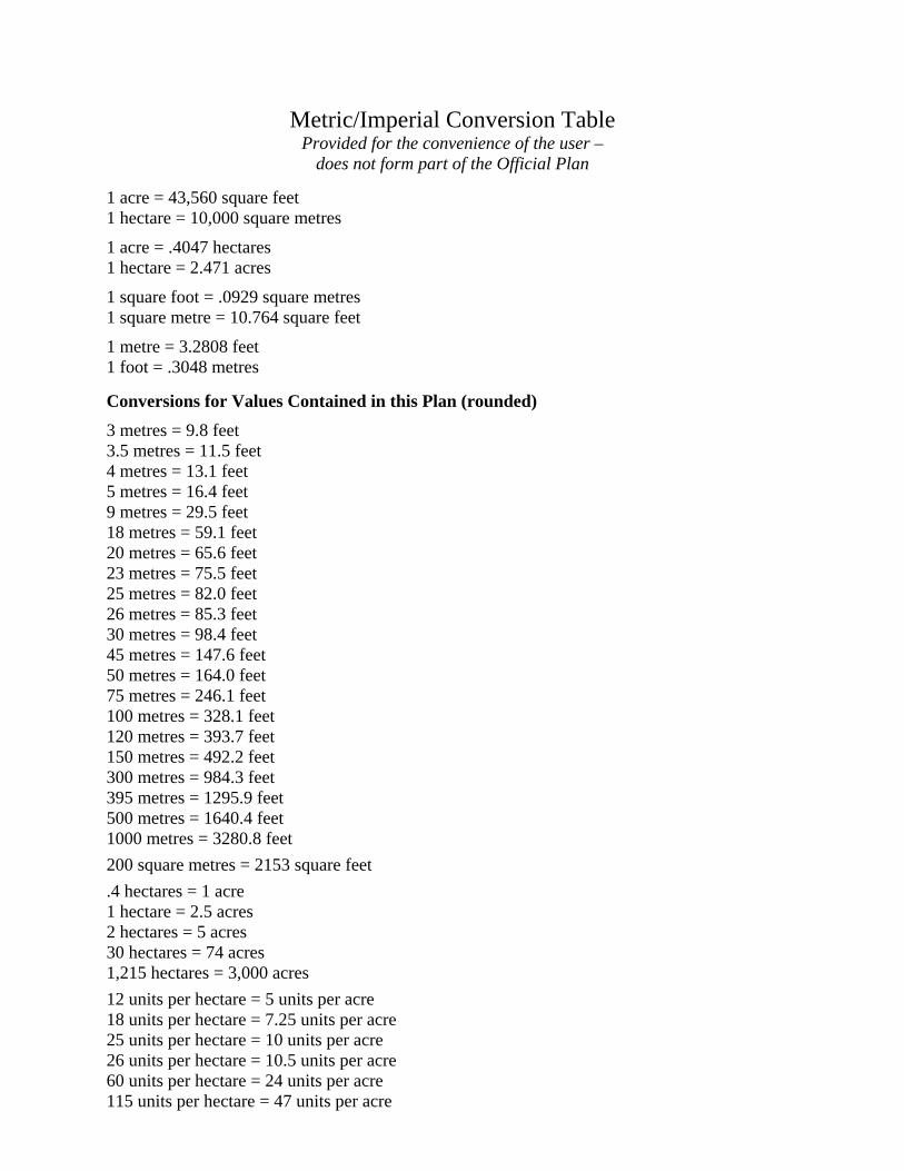
Metric/Imperial Conversion Table
Provided for the convenience of the user – does not form part of the Official Plan
1 acre = 43,560 square feet 1 hectare = 10,000 square metres
1 acre = .4047 hectares 1 hectare = 2.471 acres
1 square foot = .0929 square metres 1 square metre = 10.764 square feet
1 metre = 3.2808 feet 1 foot = .3048 metres Conversions for Values Contained in this Plan (rounded) 3 metres = 9.8 feet 3.5 metres = 11.5 feet 4 metres = 13.1 feet 5 metres = 16.4 feet 9 metres = 29.5 feet 18 metres = 59.1 feet 20 metres = 65.6 feet 23 metres = 75.5 feet 25 metres = 82.0 feet 26 metres = 85.3 feet 30 metres = 98.4 feet 45 metres = 147.6 feet 50 metres = 164.0 feet 75 metres = 246.1 feet 100 metres = 328.1 feet 120 metres = 393.7 feet 150 metres = 492.2 feet 300 metres = 984.3 feet 395 metres = 1295.9 feet 500 metres = 1640.4 feet 1000 metres = 3280.8 feet 200 square metres = 2153 square feet .4 hectares = 1 acre 1 hectare = 2.5 acres 2 hectares = 5 acres 30 hectares = 74 acres 1,215 hectares = 3,000 acres 12 units per hectare = 5 units per acre 18 units per hectare = 7.25 units per acre 25 units per hectare = 10 units per acre 26 units per hectare = 10.5 units per acre 60 units per hectare = 24 units per acre 115 units per hectare = 47 units per acre
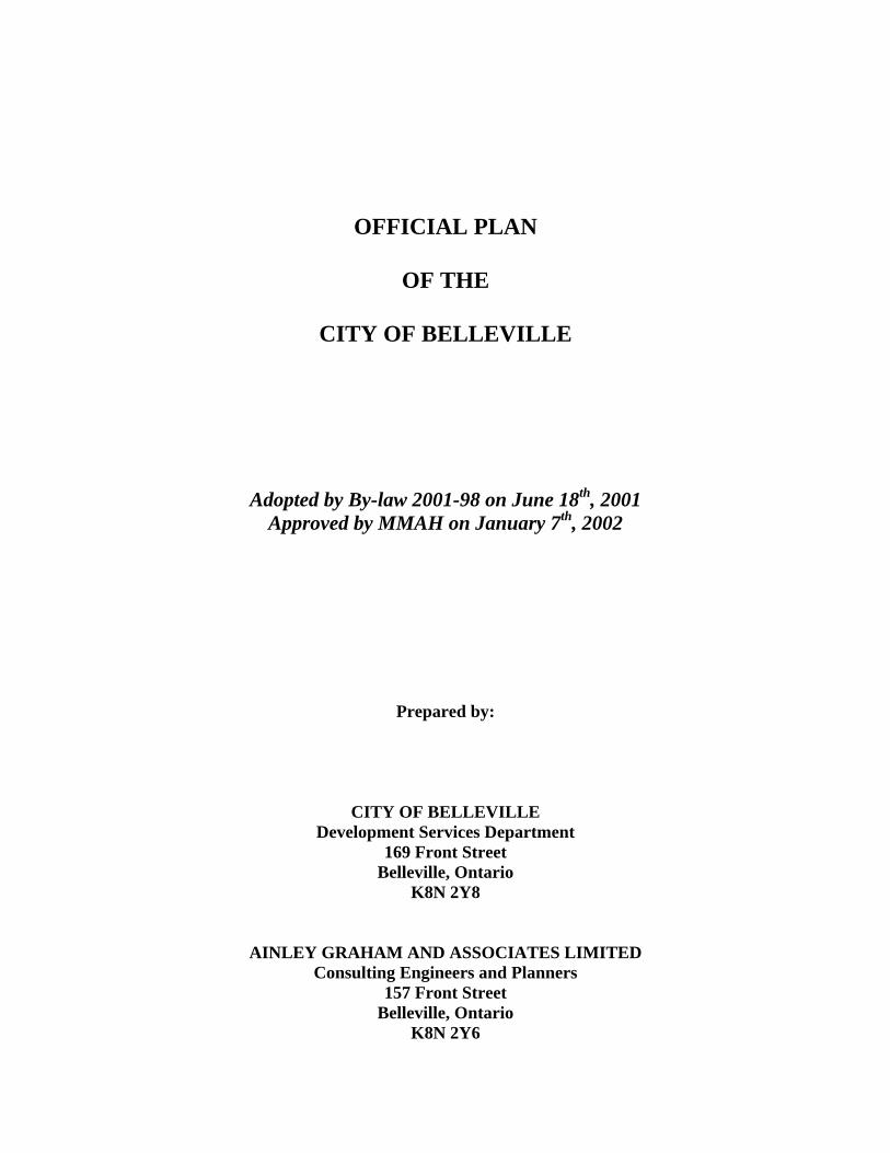
OFFICIAL PLAN
OF THE
CITY OF BELLEVILLE
Adopted by By-law 2001-98 on June 18th, 2001 Approved by MMAH on January 7th, 2002
Prepared by:
CITY OF BELLEVILLE Development Services Department
169 Front Street Belleville, Ontario
K8N 2Y8
AINLEY GRAHAM AND ASSOCIATES LIMITED Consulting Engineers and Planners
157 Front Street Belleville, Ontario
K8N 2Y6

i
TABLE OF CONTENTS PAGE SECTION 1 - ADMINISTRATION.............................................................................................1 SECTION 2 - A VISION FOR THE CITY OF BELLEVILLE................................................2
2.1 Vision Statement ....................................................................................................2 2.2 Interpretation of the Vision Statement ................................................................2
2.2.1 The Future of the City of Belleville.............................................................3 2.2.2 Environmental and Physical Resources .......................................................3 2.2.3 Growth Pressures .........................................................................................3 2.2.4 Settlement Patterns.......................................................................................4 2.2.5 Economic Development...............................................................................4 2.2.6 Agriculture ...................................................................................................5 2.2.7 Tourism........................................................................................................5 2.2.8 Commerce and Industry...............................................................................6 2.2.9 Social Needs.................................................................................................6 2.2.10 Linkages.......................................................................................................7
2.3 Conclusion ..............................................................................................................7 SECTION 3 - LAND USE POLICIES.........................................................................................8
3.1 Hamlet.....................................................................................................................9 3.1.1 Residential Policies......................................................................................9 3.1.2 Commercial and Industrial Policies .............................................................9 3.1.3 Community Facility and Parking Policies .................................................10 3.1.4 Servicing ....................................................................................................10
3.2 Agricultural Land Use.........................................................................................10 3.2.1 Permitted Uses ...........................................................................................11 3.2.2 Policies.......................................................................................................11
3.3 Rural Land Use ....................................................................................................13 3.3.1 Permitted Uses ...........................................................................................14 3.3.2 Agricultural Policies ..................................................................................14 3.3.3 Residential Policies....................................................................................14 3.3.4 Rural Commercial/Industrial and Outdoor Recreation Policies ................15 3.3.5 Natural Areas .............................................................................................16
3.4 Recreation Commercial Land Use .....................................................................16 3.4.1 Permitted Uses ...........................................................................................16 3.4.2 Policies.......................................................................................................17
3.5 Environmental Protection...................................................................................18 3.5.1 Floodplains.................................................................................................18 3.5.2 Steep Slopes and Other Hazardous Lands .................................................20 3.5.3 Significant Wetlands and Habitat of Endangered/Threatened Species......21 3.5.4 Areas of Natural and Scientific Interest (ANSIs) ......................................21 3.5.5 Woodlands, Valley-lands and Fish and Wildlife Habitat ..........................22
3.5.6 Environmental Impact Studies and Natural Heritage Study ......................23 3.6 Open Space ...........................................................................................................24
3.6.1 Permitted Uses ...........................................................................................24
ii
3.6.2 Policies.......................................................................................................24 3.7 Mineral Aggregate ...............................................................................................26
3.7.1 Permitted Uses ...........................................................................................26 3.7.2 Policies.......................................................................................................26
3.8 City Centre ...........................................................................................................28 3.8.1 Permitted Uses ...........................................................................................28 3.8.2 General Development Policies...................................................................29 3.8.3 Heritage......................................................................................................30 3.8.4 Parking .......................................................................................................31 3.8.5 Pedestrian Circulation................................................................................31 3.8.6 Community Facilities and Public Lands ....................................................31 3.8.7 Urban Design .............................................................................................32 3.8.8 Station Street Area .....................................................................................33 3.8.9 Bayshore Area............................................................................................33
3.9 Commercial Land Use .........................................................................................34 3.9.1 Policies Applicable to All Lands Designated Commercial .......................34 3.9.2 Bell Boulevard Area ..................................................................................35 3.9.3 Bayview Mall/Dundas Street East Corridor ..............................................36 3.9.4 Dundas Street West Corridor .....................................................................37 3.9.5 North Front/Highway 62 Corridor .............................................................37 3.9.6 All Other Lands Designated Commercial Land Use .................................39
3.10 Residential Land Use ...........................................................................................39 3.10.1 Permitted Uses ...........................................................................................40 3.10.2 Residential Policies....................................................................................40 3.10.3 Non-Residential Policies............................................................................44
3.11 Community Facility .............................................................................................45 3.11.1 Permitted Uses ...........................................................................................45 3.11.2 Policies.......................................................................................................46
3.12 Industrial Land Use .............................................................................................47 3.12.1 Permitted Uses ...........................................................................................47 3.12.2 Policies.......................................................................................................48
SECTION 4 - SPECIAL POLICY AREAS...............................................................................51
4.1 Special Policy Area #1 - Bayshore Planning Area ............................................51 4.1.1 Policies.......................................................................................................51
4.2 Special Policy Area #2 - The Hamlet of Point Anne .........................................53 4.2.1 Policies.......................................................................................................53
4.3 Special Policy Area #3 - Corbyville Village .......................................................54 4.3.1 Permitted Uses ...........................................................................................54 4.3.2 Residential Policies....................................................................................54 4.3.3 Commercial and Industrial Policies ...........................................................55 4.3.4 Community Facilities, Open Space, and Recreation Use Policies.............55 4.3.5 Servicing and Site Conditions....................................................................56 4.3.6 Urban Design and Heritage Policies ..........................................................57
4.4 Special Policy Area #4 - Loyalist Planning Area...............................................57 4.4.1 Land Use Policies ......................................................................................57 4.4.2 Transportation Policies ..............................................................................58

iii
4.4.3 Municipal Servicing Policies .....................................................................59 4.4.4 Railway ......................................................................................................60
4.5 Special Policy Area #5 - Cannifton Planning Area ...........................................60 4.5.1 General.......................................................................................................60 4.5.2 Residential Land Use Policies ...................................................................61 4.5.3 Commercial and Industrial Land Use Policies...........................................61 4.5.4 Community Facility and Open Space Policies...........................................62 4.5.5 Transportation Policies ..............................................................................62 4.5.6 Municipal Servicing Policies .....................................................................63
SECTION 5 - SERVICING POLICIES AND UTILITIES .....................................................65
5.1 Access to Public Roads ........................................................................................65 5.2 Municipal Sanitary Sewer and Water Systems.................................................65 5.3 Private Individual Water and Sewage Treatment Services .............................66 5.4 Communal Services .............................................................................................66 5.5 Stormwater Management....................................................................................67 5.6 Private Utilities.....................................................................................................68 5.7 Telecommunication Facilities .............................................................................69 5.8 Educational Facilities...........................................................................................69 5.9 Pipelines ................................................................................................................70 5.10 Other Services and Facilities...............................................................................71
SECTION 6 - TRANSPORTATION POLICIES ....................................................................72
6.1 Roads.....................................................................................................................72 6.1.1 Provincial Highways..................................................................................72 6.1.2 Municipal Roads ........................................................................................72 6.1.3 Functional Road Classification ..................................................................73 6.1.4 Design Criteria ...........................................................................................75
6.1.5 Road System Plan ......................................................................................76 6.2 Road Widening.....................................................................................................77 6.3 Parking and Loading Facilities...........................................................................78
6.3.1 Parking Facilities .......................................................................................78 6.3.2 Loading Facilities.......................................................................................79
6.4 Railways ................................................................................................................80 6.5 Trails and Pedestrian/Cycling Systems..............................................................80 6.6 Public Transit .......................................................................................................81 6.7 Air Transportation...............................................................................................82
SECTION 7 - GENERAL DEVELOPMENT POLICIES ......................................................83
7.1 Community Improvement Policies.....................................................................83 7.2 Subdivision of Land .............................................................................................84
7.2.1 Policies Respecting Subdivision of Land -- All Designations...................84 7.2.2 Plans of Subdivision vs. Consents .............................................................86 7.2.3 Special Policies for Consents in Areas Designated Agricultural ..............87 7.2.4 Special Policies for Consents in Areas Designated Rural Land Use .........88
7.3 Group Homes .......................................................................................................89 7.4 Cultural Heritage and Archaeological Resources.............................................89

iv
7.4.1 Cultural Heritage Resources ......................................................................90 7.4.2 Archaeological Resources..........................................................................90 7.4.3 Protection of Resources .............................................................................91
7.5 Home Occupations ...............................................................................................91 7.6 Urban Design........................................................................................................92
7.6.1 Tree Planting and Landscaping..................................................................92 7.6.2 Municipal Services.....................................................................................93 7.6.3 Public Art ...................................................................................................93 7.6.4 Architecture and Site Design .....................................................................93 7.6.5 Services for the Physically Disadvantaged ................................................94
7.7 Noise and Vibration Abatement and Attenuation ............................................94 7.8 Hazardous Uses and Contaminated Lands .......................................................96
7.8.1 Salvage Yards ............................................................................................96 7.8.2 Waste Management Sites...........................................................................96 7.8.3 Contaminated Lands and Brownfield Sites................................................98
7.9 Non-Conforming Uses .........................................................................................99 7.10 Wayside Pits and Quarries................................................................................101 7.11 Open Space System............................................................................................101
7.11.1 Parks System Plan....................................................................................101 7.11.2 Standards for the Dedication of Parkland ................................................102 7.11.3 Recreation Facilities on Private Lands ....................................................103
7.12 Water Resources ................................................................................................104 7.13 Tourist-Related Development ...........................................................................105 7.14 Energy Conservation .........................................................................................105 7.15 Housing Policies .................................................................................................106
7.15.1 Supply of Residential Lands ....................................................................106 7.15.2 Housing Renewal and Innovation............................................................106 7.15.3 Affordable and Special Needs Housing...................................................107 7.15.4 Housing Intensification............................................................................107
SECTION 8 - IMPLEMENTATION.......................................................................................108
8.1 Land Use Control By-laws ................................................................................108 8.1.1 Zoning By-laws........................................................................................108 8.1.2 Deferred Development Zones and Holding By-laws...............................108 8.1.3 Interim Control By-laws ..........................................................................109 8.1.4 Temporary Use By-laws ..........................................................................109 8.1.5 Special Zoning Provisions .......................................................................110
8.2 Site Plan Control ................................................................................................111 8.3 Sign By-laws .......................................................................................................112 8.4 Property Standards By-laws .............................................................................112 8.5 Sewer Use and Waste Collection By-laws........................................................112 8.6 Heritage By-laws ................................................................................................113 8.7 Other By-laws.....................................................................................................113 8.8 Subdivision of Land ...........................................................................................113 8.9 Capital Works ....................................................................................................114 8.10 Land Acquisition................................................................................................114 8.11 Boards and Committees ....................................................................................114
v
8.11.1 Committee of Adjustment........................................................................115 8.11.2 Business Improvement Area Board of Management ...............................115 8.11.3 Local Architectural Conservation Advisory Committee .........................116 8.11.4 Other Committees ....................................................................................116
8.12 Plans and Plan Review.......................................................................................116 8.12.1 Plans.........................................................................................................116 8.12.2 Plan Review .............................................................................................117 8.12.3 Amendments to the Official Plan.............................................................117
8.13 Procedural Guidelines and Municipal Standards...........................................118 SECTION 9 - INTERPRETATION.........................................................................................119
9.1 General Interpretation ......................................................................................119 9.2 Values and Quantities........................................................................................119 9.3 Land Use Boundaries.........................................................................................119 9.4 Main and Accessory Uses ..................................................................................120 9.5 Definitions...........................................................................................................120


1
City of Belleville Official Plan
SECTION 1 ADMINISTRATION 1.1 Upon approval of the Minister of Municipal Affairs, this Plan will be known as: THE OFFICIAL PLAN OF THE CITY OF BELLEVILLE 1.2 This Official Plan covers all land within the corporate limits of the City of Belleville. 1.3 The attached text and Schedules ‘A’, ‘B’, and ‘C’ constitute the Official Plan. 1.4 Background reports prepared to assist in preparation of this Plan contain supplementary
background information, which is the basis for the policies of this Plan. These reports do not form part of this Plan.
1.5 The Municipality is responsible for administering this Plan. The principal duties of the
Municipality are to review: • applications for development (i.e. severances, subdivisions, zoning amendment
applications, minor variances, site plans) for conformity to this Plan; • applications for amendment to this Plan; and • the policies of this Plan from time to time to ensure its relevancy.
1.6 Pursuant to the Planning Act, no public work shall be undertaken and no by-law shall be
passed for any purpose that does not conform to this Plan. 1.7 The planning horizon for this Plan is the year 2021.

2
City of Belleville Official Plan
SECTION 2 A VISION FOR THE CITY OF BELLEVILLE 2.1 Vision Statement
The City of Belleville is a diverse urban and rural community strategically located on the Moira River and Bay of Quinte, providing the benefits of a high quality of life, a broad range of economic development opportunities, valued natural and cultural heritage amenities and a full range of essential services. The Municipality shall strive to create a balance of economic, social, cultural and natural environments for the development of a well-planned, financially sound community that values its natural and cultural heritage and offers opportunities for its residents to prosper.
The Vision Statement provides the context within which long range planning of the City should occur. It sets out the characteristics of the City of Belleville that make it a great place to live and visit, and provides an image of the City that is desired for the future.
In planning for the future, the Municipality has taken stock of its past and present, as well as the economic and social trends that are occurring in the region and province. Background studies were undertaken and public meetings and workshops were held to determine the type of community desired in the future. To be successful, the Municipality intends to build on its strengths while addressing its weaknesses.
The Vision identifies and directs strategies and planning policies of this Plan to create a diversity of economic development opportunities in balance with the provision of services in a financially sound framework. It recognizes the importance of industry and commerce to the economic structure of the community and the importance that small business and entrepreneurship must play in the City’s future. The Vision recognizes that the City’s location on the Moira River and Bay of Quinte provides natural resources that sustain the community; these resources include productive agricultural lands, ground and surface waters, wildlife habitat, active and passive recreational opportunities and areas of scenic beauty. The Vision encourages a balance in growth through both new development and redevelopment to ensure the most efficient use of the Municipality’s investment in infrastructure. Responsible growth by way of development and redevelopment in all sectors of the City’s economy will be encouraged within the context of the Vision.
2.2 Interpretation of the Vision Statement
There are many elements to the Vision statement that require clarification for a full understanding of the intention of the Council for the City of Belleville.

3
City of Belleville Official Plan
2.2.1 The Future of the City of Belleville The City will continue to build on its primary strength – diversity – that makes it a dynamic community. This diversity includes a mix of urban and rural lifestyles, small and large industrial and commercial business and employment opportunities, a wide array of housing types, and a full range of urban and rural services. Much of this diversity has been made possible due to the broad range of excellent transportation resources available (highway, rail, air, water). Diversity will be enhanced by preserving important elements of the City’s historic landscapes, and by accommodating new trends and technological changes. Through the mix of urban and rural settings and the medium sized scale of the urban area, the City will be attractive for persons seeking an alternative to large urban centres, and for persons relocating for retirement purposes.
The City of Belleville will continue to evolve as the social and cultural centre of a larger region, and will strive to maintain historically shared values. These values include a strong sense of community, a sense of belonging, a tradition of self-reliance, social responsibility, and appreciation of natural and cultural heritage.
2.2.2 Environmental and Physical Resources
The City’s setting on the Moira River and Bay of Quinte is characterized by a diversity of natural features. As settlement pressures have increased, so has the awareness of environmental issues and the need to link economic growth with environmental sustainability. In the past, historic economic activity resulted in damage to or depletion of natural resources and the natural ecosystems of the Moira River watershed and the Bay of Quinte; proper environmental and land-use planning can avoid further damage in the future, and remediation of existing conditions can improve the state of the local environment.
The Bay of Quinte and Moira River watersheds, wetlands, areas of natural and scientific interest, woodlands, fish and wildlife habitats, valleylands, prime agricultural lands, and aggregate resources require careful management. The Bay of Quinte and Moira River watersheds, including both surface and groundwater, are essential sources of water for human use, and provide important recreational and economic development opportunities. The waterways, wetlands, woodlands, valleylands, and related wildlife habitats provide for biological diversity and a variety of recreational opportunities.
Prime agricultural lands are located in the traditionally rural areas of the City, and are required to provide sources of food and of economic activity. Aggregate resources are located in various parts of the community and are necessary to provide needed building materials.
2.2.3 Growth Pressures
The City’s population is projected to increase by 7,500 people by 2021 to approximately 54,000 inhabitants, a growth rate of roughly .7% per year. However, two trends may result in a growth rate up to twice the above rate (leading to a population of approximately 62,000 inhabitants by the year 2021):

4
City of Belleville Official Plan
• the trend towards expansion of smaller urban communities within easy traveling distance to large metropolitan urban centres; and
• the trend towards the City’s expansion as the regional employment and service centre for the Quinte region and areas beyond.
This additional growth can be managed by the Municipality through capital planning to expand infrastructure as necessary and through appropriate amendments to the land use schedules to establish additional serviced development lands.
The Municipality currently has the servicing infrastructure in place to accommodate the anticipated growth. Growth will be accommodated through efficient use of existing serviced land, the logical extension or improvement of services, and appropriate infilling.
In preparing for growth, careful planning and decision-making will ensure the unique and desirable characteristics of the City are not lost in accommodating growth pressures.
2.2.4 Settlement Patterns
The urban service area will be the focus of the majority of future residential growth and non-residential development.
The Hamlets of Foxboro, Plainfield, Latta, Roslin, Halloway, and Point Anne will continue to function as local service centres and accommodate limited growth. The Municipality will provide a range of housing opportunities located primarily in the urban serviced area, but additional limited residential development will be permitted in hamlets and traditional rural areas.
The Municipality will encourage commercial and industrial development in appropriate areas to complement residential development.
Redevelopment activities in the City will result in the on-going restoration of the historic building stock and there will be more emphasis on architecturally blending the new to reflect the old when developing new projects, where necessary.
Settlement in the rural areas will maintain the quality, diversity and character of the rural landscape, and will be directed away from agricultural, environmentally sensitive, hazardous and aggregate areas so as not to create a densely developed and suburbanized countryside. Sustainability of development in rural areas that relies on private services will be considered.
2.2.5 Economic Development
The economic success of the City is due largely to the community’s geographic location within easy travel distance to the Cities of Toronto, Ottawa and Montreal, the U.S. border, and its vicinity to the Bay of Quinte. Among the most important reasons for the City’s prosperity have been and will continue to be the excellent quality of life afforded the City’s residents, the excellent transportation linkages to major markets, and the highly diverse economic base.
Employment opportunities will be provided through a balance of manufacturing, research and development, education, agriculture, tourism, and commercial and industrial uses in

5
City of Belleville Official Plan
areas designated and determined to be best suited for each economic sector. A well-rounded, vibrant community with economic opportunities for people of all ages will be an objective of the Municipality.
Due in part to the fact that the City of Belleville includes the largest urban area in the region, the City will continue to be the centre of economic activity and employment opportunities for the entire region.
In planning for the community, the Municipality will give consideration to the downtown core and industrial areas being defined in whole or in part as enterprise zones. Enterprise zones are defined as areas where land use and development control policies would be strongly oriented towards encouragement for investment, development and innovation, accomplished by employing considerable flexibility in the manner land use and development is regulated.
The Municipality will foster a climate for innovative economic opportunities, with cooperation among members of the community and all levels of government. More non-residential taxable assessment will be promoted to lessen the dependency on existing and future residents. In addition to attempting to attract new commercial and industrial development, the Municipality will encourage existing businesses to expand as a generator of local employment. The Municipality will give due consideration to the residential/non-residential assessment ratio and endeavour to maintain a favourable balance of assessment to ensure a sound economic future for the City, essential to the well-being of all businesses and the residents of the community.
2.2.6 Agriculture
Agriculture will continue to be an important generator of economic activity in the rural sector and is recognized as the foundation for the rural community. In future, there will continue to be a distinct and important rural component to the City. Businesses that support the agricultural sector by adding value to farm products will be encouraged.
An objective of this Plan will be to discourage or prevent unnecessary or inappropriate encroachment or development of incompatible land uses within the immediate vicinity of significant agricultural resources. Farming activities will be encouraged along major transportation routes to enhance the rural atmosphere. Large scale agricultural operations will be required to develop comprehensive waste management plans in order to protect surface and ground waters.
2.2.7 Tourism
There will be a strong tourist demand in the future for the natural, historical and cultural attractions of the City and region. The protection and enhancement of the area’s significant natural, historical and cultural attractions will be the focus of the region’s successful tourism strategy. The Bay of Quinte and Moira River will play important roles in this regard. Tourist support services will be expanded to complement and enhance the attractions of the City.

6
City of Belleville Official Plan
An increased number of recreational facilities and opportunities will be encouraged in many parts of the community to service the leisure needs of the tourists and residents of the City and region.
2.2.8 Commerce and Industry
The commercial service sector comprised of community, business and personal services will be encouraged to expand and diversify. The urban serviced area will be the focus of the majority of future commercial and industrial activity. Expansion of the retail commercial sector will be promoted to expand the City’s primary and secondary market area. The City Centre will be strengthened as a focal point for the City by encouraging the development of a wide variety of compatible land uses with emphasis on retail and office commercial uses and residential projects, the improvement of its urban design and functional characteristics, and diversity through a wide variety of commercial, social and cultural activities.
This Plan will endeavour to ensure the availability of sufficient industrial and commercial land with access to full municipal services and public and private transportation systems in the urban serviced area to meet a wide range of development needs.
2.2.9 Social Needs
The City of Belleville will be a healthy community with a high quality of life for all of its citizens. While the City will offer an attractive location for retirees, it is intended that all age groups will find the City a pleasant and enjoyable environment in which to live.
The well being of the City’s residents will depend upon the effective delivery of: • professional health care services (i.e. a full range of professional medical service
providers, public health programs, emergency care, full service hospital); • affordable and well maintained housing for people of all ages, financial capacity and
levels of independence (single detached homes, multiple residential, home sharing, nursing homes, homes for the aged, etc.);
• health and community services including those that rely greatly on the efforts and donations of volunteers from within the community;
• education that provides skills for healthy living, professional development, self-fulfillment and employment opportunities within the City;
• recreational programs and events that encourage physical activity and social interaction for all age groups;
• cultural programs and activities that offer enrichment and education and that foster an appreciation of the City’s cultural heritage;
• a healthy environment and bio-diversity to be enjoyed by all; and • opportunities for investment to create employment for all ages and abilities, and
services for the local population.
Health care and social services will be community based and accessible; the urban serviced area will serve as a base for the administration of health services.

7
City of Belleville Official Plan
2.2.10 Linkages
The transportation, servicing and communication networks will constitute the primary linkages within the City and also between the City and the region that residents and visitors will utilize. It will be an ongoing goal of the Municipality to minimize the time, distance, economic and energy costs of movement for persons, goods and information within the City while maintaining public safety.
Electronic linkages (fibre optic cabling, digital switching, wireless communication systems, etc.) to assist or encourage businesses, telecommuters, home-based businesses and communication will become more important in the future, and this Plan supports the installation of infrastructure to ensure businesses residents of the City have access to leading-edge technology.
The Bay of Quinte and Moira River corridor will be major elements in the recreation linkages of the City.
The protection of existing and former railway corridors will be encouraged for such potential uses such as communication and utility infrastructure, transportation corridors, and for recreational activities where appropriate.
Air and rail transportation facilities should be protected from incompatible development and enhanced where feasible.
Individual private modes of transportation will continue to be relied upon in the future. Public transportation will be provided to link more densely populated parts of the City with major commercial, industrial and education nodes.
The integrity of the existing Provincial and City road networks shall be maintained and upgraded, and integrated with cycling and walking routes as much as possible.
Within built-up areas, emphasis will be placed on designing facilities that encourage walking. Walking trails that connect shoreline areas, valleys, existing parks or other important physical or man-made features will be developed wherever possible while minimizing impact on sensitive lands.
2.3 Conclusion
The Municipality is committed to realizing its Vision for the future. A strategic and proactive Official Plan will help to achieve this ideal community. The Vision is attainable because it is based upon building from the current strengths of the community, while enhancing other features. The Vision will help the Municipality in guiding and assessing land use changes and development trends in the future.

8
City of Belleville Official Plan
SECTION 3 LAND USE POLICIES The intent of this Plan is to provide for the orderly development of the City within the framework of the Vision Statement. This Plan serves to direct development in such a manner that adjacent land uses are complementary and that activities which are not compatible or which demonstrate conflicting requirements are either separated or the impacts appropriately mitigated. The land use policies contained in this Plan implement the Vision and must be read in conjunction with the following schedules:
• Schedule ‘A’ – Land Use Plan - Rural Area • Schedule ‘B’ – Land Use Plan - Urban Serviced Area • Schedule ‘C’ – Road System Plan
These schedules are attached to and form part of this Plan. Schedules ‘A’ and ‘B’ to this Plan are referred to throughout this Plan as the ‘land use schedules’.
The pattern of land use illustrated on the land use schedules has been established with the intent of providing for future development in keeping with the socio-economic fabric of the City while protecting the natural resource base. In this regard, major land use designations have been identified and related policies for each designation established in this Section of the Plan.
The following designations are shown on the land use schedules, being Schedule ‘A’ - Land Use Plan - Rural Area, and Schedule ‘B’ - Land Use Plan - Urban Serviced Area:
• Hamlet • City Centre • Agricultural Land Use • Commercial Land Use • Rural Land Use • Recreation Commercial Land Use • Environmental Protection • Open Space
• Residential Land Use • Community Facility • Mineral Aggregate • Industrial Land Use
Land uses within the City of Belleville should be developed in accordance with: • the generalized pattern of land uses delineated on the land use schedules of this Plan which
are designated Schedules ‘A’ and ‘B’; • the generalized road system plan as delineated in Schedule ‘C ’; and • the policies contained in the text of this Plan.
9
City of Belleville Official Plan
3.1 Hamlet
Hamlets shown on the land use schedules are locations where limited urban growth outside of the urban serviced area, generally on private and/or communal services, will be encouraged. These areas include the hamlets known as Foxboro, Point Anne, Plainfield, Latta, Halloway, and Roslin. The Hamlet areas are predominantly residential but a variety of commercial, industrial, community facility and recreational/open space uses are also located in the Hamlets. All of these uses will be permitted within the Hamlet designation in accordance with the policies of this Plan.
3.1.1 Residential Policies
a) Residential development within Hamlets should be limited primarily to low density residential uses.
b) Lots should be sufficiently large to accommodate the development on private
water and sewer services unless communal services are provided in which case it should be determined that sufficient capacity exists in the communal system to adequately service new residential development. Where private services are provided, care should be exercised to ensure adequate separation between water supplies and septic systems according to applicable regulations is provided.
3.1.2 Commercial and Industrial Policies
a) Commercial uses permitted in Hamlets may include a wide range of commercial uses that provide services for residents of the Hamlet and the surrounding area, and the traveling public. Commercial development should generally be small-scale and be permitted only along the main roads in the Hamlets. Such uses should be located in groupings as much as possible along the main roads.
b) Light industrial uses permitted in Hamlets should be restricted to uses that do not:
• require large quantities of water; • pose problems for the disposal of wastes; or • create problems from smoke, dust, noise or similar obnoxious features.
c) Commercial and industrial uses should be compatible with surrounding uses, both
existing and proposed, particularly with regard to appearance, traffic generation potential, noise and any other potential nuisance features.
d) The lot size and shape for new commercial and industrial uses should be
appropriate to allow the use and all related accessory uses, adequate ingress and egress, as well as buffering such as fencing, landscaping, and distance separation.
e) Commercial and industrial uses should not be permitted within a Hamlet unless
the lot is sufficiently large to accommodate the development on private water and

10
City of Belleville Official Plan
sewer services with appropriate separation distances between water sources and septic systems, unless communal services are provided in which case it should be determined that sufficient capacity exists in the communal system to adequately service the proposed use.
f) All new commercial and industrial development should recognize and respect the
historical or built heritage of the Hamlet; new development should be compatible with the historical scale, function, aesthetics and streetscape of the Hamlet.
g) Adequate buffering should be provided between the commercial or industrial use
and any adjacent residential areas.
h) Large scale or extensive areas of open storage of goods or materials should be discouraged.
3.1.3 Community Facility and Parking Policies
a) Community facility uses (public and private education facilities, churches, and institutional uses such as medical clinics, fire halls, museums, community centres, libraries, nursing homes, recreation/parks and similar) may be permitted in the Hamlet designation; the policies set out in Section 3.1.2 for commercial uses in Hamlets should be applied to community facilities as appropriate.
b) Adequate off-street parking and loading spaces should be provided for all uses
permitted in the Hamlet designation.
3.1.4 Servicing
a) Provision of municipal sewer and water services in the preferred means of servicing uses within Hamlets.
b) However, the ability of the Municipality to provide municipal services to Hamlets
is limited, and communal services within Hamlets is encouraged by this Plan wherever possible. However, private services may also be considered through a servicing options study.
3.2 Agricultural Land Use
Lands designated Agricultural land use in the land use schedules are areas with a high potential for agricultural production, being lands predominantly comprised of classes 1, 2 and 3 in the Canada Land Inventory (C.L.I.) of Soil Capability for Agriculture, and which have the capacity for agricultural production. It is the principal intent of this Plan to preserve prime agricultural lands to ensure their availability on a long-term basis by protecting such lands from incompatible uses and preventing their fragmentation.

11
City of Belleville Official Plan
3.2.1 Permitted Uses The Agricultural land use designation permits many forms of agricultural activity including the raising and/or growing of crops, animals and fish, poultry, nurseries, market gardens, livestock operations, uses that produce value added agricultural products from the farm operation on the property (i.e. maple syrup production, pick your own operations, and seasonal roadside produce stands); kennels and woodlots are also permitted uses. Agricultural-related tourist commercial (agri-tourism) uses are permitted also. Farm-related residential uses on separate lots are permitted; dwellings accessory to agricultural operation (for the farm owner and family) should be permitted on a farm along with any accommodation facilities required for essential farm employees, but nothing in this policy should be construed as encouraging or allowing for the subsequent severance of any such accessory dwellings. Residential infilling may be permitted as outlined in Section 7.2.3 d) of this Plan.
Also permitted are farm-related commercial and farm-related industrial uses that are small in scale and directly related to the farming operation and required to be in close proximity to the farming operation such as a feed mill, seed cleaning facility, agricultural produce warehouses, abattoirs, or other similar agri-business.
3.2.2 Policies
a) All development will comply with the minimum distance separation formulae established by the Province in order to minimize odour conflicts between livestock facilities and development.
b) In concert with the policies of the Conservation Authority or any Provincial
policy, regulation or guideline that may be established, the Municipality may pass a by-law to require a nutrient management plan for livestock or other agricultural waste prior to permitting the expansion or establishment of large or intensive livestock operations and/or facilities.
c) Farm-related commercial and industrial land uses should generally be encouraged
to consolidate into groups within or adjacent to Hamlets or existing clusters of similar uses or in areas of lower quality agricultural land. In determining appropriate locations for such uses, regard should be given to: • whether the proposed use is directly related to the farm operation and required
in close proximity to the farm operation; • the compatibility of the proposed use with surrounding land uses; • the siting and design of the use so as to ensure the provision of adequate off-
street parking and loading facilities, appropriate setbacks, landscaping and buffering, and ensuring any lighting or signs are arranged so as to blend in with the character of the area; and
• whether the proposal is located so as to minimize loss of agricultural land.
Farm-related commercial and farm-related industrial uses that are not directly related to the farm operation and not required in close proximity to the farm

12
City of Belleville Official Plan
operation will be directed away from lands designated Agricultural land use, and encouraged to locate in Hamlets or in areas designated Rural, Industrial or Commercial land use.
d) Agri-tourism may be permitted on active farms provided the use:
• will not result in the loss of agricultural land; • will be compatible with agricultural operations on the subject and adjoining
lands; and • can be accommodated on private services.
Such uses may include accommodations (such as bed and breakfasts) in an existing farm dwelling, retail farm produce outlets, and special events related to the business of agriculture of a temporary nature.
e) Operators of agricultural uses are encouraged to undertake environmental
management planning to: • minimize contamination risks to surface and ground water; • protect and enhance wildlife habitat in woodlots, fence-rows, and adjacent
watercourses and wetlands; and • protect and enhance the agricultural capability of the land.
f) Within areas designated Agricultural land use, drainage courses and streams,
municipal drains, woodlots and small wetland areas exist. This Plan encourages the use of good land and resource management practices to ensure that such resources are protected; fencing of streams to prevent bank erosion from livestock, woodlot management to encourage healthy tree growth, maintenance of wetland areas which enhances water quality are examples of the types of initiatives supported by this Plan. The Environmental Protection policies of this Plan should be applied to the most significant of such areas within lands designated Agricultural land use.
g) Small parcels of non-productive farmland located in areas designated Agricultural
land use (generally lands that are not designated class 1, 2, or 3 land under the C.L.I.) may be used for permitted non-agricultural purposes by amendment to this Plan provided that appropriate conditions exist or can be established to mitigate or eliminate potential conflict between the proposed use and adjacent agricultural operations and the agricultural land base will not be fragmented to such a degree that the area is no longer useful for agriculture.
h) Farm-related residential development permitted within areas designated
Agricultural land use should be subject to the following policies:
i) Residential development should have minimal impact on natural environmental features and the rural character.
ii) The extent of agricultural lands being removed from production should be minimal, and to that end parcels of land which lesser agricultural capacity are preferable for such uses over lands which have higher productive capacity.

13
City of Belleville Official Plan
iii) The natural systems should be adequate to service the residential use.
iv) The residential development should not interfere unreasonably with the normal functioning and the quality of natural features such as drainage courses and wetlands.
v) There should be no unreasonable conflict created due to residential uses being established adjacent to agricultural activities; the Agricultural Code of Practice and minimum distance separation formulae should apply.
vi) There should be safe access to an open publicly maintained road that is designed to accommodate traffic generated by the residential use, generally having at minimum 50 metres of frontage on an open public road.
i) In considering any application to amend this Plan to re-designate Agricultural
lands to any other land use designation, the Municipality will consider whether the proposed development or land use necessitating the amendment: • has demonstrated a need for additional land to be designated to accommodate
the proposed use; • has shown there are no reasonable alternative locations which avoid lands
designated Agricultural land use; and • has shown there are no reasonable alternative locations in the areas designated
Agricultural land use that avoid Class 1, 2 and 3 agricultural soils; impacts from any new non-agricultural uses on surrounding agricultural operations and lands will be mitigated.
Within the Agricultural land use designation, there may be small pockets of land that are marginally productive or of lower priority for agriculture due to their size, shape, topography, soil, drainage and other physical characteristics. However, these physical limitations and site characteristics alone do not merit consideration for an amendment to this Plan to a non-agricultural designation.
j) This Plan encourages the Municipality and the Conservation Authority to monitor
groundwater conditions within areas designated Agricultural land use. 3.3 Rural Land Use
Lands designated Rural land use in the land use schedules are characterized by a rural landscape which reflects the historical relationship between settlement areas and farm and rural community to which the settlement areas provide basic services. Lands designated Rural land use are predominantly comprised of soil classes 4, 5, 6, and 7 according to C.L.I. mapping for agriculture. These rural lands may include areas which have strong intermix of existing non-farm uses, and the agricultural land base may be fragmented to such a degree that it is no longer useful for agriculture. The amount and type of development in the Rural designation should be consistent with maintaining its rural landscape including maintenance of large open space areas.

14
City of Belleville Official Plan
3.3.1 Permitted Uses
Within areas designated Rural land use, a variety of land uses will be permitted including those permitted uses within the Agricultural land use designation, as well as limited residential, commercial/industrial and conservation and small-scale outdoor recreation uses. However, not all land designated Rural land use is appropriate for development; constraints to development or certain land uses include site specific conditions such as exposed bedrock, poor drainage, organic soils, steep and/or unstable slopes, high water table, natural areas, and groundwater recharge or discharge areas.
3.3.2 Agricultural Policies
a) Retention of existing agricultural uses and the establishment of new agricultural uses is encouraged in areas designated Rural land use.
b) The policies of the Agricultural land use designation set out in Section 3.2 of this
Plan with respect to agricultural uses shall apply to such uses within areas designated Rural land use.
3.3.3 Residential Policies
a) While the majority of residential development will be directed to the urban serviced area and Hamlets, lands designated Rural land use may be used for limited low density residential development.
b) Only residential development that has minimal impact on natural environmental
features and the rural character should be permitted. To that end, residential uses in areas designated Rural land use should reflect the character of existing development in the area, and should be encouraged on lots minimum .4 hectares in size with at least 50 metres of frontage on a public street.
Such development may be approved provided that: • there is sufficient capacity in the natural systems to adequately service the
residential use; • the development does not interfere unreasonably with the normal functioning
and the quality of natural features such as drainage courses and wetlands; • the development fully complies with the minimum distance separation
formulae discussed in Section 3.2.2 a) of this Plan; • there is safe access to an open publicly maintained road that is designed to
accommodate traffic generated by the residential development; and • it does not preclude or hinder aggregate extraction in areas designated Mineral
Aggregate (licensed and reserve areas) according to the policies of Section 3.7.2 of this Plan.
c) Estate residential subdivisions within areas designated Rural land use should only
be permitted pursuant to an amendment to this Plan, based on an analysis of: • the quantity and quality of the water supply;

15
City of Belleville Official Plan
• the means by which sewage will be managed; • the necessity and advisability of using communal services; • stormwater management; • the adequacy of roads leading to the development; • the impact upon the character of the rural landscape; • the impact of the development on natural systems; • the need for the proposed development; and • the impact of the development on traditional rural land uses and mineral
resource extraction according to Section 3.7.2 of this Plan.
However, in context with Section 3.4.2 j) of this Plan, for lands in the general vicinity of Highway 37/Harmony Road, potential exists for more intense development, and estate residential subdivisions may be permitted in this area without amendment to this Plan provided that the above issues are considered.
3.3.4 Rural Commercial/Industrial and Outdoor Recreation Policies
a) While the majority of commercial/industrial development would be directed to the urban serviced area and Hamlets, there may be a need for small scale commercial/ industrial development in the Rural area.
b) Rural commercial uses which provide for the basic and immediate needs of the
rural population and of tourists and the traveling public may be permitted as would such uses as small-scale resort and recreation commercial uses, tourist facilities, auction barns, farm related commercial and convenience commercial and other similar uses. Also permitted would be agricultural and food processing plants, including cheese factories, builder’s supply yards, bulk storage yards, contractor yards, transportation terminals, motor vehicle repair garage, saw mill and lumber yard, warehousing and other similar industrial uses; generally such uses would not include heavy water users.
c) Outdoor recreation uses permitted in areas designated Rural land use should be
restricted to small-scale uses such as small seasonal campgrounds and RV parks, small open spaces or parks that provide athletic facilities and passive recreational activities, and conservation areas.
d) The following policies apply to rural commercial and outdoor recreation uses in
areas designated Rural land use:
i) The use should be appropriate for the proposed location and be compatible with surrounding land uses.
ii) Access to uses should be located to avoid creating any traffic hazard, with adequate off-street parking and loading spaces.
iii) The use should be appropriately screened and buffered from adjacent lands with landscaping, fencing and/or distance separation as required.
16
City of Belleville Official Plan
iv) Signage and outdoor storage of goods and materials should not detract from adjoining lands or be out of character with the setting.
v) Appropriate servicing must be provided.
vi) The use does not preclude or hinder aggregate extraction in areas designated Mineral Aggregate (licensed and reserve areas) according to the policies of Section 3.7.2 of this Plan.
vii) It should be determined that no suitable sites to accommodate the use are available within the urban serviced area or Hamlets.
viii)The lands to be utilized for the proposed use will be rezoned as per the Comprehensive Zoning By-law.
3.3.5 Natural Areas
a) Within areas designated Rural land use, drainage courses and streams, municipal
drains, woodlots and small wetland areas exist. This Plan encourages the use of good land stewardship and resource management practices to help sustain natural resources and to ensure that such resources are protected; fencing of streams to prevent bank erosion from livestock, woodlot management to encourage healthy forest ecosystems and rapid tree growth, maintenance of wetland areas which enhances water quality are examples of the types of initiatives supported by this Plan. The Environmental Protection policies of this Plan should be applied to the most significant of such areas within lands designated Rural land use.
b) This Plan encourages the Municipality and the Conservation Authority to monitor
groundwater conditions within areas designated Rural land use.
3.4 Recreation Commercial Land Use
Lands as shown on the land use schedules as Recreation Commercial land use are intended to be used for large scale or space extensive developments and land uses which are geared primarily towards providing recreation or tourism services and resources to visitors to the region, as well as local residents. As the City of Belleville has natural resources and amenities that lend themselves to such development, and since this form of land use can have significant economic benefits for the region, this Plan supports recreation commercial uses outside of the urban serviced area provided natural systems are adequate to support such developments.
3.4.1 Permitted Uses
Uses permitted in areas designated Recreation Commercial land use include golf courses, sports and recreation clubs (i.e. tennis resorts, hunt clubs, soaring clubs, yacht clubs), large-scale campgrounds and recreation parks, theme parks, and other recreation or entertainment uses which are noisy or otherwise could have significant off-site impacts. Residential or hotel developments in combination with and generally ancillary to such uses may be permitted. Resort communities or complexes developed at low densities (in

17
City of Belleville Official Plan
individual or clustered configurations) in concert with significant recreational facilities for residents of the complex would be permitted. Uses permitted in the Rural designation would be permitted within areas designated Recreation Commercial.
3.4.2 Policies
a) The use intended for lands designated Recreation Commercial should be appropriate for the proposed location (i.e. with regard to land base or resource access) and be compatible with surrounding uses. Not all uses allowed within the Recreation Commercial designation may be appropriate for all lands so designated; the natural setting, access, landscape characteristics, servicing options, available municipal services, and similar should be considered prior to determining the appropriateness of any parcel of land for any use allowed in the Recreation Commercial designation.
b) Traffic generated by developments permitted in areas designated Recreation
Commercial can be significant depending on the nature of the use. Main access roads to developments should be adequate to manage the generated traffic volumes and ingress and egress points should be located to avoid creating any traffic hazard. Where needed, necessary upgrades to existing roads that will function as primary access routes to such developments may be required as a prerequisite to such development proceeding.
c) Developments should have adequate off-street parking and loading spaces to
avoid conflict with traffic flow on adjoining roads.
d) Uses permitted in the Recreation Commercial designation should be appropriately screened and buffered from adjacent lands with landscaping, fencing and/or distance separation as required, in keeping with the nature and characteristics of the use being screened and of the adjacent uses.
e) Advertising signage, lighting, and outdoor storage of goods and materials should
not detract from adjoining lands or be out of character with the setting.
f) Certain of the uses permitted in the Recreation Commercial designation can be heavy users of water or producers of waste; unless located adjacent to or in close proximity to the urban serviced area with access to municipal services, use of private or communal services may be required. The impact of such developments on natural systems and the ability of existing natural systems to provide or accommodate the services required should be determined through appropriate studies prior to development being permitted. Such studies shall include a servicing options study to determine the best means of servicing the site. Justification of the location of the new use will be required to ensure that there are no other locations within the municipality where the use could be accommodated on full municipal services. Groundwater quality and quantity should not be significantly impacted by such developments.

18
City of Belleville Official Plan
g) Environmental impacts of recreation commercial development adjacent to any
water (Bay of Quinte or any river or stream) should be appropriately mitigated.
h) Due to the size of development that may be undertaken in areas designated Recreation Commercial, stormwater management is important. The impact of runoff on natural systems and lands downstream of the use should be considered, and as such a stormwater management plan may be required prior to any development being allowed in areas designated Recreation Commercial.
i) Within areas designated Recreation Commercial, drainage courses and streams,
municipal drains, woodlots and small wetland areas exist. This Plan encourages the use of good land and resource management practices to ensure such resources are respected; plantings to prevent bank erosion, woodlot management to encourage healthy tree growth, maintenance of wetland areas which enhances water quality are examples of the types of initiatives supported by this Plan.
j) The Municipality will monitor development and the nature of development
proposals in the Highway 37/Harmony Road area; if it becomes evident that development in this area could become significant, the Municipality should give consideration to appropriate amendments to this Plan and preparation of a secondary plan to guide future change and growth within this area.
3.5 Environmental Protection
The Environmental Protection designation on the land use schedules is intended to define those lands that require special care and regulation due to their inherent natural or physical characteristics. This designation applies to: • natural hazards, being lands or areas that are potentially hazardous to human use or
development; examples include floodplains, steep slopes, unstable slopes or soils and/or unstable bedrock, lands having organic soils, poor drainage or a high water table; and
• natural heritage features and areas, being lands that are important for their environmental and social values and which provide important ecological functions; examples include significant wetlands, significant habitat of endangered and threatened species, significant woodlands and valley-lands, significant wildlife habitat, fish habitat, and significant areas of natural and scientific interest.
3.5.1 Floodplains
a) Floodplain management policies are intended to prevent the loss of life and to minimize property damage. Further, such policies encourage a co-ordinated approach to the use of land and the management of water to protect wildlife and fish habitat. Such lands are designated Environmental Protection on the land use schedules. For purposes of this Plan, a floodplain is defined as:

19
City of Belleville Official Plan
• the area, usually low lying lands adjoining a watercourse including a municipal drain which has been or may be covered by flood waters (generally pursuant to the 100 year storm event); or
• lands adjacent to the Bay of Quinte, Moira River or any other body of water where an engineered flood line has been defined.
b) As only a portion of drainage courses in the community currently have had
engineered flood lines defined pursuant to the 100 year storm event, floodplains may be determined through historical records or visual evidence to determine the probable limits of flooding activity. When new or additional engineered flood line mapping becomes available, the Municipality should amend this Plan if necessary to incorporate the mapping.
Minor changes to the boundary of floodplains illustrated on the land use schedules may be made without amendment to this Plan provided the variation can be justified through appropriate engineering or other analysis acceptable to the Conservation Authority.
Where no floodplain mapping exists, new development may be prohibited within 15 metres of the high water mark of all watercourses. This setback may be reduced if it can be adequately shown that the land is not within a flood hazard area and that all of the requirements of Section 3.5.1 e) have been addressed.
c) No development, including the temporary or permanent placing or dumping of
material of any kind (whether originating on or off site), should be permitted within a floodplain except for flood or erosion control works, shoreline stabilization works, water intake facilities and passive recreational facilities (i.e. trails, boat docking/launching facilities). Uses such as agriculture, forestry, conservation, wildlife management and similar activities may be permitted provided no associated buildings and structures are located in the floodplain. Retention and restoration of natural vegetation is encouraged in floodplains.
d) Where new lots are proposed adjacent to water courses or drainage systems, and
where part of the lot will be located in a floodplain, sufficient land above the flood line upon which to place buildings, yards and services in accordance with the policies of this Plan must be provided.
e) The provisions of Section 9.3 b) of this Plan should be applied as necessary to the
land use schedules to identify the limits of floodplains and establish which lands should be interpreted as being designated Environmental Protection land use.
There are numerous residential and other uses located within defined floodplain areas under this Plan. Such uses may be recognized as permitted uses; the following policies should be applied to existing uses within floodplains:
i) If an existing building or structure within a floodplain is destroyed (unless the destruction is due to flooding) or requires restoration or reconstruction to make it safe, such restoration or reconstruction may be permitted

20
City of Belleville Official Plan
subject to the approval of the Conservation Authority and in accordance with the policies of Section 7.9 of this Plan.
ii) Additions to buildings or structures existing within floodplains or the installation of minor accessory buildings may be permitted provided that: • the flooding hazard can be safely addressed and the work carried out in
accordance with sound engineering and design practices; • new hazards are not created and existing hazards are not aggravated; • no adverse environmental impacts would result; and • uses do not include institutional uses or emergency services, or the
disposal, manufacture, treatment or storage of hazardous substances. Prior to the approval of any such development, the Municipality may require engineering or other studies be prepared to assess the merits of the proposal in accordance with the requirements of the Conservation Authority. Conditions to approval may include the entering into of agreements to ensure that all appropriate actions are undertaken.
3.5.2 Steep Slopes and Other Hazardous Lands
a) Lands with slopes that are too steep to safely accommodate development or which are near their natural angle of repose are designated Environmental Protection to avoid development or use of such lands that might result in risk to humans or property, and to prevent steep slopes from becoming unstable. Generally, no development should be permitted on or immediately adjacent to such areas other than which can be safely managed on the lands. In most instances, uses should be restricted to natural conditions.
b) Other lands that can not safely be developed for human use or occupancy due to
their unstable nature (i.e. areas of organic soils) or man-made environmental constraints (i.e. contamination) are designated Environmental Protection to prevent any development or use that might result in risk to humans or property.
c) If an existing building or structure immediately adjacent to or on a steep slope or
any other hazard is destroyed or requires restoration, such work may be permitted in accordance with the policies of Section 7.9 of this Plan.
d) Development of such areas for an appropriate use, site alteration, or additions to
existing buildings or structures may be permitted provided that: • the hazards can be safely addressed and the work carried out in accordance
with sound engineering and design practices; • new hazards are not created and existing hazards are not aggravated; • no adverse environmental impacts would result; • safe access to such lands is available at all times; and • uses do not include institutional uses or emergency services, or the disposal,
manufacture, treatment or storage of hazardous substances.

21
City of Belleville Official Plan
To that end, the Municipality may require geo-technical and other studies that address the hazardous conditions to be prepared and agreements entered into prior to permitting any such work to proceed. Conditions to approval for development of such areas should ensure that all appropriate actions are undertaken to accommodate the proposed work or development safely.
3.5.3 Significant Wetlands and the Habitat of Endangered and Threatened Species
a) Provincially significant wetlands identified through the provincial wetland evaluation process, and significant portions of the habitat of endangered and threatened species have been designated as Environmental Protection on the land use schedules.
b) No new development within provincially significant wetlands or within
significant portions of the habitat of endangered and threatened species, or the expansion or redevelopment of existing development within such areas (excluding established agricultural activities) shall be permitted. Conservation activities associated with maintaining and restoring wetlands and natural habitats of threatened species are strongly encouraged by this Plan.
c) Development may be permitted on lands adjacent (within 120 metres) to provincially significant wetlands or significant portions of the habitat of threatened or endangered species where it has been or can be demonstrated through preparation of an environmental impact study (EIS) carried out in accordance with Section 3.5.6 of this Plan that there would be no adverse impact on the natural area or ecological functions.
d) Development applications will be reviewed using the best available information on Endangered/Threatened Species location that is available from the Ministry of Natural Resources. This information shall be reviewed in a confidential manner so as not to disclose the location information related to the particular species.
3.5.4 Areas of Natural and Scientific Interest (ANSIs)
a) ANSIs are lands and/or waters containing natural landscapes or features that have been identified by the Province on the basis of significant earth or life science values related to protection, scientific study, or education. The two broad categories of ANSIs are: • earth science areas which include significant rock and fossil locations and
land forms; and • life science areas which include significant landscapes, environments, biotic
communities and native plant life. Together, these areas feature both typical and special areas that support rare,
threatened and endangered species and plant life. ANSIs are designated Environmental Protection on the land use schedules.

22
City of Belleville Official Plan
b) ANSIs should be protected to maintain the integrity, environmental health, social and economic benefits of these significant features.
c) Development and/or site alteration generally should be discouraged but may be
permitted in or adjacent to ANSIs (within 50 metres) where it has been demonstrated through an environmental impact study (EIS) carried out in accordance with Section 3.5.6 of this Plan that the proposed development and/or site alteration would have no negative impact on the natural feature or ecological functions for which the specific area has been identified.
3.5.5 Woodlands, Valley-lands, and Fish and Wildlife Habitat
a) Lands that are included in this classification of Environmental Protection and so
designated on the land use schedules include: • significant woodlands that have a strong influence on the quality of the
environment often providing significant wildlife habitat; • significant valley-lands that exhibit unusual bio-diversity and are important
fish and wildlife habitat; • fish habitat that include spawning grounds and nursery rearing, food supply
and migration areas upon which fish depend directly in order to carry out their life processes; and
• significant wildlife habitat that are important habitat for birds and animals, providing space needed to support their populations.
b) The predominant use of such areas and lands in the vicinity should be related to
conservation to preserve the natural qualities that have warranted designation. However, use of such areas or lands adjacent to these areas (within 50 metres for wildlife habitat, woodlands or valleylands and 30 metres for fish habitat) for other activities or land uses such as residential may be permitted provided that it can be demonstrated through an environmental impact study (EIS) carried out in accordance with Section 3.5.6 of this Plan that no negative impact on the natural features or ecological functions for which the specific area has been identified would occur.
c) The lands located at Ox Point (located on the Bay of Quinte due west of Point Anne) are designated Environmental Protection on the land use schedules due to the unique environmental characteristics in the general area. At the time of adoption of this Plan, there were six existing residences and a large vacant parcel on Ox Point, all accessed by a private road extending westerly from Manley Drive in Point Anne. It is the policy of this Plan that a limited number of residences may be permitted on Ox Point, provided they are located at least 200 metres from the boundary of any licensed quarry and the uniqueness of the area from an environmental perspective is protected.
23
City of Belleville Official Plan
3.5.6 Environmental Impact Studies and Natural Heritage Study
a) The purpose of an EIS is to assess potential negative impacts which may be caused by a proposed development. In terms of developments in or adjacent to Natural Hazards (flooding, erosion, unstable slopes, etc.), the study will assess the potential for loss of life or property. In terms of developments in or adjacent to Natural Heritage features and areas, the study will address potential negative impacts to the features or ecological functions for which the area has been identified (i.e. a provincially significant wetland).
Since an EIS is a site specific determination of potential impacts within or adjacent to certain areas, it does not necessarily guarantee that any development application which is subject to an EIS will be approved.
The scope of an environmental impact study report (an EIS) should be determined by the Municipality in consultation with the Conservation Authority and should consist of: • a description of the proposed development; • information on existing conditions including an environmental inventory of
the subject and adjoining lands; • a description of how the existing environmental conditions will be affected
directly and indirectly; • a description of the actions necessary to prevent change, mitigate or remedy
the effects which might occur as a result of the proposed development; and • a description of any future monitoring and evaluation which may be necessary
to ensure no negative impacts. b) The Lower Moira River has been designated by the Ministry of Natural Resources
as a fish sanctuary for pickerel spawning. Where a development application is submitted on lands adjacent to the Lower Moira River, the Municipality with assistance of the Conservation Authority should consider the impact of such development on the river and if deemed necessary require an EIS; the conclusions of the study should be incorporated into the design of the proposed development.
c) An EIS was completed for Bell Creek in 1995. The lands designated
Environmental Protection in the Bell Creek area may be used for passive open space and recreational activities that result in minimal disturbance to the existing natural vegetation and topography of the area. Uses such as recreational trails, interpretive centres and similar such uses may be permitted.
d) A natural heritage study was underway at the time of adoption of this Plan. While
known significant areas are designated Environmental Protection on the land use schedules, the Municipality should amend this Plan to incorporate the recommendations of the natural heritage study once completed.

24
City of Belleville Official Plan
3.6 Open Space
Lands designated Open Space on the land use schedules apply to areas where the predominant use of land is for significant public outdoor parks and recreation uses. Some privately owned lands that have open space characteristics are also designated Open Space. This land use designation does not define all parkland areas that exist or that would be established within the community; some areas that would qualify as open space are located and are allowed to establish in other land use designations under this Plan.
3.6.1 Permitted Uses
Generally, open space uses would include local or neighbourhood parks, community parks, and regional parks. Parks can also be defined by their primary function, as either active or passive open space; many parkland areas have a combination of both active and passive functions. While the majority of open space lands and facilities would be publicly owned and operated, certain recreational facilities with commercial potential can be owned and operated privately, either in a commercial capacity or as non-profit ventures.
3.6.2 Policies
a) The definitions of the various types of open space provided for within this Plan are as follows:
i) Local or neighbourhood parks are open spaces located usually within residential areas that tend to serve the residents of that area. Uses are usually limited to small parks and playgrounds and include passive and active recreational activities such as outdoor sports fields (soccer or baseball) and children’s playgrounds consisting of fixed play structures, with landscaped or natural open spaces and accessory uses incidental to local recreational uses.
ii) Community parks are open spaces that by reason of their location, access, use or potential for development tend to serve the population of the whole City, or serve a specific purpose for much of the community. Uses usually consist of parks and playgrounds and include passive and active recreational uses such as a wide range of outdoor sports fields, indoor sports facilities, picnic areas, botanical gardens, and landscaped or natural open space areas. Accessory uses such as parking lots, change rooms, concession facilities, and other service uses usually are located in such parks.
iii) Regional parks are open spaces that by reason of their location, access, development or functional use, serve a more extensive population than just the residents of the City. Uses usually consist of large scale parks and playgrounds which include both active and passive uses, and include picnic grounds, exhibition grounds, outdoor and indoor sports facilities, botanical and zoological gardens, and landscaped or natural open space areas which have a regional focus and often cater the needs of visitors to the community. Accessory uses such as parking lots, small retail shops and restaurants, and other service facilities can be found in such parks.

25
City of Belleville Official Plan
Active open space areas consist of facilities where users participate in physical activities (baseball fields, soccer pitches); passive open space consists of space intended for quiet or more leisurely enjoyment (hiking trails and natural areas).
b) Open Space lands along the Bay of Quinte may be used for public or private boat docking, yacht clubs and marina facilities provided such uses do not unreasonably impact natural and man-made amenities of the recreational area within which they are located. When determining the appropriateness of such developments, the Municipality in consultation with the Conservation Authority should consider: • servicing of the site; • existing environment contamination conditions if warranted; • impact on fish and wildlife habitat, and the merits of remediation measures; • impact of development on access to the waterfront by the general public; and • integration of the use with the City’s open space system.
c) Trail development is an important component to the development of an open
space system and the promotion of the community’s quality of life. Trails that connect shoreline areas, valleys, existing parks or other important physical or man-made features should be developed wherever possible but must be planned and designed in such manner that respects the interests of abutting property owners.
To facilitate the development of trails, this Plan encourages the Municipality and the Conservation Authority to acquire rights to or ownership of existing corridors (rail, hydro or other utility) whenever opportunities for acquisition arise.
d) This Plan encourages the establishment of a high quality recreational camping and
RV park site within the immediate Belleville area. Certain lands designated Open Space may have potential for and be appropriate for this use. Prior to permitting such a use on any lands designated Open Space, Council should consider: • servicing of the site, or the capacity of the site to address the impact of
camping from a servicing perspective; • environmental issues; • land use compatibility including visual compatibility; and • access to the site from major transportation corridors.
e) Use of open space areas with the exception of local or neighbourhood open spaces
is dependent upon vehicular access. Points of ingress and egress should be established to ensure safe movement of vehicular traffic on the public street and the subject and adjoining lands, and for pedestrian and cyclist traffic. Further, such uses should have sufficient parking on-site but it is recognized that reduced parking standards may be applied where there is sufficient parking off-site to address needs during times of peak usage.
f) Generally, only buildings and structures necessary to establish and support the
principal use should be established on lands designated Open Space as a means to

26
City of Belleville Official Plan
retain as much of the open character of these lands as possible; this is particularly important when such lands support large indoor facilities such as pools, arenas, and community centres.
g) The visual appearance of all parking lots and service areas in parks should be
enhanced through appropriate landscaping. Appropriate lighting of such areas is required to ensure public safety and to accommodate certain uses; lighting should be oriented away from nearby residential properties as much as possible and from interfering with visibility on nearby public streets.
Parking lots, service areas, and areas of intense outdoor activity should be located to minimize the effects of noise on adjacent residential properties. Measures to mitigate impacts of such facilities on adjoining residential areas (i.e. plantings, fencing, berming and buffer strips, increased setbacks) should be employed as required.
h) All open space areas should have safe pedestrian access and circulation on-site.
3.7 Mineral Aggregate
The lands designated Mineral Aggregate in the land use schedules include sand, gravel and bedrock resources and pits and quarries either licensed or designated as reserve areas by the Ministry of Natural Resources. It is the intention of this Plan to protect wherever possible such resources for aggregate extraction and to ensure that the resources are utilized in accordance with proper controls.
3.7.1 Permitted Uses
In the areas identified as Mineral Aggregate, the principal uses will be pit or quarry operations together with accessory uses such as crushing facilities, recycling of aggregate materials, stockpiles and screening operations. Asphalt plants, ready-mix concrete plants and aggregate transfer stations may be permitted within the land designated as Mineral Aggregate where compatible with adjacent land uses. Within the reserve areas, agriculture and interim land uses such as forestry and outdoor recreation uses may be permitted provided that these do not include buildings or activities that would preclude or hinder the establishment of a pit or quarry.
3.7.2 Policies
a) For the areas designated as Mineral Aggregate, the area to be used for resource extraction and related uses should be located within the boundaries of the designation shown on the land use schedules. Any proposal to expand beyond these limits would require an amendment to this Plan.
b) The concept of influence areas is recognized as a means of protecting against
incompatible land uses in the vicinity of Mineral Aggregate areas, and to protect existing pits and quarries (licensed areas) from encroachment by incompatible
27
City of Belleville Official Plan
land uses. It is the policy of this Plan to discourage incompatible land uses in areas surrounding lands designated Mineral Aggregate and/or from licensed areas. This area of influence is considered generally 300 metres for a pit and 500 metres for a quarry. In these areas, development that would preclude or hinder the establishment of new operations or access to the resources should only be permitted if the: • resource use would not be feasible; or • proposed use or development serves a greater long term public interest; and • issues of public health, public safety and environmental impact are addressed.
c) Generally only licensed pit and quarry operations should be zoned to permit such
uses; reserve areas should be zoned in such a manner so as to protect such lands from incompatible development.
d) Pit and quarry operations that are subject to the Aggregate Resources Act must be
licensed by the Ministry of Natural Resources. Through the licensing procedure, the Municipality may request that conditions be placed on the licence to protect the interests of the community.
e) All pits and quarries should be operated in such a manner so as to satisfy the
requirements of the Ministry of Environment with respect to pumping and dewatering, water supply, waste water, solid and liquid waste disposal, dust and all emissions to the atmosphere including noise and vibrations.
f) Prior to removing a Mineral Aggregate designation from the land use schedules,
justification for the change that clearly demonstrates the need for the alternate land use should be provided. In considering such amendments, the Municipality should consult with the Ministry of Natural Resources and take into account: • evidence provided by the applicant that aggregate extraction is not feasible
due to quality, quantity or other development constraints; • the necessity of the alternate land use in comparison to the necessity of the
mineral aggregate resource; • the reason for the choice of the location and consideration given to alternate
locations on non-aggregate lands; and • the consideration given to the option of sequential land use in which the
mineral aggregate is removed prior to development of land for another use.
g) With the exception of wayside pits and quarries, the establishment of any new pit or quarry outside of areas so designated on the land use schedules will require an amendment to this Plan. In proposing any such amendment, the applicant must provide sufficient information to properly evaluate the proposal including: • the type and location of any neighbouring land uses; • the location of access routes, including the need to upgrade existing roads; • the site plan for the pit or quarry; • assessment of noise, blasting, hydro-geology, drainage, environmental impact,
archaeological conditions, and any other relevant matters.

28
City of Belleville Official Plan
h) In areas where Class 1, 2 or 3 soils predominate on lands comprised of Class 1, 2
or 3 soils according to the C.L.I. of Soil Capability for Agriculture, extraction of mineral aggregates is permitted as an interim use provided that rehabilitation of the site for agricultural use with similar soil characteristics as existed prior to the extractive use being established is carried out; however, complete agricultural rehabilitation will not be required if: • there is a substantial quantity of mineral aggregates below the water table
warranting extraction; or • the depth of planned extraction in a quarry makes restoration of pre-extraction
agriculture capability unfeasible; and • other alternatives have been considered and found unsuitable; and • agricultural rehabilitation in other areas will be maximized.
i) Wayside pits and quarries and portable asphalt plants used on public authority
contracts would be permitted as set out in Section 7.10 of this Plan. 3.8 City Centre
The purpose of the City Centre designation identified on the land use schedules is to encourage the development of a variety of compatible land uses in the City’s core creating as a compact, clean, safe, secure, attractive, accessible and economically stable City Centre. Uses that create or are likely to create impacts that would be contrary to this intent should be discouraged from locating in the City Centre.
Policies for the City Centre are designed to encourage and enhance the downtown core as a major focus of economic activity, create a source of civic identity and pride, and establish the City’s core area as a community landmark. Development should increase the diversity and vitality of the downtown and create a lively and vibrant environment that supports a wide variety of living, shopping, leisure, cultural and working activities. Development that takes advantage of the Moira River is strongly encouraged. It is important also to retain a strong retail sector in the City Centre.
The City Centre is intended to be multi-functional, the business, professional, cultural, entertainment and administrative centre of the City, and the policies of this Plan are intended to attract new investment to the core area to enable it to prosper and grow as the business and administrative centre for the entire region.
3.8.1 Permitted Uses
The uses permitted in the City Centre shall include a broad range of commercial, residential and community facility uses, as follows:
i) Commercial uses, including motels/hotels, conference facilities, restaurants, retail uses, business, professional and administrative offices, marinas, recreational uses, places of entertainment, outdoor cafes and restaurants, private clubs, theatres, all types of commercial services and parking lots.

29
City of Belleville Official Plan
ii) Medium and high density residential uses including seniors’ residences and retirement communities, either as main uses or within mixed use developments.
iii) Community facility uses including private and public schools, places of worship, hospitals, fire halls, police stations, government and administrative offices, assembly halls, libraries, nursing homes, museums, arenas and recreational facilities, day nurseries, parks, and parking and transportation facilities.
iv) Other uses that are in keeping with the policies of this Plan and the principle of the City Centre being a significant enterprise zone within the City.
To provide guidance on how different land uses should be developed in relationship to one another, the Municipality may prepare a more detailed land use plan for the City Centre which would direct different uses to locations best suited to their characteristics and needs, but with reasonable flexibility to avoid discouraging investment in the City Centre.
3.8.2 General Development Policies
a) This Plan encourages the City and the Belleville Business Improvement Area Board of Management (BBIA) to initiate or support programs and projects, either directly or through the efforts of community groups, towards the beautification of the City Centre through enhanced landscaping and improved streetscapes, and the provision of street furniture, lighting and public art.
The Municipality and the BBIA should encourage: • vacant lots in the City Centre to be maintained in an attractive condition
pending redevelopment for a permitted use; and • all store fronts to be maintained in an attractive condition regardless of the
nature of the occupancy of the building. b) Mixed use developments (combination of residential and non-residential uses) are
permitted within the City Centre. In order to encourage increased pedestrian activity and to maintain a traditional streetscape, mixed use development on Front Street between Dundas Street and the Sagonaska Bridge should provide for non-residential uses at street level with residential uses directed to upper floors.
c) Low-profile buildings should be encouraged to locate adjacent to existing low density residential uses located at the edge of the City Centre to achieve land use compatibility. Rehabilitation and conversion of existing structures at the periphery of the City Centre should be encouraged in order to create a transition in land use and built-form from less intense uses at the edge of the City Centre to more intense uses towards the centre of the City Centre.
d) Due to the intensity of development desired for the City Centre, developments should be designed to minimize land use conflict between uses (i.e. noise, lighting, air emissions, activity patterns, character of use, location of outdoor facilities, and scale of buildings).
30
City of Belleville Official Plan
Due to the close proximity of different uses in the City Centre, potential exists for one use that is not managed properly to significantly impact the viability of other nearby uses. The Municipality should employ the mechanisms outlined in Section 8 of this Plan and the provisions of the Liquor Licence Act respecting the issuance, revocation or suspension of liquor licences as necessary to resolve compatibility issues, reduce conflicts and to achieve the objectives of this Plan.
e) Residential uses on lands designated City Centre may be permitted in mixed use developments or as a primary single use on a lot, generally consisting of medium and high density projects. Medium and high density residential uses as defined in Section 3.10 of this Plan should generally be allowed throughout the City Centre except where such development would be incompatible with existing land uses adjacent to the City Centre, subject to the policies of Section 3.8.2 b) of this Plan.
f) This Plan encourages compact, intense development of lands designated City
Centre in order to ensure the core area remains a key focal point in the City. To achieve this objective, buildings that maximize land utility should be encouraged.
Where practical, the massing and height of buildings should respect the heritage value of the immediate area, and a balance between intensity and scale needs to be achieved in many parts of the City Centre. Buildings of more than five storeys in height will be permitted in the City Centre, but building heights should be limited to five or fewer storeys along historic shopping streets to reflect traditional building scales except where: • prevailing conditions exist that render such objective as impractical; or • design is used to achieve integration.
Building heights in the vicinity of City Hall should be restricted to protect the integrity of the clock tower as an important landmark in the City.
g) This Plan encourages the development of strong links of the City Centre to the waterfront and other commercial areas of the City. The Municipality should strive to create gateways to the City core at main vehicular and pedestrian access points.
3.8.3 Heritage
a) In order to maintain and enhance the historical character of the City Centre,
development or redevelopment of lands should be encouraged to reflect the heritage characteristics of the immediate area wherever possible in accordance with the heritage conservation policies of this Plan.
b) Where demolition of significant heritage buildings is proposed, alternatives that
avoid demolition should be investigated by the Municipality with the owner, the BBIA, Heritage Belleville and other interested parties.

31
City of Belleville Official Plan
3.8.4 Parking
a) As parking is important to the success of the City Centre, this Plan encourages provision of public and private parking facilities to meet the needs of all uses in the City Centre. Bicycle parking areas should also be provided as needed. In recognition of the concentration of uses and the frequency of multi-purpose trips to the City’s core, parking standards in some parts of the City Centre may be lower than in other areas of the community.
b) Major new development should be encouraged to provide on-site parking; this is particularly important for residential uses. However, it may not always be practical or appropriate to provide on-site parking due to location or access concerns; in such instances, the cash-in-lieu provisions as set out in Section 8.1.5 b) of this Plan may be employed at the discretion of the Municipality.
3.8.5 Pedestrian Circulation a) Safe and convenient pedestrian circulation is critical to the success of the City
Centre. This Plan encourages: • the maintenance of safe and clean sidewalks along all streets in the City
Centre; • direct access from the main commercial streets in the City Centre with parking
lots; • establishment of attractive links between Front Street and Moira River trail; • adequate lighting of all pedestrian ways in the City Centre for public safety; • use of street furniture (benches, waste receptacles) along pedestrian corridors.
b) To substantially improve pedestrian access from the Bay of Quinte waterfront to
the downtown and to contribute to the beautification of the City Centre, a trail along the Moira River is planned, to be linked with the City-wide trail network including the Trans-Canada Trail to the north. Land required for the walkway not currently owned by the Municipality may be obtained: • as a condition of site plan, subdivision or condominium approval; • as a dedication from private land owners for walkway development as a credit
against future parkland requirements associated with redevelopment; • through donation by private landowners; or • through purchase by the Municipality.
3.8.6 Community Facilities and Public Lands a) The Market Square occupies a central location in the City Centre and the
Farmers’ Market attracts large numbers of shoppers and visitors to the area, providing an outlet for locally produced products and fulfilling an important role in terms of education, social interaction, tourism, and cultural heritage. It provides a venue for cultural/arts festivals and events, and for civic functions. This Plan

32
City of Belleville Official Plan
encourages the enhancement of the Market Square and surrounding community facilities.
b) There is a concentration of publicly owned lands and buildings in the City Centre. The image and identity of the City Centre as the government, administrative and cultural centre for the entire region would be enhanced through the protection, retention, and expansion of these public facilities. This Plan encourages: • retention of public buildings and lands in public use/ownership in the City
Centre for public use unless deemed surplus to the needs of the Municipality and no appropriate community use can be identified;
• Council and the BBIA to encourage senior levels of government to locate government administrative offices and other public facilities which are appropriate in the City Centre; and
• development of the City Centre as a cultural district through location of facilities for the visual and performing arts and a new/expanded library in the City Centre.
c) Council, at its discretion, may acquire any lands within the City Centre under any
procedure permitted by law to achieve objectives for: • redeveloping underutilized or poorly developed and configured lands within
the City Centre, including consolidating lands for resale and redevelopment purposes, either independently or in partnership with land developers;
• resolving environmental contamination issues; • expanding the range and type of appropriate public uses in the City’s core; or • expanding the City’s open space system.
3.8.7 Urban Design
a) In addition to the Urban Design policies set out in Section 7.6 of this Plan, the following urban design guidelines should be considered when undertaking any development or improvement project in the City Centre: • building setbacks from public roads should be minimized except where lands
are required for sidewalks, road widening, safety, or landscaping; • outdoor patios should be encouraged, and ideally located adjacent to
pedestrian corridors; • building entrances should be oriented to streets, parking facilities and the
riverfront walkway; • front yard parking should be discouraged; • electrical servicing should be installed underground wherever possible; • tree planting along roads should include large specimen dense foliage trees
appropriately spaced and clumped planting of mixed species at focal points; • private parking lots should be properly demarcated, landscaped and lighted; • laneways providing access to parking lots should be well lighted; • signs should have regard for the heritage characteristics of the downtown and
be consistent with the scale of the building upon which they are placed;

33
City of Belleville Official Plan
• landscaping and green open space should be provided at appropriate locations as relief from buildings and the concrete and asphalt surfaces; and
• landscaping of the Moira River banks should be undertaken.
3.8.8 Station Street Area
a) The area designated City Centre east of Pinnacle Street along Station Street is used for a variety of residential and commercial purposes. Some of the existing commercial uses are space extensive that may be more appropriate in highway commercial areas of the City. This area also is located adjacent to the Moira River creating an attractive setting for a variety of uses that require such locations.
b) This Plan supports redevelopment of lands within this area for more intensive
commercial and/or residential uses. Mixed use and high density residential projects that take advantage of the area’s strategic location near the heart of the community in an attractive setting along the Moira River should be encouraged.
3.8.9 Bayshore Area
a) The area designated City Centre south of the CP Rail line within the bayshore planning area is unique; land uses are varied and development influenced by many external and internal factors. The area contains a low density residential neighbourhood interspersed with industrial, commercial, and high density residential uses.
As it is intended this area develop with a mixture of commercial, recreation and residential uses, care must be exercised when planning for this area to protect the quality of the existing and future residential community while accommodating redevelopment of underutilized lands and establishment of new uses that take advantage of the area’s waterfront location.
b) Factors that influence development in this area and which should be considered
when planning for this area include: • the close vicinity of the CP Rail line; • the proximity of this area to the City’s sewage treatment plant; • the proximity of this area to the City’s waterfront; • the existing industrial uses in the area; • the extensive open space of Meyers Pier and recreation trails in the vicinity; • the quality of the low density residential neighbourhood; • the potential for new development that caters to tourists and visitors to the
community (a key objective for the bayshore planning area); and • environmental contamination issues.
c) It is not the intent of this Plan that the low density residential areas are to be
displaced with commercial and high density residential uses. Rather, the qualities of these areas should be recognized, and attempts employed when considering
34
City of Belleville Official Plan
new projects to preserve the unique qualities of this area of the City. Vacant lands should be redeveloped for intensive commercial and/or residential uses, and redevelopment of low density uses undertaken in a manner sympathetic to the qualities of the existing residential community. New structures should be sympathetic to the massing and scale of existing uses. The interaction between residential and commercial uses is critical in this area.
Similarly, it is not the intent of this Plan to require existing industrial uses to relocate from this area. Rather, continuation of existing industrial uses is supported by this Plan, but reuse of industrial sites for appropriate commercial, residential or mixed use projects is encouraged.
3.9 Commercial Land Use
The purpose of the Commercial land use designation as illustrated on the land use schedules is to recognize and encourage the concentration of commercial uses into nodes or areas of commercial activity defined by size, function and/or intended market. While there are a number of areas designated Commercial land use throughout the City, there are four distinct areas of major commercial activity located generally within the urban serviced area outside of the City Centre where specific policies are required, as follows: • Bell Boulevard Area • Bayview Mall/Dundas Street East Corridor • Dundas Street West Corridor • North Front/Highway 62 Corridor
Commercial uses often are classified according to the market area to be served. Uses intended to serve the neighbourhood within which they are located are referred to as neighbourhood commercial uses, whereas commercial uses intended to serve the City as a whole are often referred to as community commercial. Large commercial developments or clusters intended to serve an entire region are referred to as regional commercial uses. Uses can also be distinguished by other characteristics – specialty commercial uses are usually geared to very specific market segments, such as tourists. Location is the critical issue for most commercial uses, as it influences function and its ability to penetrate preferred markets; location is closely aligned with ease and convenience of access.
3.9.1 Policies Applicable to All Lands Designated Commercial Land Use
a) Commercial development is dependent upon vehicular access. Points of ingress and egress should be established to ensure safe movement of: • vehicular traffic on the public street; • vehicular traffic on the subject and adjoining lands; and • pedestrian and cyclist traffic along the street.
Further, commercial development should have sufficient parking on-site to meet the needs of customers and staff.
b) The following design policies should be applied to all commercial development:
35
City of Belleville Official Plan
i) Outdoor storage areas for garbage should be fenced or screened from adjacent uses and preferably located away from the public street.
ii) The appearance of parking lots, loading facilities and service areas should be enhanced through appropriate landscaping, with appropriate lighting of such areas to ensure public safety, which should be oriented away from nearby residential properties and not interfere with visibility on public streets.
iii) Loading facilities, parking lots and service areas should be located so as to minimize the effects of noise and fumes on any adjacent residential properties, and where possible, such facilities should be located in a yard that does not immediately abut a residential property, and where they do, measures to mitigate the impact of such a location by fencing or plantings, berming and buffer strips, or increased setbacks should be employed as required.
iv) Facilities for safe pedestrian access and circulation on-site should be provided.
c) Developments adjacent to Highway 401 should ensure that the side of the property facing the highway are developed with a high standard of urban design. Open storage areas and parking and loading areas shall be prohibited from areas facing the highway unless it can be demonstrated that appropriate landscaping and screening to shield the open storage area will not detract from the intended character. All industrial/commercial activities shall be encouraged to locate within enclosed buildings unless it is essential for an activity to locate outdoors, in which case the industrial/commercial use will be suitably screened and buffered from the highway.
3.9.2 Bell Boulevard Area
a) Lands designated Commercial land use in the Bell Boulevard area are suitable for
commercial uses that serve the regional and community markets. As such, it is important that development of these lands be guided by appropriate land use policies to avoid future land use conflicts, traffic congestion and servicing problems, ensuring ease of access and maximizing development potential. The Bell Boulevard area’s role as a major focus of employment and retail activity within the region would be enhanced through development of retail, highway commercial and recreational commercial uses. As a gateway to the community, the image of the Bell Boulevard area should be enhanced through policies emphasizing a high level of urban design, co-ordination of separate developments to function cooperatively, landscaping and efficient traffic circulation.
b) Uses permitted on lands designated Commercial land use in the Bell Boulevard
area should include a wide array of commercial uses, including motels/hotels, conference facilities, restaurants, retail stores, personal service uses, automotive service uses, business, professional and administrative offices, recreational uses, places of entertainment, private clubs, theatres and all types of commercial services and parking lots, which may be developed either in clusters (such as plazas or malls) or on a stand alone basis.
36
City of Belleville Official Plan
c) Developments on specific lots should be co-ordinated as much as possible with
developments on adjacent lands to limit the number of accesses onto roadways to: • ensure safe traffic flow on adjoining streets, and • promote efficient and convenient traffic circulation between uses.
d) Where significant stands of trees must be removed to accommodate new
commercial development, or where sites have limited vegetation, tree planting should be established as part of the development process. Outdoor storage areas should be limited primarily to sales and display areas; where general storage areas are required, such areas should be adequately screened from the public street.
e) Where significant stands of trees must be removed to accommodate new
development, or where sites have limited vegetation, landscaping consisting of tree planting should be established as part of the development process.
f) Within the duration of this Plan, it is anticipated that Bell Boulevard will be
extended westerly to link with Wallbridge-Loyalist Road, and further, the lands through which this road will extend become part of the City of Belleville, necessitating an amendment to this Plan.
3.9.3 Bayview Mall/Dundas Street East Corridor
a) The Bayview Mall/Dundas Street East Corridor, located generally along Dundas Street East east of the City Centre to Haig Road, is a significant commercial area, characterized by a mix of commercial, industrial and low, medium and high residential density land uses, generally geared to service the community.
This area’s role as a focus of employment and retail activity within the region should be strengthened through the consolidation and intensification of existing land uses while maintaining the character of adjacent residential neighbourhoods. Expansion of commercial uses will be permitted on Herchimer Avenue south of Dundas Street to take advantage of the waterfront as a location for public recreational activities. New medium or high density residential uses either as independent uses or in concert with commercial uses would be appropriate also.
b) Uses permitted on lands designated Commercial land use in the Bayview
Mall/Dundas Street East Corridor include motels/hotels, conference facilities, restaurants, retail stores, personal service uses, automotive service uses, business, professional and administrative offices, recreational uses, places of entertainment, private clubs, theatres, community facilities, and all types of commercial services and parking lots.
c) Development of lands located south of Dundas Street East along Herchimer
Avenue should be oriented towards recreation commercial uses to take advantage of the redevelopment of the bayshore as a major public recreational resource area.

37
City of Belleville Official Plan
d) Redevelopment of residential properties located on the north side of Dundas Street East and in the vicinity of Bleecker and Dufferin Streets should be geared to uses that have minimal impact upon adjacent residential areas. Uses such as medical and business offices should be encouraged, but should be allowed through the appropriate assembly of lands to protect the interests of adjacent residential property owners.
e) Development or redevelopment of all lands in the Bayview Mall/Dundas Street
East Corridor for commercial purposes should be designed to minimize adverse impacts on adjacent residential land uses. In this regard, vehicular ingress and egress points should be oriented in such a manner so as to minimize traffic on adjacent residential streets.
3.9.4 Dundas Street West Corridor
a) The Dundas Street West Corridor is located generally along Dundas Street West, generally west of Wilkie Street to the City’s westerly boundary. This area has a mix of commercial uses generally intended to service the community, along with institutional and residential uses.
b) Uses permitted on lands designated Commercial in the Dundas Street West
corridor include motels/hotels, conference facilities, restaurants, retail stores, personal service uses, automotive service uses, business and professional offices, information services, recreational uses, places of entertainment, clubs and theatres, community facilities including senior’s residences, commercial services and parking lots. New medium or high density residential uses either as independent uses or in concert with commercial uses would be appropriate also.
c) Development along the Dundas Street West corridor should be designed in
recognition of the area’s location along a main entry to the City from the west, and to minimize adverse impacts on nearby residential areas.
3.9.5 North Front/Highway 62 Corridor
a) The North Front/Highway 62 Corridor represents the major existing and
developing arterial commercial strip that is intended to serve regional and local markets, as well as provide specialty services for the tourism sector. A variety of commercial land uses, ranging from highway commercial to general commercial and non-retail uses are located in this area.
As the major arterial entrance to the City from the north, it is important that the North Front/ Highway 62 Corridor be as attractive and accessible as possible to both the citizens of Belleville and the traveling public. Therefore, development and redevelopment of this area should focus not only on future land use but also on appropriate urban design policies that address issues such as road width, intersection improvements, ingress and egress, landscaping, signage and services.

38
City of Belleville Official Plan
b) The uses permitted on lands designated Commercial in the North Front/Highway 62 Corridor shall include those commercial establishments offering goods and services which primarily serve the whole of the community’s market area, including business and professional offices, retail commercial uses, assembly halls, places of entertainment, restaurants, hotels and motels, automotive sales and service, personal service uses, community facilities, public uses, recreational uses, either in the form of individual stores or in plazas or clusters.
c) It is important that the Municipality undertake a corridor study as soon as possible for the North Front/Highway 62 corridor to address issues pertaining to land use, traffic flow, servicing of the north end of the corridor, and the manner by which private developments occur along the corridor to ensure the corridor is developed in a safe, attractive and functional manner. This study may be completed in two parts (one south of Highway 401 and one north of Highway 401) due to the different physical characteristics of these areas.
d) This Plan encourages the consolidation of small lots into larger more efficient
development parcels along this corridor to enable developments to more easily and effectively achieve the policies set out in this Plan for this commercial area.
e) Developments should be co-ordinated as much as possible with adjacent uses and
those on the opposite side of the street in order to limit the number of and establish effective locations for accesses onto the roadway to ensure safe traffic flow and to promote efficient traffic circulation between uses.
f) Where possible, parking areas should be located in the rear or side yards in an
attempt to improve the visual appearance of the corridor from the street. g) Outdoor storage areas should be limited primarily to sales and display areas;
where general storage areas are required, such areas should be adequately screened from the public street.
h) While the entire corridor is to be fully serviced in time, the northerly portion of
the corridor is not currently serviced with sewer and water. Some limited development may be permitted in the northerly portion of this corridor without connection to full services provided that natural systems can adequately address the needs of such uses. Care should be exercised to ensure provision is made to connect such uses to full services when available.
i) The existing industrial use (ready-mix plant) located at the north-east corner of
the intersection of Highway 62 and Cloverleaf Drive should be recognized as a permitted use, and the policies of this Plan should not apply to prevent its continuation or future expansion and improvement.
j) Parts of this corridor are under the jurisdiction of the Ministry of Transportation.
Within such areas, development shall take place in accordance with Ministry

39
City of Belleville Official Plan
policies and standards, and developers shall obtain approval prior to development projects being initiated.
3.9.6 All Other Lands Designated Commercial Land Use
a) There are a number of areas designated Commercial land use on the land use schedules aside from those areas described in the preceding sections. These areas should be developed and used generally for commercial purposes in accordance with the following and other applicable policies of this Plan.
b) Commercial uses permitted within areas designated Commercial land use should
be appropriate for the market area the commercial area is best suited or designed to service. Commercial uses which are intended to service the community or regional markets should be directed to areas designated Commercial land use which are readily accessible from the City’s arterial road network; commercially designated areas which are not along major thoroughfares should be limited to uses which cater to neighbourhood needs, or specialty markets. Further, regardless of the commercial area’s function or market orientation, care should be exercised to ensure only uses which address issues of land use compatibility, access, servicing, and related matters are permitted on specific sites.
c) In general, uses to be permitted within areas designated Commercial land use
would include business and professional offices, retail establishments, places of entertainment, assembly halls, restaurants, hotels and motels, personal service uses, automotive uses, community facilities and recreational uses. In some instances, particularly in the vicinity of residential areas, residential uses either as main uses or in concert with commercial development may be appropriate.
However, not every property designated Commercial land use is suitable for all forms of commercial activity; the range of uses permitted within each area designated Commercial land use should be established taking into account: • the nature and extent of the market area that is to be served by the property
and the commercial development; • the nature of abutting land uses and the potential impact of commercial
development upon such uses, and the effectiveness of mitigative measures; • the ease of access to the lands in question from the City’s road system and the
impact of commercial development upon traffic circulation; • the potential and suitability of the location to achieve the market penetration
needed to enable the commercial development to be successful; • servicing implications; and • urban design issues.
3.10 Residential Land Use The purpose of the Residential land use designation as illustrated in the land use
schedules is to define the areas of the City within which the majority of housing development should be established.

40
City of Belleville Official Plan
3.10.1 Permitted Uses Residential development will be permitted at low, medium and high densities with forms
ranging from single family detached dwellings to various types of attached and multiple dwellings, under various forms of tenure (freehold, rental, cooperative, condominium). Specialized housing for groups such as the elderly and the physically and mentally challenged (i.e. lodge-care and nursing homes) would be permitted also.
Certain secondary uses of land of a non-residential nature may be permitted. Such uses would be restricted to those that are compatible with residential uses and which often perform a service function in support of the residential area within which they are located, or otherwise have such a minor impact that location within residential areas is of little or no consequence. Examples would include small convenience retail and service shops and offices, churches, day care centres, branch libraries, and home occupations.
3.10.2 Residential Policies
a) Residential development within areas designated Residential land use should be permitted to occur at various densities within the City to ensure a full range of housing forms at different sizes and styles that meets the needs of all citizens is provided. The densities that are supported by this Plan are as follows:
i) Low density residential uses would normally include one family detached and attached two-family dwellings, developed up to 18 units per hectare gross residential density1 or 25 units per hectare net residential density2.
ii) Medium density residential uses would normally include various types of attached, multiple or cluster housing projects such as row dwellings and small low-profile apartment complexes, developed up to 60 units per hectare net residential density2.
iii) High density residential uses would normally include various types of multiple dwellings such as apartment complexes and stacked townhouses, developed up to 115 units per hectare net residential density2.
The standards set out in these definitions should not be considered firm; circumstances or conditions will exist where the number of dwelling units permitted for a given area of land should be either higher or lower than defined in order to address other policies of this Plan.
Further, it is recognized that for certain forms of specialized housing, traditional forms of dwelling units may not be established, and the issue of density for such housing should be established on the comparative basis of the numbers of persons
1 Gross residential density means the total number of residential dwelling units per hectare of land including all roads, stormwater management facilities, utility corridors, parklands and similar which are necessary to support the residential area. 2 Net residential density means the total number of residential dwelling units per hectare of land excluding all roads, stormwater management facilities, utility corridors and similar which are necessary to support the residential area.

41
City of Belleville Official Plan
intended to reside in the housing complex relative to the size of the land parcel upon which it is to be developed.
b) The type and arrangement of dwellings and densities are important to the
character of the City and specific residential neighbourhoods. Ideally all neighbourhoods should contain a mixture of dwelling types at different densities, but in some cases this is not possible nor is it desirable; some neighbourhoods therefore may consist predominantly of one form of housing whereas other neighbourhoods would have greater variety. Care should be exercised however to not create areas of excessively high densities without ample supply of municipal services and community facilities to meet the needs of such a neighbourhood.
In establishing residential densities for neighbourhoods, Council should consider: • the capacity of servicing systems to adequately handle the traffic, water and
sewage flows, and other services to and from the area once fully developed; • the capacity of schools, parks, and other soft services in the area to adequately
service the neighbourhood; and • the availability of or the ability to provide transit services.
Council may specify a maximum overall density for any residential neighbourhood through policies in this Plan or through a secondary plan.
c) This Plan supports the development of affordable housing, and ideally all
residential neighbourhoods should have a variety of housing types at various levels of affordability. While it is recognized that market forces will determine affordability rates, this Plan encourages Council to establish land use controls that do not preclude the development of a reasonable range of housing options within the community as a whole.
d) When allocating or determining the preferred locations for high density residential
development, Council should be guided by the following principles:
i) The lands should have direct frontage on or immediate access3 to arterial or major collector roads; developments with access only to collector streets should generally be smaller scale.
ii) The main access routes to such developments should not be through areas of low density residential development.
iii) The preferred locations for large scale high density residential developments would be along major arterial streets or at major intersections where access to two or more major transportation corridors is available.
iv) High density residential development should be directed to areas which are adequately serviced with open space and other required community facilities
3 Fronts onto a local street which leads directly to a collector or arterial street but which does not run through significant areas of sensitive land uses leading to the collector or arterial street (i.e. significant areas of low density residential uses).

42
City of Belleville Official Plan
and services, all of which should be of sufficient size to meet the needs of the residents of the housing development.
v) While not a prerequisite, a preferred location for large scale high density residential development would be in close proximity to or adjacent to non-residential land uses which service the residential area (neighbourhood commercial uses, schools, parks, churches).
vi) High density residential development is a preferred housing form to be established immediately abutting a non-residential land use in another land use category, or along very high traffic corridors.
As the potential impact of high density residential uses on adjacent or nearby residential uses can be significant, care should be exercised when determining building heights, setbacks, buffering, and building orientation (fenestrations) to ensure the impact of such development on residential areas of lower density is minimized; however, where unreasonable land use conflict between high density residential development and areas of lower density would be unavoidable, high density residential development should not be permitted. Further, Council should carefully consider the character of a neighbourhood when determining the appropriate locations for high density residential development.
e) When allocating or determining the preferred locations for medium density
residential development, Council should be guided by the following principles:
i) The lands should have direct frontage on or immediate access3 to either an arterial or collector road.
ii) The main access routes to such developments should not be through significant areas of low density residential development.
iii) Where located along collector streets, the preferred locations for medium density residential developments would be at intersections or where access to two or more transportation corridors is available.
iv) Medium density residential development should be directed to areas which are adequately serviced with open space and other required community facilities and services, all of which should be of sufficient size to meet the needs of the residents of the housing development.
v) A preferred location for medium density residential development would be in close proximity to or adjacent to non-residential land uses which service the residential area (neighbourhood commercial uses, schools, parks, churches).
vi) Medium density residential development is a preferred housing form to be established immediately abutting a non-residential land use in another land use category, or along very high traffic corridors.
Care should be exercised to ensure access from medium density housing onto major traffic carriers is provided in a safe manner, and should not be permitted or allowed to be developed in any form where access to the roadway from driveways would create a traffic hazard.

43
City of Belleville Official Plan
f) Low density residential developments should be permitted in all areas designated
Residential land use except in locations where low density uses would not be appropriate. The following principles should be employed by Council to determine the preferred locations for low density residential uses:
i) Low density residential uses should not be permitted in any area where access to the roadway from individual driveways would create a traffic hazard.
ii) Low density residential uses should not be permitted in any area where the impact of adjoining non-residential uses would be excessively disruptive to the quiet enjoyment of the low density residential development.
iii) Low density residential uses are appropriate along arterial streets, but where there is concern about safe and/or efficient traffic movement along the arterial street, or where there is concern of unacceptable impacts on the low density residential development, use of reverse fronting lots should be considered, or where necessary development should be limited to medium or high density residential uses.
g) In considering the appropriateness of residential development, issues of form and
density should be considered separately where necessary (i.e. a medium density form such as a row dwelling complex developed at a low density, or a low density form such as detached dwellings developed in clusters at a medium density).
h) The conservation and rehabilitation of existing housing stock is encouraged by
this Plan in order to maintain the supply of older housing and to preserve the character of existing neighbourhoods. Infill housing should be encouraged in existing neighbourhoods to maximize land utilization and efficiency of municipal infrastructure, provided such development does not detract from the character of the neighbourhood. In some instances, conversion of larger existing residential dwellings into multiple use is warranted provided sufficient parking can be provided and the character of the existing dwelling is not significantly altered.
i) This Plan supports the development of all forms of housing in all forms of tenure,
being freehold, rental, cooperative, and condominium.
Conversion of existing rental dwellings to condominium or freehold is supported by this Plan, provided that prior to granting approval, Council considers: • the appropriateness of the building for such conversion; • site amenities and services; • existing vacancy rates in the community; • timing of the conversion; and • arrangements made for addressing the needs of or the impact upon existing
residents of the building.
j) Where any residential development is proposed to be established adjacent or in close proximity to uses or facilities which could have significant impact on such

44
City of Belleville Official Plan
development (i.e. due to noise, light, or visual impact), Council should ascertain and provide for the most appropriate means of mitigating such impacts, including: • buffering through use of plantings, fencing, berming; • increased setbacks; • solid structural barriers; and/or • architectural design (orientation of building fenestrations). Council may require the preparation of noise and vibration attenuation studies as set out in Section 7.7 of this Plan to ascertain the extent of the potential impact and to identify the most effective mitigative measures.
3.10.3 Non-Residential Policies
a) Commercial uses within areas designated Residential land use should be restricted to uses that cater to the needs of the immediate residential neighbourhood, or which are of a minor nature (similar impact to a comparable residential use). As a guiding principle, such uses should be restricted to areas which are considered appropriate for large scale high density residential development as set out in Section 3.10.2 d) of this Plan. Generally, uses should be: • limited in size to no more than 200 square metres floor area; • compatible with adjoining residential uses; • only permitted in areas which are capable of adequately servicing the needs of
the neighbourhood or otherwise be inconsequential; and • where grouped, generally limited in size to a cluster of no more than three to
four separate uses.
Where commercial development is permitted, site development criteria to be applied should ensure that: • safe access from the public street is provided; • all outdoor storage areas for garbage are fenced or screened from adjacent
uses and preferably located away from the public street; • the visual appearance of the property is enhanced through landscaping; • all exterior lighting is oriented away from residential properties and adjoining
streets; the impact of loading facilities, parking lots and service areas on adjacent residential uses is minimized through fencing or plantings, berming and buffer strips, or increased setbacks;
• safe pedestrian access and circulation is provided on-site; and • the architectural approach recognizes the character of the surrounding
neighbourhood.
Residential uses in combination with such development may be permitted provided both land uses are designed to exist compatibly on the same lot.
b) Institutional and open space uses within areas designated Residential land use
should be restricted generally to uses which cater primarily to the needs of the immediate residential neighbourhood within which they are located; examples would include churches, day care centres, and neighbourhood parks.

45
City of Belleville Official Plan
Institutional uses should be restricted to areas which are considered appropriate for medium or high density residential development as set out in Sections 3.10.2 d) and e) of this Plan, whereas open space uses may be permitted within any area designated Residential land use.
The impact of such uses on adjoining residential uses should be considered and mitigative measures taken to ensure impact on such adjoining uses is not excessive; the site development criteria set out in Section 3.10.3 a) should be applied to such situations.
c) Within areas designated Residential land use, there are numerous existing commercial, quasi-commercial and institutional land uses that typically would not qualify as neighbourhood commercial land uses, including: • the carpet outlet at the corner of Emily and Lingham Streets; • the financial institution and laundry business on the east side of Sidney Street
south of Graham; • children’s aid office and other commercial uses on the south side of Dundas
Street West east of Wilkie Street; • dental and other clinics and child development centre on Bridge Street East; • retail shops on the east side of Sidney Street north of Tracy and on the east
side of Pinnacle Street north of Grove; and • service station at the corner of Cannifton Road and McFarland Drive.
It is the intent of this Plan that any such uses that do not exhibit unreasonable impact upon the surrounding residential areas should be recognized and given reasonable opportunity for change of use and redevelopment in accordance with the Commercial land use policies of this Plan.
3.11 Community Facility
The purpose of the Community Facility designation as shown on the land use schedules is to recognize the most significant community or institutional uses located throughout the community, generally within areas predominantly used for residential purposes. This land use designation does not define all establishments that would qualify as community facilities or institutional land uses; institutional uses are located in, and are allowed to establish in a number of other land use designations established by this Plan.
3.11.1 Permitted Uses
The predominant uses of the land in areas designated Community Facility are uses which exist for the benefit of the residents of the community and which are operated for the most part by the City, senior levels of government, school boards, non-profit organizations such as church groups and public service agencies. The uses permitted would include education facilities including public, separate and private schools (including staff and student housing), churches, cemeteries, hospitals, fire halls, day nurseries, police stations, libraries, museums, galleries, theatres, community centres, service clubs, banquet halls, nursing homes, homes-for-the-aged, parks and playgrounds,

46
City of Belleville Official Plan
and similar uses. It is recognized however that not all areas so designated are appropriate for all forms or types of community facility uses. Also, commercial uses may be permitted where accessory, incidental or complementary to the community facility use.
3.11.2 Policies
a) Uses permitted in the various areas designated Community Facility should be
defined according to: • the function for which the area is designated; • the nature of access to the subject lands; • the servicing limitations of the subject lands; and • the nature of adjoining lands uses and the potential for land use conflict.
Facilities should be located where they are capable of adequately servicing their principal user groups and on lots which are adequately sized to accommodate buildings, parking, and landscaping.
Where lands designated Community Facility are located in predominantly residential areas, residential uses may be permitted where it has been determined: • there are no appropriate government or other institutional uses apparent for
such lands; and • the residential land use is appropriate in keeping with the policies of Section
3.10 of this Plan. b) Development of the majority of institutional or public facility uses is dependent
upon vehicular access to function properly. Points of ingress and egress should be established to ensure safe movement of: • vehicular traffic on the public street; • vehicular traffic on the subject and adjoining lands; and • pedestrian and cyclist traffic along the street.
Further, such uses should have sufficient parking on-site but a reduced parking standard may be applied where there is sufficient parking off-site to address the needs of such establishments during peak usage periods.
c) This Plan encourages the joint or multiple use of community facilities to provide
the most efficient and effective use of physical resources in the community. This Plan also encourages grouping of community facilities to maximize use of related services and to provide convenience to the public.
d) The visual appearance of all parking lots and service areas should be enhanced
through appropriate landscaping. Appropriate lighting of such areas is required to ensure public safety; lighting should be oriented however away from nearby residential properties and from interfering with visibility on public streets.
Parking lots, service areas and outdoor activity areas should be located so as to minimize the effects of noise and fumes on nearby residential properties. Measures to mitigate the impact of such facilities on adjoining residential areas by

47
City of Belleville Official Plan
fencing or plantings, berming and buffer strips, or increased setbacks should be employed as required.
e) Community facilities should provide for safe pedestrian access and circulation on-
site, and provide, as necessary, facilities such as bus drop-off areas and outdoor pedestrian crush spaces which do not conflict with vehicle movements.
f) The exhibition grounds located north of Bridge Street along Sidney Street have
potential for redevelopment. The size of this site restricts expansion of large scale exhibition and similar activities, and relocation of the exhibition grounds to larger and more appropriate lands is supported by this Plan.
g) Not all lands that are required to accommodate community facilities are so
designated in this Plan. Community facilities that are essential to accommodate development of the community, such as storm water management ponds, pumping stations, and utility sub-stations would be permitted in all land use designations under this Plan except in areas designated Environmental Protection.
h) The City’s sewage treatment plant is designated Community Facility. Uses that
are sensitive to odours from the plant (i.e. residential) should be discouraged from locating within 150 metres of the plant, although a 100 metre separation may be considered where mitigative steps have been incorporated into development plans.
3.12 Industrial Land Use
Areas designated Industrial land use on the land use schedules are intended to serve as the major concentrations of industrial activity and employment in the City. Industrial areas are considered to be the City’s major enterprise zones, and the policies of this Plan are intended to provide flexibility to enable firms to respond quickly to changing economic conditions. General industrial uses may be large or small scale and may or may not be in enclosed buildings, and are usually incompatible with non-industrial uses. Service industrial uses are generally located within enclosed buildings with limited outdoor storage and do not produce levels of noise, dust or odours characteristic of general industrial uses which can be detected off-site.
3.12.1 Permitted Uses
Uses permitted in areas designated Industrial land use include activities associated with the manufacturing, assembling, fabricating, packaging or processing of goods and services, including transportation/truck terminals, warehouses, railway uses, and other similar uses. Other compatible uses such as commercial uses accessory to industrial uses, commercial uses which primarily serve the industrial area, wholesale establishments, office uses, equipment rental uses, data processing establishments, other quasi-industrial, service or business uses such as automotive services uses and utility or service companies, and commercial uses which require large sites for storage are permitted.

48
City of Belleville Official Plan
Unless otherwise provided, retail uses that do not service the industrial area or do not have characteristics that warrant a location in an industrial area should not be permitted.
3.12.2 Policies
a) This Plan encourages diversification of the types and sizes of industrial activities in the City. Industrial uses should be permitted on lots of all sizes; for each lot, there should be sufficient area provided to accommodate buildings, parking and loading areas, and landscaping. Uses may be permitted either as a single use on a lot or in concert with other uses on the same lot, such as industrial malls or plazas.
b) Certain lands designated Industrial land use are located immediately adjacent to
residential areas or land uses that can be sensitive to the impacts of industrial activity. In such areas, the range of uses should be limited to service industrial uses which are less likely to cause significant off-site impacts.
Industrial uses considered obnoxious may be prohibited from being established in the community, or alternatively may be directed to areas that are secluded and located considerable distance from areas that may be impacted by such uses.
c) Where industrial development is proposed adjacent to lands designated or used
for sensitive land uses such as residential development, the Municipality should determine, using the Ministry of Environment’s guideline on compatibility between industrial facilities and sensitive land uses, the separation distances or mitigative measures that should be employed to reduce the potential of land use conflict. Separation distances may vary depending upon the nature of the proposed industrial use and the sensitive land use.
Where an existing industrial land use is located in close proximity to sensitive land uses, the Municipality should encourage the establishment of mitigative measures to reduce the impact of the industrial use on adjoining land uses (i.e. fencing, landscaping, berming, limited building fenestrations oriented towards the sensitive land uses). The Municipality should attempt also to protect such industrial uses from further development of incompatible land uses in close proximity to the industrial use that would increase the degree of incompatibility, and employ appropriate mitigative measures (i.e. setbacks, berming, screening and landscaping, fencing).
d) Dry industrial uses may be permitted without connection to full municipal
services (sanitary sewer and water) where it can be demonstrated that such a use can be appropriately developed without connection to full municipal services; care should be exercised in such situations to ensure adequate road access and soft services (i.e. police and fire protection) can be provided to the development.
Generally, this would only be employed to accommodate small enterprises or space extensive uses (i.e. trucking depots or storage yards, recycling uses, and contractors yards), and similar, where such uses do not require access to full

49
City of Belleville Official Plan
services, and where municipal services are not yet available and are not intended to be extended to such lands in the immediate future.
e) All industrial uses should meet the guidelines and requirements of the Ministry of
Environment with respect to solid and liquid waste disposal and all emissions to the environment.
f) Adequate off-street parking should be provided to accommodate employee
parking requirements. Adequate off-street loading facilities should also be provided. Outdoor storage areas should be appropriately buffered from adjacent roads and properties that may be impacted by such areas through use of landscaped strips, plantings of trees, and berming.
g) Small and isolated parcels of land designated Industrial land use located in
predominantly residential areas may be redeveloped for residential purposes in accordance with the policies of Section 3.10 without amendment to this Plan provided that prior to such development being permitted, Council determines that: • should industrial use remain, land use conflicts could be unreasonably
disruptive to the enjoyment of the residential area; and • environmental contamination issues (if any) have been or will be resolved to
the satisfaction of the Municipality in accordance with guidelines established by the Ministry of Environment.
h) General commercial, and convenience or service commercial uses may be
established within areas designated Industrial land use to provide services to workers within the industrial areas of the City and to those who may be passing through, provided that such developments are generally limited in scale and do not detract from the general purpose of such areas to provide for intensive industrial activities.
i) The lands located in the industrial area west of Sidney Street along Bell
Boulevard are designated an enterprise zone as defined in this Plan, wherein a broad range of uses (including certain compatible commercial uses) may be permitted in addition to industrial uses.
j) Within certain areas designated Industrial land use that have not yet been
developed, natural drainage courses, wetlands and natural areas exist. When development of these areas is proposed, this Plan encourages the retention of such areas in their natural state. However, where site modification is necessary, steps to mitigate environmental impacts of developing such areas should be incorporated in development plans; new planting areas, engineered wetlands, and naturalized drainage courses are among the options that should be considered.
k) Certain of the lands designated Industrial land use are used for railway purposes,
either as rail corridors, spur lines or marshalling yards, together with maintenance
appe
aled

50
City of Belleville Official Plan
and support uses. The following policies apply to areas designated Industrial land use which are used for railway purposes:
i) Railway corridors should be buffered from adjacent non-compatible land uses as much as possible through such measures as landscaped strips, berms, plantings of trees, and fencing.
ii) Care should be exercised at all level crossings to maintain good sight lines to protect public safety and to enable rail operations to continue with as much security as possible.
iii) As railway corridors and marshalling yards are a major source of noise and vibration, the policies of this Plan set out in Section 7.7 should be applied in new developing areas where development that may be subject to the impacts of rail operations is proposed in close proximity to railway lands.
iv) Should any railway corridor be abandoned, the Municipality should endeavour to acquire the right-of-way or otherwise assure its protection as an open space corridor for such activities as recreation trails, service corridors, and transportation linkages. Where no appropriate use for an abandoned rail corridor is determined and acquisition of the corridor by the Municipality is not undertaken, the rail corridor may be used for uses consistent with adjoining land use designations in this Plan without amendment to this Plan.
appe
aled

51
City of Belleville Official Plan
SECTION 4 SPECIAL POLICY AREAS In addition to the land use policies set out in Section 3 of this Plan, it is necessary to establish additional policies and guidelines for certain areas which require particular care or attention. These areas are illustrated on the land use schedules as special policy areas. Within special policy areas, both the policies of Section 3 and this Section would apply, but in instances of conflict, the policies set out in this Section would have priority. Where any policies set out in this Section specify land use boundaries, roadway locations, or servicing corridors, variations would be permitted without an amendment to this Plan provided that: • the general intent and purpose of the policies of the special policy area are not compromised; • such variations do not adversely affect the developability of adjoining lands; and • servicing parameters, including traffic circulation, are not compromised. 4.1 Special Policy Area #1 – Bayshore Planning Area
The bayshore of the City of Belleville contains a mixture of many different land uses, some having existed for many years, and others comparatively new. Some uses exhibit a high degree of urban design, while others are not visually attractive. There are conflicts between these different land uses, and environmental contamination issues exist for some of the existing and former industrial areas and adjoining lands.
The bayshore has potential to become a major destination for recreational purposes, and a preferred location in which to live or establish a business. The bayshore trail and other park development has opened the area for public recreation and solidified the perception that the Bay of Quinte has the potential to define the character of the City and improve the quality of life for residents of the entire region. This Plan establishes policies to encourage redevelopment of bayshore lands in a manner that enables the City to achieve maximum benefit from the area’s inherent characteristics and opportunities.
4.1.1 Policies
a) The main objective for the bayshore planning area is:
To more fully develop the recreational potential of the bayshore planning area through the establishment of a combination of open spaces, and compatible commercial, public facility and residential land uses, employing sensitivity to issues of urban design, environmental conditions and the area’s setting along the shores of the Bay of Quinte, creating a destination within the City which is strongly oriented to the needs of all residents of and visitors to the community.
52
City of Belleville Official Plan
b) This Plan encourages the Municipality to establish additional open space areas within the bayshore planning area. To maximize the utility of open space areas, the Municipality may acquire additional lands to: • retain for open space purposes; • connect with other lands acquired for open space purposes; or • exchange as a means to consolidate areas of open space into larger more
usable tracts. Acquisition of lands along the bayshore and the Moira River for open space purposes should be considered the highest priority.
c) The Municipality may acquire any lands within the bayshore planning area under
any procedure permitted by law to achieve objectives for: • redeveloping underutilized or poorly developed and configured lands within
the bayshore planning area, including consolidating lands for resale and redevelopment purposes, either independently or in partnership with others;
• resolving environmental contamination issues; • expanding the range and type of public uses along the waterfront; or • expanding the City’s open space system.
The Municipality may enter into partnership or other agreements with landowners to facilitate redevelopment of lands within the bayshore planning area through joint initiatives to address environmental, servicing or other issues that must be addressed prior to development being undertaken.
d) Building heights within the bayshore planning area should be carefully managed
to ensure that the waterfront is not visually barricaded from the rest of the community. Ideally, buildings immediately adjacent to the waterfront should be low profile, with taller buildings located further away from the waterfront.
e) Access to the Bay of Quinte is an important component to the success of
redeveloping the City’s waterfront. This Plan encourages the Municipality to develop trails and public access points to the shoreline where feasible.
Should the CP Rail corridor through the bayshore planning area be abandoned for railway purposes, this Plan strongly encourages the Municipality to acquire the corridor for development as a public recreation trail, and/or for reuse as a mechanism to encourage the redevelopment of adjoining lands for uses in keeping with the main objective for the bayshore planning area.
f) Where re-use of any land designated Industrial land use on the land use schedules
for a purpose other than industrial is proposed and the alternative use is in keeping the with the main objective for the bayshore planning area, such reuse may be permitted without amendment to this Plan provided: • the proposed use would be appropriate; • any environmental issues are satisfactorily resolved; and • the new uses would not create any land use conflict greater than with the
previous industrial use.

53
City of Belleville Official Plan
The provisions of the previous paragraph would also apply to use of lands designated Commercial land use for residential and open space purposes.
As certain lands are in close proximity to the sewage treatment plant, Ministry of Environment guidelines pertaining to setbacks should be applied as appropriate.
The Municipality, at its option, may amend this Plan to prevent the re-establishment of industrial uses along the waterfront where reuse is contemplated.
g) Urban design guidelines may be established by the Municipality as set out in
Section 8.13 of this Plan as a means to encourage and guide the redevelopment of lands within the bayshore planning area using appropriate architecture and landscaping to create an environment interesting to residents and visitors.
h) The Municipality may expand on the policies of this Plan through amendments or
may establish other strategic initiatives to assist with evolution of the bayshore planning area in keeping with the main objective for the bayshore planning area.
4.2 Special Policy Area # 2 – The Hamlet of Point Anne
Point Anne, located on the Bay of Quinte, has a long and important history. It is located in a high quality natural area along the Bay in the immediate vicinity of extensive rock quarry operations. Shallow soil cover, waterfront location, extensive nature of nearby incompatible land uses, and uniqueness of the location in close proximity to extensive natural areas warrant the establishment of special policies for this hamlet.
4.2.1 Policies
a) Development within the Hamlet of Point Anne should reflect its historical character. In approving development or redevelopment, Council should consider: • building heights which generally should be limited to 1 to 2 storeys; • the retention of existing buildings where suitable for adaptive reuse; and • buffering in the form of open space and/or landscaping between existing,
proposed or planned development, and in particular between non-compatible land uses and residential and other sensitive land uses.
b) Prior to any significant development being permitted within Point Anne, a special
study should be completed for Point Anne to address land use and servicing issues. Such a study should recognize the historic importance of the community. The study should have regard for the Belleville to Point Anne Significant Areas Strategic Plan, 1997 and address among other things: • the extent of current and future aggregate extraction; • the protection of natural features including wetlands and the alvar; • provision of public access to the Bay of Quinte; • adequacy of water supply and sewage treatment services; and • opportunities for development and redevelopment in the Hamlet.

54
City of Belleville Official Plan
At the completion of such study, amendments to this Plan to incorporate policy initiatives may be warranted.
c) Due to the close vicinity of an extensive licensed quarry adjacent to Point Anne, the policies of Section 3.7.2 of this Plan must be considered when addressing issues pertaining to development in the Hamlet of Point Anne. This should form a critical component of the special study referred to in Section 4.2.1 b) of this Plan.
4.3 Special Policy Area # 3 – Corbyville Village
Corbyville Village applies to the historic Corby distillery site on the Moira River. It is intended that this area be redeveloped as a village accommodating a broad range of housing with supporting and complementary uses, while recognizing existing non-residential uses.
4.3.1 Permitted Uses
Uses permitted in Corbyville Village include a combination of low and medium density residential uses, commercial uses geared primarily to service the residential community, and open space, recreational and community facility uses. It is intended that these uses combine to create a largely self-contained village providing a broad range of housing types and styles, recreational opportunities and ancillary uses. The existing industrial use would be recognized also, but could be redeveloped for residential purposes.
4.3.2 Residential Policies
a) The maximum residential development within Corbyville Village should not exceed 850 dwelling units on the basis that the industrial area is redeveloped for residential purposes. If the industrial area is retained for non-residential uses, the maximum number of residential units should not exceed 700 units. Development would consist of low and medium density residential uses.
The actual number of residential units is dependent upon a number of factors, most importantly the issue of servicing as set out in Section 4.3.5 of this Plan.
b) Uses allowed as low density residential would include detached and semi-
detached dwelling units. It is intended that lot sizes be relatively small, permitting the clustering of residential units in a woodlot or garden setting with abundant provision of open space. The density of development at low density would approximate 12 units per net hectare4.
c) Uses allowed as medium density would include low density uses as well as row
housing and low-rise apartments. Further, to provide for some residents and to
4 Net hectare in this context means lands intended for residential use but not including public and private open spaces, public road allowances, recreational facilities, environmental protection or commercial areas.

55
City of Belleville Official Plan
maintain stability in the community, apartments would be permitted. The density of development at medium density would approximate 26 units per net hectare4.
d) Dwellings should be designed and constructed to high standards of quality. The
facade of each dwelling should be compatible with the Corby design theme. e) Residential units may be developed in a series of self-contained clusters
connected by a series of small parkettes and continuous walkway systems. 4.3.3 Commercial and Industrial Policies
a) Commercial uses permitted within the Corbyville Village would include facilities
and services that are ancillary to and supportive of the village concept including a hotel/motel/inn, retail convenience stores designed to serve the needs of the community, speciality type retail stores, postal services, bank, medical and dental clinics, restaurants and other similar uses.
b) In the design of the Corbyville Village, the following guidelines should be
considered for commercial land uses: • minimal setback of commercial uses from street lines should be encouraged; • parking areas should be located in the rear and side yards and buffered by the
use of perimeter landscaping; • provision should be made for a sidewalk and landscaping between the road
and commercial buildings where appropriate; • signage should be integrated into the building facade and/or landscape design
and should reflect the Corby design theme; • buffering should be required adjacent to residential/open space uses; and • garbage and loading areas should be screened from streets by buildings and
landscaping.
c) The existing industrial area (former Corby Distillery) is recognized and light industrial uses would be permitted provided natural systems can accommodate the use (unless services are extended). Redevelopment of these lands for residential purposes as set out in Section 4.3.2 of this Plan would be permitted without amendment to this Plan.
4.3.4 Community Facilities, Open Space, and Recreation Use Policies
a) Community facilities necessary to support the village (churches, nursing homes, government offices, public uses) would be permitted in Corbyville Village.
b) Open Space and recreational uses should consist of recreational and open space
uses including passive recreational uses, and would include health/fitness and/or activity centres, playgrounds and athletic fields, indoor swimming pools, tennis courts, recreation trails, parks and other similar compatible recreational uses.

56
City of Belleville Official Plan
c) Use of the historic Corby Distillery administrative buildings for general business, government, and professional offices, restaurants and businesses that rely upon the character of these buildings would be permitted.
d) Open space areas should be designed for both passive and active recreation use;
wherever possible, existing natural features including stormwater management facilities should be enhanced through landscaping and buffer areas.
e) Where possible, Moira River frontage should be acquired by the Municipality or
Conservation Authority for public use. 4.3.5 Servicing and Site Conditions
a) Subject to the provisions of clause b) of this Section, it is intended that the site of the Corbyville Village be serviced by municipal water through extensions to the Cannifton Road watermain and by municipal sanitary sewage.
b) Council, at its discretion, may determine that servicing the Corbyville Village
through extension of municipal services is not required or desirable, and may permit development of the Corbyville Village to proceed on communal servicing. Prior to permitting development to proceed on the basis of communal servicing, the overall maximum residential density should be determined on the basis of servicing studies prepared by the developer and approved by the Municipality in consultation with the Ministry of Environment and other appropriate authorities.
c) Facilities associated with the water supply and sanitary waste disposal systems in
the Corbyville Village would be subject to compliance with the regulations of the Ministry of Environment and local authorities and should be appropriately distanced and buffered from adjacent residential and open space uses.
d) Hazard areas adjacent to the Corbyville Village may be used for storm water
management facilities, which should be developed in accordance with the Bay of Quinte Remedial Action Plan; however, stormwater management facilities should not be located below the 1:100 year flood-line.
e) Prior to obtaining final approval to develop the Corbyville Village, the owner
should undertake and provide to the Municipality: • a servicing report addressing the provision of sanitary sewage and municipal
water services, stormwater management facilities, and other utilities; • an environmental report and record of site condition indicating the site is free
of hazardous wastes and is suitable for the proposed uses in accordance with Ministry of Environment Guideline for Use at Contaminated Sites in Ontario;
• a development phasing plan; and • an archaeological assessment of the property.

57
City of Belleville Official Plan
4.3.6 Urban Design and Heritage Policies a) The Corbyville Village should reflect a common urban design theme, referred to
as the Corby design theme in an attempt to reflect the historical character of the area. The theme should reflect the architecture of the late 19th century and should be incorporated into the design for both residential and commercial land uses.
b) In addition to the above historical urban design criteria, the urban design
guidelines that should be considered include: • building heights which generally should be limited to 1 to 2 storeys for
commercial uses and detached, semi-detached or townhouse dwelling, 3 storeys maximum for apartment buildings;
• retention of existing buildings where suitable for adaptive reuse; and • buffering in the form of open space and/or landscaping between existing,
proposed or planned development located outside of the Corbyville Village, and the Corbyville Village, and in particular between non-compatible land uses and residential and other sensitive land uses.
4.4 Special Policy Area # 4 – Loyalist Planning Area
The Loyalist Planning Area, located to the west of the urbanized area of the City adjacent to the Bay of Quinte, is intended to form the westerly extension of the urban community in accordance with the most appropriate and efficient systems for sewage disposal, water supply, transportation and utility servicing. The purpose of this section is to provide guidance to ensure this area develops in a logical cost-effective manner. It should be noted that the southerly portion of the Loyalist Planning Area is within Special Policy Area #1 – Bayshore Planning Area, and the policies of that section apply also.
4.4.1 Land Use Policies
a) To ensure the Loyalist Planning Area develops in the most cost-effective and efficient manner, the Municipality should prepare a more detailed secondary plan or policy guidelines as set out in Section 8.12.1 of this Plan addressing all or some of the following issues: • commercial development criteria; • residential densities; • municipal sewer and water upgrades and extension requirements; • transportation and road network requirements; • stormwater management; • floodplain protection; • recreational land needs including trail connections.
b) It is anticipated that the Loyalist Planning Area will accommodate approximately
4,000 dwelling units providing for an area population of approximately 9,000 persons. A full range of residential densities would be permitted in accordance with Section 3.10 of this Plan.

58
City of Belleville Official Plan
c) Major commercial development, including retail, office, recreational and service
commercial uses should be encouraged to locate on lands with direct access to Wallbridge-Loyalist Road or Dundas Street West in accordance with Section 3.9.1 of this Plan. Neighbourhood commercial uses would be permitted in areas designated Residential land use in accordance with the policies of Section 3.10.3 a) of this Plan.
d) Community facility uses that maintain and enhance the social, cultural and
educational services within this area should be permitted. Community facility uses such as schools and churches should be permitted as needed. Such uses should be developed as provided for in Section 3.10.3 b) of this Plan within areas designated for Residential land use.
Loyalist College is one of the largest community facilities in the City and will significantly influence future development in the Loyalist Planning Area. It serves as the major post-secondary educational facility in the region and this Plan encourages expansion and evolution of the College as a catalyst for attracting new and innovative economic development to the Quinte region. In this regard, Loyalist College lands may be developed for uses in public/private partnerships or through private investment that: • provide for the education and training of people for business and/or
technological applications; • create new and innovative high-tech or service-based businesses; or • support the College as key component of the economic foundation of the
region. Residential uses that service the College would also be permitted.
e) Lands designated Environmental Protection consist mainly of the engineered
floodplain for Potters Creek; these lands should be used in accordance with the policies of Section 3.5 of this Plan.
f) Recreational land uses would consist mainly of active and passive parks and trails
that provide a variety of recreational services to area residents. Linkages between existing and proposed trail systems including the Lake Ontario Waterfront Trail, existing and proposed parks and Loyalist College should be provided. Park development within areas designated Residential land use should be undertaken in accordance with Section 3.10.3 b) of this Plan. The parks system plan referred to in Section 7.11.1 a) of this Plan should identify major open space requirements and new trail locations, including the westerly extension of the Bayshore Trail along the Bay of Quinte shoreline and a possible Potters Creek corridor trail.
4.4.2 Transportation Policies
a) A proposed major road transportation network for the Loyalist Planning Area is identified on Schedule ‘C’ to this Plan. This network consists of major existing and proposed roads to ensure safe and efficient vehicular access to and through

59
City of Belleville Official Plan
the area. The proposed road network should provide guidance to developers and the Municipality when preparing and reviewing applications for development.
b) In context with the detailed land use plan referred to in Section 4.4.1 a) of this
Plan, the Municipality may define more specific locations for the major roads set out in Schedule ‘C’ of this Plan.
c) Avondale Road south of Bridge Street West is to be considered a minor collector
only, accommodating only limited non-local traffic. Future land uses in this area should be determined in part in consideration of their potential to generate non-local traffic. Any development that would have a significant impact upon traffic on Avondale Road should not proceed until such time as the street has been reconstructed with sidewalks to improve public safety. As a minor collector, the character of the current residential neighbourhood as exhibited by land uses existing at the time of adoption of this Plan should be protected.
4.4.3 Municipal Servicing Policies
a) It is the intent of this Plan that the Loyalist Planning Area be serviced by full municipal sanitary sewage, water supply and other utility systems. It has been determined that there is sufficient capacity in the existing sewage treatment plant, with upgrades to existing trunk sewer and pumping station systems, to accommodate up to 9,000 persons in this planning area.
b) Additional study is required to determine the most logical and cost-effective means of servicing this area with sanitary sewer services. The Municipality should conduct a sanitary sewer servicing study to identify preferred trunk main routes, costs, and land requirements. This study should be done in conjunction with servicing studies for lands lying north of this planning area.
c) In light of the servicing limitations for this area, some limited forms of
development may be permitted within this planning area without access to full services; the limited forms of development, in this context, should be restricted primarily to estate residential uses and space extensive uses (being non-residential uses that require or have a large land base with comparatively small development footprints, and which have limited service demands that can be managed on-site). Further, such form of servicing should only be accepted in areas that are not intended to be fully serviced for some time.
d) Municipal water supply services to the area can be accommodated through the
extension of existing municipal water supply systems. Generally, the use of partial services will be discouraged except where necessary to address failed services or because of physical constraints. A servicing options study will be required to allow Council to consider all servicing options available.

60
City of Belleville Official Plan
e) Stormwater management studies should be submitted with all development applications, to be reviewed and approved by the Municipality and Conservation Authority prior to development approval.
4.4.4 Railway
a) Development adjacent to the CP Rail line should be in accordance with Section 6.4 of this Plan as well as the Ministry of Environment regulations with respect to noise, vibration and safety standards.
b) Where necessary, development proposals adjacent to the CP Rail line should be
accompanied with a detailed noise, vibration and safety study as set out in Section 7.7 of this Plan, completed to the satisfaction of the Municipality.
4.5 Special Policy Area # 5 – Cannifton Planning Area
The Cannifton Planning Area is dissected by Highways 62 and 37, and the Moira River. It is approximately 1,215 hectares in size and includes the existing settlement known as Cannifton. There are portions of this planning area that are fully developed for urban uses, but significant development potential exists for a variety of land uses throughout the planning area. This planning area is intended to accommodate a significant portion of the City’s future residential, commercial and industrial development.
4.5.1 General
a) To guide the servicing and development of the Cannifton Planning Area in a cost-effective and efficient manner, the Municipality may prepare more detailed land use plans and servicing strategies to identify proposed land uses and municipal infrastructure alignments to guide development as set out in Section 8.12.1 c) of this Plan. Details on specific residential densities, municipal sewer and water extensions, road networks, stormwater management strategies, and recreational and park systems may be included.
b) Development of the Cannifton Planning Area should occur in stages in
accordance with the logical extension of services into and through the planning area. Except as otherwise provided, stages should be approved only as servicing infrastructure is capable of being extended to accommodate new development.
c) Within this Planning Area, there are a number of traditional rural or agricultural
land uses. The policies of this Plan will not apply to prohibit the continuation of such uses, and such uses may continue subject to the Rural land use policies of this Plan. The intent of the foregoing is to ensure that designation of lands within the Cannifton Planning Area for urban development does not infringe upon the right of current rural or agricultural land uses to continue operating unencumbered by urban land use designations.

61
City of Belleville Official Plan
4.5.2 Residential Land Use Policies
a) Residential development in the Cannifton Planning Area would occur at all densities provided for in this Plan as set out in Section 3.10 of this Plan, but would consist primarily of low density residential uses.
It is anticipated that the Cannifton Planning Area will provide housing for up to 7,500 persons once fully developed, consisting of approximately 2,000 low density residential units and 1,000 medium/high density residential units.
b) In the settlement area known as Cannifton, residential development of a nature
that preserves the character of the hamlet should be encouraged.
4.5.3 Commercial and Industrial Land Use Policies a) Major commercial development would be permitted along the Highway 62
corridor and immediately north of Highway 401 in areas easily accessible from Highway 401 interchanges. Uses permitted in such areas would be as set out in Section 3.9.5 of this Plan.
b) Neighbourhood commercial uses would be permitted in areas designated
Residential land use in accordance with the policies of Section 3.10.3 a) of this Plan.
c) Uses permitted in the area designated Industrial land use in the Maitland/Parks
Drive area may include various types of industrial uses but should generally be oriented to quasi-commercial and industrial uses, such as contractors yards, discount retail outlets, equipment rental establishments, truck terminals and depots, home improvement businesses, and similar uses that often exhibit both industrial and commercial characteristics. This area may be designated an enterprise zone by Council due to the variety of land uses within this area.
In other areas designated Industrial land use, development should be established pursuant to the policies set out in Section 3.12 of this Plan.
d) Respecting the area designated Mineral Aggregate within the Cannifton Planning
Area, it is the policy of this Plan that expansion be restricted to the currently licensed area to ensure that servicing initiatives to accommodate urban land uses can be undertaken in a cost-effective and efficient manner.
e) While it is intended that in time all lands within this Planning Area would be
serviced with full municipal services, the policies of this Plan will permit the lands designated Industrial land use to be developed for certain industrial uses without access to full municipal services subject to the following criteria:
i) Such uses should have limited demand for services; natural systems must be capable to managing the servicing demands of the use without risk of adverse environmental impact.

62
City of Belleville Official Plan
ii) Adequate municipal road access is available.
iii) Provision is made for future servicing through the establishment of servicing easements and/or agreements respecting payment for municipal services and connection thereto whenever such services are to be provided.
iv) The means to provide effective fire fighting services would be available.
f) Until such time as lands designated Industrial land use located east of the Moira River are needed for industrial purposes, development and use of such lands in accordance with the policies of the Rural land use designation may be permitted.
4.5.4 Community Facility and Open Space Policies
a) Community facility uses that maintain and enhance the social, cultural and
educational services within this area should be permitted. Community facility uses such as schools and churches should be permitted as needed. Such uses should be developed as provided for in Section 3.10.3 b) of this Plan within areas designated for Residential land use.
b) Recreational land uses within the Cannifton Planning Area would consist mainly
of a network of active and passive parks and trail systems that complement the Municipality’s efforts to provide a variety of recreational opportunities to area residents. The parks system plan referred to in Section 7.11.1 a) of this Plan should identify major open space requirements and new trail locations. Development of parks within areas designated Residential land use should be undertaken in accordance with Section 3.10.3 b) of this Plan.
4.5.5 Transportation Policies
a) The proposed major road network for the Cannifton Planning Area is identified on Schedule ‘C’ to this Plan, and consists of existing and proposed collector and arterial roads that would ensure safe and efficient vehicular access to and through the area. The proposed road network should provide guidance to developers and the Municipality when preparing and reviewing applications for development.
b) In context with the detailed land use plan referred to in Section 4.5.1 a) of this
Plan, the Municipality may define more specific locations for major roads set out in Schedule ‘C’ of this Plan.
c) Access points along Highways 62 and 37 should be spaced in accordance with
Ministry of Transportation policy and standards so as to protect the safe and efficient movement of vehicles along these Provincial highways.

63
City of Belleville Official Plan
4.5.6 Municipal Servicing Policies
a) It is the intent of this Plan that the Cannifton Planning Area be fully serviced by municipal sanitary sewage and water supply, and by other utility systems.
The location, sizing and design of sewer and water systems should be in accordance with the requirements of the City in accordance with specifications designated by the City. The City has established guidelines and standards on the extension of services that should be employed to guide all future works.
b) Portions of the Cannifton Planning Area are serviced presently, and minor extensions of existing systems (sanitary and storm sewers, and water) can be used to service additional lands. Some systems must be oversized to accommodate the long term servicing of lands on the outer areas of the Planning Area.
At the time of preparation of this Plan, the means by which lands located generally east of Highway 37 within the Cannifton Planning Area would be serviced with sewer and water services has not been ascertained. Until servicing strategies are determined and the preferred method for extending services to these lands has been established, the policies of Section 4.5.3 e) of this Plan should be employed.
c) A portion of the area can be serviced with water services without major expansion of the water system, including establishment of an elevated water tank and water booster stations. Development should only be approved and allowed to proceed in accordance with the available service capacity.
d) To ensure that development proceeds in an orderly and economical manner, lands
to be developed and/or which require development approval should be: • evaluated with respect to sewer and water capacity; • allocated sewer and water capacity at approval; and • required to execute separate development agreements containing provisions
outlining the number of lots to be developed or the extent of development to be undertaken, and an estimate of the sewer and water usage.
e) Due to the servicing limitations for this area, some limited form of development
may be permitted without access to full services, as follows:
i) In areas designated Residential land use, the Rural land use policies set out in Section 3.3.3 of this Plan should be employed as appropriate.
ii) In areas designated Commercial land use, the policies set out in Section 3.9.5 h) of this Plan should be employed.
iii) In areas designated Industrial land use, the policies set out in Section 4.5.3 e) of this Plan should be applied.
f) Stormwater management within the Cannifton Planning Area should be
implemented as follows:

64
City of Belleville Official Plan
i) Master drainage plans should be prepared for each drainage basin within the Cannifton Planning Area in accordance with Municipal requirements prior to any significant development being permitted. Such plans should identify stormwater management systems including locations and sizes of storm sewers, swales, and retention/detention ponds, and means to limit phosphorus loading on the Moira River and to protect near-shore fish habitat.
ii) As a guiding principle, master drainage plans should be prepared on the basis of 0% increase in peak runoff through use of a variety of stormwater management techniques supported by this Plan.
iii) Master drainage plans should include methods to address stormwater quality.
iv) Prior to any significant development being approved or proceeding, a stormwater management report should be prepared setting out the means by which stormwater management objectives for the site would be achieved.
65
City of Belleville Official Plan
SECTION 5 SERVICING POLICIES AND UTILITIES The provision of services and utilities throughout the City is essential in achieving the objectives of this Plan. All lands in the City of Belleville within any land use designation except Agricultural Land Use designated lands established by this Plan may be used for any plant associated with the provision of any public roadway, service or utility provided that such location is either essential for the said service or represents the preferred location. The following policies together with the policies set out in Section 6 pertaining to roads and other transportation systems will provide guidance on the requirements for and the provision and use of services and utilities. 5.1 Access to Public Roads
a) All new development should have frontage on and direct access to an improved public road which is maintained on a year round basis by the Municipality or the Ministry of Transportation, with sufficient capacity to accommodate traffic generated by new development.
b) Exceptions to the above-noted policy will be allowed for:
• agriculture and conservation uses not having an accessory dwelling or any building or structure to which the public would have access; and
• individual units within condominium developments provided the development as a whole has access to a public road.
5.2 Municipal Sanitary Sewer and Water Systems
a) Development should not be permitted within the urban serviced area identified on Schedule ‘B’ of this Plan unless adequate municipal water and sewer services are available, except as may otherwise be permitted by specific policies of this Plan. Before committing services to any area or development proposal, Council should be satisfied that sufficient uncommitted reserve capacity exists in the municipal sewage and water systems to meet the needs of the proposed development.
b) This Plan encourages an ongoing program of reconstruction and rehabilitation of
the municipal water and sanitary sewer systems, including the separation of sanitary and storm sewers.
c) To facilitate the cost-effective extension of municipal services, development
requiring the installation of new municipal services should generally take place as logical extensions of existing development.

66
City of Belleville Official Plan
d) Extensions of water and sanitary sewer services generally should be borne by
private development and paid for either through direct contribution or other means such as development charges, with the Municipality assuming responsibilities in assisting with the costs of service extensions only as necessary to ensure equitable allocation of costs to all who benefit.
e) Prior to approving any significant infill development or redevelopment within
built-up areas of the City, the Municipality should ensure that trunk water or sewer mains are adequate to service the development, or that provisions to upgrade such services can be established.
f) As it is important that water and sewage treatment capacity exists to meet the
needs of growth within the urban service area, the Municipality should prepare an annual update on the residual capacity in the water and sewage systems in accordance with Ministry of Environment guidelines as a planning tool to manage growth and undertake effective capital planning.
5.3 Private Individual Water and Sewage Treatment Services
a) Within the Agricultural and Rural land use designations, development may take place on the basis of private individual water and sewage treatment services where appropriate. Servicing within Hamlets is subject to the provisions of Section 3.1.4 of this Plan. Recreation Commercial development is subject to the policies contained in Section 3.4.
b) All development to be undertaken using private services must receive approval
from the appropriate approval authority as required by Provincial statute or regulation, in accordance with municipal procedures as applicable.
c) The minimum lot size for development using private services should be in
accordance with relevant sections of this Plan. However, the minimum lot size for any development parcel may be increased to ensure natural systems are adequate to provide the required services; servicing studies may be required to be provided by the proponent by the approval authority prior to the approval of any proposed development.
5.4 Communal Services
a) Lands within the Hamlet or Recreation Commercial designation may be developed on the basis of communal services.
b) Prior to installation, the design of such systems must address the requirements of
the City and the Ministry of Environment, as well as any applicable approval processes pursuant to the Environmental Assessment Act and the Planning Act.

67
City of Belleville Official Plan
c) Communal systems may be owned by the Municipality, or may be owned and managed privately with the agreement of the Municipality.
Where privately owned communal services are to be provided, the Municipality may enter into operating agreements with the developer to either assume some or all of the operating responsibilities for such systems or to ensure effective operating procedures will be established and maintained for such systems.
d) The Municipality, in approving any communal system, should have particular
regard for the documented performance of the proposed systems, financial securities to be provided, long-term maintenance requirements and operation and administration requirements for the systems. In general, Council should only agree to accept communal systems where it can be demonstrated that such systems would not create an unacceptable financial burden on the Municipality.
e) The Municipality should ensure that communal servicing systems are upgraded
and appropriately maintained when and as necessary to ensure the continuation of adequate service levels to those connected to such systems and to ensure there is no adverse impact to the environment.
5.5 Stormwater Management
a) Stormwater management is an important component of the City’s broader interest in protecting water quality. Since development affects the quality and quantity of stormwater run-off, the Municipality should ensure that adequate consideration is given to stormwater management prior to permitting development to proceed.
In establishing requirements for stormwater management systems, the Municipality should have regard to: • the Remedial Action Plan for the Bay of Quinte; • relevant guidelines of the Ministry of Environment; and • the recommendations of the City of Belleville Pollution Control Planning
Study, 1997.
b) Due to the necessity of planning on a watershed basis, the Municipality should work with other agencies in preparing appropriate watershed studies for areas deemed by the Municipality to require such studies. The Municipality should have regard to the recommendations and conclusions of such studies; specifically, sub-watershed plans may be used as a mechanism to co-ordinate the installation of new and the improvement of existing stormwater management facilities.
c) Prior to approval of any development, the Municipality may require stormwater
management plans be prepared for review by the Conservation Authority, the Municipality, and other agencies that may be affected. Such plans should include a description of the stormwater management practices to be applied, and be in keeping with all relevant policies and guidelines of the Municipality, the Conservation Authority, and the Province. The Municipality may approve

68
City of Belleville Official Plan
development conditional upon the recommendations of such studies being instituted.
The policies that should be applied to the preparation of such studies are as follows:
i) Increases in peak runoff from development should be controlled so as to reduce the impact of development on lands downstream, generally ensuring that peak post-development flows do not exceed pre-development rates. The Municipality may establish standards to which developments must adhere to achieve such objectives.
ii) Stormwater quality should be considered in all stormwater management studies and plans, and means to address issues of quality instituted where feasible.
iii) Stormwater management strategies may be employed on either a site-by-site basis or on an areas basis, as circumstances warrant. Where addressed off-site on an area basis, approval of site-specific developments may provide for payment of monies to assist with the provision of area-wide solutions.
iv) On-site detention should be encouraged for large scale developments.
v) Prior to the approval of any development, the Municipality in consultation with the Conservation Authority should be satisfied that adequate stormwater drainage outlets are available or can be provided.
d) Techniques supported by this Plan for stormwater management include but are
not limited to: • detention ponds (normally dry flow-through ponds) which serve to detain
water during significant storm events, used primarily to control peak runoff; • retention ponds (normally designed to retain water to support vegetation)
which are used primarily to achieve water quality objectives; • artificial or man-made (engineered) wetlands which can be employed to
achieve water quality objectives; and • on-site detention using site features such as appropriately designed parking
areas or rooftops for detention, and landscaped areas where natural attenuation is possible, used primarily to control peak runoff.
5.6 Private Utilities
a) Development throughout the City relies upon the provision of a number of
utilities including telephone, cable television, electric, and natural gas. Further, a number of major utility corridors or pipelines extend through the community. Many of these utilities are located on roads or other public rights-of-way, with service sites located throughout the City.
b) The improvement of utilities is an ongoing process requiring replacement of
existing facilities and creation of new sites for utility related functions such as transformer stations, pumping stations, and valve stations. This Plan encourages

69
City of Belleville Official Plan
the co-operation of utility companies in order to avoid duplication and unnecessary disruption to the public through the co-ordination of the siting of utilities within rights-of-way and easements and the scheduling of works such as maintenance.
c) This Plan encourages the placement of utilities and all plants related thereto
underground where possible. d) Utility companies should be consulted during the design and approval process for
new development or redevelopment to ensure adequate provision is made for essential utilities.
5.7 Telecommunication Facilities
a) Telecommunication facilities play an important role in the maintenance and improvement of quality of life for business, education, public health, individuals, commercial radio and television broadcasting and emergency communications.
b) Existing telecommunication facilities sites should, where possible, be protected
from incompatible uses. New telecommunication facilities should be encouraged where possible to locate adjacent to existing facilities.
Prior to the installation of new telecommunication facilities, Council and the utility company should consider: • the visual impact on adjacent land uses; • whether the location or the site is effective in achieving required service
objectives; and • the nature of access from a publicly maintained road allowance for
construction and ongoing maintenance. c) This Plan encourages the placement of telecommunication infrastructure and
plants related thereto underground where possible. 5.8 Educational Facilities
a) Educational facilities are considered an important component of any community. As such, the location of schools should be considered in the context of their importance to meeting the servicing needs of the community.
b) Elementary and secondary schools are under direct control of local public and
separate school boards. This Plan should serve as a general guide for Council and school boards for future development of the public and separate school systems.
In considering the location for future schools, the school boards should consider: • the appropriate school size in relation to the size of the neighbourhood or
catchment area which the school is intended to serve;

70
City of Belleville Official Plan
• the appropriate site size, topography and shape and its relationship to current or future abutting land uses;
• the geographical area the school is intended to serve, and suitability of locations to provide convenient and safe service to the greatest number of children;
• the nature and appropriateness of other facilities to be established in conjunction with the school;
• the timing of the construction of the school relative to development intended to occur in the school’s vicinity;
• the nature of existing and future transportation systems and their suitability to meet the needs of the community for access to the school; and
• educational facilities are not a permitted use upon lands designated as Agricultural Land Use.
c) Private schools providing elementary and secondary education are supported by
this Plan. The guidelines pertaining to the identification of suitable locations for such schools would be as set out above for public and separate schools.
d) Loyalist College is a critical part of the educational system within the community.
This Plan encourages the growth and expansion of this college to: • extend its reach as a regional facility providing unique educational services; • expand the range of educational programs to meet the needs of the
community; • establish services and programs as needed to meet the needs of local industry
and commerce; and • develop innovative ways of expanding the range of services (i.e. student
housing) and business ventures (i.e. technology park) to strengthen the college and increase its importance as an important post-secondary educational facility in the Province of Ontario.
5.9 Pipelines
a) Major trunk pipelines transporting petroleum products and natural gas extend through the City of Belleville, as illustrated on the land use schedules. This Plan recognizes the necessity of these pipelines for the well-being of the City and the Province and supports the development and upgrading of such facilities as required from time to time.
b) Pursuant to the National Energy Board Act, the National Energy Board has
established regulations pertaining to development in the vicinity of pipelines (generally within 30 metres of the limits of the pipeline right-of-way). This Plan recognizes that structures (including fences and retaining walls), roadways and driveways, walkways, railways, drainage works, buried communication or power lines, and utility works are subject to such regulations.
71
City of Belleville Official Plan
c) Pipelines, including their rights-of-way and appurtenances to pipelines, are permitted in all land use designations established under this Plan. Such rights-of-way may be used for passive open space uses subject to approval of the owner of the pipeline.
d) Prior to the establishment of a compressor station, or where a compressor station
is in existence, the owner of the pipeline should provide for such buffering as is required by regulation or is otherwise necessary to provide public safety.
5.10 Other Services and Facilities
a) Development should be encouraged in areas where other municipal services (public roads, garbage collection, fire and police protection services, transit services, and parks) are already available or can be readily provided.
b) In general, new development should not be approved which would create an
undue financial burden for the Municipality unless Council is satisfied that the long term benefits of providing for such development would outweigh the short term costs.
72
City of Belleville Official Plan
SECTION 6 TRANSPORTATION POLICIES A safe, convenient and functional transportation network is of great importance to the City. The transportation network includes roads, railways, recreational trails, sidewalks, cycle routes, airport facilities, and parking. The Municipality should maintain and improve the pubic road systems and related facilities within the financing capability of the Municipality and in co-operation with the private sector and the Ministry of Transportation. 6.1 Roads
The road system in the City is under the jurisdiction of two levels of government, the Ministry of Transportation who is responsible for Provincial highways, and the Corporation of the City of Belleville who is responsible for all other public roads.
6.1.1 Provincial Highways
a) Highway 401 is subject to Ministry of Transportation policies and regulations. The Ministry of Transportation regulates building and land uses within 45 metres of the highway right-of-way and areas within 395 metres of the centre point of the intersection of Highway 401 and any intersecting road through issuance of permits.
Traffic studies may be required for any development proposal within the Ministry of Transportation regulated area. All development proposals within these limits should be circulated to the Ministry of Transportation for comment. A drainage study may also be required to address the impacts of stormwater management from the proposed development.
b) The Province also has jurisdiction over portions of Highways 37 and 62 in the
City.
Development adjacent to the portions of these highways under the jurisdiction of the Province would be subject to regulation by the Ministry of Transportation, who control the location and size of entrances onto the highway to protect public safety and maintain the function of the highway as a traffic carrier. The Ministry also regulates signage along such highways to protect public safety.
6.1.2 Municipal Roads
a) All public roads other than Provincial highways are under jurisdiction of the
Municipality. Generally, all public roads are maintained year round, although

73
City of Belleville Official Plan
roads which are not essential and which do not provide access to developed lands may not be maintained in an open condition during winter months.
b) Direct access to municipal roads will only be permitted in locations that can
accommodate traffic in a safe manner. Where sight deficiencies exist because of curves or grades, no new access should be permitted unless the deficiency is corrected in a manner acceptable to the Municipality. New entrances should not be established unless the Municipality issues an entrance permit.
6.1.3 Functional Road Classification
The road network in the City should be developed and maintained in accordance with the defined functional classification while having regard for the policies of the Ministry of Transportation and the Municipality. The functional classification of the existing and proposed road network is identified on the Road System Plan on Schedule ‘C’ and as defined in accordance with the hierarchy as set out below.
a) Expressways and Highways
Expressways and highways are intended to provide links between various communities and the City of Belleville, or to provide links between communities through the City. Generally such highways carry very high volumes of traffic at high speeds, with expressways carrying the greatest amount of traffic.
Expressways are divided, usually with four to six travel lanes. Access to such roads is strictly controlled, restricted to public grade-separated interchanges with extensive acceleration and deceleration lanes. These highways are intended to handle traffic at a constant high rate of speed with minimal interference.
Highways are intended to carry lower volumes of traffic than expressways and usually are designed to function at lower speeds. Highways can be two to four travel lanes wide but generally are not divided, and do not commonly have grade separated intersections or extensive acceleration and deceleration lanes. Private entrances to highways are permitted, and will be subject to Ministry of Transportation policies and standards to ensure public safety and protection of the highway’s function.
Highways perform an arterial road function as defined in this Plan. b) Arterial Roads
These roads typically carry high volumes of traffic, constituting the main transportation links between different areas or neighbourhoods of the City, or between neighbourhoods and highways and expressways leading out of the City. The majority of traffic on such roads is non-local. Typically, arterial roads carry in excess of 1,200 vehicles per peak hour.
Arterial roads are usually developed with four travel lanes but may be developed with two travel lanes on a right-of-way between 23 and 30 metres. Both the
74
City of Belleville Official Plan
number of lanes and the right-of-way widths are dependent on a variety of factors, including travel demand on the road and the need to expand the right-of-way for sidewalks and utility services. These standards are also determined by existing constraints and/or opportunities such as the location of existing uses in built-up areas. Increased width of the right-of-way may also be required to accommodate wider right lanes on multi-lane roads to enable safe and proper side-by-side sharing of the road with bicycles and noise abatement features.
When identified as feasible and appropriate, separate bicycle lanes may be constructed as part of the arterial road right-of-way.
c) Collector Roads
i) Major collectors are intended to carry moderate to high volumes of traffic,
linking neighbourhoods to arterial roads. These roads commonly carry significant levels of non-local traffic. Typically, major collectors carry up to 1,200 vehicles per peak hour.
These roads may be two or four travel lanes wide, undivided, within rights-of-way between 20 and 26 metres. The rights-of-way may be widened depending on local circumstances to accommodate needs such as wider right lanes to enable safe and proper side-by-side sharing of the road with bicycles, sidewalks, noise abatement features or landscaped boulevards. When reasonable, bicycle lanes may be constructed as part of the major collector road right-of-way.
ii) Minor collectors typically carry moderate volumes of traffic linking
neighbourhoods to major collector and arterial roads. These roads commonly carry only small amounts of non-local traffic. Typically these roads carry between 300 to 500 vehicles per peak hour.
These roads are usually two travel lanes wide, undivided, in rights-of-way between 20 and 23 metres. The rights-of-way may be increased in width to accommodate needs such as sidewalks, wider right lanes to enable safe and proper side-by-side sharing of the road with bicycles, sidewalks, utility services and landscaped boulevards.
d) Local Roads
Local roads typically carry low volumes of traffic from individual properties within neighbourhoods to minor collectors, major collectors and arterials. Non-local traffic on these streets is intended to be at very low levels. Typically these roads generally carry less than 1,000 vehicles per day (approximately 100 vehicles in the peak hour).
Local roads are usually two travel lanes in rights-of-way of up to 20 metres wide.

75
City of Belleville Official Plan
e) Rural Areas
The same road classifications (arterial, collector and local) would apply in rural areas, but the traffic volumes traditionally would be less than defined above. As a result, the number of travel lanes for higher functioning roads may be less than defined. It is the functionality of such roads that is critical, and care should be exercised to ensure the road’s principle function is protected regardless of volume.
6.1.4 Design Criteria
a) The Municipality should have regard for the following matters when reviewing new development proposals:
i) Where new roads are required to serve a developing area, a logical hierarchy of roads should be identified and designed with the capacity to accommodate anticipated traffic generated by the development.
ii) The design of the road should provide for the safe movement of vehicles and pedestrians.
iii) The carrying capacity of the adjacent roads should be sufficient to accommodate the anticipated traffic generated by the proposed development, as well as anticipated growth in levels of background traffic.
iv) The carrying capacity of existing and proposed arterial and collector roads should be protected by: • the use of shared access, where appropriate, for new development; • limiting the number of entrances/exits for non-residential developments
located adjacent to these roads; and • limiting the number of intersections of local streets with arterial and major
collector roads.
b) The regulation of entrances onto roadways is required to ensure that public safety is achieved and the function of the roadway is not compromised. In considering the nature of access to be permitted to roads from abutting lands, Council should consider the following criteria:
i) No direct access to an expressway from any abutting lot would be permitted; direct access to highways is permitted with the approval of the Ministry of Transportation. For highways under local jurisdiction, the Municipality would issue entrance permits.
ii) Direct access to major arterial roads should be permitted only from lots with large frontages; lots having narrow frontages should be developed using reverse frontages (i.e. onto an internal local road) or through consolidation of entrances. While not preferred, direct access from lots having narrow frontages to less significant arterial roads may be permitted provided the impact of entrances on the ability of the road to function as required would be minimal.

76
City of Belleville Official Plan
iii) Direct access to major collector and collector roads should be permitted from lots with large frontages and from lots with narrow frontages provided the impact of entrances on the ability of the road to function as required would be minimal.
iv) Direct access from abutting lots to local roads should be permitted.
The design of entrances onto any road is critical to the function of the road and the safety and convenience of the public. When approving entrances onto any road, the Municipality should consider: • whether the entrances would have an adverse impact on the ability of the road
to perform its primary function; • whether the entrances promote safe movement of traffic on the public street
and on the adjoining lot through provision of adequate sight lines, and relationship with entrances on adjoining lots and lots on the opposite side of the road;
• traffic characteristics of the use on the lot, and the adequacy of throat storage and turning lanes to manage anticipated traffic flows;
• the safe movement of cyclists and pedestrians along the road; and • the provisions for lighting, drainage, and signage.
c) The Municipality should consider the following guidelines when designing
arterial or collector roads or considering development applications that include arterial or collector roads as part of the development:
i) In areas of new development where heavy traffic volume is projected, residential lots shall be encouraged to back onto arterial or major collector roads, or be accessed by a local road parallel to and intersecting such roads.
ii) Traffic controls should give priority to travel on arterial and collector roads over travel on local roads; synchronized and vehicle actuated traffic signals should be employed as appropriate.
iii) Street lighting should be provided and a sidewalk shall be located along arterial and collector roads where there pedestrian traffic is anticipated.
d) The Municipality should ensure that all roads under its jurisdiction are maintained
in a safe condition. Priority for road repair should be given to those roads where such repair reduces the need for major reconstruction of the roads, as determined through the capital budgeting process.
6.1.5 Road System Plan
a) The Road System Plan attached to this Plan as Schedule ‘C’ sets out the existing and proposed road system for arterial and collector roads in the City. Such roads should be improved or established in accordance with the policies of this Plan in keeping with the principles of the Road System Plan. The precise location of proposed arterial and collector roads can only be determined following detailed

77
City of Belleville Official Plan
study, and minor departures from the locations shown on Schedule ‘C’ but which maintain the intent of this Plan will be permitted.
b) The Road System Plan illustrates a proposed arterial road on the east side of the
urban area, extending from Airport Parkway across Highway 401 to Highway 37 (referred to as the BEAR ‘Belleville East-side Arterial Route’). The BEAR would perform an important function in providing a new access to Highway 401 from the City’s north-east industrial park. Alignment of the BEAR as illustrated on the Road System Plan should be considered conceptual for purposes of this Plan. This Plan considers the development of this arterial a priority.
Further, the design of Highway 37/401 interchange is subject of investigation by the Ministry of Transportation. A possible new BEAR interchange with Highway 401 may remove a substantial amount of truck traffic from the Highway 37/401 interchange. The Municipality and the Ministry should work cooperatively on plans for the BEAR and Highway 37 interchange to ensure that in future, the most effective means of establishing a north-south arterial on the east side the urban area is achieved at the most economical cost with minimal impact upon current users of the existing Highway 37 interchange.
6.2 Road Widening
a) The Municipality may require land to be conveyed to the appropriate road authority at no cost for the purpose of widening the existing road right-of-way as a condition of severance, subdivision, or site plan approval.
Generally, widening should be sought equally from both sides of the right-of-way, but conditions may exist which makes this unachievable; exemptions or modifications to the requirements may be necessary to reflect site constraints, existing physical development or encroachments, placement of buildings, heritage structures, scale of proposed development and pedestrian safety.
b) Further to the foregoing, as a condition of the approval of a proposed
development within a site plan control area, the owner of the property may be required to convey to the Municipality without compensation land for the purpose of widening any public road abutting on the land, including land required for day-lighting triangles at the intersection of roads abutting the land, and for turning lanes and bus layovers. The following policies represent the maximum extent of road widening that may be required as a condition of site plan approval:
i) The maximum dedication for road-widening purposes for arterial roads designated under this Plan is 5 metres from each side, to a maximum road allowance width of 30 metres.
ii) The maximum dedication for road-widening purposes for collector roads designated under this Plan is 4 metres from each side, to a maximum road allowance width of 26 metres.

78
City of Belleville Official Plan
iii) The maximum dedication for road-widening purposes for local roads designated under this Plan is 3 metres from each side, to a maximum road allowance width of 20 metres.
iv) Where it is determined through traffic studies conducted for large scale developments that turning lane(s) on any abutting arterial, collector or local road are required to: • facilitate safe movement of traffic in and out of the lot proposed for
development; and • ensure the public road continues to function as intended notwithstanding
heavy traffic volumes generated by the development, the maximum dedication for road-widening purposes above any other road dedication required by this Section is 3.5 metres, provided that such widening should only be required for the length of the necessary turning lane(s).
v) Where it is determined that a bus layover is required along any arterial, collector or local road, the maximum dedication for road-widening purposes over and above any other road dedication required by this Section is 3.5 metres to a maximum length of 25 metres.
vi) Where a sight triangle abutting an arterial, collector or local road is required, the maximum dedication abutting the arterial or collector road is 9 metres, and abutting the local road is 5 metres. Where a turning lane is to be provided between two arterial roads or between an arterial road and a collector road, the maximum dedication abutting both roads may be increased to 18 metres.
6.3 Parking and Loading Facilities
The provision of vehicle parking and loading facilities is essential to the proper functioning of the municipality and the operation of its road transportation network.
6.3.1 Parking Facilities
a) As parking is an integral component of the road transportation system, this Plan encourages the location and design of parking facilities that support the efficient and safe functioning of the transportation system.
b) On-street parking may be permitted on any road upon where such parking would
not cause any hazard and not adversely impact the functionality of the road. Where the issue of functionality applies to only peak traffic periods, on-street parking may be permitted in non-peak periods. Where on-street parking is permitted, care should be exercised to ensure: • good sight lines are maintained; • access to abutting lands is not adversely impacted; and • traffic flow along the street is not unreasonably impacted. To ensure these conditions are met, the Municipality may restrict parking to only one side of any road, establish no-parking zones, or limit the time during which

79
City of Belleville Official Plan
parking is permitted. To assist with winter maintenance of roads, over-night on-street parking may be restricted.
Generally, on-street parking would be prohibited on most arterial roads, and would only be permitted on major collector and collector roads if interference with traffic flows would not be unreasonable. Typically, on-street parking on local streets would be permitted.
c) The Municipality should have regard to the following factors when considering
the approval of individual parking lots and the parking component of a larger development:
i) Access and exit to parking areas should be located so that: • visibility of other vehicles is not hindered by inadequate sight triangles or
buildings set too close to public streets or the internal road system; • visibility is maintained between vehicles entering/exiting the site and
pedestrians along the property frontage in order to minimize conflict; • there is minimal disruption to the function of the adjacent road by
providing turning lanes where required; and • where practical, adjoining land uses on arterial, major collector and
collector roads share access points in order to minimize traffic hazards.
ii) Parking for persons with disabilities should be provided and located in respect to convenience of the user, proximity to building access points or public sidewalks.
iii) Illumination of public parking areas should be provided to increase the safe and secure use of parking facilities, but should be oriented so as to prevent glare onto adjoining lands or public roads.
iv) Parking areas should be designed to control storm water runoff in a manner that does not adversely impact abutting lands and which does not promote pooling on water on-site.
v) Pedestrian circulation routes through parking areas should respect natural pedestrian travel routes, minimize hazards and inconvenience and maximize pedestrian security.
6.3.2 Loading Facilities
a) The Municipality should require the provision of on-site loading facilities for development that may regularly receive or dispatch goods. This would not be typically required in the City Centre or in concentrations of uses where the establishment and use of common loading areas is possible.
b) Loading facilities should be located to minimize the effects of noise and fumes on
adjacent uses and not interfere unreasonably with customer/employee parking areas or pedestrian circulation.

80
City of Belleville Official Plan
6.4 Railways
a) Both the Canadian Pacific Railway (CPR) and the Canadian National Railway (CNR) companies maintain mainline rail services through the City. In the instance of the CNR, a marshalling and maintenance yard is established in the City’s north-east industrial park.
Maintaining an excellent railway service is important to the continued health and expansion of the City’s industrial sector. This Plan supports the continuation of both rail services in the City and encourages development in the vicinity of the rail corridors that is either compatible with rail operations or that is undertaken using such mitigative measures as are appropriate to reduce the impact of rail operations on such uses.
b) This Plan encourages the establishment of facilities that serve to eliminate points
of conflict between railway operations and activities in the City. Facilities that can be developed to achieve this objective include: • grade separated interchanges between the City’s road network and rail lines; • development of pedestrian overpasses or tunnels; • barrier fencing along the corridors to discourage trespass; • noise attenuation barriers and fencing; and • effective infrastructure to manage storm water runoff in a controlled manner.
c) The Municipality should seek the co-operation of railway companies as necessary
to reduce the need to employ whistling through the urbanized portions of the community. To assist, the Municipality should ensure that plans for new development take into account issues of safety with respect to railway operations, and take measures as may be possible to reduce the number of at-grade interchanges and discourage pedestrian trespass onto railway lands.
d) As railway lands and corridors are prominent and within easy view from public
areas, this Plan encourages railway companies to maintain their lands in an attractive condition through use of landscaping and ground maintenance.
6.5 Trails and Pedestrian/Cycling Systems
a) It is the intent of this Plan that the concept of recreational trails connecting various parts of the City be considered as an integral part of the City’s transportation system. Recreation trail systems are a unique community resource providing opportunities for public waterfront access, outdoor leisure and recreational activities, interpretation of the natural environment and historic context of the community, and diversity of tourism activities, but also provide an important transportation resource to residents of the community.
b) It is important that private property rights be respected during the planning,
design and development processes for trails. The impact of trails on adjoining sensitive land uses must be considered, and where necessary appropriate

81
City of Belleville Official Plan
mitigative measures incorporated into the design. In some instances, relocation of proposed trail alignments may be necessary to prevent unreasonable impacts upon adjoining sensitive land uses.
c) This Plan encourages the Municipality to prepare a comprehensive trail network
plan throughout the community to provide a framework for developing trails and for acquiring lands for such purposes. This plan should identify a trail network in the region and include provisions to expand and link the City’s Bayshore Trail and Moira River Trail to the Hastings Heritage Trail, the Waterfront Trail, and the Trans-Canada Trail system. This plan should also designate any water-based trails (canoe routes) that would be available for public recreational use.
d) This Plan encourages the development of sidewalks along all roads where there is
potential demand; this is most important along arterial and collector roads. e) Development of dedicated cycling corridors or lanes along arterial and collector
roads is encouraged where feasible, either on the dedicated roadway or on the boulevard perhaps as an adjunct to pedestrian facilities. Where located on the travelled portion of the public street, this Plan encourages the delineation of such lanes through line painting and signage.
f) In the event the CP Rail line through the urbanized area of the City is abandoned
or relocated, Council should initiate procedures to either acquire the corridor for development of a trail, or enter into negotiations with appropriate authorities to ensure this corridor remains intact and in public control.
g) Any proposed pedestrian trail to cross beneath or above a provincial highway
requires prior approval from the Ministry of Transportation. 6.6 Public Transit
a) Public transit provides the primary transportation alternative to the private automobile. This Plan encourages the retention and improvement of the public transit system to provide a viable alternative to use of the private automobile.
b) To accommodate the operation of a public transit system, planning for community
development should include consideration of requirements for public transit, which would include: • allocations for bus bays; • restrictions on street parking to accommodate bus stops to reduce impact on
traffic flow; • streets planned and designed to accommodate transit vehicles; • placement of bus shelters at critical locations; and • promotion of higher densities along and in the vicinity of transit routes.
82
City of Belleville Official Plan
6.7 Air Transportation
a) Air transportation is important to the success of business and industry due to globalization of the economy and the need to move goods and people in and out of the community quickly. Recreational flying is also an important activity within the community.
b) This Plan recognizes the importance of air transportation services, and encourages
Council to ensure that adequate facilities are available within the Quinte region to meet the needs of business and the recreational pilot.
c) Illustrated on the land use schedules is the regulated bird hazard and surface
approach area for the Trenton air force base under the jurisdiction of the Federal Government. Within this regulated area, no use of land or development would be allowed that does not conform to the applicable regulations.

83
City of Belleville Official Plan
SECTION 7 GENERAL DEVELOPMENT POLICIES The policies of this Section deal with development considerations that are common to the community as a whole or to a number of land use categories. These policies apply, where relevant, in addition to the policies under the specific land use designations and special policy areas identified on the land use schedules. 7.1 Community Improvement Policies
a) The Municipality should encourage improvement to the quality of public services, community facilities and existing development, particularly within hamlets and the urban serviced area, and provide those additional community facilities as circumstances and finances permit.
Community improvement may include: • upgrading and provision of improved municipal hard services (i.e. sewers,
water systems, roads, hydro, sidewalks, etc.); • upgrading of municipal soft services (i.e. parks, playgrounds, community
centres) and improvement to the amenity of public lands; • acquisition of lands to protect natural heritage areas (i.e. significant areas of
flora and fauna or wildlife habitat such as the alvar or the Moira River caves); • upgrading and provision of transit and traffic control systems; • rehabilitation of existing buildings and structures; and • replacement of inappropriate uses which have a serious negative impact upon
the area with alternative uses and/or more appropriate buildings.
b) Criteria used to define community improvement areas include: • deficiencies in or lack of adequate municipal hard and soft services; • poor building conditions due to age, design, construction, or neglect; • existence of conflicting land uses; and • lack of public services (i.e. parking areas, pedestrian services).
This Plan designates the whole of the urban serviced area and lands designated Hamlet on the land use schedules as community improvement policy areas. Council may by by-law designate the whole or any part of such areas as a community improvement area. This Plan recognizes that of particular importance for community improvement initiatives are: • the lands designated City Centre; • Special Policy Area #1 – Bayshore Planning Area; and • Special Policy Area #2 – Point Anne.

84
City of Belleville Official Plan
c) Where a community improvement area is designated by by-law, Council may adopt a community improvement plan to provide for works necessary to achieve the objectives of this Plan for community improvement, which may include: • the funding of improvements to or the extension of municipal hard services
(i.e. sewer systems, storm water management works, water services, hydro services, roads, sidewalks);
• the funding of improvements to or the expansion of municipal soft services and community facilities (i.e. parks/playgrounds, trails, community facilities);
• the acquisition of significant areas of natural heritage; • the funding or acquisition of privately owned lands to eliminate incompatible
land uses or promote reuse and redevelopment in keeping with the objectives of this Plan, including the expansion of the City’s open space system or resolution of environmental contamination issues; and
• the financing in part through grants, loans or other financial incentives of improvements to privately owned buildings and properties.
7.2 Subdivision of Land
The subdivision of land has significant implications on how the community develops, and the provision of services to meet the needs of current and future residents. Further, there are two primary procedures for subdividing land, the plan of subdivision process and the consent process, each of which is best suited to different situations. Policies set out in this Section are intended to provide direction on the nature of the subdivision of land and the circumstances for use of the two primary procedures for subdividing land.
7.2.1 Policies Respecting Subdivision of Land Applicable to All Land Use Designations
a) When any application to subdivide land is considered, the approval authority should employ the following policies and principles:
i) No subdivision of land should be approved which would contravene the policies of this Plan.
ii) The approval authority should be satisfied all development parcels would be appropriate (i.e. sufficient frontage and area, configuration, alignment) for their intended uses.
iii) No subdivision of land should be granted which would result in any landlocked parcel being created.
iv) Development parcels should have direct access to an open municipal road (excluding individual units within condominium developments).
v) New development parcels should not be created without access to services adequate to meet the needs of the use anticipated for the lot, including access to fire and police services, hydro, telephone and other utilities.
vi) There should be no significant negative impact upon the environment, either directly or through the cumulative impact of development in the area; where private services are proposed (i.e. septic system and well), the adequacy of
85
City of Belleville Official Plan
natural systems to provide required services should be confirmed. The means by which cumulative impacts are to be assessed should be addressed.
vii) No development parcel should be created such that buildings, structures or private services would have to be located in very close proximity to or within areas of natural heritage or hazard; where any lot includes lands designated Environmental Protection, there should be sufficient area outside such areas to accommodate buildings, sewage disposal systems and accessory uses with appropriate setbacks.
viii)Development parcels for residential uses should be located an appropriate distance from designated aggregate resource areas.
ix) No development parcel should be created which would create a hazard to any person using the lot, adjoining lands, or an abutting road.
x) Where approvals or certificates are required from other agencies or government departments (i.e. access permit from the Ministry of Transportation), no subdivision of land should be granted unless such approvals or certificates are first obtained or otherwise assured.
xi) The approval authority may impose any conditions to the subdivision of land that it believes are necessary and prudent to ensure the policies of this Plan are addressed adequately, which may include but not necessarily be restricted to: • laying out and naming of roads and the provision of road widenings; • installation or upgrading of municipal services (i.e. sewers, water lines,
streets, curbs and sidewalks, street lights) and private utilities; • establishment of stormwater management facilities; • provision of open space, including trails and pedestrian links; • allocation of sufficient lands for community facilities (i.e. schools); • completing studies to address issues such as noise attenuation, traffic and
traffic control, servicing capacity, soil conditions and archaeological remains; and
• establishment of appropriate land use controls.
Conditions of the approval authority to the granting of any subdivision of land may be secured through execution of agreements and posting of securities.
xii) Lands proposed to be dedicated to the Municipality for open space purposes must be acceptable for use as open space; Council retains the option to require cash-in-lieu of the provision of land for open space.
b) The Municipality may establish guidelines and standards as set out in Section
8.13 to provide direction and clarity on the Municipality’s requirements for the subdivision of land. Of critical importance in such guidelines would be: • standards for the design and installation of services; • the requirements for service over-sizing; • methods of calculating service capacities and stormwater management
requirements; • landscaping and fencing requirements;
86
City of Belleville Official Plan
• the manner by which costing of required services would be determined; and • the manner by which legal issues relating to the development would be
addressed by the Municipality.
7.2.2 Plans of Subdivision vs. Consents
a) Except as set out below pertaining to industrial and commercial land uses, the plan of subdivision approval process should be used to accommodate the subdivision of land whenever: • the division of land results in the creation of a new municipal road; • the development would create generally more than five separate development
parcels; or • there are significant concerns respecting environmental issues or servicing
capacities.
b) Subject to policies pertaining to specific land use designations set out in other paragraphs of this Section, the consent approval process should be employed to accommodate the subdivision of land whenever: • there is no new municipal road being created by the division of land; • the number of development parcels being created is generally five or less; and • there are no significant concerns respecting environmental issues or servicing
capacities.
Consents that create more than five development parcels may be considered where there would be insufficient justification to employing the plan of subdivision process to address issues (i.e. creating separate lots within a row dwelling development which has been previously approved through other procedures).
The consent process should also be employed to deal with technical issues with regard to land titles and to accommodate adjustments in lot boundaries.
c) For any subdivision of land intended to accommodate industrial or commercial
land uses, the subdivision of land may be undertaken using the consent process provided that the approval authority is satisfied that: • a plan of subdivision application is not necessary in the public interest; • provision has been made to provide all necessary municipal services,
including the provision of roads and stormwater management facilities; and • appropriate and necessary studies have been or will be undertaken to resolve
issues related to servicing capacities and environmental issues.
The staging or phasing of such development should be considered to ensure services (i.e. roads, sewers, municipal water and stormwater management systems) are installed logically and sequentially while ensuring development is managed in a cost-effective manner.

87
City of Belleville Official Plan
7.2.3 Special Policies for Consents in Areas Designated Agricultural Land Use
a) It is the policy of this Plan that the subdivision of land within areas designated Agricultural land use be through the consent process only.
b) New lots for agricultural purposes would be permitted provided they are of a size
appropriate for the type of agricultural uses common in the area and are sufficiently large to maintain flexibility for future changes.
c) Consents to create lots for a retiring farmer may be granted provided that:
• the lot is from a farm operation for a full-time farmer of retirement age who is retiring from active working life, was farming on or before January 1, 1994 and has owned and operated the farm for a substantial number of years;
• no more than one severance is granted for each farm in excess of 30 hectares in size existing on the date of adoption of this Plan;
• inappropriate fragmentation of agricultural land is not promoted; • there has been no severance granted for residential purposes from the farm
since January 1, 1998; and • the retained and severed parcel will comply with the Provincial minimum
distance separation formulae.
Severances for residential purposes would not be allowed from any parcel less than 30 hectares in size existing on the date of adoption of this Plan; however, where a farm is split into two parts by a public road but otherwise would meet the minimum size requirements of this Section, a severance may be granted in accordance with the policies of this Section.
Upon the granting of a farm-related consent in accordance with this Section, no further severances for residential purposes should be granted during the life of this Plan.
d) In some instances, small pockets of clustered or strip residential development5
exist in areas designated Agricultural land use. In such situations, one non-farm related severance may be granted strictly as infill, provided: • inappropriate fragmentation of agricultural land is not promoted; • the proposed and retained lots are in accordance with the applicable policies
of this Plan respecting lot size and frontage; • neither of the lots upon which the adjoining residences are located were
created after January 1, 1998; and • the Provincial minimum distance separation formulae has been met.
5 In this context, two existing non-farm residences located not more than 100 metres apart and situated on the same side of the road, or an existing non-farm residence and a road or railway right-of-way not more than 100 metres apart.

88
City of Belleville Official Plan
e) A consent to enable disposal of a surplus dwelling created through the consolidation of lands may be permitted, as would a technical severance to correct a lot boundary, provided that: • inappropriate fragmentation of agricultural land is not promoted; and • the Provincial minimum distance separation formulae has been met.
f) Lots to be used for farm-related commercial and industrial purposes may be
created provided that: • the severance is to provide for a use permitted in the Agricultural land use
designation; • inappropriate fragmentation of agricultural land is not promoted; • the viability of adjacent agricultural operations is not compromised; and • the Provincial minimum distance separation formulae has been met.
7.2.4 Special Policies for Consents in Areas Designated Rural Land Use
a) It is the policy of this Plan that the subdivision of land within areas designated Rural land use be through the consent process only.
b) New lots for agricultural purposes would be permitted provided they are of a size
appropriate for the type of agricultural use intended. c) Consents to create lots for residential purposes may be granted provided that:
• no more than two consents (creating no more than three development parcels including the retained lot) are granted from any parcel larger than 2 hectares in size existing on January 1, 1998; or
• no more than one consent (creating no more that two development parcels including the retained lot) is granted from any parcel 2 hectares or less in size existing on January 1, 1998.
No consent that creates a number of development parcels in excess of the foregoing should be granted during the life of this Plan.
d) A consent to enable disposal of a surplus dwelling created through the
consolidation of lands may be permitted, as would a technical severance to correct a lot boundary or separate two lots to which titles have merged.
e) Lots for residential purposes should only be created where there is sufficient
separation from adjacent farm-related structures according to Provincial policy. f) Lots to be used for rural commercial, industrial and outdoor recreational uses may
be created provided that: • the severance is to provide for a use permitted in the Rural land use
designation; • inappropriate fragmentation of land is not promoted; • no land use conflicts with adjoining land uses would be created; and
89
City of Belleville Official Plan
• there is sufficient separation of the lot from adjacent farm-related structures according to Provincial policy.
7.3 Group Homes
a) Group homes are defined as residential uses providing long term housing for three to ten persons (excluding staff or receiving family) who by reasons of their emotional, mental, social or physical condition or legal status require a supervised living arrangement for their well-being. Often, support services such as counselling is provided in the group home. Group homes are generally licensed or approved for funding pursuant to provincial statutes or regulations.
Group homes may be permitted in all areas of the community with the exception of areas designated Environmental Protection, Industrial land use, Mineral Aggregate or Open Space land use.
b) Transition homes are defined similarly to group homes except accommodation is
provided for more than 10 persons.
Transition homes may be permitted in areas designated Agriculture land use, Rural land use, Commercial land use, and Community Facility. Transition homes may be permitted in areas designated Residential land use on lots considered suitable for high density residential development and in Hamlets provided they can be successfully integrated with existing development.
c) Due to the desire to integrate such facilities into the community for the welfare of
residents of these homes, concentrations of such facilities within specific neighbourhoods or districts should be avoided. Further, modifications to buildings or homes used for such facilities should be limited to ensure the external character of such structures is not significantly altered.
This Plan encourages operators of Group Homes to advise residents in receiving neighbourhoods as early in the process as possible of plans to establish a Group Home to facilitate open and beneficial communication between all interested parties.
7.4 Cultural Heritage and Archaeological Resources
The importance of cultural heritage resources and archaeological resources within the City is recognized. This Plan encourages the identification, conservation, protection, restoration, maintenance and enhancement of significant cultural heritage resources and archaeological resources. Cultural heritage and archaeological resources include: • archaeological sites; • cemeteries and burial sites; • buildings and structural remains of significant historical or architectural value; and • districts or landscapes of historic, architectural or scenic interest.

90
City of Belleville Official Plan
7.4.1 Cultural Heritage Resources a) All new development should have regard for significant cultural heritage
resources and wherever possible, incorporate such resources into development plans. This Plan encourages all new development to be planned in a manner that enhances the context in which significant cultural heritage resources are situated.
b) Pursuant to the provisions of the Heritage Act and in consultation with Heritage
Belleville, the Municipality may designate by by-law properties or areas to be of historic and/or architectural value or interest as set out in Section 8.6 of this Plan.
As an alternative to designation, Council may recognize properties by resolution or by maintaining a list of significant properties that are worthy of recognition, and place a plaque on such properties accordingly; prior to alteration of such properties, LACAC should endeavour to assist the owner in developing plans sympathetic to the architectural or historical conditions.
c) The Municipality may participate in the protection, preservation, or development
of significant cultural heritage resources through acquisition, assembly, establishment of covenants, heritage easements or joint ventures.
d) Council shall have regard for cultural heritage resources in the undertaking of
municipal public works. When necessary, Council will require satisfactory measures to mitigate any negative impacts on significant heritage resources.
e) This Plan encourages Council to demonstrate proper stewardship of cultural
heritage resources by conserving, restoring, enhancing and maintaining such resources under its direct control.
7.4.2 Archaeological Resources
a) Archaeological remains of prehistoric and historic habitation may exist within the boundaries of the City.
b) Prior to the approval of development in areas known to be an archaeological site
or considered to have significant potential as an archaeological site, the Municipality should require archaeological assessments by qualified licensed archaeologists. Such reports should be completed in compliance with guidelines and licensing provisions set out by the Ministry of Citizenship, Culture and Recreation.
f) The City may develop archaeological zoning by-laws pursuant to the Planning
Act for the protection of significant archaeological sites and features.
g) The City may undertake the preparation of an archaeological resources master plan. This plan would identify and map known archaeological sites registered with the Provincial archaeological sites database, as well as areas within the City

91
City of Belleville Official Plan
having archaeological potential. The Master Plan can include further policies, guidelines and strategies to protect significant archaeological sites within the City.
h) Council should ensure adequate archaeological assessment and consult
appropriate government agencies, including the Ministry of Citizenship, Culture and Recreation and the Ministry of Consumer and Commercial Relations when an identified historic human cemetery, marked or unmarked human burial is affected by land use development. The provisions under the Heritage Act and the Cemeteries Act shall apply.
7.4.3 Protection of Resources
a) The Municipality should utilize available government or non-government funding programs to assist with implementation of cultural heritage conservation policies.
b) The Municipality should co-operate with other levels of government and private
agencies and individuals in the conservation of significant cultural heritage resources. The Municipality should co-ordinate its heritage plans and programs with heritage plans and programs of senior levels of government.
c) The Municipality shall maintain a cultural heritage resource database and/or
heritage master plan for land use planning, resulting in comprehensive inventories of significant heritage buildings, heritage districts, cultural heritage landscapes, archaeological sites, and archaeological potential areas located within the City.
7.5 Home Occupations
a) Home occupations are defined as commercial or occupational activity within a dwelling operated by the principal residents of the dwelling.
Home occupations may be permitted as accessory to residential uses provided: • the external character of the dwelling is not significantly altered; • the impact upon adjoining residential dwellings is not unreasonable; • traffic generated by the home occupation does not disrupt the quiet enjoyment
or the safety of the neighbourhood; and • the main use of the property for residential purposes remains and hazards to
the occupants of the dwelling are not created.
Limitations should be established on such uses to ensure that the foregoing matters are appropriately addressed by controlling: • the percentage of floor area of a dwelling or accessory buildings that could be
exclusively devoted to the home occupation; • the range of uses that qualify as home occupations to prevent uses that
generate significant levels of traffic or create noise or other disruptions; • the number and size of commercial vehicles allowed for the home occupation; • the numbers of employees permitted; and • the nature of external advertising.

92
City of Belleville Official Plan
b) The range of uses permitted as home occupations within areas designated
Agricultural and Rural land use may be broader than in settlement areas. However the necessity of ensuring the residential character of properties that accommodate rural home occupations remains paramount. The quality of the rural landscape and the potential impacts of home occupations on natural systems and adjoining lands should be considered in determining the range of uses that should be permitted. Care should be exercised to ensure there is sufficient separation of home occupations that may have off-site impacts from adjacent residential land uses.
c) All home occupations proposed within the permit control areas of the Ministry of
Transportation require that appropriate permits from the Ministry of Transportation be obtained.
7.6 Urban Design
In order to enhance the amenity of the City for urban and rural living, it is important that this Plan encourage the application of high standards of urban design wherever possible. Urban design objectives can be achieved through: • landscaping of new development and upgrading landscaping of existing development; • encouragement for good architectural design of new structures and sympathetic
treatment of the architecture of existing structures; • use of design techniques that address the needs of the physically disadvantaged; • buffering to improve compatibility of adjoining land uses; • preservation of important streetscapes and unique neighbourhoods; • use of public art; and • appropriate maintenance of public and private lands.
As set out in Section 8.13 of this Plan, Council may establish guidelines and standards on urban design to provide direction on design that satisfies Municipal objectives.
7.6.1 Tree Planting and Landscaping
a) This Plan encourages Council to: • adopt a formal tree policy; and • continue with tree plantings along streets using species native to this climatic
region and which are suited to streetscapes in urban and rural environments (i.e. deciduous species such as maple, oak, basswood, linden, ash, and elm); care should be exercised to avoid undue conflict with overhead wires and to ensure that selected species do not grow beyond what is appropriate.
b) Owners of private lands are encouraged to undertake tree planting programs to
improve the amenity of their lands and to complement tree plantings along public streets. On private lands a wider variety of species can be employed, including many varieties of coniferous trees. Tree planting may be required pursuant to the approval of new subdivisions and site plans for new developments.

93
City of Belleville Official Plan
Tree planting on private lands can be supplemented by effective use of shrubs, ground coverings, and other landscape features. It is essential that the design of landscapes for all lands be appropriate to prevent soil erosion.
7.6.2 Municipal Services
a) This Plan encourages the installation of as many of the services and associated plants underground as may be physically or financially feasible to: • eliminate or avoid visual clutter; • increase the level of public safety; and • reduce the risk of service interruption through accident or natural disaster.
b) It is recognized by this Plan that placement of all utilities and services below
ground is not feasible. Where any service or plant is located above-ground, the owner of such service or plant is encouraged to appropriately design and landscape the grounds and maintain the site in a suitable manner.
7.6.3 Public Art
a) This Plan encourages the use of public art (i.e. sculpture, paintings, design) throughout the community to heighten awareness of the City’s qualities and character. Use of public art is particularly encouraged within the City Centre, areas designated Open Space, and throughout the Bayshore Planning Area.
b) Council is encouraged to establish a public art policy to provide guidance on the
methods of acquiring public art, themes to be pursued, and the conditions of acceptance. A committee to provide advice and guidance on the use of public art may be established by Council.
7.6.4 Architecture and Site Design
a) This Plan encourages the development of new buildings employing an architectural design that is attractive, functional, and in keeping with the character of the area in which the development is to occur.
b) This Plan encourages older buildings to be renovated in a manner sympathetic to
the original architectural style of the building.
c) This Plan encourages the use of signage in keeping with the architecture and scale of the building. Free-standing signs on lots should be positioned to achieve their intended function but not cause any hazard due to their location.
d) Commercial sites should be developed to ensure functionality and safety of the
public. Parking areas that are accessible to the public should be paved and parking spaces delineated. Pedestrian systems on large lots should be incorporated into the site design for public safety.

94
City of Belleville Official Plan
Clear access for emergency vehicles should be provided and where required, fire routes of sufficient size should be designated and appropriately signed.
e) Fencing, curbing, sidewalks, landscaped strips, planting areas, berms, and other
landscape features should be employed as appropriate to clearly delineate different functional areas on development sites.
f) Buffering between conflicting land uses is important to ensure all lands can be
used to their maximum potential. Buffering should be employed as necessary to mitigate the effects of land uses upon other adjacent properties. Techniques that may be appropriate include barrier and boundary fencing, berming, extensive tree and shrub planting, and physical separation (i.e. the placement of a parking area between two buildings containing conflicting land uses). Use of existing natural features is a preferred method of buffering where possible.
7.6.5 Services for the Physically Disadvantaged
a) All new buildings and sites to which the public have access should be developed so as to be accessible to the physically handicapped through use of ramps and railings that accommodate the needs of wheelchairs and walking aids. Sites should be adequately lighted to enable clear visibility of all features important to the movement about on such a site.
b) Owners of existing buildings and sites which are not developed to accommodate
the physically disadvantaged are encouraged by this Plan to modify the site and the building accordingly.
c) This Plan encourages the Municipality to install ramps at intersections and across
curbs and to avoid the use, wherever possible, of steps and other impediments to access for persons in wheelchairs and who use walking aids.
Where demand warrants, use of audible pedestrian signals should be employed to assist the visually impaired.
d) Public parking areas should include spaces designated and designed for drivers
who are physically challenged. The Municipality should require owners of private developments that are accessible to the public to include similar facilities.
7.7 Noise and Vibration Abatement and Attenuation
a) Certain land uses can be impacted significantly by noise and vibration generated by rail lines, major highways, airports, and similar uses. Sensitive land uses should either be discouraged from locating in close proximity to such uses or otherwise incorporate suitable noise attenuation measures to reduce the effects of noise to acceptable levels in accordance with Ministry of Environment guidelines.
appe
aled

95
City of Belleville Official Plan
b) Noise and vibration sensitive areas generally are considered to be those lands abutting or adjacent to significant sources of noise. Sensitive land uses include passive recreation, certain public assembly, and residential uses.
In the vicinity of rail operations, lands that are sensitive to noise generally are within 500 metres of a main railway line and within 250 metres of a secondary railway, and lands that are sensitive to vibration are generally within 75 metres of railway lines.
Respecting highways, lands that are sensitive to noise generally are within 250 metres of major Provincial highways and 100 metres of other major thoroughfares.
c) Prior to the approval of any development sensitive to noise or vibration,
comments should be sought from the appropriate rail company or authority with regard to the recommended noise, vibration and impact mitigative measures. The Municipality may require the proponent to engage a qualified acoustical consultant to undertake a noise assessment study and recommend appropriate noise attenuation measures to meet the Ministry of Environment’s guidelines.
d) The Municipality may require the proponent of a development that has the
potential to generate significant noise and vibration to engage a qualified acoustical consultant to undertake an analysis of noise and/or vibration and to recommend abatement measures necessary to limit noise to the maximum noise level limits set by the Ministry of Environment.
e) Among the remedies that the Municipality may employ to address issues of noise
and vibration adjacent to rail operations, provision may be made for: • the registration on title and insertion in agreements of purchase and sale or
lease a warning clause with regard to the existence of and potential impacts of rail operations;
• increased setbacks and berming to address rail safety concerns; • orientation of buildings away from rail lands; and • installation of combined security and acoustical fencing to prevent trespass
onto the railway right-of-way and to attenuate noise to acceptable levels.
f) All proposed development adjacent to railways should incorporate appropriate safety measures such as setbacks, berms, and security fencing to the satisfaction of the Municipality in consultation with the appropriate railway authority.
g) New residential development and other sensitive land uses should not be located
within 300 metres of a railway yard. Sensitive land uses that encroach to within less than 300 metres from railyards should only be considered where a noise and vibration feasibility study is conducted and where such study supports buffering and mitigative measures that adequately address noise and vibration issues in accordance with standards established by the Ministry of Environment.
appe
aled

96
City of Belleville Official Plan
All residential development and other sensitive land uses proposed to be located within 1,000 metres of a railway yard should be subject to a noise and vibration study to the satisfaction of the Municipality in consultation with the appropriate railway authority and the Ministry of Environment to determine its feasibility; any mitigative measures recommended in such studies should be required as a condition to the approval of such developments.
7.8 Hazardous Uses and Contaminated Lands
The policies of this Section are intended to address uses and lands that pose risk to human use and activity.
7.8.1 Salvage Yards
a) A salvage yards includes premises where derelict, discarded, abandoned or inoperable motor vehicles and/or other goods, wares, merchandise or articles are stored wholly or partly in the open, including junk yards, scrap yards, recycling depots, and automobile wrecking yards.
b) Salvage yards should be located a significant distance away from any existing or
proposed residential, commercial, community facility, natural heritage and hazard, or open space uses to ensure that there would be no adverse impact from salvage yards on such land uses. The actual separation distance may vary depending on topography, intervening land uses or natural buffering.
c) Salvage yards should be adequately screened on all sides either naturally or by
artificial means so that no portion of the operation, including the storage area, is visible from a public road. Solid fencing and berming of sufficient height should be employed as required.
d) Salvage yards should not cause or contribute to the pollution of any ground or
surface water or natural heritage areas. The Municipality may require studies identifying impacts on ground or surface water or natural heritage features prior to approval of any new or the expansion of any existing salvage yard.
7.8.2 Waste Management Sites
a) For the purposes of this Plan, waste management sites include: • sanitary landfill sites which may be either closed or operative; • recycling depots and transfer stations within which wastes are collected,
stored, sorted and/or packaged for shipment to markets; • composting facilities upon which materials are managed to permit
decomposition; • depots for the storage of industrial or toxic wastes pending transfer to
recycling or disposal sites; and • depots for the temporary storage of used tires.
appe
aled

97
City of Belleville Official Plan
All uses noted above generally would require a certificate of approval issued by the Ministry of Environment.
b) Sanitary landfill sites are not permitted as-of-right under the policies of this Plan,
and the establishment of a new landfill site would require an amendment.
If contemplated, sites considered for such a use should be located an adequate distance away from natural heritage features and significant areas of existing or proposed residential or commercial land uses, community facilities, hamlets, open spaces and outdoor recreation uses in order to avoid excessive negative impacts (i.e. noise, traffic, visual, environmental). The Ministry of Environment has recommended that impacts be assessed within 500 metres of the perimeter of a landfill area; the guideline entitled ‘Land Use on or Near Landfills and Dumps’ should be referenced. An assessment of need and suitability of sites and waste management options should be undertaken pursuant to the Environmental Assessment Act prior to any site being selected.
Any proposed sanitary landfill site should be: • located and operated so that the contamination of any ground or surface water
would not occur; • set back a sufficient distance from a public road so that all functions related to
the operation of the site can be carried on so that there is no unsightly appearance visible from any public road;
• subject to a substantial impact zone (with appropriate compensation) being created around the actual disposal footprint to buffer adjoining land uses; and
• located so that ingress and egress points do not create a traffic hazard with good access from the road system.
c) Sanitary landfill sites no longer in use should be rehabilitated to the standards
required by the Ministry of Environment. Use of such sites for passive open space and in some instances active parkland is preferred. No use or development of the site other than what was authorized at the time of site closure should be made of closed landfill sites for a period of twenty-five years from the year in which use of the site ceased without prior approval of the Ministry of Environment.
d) Waste transfer stations, industrial or toxic waste storage depots, recycling depots,
and composting facilities may be permitted in various areas of the community provided that impacts upon adjacent land uses is considered prior to approval. Generally such uses should be directed to areas designated Industrial land use but may be permitted in areas designated Agricultural and Rural land use, subject to the policies pertaining to such areas.
e) Sites used for storage of tires are strongly discouraged by this Plan but where
permitted, should be restricted to sites that are: • small and can accommodate only a limited amount of external storage; • well buffered from adjoining lands and would not create any land use conflict;

98
City of Belleville Official Plan
• well drained and would pose no risk to contamination of groundwater resources; and
• capable of being used in accordance with applicable criteria of the Ministry of Environment.
7.8.3 Contaminated Lands and Brownfield Sites
a) Certain sites and lands in their vicinity within the community are known or suspected to have soils contaminated with residues of current or previous industrial or commercial land uses (i.e. hydrocarbons, heavy metals) which would preclude reuse of such lands for other purposes without first eliminating or reducing the contamination levels to acceptable levels.
Industrial or commercial sites that are vacant or abandoned are commonly referred to as brownfield sites.
b) Reuse of any contaminated lands or brownfield sites should be subject to the
guidelines of the Ministry of Environment for use at contaminated sites. Uses permitted and the manner by which such uses are developed on contaminated sites should be determined in context with Ministry of Environment guidelines.
c) In managing development on potentially contaminated sites, the Municipality
should: • identify those lands or sites that are suspected or known to be contaminated; • inform the applicant upon receipt of an application for development of any
such site where contamination could be problematic given the nature of the proposed development or use;
• secure conditions and/or agreements as part of the development review process to ensure an environmental site assessment as set out in Section 7.8.3 d) of this Plan is conducted; and
• receive a Record of Site Condition (RSC) either prior to development approval, at the time of release of conditions of approval, or a the time of issuance of building permits, as required or stipulated by the Municipality.
d) Where an environmental site assessment is required for any site suspected or
known to be contaminated, the following process should be employed:
i) Complete a Phase I analysis – this would involve the gathering of information to identify actual or potential contamination related to current or historic land use of the site.
ii) Where recommended by the Phase I report, complete a Phase II analysis – this would involve sampling and analysis of the site to confirm and delineate the presence or absence of contamination suspected by the Phase I report.
iii) Where determined necessary by the Phase II report, complete a Phase III remediation action plan and implement the same in accordance with all applicable provincial and federal government guidelines and standards.

99
City of Belleville Official Plan
iv) Prepare and submit for acceptance by the Ministry of Environment a Record of Site Condition (RSC).
The Municipality, at any stage of completion of an environmental site assessment, may require an independent peer review of the work being conducted, and may require the costs of such review to be assumed by the proponent.
e) The Municipality and owners of contaminated lands and brownfield sites are
encouraged to take advantage of government programs and other sources of funding established from time to time.
The Municipality may: • enter into partnership agreements with owners of contaminated sites
respecting use of techniques that will generate funds to complete site cleanup (i.e. tax increment equivalent grants or loans);
• establish community improvement plans that provide for grants or loans to owners of such sites; or
• enter into agreements with owners of contaminated lands or brownfield sites respecting site remediation.
f) The bed of the Bay of Quinte is contaminated in specific locations, and this Plan
discourages dredging of the Bay to ensure contaminants remain dormant. 7.9 Non-Conforming Uses
a) Any existing use that does not comply with the relevant policies contained in this Plan would be deemed non-conforming in terms of this Plan.
b) Non-conforming uses may be zoned in recognition of the present use provided:
• the zoning would not permit any change of use or performance standard that will aggravate any situation detrimental to adjacent complying uses;
• such uses do not constitute a danger to surrounding uses and persons by virtue of their hazardous nature or the traffic flow they generate;
• such uses do not pollute the air, water or soil to the detriment of health and safety of residents; and
• they do not interfere with the development or enjoyment of adjacent areas in accordance with this Plan.
Where an existing use meets the above criteria, such zoning may provide for the current use and any other uses which are deemed to be similar to or more compatible with adjacent complying uses than the current use.
While applicable throughout the community, the foregoing policy is most applicable in older residential areas of the City where numerous non-residential uses which otherwise do not conform to the policies of this Plan have been established in the past and are likely to continue throughout the term of this Plan.

100
City of Belleville Official Plan
c) To eliminate non-conforming uses, the Municipality may acquire such uses or assist in whatever way possible in the relocation of the use.
d) Where there is merit in granting permission to extend or enlarge any non-
conforming use either within the lands held in ownership or on adjacent properties, Council may adopt a by-law to permit such extension or enlargement without the necessity of amending this Plan provided that: • the proposed extension or enlargement would not unduly aggravate the
situation already in created by the existence of the use; • the proposed extension or enlargement would be in proportion to the size of
the non-conforming use; • the proposed extension or enlargement would not create or increase an
unacceptable amount of noise, vibration, fumes, smoke, odour, lighting, or traffic; and
• there are provisions for use of buffering, landscaping, screening, appropriate setbacks, off-street parking and loading areas where necessary, adequate servicing, and other measures to mitigate the impacts on surrounding lands.
Council is not obligated to grant permission to extend or enlarge a non-conforming use under any circumstance.
Prior to determining the appropriateness of an enlargement or extension of a non-conforming use, Council should seek public comment. Where such a use is located within or in close proximity to areas designated Environmental Protection, or in close proximity to the Bay of Quinte, the Moira River or any natural drainage course, comments should be obtained from the Conservation Authority.
The Committee of Adjustment also may permit the extension or enlargement of a non-conforming use subject to the same consideration noted above, provided the Committee is satisfied that the general intent and purpose of this Plan is maintained. The Committee of Adjustment may permit a change in use to a similar use or more compatible use.
e) Where a non-conforming use is destroyed by fire or other accidental cause, such
building or structure may be reconstructed to its former dimensions and location provided work is commenced within twelve months of the date of destruction. Prior to the issuing any permit to reconstruct, the Municipality should consider: • whether the lands should be acquired to prevent the non-conforming use from
being re-established; • requiring the owner to conduct studies (i.e. geo-technical) to assess the
advisability and implications of re-constructing the non-conforming use; and • requiring the owner to enter into an agreement to confirm building size and
dimensions, siting, landscaping, the provision of parking and loading areas, entrances to public streets, and the exterior design of the building.

101
City of Belleville Official Plan
7.10 Wayside Pits and Quarries
a) Wayside pits and quarries are temporary operations established by or on behalf of a public road authority on short notice solely to fulfill an immediate road construction or maintenance need. Portable asphalt plants would be included under this definition.
b) Wayside pits and quarries are generally permitted throughout the community
without the need to amend this Plan or zoning by-law, provided no severe environmental disruption will occur and the site is not within a wetland, floodplain or watercourse, or areas designated Residential land use.
c) Prior to the establishment of a wayside pit or quarry, the Municipality should be
advised by the applicable Provincial Ministry that the proposed operation qualifies as a wayside pit or quarry, and a rehabilitation plan and estimate of capacity should be filed with the City.
d) A rehabilitation plan should be required as a condition of approval. Where the
wayside pit or quarry is on land designated Agricultural land use, the lands will be rehabilitated as per Section 3.7.2 h) of this Plan.
7.11 Open Space System
The City’s open space system constitutes all publicly and privately owned parks, recreational lands and facilities, natural areas, cemeteries, and similar which contribute to the provision of leisure time services for public recreation. It is important that policies be established to encourage the appropriate development of the City’s open space system for the benefit of residents of and visitors to the community. Components of the open space system generally include: • public park system and other lands owned and/or managed by the Municipality to
which the public have access for recreational purposes; • school and college lands and playgrounds to which the public have access for
recreational purposes; • lands owned by the Conservation Authority to which the public have access for
recreational purposes; • lands owned by the Crown (Provincial or Federal) to which the public have access for
recreational purposes; and • lands owned privately or under private lease from the Crown to which the public have
access for recreational purposes, such as golf courses, lawn bowling clubs, marinas, tennis clubs, utility corridors, and similar.
7.11.1 Parks System Plan
a) The Municipality should prepare and adopt a comprehensive parks system plan in conformity with the policies of this Plan, which should: • develop and identify recreational and leisure time goals for the City;

102
City of Belleville Official Plan
• inventory the existing open space system; • provide direction in development, improvement and expansion of the public
park system and recreational facilities; • provide direction and recommendations for development of school sites, and
other lands in the open space system not owned by the Municipality; • identify deficiencies in the open space system and specifically the public park
system; and • provide recommendations for improvements to the park system and
recreational facilities.
b) The parks system plan should be developed in context with the nature of the total open space system, and account for present and future recreational needs of the citizens of the region including visitors to the community.
c) While it is preferable that all areas of the community be adequately serviced with
all types of parks, this Plan recognizes that providing a range of all types of parks in all areas of the City is not possible, which should be reflected in the parks system plan.
In developing areas, the Municipality should ensure that open space meeting the needs of such areas is adequately provided. In developed areas of the City within which deficiencies exist, this Plan encourages the Municipality to attempt to remedy such deficiencies as opportunities and financial circumstances permit.
7.11.2 Standards for the Dedication of Parkland
a) As a condition of the approval of subdivision of land, Council may require: • in the instance of subdivisions for primarily residential purposes, dedication of
up to 5% of the land area for open space purposes; and • in the instance of subdivisions for primarily commercial or industrial
purposes, dedication of up to 2% of the land area for open space purposes.
b) The dedication of land for open space may be waived or reduced if Council is of the opinion that: • adequate open space facilities are provided by the owner; • adequate open space facilities are in close proximity to the proposed
development; or • such dedication is not required for industrial or commercial subdivisions.
c) Council may adopt a by-law applicable to any part or the whole of the City
stipulating that pursuant to the approval of residential, commercial or industrial development, parkland should be dedicated to the Municipality.
The by-law may require dedication of up to 2% of the land area proposed for industrial or commercial development, and in all other cases up to 5% of the land area proposed for development, for park or other public recreational purposes. Council may waive or reduce such requirements if in Council’s opinion:

103
City of Belleville Official Plan
• adequate open space facilities are provided by the owner; • adequate open space facilities are in close proximity to the proposed
development; or • such dedication is not required for industrial or commercial subdivisions.
d) Council, at its discretion, may elect to require cash-in-lieu of park land where:
• the allowable land dedication fails to provide an area of suitable shape, size or location for appropriate parkland development;
• the required dedication of land would render the reminder of the site unsuitable or impractical for development; or
• the existing parkland and recreational development in the vicinity of the site are adequate to serve the needs of existing and future residents of the area.
Such payment should be based on an appraisal by a qualified land appraiser. Where, in the opinion of the Municipality, the cost to prepare a land appraisal would be unreasonable given the anticipated cash-in-lieu value, the Municipality may utilize a standard for cash-in-lieu of parkland. In establishing such a standard, the Municipality should ensure that application of such a standard would not result in cash requirements exceeding the maximum permitted.
Money acquired as cash-in-lieu is to be placed in a fund specifically for parkland acquisition and development of recreational facilities.
e) As an alternative to the requirement to dedicate 5% of the land within a residential
subdivision or development for open space purposes, Council may require the dedication of lands at a rate of up to 1 hectare for each 300 dwelling units.
f) The Municipality should not accept any lands as parks dedication that would not
be suitable for use as parkland; areas of steep hillsides and ravines or wetlands generally would not be suitable for dedication as parkland. This same policy should be applied with respect to configuration and location, dimensions and other matters that affect the suitability of lands for recreational purposes.
g) Council may elect to accept lands for parks purposes for resale or trade in order to
consolidate lands of acceptable size, shape and location for park purposes. 7.11.3 Recreation Facilities on Private Lands
a) The Municipality may require the provision of on-site recreational facilities in large multiple unit residential developments. The facilities should be oriented to the recreational need of the residents of such development. Such areas should not be considered as part of the land dedication requirements for parkland purposes.
b) On-site recreational facilities should be tailored to the particular requirements and
needs of the residents of the proposed development, and should be proportionate in size and scale of the development they serve. Particular emphasis should be given to the establishment of playground equipment for young children.

104
City of Belleville Official Plan
7.12 Water Resources
a) This Plan recognizes the importance of groundwater resources to rural lifestyles and to fish and wildlife habitat. Groundwater quality and quantity should not be adversely impacted by development. When possible and where necessary groundwater quality should be improved. Groundwater studies should be utilized as necessary to determine whether development that would rely upon groundwater or would use excessively large quantities of groundwater should be permitted.
The taking of water for commercial purposes is subject to regulation by the Ministry of Environment. The policies of this Plan do not preclude such enterprises, but strongly encourage that prior to any enterprise being endorsed, the potential impact of such business on the water source, the aquifers and long term supply of groundwater be considered. Where approved, groundwater resources should be monitored to ensure such activities do not have adverse impacts.
b) Other than land uses which by necessity must be located immediately adjacent to
the water’s edge (i.e. marinas and related uses, boat dockage/launching facilities, dams/hydro electric facilities), buildings and structures should be adequately set back from the high-water mark in order to minimize visual disruption and to help avoid water pollution and property damage. The appropriate setback distances should be determined in consultation with the Conservation Authority taking into account issues such as engineered flood-lines, potential for erosion, wave up-rush potential, fish and wildlife habitat, and public access to the water.
c) The International Joint Commission has identified the Bay of Quinte as a Great
Lakes area of concern; water quality impairment is related to eutrophication, bacteriological contamination, persistent toxic contaminants, and destruction of fish and wildlife habitats. A remedial action plan was prepared to address this problem, and the Official Plan supports all initiatives that would lead to the eventual de-listing of the of the Bay of Quinte as an area of concern.
To restore and enhance the Bay’s ecosystem, the Bay of Quinte Remedial Action Plan encourages the Municipality to: • protect fish and wildlife habitat and shoreline along the Bay; • develop in co-operation with other agencies, strategies for achieving and
maintaining nutrient loading limits to approved levels; • ensure in co-operation with other government agencies, the quality of
stormwater runoff from development does not further reduce the quality of the waters of the Bay with respect to nutrient, bacterial and toxic contaminants;
• participate with senior levels of government and community groups in implementing remedial action and abatement programs;
• support measures to reduce the negative impact of agricultural, industrial and municipal land uses and activities on the Bay;
• establish stormwater management works with other public works projects; and • support watershed remediation programs.

105
City of Belleville Official Plan
7.13 Tourist-Related Development
a) The Quinte region has many qualities that support a strong tourist industry, and the City is in a position to benefit from this opportunity.
b) This Plan encourages development of uses that attract and provide services to
tourists (i.e. restaurants, hotels and motels, theatres, trails and beaches, parks, golf courses, recreation complexes). The land use policies for the downtown, bayshore planning area, commercial districts, open space and recreation commercial areas provide for the development of many uses that achieve those objectives.
In addition, this Plan supports the establishment of bed & breakfasts in areas designated City Centre, Commercial, Residential, Agriculture and Rural land use and in Hamlets provided that: • the residential character of the home is retained; • impact of the use upon abutting residential properties is minimal; • the lot has sufficient space to accommodate the parking off the street without
detracting from the character of the neighbourhood; • the home meets minimum standards for health and fire; and • there is good access to the property from the City’s road system. Preference should be given to use of homes that are large and have architectural or locational attributes that lend themselves to such a use.
c) In order to provide appropriate service for tourists, this Plan encourages effective
use of directional signage and information kiosks in critical locations. d) This Plan recognizes the importance of the sports fishery to the region’s tourist
industry, and encourages the maintenance and enhancement of the fishery. Public access to the Bay of Quinte and Moira River should be provided as appropriate.
7.14 Energy Conservation
a) This Plan encourages energy conservation through the development of innovative hydro and thermal energy projects, innovative wind energy projects, and area wide heating and solar energy projects.
Land use and development implications as set out in the policies of this Plan should be considered prior to approval or installation of any such projects.
b) Energy conserving features supported by this Plan include:
• upgraded insulation levels and improved construction techniques; • energy conscious design of buildings; • siting of buildings to maximize passive energy potential, including
predisposition towards east/west street orientation; • landscaping for wind shelter in winter and control of overheating in summer; • limitations on excessive scattered low density residential development;

106
City of Belleville Official Plan
• infill development on lands suitable for such development; • mix of land uses to encourage multi-purpose trips; • neighbourhood facilities to provide convenient and easily accessible services
to residential areas; • development of higher density uses adjacent to transit routes; • use of traffic management measures to reduce energy consumption, emissions
and congestion (i.e. synchronized and vehicle actuated traffic signals); • development of trail systems to provide alternative transportation services; • reuse or intensification of existing buildings; and • expanded use of public transit services as demand warrants.
c) This Plan recognizes these features cannot be provided in all circumstances; it is intended that the Municipality consider the foregoing when developing plans and granting approvals for development.
7.15 Housing Policies
The purpose of this Section is to provide guidance on the provision of housing to meet the needs of current and future residents of the City.
7.15.1 Supply of Residential Lands
a) It is the policy of this Plan that at minimum: • a 10 year supply of lands designated for residential development be
maintained; and • a 3 year supply of draft approved and registered residential building lots
blocks be available at all times.
b) Council should ensure that the above objectives are achieved by: • planning for future residential development to ensure sufficient lands are
appropriately designated; • developing plans for extension and financing of municipal services to ensure
capacity exists to accommodate new residential development; • monitoring housing trends to define housing targets and to ensure planning
policies and strategies reflect changing conditions; and • monitoring the status of applications for the approval of building lots and
housing developments. 7.15.2 Housing Renewal and Innovation
a) This Plan supports innovative residential development; Council should endeavour to increase awareness of innovative approaches to housing to foster exceptional solutions to the City’s housing needs.
b) Council should encourage maintenance, rehabilitation and renewal of the existing
housing stock by:

107
City of Belleville Official Plan
• providing a high standard of municipal service; • avoiding or reducing where possible adverse effects from incompatible land
uses and traffic, including relocating incompatible uses and redevelopment of such lands for housing where possible; and
• using federal and provincial programs when available to fund the upgrading within older neighbourhoods.
7.15.3 Affordable and Special Needs Housing
a) This Plan encourages the creation of sufficient affordable and special needs housing to meet the current and future needs of the community. The majority of such housing would be created through new residential construction.
b) To achieve this objective, Council should:
• ensure sufficient lands are zoned for a variety of housing types including small single detached and attached dwellings, multiple dwellings, accessory apartments, rooming and lodging houses;
• provide opportunities for development of small dwelling units in the City; • encourage developers to build and market portions of their developments for
affordable and special needs housing; • facilitate where appropriate conveyance of lands or units within housing
developments to co-operative, private or non-profit housing corporations; or • consider granting density bonuses described in this Plan in appropriate
locations where affordable or special needs housing would be provided.
c) Council should monitor the housing market, including the rental housing supply and vacancy rates, to ascertain whether sufficient affordable and special needs housing is available or able to be provided.
7.15.4 Housing Intensification
a) This Plan supports compatible housing intensification and infill development, such as: • accessory apartments or conversions of large residential structures to multiple
use in appropriate areas; • infilling on existing lots of record and maximizing use of underutilized lots; • subdivision of oversized residential lots; • conversion of upper floors above commercial uses in the City Centre to
residential use; • establishment of boarding houses in commercial areas and neighbourhoods of
mixed land uses; and • conversion of non-residential buildings to residential use in appropriate areas.
b) The impact of intensification on the character of existing neighbourhoods should
be considered, along with the availability and adequacy of existing municipal infrastructure to service the increased density.

108
City of Belleville Official Plan
SECTION 8 IMPLEMENTATION
The purpose of this Section is to provide general policies respecting the applicability and appropriate use of the principal means of implementing this Plan. All methods of implementing this Plan set out in this Section should be employed by the Municipality in accordance with the provisions of the Planning Act, Municipal Act, Heritage Act and other statutes that may apply. 8.1 Land Use Control By-laws
Council should adopt land use control by-laws to regulate development and define areas within which certain uses of land may occur subject to appropriate development criteria.
8.1.1 Zoning By-laws
a) Council should adopt as necessary new zoning by-laws to define the limits of areas to be allocated to various land uses and establish appropriate development criteria in conformity with the policies of this Plan.
b) In assessing the merits of new zoning by-laws or proposed amendments to zoning
by-laws, Council should consider the objectives and policies of this Plan.
8.1.2 Deferred Development Zones and Holding By-laws
a) Where Council wishes to delay final implementation of zoning for any lands, Council may: • zone such lands in a ‘deferred development’ category until such time as
conditions appropriate to accommodate development are in place; or • establish holding provisions to the zoning for such lands by placing an ‘H’ in
front of the zoning category label as it applies to such lands.
b) The Municipality may employ these techniques to: • prevent or limit the use of land to achieve orderly phasing of development; • ensure private or municipal servicing and design criteria established by the
Municipality would be met; • ensure any required studies are completed prior to development proceeding; • prevent development from proceeding until arrangements respecting the
installation of services (i.e. sewers and water mains, storm water management systems or roads) have been made;
• provide for the implementation of special design features in specific locations or developments;

109
City of Belleville Official Plan
• ensure that an environmental site assessment as set out in Section 7.8.3 d) of this Plan is undertaken; or
• ensure all conditions of development including financial requirements and agreements in accordance with the provisions of this Plan have been met.
c) Before rezoning lands designated ‘deferred development’ to an appropriate
zoning category or before removing the holding provisions, Council should be satisfied that the conditions which necessitated use of either technique have been or are assured of being satisfactorily addressed.
d) Any application to rezone lands zoned ‘deferred development’ or remove the holding symbol should be reviewed by the Municipality considering whether: • the proposed use of lands is in conformity with the policies of this Plan; • the required services are provided or can be provided; • any required reports have been completed to the Municipality’s satisfaction; • the financial requirements of the Municipality have been fulfilled; • the phasing and design of the proposed development is acceptable; or • any required agreements have been satisfactorily completed.
8.1.3 Interim Control By-laws
a) Council may adopt interim control by-laws to restrict the use of land, buildings or structures to limit development until detailed planning studies for the lands subject of the by-law are completed and accepted by the Municipality, and any appropriate amendments to zoning by-laws are in effect.
b) Council should only employ this form of land use control where it is of the
opinion that allowing development to proceed or new land uses to be established without first addressing planning issues could have significant negative implications to the lands in question, abutting lands, or the City as a whole.
c) Any interim control by-law adopted by Council may initially be in effect for a
period of up to one year from the date of passing but may be extended for a maximum of one additional year. During this period, the Municipality should employ due diligence to complete all appropriate planning studies to address issues that necessitated the interim control by-law being adopted.
8.1.4 Temporary Use By-laws
a) Council may adopt by-laws to authorize the temporary use of land, buildings or structures for any purpose otherwise prohibited by applicable zoning by-laws.
b) The temporary use may be authorized initially for a period of time up to three
years from the date of the passing of the by-law, except in the case of garden suites that may be authorized for up to ten years, but temporary uses may be extended by by-law for further periods of not more than three years each. Upon

110
City of Belleville Official Plan
the expiry of a temporary use by-law, the use authorized by the by-law would cease unless extended by by-law.
c) A temporary use by-law should generally conform to the policies of this Plan and
the following principles:
i) The use to be established should be of a temporary nature where the investment to establish the use is not to such an extent that the owner would be put to undue hardship upon termination of the temporary use.
ii) It is not considered appropriate to zone for such use on a permanent basis, taking into account issues such as access, traffic impacts, and potential long-term land use conflicts.
Temporary service/maintenance yards for utility companies or their contractors may be permitted where Council believes the implications are reasonable.
8.1.5 Special Zoning Provisions
a) Council may adopt zoning by-laws which provide for an increase in the maximum height and/or density of a development in exchange for the provision of such facilities, services or matters as are set out in the by-law.
In all cases, the facilities, services or matters provided in exchange for increased height or density of a development project should be directly linked to the nature of the development on the lands so zoned. Bonusing should be encouraged within the City Centre. The transfer of increased height and density provisions from one area of the City to another area of the City, or from one project to another project should not be permitted.
Before passing any by-law to allow an increase in height or density of any development, Council should have regard to: • the types of development to which bonuses may apply; • the areas of the City where these provisions should be applied; • the facilities, services or matters which may be provided in exchange for
increased height or density; • the extent of the increases in height or density which may be granted; and • land use and servicing implications of permitting increases in height or
density.
In all cases, development resulting from the application of increased height or density provisions should be compatible with adjacent uses and meet the general intent and purpose of this Plan. The facilities, services and matters that are to be provided should be commensurate with the increased height or density that may be granted for each development project.
As a condition to applying increased height or density provisions to a proposed development, the owner of the subject land may be required to enter into an agreement with the Municipality to be registered against the title to the land to

111
City of Belleville Official Plan
address the facilities, services or matters that are to be provided, the timing of their provision, and the increase in height or density to be given.
b) Where a zoning by-law requires parking to be provided as a condition to the
development or establishment of a use, Council may enter into an agreement to exempt a proposed development or use from providing required parking in exchange for the payment to the Municipality of a sum of money to be used by the Municipality to develop public parking facilities.
This policy should only be used in areas where there is sufficient concentration of uses and demand for the establishment of public parking facilities.
8.2 Site Plan Control
a) Site plan control should be used where proposed development or features of a particular site or district require: • consistent standard of development; • safe and efficient vehicular and pedestrian movement; • installation of features that ensure compatibility between land uses; and • appropriate placement and provision of services and drainage.
b) The entire City is designated by this Plan as a proposed site plan control area.
Council may adopt by-laws to define the City in its entirety or any portion of the City as a site plan control area.
Within the proposed site plan control area, Council may define all development with the exclusion of low density residential development and farm-related development as subject to site plan control procedures. Also exempted would be aspects of licensed aggregate operations that fall under Provincial control; the Ministry of Natural Resources is, however, encouraged by this Plan to circulate plans for licensed operations to the Municipality for review and comment. Exemptions may be achieved by defining these classes of development in the site plan control area by-law rather than defining specific areas.
c) Site plan control area by-laws may require any person proposing development
within a site plan control area to submit to the Municipality for approval: • plans showing the location of all buildings and structures to be erected and
showing the location of all facilities and works (including landscaping and grades and elevations) to be provided in conjunction with the project; and
• drawings showing plan, elevation and cross-section views for each building to be erected, illustrating the massing and conceptual design of the proposed buildings, the relationship of the proposed buildings to adjacent lands, and interior areas to which the public have access;
all of which requirements are more specifically set out in the Planning Act.
This Plan designates the City in its entirety as an area for which drawings that show plan, elevation and cross-section views for residential buildings less than twenty-five units may be required.

112
City of Belleville Official Plan
d) Council may apply such conditions as provided for in the Planning Act to the
approval of a site plan and may ensure the fulfillment of conditions of approval and the implementation of the Municipality’s policies through execution of a development agreement which may be registered against the title to the lands. Such agreement may address issues such as timing of development, future obligations, security and default provisions, and financial matters respecting the provision of services. Among these conditions may be the requirement to provide road widenings to the Municipality as set out in Section 6.2 of this Plan. Agreements may also provide for the completion of an environmental site assessment as set out in Section 7.8.3 d) of this Plan.
8.3 Sign By-laws
a) Council may adopt by-laws pursuant to the Municipal Act to regulate the type, form, size, placement, and standards for the placement or alteration of signs.
b) A sign by-law may set out requirements for the provision of details on structural
matters to ensure compliance with the Building Code, the provision of engineering reports and certificates, and the payment of appropriate fees.
8.4 Property Standards By-laws
a) Council may adopt property standards by-laws pursuant to the provisions of the Ontario Building Code Act.
b) Property standards by-laws, among other matters, may:
• define the standards for maintenance and occupancy of property; • prohibit the occupancy or use of any property that does not conform to the
standards set out in the by-law; • require repairs to be effected to any non-complying property; • require debris, refuse, and derelict vehicles be removed from property; and • require that non-complying buildings or structures be demolished if repairs are
not effected, leaving the lands in a graded and levelled condition. 8.5 Sewer Use and Waste Collection By-laws
a) Council may adopt sewer use by-laws that, among other matters would: • regulate the nature of wastes that may be permitted to be discharged into the
municipal sewer system; and • require the installation of inspection manholes for certain land uses at the
point that sewer systems discharge from private lands to the public system.
b) Council may adopt by-laws to regulate the collection and disposal of waste that, among other matters, may define the nature and quantities of waste that may be accepted by the Municipality for disposal.

113
City of Belleville Official Plan
8.6 Heritage By-laws
a) Council may adopt by-laws pursuant to the provisions of the Heritage Act to: • designate properties which have sufficient architectural, historical or other
significance to warrant specific recognition and protection; and • designate any area of the City as a heritage conservation district.
b) Prior to adopting any heritage by-law, Council should obtain advice from LACAC
(Heritage Belleville). Where any property or district is so designated, the Municipality should process plans respecting any renovation or demolition in accordance with the provisions of the Heritage Act and obtain the advice of LACAC.
c) Council may maintain the integrity of archaeological resources by adopting
zoning by-laws to prohibit any land use activities or the erection of buildings or structures on land which is a site of a significant archaeological resource.
8.7 Other By-laws
a) By-laws may be adopted under the authority of the Municipal Act or any other Act to implement the policies of this Plan with respect to: • derelict motor vehicles, wrecking yards, pits and quarries, outside storage,
storage of wastes (including tires), fences, removal of topsoil, protection of trees and forest management, conditions of property, kennels and animal control, and trailers; and
• adoption and implementation of nutrient management plans.
b) Financial by-laws such as local improvement by-laws (pursuant to the Municipal Act) and development charge by-laws (pursuant to the Development Charges Act) which are necessary to raise funds to pay for infrastructure may be adopted as necessary to implement any policy or provision of this Plan.
8.8 Subdivision of Land
a) All lands within the City are subject to subdivision control by virtue of the provisions of the Planning Act.
b) The Municipality should ensure the plan of subdivision and consent approval
processes are employed appropriately to ensure division of land is undertaken in accordance with the policies of this Plan.
c) Council, where circumstances warrant, may adopt by-laws to:
• exempt certain lots within registered plans of subdivision from subdivision control (generally referred to as part-lot control by-laws); and

114
City of Belleville Official Plan
• deem registered plans that have been in existence for eight years or more to no longer be a registered plan of subdivision as defined in the Planning Act.
8.9 Capital Works
a) Certain policies of this Plan would be implemented through the construction of public works. No public work can be undertaken that is not in conformity with the policies of this Plan.
b) This Plan encourages Council to adopt a multi-year capital works budget to
provide guidance on the allocation of monies to extend and upgrade municipal services to achieve the objectives of this Plan.
8.10 Land Acquisition
a) The Municipality may acquire and hold land within the City for the purpose of meeting any objective of this Plan. The Municipality may also sell, lease or otherwise dispose of such lands when no longer required in accordance with the Municipal Act and other relevant provisions of this Plan.
b) Without limiting the generality of the above statement, the Municipality may
acquire lands for the purpose of: • providing roads, road extensions, road widenings, and pedestrian linkages; • providing servicing and utility corridors and sites; • providing parks and lands for recreation uses, facilities, and trails; • providing cultural facilities (i.e. libraries, theatres, art galleries, halls); • eliminating non-conforming land uses; • controlling access to roads or public thoroughfares; • consolidating lands for redevelopment; • controlling hazardous lands (i.e. lands subject to flooding or erosion); • protecting natural heritage features; • protecting significant heritage sites (architectural or historical); • providing administration facilities and services; • establishing industrial land banks and enterprise centres; • providing transportation services (i.e. airports, marinas and boating facilities); • providing off-street parking areas and facilities; and • any other purpose which implements the policies of this Plan.
8.11 Boards and Committees
Council has established special committees and boards to oversee certain procedures and processes that implement portions of this Plan. Committees may be established as standing committees or special ad hoc committees to address specific issues.

115
City of Belleville Official Plan
8.11.1 Committee of Adjustment
a) A Committee of Adjustment may be established to consider applications for: • minor variances from the provisions of zoning by-laws (including bonus,
holding, temporary use and interim control by-laws), sign by-laws, and any other by-laws which implement this Plan;
• enlarging, extending or changing the use of non-conforming uses; and • determining the permitted use of land where a zoning by-law is written in
general terms. b) When considering an application for minor variance, the Committee should
consider whether: • the general purpose and intent of this Plan is maintained; • the general purpose and intent of the by-law is maintained; • the variance requested is minor; and • the variance is desirable for the appropriate development or use of the land.
c) When considering an application for an enlargement, extension or a change of use
to a non-conforming use, the Committee should consider: • whether the existing use is legal non-conforming; • whether the enlargement or extension is likely to create or aggravate any
problems, and is in accordance with the policies of this Plan; and • when a change in use is proposed, whether the proposed use is similar to the
existing use or is more compatible with the uses permitted in the by-law applicable to the area in which the non-conforming use is located.
d) When considering an application for interpretation of a zoning by-law that defines
uses of land in general terms, the Committee should consider: • whether the general purpose and intent of this Plan is maintained; and • whether the general purpose and intent of the by-law is maintained.
e) The Committee of Adjustment may also be assigned the responsibility for
granting consents for any part or the whole of the City. 8.11.2 Business Improvement Area Board of Management
a) The Municipality has created a business improvement area pursuant to the Municipal Act covering a portion of the City’s core area, and a board of management has been established. This area is referred to as the BBIA.
b) This Plan encourages the board of management for the BBIA to:
• undertake initiatives which improve the appearance and amenity of public lands within the improvement area;
• initiate promotional programs that attract investment and business activity to the City’s core; and

116
City of Belleville Official Plan
• provide recommendations to Council on matters that affect the planning and development of the City’s downtown.
8.11.3 Local Architectural Conservation Advisory Committee
a) Council has established a Local Architectural Conservation Advisory Committee (Heritage Belleville) to provide advice on matters pertaining to the identification, recognition, alteration, demolition, and preservation of significant heritage resources in the community.
b) This Plan encourages Heritage Belleville to:
• conduct research into the City’s built heritage and history and provide recommendations to the Municipality on initiatives which recognize and preserve important heritage resources;
• work with owners/tenants of heritage properties to facilitate the adaptive reuse and sympathetic restoration of such properties; and
• provide advice to Council and other decision-making bodies on matters pertaining to the alteration, demolition or preservation of designated properties and other heritage resources.
Council may expand the duties and responsibilities of Heritage Belleville to address heritage issues that necessitate consideration.
8.11.4 Other Committees
a) Council may establish ad hoc and advisory committees periodically to undertake specific initiatives to achieve any objective or implement any policy of this Plan (i.e. planning advisory committee, environmental advisory committee, or task forces to address defined issues).
b) Council should establish such bodies as required under various statutes (i.e. Line
Fences Act) to administer processes required by such statutes. 8.12 Plans and Plan Review
This Plan is not specific by its nature and provides general direction and guidance on the development of the community. Periodically it will be appropriate to establish more specific policies to address issues pertaining to the development or improvement of the City. It is also important that all plans be reviewed periodically to ensure their relevance to issues that must be addressed respecting the community’s development.
8.12.1 Plans
a) Council may adopt community improvement plans to address the community improvement policies set out in this Plan.

117
City of Belleville Official Plan
b) Council may adopt secondary plans for any area of the community to provide further guidance on density, type, form, timing and servicing of future development in the defined area. Such plans should be adopted in the same manner as amendments to this Plan, and either as plans separate from this Plan or processed as amendments with policies added to Section 4 of this Plan.
c) As an alternative to the adoption of more detailed secondary plans, Council may
adopt policy guidelines for any area, addressing issues such as servicing strategies, road systems, land use allocations, parks and trails. Such policy guidelines would be used to provide general direction and guidance on the resolving of developmental and servicing issues.
8.12.2 Plan Review
a) A comprehensive review of this Plan should be undertaken at least every 5 years in addition to the requirements of the Planning Act to hold a public meeting to determine the need for revisions to this Plan.
b) The Municipality should monitor this Plan to determine if its objectives are being
met. If any of the assumptions on which this Plan is based were to change substantially, a partial or complete review of the Plan may be undertaken at that time in order to determine whether the policies of the Plan remain appropriate.
c) During the review process, Council should hold a public meeting to discuss the
need for revisions to this Plan, and if changes are warranted, appropriate amendments should be made following the review.
8.12.3 Amendments to the Official Plan
a) Applications to amend this Plan may be submitted to Council for consideration. b) As a pre-requisite to the consideration of any application to amend this Plan, the
Municipality may require the applicant to submit those studies that are considered necessary to enable the application to be properly assessed, which may include: • assessment of servicing implications; • analysis of soil, subsoil and groundwater conditions (geo-technical and hydro-
geological studies); • environmental impact studies (EIS); • environmental site assessments (for potentially contaminated sites); • noise and vibration assessments; • traffic studies; • market and needs surveys; • stormwater management studies; and • assessments of financial impact.
118
City of Belleville Official Plan
8.13 Procedural Guidelines and Municipal Standards
a) Council may establish documents that set out procedural guidelines or municipal standards to assist land developers in effectively dealing with matters subject of this Plan. These documents, while not forming a part of this Plan, would assist with its interpretation and implementation.
b) Documents setting out procedural guidelines or municipal standards may address
matters such as: • plans of subdivisions and consent procedures and requirements (i.e.
determining and allocating servicing requirements and costs); • requirements for complete applications for official plan or zoning
amendments; • site plan control and urban design standards; and • engineering standards (i.e. stormwater management).

119
City of Belleville Official Plan
SECTION 9 INTERPRETATION The purpose of this Section is to provide guidance on interpretation of this Plan with respect to terminology, boundaries and values employed in its policies. 9.1 General Interpretation
a) Any significant departure from the policies of this Plan requires an amendment to this Plan.
b) Where any Act or portion of an Act or regulations adopted pursuant to any Act is
referred to in this Plan, such references will be interpreted to include any subsequent legislation that may replace the specified Act or regulations.
9.2 Values and Quantities
a) All figures specifying values and quantities contained in this Plan should be considered approximate and illustrative only. This policy would not apply to the road widening provisions set out in Section 6.2 b) of this Plan; these values should be considered maximums.
b) Amendments to this Plan would not be required for any minor variation from
values and quantities used provided the general intent of this Plan is maintained. 9.3 Land Use Boundaries
a) It is intended that the boundaries of any land use areas shown on the land use schedules be considered approximate only, except where bounded by such features as existing roads, railways, rivers or similar features.
b) Where a boundary reflects the limit of a hazardous or natural feature, the edge of
the hazardous or natural feature should be interpreted as the boundary. c) Amendments to this Plan for minor variations in boundaries would not be
required provided that the general intent of this Plan is preserved. d) Roads generally are not given a land use designation. Where any road is to be
developed or incorporated with abutting lands for development purposes, the land use designations prevailing on either side of the road would apply.

120
City of Belleville Official Plan
9.4 Main and Accessory Uses
a) Buildings, structures and uses that are normally incidental, accessory and essential to a permitted use will also be allowed even though not specifically stated in the land use policies.
b) Where examples of permitted uses are provided, such listing is intended to
indicate the possible range of uses considered appropriate and should not be interpreted as all encompassing unless otherwise stated. All permitted uses should be in conformity with the policies of this Plan.
9.5 Definitions
a) For the purposes of this Plan: • ‘existing’ when used in this Plan means existing as of the date of the adoption
of this Plan by the Municipality; • ‘date of adoption of this Plan’ when used in this Plan means the date upon
which Council gives final reading to the by-law to adopt this Plan; and • ‘development’ when used in this Plan means the creation of a new lot, a
change in land use, the alteration of lands to accommodate a building or structure, or the construction of buildings and structures requiring approval under the Planning or Building Code Act, but excluding activities that maintain infrastructure or works subject to the Drainage Act.
b) For the purposes of this Plan:
• ‘Municipality’ when used in this Plan means the Corporation of the City of Belleville;
• ‘Council’ when used in this Plan means the Council of the Corporation of the City of Belleville; and
• ‘City’ and ‘community’ when used in this Plan mean the City of Belleville.