CITY OF AUSTIN Mobility Bond Election · CITY OF AUSTIN Mobility Bond Election Tuesday, November 2,...
8
CITY OF AUSTIN Mobility Bond Election Tuesday, November 2, 2010 The City of Austin has scheduled a $90 million mobility bond election for Nov. 2, 2010. The proposed projects address city mobility issues, including investments in streets, sidewalks, bike paths, trails and transit infrastructure in all parts of Austin. How the Package Was Developed City staff has been working with the community since fall 2009 to collect, evaluate, and recommend priority mobility projects: Citizens, City departments, and partner agencies 1. identified more than 3,000 gaps and bottlenecks in Austin’s mobility network. This list was consolidated and refined down to 474 2. projects that were evaluated by City staff. The prioritization process, approved by the City Council 3. in March 2010, helped the City identify projects in line with community objectives developed with extensive public input. This scoring system produced the top near-term 4. mobility priorities that could be funded within a package of this size. Other projects remain under consideration for future bond cycles or funding opportunities. The City Council appointed a nine-member Citizens 5. Task Force to review these priorities. This group recommended the proposal in July 2010. Financial and Tax Impact The $90 million included in Proposition One would be funded by General Obligation Bonds, which are repaid by property taxes. If approved, the City plans on issuing the bonds beginning in Au- gust 2011. Debt service on these bonds is expected to be funded within the current tax rate — no increase in the property tax rate is anticipated. This publication is designed to provide general descriptions about the proposal that will be presented in the November 2, 2010 election for the consideration of the registered voters of Austin. It does not advocate passage or defeat of the measure and is intended for informational and educational purposes only. From top: MoPac; Barton Springs Road; U.S. 290 (Y at Oak Hill); Johnston Terrace; East Fifth Street. See “Proposed Project Descrip- tions” for more details. Roadway Projects Transit Projects Bicycle Projects Pedestrian Projects
-
Upload
duongnguyet -
Category
Documents
-
view
215 -
download
0
Transcript of CITY OF AUSTIN Mobility Bond Election · CITY OF AUSTIN Mobility Bond Election Tuesday, November 2,...

CITY OF AUSTIN
Mobility Bond Election Tuesday, November 2, 2010The City of Austin has scheduled a $90 million mobility bond election for Nov. 2, 2010. The proposed projects address city mobility issues, including investments in streets, sidewalks, bike paths, trails and transit infrastructure in all parts of Austin.
How the Package Was DevelopedCity staff has been working with the community since fall 2009 to collect, evaluate, and recommend priority mobility projects:
Citizens, City departments, and partner agencies 1. identified more than 3,000 gaps and bottlenecks in Austin’s mobility network.
This list was consolidated and refined down to 474 2. projects that were evaluated by City staff.
The prioritization process, approved by the City Council 3. in March 2010, helped the City identify projects in line with community objectives developed with extensive public input.
This scoring system produced the top near-term 4. mobility priorities that could be funded within a package of this size. Other projects remain under consideration for future bond cycles or funding opportunities.
The City Council appointed a nine-member Citizens 5. Task Force to review these priorities. This group recommended the proposal in July 2010.
Financial and Tax ImpactThe $90 million included in Proposition One would be funded by General Obligation Bonds, which are repaid by property taxes. If approved, the City plans on issuing the bonds beginning in Au-gust 2011. Debt service on these bonds is expected to be funded within the current tax rate — no increase in the property tax rate is anticipated.
This publication is designed to provide general descriptions about the proposal that will be presented in the November 2, 2010 election for the consideration of the registered
voters of Austin. It does not advocate passage or defeat of the measure and is intended for informational and educational purposes only.
From top: MoPac; Barton Springs Road; U.S. 290 (Y at Oak Hill);
Johnston Terrace; East Fifth Street. See “Proposed Project Descrip-
tions” for more details.
Roadway Projects
Transit Projects
Bicycle Projects
Pedestrian Projects
71898_bro.indd 1 9/24/10 12:34:30 PM

Page 2 City of Austin Mobility Bond Election • November 2, 2010 www.cityofaustin.org
Roadway Projects: This proposition would provide funding for preliminary engineering, design, construction and reconstruction of projects to build or rebuild the travel surface, subgrade, and associated infrastructure including storm drains, sidewalks and bikeways where feasible in those streets and/or corridors selected for construction or reconstruction.
Partnership Projects: If approved, this proposition would authorize the City to sell bonds to provide funding for the City’s participation in joint agreements with Travis County, Texas Department of Transportation and other transportation providers to design and construct improvements to the regional roadway, sidewalk, bicycle, and trail network and associated infrastructure including storm drains.
Signals and Intersections: In addition, this proposition would authorize funding for traffic signal system updates, including modifying and upgrading existing signals, installation of pedestrian signals, construction
and reconstruction of school flashers, installation of vehicle detectors, the expansion of the computerized signal system and the installation of new signals or alternative intersection infrastructure throughout Austin as well as operational changes to manage traffic on City roadways.
Pedestrian/ADA Improvements: Additionally, this proposition would provide funding for projects to repair and install sidewalks, curb ramps and gutters, and associated infrastructure including storm drains, provide accessibility of the pedestrian network as part of the Americans with Disabilities Act (ADA) compliance program, and can also provide funding for bicycle facilities cited in the City’s Bike Plan and sidewalk facilities cited in the City’s Sidewalk Master Plan.
Specific projects to be undertaken as part of the 2010 mobility bond program, if approved, may include but are not limited to the following:
Proposed Project Descriptions Also see map on p. 4
Lavaca and Guadalupe streets between approximately Cesar Chavez Street and Martin Luther King Jr. Boulevard,
design and potential relocation of utilities.
IH 35 between approximately William Cannon Drive and U.S. 290, in coordination with the Texas Department of
Transportation, conduct preliminary engineering and design of mobility infrastructure.
East Riverside Drive from approximately IH 35 to Ben White Boulevard, conduct preliminary engineering for
sidewalk, bicycle and related pedestrian facilities.
Third Street between San Antonio and Trinity streets, street reconstruction with related
pedestrian and bicycle facilities.
Manchaca Road between William Cannon Drive and South Lamar Boulevard, in coordination with TxDOT,
conduct preliminary engineering for sidewalk and bicycle facilities.
FM 969 (East Martin Luther King Jr. Boulevard) Corridor between U.S. 183 and the
City of Webberville, conduct preliminary engineering for future transportation infrastructure.
Kramer Lane Multi-Use Trail between Metric Boulevard and Burnet Road, construct pedestrian
infrastructure to connect transit services, bicycle facilities, and employment centers.
Boardwalk Trail at Lady Bird Lake between Congress Avenue Bridge and Lakeshore Park, construct multi-
phased pedestrian and bicycle infrastructure connection between the east and west sides of IH 35, including a potential connection between Riverside Drive and the trail at Blunn Creek.
Sabine and Sixth streets in vicinity of Waller Creek, conduct design of street, pedestrian, and
bicycle facilities associated with adjacent creek drainage project.
Airport Boulevard from approximately North Lamar Boulevard to U.S. 183, conduct preliminary engineering for
future roadway infrastructure.
Loop 1 (MoPac) Corridor, partner with other transportation agencies to design and evaluate options
to provide express lanes and improve access to Downtown Austin.
Guadalupe Street between 24th and 45th streets, resurface roadway and provide bicycle facilities.
Fourth Street under IH 35, connect east-west pedestrian and bicycle facilities.
Johnston Terrace neighborhood, improve pedestrian access to Allan Elementary School.
U.S. 183, between U.S. 290 and Texas 71, partner with TxDOT to address near-term traffic management.
Seventh and Eighth streets, in downtown Austin, conduct design for potential two-way operations and possible
construction.
Jollyville Road at U.S. 183, construct bicycle crossing infrastructure.
FM 969 (Martin Luther King, Jr. Boulevard.)
71898_bro.indd 2 9/24/10 12:34:42 PM
Page 3 City of Austin Mobility Bond Election • November 2, 2010 www.cityofaustin.org
Manor Road, between Airport Boulevard and East 51st Street, conduct design and construction of
street, pedestrian, and bicycle facilities.
Pleasant Valley Road between Fifth and Seventh streets, design and construct signal and intersection infrastructure.
RM 620 at RM 2222, in coordination with TxDOT, design and implement intersection infrastructure.
South Congress Avenue at William Cannon Drive, in coor-dination with TxDOT, design roadway infrastructure for
future construction.
Brodie Lane, between Slaughter Lane and FM 1626, con-struct sidewalks on west side.
Dessau Road/Cameron Road, between Braker Lane and East 51st Street, bicycle facilities.
West Rundberg Lane, Burnet Road to Metric Boulevard, construct new roadway.
East Rundberg Lane, Cameron Road to Ferguson Lane, conduct preliminary engineering,
and preserve right-of-way for future road-way.
Barton Springs Road near Robert E. Lee Road, construct continuous
bicycle lanes to connect with existing lanes on Barton Springs Road.
U.S. 290 (Oak Hill Y), between near the western terminus of the U.S. 290
freeway and FM 1826, construct near-term traffic management infrastructure.
IH 35 at East 51st Street, re-construct ramps to/from IH 35 at Cameron
Road and construct associated intersection facilities on East 51st Street.
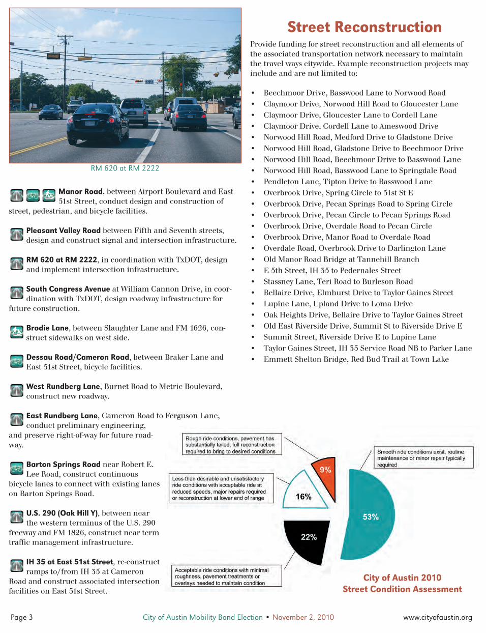
Street ReconstructionProvide funding for street reconstruction and all elements of the associated transportation network necessary to maintain the travel ways citywide. Example reconstruction projects may include and are not limited to:
Beechmoor Drive, Basswood Lane to Norwood Road• Claymoor Drive, Norwood Hill Road to Gloucester Lane• Claymoor Drive, Gloucester Lane to Cordell Lane• Claymoor Drive, Cordell Lane to Ameswood Drive• Norwood Hill Road, Medford Drive to Gladstone Drive• Norwood Hill Road, Gladstone Drive to Beechmoor Drive• Norwood Hill Road, Beechmoor Drive to Basswood Lane• Norwood Hill Road, Basswood Lane to Springdale Road• Pendleton Lane, Tipton Drive to Basswood Lane• Overbrook Drive, Spring Circle to 51st St E• Overbrook Drive, Pecan Springs Road to Spring Circle• Overbrook Drive, Pecan Circle to Pecan Springs Road• Overbrook Drive, Overdale Road to Pecan Circle• Overbrook Drive, Manor Road to Overdale Road• Overdale Road, Overbrook Drive to Darlington Lane• Old Manor Road Bridge at Tannehill Branch • E 5th Street, IH 35 to Pedernales Street• Stassney Lane, Teri Road to Burleson Road• Bellaire Drive, Elmhurst Drive to Taylor Gaines Street• Lupine Lane, Upland Drive to Loma Drive• Oak Heights Drive, Bellaire Drive to Taylor Gaines Street• Old East Riverside Drive, Summit St to Riverside Drive E• Summit Street, Riverside Drive E to Lupine Lane• Taylor Gaines Street, IH 35 Service Road NB to Parker Lane• Emmett Shelton Bridge, Red Bud Trail at Town Lake •
RM 620 at RM 2222
City of Austin 2010 Street Condition Assessment
71898_bro.indd 3 9/24/10 12:34:48 PM

Page 4 City of Austin Mobility Bond Election • November 2, 2010 www.cityofaustin.org
§̈¦
£¤
£¤
§̈¦
£¤
£¤
£¤
STATE HWY 71
STASSNEY LA
RAIL TRAIL
KRAMER LA
ANDERSON MILL RD
MO
-PA
C E
XP
Y
1ST
ST
F M
973
RD
F M 620
SH 45
LAM
AR B
LVD
BRO
DIE
LA
SLAUGHTER LA
CO
NG
RES
S AV
MAN
CHAC
A RD
BUR
NET
RD
WILLIAM CANNON DR
BRAKER LA
CAPI
TAL
OF
TEXA
S HW
Y
F M ROAD 1327
7TH ST
F M
RO
AD 6
85
PARMER LA
E STASSNEY LA
BEN WHITE BLVD
BELL BLVD
MC NEIL
RD
F M 2244RD
CAM
ERO
N RD
12TH ST
MANOR RD
MET
RIC
BLVD
OLTORF ST
45TH ST
DESS
AU R
DSOUTHWEST PKWY
RESEARCH BLVD
BURLESON RD
SPRI
NGDA
LE R
D
F M 2769RD
CESAR CHAVEZ ST
6TH ST
MC NEIL DR
BEE CAVES RD
RUNDBERG LA
KOENIG LA
DUVAL RD
JOLLYVILLE RD
MO
NTO
POLI
S DR
BALC
ONE
S DR
ENFIELD RD
ED B
LUES
TEIN
BLV
D
NORTHLAND DR
GUA
DALU
PE S
T
TODD LA
YAGER LA
HOWARD LA
38THST
26TH ST
F M
182
6
MARTIN LUTHER KING BLVD
RED
RIVE
R ST
SCENIC LOOP
BULLIC
K HO
LLOW
RD
BASTROP HW
Y
RIVERSIDE DR
FERGUSON LA
EXPO
SITI
ON
BLVD
PLEA
SANT
VA
LLEY
RD
WES
T G
ATE
BLVD
BARTON SPRINGS RD
24TH ST
F M
973
LOYOLA LA
35TH ST
GREAT HILLS TRL
11THST
15TH ST
CESAR CHAVEZ
BUR
NET
RD
BUR
NET
RD
AIRPO
RT BLVD
SH 45
F M
973
LAMAR BLVD
51STST
PARM
ER LA
F M
973
RD
PARMER LA
1ST
ST
LAM
AR B
LVD
12THST
MAN
OR
RD
ANDERSON LA
US H
WY 183
C&G REPAIRS SE
C&G REPAIRS NW
SIDEWALK REPAIRS NE
SIDEWALK REPAIRS NW
SIDEWALK REPAIRS SE
SIDEWALK REPAIRS SW & CW
GRP 44 STASSNEY LN - TERI RD TO BURLESON RD
EMMETT SHELTON - RED BUD TRAIL @ TOWN LAKE BRIDGE
C&G REPAIRS CW
SIDEWALK REPAIRS CBD
OLD MANOR RD @ TANNEHILL
BRANCH
G15C RESIDENTIAL/COLLECTOR STREETS CE
GRP 99C 2012 DOWNTOWN ALLEYS - 2E & 3D
GRP 99B 2011 DOWNTOWN ALLEYS - 8D & 10E
GRP 45 RESIDENTIAL/COLLECTOR
STREETS SE
AWU UTILITY PROJECT STREET REPAIR
PARTICIPATION SE
AWU UTILITY PROJECT STREET REPAIR
PARTICIPATION DT
AWU UTILITY PROJECT STREET REPAIR PARTICIPATION CW
G07 E 5TH STREET IH 35 TO PEDERNALES ST
969
620
1626
2222
183
183
290
183
290
35
35
UV1
UV1 UV71
UV45
UV130
UV130
UV360
UV360R
IO G
RAN
DE
NU
ECES
9TH
10TH
1ST
3RD
4TH
LAM
AR
8TH
15TH
6TH
7TH
5TH
11TH
12TH
LAVA
CA
TRIN
ITY
BRAZ
OS
RED
RIV
ER
CO
NG
RES
S
CO
LOR
ADO
GU
ADAL
UPE
SAN
JAC
INTO
2ND
CESAR CHAVEZ
MARTIN LUTHER KING
Election de Bonos del 2010 Propuesta de Proyectos de Movilidad2010 Bond Election Proposed Mobility Projects2010 Bond Election Proposed Mobility Projects
Election de Bonos del 2010 Propuesta de Proyectos de Movilidad
Downtown Transit, Arterials, Bicycle and Pedestrian
September 2010
Proposed Mobility Projects
0 2 41
Miles
Project Types/Tipos de Proyectos
Mopac
Y at Oak Hill
IH 35
US 183
RM 620 atRM 2222
Slaughter Lane
FM 969/MLK
Brodie Lane
East Riverside
Kramer Lane
Cameron Rd.
IH 35 at 51st/Cameron Rd.
Lady Bird LakeBoardwalk
Jollyville at US 183
AirportBlvd.
¯
Note: Proposed projects may include, but are not limited toprojects shown above.
Propuesta de Proyectos de Movilidad
Nota: Los proyectos proquestospueden incluir, pero no están limitados a los proyectos que semuestran arriba.
Austin 2 Mile ETJ/2 Millas de Jurisdicción Territorial de AustinAdjacent Cities/Ciudades Adjuntas
Austin City Limits/Límites de la Ciudad de Austin
Reconstruction/Reconstrucción
Travis County Partnership Program/Programa de Sociedad con el Condado de Travis
Transit/Transporte
Pedestrian, Bike, Trail, Sidewalk/Peatones, Bicicletas, Caminitos, Aceras
Intersection/IntersecciónHighway/CarreterasArterials/Calles Principales o Arterias
Transporte en el Centro, Calles Principales, Bicicletas y Peatones
71898_bro.indd 4 9/24/10 12:35:02 PM

Page 5 City of Austin Mobility Bond Election • November 2, 2010 www.cityofaustin.org
PROPOSITION 1
BALLOT LANGUAGE:The issuance of $90,000,000 in tax supported general obligation bonds and notes for constructing and reconstructing roads and streets; constructing, improving and reconstructing sidewalks, bikeways, and other bicycle and pedestrian mobility infrastructure; improving traffic signal synchronization and control systems; acquiring and installing traffic signals; constructing, reconstructing, and improving drainage facilities related to these improvements; funding design and engineering for roads, streets, drainage, traffic signal, sidewalks, bikeways, and other bicycle and pedestrian mobility infrastructure; and acquiring land and interests in land and property necessary to do so; and the levy of tax sufficient to pay for the bonds and notes.
Voter InformationThe election will be held Tuesday, November 2, 2010. Polls will be open from 7am to 7pm.
Early voting for the November 2010 elections will be conducted Octo-ber 18–29. Visit cityofaustin.org for more voter information, including early voting locations and Election Day polling places.
PROPOSICIÓN 1
LENGUAJE EN LA BOLETA ELECTORAL:La emisión de $90,000,000 de bonos obligatorios y notas financieras apoyados por impuestos para la construcción y reconstrucción de calles y avenidas; construcción, mejoras y reconstrucción de aceras, vías para ciclistas y otras necesidades de infraestructura para la movilidad de ciclistas y peatones; mejoras para la sincronización de semáforos y sistemas de control; compra e instalación de semáforos; construcción, reconstrucción y mejoras para las instalaciones de drenaje relacionadas con estas mejoras; financiamiento para el diseño e ingeniería de calles, avenidas, drenaje, señales de tránsito, aceras, vías para bicicletas y otras infraestructuras necesarias para la movilidad de ciclistas y peatones; y la compra de terrenos, terrenos de interés y propiedades necesarias para realizar dichos proyectos; y la recaudación de suficientes impuestos para pagar por dichos bonos y notas financieras.
Información para el VotanteLa elección se llevará a cabo el martes, 2 de noviembre del 2010. Los centros electorales estarán abiertos de las 7am a las 7pm.
Votación adelantada para las elecciones de noviembre del 2010 será del 18 al 29 de octubre. Visite la página de internet cityofaustin.org para más información, incluyendo los centros electorales que estarán abiertos para votación adelantada y durante el día de las elecciones.
City of AustinMayor Lee LeffingwellMayor Pro Tem Mike MartinezCouncil Member Chris RileyCouncil Member Randi ShadeCouncil Member Laura MorrisonCouncil Member Bill SpelmanCouncil Member Sheryl Cole
Marc A. Ott, City Manager
East Rundberg Lane • Calle Rundberg al este
South Congress Avenue • Avenida Congress al sur
Airport Boulevard • Bulevar Airport
71898_bro.indd 5 9/24/10 12:35:06 PM

Page 6 City of Austin Mobility Bond Election • November 2, 2010 www.cityofaustin.org
Proyectos de Carreteras: Esta proposición proveerá financiamiento para la ingeniería preliminar, diseño, construcción y reconstrucción de proyectos para construir o reconstruir superficies para movilizarse, plataformas de base y otras infraestructuras asociadas incluyendo drenaje de agua, aceras y vías para ciclistas en donde sea posible en las avenidas y/o corredores seleccionados para construcción o reconstrucción.
Proyectos en Sociedad: Esta proposición proveerá fondos para que Austin participe en acuerdos entre el condado de Travis, el Departamento de Transporte del Estado de Texas y otros proveedores de transporte para diseñar y construir mejoras a nivel regional de calles, aceras, red de senderos naturales y la asocia-ción de infraestructura necesaria incluyendo drenaje de agua.
Semáforos e Intersecciones: Esta proposición también proveerá fondos para actualizar los sistemas de señales de tráfico, incluyendo la modificación y mejora de los semáforos existentes, instalación de semáforos para peatones, construcción y reconstrucción de luces intermitentes para las escuelas, expansión del sistema computarizado de semáforos y la instalación de nuevas señales o in-
fraestructura alternativa para intersecciones por todo Austin, así como también cambios operacionales para mejorar la administración de tráfico en las calles de Austin.
Peatones/ Mejoras “ADA”: Adicionalmente, esta proposición proveerá fondos para la reparación y construcción de aceras con sus correspondientes rampas y cunetas y la infraestructura asociada con drenajes de aguas, proveerá acceso a peatones minúsvalidos de acuerdo al Acta Americana para Discapaci-tados (Americans’ with Disabilities Act) mejor conocida como ADA, además, proveerá instalaciones para el uso de bicicletas de acuerdo con el Plan de Bicicle-tas de la Ciudad de Austin (City’s Bike Plan) y para la construcción de aceras como es mencionado en el Plan Maestro de Aceras de la Ciudad de Austin (City’s Sidewalk Master Plan).
Proyectos concretos que se ejecutarán como parte del programa de bo-nos de movilidad 2010, si son aprobados, pueden incluir, pero no están limitados a:
Descripciones de los Proyectos Propuestos Vea mapa en la página 4
Calles Lavaca y Guadalupe, entre aproximadamente la calle César Chávez y el bulevar MLK Jr., diseño y potencial-
mente la reubicación de servicios de utilidades.
IH 35, entre aproximadamente la avenida William Cannon y US 290, en coordinación con TxDOT (Departamento de
Transporte del Estado de Texas), ingeniería preliminar y diseño de infraestructura de transporte.
Avenida Riverside al este, entre aproximadamente IH 35 y el bulevar Ben White, ingeniería preliminar para
aceras y otras instalaciones necesarias para ciclistas y peatones.
Calle 3 entre las calles San Antonio y Trinity, reconstrucción de calle con acceso para ciclistas.
Calle Manchaca entre la avenida William Cannon y el bulevar Lamar al sur en coordinación con TxDOT
(Departamento de Transporte del Estado de Texas), ingeniería preliminar para aceras y acceso necesario para ciclistas.
Corredor FM 969 (Bulevar Martin Luther King Jr. al este), entre la US 183 y la ciudad de
Webberville, realizar estudios preliminares de ingeniería para la infraestructura de transporte en el futuro.
Usos diversos para la avenida Kramer, entre el bulevar Metric y calle Burnet, construcción de
infraestructura peatonal para conectar servicios de transporte, acceso para ciclistas y centros de empleos.
Malecón para el lago Lady Bird, entre el puente de la avenida Congress y el parque Lakeshore, construcción
de infraestructura para peatones y ciclistas en varias fases, para conectar los lados este y oeste de la IH 35, incluyendo la posible conexión entre la avenida Riverside y el sendero natural local-izado en el riachuelo Blunn Creek.
Calles Sabine y 6 cerca de Waller Creek, diseño de calles, acceso para peatones y ciclistas asociadas
con el proyecto de drenaje en el riachuelo adjunto..
Bulevar Airport, desde aproximadamente bulevar Lamar al norte hasta US 183, ingeniería preliminar para futura
infraestructura de carreteras.
Corredor de enlace Loop 1 (MoPac), en sociedad con otras agencias de transporte, para diseñar y evaluar
opciones para proveer líneas expresas de transporte y mejorar el acceso para el centro de la ciudad.
Calle Guadalupe, entre las calles 24 y 45, pavimentar nuevamente y proveer acceso a ciclistas.
Calle 4 debajo de la IH 35, creando acceso para peat-ones y bicicletas conectando el este con el oeste.
Urbanización Johnston Terrace, mejoras de acceso para peatones en ruta hacia la escuela primaria Allan.
US 183 entre la US 290 y US 71, en sociedad con TxDOT (Departamento de Transporte del Estado de Texas), para
buscar soluciones a corto plazo para el movimiento de tráfico.
Calles 7 y 8 en el centro de Austin, diseño para posibles doble vías y posible construcción de dicho proyecto.
Corredor FM 969 (Bulevar Martin Luther King Jr. al este)
71898_bro.indd 6 9/24/10 12:35:18 PM

Page 7 City of Austin Mobility Bond Election • November 2, 2010 www.cityofaustin.org
Calle Jollyville y US 183, construcción de infraestructura para el cruce de ciclistas.
Calle Manor entre el bulevar Airport y la calle 51 al este, diseño y construcción de calle, accesos peat-
onales e instalaciones para ciclistas..
Calle Pleasant Valley entre las calles 5 y 7, diseño y con-strucción de semáforos e infraestructura en la intersección.
RM 620 en RM 2222, en coordinación con TxDOT (Depar-tamento de Transporte del Estado de Texas), diseño e
implementación de infraestructura para la intersección.
Avenida Congress al sur con la avenida William Cannon, en coordinación con TxDOT (Departamento de Transporte del
Estado de Texas), diseño de infraestructura para la futura con-strucción de carretera.
Calle Brodie entre la Calle Slaughter y FM 1626, construc-ción de aceras en el lado oeste.
Calles Dessau/Cameron entre la avenida Braker y calle 51 al este, instalaciones para ciclistas.
Calle Rundberg al oeste, calle Burnet hasta el bulevar Metric, construcción de caminos.
Calle Rundberg al este, calle Cameron hacia la Calle Ferguson, ingeniería preliminar y
preservación del derecho de paso para carreteras futuras.
Calle Barton Springs cerca de la calle Robert E. Lee, construcción continua de carriles para
ciclistas para conectar los carriles existentes con la calle Barton Springs.
US 290 (Oak Hill Y) desde aproximadamente donde termina la autopista US 290 al oeste y
FM 1826, construcción de infraestructura a corto plazo para el manejo del trafico.
IH 35 al este de la calle 51, reconstrucción de rampas hacia/desde IH 35 en la calle Cameron y construcción de
instalaciones asociadas con la intersección de la calle 51 al este.
Reconstrucción de CallesProporcionar financiamiento para la reconstrucción de calles y todos los elementos asociados con la red de transporte necesaria para mantener las vías de tránsito en toda la ciudad. Ejemplo de proyectos de reconstrucción pueden incluir pero no están limita-dos a:
Paseo Claymoor - Calle Norwood Hill hasta Calle Gloucester• Paseo Claymoor - Calle Gloucester hasta Calle Cordell • Paseo Claymoor - Calle Cordell hasta Paseo Ameswood• Paseo Beechmoor - Calle Basswood hasta Calle Norwood• Calle Norwood Hill - Paseo Medford hasta Paseo Gladstone• Calle Norwood Hill - Paseo Gladstone hasta Paseo Beechmoor• Calle Norwood Hill - Paseo Beechmoor hasta Calle Basswood• Calle Norwood Hill - Calle Basswood hasta Calle Springdale• Calle Pendleton - Paseo Tipton hasta Calle Basswood• Paseo Overbrook - Spring Circle hasta Calle 51 al este• Paseo Overbrook - Calle Pecan Springs hasta Spring Circle• Paseo Overbrook - Pecan Circle hasta Calle Pecan Springs• Paseo Overbrook - Calle Overdale hasta Pecan Circle• Paseo Overbrook - Calle Manor hasta Calle Overdale• Calle Overdale - Paseo Overbrook hasta Calle Darlington• Puente de la Calle Old Manor y Ramificación Tannehill • Calle 5 al este - IH 35 hasta Calle Pedernales• Calle Stassney - Calle Teri hasta Calle Burleson• Paseo Bellaire - Paseo Elmhurst hasta Calle Taylor Gaines• Calle Lupine - Paseo Upland hasta Paseo Loma• Paseo Oak Heights - Paseo Bellaire hasta Calle Taylor Gaines • Paseo Old East Riverside - Calle Summit hasta Paseo •
Riverside EsteCalle Summit - Paseo Riverside Este hasta Calle Lupine• Calle Taylor Gaines - Calle de acceso hacia el sur de IH 35 •
norte hasta Calle ParkerPuente Emmett Shelton - Caminito Red Bud y el •
lago Lady Bird
RM 620 a RM 2222
Ciudad de Austin 2010 Evaluación del Estado de las Calles
71898_bro.indd 7 9/24/10 12:35:25 PM

Ciudad de Austin
Elección de bonos para usos relacionados con transporte 2010Martes 2 de noviembre del 2010La Ciudad de Austin ha programado una elección de bonos con valor de $90 millones para proyectos relacio-nados con transporte para el 2 de noviembre del 2010. Los proyectos propuestos tienen el objetivo de aliviar problemas calles, aceras, vías para bicicletas, en las senderos naturales e infraestructura de tránsito por todo Austin.
¿Cómo fue desarrollado el paquete de bonos?Los empleados de la Ciudad de Austin han estado trabajando con la comunidad desde el otoño del 2009 colectando, evaluando y recomen-dando los proyectos de movilidad de mayor prioridad.
Residentes, departamentos de la ciudad y otras agencias han 1. identificado más de 3000 áreas de posibles mejoramientos de tránsito incluyendo embotellamientos en toda la red de movilidad en Austin.
Esta lista fue consolidada y refinada, creando 474 proyectos que 2. fueron evaluados por el personal de la ciudad.
El proceso de priorización, aprobado por la Junta de Regidores 3. (City Council) en marzo del 2010, ayudó a identificar cada proyec-to con un sistema creado basado en un extenso proceso público de participación y los objetivos creados durante dicho proceso.
Este sistema de evaluación produjo los proyectos con las mejores 4. posibilidades de terminar, de acuerdo a las prioridades creadas por la comunidad y la mayor posibilidad de financiarse con un paquete de bonos de este tamaño. Otros proyectos se mantendrán en consideración para futuros bonos y otras oportunidades de financiamiento.
La Ciudad de Austin designó a nueve ciudadanos a servir en 5. una Mesa Directiva de Trabajo para revisar y opinar sobre estos proyectos prioritarios. Este grupo recomendó la propuesta en el mes de julio del 2010.
Impacto Financiero y FiscalLos $90 millones incluidos en la Proposición Uno serían financiados a través de Bonos Obligatorios Generales, que se pagan con los impuestos a la propiedad. Si se aprueban, la Ciudad propone la emisión de los bo-nos a partir de agosto del 2011. Se anticipa que el servicio de la deuda de estos bonos sea financiado con el impuesto actual – no se anticipa aumento al impuesto de la propiedad.
Esta publicación fue diseñada para facilitar una descripción general sobre la propuesta que se presentará para consideración de los votantes registrados en Austin en las
elecciones del 02 de noviembre del 2010. Esta publicación no defiende la aprobación o derrota de esta medida y tiene fines informativos y educativos únicamente.
De la parte de arriba de la página: Mo-Pac; Calle Barton Springs; US 290 (Oak Hill Y); Terraza Johnston; Calle 5 al Este. Vea “Descripción de Proyectos Propues-
tos” para más detalles
Proyectos de Carreteras
Proyectos de Tránsito
Proyectos para Ciclistas
Proyectos para Peatones
71898_bro.indd 8 9/24/10 12:35:35 PM