Circulation - Santa Barbara
228
2011 CIRCULATION ELEMENT 1 Circulation CONTENT OF THESE GOALS, POLICIES AND IMPLEMENTATION ACTIONS
Transcript of Circulation - Santa Barbara

2011 CIRCULATION ELEMENT 1
Circulation
CONTENT OF THESE GOALS, POLICIES AND IMPLEMENTATION ACTIONS
2

2011 CIRCULATION ELEMENT 3
Goals, Policies and Implementation
GOALS
Circulation Policies
CIRCULATION ELEMENT
4 2011 CIRCULATION ELEMENT

CIRCULATION ELEMENT
2011 CIRCULATION ELEMENT 5

CIRCULATION ELEMENT
6 2011 CIRCULATION ELEMENT

CIRCULATION ELEMENT
2011 CIRCULATION ELEMENT 7
Parking Policies
Development Policies

8

CIRCULATION ELEMENT
1997 CIRCULATION ELEMENT 9
CIRCULATION ELEMENT
ACKNOWLEDGEMENTS
The following people participated in the development of the Circulation Element. The City
thanks them and values their support and input:
Circulation Element Update Consensus Group:
Jo Black, Independent Living Resource
Center
Laura Bridley, South Coast Employers
Transportation Network
Daryl Chapman, Santa Barbara Chamber
of Commerce, Northside Business
Association
Dallas Clark, Beachside Merchants
Association
Ozwald Da Ros, Eastside Merchants
Association
Jack Easterbrook, Santa Barbara
Industrial Association
Sue Ehrlich, Sustainability Project
Ralph Fertig, Bicycle Coalition
Christopher Haskell, Eucalyptus Hill
Association
Grant House, Eastside Study Group
Norm Johnson, Mesa Shoreline Park
Association
Estelle Karp, The Downtown
Organization
Beebe Longstreet, Westside Advisory
Council
Jon Martin, Santa Barbara Board of
Realtors
Don McDermott, Samarkand District
Improvement Assn.
Lee Moldaver, Citizens Planning
Association
June Pujo, Grass Roots 101
Jose Ramirez, El Concilio del Pueblo
Eric Sonquist, La Colina/Cienguitas
Area Neighborhood Association
Susan Trescher, La Mesa Neighborhood
Association
Dorothy Walker, League of Women
Voters
Tom Williams, Old Town Merchants
Association
City Council
Harriet Miller, Mayor
Helene Beaver
Marty Blum
Gil Garcia
Gregg Hart
Elinor Langer
Tom Roberts
Planning Commission
Carol Echt, Chair
Irma Unzueta, Vice-Chair
Barbara Chen Lowenthal
Brian Barnwell
Dan Secord
Harwood A. White
Grant House
Former Commissioner Dennis Turner

CIRCULATION ELEMENT
10 1997 CIRCULATION ELEMENT
City Staff
Sandra Tripp-Jones, City Administrator
Peter Wilson, Deputy City Administrator
David Davis, Community Development
Director
David Johnson, Public Works Director
Don Olson, Assistant Community
Development Director/City Planner
Terilynn Langsev-Burt, Principal Planner
George Gerth, Transportation and Parking Manager
Liz Casey Limón, Senior Planner
Rob Dayton, Supervising Transportation Planner
Laurie Owens, Project Planner
Brian James, Associate Planner
Rachel Adcox, Assistant Planner
Consultants
John Jostes, Interface Dudek
Ron Briggs, Interface Dudek
Technical Support from Other Agencies and Participants
Jim Damkowitch, Santa Barbara County Association of Governments
Bob Faris, Associated Transportation Engineers
Elihu Gevirtz, County of Santa Barbara Planning and Development Department
Gary Gleason, Metropolitan Transit District
Maeve Kennedy Grimes, Traffic Solutions
Chuck McQuary, Metropolitan Transit District
Steve Orocz, Penfield and Smith
Mike Powers, Santa Barbara County Association of Governments
Tim Rochte, Caltrans
Scott Schell, Associated Transportation Engineers
Ron Tan, Air Pollution Control District
CIRCULATION ELEMENT
1997 CIRCULATION ELEMENT (Page i-1) 11
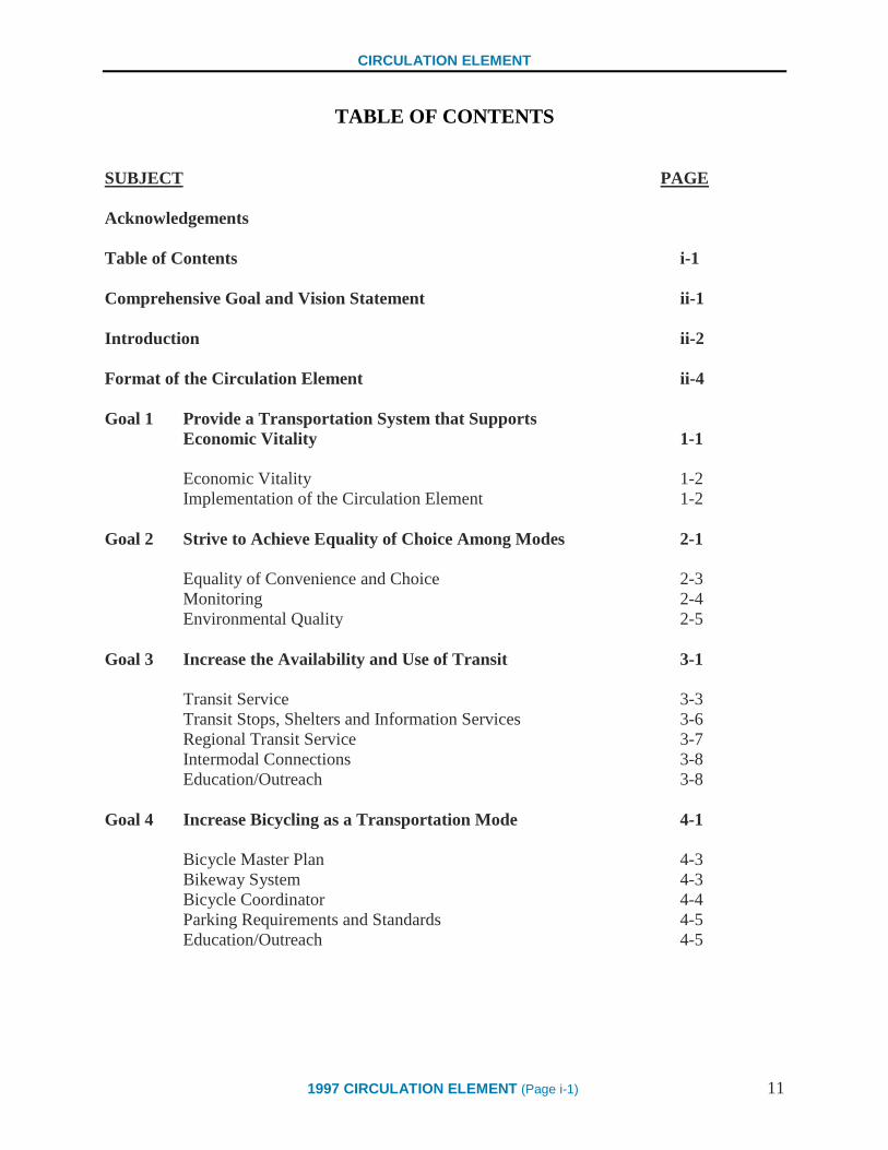
TABLE OF CONTENTS
SUBJECT PAGE
Acknowledgements
Table of Contents i-1
Comprehensive Goal and Vision Statement ii-1
Introduction ii-2
Format of the Circulation Element ii-4
Goal 1 Provide a Transportation System that Supports
Economic Vitality 1-1
Economic Vitality 1-2
Implementation of the Circulation Element 1-2
Goal 2 Strive to Achieve Equality of Choice Among Modes 2-1
Equality of Convenience and Choice 2-3
Monitoring 2-4
Environmental Quality 2-5
Goal 3 Increase the Availability and Use of Transit 3-1
Transit Service 3-3
Transit Stops, Shelters and Information Services 3-6
Regional Transit Service 3-7
Intermodal Connections 3-8
Education/Outreach 3-8
Goal 4 Increase Bicycling as a Transportation Mode 4-1
Bicycle Master Plan 4-3
Bikeway System 4-3
Bicycle Coordinator 4-4
Parking Requirements and Standards 4-5
Education/Outreach 4-5

CIRCULATION ELEMENT
12 1997 CIRCULATION ELEMENT (Page i-2)
Goal 5 Increase Walking and Other Paths of Travel 5-1
Increase Access and Walking Opportunities 5-3
Linking Pedestrian Paths to Alternative Transportation 5-4
Update and Expand the Paseo System 5-4
Design Standards 5-5
Physical Improvements and Amenities 5-6
Street Crossings 5-8
Land Use and Zoning 5-8
Education/Outreach/Community Involvement 5-9
Goal 6 Reduce the Use of the Automobile for Drive-Alone Trips 6-1
Local and Regional Transportation Demand Management Programs 6-3
City as a Model Employer 6-3
Regional Coordination 6-3
Education/Outreach/Community Involvement 6-4
Goal 7 Increase Access by Optimizing Parking Citywide 7-1
Parking Master Plan 7-2
Parking Supply 7-2
Residential Permit Parking Program 7-3
Parking Requirements and Standards 7-3
Goal 8 Increase Parking Availability and Access for
Downtown Customers 8-1
Downtown Parking and Economic Vitality 8-5
Managing Downtown Public Parking 8-5
Increased Public Parking Supply 8-7
Signage and Aesthetics 8-8
Downtown Housing 8-8

CIRCULATION ELEMENT
1997 CIRCULATION ELEMENT (Page i-3) 13
Goal 9 Develop Special Policies Related to Transportation
and Parking in the Coastal Zone 9-1
Use of Alternative Transportation 9-4
Manage Parking in Coastal Zone 9-6
Link to Alternative Transportation 9-7
Signage and Aesthetics 9-7
Cabrillo Boulevard 9-8
Goal 10 Develop a Mobility System that will Carry all Modes
of Transportation, from Automobiles to Pedestrians 10-1
Classification System 10-4
Implementation 10-6
Goal 11 Review Traffic Impact Standards at City Intersections 11-1
Traffic Standards and Impact Thresholds 11-3
Mobility System 11-4
Goal 12 Establish a Process to Include Neighborhoods in the
Discussion of the Effects of Traffic on Residential Streets 12-1
Establish a Process to Include Business and
Non-Residential Property Owners in the Discussion of
the Effects of Traffic Along Business Corridors 12-1
Traffic Management Program 12-4
Neighborhood Area Mobility Plan 12-6
Business Area Mobility Plan 12-6
Goal 13 Apply Land Use and Planning Tools and Strategies that
Support the City’s Mobility Goals 13-1
General Plan Consistency 13-4
Compact Development 13-4
Incentives for Mixed Use 13-5
Design Standards 13-5
Neighborhood Serving Uses 13-7
Location of Educational Facilities 13-7
Home-Based Businesses 13-8
Annexation 13-8
CIRCULATION ELEMENT
14 1997 CIRCULATION ELEMENT (Page i-4)
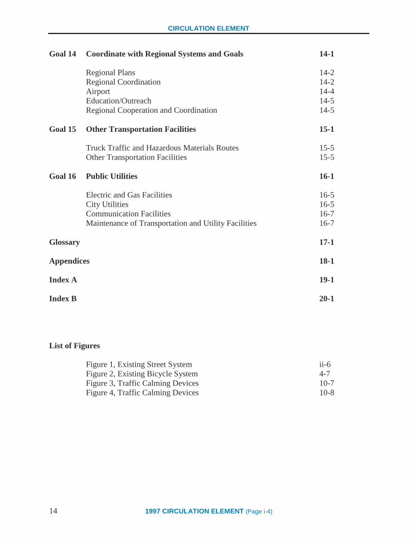
Goal 14 Coordinate with Regional Systems and Goals 14-1
Regional Plans 14-2
Regional Coordination 14-2
Airport 14-4
Education/Outreach 14-5
Regional Cooperation and Coordination 14-5
Goal 15 Other Transportation Facilities 15-1
Truck Traffic and Hazardous Materials Routes 15-5
Other Transportation Facilities 15-5
Goal 16 Public Utilities 16-1
Electric and Gas Facilities 16-5
City Utilities 16-5
Communication Facilities 16-7
Maintenance of Transportation and Utility Facilities 16-7
Glossary 17-1
Appendices 18-1
Index A 19-1
Index B 20-1
List of Figures
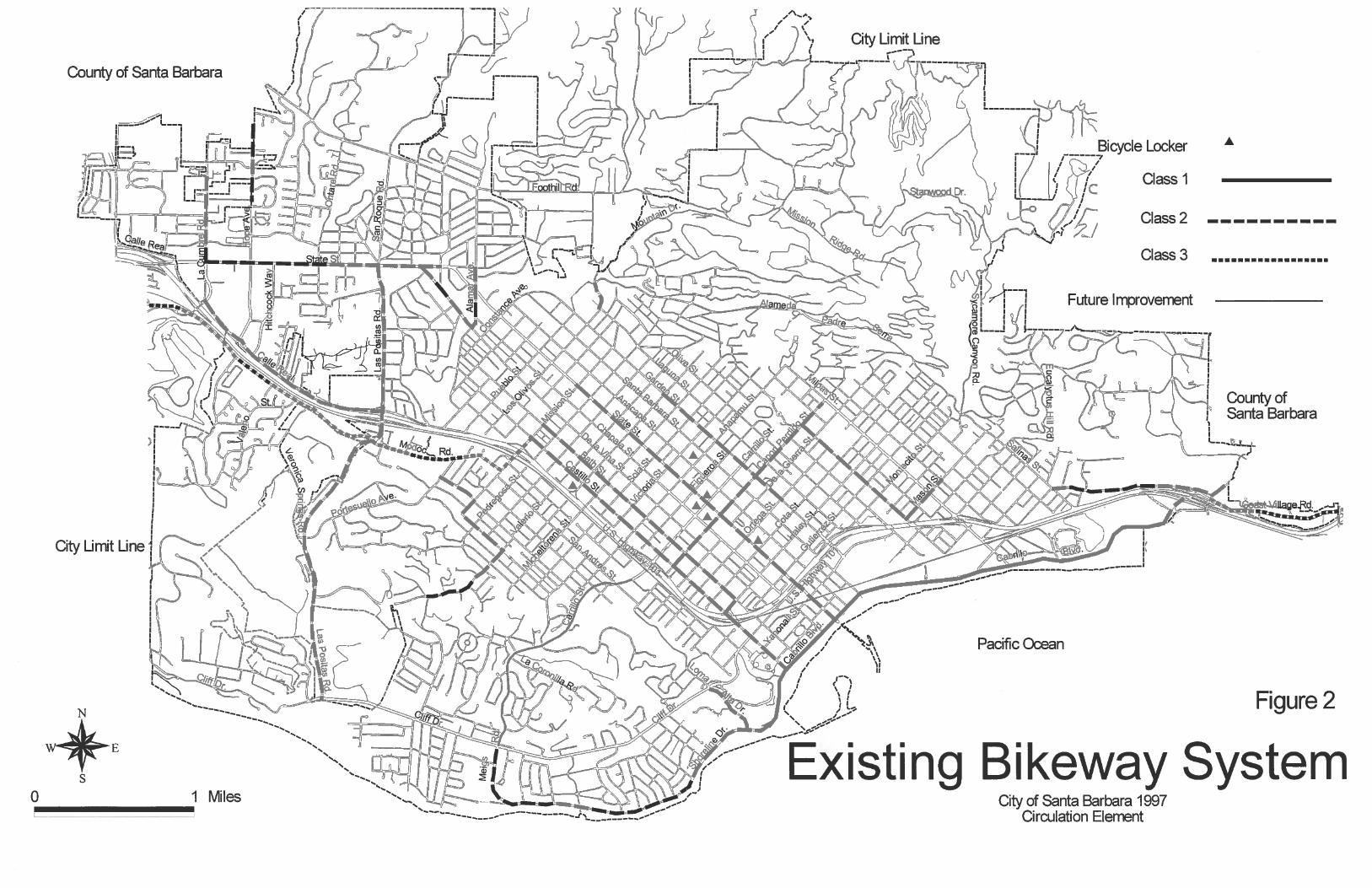
Figure 1, Existing Street System ii-6
Figure 2, Existing Bicycle System 4-7
Figure 3, Traffic Calming Devices 10-7
Figure 4, Traffic Calming Devices 10-8

CIRCULATION ELEMENT
1997 CIRCULATION ELEMENT (Page ii-1) 15
COMPREHENSIVE GOAL AND VISION STATEMENT
"While sustaining or increasing economic vitality and quality of
life, Santa Barbara should be a city in which alternative forms of
transportation and mobility are so available and so attractive that
use of an automobile is a choice, not a necessity. To meet this
challenge, the City is rethinking its transportation goals and land
use policies, and focusing its resources on developing balanced
mobility solutions. The language presented here, when taken
together, will move the City in the direction of achieving the
Vision."
Circulation Element Update Consensus Group
Consensus Report, May 31, 1995
This Comprehensive Goal and Vision Statement is the statement from which all the Goals,
Policies, and Implementation Strategies of this Circulation Element are derived. It was drafted by
a 22-member Consensus Group, which was comprised of a wide range of neighborhood and
business representatives. The Consensus Group was charged with the task of drafting a Vision
Statement aimed at solving the community transportation problems facing Santa Barbara. The
statement above represents the unanimous consensus of the group.

CIRCULATION ELEMENT
16 1997 CIRCULATION ELEMENT (Page ii-2)
INTRODUCTION
The Circulation Element is a required element of the City’s General Plan. Government Code
Section 65302(b) states that a circulation element shall consist of:
… the general location and extent of existing and proposed major thoroughfares, transportation
routes, terminals, and other local public utilities and facilities, all correlated with the land use
element of the plan.
The Circulation Element was created during a two-phased effort by members of the community.
This was purely a “grass roots” effort to create circulation policies that address the concerns of
the community. The first phase began January 17, 1995, when a 22 member Consensus Group
was formed from a diverse cross section of the community representing neighborhood, business,
environmental, transit, and bicycle interests. With the help of a professional facilitator, the
Consensus Group created and wrote the Consensus Group Report, which was adopted on May
31, 1995. The Consensus Group Report contains the overall vision for the City’s circulation
system and broad goals to attain that vision. The second phase began August 9, 1995, when the
Consensus Group began to distill the overall vision and broad goals into implementable policies
and implementation strategies. During this effort, the goals and vision were retained in their
exact form. The Consensus Group made their final recommendations on April 23, 1997, and the
Consensus Group Draft Circulation Element was finalized.
The Consensus Group Draft Circulation Element was then reviewed by the Planning
Commission on a chapter-by-chapter basis during a series of six public meetings. During these
meetings, the Planning Commission received input from members of the Consensus Group and
public to help strengthen and clarify the document. The Planning Commission made final
changes and a final recommendation to the City Council on September 11, 1997. The Draft
Circulation Element, which included changes made by the Planning Commission, was released
for public review in October, 1997. The City Council reviewed the Draft Circulation Element
during a public hearing on November 11, 1997, and adopted the Circulation Element on
November 25, 1997.
The purpose of the Circulation Element is twofold. First, the Circulation Element addresses the
requirements of State Law, which are to evaluate the transportation needs of the community and
to present a comprehensive plan to meet those needs. Second, and most importantly, it contains
measures for the implementation of the Comprehensive Goal and Vision Statement. This
purpose must be taken in the context of sustaining Santa Barbara’s high aesthetic values.
Implementation of specific goals must be accomplished through a three-phased process of 1)
establishing defined benchmarks or objectives, 2) monitoring and measuring policy impacts and
results, and 3) developing City-initiated response strategies should those policy outcomes not be
consistent with the Comprehensive Goal and Vision Statement.

CIRCULATION ELEMENT
1997 CIRCULATION ELEMENT (Page ii-3) 17
Specifically, this Circulation Element will motivate change in the following ways:
Provide a transportation system the supports the economic vitality of the City,
Strive to achieve equality of convenience and choice among all modes of transportation,
Increase the availability and use of transit,
Increase bicycling as a transportation mode,
Increase walking and other paths of travel,
Reduce the use of the automobile for drive-alone trips,
Increase access by optimizing parking citywide,
Increase parking availability and access for Downtown customers,
Develop special policies related to transportation and parking in the Coastal Zone,
Develop a mobility classification system that will carry all modes of transportation from
pedestrian to automobiles,
Review traffic impact standards used at City intersections for consistency with the goals
of the Circulation Element and the General Plan,
Establish a process to include neighborhoods in discussions of the effects of traffic on
residential streets,
Establish a process to include business and non-residential property owners in
discussions of the effects of traffic along business corridors,
Apply land use planning strategies that support the City’s mobility goals,
Coordinate with regional systems and goals,
Support the movement of people, goods, and services by other transportation facilities,
such as air, rail, and water, and
Provide and maintain public utilities.

CIRCULATION ELEMENT
18 1997 CIRCULATION ELEMENT (Page ii-4)
FORMAT OF THE CIRCULATION ELEMENT
This Circulation Element is based upon the Vision Statement and specific goal statements
identified above. The goals are shown at the beginning of each Chapter as bolded, italicized text.
Each of the 16 goal statements appears at the beginning of a Chapter with specific policies and
methods to achieve the desired goal. Within each Chapter, the policies are shown as bolded text
and numbered with two digits (e.g. 1.1, 5.4) and the Implementation Strategies are shown as
normal text and numbered with three digits (e.g. 1.1.1, 5.4.1). Each Chapter is arranged in the
following manner:
Circulation Element Goal The general direction and desired outcome of each
chapter of the Circulation Element. The State of
California General Plan Guidelines define a goal as,
“a direction setter. It is an ideal future end,
condition, or state related to the public health,
safety or general welfare toward which planning
and planning implementation measures are
directed. A goal is a general expression of
community values and, therefore, is abstract in
nature. Consequently, a goal is generally not
quantifiable, time-dependent or suggestive of
specific actions for its achievement.” The
Circulation Element Goals were developed by a
community consensus group and adopted May 31,
1995.
Example: Develop a comprehensive system of
pedestrian routes which is integrated with other
modes of transportation and which provide safe
and efficient paths of travel.
Introduction Section A description of the circulation conditions existing
at a particular moment in time. The Introduction
Section contains the following three segments:
Background A brief description of the circulation setting and
issues in the City.
Constraints A brief description of potential restrictions in the
circulation system and community that must be
addressed in order to achieve the Vision of the
Circulation Element.

CIRCULATION ELEMENT
1997 CIRCULATION ELEMENT (Page ii-5) 19
Opportunities A description of the potential issues and conditions
that can be capitalized upon to achieve the Vision of
the Circulation Element.
Policies and Implementation
Strategies Section A description of the methods to achieve the goal
statement of each chapter. The Policies and
Implementation Strategies Section contains the
following two segments:
Policies The State of California General Plan Guidelines
defines a Policy as, “a specific statement that guides
decision making. It indicates a clear commitment of
the local legislative body.” Policies, in conjunction
with the Implementation Strategies (described
below), create clear directions to achieve the Vision
Statement.
Example: 5.2 The City shall link pedestrian
paths with other alternative modes of
transportation.
Implementation Strategies Specific methods to achieve the Vision of the
Circulation Element and provide examples of
programs and actions that the City may take to
achieve the goal and policy. An Implementation
Strategy is “a rule of measure establishing a level of
quantity that must be complied with or satisfied.
Implementation Strategies further define the
abstract terms of goals and policies.”
Example: 5.2.2 Continue to provide information
on popular bike and walking routes to the transit
providers so that their services can be linked with
these routes.
Glossary Contains a list of words and their definitions. This
list can be referenced by the reader to determine the
meaning or context for a number of terms in the
Circulation Element.

20


22
CIRCULATION ELEMENT
1997 CIRCULATION ELEMENT (Page 1-1) 23
CHAPTER 1 – ECONOMIC VITALITY
Goal 1 PROVIDE A TRANSPORTATION SYSTEM THAT SUPPORTS
THE ECONOMIC VITALITY OF THE CITY
Establish and maintain a transportation system that supports the economic
vitality of local businesses.
BACKGROUND
This goal represents a recognition that, in addition to maintaining the quality of life, the
economic vitality of the City is a priority. The transportation system plays an important role in
supporting the continued growth and economic vitality of local business. Therefore, the
transportation system must enhance the business environment and quality of life of the City.
The transportation system of the City provides invaluable services to the business community by
allowing customers access to commercial areas and allowing businesses to deliver and receive
goods. When rethinking the design of a streetscape, delivery trucks must be accommodated or
alternate forms of transporting goods and services must be developed. While the transportation
of goods and services has traditionally been a guiding factor in developing roadways,
tomorrow’s solutions will rely on non-traditional approaches that support all of the transportation
needs of businesses and users.
CONSTRAINTS
With the decision to rethink transportation priorities and solutions, some policies of the past will
need adjustment. For example, current traffic standards sometimes prohibit commercial growth
that is permitted by the land development provisions of the General Plan. Such standards can be
changed to allow greater flexibility for commercial areas to better support the economic vitality
of the City.
Another constraint is that the facilitation of delivery and receipt of goods may be at odds with the
facilitation of access improvements for customers. For example, the addition of a delivery
turnout may necessitate the narrowing of sidewalks or the loss of a traffic lane. Creative
solutions will need to be found in order to accommodate all uses of the roadway.
OPPORTUNITIES
Space to store vehicles is costly, sometimes visually adverse, and limited. By increasing the use
of alternative modes of transportation and reducing reliance on the automobile for commuting to
work, business areas will be able to improve access and availability of parking for customers,
thereby enhancing economic vitality. This direction clearly shows how one aspect of
transportation can be closely related to, or affect, another. A key to economic vitality is
maintaining and enhancing the connection between the businesses and their customers. Further
development of the transportation system should increase access and the mobility of people
throughout the community and strengthen this relationship.
CIRCULATION ELEMENT
24 1997 CIRCULATION ELEMENT (Page 1-2)
POLICIES AND IMPLEMENTATION STRATEGIES
ECONOMIC VITALITY
1.1 The City shall establish, maintain, and expand a mobility system that supports
the economic vitality of local businesses.
1.1.1 Optimize access and parking for customers in business areas by implementing
policies of the Circulation Element aimed at reducing dependence upon the
automobile, and improving and increasing pedestrian, bicycle use, and transit use.
1.1.2 Review traffic impact standards used at City intersections for consistency with the
goals of the Circulation Element and General Plan through public worksessions
with the Planning Commission and the City Council.
1.1.3 Enhance alternative transportation services and infrastructure access between
residential, recreational, educational, institutional and commercial areas.
1.1.4 Provide adequate infrastructure and info-structure to support the delivery of goods
and services to and from area businesses.
IMPLEMENTATION OF THE CIRCULATION ELEMENT
1.2 The City shall place a high priority on funding and providing support for the
implementation of the Goals, Policies, and Implementation Strategies of this
Circulation Element.
1.2.1 Designate a task force and coordinator to recommend priorities for funding to the
City Council to support the Goals, Policies, and Implementation Strategies of this
Circulation Element.
CIRCULATION ELEMENT
1997 CIRCULATION ELEMENT (Page 2-1) 25
CHAPTER 2 – EQUALITY OF CONVENIENCE
Goal 2 STRIVE TO ACHIEVE EQUALITY OF CONVENIENCE AND
CHOICE AMONG ALL MODES OF TRANSPORTATION
Emphasize alternative modes in order to provide real options and opportunities
for people to choose among different forms of transportation rather than
relying exclusively on the automobile.
BACKGROUND
Currently, the automobile holds a position of prominence among mobility choices. This is based
on the historical pattern of development since the advent of the automobile, and the perpetuation
of its use through street, highway and other infrastructure improvements and funding. While
strides have been made to make other modes of transportation attractive, equality of convenience
among all modes of transportation does not exist today.
Too often, transportation facilities are designed to serve a singular purpose. For instance, many
roads are designed to accommodate mainly automobile traffic, paths are designed solely for
walking, and bike lanes are solely for bicycles. This system may have been feasible and
appropriate in the past, but as the population of Santa Barbara increases and the circulation needs
of the community change, our circulation system will need to respond in ways it has never been
asked to before. We are being challenged to develop an integrated, intermodal circulation
system which will serve the future needs of the community with limited financial resources and a
limited ability or willingness to expand the physical system as it exists today. Planning for this
future will not only involve recognizing the transportation needs of residents and businesses, but
also prioritizing mobility goals.
CONSTRAINTS
The two biggest constraints to achieving equality among different modes of transportation are: 1)
limited funding and resources available without shifting funds away from existing programs and
street maintenance funds, and 2) the perception that the automobile will always be the most
convenient mode of transportation.
People are reluctant to try shifting travel modes when other convenient choices, such as shuttles,
vanpools, transit, bike lanes, and walking paths, are not readily available to them. Until
alternative forms of travel become as convenient and easy to use as the automobile, most people
will not take advantage of the opportunities to use alternate modes of transportation. In addition,
if people are limited in their transportation choices, they tend to be more protective of the limited
transportation opportunities that exist. For example, people are more resistant to paying for
parking at work or shopping areas when other areas in the region offer unlimited free parking.
CIRCULATION ELEMENT
26 1997 CIRCULATION ELEMENT (Page 2-2)
Finally, as Santa Barbara nears buildout, with much of the City's land use pattern fully
established, alternative strategies and creative solutions must be explored in order to expand the
availability of alternative transportation facilities and services. These strategies and solutions
may include expansion of the existing transit systems and creation of new alternatives. As with
most significant policy paradigm shifts, this may require the City to assess the value of
compromises and trade-offs between existing mobility systems and alternative strategies.
OPPORTUNITIES
Santa Barbara can build upon its existing development patterns and travel systems to create an
environment where all modes of travel can be conveniently used. For example, bicycle lanes
already exist on many City streets, landscaped sidewalks exist along most of our streets to help
make a pleasing pedestrian environment, and various forms of transit are presently available for
travel within the City. Additionally, the existing grid system of roadways which is present
downtown and in the older residential neighborhoods disperses traffic and provides a number of
routes to any given destination.
Santa Barbara is also fortunate to have a climate which is conducive to outdoor activities,
including walking and cycling. As a result, Santa Barbarans are already more accustomed to
using different modes of transportation than residents of many other communities. Emphasis
should be placed on further exposure of residents and visitors to the non-motorized
transportation opportunities that are currently available to them.
In addition, some of the existing barriers to using alternative modes of transportation can be
eliminated. For example, providing bus benches and shelters with posted schedules may reduce
inconvenience and confusion surrounding the use of transit. Posting visible signs to alert drivers
to the presence of pedestrian paths or completing gaps in existing sidewalks may eliminate
barriers to walking. However, in order to remove these obstacles, careful analysis, community
discussion and the development of creative solutions will be required. While recognizing that
automobiles will remain an important mode of transportation, changes can be made to the
existing circulation system to make it more inviting to those who may choose travel by other
means.

CIRCULATION ELEMENT
1997 CIRCULATION ELEMENT (Page 2-3) 27
POLICIES AND IMPLEMENTATION STRATEGIES
EQUALITY OF CONVENIENCE AND CHOICE
2.1 Work to achieve equality of convenience and choice among all modes of
transportation.
2.1.1 Work with transit providers to enhance and expand transit services throughout
the City of Santa Barbara and the surrounding region.
2.1.2 Expand and enhance the infrastructure for and promote the use of the bicycle as
an alternative form of travel to the automobile.
2.1.3 Create an integrated pedestrian system that promotes safe and convenient
pedestrian travel throughout the City.
2.1.4 Work with outside agencies, employees, and employers to optimize the use of
alternative travel modes to reduce the use of the automobile, especially during
peak periods of congestion.
2.1.5 Manage the supply of parking on a City-wide basis and suggest methods to
better utilize existing parking or to provide additional parking.
2.1.6 Manage the parking supply and work to increase the use of alternative forms of
travel to increase the availability of parking and access to the Downtown area.
2.1.7 Address transportation issues and the provision of parking in the portion of the
Coastal Zone that is within Santa Barbara city limits.
2.1.8 Develop a new classification and service system that focuses on all forms of
travel and considers the needs of the land uses served by the system.
2.1.9 Explore ways to continue the concentration of development Downtown and
along transit corridors to facilitate the use of transit and alternative modes of
transportation.
2.1.10 Develop urban design standards that will facilitate the use of alternative means
of travel and reduce dependency upon the automobile. The standards shall
address linkages throughout the City, such as walkways, bikepaths, and transit.
2.1.11 Participate in an active and leadership role in regional transportation planning
efforts through cooperation and communication with regional agencies.
CIRCULATION ELEMENT
28 1997 CIRCULATION ELEMENT (Page 2-4)
2.1.12 Continue to provide and maintain adequate storm drainage, water supply and
distribution, and wastewater collection systems to meet existing and projected
demands. In addition, continue to work with electric, gas, and communications
suppliers to maintain and provide service.
2.1.13 Continue to support the movement of people, goods, and services by
transportation modes such as air, rail, and water. Continue to regulate the
movement of trucks and hazardous materials to ensure safety.
2.1.14 Create a program to coordinate the execution and review of Implementation
Strategies addressing signage (see Index B for a comprehensive list). The
program should be reviewed by the Sign Committee, Historic Landmarks
Commission, and Architectural Board of Review.
MONITORING
2.2 To assure that the community is moving towards the Vision articulated in
this Circulation Element, the City shall monitor changes in traffic volumes,
travel patterns and mobility choices through a program which:
establishes a baseline of traffic volumes and travel patterns,
establishes performance benchmarks related to the policy statements
and implementation strategies within each chapter of the Circulation
Element,
assesses the impacts of policy implementation and progress against these
benchmarks, and
includes City response strategies if the outcomes of policy and project
specific decisions are not consistent with the Vision articulated within
this Circulation Element.
2.2.1 The City Administrator shall direct staff to develop and implement a monitoring
program and submit reports every two years to the Planning Commission and
City Council regarding the effectiveness of achieving the Goals and Policies of
the Circulation Element. These reports shall include, but not be limited to,
information on the following topics:
the effectiveness of land use policies in meeting the City’s mobility goals,
the effectiveness of the policies of the Circulation Element towards
increasing the use and effectiveness of transit programs,

CIRCULATION ELEMENT
1997 CIRCULATION ELEMENT (Page 2-3) 29
the attainment of regional air quality standards, and
ridership patterns and use of alternative forms of transportation. Continue to
obtain this information from responsible agencies, such as MTD. In areas
where no information is available, conduct surveys.
2.2.2 Prior to each annual adoption of the Capital Improvement Program, public work
sessions shall be held with the Planning Commission and the City Council to
develop project priorities for funding.
ENVIRONMENTAL QUALITY
2.3 The development and maintenance of mobility and utility systems should
include consideration of the impacts and enhancements to Santa Barbara’s
environmental quality.
2.3.1 Continue to review proposed mobility and utility projects for compliance with
relevant documents such as the California Environmental Quality Act (CEQA),
Santa Barbara General Plan, Santa Barbara Municipal Code, Santa Barbara
Master Environmental Assessment, and Local Coastal Plan. The review should
include, but not be limited to, an examination of the potential negative impacts
of water runoff from streets and parking lots.
2.3.2 Continue to review proposed mobility and utility projects for compliance with
the Santa Barbara County Clean Air Plan and Air Quality Plan.

30
CIRCULATION ELEMENT
1997 CIRCULATION ELEMENT (Page 3-1) 31
CHAPTER 3 – TRANSIT
Goal 3 INCREASE THE AVAILABILITY AND USE OF TRANSIT
Support the increased use and availability of transit. This will be accomplished
by augmenting resources, planning, and funding to promote the development,
expansion and use of transit, such as buses, shuttles, rail, and vanpools (see
Glossary).
BACKGROUND
This chapter focuses upon the enhancement and expansion of transit services in the City of Santa
Barbara and the surrounding region. The purpose of the Policies and Implementation Strategies
in this chapter is to increase the choices available for travel.
Improvements to the transit system could increase the number of riders, reduce reliance on the
auto, decrease the need for street capacity improvements, make more efficient use of the existing
street system, reduce the demand for parking, provide greater independence for youth and others
who cannot or choose not to use cars, improve air quality, increase interaction among people,
create local jobs, and enhance the quality of life in Santa Barbara.
The following transit systems currently exist and provide service to the City:
Metropolitan Transit District (MTD) - the public bus system for the South Coast,
including both conventional buses, electric buses and shuttles,
Clean Air Express - subscription commuter services to Santa Barbara and Goleta from
northern Santa Barbara County and Ventura,
Downtown/Waterfront Shuttle (MTD) - a City subsidized MTD service which provides
short distance connections in and around the Downtown and Waterfront on short
headways,
Easy Lift Transportation - pre-scheduled door-to-door service for the elderly and disabled
individuals,
Greyhound - regional and nationwide bus service,
Amtrak - regional and nationwide rail service,
Private bus and taxi operators, and
School bus systems.
CONSTRAINTS
The City does not directly operate and has limited control over any of the transit operations in
the City. This means that the City's ability to affect change is limited. However, through
funding, coordination, and participation, the City can help to influence transit operations.

CIRCULATION ELEMENT
32 1997 CIRCULATION ELEMENT (Page 3-2)
The policies of this Circulation Element are designed to offer incentives to use alternative forms
of transportation whenever possible. This means that efforts to increase ridership on transit are
focused on incentive based options.
The most successful method to increase transit ridership is to increase service. However, the
operating costs involved with increased service and the competition for subsidies is the major
constraint to expanded and improved public transit.
OPPORTUNITIES
To be attractive and successful, public transit in Santa Barbara must be frequent, reliable,
comfortable, and affordable. With adequate funding, targeted improvements to existing transit
services could considerably increase ridership in the City. These improvements include
increasing the number of smaller, quieter, cleaner, more frequent electric buses, vans and
shuttles. Improving the aesthetics, safety and comfort of transit stops could also result in
increased ridership. Focus should also be placed on increasing the service frequency on major
corridors, including linking neighborhoods and major commercial and activity centers. An
optimal situation would be that during morning peak hours, noontime and afternoon peak hours,
riders would expect a shuttle/bus to pass by every 7 minutes on major corridors. This would
dramatically increase the convenience of public transit throughout the City. By making transit
more convenient and attractive, the opportunity exists to help reduce the amount of single-
occupant vehicle trips and traffic congestion. In turn, this may reduce automobile emissions and
help improve air quality.
Identification and analysis of travel characteristics will help identify changes with the highest
benefit/cost ratio. It has been shown in many communities that simply putting more buses on the
street will not mean an increase in ridership.
The City has control over land development and associated infrastructure. The type and design
of land development directly influences transit attractiveness and efficiency. Circulation system
features such as bus shelters and priority bus access/movement can also influence function and
ridership.

CIRCULATION ELEMENT
1997 CIRCULATION ELEMENT (Page 3-3) 33
POLICIES AND IMPLEMENTATION STRATEGIES
Please note: for purposes of this chapter, “support” refers to funding, coordination, and
participation.
TRANSIT SERVICE
3.1 The City shall promote the development, improvement, expansion, and
increased ridership of transit within the City, including the development of
new forms of transit as they become available.
3.1.1 Encourage and support transit providers, in increasing the number of vehicles
and reducing waiting times on selected popular routes. Explore the possibility of
adding additional transit vehicles or creating new routes where it is suspected
that use is low due to extended time periods between buses.
3.1.2 Help transit providers explore the use of "on demand" service, either by
providing additional buses for expanded service or by other means such as
jitneys, paratransit, shuttles, taxis and Dial-A-Ride operations.
3.1.3 Work with transit providers to serve new types of routes such as one that would
connect grammar schools with major employers. This would provide parents the
ability to take their child to school and then continue on to their place of
employment.
3.1.4 Encourage and support MTD in expanding shuttle service to other routes within
the City which have the potential to have a sustainable ridership.

CIRCULATION ELEMENT
34 1997 CIRCULATION ELEMENT (Page 3-4)
3.1.5 Help identify and fund fare subsidies or transit pass programs. Consider the
following options:
fare subsidies that could increase ridership on newly introduced routes,
a system whereby employers can choose to pay an annual fee to be dedicated
to a secured transportation fund to increase transit in lieu of providing
employee parking spaces,
a transit pass program for employers and employees,
a transit pass program for schools or other groups,
a Downtown employee subsidized bus pass program,
senior and youth discount passes, and
youth ridership programs for expanded weekend and nighttime ridership.
3.1.6 Identify and implement opportunities to give the movements of transit vehicles,
such as buses, a priority over other vehicles through methods such as:
allowing transit vehicles to make turning movements that are prohibited to
other vehicles,
allowing transit vehicle traffic signal pre-emption, and
providing transit vehicle only lanes that may occur during selected times and
would not prohibit vehicular traffic flow.
Improvements for transit only movements will be considered by the Planning
Commission and City Council when service levels increase and the need is
determined to be appropriate.
3.1.7 Work with transit providers to evaluate the impact of a centralized transfer
system (spider web) against a potential for dispersed route interchange points
(grid).
3.1.8 Encourage transit providers to establish programs for corporate sponsorship of
vehicles.

CIRCULATION ELEMENT
1997 CIRCULATION ELEMENT (Page 3-5) 35
3.1.9 Assist transit providers in the development of a strategic plan for service,
including:
links to State Street along Mission and/or Micheltorena,
shuttle service between the Westside to the Eastside, Downtown, and
Waterfront areas,
shuttle service connecting the Lower with the Upper Westside,
improved two-way or loop shuttle service for the Mesa, Northside,
Westside, and Downtown,
visitor destinations,
Downtown grid,
Downtown - Northside and La Cumbre Plaza,
Downtown – Waterfront, and
improved service between the Airport and other areas of the South
Coast.
3.1.10 Support the continuation of frequent, inexpensive transit service in areas with
high numbers of transit dependent persons.
3.1.11 Implement policies in the Land Use chapter of the Circulation Element and the
General Plan Land Use Element that encourage the use of transit.
3.1.12 Coordinate and participate in transit master planning in order to achieve a
comfortable, convenient, efficient, and affordable transit system that
accommodates all users, including residents, commuters, shoppers, students,
visitors, youth, seniors, and the transit dependent.
3.1.13 Support the expansion of the hours of operation for transit providers along routes
or areas where there is a need.
3.1.14 Support transit providers in the provision of shuttle/bus services to and from
special events in areas such as the Waterfront, Downtown, Mission/Museum,
County Bowl, Oak Park, and City College.
3.1.15 Regulate taxi operations in order to ensure fair pricing, safe and qualified
drivers, efficient service, and service to heavily traveled areas such as tourist
destinations or the Airport.

CIRCULATION ELEMENT
36 1997 CIRCULATION ELEMENT (Page 3-6)
3.1.16 Provide for appropriately sited taxi loading zones where needed.
3.1.17 The City shall support transit through funding, coordination, and participation,
including but not limited to:
including transit improvements in the Capital Improvements Plan (CIP),
using discretionary funds to support transit operations and maintenance,
sponsoring a monthly roundtable of agencies representing various modes of
travel to coordinate planning and implementation, and
maintaining strong policies that encourage citywide transit system
improvements.
TRANSIT STOPS, SHELTERS AND INFORMATION SYSTEMS
3.2 The City shall improve and develop safe, convenient, and protected transit
stops that are compatible in design, color, and material with the
surrounding area.
3.2.1 Give bus stops a priority over on-street parking when there is a demonstrated
conflict or need.
3.2.2 Encourage transit providers to provide or continue to provide clear and easy to
understand route information and maps or other computerized transit information
systems at transit stops.
3.2.3 Provide and regularly maintain amenities such as benches, shelters, lighting,
newsracks, and decorative trashcans at transit stops.
3.2.4 Expand the Bicycle Locker Program at transit stops and other strategic locations.
3.2.5 Employ a portable transit shelter that can help in the evaluation of new
demonstration routes in residential neighborhoods.
3.2.6 Develop a program that, at the request of the property owner, would allow the
City to install and maintain additional landscaping adjacent to transit stops to
address neighborhood concerns.

CIRCULATION ELEMENT
1997 CIRCULATION ELEMENT (Page 3-7) 37
3.2.7 Work with transit providers to improve and expand the transit route and signage
program by showing connections between major attractions such as schools,
museums, places of worship, institutions, shopping and recreation areas.
3.2.8 Work with transit providers and property owners to provide transit stops within
parking lots of large shopping centers and other major visitor destinations.
3.2.9 Work with transit providers to develop and maintain the transit infrastructure,
such as transit stops, in a clean, safe and cost effective manner.
REGIONAL TRANSIT SERVICE
3.3 The City shall support increases in regional transit services.
3.3.1 Mandate the coordination of local transit services with regional transit providers
and regional transit master plans.
3.3.2 Coordinate and encourage public participation in discussions with transit
providers, Santa Barbara County, local cities, and transit users in the creation of
a Regional Transit Master Plan that addresses regional transit needs (see
Implementation Strategy 3.1.9 for related policies).
3.3.3 Study and identify the means of providing improved transit service to the Milpas
area, including, but not limited to, converting the Milpas Street post office
building to a transit center which includes transportation services such as buses,
vanpools, carpools, shuttles, and park and ride options, as well as post office
boxes.
3.3.4 Encourage the continuation and expansion of commuter subscription bus service,
such as the Air Pollution Control District’s (APCD) Clean Air Express.
3.3.5 Explore the creation of designated areas for tour bus parking, drop-off and pick-
up, as well as routes.
3.3.6 Encourage the creation of light rail and metrorail connections between Santa
Barbara, Oxnard, San Luis Obispo, and points in-between.
CIRCULATION ELEMENT
38 1997 CIRCULATION ELEMENT (Page 3-8)
INTERMODAL CONNECTIONS
3.4 The City shall work to improve and expand intermodal connections.
3.4.1 Support programs and policies that maintain or expand the level of passenger rail
and bus service. Bus service shall be considered in any development in the
vicinity of the Union Pacific Railway Depot.
3.4.2 Assist transit providers in the placement of bike racks on all buses and secure
storage at selected stops.
3.4.3 Promote and expand the employee shuttle bus service to and from the parking
lots at the intersections of Carrillo St. and Castillo St. and Santa Barbara St. and
Cota St.
3.4.4 Participate in and coordinate with efforts of the Technical Transportation
Advisory Committee (TTAC) and Santa Barbara County Association of
Governments (SBCAG) to develop vital links between their different services.
In addition, the City shall provide information on popular bike and walking
routes to the transit providers so their services can be linked with these routes
(see 14.2.3 and 3.1.17).
3.4.5 Provide improved service and hours of operation of transit and door-to-door
transit service to and from the Santa Barbara Municipal Airport.
3.4.6 Continue to support transit connections to other airports, such as but not limited
to, Los Angeles International Airport.
EDUCATION/OUTREACH
3.5 The City shall work to increase public awareness of and cooperation with
the City's transit planning goals.
3.5.1 Work with local businesses and transit providers to develop transit incentive
programs.
3.5.2 Train City appointed MTD Board Members, Council Members, City Staff, and
MTD Staff on the functions and working of transit services to ensure the
consideration of City transit issues, and conduct joint work sessions with the
City Council and directors of transit providers.

CIRCULATION ELEMENT
1997 CIRCULATION ELEMENT (Page 3-9) 39
3.5.3 Encourage area schools to expand education programs about the benefits and
advantages of the use of transit.
3.5.4 Develop and work with transit providers, regional rideshare programs, and others
to expand existing transit marketing programs.
3.5.5 Market the City's transit system, through organizations such as the Chamber of
Commerce and the Convention and Visitors Bureau.

40
CIRCULATION ELEMENT
1997 CIRCULATION ELEMENT (Page 4-1) 41
CHAPTER 4 – BICYCLING
Goal 4 INCREASE BICYCLING AS A TRANSPORTATION MODE
Develop a comprehensive system of bicycle routes which are integrated with
other modes of transportation and which provide safe and efficient bikeways.
BACKGROUND
Although bicycling has been historically popular for both recreation and transportation, Santa
Barbara’s heightened awareness of the bicycle as an environmentally sensitive alternative mode
of travel resulted from increased traffic congestion and higher gas prices. One goal of the City’s
Bikeway Master Plan, adopted in 1974, was "to make bicycling a means of transportation which
may be used safely and enjoyably on any street in the City." Today, the more than 30 miles of
bicycle paths and street lanes are steadily utilized and bicycle use in Santa Barbara is one of the
highest in the nation (see Figure 2).
CONSTRAINTS
Despite significant improvement in the bikeway network, gaps in the system require infill and
new routes need to be created to address concerns about safety. For example, traffic congestion
at freeway interchanges can be an intimidating barrier to bicyclists, especially children. As
Citywide vehicular traffic has steadily increased, so have requests for more bicycle lanes and
paths.
The broad range of rider types and skill levels (e.g. commuters, recreational riders, children,
mountain bicyclists, and racers) is a constraint because each has different bicycling needs. To
maximize the community benefit, rider differences should be considered in plan development
and implementation.
Another key constraint is the lack of adequate, safe, and secure bicycle storage lockers adjacent
to destination points within the City. Where these have been provided, there is ample anecdotal
evidence of high levels of use. Lastly, integration with other modes of transportation has been
somewhat limited. Recent additions of bike racks to the front of MTD buses are a first step in
addressing this issue.
OPPORTUNITIES
Increased bicycle use is directly linked to a number of goals articulated within this Circulation
Element. Increased bicycle ridership will result in decreased demand for parking, reduced auto
traffic congestion and lower levels of air pollution. To achieve increased ridership, the City must
expand and improve the existing regional bikeway system. This includes expansion of on-street
bike lanes, improved lighting and path quality on existing bicycle paths and the addition of
bicycle paths in targeted areas with the potential for high levels of use. This can only be
accomplished in coordination with the City of Carpinteria and the County of Santa Barbara.
CIRCULATION ELEMENT
42 1997 CIRCULATION ELEMENT (Page 4-2)
Improving the convenience for commuters requires the City to improve bicycle storage safety at
work locations and to expand the opportunities for multi-modal travel (i.e. bikes used in
conjunction with buses, trains, carpools and vanpools). This can be done in a cost effective
manner with the addition of storage lockers, funding of additional bikeracks on buses and
shuttles, and the same type of employee incentive programs utilized for carpool programs.
Secure bicycle storage can be located in a manner that provides benefits to specific business and
properties. As a result, it is one program that may be tailored to the public-private partnership
concept in order to expand the level of funding. Where secure bicycle lockers are provided, the
City (and any partners) will need to address both short-term and long-term parking bicycle
needs. The relatively low cost of these improvements, and the direct impact of reducing
automobile trips creates an opportunity for the City to move forward on these improvements
within a short time period and have significant positive impacts on mobility.
Related Benefits
It is also important to understand how increased bicycling helps to meet the goals set forth in the
Vision Statement. Increasing bicycle travel will help achieve the following goals:
support the economic vitality of the City by enhancing livability and improving
community space,
move the City closer to equality of convenience and choice among all modes of
transportation,
increase the availability of parking and access for Downtown customers, both in cars and
on bikes,
develop a mobility system that carries all modes of transportation from pedestrians to
automobiles,
review traffic impact standards used at intersections for consistency with Circulation
Element and General Plan,
coordinate the regional bikeway system,
reduce the need for automobile parking in the Coastal Zone,
provide air quality benefits, and
possibly reduce wear on City streets.

CIRCULATION ELEMENT
1997 CIRCULATION ELEMENT (Page 4-3) 43
POLICIES AND IMPLEMENTATION STRATEGIES
BICYCLE MASTER PLAN
4.1 The City shall update and implement the City’s Bicycle Master Plan.
4.1.1 Work with neighborhoods, interest groups, employers, the County, UCSB, and
SBCAG to identify current and future needs for bikeways in the Bicycle Master
Plan.
4.1.2 Outline criteria for installing bike lanes on City streets in the Bicycle Master
Plan.
4.1.3 Review bikeway routes and the Bicycle Master Plan periodically to address
changing conditions and the needs of bicycle riders of various types and skill
levels.
4.1.4 Incorporate Bicycle Master Plan projects into the City’s Capital Improvements
Program.
4.1.5 Monitor the use and effectiveness of bicycle parking facilities required by the
Santa Barbara Municipal Code.
BIKEWAY SYSTEM
4.2 The City shall work to expand, enhance, and maintain the system of
bikeways to serve current community needs and to develop increased
ridership for bicycle transportation and recreation.
4.2.1 Create bikeways that conveniently serve major areas of attraction, such as
shopping centers, public buildings, parks, places of employment, schools, and
the Waterfront.
4.2.2 Keep public bike facilities and rights-of-way in good condition, well lit, and well
maintained.
CIRCULATION ELEMENT
44 1997 CIRCULATION ELEMENT (Page 4-4)
4.2.3 Encourage facilities for bicycle travel and parking in any future development,
construction, or reconstruction projects during the review of new development
and infrastructure improvements. Bicycle facilities can be achieved through
methods such as:
purchase, dedication, and other means of property acquisition,
conditions of approval,
expanding the scope of maintenance projects, and
enforcement of the Santa Barbara Municipal Code, Parking Section.
4.2.4 Create opportunities for bicycle travel to interface with bus and train travel by
working with transit providers to ensure that transit facilities are equipped with
adequate bicycle carrying capacity and that the equipment is consistently
deployed.
4.2.5 Adopt and implement the Regional Bikeway Signage Program.
4.2.6 Increase attractive, convenient, and secure bike parking and storage facilities on
public property and encourage the provision of the same on private property.
Continue to consider fully enclosed individual lockers and/or bicycle racks.
4.2.7 Identify possible changes at freeway interchanges and over/under passes that will
facilitate the movement of bicycles through the interchange. Gather input from
neighborhood groups, business groups, bicycle support groups and other
interested organizations.
4.2.8 Install bicycle sensitive traffic signals at main bikeway intersections.
BICYCLE COORDINATOR
4.3 The City shall designate a Bicycle Coordinator.
4.3.1 The Bicycle Coordinator shall coordinate implementation of the goals, policies,
and strategies of the Circulation Element and the Bicycle Master Plan with those
of the County.
4.3.2 The Bicycle Coordinator shall represent bicyclist's interests in any significant
discussions of transportation developments within the City.

CIRCULATION ELEMENT
1997 CIRCULATION ELEMENT (Page 4-5) 45
4.3.3 Implement a system to report maintenance needs to the Bicycle Coordinator.
4.3.4 The Bicycle Coordinator shall promote the use of bicycles.
4.3.5 The Bicycle Coordinator shall encourage City Staff to use bicycles for short trips
or deliveries.
4.3.6 The Bicycle Coordinator shall encourage the use of programs intended to teach
safe bicycle riding techniques.
4.3.7 Work with local and regional bicycle groups and coalitions to promote bicycling
both within and outside of the City.
4.3.8 Encourage bicycle retailers to sponsor bicycle "Fun Rides" or races to promote
bicycle riding.
4.3.9 Recognize the role of bicycle related businesses as important to supporting
bicycle commuting and riding.
4.3.10 The Bicycle Coordinator shall explore the feasibility of creating a “green bike
program” designed to provide communal bicycles for local trips.
PARKING REQUIREMENTS AND STANDARDS
4.4 The City shall continue to use parking restrictions to create peak commute
hour capacity for bicycle traffic. Public hearings shall be held prior to the
creation of new parking restrictions.
4.4.1 Consider prohibiting peak commute period parking on major streets to create
additional bicycle travel lanes, as appropriate, and upon consultation with
adjacent property owners and a properly noticed public hearing.
EDUCATION/OUTREACH
4.5 The City shall actively promote the safe use of bicycles as an efficient and
affordable mode of transportation.
4.5.1 Work with the Convention and Visitor's Bureau and the Chamber of Commerce
to promote a bicycle friendly image of the City to residents and tourists.
CIRCULATION ELEMENT
46 1997 CIRCULATION ELEMENT (Page 4-6)
4.5.2 Work with schools to provide information to children, adults, bicyclists, and
motorists about the safe use of the bicycle on City streets including, but not
limited to, the following:
safety awareness programs at area elementary, middle, and high schools,
providing maps outlining bikeways, streets with designated bicycle lanes,
and streets with lesser traffic volumes that are safer for bicycle travel,
increased signage to alert motorists to the presence of bicycles,
work with bicycle retailers to provide patrons with information regarding the
safe use of the bicycle,
promote ride-to-school days, and
promote/sponsor a Bike-to-Work Day.
4.5.3 Encourage local business to use bicycle couriers for deliveries.
4.5.4 Educate people about and enforce laws relating to safe bicycle use, such as:
using lights and reflectors at night,
stopping at signalized or signed intersections and crosswalks,
riding on the right side of the road,
keeping off of the sidewalk, and
properly using helmets, especially youth.

48
CIRCULATION ELEMENT
1997 CIRCULATION ELEMENT (Page 5-1) 49
CHAPTER 5 – WALKING
Goal 5 INCREASE WALKING AND OTHER PATHS OF TRAVEL
Develop a comprehensive system of pedestrian routes which are integrated with
other modes of transportation and which provide safe and efficient paths of
travel.
BACKGROUND
This Chapter discusses methods to identify and build on the City’s existing positive pedestrian
environment in order to enhance and increase opportunities for pedestrian travel. The term
"paths of travel" describes the City's walking environment, with its network of sidewalks and
pathways, and conveys a recognition of the diverse abilities, needs, and interests of its
businesses, residents, and visitors.
CONSTRAINTS
Some developed areas of the City and the foothills are not pedestrian-friendly because of the
topography, lack of pedestrian amenities, and difficulty in accessing needed but distant services.
Attempts to retrofit these areas to accommodate walking may be inhibited by these challenges.
It is also difficult to create a pedestrian-friendly environment in areas with high traffic volumes
or high speeds, such as freeway interchanges, wide traffic corridors (e.g. Cabrillo Boulevard),
and streets with frequent or wide curb cuts and wide or skewed intersections. Pedestrian safety
is often in conflict with vehicles exiting from both large and small parking lots because of
inadequate visibility and warning signs.
Highway 101 limits interaction between neighborhoods and poses a significant automobile-
dominated barrier to pedestrians, except at the State Street underpass, where transit, bicyclists,
and pedestrians are simultaneously served successfully. Conversely, many of the Highway 101
crossings (e.g. Ortega, Anapamu, and Butterfly Lane) are under-utilized because of a sense of
isolation created by poor visibility and a lack of lighting, identification signage, and aesthetic
treatments.
Conflicts between uses can occur in paseos (see Glossary) located to the rear of commercial
properties due to safety hazards (e.g. delivery trucks) and nuisances (e.g. noise and trash odors).
CIRCULATION ELEMENT
50 1997 CIRCULATION ELEMENT (Page 5-2)
OPPORTUNITIES
The City of Santa Barbara’s historical compact development grid pattern created the Downtown
area with its narrow streets and wide sidewalks and a successfully integrated pedestrian
circulation system that allows easy access to businesses and services. By expanding the existing
positive pedestrian environment, the City could encourage housing within the Downtown area to
enable employees to live near where they work.
Santa Barbara is also unique in that the paseo system is well established. Paseos are a series of
connecting private and public walkways joined to streets, parking facilities, open plazas,
courtyards, cafes and shops through the central portions of city blocks. Please note that alleys
are different from paseos in that they are primarily automobile oriented. Paseos generally
promote pedestrian use and buildings that are oriented in size, entrances, amenities, and signage
to the pedestrian. Paseos provide a pleasant experience for the user and open up an increased
number of facades of commercial buildings. This promotes increased pedestrian access to
Downtown, which in turn supports the economic vitality of the area.
The pedestrian environment could be enhanced, where appropriate, by better lighting and
security, shade trees, street furniture, and landscaped parkways to separate pedestrians and
traffic. The continuation and expansion of the existing American with Disabilities Act (ADA)
upgrade program, which requires physical improvements to facilitate the access by persons with
disabilities, is also important.
A sign program would also help identify walking routes to various attractions around the City for
those who are unfamiliar with the City. Directional signs would also improve the connections
between different areas of the City by creating well-traveled routes. Designated walking routes
and directional signs could encourage higher pedestrian use, a greater perception of safety, and
improved connections between different areas of the City.
CIRCULATION ELEMENT
1997 CIRCULATION ELEMENT (Page 5-3) 51
POLICIES AND IMPLEMENTATION STRATEGIES
INCREASE ACCESS AND WALKING OPPORTUNITIES
5.1 The City shall create an integrated pedestrian system within and between
City neighborhoods, schools, recreational areas, commercial areas and
places of interest.
5.1.1 Establish an annual sidewalk expansion and improvement program with a
designated source of funding and update the Sidewalk Inventory Study to
develop a process for funding priorities for improvements. Incorporate the
expansion and improvement program into the Capital Improvements Program.
5.1.2 Identify and link major activity centers and destinations with walkways. This
will consist of the following:
surveying existing connections between neighborhoods and identifying
opportunities and constraints for new pedestrian connections,
identifying existing barriers to walking to school and where feasible
eliminating those barriers,
providing improved access for pedestrians (for example, between such areas
as the Eastside, Westside, Mesa, Lower State, Upper State and Waterfront
areas, major attractions, recreation, cultural, and commercial areas),
working with neighborhood markets and grocery stores to identify ways to
encourage walking trips to the market from surrounding neighborhood
areas,
improving pedestrian access in and around the Mission by providing safe
and attractive walking connections between the Mission, Rose Garden,
Rocky Nook Park, Natural History Museum and Alameda Padre Serra, and
creating an integrated pedestrian system linking the Franklin Center,
Franklin School, the Eastside Library and the community gardens.
5.1.3 Work with local merchants to create a package delivery system.

CIRCULATION ELEMENT
52 1997 CIRCULATION ELEMENT (Page 5-4)
5.1.4 Work with Caltrans to improve and maintain Highway 101 pedestrian
over/undercrossings to promote increased pedestrian use. This may include
adding amenities such as lighting, landscaping, and identification signage.
5.1.5 Encourage newly proposed developments to include pedestrian connections to
surrounding areas, adjacent transit facilities, or other travel facilities during
development review.
LINKING PEDESTRIAN PATHS TO ALTERNATIVE TRANSPORTATION
5.2 The City shall link pedestrian paths with other alternative modes of
transportation.
5.2.1 Work with all transit providers to develop links between different transit
services. This may include providing route information along pedestrian routes,
improved transit stops, and providing pedestrian connections to alternative forms
of travel.
5.2.2 Continue to provide information on popular bike and walking routes to the
transit providers so that their services can be linked with these routes.
UPDATE AND EXPAND THE PASEO SYSTEM
5.3 Protect and expand existing paseos and acquire new paseos in the Downtown.
5.3.1 Develop conceptual designs and guidelines for new paseos.
5.3.2 Establish protective mechanisms such as land acquisitions, historic designations,
use of easements, private development cooperation, and development controls
for the paseo system.
5.3.3 Encourage private development to incorporate public paseos by offering
increased density and other incentives for providing or improving paseos and
paseo connections.

CIRCULATION ELEMENT
1997 CIRCULATION ELEMENT (Page 5-5) 53
5.3.4 Consider closing streets to create pedestrian plazas if, upon consultation with a
broad segment of the community and general agreement of the affected business
owners and property owners, it can be demonstrated that it would improve
pedestrian access and enhance the Downtown business environment.
5.3.5 Encourage business owners to keep paseos in the rear of commercial buildings
free of trash and limit deliveries to hours when the paseos are not heavily
traveled.
5.3.6 Provide mid-block crossings to connect existing paseos, if appropriate and
feasible.
DESIGN STANDARDS
5.4 The City shall revise and enhance design guidelines and standards for the
City's pedestrian system.
5.4.1 Work with the Architectural Board of Review and Historic Landmarks
Commission to revise and enhance City design standards for all sidewalks and
paths of travel. Standards should address width of paths, safety, lighting,
landscaping, location, street furniture, the availability of alternate pedestrian
access-ways, and the provision of kiosks or other methods to exchange public
information.
5.4.2 Provide parkways or tree wells and develop other innovative methods where
appropriate to separate and/or protect pedestrians from traffic.
5.4.3 Revise Outer State Street Design Guidelines and Haley Milpas Design
Guidelines to emphasize pedestrian friendly design.
5.4.4 Update and revise the Public Works Street Design Standards to include the
following standards:
sidewalks should be wide and shaded by trees,
trees should be placed at the curb-side of the sidewalk to provide a
psychological and physical separation between pedestrians and auto traffic.
Adequate room for growth should be given to avoid sidewalk damage by
tree roots, and
the width and number of curb cuts (driveways) on City streets should be
kept to a minimum or designed in a manner that protects the safety of
pedestrians.

CIRCULATION ELEMENT
54 1997 CIRCULATION ELEMENT (Page 5-6)
5.4.5 Improve design for disabled access by providing more ramps, providing more
repair to cracked and heaved sidewalks, filling in gaps in existing sidewalks,
identifying and relocating obstructions (fire hydrants, telephone poles, light
poles) in narrow sidewalks or providing paths around obstructions, and using
paving materials which are conducive to wheelchairs and those who have
difficulty walking.
5.4.6 Require striping/signage, crossing guards, stop signs, and other devices to
improve safety near schools and parks.
5.4.7 Notify and work with affected property owners, user groups, and tenants prior to
the adoption of any design standards for pedestrian oriented improvements.
5.4.8 During the development review process, identify all sidewalk obstructions (e.g.
fire hydrants, telephone poles, utilities, etc.) on development plans and, if
feasible, locate or relocate them in such a way so as to remove the obstruction
and to enhance visual aesthetics.
PHYSICAL IMPROVEMENTS AND AMENITIES
5.5 The City shall create and foster a pedestrian friendly environment through
physical and cultural improvements and amenities.
5.5.1 Provide street furniture, especially benches for resting and shade trees along
streets, where appropriate. Look for opportunities for new resting spots, plazas,
placitas, small squares, and landscaped areas in all areas of the City which
should include focal point(s), opportunities for people watching, and/or attractive
natural surroundings. These areas will encourage gathering, public and social
interaction and could be used for cultural events and activities. An example
could be the placement of benches and street furniture in Chase Palm Park.
5.5.2 Identify areas where additional street and paseo lighting is appropriate and
implement methods to provide that lighting.
5.5.3 Improve sidewalk conditions to increase ease of use for all pedestrians including
those with strollers, wheelchairs, carts, walkers, and other walking assistance
devices.
CIRCULATION ELEMENT
1997 CIRCULATION ELEMENT (Page 5-7) 55
5.5.4 Encourage plazas, courtyards, cafes, shops, and restaurants along walkways in
commercial areas to encourage a mix of private business and public uses.
Adequate width should remain for pedestrian travel.
5.5.5 Consider public plazas, restrooms, resting spots, or gathering places in all
commercial areas of the City, especially in the following areas:
Milpas Street from Cabrillo Boulevard to Anapamu Street, and
the Eastside near Milpas Street starting temporarily by blocking off parts of
streets such as Montecito Street, Calle Puerto Vallarta, Alphonse or Jennings
for special events.
5.5.6 Look for opportunities to connect placitas to public, private and institutional
uses. Include signage, as appropriate.
5.5.7 Develop procedures that improve the City's infrastructure by incorporating the
new sidewalk design standards into street maintenance projects.
5.5.8 Prior to creating any plaza areas conduct a noticed public hearing.
5.5.9 Improve the beachway to increase safety for all users.
5.5.10 Adequately fund programs for regular maintenance of heavily used pedestrian
amenities, including sidewalks, under/overpasses, and footbridges. Programs
should include litter removal, graffiti removal, steam cleaning, and landscape
maintenance.
5.5.11 Create incentives and opportunities for private property owners to make
incremental improvements to enhance the pedestrian environment surrounding
their properties, such as widening sidewalks and planting street trees. Any
improvements should comply with relevant design guidelines and standards.
5.5.12 Consider the creation of mercados, or markets, in appropriate commercial areas
of the City.
5.5.13 Install small segments of sidewalks in selected areas, especially on blind curves
or in hilly areas with narrow streets, to help improve the safety of pedestrians.
CIRCULATION ELEMENT
56 1997 CIRCULATION ELEMENT (Page 5-8)
STREET CROSSINGS
5.6 The City shall make street crossings easier and more accessible to
pedestrians.
5.6.1 Where necessary, allow all-way crossings or adjust signal timing to allow more
time for pedestrians to cross the street. Priority should be given to areas with
high pedestrian activity as identified in the Sidewalk Inventory Study. Possible
areas include Cabrillo Boulevard/State Street, Carrillo Street/Chapala Street and
along Milpas Street near Santa Barbara Junior High School, Santa Barbara High
School, and Montecito Street.
5.6.2 Widen sidewalks and add medians and other means at intersections to reduce the
crossing distance for pedestrians, where appropriate.
5.6.3 Reduce the speed limit in targeted pedestrian areas (e.g. near parks, schools, and
hospitals) to 25 miles per hour.
LAND USE AND ZONING
5.7 The City shall amend the Zoning Ordinance to ensure that land use
planning and zoning encourage pedestrian uses.
5.7.1 Include sidewalks, landscaping, and other facilities in new public and private
construction to promote pedestrian activity where appropriate and consistent
with the policies contained in this element.
5.7.2 Review, and revise where appropriate, the Zoning Ordinance to allow more
small/compact residential neighborhood services (e.g. corner markets, medical
and professional offices) within walking distance of existing residential
neighborhoods (see Implementation Strategies 13.5.1 and 13.5.2).
5.7.3 Continue to implement zoning practices that encourage mixed use developments
in order to improve opportunities for pedestrian access and decrease dependency
on the automobile.
5.7.4 Amend the Zoning Ordinance to encourage property owners to avoid situating
parking lots between the street edge/sidewalk area and storefronts.
5.7.5 Continue to ensure that private and public developments, as well as capital
improvements, are designed to accommodate the elderly, the handicapped, the
disabled, and the blind.

CIRCULATION ELEMENT
1997 CIRCULATION ELEMENT (Page 5-9) 57
EDUCATION/OUTREACH/COMMUNITY INVOLVEMENT
5.8 The City shall encourage community involvement in effectively promoting
the benefits of walking and identify opportunities for improving the
pedestrian system.
5.8.1 Establish a signage program for pedestrian routes throughout the City that link
various neighborhoods and attractions.
5.8.2 Enhance existing or develop new partnerships with civic organizations to
promote walking tours of Santa Barbara and provide brochures and signage to
advertise these tours.
5.8.3 Encourage public and private schools, from pre-school through high school, to
promote walking through methods such as walking field trips.
5.8.4 Work with public and private schools to identify and expand safe routes to
school.
5.8.5 Consider establishing a hotline to report pedestrian trouble spots.
5.8.6 Continue a Traffic Safety Committee comprised of residents, the Assistant
Traffic Engineer and business representatives for the purpose of studying matters
of traffic and pedestrian safety, traffic calming, and making recommendations to
the City Council regarding measures to promote and improve traffic and
pedestrian safety.
5.8.7 Coordinate a "Walker's Appreciation Day" with Downtown retailers. Co-
sponsor a "Walk to Work", "Take a Walk", or "Walk to School" day.
5.8.8 Work with community groups to encourage neighborhood walk-about activities.
5.8.9 Work with the Police Department to improve pedestrian safety at night (in areas
including paseos and placitas) through such methods as increased bicycle
patrols.
5.8.10 Encourage public and private schools to implement pedestrian safety education
programs for all ages.
5.8.11 Encourage community groups, business groups, and individuals to assist in the
cleaning and maintenance of sidewalks, sidewalk furniture, landscaping, and
pedestrian overpasses, including graffiti removal and litter pickup.

58

CIRCULATION ELEMENT
1997 CIRCULATION ELEMENT (Page 6-2) 59
CHAPTER 6 – REDUCE THE USE OF THE AUTOMOBILE
Goal 6 REDUCE THE USE OF THE AUTOMOBILE FOR DRIVE-
ALONE TRIPS
Efficiently and effectively use the existing street system through incentives, the
provision of attractive alternatives and a transportation demand management
program. Recognizing that automobiles will still be on the road, the City will
support programs that encourage increased vehicle occupancies and trip
reduction in order to enjoy the quality of life that currently exists. The City
recognizes that reducing drive-alone trips from current levels may create
roadway capacity for new development consistent with the General Plan.
BACKGROUND
This chapter focuses on making alternative transportation modes more attractive and convenient
in order to reduce the use of the automobile for drive-alone trips. Social scientists have studied
the history of the automobile and agree that its proliferation has dramatically changed life in
America. The automobile continues to provide a freedom of movement not previously known
while simultaneously negatively impacting development patterns, community life, and the
environment. It is important to note that many people cannot afford to use, or choose not to use,
the automobile. In addition, some segments of society do not recognize that the automobile is
neither cost nor energy efficient. Yet, there is limited community support for additional street
widening and infrastructure investments. The City must continue to plan for the use of the
automobile until more choices are available and the community begins to change the way it
perceives the single occupancy vehicle.
CONSTRAINTS
The following constraints exist in the City:
few travel choices can match the ease and convenience of the automobile,
streets operate at acceptable levels except during peak commute hours and special events,
parking is generally inexpensive and easily available,
Federal and State programs focus more on the expansion of the infrastructure than on the
efficient use of highway system, and
housing in the Downtown core is less available, and therefore, more expensive than
similar housing outside the City.

CIRCULATION ELEMENT
60 1997 CIRCULATION ELEMENT (Page 6-2)
OPPORTUNITIES
The City’s physical setting and development patterns are conducive to the expanded use of
transportation alternatives. Its residential areas are part of a compact urban form and its climate
is excellent for outdoor activities. There is demand for increased housing in the Downtown area
that strengthens the compact urban form that allows people to live close to employment
opportunities and residential support services.
Ride sharing can reduce peak hour single occupancy vehicle trips for commuters with similar
schedules, origins, and destinations, because home/work, home/school, and school/work trips
may be easily coordinated. Drive alone trips may also be reduced with employee incentives such
as: preferential parking; guaranteed mid-work transit services; ride home transportation; and
cash-out rebates. Expansion of transit services such as air, rail, water, bus, electric shuttles,
taxis, and jitneys can remove additional trips from the roadway. Other opportunities to reduce
the number of drive alone-trips may include:
employee telecommuting,
commercial telecommuting centers or satellite offices,
local merchant tele-shopping services, and
local merchant coordinated package delivery services.
CIRCULATION ELEMENT
1997 CIRCULATION ELEMENT (Page 6-3) 61
POLICIES AND IMPLEMENTATION STRATEGIES
LOCAL AND REGIONAL TRANSPORTATION DEMAND MANAGEMENT
PROGRAMS
6.1 The City shall continue to support efforts to expand Transportation
Demand Management Programs.
6.1.1 Work with local and regional transportation demand management services, such
as Traffic Solutions, to actively promote the advantages and cost savings of
alternative forms of transportation.
6.1.2 Work with local and regional transportation demand management services, such
as Traffic Solutions, to explore opportunities for employer vanpool sponsorship.
6.1.3 Increase funding for local/regional Transportation Demand Management
programs, such as Traffic Solutions.
6.1.4 Work with employers to provide transportation demand management programs
that encourage employees to rideshare and use alternative modes of
transportation. Such voluntary programs may include telecommuting,
transportation allowances in lieu of free or inexpensive parking, free or low cost
bus passes, and van-pools.
CITY AS A MODEL EMPLOYER
6.2 The City shall set an example as a model employer to reduce the use of the
single occupancy vehicle.
6.2.1 The City, as a model employer, shall continue to promote its transportation
demand management program and encourage employees to live close to the
workplace. The City may discuss issues with employees’ union representatives
as necessary in order to meet the program’s objectives.
REGIONAL COORDINATION
6.3 The City shall support and promote regional programs that reduce the use
of the single occupancy vehicle.
6.3.1 Create incentives to increase use of peripheral lots.
CIRCULATION ELEMENT
62 1997 CIRCULATION ELEMENT (Page 6-4)
6.3.2 Consider establishing van/carpool parking on street and in public parking lots.
6.3.3 Develop and implement land use policies and Circulation Element
Implementation Strategies such as those listed under the Regional Coordination
section of Chapter 14 that promote the:
expansion of regional park and ride facilities,
development of regional rail service between Carpinteria and Goleta/Isla
Vista, and
the provision of shuttle and or express service between Ventura and
Goleta/Isla Vista.
EDUCATION/OUTREACH/COMMUNITY INVOLVEMENT
6.4 The City shall work to raise awareness about the effects of automobile use
and the value of alternatives to driving alone.
6.4.1 Continue to work with agencies, such as the School District and Traffic
Solutions, and fund programs that are designed to expand the education,
outreach, and marketing components of transportation demand management
services.
6.4.2 Work with groups such as the Air Pollution Control District (APCD) and Traffic
Solutions to educate the public about auto-related air pollution emissions.
6.4.3 Work with groups such as the Community Environmental Council (CEC), to
incorporate information about opportunities to decrease energy consumption,
reduce air pollution, and improve resource conservation through decreased use
of the automobile.
6.4.4 Encourage local and regional transportation demand management services, such
as Traffic Solutions, the Air Pollution Control District (APCD), and the
Community Environmental Council (CEC) to develop a local access television
program aimed at raising awareness and discouraging drive alone trips.
6.4.5 Participate in the Clean Cities Program (see Glossary).

CIRCULATION ELEMENT
1997 CIRCULATION ELEMENT (Page 6-5) 63
6.4.6 Continue to participate in and share information with the Environmental
Protection Agency/Local Government Commission's Transportation Partners
Program.
6.4.7 Encourage the use of bicycling and other forms of alternative transportation
through the sponsorship of events such as a Bike-to-Work Day.
6.4.8 Work with groups such as the Convention and Visitors Bureau and the Chamber
of Commerce to promote the use of public forms of transportation, alternative
forms of travel and ridesharing to and within the City in all out of town
advertising and promotion efforts.

64

CIRCULATION ELEMENT
1997 CIRCULATION ELEMENT 65
The three chapters that follow (Parking Citywide, Downtown, and Coastal Zone) address parking
and access issues in the City. The chapters together represent a larger, overarching goal: to
increase access and to manage parking to increase parking availability. However, the chapters
remain separate because they each address issues specific to the area of coverage. The Parking
Citywide chapter addresses broad parking issues that are applicable throughout the City. This
chapter is presented first to provide a broad community perspective on approaches to improve
access and manage parking. The Downtown and Coastal Parking chapters are presented next
and contain policies and implementation strategies that apply specifically to those areas.

66

CIRCULATION ELEMENT
1997 CIRCULATION ELEMENT (Page 7-1) 67
CHAPTER 7 – PARKING CITYWIDE
Goal 7 INCREASE ACCESS BY OPTIMIZING PARKING CITYWIDE
Develop and implement innovative parking management strategies and a
master parking plan that is consistent with the scale of surrounding
neighborhood land uses, supports the land uses of the General Plan, and
furthers the goals of the Circulation Element's Vision Statement.
BACKGROUND
This chapter of the Circulation Element focuses on the supply, master planning, and management
strategies for parking throughout the City of Santa Barbara. American cities continue to devote
much of their land space to the movement and storage of the automobile. As a result, zoning and
design standards favor the automobile. Cities like Santa Barbara have struggled with finding
ways to successfully maintain a pedestrian oriented environment while accommodating the space
needs of the automobile.
Peak period vehicular parking shortages occur Citywide because of the combined demands of
tourists, shoppers, residents, commuters, and other concurrent users. Santa Barbara's Downtown
and Waterfront areas have the greatest parking demand. Parking is also impacted in the Milpas
Street and Outer State Street corridors. Milpas Street is an example of an area with old
buildings, no public parking structures, and little opportunity for private parking. Parking
impacts also occur during special events at Oak Park, the County Bowl, and on Farmer’s Market
days.
CONSTRAINTS
Many older buildings, constructed with little or no parking, cannot expand or intensify their use
because it is often difficult or impossible to comply with new parking regulations. In many areas
of the City, there is little or no land available for consolidation of parking facilities.
OPPORTUNITIES
In many areas of the City, there are numerous opportunities to promote shared parking for uses
that operate at different time periods, such as a dinner restaurant and offices. Other examples
include the use of school, church, and peripheral parking lots for special events, in combinations
such as:
County Bowl/Santa Barbara High School,
Mormon Church/Fielding Institute, and
Cota Lot/Farmer’s Market.
The "park once" concept, which allows access to a variety of uses without having to drive from
one activity to the next, can be expanded.
CIRCULATION ELEMENT
68 1997 CIRCULATION ELEMENT (Page 7-2)
POLICIES AND IMPLEMENTATION STRATEGIES
PARKING MASTER PLAN
7.1 Develop and implement a Parking Master Plan to coordinate and manage
parking in the City.
7.1.1 Create a Parking Master Plan that outlines strategies and implementation
measures for addressing the City’s parking supply, residential parking permit
program, and parking requirements and design standards.
PARKING SUPPLY
7.2 The City shall improve ways to utilize existing parking and create new parking
opportunities through partnerships and cooperation.
7.2.1 Research the availability and develop the mechanism that allows the general
public to use private and governmental agency parking lots.
7.2.2 Work with other agencies to develop peripheral parking lots linked by a shuttle
system to employment centers.
7.2.3 Explore new opportunities to expand designated on-street carpool spaces in
parking impacted business areas.
7.2.4 Explore the feasibility of developing jointly coordinated business/package
delivery services.
7.2.5 Explore the feasibility of developing parking facilities for multipurpose use by
both public and private entities. For instance, a parking area can be used jointly
by Santa Barbara Junior High School, the County Bowl, and Milpas area
merchants and customers.
7.2.6 Create incentives to:
improve underutilized parking areas (for example, the rear of Milpas Street
properties), and
create secondary access in the rear of buildings to provide opportunities for
paseos, increased landscaping, and additional parking for motor vehicles and
bicycles.
CIRCULATION ELEMENT
1997 CIRCULATION ELEMENT (Page 7-3) 69
7.2.7 Develop methods to optimize the use of on street parking. These methods may
include the following:
the reduction of red painted curbs and other street parking prohibitions where
safe and feasible,
considering using on-street parking, where available, to satisfy private
parking demands,
allowing design flexibility and building siting that enhances the use of
alternative means of travel, and
increasing the availability and use of alternative means of travel to reduce the
demand for parking spaces.
7.2.8 Encourage uses with different peak parking hours to share facilities and,
therefore, reduce the total number of required parking spaces.
RESIDENTIAL PERMIT PARKING PROGRAM
7.3 The City shall continue to operate a Residential Parking Permit Program.
7.3.1 As requested, expand the Residential Parking Permit Program to help ensure on-
street parking for residents in impacted areas such as Downtown or the
Waterfront.
PARKING REQUIREMENTS AND STANDARDS
7.4 The City shall update its Parking Requirements and Design Standards to
optimize its parking resources and to encourage increased use of alternative
transportation.
7.4.1 Incorporate innovative design standards, such as tandem parking, stacked
parking, and valet parking.
7.4.2 Consider allowing on-site parking requirements to be reduced if amenities are
provided that support the use of alternative transportation.
7.4.3 Survey land uses, public parking supplies, and available alternative modes of
transportation prior to considering changes in parking requirements.

CIRCULATION ELEMENT
70 1997 CIRCULATION ELEMENT (Page 7-4)
7.4.4 Consider amending the parking standards of the Santa Barbara Municipal Code
to allow reduced parking standards for uses such as delivery services, courier
services, and phone and mail order services that help reduce automobile trips.
7.4.5 Consider using the pricing of public parking lots as a way to discourage drive
alone trips. As an example, the fee structure could be set so that rideshare
vehicles pay a reduced fee or receive reserved spaces. This program should be
considered with input from shoppers, businesses, and citizens.
7.4.6 Consider the efficacy of and appropriate location of visitor recreational vehicle
parking.

CIRCULATION ELEMENT
1997 CIRCULATION ELEMENT (Page 8-1) 71
CHAPTER 8 – DOWNTOWN
Goal 8 INCREASE PARKING AVAILABILITY AND ACCESS FOR
DOWNTOWN CUSTOMERS
Increase parking availability and access for Downtown customers and reduce
the need for downtown employee parking by making alternative modes of
transportation convenient for Downtown employees and the public through
methods such as:
improving pedestrian and transit access,
increasing bicycle parking,
providing incentives for employees to use alternative transportation and
park in peripheral lots,
discouraging the employee shuffle, and
managing parking resources and/or adding new parking spaces, where
necessary.
BACKGROUND
This chapter focuses upon methods to increase the availability of parking and access to the
Downtown area. The Downtown area is bounded by Sola Street on the north, Garden Street on
the east, U.S. 101 on the south, and De La Vina Street on the west. The Downtown is Santa
Barbara's primary governmental, commercial and business center. Its parking needs are unique
because of its urban density and compact pattern of development.
In 1964, the Citywide commercial parking requirement was one space per five hundred square
feet of building area. The first reference to discussion of downtown parking and traffic issues
was in the 1964 General Plan, which introduced a more pedestrian-oriented vision for downtown
State Street. It called for the removal of on-street parking and the creation of public off-street
parking lots and a people mover system. Much of impetus for these changes came from
Downtown area merchants who were concerned that business would be lost to La Cumbre Plaza
(with promises of ample free parking) which was then under construction near the western City
limits.
The first public parking lots were constructed to replace the on-street parking removed from the
Downtown core and to increase the parking supply. To pay for construction and maintenance,
two Parking Assessment Districts were formed in the Downtown area. The lots were paid for by
property owners through an assessment based on Zones of Benefit (see Glossary). Sidewalks
were also widened, landscaping added, and vehicle lanes reduced in order to create a more
pedestrian friendly environment.

CIRCULATION ELEMENT
72 1997 CIRCULATION ELEMENT (Page 8-2)
The Santa Barbara Goals Report, issued in early 1970, and the 1974 Impacts of Growth Study
continued to focus on reduction of auto uses in the Downtown. These studies recommended that
employee access to on-street parking be discouraged by eliminating long term on-street parking
except through a Residential Parking Permit Program. Ninety minute free parking was
established in the public parking lots and on Downtown streets so that short term spaces would
be available to shoppers. The Shopper Hopper and People Mover systems were short-lived
attempts to encourage the “park once” concept for the shopper while minimizing employee use
of parking spaces.
In the early 1980s, parking requirements were revised to one parking space for every 250 square
feet of development. In the Downtown area, however, one space per 500 square feet was
retained because of space availability in the public parking lots. The City initiated a Residential
Parking Permit (RPP) program to give parking priority to residents of a neighborhood impacted
by commuter or shopper parking. Two peripheral commuter lots were built and two-level
garages replaced two surface lots. Subsequently, two additional surface lots were built in the
lower Downtown (Oldtown) area.
Existing Parking
The Downtown area public parking lots supply 2705 spaces in eight surface lots and four multi-
level garages. The Comprehensive Parking Analysis of the Downtown area prepared by Rich
and Associates, Inc. (1991), concluded that there was an existing parking deficit of 1,613 spaces
north of Carrillo Street. The analysis also identified a possible future deficit in that area of as
many as 2,293 spaces.
CONSTRAINTS
Most Downtown area public lots and on-street parking areas are at or near capacity during
periods of peak demand. Few, if any, resources exist to construct more parking structures.
Limited area is available for new surface lots. A 1994 attempt to create a new assessment district
failed by a large margin, despite the cumulative benefit to the Downtown area of sharing and
pooling its parking supply. A lot is considered impacted, from an environmental review
perspective, when regular occupancy exceeds 85% (although the Zone of Benefit still applies)
and mitigation is required for new projects. Because of the foregoing conditions, development
possibilities are constrained. Downtown area parking supplies continue to be constrained by
employees who use short-term spaces for long-term parking.
OPPORTUNITIES
If adequate, reliable, alternative transportation choices exist, employees will have less need for
parking. Reduced demand for employee parking will leave more of the existing parking spaces
available for use by downtown customers.

CIRCULATION ELEMENT
1997 CIRCULATION ELEMENT (Page 8-3) 73
If the overall need for employee parking is reduced (e.g. decreasing employee and public parking
demand) it may be possible to reduce the parking requirements for new development. Reduced
parking requirements could lessen development costs and make more land available for other
priority uses, such as housing, commercial development, open space, and landscaping. Reducing
the need for parking can be accomplished through both short and long term strategies.
Short Term Opportunity
Because of the high cost of building new parking lots and structures, a reduction of employee
parking demand will be required in order to meet a rising customer parking demand. If
Downtown employers will support and promote employee transportation alternatives, such as
shuttles, transit, and bicycles, customers will continue to be able to find convenient and
inexpensive parking in the Downtown. In addition, the expansion of transit service between
residential areas and places of employment could help reduce the demand for Downtown
parking.
The opportunity exists to change employee commute choices by providing incentives and
disincentives to change and reinforce behavior. An entrepreneurial and innovative approach
must be taken to design incentives that will have a lasting effect on employee choices.
One disincentive, or deterrent, to employee shuffling is to reduce the free parking period from 90
to 60 minutes. This idea is controversial because businesses and property owners believe that
shoppers will not come Downtown if the 90 minute free parking program is reduced. However,
reducing the parking time could make more parking available to shoppers because employees are
less likely to be able to leave work every 55 minutes to move their cars and would be required to
make different arrangements.
The City can use underutilized parking lots, such as the employee parking lot at the intersection
of Carrillo and Castillo, through marketing and other incentives to help alleviate parking
congestion in the Downtown core.
In addition, the opportunity may exist to construct a new parking structure on the site of surface
Lot #3 (at the corner of Chapala and Carrillo), which would help to alleviate the current parking
deficit north of Carrillo Street.
Long Term Opportunity
At the beginning of the 20th century, the mix of land uses in Downtown Santa Barbara included
many homes and second floor living areas over store fronts. Many people who worked in the
State Street area also lived Downtown. As the Downtown core has expanded over time,
residential neighborhoods have been slowly pushed back. Office spaces have replaced second
floor living areas. Today, people who work Downtown vastly out number those who live
Downtown. Consequently, the number of people driving to work has also increased, requiring
more parking during the day.

CIRCULATION ELEMENT
74 1997 CIRCULATION ELEMENT (Page 8-4)
One long term opportunity to help alleviate Downtown parking demand is the enhancement and
provision of accessible and convenient transportation facilities for transit, biking, and walking.
Increased public education regarding alternative transportation opportunities can also help
alleviate parking demand. In addition, an opportunity exists through the continued management
of existing parking to optimize its supply. Finally, land use patterns can have a profound effect
on Downtown parking demand. The provision of housing in the Downtown area can provide the
opportunity for people to either live and work in the Downtown or commute from the Downtown
area to outlying areas. At the very least, additional housing in the Downtown area would allow
Downtown residents the opportunity to access commercial, social, and recreational opportunities
in the immediate proximity without necessitating the use of the automobile. The provision of
housing can also help the City alleviate the imbalance in the number of jobs to the number of
housing units. This is known as a jobs-housing imbalance. For a detailed discussion on the jobs-
housing balance and a list of policies to help address this issue, please refer to the Housing
Element of the General Plan.

CIRCULATION ELEMENT
1997 CIRCULATION ELEMENT (Page 8-5) 75
POLICIES AND IMPLEMENTATION STRATEGIES
DOWNTOWN PARKING AND ECONOMIC VITALITY
8.1 The City shall continue to manage the Downtown public parking supply to
support the economic vitality of the Downtown business district while
sustaining or enhancing its historical and livable qualities.
8.1.1 Operate and manage the Downtown public parking program in partnership with
the Downtown community to reduce the need for employee parking and to
increase available parking for customers and clients.
8.1.2 Establish consistent parking demand standards in the Downtown based on the
Zone of Benefit principles and through methods such as:
creating standards that allow capacity to be determined by the peak hour
parking demands of various uses, and
extending the duration utilized when determining capacity. For instance,
average the amount of use of parking over an entire day rather than during
the peak periods.
8.1.3 Consider reducing or eliminating the parking requirements for small businesses
and small additions (as defined in the Santa Barbara Municipal Code), when
adequate alternatives are operational.
8.1.4 Operate and manage the Downtown public parking program in partnership with
the Downtown community to meet existing public parking needs.
MANAGING DOWNTOWN PUBLIC PARKING
8.2 The City shall manage the Downtown parking supply to reduce the need for
employee parking while increasing the availability of customer parking and
working with the County of Santa Barbara to address parking needs.
8.2.1 Develop a subsidized bus pass program for Downtown employees. Consider
other incentives for employees who bike, walk, or car/van pool to work.
8.2.2 Increase the awareness of employers and employees about impacts of employee
parking and commuting habits through marketing and education.

CIRCULATION ELEMENT
76 1997 CIRCULATION ELEMENT (Page 8-6)
8.2.3 Explore free or inexpensive preferential car and van pool spaces in the
Downtown parking lots. Monitor any adopted program to ensure proper use and
minimal customer displacement.
8.2.4 Sell daily parking permits in the commuter parking lots.
8.2.5 Support increased ridership on the electric Downtown Shuttle as an effective
parking management tool which also reduces congestion.
8.2.6 Explore methods to discourage employee shuffling and, if possible, to increase
revenue to fund alternative transportation programs while not impacting
customer convenience.
8.2.7 Assess the impact of employee shuffling on Downtown parking.
8.2.8 In conjunction with any plans for new parking Downtown, assess the
effectiveness of alternative transportation programs in reducing employee
parking needs.
8.2.9 Consider reducing parking requirements for the downtown core if
implementation strategies are successful in reducing employee parking.
8.2.10 Implement the strategies contained in the Circulation Element, Land Use
chapter, and the Land Use and Housing Elements pertaining to increasing
housing in the downtown core and along major transit routes.
8.2.11 Parking structures shall be designed to be compatible with the surrounding area
in terms of scale, materials, design, and color. The incorporation of commercial
uses along the street level frontage should be encouraged.
8.2.12 The interior and exterior of parking structures shall be designed to facilitate the
movement of pedestrians to and from their vehicles in a comfortable and safe
manner. This may include reducing driveway entrances, improving pedestrian
pathways, providing signalized mid-block pedestrian crossings, and allowing
commercial or service uses on the bottom level (see Chapter 5, Walking).
8.2.13 Increase the use of underutilized public parking lots through marketing,
improved signage, and other incentives.

CIRCULATION ELEMENT
1997 CIRCULATION ELEMENT (Page 8-7) 77
8.2.14 Consider methods to encourage auto entry to and exit from public parking lots
during off-peak commute periods. Methods may include the following:
reducing or waiving the parking fee for vehicles entering or leaving public
parking lots after the peak PM commute period, and
eliminating the free parking period for vehicles exiting public parking lots
during peak commute periods.
8.2.15 Explore coordinated management of the Downtown and Waterfront public
parking lots in order to efficiently utilize the existing parking inventory.
Improve connections between the two areas with frequent electric shuttle service
throughout the day.
INCREASED PUBLIC PARKING SUPPLY
8.3 The City shall increase the public parking available Downtown to address
existing needs.
8.3.1 Identify possible areas for expanding Downtown parking that will decrease the
existing parking deficit north of Carrillo Street.
8.3.2 Maintain the current supply and explore new opportunities for on-street parking
Downtown.
8.3.3 Identify possible areas for expanding parking that enhance the park once
concept.
8.3.4 Expand the use and supply of commuter and peripheral parking.
8.3.5 Increase the use of underutilized public parking lots through marketing,
improved signage, and other incentives.

CIRCULATION ELEMENT
78 1997 CIRCULATION ELEMENT (Page 8-8)
SIGNAGE AND AESTHETICS
8.4 The City shall promote excellent signage and aesthetics in the Downtown
area.
8.4.1 Utilize the El Pueblo Viejo Design Guidelines to improve signage, aesthetics,
and knowledge of transportation linkages to help resolve conflicts among various
modes of transportation.
8.4.2 Develop a program for the Downtown area to improve parking lot aesthetics and
provide signage regarding location and transportation linkages between parking
lots and points of interest.
8.4.3 Work with CalTrans to improve freeway signage to and from the Downtown
area.
DOWNTOWN HOUSING
8.5 The City shall promote/facilitate the development of housing to decrease the
need for parking through an increased walking/biking population that lives,
works, and shops in the Downtown (See Chapter 13).
8.5.1 Educate property and business owners, developers, and the community about the
benefits of increased housing Downtown.
8.5.2 Allow residential parking in public parking lots for mixed use development after
ensuring that there is adequate capacity to serve existing uses.
8.5.3 Develop public/private partnership criteria for the use of air space over
Downtown public parking lots as an incentive for housing development.

CIRCULATION ELEMENT
1997 CIRCULATION ELEMENT (Page 9-1) 79
CHAPTER 9 – COASTAL ZONE
Goal 9 DEVELOP SPECIAL POLICIES RELATED TO
TRANSPORTATION AND PARKING IN THE COASTAL ZONE
Create a more consolidated parking system in the waterfront area and explore
new and/or expanded opportunities for use of alternative transportation. In
order to open up new areas for recreational use and to allow for better views
from Cabrillo Boulevard, no further development of parking should occur on
the ocean side of Cabrillo Boulevard, except in the developed harbor areas if
consistent with the Harbor Master Plan.
BACKGROUND
This chapter addresses transportation and parking issues in the Coastal Zone of the City of Santa
Barbara.
Approximately 4.17 square miles of the City (including 1.5 square miles at the Airport) are
located within the Coastal Zone and are subject to regulations contained in the California Coastal
Act. The Coastal Zone stretches from the easterly to westerly boundaries of the City and roughly
includes the Coast Village Road area, the Waterfront area, the area west of Cliff Drive, and the
Airport area (see Glossary for precise boundaries). The Coastal Act contains policies to guide
new development in the Coastal Zone in a manner that is protective of coastal resources. Of
these policies, two in particular are relevant to transportation and circulation in the City's Coastal
Zone:
Coastal Act Section 30252: "The location and amount of new development should maintain and
enhance public access to the coast by (1) facilitating the provision or extension of transit service,
(2) providing commercial facilities within or adjoining residential development or in other areas
that will minimize the use of coastal access roads, (3) providing non-automobile circulation
within the development, (4) providing adequate parking facilities or providing substitute means
of serving the development with public transportation, (5) assuring the potential for public
transit for high intensity uses such as high rise office buildings and by (6) assuring that the
recreational needs of new residents will not overload nearby coastal recreation areas by
correlating the amount of development with local park acquisition and development plans with
the provision of on site recreational facilities to serve the new development."
Coastal Act Section 30253: "New development shall. . .minimize energy consumption and
vehicle miles traveled."
Consistent with the Coastal Act, the City has a Local Coastal Program (LCP) which was
originally adopted by the City Council and certified by the California Coastal Commission in
1981. The LCP contains policies and actions which are consistent with the Coastal Act and
specific to conditions in the City's Coastal Zone. Chapter III of the City's LCP contains a
number of policies and actions pertaining to transportation and parking. The relationship of
these policies to the Circulation Element is discussed in more detail below.

CIRCULATION ELEMENT
80 1997 CIRCULATION ELEMENT (Page 9-2)
In 1982, the City Council adopted a Local Coastal Plan for the Airport and Goleta Slough. This
area consists of the Municipal Airport and supporting aviation facilities, the Goleta Slough, and
the area north of Hollister Avenue devoted to non-aviation commercial and industrial uses. The
City is currently developing an Airport Industrial Area Specific Plan for the industrial area
straddling Hollister Avenue, as well as an Aviation Facilities Plan for the Airport operations
area. These documents will address circulation improvements in these two areas (see Chapter
15, Other Transportation Facilities, for more detail).
In 1996, the California Coastal Commission certified the City's Harbor Master Plan that provides
specific policy guidance regarding development within the Harbor. The Harbor Master Plan
recommends specific parking and access improvements within the Harbor to meet the needs of
existing and future development.
In general, the Waterfront remains underdeveloped when compared to other areas of the City.
However, several significant City projects are scheduled to be completed by the year 2000,
including the extension of Salsipuedes and Garden Streets to Cabrillo Boulevard, the renovation
of the Railroad Depot, and the expansion of Chase Palm Park and implementation of the
improvements called for in the Harbor Master Plan. New development will dramatically change
the City's Waterfront and its transportation, circulation and parking patterns.
CONSTRAINTS
The Waterfront and Coast Village areas of the City contain high concentrations of businesses
that cater to both tourists and local residents. However, there is limited public parking in the
Waterfront and on Coast Village Road. During busy times (e.g. summer weekends), parking
problems often exist in the West Beach area, along Lower State Street and along Coast Village
Road. One of the problems associated with increasing the effective use of existing parking in
these areas is that most businesses are required to provide their own parking and few private lots
are shared by more than one business.
Further, there is limited transit and other access to the Waterfront and Coast Village Road from
the Eastside, Westside, and Downtown areas of the City. Highway 101 physically separates the
Waterfront from the rest of the City, leaving only a few access points. As a result, these access
routes are becoming increasingly congested. It is important to ensure that coastal access is
maintained in the most efficient manner possible.
Studies related to the Harbor Master Plan (1996) indicate that an adequate number of parking
spaces exist to serve the uses in the Harbor, but the location and distribution of these spaces does
not always meet the needs of the potential users. Further, Harbor users are often unaware of
parking that is available nearby. Implementation of the Harbor Master Plan includes installation
of signs directing people to the various Harbor activity areas, including available parking areas.

CIRCULATION ELEMENT
1997 CIRCULATION ELEMENT (Page 9-3) 81
LCP policy 11.5 requires that, with the exception of Stearn’s Wharf, all new developments in the
Coastal Zone must meet their parking demand either on-site or in other privately owned parking
lots. This can be a constraint to the redevelopment of existing buildings because of limited
available space for on site parking. Further, because few public parking lots exist, the Zoning
Ordinance parking requirements in the Coastal Zone are greater than in the Downtown area.
Any changes to the transportation or parking system in the Coastal Zone must take into
consideration the policy framework embodied by the California Coastal Act and the City's LCP.
The Coastal Act policies emphasize provision of public access to coastal areas, including
provision of adequate parking facilities. Any proposal(s) to change transportation or parking
provisions and requirements in the Coastal Zone must demonstrate that coastal access will not be
adversely affected.
OPPORTUNITIES
The Coastal Act policies listed above encourage increased public access through alternative
modes of transportation and reductions in energy consumption and vehicle miles traveled. As a
result, these policies are generally consistent with the Circulation Element Goals and Policies.
Further, the City's Local Coastal Plan (LCP) encourages development of new multi-use parking
facilities by both the City and private developers, the use of time limits and fees to generate
revenue and divert drivers to peripheral lots, and the use of alternative modes of transportation.
The Waterfront is in a portion of the Redevelopment Plan Area which is less built out than other
areas of the City. As a result, opportunities exist to create consolidated parking facilities. New
opportunities also exist for the use of alternative transportation and connections to existing
parking facilities.
The "park once" concept, which encourages people to access a variety of services and stores
without having to move their cars, has been successfully implemented in the Downtown area.
This concept should be incorporated into the Coastal Zone. This could be accomplished by
moving away from requiring that parking demand be met on site and moving towards
consolidated parking lots that are shared by a variety of users.
In 1996, Cabrillo Boulevard was deleted from the State Highway system and jurisdiction was
transferred to the City of Santa Barbara. As a result, the City has the opportunity to study
Cabrillo Boulevard and make changes as necessary to enhance its operation and appearance in a
manner that is consistent with the City's vision for the Waterfront area and the Circulation
Element Vision Statement.

CIRCULATION ELEMENT
82 1997 CIRCULATION ELEMENT (Page 9-4)
POLICIES AND IMPLEMENTATION STRATEGIES
USE OF ALTERNATIVE TRANSPORTATION
9.1 The City shall encourage use of alternative modes of transportation,
especially non-motorized options, in and around the Coastal Zone.
9.1.1 Improve pedestrian, bicycle, and transit access throughout the Coastal Zone.
Improve access from the Wharf and Harbor areas to the La Playa (City College)
lots, Waterfront, and State Street areas through such methods as:
providing additional bicycle and pedestrian paths,
working with transit providers to increase transit service,
improving the existing beachway to increase safety for pedestrians, cyclists,
skaters, and other forms of non-motorized travel,
providing additional bicycle racks and/or lockers in public areas, including
public parking lots,
improving lighting along pedestrian routes to encourage pedestrian activity
especially between Lower State Street, Stearns Wharf, the Harbor and the
overnight tourist accommodations, and
providing additional seating and resting spots in public areas for pedestrians.
9.1.2 Increase pedestrian, bicycle, and transit access from the Westside, Eastside, and
Downtown through such methods as:
creating bicycle lanes between Rancheria Street and the Harbor area,
widening and improving Castillo Street sidewalks from Downtown to the
Waterfront,
developing a walkway and improving existing bicycle lanes to connect
Shoreline Park to Leadbetter Beach along Shoreline Drive,
completing the Calle Caesar Chavez (Salsipuedes) and Garden Street
extension projects,
working with transit providers to increase transit service,
creating access to the Waterfront from both a Cacique Street under-crossing

CIRCULATION ELEMENT
1997 CIRCULATION ELEMENT (Page 9-5) 83
at Highway 101 and a Voluntario Street pedestrian overcrossing at Highway
101,
providing additional bicycle racks and/or lockers in public areas along State
Street and throughout the Downtown area, and
increasing the frequency of shuttle service along the State Street route.
9.1.3 Develop a paseo plan for the interior portions of the HRC-2 zone, especially
along Helena and Anacapa Streets between Cabrillo Boulevard, and Yanonali
and State Streets to improve pedestrian circulation in the Waterfront area and
attract visitors to the interior areas. See Chapter 5 for a description of paseos.
Utilize dedication and develop paseos with landscaping and pedestrian
amenities.
9.1.4 Work with the Conference and Visitors Bureau and Chamber of Commerce to
market the transportation system and promote travel to Santa Barbara through
methods such as:
marketing improvements to the transportation system to make the City more
attractive to tourists and companies seeking to locate in Santa Barbara,
promoting and marketing the use of alternative transportation by visitors,
especially between the Railroad Depot, Airport, and Waterfront
hotels/motels, and
encouraging visitors to use alternative forms of travel such as the train.
9.1.5 Connect the Cabrillo Boulevard Bikeway to the Douglas Family Preserve,
Arroyo Burro County Beach, and Las Positas Park with a link to the
UCSB/Santa Barbara bikeway running parallel to Modoc Road.
9.1.6 Study the adequacy of the Harbor as a destination and departure point for
interregional water transit methods such as hydrofoil, hovercraft, and high-speed
catamaran, as well as ocean-dependent and ocean related activities that attract
large numbers of people to the Channel Islands National Park.
9.1.7 Encourage the use of the Harbor as a gateway to the Channel Islands National
Park.
9.1.8 Encourage continued and improved water taxi service in the Wharf and Harbor
areas.

CIRCULATION ELEMENT
84 1997 CIRCULATION ELEMENT (Page 9-6)
MANAGE PARKING IN COASTAL ZONE
9.2 The City shall maintain, improve, consolidate, and promote the efficient
use of parking supplies in the Coastal Zone.
9.2.1 Study and where feasible, implement methods to extend the "park once" concept
in the Waterfront through such methods as:
working with property owners to form a parking/transit assessment district in
the Lower State Street area to consolidate existing parking resources while
protecting low intensity/low density shoreline-oriented uses (see General
Plan Land Use Element, page 29, Section III),
considering Zoning Ordinance amendments that would encourage
development of private parking lots to supplement the existing parking
supply in the Coastal Zone, and
considering Zoning Ordinance amendments that would reduce parking
requirements for non-residential uses that share parking facilities.
9.2.2 Consider revising Local Coastal Plan Policy 11.5 to modify requirements that
parking demand be met on site in the Coastal Zone. Amend the policy to allow
property owners to propose alternative approaches to meeting parking demand in
a manner consistent with other areas of the City, providing such modification
does not reduce the number of public parking spaces available to the general
public for the purposes of accessing the shoreline and beach in the waterfront
area.
9.2.3 Prepare a long range Waterfront parking master plan, utilizing the Harbor Master
Plan and traffic/transit studies as appropriate.
9.2.4 Preserve existing on street parking where safe, appropriate, and feasible.
9.2.5 Continue to work with the Santa Barbara City College to reduce the amount of
drive-alone trips and the demand for parking through programs such as:
transit passes for students,
educational information about the benefits of alternative modes of travel,
bicycle facilities such as bike lanes and bike storage systems, and
pedestrian facilities such as paths, transit stops, landscaping, and benches.
CIRCULATION ELEMENT
1997 CIRCULATION ELEMENT (Page 9-7) 85
LINK TO ALTERNATIVE TRANSPORTATION
9.3 The City shall coordinate parking lot access and alternative modes of
transportation.
9.3.1 Develop a Coastal Zone linkage plan for bicycles and pedestrians among parking
lots and points of interest through dedication, acquisition, easements, the
purchase of property, and other applicable methods.
9.3.2 Use the Redevelopment Agency (RDA) to consolidate parking facilities and
create new opportunities for use of alternative transportation to connect existing
parking facilities for Coastal Zone areas in and within the RDA.
9.3.3 Assist transit providers in providing low cost shuttle service between public
parking lots and other destinations.
9.3.4 Work with transit providers to provide attractive, shaded shelters at shuttle stops.
9.3.5 Improve alternative transportation connections from the Coastal Zone to existing
parking facilities outside the Coastal Zone.
SIGNAGE AND AESTHETICS
9.4 The City shall promote excellent signage and aesthetics.
9.4.1 Implement Harbor Master Plan policies and programs that will:
improve signage and aesthetics within the plan area,
provide information about the various forms of transportation available,
improve linkages between forms of transportation, and
resolve conflicts between various modes of transportation that occur within
the plan area.
9.4.2 Develop a program for the entire Coastal Zone to improve parking lot aesthetics
and provide signage regarding location and transportation linkages between
parking lots and points of interest.
9.4.3 Work with Cal-Trans to improve freeway signage to and from the Downtown
and Coastal Zone areas.

CIRCULATION ELEMENT
86 1997 CIRCULATION ELEMENT (Page 9-8)
CABRILLO BOULEVARD
9.5 The City shall develop a Master Plan for the entire length of Cabrillo
Boulevard and interchanges that identifies potential operational and
aesthetic improvements.
9.5.1 Create a Master Plan for Cabrillo Boulevard that explores the implementation of
the following:
reducing traffic lanes on Cabrillo Boulevard to provide additional
recreational areas, bike lanes, parking or landscaping,
providing an all-way crosswalk at Cabrillo Boulevard and State Street to
facilitate the movement of non-auto traffic. All-way crosswalks involve
stopping vehicular traffic in all directions for a period of time to allow non-
motorized travelers to cross intersections diagonally in addition to
traditional street crossing,
improving pedestrian access and crossing of Cabrillo Boulevard as new
parking is developed on the inland side of Cabrillo Boulevard,
maintaining on-street parking along Cabrillo Boulevard. No further
development of off-street parking should occur on the ocean side of Cabrillo
Boulevard, and
relocating tour bus parking to an area designated and signed for that purpose
and enforcing tour bus parking regulations.
CIRCULATION ELEMENT
1997 CIRCULATION ELEMENT (Page 10-1) 87
CHAPTER 10 – MOBILITY
Goal 10 DEVELOP A MOBILITY SYSTEM THAT WILL CARRY ALL
MODES OF TRANSPORTATION, FROM PEDESTRIANS TO
AUTOMOBILES.
Develop a classification and service system that designates streets, walkways
and bikeways in a manner that meets the overall objectives of the Vision. To do
this, the City will develop and implement a classification system that integrates
all modes of transportation, creates intermodal connections, and results in a
City in which automobile use is a choice, not a necessity.
BACKGROUND
This chapter discusses the way in which mobility corridors are used to provide access, move
people, and move goods. This chapter also proposes a new classification system that is based on
access and mobility rather than on street size and volume of automobile traffic. The purpose of
this new classification and service system is to ensure a consideration of all forms of travel when
designing or improving transportation infrastructure.
The City's 1988 Interim Circulation Element relied upon the standard street classification system
adopted by the Institute of Transportation Engineers. This system utilized five categories of
streets: freeway; primary arterial; minor arterial; collector street; and local street. These
classifications were based on traffic volumes in vehicles per day, right-of-way width, and design
features such as the number of travel lanes, presence of driveway access and on-street parking.
Historically, the volume of vehicular traffic was the primary basis by which a City qualified for
funding from the Federal or State governments.
As required by California State Government Code Section 65089, the Santa Barbara County
Association of Government's Congestion Management Plan (CMP) contains a designated
roadway system which identifies State Highways and principal arterials within the City of Santa
Barbara. The City of Santa Barbara is required to maintain a certain level of service, or
congestion level, on streets designated in the CMP in order to receive Federal and State funding
(Government Code Section 65089.2). In addition, the CMP provides its own classification
system used when determining eligibility for funding rather than the classification system
contained within the City's Circulation Element. However, the Intermodal Surface
Transportation Efficiency Act (ISTEA), passed in 1991, established new policies that fund a
variety of modes of transportation, including cars, trucks, buses, trains, bicycles, and walking.
ISTEA requires the comprehensive planning of appropriate modes of transportation for natural
and built environments and air quality standards.

CIRCULATION ELEMENT
88 1997 CIRCULATION ELEMENT (Page 11-2)
State highways and principal arterials within the City of Santa Barbara which are identified in
the CMP are as follows:
State Highways:
Highway 101 (within City limits)
State Route 144 (portions of Milpas St., Mason St., Salinas St., and Sycamore Cyn. Rd.)
State Route 192 (portions of Sycamore Cyn. Rd., Stanwood Dr., Mission Ridge Rd.,
Mountain Dr., and Foothill Rd.)
State Route 225 (portions of Las Positas Rd., Cliff Dr., and Castillo St.)
Principal Arterials:
Street Segment
State Street De La Vina St. to Hollister Ave.
Las Positas Road Highway 101 to State St.
Chapala Street Gutierrez St. to Mission St.
De La Vina Street Mission St. to State St.
Mission Street Highway 101 to Anacapa St.
Anacapa Street Mission St. to Highway 101
Carrillo St./Meigs Rd. Cliff Drive to Anacapa St.
Haley Street Highway 101 to Milpas St.
Gutierrez Street Bath St. to Milpas St.
Milpas Street Cabrillo Blvd. to Haley St.
Garden St. Haley St. to Cabrillo Blvd. (upon extension)
Hollister Ave. San Pedro Creek to Los Carneros Rd.
Fairview Ave. Placencia St. to Olney St.
CONSTRAINTS
The limitation of most classification systems is that they focus exclusively on the movement of
automobiles. The systems have not included nor measured transit or the movement of
pedestrians or bicycles. Further, the design standards which have been used tended to focus on
automobile capacity (number of travel lanes, lane width, presence of turn pockets, distance
between intersections) and less on other modes (sidewalk and bicycle lane widths, distance
between transit stops, design and location of bus stops, etc.). Classification systems also tended
to place limitations on roadway design. Another constraint is the fact that all paths of travel
cannot accommodate all forms of travel.

CIRCULATION ELEMENT
1997 CIRCULATION ELEMENT (Page 10-3) 89
OPPORTUNITIES
The CMP provides a classification system for obtaining State and Federal funding. However,
any classification and service system developed to implement the Circulation Element could be
designed to serve additional objectives. For example, the classification and service system could
be identified by function (e.g. residential, commercial, multiple/mixed purpose) rather than by
design characteristics (e.g. number of vehicle lanes, access). This could result in a fully
integrated system that includes automobiles, pedestrians, cyclists, and transit, and considers the
specific land use and neighborhood characteristics while emphasizing multimodal access that
supports the economic vitality of the local businesses.
A classification and service system is a mobility infrastructure planning tool that provides
information about potential infrastructure needs, recognizing that residential neighborhoods have
less intensive uses than commercial and industrial neighborhoods. Classification and service
systems complement other long range planning strategies to facilitate movement of people and
goods through the community now and in the future.
CIRCULATION ELEMENT
90 1997 CIRCULATION ELEMENT (Page 10-4)
POLICIES AND IMPLEMENTATION STRATEGIES
CLASSIFICATION SYSTEM
10.1 The City shall develop and use a mobility classification and service system
that will designate mobility corridors throughout the City based on their
purpose and function. The purpose of this classification and service system
is to ensure consideration of all forms of travel in the design, development,
improvement, and maintenance of all mobility corridors.
Residential Corridors:
Residential corridors include public alleys, transit routes, streets, bicycle
routes, sidewalks, and footpaths which are located in residential
neighborhoods and which exclusively serve the local transportation needs
of the surrounding residential neighborhood. While land uses along
residential corridors are predominately residential, these corridors may
also contain other residential serving land uses such as neighborhood
markets, offices, child care facilities, churches, and public services
facilities (fire stations, schools, etc.).
Residential corridors shall be designed and maintained in a manner that
preserves and enhances neighborhood aesthetics. These corridors may be
designed with lower automobile traffic speeds and provide comfortable
paths of travel for children, pedestrians, bicyclists, and others.
Consideration for the safety of children shall be particularly emphasized.
The following design features, as appropriate, may be incorporated into
residential corridors (See Figures 3 and 4):
lighting landscaping
sidewalks seating
widened sidewalks raised intersection
street trees transit stops
bicycle racks/lockers bicycle lanes
parkways newsracks
stop lights one way streets
curb bulbs directional signage
chokers signal pre-emption
speed humps fire hydrants
reduced speed limits permit parking
utility poles and equipment
neighborhood traffic circles
other traffic calming measures
safe sight distances for vehicles, bicyclists, and pedestrians

CIRCULATION ELEMENT
1997 CIRCULATION ELEMENT (Page 10-5) 91
Commercial Corridors:
Commercial corridors include streets, public alleys, transit routes, bicycle
routes, footpaths, sidewalks, and paseos that principally serve
commercial and industrial areas of the City. These corridors shall be
designed and maintained to support and serve commercial and industrial
activities emphasizing multimodal access to preserve and sustain the
economic vitality of local businesses. These corridors shall be designed
and maintained in a manner that preserves and enhances aesthetic
quality. The streets included in the Congestion Management Plan (listed
on Page 10-2) would typically be covered in the Commercial and
Multiple/Mixed Purpose categories. The following design features, as
appropriate may be incorporated into commercial corridors:
adequate delivery loading/unloading areas
safe sight distances for vehicles, bicycles, and pedestrians
wide sidewalks
landscaping which does not distract from nor conceal storefronts
transit stops
pedestrian scale amenities
signal preemption
paving materials
traffic calming devices
Multiple/Mixed Purpose Corridor:
Multiple/Mixed purpose corridors include, public alleys, transit routes,
streets, bicycle routes, footpaths, sidewalks, and paseos that serve
multiple areas and functions (residential, commercial, scenic, through
traffic between neighborhoods, etc.). Each multiple/mixed purpose
corridor in the City is different as determined by location, principal
transportation modes, and purpose of users. Therefore, each corridor
requires individual design. The streets included in the Congestion
Management Plan (listed on Page 10-2) would typically be covered in the
Commercial and Multiple/Mixed Purpose categories.
The design features for both Residential and the Commercial Corridors,
as appropriate, may be used in the multiple/mixed purpose corridors.
However, caution must be taken to ensure that the corridor will continue
to serve the needs of its residents, businesses, and other users.

CIRCULATION ELEMENT
92 1997 CIRCULATION ELEMENT (Page 10-6)
Gateway Corridors:
Gateway corridors, such as Route 154 at State Street, Cabrillo Boulevard
at the Bird Refuge, Carrillo Street at Route 101, and Garden Street at
Highway 101, serve as major entry points into the City and should be
distinctive. Design criteria for these gateway corridors may include but
are not limited to:
interesting landscaping or entry structures which become the
signature of the City
traffic control mechanisms
10.1.1 Create a Mobility Classification and Service System Map that identifies paths of
travel as Residential, Commercial, Multiple/Mixed Purpose, or Gateway. The
draft map shall be reviewed at public workshops before being considered for
approval by the Planning Commission and City Council.
10.1.2 Include in the development of the Mobility Classification and Service System
Map, input from citizens groups, business groups, and neighborhood groups, the
general public, local and regional transportation agencies, and transit providers.
10.1.3 Corridor specific design features shall be drawn from the list of possibilities
contained in each corridor described in Policy 10.1; other features may be added
through the review process.
IMPLEMENTATION
10.2 The City shall implement its Mobility Classification and Service System.
10.2.1 Review all transportation improvement projects for consistency with the City's
Mobility Classification and Service System.
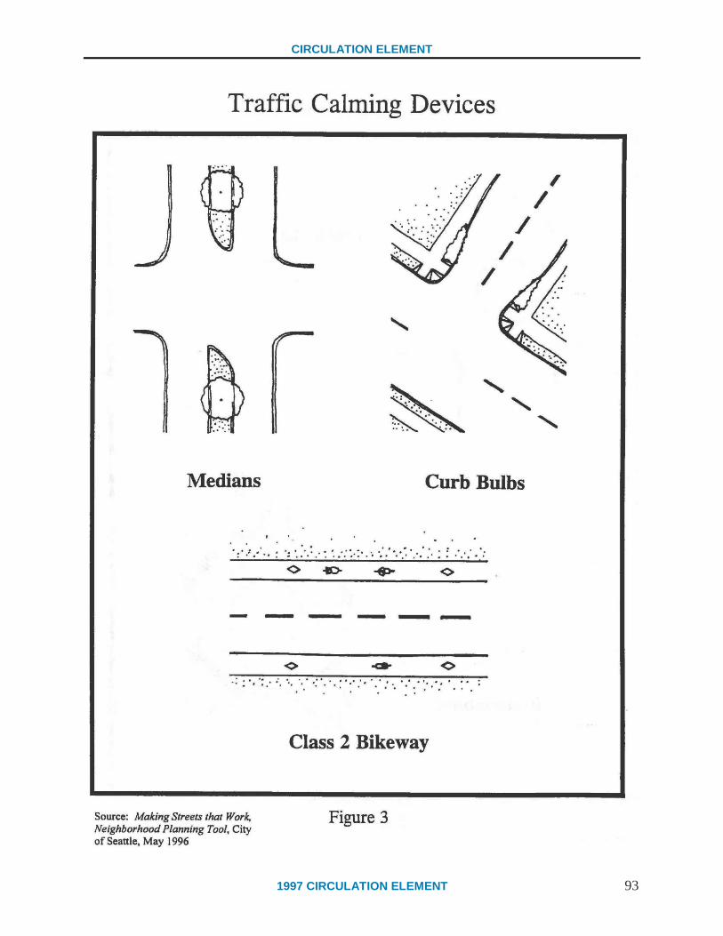
CIRCULATION ELEMENT
1997 CIRCULATION ELEMENT 93

CIRCULATION ELEMENT
94 1997 CIRCULATION ELEMENT

CIRCULATION ELEMENT
1997 CIRCULATION ELEMENT (Page 11-1) 95
CHAPTER 11 – TRAFFIC STANDARDS
Goal 11 REVIEW TRAFFIC IMPACT STANDARDS USED AT CITY
INTERSECTIONS FOR CONSISTENCY WITH THE GOALS OF
THE CIRCULATION ELEMENT AND GENERAL PLAN.
Explore ways to continue the concentration of development Downtown and
along transit corridors to facilitate the use of transit and alternative modes of
transportation.
BACKGROUND
Land use patterns directly affect the transportation choices that people make. A compact,
pedestrian oriented development pattern will provide a greater variety of transportation choices
by facilitating modes of transportation other than the automobile. This happens because people
can live and work in close proximity to transportation centers and facilities. Conversely, a low-
density, sprawling development pattern that segregates residential and non-residential uses limits
transportation options and increases dependence on the automobile for mobility. This land use
pattern, commonly known as Urban Sprawl, can be seen in many post World War II
communities such as Los Angeles and San Jose.
Currently, the amount and density of development that can occur in the City is governed by
different sets of regulations. Passed by the voters in 1989, Measure E was incorporated into the
City Charter as Charter Section 1508. This Charter Section not only places a ceiling on the total
amount of non-residential square footage developed in the City until the year 2010, it also states
that new non-residential construction can only occur where it will not cause a significant and
unmitigated adverse impact on the City’s water resources and traffic within the City, or the
supply of affordable housing on the South Coast. However, because Measure E has not been
incorporated into the City's Local Coastal Program it cannot be used for the purpose of making
findings regarding the consistency of any project with the certified Local Coastal Program until
such time as the provisions of Measure E are certified through the Coastal Commission through
an amendment to the City's Local Coastal Program.
Traffic impacts are currently determined in two different ways. The first way that traffic impacts
are determined is by adopted Level of Service (LOS) standards for signalized City intersections.
Currently, signalized intersections are considered impacted if they exceed the City’s LOS goal of
C, which carries a Volume to Capacity Ratio of .80. However, for the purposes of environmental
assessment in the City of Santa Barbara under the California Environmental Quality Act, a
signalized intersection is considered impacted if a project causes the Volume to Capacity Ratio
to exceed .77. By state law, in any case where a project results in a significant traffic impact, an
environmental impact report must be prepared.

CIRCULATION ELEMENT
96 1997 CIRCULATION ELEMENT (Page 11-2)
CONSTRAINTS
The current method for determining traffic impacts acts as a constraint to development in areas
where intersections are at or near the maximum allowable capacity. Impacted intersections are
typically located near freeway on/off-ramps, Downtown, or near commercial centers. Ironically,
it is these compact and higher density areas that will most easily facilitate transit and alternate
modes of transportation. In addition, the inability of small businesses to expand in locations at or
near impacted intersections may result in the relocation of those businesses to lower density or
outlying areas that may not be as suitable for alternative modes of transportation. This will, in
turn, increase the reliance on the automobile in these areas and possibly contribute to a sprawling
development pattern. In addition, the charter section requirement that new development occur
only where it does not cause a significant and unmitigated adverse impact on traffic also acts as a
constraint. Traditionally, the methods to mitigate traffic impacts involved improvements to
streets, such as street widening, turn lanes, or striping. In a city such as Santa Barbara that is
mostly developed, many of these mitigation methods may no longer be feasible or desirable.
OPPORTUNITIES
Santa Barbara currently has several areas with a compact development pattern that can support a
transportation system comprised to a large degree of alternative modes of travel (i.e. Downtown
and areas adjacent to commercial corridors). By allowing the pattern of compact development to
continue in these areas, the use of alternative modes of transportation can be facilitated. In
addition, the City can explore ways to allow Small Additions to existing businesses to occur in
the Downtown area and along transit corridors near impacted intersections and expand the list of
available methods to mitigate traffic impacts. This can include methods such as funding for
transit operating costs or partial contributions to larger improvement projects supporting
alternative transportation.

CIRCULATION ELEMENT
1997 CIRCULATION ELEMENT (Page 11-3) 97
POLICIES AND IMPLEMENTATION STRATEGIES
TRAFFIC STANDARDS AND IMPACT THRESHOLDS
11.1 The City shall facilitate the use of transit and alternative modes of
transportation by emphasizing compact, pedestrian oriented development
and connections among all forms of travel during the development and
environmental review process. Within the Coastal Zone portion of the City,
the provisions of Measure E shall not be used for the purpose of making
findings regarding the consistency of any project with the certified Local
Coastal Program until such time as the provisions of Measure E are
certified by the Coastal Commission through an amendment to the City's
Local Coastal Program.
11.1.1 Continue to use existing traffic standards and impact thresholds as described in
the City’s Master Environmental Assessment (MEA), until new standards and
thresholds consistent with the 1997 Circulation Element are developed and
incorporated into the City’s Environmental Goals and Guidelines.
11.1.2 In addition to the Implementation Strategies discussed in Chapter 13, Land Use,
the City shall facilitate the use of transit and alternative modes by exploring
methods such as, but not limited to:
considering ways to allow Small Additions to existing businesses to occur in
the Downtown area and along transit corridors near impacted intersections,
considering expanding the list of available methods to mitigate traffic
impacts. This can include methods such as funding for transit operating
costs or partial contributions to larger improvement projects supporting
alternative transportation,
reviewing traffic impact standards used at City intersections to see whether
they should be raised or lowered for consistency with the goals of the
Circulation Element, other elements of the General Plan, and with the City
Charter through public worksessions with the Planning Commission and
City Council, and
considering adoption of the County Congestion Management Plan Level of
Service Standards for freeway interchanges. This standard would allow
higher volumes of traffic and increased congestion at freeway interchanges.
CIRCULATION ELEMENT
98 1997 CIRCULATION ELEMENT (Page 11-4)
MOBILITY SYSTEM
11.2 The City shall create an adequately funded mobility system consistent with
the vision of this Circulation Element that will increase the access to and
convenience of alternative forms of travel.
11.2.1 Increase funding for alternative transportation systems to solve community
transportation issues and problems not resulting from new development.
11.2.2 Implement the Goals and Policies of Chapter 12, Public Involvement, to involve
the community in methods to create a flexible system of mobility.

CIRCULATION ELEMENT
1997 CIRCULATION ELEMENT (Page 12-1) 99
CHAPTER 12 – PUBLIC INVOLVEMENT
Goal 12 ESTABLISH A PROCESS TO INCLUDE NEIGHBORHOODS IN
THE DISCUSSION OF THE EFFECTS OF TRAFFIC ON
RESIDENTIAL STREETS
Develop a mechanism for monitoring changes to all neighborhoods and for
addressing those changes if appropriate. The mechanism should take the form
of a methodology or procedure for assessing and responding to neighborhood
traffic impacts both during periodic reviews and upon neighborhood request.
Any review and discussion of neighborhood through traffic should be addressed
on an area-wide basis so that all segments of the community, including persons
representing commercial and industrial areas, can participate in creating
solutions to a given traffic problem.
ESTABLISH A PROCESS TO INCLUDE BUSINESS AND NON-
RESIDENTIAL PROPERTY OWNERS IN THE DISCUSSION OF
THE EFFECTS OF TRAFFIC ALONG BUSINESS CORRIDORS
Establish a process to include businesses and non-residential property owners
in the discussion of the effects of traffic along business corridors. Opportunity
to comment on the effects of traffic on business would provide assurance that
future transportation policies support economic vitality. Any review and
discussion of traffic in and around business areas should be addressed on an
area-wide basis so that all segments of the community including persons
representing surrounding residential areas, can participate in creating solutions
to a given traffic problem.
BACKGROUND
The purpose of this chapter is to give residents, business owners, property owners, and
commercial and residential tenants the opportunity to provide input and help find solutions to
address traffic problems and mobility issues. This chapter suggests that a cooperative approach
between people in an affected area is the best approach to finding a workable solution to these
issues. In this way, people who share common paths of travel and have different needs, such as
residents, business owners, industrial users, or service providers, can be considered as one
planning area.
Over the years, some of Santa Barbara's residential neighborhoods have experienced a steady
increase in traffic volumes which have affected the livability of many neighborhoods.
Consequently, the use of the residential street as an interactive community space has declined.
For example, as traffic volumes increase, the ability of children and adults to use the street for
recreational activities diminishes. Many City residents have already expressed concern
regarding high levels of noise pollution along freeway and major transportation corridors. In
response, people may open front windows less and may not use front rooms to sleep. In
addition, the speed of passing cars affects the livability of streets and affects access to and from

CIRCULATION ELEMENT
100 1997 CIRCULATION ELEMENT (Page 12-2)
the area, as well as in and out of driveways. Automobile traffic also creates a barrier to visiting
neighbors on the other side of the street. Studies have shown that on high volume streets, fewer
neighbors know each other and there is general perception of unfriendliness.
Traffic issues also continue to arise in commercial areas. The widening of streets and the
increased speed of passing cars are detrimental to the free movement of people and goods in
commercial areas. Ease of access to business corridors and free mobility between them are
highly important to the economic vitality of an area. Congested streets and high speeds make
access to commercial areas difficult, and the associated air and noise pollution makes them less
attractive to patrons.
Due in part to these increasing traffic volumes, the number of requests to respond to traffic
problems in residential, commercial, and mixed/multiple use areas has also increased. The
negative effects of traffic on the quality of life and the economic vitality of an area are clear, and
the City must provide leadership and be proactive in addressing related concerns and issues.
However, a cooperative effort between all property owners and tenants in a given area is
imperative to reach an equitable and workable solution for all.
CONSTRAINTS
The desire to use the automobile for transportation directly conflicts with a desire to reduce
traffic volumes on City streets. The City of Santa Barbara is largely made up of a grid roadway
system with few cul-de-sac streets. The benefit of this type of layout is the ability to effectively
limit the number of arterial streets necessary to carry City traffic. However, as traffic volumes
increase and arterials become congested, drivers in commercial areas become frustrated resulting
in traffic spreading to neighborhood streets or drivers avoiding congested areas. Although
closing such streets to through traffic would certainly enhance the livability of neighborhoods,
the corresponding traffic congestion on arterial streets (e.g. streets in predominantly commercial
areas) causes problems for business owners and patrons. In addition, there are many areas of the
City where streets were not developed in the grid pattern (e.g. the Foothill, Las Positas, and
Samarkand areas), which aggravates existing traffic flow problems because of a lack of
alternative routes.
The City's inability to handle more automobile traffic is a growing concern. Increases in traffic
are caused by commercial and residential growth both inside and outside of the City. Although
much of the City's increased traffic has been attributed to commercial growth, neighborhood
growth is also a factor. With each additional household, approximately 10 new trips are added to
the street. Streets "down stream" from new residential developments are also affected. While
the traffic generated by one new home is seldom noticed, the development of numerous
residential units over time can dramatically change the character of a neighborhood.
This Chapter looks at ways that community members can work together to find solutions to
traffic problems generated by increased automobile use. These solutions to address traffic issues
in an area will be called a Neighborhood or Business Area Mobility Plan. As initiated
by the public, the City will assist area groups in developing Neighborhood or Business Area
Mobility Plans. These plans are described below.
CIRCULATION ELEMENT
1997 CIRCULATION ELEMENT (Page 12-3) 101
OPPORTUNITIES
A major goal of this element is to create transportation options that effectively reduce
dependency on the automobile. It is envisioned that the increased utilization of transit and
alternate forms of transportation throughout the City will go a long way toward relieving
increasing levels of automobile traffic and traffic congestion. However, vehicular traffic may
continue to increase and the car's presence may continue to create livability problems. The City
has an opportunity to design a community process to address the negative effects of the car
without dramatically reducing mobility and accessibility. This community process shall be
known as the Traffic Management Program.
The Traffic Management Program will be designed to guide neighborhoods, businesses, and
mixed use areas in the development of specific plans addressing mobility and traffic issues. The
Traffic Management Program will present a range of options to help address specific mobility
and traffic issues, present the methodology for implementing the desired actions, explain the
potential costs and benefits of the desired actions, and explain the public process required to
implement desired actions. In essence, this program will present a method to address community
mobility and traffic issues with an emphasis on community participation, education, and
ownership.
Property owners and tenants will use the Traffic Management Program as a guide to create either
a Neighborhood or Business Area Mobility Plan. These plans, developed with the assistance of
City Staff, will detail the desired methods and implementation measures to address a particular
mobility or traffic issue. Community members representing both residential and business
interests in a given area will convene to address traffic problems and find mutually agreeable
solutions. A short video describing the process of developing a Neighborhood or Business Area
Mobility Plan will be provided. Developing a traffic plan can be a unifying process that will
introduce residents and business owners to one another and create a spirit of community. A
successful process will also give residents and business owners a sense of responsibility for
implementation and monitoring.
For many years, traffic solutions have focused on accommodating the car, sometimes at the
expense of other forms of travel or the surrounding area. When addressing traffic problems it
should be recognized that streets have more functions than simply moving cars. Streets are an
integral part of the surrounding area and should be treated as such. The residential street right-
of-way should be treated as an extension of the home and outdoor living space for the
neighborhood. Streets serving commercial areas should be treated as an extension of the
adjacent businesses to help attract shoppers. Therefore, policies designed to reduce the
automobile's negative effects should not be dictated solely by a traditional traffic engineering
approach. Solutions need to include land use planning and encompass a wide range of
innovative strategies with an emphasis on community participation, safety, and mobility.

CIRCULATION ELEMENT
102 1997 CIRCULATION ELEMENT (Page 12-4)
POLICIES AND IMPLEMENTATION STRATEGIES
TRAFFIC MANAGEMENT PROGRAM
12.1 Improve livability and economic vitality by creating a program that
describes a process for residents, tenants, property owners, business owners,
and other interested parties in an area or corridor, to address mobility
issues and mitigate impacts of vehicular traffic.
12.1.1 Create a Traffic Management Program which will:
detail a process to develop and implement Neighborhood Area and Business
Area Mobility Plans that address the traffic and mobility concerns of an
impacted area, including the concerns of any residential, commercial, mixed
use, industrial, recreational, and service uses in the area. The types of issues
that this plan is intended to address include: transit issues; mobility issues;
maintenance issues; pedestrian and bicycle connections; through traffic
volumes; visual impacts; traffic speeds; noise; safety for children and
pedestrians; and collisions,
detail the process required for education on traffic issues, implementation,
potential costs and benefits of various alternatives addressing mobility and
traffic issues, conflict resolution strategies, the public hearing and design
review process, and future enforcement and monitoring,
describe various options available to address traffic issues such as:
encourage the use of alternate modes of transportation to reduce vehicle
traffic,
speed humps,
chokers,
street closures,
partial street closures,
raised intersections,
roundabouts,
neighborhood traffic circles,
street trees,
curb bulbs,
loading/unloading areas,
distances for vehicles leaving commercial facilities to reduce conflicts
with bicycles and pedestrians,
providing wide sidewalks for pedestrian travel and outdoor
display/activity areas, where appropriate,
access ramps,
CIRCULATION ELEMENT
1997 CIRCULATION ELEMENT (Page 12-5) 103
12.1.1 landscaping to enhance storefront displays and not distract from or
conceal those displays, and
providing transit facilities,
encourage community members to identify innovative solutions to address
traffic problems,
include the location of information sources related to traffic, including but
not limited to the following:
status of current projects or improvements,
other applicable area plans, and
neighborhood traffic statistics such as traffic counts, speeds, local vs.
cut-through traffic, truck traffic,
describe a process by which concerned community members can
effectively organize to address traffic related issues, and
include video instruction detailing the process for developing
Neighborhood Area and Business Area Mobility Plans.
12.1.2 The City shall fund a pilot Traffic Management Program to assess the
efficiency/impact of such programs and to quantify the staff and resources
needed to implement this program. The City shall dedicate the necessary staff
and resources to implement the program.
12.1.3 Schedule a regular review and monitoring cycle of Neighborhood Area and
Business Area Mobility Plans to address changing conditions. Prepare the Plans
in advance of the Public Works’ street maintenance cycle to ensure community
input.

CIRCULATION ELEMENT
104 1997 CIRCULATION ELEMENT (Page 12-6)
NEIGHBORHOOD AREA MOBILITY PLAN
12.2 Improve livability and economic vitality by working with residents, tenants,
property owners, business owners, and other interested parties of an
impacted area or corridor to mitigate the impacts of vehicular traffic. The
City shall consult with residents, property owners, and commercial tenants
located in close proximity to any corridor or street before implementing
improvements that could result in changes to the existing characteristics of
that corridor or street, its traffic patterns or infrastructure. Improvements
shall be consistent with Neighborhood Area Mobility Plans.
12.2.1 Work with residents, tenants, adjacent business owners, property owners, and
other interested parties to create Neighborhood Area Mobility Plans that:
address community traffic concerns, including decreased access due to
congestion, visual impacts, maintenance issues, traffic speeds, and high
volumes that contribute to noise and collisions, and discourage pedestrian
activity,
prevent the diversion of traffic problems from one area to another, and
facilitate the communication and interaction between the various areas to
help coordinate efforts and strengthen the connections and
interrelationships.
BUSINESS AREA MOBILITY PLAN
12.3 Sustain or improve economic vitality and quality of life in business areas or
corridors by working with property owners, business owners, residents,
tenants, and other interested parties to mitigate the impacts of vehicular
traffic in business areas. The City shall consult with commercial tenants,
property owners, and residents located in close proximity to any corridor or
street before implementing improvements that could result in changes to the
existing characteristics of that corridor or street, its traffic patterns or
infrastructure. Improvements shall be consistent with Business Area
Mobility Plans.
CIRCULATION ELEMENT
1997 CIRCULATION ELEMENT (Page 12-7) 105
12.3.1 Work with residents, tenants, adjacent businesses owners, property owners, and
other interested parties to create Business Area Mobility Plans that:
address community traffic concerns, including decreased access due to
congestion, visual impacts, maintenance issues, traffic speeds, and high
volumes that contribute to noise and collisions, and discourage pedestrian
activity,
prevent the diversion of traffic problems from one area to another, and
facilitate the communication and interaction between the various areas to
help coordinate efforts and strengthen the connections and interrelationships.

106

1997 CIRCULATION ELEMENT (Page 13-1) 107
CHAPTER 13 – LAND USE
Goal 13 APPLY LAND USE PLANNING TOOLS AND STRATEGIES THAT
SUPPORT THE CITY'S MOBILITY GOALS.
Enhance the historic pattern of compact development. The City can facilitate
this development pattern in a number of ways, including:
Allowing more compact development along major transit corridors (without
increasing the City-wide development potential as provided for in the
existing Zoning Ordinance and General Plan);
Providing incentives for mixed use development;
Establishing provisions that allow for creative site development and urban
design standards;
Studying neighborhoods to determine their service needs and creating
mechanisms to address those needs;
Encouraging development of schools, preschools and day care centers in
ways which reduce travel demand;
Encouraging and supporting neighborhood services and commercial uses in
residential areas;
Establishing social/neighborhood centers (in conjunction with
neighborhood schools if possible);
Reducing/eliminating parking requirements (residential and nonresidential)
where it can be demonstrated as appropriate; and
Evaluating proposed annexations to ensure that services/commercial needs
and transportation linkages are adequately addressed.
BACKGROUND
This Chapter addresses ways in which the physical development patterns can affect
transportation modes. Land use patterns directly affect the transportation choices people make.
The dominant land use pattern which has emerged in many U.S. cities since World War II tends
to separate residential uses from commercial and industrial uses. This development pattern
favors the automobile because of the greater distances between homes, schools, businesses,
services and other activities. As a result, most people frequently rely on the automobile for daily
activities. Reliance on the automobile negatively impacts the environment and quality of life.
The amount of congestion, air pollution, and paving increases in direct proportion to the use of
the automobile. As an example, the Land Use Element of the General Plan states that
approximately 20% of the land in Santa Barbara is devoted to the automobile. Exclusively
automobile oriented land use patterns create difficulties for those who cannot drive, or do not
drive. A land use pattern which tends to favor one mode of transportation will limit the
transportation choices available to all.
CIRCULATION ELEMENT
108 1997 CIRCULATION ELEMENT (Page 13-2)
The City's relatively small size and historic pattern of compact development has resulted in less
automobile orientation than in other communities. For example, high density residential uses are
located in close proximity to Downtown and neighborhood services. Many neighborhood
markets are located in residential neighborhoods even though some do not conform to zoning
regulations. Because of consolidated parking areas and clustered businesses, the Downtown area
has remained compact. The Zoning Ordinance encourages mixed use developments in
commercial areas. The downtown grid system with relatively narrow streets reduces vehicle
speeds, making people feel more comfortable.
CONSTRAINTS
Some places in the City are difficult to access by modes other than the automobile by virtue of
their design. Limited opportunities exist for large-scale changes in areas where access is difficult
because the City is approaching buildout. Compact development which encourages pedestrian
use may result in conflicts between land uses. For example, a grocery store may result in
increased noise, odors, lighting, and traffic for nearby residential uses. Alternatively, some land
uses by their vary nature require large expanses of open areas to accommodate the automobile,
impeding compact development.
OPPORTUNITIES
The General Plan Land Use Element contains policies that govern the physical development of
the City. The Land Use Element encourages growth in established commercial centers, thus
efficiently and effectively using existing resources. This type of growth could also facilitate the
use of alternative transportation and could reduce the need for the automobile.
The City has a responsibility to create, continue, or enhance compact development patterns that
allow alternative transportation modes in the Downtown and other commercial areas. New
strategies could include incentives encouraging the transfer of development rights from outlying
areas, such as hillside and environmentally sensitive areas, to existing centralized residential and
commercial centers nearer to transit corridors (See Transfer of Existing Development Rights in
Glossary). While new development occurs, opportunities for improvements should be identified.
Where infill development occurs, opportunities for pedestrian, transit, and bicycle linkages
should be identified.
In order facilitate a compact development pattern, Santa Barbara must actively encourage
housing development within the Downtown core. One possible incentive for the development of
residential units is to offer the use of space above parking lots (air rights) for housing. On a
broader level, other City policies (e.g. Zoning Overlays, Ordinances) should be changed to
encourage Downtown housing. The City may need to sponsor a project to demonstrate the
success of Downtown housing to business and financial institutions.
CIRCULATION ELEMENT
1997 CIRCULATION ELEMENT (Page 13-3) 109
New housing should be designed for a broad range of household income levels. Housing that
would most benefit the parking system would be located between De La Vina and Garden Streets
from Cabrillo Boulevard to Sola Street. By increasing the resident population of the Downtown
and moving toward a jobs/housing balance, parking demand will be reduced.
An added benefit of this strategy will be an increase in customer base and an increase in the
range of businesses operating Downtown. For example, new businesses and services that cater
to household needs will develop, such as groceries, laundries, and house cleaning services. The
Downtown business day will also expand to include the morning and late evening hours. People
living Downtown will not require additional public parking, as residential on site or remote
parking will be required. These benefits will help meet the Downtown Parking Program's goal to
increase the economic vitality of the business district.

CIRCULATION ELEMENT
110 1997 CIRCULATION ELEMENT (Page 13-4)
POLICIES AND IMPLEMENTATION STRATEGIES
GENERAL PLAN CONSISTENCY
13.1 The City shall integrate the goals of this Circulation Element with land use
decisions.
13.1.1 Encourage the development of projects that combine and locate residential uses
near areas of employment and services.
13.1.2 Continue to require the review of proposed projects for consistency with the
Goals and Policies of the General Plan.
COMPACT DEVELOPMENT
13.2 Without increasing the City wide development potential as provided for in
the existing Zoning Ordinance and General Plan, the City shall allow more
compact, pedestrian oriented development along major transit corridors
(see Traffic Standards Chapter, Implementation Strategy 11.1.1).
13.2.1 Coordinate with transit providers and the public to identify those streets and
routes that could be designated as major transit corridors.
13.2.2 Consider amending the Zoning Ordinance to:
allow increased residential densities and more compact, pedestrian oriented,
non-residential development along streets identified as major transit
corridors, and
reduce parking requirements for properties near major transit corridors if it
can be demonstrated that a negative impact will not occur. In conjunction
with this reduction, the City shall evaluate and aggressively monitor the
results to ensure continued use of alternative means of travel and to justify
reduced parking demands.
13.2.3 Identify commercial areas along transit corridors where opportunities exist for
creating pedestrian access, such as paseos and paths.

CIRCULATION ELEMENT
1997 CIRCULATION ELEMENT (Page 13-5) 111
INCENTIVES FOR MIXED USE
13.3 Provide incentives for mixed use development (see Glossary).
13.3.1 Evaluate the effectiveness of the post 1992 Zoning Ordinance Amendments that
were intended to encourage mixed use development.
13.3.2 Continue to identify and pursue new strategies to encourage the development of
mixed use projects.
13.3.3 Continue to assist in the development of mixed use projects through such
methods as, but not limited to:
land use policies,
modified development standards, and
public - private partnerships and/or financial support, where a City Council
finding of General Plan consistency has been made.
DESIGN STANDARDS
13.4 Establish provisions to allow for creative site development and urban design
standards that support the City’s mobility goals.
13.4.1 Revise the Public Works street design standards, as appropriate, to:
minimize the use of cul-de-sacs in new developments,
include properly maintained landscaping and street trees in public rights of
way,
ensure access between cul-de-sacs and streets, and
allow narrower streets and intersections, wider sidewalks, and parkways
where safe.
13.4.2 Ensure that all City design guidelines orient buildings toward pedestrian
activities through such methods as:
Commercial Areas:
creating attractive, interesting, and pleasing building facades that are
oriented toward paseos, streets and sidewalks,
reducing or eliminating setbacks for non-residential or mixed use
buildings,
CIRCULATION ELEMENT
112 1997 CIRCULATION ELEMENT (Page 13-6)
placing parking lots behind buildings or underground, if feasible,
encouraging shared parking facilities,
incorporating paths and paseos between adjacent properties as new
development, redevelopment and infill development occurs,
screening equipment and materials storage from public view,
incorporating lighting, seating, landscaping, newsracks, shade structures,
etc., and
creating landscaped open spaces.
Residential Areas:
encouraging front porches,
encouraging garages to be placed behind residences to the rear of lots,
encouraging minimal use of new cul-de-sacs. Cul-de-sacs may be
allowed where justified based on geologic or other significant features.
Where allowed, provide access between cul-de-sacs and streets,
incorporating pedestrian and bicycle paths and connections between
adjacent properties,
minimizing fences, walls, and private entry gates to separate large scale
residential developments from the street (or use of private entry gates),
minimizing fences, walls, hedges and private entry gates along frontages
of single family residential lots, and
allowing flexibility in design standards for residential development
adjacent to transit corridors to ensure adequate buffering of noise and
traffic.
13.4.3 Continue to prohibit new drive-through facilities.
13.4.4 Review the Transfer of Existing Development Rights (TEDR) Ordinance for
consistency with the Circulation Element.
13.4.5 Explore the feasibility of the transfer of residential development rights from
hillside and environmentally sensitive areas to transit corridors and commercial
areas while preserving the residential development rights.
CIRCULATION ELEMENT
1997 CIRCULATION ELEMENT (Page 13-7) 113
NEIGHBORHOOD SERVING USES
13.5 Determine the need for residential neighborhood services and commercial
uses that support the City’s mobility goals. Provide opportunities to
address those needs, while preserving and protecting the neighborhood
character.
13.5.1 Allow small scale neighborhood serving commercial uses in residential areas if
supported by affected property owners. Ensure that the character of the
surrounding neighborhood is protected.
13.5.2 Consider amending the Zoning Ordinance to:
reduce or eliminate automobile parking requirements for small scale
neighborhood serving commercial uses,
encourage the establishment of new social/neighborhood centers, and
grandfather existing non-conforming uses.
LOCATION OF EDUCATIONAL FACILITIES
13.6 Identify specific suitable areas and encourage the development of schools,
pre-schools, or day care centers that are compatible with surrounding land
uses and that minimize travel demand.
13.6.1 Work with school districts, private schools, major employers, and appropriate
agencies to:
locate child care facilities near existing schools and major employment
centers,
encourage parents and students to share trips, and
create employer incentives for sponsoring on-site child care facilities.
CIRCULATION ELEMENT
114 1997 CIRCULATION ELEMENT (Page 13-8)
HOME-BASED BUSINESSES
13.7 Encourage and support appropriate home-based businesses in residential
areas.
13.7.1 Revise the Zoning Ordinance to:
allow home based business activities, and
allow telecommuting centers (see Glossary) in appropriate areas.
ANNEXATION
13.8 Ensure that sustainable transportation linkages, public services,
infrastructure, and commercial needs support the City’s mobility goals and
are evaluated in proposed annexations.
13.8.1 Complete the City's 1995 Annexation Policy Update that promotes sustainable
development practices including development near existing services and use of
alternative transportation and discourages urban sprawl and land use patterns
which further the region's dependence on the automobile.
CIRCULATION ELEMENT
1997 CIRCULATION ELEMENT (Page 14-1) 115
CHAPTER 14 – REGIONAL COORDINATION
Goal 14 COORDINATE WITH REGIONAL SYSTEMS AND GOALS.
Increase the City’s participation in regional transportation planning activities
and continue to influence the development of regional plans.
BACKGROUND
This chapter focuses on increasing City participation in regional transportation planning efforts
through cooperation and communication. The City recognizes that it is an integral part of a
regional and statewide transportation system. The City’s facilities connect to areas outside the
City's boundaries. These connections need to be coordinated with facilities in other jurisdictions.
Effective South Coast participation decisions result from membership on and participation in the
Santa Barbara County Association of Governments (SBCAG) and the Metropolitan Transit
District (MTD) Board of Directors. Close coordination with the County of Santa Barbara and
the City of Carpinteria is critical to the success of these efforts. Other important agencies with
overlapping jurisdictions are the Santa Barbara County Air Pollution Control District (APCD)
and the California Department of Transportation (Caltrans).
CONSTRAINTS
Although the City has twenty-five percent of the County’s population, it has but one of twelve
votes on SBCAG. Therefore the City has limited influence over regional planning and funding
efforts.
OPPORTUNITIES
Active participation in the development of regional plans and programs may result in greater
cooperation between jurisdictions and greater consideration of the City’s transportation goals and
objectives.

CIRCULATION ELEMENT
116 1997 CIRCULATION ELEMENT (Page 14-2)
POLICIES AND IMPLEMENTATION STRATEGIES
REGIONAL PLANS
14.1 The City shall encourage regional transportation plans and programs (such
as those under the jurisdiction of the Santa Barbara County Association of
Governments) that support the Circulation Element.
14.1.1 Proactively participate in the development and review of regional plans.
Allocate resources to ensure input from City Council, Planning Commission, the
Planning and Public Works Departments, the offices of the City Attorney and the
City Administrator's Office.
14.1.2 The City’s representation on the SBCAG Board shall reflect the strength of the
Circulation Element’s community consensus.
14.1.3 The City’s representative to the SBCAG Board shall inform the Planning
Commission and the City Council if regional plans or impending decisions are
discussed or decisions are made that are inconsistent with this Circulation
Element.
14.1.4 Prior to each annual adoption of the Capital Improvements Program, public work
sessions shall be held with the Planning Commission and the City Council to
develop project priorities for funding.
REGIONAL COORDINATION
14.2 The City shall encourage coordination with the County of Santa Barbara and
other agencies and jurisdictions through joint work sessions in order to pursue
regional transportation goals.
14.2.1 Hold regular annual sessions with the Planning Commission and City Council on
regional transportation issues. Invite the First, Second, and Third District
Supervisors as well as the City of Carpinteria to the meeting.
14.2.2 Explore funding to expand a coordinated regional traffic model to include City
streets (not just Congestion Management Plan routes).
CIRCULATION ELEMENT
1997 CIRCULATION ELEMENT (Page 14-3) 117
14.2.3 Establish a South Coast Land Use and Transportation Work Group that includes
representatives from:
City of Santa Barbara Planning Department,
City of Santa Barbara Public Works Department,
City of Santa Barbara Airport Department,
City of Santa Barbara Waterfront Department,
County of Santa Barbara Planning and Development Department,
County of Santa Barbara Public Works Department,
County of Santa Barbara Affordable Housing Program,
City of Carpinteria Planning Department,
City of Carpinteria Public Works Department,
Santa Barbara County Association of Governments,
Air Pollution Control District,
Metropolitan Transit District,
Caltrans,
school districts,
Traffic Solutions and/or other regional transportation demand management
programs,
private sector transportation planners,
private sector transportation engineers, and
where appropriate, the Cities of Ventura, Lompoc, and Santa Maria.
The work group shall focus on:
regional and local coordinated planning efforts,
developing a comprehensive list of funding sources, and
developing a prioritized list of potential projects for funding.
CIRCULATION ELEMENT
118 1997 CIRCULATION ELEMENT (Page 14-4)
The public shall be notified and permitted to observe all meetings of the South
Coast Land Use and Transportation Work Group.
14.2.4 The City shall review and comment on significant development projects located
outside of, but with potential impacts upon, the City of Santa Barbara. Each
proposal’s consistency with the Circulation Element should be addressed and the
comments forwarded to appropriate agencies.
AIRPORT
14.3 The City shall coordinate with the County and other agencies and
jurisdictions to improve transportation to and from the City's Airport.
14.3.1 Work with the County on high priority projects such as:
the South Kellogg extension,
Highway 217 off-ramp,
the Hollister/Los Carneros intersection,
electric shuttles,
bicycle/pedestrian paths parallel to Hollister and the Railroad,
the extension of the South Fairview bike path,
bicycle/pedestrian bridge over the freeway either at La Patera or west of
Fairview, and
developing a direct connection between the Goleta Rail Depot and the
Airport.
14.3.2 Encourage the development of transit services to, into, and from the Airport
Terminal, such as:
increased and enhanced taxi service,
increased/regular bus service, and
increased on-demand services such as airport shuttles.
14.3.3 Explore the development of bicycle paths/amenities to encourage bicycling to
and from the Airport.

CIRCULATION ELEMENT
1997 CIRCULATION ELEMENT (Page 14-5) 119
EDUCATION/OUTREACH
14.4 The City shall develop an education/outreach program about the City's
Circulation Element.
14.4.1 Distribute the adopted Circulation Element to SBCAG, other jurisdictions,
transportation related agencies, and affected groups.
14.4.2 Encourage regional marketing of transportation services to educate the public
about the availability and benefit of alternative modes of transportation.
14.4.3 Review proposed State and Federal legislation for effects on the Circulation
Element and comment as appropriate.
REGIONAL COOPERATION AND COORDINATION
14.5 The City shall cooperate with regional efforts that promote the use of
alternative transportation.
14.5.1 Work with regional agencies to explore the feasibility of a regional commuter
shuttle system linking City employment centers with distant residential areas.
14.5.2 Encourage development of new or expanded regional park and ride facilities.
14.5.3 Encourage the development of regional rail service between Carpinteria and
Goleta/Isla Vista.
14.5.4 Encourage station improvements and the development of intermodal connections
between the Union Pacific Railway Depots and employment centers.
14.5.5 Encourage regional transit providers (e.g. APCD’s Clean Air Express) to provide
express service from Ventura, Santa Barbara, and Goleta/Isla Vista.
14.5.6 Encourage the development of and provide incentives for telecommuting and a
regional teleconferencing system to reduce interregional trips.
14.5.7 Work with other agencies to implement the adopted Regional Bikeway Plan.
14.5.8 Encourage and support the possibility of the expansion of Metrolink service to
Santa Barbara.

120
CIRCULATION ELEMENT
1997 CIRCULATION ELEMENT (Page 15-1) 121
CHAPTER 15 – OTHER TRANSPORTATION FACILITIES
Goal 15 OTHER TRANSPORTATION FACILITIES
Continue to support the movement of people, goods, and services by
transportation modes such as air, rail, and water. The movement of trucks and
hazardous materials shall continue to be regulated to ensure safety.
BACKGROUND
State Planning Law requires that Circulation Elements address the movement of people and
goods. State Planning Law also requires Circulation Elements to discuss issues related to other
forms of transportation, communication and public utilities. This chapter discusses other
transportation facilities in the City that have not been addressed in the preceding chapters.
TRUCK AND HAZARDOUS MATERIALS ROUTES
Truck Routes
The City does not have a network of designated truck routes. The City relies on weight limit
regulations to restrict truck traffic in inappropriate areas, such as residential neighborhoods.
Hazardous Materials Routes
The State of California Vehicle Code, beginning with Section 31300, governs transport of
hazardous materials, including waste. The California Highway Patrol enforces these regulations
on state highways and local police and fire departments oversee compliance elsewhere. The
majority of tank trucks transporting hazardous materials travel via U.S. Highway 101. Until
prohibited in the late 1980's, State Highway 154 was used as an alternate route.
Hazardous materials are also transported through the City via the Union Pacific Railroad.
However, in 1995, the City Council adopted a resolution opposing the transportation of spent
nuclear fuel through the City.
OTHER TRANSPORTATION FACILITIES
Air Transportation
The Santa Barbara Municipal Airport is located in the South Coast region of Santa Barbara
County. The City of Santa Barbara has owned and managed the Santa Barbara Municipal
Airport since 1941. It is the largest commercial service airport on the California coast between
San Jose and Los Angeles.

CIRCULATION ELEMENT
122 1997 CIRCULATION ELEMENT (Page 15-2)
The Airport includes three runways. Runway 7/25 is the east-west runway. It is 6,052 feet long
and is the only runway at the Airport set up for instrument landing. It is also the runway for
commercial jets and other large aircraft. Runways 15/33L and 15/33R are parallel north-south
runways that are 4,183 feet and 3,952 feet long respectively. The Airport is presently served by
ten airlines, including United, United Express, Shuttle by United, American Eagle, USAir,
Northwest, Alaska Airlines, Sky West/Continental Connection, Sky West/Delta Connection, and
America West Express. Nonstop destinations include Los Angeles, San Francisco, Sacramento,
Denver, Las Vegas, and Phoenix.
Currently, there are over 100 commercial flights daily with domestic and international
destinations. The Airport generated 530,650 passengers in 1995 with the total number of
passengers projected to be 936,000 by 2010. The number of Airport operations (take-offs and
landings) is also expected to increase from 194,000 in 1995 to 218,000 in 2010. The rate of
increase for passengers is greater than that for operations because it is expected that smaller
commuter planes will be replaced with larger planes, reducing the number of flights necessary to
carry the same number of passengers. While air carrier operations are the most visible of
operations, the majority of air traffic at the Airport is generated by general aviation which
includes small private planes, corporate jets, and helicopters. The Airport also provides an
important base for U.S. Forest Service fire fighting planes during the fire season.
In 1990, the City Council established goals that are the basis of the development of the Airport
Specific Plan, Airport Industrial Area Specific Plan, and the Aviation Facilities Plan. The
Airport Industrial Area Specific Plan (ASP) is focused on the commercial/industrial area on the
north side of the Airport, straddling Hollister Avenue. The Administrative Final Specific Plan
was released for public review in August, 1997, and will be the subject of public hearings
through the end of 1997. The Aviation Facilities Plan (AFP) is focused on Airport operations.
This Plan calls for:
construction of a 1,000 foot long by 500 foot wide Runway Safety area at each end of
Runway 7/25,
extension of Runway 7/25 to accommodate the loss of usable runway due to the construction
of Runway Safety Areas at each end of the runway,
construction of a 1,000 foot long by 500 foot wide Runway Safety area at each end of
Runway 7/25,
addition of 40,000 to 50,000 square feet to the Airline Terminal,
addition of parking for 1,300 automobiles,
addition of a new Taxiway M west of and parallel to Runway 15/33L, and
addition of up to 75 T-hangars (covered parking for aircraft).
CIRCULATION ELEMENT
1997 CIRCULATION ELEMENT (Page 15-3) 123
These changes are proposed in order to meet existing needs, projected future needs, and to
increase Airport safety. A draft Aviation Facilities Plan was completed in 1990 and is presently
being rewritten to include updated passenger projections, noise contours, and project
descriptions.
Because the intersections affected by traffic generated from both the Airport Specific Plan and
the Aviation Facilities Plan are in the unincorporated County area, the City is working with
County Planning and Development and Public Works Departments to develop traffic mitigation
measures.
Rail Transportation
Union Pacific Railroad arrived in Santa Barbara in 1886 and completed the Coast Line in 1901,
making it possible for passengers to travel between San Francisco and Los Angeles. The present
Railroad Depot at State and Yanonali Streets was completed in 1905 and is a designated City
Landmark. Union Pacific Railroad operates freight trains through Santa Barbara. On average,
seven freight trains travel through Santa Barbara daily on weekdays, and four freight trains travel
through Santa Barbara daily on weekends. Passenger trains are operated by Amtrak. Amtrak
has increased the number of passenger trains substantially over the last decade. The Coast
Starlight train travels between Los Angeles and Seattle and stops once daily in Santa Barbara
northbound and southbound. The San Diegan operates between Santa Barbara and San Diego
with three daily round trips to Santa Barbara. In fall 1995, a new San Diegan was added that
travels north to San Luis Obispo. The last San Diegan each evening lays over at a spur between
Santa Barbara and Salsipuedes Street in the Waterfront area of Santa Barbara. This late evening
northbound San Diegan then becomes the first southbound passenger train in the morning.
CalTrans, in cooperation with Amtrak, has plans to provide additional passenger stations
between Santa Barbara and San Luis Obispo with the intent of promoting commuter traffic
between the new stations. An unstaffed station at Carpinteria was recently opened. Proposed
stations include Goleta, Guadalupe, and Surf. All of these stations would be unstaffed. In
addition to the proposed Goleta Station, a new overnight layover spur would likely be provided
in the Goleta area to replace the one in Santa Barbara's Waterfront.
Water Transportation
The Santa Barbara Harbor serves both the commercial fishing industry, recreational boaters, and
others who enjoy the Harbor atmosphere. Facilities for commercial fishing, storage areas, and
retail and recreational activities are located in the Harbor area. The demand for Harbor slips far
exceeds the supply and there is a waiting list consisting primarily of recreational boaters.

CIRCULATION ELEMENT
124 1997 CIRCULATION ELEMENT (Page 15-4)
The Local Coastal Plan, adopted in 1981, required the preparation of a plan for the Harbor and
Stearn’s Wharf that will maintain the existing "working harbor" nature of the area. The Harbor
Master Plan and associated changes to the LCP received final certification from the California
Coastal Commission in June 1996. The goals of the Harbor Master Plan are to provide for
primary ocean dependent uses, such as fishing and recreational boating, and for secondary uses,
such as ocean related and visitor serving uses. In order to improve access to the Harbor area, the
Harbor Master Plan (HMP) includes several policies related to circulation issues (see Chapter 9,
Coastal, for more detail).
The City should also consider working with cruise ship lines to determine what facilities would
be needed to make Santa Barbara a regular stop on Pacific Coast trips. Cruise ships bring in
tourists without automobiles or the need for overnight accommodations. Such tourists can walk
or use shuttles to explore the Santa Barbara Waterfront or will visit historic locations via tour
bus. Cruise ship passengers can have a healthy impact on the City’s economy without
substantially impacting the circulation system.
CIRCULATION ELEMENT
1997 CIRCULATION ELEMENT (Page 15-5) 125
POLICIES AND IMPLEMENTATION STRATEGIES
TRUCK TRAFFIC AND HAZARDOUS MATERIALS ROUTES
15.1 Regulate the movement of truck traffic and hazardous materials throughout
the City.
15.1.1 Enforce weight limits as a means to safely regulate truck traffic in noise sensitive
areas, such as residential neighborhoods and near schools and hospitals.
15.1.2 Ensure that signage indicating weight limits is clearly posted throughout the
City.
15.1.3 Coordinate with agencies, such as the California Highway Patrol, the County
Office of Emergency Services, and Union Pacific Railroad, to regulate the
transportation and storage of hazardous materials in and through the City.
15.1.4 Continue to coordinate with the County to implement the Hazardous Waste
Management Plan of the Santa Barbara Municipal Code.
15.1.5 Support the development and implementation of a quick-response emergency
services program for the 101 Freeway and railroad corridors and continue to
support the City’s Hazardous Materials Team.
15.1.6 Continue to oppose the transportation of spent nuclear fuel through the City.
OTHER TRANSPORTATION FACILITIES
15.2 Manage and operate the Airport in an efficient, cost effective, and safe
manner.
15.2.1 Operate the Santa Barbara Municipal Airport in a safe and cost effective manner.
15.2.2 Accommodate a variety of users, such as commercial and general aviation users,
at the Santa Barbara Municipal Airport.

CIRCULATION ELEMENT
126 1997 CIRCULATION ELEMENT (Page 15-6)
15.2.3 Implement the Airport Industrial Area Specific Plan to address circulation issues
associated with the industrial area on the north side of the Airport, including
policies designed to:
improve vehicle circulation within the Plan area, including improved access
to Hollister Avenue,
improve usability of the street system for pedestrians, including making the
system more inviting and providing a pedestrian walkway along Hollister
Avenue,
accommodate and support alternative modes of transportation, including
working with Metropolitan Transit District and other agencies to provide
transit and shuttle service within the area and to surrounding areas,
coordinate bicycle and pedestrian facilities with those planned by the County
and design the new street system within the planning area to accommodate
bicycles and pedestrians, and
develop a direct link between the Airport and the Goleta Rail Depot.
15.2.4 Implement the Aviation Facilities Plan to address existing and projected future
safety and operational needs of the Airport.
15.2.5 Work with agencies, such as the FAA, the County Planning and Development
and Public Works Departments, and U.C.S.B. to address circulation and Airport
related issues, such as noise and the use of alternative modes of transportation.
15.2.6 Support the creation of excellent transit access to and from the Airport terminal.
15.3 Work with transit providers to ensure safe and reliable rail transportation.
15.3.1 Coordinate with rail transportation operators, such as Union Pacific Railroad and
Amtrak, to ensure safe and reliable rail transportation in the City.
15.3.2 Work with rail transportation operators, such as Amtrak and Metrolink, to
increase regional and commuter passenger rail service and connections to help
reduce dependency on the automobile.
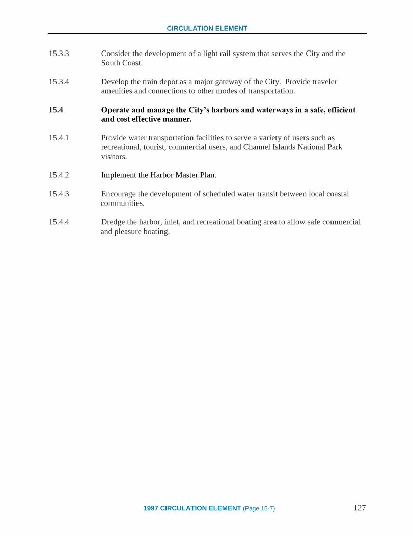
CIRCULATION ELEMENT
1997 CIRCULATION ELEMENT (Page 15-7) 127
15.3.3 Consider the development of a light rail system that serves the City and the
South Coast.
15.3.4 Develop the train depot as a major gateway of the City. Provide traveler
amenities and connections to other modes of transportation.
15.4 Operate and manage the City’s harbors and waterways in a safe, efficient
and cost effective manner.
15.4.1 Provide water transportation facilities to serve a variety of users such as
recreational, tourist, commercial users, and Channel Islands National Park
visitors.
15.4.2 Implement the Harbor Master Plan.
15.4.3 Encourage the development of scheduled water transit between local coastal
communities.
15.4.4 Dredge the harbor, inlet, and recreational boating area to allow safe commercial
and pleasure boating.

128

CIRCULATION ELEMENT
1997 CIRCULATION ELEMENT (Page 16-1) 129
CHAPTER 16 – PUBLIC UTILITIES
Goal 16 PUBLIC UTILITIES
To meet existing and projected needs, continue to provide and maintain adequate storm
drainage, water supply and distribution, and wastewater collection systems. In
addition, the City shall continue to work with electric, gas, and communications
suppliers to maintain and provide service.
BACKGROUND
State Planning Law requires that Circulation Elements address the movement of people and
goods. State Planning Law also requires Circulation Elements to discuss issues related to other
forms of transportation, communication and public utilities. This chapter discusses public
utilities in the City that have not been addressed in the preceding Chapters.
PUBLIC AND QUASI-PUBLIC UTILITIES
POWER FACILITIES
Electricity
Edison Company provides electrical power to the City. The City is served by an electrical
distribution system operating at two voltage levels, 4 Kilovolts (Kv) and 16 Kv. The 4 Kv
system serves the Downtown. The 16 Kv system primarily serves the remainder of the City.
However, as new uses are added Downtown the higher voltage system is used in order to avoid
overloading the existing system. Electricity is moved from sources to substations over the City's
transmission system. At present the transmission system operates at 60 Kilovolts and is
approximately 30% underground. Future facilities will all be underground. As commercial,
industrial or residential neighborhoods have funds available or agree to an assessment against
their property taxes, transmission lines in other areas of the City will also be placed underground.
Present facilities are adequate to serve both current and projected electrical needs of the City.
Minor upgrades and monitoring of existing substations will continue to occur over time.
Natural Gas
Southern California Gas Company (SCG) provides natural gas to the City. In 1995, annual
consumption in the City was 2,049,847,600 cubic feet. Approximately 97% of the City uses
natural gas for water heating, 94% for space heating, 78% for cooking and 72% for clothes
dryers. Natural gas is provided via pipelines. SCG has indicated that it can meet future demands
for natural gas in the City. More deregulation and competition are the biggest changes foreseen
in the future. However, this will primarily affect manufacturing use of natural gas.
CIRCULATION ELEMENT
130 1997 CIRCULATION ELEMENT (Page 16-2)
CITY UTILITIES
Storm Drain System
The storm drain system is designed to safely convey water runoff to the ocean. Storm drain
facilities used to collect and transport this water include natural watercourses, channels, ditches,
gutters, catch basins, inlet structures, pumps, tide gates, and pipes. The Laguna Pump Station is
fully automated and assists in pumping runoff from the north side of the freeway to the south
side of the freeway. Catch basins, pipes, and inlet structures are cleaned annually to prevent the
lines from clogging and to reduce flooding potential. During storm conditions, crews mobilize to
respond to clogged drains, damaged facilities, blocked roads, and to protect property. After
storms pass, storm debris, mud, and sand are cleaned up and removed from the public right-of-
way. There is an annual budget appropriation for repair of and improvements to the system. In
addition, the City has recently established a public education program to reduce illegal dumping
of hazardous wastes into storm drains. This program includes public education, stenciled signs
at drop inlets, and other locations and increased enforcement of violations.
Water Supply and Distribution System
The City of Santa Barbara operates the principal water supply and distribution system that serves
City residents and some unincorporated portions of Santa Barbara County, primarily in the
Mission Canyon area. A small percentage of City residents are served by other water agencies
through special agreements. The City's distribution system is maintained on a 100-year
replacement cycle, with a portion of the system replaced each year. Current demand is
approximately 13,000 AFY. In the short term, as post-drought usage continues to recover,
demand is projected to reach 14,000 AFY by 1999. For the long term (through the year 2015),
demand is projected to be between 15,200 AFY and 16,900 AFY depending on the long term
effects of demand reduction efforts instituted during the drought. The Long Term Water Supply
Program, which includes a safety margin for unanticipated demand increases or supply
deficiencies, was adopted by the City Council on July 5, 1994, and includes supplies sufficient to
meet a demand of up 18,200 AFY, given a maximum acceptable shortage of 10%.
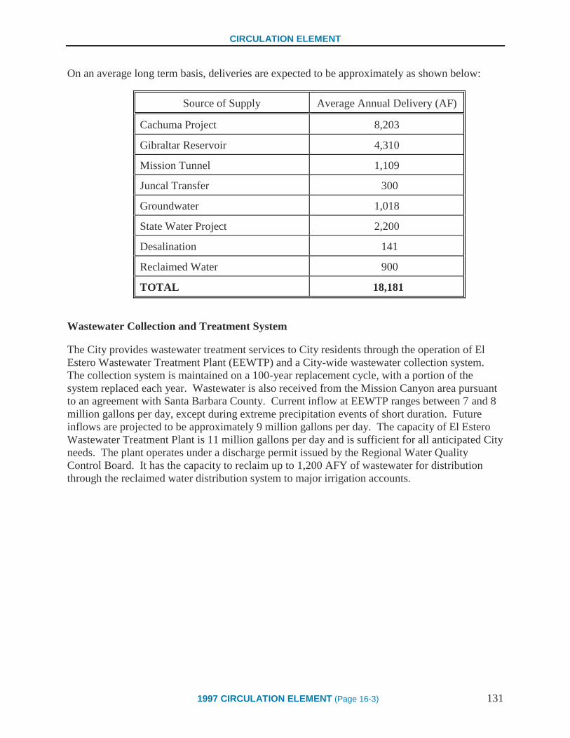
CIRCULATION ELEMENT
1997 CIRCULATION ELEMENT (Page 16-3) 131
On an average long term basis, deliveries are expected to be approximately as shown below:
Source of Supply Average Annual Delivery (AF)
Cachuma Project 8,203
Gibraltar Reservoir 4,310
Mission Tunnel 1,109
Juncal Transfer 300
Groundwater 1,018
State Water Project 2,200
Desalination 141
Reclaimed Water 900
TOTAL 18,181
Wastewater Collection and Treatment System
The City provides wastewater treatment services to City residents through the operation of El
Estero Wastewater Treatment Plant (EEWTP) and a City-wide wastewater collection system.
The collection system is maintained on a 100-year replacement cycle, with a portion of the
system replaced each year. Wastewater is also received from the Mission Canyon area pursuant
to an agreement with Santa Barbara County. Current inflow at EEWTP ranges between 7 and 8
million gallons per day, except during extreme precipitation events of short duration. Future
inflows are projected to be approximately 9 million gallons per day. The capacity of El Estero
Wastewater Treatment Plant is 11 million gallons per day and is sufficient for all anticipated City
needs. The plant operates under a discharge permit issued by the Regional Water Quality
Control Board. It has the capacity to reclaim up to 1,200 AFY of wastewater for distribution
through the reclaimed water distribution system to major irrigation accounts.

CIRCULATION ELEMENT
132 1997 CIRCULATION ELEMENT (Page 16-4)
COMMUNICATION UTILITIES
Telephone
Local telephone service in the City is provided by General Telephone (GTE). GTE is in the
process of system upgrades involving the use of fiber optics which can carry many more lines
than can copper wiring. In addition, all of Santa Barbara County is equipped with digital
switching capability. This capability will facilitate transmission of all telecommunications
services including voice, video, and data. GTE has indicated that there are no foreseeable
problems with the provision of telephone and other telecommunications services to growth areas
in the City.
Because of the rapid increase in facsimile machines, cellular phones, pagers, and computer
modems across the state, the number of telephone lines has increased at an astounding rate
during the last few years. In the Santa Barbara area alone, growth was 8,000 lines in 1995, a
substantial increase over the past several years and more than could be directly accounted for by
population and employment growth. In addition, new competition in the local market will result
in certain blocks of prefixes in each area code being assigned to different telephone companies,
further depleting the availability of phone lines. In addition, as of June 1, 1996, GTE is now able
to enter the long distance market. This will facilitate GTE's ability to provide Internet access and
cable television programming to its customers in the future. The 805 area code that serves the
Santa Barbara area is planned to be divided in the future.
Cable
While cable television services are not technically considered public utilities and are not
regulated by the Public Utilities Commission, such services are an important part of the
community and have the potential to assist in reducing traffic in Santa Barbara. Cox
Communications provides cable television service to the City of Santa Barbara. Cable service is
available to all City residents and is used by 30,700 customers in the City and approximately
65,000 in the South Coast. Cox is continuing its South Coast infrastructure investment program
which has totaled more than $20 million over the past five years. Cox has also completed a
state-of-the-art electronics and signal facility in Goleta. This upgrade has increased the
company's channel capacity and increased service reliability and picture quality. Through Cox,
the City and County are able to provide live television coverage of City Council, Board of
Supervisors, and Planning Commission meetings, as well as special events that occur in the
community. Cox is exploring the possibility of conducting tests later in 1995 for interactive data
services such as video-conferencing, electronic mail, interactive participation in community
forums, and other computer related services.

CIRCULATION ELEMENT
1997 CIRCULATION ELEMENT (Page 16-5) 133
POLICIES AND IMPLEMENTATION STRATEGIES
ELECTRIC AND GAS FACILITIES
16.1 Ensure that adequate electrical systems are provided to meet the needs of
Santa Barbara residents, industrial uses, and businesses.
16.1.1 Work with the Edison Company to maintain and improve current levels of
service and meet future demands, assuring the development of three phase power
throughout the M-1 zones.
16.1.2 Prior to approval of new or expanded structures that have the potential for
significant energy use, contact the Edison Company to identify the adequacy of
supplies.
16.1.3 As appropriate and feasible and based upon demand, work with the Edison
Company to plan for and provide recharging stations for electric vehicles.
16.1.4 Where possible, place gas lines, electrical lines, and equipment underground.
16.2 Ensure that an adequate gas supply is provided to meet the needs of Santa
Barbara residents and businesses.
16.2.1 Continue to work with Southern California Gas Company and other providers to
maintain and improve current levels of service and meet future demands.
16.2.2 Prior to approval of new or expanded structures that have the potential for
significant energy use, contact Southern California Gas Company or other
providers to identify the adequacy of supplies.
CITY UTILITIES
16.3 Provide a storm drainage system that is able to support the permitted land
uses while preserving the public safety.
16.3.1 Maintain and improve, as necessary, the existing public storm drains and flood
control facilities.
CIRCULATION ELEMENT
134 1997 CIRCULATION ELEMENT (Page 16-6)
16.3.2 Coordinate with County and Regional agencies in the maintenance and
improvement of storm drain facilities in order to protect the City’s residents,
property, and structures from flood hazard (e.g. Highway 101 or railroad
crossings and Laguna Creek).
16.3.3 Ensure that adequate storm drain facilities are in place to serve new or expanded
uses.
16.3.4 Encourage the use of methods, such as the use of pervious surfaces and
percolation ponds, that help to reduce the amount of runoff.
16.3.5 Require structures located in designated flood hazard areas to comply with local,
State, and Federal building and safety standards.
16.3.6 Explore methods to educate and inform the public of the potential impacts of
dumping dangerous/hazardous materials into the storm drains.
16.4 Provide an adequate water supply system to meet the needs of existing and
future residents and businesses.
16.4.1 Manage and enhance the City’s water supply facilities to accommodate existing
and projected population levels as identified in the Long Term Water Supply
Program.
16.4.2 Require the incorporation of water conservation techniques in the design of new
work projects in order to reduce the demand on available water resources.
16.4.3 Ensure that there is sufficient water capacity and supply prior to approving new
development projects or expansions to existing projects.
16.5 Provide a safe, efficient, and cost effective wastewater collection and
treatment system that is able to meet the needs of permitted land uses.
16.5.1 Collect and treat wastewater to meet local, Regional, State, and Federal
Standards.
16.5.2 Monitor existing and projected demands on the wastewater system and ensure
that adequate capacity exists.
16.5.3 Prior to allowing the development of new structures, ensure that adequate
capacity exists. If capacity does not exist, identify means and costs involved in
meeting the increased demand.

CIRCULATION ELEMENT
1997 CIRCULATION ELEMENT (Page 16-7) 135
16.5.4 Improve and upgrade the wastewater treatment and collection system to mitigate
existing deficiencies and meet the needs of projected growth.
COMMUNICATION FACILITIES
16.6 Ensure adequate telecommunication and cable services are provided to meet
the needs of Santa Barbara residents and businesses.
16.6.1 Work with communication service providers to maintain current levels of service
and meet future demands.
16.6.2 Promote the development of telecommuting and teleconferencing info/infra
structure and facilities to help reduce the number of automobile trips.
16.6.3 Promote implementation of new communication technologies (e.g. fiber-optic
lines with higher speed and wider band-width utilization).
MAINTENANCE OF TRANSPORTATION AND UTILITY FACILITIES
16.7 Ensure that utility and transportation facilities are well maintained and located,
so as not to impede pedestrians or traffic, and are aesthetically pleasing.
16.7.1 Encourage and work with utility providers and transportation providers to
maintain their facilities in a clean and safe manner.
16.7.2 Continue the graffiti removal and enforcement program working closely with
transportation and utility providers to ensure graffiti removal from their facilities.
16.7.3 Expand public and private street and parking lot cleaning, maintenance, and
improvement programs.

136

CIRCULATION ELEMENT
1997 CIRCULATION ELEMENT (Page 17-1) 137
Circulation Element
GLOSSARY OF TERMS
Affordable housing A residential unit that is generally affordable to households with low and moderated incomes.
The residents generally should not be required to pay more than 30% of their gross monthly
income on rent or house payments.
Air Pollution Control District (APCD)
An independent special district whose mission is to “protect the people and the environment of
Santa Barbara County from the effects of air pollution.” The APCD regulates local sources of
air pollution, except motor vehicles. APCD monitors pollution in the county; adopts rules, issues
permits, and inspects businesses to ensure compliance; prepares clean air plans to achieve clean
air standards; responds to complaints about air pollution; and educates the public on their role in
cleaning up the air. The APCD is governed by a board consisting of each of the five county
supervisors and one representative (a mayor or Councilmember) from each of the seven cities in
the county. (Source: Provided by the APCD)
Air rights The rights to the space above a property. Common law grants the owner a piece of real estate
ownership of a vertical space extending an unlimited distance above the ground.
Alternative transportation
In the context of this Circulation Element, a form of travel that does not utilize the single
occupant motor vehicle. May include transit, vanpools, carpools, bicycling, and walking.
Americans with Disabilities Act (ADA) Federal law that is intended to ensure accessibility to physical structures for all people. The
ADA sets minimum standards to accommodate the physically challenged.
Arterial streets
A functional description of a road segment that provides for through traffic movement between
areas and across the city, and direct access to abutting property.
Assessment districts
A specified area that is charged a fee or tax for the provision of services, the installation of
infrastructure improvements, and/or maintenance.
Automobile oriented uses Functional activities that are auto-related and/or those which by their design attract primarily
customers and employees using the automobile.
Beachway
A path adjacent to the beach that is used by pedestrians and all forms of non-motorized vehicles.

CIRCULATION ELEMENT
138 1997 CIRCULATION ELEMENT (Page 17-2)
Benefit/Cost Ratio The relationship between the benefits and costs of a project. When the ratio is less than 1, the
costs outweigh the benefits. When the ratio is more than 1, the benefits outweigh the costs.
Bicycle Coalition
The Santa Barbara Bicycle Coalition is a countywide advocacy and resource organization that
promotes bicycling for safe transportation and recreation.
Bicycle Coordinator
A employee who has as part or all of their job description the responsibility for coordination,
study, evaluation, or development of bicycle and bike use programs or facilities for the
employer. Local government agency coordinators may also be responsible for identifying and
securing funding for bike projects.
Bicycle facilities
Any bicycle-related structure, such as a bike rack or bike lane, designed to improve or encourage
bicycle use.
Bicycle lane
Also referred to as Class II lanes, these are semi-exclusive lanes for bicycles. Bike lanes should
include striping, pavement stencils, directional arrows and signs. Existing examples include
Coast Village Road, Canon Perdido and State Street in the downtown area.
Bicycle Parking
A facility or piece of equipment designed to hold and lock a bicycle. Can be in the form of a
rack or fully enclosed locker.
Bicycle Path
Also referred to as Class I bike paths, these are segregated paths separated from the roadway
facilities. Existing examples include the bike path along Cabrillo Boulevard.
Bicycle Routes
Also referred to as Class III bike routes, these are routes distinguished only by signage.
Typically, these are roadways where the cyclists are integrated with motor vehicles.
Bikeway network or system
Linked bike-riding facilities.
Bikeways Master Plan
A long range plan for bicycle facilities, such as bike lanes and bike racks, in the City. First
adopted in 1974. An updated plan is being developed in coordination with the CEU.

CIRCULATION ELEMENT
1997 CIRCULATION ELEMENT (Page 17-3) 139
Bus pockets or turnouts
A bus stop which allows the bus to stop out of the moving traffic (and bike) lane. May be at the
curb if parking is permitted on the street or the curb may be recessed into the sidewalk area if no
parking is allowed.
Bus shelters
A weather shelter that protects waiting bus riders from the elements such as wind, rain, and
shade from the sun.
California Coastal Commission (CCC) Empowered by California Coastal Act to protect the coastal areas of California, ensure access to
the coastline, and to regulate coastal development.
California Department of Transportation (Caltrans)
A State agency that is responsible for the development and maintenance of State roadways.
Equivalent to the Board of Directors for Caltrans. They approve the disbursement of all State
and Federal transportation related funds for transportation related projects in the State.
Canopy A covering or roof-like structure created by things such as tree branches, cloth structures, and/or
solid materials.
Capital improvements
Improvements that are called out by the capital budget and land use controls (e.g. roads, public
facilities and utilities).
Carpool
A group of two or more people who ride together in one vehicle.
Catch basins
A storm water structure designed to collect rainwater and direct it into a pipe.
Central Business District (CBD)
The area roughly bounded by Arrellaga Street to the north, Garden Street to the east, U.S. 101 to
the south, and De La Vina to the west. (Source: Santa Barbara Municipal Code Section
28.90.100)
Central City Redevelopment Plan (CCRP)
A plan which governs the conduct of redevelopment activities in the Central City
Redevelopment Project Area, which includes significant portions of the downtown business
district and the Waterfront. It also defines significant redevelopment goals, projects and powers,
and expires in 2007.

CIRCULATION ELEMENT
140 1997 CIRCULATION ELEMENT (Page 17-4)
Centralized transfer system A system by which many modes of transportation meet at central locations to simplify
transferring between modes.
Chamber of Commerce
Local association of businesses.
Circulation Element Mandated as a part of the General Plan, it serves as the City's guide in making decisions for
public and private improvements of the transportation system. The Circulation element also
establishes policies that reflect the desires of the community and responds to the uniqueness of
Santa Barbara and its resources.
Circulation System
A network of roads, sidewalks, bikeways, and paths used for travel.
City Council Santa Barbara City Council
City Redevelopment Agency Created under the authority of the State Community Redevelopment Act, it is a local agency that
can exercise general and specific governmental powers to effect the elimination of economic or
physical blight within the Central City Redevelopment Project Area. Powers include the ability
to buy private property for resale to private parties, the ability to exercise eminent domain to
acquire property, and the power to collect incremental property taxes to service debt. The
Agency Board is comprised of members of the City Council.
Clean Air Express
A subscription commuter bus (club bus) funded by the Air Pollution Control District. The
busses utilize a dual fuel technology to reduce emissions.
Clean Cities Program
A locally based government\industry partnership coordinated by the U.S. Department of Energy,
to expand the use of alternatives to gasoline and diesel fuel.
Cluster development
Grouping development in order to maximize the open space between buildings, preserve
environmentally sensitive areas, or create a certain development pattern.

CIRCULATION ELEMENT
1997 CIRCULATION ELEMENT (Page 17-5) 141
Coastal Act A 1976 legislative mandate requiring all jurisdictions lying wholly, or in part, within the State's
Coastal Zone to prepare a coastal plan. The coastal plan determines the future development that
can occur on the coast and consist of land use plans, zoning ordinances, Zoning maps, and
implementation programs.
Coastal Zone The area of the City that is within the area designated by the California Coastal Act. This area is
bounded by the westerly and easterly City limits. From the westerly City limits to Las Positas
Road, the zone extends inland approximately 1000 yards paralleling the mean high tide of the
sea. At Las Positas Rd. the inland boundary shifts seaward to Cliff Drive, and from that point
easterly along Cliff Drive to Rancheria Street. From Rancheria to Chapala Street, Montecito
Street forms the land boundary. Easterly from Chapala Street to Salinas Street, the eastern City
limit, the zone widens again to 100 yards parallel to the mean high tide line. Another portion of
the City, four miles west of the City proper, is the Municipal Airport, an enclave of
approximately 950 acres, which is almost wholly within the Coastal Zone.
Coast Village area An area of the City characterized by a mix of restaurant, commercial, retail, and residential uses.
In general, this area is bounded on the north by the rear property lines of lots on the north side of
Coast Village Road, on the south by Highway 101, on the East by Olive Mill Road, and on the
west by Hot Springs Road.
Commercial/Activity Centers A cluster of uses that collectively generate many trips (e.g., schools, parks, neighborhood
commercial district etc.).
Community Development Block Grant
An annual entitlement (approximately $1.5 million) received by the City from the U.S.
Department of Housing and Urban Development (HUD) to be used for activities that benefit low
and moderate income persons. Moneys are predominantly used for capital projects located in
low-income neighborhoods. The grants also fund activities of social service agencies.
Community Environmental Council (CEC)
A community action group concerned with sustainable communities, recycling, waste
management, environmental business assistance, organic gardening, and environmental
education.
CIRCULATION ELEMENT
142 1997 CIRCULATION ELEMENT (Page 17-6)
Compact Development A development pattern characterized by structures located in close proximity to each other. This
term is also used to describe a pattern of development with commercial, residential, recreational,
and service uses located in a close proximity to each other to facilitate walking, bicycle, and
transit use.
Congestion Management Plan (CMP) A Countywide program, required by Proposition 111, that is designed to reduce auto-related
congestion on major streets (as designated in the plan) through the provision of roadway
improvements, travel demand management, and coordinated land use planning among all local
jurisdictions.
Consensus Group Circulation Element Update Consensus Group. The 22-member group appointed by the City
Council to review and develop consensus on the City's Circulation Element Update.
Constraint Something that restricts, limits, or regulates. For the purposes of the CEU, this term is used to
describe situations that block or prevent realization of potential opportunities.
County Bowl Santa Barbara County Bowl; an outdoor entertainment amphitheater located near Milpas and
Anapamu Streets.
Cul-de-sac
A dead-end street with a turn around bulb at the end.
Curb cuts
Also known as wheelchair ramps, a warping of the sidewalk at an intersection so that the street
and sidewalk grades match.
Customers
The clients of a particular use or sector of uses.
Dedication
The transfer of property from private to public ownership.
Demolition/rebuilding projects Projects that involve the demolition of a building and reconstruction of a new building on the
same site
Density The average number of housing units per unit of land, typically an acre.
CIRCULATION ELEMENT
1997 CIRCULATION ELEMENT (Page 17-7) 143
Depot
The Santa Barbara Railroad Depot on Lower State Street.
Development controls
Land use controls that acquire their legal force through adoption by a legislative body or through
powers granted by the State (i.e. the police power). Examples include the Zoning Ordinance and
Subdivision Regulations.
Development potential The maximum nonresidential square footage or number of residential units that can be developed
on a particular site as determined by the zoning designation.
Dial-A-Ride On Demand transportation service.
Disincentives Strategies designed to discourage certain behaviors or actions.
Downtown An area of approximately 169 acres roughly bounded by Sola Street on the north, Garden Street
on the east, U.S. 101 on the south, and De La Vina Street on the west.
Downtown Organization A business organization comprised of Downtown businesses and those with business licenses in
the Downtown area.
Downtown Parking Program
The City Division that operates and maintains downtown parking lots and parking and
Transportation Demand Management programs in the Central Business District. It is a self
supporting enterprise fund in the City Budget.
Downtown/Waterfront Shuttle
Shuttle bus service along State Street and Cabrillo Blvd. funded by the City and the
Redevelopment Agency, and operated by MTD.
Downtown/Waterfront Vision Study Area
An area bounded roughly by a line extending easterly from the intersection of Bath St. and
Micheltorena St. to Garden Street, southerly to Haley St., easterly to the intersection of
Quarantina St. and Montecito St., easterly to the intersection of Highway 101 and Los Patos
Way, southerly along Los Patos Way to Cabrillo Blvd., westerly along Cabrillo Boulevard
(including the Harbor and Wharf areas) to Loma Alta, northerly following Loma Alta to Haley
Street, easterly to Bath St., and northerly to Micheltorena St.

CIRCULATION ELEMENT
144 1997 CIRCULATION ELEMENT (Page 17-8)
Easements
A right, such as a right-of-way, afforded to a person or entity to make use of another person's
real property.
Eastside General Plan Definition: A 445 acre area bounded by Canon Perdido Street, Highway 101, the
base of the Riviera, and the rear of the commercial strip on the east side of Milpas Street.
Eastside Study Group Definition: The area bounded by Anapamu Street, Salinas Street, Santa
Barbara Street, and the ocean.
Easy Lift Transportation A private, non-profit paratransit service provider on the South coast. Since 1979, Easy Lift has
provided frail elderly and temporarily or permanently disabled individuals with wheelchair-
accessible transportation. Service area includes all of south Santa Barbara County.
Electric Shuttle
The electric powered 26-passenger vehicle currently in use in the Downtown and Waterfront
areas.
El Estero Wastewater Treatment Plant (EEWTP)
City wastewater treatment facility
Employee Shuffle A term to describe the movement of vehicles, which are parked on public streets or in public lots,
to comply with the 90 minute parking restrictions.
Environmental impacts
A substantial or potentially substantial adverse change in the environment.
Environmental Protection Agency (EPA)
Federal agency empowered to protect the environment.
Facade The exterior surface of a wall of a building.
Fare Subsidies
A method of reducing the cost of transit service to the user.
Fixed route service
Transit service with a pre-established route.

CIRCULATION ELEMENT
1997 CIRCULATION ELEMENT (Page 17-9) 145
Foothill area An area bounded on the north, east and west by the City limits and on the south by Foothill Road
and Laurel Canyon Road to the City limits line above Marilyn Way.
Future Bikeway Map
A map which depicts the City’s vision for the City’s bikeway system.
General Plan As required by State law, the City has a comprehensive, long-term general plan for the physical
development of the City. The plan includes seven required elements: land use, circulation,
housing, conservation, open space, noise, and safety. The City’s first General Plan was adopted
by City Council in 1964.
General Plan Update (GPU) A systematic or comprehensive update of a General Plan. For the purposes of the CEU, this term
is used to refer to the public involvement process and long term growth decisions that were made
in 1989 culminating in the November 1989 ballot “Measure E.”
General Telephone (GTE) Provider of telephone service in the area.
Goal The State of California, General Plan Guidelines define a goal as “an ideal future end, condition
or state related to the public health, safety or general welfare toward which planning and
planning implementation measure are directed. A goal is a general expression of community
values and, therefore, is abstract in nature. Consequently, a goal is generally not quantifiable,
time-dependent or suggestive of specific actions for its achievement.”
Grid system
A system of city streets which result in four sided "city blocks" in a "checkerboard" pattern.
Harbor An area of approximately 252 acres in the vicinity of Stearn's Wharf and the Breakwater. 2/3 of
the area is under water, and 1/3 is dry land.
Harbor Master Plan Adopted in June 1996, the goals of the Harbor Master Plan are to provide for primary ocean
dependent uses, such as commercial fishing and recreation boating, and for secondary uses such
as ocean related and visitor serving uses. It covers the ten-year period from 1995 to 2004.
Headways
The elapsed time between transit vehicles on the same route.
CIRCULATION ELEMENT
146 1997 CIRCULATION ELEMENT (Page 17-10)
Impacted parking
Situation where there is not enough parking spaces to meet demand. Occurs in both residential
and nonresidential areas.
Implementation strategy
The State General Plan Guidelines define as “an action, procedure, program or technique that
carries out general plan policy. Each policy must have at least one corresponding
implementation measure.
Incentive based policies and programs Policies or programs that are designed to encourage certain actions.
Inductive coupling
The transfer of alternating electrical energy between separated electrical coils.
Infill development Development in areas that are already largely developed. May include development of vacant
properties or redevelopment of underdeveloped properties.
Info-structure
Technological devises that help reduce the need for automobile travel. This includes such
devises as electronic mail, faxes, teleconferencing, etc.
Infrastructure
Improvements or structures, such as streets, water pipes, or storm drains, bicycle lanes,
alternative transportation facilities, or other public right-of-way improvements, typically
intended to serve the public.
Inlet structures Points where water overflow can enter storm drain facilities and creeks.
Integrated pedestrian system
Connected pedestrian paths of travel.
Interface A point at which independent systems or diverse groups interact.
Intermodal circulation system
A coordinated, comprehensive transportation system which connects different types or modes of
transportation.
Intermodal connections
Locations where people can move from one type of transportation to another.

CIRCULATION ELEMENT
1997 CIRCULATION ELEMENT (Page 17-11) 147
Intermodal Surface Transportation Efficiency Act (ISTEA)
Federal Legislation passed in 1991 that established new policies that fund a variety of modes of
transportation, including cars, trucks, buses, trains, bicycles, and walking. ISTEA requires state
and regional authorities to think and plan comprehensively about appropriate modes of
transportation for natural and built environments and relate the selected modes to air quality in
metropolitan areas and the quality of life in communities in general.
Jitney A door to door transportation service.
Jobs/housing balance Relationship between the location of current and future jobs and housing. The relationship is
important in that it affects future transportation/circulation needs. Imbalance leads to impacts on
air quality, energy consumption, congestion and housing affordability.
Joint parking
Parking lots that serve more than one property or use.
Level of Service (LOS)
A method of describing the operating efficiency of a roadway or intersection. Typically
described on a scale from A to E, with E being the most congested and A representing free-flow
conditions.
Linkage
A path of travel that connects two points.
Living within resources Used to refer to an early 1980’s ballot Measure K that amended the City Charter to include
“…land development shall not exceed its public services and physical and natural resources…
All land use policies shall provide for a level and balance of residential and commercial
development which will effectively utilize, but will not exhaust, the City’s resources in the
foreseeable future.” Measure K was approved by the voters and incorporated into the City
Charter as Section 1507.
Local Coastal Program (LCP) A local government's land use plans, zoning ordinances, zoning district maps and implementing
actions which, taken together, meet the requirements for an implement the provisions of the
Coastal Act at the local level.
Local Government Commission's Transportation Partners Program
A program coordinated by the Local Government Commission in which cities exchange
information and encourage innovative transportation solutions that promote decreased reliance
on the automobile.
CIRCULATION ELEMENT
148 1997 CIRCULATION ELEMENT (Page 17-12)
Long term parking
Vehicles that remain parked for extended periods of time when compared to other vehicles. In
the downtown, it is usually employee parking as compared to shopper parking.
Lower State Street State Street between Cabrillo Boulevard and Highway 101.
Lower Westside The area generally bounded by Carrillo Street, Montecito Street, Highway 101, Loma Alta and
the base of Mesa Hills.
Measure D
A 1/2 percent sales tax referendum approved by voters in 1989 to fund transportation facility
maintenance and improvements in Santa Barbara County over the next 20 years.
Measure E Charter Section 1508, which limits future non-residential growth in the City and mandates that
implementation of the growth cap be completed through General Plan Amendments, zoning
ordinance revisions, and other measures.
Mercado
A market; can be an open-air market.
Mesa The area generally bounded on the east by Oceano Avenue, on the south by the Pacific Ocean,
on the west by the City limits, and on the north at the top of the steep hillside.
Metropolitan Transit District (MTD)
The designated authority for transit services in the South Coast, and the agency authorized to
receive transit funding from state and federal sources. In many Implementation Strategies, MTD
is referenced. For the purposes of the Circulation Element, MTD is intended to include all transit
providers.
Minor Addition
Defined by the S.B.M.C. Section 28.87.300 as a non-residential addition, conversion of
residential floor area to non-residential floor area, or new non-residential construction of less
than or equal to 1,000 square feet.
Mission The Santa Barbara Mission.

CIRCULATION ELEMENT
1997 CIRCULATION ELEMENT (Page 17-13) 149
Mission Canyon area The unincorporated area between the Riviera and Foothill areas as shown on the General Plan
Map.
Mitigation measures Measures taken to lessen the intensity or severity of environmental impacts associated with a
project.
Mixed Use
The combination of residential units with other land uses, typically commercial office or retail
uses in the same building or on the same site.
Mobility classification system
Classification of streets intended to ensure that all forms of travel are considered in the City’s
street system.
Mobility corridor
A path of travel intended to accommodate various forms of travel.
Multi-modal transportation systems
Transportation systems intended to allow connections between and use of various forms of
travel, such as a bike racks on transit.
Multiple/Mixed Purpose
The combination of different types of uses (e.g. residential/commercial/office or
office/commercial/light industrial) within a common neighborhood or district.
Neighborhood
Property owners and tenants located in close proximity to each other and sometimes sharing
physical similarities or distinctive characteristics.
Neighborhood Commercial Uses Commercial uses intended for patronage by people who live within walking distance of them.
These uses are typified by markets, laundromats, video stores, and cleaners.
Neighborhood Serving Uses
Uses that are designed to provide a desired need for people in the surrounding area. These can
be typified by uses described above in neighborhood commercial uses, medical offices,
recreational facilities, educational facilities, and public service facilities.

CIRCULATION ELEMENT
150 1997 CIRCULATION ELEMENT (Page 17-14)
Neighborhood Area and Business Area Mobility Plans In conjunction with the Traffic Management Program, the Neighborhood Area and Business
Area Mobility Plans detail the desired methods and implementation measures to address a
particular traffic issue.
Neotraditional town planning/New Urbanism
Term used to describe a development pattern typical of cities that developed prior to use of the
automobile. This type of development pattern is characterized by the location of commercial,
residential, educational, service, and recreational uses in a close proximity to one another. This
allows access by means other than the automobile.
Noise contours Lines connecting points of equal sound intensity.
Non-residential growth limits Regulations that restrict the amount of non-residential development potential.
Old Town
The area of Downtown generally located in and around State Street between the freeway and
Cota Street.
"On-demand" service Used to describe transportation, such as a taxi, that is available when needed.
Ordinance A regulation or law governing an aspect of a project.
Outer State Street area An area bounded on the north by the northern boundary of commercial properties on the north
side of Sate Street and Via Lucerno, on the south by Highway 101 and the southern boundary of
the commercial property on State Street and De La Vina, on the east by Mission Creek, and on
the west by San Marcos Pass Road.
Paratransit A door-to-door transportation service for the physically challenged.
Park and ride facilities
A facility where people can leave their vehicles while they commute to work in a car\vanpool.
Facilities include reserved parking spaces or parking lots intended to accommodate long-term
parking.

CIRCULATION ELEMENT
1997 CIRCULATION ELEMENT (Page 17-15) 151
"Park once" concept
An idea where a person can access desired commercial and service needs without having to drive
to each individual use. This is associated with Neotraditional town planning. The Downtown
area is generally referred to as a successful “park once” environment where a person can park a
car in a public lot and walk or take a shuttle to a variety of retail, entertainment, cultural and
other type uses without having to use a car.
Parkway A strip of planted area between the street and the sidewalk.
Participatory planning process A process which gives the community many opportunities to review and discuss important
planning goals and issues and to express opinions regarding future goals, policies, and strategies.
The emphasis is on early and frequent involvement and the exchange of information.
Paseos A series of connecting private and public walkways joined to streets, open plazas, courtyards,
cafes and shops through the central portions of City blocks.
Peak commute congestion periods
Periods when most people are commuting to work. These typically occur between 7:00 and 9:00
AM and 4:00 and 6:00 PM.
Peak hour capacity
The amount of traffic that a street can accommodate during the peak congestion periods (see
above).
Pedestrian amenities
Features designed to encourage and facilitate travel by foot. These can be such things as
benches, trees, information kiosks, newspaper racks, sidewalks, drinking fountains, or transit
stops.
Pedestrian friendly design Development which is designed with an emphasis primarily on the street sidewalk and on
pedestrian access to the site and building, rather than on auto access and parking areas. The
building is generally placed close to the street and the main entrance is oriented to the sidewalk.
Pedestrian Oriented Development Pedestrian oriented developments provide clear, comfortable pedestrian access to a commercial
and residential areas and transit stops.

CIRCULATION ELEMENT
152 1997 CIRCULATION ELEMENT (Page 17-16)
People mover
System designed to move people through selected areas.
Peripheral lots
Parking lots located on the outskirts of the downtown area. These include the parking lots on the
intersections of Castillo - Carrillo and Cota - Santa Barbara.
Placita A small plaza.
Planning Commission The City of Santa Barbara Planning Commission. Commissioners are appointed by the City
Council to review matters related to planning and development.
Plaza
A public square or open area.
Policy The State General Plan Guidelines describe a policy as: “a specific statement that guides
decision making.”
Policy framework A set of policies that denote a collective course of action.
Public improvements
Features intended to serve and help the public. These can be streets, sidewalks, public
landscaping, and public utilities.
Redevelopment
The elimination of economic or physical blight in a redevelopment project area through a
redevelopment agency that is endowed with the powers to acquire and dispose of private
property, to acquire property through the exercise of eminent domain, and to collect incremental
property taxes in order to service debt.
Redevelopment Project Area An area designated by the City Council as containing economic or physical blight that hampers
orderly and effective development to the degree that private market forces cannot correct the
blight. The Redevelopment Agency is empowered to exercise its powers in the project area to
correct the blight. The Central City Redevelopment Project Area roughly encompasses the
Downtown from Highway 101 on the west to Santa Barbara Street on the east and extends from
Victoria Street on the north to the Waterfront on the south.

CIRCULATION ELEMENT
1997 CIRCULATION ELEMENT (Page 17-17) 153
Region Commonly refers to the “South Coast” which extends from Gaviota to Oxnard. However, the
practical boundaries of the region may be limited or expanded depending on the chosen mode of
transportation. For example, the effective region of a bicyclist would be smaller than that of a
vehicular commuter, whose region may extend as far north as Santa Maria or as far south as Los
Angeles.
Replacement cycle The length of time between installation and replacement of infrastructure.
Residential Parking Permit Program (RPP)
A system intended to preserve on-street parking for residents in a designated area. The system
allows residents with a RPP pass to remain parked in areas restricted with time limits.
Rezone To change the zoning of a parcel or area.
Ridership
Use of transit or participation in ridesharing programs.
Right-of-way
Denotes the area used or intended to be used for public travel. This includes the street,
sidewalks, and any public landscaping area.
Riviera An area bounded by the top of Mission Ridge, Alameda Padre Serra, Sycamore Canyon Road,
and Mountain Drive.
Santa Barbara County Association of Governments (SBCAG) A voluntary council of governments formed under a joint powers agreement executed by each of
the general-purpose local governments. In Santa Barbara County, SBCAG is the designated
regional planning agency and the metropolitan planning organization.
Scale The relative dimensions or size of a project
Setback The required distance between the edge of a building and the street, sidewalk, or lot line as
established by the zoning of the area.
Short term parking
Parking that is restricted to a specified time limit, such as 90 minutes.
CIRCULATION ELEMENT
154 1997 CIRCULATION ELEMENT (Page 17-18)
Signal phase An assignment of right-of-way using red and green traffic lights at a signalized intersection.
Small Addition Defined by the S.B.M.C Section 28.87.300 as a non-residential addition, conversion of
residential floor area to non-residential floor area, or new non-residential construction of greater
than 1,000 and less than or equal to 3,000 square feet.
Southern California Edison (SCE)
Provider of electricity in the area.
Southern California Gas Company (SCG) Provider of gas in the area.
Stacking Parking
A parking pattern where the first vehicle is blocked in by a second vehicle which parks behind
the first. Also known as tandem parking.
Street frontage The portion of a lot that forms an edge with the street.
Surface parking lots
Parking lots located on the street level.
Sustainable
The quality of being maintainable and existing in perpetuity.
Tandem parking
See Stacking Parking
Telecommute
Working without physically traveling by using a computer and contacting an employer by
modem, phone etc. to reduce work-related automobile trips.
Teleshop Shopping at home using a computer modem and/or phone and catalog to reduce consumer-
related automobile trips.
Tide gates Gates used to keep tidewaters in or out of an area.
CIRCULATION ELEMENT
1997 CIRCULATION ELEMENT (Page 17-19) 155
Traffic Calming
Devices intended to reduce the speeds of vehicles. These include, but are not limited to, curb
bulbs, speed bumps, and landscaping.
Traffic corridors
Paths of travel intended to accommodate vehicular travel.
Traffic impact standards
Standards which determine the acceptable level of congestion at signalized intersections and
details at what point a traffic impact will occur with the addition of a given amount of traffic.
Traffic Management Program A Citywide program to create Neighborhood Area and Business Area Mobility Plans. The
Neighborhood Traffic Management Program present a range of options to help address specific
traffic issues, present the methodology for implementing the desired actions, explain the
potential costs and benefits of the desired actions, and explain the public process required to
implement the actions.
Traffic Solutions
A Countywide program aimed at reducing the amount of drive-alone vehicle trips.
Transfer of Existing Development Rights (TEDR)
A mechanism that allows the transfer of existing non-residential development rights from certain
properties to certain other properties within the City.
Transit
Travel by alternative forms of group transportation on facilities such as buses, shuttles, rail,
water, jitney, vanpools, and carpools.
Transit center
A facility designed to accommodate boarding and disembarking of transit vehicles. This term is
also used to describe the Greyhound and MTD stations on Chapala and Carrillo.
Transit corridors
A path of travel designed to provide transit either exclusively or in conjunction with other forms
of travel.
Transit Pass Programs
Programs through which free bus passes are distributed to encourage people to use transit rather
than the automobile.
Transit turnouts
See Bus Turnouts

CIRCULATION ELEMENT
156 1997 CIRCULATION ELEMENT (Page 17-20)
Transit vehicle traffic signal pre-emption
A system at signalized intersections which that detects a bus in traffic and assigns sufficient
green time for the bus to clear the intersection.
Transportation Demand Management Program Actions that are designed to change travel behavior in order to reduce single-occupancy vehicles,
improve performance of transportation facilities, and reduce the need for additional road
capacity.
Transportation linkages
Facilities intended to connect various forms of travel. These can be such things as streets, transit
stops, bicycle lanes, and bicycle racks.
Transportation modes
Various forms of travel such as bicycle, automobile, walking, transit, rail, air, or water.
Travel lanes
Paths intended to accommodate travel such as streets, bicycle lanes, and sidewalks.
Turn pockets
Designated lanes designed to facilitate the movement of automobile traffic. These are typically
right or left-hand turn lanes.
Urban design
The large scale organization of a city, dealing with the massing and organization of buildings and
the spaces between them, but not with the design of the individual buildings.
Urban Sprawl
The decentralization of development, resulting in low density construction away from traditional
urban centers.
Vanpool
A ridesharing strategy whereby several people use a van to commute to work instead of using
their individual vehicles.
Watercourses Waterways; the beds or channels of waterways.
Waterfront Area An area of approximately three square miles along the Pacific Ocean from the Bird Refuge to the
Mesa Bluffs, south of Highway 101.
CIRCULATION ELEMENT
1997 CIRCULATION ELEMENT (Page 17-21) 157
Waterfront Area Traffic Study
A traffic study required by the Harbor Master Plan to be completed for the Waterfront area
following the completion of the Salsipuedes and Garden Street extensions.
West Beach area An area bounded on the southeast by Cabrillo Boulevard and Shoreline Drive, on the Southwest
by the western property line of Santa Barbara City College, on the northwest by Montecito
Street, Castillo Street, and Highway 101, and on the northeast by Yanonali Street, Chapala
Street, and Kimberly Avenue.
Wharf (prop. n.) Stearn's Wharf, the oldest working wooden wharf in CA, built in 1867 to facilitate the transfer of
cargo and people from ships to shore.
Zones of Benefit
A designated area that does not have to provide the entire amount of parking required by the
Santa Barbara Municipal Code, Parking Section. These areas are located near a public parking
lot that provides the required parking for the uses.
Zoning Ordinance Chapters 23-28 of the City of Santa Barbara Municipal Code and defined in the Municipal Code
as established to “serve the public health, safety, comfort, convenience and general welfare and
to provide the economic and social advantages resulting from an orderly planned use of land
resources, and to encourage, guide and provide a definite plan for the future growth and
development” of the City.
Zoning overlays A method of increasing particular zoning standards in an area where the standards in the basic
zone are not sufficiently restrictive to assure appropriate development or protect the residents
against inappropriate land uses or activities otherwise permitted in the basic zone category.
Zoning regulations
Establish development standards and regulate land uses throughout the City.</p>

158

CIRCULATION ELEMENT
1997 CIRCULATION ELEMENT (Page 18-1) 159
Appendices
List of Alternatives from Public Workshop on Highway 101 Widening Alternative Analysis,
February 17, 1994
Beyond Sprawl, New Patterns of Growth to Fit the New California, Bank of America
Paved Paradise and 15 Ways to Fix the Suburbs, Newsweek
Common Questions Regarding Small and Minor Non-Residential Additions, City of Santa
Barbara

160

CIRCULATION ELEMENT
1997 CIRCULATION ELEMENT (Appendices) 161
List of Alternatives from the Public Scoping Workshop
on Highway 101 Widening Alternatives Analysis
February 17, 1994
LIST OF ALTERNATIVES (GROUP 1) 1. Light rail
2. On/off ramp improvements (increase efficiency)
3. Subscription van service for commuters similar to EasyLift
4. Improve bus/transit (expand lines, increase users
5. Ferry cars by boat (LA – SB)
6. Better transit to railroad and airport to decrease car rental by tourists
7. Incentives for tourist to leave car at home (discount on transit tickets)
8. Multi-use ticket for rail, bus, shuttle – option of choices
9. Integrate transportation modes
10. Employer stimulation/incentive employee carpool
11. Electric car rental
12. Company-owned commuter vehicles for vanpooling
13. Tax incentives for telecommuting
14. Improve retail delivery service to decrease shopping trips
15. Magnetic trains
16. Long-term inter-city high speed rail
17. Need multi-modal alternatives (take bikes on train or bus)
18. Depots must be attractive & safe to be used
19. Solutions geared toward private enterprise or combination of public/private
20. Parking pricing policy to decrease car use (vehicle emissions)
21. Employers pay for carpoolers gas (similar JPL program)
22. Disincentives for SOV
23. Need more Class I bike trails (look at Ojai)
24. Summerland bus stops need improvements (benches, covers)
25. Ortega Hill needs better, safer bike path

CIRCULATION ELEMENT
162 1997 CIRCULATION ELEMENT (Appendices)
LIST OF ALTERNATIVES (GROUP 2) 1. On-demand transport service
2. Reduce residential traffic
3. Enhance and expand mass transit in Santa Barbara corridor from Ventura to San Luis Obispo
4. No Alternatives
5. Businesses offer employees “monetary” incentives for carpooling
6. Fast train route – Do-able on coastline…
7. Bicycle corridor along railroad from Carpintería to Goleta. Feeder routes. Facilities for secure parking and facilities for lockers, showers
8. Improve point-to-point service
City subsidized (low cost)
Frequent
9. Earthquake safety
10. Bike and Ride
11. Multi-modal export
12. Live and work zoning
13. Close some Montecito and Summerland exits on Highway 101
14. Incentives for tourists to use alternative transportation (partner with local business)
15. Better transit information in phone book
16. More and better access from transit pick-up points to residential areas
17. Increase telecommuting
SUMMARY OF ALTERNATIVES (GROUP 2) 1. On-demand transit services (subsidized) to supplement mass transit
2. Close selected on/off ramps in Montecito and Summerland
3. Inter-modal connectivity
4. Major bicycle corridor along railroad
5. Live and work zoning
6. Increase telecommuting work
7. Incentives for business and tourists to use alternative modes
CIRCULATION ELEMENT
1997 CIRCULATION ELEMENT (Appendices) 163
4. Improve bicycling facilities
5. Commuter traffic diverted to other systems
6. Creative funding for above
7. Alternate route
LIST OF ALTERNATIVES (GROUP 4)
1. Require certain level of participation (carpool, alternative modes) or you won‟t get it – (mandates)
2. Look to large employers (e.g., UCSB) for enforcement or encouragement practices
3. Remove truck traffic to Interstate 5
4. Transit, who? – large percent of transit dependents
5. Jitney Service may be incompatible in public transit corridors
6. Have bikeway lead to popular destinations/provide bike lockers at work/provide showers at work
7. Bike lane needs to be continuous from Santa Barbara to County line (Ventura) to get people off 101
8. Safe bikeways have to be provided
9. How can transit compete with 15-20 minute private commute? High cost parking in downtown could create one disincentive
10. How long does it take to develop clientele for a new transit service?
Need good headway
Need logical routes
May take 1-2 years to establish
11. Consider one/two trip frequency for a large capacity bus into Santa Barbara from Ventura/San Luis Obispo for tourist transport
12. Surplus rail capacity exists to accommodate commuter/local runs
13. Express transit – inter-county/intra-county
14. Transit should address segments of the market
15. Park and Ride (carpool or rail)
16. Improve surface streets to reduce local use of 101
17. Commuter bus links between/within County
18. Connections between modes
19. Parking disincentives
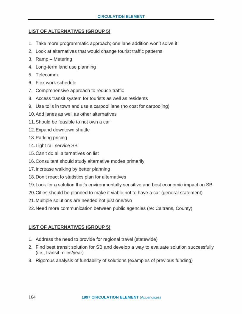
CIRCULATION ELEMENT
164 1997 CIRCULATION ELEMENT (Appendices)
LIST OF ALTERNATIVES (GROUP 5)
1. Take more programmatic approach; one lane addition won‟t solve it
2. Look at alternatives that would change tourist traffic patterns
3. Ramp – Metering
4. Long-term land use planning
5. Telecomm.
6. Flex work schedule
7. Comprehensive approach to reduce traffic
8. Access transit system for tourists as well as residents
9. Use tolls in town and use a carpool lane (no cost for carpooling)
10. Add lanes as well as other alternatives
11. Should be feasible to not own a car
12. Expand downtown shuttle
13. Parking pricing
14. Light rail service SB
15. Can‟t do all alternatives on list
16. Consultant should study alternative modes primarily
17. Increase walking by better planning
18. Don‟t react to statistics plan for alternatives
19. Look for a solution that‟s environmentally sensitive and best economic impact on SB
20. Cities should be planned to make it viable not to have a car (general statement)
21. Multiple solutions are needed not just one/two
22. Need more communication between public agencies (re: Caltrans, County)
LIST OF ALTERNATIVES (GROUP 5)
1. Address the need to provide for regional travel (statewide)
2. Find best transit solution for SB and develop a way to evaluate solution successfully (i.e., transit miles/year)
3. Rigorous analysis of fundability of solutions (examples of previous funding)

CIRCULATION ELEMENT
1997 CIRCULATION ELEMENT (Appendices) 165
Beyond Sprawl: New Patterns of Growth to Fit
the New California
Sponsor's Note:
This report suggests new ideas about how California can continue to grow while still fostering the economic
vitality and quality of life that makes it such a vibrant place to live and work. It is sponsored by a diverse
coalition-the California Resources Agency, a government conservation agency; Bank of America, California's
largest bank; Greenbelt Alliance, the Bay Area's citizen conservation and planning organization; and the Low
Income Housing Fund, a nonprofit organization dedicated to low-income housing.
The fact that such a diverse group has reached consensus on the ideas in this report reflects how important the
issue of growth is to all Californians. We hope this report will make a meaningful contribution to the public
dialogue about the quality and direction of California's growth in the 21st century.
EXECUTIVE SUMMARY
California is at a unique and unprecedented point in its history-a point at which we face profound
questions about our future growth that will determine the state's economic vitality and quality of
life for the next generation and beyond.
One of the most fundamental questions we face is whether California can afford to support the
pattern of urban and suburban development, often referred to as "sprawl," that has characterized
its growth since World War II.
There is no question that this pattern of growth has helped fuel California's unparalleled
economic and population boom, and that it has enabled millions of Californians to realize the
enduring dream of home ownership. But as we approach the 21st century, it is clear that sprawl
has created enormous costs that California can no longer afford. Ironically, unchecked sprawl
has shifted from an engine of California's growth to a force that now threatens to inhibit growth
and degrade the quality of our life.
This report, sponsored by a diverse coalition of organizations, is meant to serve as a call for
California to move beyond sprawl and rethink the way we will grow in the future. This is not a
new idea, but it is one that has never been more critical or urgent.
Despite dramatic changes in California over the last decade, traditional development patterns
have accelerated. Urban job centers have decentralized to the suburbs. New housing tracts have
moved even deeper into agricultural and environmentally sensitive areas. Private auto use
continues to rise.

CIRCULATION ELEMENT
166 1997 CIRCULATION ELEMENT (Appendices)
This acceleration of sprawl has surfaced enormous social, environmental and economic costs,
which until now have been hidden, ignored, or quietly borne by society. The burden of these
costs is becoming very clear. Businesses suffer from higher costs, a loss in worker productivity,
and underutilized investments in older communities.
California's business climate becomes less attractive than surrounding states. Suburban residents
pay a heavy price in taxation and automobile expenses, while residents of older cities and
suburbs lose access to jobs, social stability, and political power. Agriculture and ecosystems also
suffer.
There is a fundamental dynamic to growth, whether it be the growth of a community or a
corporation, that evolves from expansion to maturity. The early stages of growth are often
exuberant and unchecked-that has certainly been the case in post-World War II California. But
unchecked growth cannot be sustained forever. At some point this initial surge must mature into
more managed, strategic growth. This is the point where we now stand in California.
We can no longer afford the luxury of sprawl. Our demographics are shifting in dramatic ways.
Our economy is restructuring. Our environment is under increasing stress. We cannot shape
California's future successfully unless we move beyond sprawl.
This is not a call for limiting growth, but a call for California to be smarter about how it grows-to
invent ways we can create compact and efficient growth patterns that are responsive to the needs
of people at all income levels, and also help maintain California's quality of life and economic
competitiveness.
It is a tall order-one that calls for us to rise above our occasional isolation as individuals and
interest groups, and address these profound challenges as a community. All of us-government
agencies, businesses, community organizations and citizens-play a role. Our actions should be
guided by the following goals:
To provide more certainty in determining where new development should and should not
occur.
To make more efficient use of land that has already been developed, including a strong
focus on job creation and housing in established urban areas.
To establish a legal and procedural framework that will create the desired certainty and
send the right economic signals to investors.
To build a broad-based constituency to combat sprawl that includes environmentalists,
community organizations, businesses, farmers, government leaders and others.
Californians are already taking some of these steps. We have attempted in this report to not only
point out the obstacles to sustained growth, but also to highlight the positive actions that are
occurring to better manage growth. Our fundamental message is that we must build on these
early successes and take more comprehensive and decisive steps over the next few years to meet
this challenge. To build a strong, vibrant economy and ensure a high quality of life for the 21st
century, we must move beyond sprawl in the few remaining years of the 20th century.
CIRCULATION ELEMENT
1997 CIRCULATION ELEMENT (Appendices) 167
INTRODUCTION
California is at the crossroads of change.
Our economy is emerging from its worst downturn in 60 years-a downturn that has required
nearly all of the state's major industries to retool for greater competitiveness in a global
marketplace. Our demographic profile is changing dramatically. New racial and immigration
patterns are rapidly producing a truly multicultural society, creating a variety of related social
and economic issues. At the same time, California has emerged as one of the most urbanized
states in the union, as our metropolitan areas continue to grow in population and scale.
In the face of this change, California remains shackled to costly patterns of suburban sprawl.
Even as our economy and our society are being reinvented daily, we continue to abandon people
and investments in older communities as development leap-frogs out to fringe areas to
accommodate another generation of low-density living. And we continue to create communities
that rely almost exclusively on automobiles for transportation. In short, the "new" California-
with 32 million people and counting- is using land and other resources in much the same fashion
as the "old" California, with only 10 million people.
We cannot afford another generation of sprawl. As the Governor's Growth Management Council
stated in a recent report: "What may have been possible with 10 or even 20 million people is
simply not sustainable for a population of twice that much in the same space." Continued sprawl
may seem inexpensive for a new homebuyer or a growing business on the suburban fringe, but
the ultimate cost-to those homeowners, to the government, and to society at large-is potentially
crippling. Allowing sprawl may be politically expedient in the short run, but in the long run it
will make California economically uncompetitive and create social, environmental and political
problems we may not be able to solve.
At a time when economic growth is slow and social tensions are high, it is easy to dismiss an
issue like suburban sprawl as superfluous. Yet it lies at the heart of the very economic, social and
environmental issues that we face today. Rapid population growth and economic change are
occurring in a state increasingly characterized by a limited supply of developable land,
environmental stress at the metropolitan fringe, and older communities in transition. With the
onset of economic recovery, the next few years will give rise to land-use decisions of
fundamental importance. They will help determine whether our state can succeed in re-
establishing the economic and social vitality that have made it such a successful place to live and
work for more than 140 years.
Suburban Sprawl and the "Old" California
In the decades after World War II, California emerged as an economic and political powerhouse,
providing jobs, housing and prosperity for most of its rapidly growing population.
Underlying this success was a development pattern that emphasized expanding metropolitan
areas, conversion of farmland and natural areas to residential use, and heavy use of the
automobile. In the postwar era, this way of life worked for California. With a prosperous and
land-rich state, most families were able to rise to the middle class and achieve the dream of home
ownership. Government agencies and private businesses were able to provide the infrastructure
of growth-new homes, roads, schools, water systems, sewage treatment facilities, and extensions
of gas and electric distribution.

CIRCULATION ELEMENT
168 1997 CIRCULATION ELEMENT (Appendices)
Within the last generation, however, this postwar formula for success has become overwhelmed
by its own consequences. Since the 1970s, housing has become more expensive, roads have
become more congested, the supply of developable land has dwindled, and, because of
increasing costs, government agencies have not been able to keep up with the demand for public
services.
Since the late 1970s, several efforts have been initiated to address the question of how to manage
California's growth, but all have failed-some for lack of consensus, some for lack of engaged
constituency, some simply because of bad timing.
The Challenge of the "New" California
In the 1990s, California is undergoing change of such scale and significance that it will literally
redefine the state. To succeed, the new California must recognize and build upon the following
changes in positive ways.
Population Growth
California's population continues to grow at a remarkably fast pace. Today's total of
approximately 32 million people represents a doubling of the population since the mid-1960s,
when California became the nation's most populous state.
During the boom years of the 1980s, California added more than 6 million new residents, a
population larger than all but a few of the 49 other states. Even during the bust years of the early
1990s, the state's population grew at a rate of almost a half-million people per year-in effect,
adding another Oakland or Fresno every year-even as we have suffered a net loss in the number
of jobs.
This continuing surge in population puts pressure on both existing communities and on the
remaining supply of undeveloped land, making it extremely difficult for traditional suburban
patterns to accommodate more people.
Changing Demographics
While growing rapidly, California's population is also changing in significant ways. The
demographic changes are well documented. Latinos-whose roots extend to Mexico, Central
America, South America, and the Caribbean-are growing rapidly in number and may outnumber
Anglos a generation from now. Californians of Asian ancestry now make up almost 10 percent of
the population. African-Americans remain an important racial group, and the state's mosaic is
rounded out by Native Americans, immigrants from South Asia and the Middle East, and others
who bring great diversity to the state. California is truly one of the world's most multicultural
societies.
Underneath the racial diversity lies another important change in the state's population patterns
that will have a profound effect on California's attitudes toward growth over the next generation.
Traditionally, the popular perception has been that California's population grows because of
migration from other parts of the United States. However popular, this perception is no longer
true. Most new Californians now come from other countries, principally in Latin America and
Asia.

CIRCULATION ELEMENT
1997 CIRCULATION ELEMENT (Appendices) 169
The birth rate is also an increasing source of population growth. During the 1990s recession,
"natural increase"-the net total of births over deaths-has accounted for almost 400,000 new
people each year. Tomorrow's California will include-for the first time-a vast pool of people who
are Californians from birth. They will want what Californians before them have wanted-
education, jobs and housing. Most will expect the state to find a way to accommodate them. But
their numbers are so huge that they probably cannot be sustained by traditional suburban
development patterns.
Economic Change
During the recession, California has undergone an unprecedented economic restructuring. The
state has lost 400,000 manufacturing jobs since 1990, causing businesses and workers alike to
rethink old assumptions about how to ensure prosperity.
Traditional foundations of the state's economy, such as aerospace and defense, have been
drastically reduced and will probably never return, at least not in their previous form. Others-
such as entertainment, technology, the garment industry and agriculture-remain just as important
as ever. But they too have undergone tremendous change, becoming leaner and more efficient in
response to global competition. And small businesses remain the largest source of new job
creation. In the near future, the impact of the North American Free Trade Agreement will begin
to be felt.
These economic changes are also putting pressure on the state's land-use patterns. The loss of
manufacturing jobs is emptying out the state's long-established industrial areas, usually located
in older communities. Downsizing and technological change in other industries is also rendering
older buildings obsolete and creating a demand for new buildings-often in new suburbs-that are
both inexpensive and flexible. The closure of many military bases is bringing a huge amount of
land to the real estate market that will either extend sprawl or encourage new development
patterns, depending on how that land is used.
Spreading Urbanization
In response to both demographic and economic pressure, California has become the most
urbanized state in the union. According to the 1990 Census, more than 80 percent of all
Californians live in metropolitan areas of 1 million people or more, with 30 percent of the state's
population living in Los Angeles County alone.
This large-scale urbanization means that California's people and businesses compete intensely
with each other for space to live and work. The edges of metropolitan areas continue to grow to
accommodate expansion of population and economic activity, while some neglected inner-city
areas are left behind. These patterns increase the stress of daily life while, at the same time, put
more pressure on land and environmental resources at the metropolitan fringe.
CIRCULATION ELEMENT
170 1997 CIRCULATION ELEMENT (Appendices)
SPRAWL AND ITS CAUSES
All of these factors-a growing population, a changing economy, and increased urbanization-have
been present in California for many years. But they have accelerated in the 1990s, while
traditional suburban development patterns have continued. In a state with such powerful growth
dynamics, the results are astonishing. The following trends are typical of the effects of sprawl
over the last 10 to 20 years:
Employment centers have decentralized dramatically. While jobs used to be concentrated
in central cities, most are now created in the newer suburbs. For example, the complex of
office centers around John Wayne Airport in Orange County-built on land that was, until
a generation ago, cultivated for lima beans-recently surpassed downtown San Francisco
as the second-largest employment center in the state.
New housing tracts have pushed deeper into agricultural and environmentally sensitive
areas. Job centers in suburban San Jose and the East Bay area have opened up Tracy,
Manteca, Modesto, and other Central Valley towns as "bedroom suburbs," while job
growth in the San Fernando Valley has stimulated housing construction 40 miles to the
north in the Antelope Valley. This development has created metropolises virtually
unmanageable in size.
Dependence on the automobile has increased. According to the California Energy
Commission, between 1970 and 1990 the state's population grew by 50 percent, but the
total number of miles traveled by cars and trucks grew by 100 percent.
Isolation of older communities, including central cities and "first wave" suburbs built in
the 1940s and 1950s, has increased. Easy mobility for the middle class has caused them
to abandon many older neighborhoods, disrupting social stability and increasing the
economic disparity between older communities and newer suburbs. The decentralization
of jobs has hit older neighborhoods especially hard, because new jobs are now virtually
inaccessible to the poor and the working class. Also left behind are infrastructure
investments, which are tremendously expensive to replicate in new suburbs.
Even though the consequences of sprawl have been understood for at least two decades, attempts
to combat it have been fragmented and ineffective. The engine of sprawl is fueled by a mix of
individual choices, market forces, and government policies, most of which have only become
more entrenched over time. These forces include:
A perception that new suburbs are safer and more desirable than existing communities.
Many people believe that suburbs provide them with good value-safe streets,
neighborhood schools, a "small-town" atmosphere, close proximity to their local
governments, and new (though not necessarily better) community infrastructure.
A perception that suburbs are cheaper than urban alternatives. Owning a starter home in a
distant new suburb is still within the financial reach of a typical family, despite the
increased commuting costs. The family's financial equation, however, does not take into
account the larger cost to society of far-flung suburbs-a cost the family will eventually
share in paying.

CIRCULATION ELEMENT
1997 CIRCULATION ELEMENT (Appendices) 171
A belief that suburban communities will give businesses more flexibility to grow.
Businesses welcome the tax incentives and freedom from heavy regulation that are often
provided in newer suburban communities trying to develop a strong business base.
Businesses also view suburban locations as safer-a view reflected in the cost of
insurance-and they perceive they will have access to a better-educated work force.
Technological changes that have decentralized employment away from traditional
centers. This phenomenon permits dispersal of both jobs and houses across a huge area.
The emergence of the "information superhighway" may accelerate this trend.
Highway and automobile subsidies that have traditionally fueled suburban growth remain
in place today. Since the 1950s, automobile use has been encouraged by government-
financed road- building programs, and for the most part the "external costs" of
automobile use (i.e., air pollution) have not been the direct financial responsibility of the
individual motorist.
Local land-use policies that inadvertently cause sprawl. In many older suburban
communities, "slow-growth" attitudes restrict new development, pushing employment
and housing growth to the metropolitan fringe. With a lack of regional planning, each
community pursues its own self-interests, regardless of costs imposed on other
communities.
Fiscal incentives that encourage local governments to "cherry- pick" land uses based on
tax considerations. Under Proposition 13's property-tax limitations, there is little fiscal
incentive for many communities to accept affordable housing-and when such housing is
built, developers must usually pay heavy development fees. Meanwhile, because
communities must raise revenues to provide mandated services, auto dealers and retailers,
both big sales-tax producers, receive subsidies to locate in communities.
The result of all these factors is a severe regional imbalance. Housing, jobs, shopping, and other
activities are scattered across a huge area and long auto trips are often required to connect them.
Such a development pattern imposes a considerable cost on all who use it, though the costs are
often hidden and those who pay them are not always aware of it.
THE COST OF SPRAWL
The cost and consequences of sprawl have been documented among academics and planning
experts for more than two decades. In the early 1970s, planning consultants Lawrence Livingston
and John Blayney produced a landmark study showing that in some cases, a California
community would be better off financially if it used a combination of zoning and land
acquisition instead of permitting development of low-density subdivisions. A few years later, the
U.S. Council on Environmental Quality produced its landmark report, The Cost of Sprawl-the
first comprehensive analysis of sprawl's true expense to society. As fiscal and cost-benefit
analysis techniques have become more refined, the true cost of sprawl has become much more
apparent.
Today, no one in California is unaffected by the cost of sprawl. Its consequences spread across
all groups, regardless of geography, race, income, or political status.

CIRCULATION ELEMENT
172 1997 CIRCULATION ELEMENT (Appendices)
Taxpayers
Sprawling suburbs may be cheaper in the short-term for individuals and families who buy houses
in new communities, but their "hidden" costs may ultimately be passed on to taxpayers in a
variety of ways.
The cost of building and maintaining highways and other major infrastructure
improvements to serve distant suburbs.
The cost of dealing with social problems that fester in older neighborhoods when they are
neglected or abandoned.
The cost of solving environmental problems (wetlands, endangered species, air pollution,
water pollution) caused by development of virgin land on the metropolitan fringe.
Taken together, it is clear that all these costs have contributed to California s dire fiscal
situation during the 1990s, which has strained state and local government budgets to the
breaking point.
Businesses
Many businesses benefit from suburban locations. But all businesses, both small and large, also
bear many of the following costs.
Adverse impacts on the state's business climate. By reducing the quality of life, sprawl
has made California a less desirable location for business owners and potential
employees. By increasing suburban resistance to further growth, sprawl has made it
difficult for businesses to relocate and expand in California. Both these trends increase
the attractiveness of neighboring states such as Arizona, Nevada, and Utah. For example,
a major film studio recently decided to relocate its animation facility to Arizona,
principally because of lower housing prices and less traffic congestion.
Higher direct business costs and taxes to offset the side-effects of sprawl. This can
include the cost of new business infrastructure or of mitigating transportation and
environmental problems. For example, in many metropolitan areas, air-quality regulators
have forced businesses to take the lead in fighting air pollution by initiating carpooling
programs for their employees.
A geographical mismatch between workers and jobs, leading to higher labor costs and a
loss in worker productivity. Many workers must now commute long distances to their
jobs, which takes a significant toll on their personal, family and professional life. Many
other workers are removed from large portions of the job market simply because they
cannot get to where the new jobs are.
Abandoned investments in older communities, which become economically
uncompetitive because of sprawl and its associated subsidies. This is especially true of
the state's utility companies, whose investments in gas, electric and water infrastructure
are literally rooted in established communities.
CIRCULATION ELEMENT
1997 CIRCULATION ELEMENT (Appendices) 173
Residents of New Suburbs
There is no question that new suburban residents are, in many ways, the principal beneficiaries
of suburban sprawl. They often live in new and affordable neighborhoods which they perceive as
safe and prosperous. Yet many suburban residents are becoming increasingly aware that they pay
a high price for these benefits in the following ways.
The cost of automobiles. The average Californian spends one dollar out of every five on
buying and maintaining their cars. As a consequence they have less to invest or spend on
other items.
Time lost commuting to work and other destinations. A huge number of Californians now
spend an hour or more per day in their car, and the number continues to rise. A recent
survey by the Walnut Creek-based Contra Costa Times showed that the commute times
for residents of 10 cities in Alameda and Contra Costa counties had increased an average
of 13 percent between 1980 and 1990.
The cost of new suburban infrastructure. Suburbs are often perceived as "low-tax"
locations, when, in fact, most new suburban homebuyers in California must pay
additional taxes (usually Mello-Roos taxes) to cover the massive cost of new roads,
schools, and other infrastructure required in new communities. These additional taxes
often have the effect of doubling a new homeowner's property tax bill.
Residents of Central Cities and Older Suburbs
Residents of central cities and older suburbs are among the biggest losers in the sprawl process.
Once they were among the most fortunate of metropolitan dwellers, because their central
location provided access to jobs, shopping, and other amenities. However, sprawl has penalized
them by creating or accelerating the following trends:
Loss of jobs and access to jobs. Residents of older neighborhoods no longer have
convenient access to most jobs. This is especially difficult for poor and working-class
citizens who must rely on public
transportation, because it is difficult to commute to most suburban jobs without a car.
Economic segregation and loss of social stability. By luring middle-class residents from
older neighborhoods, sprawl creates destructive economic segregation and robs those
neighborhoods of the social stability that will keep them viable. The distribution of
income becomes more skewed, and it becomes increasingly difficult for low-income
people to escape poverty.
Underutilized or abandoned investments. Businesses are not the only entities whose
investments can become stranded when city neighborhoods decline. Individual
homeowners and small shopowners can also see a stagnation or decline in property
values. And this trend is not only visible in the inner city. Huge investments in older
suburban shopping centers, for example, are now threatened because these centers are
perceived as uncompetitive.
CIRCULATION ELEMENT
174 1997 CIRCULATION ELEMENT (Appendices)
Shifts in political power and government services. By removing the middle class of all
races from older communities, sprawl makes it easier for that middle class to ignore the
political and social problems left behind. Thus, revenues fall and it becomes more
difficult for older neighborhoods-urban or suburban-to maintain government services,
and the incentive for home ownership required to provide the foundation for prosperity.
Farmers
Agriculture remains one of California's leading industries. Yet sprawl continues to take a heavy
toll on California agriculture in the following ways.
A permanent loss of agricultural land. Between 1982 and 1987, the Central Valley-
California's leading agricultural region-lost almost a half-million acres of productive
farmland. Some of this land can be replaced by bringing new land into agricultural
production, but often at a high economic and environmental cost. Also, many of
California's micro-climates support unique agricultural products that cannot be replaced
by land in other areas. Highly productive coastal agricultural lands lost to sprawl cannot
be replaced at any cost.
A loss in productivity due to pollution. Sprawl-induced ozone pollution alone can reduce
crop yields by as much as 30 percent. According to the Agricultural Issues Center at UC
Davis, pollution-induced costs to agriculture exceed $200 million per year.
A decline in farm communities. As sprawl has eroded agricultural production, the effect
on farm communities has been devastating. In some cases, rural communities have been
transformed into bedroom suburbs, creating destructive commuting patterns while
destroying agriculture infrastructure and productivity.
Long-term uncertainty. Sprawl destabilizes agriculture by creating the temptation to "sell
out." The prospect of eventual sale to a developer reduces incentives for farmers to make
long-term capital investments. In many cases, farmers stay afloat financially only by
borrowing against the speculative value of their farm for development- creating a self-
fulfilling prophecy of sprawl. Another uncertainty for farmers arises from increased
demand for water for urban uses driven by sprawl patterns.
The Environment
Traditional development patterns have taken a massive toll on all three basic elements of the
natural environment: land, air, and water.
Land: After 50 years of sprawl, California's metropolitan areas are enormous, reaching
deep into natural ecosystems that were thriving even a generation ago. Some 95 percent
of the state's wetlands have been destroyed over the last 200 years, and the few wetlands
that remain are threatened. Also, California now has the highest number of candidate and
listed endangered species of any state-partly because sprawl is affecting the state's
unmatched diversity of biological systems. Sprawl makes it more difficult to resolve
these land conservation issues by putting tremendous development pressure on the supply
of remaining open land. Finally, sprawl compromises one of the most essential assets of
California-the beauty and drama of its landscape. Far from being just a luxury, this value

CIRCULATION ELEMENT
1997 CIRCULATION ELEMENT (Appendices) 175
of open space is an important component in the state's ability to attract and hold workers
and investors.
Air: California has the worst air quality in the nation, and air pollution experts estimate
that a third of all air pollution emissions are traceable to car and truck emissions
exacerbated by longer commutes and higher auto use. The South Coast Air Quality
Management District, which has the strictest air-pollution regulations in the country,
estimates that air pollution in the four-county Los Angeles area costs $7.4 billion per
year, or about $600 per resident. Dramatic gains in pollution technology are likely to be
offset by further sprawl. According to air pollution expert J.V. Hall, "The benefits of
pollution-reduction technology can easily be overwhelmed by our choices about where to
live and work, about modes of travel, and about how many miles we drive."
Water: Sprawl takes a serious toll on California's water supply. Forty of the state's 350
groundwater basins are seriously overdrafted, and water planners predict that by 2020 the
state will face a water supply deficit of between 2 million and 8 million acre-feet. Though
not the sole cause, fringe development does make the water issue more expensive and
complicated to manage.
BEYOND SPRAWL
In the postwar era, the continuous cycle of suburban sprawl-counter-productive as it was in many
ways-actually helped to fuel California's prosperity, as consumption of new houses and new cars
became one of the bases of our prosperity. It is clear, however, that the new California cannot
sustain old patterns of urban development, if the state is to prosper in the future.
The sponsors of this report-Bank of America, the California Resources Agency, Greenbelt
Alliance, and the Low-Income Housing Fund-firmly believe that California cannot succeed
unless the state moves beyond sprawl. Strong policy direction from our political leaders on both
the state and local level is essential. But government policies alone will not help California move
forward. Our businesses, our community groups, and our citizens must also take the initiative.
We must understand how sprawl affects each of us individually, how it impedes the state's
progress, and how it could make a prosperous future more difficult to achieve.
Population growth will require some degree of development on the suburban fringe. The
question is whether we will be able to use existing urban and suburban land more efficiently in
order to minimize sprawl and protect valuable open spaces. The answers will lie in our ability to
attract housing and businesses to older urban and suburban areas and to channel development on
the fringe to achieve the desired protection and economic benefits.
California businesses cannot compete globally when they are burdened with the costs of sprawl.
An attractive business climate cannot be sustained if the quality of life continues to decline and
the cost of financing real estate development escalates. People in central cities and older suburbs
cannot become part of the broader economy if sprawl continues to encourage disinvestment, and
the state can neither afford to ignore nor fully subsidize these neglected areas.
California must find a new development model. We must create more compact and efficient
development patterns that accommodate growth, yet help maintain California's environmental
balance and its economic competitiveness. And we must encourage everyone in California to
propose and create solutions to sprawl.

CIRCULATION ELEMENT
176 1997 CIRCULATION ELEMENT (Appendices)
A do-nothing approach, in effect, constitutes a policy decision in favor of the status quo. This, in
fact, has been the de facto direction for the last generation. While the state and the regions have
created a leadership void in this area, many local governments have stepped in with their own
policies, which often have served to promote sprawl rather than prevent it. Recent research has
shown that individual local growth-control policies do not stop development, but merely deflect
it- often to another area further out on the metropolitan fringe, where the cost of development is
even greater. The question is not whether to address sprawl. The question is how to address it.
In the early 1990's, the California Legislature convened a consensus project on growth
management, and in 1991 Governor Wilson formed a cabinet-level council charged with
developing a plan on how the state should address the challenge. A great deal of good work was
done and agreement was reached in some areas. These processes did not result in legislative
action, but a good foundation of understanding has been established.
As was stated at the outset, this report is not meant to be a manual or a tactical "how-to" on
changing development patterns in California. Rather, it is meant as a wake-up call to all
Californians that the sprawl issue has a new urgency in the state, and that all of us can play a role
in addressing the problem.
To succeed, we will have to set aside individual interests, build on the foundation that has been
laid, and work for the good of the whole. We need to address sprawl through community action,
public policy, private business practices, and individual behavior. It is our intent that the ideas
and examples that follow will be used as a basis for further refinement and concerted action.
First, more certainty is needed in delineating where new development should and should not
occur. Sprawl occurs partly because current policy constrains the real estate market by rewarding
"leapfrog" development driven by cheaper and more easily developed land on the metropolitan
and suburban fringe. The alternative is to be more explicit about conservation and development
priorities, targeting actions and policies for better integration of the two.
Using this approach means utilizing land at the suburban fringe more efficiently and encouraging
the reuse of land and other development opportunities in already developed areas. It does not
mean stopping growth at the fringe, but doing it at density levels that will not promote further
sprawl. To succeed, this approach needs more effective public policies encouraging such
compact growth and removing barriers to it.
However, the other side of certainty for developers requires commitments to conserve
ecologically important habitats and other open space. Accelerating statewide planning efforts
such as Natural Communities Conservation Planning (NCCP), which involves voluntary action
at the local level and requires consensus among development, environmental, community and
local government interests, will enhance our ability to provide greater environmental and
economic certainty regarding new development. With its emphasis on biological assessment,
ecosystem protection and compatible economic development, NCCP can provide much greater
certainty to both those who want to develop their property and those who want to protect the
natural environment. Broader use of mitigation banks can facilitate market-based compensation
to landowners who choose to help protect ecologically valuable land.
Conservation of other habitat and open space, such as prime agricultural land, will also require
us to find creative approaches like the NCCP process. The newly established California

CIRCULATION ELEMENT
1997 CIRCULATION ELEMENT (Appendices) 177
Environmental Resources Evaluation System (CERES) will help this process by expanding
access to data about important resources in the state.
Regardless of the methods used, much of the leadership for providing greater certainty for
conservation and development must come from the state, regional agencies, and local
governments working together. But private businesses also have a critical role. Especially in
difficult economic times, real estate developers and their lenders know that certainty of approval
and availability of infrastructure, rather than speculative leapfrogging, will reduce costs and
reduce processing time. Thus, new real estate developments can be brought to market more
quickly and cheaply within areas where effective consensus plans for conservation and
development have been created.
Second, we should make more efficient use of land that has already been developed. Older urban
and suburban neighborhoods should be reinforced as good places to live and do business, and the
process should take place without displacing low-income residents. Sprawl occurs partly because
of the perception that older neighborhoods are dangerous, expensive, obsolete, unpleasant, or
otherwise unacceptable to those who have the option of leaving. The result is a tragic neglect of
both people and capital investments.
Older neighborhoods must be maintained and improved so they are again desirable places to live
and work. Old Town Pasadena, the South of Market area in San Francisco, and the train depot
reconstruction in Sacramento are all prime examples of successful restoration projects. Better
school systems, job training and access to capital for small businesses are prerequisites. These
efforts require a combination of government policy initiatives, active business investment, and
special efforts by individuals and community groups.
Attracting jobs is absolutely critical. State and local governments should adopt land-use and
transportation policies that reinforce investments in older neighborhoods. Incentives must be
developed for job- creating businesses, homebuyers, and others willing to invest in older
neighborhoods. For example, Superfund laws can be made more sensible so existing industrial
sites can be recycled into new uses. Investors can make more aggressive use of low income
housing tax credits. Wider use can be made of Enterprise Zones. And tax credits or other
incentives can be established for lending and equity investments that support small businesses
and job growth. Development on the fringe imposes infrastructure, pollution and social costs
well in excess of assessed development fees. If we rationalize development and control the costs
of sprawl, it will free up capital that can be reinvested into existing cities and suburbs.
Older communities themselves need to make their neighborhoods attractive to job creating and
housing investments. Individuals and community groups in those areas should redouble their
efforts to improve the quality of urban life in small ways, for example, by forming community-
based crime prevention groups and supporting local community development efforts that will
enhance their neighborhoods.
Home ownership at all income levels needs to be encouraged. In general, those who own homes
have the greatest interest in maintaining neighborhood vitality. Public policy should support
methods of keeping low-income people from displacement through development of affordable
housing (both home ownership and rental) and provision of supportive services. Also if
developers are to provide quality housing in existing neighborhoods, they need protection from
frivolous environmental and product liability suits.
CIRCULATION ELEMENT
178 1997 CIRCULATION ELEMENT (Appendices)
The closing of military bases in California offers interesting potential for development. Bases
have substantial potential as alternatives to building houses and job centers on the suburban
fringe. While there are problems associated with redeveloping many bases, they also have
excellent potential for showcasing how to resolve difficult urban rebuilding strategies.
Third, a legal and procedural framework should be established to create the desired certainty and
send the right economic signals to investors. Four elements are needed.
(a) Where development is allowed, state and local permitting should be streamlined. This is
critical to encouraging development in urban and older suburban areas. It may require changes to
legislation that relates to permitting.
(b) Development at the metropolitan fringe should be required to pay the full marginal cost of
development. Housing and business space on the metropolitan fringe is often inexpensive
because those developments pay for local infrastructure, but do not pay the full cost of
constructing roads, developing water supplies, mitigating environmental problems, and creating
regional imbalances. Imposing such costs on those developments would discourage sprawl. For
example, the city of Lancaster adopted an innovative program that requires new development to
pay capital and operating costs of infrastructure. Development further out pays its full cost, while
development that is closer to the city's center pays much less, since it is tied in to existing city
services.
Again, this is a task that requires the active participation of both government and business. For
example, many government agencies, such as water suppliers, subsidize development on the
metropolitan fringe by spreading the cost of their infrastructure across all users, new and old.
Changing such policies would discourage sprawl.
Failing to levy the full marginal cost gives leapfrog development an unfair competitive
advantage over projects in existing urban areas, where transactions are made more difficult and
expensive by toxic waste and other environmental liability issues. Expanding environmental
audits to include wetlands, endangered species, and other issues-a practice that is already
beginning-would also discourage sprawl by including the full assessment of environmental cost
in private real estate transactions.
(c) California's local governments should encourage more efficient and coordinated local land-
use policies. Sprawl has been encouraged by tax revenue competition among local governments
for some land uses, such as retail centers, and by slow-growth policies that discourage other land
uses, such as housing.
Development patterns that are now truly regional are being created almost completely by an
accumulation of local decisions. But some local governments are beginning to show that it is
possible to work together toward consistent land-use policies when given the incentive to do so.
In planning for the reuse of closed military bases, for example, local governments are forming
"joint powers authorities" in which many jurisdictions work together toward a common goal.
The vast majority of Californians choose to locate in large metropolitan areas. But most of these
people live in small, politically independent suburban jurisdictions. These local governments
must work together toward a consistent set of land-use policies-such as discouraging
development on the metropolitan fringe and reinforcing investments in transit systems-that will
enhance economic opportunity and quality of life across the entire metropolitan area. Joint

CIRCULATION ELEMENT
1997 CIRCULATION ELEMENT (Appendices) 179
powers authorities, such as those created for military base reuse, should be viewed as one model
for cooperative planning, and others are needed.
(d) Technological change should be used to combat sprawl rather than encourage it. In the past,
technological advancements (such as automobiles and government-sponsored freeways) have
supported sprawl, requiring expensive after-the-fact government action of questionable value
(such as ridesharing requirements). Today we stand at the threshold of a new technological era
that offers the opportunity to have more work done at home and in local communities. We must
take advantage of the opportunities presented by the information superhighway to improve our
land-use patterns rather than further destroy them.
For example, the information superhighway could end up encouraging a further decentralization
of jobs to the metropolitan fringe. Freed of a daily commute to a large employment center, some
individuals and small businesses will seek to locate in distant suburbs and travel back to older
urban centers to do business as needed. This trend could put more pressure on land at the fringe.
However, the telecommunications revolution can also hold the potential for reviving
economically troubled areas. Because of its locational flexibility, telecommunications can
provide new job prospects for older urban neighborhoods and for rural towns. Both government
policy and private business practice should encourage the use of telecommunications to reinforce
existing communities rather than further dissipate them.
Fourth, we should forge a constituency to build sustainable communities. Past efforts to reduce
sprawl have been hampered because little constituency exists beyond groups of government
reformers, some local government leaders, community groups, and conservationists. But, as this
report suggests, many other players in California's future will also find themselves increasingly
stifled by sprawl. Political alliances must be forged between environmentalists, inner-city
community advocates, business leaders, government experts, farmers, and suburbanites to
improve the quality of life in all our existing communities and protect our resources.
This will not be an easy task. Most of these groups are focused on their specific agendas and
often harbor animosity toward each other even though alliances make long-term strategic sense.
But it is possible. For example, environmentalists concerned about development at the suburban
fringe have tremendous opportunities to work with governments and community organizations
seeking to increase investment in more central urban areas. Farmers seeking a long-term future
in agriculture near an urban area can form very effective alliances with those working to protect
resources. Community groups, government agencies, and builders can explore new marketing
and funding options that support homebuilding closer to major transit lines, taking advantage of
the huge demand for housing created by the state's dramatically changing demographics.
Taxpayers concerned about the inefficiency of governmental expenditures can join with those
working to make better use of infrastructure in existing urban areas. There are literally dozens of
such alliances waiting to be created.
We must act now. The decisions we make in the next few years will determine California's future
course-and its chances for success. To build a strong economy and retain a good quality of life
for the 21st Century, we must move beyond sprawl to a new vision of community in the few
remaining years of the 20th Century.

CIRCULATION ELEMENT
180 1997 CIRCULATION ELEMENT (Appendices)
Acknowledgments
All of the report's conclusions may not be endorsed in their entirety by each of the four sponsors.
At the same time, each of the organizations believes that the time to act is now and that this
report can help advance the public dialogue about California's growth and development.
The sponsors are grateful for the assistance provided by Steven Moss and his associates at the
consulting firm of M. Cubed for developing much of the basic research behind this paper. We are
also indebted to William Fulton for conceptualizing and drafting the paper. His clarity of vision
helped consolidate our thinking into a comprehensive whole. If you would like to comment on
the paper, or obtain additional copies, please contact any of the following sponsors:
Bank of America
Environmental Policies and Programs
#5800
PO Box 37000
San Francisco, CA 94137
(415) 622-8154
California Resources Agency
The Resources Building
Sacramento, CA 95814
(916) 653-5656
Greenbelt Alliance 116 New Montgomery, Suite 640
San Francisco, CA 94105
(415) 543-4291
The Low Income Housing Fund
605 Market Street
San Francisco, CA 94105
(415) 777-9804
Originally published on the Bank of America's Web site.
Copyright © 1996, BankAmerica Corporation.

CIRCULATION ELEMENT
1997 CIRCULATION ELEMENT (Appendices) 181
Newsweek Magazine
Bye-Bye, Suburban Dream May 14, 1995
Phoenix Sprawls into the desert at the rate of an acre an hour. Greater New York City stretches clear into Pennsylvania. Strip malls, traffic, fear of crime have wrecked the tranquil 'burbs of Ozzie and Harriet's time. How can we bring civility back to Suburban life?
PAVED PARADISE
The "new urbanists' are going back to the future to take the edge off edge cities. They want to bring small-town charm to blighted metropolitan landscapes.
Viewed from the air, there's no apparent reason why a city like Phoenix, Ariz. already
the seventh largest in the nation, couldn't keep growing forever. Four times a year, a pilot from Landiscor, an aerial-surveying company, flies over the city at 20,000 feet, snapping pictures to be assembled into vast photographic maps. They show the white boxes of downtown, the graceful loop of the freeways as they intersect and sort themselves out by compass point, and the gleaming roofs of suburbia stretching to the horizon in nested curves of roads, streets, drives and lanes. The pictures from the end of March show .5,000 more houses than the ones taken three months earlier. Houses squeeze through the gap between two Indian reservations and follow the highways into the desert, which they are consuming at an acre an hour. Excluding federal land, the only thing standing in the way of Phoenix's swallowing the rest of the state, says Michael Fifield, director of the Joint Urban Design Program of Arizona State University, is Tucson.
Unless, that is, you subscribe to the view of former mayor Terry. Goddard, that Phoenix is approaching the marginal disutility of suburban sprawl. This is the point at which each new subdivision subtracts more from the quality Of life than the new inhabitants will contribute to the economy by buying wind chimes, mesquite logs and Nayajo-motif throw rugs. Many other places in the country are coming round to this view Most suburbs are exploding in size without even the compensation of economic growth: the Cleveland metropolitan area expanded by a third between 1970 and 1990 even as its population declined. Over roughly' the same period, California's population increased by 40 percent while the total of vehicle-miles driven doubled. Maintaining a fleet of cars to navigate among the housing tracts, commercial strips and office complexes of the American landscape now takes 18 percent of the average family budget.
WONDER TOWN
Some people consider such communities too cute, but cuteness is the glue that holds them together at five units an acre.
CIRCULATION ELEMENT
182 1997 CIRCULATION ELEMENT (Appendices)
As anyone who reads the fiction in The Now Yorker knows. Americans mostly live in banal places with the souls of shopping malls, affording nowhere to mingle except traffic jams, nowhere to walk except in the health club. By itself, this hasn't been a reason to stop building suburbs. But economic unsustainability may carry more weight. A conference on "Alternatives to Sprawl" at the Brookings Institution this year was electrified by a report from the Bank of America endorsing the formerly elitist view that sprawl in California has created "enormous social, environmental and economic costs, which until now have been hidden, ignored, or quietly borne by society . . . Businesses suffer from higher costs, a loss in worker productivity, and underutilized investments in older communities." "You can't keep spreading out." says Mike Burton, executive director of Port-kind. Ore.'s metropolitan government, Metro. "The cost to make roads and sewers gets to the point where it doesn't work."
The challenge is to devise an alternative to sprawl, where people can envision their
children playing in the streets. It must not evoke "the city." an alien place where by definition middle-class Americans refuse to live. So a growing corps of visionaries. of which the best-known are Miami-based architects Andres Duany and his wife and partner, Elizabeth Plater-Zyberk, are looking to an even older model-the "village," defined as a cluster of houses around a central place that is the focus of civic life. Under the banner of "new urbanism," they have promulgated some surprisingly simple and obvious rules for building better suburbs described in detail on the following pages. They can be roughly summarized in these three principles:
Density: A typical modern suburb may have one to two dwelling units per acre, and is laid out entirely for the convenience of the automobile. The new urbanism strives for five or six units per acre, including a mix of housing types: detached houses. row houses, apartments, "granny fiats" tucked away, above the garages. In theory and the new urbanism still exists mostly in theory--the village would extend no more than a quarter-mile from the center to the edge and include a transit stop and a place to buy a quart of milk and a newspaper (actually, probably, a decaf latte and a copy of The Kenyon Review, but the point is the same).
Civic space: Suburbs--except for the streets--consist of almost exclusively private space, much of it devoted to the single most useless form of plant life in all botany, the ornamental lawn. A suburb is a place that's two-thirds grass but with nowhere for kids to play ball, except in the streets. Communities need parks and outdoor public spaces in which people can gather and interact.
NO STREET OF DREAMS
The „civic center‟ of many suburbs, designed for the convenience of the car, is a strip mall along a six-lane highway.

CIRCULATION ELEMENT
1997 CIRCULATION ELEMENT (Appendices) 183
"SEASIDE' PLANNER
American city planning went to hell during World War II, says Andres Duany, the architect who, with his wife and partner, Elizabeth Plater-Zyberk, designed the neotraditionalist town of Seaside, Fla. "Any town-planning text prior to 1935," he says, "has references to social Issues, to technical issues, to esthetic issues." But after the war, specialists and bean counters took over it. Was as if America had suffered a stroke. "We lost language, we lost the ability to think complexity." As a result, "the suburbs we have are cartoons of planning."
Mandatory design codes: Obviously, no one with a choice in the matter would want to look out his window at a 7-Eleven. New urbanist practitioners impose elaborate design and zoning controls intended to create harmonious streetscapes. The results can be intensively cute and not to the taste of people unaccustomed to seeing dormers, gables and porticoes on every building. But cuteness is the glue that holds neighborhoods together at five units per acre.
Like most visionary architectural schemes, this idea has sold more books than houses. Its principles were known to planners early in the century, when such charming communities as Scarsdale, N.Y., Mariemont, Ohio, and Lake Forest, Ill., were built. But they were forgotten in the postwar rush to build suburbs on the same principles of efficiency that had been employed in constructing army bases. Their first new application came a decade ago, when Duany and Plater-Zyberk drew up plans for a small resort town on the Florida panhandle, called Seaside. Seaside--with its cozy, narrow streets, its jumble of pastel homes with mandatory front porches -- is probably the most influential resort community since Versailles. Prince Charles noted it approvingly in his BBC special on architecture. Since then other "neotraditional" developments have been built in places as far-flung as suburban Maryland (Kentlands. also planned by Duany and Plater-Zyberk) and the outskirts of Sacramento, Calif. (Laguna West. planned by Peter Calthorpe of San Francisco). But the real test of this idea will come in about a year, when the Disney Co. opens its first planned community ever, Celebration, Fla., on a 5,000-acre swath of land near Disney World. After considering a typical subdivision built around a golf course, the company opted for a plan which vice president Wing Chad described as "traditional little-town America."
Celebration will either validate the new urbanism with the imprimatur of Disney--"safe for middle-class consumption"-- or prove the point of its critics, that it's a plot to lure unwitting citizens into living in theme parks.
You can look at Phoenix as a pretty good example of what the new urbanism is up against. It is among the five fastest-growing metropolises in the country, and few places are as relentlessly suburban in character. It has a downtown so exiguous that a pedestrian outside its biggest office building at 9 on a weekday morning is a phenomenon as singular as a cow in Times Square. Meanwhile the new subdivisions race each other toward the mountains. Del Webb Corp., a major national developer, recently won approval over heated opposition for a 5,600-acre project in New River, 80 miles north of downtown and at least 10 miles beyond the outer edge of existing development. The environment, which to developers used to just be the stuff they knocked

CIRCULATION ELEMENT
184 1997 CIRCULATION ELEMENT (Appendices)
down to make room for houses, is now a cherished selling point. There is a catch, according to Frances Emma Barwood, a city council member who represents most of the sparsely populated northeast quadrant of Phoenix: "The people who bought houses in Phase One [of a popular development] were told they'd be surrounded by beautiful lush deserts, hut instead they're surrounded by Phases Two and Three."
Left behind in this rush to embrace nature are thousands of 1960s-era ranch houses
that are too old, small and unfashionable to attract middle-class buyers, and as a result are turning into that new American phenomenon, the suburban slum. This may be the fate of an area called Maryvale, which like all west-side suburbs suffers from the competitive disadvantage that commuters must drive into the sun both ways. Interspersed among the houses are large tracts of vacant land, dreary commercial strips and a mall, once the cynosure of a thriving neighborhood, now dark and empty. "For the same money that Del Webb is spending in New River, I'll bet they could buy up most of this area and rebuild it," Goddard says. "What is the imperative that says we have to go to a beautiful rural area when we have all this land a few miles from downtown? We're destroying ourselves in shorter and shorter cycles."
The imperative, as Goddard well knows, is "the market." To build in an existing neighborhood, says Jack Gleason, a senior vice president at Del Webb, is to "run against the market, instead of with it." Banks are reluctant to lend to such "infill" projects because they have no assurance the houses will sell. A prime engine of Phoenix's growth apparently consists of middle-aged couples fleeing California. This is a market, Gleason notes, heavily driven by "security," the polite term for "fear." "Fear of crime is a great motivator for development," says Joe Verdoorn, a Phoenix planner. "Everybody wants to be on the far side of the fleeway."
So the new subdivisions go up behind ocher-colored stucco walls six feet high, with guards and gates between the public roads and the inner sanctum of residential streets. Other kinds of barriers defend something nearly as dear to suburbanites as their own skins, property values. Homeowners are isolated by design from apartments, shops, public squares or anything else that might attract people with less money or of a different race. Deed restrictions and community associations see to it that no one will ever bring down the tone of the neighborhood by turning his living room into a beauty parlor. Success for a development lies in freezing for eternity the social and economic class of the original purchasers.
DON’T FENCE ME IN
To run with the market is to develop virgin land farther out, not to rebuild dying communities closer to the city.

CIRCULATION ELEMENT
1997 CIRCULATION ELEMENT (Appendices) 185
No wonder they're so sterile-sterility is designed into them! Anything else is a threat to the steady appreciation of resale value homeowning Americans take as a basic economic right. You drive down the wide, curving streets of Terravita, in north Scottsdale, whose sales slogan is "The Harmony of Land and Life," and the only signs of "Life" are the saguaro cactuses, which accrue at the rate of about an inch a year. The houses themselves are magnificent monuments to family life: thoughtfully designed, carefully constructed, with master bath suites the size of the Oval Office, but the face they turn to the street is the blank brown plane of a three-car garage.
To even think of changing this culture is an enormous task. It runs counter to the
dominant ideology of free-market economics, which in its reductive fashion holds that developers by definition are building what people want to buy. "There is this strange conceit among architects," says Peter Gordon, a professor of economics at the University of Southern California, "that people ought to live in what they design. If you look at how people really want to live in this country, suburbanization is not the problem, it is the solution." And for that matter, Oscar Newman, a celebrated New York-based urban planner, describes the new urbanism as "a retrogressive sentimentality." American families typically live in a neighborhood for three to five years, forming communities based not on common birthplace but on interest: young singles, families with children, "active adults." Who among us, Newman asks, really wants to re-create the social ambience of an 18th-century village? He thinks the suburbs need more exclusivity, gates and barriers where none exist already, recognizing that most of us are going to live among strangers for most of our lives.
On the other hand, people can buy only what's for sale. The housing market is notoriously conservative and conformist, if for no other reason than that most people expect to sell their houses someday. Perhaps more people would choose to live in urban villages if they were exposed to them. "if you ask people if they want "density,' they' will always say no," says Peter Katz, author of "The New Urbanism." "But if you ask if they want restaurants and schools and other things close to where they live, they say yes." But you couldn't build a village in most places in the country even if you wanted to. Suburban sprawl is built into the zoning codes of most communities and the lending policies of virtually every bank. For new villages to become a reality, they will have to get past a phalanx of planning boards and bank officers, whose first principle is, "Nobody ever lost his job for following the code."
We are, nevertheless, on the verge of a great opportunity. Americans moved to the suburbs for the best of motives--to give their children better schools, cleaner air, a place to ride their bicycles without getting their tires caught in the trolley tracks. Suburbs should teem with life, with humanity in all its diversity (or as much diversity as you can find within one standard deviation of the median family income)--with people walking, running, biking, rocking. But their design has promoted instead the ideals of privacy and exclusivity: the clapboard-sided ranch house, evocative of empty plains; the brick colonial, hinting at descent from the Virginia aristocracy. We can continue the trend of the last 40 years, which Gopal Ahluwalia, director of research for the National
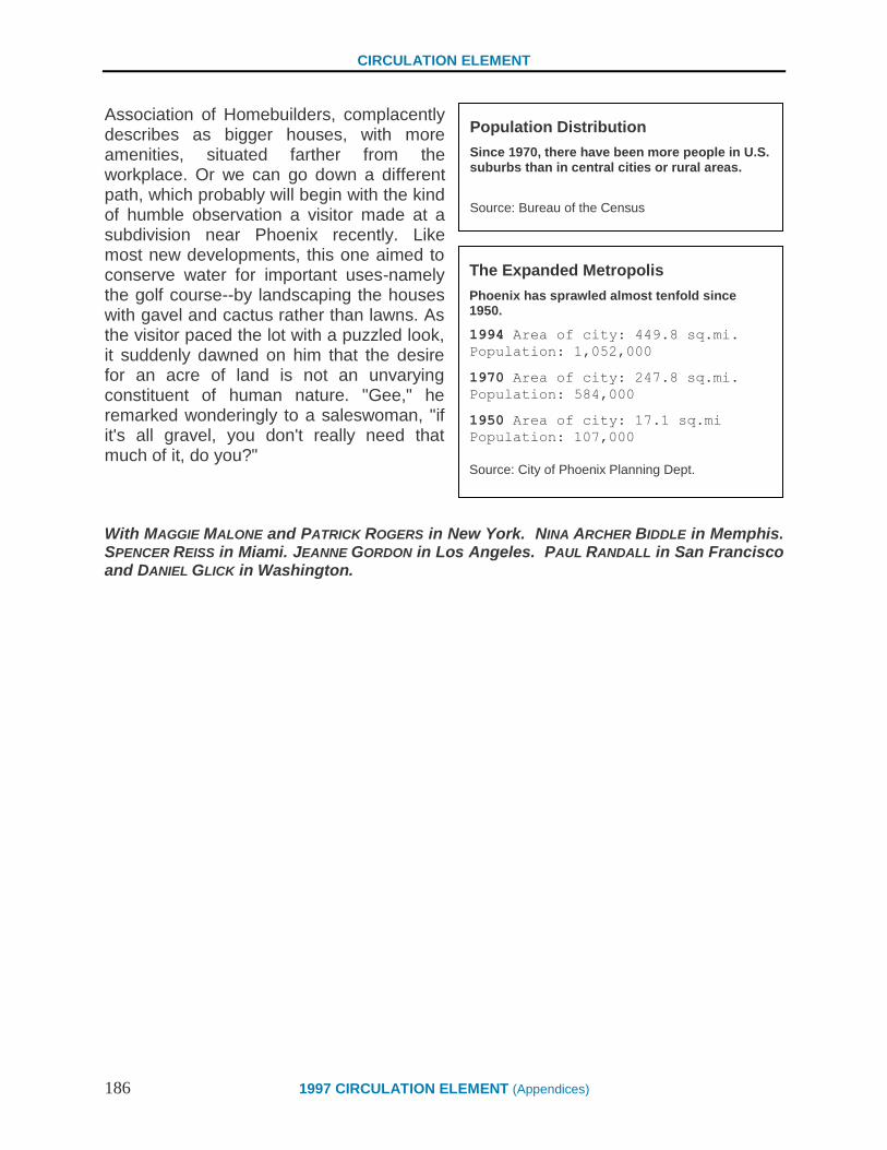
CIRCULATION ELEMENT
186 1997 CIRCULATION ELEMENT (Appendices)
Association of Homebuilders, complacently describes as bigger houses, with more amenities, situated farther from the workplace. Or we can go down a different path, which probably will begin with the kind of humble observation a visitor made at a subdivision near Phoenix recently. Like most new developments, this one aimed to conserve water for important uses-namely the golf course--by landscaping the houses with gavel and cactus rather than lawns. As the visitor paced the lot with a puzzled look, it suddenly dawned on him that the desire for an acre of land is not an unvarying constituent of human nature. "Gee," he remarked wonderingly to a saleswoman, "if it's all gravel, you don't really need that much of it, do you?"
With MAGGIE MALONE and PATRICK ROGERS in New York. NINA ARCHER BIDDLE in Memphis. SPENCER REISS in Miami. JEANNE GORDON in Los Angeles. PAUL RANDALL in San Francisco and DANIEL GLICK in Washington.
The Expanded Metropolis
Phoenix has sprawled almost tenfold since 1950.
1994 Area of city: 449.8 sq.mi.
Population: 1,052,000
1970 Area of city: 247.8 sq.mi.
Population: 584,000
1950 Area of city: 17.1 sq.mi
Population: 107,000
Source: City of Phoenix Planning Dept.
Population Distribution
Since 1970, there have been more people in U.S. suburbs than in central cities or rural areas.
Source: Bureau of the Census

CIRCULATION ELEMENT
1997 CIRCULATION ELEMENT (Appendices) 187
Newsweek Magazine
Bye-Bye, Suburban Dream May 14, 1995
15 Ways to Fix The Suburbs
Most of us actually know what we want in a neighborhood-we just don't know how to get it, because developers have been building the wrong thing for 50 years. Here's how to get our communities back on track.
For decades, Anton Nelesson of Rutgers University has been using the tools of
science to pursue that most elusive and subjective quality, happiness. When a developer comes into a community, humbly seeking permission to re-create ancient Pompeii on the site of an old Go Karl track, the town's planners commission Nelesson to survey the populace and determine if that's what they'd actually like there. Using photographs, models and questionnaires, Nelesson has surveyed people all over the country, and these are some of the things he's found:
"Everybody will call for a green open space in the middle-that's automatic. They will put the major community buildings around the plaza, then group the houses on relatively narrow streets. Ninety-nine percent don't want streets that are more than two lanes wide. At the edges of the village they leave open space."
"With two working spouses, [smaller lots] make a lot more sense. You don't want to mow that big lawn."
"People have a fundamental, psychological, spiritual response to nature. If you show them recently built multi-family housing or office parks, they go negative. A small, traditional neighborhood is what people want, They don't know how to get it."
Well, of course they don't: most of them haven't even seen a "small, traditional neighborhood" in years, if ever. But they instinctively choose it anyway. The premise of the new urbanism is that people can have the kinds of neighborhoods they say they like. Architects know how to design them, developers can build them, banks can make money on them. All it takes is a measure of political will to overcome the inertia of 50 years of doing things the wrong way . . . and the application of a few simple rules.

CIRCULATION ELEMENT
188 1997 CIRCULATION ELEMENT (Appendices)
Give Up Big Lawns 1 One useful way to define a suburb is "a place that grows lawns." The great postwar
disillusionment began for many Americans when they left the city in search of a simpler life and discovered that watering, fertilizing, weeding and mowing the measliest yard takes more time over a year than the average New Yorker spends looking for parking. And the expanses of front lawn themselves serve no purpose but their owners' vanity except that most suburban communities require them, on the theory, that large setbacks help preserve the bucolic character of a community. That may have been true in the 1920s, when suburbs were being settled 80 houses at a time. But when highways opened up huge areas of countryside after the war, large-lot zoning had the opposite effect: by spreading population over a larger area, it accelerated sprawl. If zoning boards weren't so fearful of "density," they could require developers to cluster houses and set aside land nearby for open space and recreation. This is also a more efficient way to build a community. Houses that are 100 feet apart, obviously, have 100 feet of unused road and utility lines between them. School buses have that much farther to travel.
And the goal of making a walkable community is defeated when houses are spread out on huge lots. Even the depth of the front yard turns out to make a crucial psychological difference. When houses are set back behind 30 feet of lawn, the streetscape becomes oppressively desolate; your perspective changes so slowly you don't feel you're reaching a destination. Probably no single change would improve the quality of suburban life as much as shrinking the size of lots--and it would actually make houses cheaper.
Bring Back the Corner Store 2 The suburban condition, says architect Peter Calthorpe, "is a landscape of absolute
segregation . . . not just in terms of income, age or ethnicity. but simple functional uses." This is so obvious that most people no longer see the absurdity of making a five-mile round trip for a loaf of bread. That is, as long as they have a car; for anyone not so blessed children, the elderly or handicapped, people who can't afford a car for every member of the family- it's nuts. Again, this is a function of good intentions undone by the explosion of suburbia. What worked in a compact neighborhood in a city-a dry- cleaner, a drugstore. a corner grocery--became grotesque when blown up a hundredfold and applied to whole counties. Shopping strips stretched for dozens of miles along the highways, while the curving streets of suburbia wormed their way ever deeper into the countryside.

CIRCULATION ELEMENT
1997 CIRCULATION ELEMENT (Appendices) 189
Obviously, malls and supermarkets, with their vast selections and economies of scale. will never be supplanted by neighborhood shopping streets and corner groceries. But it still should be possible to provide some of the necessities of life within walking distance of many people. Then you could send your kid out for that bread -- and a newspaper while he's at it.
Make the Streets Skinny 3 Modern subdivisions are designed to be driven, not walked. Even little-used streets
are 36 feet or 40 feet wide, with big sweeping curves at the corners. It's great for cars: traffic barely needs to slow down. But for those on foot, the distance is daunting. Narrow streets--as little as 26 feet wide - and tight, right-angled corners are a lot easier for walkers, and probably safer as well, because they force drivers to slow down. One objection: fire departments worry about getting trucks through. But that hasn't been a big problem in old nabes in cities like New York and Boston.
Drop the Cul-De-Sac 4 The cul-de-sac, a fancy term for "dead
end." has emerged as the street plan of choice for modern suburbs. Its great advantage the elimination of through traffic is also its weakness, because it compels everyone in a given subdivision to use the same few roads, often at the same times. Anyone attempting to travel on foot or by bicycle will eventually wind up on the shoulder of a busy highway and probably give up. But streets don't have to be like that: they can follow predictable routes and interconnect. This gives motorists a choice of routes, so they don't all pile up every morning waiting to make a left turn at the same intersection.

CIRCULATION ELEMENT
190 1997 CIRCULATION ELEMENT (Appendices)
LEADING NEW URBANIST
Nothing irks Peter Calthorpe more than "naysayers who say that Americans don't want to live in high-density cities--they want suburbs, as though there were only two choices!" According to the San Francisco architect, "The answer is to understand there are a huge number of people with different lifestyles. There are different densities in new urbanism, some low, some high. Neighborhoods that have diversity--cafes, recreation, casual social encounters--will be increasingly important. Suburbs aren't just about bedrooms anymore."
Draw Boundaries 5 In an absolute sense, there is no real shortage
of land in the United States; if the entire population lived on an acre of land per household, it would occupy less than 5 percent of the contiguous 48 states (plus all of Canada and Mexico for parking). But in the regions where Americans actually want to live. they are swarming into the countryside, covering whole counties with "edge cities" flung outward from the beltways as if by centrifugal force. New York City's suburbs reach across the whole state ot' New Jersey into eastern Pennsylvania, nearly 100 miles from Times Square. To new-urbanist theoreticians, this is the disastrous result of shortsighted government policies, such as the bias in the federal mortgage-guarantee program toward detached houses on large plots of land. To flee-market economists, it represents the sum of millions of choices by informed individuals who have decided that, on balance, getting up before dawn in Bucks County beats a full night's sleep in Brooklyn.
But sprawl is not a necessary component of affluence. In Europe and Japan, governments have proclaimed "urban-growth boundaries," beyond which development is more or less prohibited. Even in a democratic country such as Holland, a businessman seeking to live on a farm and drive into the city to work would have to request permission from the government-and he might not get it. Try telling that to Lee Iacocca. Contrary to popular American political theory, these regulations haven't noticeably affected the prosperity of Western Europe--nor of the one major American city that has instituted its own urban-growth boundary: Portland, Ore.
In Oregon, naturally, no one would prevent the hypothetical businessman from living on a farm; he just couldn't sell it off for a subdivision when he retired to Palm Springs. More than 20 years ago, planners for the Portland metropolitan area drew a line around 325 square miles--covering 24 municipalities and parts of three counties-and designated it to receive virtually all population growth. Along the way they have reduced the average lot size for detached houses from 13,000 square feet to an average of 8.500 square feet-roughly the difference between putting three and five units on an acre. The proposed future goal is an even mingier 6,600 square feet. Between now and the year 2040, Portland's planners expect the population to grow some 77 percent, but they are committed to an increase of residential land use of only 6 percent. Instead of planting more "edge cities" at the arbitrary points where freeways intersect, Portland has concentrated job growth in its downtown. The urban-growth boundary has been so

CIRCULATION ELEMENT
1997 CIRCULATION ELEMENT (Appendices) 191
successful that even a conservative property-rights group, Oregonians in Action, endorses the concept (although it argues with some details). Imagine how Los Angeles would look today if it had done this 20 years ago.
Hide the Garage 6 Most suburban houses give the appearance that they are first of all places to park,
turning to the world the blank and desolate face of a garage door. Neighborhoods look more pleasant when garages are put behind the houses, accessible by side yards or by alleys.
Mix Housing Types 7 Of all the ways to improve the social and physical organization of the suburbs. none
would be as subversive as breaking the monopoly of single-family detached homes: that endless alternation of "Crestwoods" and "Auroras" intended to foster the illusion of preference in buyers' choosing between four bedrooms and three bedrooms plus a den. Homogeneity is the very essence of the suburbs. Attached houses, rental units, shops or businesses-anything that might attract traffic and its attendant evil, a decline in property values--are banned.
This is a fairly new phenomenon in human history. For most of the last 9,000 years, most people inhabited villages, where by definition nothing was very far from anything else. As late as the 1940s, for that matter, Memphis,. Tenn., developer Henry, Turley grew up in the End of haphazard city neighborhood that is the despair of sensible planners: a jumble of stores, shacks, flats, walk-ups and decaying mansions. all suffused with the vivid street life neighbors made for themselves in the era before air conditioning lured them indoors. It is, course, beyond the power of zoning to bring back those days. even if we wanted them back. But it may be possible to recapture some of the energy and spirit that characterized American civic life before television clamped its monopoly on public discourse and entertainment. So in 1987 when Turley bought a 135-acre vacant plot on an island in the Mississippi five minutes from downtown Memphis. he embarked on a radically different kind of development, which began not by asking "What will the county let me builds?" or "What will the banks finance?" but "What kind of place do people want to live in?"
The result was Harbor Town, intended to be "a slice of the world--the more complete and varied the better." There are houses ranging in price from $114,000 to $425,000, which contrasts with a typical subdivision in Phoenix, Ariz., for example, where the seven basic models run the gamut from $271,990 to $316,990. There are town houses and apartments, and shops being planned. Developers had tried mixing housing types in the "planned communities" of the 1970s, but in those each use was isolated in its own thousand-acre quadrant; in Harbor Town they are all within a few blocks of each other. Turley seems to have decreed that instead of golf, the leading recreational activity
CIRCULATION ELEMENT
192 1997 CIRCULATION ELEMENT (Appendices)
would be chatting with neighbors while watching the sun set over the river, so he set the houses close together and built cozy village squares. The houses themselves are an eye-popping collection of styles, including Charlestown provincial, Cape Cod and Bauhaus modern, but they have an underlying unity based on materials (mostly clapboard or wood siding) and the ubiquitous new-urbanist amenity, porches. Turley expects to make money on the project, when it's completed in 1997, but he also has a higher aim. "Democracy assumes-demands-that we know, Understand and respect our fellow citizens," he says. "How can we appreciate them if we never see them?"
Plant Trees Curbside 8 Nothing humanizes a street more than a row of trees shading the sidewalk. But they
must be broad-leafed shade trees such as sycamores or chestnuts, not the dinky globular things like flowering pears that developers favor in parking lots. And they should be planted out at the curbline, where they will grow out to form a canopy over the roadway. Why don't more places have such an obvious amenity already? Because traffic engineers worry that people might drive into them.
Put New Life Into Old Malls 9 They've got fountains, hanging ferns and ice rinks, and if you stay in one long
enough you may eventually hear "Wichita Lineman" rescored for 140 violins, but most shopping malls are, essentially, just vast sheds that consumers trudge through until, with nothing left to spend, they are spit out into the parking lot. No wonder people are so quick to desert them when a bigger one opens up down the road. Ghost malls are no longer a rare sight in America. Phoenix has at least two, including one right across the street from several of its largest office buildings. But the land they occupy can, with some ingenuity and a lot of money, become the nucleus of a real neighborhood, an architectural adornment rather than a hulking blight.
The process is happening first with strip shopping centers. which are usually older than enclosed malls and less complex architecturally. The first step is to transcend the definition of a "shopping center" as a grouping of unrelated stores in the middle of a parking lot. That pretty much described the New Seabury, Shopping Center, a dreary 1960s-era strip mall on a busy highway in Cape Cod, Mass., about 70 miles from Boston. A decade ago, the owners decided to redevelop it on a radically different scheme, modeled on a New England town. New streets were hid out in what had been the parking lot: new shops were built in the neglected area behind the existing ones. A 25-year development plan was drawn up, envisioning a substantial community; offices, a library, a church and a senior-citizens' home have already been built.
CIRCULATION ELEMENT
1997 CIRCULATION ELEMENT (Appendices) 193
A DIFFERENT APPROACH
Mixing income levels in a neighborhood is a new-urbanist credo, and nobody does that better than planner Oscar Newman. His scattered-site low-income housing for Yonkers, N.Y., is a model of its kind. But Newman is no fan of the new urbanists. "Instead of saying, "This is what's wrong [with suburbs],' they should ask, "Why do people feel it's worth it to live there?'"
Parking was redistributed along the curbs of the new internal streets. This makes for some congestion and inefficiency, but lessens the frustration of trudging down long aisles of parked ears toward a distant mall entrance. Developer Douglas Storrs says that shoppers find the strength to walk as much as half a mile down the sidewalks of what is now called Mashpee Commons, passing shop windows, benches and planters. The same people reach the threshold of exasperation when they have to park more than 400 feet from the door to an ordinary mall.
There are other examples, including Mizner Park, in Boca Raton, Fla., where a failing shopping center was replaced with a 28-acre mixed-use development organized around a new public park. To be sure, not all developers will be this ambitious with their properties. But as a first step, hiding the ugly collection of Dumpsters and loading docks on the backsides of strip malls could eliminate a lot of suburban blight.
Plans for Mass Transit 10 Is there any way to get Americans out of their cars
and into buses and trains? In Los Angeles, not even an earthquake sufficed; only about 2 percent of drivers switched to mass transit after their freeways fell down last year, and most of them went right back to driving as soon as the roads were patched up.
The problem is that transit seems to need a critical mass to work, and many metropolitan areas (Los Angeles among them) are just too spread out. Many commuters seem to think that if you have to drive to the train station anyway, you might as well just keep going to the office.
Hence Calthorpe's idea for the "pedestrian pocket": a relatively dense settlement within a quarter-mile walk of a transit stop. In Portland, Ore., they're building the transit line first-putting stops literally in the middle of empty fields--in the expectation that the development will follow.
Link Work to Home 11 Suburbs are no longer just bedroom communities; the dispersal of employment
out of the central cities has been going on for a generation. (As the writer William H. Whyte demonstrated two decades ago, big corporations leaving the city tend to relocate within a few miles of the chief executive's house.) But the result-the oxymoronic "office parks" consisting of indistinguishable glass cubes amid a token fuzz of grass and a giant parking lot-is just a higher class of sprawl than the gas stations and fried-chicken places that would have been built there instead.
CIRCULATION ELEMENT
194 1997 CIRCULATION ELEMENT (Appendices)
If companies don't want to be downtown, they should at least attempt to integrate their offices-or factories, for that matter-into communities. Nobody wants to live next to a steel mill, naturally. But in Laguna West, outside Sacramento, people are happy to live within a quarter-mile of an Apple Computer plant, which provides 1,200 white-collar and assembly-line jobs. Apple agreed to locate there after the community was already planned: developer Phil Angelides says the company liked the idea that executives and workers could afford to live in the same community. Playa Vista, a new-urbanist community being planned for Los Angeles, has been mentioned as a possible home for the DreamWorks SKG multimedia company. It could be an updated-and very. upscale-version of the company town, which in this case will comprise 13,000 houses and apartments, shops, a park, promenades and jogging trails along the last tidal marsh in the city.
Calthorpe believes that more businesses will move to new-urbanist projects as they grow disillusioned with the traffic and isolation of their office parks. "The idea is not necessarily to live in the same development you work in," he says; "there are a lot of criteria for where you choose your house. But if people can walk to a park, to midday shopping, restaurants and day care, it's better for the people working there."
Make a Town Center 12 Every town needs a center: a plaza, square or green that is a geographical
reference point and a focus of civic life--even if that just means a place to push a stroller or throw a Frisbee. Shopping malls are a poor substitute; the area they serve is too diffuse, and in any case their civic function is incidental to their real purpose making money. Developers often provide some parkland in their subdivisions, but it's usually on leftover parcels that wouldn't be built on anyway, by the edge of the highway or adjoining another subdivision.
Shrink Parking Lots 13 Parking is one of Suburbia's highest achievements. Only in the United States does
the humblest copy-shop or pizzeria boast as much space for cars as the average city hall. But it is also a curse; the vast acreage given over to asphalt is useless for any other purpose, and goes unused more than half the time anyway. Most planners regard parking as a prerequisite for economic growth, like water. But downtown Portland, Ore., which strictly regulates parking, has been thriving with essentially the same space for cars as it had 20 years ago. Developers often build more parking than they actually need; a half-empty lot is presumed to reassure prospective tenants that they'll never run out of space for their cars. Yet a bank, a movie theater and a church are all full at different times. One simple improvement towns can make is to look for ways to share and pool parking space among different users.

CIRCULATION ELEMENT
1997 CIRCULATION ELEMENT (Appendices) 195
The ideal-although expensive- solution to the parking problem is for cars to vanish underground when they get where they're going. A shopping center surrounded by acres of striped asphalt, whether it's empty or full, might as well put up a moat against pedestrians. Large parking lots should be situated behind buildings whenever possible--something most suburban zoning codes don't currently allow-and divided by streets, sidewalks or structures into smaller segments of around three acres or less. On-street parking in residential neighborhoods is controversial. Some planners favor it, because it creates a "buffer" between pedestrians and traffic, but others consider it a danger to children running out between the cars.
Turn Down the Lights 14 It is probably true that illuminating a suburban street to the level of the infield at
Comiskey Park reduces accidents, especially for people who leave their regular glasses at home and have to drive in sunglasses. For everyone else, though, towering, garish sodium-vapor street lamps intrude on the peacefulness of the night with the insistence of a stuck horn. Where safety is not a big issue, why not use several smaller lamps that cast a gentler glow and let you see the stars?
Think Green 15 Out beyond the beltway, where the roads are narrow and blacktop, past the point
at which the dwindling traffic is too sparse to warrant plucking by even the mingiest motor court, there's a beautiful land. There are pale green corn plants poking through the brown soft, lakes glimpsed through trees, cholla cactus among the tumbled red rocks. It's not wilderness, but countryside, the unfinished canvas of America. It tells us where we are-in Illinois, Maine or Texas--and it locates us in time: summer, fall, winter, spring. There's nothing to buy there, nowhere to park; it doesn't lure us with golden arches or free coffee mugs with a fill-up. It's just there.
And by the same token, it isn't making anyone rich, yet. There is a gradient of value that runs from the city to the country, and it keeps moving outward; pick any spot and it's just a matter of time before it makes the magical transition from "countryside" to "real estate." The process seems inevitable, but it isn't, really. It's the product of concrete decisions made in an age when roads were still viewed as the harbingers of civilization rather than discount muffler outlets. And as surely as our society made those decisions, it can change them, before lawn meets lawn and asphalt meets asphalt, covering the land in a seamless carpet of sprawl.

196

CIRCULATION ELEMENT
1997 CIRCULATION ELEMENT (Appendices) 197
COMMON QUESTIONS
REGARDING SMALL AND
MINOR NON-RESIDENTIAL
ADDITIONAL
What is Measure E?
Measure E was a ballot initiative passed by Santa Barbara voters in 1989
that limits the amount of new non-residential development within the City
to 3 million square feet until the year 2010. This was done in response to
resident concerns about living within the existing resources available to
Santa Barbara and the preservation of the existing quality of life. The
3 million square feet was divided into categories available to different types
of projects. These categories are: Approved Projects Pending Projects,
Vacant Property, Small Additions, Community Priority, and Economic
Development. Minor Addition square footage is also available but is not
counted in the 3 million square foot limit.
Does Measure E limit residential development?
No. Measure E applies only to new non-residential development in the
City. The City’s General Plan and Zoning Ordinance encourage residential
development, specially in and around the Downtown area. Property
owners faced with limited commercial development potential under
Measure E are encouraged to pursue mixed-use development projects.
There are many successful examples of buildings with retail/commercial
space on the ground floor with residential units above. Examples of
detached residential and non-residential uses that are on the same parcel
also exist in the area.
CIRCULATION ELEMENT
198 1997 CIRCULATION ELEMENT (Appendices)
Common Measure E Questions
November 24, 1997
Page 2
What is a Minor Addition?
The Santa Barbara Municipal Code defines a Minor Addition as a project
Involving less than or equal to 1,000 square feet of new non-residential
development. This square footage can take the form of new development,
an addition to an existing building, or the conversion of residential floor
area to a non-residential use. Any legal lot, as permitted by zoning, is
eligible to apply for up to 1,000 square feet of Minor Additions. Minor
Additions are not subject to Development Plan review and approval.
What is a Small Addition?
The Santa Barbara Municipal Code defines a Small Addition as 1,001-3,000
square feet of non-residential development. This development can be in the
form of an addition to an existing building, new construction, or conversion
of residential floor area to a non-residential use. The Small Addition
category was created to allow for the expansion and growth of existing
businesses in the City while maintaining a limit on total non-residential
growth.
There is a total of 600,000 square feet of Small Addition space available
until the year 2010. This Measure E development category is unique in that
the ballot measure stated that Small Additions shall be limited to 30,000
square feet per year. This limitation was placed on Small Additions
in anticipation of the demand for Small Additions exceeding the 20 year
allocation. The annual limit is intended to pace the rate of development in
this category.
If the 30,000 square feet is completely allocated by some point in the same
calendar year, no development in this category can take place until the
following year.
What properties are eligible for a Small Addition?
Any legal lot, as permitted by zoning, is eligible to apply for up to 2,000
square feet of non-residential square footage from this category. However,
CIRCULATION ELEMENT
1997 CIRCULATION ELEMENT (Appendices) 199
Common Measure E Questions
November 24, 1997
Page 3
the 2,000 square foot limit is a cumulative total per parcel until the year
2010/ Small Additions are subject to Development Plan review and
approval and must not result in any significant impacts on traffic, water, or
housing.
How are Minor and Small Additions used together?
Square footage from the Small and Minor Addition categories are often
combined and used together for a single development project. The 2,000
square foot limit per lot on Small Additions, combined with the 1,000
square foot limit per lot on Minor Additions, means that the total new non-
residential square footage available per lot from these categories is 3,000
square feet until the year 2010.
The first 1,000 square feet of development on a lot is considered a Minor
Addition in all cases. Any cumulative development on a lot exceeding
1,000 square feet up to the 3,000 square foot limit is considered a Small
Addition. For example, an addition of 1,000 square feet would be a Minor
Addition, while a later addition of 2,000 on the same parcel would be
considered a Small Addition. In this example, the cumulative total of 3,000
square feet per lot has been reached and no further applications could be
made for Small or Minor Additions.
There are also cases where square footage for the same addition may be
drawn from both categories. For example, a 1,200 square foot addition to a
building with no previous additions would use 1,000 square feet of Minor Addition
square footage and 200 square feet of Small Addition square footage.
When is a Minor Addition considered a Small Addition?
When the cumulative square footage total per parcel exceeds 1,000 square
feet, any additional development on the parcel must come from the Small Addition
category. For example, an addition of 900 square feet to a
building with a previous addition of 1,000 square feet would bring the
cumulative parcel total to 1,800 feet. Therefore, even through both additions

CIRCULATION ELEMENT
200 1997 CIRCULATION ELEMENT (Appendices)
Common Measure E Questions
November 24, 1997
Page 4
Were less than or equal to 1,000 square feet, the later 800 square foot
addition would be processed as a Small Addition.
Can Small Addition square footage be used with square footage
from other categories?
The submittal of a complete application for review by the Architectural
Board of Review, the Historic Landmarks Commission, the Development
Review Committee, or the Planning Commission will start the process for a
square footage allocation. Please see the attached sheet which outlines the
Small Additions square footage allocation procedure. Planning Division
Staff will be able to assist you in determining the type of review that your
projects require and the applicable submittal requirements. All Small
Additions are subject to Development Plan review and approval findings as
described in Section 28.87.300 of the Zoning Ordinance.
For further information regarding Measure E or the status of development
activity under Measure E, please contact Rachel Adcox, Acting Assistant
Planner, or Liz Casey, Senior Planner, at (805) 564-5470.

CIRCULATION ELEMENT
1997 CIRCULATION ELEMENT (Appendices) 201

202

CIRCULATION ELEMENT
1997 CIRCULATION ELEMENT (Page 19-1) 203
Index A
The following index groups Policies and Implementation Strategies by subject matter. The left
hand column describes the particular subject. The right hand column lists the relevant Policies
and Implementation Strategies.
Subject Policies and Implementation Strategies
Air Transportation 2.1.13
Airport 3.1.9, 3.4.5, 14.3, 14.3.1, 14.3.2, 14.3.3, 15.2, 15.2.1, 15.2.2, 15.2.5,
15.2.6
Airport Industrial Area Specific Plan 15.2.3
Aviation Facilities Plan 15.2.4
Annexation 13.8, 13.8.1
Bicycle
Bicycle Coordinator 4.3, 4.3.1, 4.3.2, 4.3.3, 4.3.4, 4.3.5, 4.3.6, 4.3.7, 4.3.8, 4.3.9, 4.3.10
Coastal Zone 2.1.7, 5.5.9, 9.1, 9.1.1, 9.1.2, 9.2.5, 9.3.1, 9.3.5
Downtown 2.1.6, 8.2.1
Expansion of routes/paths 2.1.2, 4.2, 4.2.1, 4.4, 4.4.1, 9.1.1, 9.1.2, 9.1.5, 9.2.5, 9.5.1
Green Bike Program 4.3.10
Infrastructure 1.1.3, 2.1.2, 3.4.2, 4.1.2, 4.2, 4.2.1, 4.2.2, 4.2.3, 4.2.4, 4.2.5, 4.2.7,
4.2.8, 9.1.1, 9.1.5
Linkages 1.1.3, 4.2.1, 9.1.1, 9.1.2, 9.1.5, 14.3.3, 15.2.3
Parking/Storage 3.2.4, 3.4.2, 4.1.5, 4.2.3, 4.2.6, 7.2.6, 9.1.1, 9.1.2, 9.2.5
Planning 4.1, 4.1.1, 4.1.2, 4.1.3, 4.1.4, 4.2.5, 4.3.1, 9.5, 9.5.1, 14.5.7
Safety 4.3.6, 4.5.2, 4.5.4, 5.5.9, 5.8.6, 9.1.1
Business
Economic Vitality 1.1, 5.3.4, 8.1
Delivery Systems 1.1.4, 4.3.5, 4.5.3, 5.1.3, 7.2.4, 7.4.4
Home-based businesses 13.7, 13.7.1
Mercados 5.5.12
Capital Improvements Plan/Program 2.2.2, 3.1.17, 4.1.4, 5.1.1, 14.1.4
Carpool/Vanpool 3.3.3, 6.1.2, 6.1.4, 6.3.2, 7.2.3, 8.2.1, 8.2.3
Compact Development 2.1.9, 13.2.2, 11.1
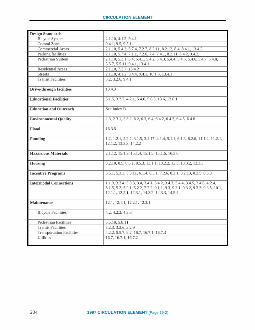
CIRCULATION ELEMENT
204 1997 CIRCULATION ELEMENT (Page 19-2)
Design Standards
Bicycle System 2.1.10, 4.1.2, 9.4.1
Coastal Zone 9.4.1, 9.5, 9.5.1
Commercial Areas 2.1.10, 5.4.3, 5.7.4, 7.2.7, 8.2.11, 8.2.12, 8.4, 8.4.1, 13.4.2
Parking facilities 2.1.10, 5.7.4, 7.1.1, 7.2.6, 7.4, 7.4.1, 8.2.11, 8.4.2, 9.4.2,
Pedestrian System 2.1.10, 5.3.1, 5.4, 5.4.1, 5.4.2, 5.4.3, 5.4.4, 5.4.5, 5.4.6, 5.4.7, 5.4.8,
5.5.7, 5.5.11, 9.4.1, 13.4.1
Residential Areas 2.1.10, 7.2.7, 13.4.2
Streets 2.1.10, 4.1.2, 5.4.4, 9.4.1, 10.1.3, 13.4.1
Transit Facilities 3.2, 3.2.6, 9.4.1
Drive-through facilities 13.4.3
Educational Facilities 3.1.5, 3.2.7, 4.2.1, 5.4.6, 5.6.3, 13.6, 13.6.1
Education and Outreach See Index B
Environmental Quality 2.3, 2.3.1, 2.3.2, 6.2, 6.3, 6.4, 6.4.2, 6.4.3, 6.4.5, 6.4.6
Flood 16.3.5
Funding 1.2, 1.2.1, 2.2.2, 3.1.5, 3.1.17, 4.1.4, 5.1.1, 6.1.3, 8.2.6, 11.1.2, 11.2.1,
12.1.2, 13.3.3, 14.2.2
Hazardous Materials 2.1.12, 15.1.3, 15.1.4, 15.1.5, 15.1.6, 16.3.6
Housing 8.2.10, 8.5, 8.5.1, 8.5.3, 13.1.1, 13.2.2, 13.3, 13.3.2, 13.3.3
Incentive Programs 3.5.1, 5.3.3, 5.5.11, 6.1.4, 6.3.1, 7.2.6, 8.2.1, 8.2.13, 8.3.5, 8.5.3
Intermodal Connections 1.1.3, 3.2.4, 3.3.3, 3.4, 3.4.1, 3.4.2, 3.4.3, 3.4.4, 3.4.5, 3.4.6, 4.2.4,
5.1.5, 5.2, 5.2.1, 5.2.2, 7.2.2, 9.1.1, 9.3, 9.3.1, 9.3.2, 9.3.3, 9.3.5, 10.1,
12.1.1, 12.2.1, 12.3.1, 14.3.2, 14.3.3, 14.5.4
Maintenance 12.1, 12.1.1, 12.2.1, 12.3.1
Bicycle Facilities 4.2, 4.2.2, 4.3.3
Pedestrian Facilities 5.5.10, 5.8.11
Transit Facilities 3.2.3, 3.2.6, 3.2.9
Transportation Facilities 4.2.2, 5.5.7, 9.2, 16.7, 16.7.1, 16.7.3
Utilities 16.7, 16.7.1, 16.7.2

CIRCULATION ELEMENT
1997 CIRCULATION ELEMENT (Page 19-3) 205
Marketing 12.1.1
Bicycle 2.1.2, 4.3.4, 4.3.7, 4.3.8, 4.3.9, 4.5, 4.5.1, 6.1.1, 6.3, 6.4, 6.4.1, 6.4.7,
6.4.8, 9.1.4
Pedestrian 5.8, 5.8.2, 5.8.3, 5.8.7, 5.8.8, 6.1.1, 6.3, 6.4, 6.4.1, 6.4.7, 6.4.8, 9.1.4
Transit 3.5.4, 3.5.5, 6.1.1, 6.3, 6.4, 6.4.1, 6.4.7, 6.4.8, 9.1.4
Parking 8.2.2, 8.2.13, 8.3.5, 9.2
Mixed/Multiple Purpose 5.7.3, 8.5.2, 13.1.1, 13.2.2, 13.3, 13.3.1, 13.3.2, 13.3.3
Monitoring See Index B
Neighborhood Serving Uses 5.7, 5.7.2, 13.5, 13.5.1, 13.5.2
Parking
Consolidated/Shared 7.2.1, 7.2.5, 7.2.8, 9.2, 9.2.1, 9.3.2 Customer parking 1.1.1, 3.2.8, 6.3.2, 8.1.1, 8.2, 8.2.7 Demand Standards 8.1.2, 9.2.2 Employee Parking 3.2.8, 6.3.2, 8.1.1, 8.2, 8.2.2, 8.2.8, 8.2.9 Employee Shuffle 8.2.6, 8.2.7 Management 2.1.5, 2.1.6, 7.1.1, 7.2, 7.2.6, 7.2.7, 7.4, 8.1, 8.1.1, 8.1.4,
8.2, 8.2.15, 9.2, 9.2.1, New parking areas 2.1.5, 7.2, 7.2.6, 8.2.8, 8.3, 8.3.1, 8.3.2, 8.3.3, 8.3.4, 9.2.1,
9.5.1 On-street 3.2.1, 4.4.1, 6.3.2, 7.2.3, 7.2.7, 7.3.1, 8.3.2, 9.2.4, 9.1.5 Park and Ride 14.5.2 “Park Once” concept 8.3.3, 9.2.1 Peripheral/Commuter lots 3.4.3, 6.3.1, 7.2.2, 8.2.4, 8.3.4 Planning 3.1.17, 7.1, 7.1.1, 9.2.3, 13.4.2 Pricing 7.4.5, 8.2.3, 8.2.14 Recreational Vehicle 7.4.6 Requirements 3.1.5, 4.2.3, 5.7.4, 7.1.1, 7.2.7, 7.4, 7.4.2, 7.4.3, 7.4.4,
8.1.3, 8.2.9, 8.5.2, 9.2.1, 9.2.2, 13.2.2, 13.5.2 Residential 7.1.1, 7.3, 7.3.1, 8.5.2
Tour Bus 3.3.5, 9.5.1

CIRCULATION ELEMENT
206 1997 CIRCULATION ELEMENT (Page 19-4)
Pedestrian Accessibility (disabled, elderly) 5.4.1, 5.4.5, 5.4.8, 5.5.3, 5.6, 5.7.5 Coastal Zone 2.1.7, 5.5.9, 9.1, 9.1.1, 9.1.2, 9.1.3, 9.3.1, 9.3.5 Downtown 2.1.6, 5.3, 5.3.4, 5.8.7, 8.2.1 Improvements/Amenities 5.1.4, 5.2.1, 5.3.4, 5.4.1, 5.4.2, 5.5, 5.5.1, 5.5.2, 5.5.4,
5.5.5, 5.5.6, 5.5.8, 5.5.11, 5.7.1, 5.7.5, 5.8, 8.2.12, 9.1.1,
9.1.2, 9.1.3, 9.2.5, 9.5.1, Infrastructure 1.1.3, 2.1.3, 5.1, 5.1.1, 5.1.2, 5.1.4, 5.4.1, 5.4.4, 5.5.3,
5.5.6, 5.5.7, 5.5.8, 5.5.13, 5.6.1, 5.6.2, 5.7.1, 5.7.5, 5.8,
5.8.5, 9.1.1, 9.2.5, 9.5.1 Linkages 1.1.3, 5.1, 5.1.2, 5.1.5, 5.3.6, 5.5.6, 5.7, 9.1.1, 9.1.2, 13.2.3,
15.2.3 Paseos 5.3, 5.3.1, 5.3.2, 5.3.3, 5.3.5, 5.3.6, 5.5.2, 7.2.6, 9.1.3,
13.2.3 Safety 2.1.3, 5.3.5, 5.3.6, 5.4.1, 5.4.2, 5.4.4, 5.4.5, 5.4.6, 5.4.8,
5.5.2, 5.5.9, 5.5.13, 5.6, 5.6.1, 5.6.2, 5.6.3, 5.8.4, 5.8.6,
5.8.9, 5.8.10, 8.2.12, 9.1.1
Public Involvement See Traffic Management Program
Public Utilities
Communication and
Telecommunications Facilities 2.1.12, 5.4.8, 6.1.4, 13.7.1, 14.5.6, 16.6, 16.6.1, 16.6.2,
16.6.3 Electricity 2.1.12, 5.4.8, 16.1, 16.1.1, 16.1.2, 16.1.3, 16.1.4 Gas 2.1.12, 16.1.4, 16.2, 16.2.1, 16.2.2, 16.4.2 Storm Drainage 2.1.12, 16.3, 16.3.1, 16.3.2, 16.3.3, 16.3.4, 16.3.5, 16.3.6 Wastewater Collection 2.1.12, 16.5, 16.5.1, 16.5.2, 16.5.3, 16.5.4 Water Supply 2.1.12, 5.4.8, 16.4, 16.4.1, 16.4.2, 16.4.3
Rail Transportation See Transit, Rail Transportation
Redevelopment Agency 9.3.2
Regional
Planning 2.1.11, 3.3.1, 3.3.2, 4.3.1, 14.1.1, 14.1.2, 14.1.3, 14 2.4, 14.5, 14.5.1,
14.5.2, 16.1.3
Coordination with agencies 2.1.11, 3.3.1, 3.3.2, 3.4.4, 4.3.1, 4.3.7, 6.3.3, 14.2, 14.2.1, 14.2.3, 14.3,
14.3.1, 14.5.5, 14.5.7, 15.1.3, 15.1.4, 15.2.3, 15.2.5, 15.3, 15.3.1,
16.1.1, 16.1.2, 16.2.1, 16.2.2, 16.2.3
Signage See Index B
Street Classification System 2.1.8, 10.1, 10.1.1, 10.1.2, 10.1.3, 10.2, 10.2.1

CIRCULATION ELEMENT
1997 CIRCULATION ELEMENT (Page 19-5) 207
Traffic Calming 5.8.6, 10.1, 12.1.1, 12.2.1, 12.3.1
Traffic Impact Standards 1.1.2, 11.1, 11.1.1, 11.1.2
Traffic Management Program 11.2.2, 12.1, 12.1.1, 12.1.2
Neighborhood Area Management Plan 12.2, 12.2.1
Business Area Management Plan 12.3, 12.3.1
Transfer of Existing Development
Rights
13.4.4, 13.4.5
Transit
Coastal Zone 2.1.7, 3.1.5, 9.1, 9.1.1, 9.1.3, 9.3.5,
Downtown 2.1.6, 8.2.5, 9.1.2
Commuter Subscription Service 3.3.4,
Expansion/Improvement of Services 1.1.3, 2.1.1, 3.1, 3.1.1, 3.1.2, 3.1.3, 3.1.4, 3.1.5, 3.1.8, 3.1.10, 3.1.13,
3.1.14, 3.1.17, 3.2.5, 3.2.7, 3.3, 3.3.3, 3.3.4, 3.4.1, 3.4.5, 4.2.4, 6.3.3,
9.1.1, 9.1.2, 9.3.3, 12.1.1, 14.5.5
Infrastructure 3.4.2, 11.1
Linkages 1.1.3, 3.1.7, 3.1.9, 3.1.14, 3.1.15, 3.2.7, 8.2.15, 9.1.1, 9.1.2, 9.1.3,
12.1.1, 15.2.3, 15.2.6
Pass Programs 3.1.5, 6.1.4, 8.2.1, 9.2.5
Planning 3.1.9, 3.1.11, 3.1.12, 3.3.1, 3.3.2, 3.5, 3.5.2, 9.5, 9.5.1, 12.1.1, 13.2.1
Priority Movement 3.1.6, 3.2.1
Rail Transportation 2.1.12, 3.3.6, 3.4.1, 6.3.3, 14.5.3, 14.5.4, 14.5.8, 15.2.3,
15.3, 15.3.1, 15.3.3, 15.3.4
Regional 3.3, 3.3.1, 3.3.2, 3.3.6, 3.4.5, 3.4.6, 6.3.3, 15.5.1, 14.5.5
Safety 3.2.9
Shelters/Stops 3.2, 3.2.2, 3.2.3, 3.2.4, 3.2.5, 3.2.6, 3.2.8, 3.2.9, 3.4.2, 5.2.1, 9.2.5,
9.3.4
Shuttles 3.1.4, 3.1.14, 3.3.3, 3.4.3, 6.3.3, 7.2.2, 8.2.5, 8.2.15, 9.1.2, 9.3.3,
12.1.1, 15.3.4
Taxi 3.1.15, 3.1.6
Tour busses 3.3.5
Transit Center 3.3.3
Transportation Demand
Management
Programs
6.1, 6.1.1, 6.1.2, 6.1.3, 6.1.4, 6.2.1, 6.4.1, 6.4.4, 6.4.6
Truck Traffic 2.1.13, 15.1, 15.1.1, 15.1.2
Water Transportation 2.7.1, 2.1.13, 9.1.6, 9.1.7, 9.1.8, 15.4, 15.4.1, 15.4.3, 15.4.4
Harbor Master Plan 15.4.2
Local Coastal Plan 9.2.2

208

CIRCULATION ELEMENT
1997 CIRCULATION ELEMENT (Page 20-1) 209
Index B
The following index presents the text of Policies and Implementation Strategies that relate to
Education, Monitoring, and Signage. The left hand column lists the number of each Policy and
Implementation Strategy and the right hand column includes the text.
Education
Policy or I.S. Text
3.5 The City shall work to increase public awareness of and cooperation with the City's
transit planning goals.
3.5.1 Work with local businesses and transit providers to develop transit incentive programs.
3.5.2 Train City appointed MTD Board Members, Council Members, City Staff, and MTD Staff
on the functions and working of transit services to ensure the consideration of City transit
issues, and conduct joint work sessions with the City Council and directors of transit
providers.
3.5.3 Encourage area schools to expand education programs about the benefits and advantages
of the use of transit.
3.5.4 Develop and work with transit providers, regional rideshare programs, and others to
expand existing transit marketing programs.
3.5.5 Market the City's transit system, through organizations such as the Chamber of Commerce
and the Convention and Visitors Bureau.
4.3.4 The Bicycle Coordinator shall promote the use of bicycles.
4.3.6 The Bicycle Coordinator shall encourage the use of programs intended to teach safe
bicycle riding techniques.
4.3.7 Work with local and regional bicycle groups and coalitions to promote bicycling both
within and outside of the City.
4.3.8 Encourage bicycle retailers to sponsor bicycle "Fun Rides" or races to promote bicycle
riding.
4.5 The City shall actively promote the safe use of bicycles as an efficient and affordable
mode of transportation.
4.5.1 Work with the Convention and Visitor's Bureau and the Chamber of Commerce to
promote a bicycle friendly image of the City to residents and tourists.
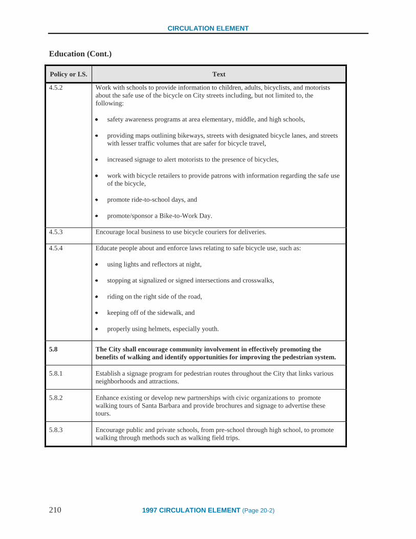
CIRCULATION ELEMENT
210 1997 CIRCULATION ELEMENT (Page 20-2)
Education (Cont.)
Policy or I.S. Text
4.5.2 Work with schools to provide information to children, adults, bicyclists, and motorists
about the safe use of the bicycle on City streets including, but not limited to, the
following:
safety awareness programs at area elementary, middle, and high schools,
providing maps outlining bikeways, streets with designated bicycle lanes, and streets
with lesser traffic volumes that are safer for bicycle travel,
increased signage to alert motorists to the presence of bicycles,
work with bicycle retailers to provide patrons with information regarding the safe use
of the bicycle,
promote ride-to-school days, and
promote/sponsor a Bike-to-Work Day.
4.5.3 Encourage local business to use bicycle couriers for deliveries.
4.5.4 Educate people about and enforce laws relating to safe bicycle use, such as:
using lights and reflectors at night,
stopping at signalized or signed intersections and crosswalks,
riding on the right side of the road,
keeping off of the sidewalk, and
properly using helmets, especially youth.
5.8 The City shall encourage community involvement in effectively promoting the
benefits of walking and identify opportunities for improving the pedestrian system.
5.8.1 Establish a signage program for pedestrian routes throughout the City that links various
neighborhoods and attractions.
5.8.2 Enhance existing or develop new partnerships with civic organizations to promote
walking tours of Santa Barbara and provide brochures and signage to advertise these
tours.
5.8.3 Encourage public and private schools, from pre-school through high school, to promote
walking through methods such as walking field trips.

CIRCULATION ELEMENT
1997 CIRCULATION ELEMENT (Page 20-3) 211
Education (Cont.)
Policy or I.S. Text
5.8.4 Work with public and private schools to identify and expand safe routes to school.
5.8.5 Consider establishing a hotline to report pedestrian trouble spots.
5.8.6 Continue a Traffic Safety Committee comprised of residents, the Assistant Traffic
Engineer and business representatives for the purpose of studying matters of traffic and
pedestrian safety, traffic calming, and making recommendations to the City Council
regarding measures to promote and improve traffic and pedestrian safety.
5.8.7 Coordinate a "Walker's Appreciation Day" with Downtown retailers. Co-sponsor a "Walk
to Work", "Take a Walk", or "Walk to School" day.
5.8.8 Work with community groups to encourage neighborhood walk-about activities.
5.8.9 Work with the Police Department to improve pedestrian safety at night (in areas including
paseos and placitas) through such methods as increased bicycle patrols.
5.8.10 Encourage public and private schools to implement pedestrian safety education programs
for all ages.
5.8.11 Encourage community groups, business groups, and individuals to assist in the cleaning
and maintenance of sidewalks, sidewalk furniture, landscaping, and pedestrian overpasses,
including graffiti removal and litter pickup.
6.1 The City shall continue to support efforts to expand Transportation Demand
Management Programs.
6.1.1 Work with local and regional transportation demand management services, such as Traffic
Solutions, to actively promote the advantages and cost savings of alternative forms of
transportation.
6.4 The City shall work to raise awareness about the effects of automobile use and the
value of alternatives to driving alone.
6.4.1 Continue to work with agencies, such as the School District and Traffic Solutions, and
fund programs which are designed to expand the education, outreach and marketing
components of transportation demand management services.
6.4.2 Work with groups such as the Air Pollution Control District (APCD) and Traffic
Solutions to educate the public about auto-related air pollution emissions.

CIRCULATION ELEMENT
212 1997 CIRCULATION ELEMENT (Page 20-4)
Education (Cont.)
Policy or I.S. Text
6.4.3 Work with groups such as the Community Environmental Council (CEC), to incorporate
information about opportunities to decrease energy consumption, reduce air pollution, and
improve resource conservation through decreased use of the automobile.
6.4.4 Encourage local and regional transportation demand management services, such as
Traffic Solutions, the Air Pollution Control District (APCD), and the Community
Environmental Council (CEC) to develop a local access television program aimed at
raising awareness and discouraging drive alone trips.
6.4.5 Participate in the Clean Cities Program (see Glossary).
6.4.6 Continue to participate in and share information with the Environmental Protection
Agency/Local Government Commission's Transportation Partners Program.
6.4.7 Encourage the use of bicycling and other forms of alternative transportation through the
sponsorship of events such as a Bike-to-Work Day.
6.4.8 Work with groups such as the Convention and Visitors Bureau and the Chamber of
Commerce to promote the use of public forms of transportation, alternative forms of
travel, and ridesharing to and within the City in all out of town advertising and promotion
efforts.
8.2.2 Increase the awareness of employers and employees about impacts of employee parking
and commuting habits through marketing and education.
8.5.1 Educate property and business owners, developers, and the community about the benefits
of increased housing Downtown.
9.1.4 Work with the Conference and Visitors Bureau and Chamber of Commerce to market the
transportation system and promote travel to Santa Barbara through methods such as:
marketing improvements to the transportation system to make the City more
attractive to tourists and companies seeking to locate in Santa Barbara,
promoting and marketing the use of alternative transportation by visitors, especially
between the Railroad Depot, Airport, and Waterfront hotels/motels, and
encouraging visitors to use alternative forms of travel such as the train.
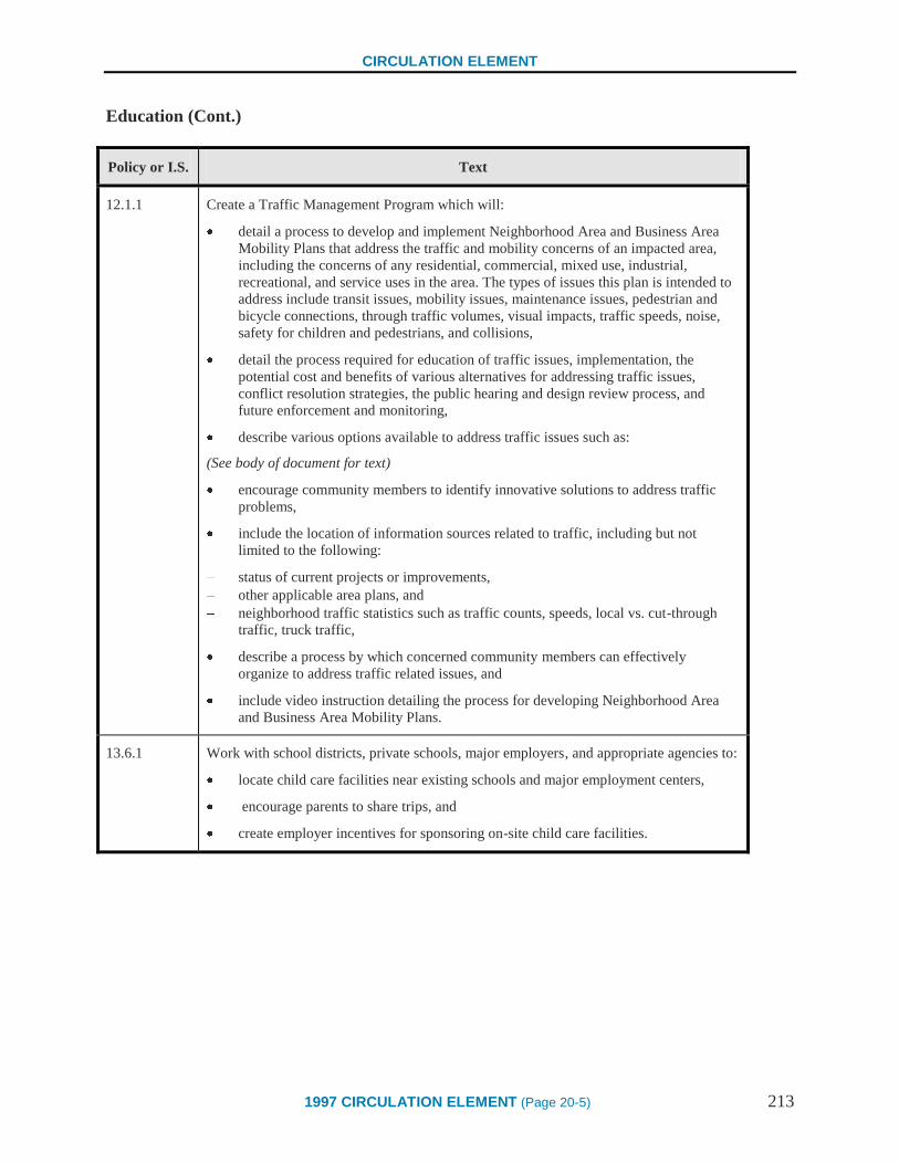
CIRCULATION ELEMENT
1997 CIRCULATION ELEMENT (Page 20-5) 213
Education (Cont.)
Policy or I.S. Text
12.1.1 Create a Traffic Management Program which will:
detail a process to develop and implement Neighborhood Area and Business Area
Mobility Plans that address the traffic and mobility concerns of an impacted area,
including the concerns of any residential, commercial, mixed use, industrial,
recreational, and service uses in the area. The types of issues this plan is intended to
address include transit issues, mobility issues, maintenance issues, pedestrian and
bicycle connections, through traffic volumes, visual impacts, traffic speeds, noise,
safety for children and pedestrians, and collisions,
detail the process required for education of traffic issues, implementation, the
potential cost and benefits of various alternatives for addressing traffic issues,
conflict resolution strategies, the public hearing and design review process, and
future enforcement and monitoring,
describe various options available to address traffic issues such as:
(See body of document for text)
encourage community members to identify innovative solutions to address traffic
problems,
include the location of information sources related to traffic, including but not
limited to the following:
status of current projects or improvements,
other applicable area plans, and
neighborhood traffic statistics such as traffic counts, speeds, local vs. cut-through
traffic, truck traffic,
describe a process by which concerned community members can effectively
organize to address traffic related issues, and
include video instruction detailing the process for developing Neighborhood Area
and Business Area Mobility Plans.
13.6.1 Work with school districts, private schools, major employers, and appropriate agencies to:
locate child care facilities near existing schools and major employment centers,
encourage parents to share trips, and
create employer incentives for sponsoring on-site child care facilities.
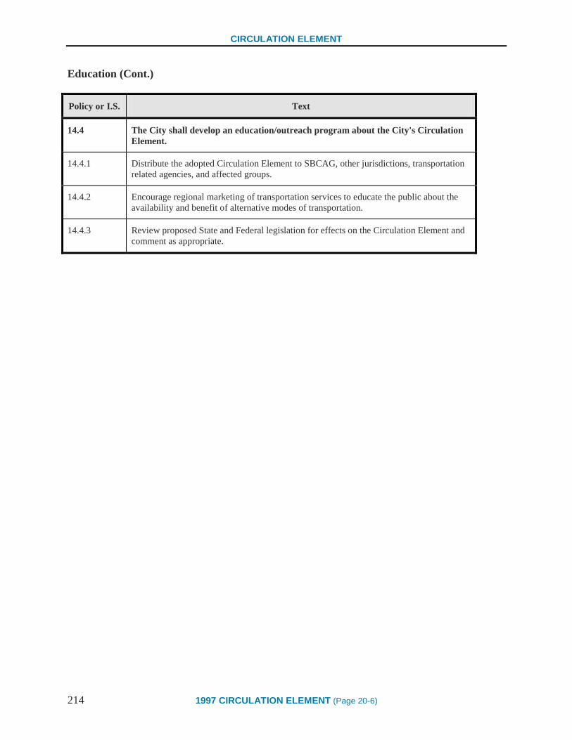
CIRCULATION ELEMENT
214 1997 CIRCULATION ELEMENT (Page 20-6)
Education (Cont.)
Policy or I.S. Text
14.4 The City shall develop an education/outreach program about the City's Circulation
Element.
14.4.1 Distribute the adopted Circulation Element to SBCAG, other jurisdictions, transportation
related agencies, and affected groups.
14.4.2 Encourage regional marketing of transportation services to educate the public about the
availability and benefit of alternative modes of transportation.
14.4.3 Review proposed State and Federal legislation for effects on the Circulation Element and
comment as appropriate.

CIRCULATION ELEMENT
1997 CIRCULATION ELEMENT (Page 20-7) 215
Monitoring
Policy or I.S. Text
2.2 To assure that the community is moving towards the Vision articulated in this
Circulation Element, the City shall monitor changes in traffic volumes, travel
patterns and mobility choices through a program which:
establishes performance benchmarks related to the policy statements and
implementation strategies within each chapter of the Circulation Element,
assesses the impacts of policy implementation and progress against these
benchmarks, and
includes City response strategies if the outcomes of policy and project specific
decisions are not consistent with the Vision articulated within this Circulation
Element.
2.2.1 The City Administrator shall direct staff to develop and implement a monitoring program
and submit reports every two years to the Planning Commission and City Council
regarding the effectiveness of achieving the Goals and Policies of the Circulation
Element. These reports shall include, but not be limited to, information on the following
topics:
land use policy effectiveness in meeting the City’s mobility goals,
the effectiveness of the policies of the Circulation Element towards increasing the
use and effectiveness of transit programs,
the attainment of regional air quality standards, and
ridership patterns and use of alternative forms of transportation. Continue to obtain
this information from responsible agencies, such as MTD. In areas where no
information is available, conduct surveys.
2.2.2 Prior to each annual Capital Improvements Program, public work sessions shall be held
with the Planning Commission and City Council to develop project priorities for funding.
8.2.7 Assess the impact of employee shuffling on Downtown parking.
12.1.3 Schedule a regular review and monitoring cycle of Neighborhood Area and Business
Area Mobility Plans to address changing conditions. Prepare the Plans in advance of the
Public Works’ street maintenance cycle to ensure community input.

CIRCULATION ELEMENT
216 1997 CIRCULATION ELEMENT (Page 20-8)
Monitoring (Cont.)
Policy or I.S. Text
13.2.2 Consider amending the Zoning Ordinance to:
allow increased residential densities and more compact, pedestrian oriented non-
residential development along streets identified as major transit corridors, and
reduce parking requirements for properties near major transit corridors if it can be
demonstrated that a negative impact will not occur. In conjunction with this
reduction, the City shall evaluate and aggressively monitor the results to ensure
continued use of alternative means of travel and to justify reduced parking demands.

CIRCULATION ELEMENT
1997 CIRCULATION ELEMENT (Page 20-9) 217
Signage
Policy or I.S. Text
2.1.14 Create a program to coordinate the execution and review of Implementation Strategies
addressing signage (see Index B for a comprehensive list). The program should be
reviewed by the Sign Committee, Historic Landmarks Commission, and Architectural
Board of Review.
3.2.7 Work with transit providers to improve and expand the transit route and signage program
by showing connections between major attractions such as schools, museums, places of
worship, institutions, shopping and recreation areas.
4.2.5 Adopt and implement the Regional Bikeway Signage Program.
4.5.2 Work with schools to provide information to children, adults, bicyclists and motorists
about the safe use of the bicycle on City streets including, but not limited to, the
following:
Increased signage to alert motorists to the presence of bicycles (3rd
bullet)
5.1.4 Work with Caltrans to improve and maintain Highway 101 pedestrian
over/undercrossings to promote increased pedestrian use. This may include adding
amenities such as lighting, landscaping, and identification signage.
5.4.1 Work with the Architectural Board of Review and Historic Landmarks Commission to
revise and enhance City design standards for all sidewalks and paths of travel. Standards
should address width of paths, safety, lighting, landscaping, location, street furniture, the
availability of alternate pedestrian accessways, and the provision of kiosks or other
methods to exchange public information.
5.4.6 Require striping/signage, crossing guards, stop signs and other devices to improve safety
near schools and parks.
5.5.6 Look for opportunities to connect placitas to institutional, public, private and institutional
uses. Include signage, as appropriate.
5.8.1 Establish a signage program for pedestrian routes throughout the City which links
various neighborhoods and attractions.
5.8.2 Enhance existing or develop new partnerships with civic organizations to promote
walking tours of Santa Barbara and provide brochures and signage to advertise these
tours.
8.2.13 Increase the use of underutilized public parking lots through marketing, improved
signage, and other incentives.

CIRCULATION ELEMENT
218 1997 CIRCULATION ELEMENT (Page 20-10)
Signage (Cont.)
Policy or I.S. Text
9.4 The City shall promote excellent signage and aesthetics.
9.4.1 Implement Harbor Master Plan policies and programs that will:
improve signage and aesthetics within the plan area,
provide information about the various forms of transportation available,
improve linkages between forms of transportation, and
resolve conflicts between various modes of transportation that occur within the plan
area.
9.4.2 Develop a program for the entire Coastal Zone to improve parking lot aesthetics and
provide signage regarding location and transportation linkages between parking lots and
points of interest.
9.4.3 Work with Cal-Trans to improve freeway signage to and from the Downtown and
Coastal Zone areas.
9.5.1 Create a Master Plan for Cabrillo Boulevard that explores the implementation of the
following:
Relocating tour bus parking to an area designated and signed for that purpose
and enforcing tour bus parking regulations. (5th
bullet)
10.1 Directional signage (included in the list of possible design features for Residential
Corridors)
15.1.2 Ensure that signage indicating weight limits is clearly posted throughout the City.
CIRCULATION ELEMENT
1974 SCENIC HIGHWAYS ELEMENT (Page 115) 219
SCENIC HIGHWAYS ELEMENT
The Scenic Highways element of the General Plan is concerned with the development, establishment, and
protection of scenic highways.
The California scenic highway program was created in 1963 by the State legislature through Senate Bill
1467. This legislation establishes the State’s responsibility for the protection and enhancement of
California’s natural scenic beauty by identifying those portions of the State highway system which, together
with the adjacent scenic corridor, require special conservation treatment.
Official scenic highways are so designated by the State Scenic Highways Advisory Committee after land
use controls have been adopted by the local jurisdiction to protect the scenic appearance of the highway
corridor, and after specific planning, design, and maintenance standards have been established by the State
Department of Transportation to ensure the scenic appearance of the highway. Highways eligible for such
designation are listed in the Scenic Highways Master Plan found in the California Government Code. In
formulating the list, the Committee used the following standards in its evaluation of state highways:
1. The scenic corridor through which the highway passes should have consistent scenic,
historic, or aesthetic value during all seasons.
2. Consideration should be given those highways or routes which are:
a. State or jurisdictional entry routes.
b. Predominately used for recreation or vacation travel.
c. Utilized for one-day sightseeing, or study trips.
d. Part of an integrated or semi-integrated, scenic route system that traverses varied
scenic corridors for longer trips.
e. Typical of varied scenic factors available within the jurisdiction.
f. Through areas of extraordinary scenic value.
3. If possible, all principal landscape and topographical-type areas should be represented in
the system.
4. Routes of historic significance which connect places of interest should be considered even
though the route is of marginal scenic value.
At present, the City of Santa Barbara has two of its five State highways included in the eligible Scenic
Highways Master Plan; U.S. Highway 101 and State Highway 154, known as San Marcos Pass Road. State
Highway 154 is the only officially designated scenic highway, adopted November 12, 1968, by the County
Board of Supervisors.

CIRCULATION ELEMENT
220 1974 SCENIC HIGHWAYS ELEMENT (Page 116)
Goal
The scenic highways element is the initial step leading toward official designation. The purpose of the
scenic highway designation is the protection and enhancement of the natural scenic resources of the
highway corridor, and the assurance that the highway incorporates not only safety, utility and economy, but
also beauty.
The standards for achieving official designation of eligible scenic highways require that local government
agencies take such planning actions as may be necessary to protect and enhance the scenic appearance of the
highway corridor, including, but not limited to the following controls:
a. The regulation of lane use which may include intensity of development.
b. Specific land and site planning.
c. Prohibition of offsite outdoor advertising.
Additional optional measures may also be included in scenic highway planning:
a. Citizens Advisory Committee.
b. Setback and height regulations.
c. Subdivision regulations.
d. Location of overhead utilities.
e. Management policies.
f. Maintenance provisions.
g. Grading ordinance.
h. Urban and rural programs.
i. Coordination and cooperation with adjacent jurisdictions.
Potential State Scenic Highways
Two highway routes within the City, one urban and one semi-rural, have potential for the state scenic
highway program. However, because each is a secondary state highway, neither is presently listed on the
Master Plan of eligible State highways. Because both routes meet the standards of the State Scenic
Highways Advisory Committee for eligible State highways, eligibility can be established by requesting that
the Committee consider and include both in the Master Plan. A description of these routes, with a
discussion of land use controls, and planning, design, and maintenance standards follows:
CIRCULATION ELEMENT
1974 SCENIC HIGHWAYS ELEMENT (Page 117) 221
CABRILLO BOULEVARD (225) FROM 101 TO CASTILLO STREET
Description
East Cabrillo Boulevard begins at the 101 Freeway near the Montecito border. The road curves past the
Bird Refuge and Child’s Estate on the north, and the Santa Barbara Cemetery and Clark Estate on the south.
A separated bikeway parallels the boulevard, winding around the Bird Refuge. At Niños Drive, Cabrillo
widens to ninety feet. On the north side are the East Beach condominium complex, the Mar Monte Hotel,
and other similar hotel and motel developments. On the south, Cabrillo Boulevard borders East Beach,
Palm Park, and the Santa Barbara Channel. The expansive view of the beach and water through the tall
palm trees looks west toward Stearns Wharf and the harbor. This panorama is one of Santa Barbara’s most
treasured scenic resources.
At Punta Gorda Street, Cabrillo Boulevard passes the Southern Pacific Round House, a building of historic
value which may be preserved. Beyond the Round House to Santa Barbara Street, the Boulevard offers a
continuing view of the Channel to the south. Shrubbery screens an undeveloped area to the north along this
portion, creating a naturally landscaped effect until the more developed portion of Cabrillo begins. At Santa
Barbara Street, the Chart House Restaurant on the north initiates the urbanized area of Cabrillo. Both the
Chart House and another restaurant, the España, are of special interest because they contribute to the
attractive urban scene. On the south, Stearns Wharf extends out from the shoreline opposite State Street.
Cabrillo Boulevard’s intersection with State Street is the center of the tourist vicinity, which continues on
with restaurants and motels on the northern side until Castillo Street. West Beach and the Harbor are visible
to the south, providing a scene of sailboats and docks, as Cabrillo Boulevard ends.
Land Use Controls
Along with other points of interest in the City, Cabrillo Boulevard is a major tourist attraction and should be
preserved for visitors and residents as an urban scenic highway.
Land use regulations consistent with the policies of the General Plan should be in effect over the entire
corridor. There are two areas on Cabrillo Boulevard, however, which are not in conformance at the present
time. The first is an area north of Cabrillo Boulevard from Chapala Street to approximately Santa Barbara
Street, designated in the General Plan for hotel and related commerce, which is presently zoned for
commercial and manufacturing uses. Under the C-2 and C-M zoning, inappropriate land uses such as auto
repair or retail and wholesale service activities could occur. The second is an adjacent area, also north of
Cabrillo Boulevard, from Santa Barbara to Punta Gorda Street, designated in the General Plan for hotel and
residential development. It is presently zoned M-1 for manufacturing uses and should be rezoned to enable
proper development to take place.

CIRCULATION ELEMENT
222 1974 SCENIC HIGHWAYS ELEMENT (Page 118)
These areas are within the Central City Redevelopment Project study area and may be rezoned upon specific
land use recommendations resulting from the study.
Although there are height restrictions for hotel and motel development, setback requirements are minimal.
Because the second area is a prime site for some type of hotel facility, it is recommended that appropriate
setback requirements be established, and that a height-setback relationship be created in such a manner that
any future development does not obstruct views of scenic resources or infringe on the open quality of the
corridor. In addition to setbacks, it is recommended that building separations be required to provide
significant open spaces and to control the intensity of development. Excellence in landscape, architectural,
and construction designs should be encouraged for this hotel site, as well as for the proposed redevelopment
of Stearns Wharf. Both facilities must be considered visually important elements within the highway
corridor, and should therefore be in keeping with the cityscape and skyline. Along with any other
commercial development on Cabrillo Boulevard, these facilities should reflect the density, tempo, and
activities of the population.
The size, height, number and type of on-premise restaurant, motel and other commercial advertising signs
allowed on Cabrillo Boulevard should be the minimum necessary for identification. Both on-premise and
off-site signs should be strictly controlled by the Architectural Board of Review in the scenic highway
corridor. Their design and location should relate to the surrounding environment. The Architectural Board
of Review’s control over building colors should be expanded to cover repaintings not only within the scenic
highway corridor, but throughout the entire City.
The public right-of-way should be landscaped, where appropriate. Mission Creek, passing under Cabrillo
Boulevard near State Street, is presently an eyesore. The creek should be improved and landscaped.
Planning, Design, and Maintenance Standards
The essence of Cabrillo Boulevard as a scenic drive is its proximity and exposure to the shoreline. The City
is considering enhancing the shoreline through the expansion of Palm Park in order to provide recreational
features such as bikeways, walkways, picnic areas, and parking areas within uncrowded, generous spaces.
The park is heavily used on the weekends, and additional space is necessary to reduce the density.
In order to accomplish this expansion, it has been suggested that the beach area beyond Palm Park be
widened. Methods to expand oceanward, to the south, should therefore be investigated. Such an expansion
could also be accomplished by widening the Park northward. This latter type of expansion requires the
realignment of Cabrillo Boulevard. The designation of a scenic highway is based on that which can be seen
by the traveler in relation to the corridor adjacent to the highway. Therefore, adequate standards for the
planning, location, and design of the Cabrillo Boulevard realignment, if that occurs, should be applied in
order to take advantage of the best scenic values within the corridor.
Toward this end, planning and design for Cabrillo Boulevard should provide for roadside parking areas and
lookouts wherever scenic vistas are warranted. Parking areas on the ocean side would be designed and
treated in such a way as to preserve the view of the shoreline from the highway. A good example of such
design can be found in Shoreline Park, where lots are depressed and landscaped so that their impact on the
scenic vista is minimized. On-street parking should be prohibited on Cabrillo Boulevard east of State Street.
West of State Street to Castillo Street, on-street parking should be removed on the ocean side of Cabrillo.
The varied needs of parkers in the area between State Street and the Harbor presently conflict, and need to
be studied as part of an overall shoreline plan already recommended in the General Plan.
CIRCULATION ELEMENT
1974 SCENIC HIGHWAYS ELEMENT (Page 119) 223
Night views from Cabrillo Boulevard are also treasured as scenic resources by residents and visitors alike,
and should be protected. If Cabrillo Boulevard is realigned, the street lighting installed should be more
traditional. Lighting standards in keeping with the image of the City should replace those existing, which
now lend a “freeway” feeling to the drive.
Finally, Senate Bill 1467 states that the Department of Transportation shall give special attention to the
highway’s visual appearance. Therefore, in addition to improved planning and design standards, a scenic
highway designation ensures that Cabrillo Boulevard will receive a superior maintenance program.
SYCAMORE CANYON ROAD
Sycamore Canyon Road (144) from Alameda Padre Serra to Stanwood Drive (192). Stanwood Drive to
Mission Ridge Road (192) where it intersects with Mountain Drive. Mountain Drive (leaving 192 which
continues on Foothill Road) to the Old Mission on Los Olivos Street.
Description
Sycamore Canyon Road begins heading north at Alameda Padre Serra, curving through a residential area
that slopes up on either side of the canyon. In the far distance is a view of the Santa Ynez Mountains.
Further into Sycamore Canyon, the landscape becomes more natural, revealing open grassy hillsides.
Eucalyptus, evergreen, and sycamore trees border the road. Adjacent, to the west, is Sycamore Creek which
is often hidden by dense shrubbery.
Turning left on Stanwood Drive, the road is bounded by dense, natural vegetation as it twists and winds
slowly upward through the canyon. Rock outcroppings appear and residences can occasionally be seen. At
the top of a rise, Stanwood Drive opens onto rocky fields where horses graze. Beyond is a beautiful broad
span of the Santa Ynez Mountains.
On Mission Ridge Road, going west, the foothills dotted with houses are visible below the mountains.
Sheffield Reservoir lies just off the road to the north. Further on Mission Ridge Road, residences can be
seen closer to the roadway. Mountain Drive, with dense vegetation to one side and an old stone wall to the
other, snakes down toward the Santa Barbara Mission. In the foreground, the towers of St. Anthony can be
seen. Turning onto Los Olivos Street, the historic Mission appears on the right while open lawns spread
before the Mission on the left.
Land Use Controls
In contrast to the potential urban scenic highway described above, the combination of Sycamore Canyon
Road, Stanwood Drive, Mission Ridge Road, and Mountain Drive runs primarily through rural residential
areas of extraordinary scenic value, which should be protected and enhanced for the residents of Santa
Barbara as a semi-rural scenic highway. In addition, this route has historic significance because it passes by
preserved remnants of an Indian water system and terminates at the Santa Barbara Mission.

CIRCULATION ELEMENT
224 1974 SCENIC HIGHWAYS ELEMENT (Page 120)
Existing land use regulations are consistent with the policies of the General Plan, and are now in effect over
this entire corridor. A portion of this potential scenic highway is within the designated hillside open space
described in the open space element of the General Plan, and most of the adjacent lands have been
appropriately rezoned to the lowest residential density allowable at the present time. However, more
restrictive measures are necessary to preserve the scenic qualities of this highway corridor. For example, the
City presently has a subdivision ordinance, but more specific land development control is desirable. Site
plan and architectural control should be established in regard to the construction of single-family dwellings
and specific subdivision design standards should be developed. In addition, it is necessary to establish a
method for the control of the removal of trees on public property in rural areas, particularly within the scenic
highway corridors. In order to achieve such control, it is recommended that a tree preservation ordinance be
adopted. At the present time, public sentiment for tree preservation bespeaks a need for an ordinance which
would provide protection throughout the City. Through creation of such mechanisms, the natural beauty of
the hillsides through which the scenic highway corridor passes will be protected and preserved.
Improper grading has occurred in the past within this scenic highway corridor. An example of its effects is
visible from Sycamore Canyon Road, below the Conejo Road subdivision, where debris is crumbling down
the steep slope of the hillside to Sycamore Creek. This situation should be remedied. A grading plan is now
required as part of the subdivision ordinance, and as a result of the recent council action, must now be
approved by the Architectural Board of Review as well as the Director of Public Works. The Architectural
Board of Review, acting as a grading review board, and the newly adopted grading ordinance (June 25,
1974) are concerned with the development of single-family lots as well as subdivisions. Both will help
prevent any type of improper residential development of these hillsides.
The setback requirements for the low-density residential zones found in these designated hillside open
spaces is presently set at 35 feet. In order not to obstruct important scenic views of the hillsides and the
mountains beyond, it is recommended that setback requirements be regulated through the previously
mentioned site plan and review.
Finally, the most blighting influence on this potential scenic highway is the overhead wiring which abounds
throughout the route. The General Plan recommends an increased tempo for underground conversions with
an ultimate goal of complete underground utilities for Santa Barbara within this century. By resolution of
the City Council in 1967, the entire City is subject to the undergrounding of new construction. In addition,
the State requires generally that any wiring installed after December 1972, visible from a scenic highway,
must be placed underground. There is no State requirement to underground utilities installed before 1972,
but the State has determined that utility companies must set aside funds and formulate a program of utility
conversion. The priority of areas in need of conversion is determined by each local jurisdiction in
cooperation with the public utility involved. Although there are many areas of Santa Barbara in need of
conversion, the removal of the overhead wires presently found in this highway corridor through a
conversion program would greatly enhance this scenic route for the enjoyment of all the residents of Santa
Barbara. When a scenic highway designation has been acquired for this route, the Council may decide to
request that the overhead utilities be undergrounded.
Planning, Design, and Maintenance Standards
The essence of this highway as a scenic route is its exposure to quiet hillsides, mountainous terrain, natural
vegetation, and beautiful views available in Santa Barbara’s foothills. Through improved planning, design,
and maintenance, this exposure can be protected.
CIRCULATION ELEMENT
1974 SCENIC HIGHWAYS ELEMENT (Page 121) 225
Many residents enjoy these roads not only for automobile driving, but also for hiking, riding bicycles, and
riding horses. The highway right-of-way is narrow at several locations along the route and ample room is
not now available for all the present uses. Because the Department of Transportation is required to consider
the concept of a “complete highway” in its planning and design for a scenic highway, it must incorporate
plans for safety, economy, and utility, as well as beauty. Therefore, the needs of bicyclists and equestrians
will be considered by the DOT and the location of bikeways and riding trails will be an important element in
the design standards created for this scenic route.
The combination of Sycamore Canyon Road, Stanwood Drive, Mission Ridge Road, and Mountain Drive
should not be considered an expedient route to get from one place in the City to another. The scenic quality
of this drive results in part from the slow and winding terrain that the highway corridor traverses. Major
changes in the present route alignment could detract from this scenic quality. The designation of this route
as a scenic highway can protect the qualities of the route against inappropriate realignment, widening, or
improvement.
Potential City Scenic Routes
Instead of acquiring a State scenic highway designation for a particular road, Santa Barbara can create a city
scenic route designation which would protect the appearance of any selected highway corridor or street
corridor through adopted land use controls. In regard to a State highway, however, it should be noted that
such a city designation would have little impact on the highway within the corridor, or on the planning,
design, and maintenance standards of the State Department of Transportation. At the present time, only one
scenic city street should appropriately be considered for this program. In the future, it may be determined
that there are other streets that might also benefit.
SHORELINE DRIVE FROM CASTILLO STREET TO THE END OF SHORELINE PARK
Shoreline Drive, when considered in combination with Cabrillo Boulevard, meets State Standards for a
scenic highway designation. However, because of the fear that increased traffic might result from a State
designation, it is recommended instead that Shoreline Drive be preserved and enhanced through a City
scenic route designation.
Land Use Controls
Beginning at Castillo Street, Shoreline Drive curves past the harbor to the south. Two parcels of land
adjacent to Shoreline Drive and west of the City Plunge are now vacant. Both need to be properly
landscaped to minimize the visual impact of the expanded harbor parking now being proposed in the current
Harbor Improvement Plan. In addition, existing parking areas on the north side of Shoreline Drive in the
vicinity of City College should also be landscaped so that they do not detract from the view.
Passing by City College, Shoreline Drive rises onto the Mesa offering another beautiful panorama of the
Santa Barbara Channel beyond the lawns of Shoreline Park. The speed limit in this area of Shoreline Drive
at the present time is 30 miles per hour. Although average daily traffic counts demonstrate that 30 miles per
hour is an appropriate speed, the scenic aspects of the route may require a slower speed limit in order for
drivers and pedestrians to properly enjoy another of Santa Barbara’s scenic resources in safety.
CIRCULATION ELEMENT
226 1974 SCENIC HIGHWAYS ELEMENT (Page 122)
Relationship to Other Elements
OPEN SPACE ELEMENT
The Scenic Highways element relates directly to the Open Space Element because the proposed scenic
corridors traverse significant natural and urban open space areas. The proposed Cabrillo Boulevard route
borders the Santa Barbara shoreline, which is an actively used open space consisting of the harbor, harbor
facilities, beaches, and adjacent park areas. The corridor of this urban route encompasses all of these open
spaces. As earlier stated, the intent of the Scenic Highways element is to protect and enhance the natural
scenic resources within the corridor.
The proposed Sycamore Canyon Road, Stanwood Drive, Mission Ridge Road, and Mountain Drive route
traverses the largest major hillside open space, consisting of Sycamore Canyon, Mountain Drive, and
Mission Canyon. The newly acquired Parma Park is part of this open space area. In addition, Sycamore
Creek, lying parallel to the proposed scenic route, provides one of Santa Barbara’s open space corridors
through the community. It is the policy of the City to maintain these hillside areas and creek channels in
their natural state. Through the regulation of land use and through specific land and site planning, the scenic
highways element offers an opportunity to augment protection for Santa Barbara’s natural and urban open
space areas.
CIRCULATION ELEMENT
The scenic highways element relates directly to the circulation element because the scenic routes proposed
are State highways and City streets, and are therefore part of the select system of arterial and collector
streets which comprise the City’s circulation system. Santa Barbara’s circulation system should be
attractive as well as functional, and those routes adopted as scenic highways will be assured of incorporating
beauty as well as safety, utility, and economy.
RECREATION ELEMENT
Inasmuch as scenic highways provide major access to Santa Barbara’s urban and rural space where
recreation can take place, there is a relationship between the scenic highways element and the recreation
element. The scenic highways corridors incorporate active forms of recreation such as hiking, biking, and
riding trails, and passive forms of recreation found in the modular parks. A leisurely drive through one of
Santa Barbara’s scenic corridors will provide a good deal of recreation for residents and visitors alike.
Goals for Potential State Scenic Highways
CABRILLO BOULEVARD (225)
1. Rezone areas not in conformance with the General Plan.
2. Establish appropriate setback requirements for development on Cabrillo Boulevard.
3. Create a height-setback relationship for development.
4. Require building separations for development.

CIRCULATION ELEMENT
1974 SCENIC HIGHWAYS ELEMENT (Page 121) 227
5. Consider either realigning Cabrillo Boulevard, or widening East Beach in order to allow for
the expansion of Palm Park.
6. Prohibit on-street parking on Cabrillo Boulevard, east of State Street.
7. Remove on-street parking on the ocean side of Cabrillo Boulevard, west of State Street.
8. Landscape the public right-of-way.
9. Improve Mission Creek at Cabrillo Boulevard.
10. Control building colors on Cabrillo Boulevard.
11. Control on-premise and off-site outdoor advertising signs on Cabrillo Boulevard.
12. Utilize traditional lighting standards.
SYCAMORE CANYON ROAD (144), STANWOOD DRIVE (192),
MISSION RIDGE ROAD (192), MOUNTAIN DRIVE
1. Establish site plan and architectural control in relation to the construction of single-family
dwellings.
2. Develop specific subdivision design standards.
3. Write a tree preservation ordinance.
4. Remedy the grading problem caused by the Conejo Road Subdivision.
5. Regulate setback requirements in order that development will not obstruct important views.
6. Maintain an Underground Utilities Advisory Committee.
7. Establish biking, hiking, and horse trails where appropriate.
Goals for Potential City Scenic Routes
SHORELINE DRIVE
1. Landscape properly the vacant parcels of land west of the City Plunge, to minimize the
visual impact of expanded harbor parking.
2. Landscape properly the existing parking areas on the north side of Shoreline Drive in the
vicinity of City College.
3. Consider the scenic aspects of Shoreline Drive as well as the average daily traffic in
determining the appropriate speed for the route.
Procedure to Acquire a State Scenic Highways Designation
1. Letter directed to the State Scenic Highways Advisory Committee for consideration of each
highway to be placed on the State’s Scenic Highway System Master Plan of eligibility.

CIRCULATION ELEMENT
228 1974 SCENIC HIGHWAYS ELEMENT (Page 124)
2. Adoption of each potential scenic highway by the State legislature and placement on the
Master Plan.
3. City Council initiate corridor studies (Corridor Survey and Highway Facility Study) leading
to official designation. The Department of Transportation will conduct corridor studies in
cooperation and coordination with the local government staff.
4. The City shall prepare a specific local Scenic Highway Corridor Protection Plan and
Implementation Program for each highway, based on the State’s Corridor Survey and
Facility Study.
5. The corridor boundaries, the local Scenic Highway Corridor Protection Plan, and the
Implementation Program shall be adopted by the Planning Commission and City Council.
6. Upon adoption of the boundaries, the plan, and the program, the City shall make
application to the District Director of Transportation for official designation.
7. Designated State Scenic Highways shall be marked with the official “poppy sign”, and
shall be indicated on State maps and other publications.
8. Designated City Scenic Routes shall remain unmarked and unadvertised.