CIAIAC - mitma · 2019. 9. 5. · COMISIÓN DE INVESTIGACIÓN DE ACCIDENTES E INCIDENTES DE...
62
COMISIÓN DE INVESTIGACIÓN DE ACCIDENTES E INCIDENTES DE AVIACIÓN CIVIL CIAIAC CIAIAC Report EXT A-001/2012 Afghanistan Accident involving an MD-83 aircraft, registration EC-JJS, operated by Swiftair, S.A., at the Kandahar Airport (Afghanistan), on 24 January 2012
Transcript of CIAIAC - mitma · 2019. 9. 5. · COMISIÓN DE INVESTIGACIÓN DE ACCIDENTES E INCIDENTES DE...
COMISIÓN DEINVESTIGACIÓNDE ACCIDENTESE INCIDENTES DEAVIACIÓN CIVIL
CIAIACCIAIAC
ReportEXT A-001/2012AfghanistanAccident involving an MD-83aircraft, registration EC-JJS,operated by Swiftair, S.A., at theKandahar Airport (Afghanistan),on 24 January 2012


Report
EXT A-001/2012 Afghanistan
Accident involving an MD-83 aircraft, registration EC-JJS, operated by SWIFTAIR, S.A.,
at the Kandahar Airport (Afghanistan) on 24 January 2012
COMISIÓN DE INVESTIGACIÓNDE ACCIDENTES E INCIDENTESDE AVIACIÓN CIVIL
SUBSECRETARÍA

Edita: CentrodePublicaciones SecretaríaGeneralTécnica MinisteriodeFomento©
NIPO:161-13-152-2
Diseñoymaquetación:Phoenixcomunicacióngráfica,S.L.
COMISIÓNDEINVESTIGACIÓNDEACCIDENTESEINCIDENTESDEAVIACIÓNCIVIL
Tel.:+34915978963 E-mail:[email protected] C/Fruela,6Fax:+34914635535 http://www.ciaiac.es 28011Madrid (España)

F o r e w o r d
This report is a technical document that reflects the point of view of the Civil Aviation Accident and Incident Investigation Commission (CIAIAC) regarding the circumstances of the accident object of the investigation, and its probable causes and consequences.
In accordance with the provisions in Article 5.4.1 of Annex 13 of the International Civil Aviation Convention; and with articles 5.5 of Regulation (UE) n.o 996/2010, of the European Parliament and the Council, of 20 October 2010; Article 15 of Law 21/2003 on Air Safety and articles 1, 4 and 21.2 of Regulation 389/1998, this investigation is exclusively of a technical nature, and its objective is the prevention of future civil aviation accidents and incidents by issuing, if necessary, safety recommendations to prevent from their reoccurrence. The investigation is not pointed to establish blame or liability whatsoever, and it’s not prejudging the possible decision taken by the judicial authorities. Therefore, and according to above norms and regulations, the investigation was carried out using procedures not necessarily subject to the guarantees and rights usually used for the evidences in a judicial process.
Consequently, any use of this report for purposes other than that of preventing future accidents may lead to erroneous conclusions or interpretations.
This report was originally issued in Spanish. This English translation is provided for information purposes only.


Report EXT A-001/2012 Afghanistan
v
Ta b l e o f c o n t e n t s
Abbreviations ............................................................................................................................... vii
Synopsis ........................................................................................................................................ ix
1. FACTUAL INFORMATION ...................................................................................................... 1
1.1. History of the flight ....................................................................................................... 1 1.2. Injuries to persons ......................................................................................................... 3 1.3. Damage to aircraft ........................................................................................................ 3 1.4. Other damage ............................................................................................................... 4 1.5. Personnel information ................................................................................................... 5 1.5.1. Captain ............................................................................................................. 5 1.5.2. First officer ....................................................................................................... 5 1.5.3. FA1 ................................................................................................................... 6 1.5.4. FA2 ................................................................................................................... 6 1.5.5. FA3 ................................................................................................................... 6 1.6. Aircraft information ....................................................................................................... 7 1.7. Meteorological information ........................................................................................... 7 1.8. Aids to navigation ......................................................................................................... 8 1.9. Communications ........................................................................................................... 9 1.10. Aerodrome information ................................................................................................. 9 1.11. Flight recorders .............................................................................................................. 10 1.11.1. Cockpit voice recorder .................................................................................... 10 1.11.2. Flight data recorder ........................................................................................ 11 1.12. Tests and research ......................................................................................................... 13 1.12.1. Captain’s statement ........................................................................................ 13 1.12.2. First officer’s statement ................................................................................... 15 1.12.3. Statement from the Kandahar Tower controller .............................................. 16 1.12.4. Statement from an eyewitness ....................................................................... 17 1.12.5. Radar information ........................................................................................... 17 1.12.6. Theoretical landing distance ........................................................................... 19 1.12.7. Approach reference speed .............................................................................. 19 1.13. Organizational and management information ............................................................... 20 1.13.1. On the aircraft operator ................................................................................. 20 1.13.2. Operating in Kandahar ................................................................................... 20 1.13.3. Criteria and responsibilities for determining the use of aerodromes ............... 22 1.13.4. Alignment and stabilization criteria on approach ............................................ 22 1.14. Additional information .................................................................................................. 23 1.14.1. Regulations applicable to the approach .......................................................... 23 1.14.2. Visibility .......................................................................................................... 24
2. ANALYSIS ............................................................................................................................... 25
2.1. General considerations .................................................................................................. 25 2.2. Approach to the Kandahar Airport ............................................................................... 26

Report EXT A-001/2012 Afghanistan
vi
2.3. Last 1,000 ft of radioaltitude ........................................................................................ 26 2.4. Contact with the ground .............................................................................................. 31
3. CONCLUSIONS ....................................................................................................................... 33
3.1. Findings ......................................................................................................................... 33 3.2. Causes ........................................................................................................................... 34
4. SAFETY RECOMMENDATIONS .............................................................................................. 35
APPENDICES .................................................................................................................................. 37
Appendix A. RNAV (GPS) APPROACH RWY 05 Kandahar (OAKN) ........................................ 39 Appendix B. Kandahar Airport Diagram ............................................................................... 43 Appendix C. FDR data for the last 1,000 ft .......................................................................... 47

Report EXT A-001/2012 Afghanistan
vii
A b b r e v i a t i o n s
00 °C Degree centigradeACMI Aircraft, Crew, Maintenance & InsuranceAESA Spain’s Aviation Safety AgencyAGL Above Ground LevelAIP Aeronautical Information PublicationAMSL Above Mean Sea LevelAOC Air Operators CertificateAPCH ApproachATIS Automatic Terminal Information ServiceATPL (A) Airline Transport Pilot License (Airplane)ATS Air Traffic ServiceBRNAV Basic Area NavigationCAS Calibrated Air SpeedCIAIAC Spain’s Civil Aviation Accident and Incident Investigation CommissionCVR Cockpit Voice RecorderCWY ClearWaydeg DegreeDGAC Spanish Civil Aviation General DirectorateDME Distance Measuring EquipmentECAC European Civil Aviation ConferenceFAF Final Approach FixFAWP Final Approach WaypointFDR Flight Data RecorderFA Flight attendantFAF Final Approach FixFIR Flight Information RegionFL Flight Levelft Footg Gravity forceGNSS Global Navigation Satellite SystemGPS Global Positioning SystemGPWS Ground Proximity Warning SystemGS Ground Speedh Hour(s)IAF Initial Approach FixIATA International Air Transport AssociationICAO International Civil Aviation OrganizationIFR Instrument Flight RulesILS Instrument Landing SystemIMC Instrument Meteorological Conditionsin Hg Inches of mercuryIR Instrument RatingISAF International Security Assistance ForceKIAS Indicated airspeed in knotskt Knot(s)km Kilometer(s)lb Pound(s)LT Local Timem Meter(s)mbar MillibarMDA Minimum Descent AltitudeMETAR Aviation Routine Weather ReportMFA Minimum Flight AltitudeMHz Megahertzmin Minute(s)

Report EXT A-001/2012 Afghanistan
viii
A b b r e v i a t i o n s
MRVA Minimum Radar Vectorization AltitudeMSA Minimum Sector AltitudeNDB Non-Directional BeaconNM Nautical MilesNOTAM Notice to Air MenNTSB National Transportation Safety Board (USA)OMA Operations ManualPAPI Precision Approach Path IndicatorPCN Pavement Classification NumberPPR Prior Permission RequestPRNAV Precision Area NavigationQNH Altimeter sub-scale setting to obtain elevation when on the groundRA RadioaltimeterRNAV Area NavigationRNP Required Navigation PerformanceRWY RunWaySID Standard Instrumental DepartureSTAR Standard Instrumental ArrivalSWY StopWayTACAN Tactical Air Navigation SystemTAFOR/TAF Aerodrome forecastTCAS Traffic alert and Collision Avoidance SystemUAE United Arab EmiratesUIR Upper Information RegionUTC Universal Coordinated TimeVDP Visual Descent PointVHF Very High FrequencyVMC Visual Meteorological ConditionsVOR VHF Omni Range

Report EXT A-001/2012 Afghanistan
ix
S y n o p s i s
Owner and operator: Swiftair, S.A.
Aircraft: MD-83
Date and time of accident: 24 January 2012; at 03:58 UTC1
Site of accident: Kandahar Airport (Afghanistan)
Persons onboard: 91; crew, 5; passengers, 86
Type of flight: Commercial Air Transport – Scheduled- International – Passenger
Date of approval: 25 September 2013
Summary of accident
On Tuesday, 24 January 2012, a McDonnell Douglas MD-83, registration EC-JJS, operated by Swiftair, took off from the Dubai Airport (United Arab Emirates) at 02:08 UTC2 on a scheduled flight to the Kandahar Airport (Afghanistan). Its callsign was SWT094 and there were 86 passengers (one of them a company mechanic), three flight attendants and two cockpit crew onboard.
Swiftair, S.A. was operating this regularly scheduled passenger flight under an ACMI3 arrangement with the South African company Gryphon Airlines.
Kandahar Control cleared them for an RNAV (GPS) approach to runway 05, providing them a direct vector to point FALOD (IAF4) and to descend to 6,000 ft. The PAPI5 was out of service, meaning that in final approach only visual references on the runway and the ground were available to the crew.
They established visual contact with the runway 500 ft above minimums and noted that they were a little right of the runway centerline, as a result of which they corrected their deviation from the centerline by adjusting their path from right to left.
1 All times in this report are in UTC (Coordinated Universal Time).2 The time zone in Dubai is UTC+4 hours and UTC+4:30 h in Kandahar.3 Provides the service by supplying the aircraft, crew, maintenance and insurance.4 Initial Approach Fix.5 Precision Approach Path Indicator.

Report EXT A-001/2012 Afghanistan
x
They landed at 03:58. During the flare, the crew noticed the airplane was moving to the left, threatening to take them off the runway, as a result of which the captain applied a right roll angle. This caused the right wing tip to strike the ground before the wheels made contact with the ground.
The wing contacted the ground some 20 m prior to the threshold, resulting in five threshold lights being destroyed by the aircraft.
The aircraft sustained damage to its right wing. No occupants on the aircraft were injured and the normal procedure was used to disembark.

Report EXT A-001/2012 Afghanistan
1
1. FACTUAL INFORMATION
1.1. History of the flight
On Tuesday, 24 January 2012, a McDonnell Douglas MD-83, registration EC-JJS and operated by Swiftair, took off from the Dubai Airport (United Arab Emirates) at 02:08 UTC on a scheduled flight to the Kandahar Airport (Afghanistan). Its callsign was SWT094 and there were 86 passengers (one of them a company mechanic), three flight attendants and two cockpit crew onboard.
Swiftair, S.A. was operating this regularly scheduled passenger flight under an ACMI arrangement with the South African company Gryphon Airlines.
The crew was picked up at its usual hotel in the emirate of Ras al-Khaimah (United Arab Emirates) at 21:00. The airplane was parked in the Ras al-Khaimah airport and had to be flown empty to the Dubai Airport. This flight departed at 00:20 UTC en route to Dubai. Once there, an agent for Gryphon Airlines gave the crew the documentation for the flight to Kandahar.
They went through customs at the Dubai Airport, boarded the passengers and the cargo and refueled the airplane with enough fuel to make the return the flight, a typical practice so as to avoid refueling in Kandahar.
The airplane took off from runway 30R at the Dubai Airport at 02:08 on standard instrument departure RIKET2D and climbed to flight level FL290. The first officer was the pilot flying.
At 03:42, while over SERKA, they were transferred to Kabul control, which instructed them to descend to FL280. The crew reported its ISAF6 callsign (ISF39RT) to this ATS station, which allowed the aircraft to fly over Afghan airspace, and entered the new stipulated squawk code7.
Kabul Control instructed the crew to follow some radar vectors that took them to point SODAS, where they were transferred to Kandahar Control at 03:46. The crew reduced the airspeed to 250 kt above this point.
Kandahar Control cleared them for an RNAV (GPS) approach to runway 05, providing a direct vector to point FALOD (the IAF), and to descend to 6,000 ft.
The weather information provided on the ATIS8 “F” broadcast was runway in use 05, wind from 060º at 17 kt gusting to 24 kt, visibility 1,200 m, scattered clouds at
6 International Security Assistance Force7 When entering the Kabul control area, an ISAF callsign must be used and a new squawk code entered in the
transponder. These new data, as well as all relevant flight and customs information, is e-mailed to the captain by Gryphon Airlines, the day before the flight.
8 Automatic Terminal Information Service.

Report EXT A-001/2012 Afghanistan
2
2,700 ft and broken clouds at 3,000 ft, temperature 1 ºC, dewpoint –7 ºC and QNH9 30.06 in Hg (1,018 mbar). This information was practically the same as that radioed to the crew by the Kandahar control tower a few minutes before landing: wind from 060 at 15 kt gusting to 21 kt.
They reached point FALOD (IAF) under cloud cover (and thus in IMC10 conditions). They did not exit the clouds until 1,500 ft before minimums which, for this approach, according to the associated chart, was an altitude of 3,700 ft, or 394 ft AGL11.
They established visual contact with the runway 500 ft above minimums and noted that they were a little right of the runway centerline.
Since the captain had more operational experience at the destination airfield, he decided to take over the controls and fly the last phase of the approach maneuver.
The PAPI was out of service, meaning that in final approach they only had visual references to the runway and over the ground.
During short final they corrected the deviation from the runway centerline by adjusting their path from right to left.
They landed at 03:58. During the flare, the crew noticed the airplane was shifting to the left, threatening to take them off the runway, as a result of which the captain applied a right roll angle. This caused the right wing tip to strike the ground before the wheels made contact with the ground. The captain regarded the maneuver as a hard landing, although the first officer thought they might have struck the runway.
The autopilot was engaged until visual contact was established with the runway and the auto-throttle until the landing.
On exiting the runway, the airport control tower personnel (who had witnessed the contact with the ground) ordered the crew to stop and informed them of the damage they had seen during the landing. They dispatched the emergency services (firefighters), which forced them to turn off their engines. Once it was confirmed that there was no fuel leak or damage to the wheels or brakes, they allowed the crew to restart the engines and proceed to the stand.
The wing made contact with the ground some 20 m prior to the threshold, resulting in five threshold lights being destroyed by the aircraft and in damage to the aircraft’s right wing.
According to the crew’s statement, the passengers were not really aware of the contact between the wing and the ground and they were subsequently disembarked normally.
9 Altimeter sub-scale setting to obtain elevation when on the ground.10 Instrument Meteorological Conditions.11 Above Ground Level.

Report EXT A-001/2012 Afghanistan
3
1.2. Injuries to persons
Injuries Crew Passengers Others
Fatal
Serious
Minor 5 86 Not applicable
None Not applicable
TOTAL 5 86
1.3. Damage to aircraft
The aircraft sustained the following damage to its right wing:
The last 3.6 m of the right wing (from section XRS 477 to the wingtip) was significantly and permanently bent upward. This entire area scraped along the ground, resulting in considerable scratches and gashes in this section of the underside of the wing. The outermost leading-edge slat (number 5) was severely damaged, while the number 4 slat was scratched.
As for the moving surfaces on the wing’s trailing edge, the outermost aileron and its trim tab were heavily damaged, as was the outboard flap, though to a lesser extent. The wingtip and its lights also suffered significant damage.
Figure 1. Damaged right wing seen from behind

Report EXT A-001/2012 Afghanistan
4
Figures 2 y 3. Damaged right wing seen from the front
1.4. Other damage
The wing made contact with the ground some 20 m before the threshold, resulting in damage to five threshold lights (see area in red in figure 5).
Figures 4 y 5. Runway 05 threshold after the accident

Report EXT A-001/2012 Afghanistan
5
1.5. Personnel information
A study of the flight personnel’s records showed that the pilots had valid and in force ATPL (A) licenses and ratings for the type of aircraft involved that had been issued by Spain’s aviation authority. Both pilots also had valid medical certificates. The three flight attendants also had valid and in force FA certificates, aircraft ratings and medical certificates.
1.5.1. Captain
Age: 38
Nationality: Spanish
License: ATPL (A), valid until 3/07/2016
Ratings: • IR: valid until 28/02/2013 • DC9 80/MD88/MD90: valid until 28/02/2013
Medical certificate: class 1, valid until 17/11/2012
Total flight hours: 4,946 h
Flight hours on the aircraft type: 3,228 h
Duty periods: • Last 30 days: 16:38 h • Last 24 h: 00:00 h
The captain had been involved in this operation for six months. His last stay had been from 2 to 15 January, when the airplane was taken to Spain, only to return on 18 January 2012.
1.5.2. First officer
Age: 30
Nationality: Spanish
License: ATPL (A), valid until 07/04/2015
Ratings: • IR: valid until 28/02/2013 • DC9 80/MD88/MD90: valid until 28/02/2013
Medical certificate: Class 1, valid until 18/10/2012
Total flight hours: 2,881 h
Flight hours on the aircraft type: 2,222 h

Report EXT A-001/2012 Afghanistan
6
Duty periods: • Last 30 days: 12:30 h • Last 24 h: 00:00 h
The first officer joined the operation, along with the captain, on 18 January 2012.
1.5.3. FA1
Age: 28
Nationality: Spanish
Certificate: FA, valid until 09/08/2016
Ratings: • ATR42/72 • DC9 80/MD88/MD90
Medial certificate: class 2, valid until 23/11/2015
1.5.4. FA2
Age: 27
Nationality: Spanish
Certificate: FA, valid until 08/05/2013
Ratings: • ATR42/72 • DC9 80/MD88/MD90
Medial certificate: class 2, valid until 31/01/2013
1.5.5. FA3
Age: 26
Nationality: Spanish
Certificate: FA, valid until 02/08/2016
Ratings: • ATR42/72 • DC9 80/MD88/MD90
Medial certificate: class 2, valid until 20/09/2012
All of the crew members had completed the training courses approved for the operator as per the EU OPS.

Report EXT A-001/2012 Afghanistan
7
1.6. Aircraft information
Manufacturer: McDonnell Douglas
Model: DC-9-83 (MD-83)
Serial number: 49793
Year of manufacture: 1989
Engines: • Number: 2 • Manufacturer: Pratt & Whitney • Model: JT8D-219 • Serial numbers: 725463 and 708185
Weight: • Basic empty weight: 83,075 lb • Operating empty weight: 85,498 lb • Maximum takeoff weight: 160,000 lb
The aircraft was registered in Spain’s Aircraft Registry in November 2005 by the Civil Aviation General Directorate (DGAC). Its last registration certificate had been issued by Spain’s Aviation Safety Agency (AESA) on 17 February 2011 and was valid until 2 December 2012.
Its airworthiness certificate was issued by the DGAC in November 2005. It had last been renewed by the AESA in June 2011, which extended its validity until 22 June 2012.
The analysis of the aircraft’s weight and balance revealed that the accident flight was conducted within these limits at all times.
The aircraft last underwent scheduled maintenance on 31 October 2011 with 40,308:24 total flight hours and 28,425 cycles. This maintenance included the 1A (450 h), 2A (900 h), 4A (1,800 h), 4C (14,400 h), 8C (28,800 h), 30 month, 60 month and 120 month inspections.
Nothing out of the ordinary was noted in the scheduled maintenance documentation, which showed that the maintenance program had been complied with.
1.7. Meteorological information
The meteorological information for the time period during which the approach to the Kandahar Airport was made was:

Report EXT A-001/2012 Afghanistan
8
03:50 METAR12:
SA 0350 060/17G20 1200 BLDU FEW022 BKN040 01/M07 Q1018
This report informed of wind from 060º at 17 kt, gusting to 20 kt, 1,200 m visibility, blowing dust, few clouds at 2,200 ft and broken at 4,000 ft, temperature of 1 ºC, dew point of –7 ºC and a QNH of 1,018 mbar.
04:07 METAR:
SA 0407 060/16G20 1200 BLDU BKN040 01/M07 Q1018
This report informed of slight variations from the last METAR, mainly of a change in continuous wind speed to 16 kt and only a layer of broken clouds remaining at 4,000 ft.
In its operational flight plan, the crew also took note of the ATIS F information, which informed of wind from 060º at 17 kt and gusting to 24 kt, visibility of 1,200 m, few clouds at 2,700 ft and broken at 3,000 ft, temperature of 1 ºC and a dew point of –7 ºC and a QNH of 30.06 in Hg (equivalent to 1,018 mbar).
The TAFOR13 forecast, available to the crew, provided the following information:
TAF OAKN 231030Z 2312/2412 06025G30KT 8000 HZ SKC TX05/2312Z TNM02/2302Z BECMG 2318/2320 06012KT 8000 BR SCT100 BECMG 2404/2406 05015G20KT 5000 –RASN SCT030 BKN050 BKN100 TEMPO 2406/2412 3200 RASN SCT010 BKN030 OVC050=
This forecast indicated that at the time of arrival in Kandahar (around 04:00), the wind would be from 050º at 15 kt, gusting to 20 kt, visibility would be 5 km, light sleet, with a layer of scattered clouds at 3,000 ft, a broken layer at 5,000 ft (cloud ceiling) and another broken layer at 1,0000 ft.
In addition, four minutes before landing the crew was informed by the Kandahar tower that the wind was from 060º at 15 kt. A minute later, the control tower reported the same wind information and added that the wind was gusting up to 21 kt.
1.8. Aids to navigation
Both the airport’s VOR14 (identifier KDR) and its NDB15 (identifier OKN) were operational.
The PAPI (Precision Approach Path Indicator) was out of service.
12 Airport weather report.13 Aerodrome forecast.14 VHF Omni Range.15 Non-Directional Beacon.
Report EXT A-001/2012 Afghanistan
9
The aircraft was cleared to make an RNAV (GPS) approach to runway 05 at Kandahar (the chart for this procedure is included in Appendix A). The RNAV (GPS) 05 approach specifies a standard altitude above the threshold of 40 ft.
1.9. Communications
A transcript of the communications with the Kandahar control tower from 03:55:12 to 03:59:01 was available to investigators.
At 03:55:12, the aircraft established contact with the Kandahar tower on a frequency of 125.5 MHz, reporting that it was nine miles out and established on final.
At 03:55:17, the Kandahar tower requested that they report when five miles out, which the crew acknowledged.
At 03:56:27, control requested that they verify gear down and provided them with wind information (060º at 15 kt), urging them to continue the approach. The crew acknowledged the message.
At 03:57:20, the controller repeated the same wind information, adding that it was gusting to 21 kt and cleared them to land on runway 05. The crew acknowledged the clearance.
At 03:58:45 (with the aircraft already on the ground), the control tower asked the crew if they needed assistance, to which the crew replied no.
At 03:58:57, the crew was instructed to turn right when possible and contact ground frequency. The crew acknowledged, left the runway via C1 (rapid exit) and contacted ground frequency.
1.10. Aerodrome information
The Kandahar International Airport, ICAO identifier OAKN and IATA identifier KDH, is located 17 km southeast of the city of Kandahar, in the south of Afghanistan.
It currently serves as a base for the provincial reconstruction teams for the area of Afghanistan and is guarded by ISAF (International Security Assistance Force) personnel.
The airport’s runway is in a 05/23 orientation and measures 3204 m long by 55 m wide (10,512 ft x 180 ft).
Report EXT A-001/2012 Afghanistan
10
The runway 05 threshold is at coordinates 31 29’51.63N 065 50’02.48E at an elevation of 3,306 ft. It has a +0.3% gradient and it has no declared clearway (CWY) or stopway (SWY). Its approach course is 053º.
The asphalt-paved runway has a pavement classification number (PCN) of 54.
The available radio navaids are:
• VOR, identifier KDR, on a frequency of 116.0 MHz.• TACAN16, identifier KAF, on a frequency of CH75X.• NDB, identifier OKN, on a frequency of 172 KHz.• ILS17, identifier I-OKN, on a frequency of CH22Y for runway 23.
Runway 05 has:
• High-intensity runway lights spaced 90 m apart.• Runway end identification lights.• Precision approach path indicator (PAPI) system.
The airport chart is shown in Appendix B.
1.11. Flight recorders
The aircraft was equipped with a flight data recorder (FDR) and a cockpit voice recorder (CVR). Both were in good condition and exhibited no apparent damage.
The aircraft’s flight recorders were removed from the aircraft and sent to the CIAIAC for analysis.
1.11.1. Cockpit voice recorder
The cockpit voice recorder was a Honeywell AV-557C model, part number 980-6005-073 and serial number 9388. It was a magnetic tape unit with an approximate duration of 30 minutes.
The information on the CVR was not preserved after the event and the aircraft was energized afterwards for maintenance tests, as a result of which the CVR was recording during this time, meaning the recording from the accident flight was lost.
16 Tactical Air Navigation System17 Instrument Landing System

Report EXT A-001/2012 Afghanistan
11
1.11.2. Flight data recorder
The flight data recorder was a Honeywell UFDR, part number 980-4100-DXUS and serial number 1422. It was a magnetic tape unit capable of recording 34 flight hours and a total of 103 parameters. It contained the data from the accident flight, an analysis of which allowed investigators to reconstruct the approach until the point where the wing impacted the ground.
The data taken from the FDR yielded the following information on the approach maneuver executed by the aircraft in Kandahar (Appendix C provides more detailed information in table form from 03:57:04 at a RA18 of 1,304 ft until the landing at time 03:58:27).
• At 03:45:27, the aircraft commenced its descent from flight level 280 on a heading of 300º.
• It crossed flight level 160 (transition level) at 03:51:12, established on the final approach heading vector of 339º. At this point it started reducing speed19. The flaps were deployed to 11º at a speed of 277 kt.
• At 03:52:20, descending through 14,400 on a heading of 340º and 238 kt, flaps 15º were selected.
• Almost a minute later, at 03:53:12, the crew lowered the landing gear.
• They turned from the final vector heading of 340º to a final heading of 050º at 03:54:19 while at an altitude of 9540 ft and a speed of 233 kt.
• At 03:55:12, the crew contacted Kandahar Tower and reported they were nine miles out established on final.
• At 03:56:12, they reached the FAF20 at 6,300 ft, selected 28º flaps and maintained a speed of 192 kt.
• At 03:57:06, three miles out, passing through 4,400 ft at a speed of 193 kt, they selected flaps 40º.
• The stabilization point (1,000 ft of RA) was reached at 03:57:12 at 4,300 ft on a heading of 057º, a speed of 192 kt and a descent rate of 2,640 ft/min.
• At 03:57:20, the control tower corrected the wind information, reporting wind from 060º at 15 kt gusting to 21 kt, and cleared the aircraft to land.
• Twenty seconds later, while passing through 3,790 ft at 150 kt, the crew disengaged the autopilot and maintained a heading of 056º.
• Two seconds later they reached 3,770 ft (500 ft RA) on heading 058º at 149 kt.
18 Radioaltimeter.19 The speed recorded on the FDR is calibrated airspeed (CAS). On the MD-83, the speed shown on the main
anemometers is equivalent to the CAS, since the information displayed is processed by the air data computers, which correct the signals received from the probes.
20 Final Approach Fix.

Report EXT A-001/2012 Afghanistan
12
Figure 6. Aircraft’s estimated flight path21 and headings with respect to the approach centerline
Note: aircraft and centerline separation not to scale.
• At 03:57:48, the approach minimums were reached (3,700 ft and a RA of 394) one mile out. The airplane had a pitch angle of –1 and a right roll angle of 8º and was passing through course 063º to 068º at a speed of 152 kt.
• At 03:58:02, the roll angle reached a value of 25º left. The RA was 114 ft and the heading was 054º.
• At 03:58:11, half a mile out, the altitude was 3,407 ft, the RA was 118, the pitch was 7º and the roll angle was 11º left. The airplane was on a heading of 038º at a speed of 138 kt.
• At 03:58:16, the roll direction changed from left to right. The RA was 102 ft and the heading was 038º at a speed of 130 kt.
• At 03:58:23, a roll angle of 20º and a pitch angle of 9º were recorded at a RA of 13 ft. The speed was 123 kt and the heading was 053º. It was then that the aircraft’s right wing hit the ground, followed immediately by a sudden drop in the roll angle to 5º.
21 The information available cannot be used to accurately determine the aircraft’s lateral deviation from the runway centerline.

Report EXT A-001/2012 Afghanistan
13
• At 03:58:37, the compression of the nose wheel strut was recorded, indicating that the aircraft had landed.
• The auto-throttle was kept engaged until the landing22.
• The FDR does not record the status of the spoilers, so it is not known whether they deployed to aid with roll control.
• The FDR does not record GPWS23 data, meaning the number and type of alerts provided by this system, if any, are not known.
• The vertical acceleration recorded on impact was 1.36 g.
1.12. Tests and research
1.12.1. Captain’s statement
That day they had departed on time from Dubai.
Upon reaching Kabul (military control), they had to select their pre-assigned transponder code and change their callsign to their ISAF code. They also reported their codes of origin and destination.
They also had to report their ISAF and «civilian» callsigns to Kandahar ground. If any changes had to be made to the PPR24, this was handled by Gryphon Airlines.
The database for the onboard flight navigator was updated and contained every point in their area of operations.
Aircraft are transferred to Kabul control at point SERKA. They were given vectors and then routed direct to point SODAS, where they were transferred to Kandahar control. Approach provided them with approach vectors. In the captain’s words, the tendency was to «come in high», so before SODAS they had to reduce their speed to 250 kt or to the minimum clean configuration maneuvering speed Vpclean (which in this case was 239 KIAS for 136,000 lb). Speed restrictions were not common.
They were cleared for an RNAV (GPS) approach to runway 05.
SODAS is also a point for departing the area, and they were requested to fly over it at a specific altitude or flight level. If they did not reach it at the expected altitude,
22 When below 50 ft RA, the throttle goes into RETD mode, meaning it automatically retards to the idle position to aid in landing and stops attempting to maintain the selected target speed.
23 Ground Proximity Warning System.24 Prior Permission Request. Permit to stay in a military base that establishes a time window during which an airplane
can be there.

Report EXT A-001/2012 Afghanistan
14
control gave them vectors to reach it that allowed them to exit the area under ISAF control.
They encountered clouds on the approach. There are usually high-level clouds in the area that deposit a lot of ice. Controllers there are rather strict and do not normally accept diversions due to storms.
The weather information obtained from ATIS “F” was wind from 060 17G24, visibility 1,200 m SCT 027 BKN 030 1/-7 QNH 30.06 in Hg. They were cleared to the initial approach fix (FALOD) and to descend to 6,000 ft.
FALOD (IAF) was under a cloud cover that persisted until some 1,500 ft before minimums.
They saw the runway 500 ft above minimums and noted they were right of the runway centerline, meaning they would have to correct their course to the left. Even though it was snowing, visibility was not a limiting factor.
According to his statement, at that point the airplane was fully configured for landing with flaps 40 and a speed of Vref + 5 kt, corresponding to a landing weight of 136,000 lb. The autopilot was engaged until they saw the runway, and the auto-throttle remained on until they landed.
There was nothing unusual about the wind. He noted that in the area there is usually wind, windshear, and so on, but that on this occasion the wind was almost entirely a headwind with no crosswind component.
He did not see traffic ahead of him and did not pay attention to the TCAS25. The captain stated that military traffic can use another frequency, which is why he heard no preceding traffic26.
More than traffic separation, the captain admitted to be more focused on the runway. The situation did not worry him since it was a normal operation that he had done other times before.
The captain had already had to execute a missed approach to Kandahar on other occasions, normally as directed by the tower.
He insisted that the aircraft was stabilized throughout. While flaring over the runway, he noticed the aircraft moving to the left, threatening to take them off the runway, so he reacted by rolling right.
25 Traffic alert and Collision Avoidance System.26 The AIP Afghanistan states that military airplanes supporting ISAF forces are to use UHF frequencies as
much as possible.

Report EXT A-001/2012 Afghanistan
15
He said they were drifting a bit on final but that they were lined up with the runway. He had been correcting the heading constantly to the left. He estimated the point of contact to have been a little left of the centerline, but far from the edge.
The captain considered it a hard landing, though the first officer expressed his concerns that they may have touched the runway with the wing.
On leaving the runway, the control tower ordered them to stop and dispatched the emergency services (firefighters) and made them stop their engines. Once the absence of fluid leaks (especially fuel) and damage to the tires and brakes was confirmed, they were allowed to restart their engines and proceed to parking.
The passengers were not really aware of the incident and were disembarked normally.
The head of security at the base conducted a recorded interview with the two crewmembers. The airplane was then towed to another parking stand and they were taken to where the Gryphon Airlines personnel were. There they were told they had to submit to a drug and alcohol test and were taken to a hospital on the base.
While en route to the hospital they saw that the windsock at the head of the runway was changing direction.
The PAPI was out of service, as indicated in the NOTAMs (NOTAM OAKN A 00191/12), meaning it was unavailable for use as a reference.
At around 13:00 they were taken to Dubai on a Boeing 737 belonging to an Afghan airline.
1.12.2. First officer’s statement
He stated that he had flown into and out of the Kandahar Airport several times before this accident.
The flight was very uneventful. On commencing the descent, they were cleared by the military control to make the approach to runway 05. Control left them high (which he considered typical for airports located in war zones), meaning they were forced to configure the airplane sooner.
When over point FALOD, they were some 500 ft above the altitude specified in the approach chart but with the airplane configured for landing (flaps 40 and a speed of

Report EXT A-001/2012 Afghanistan
16
170 kt), which made it easier to be at CODIX (FAF) at 5,300 ft and 150 kt. From that point on, they continued the descent to minimums, which were 3,700 ft. At an AGL of 1,500-1,700 ft they exited the clouds and continued.
When established at approximately 500 ft above minimums, they saw the runway slightly off to their left and continued the approach.
When fully established above the runway, they felt a strong gust of wind from the right that pushed them left of the runway centerline. In his attempt to correct for this, the captain touched the ground with the right wing.
He noted that whenever there is strong and gusty wind in Kandahar, there is usually windshear near the ground, though that was not the case on the day of the accident.
He suspected at the time that the wing had touched, and informed the captain of this. The captain replied that it had only felt to him like a harder than normal landing. He was satisfied with this comment since he had not thought it a cumbersome landing.
On leaving runway 05 via C1, the control tower instructed them to hold their position. When they asked why, they were told the airplane was damaged. It was then that the firefighters appeared and conducted an inspection of the outside of the airplane. Once satisfied that there was no risk of a fuel leak or of damage to the landing gear or wheels, and that there was only the damage to the right wing, they allowed them to continue taxiing to the stand, where the passengers were disembarked normally without any problems.
1.12.3. Statement from the Kandahar Tower controller
On 24 January 2012 at approximately 04:00 UTC, he was training another controller in the Local Control position.
An MD-83 with callsign ISF39RT had been cleared to land on runway 05. The aircraft was doing a GPS approach under IFR27 conditions. The reported visibility was 1200 m.
He was looking out the westernmost window in the tower expecting to see the MD-83 emerge from the dust on final, when he saw a bright light appear south of the centerline. He could not tell whether the light was the airplane or a vehicle, but it looked strange,
27 Instrument Flight Rules.

Report EXT A-001/2012 Afghanistan
17
so he checked the radar screen to make sure the airplane was properly lined up with the runway.
The aircraft seemed to be lined up over the centerline. He looked out the window once more to the final approach area just in time to see that the airplane was emerging from the dust at about 50-100 ft above the ground in the final approach area.
The airplane was making fast corrective actions. He decided not to say anything over the radio since the aircraft was at a critical moment in the flight. He did make a comment out loud in the tower to the other controllers. He then noticed sparks coming off the airplane that seemed to be coming from the wingtip striking the runway surface. The airplane continued with its landing run.
As it passed in front of the tower he could see that the wing tip was bent, so they arranged to call the accident number. The airplane left the runway via taxiway Charlie 1. The controller under instruction asked him to take over the position and he unplugged from the console. He then informed the pilot that they would dispatch the accident team to visually inspect the aircraft. He also informed the crew that it looked like the wingtip had struck the runway and that they could have a fuel leak. Another airplane informed the ground controller of the presence of debris on the runway. The ground controller instructed the crew to stop the engines to facilitate the inspection by the accident team.
1.12.4. Statement from an eyewitness
According to the statement from an eyewitness who saw the aircraft contact the ground, it happened some 20 m before the runway threshold. As the airplane crossed it, it tore out five lights from the start of the runway (threshold).
The airplane was coming from the right of the runway centerline correcting to the left before lining up on the runway heading.
The right gear touched down first halfway down the threshold markings (piano keys), left of the central line (see figures 4 and 5).
1.12.5. Radar information
The radar information available was that sent by the NTSB’s official representative, and is shown below:
ISF39RT, MD-83, established on final:

Report EXT A-001/2012 Afghanistan
18
Miles out on final GPS DME28 Altitude AMSL29 GS30 (kt)
11 085 252
10 079 248
9 073 245
8 069 239
7 066 231
FAF 6 063 215
5 058 203
4 052 198
3 045 195
2 039 189
MDA31/VDP32 1 037 166
0.5 034 142
0 033 122
The above data were used to make the following graph showing a profile of the difference between the aircraft’s approach path and the published RNAV (GPS) 05 maneuver with a 3.06º slope (see Appendix A).
Figure 7. Approach profile – actual versus published
28 Distance Measurement Equipment.29 Above Mean Sea Level.30 Ground Speed.31 Minimum Descent Altitude.32 Visual Descent Point.

Report EXT A-001/2012 Afghanistan
19
Figure 8. Detail of previous figure
The graph shows that even though the profile was above the glide slope throughout the approach, in the last segment (final mile), the maneuver was conducted below the glide slope.
1.12.6. Theoretical landing distance
The Aircraft Flight Manual was used to calculate the theoretical landing distance corresponding to the aircraft’s weight, the pressure altitude of the airport and the headwind component. The result was 2,970 ft of runway needed to ensure a safe landing, assuming an altitude above the threshold of 50 ft.
1.12.7. Approach reference speed
The Aircraft Flight Manual specifies that the speed to be maintained during the final phase of the approach is the reference speed (Vref) plus offsets for wind, the minimum being 5 kt.
The reference speed associated with a landing weight of 136,000 lb was determined to be 135 kt, meaning that the target speed should have been 140 kt (135 + 5 kt).

Report EXT A-001/2012 Afghanistan
20
1.13. Organizational and management information
1.13.1. On the aircraft operator
The company Swiftair, S.A. had an Air Operators Certificate (AOC) issued by the AESA on 21 December 2011. Its AOC number is E-AOC-006.
In said AOC, the McDonnell Douglas DC-9-83 (MD 83) was approved to engage in the commercial transport of passengers and cargo in area of operations C9 (worldwide) through a specific BRNAV authorization.
The accident aircraft had been issued a basic RNAV operational approval in October 2005, pursuant to Operating Circular 1/98 Rev. 1 of Spain’s Civil Aviation General Directorate. It did not, however, had the approval needed to carry out RNP APCH maneuvers such as the one performed in Kandahar.
In its A Operations Manual, the company Swiftair, S.A. gives instructions to its crews on how to operate under area navigation (RNAV) criteria and states that they have airplanes certified for BRNAV operations.
The company’s Training Department gives courses on BRNAV operations to the crews.
The BRNAV equipment on the accident aircraft was a stand-alone GPS unit that was not connected to other navigation systems.
1.13.2. Operating in Kandahar
The accident took place within the scope of an operation that the company Swiftair, S.A. was carrying out at the Kandahar Airport in Afghanistan.
Swiftair, S.A. was handling the operation under contract with the South African company Gryphon Airlines under an ACMI lease. This company, in turn, had a contract with the United States government to transport troops and personnel from a services provider called DynaCorp.
Despite serving as its operations base, they were having problems parking at the Dubai Airport (ICAO identifier OMDB and IATA identifier DXB) due to heavy traffic, meaning that aircraft and crews overnighted in the Ras al-Khaimah Emirate (United Arab Emirates, UAE) and then flew the empty airplane between the Ras al-Khaimah Airport (ICAO identifier OMRK and IATA identifier RKT) and the Dubai Airport.

Report EXT A-001/2012 Afghanistan
21
The commercial operation was Dubai-Kandahar and back. The route was flown Mondays, Tuesdays, Thursdays and Saturdays. In Dubai they took on maximum fuel so as to avoid having to refuel in Kandahar, where fuel prices were high.
The crew was picked up at the hotel, located some 30 minutes away from the airport, at 03:00 local time, with the takeoff to Dubai being at 04:20 LT (00:20 UTC).
In Dubai they boarded the passengers and took off at about 06:00 LT (02:00 UTC) on the two-hour long flight, during which they normally encountered a strong tailwind.
The route was not direct but rather diverted through Pakistan, since the aircraft’s insurance did not allow it to overfly Iran.
Kandahar is 30 minutes ahead of Dubai (UTC + 4:30). The stopover was quick, lasting approximately 20 minutes.
The airplane landed back in Dubai at about 11:30 LT after a flight lasting three hours, on average. They usually arrived half an hour before their scheduled arrival time since they were able to shorten their route significantly by heading to a point called PG.
In Dubai they refueled again to avoid doing so in Ras al-Khaimah (normally 25,000 lb, enough for the round trip).
Maintenance crews inspected the airplane daily in Ras al-Khaimah, and once a week the airplane was flown to Kuwait, where Swiftair, S.A. had a small parts warehouse.
On 18 January 2012, the crew flew from Madrid to Heraklion to Kuwait. They offloaded material in Kuwait and from there flew to Ras al-Khaimah. Two full crews made the trip, as required by the contractor, Gryphon Airlines. Each crew had three FA’s, two pilots and one mechanic.
The crew scheduling was done in Madrid. The crews were alternated, but each crew’s make-up was fixed. Each crew had three FA’s since the airplanes had a 149-seat configuration (Y-149)33.
Swiftair, S.A. provided them with a document detailing the specifics of the operation (parking stands, frequencies, etc.).
Gryphon Airlines handled the details of the flight, sending an e-mail the day before confirming the details of the next day’s flight, namely the times, ISAF callsign, squawk code and PPR. They also provided the crews with the flight dispatch documentation (flight plans, weather forecasts, NOTAM’s, Sigmet maps and Gendec).
33 One FA is required for every fifty seats in the airplane configuration (EU OPS 1990).

Report EXT A-001/2012 Afghanistan
22
1.13.3. Criteria and responsibilities for determining the use of aerodromes
Due to the complexity of the operation, in it’s A Operations Manual, Swiftair, S.A. includes aspects for the use of those airports where they may be engaged in operations.It states that the final approval for the use of an airport and its alternates along the programmed routes lies with the Flight Operations Manager along with the Fleet Managers, who should conduct an operational analysis.
This manual also specifies that the airports are classified categories “A” to “C” in ascending order of difficulty. The person responsible for these classifications is the Fleet Manager, and the airports are listed in the C Operations Manual.
This manual states that the Kandahar Airport is considered as a category B. This means that prior to operating there, the captain must be informed directly or by means of a scheduled instruction of the airport’s classification and acknowledge having carried out said instructions. In this case the captain had flown into this airport before and had received in-flight instruction regarding operating at this airport.
1.13.4. Alignment and stabilization criteria on approach
The operator’s Operations Manual (OMA, rev. 19 of 31 May 2009), so as to ensure a safe approach and landing, instructs to maintain the following:
— Alignment with the runway in use:
• On non-precision approaches, be within ±5º of the runway centerline. • On precision approaches, be within ±1 dot of the localizer indicator.
— The required landing configuration, which is shown in the corresponding B Operations Manual.
• A stabilized approach, defined as one that fulfills the following criteria: • The airplane is on the correct flight path. • Only small changes in heading and pitch are required. • The speed is between Vref and Vref + 20 kt. • The airplane is configured for landing. • The maximum descent rate does not exceed 1000 ft/min. • The engines must be stable and capable of holding speed. • All of the checklists are completed.
On straight-in approaches, the airplane must be in a stable approach at 1,000 ft IMC or at 500 ft VMC above the threshold.

Report EXT A-001/2012 Afghanistan
23
On circling approaches, wings should be level and the approach stable when the airplane is 500 ft above the threshold.
1.14. Additional information
1.14.1. Regulations applicable to the approach
According to the (Ministry of Development) Resolution of 25 February 2002 of the Civil Aviation General Directorate on the operational approval and criteria for the use of basic area navigation systems (basic RNAV) in European airspace (Operating Circular 1/98 Rev. 1), the BRNAV portion of the route must be above the Minimum Sector Altitude (MSA) / Minimum Flight Altitude (MFA) / Minimum Radar Vectorization Altitude (MRVA), as appropriate, and must be in keeping with the criteria specified in the ICAO PANS-OPS for en route operations and with the design principles of the BRNAV route.
The scope of the application of this resolution for Spanish-registered aircraft operating under IFR is limited to the airspaces of ECAC34 member States (including the Casablanca FIR/UIR).
The BRNAV portion of an arrival route must end at a reference point defined by a conventional navaid, in keeping with the criteria described above, and the arrival must be completed using a duly approved alternative final approach procedure or it must be guided using radar vectors.
In June 2010, Spain’s DGAC issued, by resolution, Operating Circular 03/01 on precision RNAV (P-RNAV) operational approvals in the designated European airspace, which aims to extend the use of P-RNAV procedures to arrivals, departures and approaches to the final approach waypoint (FAWP), meaning they are not applicable during the final phase of an approach.
By virtue of OC 03/01 then, in order to carry out a RNAV SID or STAR, aircraft must be PRNAV certified. This means that BRNAV equipment can only be used for RNAV SID and RNAV STAR only when expressly authorized in the departure and arrival charts.
The national regulation does not cover the final approach phase of RNAV (GPS) maneuvers.
In Documents 8168 and 9613, the ICAO states that it shall be the State of the operator that must approve non-precision GNSS approach operations.
34 European Civil Aviation Conference.

Report EXT A-001/2012 Afghanistan
24
1.14.2. Visibility
ICAO Annex 2, Rules of the AIR, point 3.9, “VMC visibility and distance from cloud minima”, states that in airspaces classified as A, B, C, D or E (controlled airspace) at 900 m (3,000 ft) AMSL or below or at 300 m (1,000 ft) above terrain, whichever is greater, flight visibility shall not be less than 5 km and the distance to the clouds shall be 1,500 m horizontally and 300 m (1,000 ft) vertically.

Report EXT A-001/2012 Afghanistan
25
2. ANALYSIS
2.1. General considerations
The flight schedule for 24 January 2012 was carried out as per normal procedure with no notable deviations. The positioning flight from Ras al-Khaimah to Dubai and the dispatch in Dubai for the flight to Kandahar took place within the typical parameters of an operation that was very familiar to the crew.
Swiftair, S.A. was operating this scheduled passenger flight under an ACMI arrangement with the South African company Gryphon Airlines, meaning the operation was conducted as per the operating manuals of and the operational approval given to Swiftair, S.A.
The aircraft’s documentation was in order and the analysis of the aircraft’s weight and balance revealed that the operation was conducted within these limits at all times. As for the maintenance, no anomalies were detected in the documentation for the scheduled maintenance, which had been completed in keeping with the Maintenance Program.
A study of the flight crew’s records revealed that the pilots had valid and in force ATPL (A) licenses and ratings for the type of aircraft, issued by Spain’s aviation authority. The crew had also been trained on operations at the Kandahar Airport, as required by the company’s criteria for the classification of aerodromes.
Both pilots also had valid and in force medical certificates. The three flight assistants likewise had valid and in force FA certificates and ratings for the aircraft in question as well as medical certificates.
The accident flight was uneventful until the approach phase.
After the accident, the crew did not make any efforts to preserve the contents of either the cockpit voice or data recorders, and since the airplane was energized in the hours after the accident to carry out maintenance tasks and to evaluate the damage, the recorders continued running during this time. As a result, the thirty-minute tape on the cockpit voice recorder was taped over and information that would have been useful to this investigation was lost. The flight data recorder stores 34 hours of flight data, meaning the recording of new data was not enough to overwrite the data from the accident flight.
In the CIAIAC’s final report A-029/2011, a recommendation was issued intended to prevent this type of overwriting of data from occurring.

Report EXT A-001/2012 Afghanistan
26
2.2. Approach to the Kandahar Airport
Approach maneuver
The approach made into the Kandahar Airport was an RNAV (GPS) approach to runway 05 (see Appendix A).
The accident aircraft, owned by Swiftair S.A., did not have operational authorization to conduct that kind of approach.
The crew was also unable to use the PAPI to align visually with the glide slope since said instrument was out of service. This condition was known to the crew beforehand, as it had been reported in NOTAM OAKN A 00191/12.
Meteorological conditions
Based on the ICAO criteria for classifying visual conditions, given that the reported visibility was 1,200 m, it may be deduced that IMC conditions prevailed at the time of the accident.
As for the wind, the METAR for 03:50, that is, eight minutes before the accident, reported a crosswind component of 2.1 kt gusting to 2.44 kt. The 04:07 METAR, nine minutes after the accident, had a crosswind component of 2 kt gusting to 2.44 kt. In light of these values, the approach cannot be regarded as having taken place in crosswind conditions (a finding that is confirmed by the pilots’ statements).
Communications
Investigators were unable to access communications other than those transcribed by the controller in the tower since those contained on the CVR were not preserved.
As regards the former, between the crew and the control tower, there were only four exchanges prior to the accident. In none of them did the crew report anything out of the ordinary or any problems executing the approach.
2.3. Last 1,000 ft of radioaltitude
Stabilization of the aircraft at a RA of 1,000 ft
Under the IMC conditions in which the approach was being made, the aircraft should have been stabilized at 1,000 ft above the threshold, and yet it was not.
As a result of this the approach should have been discontinued and a missed approach executed. Moreover, while descending through the last 1,000 ft above the threshold, the aircraft should have remained within stabilization parameters, which was also not the case.

Report EXT A-001/2012 Afghanistan
27
A RA of 1,000 ft was reached between 03:57:11 and 03:57:12 with the airplane at a speed of 192 kt and on a heading of 057º.
By then the airplane had been in a landing configuration (flaps 40 and landing gear down) for a few seconds and its heading was within ±5º of the runway centerline (approach heading 053º), an allowable margin.
The speed, however, should have been within Vref and Vref + 20 kt, that is, between 135 and 155 kt, which it was not (at 192 kt, it was exceeding the maximum allowed airspeed by 37 kt). As for the glide slope, the aircraft was above the theoretical slope (see figure 8), meaning it was not in compliance with this stabilization parameter either. As for the descent rate (see Appendix C), between 03:57:11 and 03:57:12 the aircraft descended through a RA of 1000 ft at a descent rate well in excess of the maximum rate of 1,000 ft/min, and thus this parameter also meant that the approach was not within the limits for continuing the descent in a stabilized manner.
Stabilization of the aircraft below an RA of 1,000 ft
Immediately after 03:57:11, the aircraft was below 1,000 ft RA. The conditions needed to regard the approach as stabilized were still not being satisfied for the following reasons35:
• As concerns the alignment with the runway in use:
At 03:57:44 (466 ft RA), the airplane’s heading was more than 5º off the runway centerline and remained that way for the next 16 seconds, until 03:58:00 (142 ft RA). At 03:58:04 (77 ft RA), the airplane’s heading exceeded –5º with respect to the runway centerline, a condition that persisted for the next 18 seconds until 03:58:22 (25 ft RA), one second before the right wing made contact with the ground.
• As regards the correct glide slope:
The graph in fgure 8 shows that the aircraft was practically outside of the theoretical approach glide slope at all times (except for 4 instances when it was within the glide slope envelope).
The statements of the control tower controller also confirmed that when the aircraft was within visual range, it was in an unusual position (too low), so much so that he wondered whether it was a car’s headlights that he was seeing.
While the inoperability of the PAPI hindered the pilot’s efforts to follow the correct glide slope, the length of the runway was not a limiting factor in the operation.
The available length of runway 05 at the Kandahar Airport is 10,512 ft. Given that the aircraft’s calculated landing distance was 2,970 ft (crossing the threshold at 50 ft), the crew was likely not conditioned by the length of the runway to force a maneuver below
35 See Appendix C so as to better understand the text.

Report EXT A-001/2012 Afghanistan
28
the glide slope and/or to try to fly over the threshold as low as possible36. And yet the right wing impacted the ground some 20 m before the threshold and was still being dragged on the ground when the airplane reached the threshold, since five edge lights on the threshold were damaged by contact with the right wing.
• As regards the small attitude adjustments required:
The following two graphs show the trend in the roll and pitch parameters.
An analysis of the graphs reveals that the attitude adjustments made were not minor, reaching maximum values of –25º and +20º of roll and –7º and +12º of pitch.
Even though the FDR does not record data for the spoilers (meaning it is unknown whether or not they deployed to aid in controlling the roll), the rapid corrections in roll angle indicate that they did deploy, since this occurs whenever the yoke is turned more than 5º.
From 03:57:56 on, that is, 27 seconds before impact, the roll was to the left, while at 03:58:16, the roll tendency changed, with the roll angles shifting to the right. The altitude was 102 ft and the heading 038º with a speed of 130 kt. This maneuver at such a low altitude seems to indicate an effort to line up the aircraft with the runway by
Figure 9. Roll angle in the last 1,000 ft of RA
36 The RNAV (GPS) 05 approach maneuver establishes a standard altitude over the threshold of 40 ft, meaning that the runway length required would be even less than 2,970 ft.

Report EXT A-001/2012 Afghanistan
29
Figure 10. Pitch angle in the last 1,000 ft of RA
means of a sharp roll to the right that reached a value of 20º combined with an input to the right pedal that deflected the rudder up to 15º in the second before impact.
• As concerns the speed:
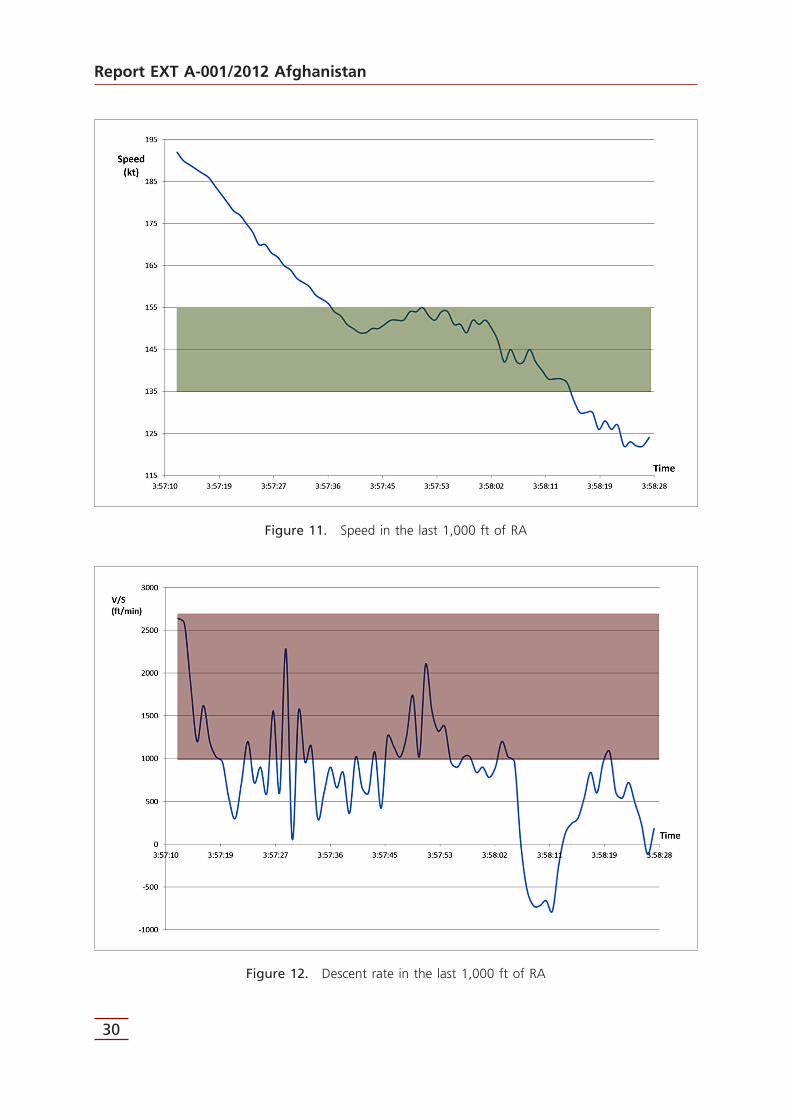
The speed should have been maintained between Vref and Vref + 20 kt, that is, between 135 and 155 kt. The graph 11, however, shows that the descent started at speeds in excess of 155 kt and ended below 135 kt. It was only kept within the stipulated range (green area) from 03:57:37 (549 ft RA) to 03:58:14 (116 ft RA).
Furthermore, the target speed calculated for this approach (140 kt) was also not maintained, except instantaneously at time 03:58:10.
• As regards descent rate:
The maximum rate should have been 1,000 ft/min, but as the graph below shows, the descent rate exceeded this maximum on several occasions (red area).
There was even an interval between 03:58:07 (70 ft RA) and 03:58:12 (122 ft RA) when the aircraft climbed (shown in the graph 12 as a negative descent rate).
Report EXT A-001/2012 Afghanistan
30
Figure 11. Speed in the last 1,000 ft of RA
Figure 12. Descent rate in the last 1,000 ft of RA

Report EXT A-001/2012 Afghanistan
31
2.4. Contact with the ground
The contact with the ground took place at time 03:58:23, with the aircraft traveling at 122 kt (13 kt below the minimum calculated for the maneuver, Vref, and 18 kt below the target speed) and with an instantaneous descent rate of 720 ft/min.
The contact took place with the right wing and the aircraft at a +20º roll angle and a +9º pitch angle. The radioaltimeter at that instant indicated 13 ft and the aircraft was about 20 m from the runway 05 threshold on a heading of 050º.
The speed (122 kt) and pitch (+9º) parameters are consistent with a rapid corrective maneuver very close to the ground intended to correct an altitude that was below the glide slope.
With the auto-throttle in RETD mode (below 50 ft RA), the throttle goes into idle, meaning that when a maneuver is initiated to raise the pitch angle, the auto-throttle does not react by increasing thrust, and thus the speed decreases.
Finally, after the impact there was a sharp decrease in the roll angle, which went from +20º to +5º in one second37. There was also a right yaw that increased the heading by 3º to 053º, which is exactly the runway heading. Both changes in the airplane’s attitude are consistent with the wing bouncing back from the ground and with the right yaw induced in the aircraft by the right wing dragging along the ground.
The damage to the aircraft is consistent with an increasing right roll angle. In the last five seconds before impact the airplane was rolling right at a rate of 3 degrees per second, and at 4 degrees per second at the moment of impact. This resulted in a hard impact with the ground that radically halted the rolling motion, which dropped from +20º to +5º in one second and caused significant damage to the right wing, as well as an appreciable permanent deformation.
37 See Appendix C so as to better understand the text.


Report EXT A-001/2012 Afghanistan
33
3. CONCLUSIONS
3.1. Findings
• The flights of 24 January 2012 were conducted in keeping with normal operations, with no notable deviations.
• The accident flight was uneventful until the approach phase.• The crew was very familiar with the operation and had received training on operating
at the Kandahar Airport, as per the company’s aerodrome classification criteria.• Swiftair, S.A. was operating this regularly scheduled passenger flight under an ACMI
arrangement with the South African company Gryphon Airlines, meaning the operation was conducted as per the operating manuals of and the operational approval given to Swiftair, S.A.
• The aircraft had valid and in force registration and airworthiness certificates and its documentation was in order.
• The aircraft was in compliance with the approved maintenance program.• The operation was within the aircraft’s weight and balance limits at all times.• Both pilots had valid and in force flight licenses and ratings for the type of flight,
issued by Spain’s aviation authority. Both pilots also had valid medical certificates.• The three flight attendants also had valid and in force FA certificates, aircraft ratings
and medical certificates.• The accident aircraft did not have operational approval to conduct the RNAV (GPS)
approach that it made to runway 05 at the Kandahar Airport.• The crew had not been trained on that type of approach.• The crew was unable to use the PAPI to line up visually with the glide slope since the
PAPI was out of service, a situation that was known to the crew beforehand.• Instrument meteorological conditions prevailed at the time of the accident.• The wind present on approach was practically lined up with the runway centerline,
meaning the approach is not regarded as having been carried out under crosswind conditions.
• Weather conditions, in general, while not ideal, did not complicate the approach maneuver.
• The length of the runway in use was more than sufficient to ensure the safety of the operation.
• In its communications with the control tower, the aircraft’s crew never reported anything out of the ordinary or any problems with the approach.
• The aircraft should have been stabilized 1,000 ft above the threshold, but it was not. As a result, the crew should have gone around and not continued with the approach.
• During the final 1,000 ft of the descent to the threshold, the aircraft should have remained within the stabilization criteria, but this was not the case. The crew should therefore again have executed a go-around and not continued with the approach.
• After the accident the crew made no effort to preserve the contents of either the cockpit voice or flight data recorders.

Report EXT A-001/2012 Afghanistan
34
3.2. Causes
The accident was likely caused by the failure to observe the company’s operating procedures and not executing a go-around when the approach was clearly not stabilized. Moreover, the operator lacked the authorization (and the crew the training) to carry out the RNAV (GPS) approach maneuver that was conducted at RWY 05 of the Kandahar Airport.
Contributing to the accident was:
• The inoperable status of the PAPI at runway 05 of the Kandahar Airport, which was thus unable to aid the crew to establish the aircraft on the correct descent slope.

Report EXT A-001/2012 Afghanistan
35
4. SAFETY RECOMMENDATIONS
REC 50/13. It is recommended that Swiftair, S.A., responsible for the operation, generate a procedure intended to ensure that its crews do not carry out unauthorized (and thus unsanctioned) maneuvers.
REC 51/13. It is recommended that Swiftair, S.A., responsible for the operation, generate a procedure intended to ensure that its crews receive proper training on adherence to operating procedures.
REC 52/13. It is recommended that Spain’s Aviation Safety Agency (AESA) ensure that Swiftair, S.A. crews do not carry out unauthorized (and thus unsanctioned) maneuvers.
REC 53/13. It is recommended that Spain’s Aviation Safety Agency (AESA) ensure that Swiftair, S.A. crews receive proper training on adherence to operating procedures.


Report EXT A-001/2012 Afghanistan
37
APPENDICES


Report EXT A-001/2012 Afghanistan
39
APPENDIX ARNAV (GPS) Approach RWY 05
Kandahar (OAKN)


Report EXT A-001/2012 Afghanistan
41


Report EXT A-001/2012 Afghanistan
43
APPENDIX BKandahar Airport Diagram


Report EXT A-001/2012 Afghanistan
45


Report EXT A-001/2012 Afghanistan
47
APPENDIX CFDR data for the last 1,000 ft


Report EXT A-001/2012 Afghanistan
49
Notes:
• The Vertical Speed column was calculated based on the differences in radioaltitude over consecutive seconds.
• The rows in blue correspond to the seconds immediately before and after passing through a RA of 1,000 ft.
• The row in red corresponds to the instant when the right wing struck the ground• The row in brown corresponds to the instant in which all of the aircraft’s main
landing gear wheels were on the runway (10 seconds later the strut in the front gear leg registered full compression).