church continue the walk down the slope at
2
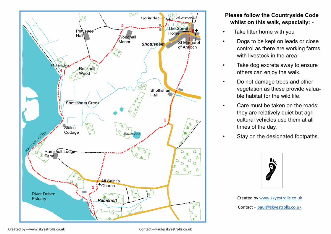
Created by—www.skyestrolls.co.uk Contact—[email protected] The Sorrel Horse The Street, Shottisham Woodbridge, Suffolk. IP12 3HD 01394 411617 www.thesorrelhorse.co.uk Opening times: - Due to seasonal variations in our opening times we recommend checking our website or call the above number where a member of the team will be pleased to assist. Walk C A circular walk to and Anglo-Saxon look- out point and along the Deben Estuary Approximately 9.9 km / 6.2 m Short walk through farmland with glorious estuary views and historic features. Could be muddy in places, with some uneven paths, not suitable for wheelchairs, pushchairs or cycles. Route also available to follow for free on phone and tablet at www.ViewRanger.com What you may see: - St Margaret of Antioch church at Shottisham – medieval tower, but main part of church rebuilt during 19 th century. Woodhall Manor – 16 th century listed mansion Rockhall Wood Pit – Geological and historical fea- ture within SSSI Deben Estuary – River flooded approximately 7000 years ago, after last Ice Age. St Michael’ s Church Ramsholt—Tower used in Anglo Saxon times as lookout along length of es- tuary. 1. Leave via the front door and turn left, cross Hollesley Road and walk up Villa Hill. The road soon ends, follow the obvious footpath passing paddocks and into open farmland. At the end of the path cross the main Wood- bridge Road (B1083) and go along the small lane opposite. After a short distance the road takes a sharp left turn, on the apex of this bend a large farm track goes off to the right. Go along this track. 2. Follow the track, passing a wood on your left, then turn left along another track with a line of trees on now on your left. This leads to All Saints Church at Ramsholt with beautiful views across the Deben Estuary. Although the current tower only dates back as far as Norman times a church and tower were here before then and used for a variety of purpos- es. After spending time in the grounds and church continue the walk down the slope at the side of the church, bearing right, into the meadows. 3. After going through the gate into the water meadow turn right for a short distance and then find the path that runs away to your left on the landward side of the large lagoon. This brings you to a gate and stile adjacent to the estuary embankment. Turn right along the embankment following a well-defined and signed path. At Ramsholt Cliffs take the path over the top into a field, re-join the embank- ment path about 100m prior to Sluice Cot- tage. Approximately 800 m after crossing the sluice (where Shottisham Creek enters the Deben) a path will be found that leads down to the right and across a meadow. 4. Take this path, over a small footbridge and then turn right along the edge of a field until reaching a farm track. At this track turn right towards Rockhall Wood, spend a few moments at this fascinating location. Then follow the track to the left that leads away from this wood. Another small wood is passed on your right prior to entering a smaller path between pad- docks at the rear of Woodhall Manor. 5. At the junction of this path and the track turn right passing Woodhall Manor until reaching the road. Here, take care as you cross, take the path on the opposite side through water meadows and over footbridges. This path will lead to the village allotments and the end of Church Road. Turn right along the road where The Sorrel Horse will be found on your left, please enjoy some refreshments at the end of your stroll.
Transcript of church continue the walk down the slope at

Created by—www.skyestrolls.co.uk Contact—[email protected]
The Sorrel Horse The Street, Shottisham
Woodbridge, Suffolk. IP12 3HD 01394 411617
www.thesorrelhorse.co.uk
Opening times: - Due to seasonal variations in our opening times we recommend checking our website or call the above number where a member of the team will be pleased to assist.
Walk C
A circular walk to and Anglo-Saxon look-
out point and along the Deben Estuary
Approximately 9.9 km / 6.2 m
Short walk through farmland with glorious
estuary views and historic features.
Could be muddy in places, with some uneven paths, not suitable for wheelchairs,
pushchairs or cycles.
Route also available to follow for free on phone and tablet at www.ViewRanger.com
What you may see: -
St Margaret of Antioch church at Shottisham –
medieval tower, but main part of church rebuilt
during 19th century.
Woodhall Manor – 16th century listed mansion
Rockhall Wood Pit – Geological and historical fea-
ture within SSSI
Deben Estuary – River flooded approximately
7000 years ago, after last Ice Age.
St Michael’s Church Ramsholt—Tower used in Anglo Saxon times as lookout along length of es-tuary.
1. Leave via the front door and turn left, cross
Hollesley Road and walk up Villa Hill. The
road soon ends, follow the obvious footpath
passing paddocks and into open farmland. At
the end of the path cross the main Wood-
bridge Road (B1083) and go along the small
lane opposite. After a short distance the road
takes a sharp left turn, on the apex of this
bend a large farm track goes off to the right.
Go along this track.
2. Follow the track, passing a wood on your left,
then turn left along another track with a line of
trees on now on your left. This leads to All
Saints Church at Ramsholt with beautiful
views across the Deben Estuary. Although
the current tower only dates back as far as
Norman times a church and tower were here
before then and used for a variety of purpos-
es. After spending time in the grounds and
church continue the walk down the slope at
the side of the church, bearing right, into the
meadows.
3. After going through the gate into the water
meadow turn right for a short distance and
then find the path that runs away to your left
on the landward side of the large lagoon. This
brings you to a gate and stile adjacent to the
estuary embankment. Turn right along the
embankment following a well-defined and
signed path. At Ramsholt Cliffs take the path
over the top into a field, re-join the embank-
ment path about 100m prior to Sluice Cot-
tage. Approximately 800 m after crossing the
sluice (where Shottisham Creek enters the
Deben) a path will be found that leads down
to the right and across a meadow.
4. Take this path, over a small footbridge
and then turn right along the edge of a
field until reaching a farm track. At this
track turn right towards Rockhall Wood,
spend a few moments at this fascinating
location. Then follow the track to the left
that leads away from this wood. Another
small wood is passed on your right prior
to entering a smaller path between pad-
docks at the rear of Woodhall Manor.
5. At the junction of this path and the track
turn right passing Woodhall Manor until
reaching the road. Here, take care as
you cross, take the path on the opposite
side through water meadows and over
footbridges. This path will lead to the
village allotments and the end of Church
Road. Turn right along the road where
The Sorrel Horse will be found on your
left, please enjoy some refreshments at
the end of your stroll.
Created by—www.skyestrolls.co.uk Contact—[email protected]
Please follow the Countryside Code
whilst on this walk, especially: -
• Take litter home with you
• Dogs to be kept on leads or close
control as there are working farms
with livestock in the area
• Take dog excreta away to ensure
others can enjoy the walk.
• Do not damage trees and other
vegetation as these provide valua-
ble habitat for the wild life.
• Care must be taken on the roads;
they are relatively quiet but agri-
cultural vehicles use them at all
times of the day.
• Stay on the designated footpaths.
Created by www.skyestrolls.co.uk
Contact – [email protected]