Chronology APN CAPaBLE Proposal Development · APN CAPaBLE Proposal Development ... Pramuka Island...
46
APN Scoping Workshop, Jakarta, 6-7 May 2013 Presentation 6 APN CAPaBLE Proposal Development APN Scoping Workshop to Develop an APN Proposal on Capacity Building of Climate Change Adaptation in Urban Planning in the SEA Jakarta, 6-7 May 2013 Chronology • 2010: SPG member for Indonesia discussed an initial concept of summer school in urban planning to adapt with climate change. The SPG member for Indonesia then brought the idea to the SEA- SRC meeting in Manila in 2010. The SEA-SRC agreed to develop a CAPaBLE proposal. • 2011: APN SEA-SRC pointed the SPG member for Indonesia as the project leader. A proposal was developed and submitted through CAPaBLE. The proposal then went through regular process of review. During the review, three proposals (SEA-SRC, START, Taiwan) were asked to merge. • 2012: The new combined proposal did not succeed, but the Capacity Development Committee agreed to recommend a seed grant to develop further. The seed grant was provided for scoping workshop. SEA-SRC meeting in Siem Reap, Cambodia agreed to postpone the date from December 2012 to March 2013 (tentative). SEA-SRC ad-hoc meeting in Kobe on April 2013 agreed the date of the scoping workshop would be 6-7 May 2013 in Jakarta. Materials for Proposal Development 1. Original CAPaBLE Proposal by the SEA-SRC 2. Questions to the proposal (raised by reviewers) 3. APN’s regulations on finance and data sharing 4. FAQs and advice on developing proposals 5. Presentations 6. Others Actions • Define the scope of proposed project and output • Type of activities summer school • Define the target groups • Period (1 year or multi-years) • Answering the questions as guidance • PI and collaborators • Contribution from each country • Seeking any national and/or international organisations to involve • Improve the rationale, methodology, literature • Define the resource persons • Define the mode of operation
Transcript of Chronology APN CAPaBLE Proposal Development · APN CAPaBLE Proposal Development ... Pramuka Island...
APN Scoping Workshop, Jakarta, 6-7 May 2013
Presentation 6
APN CAPaBLE Proposal Development
APN Scoping Workshop to Develop an APN Proposal on Capacity Building of Climate Change Adaptation in Urban Planning in the SEA
Jakarta, 6-7 May 2013
Chronology • 2010: SPG member for Indonesia discussed an initial concept of
summer school in urban planning to adapt with climate change. The SPG member for Indonesia then brought the idea to the SEA-SRC meeting in Manila in 2010. The SEA-SRC agreed to develop a CAPaBLE proposal.
• 2011: APN SEA-SRC pointed the SPG member for Indonesia as the project leader. A proposal was developed and submitted through CAPaBLE. The proposal then went through regular process of review. During the review, three proposals (SEA-SRC, START, Taiwan) were asked to merge.
• 2012: The new combined proposal did not succeed, but the Capacity Development Committee agreed to recommend a seed grant to develop further. The seed grant was provided for scoping workshop. SEA-SRC meeting in Siem Reap, Cambodia agreed to postpone the date from December 2012 to March 2013 (tentative). SEA-SRC ad-hoc meeting in Kobe on April 2013 agreed the date of the scoping workshop would be 6-7 May 2013 in Jakarta.
Materials for Proposal Development
1. Original CAPaBLE Proposal by the SEA-SRC
2. Questions to the proposal (raised by reviewers)
3. APN’s regulations on finance and data sharing
4. FAQs and advice on developing proposals
5. Presentations
6. Others
Actions
• Define the scope of proposed project and output • Type of activities summer school • Define the target groups • Period (1 year or multi-years) • Answering the questions as guidance • PI and collaborators • Contribution from each country • Seeking any national and/or international
organisations to involve • Improve the rationale, methodology, literature • Define the resource persons • Define the mode of operation
APN Scoping Workshop, Jakarta, 6-7 May 2013
Presentation 7
D K I J A K A R T A P R O V I N C E
S PAT I A L P L A N May 6, 2013
DEPARTMENT OF SPATIAL PLANNING
JAKARTA PROVINCE
SPATIAL PLAN POLICY
Province Spatial Plan
City/Regency Spatial Plan
Detailed Spatial & Zoning Regulation
Scale 1 : 50.000 Scale 1 : 5.000 Scale 1 : 20.000 Substance :
Substance : 1. Spatial Structure Plan:
• Primary and Secondary Central Activity
• Primary Infrastructure System
2. Spatial Pattern Plan: Digit 2
3. Province Stategic Area 4. General Provision of
Zoning Regulation
1. Spatial Structure Plan: • Tertiary Central Activity • Secondary
Infrastructure System 2. Spatial Pattern Plan : Digit
3 3. City Stategic Area 4. Direction of Zoning
Regulation
1. Spatial Structure Plan: • Sub-District Central Activity • Tertiary Infrastructure
System 2. Spatial Pattern Plan : Digit 4 3. Infrastructure Network Plan 4. Zoning Map and Zoning Text 5. Zoning Text:
Utilization of space regulation Minimum of Intensity
Regulation Building Mass Regulation Other Regulation Speciality Regulation
MACRO POLICY OPERATIONAL POLICY
Urban Design Guidelines (Strategic Area)
Scale 1 : 1.000
1. Land Use Structure 2. Intensity of Land Use 3. Building Regulation 4. Circulation Systems & Strip
Connector 5. Open Space Planning Systems
& Green 6. Environmental Quality
Regulation 7. System Infrastructure and
Utilities Environment
STRATEGIC ISSUES OF SPATIAL PLANNING JAKARTA PROVINCE
Traffic Jam
Flood Management
Open Space
Climate Change
Increase in Energy Consumption
Changes in The Economy and World Financial
Population and Social Problems
Limited Clean Water Supply, Liquid Waste Management and Waste Management
Disaster Mitigation Preparedness
Limited Development Funding
PERDA NO.1/2012
JAKARTA PROVINCE SPATIAL PLAN 2030
APN Scoping Workshop, Jakarta, 6-7 May 2013
Presentation 7
PRINCIPLES OF JAKARTA PROVINCE
SPATIAL PLAN 2030
1. Growth Management.
2. Functional Basis of Planning is Megalopolitan Jabodetabekpunjur.
3. Transformation from Stakeholders to Shareholders.
VISION DAN MISSION
• build humanity infrastructure;
• optimize the productivity of city;
• developing urban culture;
• mainstreaming disaster mitigation based development;
• creating a prosperous and dinamic city life;
• harmonize urban life with the environment;
Jakarta as the capital of the Unitary State of the Republic of Indonesia that comfortable, sustainable
and populated by prorperous community VISION
MISSION
SPATIAL PLANNING STRATEGY SCHEME
Pramuka Island
JAKARTA PROVINCE SPATIAL PLAN 2030
RELATED TO CLIMATE CHANGE Policy : - Increasing Open Green Space to reach 30% from land area - Reduction of greenhouse gas emissions for anticipation of global warming
and climate change - Increased adaptation and mitigation against the threat of global warming
and climate change and risk of other disasters
Strategy :
- Apply green building and sustainable urban design - Improve the quantity and quality of green space and maintain availability of
existing green space - Direct utilization of vulnerable disaster area for cultivation activities that
have a high adaptability; - Reduce disaster risk through rearrangement and application of technology or
engineering in the affected areas - Develop The North Coast Region (Pantura) as an effort to anticipate climate
change - Increase the provision of open blue space to anticipate the increase of
rainfall intensity
APN Scoping Workshop, Jakarta, 6-7 May 2013
Presentation 7
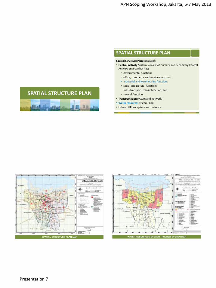
SPATIAL STRUCTURE PLAN
Spatial Structure Plan consist of:
Central Activity System; consist of Primary and Secondary Central Activity, an area that has:
• governmental function;
• office, commerce and services function;
• industrial and warehousing function;
• social and cultural function;
• mass transport transit function; and
• several function.
Transportation system and network;
Water resources system; and
Urban utilities system and network.
SPATIAL STRUCTURE PLAN
SPATIAL STRUCTURE PLAN MAP WATER RESOURCES SYSTEM - POLDER SYSTEM MAP
APN Scoping Workshop, Jakarta, 6-7 May 2013
Presentation 7
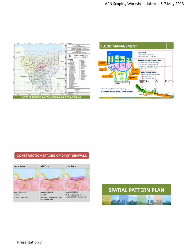
WATER RESOURCES SYSTEM - RESERVOIR DISTRIBUTION MAP
. . . .
t0
t1
t2
t3
UPSTREAM
(Puncak-Bogor)
MIDDLESTREAM
(Bogor-Depok-Jaksel)
DOWNSTREAM
(Jaksel-Jakut)
2000 m
+ M
SL
.
t4 Pesisir
Sistim
polder
Evapora
si
Waduk/situ
Evapotranspirasi
Evapotranspirasi
Resapan air
Hujan
Banjir kanal
Gravitasi Polder
FLOOD MANAGEMENT
Sea Wall: - Phase I: Existing Shore - Phase II and III: - 8 or more
Flowed with Polder system: - Polder system extension to barat - East and West Interconnection - Increase the capasity of canals, rivers and reservoirs - Cengkareng Drain II development
Flowed naturally : - Infiltration wells and biopore - Reduce run off - Build new reservoirs
Increase canal and river capasity
WATER BODY RATIO TARGET : 5%
Sea
Reclamation Area
Lower
Area
Higher
Area
Lower
Area
Sea Wall
Tanjung Priok
Port and
Marunda Port
Development
Plan
Mangrove Cengkareng
Drain II Plan
Cengkareng
Drain I
Kanal Banjir Barat
Kanal Banjir
Timur
Reservoir retention outside DKI Jakarta
14
Stage 1 (2011-2015) Stage 2 (2015-2025) Stage 3 (2025-2030)
Short Term Mid Term Long Term
CONSTRUCTION STAGES OF GIANT SEAWALL
Function:
coastal protection
Function:
Integrated development with
reclamation area
Multi purpose seawall
construction for Jakarta Bay
SPATIAL PATTERN PLAN
APN Scoping Workshop, Jakarta, 6-7 May 2013
Presentation 7
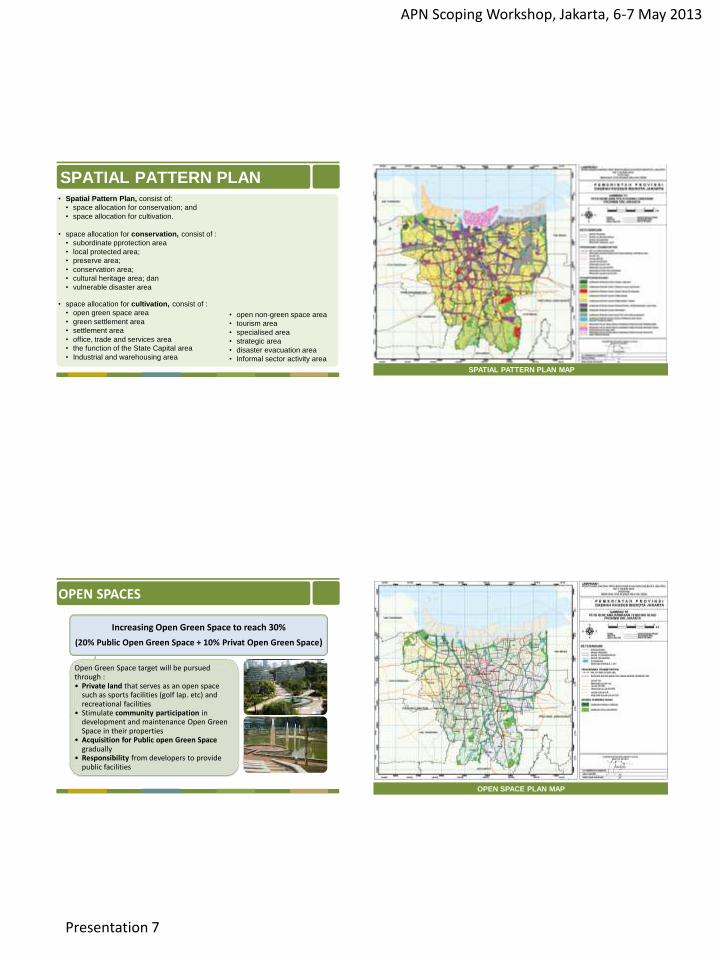
• Spatial Pattern Plan, consist of:
• space allocation for conservation; and
• space allocation for cultivation.
• space allocation for conservation, consist of :
• subordinate pprotection area
• local protected area;
• preserve area;
• conservation area;
• cultural heritage area; dan
• vulnerable disaster area
• space allocation for cultivation, consist of :
• open green space area
• green settlement area
• settlement area
• office, trade and services area
• the function of the State Capital area
• Industrial and warehousing area
SPATIAL PATTERN PLAN
• open non-green space area
• tourism area
• specialised area
• strategic area
• disaster evacuation area
• Informal sector activity area SPATIAL PATTERN PLAN MAP
Increasing Open Green Space to reach 30%
(20% Public Open Green Space + 10% Privat Open Green Space)
Open Green Space target will be pursued through : • Private land that serves as an open space
such as sports facilities (golf lap. etc) and recreational facilities
• Stimulate community participation in development and maintenance Open Green Space in their properties
• Acquisition for Public open Green Space gradually
• Responsibility from developers to provide public facilities
OPEN SPACES
OPEN SPACE PLAN MAP
APN Scoping Workshop, Jakarta, 6-7 May 2013
Presentation 7
DETAILED SPATIAL PLAN
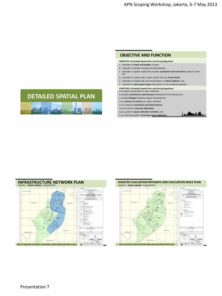
OBJECTIVE AND FUNCTION
FUNCTION of Detailed Spatial Plan and Zoning Regulation
a.to support actualization of space utilization;
b.maintain consistency and harmony development of functional area;
c.creating linkages between program development;
d.as a device to control over space utilization;
e.as a reference incentives and disincentives;
f.as the basis for sanction imposition;
g.as a guide for space utilization activities; dan
h.as a technical guide in licensing space utilization .
OBJECTIVE of Detailed Spatial Plan and Zoning Regulation
a. realization of value and quality of space
b. realization of spatial management administration;
c. realization of spatial regioan that provides productive and innovative quality of urban
life;
d. realization of Jakarta with a water system that can reduce flood;
e. realization of Jakarta with well transportation to reduce gridlock; dan
f. realization of open green space accordance to the prevailing regulation.
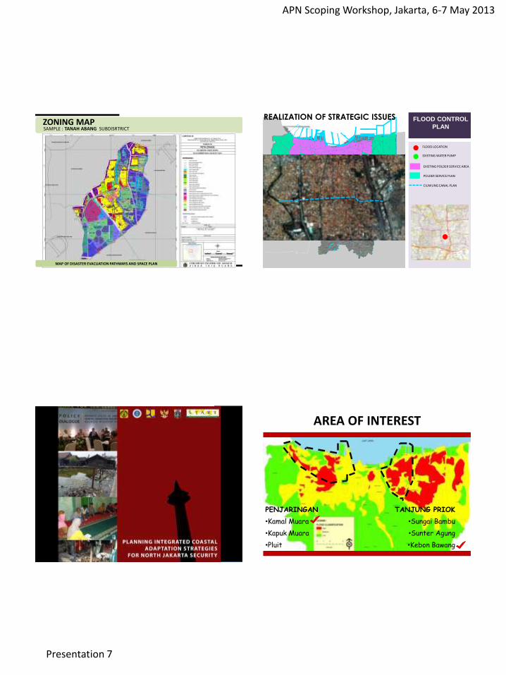
INFRASTRUCTURE NETWORK PLAN SAMPLE : TANAH ABANG SUBDISRTRICT
MAP OF DRAINAGE NETWORK, CLEAN WATER, WASTE WATER AND WASTE PLAN
DISASTER EVACUATION PATHWAYS AND EVACUATION SPACE PLAN SAMPLE : TANAH ABANG SUBDISRTRICT
MAP OF DISASTER EVACUATION PATHWAYS AND EVACUATION SPACE PLAN
APN Scoping Workshop, Jakarta, 6-7 May 2013
Presentation 7
ZONING MAP SAMPLE : TANAH ABANG SUBDISRTRICT
MAP OF DISASTER EVACUATION PATHWAYS AND SPACE PLAN
FLOOD CONTROL
PLAN
FLOOD LOCATION
EXISTING WATER PUMP
EXISTING POLDER SERVICE AREA
POLDER SERVICE PLAN
CILIWUNG CANAL PLAN
REALIZATION OF STRATEGIC ISSUES
!!!!! !!
!
!
!
!
! !
!!! !
!!
! !!! !
!
!
!!! !! !! !
!
!!
!
!
!
!!
!
!
!
! !
!
!
!!
!
!!!
!!! !!! !
!!
!
!!
! ! !!!
!!
! !
!!!!!!! !
!
!!!!!!! !
!!!!
!
! !!
!
!!
!
!
!!
!
!
!
!!!!!!
!!! !
!
! !!
! !!!!
! !
!! !!
!
!!
!
!
!
!
!!! !
!
!!
!
!
!
!!
!!
!
!
!
!
!
!
!!!
!
!!
! !!
!
!!
!! !
!
!
!!
!
!
!!
!
!!
!!!
!
!!
!
!
!
!!
!!
!
!!
!
! !!!
!
!! !!
!!
!!
!
!!
!
!
!
!
!
!!!
!
!
!
!!
!
!
!
!!
!
!
!
!
!
!
!
!
!
!
! ! !!
!
!
!
!
!
!
!
!
!
!
! !
!!
!
!
!
!!
!!!!!
!!!
!!!!!!!!
!!
!
!
!
!!
!
!
! !
!
!!
! !! ! !
!!
!
! !!
!!
!
!
!
!
!!!
!!
!!
!
!
!
!! !
!
!!
!
!
!
!
!!
!
!
!
!
!
!!
!
! !
!!
!
!
!
!!
!
!
!
!
!
!!
!
!
!!
!
!
!
!
!!
!
!!
!
!!
!
!! !
!
!
!!
!!
!
!
!
!!
!
!
!
!
!
!
!
!!!
!
!
!
!
!
!
!
!
!!
!
!! !
!
!
!
! !
!!
!
!
!
!
!
!
!
! !!
!!!
!
!
!
!
!
!!!
!
!
!
!
!
!
!!
!
!
!
!
!
!
!
!
!
!
!
!
!
!
!
!
!
!
!
!
!
!
!
!
!
!
!
!
! !
!!
!
!!
!
!
!
!
!
! !
!
!!
!!
!!
!
!
!
!
!!
!!
!
!
!
!!
!
TANJUNG PRIOK
•Sungai Bambu
•Sunter Agung
•Kebon Bawang
PENJARINGAN
•Kamal Muara
•Kapuk Muara
•Pluit
AREA OF INTEREST
APN Scoping Workshop, Jakarta, 6-7 May 2013
Presentation 7
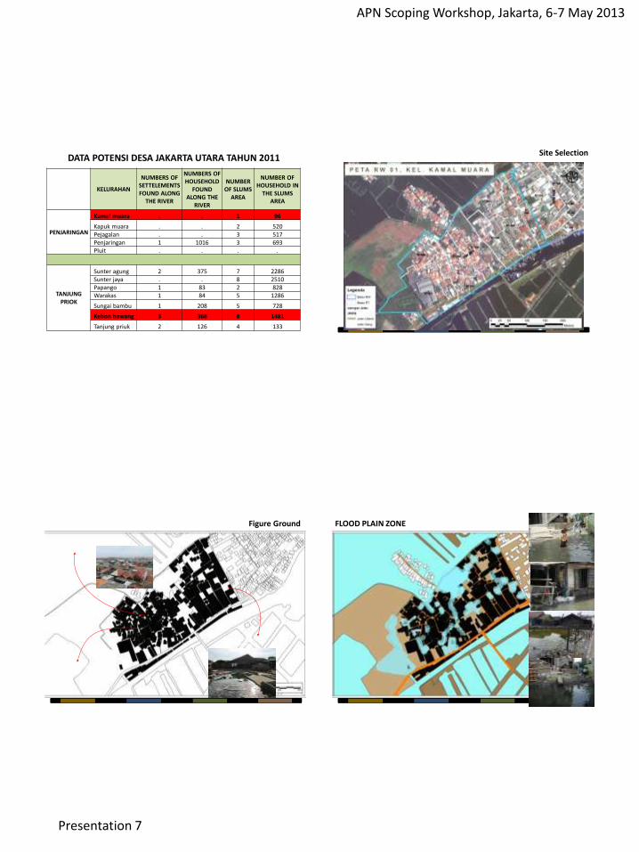
KELURAHAN
NUMBERS OF SETTELEMENTS FOUND ALONG
THE RIVER
NUMBERS OF HOUSEHOLD
FOUND ALONG THE
RIVER
NUMBER OF SLUMS
AREA
NUMBER OF HOUSEHOLD IN
THE SLUMS AREA
PENJARINGAN
Kamal muara . . 1 96
Kapuk muara . . 2 520 Pejagalan . . 3 517 Penjaringan 1 1016 3 693 Pluit . . . .
TANJUNG PRIOK
Sunter agung 2 375 7 2286 Sunter jaya . . 8 2510 Papango 1 83 2 828 Warakas 1 84 5 1286
Sungai bambu 1 208 5 728
Kebon bawang 3 368 8 1481
Tanjung priuk 2 126 4 133
DATA POTENSI DESA JAKARTA UTARA TAHUN 2011 Site Selection
Figure Ground
Kepadatan Tinggi
Minim Ruang Sosial
Ruang Terbuka Tergenang
FLOOD PLAIN ZONE
APN Scoping Workshop, Jakarta, 6-7 May 2013
Presentation 7
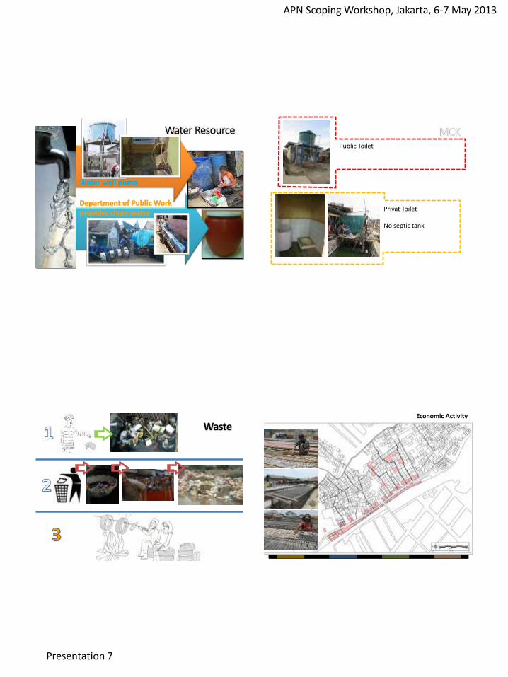
Water well pump
Public Toilet
Privat Toilet No septic tank
Economic Activity
APN Scoping Workshop, Jakarta, 6-7 May 2013
Presentation 7
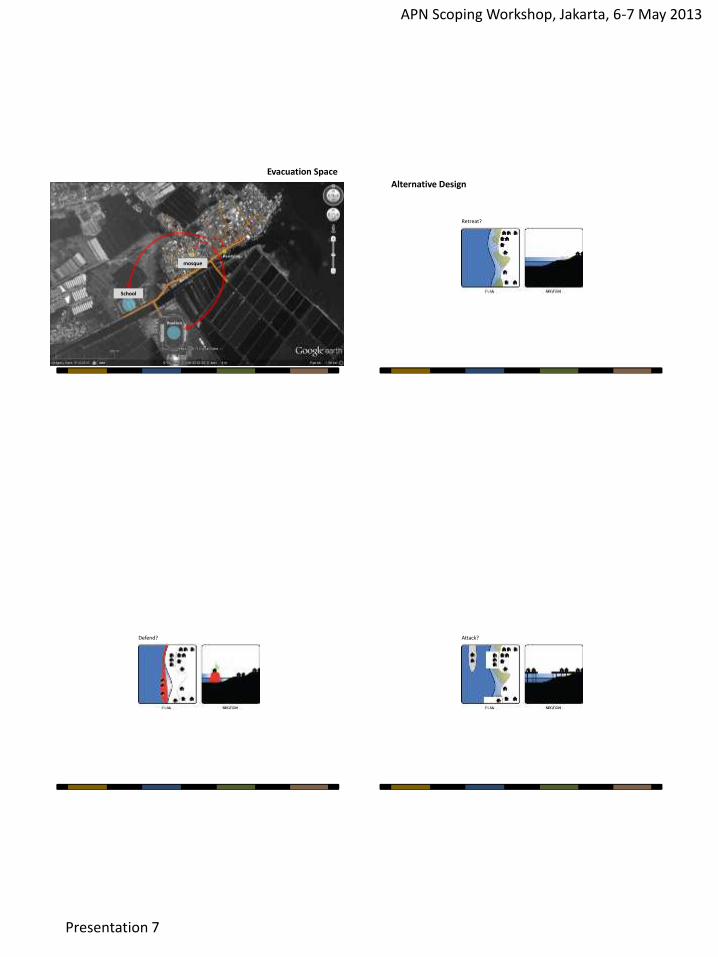
Evacuation Space
mosque
School
Retreat?
Alternative Design
Defend? Attack?
APN Scoping Workshop, Jakarta, 6-7 May 2013
Presentation 7
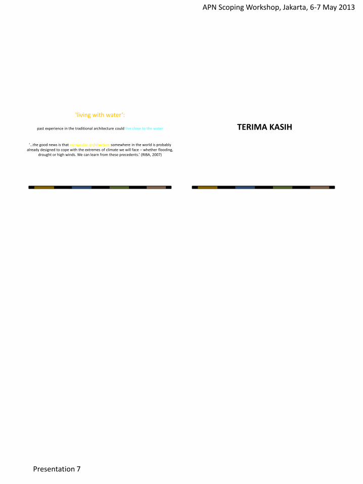
‘…the good news is that vernacular architecture somewhere in the world is probably already designed to cope with the extremes of climate we will face – whether flooding,
drought or high winds. We can learn from these precedents.’ (RIBA, 2007)
'living with water‘:
past experience in the traditional architecture could live close to the water TERIMA KASIH
APN Scoping Workshop, Jakarta, 6-7 May 2013
Presentation 8
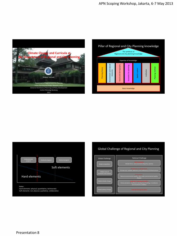
Climate Change and Curricula at the Department of Regional and City Planning
Department of Regional and City Planning
Urban Planning and Design Research Group
School of Architecture Planning and Policy Development
Institut Teknologi Bandung
2013
Ridwan Sutriadi
Pillar of Regional and City Planning knowledge
Pla
nn
ing
theo
ry
Envi
ron
men
t an
d n
atu
ral
reso
urc
es
Soci
al a
nd
dem
ogr
aph
y
Eco
no
mic
fo
r p
lan
nin
g
Spat
ial s
yste
m
inst
itu
tio
n
Pla
nn
ing
met
ho
d
Basic knowledge
Expertise of knowledge
The synthesis of Regional and city planning knowledge
Notes: Hard elements: physical, quantitative, technocratic Soft elements: non physical, qualitative, collaborative
Undergraduate program
Graduate program Doctoral program
Hard elements
Soft elements
Global Challenge of Regional and City Planning
Global competition
Global crisis of economic and cultural
Global climate change
Global political change
Global Challenge National Challenge
Socio economic: Market force; socio-economic disparity; poverty
The dynamic of development: Primate city; isolated; deficiency and inefficiency of infrastructures
Environment : Natural environmental quality; men made environmental quality;
disaster
Food and Energy Securities
Institution, financing and politic: Democratization, insufficient development funding, in conducive
socio-economic condition
APN Scoping Workshop, Jakarta, 6-7 May 2013
Presentation 8
GIS
Planning studios
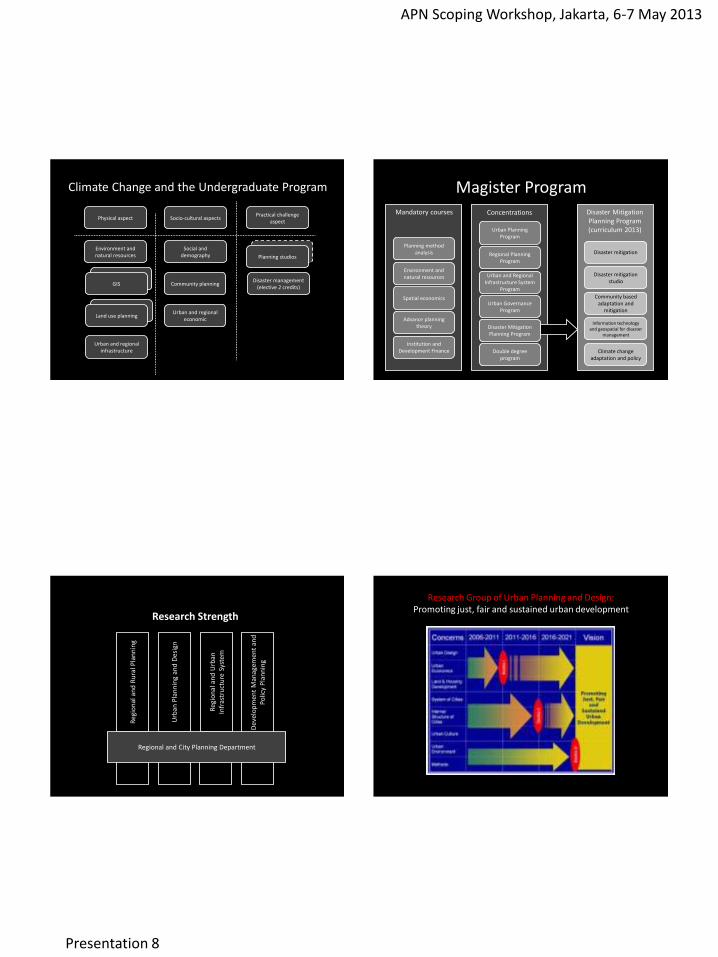
Climate Change and the Undergraduate Program
Physical aspect Socio-cultural aspects Practical challenge
aspect
Environment and natural resources
Social and demography Planning studios
Disaster management (elective 2 credits)
GIS Community planning
Urban and regional economic
Urban and regional infrastructure
Land use planning Land use planning
Magister Program
Planning method analysis
Environment and natural resources
Spatial economics
Advance planning theory
Mandatory courses Concentrations
Urban Planning Program
Regional Planning Program
Urban and Regional Infrastructure System
Program
Urban Governance Program
Disaster Mitigation Planning Program
Institution and Development Finance Double degree
program
Disaster mitigation
Disaster mitigation studio
Community based adaptation and
mitigation
Information technology and geospatial for disaster
management
Climate change adaptation and policy
Disaster Mitigation Planning Program (curriculum 2013)
Research Strength
Urb
an P
lan
nin
g an
d D
esig
n
Reg
ion
al a
nd
Urb
an
Infr
astr
uct
ure
Sys
tem
Reg
ion
al a
nd
Ru
ral P
lan
nin
g
Dev
elo
pm
ent
Man
agem
ent
and
Po
licy
Pla
nn
ing
Regional and City Planning Department
Research Group of Urban Planning and Design: Promoting just, fair and sustained urban development
APN Scoping Workshop, Jakarta, 6-7 May 2013
Presentation 8
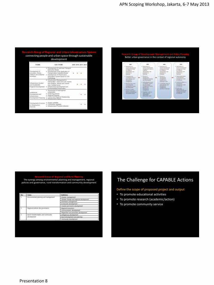
Research Group of Regional and Urban Infrastructure System connecting people and urban space through sustainable
development
Research Group of Development Management and Policy Planning Better urban governance in the context of regional autonomy
Research Group of Regional and Rural Planning The synergy among environmental planning and management, regional
policies and governance, rural transformation and community development
The Challenge for CAPABLE Actions
Define the scope of proposed project and output
• To promote educational activities
• To promote research (academic/action)
• To promote community service
APN Scoping Workshop, Jakarta, 6-7 May 2013
Presentation 8
The Challenge for CAPABLE Actions
Type of activities • TOT and faculty exchange • Accommodating CC concern to the planning studio (especially
master program) • To develop research based activities
– To develop basic research that have been done by related research group (international cooperation type)
– To enrich related curriculum by adding CC material – To incorporate the planning studio project with the CC concern
• To develop serial CC training – Define personnel – Define target group – Define CC’s material focus.
The Challenge for CAPABLE Actions
Define the target group • DRCP has ongoing functional planning training and thematic
training (including CC training) incorporation between DRCP and Bappenas (Pusbindiklatren) with the target group local government employees.
• Some planning faculties do have teaching material related to CC. • DRCP (SAPPD) has ongoing summer program with international
universities partners – Community based environmental awareness (Bali Field School, 2009, with
UF) – Promoting community based planning and design (Sawahlunto, 2012, with
UF) – Cultural aspects and planning design (Yogyakarta, 2013).
• Professional association (such as Indonesian Association of Planner)
The Challenge for CAPABLE Actions
Period
• Annual (summer program)
• Every semester
• Based on demand
The Challenge for CAPABLE Actions
Answering the questions as guidance • Planning and management based
– CC and current planning policy (national/province/ regency-city level/local level)
– The position of CC based action plan (Planning process phase/planning implementation phase/ planning control phase)
• Capacity building based – Capacity building for governmental employees/particular
stakeholders (NGO/CBO/young generation) – Out of the box: civic engagement and communicative channel
(voluntary planning activities; community based monitoring) to respond uncertainties (values/environment/related decision making process)
APN Scoping Workshop, Jakarta, 6-7 May 2013
Presentation 8
The Challenge for CAPABLE Actions
PI and collaborators • ITB, SAPPD and DRCP does have persons who deal with
international cooperation • DRCP does have CC related research throughout research group:
– CC mitigation and adaptation (regional and rural planning RG). – CC and infrastructure quality and preparedness (urban and regional
infrastructure system RG) – CC and livability/green development for all (urban planning and design
RG) – CC and civic engagement model (Development Management and Policy
Planning RG).
• DRCP working together with professional association (IAP) towards CC concern
• DRCP as a hub to promote CC concern throughout private urban planning school in Indonesia
The Challenge for CAPABLE Actions
Contribution from each countries
• Providing trainers
• Providing case studies (including cooperation with local government as hosts)
• Providing related CC research that have been done as entry points for CAPABLE actions
The Challenge for CAPABLE Actions
Seeking any national/international organizations to involve
• To encourage CC based activities among international university’s partners
• To identify national/international organizations that have the similar program.
The Challenge for CAPABLE Actions
Improve the rationale, methodology, literature
• International approach?
• Local wisdom approach?
• Technological based approach?
APN Scoping Workshop, Jakarta, 6-7 May 2013
Presentation 8
The Challenge for CAPABLE Actions
Define the resource persons
• Persons/faculties/research assistants that have interest in CC.
• Decision maker in international/national/local level
The Challenge for CAPABLE Actions
Define the mode of operation
• Developing teaching material based on existing teaching material and accommodating raising issues.
• The expected impact of post CC training
APN Scoping Workshop, Jakarta, 6-7 May 2013
Presentation 9
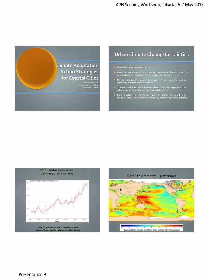
Climate Adaptation Action Strategies for Coastal Cities
Kem Lowry, PhD Adjunct Senior Fellow
East-West Center
Urban Climate Change Certainties
Global climate change is real.
Global temperatures will continue to increase even if major reductions in greenhouse gas emissions are substantially reduced.
Climate change will increase the frequency of some natural hazards, especially extreme weather events.
Climate change will have disproportionate negative impacts on the urban poor and residents of informal settlements.
Building urban resilience to the impacts of climate change will be an on-going process of planning, managing, monitoring and adaptation.
2010 – Tied as warmest year 1.34oF (0.8oC) total warming
Chip Fletcher, University of Hawaii at Manoa
School of Ocean and Earth Science and Technology,
Satellite Altimetry – 3.27mm/yr
APN Scoping Workshop, Jakarta, 6-7 May 2013
Presentation 9
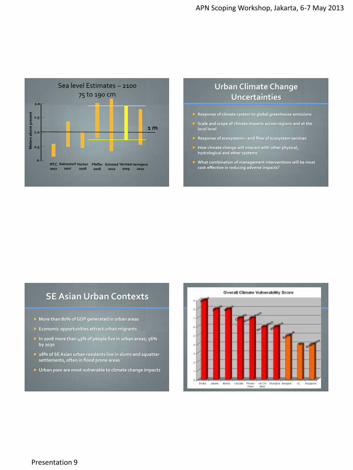
Sea level Estimates – 2100 75 to 190 cm
0
0.5
1.5
1.0
2.0
IPCC 2007
Rahmstorf 2007
Horton 2008
Grinsted 2010
Vermeer 2009
Jevrejeva 2010
Pfeffer 2008
Me
ters
ab
ove
pre
sen
t
1 m
Urban Climate Change Uncertainties
Response of climate system to global greenhouse emissions
Scale and scope of climate impacts across regions and at the local level
Response of ecosystems—and flow of ecosystem services
How climate change will interact with other physical, hydrological and other systems
What combination of management interventions will be most cost-effective in reducing adverse impacts?
SE Asian Urban Contexts
More than 80% of GDP generated in urban areas
Economic opportunities attract urban migrants
In 2008 more than 45% of people live in urban areas; 56% by 2030
28% of SE Asian urban residents live in slums and squatter settlements, often in flood prone areas
Urban poor are most vulnerable to climate change impacts
Flooding of Informal Settlements
APN Scoping Workshop, Jakarta, 6-7 May 2013
Presentation 9
Designing a Local Adaptation Strategy
Assess vulnerabilities
Identify management options
Select management tools
Implement management tools
Ongoing monitoring, evaluation and adaptation
Risk Assessment
What hazards will climate change cause or contribute to?
How serious are hazards likely to be?
What research/analysis is needed?
Where should planners and policy makers focus their adaptation efforts?
Urban Planning Challenges
Identifying and assessing urban [and rural] vulnerabilities to climate change [combining technical analysis and community meetings and workshops]
Educating policy-makers and communities about short and long term impacts of climate change
Identifying management tools to address impacts [flood-proofing areas, hazard zones, etc.]
Evaluating options including costs
Identifying and addressing implementation barriers.
APN Scoping Workshop, Jakarta, 6-7 May 2013
Presentation 9
The Concept of Climate Change Risk
RISK
HAZARD VULNERABILITY
Elements of Vulnerability
Vulnerability
Exposure
Sensitivity
Adaptive Capacity
Risk Hazard
Frequency
Magnitude
Extent
Vulnerability
Exposure
Sensitivity
Adaptive capacity
Elements of Vulnerability
Sensitivity—how susceptible are structures, individuals and the environment to hazard impacts
Exposure—what is in harm’s way—people, structures, infrastructure and environmental assets that could be affected by a hazard
Ability to cope—community resiliency which includes hazard awareness, hazard planning, identifying evacuation routes, placing shelters in non-exposed areas, pre-placing emergency supplies, etc.
APN Scoping Workshop, Jakarta, 6-7 May 2013
Presentation 9
How Sensitive Are Community Assets to Hazard Impacts
Structural Sensitivity
Areas Exposed to Potential Hazards
Providing Food & Water as Post-Flood Adaptive Capacity
APN Scoping Workshop, Jakarta, 6-7 May 2013
Presentation 9
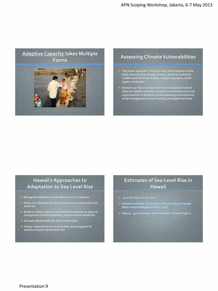
Adaptive Capacity takes Multiple Forms
Assessing Climate Vulnerabilities
Top-down approach: Focus on long-term impacts of sea level rise and other change drivers, develop predictive models and technical studies, design long-term, multi-agency strategies
Bottom up: Focus on key short-term impacts for which data are readily available, involve communities and local organizations in designing and evaluating interventions, build management around existing management tools.
Hawaii’s Approaches to Adaptation to Sea Level Rise
Recognize adaptation may have to occur in phases.
Focus on a few key climate change issues, particularly sea level rise
Build on historic and current technical analysis on rates of change and climate variability, exposure and sensitivity
Educate elected officials and communities
Design adaptations to existing laws and programs to address impacts of sea level rise
Estimates of Sea Level Rise in Hawaii
.24 m by 2050; 1m by 2100
Erosion multiplier of 150 [according to State of Hawaii Multi-Hazard Mitigation Plan, 2007]
Hence, .24 m increase results in beach retreat of 36 m.
APN Scoping Workshop, Jakarta, 6-7 May 2013
Presentation 9
Impacts of Sea Level Rise Over Next 10-15 Years
Increased each erosion and retreat
Increased flooding in coastal areas
Reduced access to shoreline attractions
Increased flooding threats to key infrastructure including roads, sewers, storm drains, electrical lines
Threats to freshwater aquifers
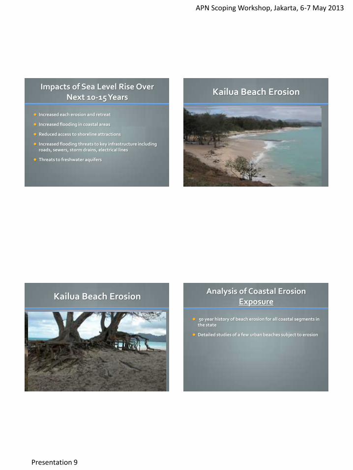
Kailua Beach Erosion
Kailua Beach Erosion Analysis of Coastal Erosion
Exposure
50 year history of beach erosion for all coastal segments in the state
Detailed studies of a few urban beaches subject to erosion
APN Scoping Workshop, Jakarta, 6-7 May 2013
Presentation 9
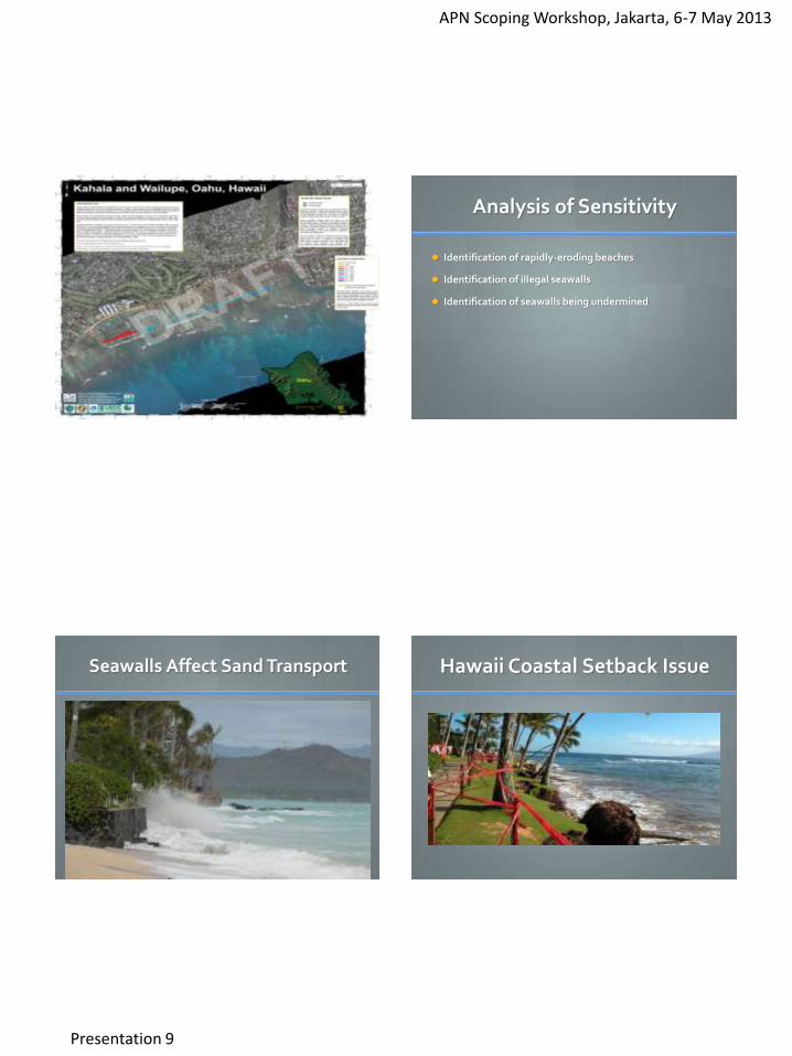
Analysis of Sensitivity
Identification of rapidly-eroding beaches
Identification of illegal seawalls
Identification of seawalls being undermined
Seawalls Affect Sand Transport
Hawaii Coastal Setback Issue
APN Scoping Workshop, Jakarta, 6-7 May 2013
Presentation 9
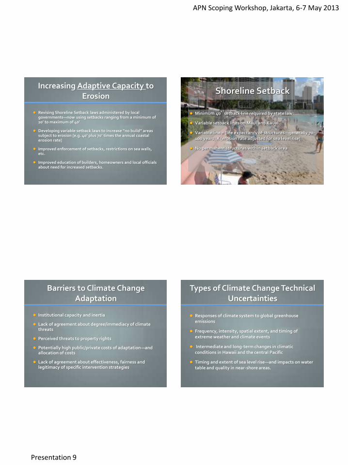
Increasing Adaptive Capacity to Erosion
Revising Shoreline Setback laws administered by local governments—now using setbacks ranging from a minimum of 20’ to maximum of 40’
Developing variable setback laws to increase “no build” areas subject to erosion [e.g. 40’ plus 70’ times the annual coastal erosion rate]
Improved enforcement of setbacks, restrictions on sea walls, etc.
Improved education of builders, homeowners and local officials about need for increased setbacks.
Shoreline Setback
Minimum 40’ setback line required by state law
Variable setback lines on Maui and Kauai
Variable line = [life expectancy of structures—generally 70-100 years] X [erosion rate adjusted for sea level rise]
No permanent structures within setback area
Barriers to Climate Change Adaptation
Institutional capacity and inertia
Lack of agreement about degree/immediacy of climate threats
Perceived threats to property rights
Potentially high public/private costs of adaptation—and allocation of costs
Lack of agreement about effectiveness, fairness and legitimacy of specific intervention strategies
Types of Climate Change Technical Uncertainties
Responses of climate system to global greenhouse emissions
Frequency, intensity, spatial extent, and timing of extreme weather and climate events
Intermediate and long-term changes in climatic conditions in Hawaii and the central Pacific
Timing and extent of sea level rise—and impacts on water table and quality in near-shore areas.
APN Scoping Workshop, Jakarta, 6-7 May 2013
Presentation 9
Reducing Technical Uncertainties
More international and national refinement of climate change models.
Refinement of models for assessing frequency, intensity, spatial extent and timing of extreme climate events.
Increased local research focus on possible short and long-term impacts of climate change generally and extreme events in particular.
Research on “cascading’ impacts of specific climate change events such as extended droughts or severe flooding.
Reducing Political Uncertainties
Recognize that technical research is unlikely to provide certainty regarding the types, timing and magnitude of climate change events.
Engage communities in analysis of future climate change scenarios and their potential impacts.
Focus greater research and management attention on chronic risk factors [e.g. coastal erosion and flooding].
Develop short and longer term vulnerability assessments
Develop adaptive management strategies that build resilience over time.
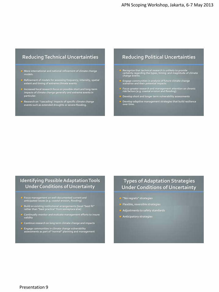
Identifying Possible Adaptation Tools Under Conditions of Uncertainty
Focus management on well-documented current and anticipated issues [e.g. coastal erosion, flooding]
Build on existing institutional arrangements [local “best fit” rather than “best practice” from someplace else]
Continually monitor and evaluate management efforts to insure validity
Continue research on long term climate change and impacts
Engage communities in climate change vulnerability assessments as part of “normal” planning and management
Types of Adaptation Strategies Under Conditions of Uncertainty
“No regrets” strategies
Flexible, reversible strategies
Adjustments to safety standards
Anticipatory strategies
APN Scoping Workshop, Jakarta, 6-7 May 2013
Presentation 9
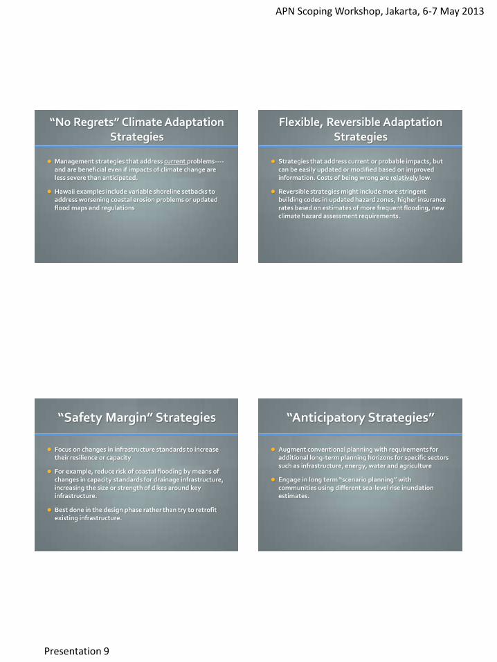
“No Regrets” Climate Adaptation Strategies
Management strategies that address current problems----and are beneficial even if impacts of climate change are less severe than anticipated.
Hawaii examples include variable shoreline setbacks to address worsening coastal erosion problems or updated flood maps and regulations
Flexible, Reversible Adaptation Strategies
Strategies that address current or probable impacts, but can be easily updated or modified based on improved information. Costs of being wrong are relatively low.
Reversible strategies might include more stringent building codes in updated hazard zones, higher insurance rates based on estimates of more frequent flooding, new climate hazard assessment requirements.
“Safety Margin” Strategies
Focus on changes in infrastructure standards to increase their resilience or capacity
For example, reduce risk of coastal flooding by means of changes in capacity standards for drainage infrastructure, increasing the size or strength of dikes around key infrastructure.
Best done in the design phase rather than try to retrofit existing infrastructure.
“Anticipatory Strategies”
Augment conventional planning with requirements for additional long-term planning horizons for specific sectors such as infrastructure, energy, water and agriculture
Engage in long term “scenario planning” with communities using different sea-level rise inundation estimates.
APN Scoping Workshop, Jakarta, 6-7 May 2013
Presentation 9
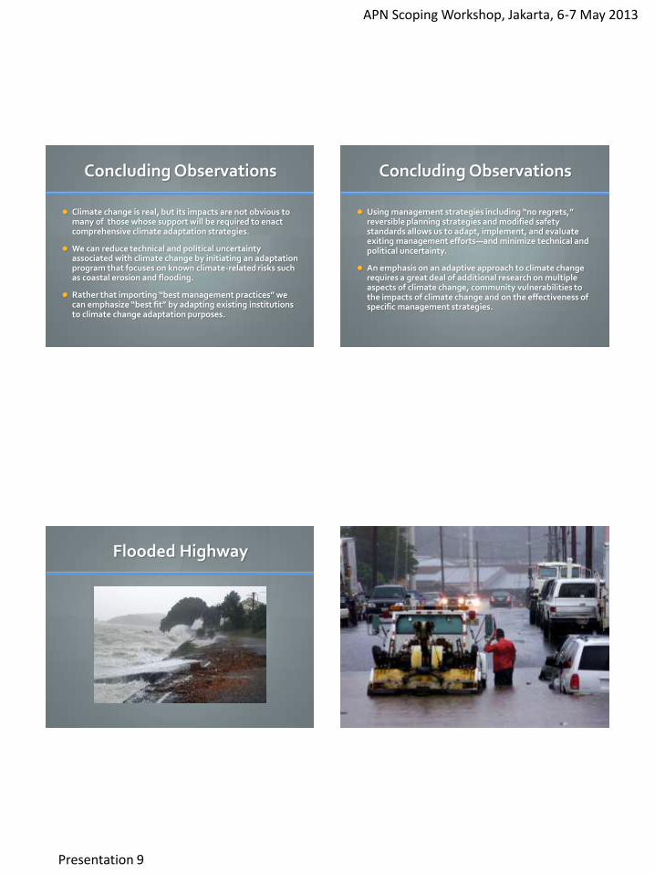
Concluding Observations
Climate change is real, but its impacts are not obvious to many of those whose support will be required to enact comprehensive climate adaptation strategies.
We can reduce technical and political uncertainty associated with climate change by initiating an adaptation program that focuses on known climate-related risks such as coastal erosion and flooding.
Rather that importing “best management practices” we can emphasize “best fit” by adapting existing institutions to climate change adaptation purposes.
Concluding Observations
Using management strategies including “no regrets,” reversible planning strategies and modified safety standards allows us to adapt, implement, and evaluate exiting management efforts—and minimize technical and political uncertainty.
An emphasis on an adaptive approach to climate change requires a great deal of additional research on multiple aspects of climate change, community vulnerabilities to the impacts of climate change and on the effectiveness of specific management strategies.
Flooded Highway
APN Scoping Workshop, Jakarta, 6-7 May 2013
Presentation 9
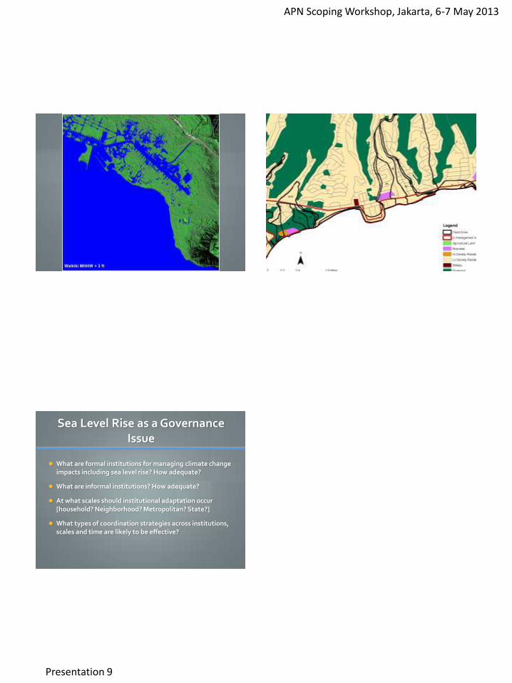
Sea Level Rise as a Governance Issue
What are formal institutions for managing climate change impacts including sea level rise? How adequate?
What are informal institutions? How adequate?
At what scales should institutional adaptation occur [household? Neighborhood? Metropolitan? State?]
What types of coordination strategies across institutions, scales and time are likely to be effective?
APN Scoping Workshop, Jakarta, 6-7 May 2013
Presentation 10
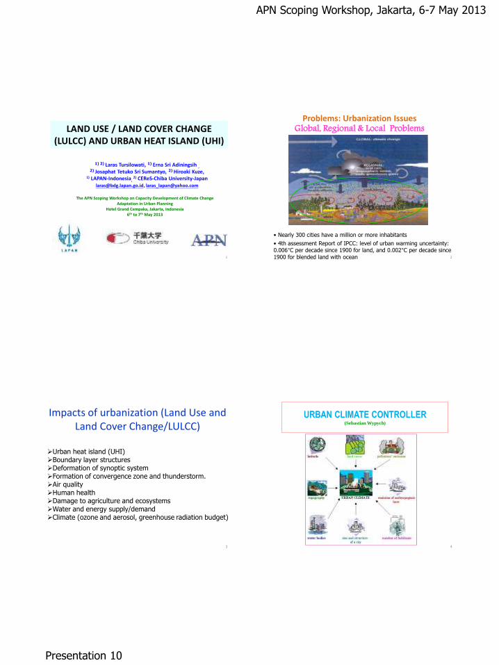
LAND USE / LAND COVER CHANGE (LULCC) AND URBAN HEAT ISLAND (UHI)
1) 2) Laras Tursilowati, 1) Erna Sri Adiningsih , 2) Josaphat Tetuko Sri Sumantyo, 2) Hiroaki Kuze,
1) LAPAN-Indonesia, 2) CEReS-Chiba University-Japan
[email protected], [email protected]
The APN Scoping Workshop on Capacity Development of Climate Change Adaptation in Urban Planning
Hotel Grand Cempaka, Jakarta, Indonesia 6th to 7th May 2013
1
Problems: Urbanization Issues Global, Regional & Local Problems
• Nearly 300 cities have a million or more inhabitants
• 4th assessment Report of IPCC: level of urban warming uncertainty: 0.006°C per decade since 1900 for land, and 0.002°C per decade since
1900 for blended land with ocean 2
Impacts of urbanization (Land Use and Land Cover Change/LULCC)
3
Urban heat island (UHI) Boundary layer structures Deformation of synoptic system Formation of convergence zone and thunderstorm. Air quality Human health Damage to agriculture and ecosystems Water and energy supply/demand Climate (ozone and aerosol, greenhouse radiation budget)
URBAN CLIMATE CONTROLLER (Sebastian Wypych)
4
APN Scoping Workshop, Jakarta, 6-7 May 2013
Presentation 10
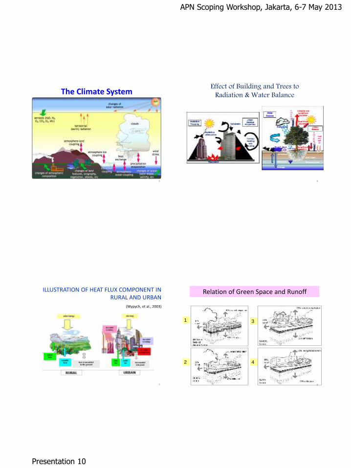
The Climate System
5
Effect of Building and Trees to Radiation & Water Balance
6
ILLUSTRATION OF HEAT FLUX COMPONENT IN RURAL AND URBAN
(Wypych, et al., 2003)
7
Relation of Green Space and Runoff
1
4
3
2
8
APN Scoping Workshop, Jakarta, 6-7 May 2013
Presentation 10
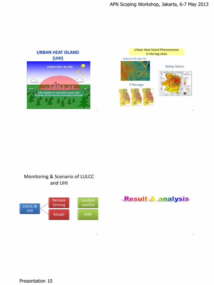
URBAN HEAT ISLAND (UHI)
9
Urban Heat Island Phenomenon in the big cities
10
Monitoring & Scenario of LULCC and UHI
LULCC & UHI
Remote Sensing
Landsat satellite
Model WRF
11 12
APN Scoping Workshop, Jakarta, 6-7 May 2013
Presentation 10
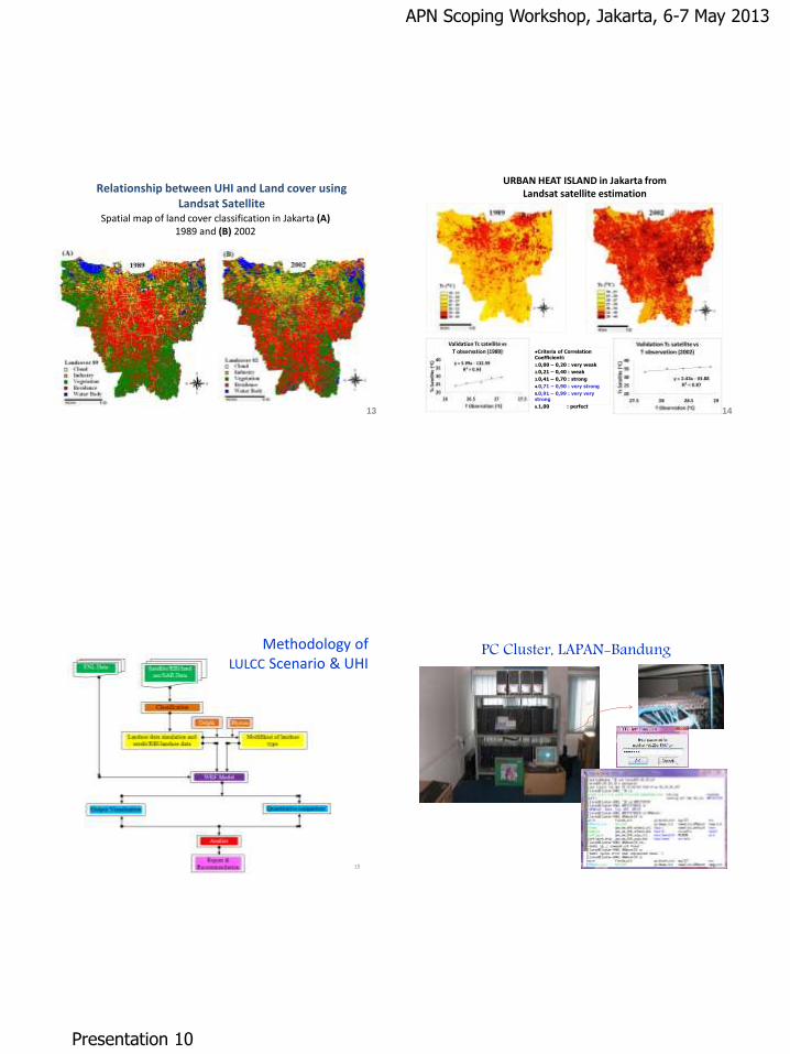
Relationship between UHI and Land cover using Landsat Satellite
13
Spatial map of land cover classification in Jakarta (A) 1989 and (B) 2002
14
URBAN HEAT ISLAND in Jakarta from Landsat satellite estimation
Criteria of Correlation Coefficienti:
1.0,00 – 0,20 : very weak
2.0,21 – 0,40 : weak
3.0,41 – 0,70 : strong
4.0,71 – 0,90 : very strong
5.0,91 – 0,99 : very very strong
6.1,00 : perfect
15
Methodology of LULCC Scenario & UHI
PC Cluster, LAPAN-Bandung
16
APN Scoping Workshop, Jakarta, 6-7 May 2013
Presentation 10
Scheme of UCM (Urban Climate Model)
Land use
Original LU
USGS
RBI map
(24 class)
IKONOS
satellite data
(27 class)
UCM
WRF
Heat storage
Anthropogenic
heat flux
Radiation
trapping
17
1
2
3 4
18
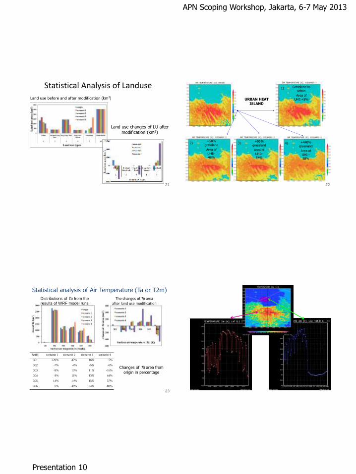
RUNNING RESULT OF WRF MODEL 80 VARIABLES
19
Modification/Scenario of Landuse runs in Weather Research Forecast (WRF) model
+58% grassland
+95% grassland
+440% grassland
Grassland to urban
1)
2) 3) 4)
20
APN Scoping Workshop, Jakarta, 6-7 May 2013
Presentation 10
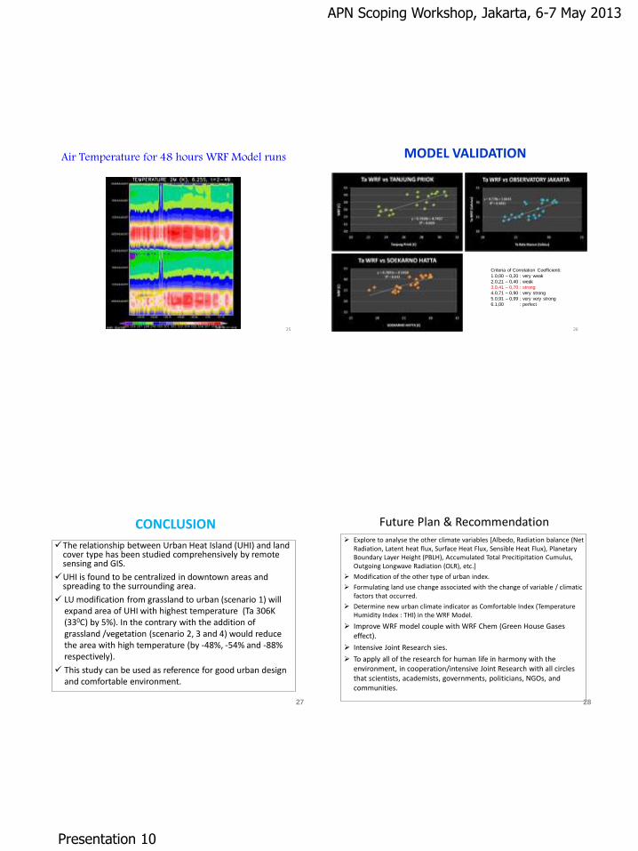
Statistical Analysis of Landuse
Land use before and after modification (km2)
21
Land use changes of LU after modification (km2)
URBAN HEAT ISLAND
+58% grassland
Area of
UHI:-48%
+95% grassland
Area of
UHI:-54%
+440% grassland
Area of
UHI:-88%
Grassland to urban
Area of
UHI:+5%
1)
2) 3) 4)
22
Ta (K) scenario 1 scenario 2 scenario 3 scenario 4
301 226% 47% 16% 5%
302 -7% -4% -5% -6%
303 -9% 10% 11% -16%
304 9% 11% 13% 44%
305 14% 14% 15% 37%
306 5% -48% -54% -88%
Distributions of Ta from the
results of WRF model runs
Changes of Ta area from
origin in percentage
23
Statistical analysis of Air Temperature (Ta or T2m)
The changes of Ta area after land use modification
24
APN Scoping Workshop, Jakarta, 6-7 May 2013
Presentation 10
Air Temperature for 48 hours WRF Model runs
25
MODEL VALIDATION
Criteria of Correlation Coefficienti:
1.0,00 – 0,20 : very weak
2.0,21 – 0,40 : weak
3.0,41 – 0,70 : strong
4.0,71 – 0,90 : very strong
5.0,91 – 0,99 : very very strong
6.1,00 : perfect
26
CONCLUSION
The relationship between Urban Heat Island (UHI) and land cover type has been studied comprehensively by remote sensing and GIS.
UHI is found to be centralized in downtown areas and spreading to the surrounding area.
LU modification from grassland to urban (scenario 1) will expand area of UHI with highest temperature (Ta 306K (330C) by 5%). In the contrary with the addition of grassland /vegetation (scenario 2, 3 and 4) would reduce the area with high temperature (by -48%, -54% and -88% respectively).
This study can be used as reference for good urban design and comfortable environment.
27
Future Plan & Recommendation Explore to analyse the other climate variables [Albedo, Radiation balance (Net
Radiation, Latent heat flux, Surface Heat Flux, Sensible Heat Flux), Planetary Boundary Layer Height (PBLH), Accumulated Total Precitipitation Cumulus, Outgoing Longwave Radiation (OLR), etc.]
Modification of the other type of urban index.
Formulating land use change associated with the change of variable / climatic factors that occurred.
Determine new urban climate indicator as Comfortable Index (Temperature Humidity Index : THI) in the WRF Model.
Improve WRF model couple with WRF Chem (Green House Gases effect).
Intensive Joint Research sies.
To apply all of the research for human life in harmony with the environment, in cooperation/intensive Joint Research with all circles that scientists, academists, governments, politicians, NGOs, and communities.
28

APN Scoping Workshop, Jakarta, 6-7 May 2013
Presentation 10
29
APN Scoping Workshop, Jakarta, 6-7 May 2013
Presentation 11
Climate Change Adaptation intergrade to Urban planning:
Experiences from Asia countries to
Vietnam
Country: Vietnam
SPG: Dr. Ngo Kim Chi
Presenter by: PhD. MBA Ngo Kim Chi- SPG member of Vietnam
APN Scoping WS, Hotel Grand Cempaka, Indonesia, 6-7 May, 2013
INTERACTIVE SESSION I
First glance in Vietnam and urban area: The population: 87,84 million
(2011), growth rate 1,05%, Urban population: 46.5%.
High population in urban area: 20,8% - Agricultural-forest lands: 79,2%.
Industry: 232 Industrial parks, high population- economic zones located in
coastal zone and in main river basins: Mekong, Red river.
GDP: 7.3%, industry 29% to 41% of GDP, capita income rose (US$ 260 in
1995 to US$ 835 in 2007; 1407 in 2008-2011. Vietnam impacted by CC.
EXTREMES: Frequency of tropical cyclones that affect Vietnam has
increased by 0.43 event per decade in the past 50 years.
RAINFALL - FLOOD: 2009, 2010, 2011, 2012 extreme heavy rainfall - flood –
loss- damages. 6-8 heavy floods/year
SEA LEVEL RISE: increased by 0.398 cm per year (1981-2006) at Vung Tau
Sea level rise: longer a warning, happening sooner to coastal zone, especially Hochiminh
city, Can tho city (South), Haiphong, Nam Dinh, Thanh Hoa (North).
MEAN ANNUAL TEMPERATURE: Increased by 0.4°C since 1960, the rate of increase more
rapid in the dry seasons (November, December, January; February, March, April) and in the
southern parts of Vietnam. Frequency of ‘hot’ days (1998, 2002, 2003, 2006, 2007 and
2009 ) increased since 1960, annual frequency of ‘cold’ days decreased.
Heat waves – Drough in wide area.
Storm. "El Niño", more frequent storm frequency, stronger, wider, deeper, major damage due
to population density areas
INTERACTIVE SESSION I
APN Scoping Workshop, Jakarta, 6-7 May 2013
Presentation 11
INTERACTIVE SESSION I
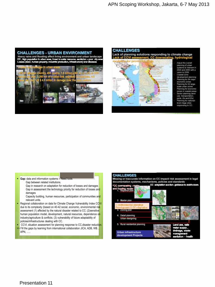
Impact of climate change to urban area
INTERACTIVE SESSION I
Gap: data and information systems – Need tools
Gap between related institutions.
Gap in research on adaptation for reduction of losses and damages
Gap in assessment the technology priority for reduction of losses and
damages
Capacity building, human resources, participation of communities and
relevant units.
Regional collaboration on data for Climate Change Vulnerability Index CCVI
due to its complexity (based on 40-42 social, economic, environmental risk
assessment (1) affected by the natural disaster related to CC; (2)sensitive
human population model, development, natural resources, dependence on
industry/agriculture & conflicts; (3) vulnerability of future adaptability of
policies/infrastructures dealing with CC.
CCVI, situation assessment for planning response to CC,disaster reduction.
=> Fill the gaps by learning from international collaboration JICA, ADB, WB…
APN, …..
INTERACTIVE SESSION I
APN Scoping Workshop, Jakarta, 6-7 May 2013
Presentation 11
INTERACTIVE SESSION I
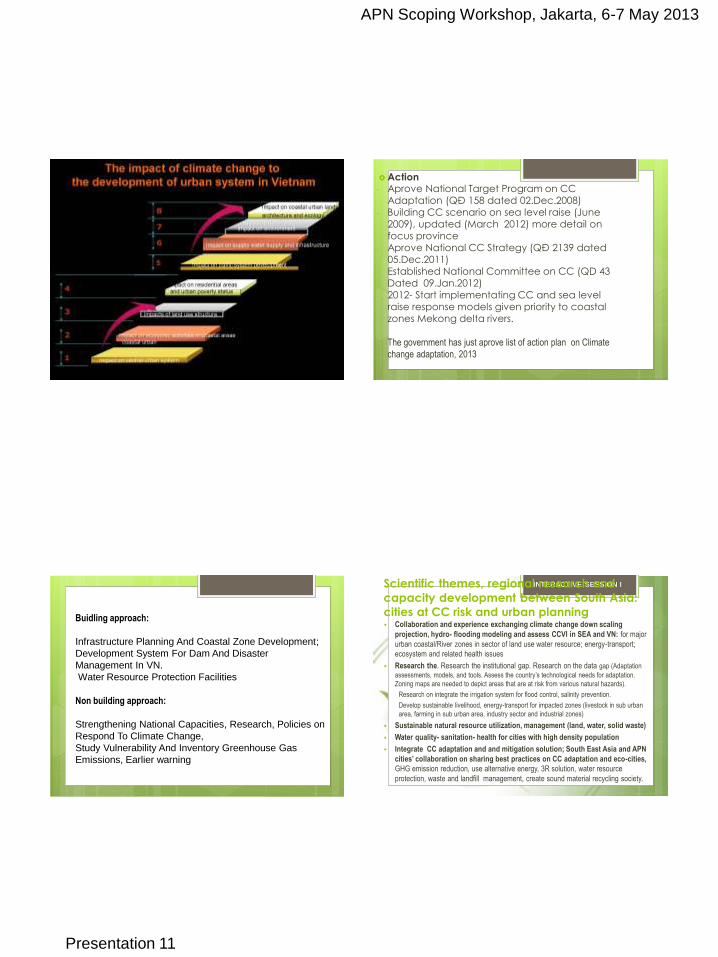
Action - Aprove National Target Program on CC
Adaptation (QĐ 158 dated 02.Dec.2008) - Building CC scenario on sea level raise (June
2009), updated (March 2012) more detail on focus province
- Aprove National CC Strategy (QĐ 2139 dated 05.Dec.2011)
- Established National Committee on CC (QD 43 Dated 09.Jan.2012)
- 2012- Start implementating CC and sea level raise response models given priority to coastal zones Mekong delta rivers.
- The government has just aprove list of action plan on Climate
change adaptation, 2013
Buidling approach:
Infrastructure Planning And Coastal Zone Development;
Development System For Dam And Disaster
Management In VN.
Water Resource Protection Facilities
Non building approach:
Strengthening National Capacities, Research, Policies on
Respond To Climate Change,
Study Vulnerability And Inventory Greenhouse Gas
Emissions, Earlier warning
INTERACTIVE SESSION I
Scientific themes, regional research and
capacity development between South Asia:
cities at CC risk and urban planning Collaboration and experience exchanging climate change down scaling
projection, hydro- flooding modeling and assess CCVI in SEA and VN: for major
urban coastal/River zones in sector of land use water resource; energy-transport;
ecosystem and related health issues
Research the. Research the institutional gap. Research on the data gap (Adaptation
assessments, models, and tools. Assess the country’s technological needs for adaptation.
Zoning maps are needed to depict areas that are at risk from various natural hazards).
Research on integrate the irrigation system for flood control, salinity prevention.
Develop sustainable livelihood, energy-transport for impacted zones (livestock in sub urban
area, farming in sub urban area, industry sector and industrial zones)
Sustainable natural resource utilization, management (land, water, solid waste)
Water quality- sanitation- health for cities with high density population
Integrate CC adaptation and and mitigation solution; South East Asia and APN
cities’ collaboration on sharing best practices on CC adaptation and eco-cities,
GHG emission reduction, use alternative energy, 3R solution, water resource
protection, waste and landfill management, create sound material recycling society.
APN Scoping Workshop, Jakarta, 6-7 May 2013
Presentation 11
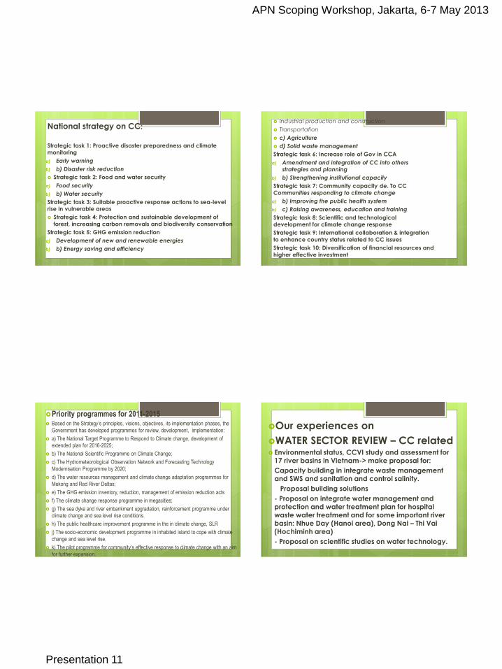
National strategy on CC:
Strategic task 1: Proactive disaster preparedness and climate monitoring
a) Early warning
b) b) Disaster risk reduction
Strategic task 2: Food and water security
a) Food security
b) b) Water security
Strategic task 3: Suitable proactive response actions to sea-level rise in vulnerable areas
Strategic task 4: Protection and sustainable development of
forest, increasing carbon removals and biodiversity conservation
Strategic task 5: GHG emission reduction
a) Development of new and renewable energies
b) b) Energy saving and efficiency
Industrial production and construction
Transportation
c) Agriculture
d) Solid waste management
Strategic task 6: Increase role of Gov in CCA
a) Amendment and integration of CC into others strategies and planning
b) b) Strengthening institutional capacity
Strategic task 7: Community capacity de. To CC
Communities responding to climate change
a) b) Improving the public health system
b) c) Raising awareness, education and training
Strategic task 8: Scientific and technological
development for climate change response
Strategic task 9: International collaboration & integration
to enhance country status related to CC issues
Strategic task 10: Diversification of financial resources and
higher effective investment
Priority programmes for 2011-2015 Based on the Strategy’s principles, visions, objectives, its implementation phases, the
Government has developed programmes for review, development, implementation:
a) The National Target Programme to Respond to Climate change, development of
extended plan for 2016-2025;
b) The National Scientific Programme on Climate Change;
c) The Hydrometeorological Observation Network and Forecasting Technology
Modernisation Programme by 2020;
d) The water resources management and climate change adaptation programmes for
Mekong and Red River Deltas;
e) The GHG emission inventory, reduction, management of emission reduction acts
f) The climate change response programme in megacities;
g) The sea dyke and river embankment upgradation, reinforcement programme under
climate change and sea level rise conditions.
h) The public healthcare improvement programme in the in climate change, SLR
j) The socio-economic development programme in inhabited island to cope with climate
change and sea level rise.
k) The pilot programme for community’s effective response to climate change with an aim
for further expansion.
Our experiences on
WATER SECTOR REVIEW – CC related Environmental status, CCVI study and assessment for
17 river basins in Vietnam-> make proposal for:
- Capacity building in integrate waste management and SWS and sanitation and control salinity.
- Proposal building solutions
- - Proposal on integrate water management and protection and water treatment plan for hospital waste water treatment and for some important river basin: Nhue Day (Hanoi area), Dong Nai – Thi Vai (Hochiminh area)
- - Proposal on scientific studies on water technology.
APN Scoping Workshop, Jakarta, 6-7 May 2013
Presentation 11
INTERACTIVE SESSION I
P
GHG emissions
-1,000,000
-500,000
0
500,000
1,000,000
1,500,000
2,000,000
Debits Credits Debits Credits Debits Credits Net
Recycled waste Disposed of waste Total MSW treatment
ton
ne C
O2-e
q/y
r
BS 2015
2020 2025
GHG emissions
-1,000,000
-500,000
0
500,000
1,000,000
1,500,000
2,000,000
Debits Credits Debits Credits Debits Credits Net
Recycled waste Disposed of waste Total MSW treatment
ton
ne C
O2-e
q/y
r
BS 2015
2020 2025
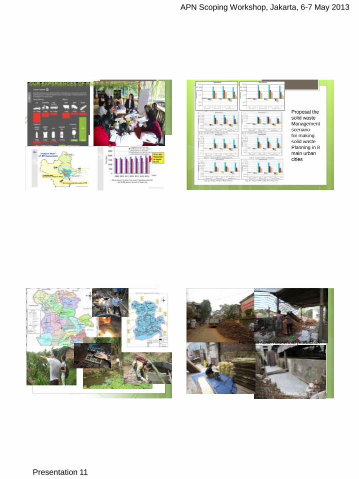
Proposal the
solid waste
Management
scenario
for making
solid waste
Planning in 8
main urban
cities
INTERACTIVE SESSION I
Environmental status
assessment
Environmental planning
and water protection for
stakeholders (family,
enterprise and community)
INTERACTIVE SESSION I
For small scale household production
APN Scoping Workshop, Jakarta, 6-7 May 2013
Presentation 11
INTERACTIVE SESSION I
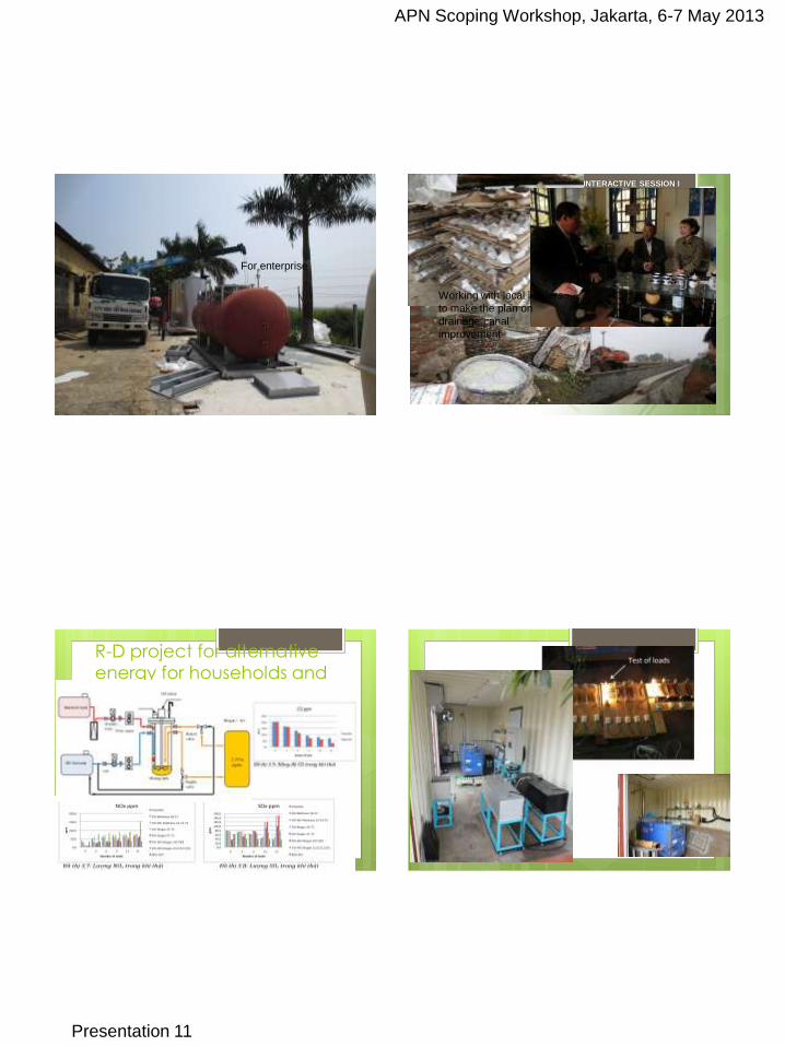
For enterprise
INTERACTIVE SESSION I
Working with local leaders
to make the plan on
drainage canal
improvement
R-D project for alternative energy for households and enterprises
APN Scoping Workshop, Jakarta, 6-7 May 2013
Presentation 11
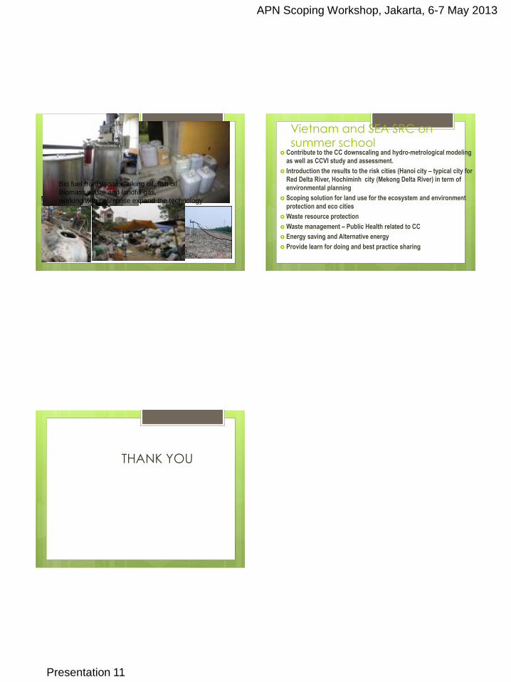
Bio fuel from waste cooking oil, fish oil
Biomass waste and landfill gas,
working with enterprise expand the technology
Vietnam and SEA SRC on summer school
Contribute to the CC downscaling and hydro-metrological modeling
as well as CCVI study and assessment.
Introduction the results to the risk cities (Hanoi city – typical city for
Red Delta River, Hochiminh city (Mekong Delta River) in term of
environmental planning
Scoping solution for land use for the ecosystem and environment
protection and eco cities
Waste resource protection
Waste management – Public Health related to CC
Energy saving and Alternative energy
Provide learn for doing and best practice sharing
THANK YOU