Chris Birchfield Atmospheric Sciences, Spanish minor.
26
Sensitivity of High-Resolution Simulations of Hurricane Bob (1991) to Planetary Boundary Layer Parametrizations Scott A. Braun & Wei-Kuo Tao Chris Birchfield Atmospheric Sciences, Spanish minor
-
Upload
tracy-townsend -
Category
Documents
-
view
224 -
download
6
Transcript of Chris Birchfield Atmospheric Sciences, Spanish minor.

Sensitivity of High-Resolution Simulations of Hurricane Bob
(1991) to Planetary Boundary Layer Parametrizations
Scott A. Braun & Wei-Kuo Tao
Chris BirchfieldAtmospheric Sciences, Spanish minor
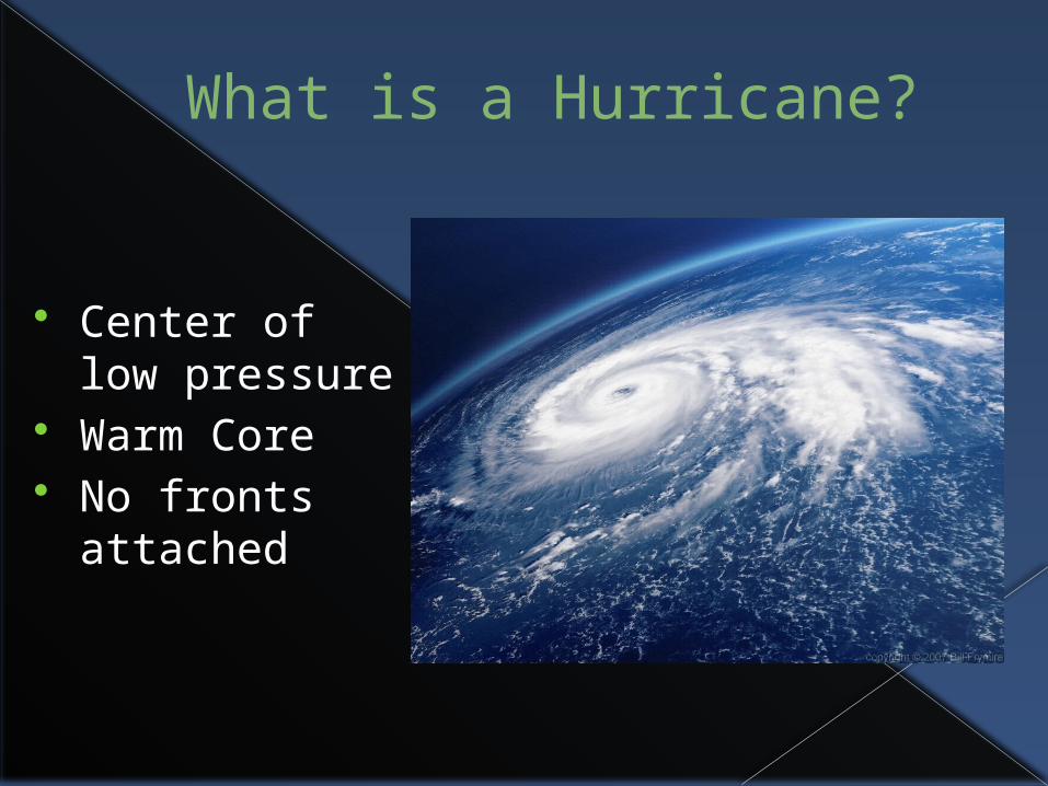
What is a Hurricane?
Center of low pressure
Warm Core No fronts
attached

How do they form?
Warm tropical oceans between 8° and 20° latitude
Typically 80°F< Tropical disturbance Convection - Thunderstorms form Rotation due to Coriolis Force Depression Tropical Storm
Hurricane

Anatomy of a Hurricane

Saffir-Simpson Hurricane Scale

Purpose of this research
Inner-core observations of hurricanes limited to dropsondes or buoys
Modelers forced to use high-sensitivity PBL parameterizations
Importance of surface fluxes & vertical mixing
Equivalent potential temperature (Θe)

Hurricane Bob (1991)

9 total simulations conducted
Burk-Thompson PBL scheme Bulk-Aerodynamic PBL scheme Blackadar PBL scheme MRF PBL scheme BL/BT BL/BU1 BL/BU2 BU/BT MRF/BT

Map of domains
Domain A – 36-km grid
Domain B – 12-km grid
C1 & C2 – moving 4-km grids

Simulation of MM5 Model Used to conduct 72-hr simulations Uses course grid of 193 X 163 grid points Uses x,y spacing of 36 km (fig.1) Grid centered at 33°N, 84°W Conditions were obtained from ECMWF 9 high-resolution simulations

Min Pressure & Max Winds

Surface Wind Analysis
Shows max winds in excess of 50 m/s E
Shaded region = winds of 35< m/s

Winds at lowest (42m) level
BT yields winds of 55< m/s
BA has wavenumber 2 pattern. 100 km area of 35 m/s winds
BL and MRF display weaker winds

NEXRAD radar (Cape Hatteras, NC)
Indicates partial eyewall
Radius of ~25km Northern convective
bands showed high reflectivities

Simulated Radar Reflectivity
Each case shows defined eyewall
Precipitation less defined – more scattered

Vertical Cross Sections (1)
BT
BA
BL
MRF
Vertical Velocity Tangential Velocity

Vertical Cross Sections (2)
BT
BA
BL
MRF
Radial Velocity Equivalent Potential Energy (Θe)

Vertical Cross Sections (3)
BT
BA
BL
MRF
Avg. Tangential Velocity Temp. Tendency

Vertical Cross Sections (4)
BT
BA
BL
MRF
Water Vapor Tendencies Eddy Diffusivity Coefficient

PBL Moisture Tendency Equation
qv = Vapor mixing ratio K = Eddy diffusivity Lv = Latent heat of vaporization ρ = Density of air Δz1 = Vertical grid increment of lowest
layer

Surface Fluxes and Exchange coefficients
Es & Cq = Moisture Hs & C0 = Heat τ s & CD = Momentum Ck = Enthalpy

Drag Coefficients
Blackadar agrees with Hawkins and Imbembo up to 45 m/s
BT values parallel, but lower due to weaker dependence of zo.
BA is uniform due to lack of wind speed dependence zo

Min SLP & Max Wind Speed
Original Blackadar produces weakest storm (Ck/CD) is smallest
BL/BU1 neglecting zo produces the strongest storm
BL/BU2 including zo
does not produce strongest

Conclusion
The MM5 model simulated Hurricane Bob in high resolution
Results exhibited high sensitivity to PBL processes.
Min SLP and max winds varied by 16mb and 15 m/s
BT & BA produced the strongest storms Vertical structures similar in BT, BL and BA Each PBL scheme differed in vertical mixing

Conclusion Cont’d
Intensity increases as Ck/CD increases Surface fluxes & vertical mixing differ
difficult to ascertain individual roles. Simulated intensity varies depending on
wind speed dependence of the surface roughness parameter z0
Precipitation forecasts very sensitive
Obtaining measurements for heat, moisture, momentum essential.
Dropsondes & Doppler Radar play significant role in observing the depth.

Future Research
More measurements Dissipative heating Sea spray Ocean-atmosphere
coupling