China's Nine-Dashed Map: Maritime Source of Geopolitical ...
46
Purdue University Purdue e-Pubs Libraries Faculty and Staff Scholarship and Research Purdue Libraries 10-30-2014 China's Nine-Dashed Map: Maritime Source of Geopolitical Tension Bert Chapman Purdue University, [email protected] Follow this and additional works at: hp://docs.lib.purdue.edu/lib_fsdocs Part of the Admiralty Commons , American Politics Commons , Asian Studies Commons , Comparative Politics Commons , Defense and Security Studies Commons , Energy Policy Commons , International Law Commons , International Relations Commons , International Trade Commons , Military Studies Commons , Military, War and Peace Commons , National Security Commons , Other Geography Commons , and the Transnational Law Commons is document has been made available through Purdue e-Pubs, a service of the Purdue University Libraries. Please contact [email protected] for additional information. Recommended Citation Chapman, B. (2014) China's Nine-Dashed Map: Maritime Source of Geopolitical Tension. Mackinder Forum Commentary. e Mackinder Forum. Retrieved from hp://www.mackinderforum.org/commentaries/china2019s-nine-dashed-map-maritime-source- of-geopolitical-tension/china2019s-nine-dashed-map-maritime-source-of-geopolitical-tension
Transcript of China's Nine-Dashed Map: Maritime Source of Geopolitical ...

Purdue UniversityPurdue e-Pubs
Libraries Faculty and Staff Scholarship and Research Purdue Libraries
10-30-2014
China's Nine-Dashed Map: Maritime Source ofGeopolitical TensionBert ChapmanPurdue University, [email protected]
Follow this and additional works at: http://docs.lib.purdue.edu/lib_fsdocsPart of the Admiralty Commons, American Politics Commons, Asian Studies Commons,
Comparative Politics Commons, Defense and Security Studies Commons, Energy Policy Commons,International Law Commons, International Relations Commons, International Trade Commons,Military Studies Commons, Military, War and Peace Commons, National Security Commons, OtherGeography Commons, and the Transnational Law Commons
This document has been made available through Purdue e-Pubs, a service of the Purdue University Libraries. Please contact [email protected] foradditional information.
Recommended CitationChapman, B. (2014) China's Nine-Dashed Map: Maritime Source of Geopolitical Tension. Mackinder Forum Commentary. TheMackinder Forum. Retrieved from http://www.mackinderforum.org/commentaries/china2019s-nine-dashed-map-maritime-source-of-geopolitical-tension/china2019s-nine-dashed-map-maritime-source-of-geopolitical-tension

China’s Nine-Dashed Map: Maritime Source of Geopolitical Tension
Bert Chapman
Government Information, Political Science, & Economics
Librarian/
Professor of Library Science
Purdue University Libraries
West Lafayette, IN
Abstract: The South China Sea (SCS) is becoming an increasingly contentious
source of geopolitical tension due to its significance as an international trade
route, possessor of potentially significant oil and natural gas resources, China’s
increasing diplomatic and military assertiveness, and the U.S.’ recent and
ongoing Pacific Pivot strategy. Countries as varied as China, Taiwan, the
Philippines, Indonesia and other adjacent countries have claims on this region’s
islands and natural resources. China has been particularly assertive in asserting
its SCS claims by creating a nine-dash line map claiming to give it de facto
maritime control over this entire region without regard to international law on
claimed land features and without providing transparency for the rationale
behind its assertions. Regional countries are responding by increasing defense
spending and developing responses to Chinese assertiveness such as the 2014
Australia-Japan defense technology sharing agreement. This presentation will
examine the reactions to Beijing’s assertiveness by other Asian-Pacific
countries including Australia, Japan, other Southeast Asian countries, and the
U.S.
Introduction-The beginning of Fall 2014 sees international attention justifiably
focused on the military confrontation between the U.S. and various allies and
the Islamic State in Iraq and Syria. International geopolitical attention during

this year has also been focused on Russian annexation of Crimea and Moscow’s
aggressiveness toward Ukraine, and ongoing areas of crisis involving
Afghanistan, Iran, and Pakistan. While all of these international security crisis
centers are important, geopolitical observers must also recognize the SCS’
increasing strategic importance and source of international tension during the
second decade of this millennium.
This body of water encompasses nations as diverse as China, the Philippines,
Vietnam, Malaysia, and Indonesia and affects the trading and strategic
interests of many world countries including the Australia, India, Japan, and the
United States. It is a semi-enclosed area bordered on the west by Vietnam, on
the east by Brunei, Malaysia, and the Philippines, on the South by Indonesia
and Malaysia, and on the north by China and Taiwan covering an area
approximately 550-650 nautical miles wide and a length of over 1,200 nautical
miles. China’s growing diplomatic, economic, and military power have
increased Beijing’s assertiveness toward the SCS and culminated in it issuing
the following nine-dashed map to highlight its territorial, island, seabed, and
waterborne claims to this region with an another map reflecting the disputed
Paracel and Spratly Islands in the SCS claimed by adjacent countries. Concern

over increasing Chinese assertiveness in the SCS and the issuance of this map is
reflected in multiple sources[1].

Courtesy: STRATFOR
These claims, according to Beijing, reflect and are justified by the experience
of historic surveying expeditions, fishing, and naval activities dating back to the
15th
century. Claims to this area are also reflected in a 1947 map drawn by the
defunct Kuomintang government and reaffirmed in official maps published by
the People’s Republic of China from 1949-present. China’s lofty sense of its
historical maritime influence was demonstrated in an October 24, 2003

address to the Australian Parliament, 2003, when Chinese President Hu Jintao
claimed that Chinese mariner Zheng He’s exploration fleet had sailed as far
south as Australia in the 1420s. A 2013 map issued by China’s State Bureau of
Surveying and Mapping adds a tenth dash placed east of Taiwan incorporating
that nation into China within 70 miles of Yonaguni which is Japan’s
westernmost island in the Ryukyu Island chain. This map is also featured as a
background in new Chinese passports drawing protests from the Philippines
and Vietnam[2].

Ten-dash map including Taiwan as part of China. Courtesy: Australian
Strategic Policy Institute.
In May 2009 Beijing’s submitted a claim to the United Nations Commission
on the Law of the Sea (UNCLOS), the international organization striving to
establish a legal framework governing all uses of oceans, using the nine-dashed
map claiming indisputable sovereignty over the entire body of water, islands,
seabed, and subsoil within the 200 mile nautical limits of the Outer Continental
Shelf[3]. This action produced acute concern among other neighboring states
with Malaysia and Vietnam filing a joint submission to UNCLOS this same
month contending that there are unresolved disputes in the territorial area
defined by the Chinese submission, that Kuala Lumpur and Hanoi and have
worked to get the cooperation of other adjacent coastal states, that this claim
adheres to UNCLOS Article 76 covering continental shelf claims, and that these
two countries may make further supporting claims on this topic to UNCLOS[4].
Natural Resources and Trade Routes-The SCS is a major international trade
route, adjoining nations are large energy resource consumers, and it is also the
site of potentially monumental energy resources. The U.S. Energy Information
Administration (EIA) notes that non-OECD liquid fuel consumption in Asian
countries is expected to grow annually by 2.6% from 20% of global

consumption in 2008 to over 30% of global consumption by 2035. EIA also
projects non-OECD Asian natural gas consumption to grow 3.9% annually from
10% of global natural gas consumption in 2008 to 19% by 2035 with China
projected to account for 43% of this growth[5].
EIA also estimates that the SCS contains nearly 11 billion barrels of oil and
190 trillion cubic feet of natural gas in proved and probable reserves. In
addition, the U.S. Geological Survey has done additional analysis of potential
undiscovered conventional oil and gas fields in several Southeast Asia geologic
provinces in 2010 as part of its World Petroleum Resources Assessment
Project. This study concluded that there could be between 5 and 22 billion
barrels of undiscovered oil and 70 and 290 trillion cubic feet of undiscovered
natural gas in these regions though the cost of extracting these resources
would be high[6].
Over half of annual global merchant fleet tonnage passes through the
Lombok, Malacca, and Sunda Straits continuing to the SCS including nearly 1/3
of global crude oil and over ½ of global liquefied natural gas (LNG) trade
passing through the SCS. Asia’s growing energy demand leads EIA to expect
increased oil flow from producers in the Persian Gulf and Africa to pass through
the SCS with the Malacca Strait being the shortest sea route between these

suppliers and Asian markets. This also applies to LNG trade with SCS countries
importing from supplier countries as varied as Australia, Indonesia, Malaysia,
and Qatar accounting for nearly 75% of LNG exports to this region[7].
China’s Claims-China insists its historic claims cover four major archipelagic
groups in the SCS-Spratlys (Nanha), Paracels (Xisha), Pratas (Dongsha), and
Macclesfield Bank (Zongsha) along with Scarborough Reef (Huangyan Island).
There is considerable debate over whether China has claimed these areas since
ancient times, whether Beijing claims sovereignty over geographic features
such as islands, reefs, and shoals failing to meet UNCLOS definition of an island
under international law, and the validity of Beijing’s claims. Chinese strategists
also incorporate a first and second island chain on Western Pacific territories
into their geopolitical aspirations. The first island chain includes Indonesia, the
Korean Peninsula, Kurile Islands, Japan, the Philippines, and Taiwan. The
second island chain includes the U.S. territories of Guam and the Northern
Mariana Islands[8].

China Island Chains Map Courtesy: U.S. Department of Defense
International legal scholars have expressed concerns with the scope of
China’s claims including mentioning that naming an area in the SCS does not
establish sovereignty over it, ambiguity over the precise meaning of China’s
nine-dashed map, and asserting that cartographic dashes do not suggest
maritime boundary claims and have no impact on resolving maritime boundary
disputes. Additional problems include cartographic materials losing credibility
when they contradict each other, that ambiguous and incoherent cartography

weakens the evidentiary strength of a claim in international law, ambiguity in
defining historical waters, and that such maps need to be drawn up by neutral
experts instead of partisan countries to enhance their probative value in
international law[9].
Other Nations Claims-This situation is complicated further by other nations
claims to SCS waters, islands, reefs, and continental shelf. The Philippines
passed a law in 2009 saying that Scarborough Shoal and other islands Manila
claims in the SCS (Kalayaan Island Group) will be governed under UNCLOS
Article 121. The Philippines also notified UNCLOS’ Commission on the
Limitations of the Continental Shelf (CLCS) it intends to submit limitations on its
continental shelf in the SCS and that it will also claim an Exclusive Economic
Zone (EEZ) claim from its main archipelago’s archipelagic baselines and will also
claim an extended continental shelf into the SCS beyond its EEZ’s outer
limits[10].
On January 22, 2013, the Philippines informed the Chinese Embassy in
Manila that they had submitted an application with UNCLOS to arbitrate their
competing claims. This was rejected by the Chinese Ambassador to the
Philippines on February 19 and Beijing’s refusal to arbitrate this dispute has

strained bilateral relations between these countries and produced greater
obstacles to the Association of Southeast Asian Nations (ASEAN) and China
reaching a binding SCS Code of Conduct[11].
Taiwan takes a similar position to China claiming an EEZ of 200 nautical
miles. In May 2012, Taiwanese National Security Director General Tsai Der-
Sheng announced that Vietnam and the Philippines have asked Taiwan not to
work with China on South Sea issues. While Taipei generally favors peaceful
solutions to territorial disputes, some Taiwanese scholars and government
officials advocate more assertive actions. In April 2012 members of the
parliamentary Foreign and National Defense Committee visited Taiping island
where they were briefed by Taiwanese troops on their defense capabilities and
these islands have been reinforced by military personnel to augment to
Taipei’s sovereignty claims[12].
Malaysia has taken a nonconfrontational stance with China on this issue. It
has strong economic relationships with Beijing who became Kuala Lumpur’s
largest trading partner in 2010, Malaysia does not have the military capacity to
contest China’s claims, it does not have nationalist pressure to act against
China, and its politicians and public opinion are more concerned with maritime
disagreements with Indonesia[13].

Vietnam, in contrast, takes a more assertive approach on SCS matters
seeking to cooperate with the Philippines and Malaysia while also striving for
balance with Beijing to keep bilateral relations from being excessively strained.
Both Hanoi and Manila are heavily dependent on fishing though their
economics are increasingly tied to China. China and Vietnam reached a Gulf of
Tonkin delimitation agreement in 2000, but fought over disputed islands such
as the Paracels in 1974 and 1988 with China occupying these islands and
leading the Vietnamese to believe China is willing to use force to settle
territorial disputes. Hanoi also faces domestic nationalist pressure to stand up
to Beijing due to the centuries long historical enmity between these two
countries despite both being governed by Communist Parties. Vietnam’s
economy depends significantly on access to adjacent energy and fishing
resources and China’s nine-dashed map cutting through Vietnam’s EEZ renews
fears in Vietnam and other claimant nations that China aspires to claim both
island features and all waters within the nine-dashed map[14].
Recent years have seen numerous security incidents between China and
these countries. In June 2012, Vietnam passed a maritime law declaring its
jurisdiction over the Paracel and Spratly Islands and requiring all foreign naval
ships to notify Vietnamese authorities before entering these areas. China

expressed its opposition to this statute by establishing a prefecture level
administrative city Sansha on the Paracel’s Woody Island which would be
overseen by the central government. In addition, the state-owned Chinese
National Overseas Oil Company (CNOOC) contested Vietnamese energy claims
by inviting foreign oil companies to jointly exploit nine drilling blocks in
disputed areas two days after the Vietnamese law’s passage. Beijing’s
pressuring of foreign oil companies drilling in South China Sea followed upon
China telling U.S. and other foreign oil firms during Summer 2007 to stop
collaborating with Vietnamese oil drillers or face unspecified consequences in
their business dealings with China[15].

Maritime and Territorial Disputes Involving China including Paracel Islands,
Scarborough Shoal, and Spratly Islands in the South China Sea.
Courtesy: UNCLOS and CIA.
The Philippines and China have periodically had security incidents in these
waters. Beijing has accused the Philippines of occupying Chinese islands and
on January 27, 2014 a Chinese coast guard vessel used a water cannon to try to

drive away Philippine fisherman from Scarborough Shoal with Chinese
diplomatic personnel in Manila being summoned to the Foreign Ministry to
hear the government’s strongly worded protest. The Philippine Foreign
Ministry said nine such harassment incidents occurred during the previous year
and in February 2014 the U.S. Navy Commander said the U.S. would help the
Philippines if conflict resulted over these disputed waters[16].
Chinese Incidents with U.S. Military in SCS and Elsewhere-Chinese
assertiveness of its maritime and territorial claims in the SCS has not been
limited to adjacent countries. It has also targeted normal U.S. military and
intelligence gathering activities in this region over the past decade. On March
31, 2001 a U.S. EP-3 electronic naval surveillance plane was struck by a Chinese
fighter pilot and forced to make an emergency landing at China’s Hainan Island.
The Chinese pilot was killed and the U.S. crew was detained for eleven days
before being released although China was able to gain some sensitive
information about this plane’s technological capabilities[17]. Hainan Island
has become a militarily and strategically significant location for China featuring
a naval base hosting its first aircraft carrier, some of its submarine fleet, and
the Wenchang Space Launch facility as part of China’s space program
infrastructure[18].
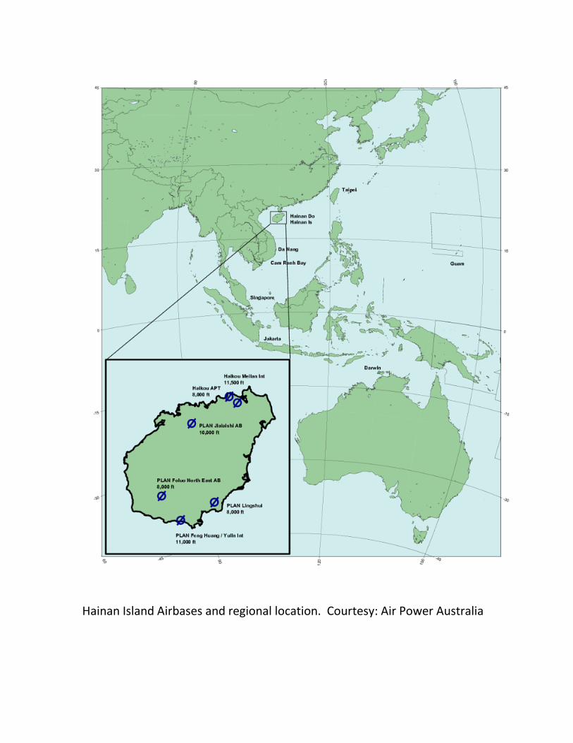
Hainan Island Airbases and regional location. Courtesy: Air Power Australia
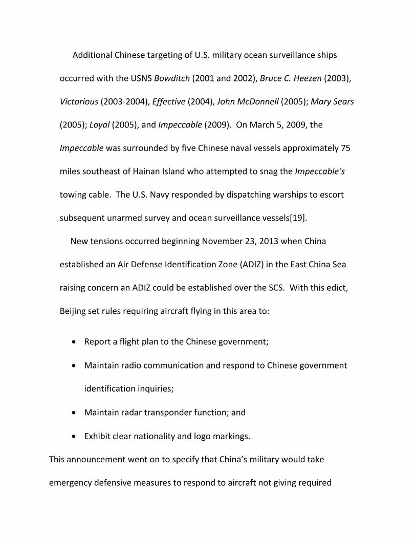
Additional Chinese targeting of U.S. military ocean surveillance ships
occurred with the USNS Bowditch (2001 and 2002), Bruce C. Heezen (2003),
Victorious (2003-2004), Effective (2004), John McDonnell (2005); Mary Sears
(2005); Loyal (2005), and Impeccable (2009). On March 5, 2009, the
Impeccable was surrounded by five Chinese naval vessels approximately 75
miles southeast of Hainan Island who attempted to snag the Impeccable’s
towing cable. The U.S. Navy responded by dispatching warships to escort
subsequent unarmed survey and ocean surveillance vessels[19].
New tensions occurred beginning November 23, 2013 when China
established an Air Defense Identification Zone (ADIZ) in the East China Sea
raising concern an ADIZ could be established over the SCS. With this edict,
Beijing set rules requiring aircraft flying in this area to:
• Report a flight plan to the Chinese government;
• Maintain radio communication and respond to Chinese government
identification inquiries;
• Maintain radar transponder function; and
• Exhibit clear nationality and logo markings.
This announcement went on to specify that China’s military would take
emergency defensive measures to respond to aircraft not giving required

identification[20].
On December 5, 2013, the missile cruiser USS Cowpens was conducting
surveillance of China’s Liaoning carrier battle group about 32 miles southeast of
Hainan Island. Two Chinese naval vessels approached the Cowpens with one of
them altering course and crossing directly in front of the Cowpens bow forcing it
to come to a complete stop to avoid a collision while the Chinese ship passed less
than 100 yards in front. This behavior by China violates professional maritime
behavior such as the Convention of International Regulations for Preventing
Collisions at Sea in which China participates[21].
Further Chinese aggressiveness toward U.S. military assets occurred on August
19, 2014 when an armed Chinese jet fighter conducted a dangerous intercept of a
Navy P-8 Poseidon patrol aircraft in international airspace 135 miles east of
Hainan Island. Pentagon Press Secretary Rear Admiral John Kirby told reporters
that the Chinese jet made several passes of the Poseidon crossing under the
aircraft within 50-100 feet. Kirby went on to mention the U.S. had expressed its
strong concern about this unsafe and unprofessional behavior to the Chinese[22].
On September 25, 2014, U.S. Pacific Command Commander Admiral Samuel
Locklear, when asked about increasing Chinese aircraft intercepts in that region,
acknowledged increasing Chinese aerial and naval activity in that region, said the

U.S. and China regularly interact about preventing misunderstandings or bad
interactions such as the August 19 incident, and expressed his hope that the U.S.
and China would respect each other’s international maritime and airspace
rights[23].
Regional Defense Spending Increases-This increasing tension occurs within a
strategic context of increased defense spending in recent years by nations
adjacent to the SCS and whose economic and strategic interests are directly
affected by developments in its waters. The Stockholm International Peace
Research Institute (SIPRI) Military Expenditure Database reports East Asian
nations military spending increased from $144 billion in 1998 to $318 billion in
2013. Per capita defense spending figures from these counties between 1998-
2013 also demonstrates significant increases:
Australia 1998 $380 2013 $1,033
Brunei 1998 $927 2013 $1,015
China 1998 $14.60 2013 $138.50
Indonesia 1998 $3 2013 $31.60
Japan 1998 $290 2013 $381.70
Malaysia 1998 $51.80 2013 $161.60
Philippines 1998 $16.50 2013 $35.62
South Korea 1998 $226 2013 $675.60
Taiwan 1998 $421 2013 449.90
Vietnam 2003 $10.50 2013 $37.80[24]

The significant economic growth of many of these countries has enabled most
of them to achieve these increased defense expenditures without having this
spending account for additional percentages in their annual government spending
as the following figures demonstrate:
Australia 1998 5.7% 2013 4.4%
Brunei 1998 12.1% 2013 6.7%
China 1998 11.9% 2013 8.3%
Indonesia 1998 3.8% 2013 4.4%
Japan 1998 2.7% 2013 2.4%
Malaysia 1998 6.4% 2013 5.2%
Philippines 1998 9.1% 2013 6.8%
South Korea 1998 6.4% 2013 12.8%
Taiwan 1998 11.6% 2013 11.0%
Vietnam 2003 7.6% 2013 5.1%[25]
Increasing tensions in the SCS region are likely to drive further defense
spending increases by adjacent countries with Chinese defense spending and
increasing regional assertiveness and the U.S.’ pivot to the Asia-Pacific likely to
play critical roles in ensuring the SCS region’s vulnerability to regional or
international conflict. Such conflict is likely to involve or affect powers from
outside the SCS such as the Australia, Japan, and the U.S. and impact the interests
of powers as far away as India and Europe[26].
U.S. and Allied Responses-The U.S. has not taken a formal position on SCS
territorial claims. At the July 23, 2010 ASEAN Regional Forum meeting in Hanoi,
Secretary of State Hillary Clinton reaffirmed traditional U.S. support for freedom
of navigation and respect for international law, and opposed claimants using
force. She went on to stress that maritime claims should be derived solely from
legitimate claims to land features. Additional characteristics of U.S. SCS policy
include peacefully resolving territorial disputes without threats of coercion or
intimidation, parties avoiding taking provocative or unilateral actions which might
disrupt the status quo and jeopardize and security, opposing claims impinging on
lawful rights, freedoms, and uses of the sea belonging to lawful nations, that that
coastal states do not have the right under UNCLOS to regulate foreign military
activities in their EEZ’s[27]. The U.S. also issues annual reports on attempts by
various nations to interfere with international freedom of navigation with the
Fiscal Year 2013 report charging China with making excessive maritime claims

including: excessive straight baselines; security jurisdiction in contiguous zones;
airspace jurisdiction over EEZ; domestic law criminalizing foreign entity survey
activity in EEZ; and requiring prior permission of innocent passage of foreign
military ships through territorial seas[28].
A more tangible rhetorical, though economically and militarily unresolved,
demonstration of U.S. commitment to resisting Chinese territorial claims in the
nine-dash map is Washington’s strategic Asia-Pacific pivot originating in 2010-
2011. Based on the questionable rationale that the need for a U.S. military
presence in the Mideast is declining and that this makes it necessary for the U.S.
to shift its military assets and emphasis to East Asia including nations adjoining
the SCS was noted in a January 5, 2012 Defense Department document. This
assessment stressed that U.S. economic and security interests are closely linked
to developments in an area encompassing the Western Pacific and East Asia into
the Indian Ocean region and South Asia. It went on to stress that the U.S. would
expand existing relationships with Asian allies and key partners to enhance
collective capacity for securing common interests[29].
A key policy declaration from this document announced the following
emphasis to maintain mutually cooperative dialogue with China while also
defending its interests and those of its Asia-Pacific allies:

The maintenance of peace, stability, the free flow of commerce, and
of U.S. influence in this dynamic region will depend in part on an under-
lying balance of military capability and presence. Over the long term,
China’s emergence as a regional power will have the potential to affect
the U.S. economy and our security in a variety of ways. Our two countries
have a strong stake in peace and stability in East Asia and an interest in
building a cooperative bilateral relationship. However, the growth of China’s
military power must be accompanied by greater clarity of its strategic
intentions in order to avoid causing friction in the region. The United States
will continue to make the necessary investments to ensure that we maintain
regional access and the ability to operate freely in keeping with our treaty
obligations and with international law. Working closely with our network of
allies and partners, we will continue to promote a rules-based international
order that ensures underlying stability and encourages the peaceful rise of
new powers, economic dynamism, and constructive defense cooperation[30].
The U.S. has taken some steps to demonstrate this pivot as evidenced by a
November 2011 agreement between President Obama and then Australian Prime
Minister Julia Gillard that deploys a few hundred Marines as a rotational force to
Darwin in Australia’s Northern Territory[31]. It is also increasing its already

significant military presence on Guam by transferring 8,000 Marines from the
Japanese island of Okinawa which is expected to occur by 2014. This increased
presence on Guam will also include Army construction of a missile defense
system, the addition of Air Force drones and B-52 bombers, and the Navy
expanding Guam’s port to accommodate visiting aircraft carriers, and providing
Vietnam $32 million to strengthen its maritime security[32].
The U.S. also seeks to develop Air-Sea Battle (ASB) doctrine to leverage U.S.
and allied air, cyberspace, land, sea, and space assets to reduce the risk these
forces face from growing Chinese anti-access air denial (A2AD) capabilities
seeking to prevent the U.S. and its allies from defending their Asia/Pacific
strategic interests through longer range precision weapons targeting airbases,
capital ships, land forces, network infrastructure, and space-based platforms.
This involves developing networked integrated forces to attack-in-depth and
disrupt, defeat, and destroy hostile forces. Budgetary funding for this remains
uncertain. The following maps illustrates the extent of shipping lanes in the Asia-
Pacific region and how Chinese control of the SCS and adjacent waters could have
injurious economic and strategic impact on the U.S. and its allies[33].

Courtesy: Australian Department of Defence

Courtesy: Center for Strategic and Budgetary Assessments
Australia-Japan Defense Cooperation Agreement and Additional Regional
Security Concerns-Other nations in the region who are concerned by the Obama
Administration’s strategic inconstancy and U.S. defense spending constraints are
exploring their own options for enhancing cooperation against what they see as
China’s hegemonic aspirations. An example of this is a 2014 Australian-Japanese
Defense Cooperation Agreement. Signed on July 8, 2014 by Australian Prime
Minister Tony Abbott and Japanese Prime Minister Shinzo Abe, this agreement

commits these countries to share relevant defense equipment and technology to
implement joint research, development, and production projects for enhancing
security and defense cooperation consistent with the United Nations Charter[34].
Australia is also acutely concerned with maintaining freedom of the seas due to
its proximity to the SCS and other strategic waterways such as the Indian and
Pacific Ocean[35]. In its consultation document for a proposed 2015 Defense
White Paper Australia’s Department of Defense included maritime sovereignty
disputes in North Asia and the SCS as areas of emerging security concerns which
might require direct Australian involvement[36].
Singaporean analyses of this issue stress the need for all parties to continue
dialogue, strive for maximum collaboration between interested states, stress the
limited possibility of short or medium-term conflict but remain concerned about
the possibility for miscalculations and limited confrontations, and prefer placing
less emphasis on sovereignty issues and more on joint resource exploration and
development[37].
India considers the Straits of Malacca leading from the SCS to the Indian Ocean
as a primary area of strategic concern and the SCS itself as a secondary concern in
its official Maritime Strategy document[38]. The 2014 edition of the East Asian
Strategic Review published by Japan’s National Institute of Defence Studies notes

that tension continues between ASEAN nations and China over territorial and
maritime rights in the SCS. It noted ASEAN had made partial progress to develop
a “code of conduct” with Beijing on this topic. In addition, this assessment also
recognized strengthening Philippine-U.S. military cooperation such as the April
2013 Balikatan (Shoulder-to-Shoulder) military exercise involving Japan and other
countries and also noted that the U.S. pivot toward the Asia-Pacific would see
Washington reinforce its military presence in the Philippines by increasing its
number of naval vessel calls at Subic Bay and by increasing its military assistance
to Manila nearly 70% from 2013-2014[39].
Conclusion-China’s nine-dashed map is an example of an aspiring hegemon
seeking to assert its muscle by coercively influencing its neighbors to submit to its
strategic objectives. It is not surprising that it makes such audacious and
unrealistic geopolitical claims at a time when the Obama Administration is seen as
being unwilling to forcibly defend U.S. geopolitical interests in this part of the
world by its inaction and hesitancy in other global crisis areas[40].
It would be desirable if the U.S. and other powers affected by SCS
developments would peacefully work to peacefully resolve their disputes in this
region. An Australian analyst suggests that a cooperative management regime is
necessary for the common interests of claimant countries. He believes a

management entity for the SCS should be established comprised of all
surrounding countries and that ASEAN and China should establish this
organization with the U.S. bringing the experience of ocean management instead
of increased military engagement. This approach is unlikely to work long-term
due to China’s reluctance to submit to international arbitration on this issue and
seeking to exploit ASEAN member countries internal politics to its benefit[41].
The U.S. should maintain regular discussion with China and candidly express its
concerns about Beijing’s aggressive actions in the SCS. The U.S. should also
increase its cooperation and collaboration with its regional partners to make the
costs of Chinese aggression to high. Specific examples of this would include
conducting regular military exercises with partner countries, providing them with
targeted military assets to deter and defeat Chinese aggressiveness such as A2AD
efforts, augmenting Vietnam’s Army and the military and intelligence capabilities
of allied SCS nations, developing financially and strategically realistic doctrine for
implanting ASB, threaten to support Uighur separatists in Western China, and
explicitly and publicly warning China that harassment of U.S. intelligence and
military activities and assets in the SCS will result in the use of lethal force.
U.S. and international policymakers should heed the following words from
Representative Steve Chabot (R-OH) who currently chairs the House Foreign

Foreign Affairs Committee’s Subcommittee on Asia and the Pacific on January 14,
2014:
We are witnessing a dangerously aggressive China trying to assert greater
control over these territories to change the regional status quo in a way that
violates the core principles of international law. The implications of these
actions for the United States are substantial since we have strategic and
economic interests that are increasingly threatened by the growing tension
and confrontational incidents in these waters.
An American presence in Asia is built on maintaining peace and stability
that is upheld through respect for international law, freedom of navigation,
and unhindered, lawful commerce in the maritime regions. This is pursued
through our alliances with Japan, South Korea, Australia, Thailand and the
Philippines, in addition to our steadfast relationships with Taiwan and
Singapore, and evolving relationships with Vietnam and Indonesia[42].
While much of American public opinion may be war weary, we must recognize
that the persistence of international crisis and potential military conflict is
inexorable. The world should carefully watch China’s response to pro-democracy
demonstrations in Hong Kong as an important indication of its potential future

activities in the SCS. China’s nine-dashed map claims for the South China Sea
may or may not produce international conflict, but the U.S. and its allies would be
wise to prepare domestic public opinion and militaries for the possibility of such
conflict in the years to come. Instead of being serene in the 21st
century, the SCS
and significant areas of the Pacific Ocean, may become the scene of explosive
combat and augment what scholar Colin Gray has described as Another Bloody
Century between multiple military powers due to this region’s growing economic
and strategic importance, increasing military spending, and competition between
powers for access to and control of its resources by powers as far flung as
Australia, China, India, the United States, and other countries[43].
References
[1]Examples include Robert Beckman, “The UN Convention on the Law of
the Sea and the Maritime Disputes in the South China Sea,” The American
Journal of International Law, 107 (1)(January 2013): 143; Peter Dutton, “Three
Disputes and Three Objectives: China and the South China Sea,” Naval War
College Review, 64 (4)(Autumn 2011): 42-67; Robert D. Kaplan, Asia’s
Cauldron: The South China Sea and the End of a Stable Pacific, (New York:
Random House, 2014); U.S. Department of Defense, Annual Report to

Congress: Military and Security Developments Involving the People’s Republic
of China, (Washington, DC: DOD, 2014): 3-4, 21, 37;
http://www.defense.gov/pubs/2014_DoD_China_Report.pdf; Accessed
September 30, 2014; Clarence J. Bouchat, The Paracel Islands and U.S. Interests
and Approaches in the South China Sea, (Carlisle, PA: United States Army War
College Press, 2014); and Ibid., Dangerous Ground: The Spratly Islands and U.S.
Interests and Approaches, (Carlisle, PA: United States Army War College Press,
2013).
[2]See Zhao Hong, “The South China Sea Dispute and China-Asean
Relations,” Asian Affairs, 44 (1)(2013): 28-29; Australia, Parliament, House of
Representatives, Senate, Hansard, 40th
Parliament, 1st
Session, (October 24,
2003): 21697;
http://parlinfo.aph.gov.au/parlInfo/download/chamber/hansardr/2003-10-
24/toc_pdf/2966-
4.pdf;fileType=application%2Fpdf#search=%22chamber/hansardr/2003-10-
24/0000%22; Accessed September 29, 2014; and Euan Graham, “China’s New
Map: Just Another Dash,” (Canberra: The Strategist Australian Strategic Policy
Institute Blog, September 17, 2013): 1-2;

http://www.aspistrategist.org.au/chinas-new-map-just-another-dash/;
Accessed October 22, 2014.
[3]See International Crisis Group, Stirring Up the South China Sea )(I): Asia
Report No 223, (Brussels: International Crisis Group, April 23, 2012): 1-2;
http://www.crisisgroup.org/~/media/Files/asia/north-east-asia/223-stirring-
up-the-south-china-sea-i.pdf; Accessed September 29, 2014; and United
Nations, Division for Ocean Affairs and Law of the Sea, Submission by China
(New York: United Nations Commission on the Law of the Sea (UNCLOS), May
7, 2009): 1;
http://www.un.org/depts/los/clcs_new/submissions_files/mysvnm33_09/chn_
2009re_mys_vnm_e.pdf
[4]Ibid., Joint Submission to the Commission on the Limits of the Continental
Shelf, pursuant to Article 76, Paragraph 8 of the United Nations Convention on
the Law of the Sea 1982 in respect of the Southern Part of the South China Sea
Part 1: Executive Summary, (New York: UNCLOS, 2009): 2-4;
http://www.un.org/depts/los/clcs_new/submissions_files/mysvnm33_09/mys
_vnm2009excutivesummary.pdf; Accessed September 29, 2014.

[5]U.S. Department of Energy, Energy Information Administration, South
China Sea, (Washington, DC: EIA, 2013): 1, 3-4;
http://www.eia.gov/countries/analysisbriefs/South_China_Sea/south_china_s
ea.pdf; Accessed September 30, 2014.
[6]See Ibid., 2; and U.S. Geological Survey, Energy Resources Program, World
Petroleum Assessment, (Reston, VA: USGS, 2014):
http://energy.usgs.gov/OilGas/AssessmentsData/WorldPetroleumAssessment.
aspx; Accessed September 30, 2014.
[7]See EIA, South China Sea, 8-9; and Bernard D. Cole, Sea Lanes and
Pipelines: Energy Security in Asia, (Westport, CT: Praeger Security
International, 2008).
[8]See Beckman, 153-154, Jiangmen Shen, “International Law Rules and
Historical Evidences Supporting China’s Title to the South China Sea Islands,”
Hastings International and Comparative Law Review, 21 (1)(1997): 2-51;
Robert D. Kaplan, “The Geography of Chinese Power: How Far Can Beijing
Reach on Land and at Sea?,” Foreign Affairs, 89 (3)(May/June 2010): 33-34;
and J. Bruce Jacobs, China’s Frail Historical Claims to the South China and East
China Seas, (Washington, DC: American Enterprise Institute, June 2014);

http://www.aei.org/files/2014/06/24/-chinas-frail-historical-claims-to-the-
south-china-and-east-china-seas_144030612659.pdf
[9]See Mark S. Monmonier, Lying With Maps, 2nd
ed., (Chicago: University
of Chicago Press, 1996); Erik Franckx and Marco Benatar, “Dots and Lines in
the South China Sea: Insights from the Law of Map Evidence,” Asian Journal of
International Law, 2 (June 2012): 89-118; Florian Dupuy and Pierre-Marie
Dupuy, “A Legal Analysis of China’s Historic Rights Claim in the South China
Sea,” The American Journal of International Law, 107 (1)(January 2013): 124-
141.
[10]See Beckman, 148; and United Nations Convention on the Law of the
Sea, Contents, (New York: UNCLOS, 2014): 63; .
http://www.un.org/depts/los/convention_agreements/texts/unclos/unclos_e.
pdf; Accessed October 1, 2014.
[11]Alex Calvo, “Manila, Beijing, and UNCLOS: A Test Case?”, The Asia-
Pacific Journal, 11 (34)(August 26, 2013);
http://www.japanfocus.org/site/make_pdf/3988; Accessed October 1, 2014.
[12]See Beckman, 148; and International Crisis Group, Stirring Up the South
China Sea (II): Regional Responses Asia Report No 229, (Brussels: International

Crisis Group, July 24, 2012): 11-13;
http://www.crisisgroup.org/~/media/Files/asia/north-east-asia/229-stirring-
up-the-south-china-sea-ii-regional-responses; Accessed October 1, 2014.
[13]Ibid., 10.
[14]See Ibid., 2-5; and Le Hong Hiep, “Vietnam’s South China Sea Disputes
With China: The Economic Determinants,” The Korean Journal of Defense
Analysis, 26 (2)(June 2014): 175-192.
[15]See Ibid., 5-6, 15-16; and U.S. Congress, Senate Committee on Foreign
Relations, Subcommittee on East Asian and Pacific Affairs, Maritime Disputes
and Sovereignty Issues in East Asia, (Washington, DC: GPO, 2009): 4-5;
http://purl.access.gpo.gov/GPO/LPS116648; Accessed October 1, 2014.
[16]Manual Mogato, “Philippines Protests Over South China Sea Water
Cannon Incident,” Reuters, (February 25, 2014);
http://www.reuters.com/article/2014/02/25/us-philippines-southchinasea-
idUSBREA1O09P20140225; Accessed October 1, 2014.
[17]See Gerry J. Gilmore, “Chinese Jet Struck Navy EP-3 Aircraft, Rumsfeld
Says,” DOD News, (April 13, 2001):

http://www.defense.gov/news/newsarticle.aspx?id=44955; Accessed October
1, 2014; and Bootie Cosgrove-Mather, “China ‘Likely’ Saw U.S. Secrets,” CBS
News, (September 12, 2003): http://www.cbsnews.com/news/china-likely-
saw-us-secrets/; Accessed October 1, 2014.
[18]See “China Conducts Military Exercise in South China Sea,” VOA News,
(July 29, 2010); http://www.voanews.com/content/china-conducts-military-
exercise-in-south-china-sea-99615779/122943.html; Accessed October 1,
2014; Arthur Waldron, “China’s ‘Peaceful Rise’ Enters Turbulence,” Orbis, 58
(2) (Spring 2014): 164-181; and “China Completes Construction of Advanced
Space Launch Facility,” Space Daily, (September 12, 2014): 1-2;
http://www.voanews.com/content/china-conducts-military-exercise-in-south-
china-sea-99615779/122943.html; Accessed October 1, 2014.
[19]Bouchat, The Paracel Islands and U.S. Interests and Approaches in the
South China Sea, 27.
[20]Jun Ozawa, China’s ADIZ Over the East China Sea: A “Great Wall in the
Sky”?, (Washington, DC: The Brookings Institution, 2013);
http://www.brookings.edu/research/opinions/2013/12/17-china-air-defense-
identification-zone-osawa; Accessed October 1, 2014.

[21]See Bouchat, The Paracel Islands, 27; Annual Report to Congress:
Military and Security Developments Involving the People’s Republic of China, 4;
and International Maritime Organization, Convention on the International
Regulations for Preventing Collisions at Sea, 1972, (London: International
Maritime Organization, 2014);
http://www.imo.org/OurWork/Safety/Navigation/Pages/Preventing-
Collisions.aspx; Accessed October 1, 2014.
[22]Amaani Lyle, DOD Registers Concern to China for Dangerous Intercept,
(Washington, DC: DOD News, Defense Media Activity, August 22, 2014);
http://www.defense.gov/news/newsarticle.aspx?id=122997; Accessed October
1, 2014.
[23]U.S. Pacific Command, Department of Defense Press Briefing on U.S.
Pacific Command’s Area of Responsibility by Admiral Locklear in the Pentagon
Briefing Room, (Honolulu: Pacific Command, September 25, 2014);
http://www.pacom.mil/Media/SpeechesTestimony/tabid/6706/Article/11260/
department-of-defense-press-briefing-on-us-pacific-commands-area-of-
responsibil.aspx; Accessed October 1, 2014.

[24]SIPRI Military Expenditure Database, (Stockholm: Stockholm
International Peace Research Institute, 2014);
http://www.sipri.org/research/armaments/milex/milex_database; Accessed
October 1, 2014. Figures for Vietnam do not begin until 2003.
[25]Ibid.
[26]See Joachim Hofbauer, Priscilla Hermann, and Sneha Ragavan, Asian
Defense Spending 2000-2011, (Washington, DC: Center for Strategic and
International Studies, 2012); Robert D. Kaplan, “The South China Sea is the
Future of Conflict,” Foreign Policy, 188 (September/October 2011): 76-85; and
Yun Sen, “China’s New Calculations in the South China Sea,” Asia-Pacific
Bulletin (267)(June 10, 2014);
http://scholarspace.manoa.hawaii.edu/bitstream/handle/10125/33116/APB%
20no.%20267.pdf?sequence=1; Accessed October 1, 2014.
[27]See Walter Lohman, Not the Time to Go Wobbly: Press U.S. Advantage
on South China Sea, (Washington, DC: Heritage Foundation,September 22,
2010): http://www.heritage.org/research/reports/2010/09/not-the-time-to-
go-wobbly-press-us-advantage-on-south-china-sea#_ftn3; Accessed October 2,
2014; U.S. Department of State, “Remarks at Press Availability Hillary Rodham

Clinton,” (Washington, DC: U.S. Department of State, July 23, 2010);
http://www.state.gov/secretary/20092013clinton/rm/2010/07/145095.htm;
Accessed October 2, 2014; Ibid. Maritime Security and Navigation,
(Washington, DC: U.S. Department of State, n.d.):
http://www.state.gov/e/oes/ocns/opa/maritimesecurity/; Accessed October 2,
2014; and Ronald O’Rourke, Maritime Territorial and Exclusive Economic Zone
(EEZ) Disputes Involving China: Issues for Congress, (Washington, DC: Library
of Congress, Congressional Research Service, March 14, 2014):
http://fpc.state.gov/documents/organization/224476.pdf; Accessed October 2,
2014.
[28]U.S. Department of Defense, Under Secretary of Defense for Policy,
Freedom of Navigation (FON) Report for Fiscal Year (FY) 2013, (Washington,
DC: DOD, March 6, 2014): 1;
http://policy.defense.gov/Portals/11/Documents/gsa/cwmd/FY2013%20DOD%
20Annual%20FON%20Report.pdf; Accessed October 2, 2014.
[29]See U.S. Department of Defense, Sustaining Global U.S. Leadership
Priorities for 21st
Century Defense, (Washington, DC: DOD, 2012): 2;
http://www.defense.gov/news/Defense_Strategic_Guidance.pdf; Accessed

October 2, 2014; and Renato Cruz de Castro, “The Obama Administration’s
Strategic Pivot to Asia: From a Diplomatic to a Strategic Constrainment of an
Emergent China,” The Korean Journal of Defense Analysis, 25 (3)(September
2013): 331-350.
[30]Sustaining Global U.S. Leadership Priorities for 21st
Century Defense, 2.
[31]Lance Corporal Erik Estrada, “Marines Increase Presence in Australia
With Third Iteration of MRF-D,” (Honolulu: U.S. Marine Corps Forces Pacific,
March 26, 2014);
http://www.marforpac.marines.mil/News/NewsArticleDisplay/tabid/919/Articl
e/161465/marines-increase-presence-in-australia-with-third-iteration-of-mrf-
d.aspx; Accessed October 2, 2014.
[32]See ”Guam Braces for Military Buildup,” (Washington, DC: Voice of
America News Asia, January 18, 2010):
http://www.voanews.com/content/guam-braces-for-military-buildup-
82048832/111564.html; Accessed October 2, 2014; and U.S. Congress, House
Committee on Armed Services Subcommittee on Seapower and Projection
Forces, and House Committee on Foreign Affairs, Subcommittee on Asia and
the Pacific, Maritime Sovereignty in the East and South China Seas,

(Washington, DC: GPO, 2014): 3; http://purl.fdlp.go.gov/GPO/gpo50612;
Accessed October 3, 2014.
[33]U.S. Department of Defense, Air-Sea Battle Office, Air-Sea Battle:
Service Collaboration to Address Anti-Access and Area Denial Challenges,
(Washington, DC: DOD, 2013): i, 4; http://www.defense.gov/pubs/ASB-
ConceptImplementation-Summary-May-2013.pdf; Accessed October 2, 2014.
[34]Japan, Ministry of Foreign Affairs, Agreement Between The Government
of Japan and the Government of Australia Concerning the Transfer of Defense
Equipment and Technology, (Tokyo: Ministry of Foreign Affairs, July 8, 2014):
http://www.mofa.go.jp/files/000044447.pdf; Accessed October 2, 2014.
[35]Stuart Kaye, Freedom of Navigation in the Indo-Pacific Region,
(Canberra: Royal Australian Navy Sea Power Centre, 2008);
https://www.navy.gov.au/sites/default/files/documents/PIAMA22.pdf;
Accessed October 2, 2014.
[36]Australia, Department of Defence, Defence Issues Paper: A Discussion
Paper to Inform the 2015 Defence White Paper, (Canberra: Department of
Defence, 2014): 9;

http://www.defence.gov.au/Whitepaper/docs/DefenceIssuesPaper2014.pdf;
Accessed October 2, 2014.
[37]See Irvin Lim, “Drawing Lines…In Water: Set-and-Drift Away from
UNCLOS & Getting Back on Track,” Pointer: Journal of the Singapore Armed
Forces, 35 (3)(2010): 26-34; and Ralf Emmers, “Geopolitics and Maritime
Territorial Disputes in the South China Sea: From Competition to
Collaboration,” Pointer: Journal of the Singapore Armed Forces, 35 (3)(2010):
35-44.
[38]India, Navy, Freedom to Use the Seas: India’s Maritime Military
Strategy, (New Delhi: Ministry of Defence, Navy, 2007): 59-60;
http://www.indiannavy.nic.in/sites/default/files/maritime_strat.pdf; Accessed
October 2, 2014.
[39]Southeast Asia: South China Sea Grows More Complicated, (Tokyo:
National Institute for Defense Studies, 2014): 147-151;
http://www.nids.go.jp/english/publication/east-asian/pdf/2014/east-
asian_e2014_04.pdf; Accessed October 2, 2014.
[40]See Sen, China’s New Calculations in the South China Sea; Walter Russell
Mead, “The Return of Geopolitics: The Revenge of the Revisionist Powers,”

Foreign Affairs, 93 (3)(May 2014): 69-79; and “Obama’s Foreign Policy Based
on Fantasy,” Washington Post, (March 2, 2014):
http://www.washingtonpost.com/opinions/president-obamas-foreign-policy-
is-based-on-fantasy/2014/03/02/c7854436-a238-11e3-a5fa-
55f0c77bf39c_story.html; Accessed October 3, 2014.
[41]See Sam Bateman, “Increasing Competition in the South China Sea-Need
for a New Game Plan,” Australian Defence Force Journal, 189
(November/December 2012): 100; and Stirring Up the South China Sea (II):
Regional Responses, 31.
[42]Maritime Sovereignty in the East and South China Seas, 1.
[43]See Colin S. Gray, Another Bloody Century: Future Warfare, (London:
Phoenix Press, 2012); and Kaplan, Asia’s Cauldron: The South China Sea and
the End of a Stable Pacific.