Chief Joseph Elementary Safer Routes to School (SR2S ...
34
Chief Joseph Elementary Safer Routes to School (SR2S) Draft Engineering Strategies Report Approved June 2008 Introduction The Portland Office of Transportation (PDOT) initiated a Safer Routes to School (SR2S) engineering review for Chief Joseph Elementary with a walkabout on November 16, 2006. At that meeting the concerns of school representatives, parents and students were described, and a walking tour around the school and on adjacent streets and school travel routes was conducted. This report is a description of traffic conditions investigated around Chief Joseph Elementary, with emphasis on concerns identified during the investigation, and a list of potential strategies for consideration and further review. Chief Joseph Elementary is located in an urban environment surrounded by a fairly complete grid system of streets, curb and sidewalk (Figure 1). Adjacent streets in the neighborhood, near the school, that have had traffic calming projects in the past include: Wabash and Emerald, Willis to Lombard speed bumps (1996); Greeley at Bryant curb extensions (2001); Bryant, Greeley to Denver speed bumps (1996); N Willamette, Rosa Parks Way to Killingsworth, speed bumps (2006); Rosa Parks Way at Willamette Pedestrian and Bike Median (2007); Rosa Parks Way at Omaha and Fenwick Pedestrian Islands (2007); and N Denver, Watts to Killingsworth, Light Rail Mitigation (islands and speed tables) (2007). Figure 1. Area Map - 1 -
Transcript of Chief Joseph Elementary Safer Routes to School (SR2S ...

Chief Joseph Elementary Safer Routes to School (SR2S) Draft Engineering Strategies Report
Approved June 2008 Introduction The Portland Office of Transportation (PDOT) initiated a Safer Routes to School (SR2S) engineering review for Chief Joseph Elementary with a walkabout on November 16, 2006. At that meeting the concerns of school representatives, parents and students were described, and a walking tour around the school and on adjacent streets and school travel routes was conducted. This report is a description of traffic conditions investigated around Chief Joseph Elementary, with emphasis on concerns identified during the investigation, and a list of potential strategies for consideration and further review. Chief Joseph Elementary is located in an urban environment surrounded by a fairly complete grid system of streets, curb and sidewalk (Figure 1). Adjacent streets in the neighborhood, near the school, that have had traffic calming projects in the past include: Wabash and Emerald, Willis to Lombard speed bumps (1996); Greeley at Bryant curb extensions (2001); Bryant, Greeley to Denver speed bumps (1996); N Willamette, Rosa Parks Way to Killingsworth, speed bumps (2006); Rosa Parks Way at Willamette Pedestrian and Bike Median (2007); Rosa Parks Way at Omaha and Fenwick Pedestrian Islands (2007); and N Denver, Watts to Killingsworth, Light Rail Mitigation (islands and speed tables) (2007).
Figure 1. Area Map
- 1 -
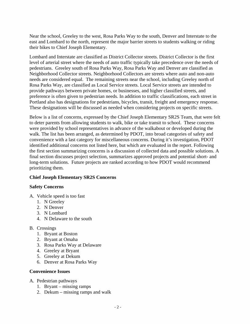
Near the school, Greeley to the west, Rosa Parks Way to the south, Denver and Interstate to the east and Lombard to the north, represent the major barrier streets to students walking or riding their bikes to Chief Joseph Elementary. Lombard and Interstate are classified as District Collector streets. District Collector is the first level of arterial street where the needs of auto traffic typically take precedence over the needs of pedestrians. Greeley south of Rosa Parks Way, Rosa Parks Way and Denver are classified as Neighborhood Collector streets. Neighborhood Collectors are streets where auto and non-auto needs are considered equal. The remaining streets near the school, including Greeley north of Rosa Parks Way, are classified as Local Service streets. Local Service streets are intended to provide pathways between private homes, or businesses, and higher classified streets, and preference is often given to pedestrian needs. In addition to traffic classifications, each street in Portland also has designations for pedestrians, bicycles, transit, freight and emergency response. These designations will be discussed as needed when considering projects on specific streets. Below is a list of concerns, expressed by the Chief Joseph Elementary SR2S Team, that were felt to deter parents from allowing students to walk, bike or take transit to school. These concerns were provided by school representatives in advance of the walkabout or developed during the walk. The list has been arranged, as determined by PDOT, into broad categories of safety and convenience with a last category for miscellaneous concerns. During it’s investigation, PDOT identified additional concerns not listed here, but which are evaluated in the report. Following the first section summarizing concerns is a discussion of collected data and possible solutions. A final section discusses project selection, summarizes approved projects and potential short- and long-term solutions. Future projects are ranked according to how PDOT would recommend prioritizing them. Chief Joseph Elementary SR2S Concerns Safety Concerns A. Vehicle speed is too fast
1. N Greeley 2. N Denver 3. N Lombard 4. N Delaware to the south
B. Crossings
1. Bryant at Boston 2. Bryant at Omaha 3. Rosa Parks Way at Delaware 4. Greeley at Bryant 5. Greeley at Dekum 6. Denver at Rosa Parks Way
Convenience Issues A. Pedestrian pathways
1. Bryant – missing ramps 2. Dekum – missing ramps and walk
- 2 -

B. Vehicle Congestion
1. Saratoga
Miscellaneous A. School signing and marked crossing review Summary of Findings and Solutions Vehicle Speed and Volumes Vehicle counts were reviewed or collected for the area streets and are presented in Table 1, below. From Table 1 it can be seen that vehicle speeds on several streets are excessively high (posted+5 mph, in bold) including: Brandon at Kenton Park; Atlantic, Rosa Parks to Killingsworth; Curtis, Lombard to Rosa Parks; Curtis, Rosa Parks to Willamette; Detroit, Rosa Parks to Killingsworth; and Wabash, Lombard to Willamette. Though there were concerns expressed by the Chief Joseph Elementary SR2S Team about speeding traffic on Greeley, Denver, Lombard and Delaware, measured vehicle speeds appear to be acceptable at this time. Table 1. Collected Traffic Data
Location Date Northbnd
Speed* Southbnd
Speed*
Lowest Posted Speed
Northbnd Volume
SouthbndVolume Total
Maryland N/Rosa Parks 10/11/04 26 25 25 249 158 407
Maryland S/Dekum 4/19/07 29 29 25 272 331 603
Montana N/Rosa Parks 10/20/04 24 22 25 129 175 304
Interstate S/Bryant 12/9/04 - - 35 5383 4191 9574
Interstate S/Lombard 10/21/04 - - 35 4805 4466 9,271
Interstate at Russett 10/21/04 30 32 35 4016 4725 8,741
Greenwich S/Lombard 4/18/07 22 24 25 157 315 472
Concord S/Holman 4/5/07 25 24 25 216 187 403
Fenwick S/Buffalo 4/16/07 23 23 25 98 95 193
Campbell S/Holman 4/9/07 26 29 25 200 187 387
N Denver N/Bryant 2/21/08 33 34 35 2425 2490 4,915
N Denver N/Dekum 2/21/08 33 33 35 2477 2662 5,139
N Denver N/Saratoga 2/28/08 29 32 35 2776 2601 5,377
- 3 -

Brandon S/Willis 4/11/07 30 30 25 693 673 1366
Detroit N/Ainsworth 7/25/05 31 31 25 164 152 316
Boston N/Buffalo 6/6/07 25 24 25 150 147 297
Boston S/Holman 4/5/07 27 27 25 163 125 288
Delaware S/Watts 4/11/07 28 29 25 466 456 1,325
Delaware N/Terry 4/11/07 27 29 25 443 423 866
Delaware N/Russett 4/11/07 24 25 25 652 473 1,125
Delaware N/Bryant 4/11/07 27 27 25 124 159 283
Delaware S/Rosa Parks Way 3/15/06 27 26 25 145 142 287
Delaware S/Holman 4/5/07 27 27 25 140 142 282
Wilbur S/Holman 4/16/07 26 25 25 88 104 192
Burrage S/Buffalo 4/4/07 24 26 25 108 178 286
Burrage S/Holman 4/16/07 25 25 25 119 150 269
Greeley S/Buffalo 4/17/07 35 34 35 3495 2989 6,484
Greeley N/Dekum 4/17/07 35 34 35 3589 3372 6,961
Greeley N/Rosa Parks Way 8/22/00 38 39 35 3133 3262 6,395
Greeley S/Rosa Parks Way 11/30/04 33 33 35 8572 7796 16,368
Atlantic S/Buffalo 4/4/07 23 23 25 164 126 290
Atlantic S/Dekum 4/4/07 26 26 25 281 128 409
Atlantic S/Rosa Parks Way 5/5/03 30 28 25 229 205 434
Atlantic N/Ainsworth 1/26/04 30 29 25 146 159 304
Curtis N/Morgan 4/5/07 25 24 25 123 147 270 Curtis N/Liberty 4/5/07 27 30 25 136 99 235
Curtis 1/26/04 30 30 25 111 147 258
- 4 -

N/Ainsworth Knowles S/Holland 4/19/07 25 25 25 186 182 368
Knowles S/Saratoga 4/17/07 26 26 25 141 132 273
Oatman S/Holland 4/17/07 25 25 25 136 114 250
Oatman N/Saratoga 4/17/07 25 24 25 117 72 189
Vincent N/Morgan 4/18/07 27 26 25 120 107 227
Wabash S/Lombard 5/22/06 31 31 25 384 287 671
Location Date Eastbnd Speed*
Westbnd Speed*
Lowest Posted Speed
Eastbnd Volume
Westbnd Volume Total
Lombard at Interstate 7/21/03 - - 11931 13244 25,175
Lombard at Delaware 8/18/03 - - 12274 11393 23,667
Buffalo E/Delaware 4/9/07 24 23 25 98 215 313
Buffalo E/Mobile 4/4/07 24 24 25 247 325 572
Bryant E/Fenwick 4/5/07 26 24 25 179 127 306
Dekum W/Wilbur 4/9/07 27 29 25 269 274 543
Dekum E/Newcastle 4/9/07 27 26 25 256 185 441
Saratoga W/Newcastle 4/16/07 22 20 25** 252 407 659
Saratoga E/Newcastle 4/16/07 27 26 25 174 212 386
Rosa Parks Way E/Omaha 4/16/07 36 37 35 5552 5748 11,300 *Miles per hour - 85th percentile speed; 15% of drivers exceed this. **School zone 7 AM to 5 PM.
SOLUTIONS FOR SAFETY CONCERNS SOLUTONS FOR SPEEDING The following street segments have qualified for a subsidized speed bump project and can be offered traffic calming through the Subsidized Purchase Program:
Brandon at Kenton Park
- 5 -

Atlantic, Rosa Parks to Killingsworth Curtis, Lombard to Rosa Parks Curtis, Rosa Parks to Willamette Detroit, Rosa Parks to Killingsworth
Under the Subsidized Purchase program residents on Local Service streets meeting minimum speeding and specific traffic volume requirements are offered speed bump projects that are subsidized for 60% of the construction costs. If approval is obtained through petition from 2/3rds of the households, funding for 40% of the project costs will need to be arranged by local residents. If the Chief Joseph Elementary SR2S Team so chose, some portion of the local resident match funding could be accomplished with the Chief Joseph Elementary SR2S safety funds. Speed bumps cost $2,200 each and the local resident match funding for a subsidized project is $880 per bump.
Brandon at Kenton Park Brandon at Kenton Park has a measured 85th percentile speed of 30 mph in a 25-mph zone and is recommended for 2 speed bumps adjacent to the park. The local resident funding match for this project is $1,760. This is the amount the Chief Joseph Elementary SR2S Team could assist with.
Atlantic, Rosa Parks to Killingsworth Atlantic, Rosa Parks to Killingsworth has a measured 85th percentile speed of 30 mph in a 25-mph zone and is recommended for 4 speed bumps. The local resident funding match for this project is $3,520. This is the amount the Chief Joseph Elementary SR2S Team could assist with. Curtis, Lombard to Rosa Parks Curtis, Lombard to Rosa Parks has a measured 85th percentile speed of 30 mph in a 25-mph zone and is recommended for up to 5 speed bumps. The local resident funding match for this project is $4,400. This is the amount the Chief Joseph Elementary SR2S Team could assist with. Curtis, Rosa Parks to Willamette Curtis, Rosa Parks to Willamette has a measured 85th percentile speed of 30 mph in a 25-mph zone and is recommended for 3 speed bumps. The local resident funding match for this project is $2,640. This is the amount the Chief Joseph Elementary SR2S Team could assist with. Detroit, Rosa Parks to Killingsworth Detroit, Rosa Parks to Killingsworth has a measured 85th percentile speed of 31-32 mph in a 25-mph zone and is recommended for 6 speed bumps. The local resident funding match for this project is $5,280. This is the amount the Chief Joseph Elementary SR2S Team could assist with. The remaining streets identified with excessive speeding do not qualify for a subsidized traffic calming project and are discussed below.
Wabash, Lombard to Willamette Wabash, Lombard to Willamette has a measured 85th percentile speed of 31 mph in a 25-mph zone. Wabash is a Neighborhood Collector, indicating higher expected use by drivers, but is not a Major Emergency Response route. This means that longer speed bumps, called speed tables, could be used on Wabash to slow vehicle speed. Wabash has high traffic volumes that are a concern to PDOT in regards to traffic diversion. Though rare, occasionally after constructing a traffic calming project on a busy street, excessive amounts of traffic will move to a parallel route.
- 6 -

Because Wabash is a Neighborhood Collector street, with a wider area of influence, the process to approve speed tables requires more involvement. Not only do residents along the street need to approve a traffic calming project, but any neighborhood association that the project crosses must also approve the project. It is recommended that 3 speed tables be constructed along Wabash. The cost of the project would be up to $6,600. PDOT does not currently provide a subsidy for traffic calming on Neighborhood Collector streets, so the project must be fully funded by residents. The Chief Joseph Elementary SR2S Team could consider a partial funding of this traffic calming project to encourage construction. N Greeley Avenue N Greeley has a measured 85th percentile speed of 35-39 mph in a 35-mph zone, and does not meet PDOT’s minimum definition of speeding for traffic calming projects (85th percentile speed 5 mph over the posted speed). Greeley is a Local Service street north of Rosa Parks, but is a Neighborhood Collector to the south, indicating higher expected use by autos, and is designated as a Major Emergency Response route along its whole length. It is unusual for a Local Service street to also be a Major ER route. Greeley is not designated for Freight, but it was noted that signs exist at Lombard (to the north) directing traffic onto Greeley to get to Swan Island, a significant freight district. North Interstate Avenue (to the east) is two levels higher in traffic classification and has recently had the speed limit there reduced from 35 mph to 30 mph. N Denver, east of the school, and Rosa Parks Way (to the south), are also under consideration for speed limit reductions to 30 mph. N Denver and Rosa Parks are both Neighborhood Collector streets. The Chief Joseph ST2S Team has already approved PDOT to request an ODOT review of the posted speed on N Greeley Avenue and request the ODOT Swan Island guide sign on Lombard be removed. Portland does not currently have an approved tool for reducing speeding on ER routes. A safer walking environment will need to focus on other tools, like alternate routes, enforcement, and enhancing the safety of key crossing locations. SOLUTIONS FOR CROSSINGS Adult crossing guards are often suggested to improve safety at busy crossings. PDOT would not discourage Chief Joseph Elementary from using paid or volunteer adult crossing guards, but PDOT does not have any pending plans or budget to provide adult crossing guards for elementary schools in Portland. There are two primary methods to physically change crossings of higher volume roadways and enhance the safety of crossings. The first is the pedestrian refuge island. Pedestrian refuge islands are short medians of full-height curb constructed between auto travel lanes, most often at the centerline of a street. Included in the construction is a pedestrian area where pedestrians may take refuge, pausing for short periods of time. Pedestrian refuge islands permit the crossing of half a street at a time so pedestrians only have to find a gap and concentrate on one direction of traffic at a time (good for younger pedestrians). Pedestrian islands may require auto traffic to change direction to drive around the island and this may require more parking removal than other treatments. Pedestrian refuge islands cost approximately $12,000-$30,000. The second common physical change is called a curb extension. Curb extensions are short sections of roadside curb that have been constructed closer to the centerline of a street, replacing the existing curb. Curb extensions improve pedestrian crossing opportunities by reducing the
- 7 -

distance a pedestrian must cross at street level, enabling the use of shorter gaps in vehicle traffic. Curb extensions increase the visibility between pedestrians and motor vehicle operators by moving pedestrians closer to the street centerline before entering the roadway. With curb extensions, pedestrians must still find a gap in two directions of traffic, but curb extensions typically do not remove as much on-street parking as pedestrian refuge islands. The cost for a curb extension is approximately $12,000 - $20,000 due to storm water management impacts. Other changes to aid pedestrians crossing busy streets, called operational, include all-way stops and signals. Both types of enhanced control have a series of national and local standards that must be met before they are approved. Also, both types of control can reduce some crashes, but may increase other types. All-way stops are most appropriate at the intersection of two similar (and lower volume) streets. All-way stop-controlled intersections can be safer than most intersections for pedestrian crossings because all drivers are expected (and expecting) to stop every time they arrive there. Unlike signalized intersections, all-way stop-controlled intersections often operate at lower speeds since none of the approaching traffic is provided automatic right of way by a green signal. All-way stop control costs approximately $300 per entering street to install. Signals are similarly used at higher volume intersections. Signals cost at least $150,000 to install. There also may be lower-cost parking control or maintenance corrections that would improve the safety of crossings by increasing the visibility between pedestrians and auto drivers.
Proposed Walking Routes The school service area was reviewed to create a map of recommended walking routes in an attempt to focus on priority crossings needing improvement (Figure 3, next page). These routes are chosen, in part, by moving out from the school along main access streets. These streets are chosen for pedestrian routes because they have more ‘eyes on the street’ – they naturally have more users who can watch for unsafe activity or behavior from children or strangers. Alternate pathways are chosen when the main roads are considered too busy, or do not have sufficient pedestrian facilities. Streets identified as barriers to walking or biking to Chief Joseph Elementary include Greeley, Rosa Parks Way, Denver, Interstate, and Lombard. It is recommended that students remain on their side of a barrier street and wait to cross at signalized or enhanced crossing locations. Signalized crossings (and all-way stop-controlled intersections) are the best locations to cross; though they may also be the busiest. Enhanced crossings are the next best location to cross – locations where physical changes have been made to increase visibility or shorten crossing distances. Marked and signed crossings may alert drivers to the presence of more pedestrians, but students should be warned that a marked crossing is no safer than an unmarked crossing. Figure 3 identifies crossings that are reviewed in this report in more detail with dashed circles.
- 8 -

Figure 3. Proposed Pathways Map
Additional locations identified for review from plotting pathways include: Denver at Terry Terry at Interstate Interstate at Lombard Lombard at Delaware Lombard at Denver Buffalo at Interstate Buffalo at Denver Bryant at Denver Bryant at Interstate Dekum at Denver Dekum at Interstate
- 9 -

Denver at Rosa Parks Way Rosa Parks Way at Interstate Rosa Parks Way at Delaware Rosa Parks Way at Greeley Dekum at Greeley Bryant at Greeley
Denver at Terry Denver at Terry is a two-way stop controlled intersection (Terry stopped). Terry is a Local Service street and N Denver Avenue is a Local Service, Transit Access (with bus stops on Denver approaching Terry), City Walkway, City Bikeway (with bike lanes), and Truck Access street. The intersection has had one reported crash from 2003 through 2006. For the estimated 9,000 vehicles entering the intersection each day, one crash in four years translates into 0.08 crashes per million entering vehicles. Portland does not investigate intersections for safety modifications based on crash history until the four-year crash rate reaches 1 crash per million entering vehicles. Denver at Terry appears to be operating very safely, but was identified as a crossing location to investigate for enhancement. Denver has had all corners reconstructed and pedestrian refuge islands constructed north and south of Terry in 2007 as part of a light rail mitigation project (Figure 4). Construction of light rail on N Interstate Avenue was determined to have shifted some traffic to N Denver Avenue and the pedestrian refuge islands were constructed to make is easier for pedestrians to cross Denver with the increase in vehicle traffic.
Figure 4. N Denver at Terry Pedestrian Refuge Islands
Enhancing the intersection with curb extensions would further improve pedestrian visibility at the intersection and shorten the crossing distance, but would need to accommodate transit stops. Figure 5, below, depicts proposed curb extensions south of Terry on Denver. A transit or green curb extension costs $20,000 to install while a standard curb extension costs $12,000. The bus zones on Denver remove parking where vehicles approach the intersections, benefiting pedestrian visibility, so that additional parking removal (for visibility) is not recommended.
- 10 -

Figure 5. Denver at Terry Curb Extensions
Terry at Interstate Terry at Interstate (south intersection) is a fully signalized intersection with countdown pedestrian signal heads. Interstate Avenue is a District Collector Traffic street, Regional/Major Transit street (with light rail in the center), City Walkway, City Bikeway (with bike lanes), Truck Access, and Major Emergency Response route. The intersection has had 4 reported crashes from 2003 through 2006. For the estimated 8,900 vehicles entering the intersection each day, 4 crashes in four years translates into 0.33 crashes per million entering vehicles. Interstate at Terry appears to be operating safely, but was identified as a crossing location to investigate for enhancement. The safest crossings of Interstate will usually be at signalized intersections like Terry. An often-suggested change is to provide pedestrians crossing busy roads with a head start called a Leading Pedestrian Interval. A Leading Pedestrian Interval (LPI) means that when a pedestrian goes to cross Interstate, the first 5-seconds of the WALK phase will occur without Terry auto traffic receiving a green signal. Right turns on red would still be possible, if not already prohibited. Leading Pedestrian Intervals are best used where conflicts exist between pedestrians and turning vehicles. Drivers turning left from Terry have permissive turns, meaning they are to watch for pedestrians crossing Interstate and look for a turn opportunity at the same time, however, Leading Pedestrian Intervals are not recommended at this time due to the low volume of traffic on Terry. All available space on Interstate is currently being used for vehicle travel or turn lanes, so other engineering enhancements are not possible.
Interstate at Lombard Interstate at Lombard is a fully signalized intersection with countdown pedestrian signal heads. Lombard is a District Collector Traffic street, Major Transit street, City Walkway, City Bikeway, Truck Access, and Major Emergency Response route. The intersection of Interstate Avenue at Lombard is identified as a transit center due to the confluence of light rail and several transit routes. The intersection has had 44 reported crashes from 2003 through 2006. For the estimated 32,300 vehicles entering the intersection each day, 44 crashes in four years translates into 1.00 crash per million entering vehicles. Interstate at Lombard appears to need a review for safety operation, and was identified as a crossing location to investigate for enhancement. A review of the four-year crash history is presented in Table 2, below. The number of crashes that occurred in 2003 is approximately twice the number of crashes that have occurred each year
- 11 -

since 2003. The reduction in crashes is likely due to the light rail construction that placed a median in Interstate Avenue and updated the signal control at the intersection. When reviewing the types of crashes that have occurred, rear-end crashes are dominant. This indicates issues related to congestion. Rear-end crashes are the type over which drivers have the most control (driving too fast and following too close), and for which there are no clear engineering solutions. Table 2. Interstate at Lombard Crash History Summary
Yearly Total Crashes Crash Type Number Percent 2003 2004 2005 2006 Angle 1 2%
Left Turn Opposed 5 11% Rear End 24 55% 18 8 10 8 Ped/Bike 3 7% Other 11 25% 41% 18% 23% 18% Total 44
The safest crossings of both Interstate and Lombard will usually be at signalized intersections. Previously discussed was a Leading Pedestrian Interval, where pedestrians get a head start crossing a busy street with permissive left turns. Drivers turning left from both Lombard and Interstate have their own turn lanes and signal so the turning vehicles don’t conflict with crossing pedestrians. Leading Pedestrian Intervals are best used where conflicts exist between pedestrians and turning vehicles, and Leading Pedestrian Intervals are not recommended. All available space on both Interstate and Lombard is currently being used for vehicle travel or turn lanes, so other engineering enhancements are not possible. Lombard at Delaware Lombard at Delaware is a half-signalized intersection. The signal on Lombard is only for pedestrians crossing Lombard east of Delaware, and there is no signal for traffic on Delaware. Delaware traffic is controlled by stop signs. N Delaware Avenue is a Local Service street and Lombard has a marked crosswalk east of Delaware. The intersection has had 7 reported crashes from 2003 through 2006. For the estimated 25,000 vehicles entering the intersection each day, 7 crashes in four years translates into 0.21 crashes per million entering vehicles. Lombard at Delaware appears to be operating safely, but was identified as a crossing location to investigate for enhancement. The safest crossings of Lombard will usually be at signalized intersections like Delaware. For an intersection like Lombard at Delaware safety improvements are more difficult since most roadway space is currently in use. One proposed change is to the pedestrian signal heads, changing them to countdown signal heads (Figure 6, next page), as are commonly used to cross N Interstate. This will provide more information to pedestrians about time remaining to safely cross Lombard. The Chief Joseph SR2S Team approved this change as part of the first items to be accomplished.
- 12 -

Figure 6. Countdown Pedestrian Signals
Previously discussed was a Leading Pedestrian Interval, where pedestrians get a head start crossing a busy street with permissive left turns. Because Delaware auto traffic is controlled by stop signs and LPI to cross Lombard serves no purpose. From a field visit it was determined that the northeast corner ramps are deficient. Reconstructing the corner to add a curb ramp would cost $4,000. Enhancing the intersection with a curb extension will improve pedestrian visibility at the intersection and shorten the crossing distance. Figure 7 depicts a possible curb extension. A transit curb extension costs $20,000 to install.
Figure 7. Lombard at Delaware Proposed Curb Extensions
Lombard at Denver Lombard at Denver is a fully signalized intersection. N Denver Avenue is a Neighborhood Collector south of Lombard, Local Service street north of Lombard, and a Transit Access, City Walkway, City Bikeway (with bike lanes), and Truck Access street. The intersection has had 32 reported crashes from 2003 through 2006. For the estimated 30,000 vehicles entering the intersection each day, 32 crashes in four years translates into 0.78 crashes per million entering vehicles. Lombard at Denver appears to be operating safely, but was identified as a crossing location to investigate for enhancement. The safest crossings of Lombard will usually be at signalized intersections like Denver. Countdown signal heads were discussed earlier (Figure 6), and are recommended for both streets. This will provide more information to pedestrians about time remaining to safely cross both Lombard and Denver. Also previously discussed was an LPI, where pedestrians get a head start crossing a busy street
- 13 -

with permissive left turns. Drivers turning left from Lombard have their own turn lanes and signal so the turning vehicles don’t conflict with pedestrians crossing Denver (protected left turns). Drivers turning left from Denver have permissive turns, meaning they are to watch for pedestrians crossing Lombard and look for a turn opportunity at the same time. In order to provide the LPI, green time would need to be taken from auto uses or additional time added to the total signal cycle length. Either way it could mean an added delay of 5 seconds for autos each time the signal runs through a cycle. If approved for crossing Lombard, it is recommended that LPI time should be taken from auto uses on Denver and not Lombard. Denver at Lombard has an unusual geometry due to the angle that Denver south of Lombard enters the intersection (Figure 8). Figure 8. N Denver at Lombard
A site visit determined that the northwest corner was deficient regarding curb ramps. Reconstructing a corner is estimated to cost $4,000. Enhancing the intersection with curb extensions can improve pedestrian visibility at the intersection and shorten the crossing distance, but the available space is limited due to existing uses and the intersection geometry. Figure 9, below, depicts a possible curb extension at the southwest corner. A large curb extension as depicted can be used for a variety of amenities, including storm water management or a pocket park. Typical costs for the kind of change depicted in Figure 9 are $100,000 to $200,000.
Figure 9. Lombard at Denver Pocket Park
- 14 -

Buffalo at Interstate Buffalo at Interstate is a fully signalized intersection with countdown pedestrian signals. Buffalo is a Local Service street. The intersection has had 3 reported crashes from 2003 through 2006. For the estimated 11,800 vehicles entering the intersection each day, 3 crashes in four years translates into 0.19 crashes per million entering vehicles. Buffalo at Interstate appears to be operating very safely, but was identified as a crossing location to investigate for enhancement. The safest crossings of Interstate will usually be at signalized intersections like Buffalo. Leading Pedestrian Intervals (LPI) were previously discussed as one enhancement. Drivers turning left from Interstate have their own turn lanes and signal so the turning vehicles don’t conflict with pedestrians crossing Buffalo (protected left turns). Drivers turning left from Buffalo have permissive turns, meaning they are to watch for pedestrians crossing Lombard and look for a turn opportunity at the same time. In order to provide the LPI, green time would need to be taken from auto uses or additional time added to the total signal cycle length. Either way it could mean an added delay of 5 seconds per street for autos each time the signal runs through a cycle. Over time this can add up if pedestrians often use the intersection. A Fred Meyer store is sited at the northeast corner of this intersection and is likely to attract pedestrians to use this crossing. If approved for crossing Interstate, it is recommended that LPI time should be taken from auto uses on Buffalo and not Interstate. A site visit determined that all corner ramps were sufficient. All available space on Interstate is currently being used for vehicle travel or turn lanes, and additional engineering enhancements are not recommended at this time. Buffalo at Denver Buffalo at Denver is a two-way stop controlled intersection (Buffalo stopped). Denver between Lombard and Rosa Parks Way is a Neighborhood Collector street, Transit Access street, City Bikeway (with bike lanes), and City Walkway. The intersection has had 4 reported crashes from 2003 through 2006. For the estimated 5,600 vehicles entering the intersection each day, 4 crashes in four years translates into 0.52 crashes per million entering vehicles. Buffalo at Denver appears to be operating safely, but was identified as a crossing location to investigate for enhancement. Denver south of Buffalo recently had curb ramps and pedestrian refuge island constructed as part of mitigation for added traffic on Denver resulting from light rail construction on N Interstate Avenue (Figure 10). Speed tables were also added on N Denver to mitigate vehicle speed. The island needs the curb painted yellow, but no additional enhancements are recommended at this time.
- 15 -

Figure 10. Denver at Buffalo Pedestrian Improvements
Bryant at Denver Bryant at Denver is a two-way stop controlled intersection (Bryant stopped) with a marked school crosswalk on Denver south of Bryant, and Bryant is a Local Service street. The intersection has had one reported crash from 2003 through 2006. For the estimated 5,400 vehicles entering the intersection each day, one crash in four years translates into 0.14 crashes per million entering vehicles. Bryant at Denver appears to be operating very safely, but was identified as a crossing location to investigate for enhancement. Denver, north and south of Bryant, recently had curb ramps and pedestrian refuge islands constructed as part of mitigation for added traffic on Denver that resulted from light rail construction on N Interstate Avenue (Figure 11). The island needs the curb painted yellow, but no additional enhancements are recommended at this time.
Figure 11. Denver at Bryant Pedestrian Improvements
Bryant at Interstate Bryant at Interstate is a two-way stop controlled intersection (Bryant stopped). Interstate Avenue at Byrant has a light rail median in the center, restricting all vehicles to only making right turns. Pedestrians crossing Interstate are provided a Z-crossing that focuses pedestrian attention on the pathway they are approaching. Bryant at Interstate had one reported pedestrian crash in 2003 where a distracted driver going west struck a pedestrian crossing Bryant. With construction of
- 16 -
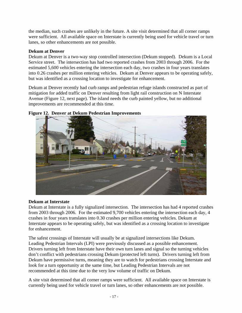
the median, such crashes are unlikely in the future. A site visit determined that all corner ramps were sufficient. All available space on Interstate is currently being used for vehicle travel or turn lanes, so other enhancements are not possible. Dekum at Denver Dekum at Denver is a two-way stop controlled intersection (Dekum stopped). Dekum is a Local Service street. The intersection has had two reported crashes from 2003 through 2006. For the estimated 5,600 vehicles entering the intersection each day, two crashes in four years translates into 0.26 crashes per million entering vehicles. Dekum at Denver appears to be operating safely, but was identified as a crossing location to investigate for enhancement. Dekum at Denver recently had curb ramps and pedestrian refuge islands constructed as part of mitigation for added traffic on Denver resulting from light rail construction on N Interstate Avenue (Figure 12, next page). The island needs the curb painted yellow, but no additional improvements are recommended at this time.
Figure 12. Denver at Dekum Pedestrian Improvements
Dekum at Interstate Dekum at Interstate is a fully signalized intersection. The intersection has had 4 reported crashes from 2003 through 2006. For the estimated 9,700 vehicles entering the intersection each day, 4 crashes in four years translates into 0.30 crashes per million entering vehicles. Dekum at Interstate appears to be operating safely, but was identified as a crossing location to investigate for enhancement. The safest crossings of Interstate will usually be at signalized intersections like Dekum. Leading Pedestrian Intervals (LPI) were previously discussed as a possible enhancement. Drivers turning left from Interstate have their own turn lanes and signal so the turning vehicles don’t conflict with pedestrians crossing Dekum (protected left turns). Drivers turning left from Dekum have permissive turns, meaning they are to watch for pedestrians crossing Interstate and look for a turn opportunity at the same time, but Leading Pedestrian Intervals are not recommended at this time due to the very low volume of traffic on Dekum. A site visit determined that all corner ramps were sufficient. All available space on Interstate is currently being used for vehicle travel or turn lanes, so other enhancements are not possible.
- 17 -

Denver at Rosa Parks Way Denver at Rosa Parks Way is a fully signalized intersection. Rosa Parks Way is a Neighborhood Collector, Transit Access, City Walkway, City Bikeway (with bike lanes), and Major Emergency Response route. Denver Avenue south of Rosa Parks Way is a Local Service street, City Walkway and City Bikeway (with bike lanes). Denver north of Rosa Parks is offset east of Denver south of Rosa Parks. The intersection had 17 reported crashes from 2003 through 2006. For the estimated 16,100 vehicles entering the intersection each day, 17 crashes in four years translates into 0.78 crashes per million entering vehicles. Denver at Rosa Parks Way appears to be operating safely, but was identified as a crossing location to investigate for enhancement. The safest crossings of Denver or Rosa Parks Way will usually be at signalized intersections. Countdown signal heads were discussed earlier (Figure 6), and are recommended for both streets. Also previously discussed was an LPI, where pedestrians get a head start crossing a busy street with permissive left turns. Drivers turning left from Denver and Rosa Parks have permissive turns, meaning turning drivers are to watch for pedestrians crossing and look for a turn opportunity at the same time. In order to provide the LPI, green time would need to be taken from auto uses or additional time added to the total signal cycle length. Either way it could mean an added delay of 5 seconds per street for autos each time the signal runs through a cycle. Over time this can add up if the intersection is used often by pedestrians. If approved for crossing Rosa Parks Way, it is recommended that LPI time should be taken from auto uses on Denver and not Rosa Parks Way. A site visit determined that all corner ramps were sufficient. Enhancing the intersection with curb extensions will improve pedestrian visibility at the intersection and shorten the crossing distance. Figure 13, below, depicts possible curb extensions. A transit or green curb extension costs $20,000 to install while a standard curb extension costs $12,000. Figure 13. Denver at Rosa Parks Way Curb Extensions
Rosa Parks Way at Interstate Rosa Parks Way at Interstate is a fully signalized intersection with countdown pedestrian signals. The intersection had 18 reported crashes from 2003 through 2006. For the estimated 23,800
- 18 -

vehicles entering the intersection each day, 18 crashes in four years translates into 0.56 crashes per million entering vehicles. Rosa Parks Way at Interstate appears to be operating safely, but was identified as a crossing location to investigate for enhancement. The safest crossings of Interstate or Rosa Parks Way will usually be at signalized intersections. Previously discussed was an LPI, where pedestrians get a head start crossing a busy street with permissive left turns. Drivers turning left from both Interstate and Rosa Parks Way have their own turn lanes and signal so the turning vehicles don’t conflict with crossing pedestrians, and Leading Pedestrian Intervals are not needed. All available space on Interstate and Rosa Parks Way is currently being used for vehicle travel or turn lanes, so other enhancements are not possible.
Rosa Parks Way at Delaware Rosa Parks Way at Delaware is a fully signalized intersection with a marked school crossing on Rosa Parks east of Delaware. Delaware is a Local Service street. The intersection had no reported crashes from 2003 through 2006. Rosa Parks Way at Delaware appears to be operating very safely, but was identified as a crossing location to investigate for enhancement. The safest crossings of Rosa Parks Way will usually be at signalized intersections like Delaware. Countdown signal heads were discussed earlier (Figure 6), and are recommended for crossing Rosa Parks Way. The Chief Joseph SR2S Team approved countdown signal heads and the signals were included in a proposed project for Federal funding approved in January of 2008. However, construction is not expected to begin until 2010. Also previously discussed was an LPI, where pedestrians get a head start crossing a busy street with permissive left turns. Drivers turning left from Delaware have permissive turns, meaning they are to watch for pedestrians crossing Lombard and look for a turn opportunity at the same time. In order to provide the LPI, green time would need to be taken from auto uses, however, Leading Pedestrian Intervals are not recommended at this time due to the low volume of traffic on Delaware. The Chief Joseph SR2S Team approved corner reconstruction for Rosa Parks Way at Delaware in order to install curb ramps where existing facilities were deficient or missing. The Bureau of Maintenance completed that work in September of 2007 (Figure 14).
Figure 14. Rosa Parks Way at Delaware – New Curb Ramps
- 19 -

Enhancing the intersection with curb extensions will improve pedestrian visibility at the intersection and shorten the crossing distance. Figure 15, below, depicts possible curb extensions. A transit or green curb extension costs $20,000 to install while a standard curb extension costs $12,000.
Figure 15. Rosa Parks Way at Delaware Curb Extensions
Rosa Parks Way at Greeley Rosa Parks Way at Greeley is a fully signalized intersection, except the pedestrian crossing on Rosa Parks west of Greeley is closed. Greeley is a Local Service street north of Rosa Parks Way, and a Neighborhood Collector south of Rosa Parks Way. Greeley is also a Transit Access street, City Walkway and Major Emergency Response route. The intersection has had 17 reported crashes from 2003 through 2006. For the estimated 28,500 vehicles entering the intersection each day, 17 crashes in four years translates into 0.44 crashes per million entering vehicles. Rosa Parks Way at Greeley appears to be operating safely, but was identified as a crossing location to investigate for enhancement. The safest crossings of Rosa Parks Way or Greeley will usually be at signalized intersections. Countdown signal heads were discussed earlier (Figure 6), and are recommended for both streets. The signal operation at Greeley and Rosa Parks is unusual for Portland in that the north and south approaches operate separately from each other (split phasing). This was done (as well as closing the west crosswalk) due to the large volume of traffic going north on Greeley that turns west onto Rosa Parks Way. If the previously discussed Leading Pedestrian Interval were to be used, it would only delay the southbound approach on Greeley (the Local Service portion of the street). A site visit determined that the northeast corner is deficient in curb ramps. Reconstructing the northeast corner is estimated to cost $4,000. Enhancing the intersection with curb extensions will improve pedestrian visibility at the intersection and shorten the crossing distance. Figure 16, below, depicts possible curb extensions. A transit or green curb extension costs $20,000 to install while a standard curb extension costs $12,000. To get the maximum benefit from curb extensions on Rosa Parks Way at Greeley, the current lane striping would need to be modified as shown in Figure 16. The proposed striping change would bring Rosa Parks Way at Greeley into conformance with the other intersections west of Interstate Avenue. Traffic counts do not
- 20 -

support two through lanes for eastbound Rosa Parks Way at Greeley. Figure 16. Rosa Parks Way at Greeley
Dekum at Greeley Dekum at Greeley is a two-way stop controlled intersection (Dekum stopped). The intersection has had one reported crash from 2003 through 2006. For the estimated 7,500 vehicles entering the intersection each day, one crash in four years translates into 0.10 crashes per million entering vehicles. Dekum at Greeley appears to be operating very safely, but was identified as a crossing location to investigate for enhancement. Speeding concerns were discussed earlier and the speed zone on Greeley will be reviewed. The Chief Joseph SR2S Team tentatively approved construction of pedestrian refuge islands and corner reconstruction for Dekum at Greeley, and the corner work has already been completed. The island work was included in a proposed project for Federal funding approved in January of 2008 (Figure 17). However, construction is not expected to begin until 2009 or 2010. Figure 17. Dekum at Greeley Enhanced Crossing
- 21 -

Bryant at Greeley Bryant at Greeley is a two-way stop controlled intersection (Bryant stopped). Bryant is a Local Service street, and a marked school crosswalk exists on Greeley south of Bryant (with beacons). The intersection has had 2 reported crashes from 2003 through 2006. For the estimated 7,400 vehicles entering the intersection each day, 2 crashes in four years translates into 0.20 crashes per million entering vehicles. Bryant at Greeley appears to be operating very safely, but was identified as a crossing location to investigate for enhancement. Bryant at Greeley had curb extensions constructed on three corners as part of a school safety project in 2001 (Figure 18). All remaining space on Greeley is currently being used for vehicle travel lanes, so other engineering enhancements are not possible.
Figure 18. Bryant at Greeley
SOLUTIONS FOR VIOLATIONS
Illegal Parking During the walkabout some parking that blocked legal crosswalks on Bryant was noted. It was recommended to add NO PARKING signs near the crosswalks at Boston and Omaha to identify for parents appropriate parking locations. The Chief Joseph SR2S Team approved visibility clearances for the crossings on Bryant at Boston and Omaha. Most children that are driven to school are dropped off on Bryant or Saratoga. During the walk it was noted that some of the parking control signs on Saratoga were faded and need to be replaced. Some of the signing also appeared overly restrictive or not suited to the needs of Chief Joseph Elementary (Figure 19). Violations of parking controls were frequently observed. Parking signs and changes to restrictions or layout are recommended to better meet the needs of parents arriving by automobile. PDOT will continue to work with Chief Joseph Elementary to implement parking control changes that meet the needs of the school. Current parking control on Saratoga is depicted in Figure 19.
- 22 -
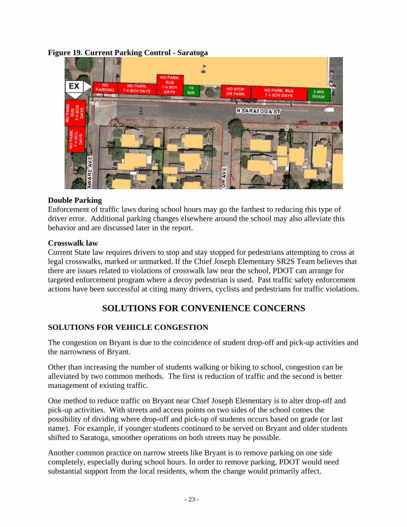
Figure 19. Current Parking Control - Saratoga
Double Parking Enforcement of traffic laws during school hours may go the farthest to reducing this type of driver error. Additional parking changes elsewhere around the school may also alleviate this behavior and are discussed later in the report. Crosswalk law Current State law requires drivers to stop and stay stopped for pedestrians attempting to cross at legal crosswalks, marked or unmarked. If the Chief Joseph Elementary SR2S Team believes that there are issues related to violations of crosswalk law near the school, PDOT can arrange for targeted enforcement program where a decoy pedestrian is used. Past traffic safety enforcement actions have been successful at citing many drivers, cyclists and pedestrians for traffic violations.
SOLUTIONS FOR CONVENIENCE CONCERNS SOLUTIONS FOR VEHICLE CONGESTION The congestion on Bryant is due to the coincidence of student drop-off and pick-up activities and the narrowness of Bryant. Other than increasing the number of students walking or biking to school, congestion can be alleviated by two common methods. The first is reduction of traffic and the second is better management of existing traffic. One method to reduce traffic on Bryant near Chief Joseph Elementary is to alter drop-off and pick-up activities. With streets and access points on two sides of the school comes the possibility of dividing where drop-off and pick-up of students occurs based on grade (or last name). For example, if younger students continued to be served on Bryant and older students shifted to Saratoga, smoother operations on both streets may be possible. Another common practice on narrow streets like Bryant is to remove parking on one side completely, especially during school hours. In order to remove parking, PDOT would need substantial support from the local residents, whom the change would primarily affect.
- 23 -

Preventing or reducing drop-off and/or pick-up activities on Bryant may be possible with a change to the off-street parking. Delaware between Bryant and Saratoga was vacated many years ago and is currently used as part of the Chief Joseph off-street parking. The old street segment is still intact and has a single driveway at the south end (Saratoga). Figure 20, below, depicts one concept for increasing available parking spaces by making the old segment operate one-way northbound. This proposal would require modifying the south driveway and adding a driveway at the north end for egress. Figure 20. Delaware Parking Proposal
One way streets may alleviate some of the congestion problems. One way operation can be accomplished with signing alone, but is more successful when enforcement is also used. In order to change a local street to one-way operation, PDOT would need substantial support from the local residents. Figure 21 depicts a change on Saratoga that was approved by the Chief Joseph SR2S Team. Figure 21. One-way Operation on Saratoga with Angle Parking
- 24 -

SOLUTIONS FOR POOR PATHWAY CONNECTIVITY As part of this report, walking paths were identified so as to focus safety improvement efforts on key crossing locations. The pathways identified include: Terry, Denver to Interstate; Denver, Terry to Rosa Parks; Delaware, Lombard to Rosa Parks; Greeley, Lombard to Rosa Parks; Buffalo, Denver to Interstate; Bryant, Wabash to Interstate; Dekum, Greeley to Delaware and Denver to Interstate; and Rosa Parks Denver to Interstate. A survey of the proposed walking routes was conducted to review for complete sidewalks and curb ramps and needed maintenance. The results of the survey are presented below for each route. The locations reviewed below do not include crossing enhancements already discussed. Each corner reconstructed to provide curb ramps is estimated to cost $4,000. Terry, Denver to Interstate Pathway Deficiencies Along Terry there were no observed gaps in sidewalk. There is only one intersection between Denver and Interstate, at Fenwick, and all corners were complete.
Denver, Terry to Rosa Parks Pathway Deficiencies Along Denver there were no observed gaps in sidewalk. From the survey of curb ramps, it appears that adding ramps to three corners would complete the pathway the quickest (Table 3). Reconstructing 3 corners is estimated to cost $12,000. Table 3. Denver Intersections
Corner Cross Street Northeast Northwest Southwest Southeast Farragut Ok Ok Ok Ok Russett No ramp Ok Ok Ok Saratoga Ok No ramp Ok Ok Liberty Ok Ok No ramp Ok
Delaware, Lombard to Rosa Parks Pathway Deficiencies Along Delaware there were observed gaps in sidewalk and curb between Saratoga and Dekum. From the survey of curb ramps, it appears that adding ramps to three corners at Saratoga would complete a path on Delaware (Table 4). Reconstructing 1 corner and adding two ramps is estimated to cost $6,000. Curb and sidewalk costs approximately $45,000 per 200-foot block face. Table 4. Delaware Intersections
Corner Cross Street Northeast Northwest Southwest Southeast Buffalo Ok Ok Ok Ok Bryant Ok Ok Ok Ok Saratoga No Ramp Na No Ramp No Ramp Dekum Ok Ok Ok Ok
Greeley, Lombard to Bryant Pathway Deficiencies Along Greeley, Lombard to Bryant there were no observed gaps in sidewalk. There are only two intersections on Greeley between Lombard and Rosa Parks that have not been discussed.
- 25 -

Greeley at Buffalo recently had the corners rebuilt and the curb ramps at Lombard are satisfactory. Buffalo, Denver to Interstate Pathway Deficiencies Along Buffalo there were several observed gaps in sidewalk east of Denver, Campbell Fenwick and Concord, but all corners appeared to be correct. Sidewalk costs approximately $8,000 per 200-foot block face.
Table 5. Buffalo Intersections Corner
Cross Street Northeast Northwest Southwest Southeast Campbell Ok Ok Ok Ok Fenwick Ok Ok Ok Ok Concord Ok Ok Ok Ok Greenwich Ok Ok Ok Ok Interstate Ok Ok Ok Ok
Bryant, Wabash to Interstate Pathway Deficiencies Along Bryant there were observed gaps in sidewalk west of Newcastle, Omaha, Boston, Curtis, Knowles and Oatman. Curb was also missing between Villard and Vincent. The Chief Joseph SR2S Team approved adding curb ramps for the crossings on Bryant at Boston and Omaha, as well as marking them as pedestrian crossings, and that work has been completed (Figure 22).
Figure 22. Bryant at Boston Curb Ramps
From the survey of curb ramps, it appears that deficiencies exist at 38 corners (Table 6, next page). Reconstructing 38 corners is estimated to cost $152,000. Sidewalk costs approximately $8,000 per 200-foot block face, while curb and sidewalk is approximately $45,000 per block (one side).
- 26 -

Table 6. Bryant Intersections Corner
Cross Street Northeast Northwest Southwest Southeast Wabash Ok Ok Ok Ok Vincent No ramp No ramp No ramp No ramp Oatman Ok Ok Ok Ok Knowles No ramp No ramp No ramp No ramp Curtis No ramp No ramp No ramp No ramp Villard No ramp No ramp No ramp Ok Atlantic Ok Ok Ok Ok Burrage No ramp No ramp Ok Ok Wilbur No ramp No ramp Ok Ok Delaware Ok Ok Ok Ok Boston Ok Ok Ok Ok Omaha Ok Ok Ok Ok Newcastle No ramp No ramp No ramp Ok Mobile No ramp No ramp No ramp No ramp Lancaster No ramp No ramp No ramp No ramp Campbell No ramp No ramp No ramp No ramp Fenwick No ramp No ramp No ramp No ramp Concord Ok Ok Ok Ok Greenwich Ok Ok Ok Ok Interstate Ok Ok Ok Ok
Dekum, Greeley to Interstate Pathway Deficiencies Along Dekum there were observed gaps in sidewalk west of Newcastle, Omaha and Delaware. From the survey of curb ramps, it appears that adding ramps to 22 corners would provide a complete path to Chief Joseph Elementary (Table 7). Reconstructing 22 corners is estimated to cost $88,000. Sidewalk costs approximately $8,000 per 200-foot block face (one side).
Table 7. Dekum Intersections Corner
Cross Street Northeast Northwest Southwest Southeast Greenwich Ok Ok Ok Ok Concord Ok Ok Ok Ok Fenwick No ramp No ramp No ramp No ramp Campbell No ramp No ramp No ramp No ramp Newcastle No ramp No ramp No ramp No ramp Omaha No ramp No ramp No ramp No ramp Boston No ramp Ok Ok No ramp Delaware Ok Ok Ok Ok Wilbur Ok Ok No ramp No ramp Burrage Ok Ok No ramp No ramp
- 27 -
Rosa Parks, Denver to Interstate Pathway Deficiencies Along Rosa Parks, Denver to Interstate, there were no observed gaps in sidewalk. From the survey of curb ramps, it appears that all corners are complete for the identified pathway (Table 8, next page). Table 8. PATHWAY Intersections
Corner Cross Street Northeast Northwest Southwest Southeast Campbell Ok Ok Ok Ok Fenwick Ok Ok Ok Ok Concord Ok Ok Ok Ok
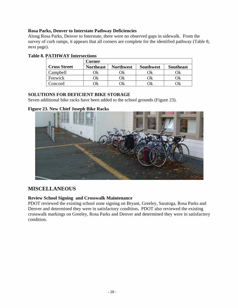
SOLUTIONS FOR DEFICIENT BIKE STORAGE Seven additional bike racks have been added to the school grounds (Figure 23). Figure 23. New Chief Joseph Bike Racks
MISCELLANEOUS Review School Signing and Crosswalk Maintenance PDOT reviewed the existing school zone signing on Bryant, Greeley, Saratoga, Rosa Parks and Denver and determined they were in satisfactory condition. PDOT also reviewed the existing crosswalk markings on Greeley, Rosa Parks and Denver and determined they were in satisfactory condition.
- 28 -

PROJECT SUMMARY AND RECOMMENDED PRIORITY When considering how to prioritize projects many factors influence the decision-making process. Safety, ease of construction and available funds are only a few of the things to consider. As part of the development of potential solutions PDOT has traditionally sought to find the best solutions without consideration of cost and only after the best solutions are identified to consider which projects to move forward. When seeking to encourage walking and biking to school, safety is PDOT’s first goal and increasing the pleasantness of the commute is secondary. When determining what projects to move forward, cost is often the greatest influence. For this reason, once a list of strategies is determined, the potential solutions are usually divided into categories of short-term and long-term. Short-term projects have been completed or are easily attainable in one to two years. Long-term projects are usually cost-prohibitive, are mutually exclusive of other projects, or conflict with SR2S Team desires. An example of mutually exclusive projects is the choice between a center turn lane or on-street parking where there is not space for both. Long-term projects are included in this report in the event additional funding becomes available. Below is a list of the possible solutions discussed in this report (Table 9). The short-term projects are listed in the order of priority with projects already approved by the Chief Joseph Elementary Safer Routes School Team listed first. Future short-term projects are listed next. Projects that PDOT believes provide the greatest safety benefit are listed before projects that are primarily for convenience. Future long-term projects are listed in a similar fashion with safety ahead of convenience. Table 9. Chief Joseph Elementary SR2S Prioritized Strategies List
Short-term (Approved and Prioritized by the SR2S Team, Bold = Completed)
Rank Location Project Page Estimated
Cost
1 Bryant at Boston Marked pedestrian crossing 26 $1,000
2 Bryant at Boston Corner Rebuild (2) 26 $8,000 3 Bryant at Boston Curb ramp 26 $1,000
4 Bryant at Omaha Marked pedestrian crossing 26 $1,000
5 Bryant at Omaha Corner Rebuild (2) 26 $8,000 6 Bryant at Omaha Curb ramp 26 $1,000 7 Rosa Parks Way at Delaware Corner Rebuild (4) 19 $16,000 8 Bryant at Boston and Omaha No Parking signs 22 $400 9 Saratoga, Delaware to Boston Forward Angle Parking 24 $2,000
10 Saratoga, Delaware to Boston Parking control signs, per zone 22 $200
11 Greeley, Lombard to Rosa Parks Way Speed Zone Change 7 $500
12 Greeley at Lombard Guide Sign Removal 7 $1,000
13 Rosa Parks Way at Delaware Pedestrian Countdown signals (4) – Federal Funding Approved
19 $6,000
- 29 -

14 Lombard at Delaware Pedestrian Countdown Signals (2) 12 $4,000
$50,100.00Short-term– Ranked by PDOT
Rank Location Project Page Estimated
Cost
1 Bryant and Saratoga Managed Student Pickup 23 0
2 Denver at Buffalo Paint Median Islands 15 $100 3 Denver at Bryant Paint Median Islands 16 $100 4 Denver at Dekum Paint Median Islands 17 $100
5 Rosa Parks at Greeley Pedestrian Countdown Signals (6) 20 $6,000
7 Lombard at Denver Pedestrian Countdown Signals (8) 13 $6,000
8 Rosa Parks at Denver Pedestrian Countdown Signals (8) 18 $6,000
9 Rosa Parks at Greeley Leading Pedestrian Interval 20 $500
10 Rosa Parks at Denver Leading Pedestrian Interval 18 $500
11 Lombard at Denver Leading Pedestrian Interval 13,14 $500
12 Interstate at Buffalo Leading Pedestrian Interval 15 $500
13 Brandon at Kenton Park Speed Bumps (2) 6 $1,760
14 Detroit, Rosa Parks to Killingsworth Speed Bumps (6) 6 $5,280
15 Wabash, Lombard to Willamette Speed Tables (3) 6, 7 $6,600
16 Curtis, Rosa Parks to Willamette Speed Bumps (3) 6 $2,640
17 Atlantic, Rosa Parks to Killingsworth Speed Bumps (4) 6 $3,520
18 Curtis, Lombard to Rosa Parks Speed Bumps (5) 6 $4,400
19 Delaware, Bryant to Saratoga Driveways and Angle Parking 24 $5,000
20 Bryant Parking Removal, One Side 23 $1,000
$50,500.00Long-term – Ranked by PDOT
Rank Location Project Page Estimated
Cost
1 Greeley at Dekum Pedestrian Islands (2)– Federal Funding Approved
21 $63,200
- 30 -

2 Lombard at Delaware Corner Reconstruct 13 $4,000 3 Delaware Add off-street parking 24, 25 $5,000 4 Lombard at Denver Corner Reconstruct 14 $4,000 5 Lombard at Delaware Curb Extension 13 $20,000 6 Denver at Terry Curb Extensions (2) 10 $40,000 7 Denver, Terry to Rosa Parks Corner Reconstruct (3) 25 $12,000 8 Rosa Parks at Denver Curb Extensions (4) 18 $60,000 9 Rosa Parks at Greeley Corner Reconstruct 20 $4,000
10 Rosa Parks at Greeley Curb Extensions (2) and Re-striping 20, 21 $34,000
11 Buffalo, Denver to Interstate Sidewalk, 4 Blocks 26 $70,000 12 Rosa Parks at Delaware Curb Extensions (4) 19, 20 $70,000
13 Delaware, Lombard to Rosa Parks
Corner Reconstruct and two ramps 25 $6,000
14 Delaware, Lombard to Rosa Parks
Curb and Sidewalk, 1 Block 25 $45,000
15 Bryant, Wabash to Interstate Corner Reconstruct (38) 26 $152,000
16 Bryant, Wabash to Interstate Sidewalk, 6 Blocks 26 $60,000
17 Dekum, Greeley to Interstate Corner Reconstruct (22) 27 $88,000
18 Dekum, Greeley to Interstate Sidewalk, 3 Blocks 27 $30,000 19 Denver at Lombard Pocket Park 14 $200,000
$967,200.00
- 31 -

Chief Joseph Elementary Safer Routes to School (SR2S) Approved Engineering Projects Report
June 2008 The Chief Joseph SR2S Team met on May 24, 2008 to determine the final priority of projects as listed below in Table 1. Table 2, next page, identifies projects the team removed from consideration. Table 1. Chief Joseph Elementary SR2S Project List
Short-term (Approved and Prioritized by the SR2S Team, Bold = Completed)
Rank Location Project Page Estimated
Cost
1 Bryant at Boston Marked pedestrian crossing 26 $1,000
2 Bryant at Boston Corner Rebuild (2) 26 $8,0003 Bryant at Boston Curb ramp 26 $1,000
4 Bryant at Omaha Marked pedestrian crossing 26 $1,000
5 Bryant at Omaha Corner Rebuild (2) 26 $8,0006 Bryant at Omaha Curb ramp 26 $1,0007 Rosa Parks Way at Delaware Corner Rebuild (4) 19 $16,0008 Bryant at Boston and Omaha No Parking signs 22 $400
9 Bryant Parking Removal, One Side 23 $1,000
10 Saratoga, Delaware to Boston Forward Angle Parking 24 $2,000
11 Saratoga, Delaware to Boston Parking control signs, per zone 22 $200
12 Greeley, Lombard to Rosa Parks Way Speed Zone Change 7 $500
13 Greeley at Lombard Guide Sign Removal 7 $1,000
14 Rosa Parks at Denver Pedestrian Countdown Signals (8) 18 $6,000
15 Lombard at Delaware Pedestrian Countdown Signals (2) 12 $4,000
$51,100Short-term– Ranked by SR2S Team
Rank Location Project Page Estimated
Cost
1 Delaware, Saratoga to Dekum Curb and Sidewalk, east side (Req. RoW) 25 $1,000,000
2 Bryant and Saratoga Managed Student Pickup 23 0
3 Denver at Buffalo Paint Median Islands 15 $1004 Denver at Bryant Paint Median Islands 16 $1005 Denver at Dekum Paint Median Islands 17 $1006 Rosa Parks at Greeley Pedestrian Countdown 20 $6,000
- 32 -

Signals (6)
7 Lombard at Denver Pedestrian Countdown Signals (8) 13 $6,000
9 Rosa Parks Way at Delaware Pedestrian Countdown signals (4) – Federal Funding Approved
19 $6,000
10 Rosa Parks at Greeley Leading Pedestrian Interval 20 $500
11 Rosa Parks at Denver Leading Pedestrian Interval 18 $500
12 Lombard at Denver Leading Pedestrian Interval 13,14 $500
13 Interstate at Buffalo Leading Pedestrian Interval 15 $500
14 Brandon at Kenton Park Speed Bumps (2) 6 $1,760
15 Detroit, Rosa Parks to Killingsworth Speed Bumps (6) 6 $5,280
16 Wabash, Lombard to Willamette Speed Tables (3) 6, 7 $6,600
17 Curtis, Rosa Parks to Willamette Speed Bumps (3) 6 $2,640
18 Atlantic, Rosa Parks to Killingsworth Speed Bumps (4) 6 $3,520
19 Curtis, Lombard to Rosa Parks Speed Bumps (5) 6 $4,400$1,044,500
Long-term – Ranked by SR2S Team
Rank Location Project Page Estimated
Cost
1 Greeley at Dekum
Pedestrian Islands (2)– Federal Funding Approved – 2010 Construction
21 $63,200
2 Bryant, Wabash to Interstate Corner Reconstruct (38) 26 $152,000
3 Bryant, Wabash to Interstate Sidewalk, 6 Blocks 26 $60,0004 Lombard at Delaware Corner Reconstruct 13 $4,0005 Lombard at Denver Corner Reconstruct 14 $4,0006 Lombard at Delaware Curb Extension 13 $20,0007 Denver at Terry Curb Extensions (2) 10 $40,0008 Denver, Terry to Rosa Parks Corner Reconstruct (3) 25 $12,0009 Rosa Parks at Denver Curb Extensions (4) 18 $60,00010 Rosa Parks at Greeley Corner Reconstruct 20 $4,000
11 Rosa Parks at Greeley Curb Extensions (2) and Re-striping 20, 21 $34,000
12 Buffalo, Denver to Interstate Sidewalk, 4 Blocks 26 $70,00013 Rosa Parks at Delaware Curb Extensions (4) 19, 20 $70,000
- 33 -

14 Delaware, Lombard to Rosa Parks
Corner Reconstruct and two ramps 25 $6,000
15 Delaware, Lombard to Rosa Parks
Curb and Sidewalk, Each Block 25 $45,000
16 Dekum, Greeley to Interstate Corner Reconstruct (22) 27 $88,000
17 Dekum, Greeley to Interstate Sidewalk, 3 Blocks 27 $30,00018 Denver at Lombard Pocket Park 14 $200,000
$683,000 Table 2. Projects Removed from Consideration
Location Project Page Note Delaware, Bryant to Saratoga
Driveways and Angle Parking 24
Delaware Add off-street parking 24, 25
Preserve for future open space
- 34 -