Chevron Case: Re 23 - Public-Redacted - lbg Expert Report (nov. 7, 2014)
Chevron Case: Re 23 - Public - lbg Expert Report (nov. 7, 2014) Appendix F
136
Photographic Collection from 2013 and 2014 Site Investigations Appendix F
-
Upload
embajada-del-ecuador-en-usa -
Category
Environment
-
view
76 -
download
2
Transcript of Chevron Case: Re 23 - Public - lbg Expert Report (nov. 7, 2014) Appendix F

Photographic Collection from 2013 and 2014 Site Investigations
Appendix F

Photo 1 Overview of hidden pit at SSF-34

Photo 2 Crude at an undocumented pit at SSF-34. Photoionization detector (PID) measurement of volatile organic vapors emanating from oil is 46.5 ppm

Photo 3 SSF-34
Liquid crude just beneath the surface at an undocumented TexPet pit that was discovered after a farmer expanded his fields. Petroleum contamination at this location exceeded all thresholds,
including over a thousand times the Judgment cleanup standard.

Photo 4 Crude at an undocumented pit at SSF-34 from different location than Photo 2.
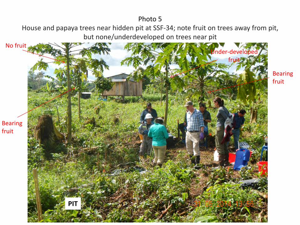
Photo 5 House and papaya trees near hidden pit at SSF-34; note fruit on trees away from pit,
but none/underdeveloped on trees near pit
PIT
No fruit
Bearing fruit
Under-developed fruit
Bearing fruit

Photo 6 Metal placard at SSF-34 well head documenting abandonment date of
September 22, 1983

Photo 7 AG-06
Photo of foot path used by local residents that leads to wetland contaminated with crude oil.

Photo 8 Spring at AG-06
Spring opening

Photo 9 Crude oil on water beneath soil revealed in probe hole at AG-06
Oil in probe hole

Photo 10 AG-06
Oil droplets in water that had collected in a tree stump in AG-06 wetland.
Spring opening

Photo 11 Smear of crude oil from inside stump where oil droplets were observed at AG-06
Oil droplets
Smear

Photo 12 AG-06
Tar covered oil seep in wetland. The groundwater seep carries contamination from the uphill TexPet pits to the wetland below. Crude oil collects in the wetland and forms a tar cover over liquid crude oil
soaked sediments. The soil and sediments in this wetland are contaminated with petroleum in excess of Ecuadorian regulations and as much as 140 times the Judgment clean-up standard.

Photo 13 AG-06
Dr. Garvey using a PID to test the oil seep in the wetland. The PID reading of 164.6 ppm indicates that there is unweathered, liquid crude oil beneath the tar cover. This crude oil has migrated
down from the TexPet pits uphill to the wetland area.

Photo 14 Oil contaminated soil and PID measurement of volatile organic vapors (21.6 ppm)
indicative of oil contamination emanating from soil in the seep area at AG-06

Photo 15 Crude oil and tar beneath leaf litter in the seep area at AG-06

Photo 16 Oil contaminated sediment beneath leaf litter at AG-06

Photo 17 Oil contaminated soil beneath leaf litter at AG-06

Photo 18 AG-06
Contaminated wetland with LBG’s monitoring well (yellow tube). The monitoring wells in the wetland discovered elevated levels of petroleum up to twelve times higher than Ecuadorian regulations permit. LBG’s sampling also found napthenic acids present in the groundwater.
Napthenic acids are components of crude oil that are soluble in water — their presence means there is crude in the water itself not from any sediment or soil particles in the water.

Photo 19 House and residents next to hand dug water supply well at LA-16

Photo 20 LA-16
Marker for location of well site LA-16, which was closed in 1981

Photo 21 Hand dug family water well with crude that flowed from pits about 50 m to left in
picture at LA-16

Photo 22 Location where petroleum evident in soil and water next to hand dug well at LA-16
Well
Oil in water and soil
Pits

Photo 23 LA-16
Girl bathing her little brother from water from a domestic well at LA-16. Napthenic acids were found present in this domestic well, indicating the presence of crude oil in the water.

Photo 24 LA-16
Area downgradient from TexPet pits with domestic water well in the background. In the foreground are two LBG monitoring wells (yellow pipes). LBG found groundwater contamination
four times the Ecuadorian regulations.

Photo 25 Oil in soil and water next to hand dug well at LA-16 (location shown in Photo 22)

Photo 26 Smear of crude oil at LA-16 from location in Photo 25

Photo 27 LA-16
Cleared cornfield that is east of two TexPet pits. PetroEcuador employee is using a digging bar to visually examine the soil as local residents look on. Samples collected in this area were twenty-five times the Judgment clean-up standard.

Photo 28 Injection well SSF-13

Photo 29 Shushufindi 13 (“SSF-13”)
Overview of TexPet pit closed in 1976, labeled Pit 3, with PetroEcuador employees examining the pit. View from northwest corner. On the east side of the pit (left in the photo) is a cut in the berm which drains the pit contents to a
stream. LBG’s soil samples taken outside of this pit’s boundary exceeded thresholds by as much as eight times.

Photo 30 Pit 3 at SSF-13

Photo 31 Breach in pit berm at Pit 3 at SSF-13
Breach
Berm
Berm

Photo 32 SSF-13
LBG using a PID to measure the amount of organic vapors coming out of a freshly dug hole in Pit 3. PID reading in the photo of 76.2 ppm, indicative of crude oil contamination. At this pit, PID readings were as high as 100 ppm.

Photo 33 SSF-13
LBG’s site investigation revealed that sediments in the stream where the cattle are grazing exceeds the Judgment cleanup standard more than twenty times.
Oil in water and soil
Pits

Photo 34 Oil sheen on sediment at LA-02
Photo 35 Oil sheen on sediment, tar, and groundwater seep at LA-02

Photo 36 Oil sheen on sediment and groundwater seep at LA-02

Photo 37 Oil sheen on sediment and groundwater seep at LA-02 with PID reading (10.7 ppm)

Photo 38 Contaminated sediment at LA-02

Photo 39 Poking stick into oil contaminated sediment at LA-02

Photo 40 Oil on stick withdrawn from sediment at LA-02

Photo 41 Siphon from Pit 3 at LA-02 (July, 2013)

Photo 42 Oil and water leaking from siphon (behind and above log) from buried,
undisclosed Pit 3 at LA-02 (August 2014)
Fresh oil drops on plant leaves

Photo 43 Oil contaminated sediment and child’s ball at LA-02

Photo 44 Area adjacent to stream impacted by Pit 3 at LA-02 – Area is being cleared for use.

Photo 45
SSF-55 - Pit 1 PID reading (3.2)
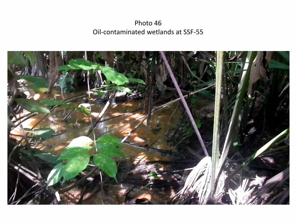
Photo 46 Oil-contaminated wetlands at SSF-55

Photo 47 Crude oil on hand auger and oil-saturated sediment from contaminated
wetland at SSF-55

Photo 48 Oil contaminated wetland at SSF-55

Photo 49 Petroleum sheen on water in wetland at SSF-25

Photo 50 Oily sediment and oil smears on hand auger and glove at access point to stream at SSF-25

Photo 51 Collecting oil contaminated sediment from stream at SSF-25, note sheens and oil droplets

Photo 52 Asphalt from stream downstream of pit at LA-35

Photo 53 Oil and petroleum sheen on a stream at YU-02

Photo 54 Petroleum sheen and oil droplets in wetland at YU-02

Photo 55 Petroleum sheen in stream at YU-02

Photo 56 Petroleum droplets on the water surface in wetland at YU-02

Photo 57 Oil sheen and droplets on water at YU-02

Photo 58 Hand dug well at house adjacent to YU-02

Photo 59 Oil-soaked sediment from wetland at YU-02

Photo 60 Oil droplets in hand-auger sample of clay from a wetland at YU-02

Photo 61 Siphon pipe protruding from Pit A berm at GU-06 indicating pit was designed to contain oil. Note the highest concentrations of barium detected by LBG in soil (5080 mg/kg) were from inside Pit A
A.

Photo 62 Oil droplets in hand auger sediment sample from GU-06

Photo 63 Petroleum sheen on flowing stream at GU-06, same location as
cover photo of the LBG December 2013 Rejoinder Report

Photo 64 Petroleum sheen on flowing stream, same location as cover photo of the
LBG December 2013 Rejoinder Report

Photo 65 Petroleum sheen on flowing stream at GU-06

Photo 66 Oil droplets on water at GU-06

Photo 67 Petroleum sheen and oil droplets in a wetland at GU-06

Photo 68 Sheens in path through oil contaminated wetland at GU-06

Photo 69 Sheens appearing in footprint just after stepping on the wetland sediment at GU-06

Photo 70 Petroleum sheen on water at AG-09

Photo 71
Degraded pond and wetland inside “RAP Remediate” Pit 1 at AU-19

Photo 72 Side of undisclosed Pit 3 exposed by slope failure at AU-19

Photo 73 Oil seeping from side wall of slope failure at undisclosed Pit 3 in AU-19 (Photo 72)

Photo 74 Land owner excavated into old pit without knowing former pit’s location at SA-15

Photo 75 Overview of farmer’s excavation that exposed old pit at SA-15
Pit exposed here

Photo 76 Oil in sediment of marshy stream from spring at SA-15

Photo 77 Oil in sediment of marshy stream from spring at SA-15

Photo 78 Oil contaminated marshy stream from spring at SA-15

Photo 79 Side of second excavation that hit another pit at SA-15

Photo 80 Side of second excavation that hit another pit at SA-15 with house in background

Photo 81 Petroleum in an re-excavated pit during the rain at SA-53; pit was previously
remediated during the RAP
Sheen
LBG geologist

Photo 82 Petroleum sheen emanating from native soil in excavated pit during rain at SA-53

Photo 83 Ongoing remediation (>3 years) of Texpet “RAP remediated” pit at SA-54; sheen is
observable on water
Sheen

Photo 84 Groundwater flowing into excavated pit with sheens on water at SA-54; hose
connected to pump used to dewater the pit is in the foreground
Groundwater seep

Photo 85 Ongoing remediation (>3 years) of RAP remediated pit at SA-54; sheens on water
surface emanating from soil

Photo 86 Ongoing remediation (>3 years) of RAP remediated pit at SA-54

Photo 87 Oil on stream being remediated by PetroAmazonas at SA-86; oily sediment was
exposed after the stream bank was stripped away
Oil contaminated sediment Soil
Oil slick on water

Photo 88 Oil on stream and oil contaminated sediment being remediated at SA-86
Oil contaminated sediment
Soil
Oil slick on water

Photo 89 Stream remediation overview at SA-86. Stream water is diverted to oil-water
separators before being discharged downstream
Oil containment booms
Soil
Oil slick on water

Photo 90 Exposed dark black sediment contains obvious petroleum impacts at SA-86
Oil contaminated sediment/soil Soil

Photo 91 Looking downstream over stream remediation
Oil contaminated sediment Soil
Oil slick on water
Oil contaminated sediment

Photo 92 Looking farther upstream from middle of remediation at SA-86

Photo 93 Stream remediation showing exposed contaminated sediment at SA-86
Oil contaminated sediment
Soil

Photo 94 Looking upstream from bridge at SA-86

Photo 95 Petroleum sheen in an undocumented pit with a PID reading of 97 ppm at SA-56

Photo 96 Oil seep at undocumented pit at SA-56

Photo 97 Hard asphalt under plants at SA-56

Photo 98 Petroleum sheen in creek adjacent to piling foundations at SA-89

Photo 99 Petroleum sheen on degraded stream at SSF-42A

Photo 100 Degraded stream adjacent to remediated pit at SSF-42A

Photo 101 Bats in a culvert for the degraded stream at SSF-42A

Photo 102 Small soil-filled (buried oil) pits at AU-24

Photo 103 Soil covered but un-remediated pit at AU-24, next to school

Photo 104 Un-remediated pit full of water used by local residents at YU-06, house in background
Elevated PID readings were measured in the sediment from this pit
House

Photo 105 Un-remediated oil (oil on water) pit SSF-Suroeste Production Station

Photo 106 Tip of digging bar was black from oil at SA-85

Photo 107 Showing depth of cover (<0.5 m) and oil at SA-85

Photo 108 New wood mill over pit at SA-6

Photo 109 Plants for PetroAmazonas remediation/revegitation projects

Photo 110 Pit 1 crude oil at CH-01

Photo 111 Pit 1 crude oil at CH-01; plants are growing on leaf litter covering 1 meter thick layer of oil

Photo 112 Oil in pit 1 at AG-04

Photo 113 Drainage pipe (siphon) on the pit side at AG-04
Siphon pipe

Photo 114 Crude oil leaking from undocumented pit at AG-04

Photo 115 Community water well next to wetland with petroleum sheens and elevated PID
measurements at AG-08

Photo 116 Oily groundwater seep at AG-02 – TPHe8015 analysis of a sediment sample collected
here detected 31,310 mg/kg

Photo 117 Smear from oily groundwater seep at AG-02

Photo 118 People washing clothes and playing in a stream where petroleum drains at AG-02

Photo 119 Oil in soil

Photo 120 Remnants of old spill at SSF-37

Photo 121 Laundry area at SSF-37

Photo 122 Unremediated Pit 4 at YU-05

Photo 123 Unremediated Pit 4 at YU-05

Photo 124 Remediated Pit 3 at YU-05

Photo 125 Oil contaminated soil

Photo 126 Oily sediment and water

Photo 127 Oily sand that smells strongly of oil from YU-02

Photo 128 Sheen in footprint at YU-02

Photo 129 Oil from stream on leaf

Photo 130 Cattle by pit berm at SSF-04

Photo 131 Oil droplets and blebs in water and sediment

Photo 132 Oil contaminated sandy sediment in stream at LA-02

Photo 133 Small un-remediated pit exposed in sand pit at SA-65
Sand fill and trash
Degraded oil
Hardened waste cement
Contaminated native sand

Photo 134 Oil contaminated sand beneath un-remediated pit exposed in sand pit at SA-65

Photo 135 Sheen emanating from excavated soil at Dureno 01