Chester Characterisation Study
33
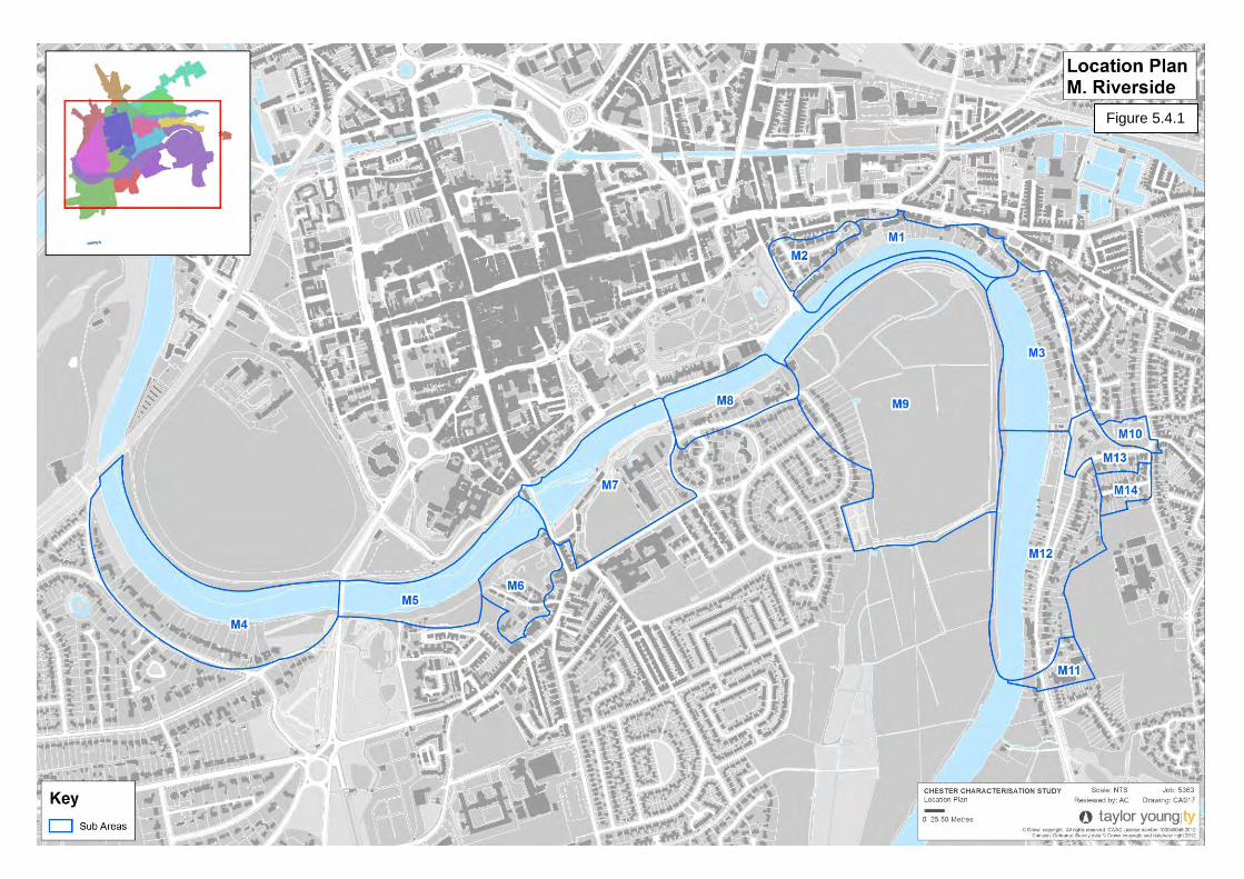
Chester Characterisation Study: Final Report 5.4 M. Riverside Character Area Assessment Location The Riverside character area includes the whole length of the River Dee as it passes through the study area. It generally includes the River and land to its immediate south but also include the northern bank in the area south of Boughton. Sub-Areas The area is comprised of the following sub-areas: M1. Boughton Deeside - land on the northern bank of the River, south of Boughton. M2. Dee Hills Park - the planned suburban development on the northern side of the River, south of Boughton. M3. Sandy Lane - leading south alongside the eastern bank of the River. M4. Curzon Park Riverside - the part of the planned suburban development that backs onto the southern river bank. M5. Styelane Croft - a track through a heavily vegetated area on the southern bank. M6. Edgar's Field - the open space and surrounding streets. M7. Old Dee Bridge - the historic bridge and adjacent land on the southern bank of the River. M8. Lower Park Road (Queen’s Park) - the northern side of the road (and adjacent part of Victoria Crescent), with large villas backing onto the riverside. M9. Earls Eye Meadows - the open space in the flood plain in the loop of the river. M10. Stocks Lane Bowling Green -Bowling Green at the corner of Stocks Land and Dee Banks and surrounding buildings. M11. Deva Heights - New housing development and adjacent school accessed off Dee Banks on the south of the area. M12. Dee Banks - overlooks the River from an elevated height. M13. Walmoor House - land between Sandy Lane and Dee Banks. M14. Private Walk - a small private street off Bachelors Lane M1. Boughton Deeside 74
Transcript of Chester Characterisation Study

Chester Characterisation Study: Final Report
5.4 M. Riverside
Character Area Assessment
Location
The Riverside character area includes the whole length of the River Dee as it passes through the study area. It generally includes the River and land to its immediate south but also include the northern bank in the area south of Boughton.
Sub-Areas
The area is comprised of the following sub-areas:
M1. Boughton Deeside - land on the northern bank of the River, south of Boughton.
M2. Dee Hills Park - the planned suburban development on the northern side of the River, south of Boughton.
M3. Sandy Lane - leading south alongside the eastern bank of the River.
M4. Curzon Park Riverside - the part of the planned suburban development that backs onto the southern river bank.
M5. Styelane Croft - a track through a heavily vegetated area on the southern bank.
M6. Edgar's Field - the open space and surrounding streets.
M7. Old Dee Bridge - the historic bridge and adjacent land on the southern bank of the River.
M8. Lower Park Road (Queen’s Park) - the northern side of the road (and adjacent part of Victoria Crescent), with large villas backing onto the riverside.
M9. Earls Eye Meadows - the open space in the flood plain in the loop of the river.
M10. Stocks Lane Bowling Green -Bowling Green at the corner of Stocks Land and Dee Banks and surrounding buildings.
M11. Deva Heights - New housing development and adjacent school accessed off Dee Banks on the south of the area.
M12. Dee Banks - overlooks the River from an elevated height.
M13. Walmoor House - land between Sandy Lane and Dee Banks.
M14. Private Walk - a small private street off Bachelors Lane
M1. Boughton Deeside
74
Chester Characterisation Study: Final Report
75
Figure 5.4.1

Chester Characterisation Study: Final Report
Historical Development was extended in 1270. In 1826 the causeway was widened to provide a footway on the upstream side.
A settlement has existed at Handbridge since the Iron Age. It was the site of a sandstone quarry during the Roman occupation and later saw expansion as the City grew beyond the City Walls. According to legend, Edgar's Field is one of a few sites that may have been the Royal palace of the Anglo-Saxon King Edgar of England, although there is no archaeological evidence of this. Legend tells that, in order to pledge an oath to him, six lesser kings rowed him up the Dee to his palace, where they pledged allegiance to the king "on both land and sea".
The Old Dee Bridge is the oldest bridge in the City. A bridge on this site was originally built by the Romans. During the medieval period, successive river crossings were built on the site of the bridge noted in the Domesday Book to replace others lost to flooding; the current Old Dee Bridge dates from 1353, but at least four other bridges existed on the site beforehand. The bridge became a choke point in Welsh invasions, leading to both ends of the bridge being fitted with sentry posts. Although the bridge formed the only crossing at that point, residents were reluctant to repair the bridge, leading Richard II of England to pay for the crossing to be restored in 1374 with large towers and a drawbridge to further deter Welsh raids.
Chester Weir, across the River, was built in 1093, under the orders of Hugh Lupus, to provide power to drive water mills along the banks of the river, and to improve the navigation of the River. The mills ran a legally enforced monopoly, with all Cestrians being forced to have their corn ground at these mills. The millers were reputed to be take many times what they should in tithes. The song "Miller of Dee" was written about these millers, which led to "Miller of the Dee" becoming an insult in Medieval culture, meaning a thief or a cheat. The weir and causeway
Around this time it was decided that the old Dee Bridge was becoming inadequate for the expected traffic and it was decided to build an additional bridge to link the City with North Wales. This resulted in the Grosvenor Bridge, designed by Thomas Harrison, which opened in 1832. At the time of its construction, the bridge was the longest single-span arch bridge in the world, a title that it retained for 30 years. Its Grade I listing reflects its historic significance.
Old Dee Bridge (drawing from 1900)
The growth of �hester’s suburbs was a slow and piecemeal process. The main era accounting for most of the development in this area, occurred between 1840 and 1914. In 1870 a revived prosperity of the City led to a building boom - of terraced housing for workers, artisans and the lower middle class; and villas for the wealthy. Later in this period areas of larger terraced housing for the more prosperous middle classes were built, including those for commuters to neighbouring towns and cities.
76

Chester Characterisation Study: Final Report
The constraints imposed by the River Dee and its meadows meant that most suburban development took place in an arc to the north, northeast, and east of the walls or across the river at Handbridge, Queen's Park, Curzon Park, and Saltney. The northern suburbs were predominantly of terraced housing while those to the south and east of the river generally contained more spacious properties.
The Queen's Park suspension bridge was opened in 1852 to serve the residential development of Queen’s Park, providing a direct link to the walled city. Chester Corporation took on the responsibility for this bridge in the early 1920s. They demolished it in 1922 and replaced it with a new bridge designed by Charles Greenwood, City Engineer and Surveyor. This is the bridge that stands today; it was restored in 1998.
Dee Hills was developed in 1850s when William Titherington, the owner of a 10 acre estate, broke up his land to build Sandown Terrace, three Italianate houses and Deva Terrace. In 1873 Dee Hill had extensive grounds with pleasure gardens above the river and a tree-lined drive from The Bars, flanked by paddocks to the north and allotment gardens to the south-east. More estate land was being sold for development and in the 1880s Beaconsfield Terrace had been built on the northern part of this land. The drive was now named Dee Hills Park and was lined with larger houses, including the largest: Uffington House. By 1892 Dee Hills House and the remaining gardens had been sold to the government and was being used as the residence of the !rmy’s district commander/
A few villas were also built in this period east of the River, at Dee Banks, including a pair completed by John Douglas in 1869. Further infill occurred in this area in the late 19th century and in 1896 Douglas built a large house, Walmoor Hill, for his own use on a steep site overlooking the river.
Former home of John Douglas (later a girls͛ school), Dee �anks
Also of historical note is the former British Army Western Command (now HBOS offices) complex on the southern bank of the river to the west of Victoria Crescent. This was built in 1938/9 when the headquarters outgrew its original home in Watergate House (built by the prolific Chester architect Thomas Harrison in 1820) on Watergate Street. The building was hurriedly completed at the outbreak of World War Two and the headquarters function was duplicated in a vast underground bombproof space. In 1943 and 1944, secret meetings were held in the underground bunkers between Winston Churchill, General Eisenhower and General de Gaulle.
In 1972 the Royal Army Pay Corps (RAPC) took over the buildings until the Ministry of Defence closed the site in 1997. The buildings were sold to North West Securities (later Capital Bank and then HBOS) for use as their Chester Head Office. A radical enlargement and remodelling took place at this time: the building was increased in height, the central portico-detailed wing was added and a second perpendicular building was added. The building is consequently much altered and relatively new but it remains important due to its wartime historical significance.
77
78
Chester Characterisation Study: Final Report
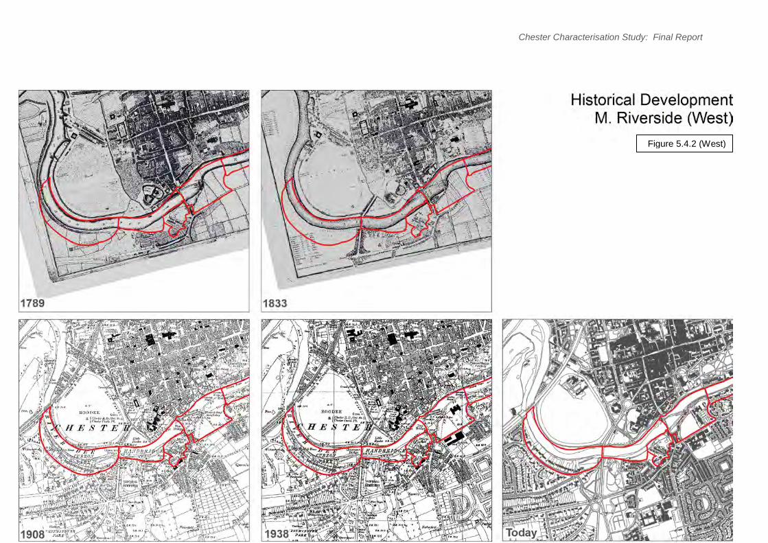
Figure 5.4.2 (West)

79
Chester Characterisation Study: Final Report
Figure 5.4.2 (East)
Land-uses
Land-uses in this area surrounding the River are predominantly residential, where the value of the pleasant riverside aspect can be maximised. The other significant land-use is open space – at the Earl’s Eye Meadows, Styelane Croft, opposite Old Dee Bridge and on Sandy Lane. This is often a result of flood plain factors and also provides for public access to the riverside. The only other significant use is the office park in sub-area M7 (the site of the former British Army Western Command).
Urban Form
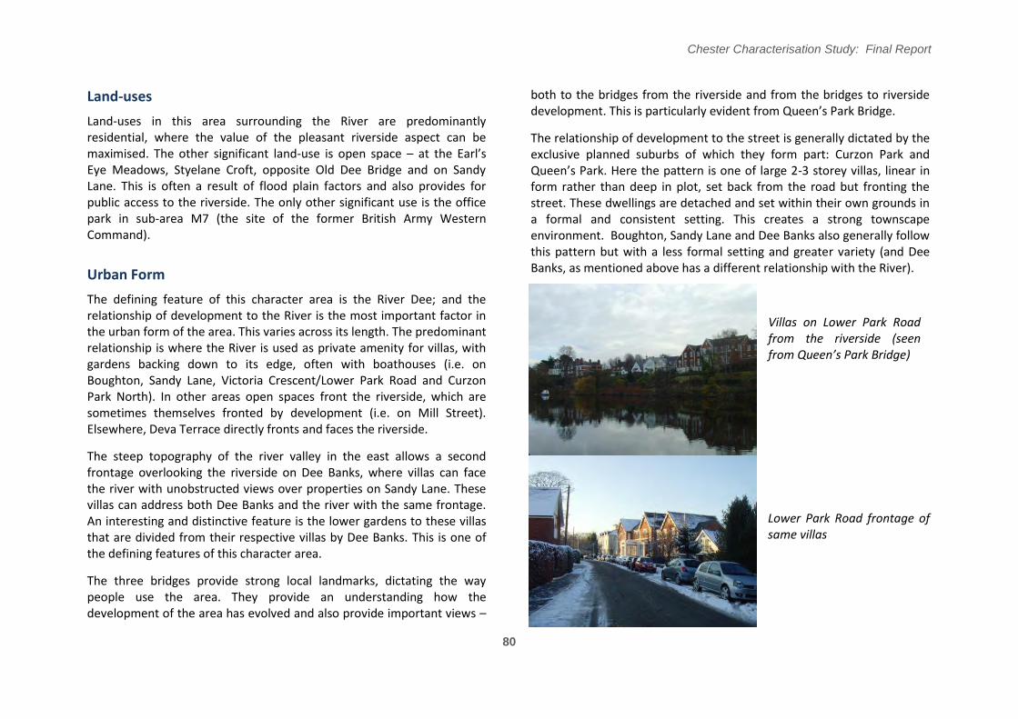
The defining feature of this character area is the River Dee; and the relationship of development to the River is the most important factor in the urban form of the area. This varies across its length. The predominant relationship is where the River is used as private amenity for villas, with gardens backing down to its edge, often with boathouses (i.e. on Boughton, Sandy Lane, Victoria Crescent/Lower Park Road and Curzon Park North). In other areas open spaces front the riverside, which are sometimes themselves fronted by development (i.e. on Mill Street). Elsewhere, Deva Terrace directly fronts and faces the riverside.
The steep topography of the river valley in the east allows a second frontage overlooking the riverside on Dee Banks, where villas can face the river with unobstructed views over properties on Sandy Lane. These villas can address both Dee Banks and the river with the same frontage. An interesting and distinctive feature is the lower gardens to these villas that are divided from their respective villas by Dee Banks. This is one of the defining features of this character area.
The three bridges provide strong local landmarks, dictating the way people use the area. They provide an understanding how the development of the area has evolved and also provide important views –
Chester Characterisation Study: Final Report
both to the bridges from the riverside and from the bridges to riverside development/ This is particularly evident from Queen’s Park �ridge/
The relationship of development to the street is generally dictated by the exclusive planned suburbs of which they form part: Curzon Park and Queen’s Park/ Here the pattern is one of large 2-3 storey villas, linear in form rather than deep in plot, set back from the road but fronting the street. These dwellings are detached and set within their own grounds in a formal and consistent setting. This creates a strong townscape environment. Boughton, Sandy Lane and Dee Banks also generally follow this pattern but with a less formal setting and greater variety (and Dee Banks, as mentioned above has a different relationship with the River).
Villas on Lower Park Road from the riverside (seen from Queen͛s Park �ridge)
Lower Park Road frontage of same villas
80

Chester Characterisation Study: Final Report
There are a number of notable exceptions to this pattern, generally resulting from different eras of development or changing topography.
Dee Hills Park is also an example of planned suburban development but housing here lacks riverside views and is more modest in form (generally semi-detached) than the riverside villas. These properties are semi-detached and set back from the street with front gardens. They are still strong examples of consistent urban form that addresses the street well.
Dee Hills Park
Sandown Terrace is a magnificent set-piece development that stands on its own as a grand two-storey mews terrace. Its rear elevation faces the river at the bottom of a long garden. Deva Terrace is a less ornate but still an impressive three-storey riverside terrace to the west of Sandown Terrace. This terrace is located directly on the riverside, behind a retaining wall and riverside path. The rear of the terraces fronts a small street.
Sandown Terrace
Greenway Street, �achelor’s Lane (and the adjoining Private Walk) and the corner of Handbridge by Old Dee Bridge all have smaller-scale two to three storey Georgian and Victorian housing that often pre-dates the period of 19th century suburban villa development. Properties here are generally plainer, smaller, terraced or semi-detached and back-ofpavement (or with small front gardens on Private Walk).
Barrel Well Hill has a more distinct form due to its steep topography. This is a steeply descending street extending south from Gallows Hill on Boughton. It has back-of-pavement domestic scale Georgian and Victorian development on its southern side, on plots which back onto the riverside. At its eastern end the street is terminated with a courtyard development form, whilst the massing of St Paul’s �hurch dominates due to the change of level at this point. Barrel Well Hill provides strong townscape as a more intimate and tranquil space, with the topography creating interesting views down the street.
81

Chester Characterisation Study: Final Report
82
Figure 5.4.3: Urban Form Figure 5.4.3 (West)

Chester Characterisation Study: Final Report
83
Figure 5.4.3 (East)

Chester Characterisation Study: Final Report
Townscape Character
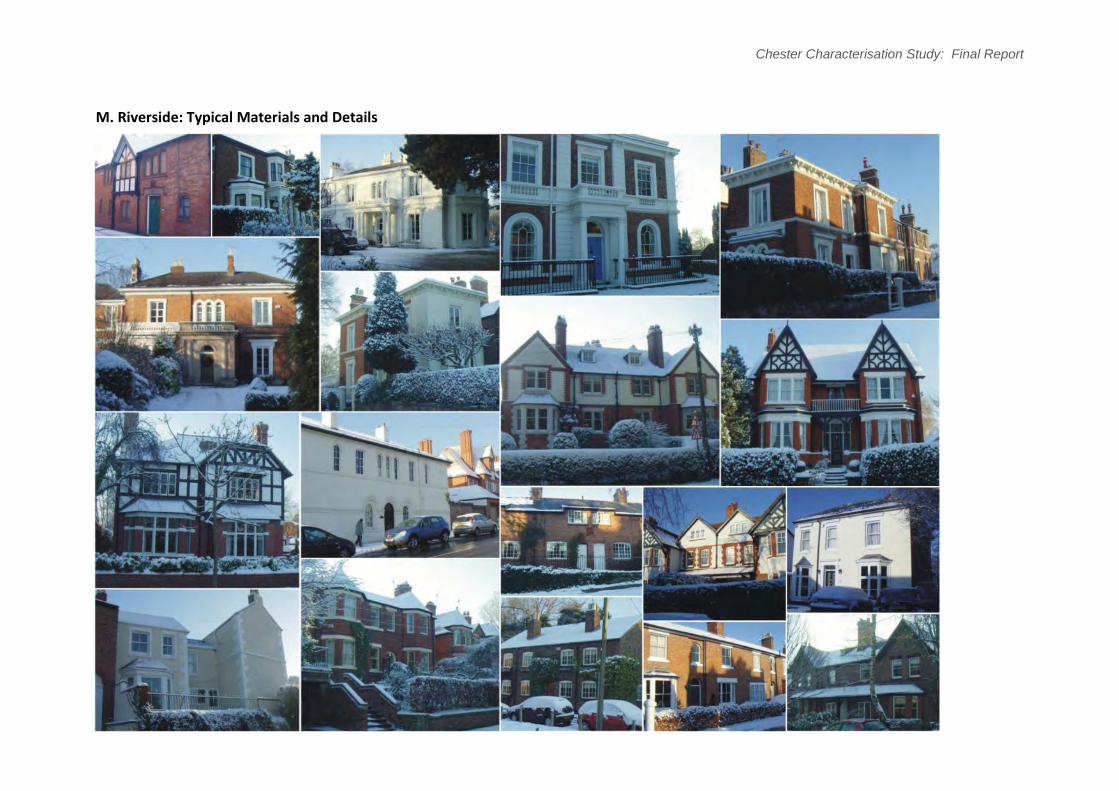
There is a consistency to the villas across the character area, from �oughton, Dee �anks and Sandy Lane to Queen’s Park and �urzon Park/ These detached villas are of individual design but have common themes. The predominant style is typical Regency design, although these villas were mostly built slightly later from the 1840s onwards. This comprises a modification of the classic Georgian symmetry, with bay windows, bowed elevations and taller floor-to ceiling windows – making the most of the riverside views. There is also more widespread use of smooth cream or white render and detailing, allied with use of warm red-brown local brick. Windows are typically sashes, often multi-paned. Roofs are generally shallow pitched, often behind parapets. Use of bays, porticos and projecting bays create an interesting articulation to these properties. Round-arch window heads and Italianate stylings are also popular throughout the area. The combined effect is a pleasingly consistent yet varied townscape with subtle variations around these themes.
Typical Villa form – Lower Park Road
The more middle-class suburban housing of Dee Hills Park and the eastern and southern ends of Dee Banks were developed later and have more typical Victorian and Edwardian stylings. These includes more bay windows, gable fronts, and black timber/white render decoration or decorative brickwork / white render combinations on later properties. Properties at the eastern end of Dee Banks often have two-storey bays with hipped roofs. Those at the southern end have more steeply pitched roofs with gable fronts. Windows are often horizontally proportioned in groups. These areas do not benefit from the consistency across the character area that the larger villas have and instead are representative of their own eras of development. In Dee Hills Park though, a consistent and distinctive character is evident through the street form and landscape character and by the change of character experienced at the entrance of the road from Boughton (marked by signed gateposts).
Eastern end of Dee Banks
84

More simple early Victorian houses are also found on Dee Banks and on Private Walk (off �achelor’s Lane)/ These are plainer two-storey cottages, in detached, semi-detached or terraced form, in white render or brick with modest ground floor bays and simpler detailing. A good three storey simple Georgian group is found on Handbridge, incorporating the Ship Inn.
Private Walk (off �achelor͛s Lane)
The Victorian cottages on Greenway Street, and on Mill Street, have a more rural character with red-brown brick, traditional pitched roofs (with slight dormers on Greenway Street), simple door openings and horizontally proportioned, multi-paned windows with timber casements.
Landscape Character
The landscape character of the area is rich and interesting and a defining characteristic. This is dominated by the River, which when not fronting sites directly, is a visible feature for much of the area. Although most of the banks are in private ownership there are many views of the riverside, its facing development and planting in these private gardens to provide
Chester Characterisation Study: Final Report
strong amenity throughout the area. This is especially noticeable from the riverside itself and from the three bridges that cross the river here. The bridges themselves (Old Dee �ridge, Queen’s Park �ridge and Grosvenor Bridge) also act as strong landmarks on views up and downstream.
Earl͛s Eye Meadows viewed from �oughton
View east from Queen͛s Park �ridge
85
Earl’s Eye Meadows, the open land in the loop of the River, is an important feature both historically and in terms of the urban form of the area. This large space provides dual benefits in terms of amenity. The surrounding villas of Boughton, Dee Banks and Sandy Lane benefit from views across these fields, which allow wider views of the riverside. Additionally, when in the meadow itself one benefits from the complete aspect of surrounding Victorian villas that face the space. This is an important element in the townscape of the City.
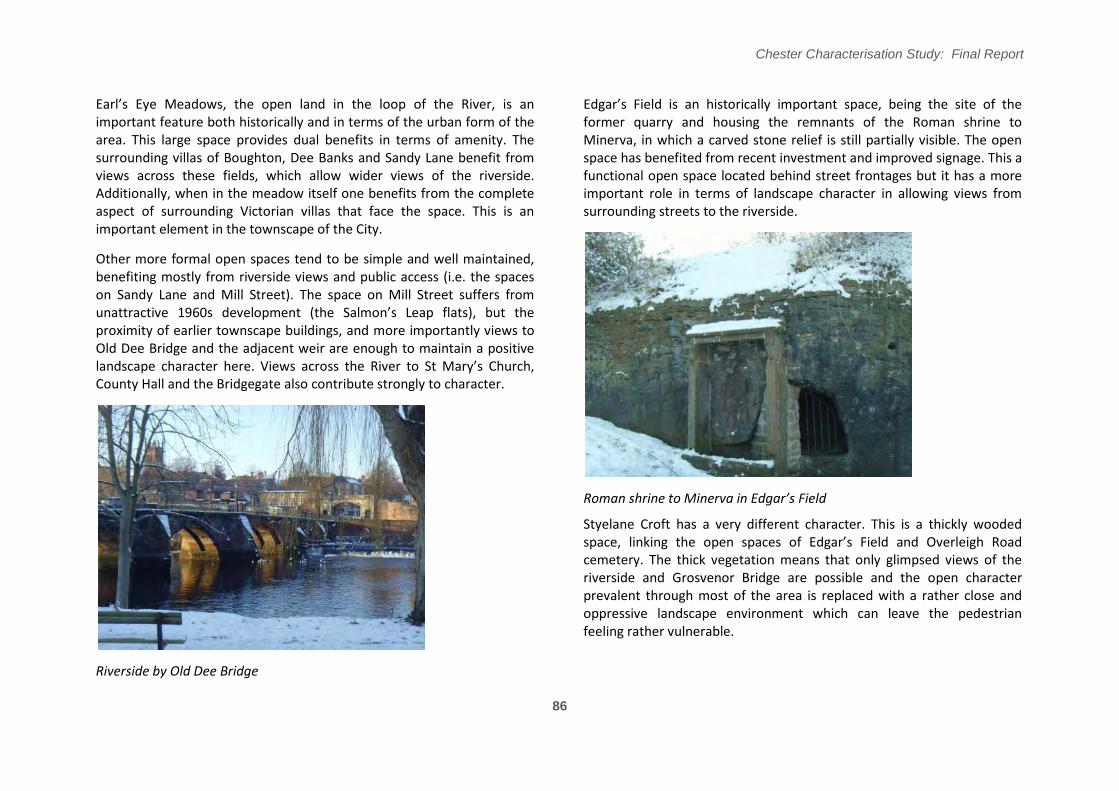
Other more formal open spaces tend to be simple and well maintained, benefiting mostly from riverside views and public access (i.e. the spaces on Sandy Lane and Mill Street). The space on Mill Street suffers from unattractive 1960s development (the Salmon’s Leap flats), but the proximity of earlier townscape buildings, and more importantly views to Old Dee Bridge and the adjacent weir are enough to maintain a positive landscape character here/ Views across the River to St Mary’s �hurch, County Hall and the Bridgegate also contribute strongly to character.
Riverside by Old Dee Bridge
Chester Characterisation Study: Final Report
Edgar’s Field is an historically important space, being the site of the former quarry and housing the remnants of the Roman shrine to Minerva, in which a carved stone relief is still partially visible. The open space has benefited from recent investment and improved signage. This a functional open space located behind street frontages but it has a more important role in terms of landscape character in allowing views from surrounding streets to the riverside.
Roman shrine to Minerva in Edgar͛s Field
Styelane Croft has a very different character. This is a thickly wooded space, linking the open spaces of Edgar’s Field and Overleigh Road cemetery. The thick vegetation means that only glimpsed views of the riverside and Grosvenor Bridge are possible and the open character prevalent through most of the area is replaced with a rather close and oppressive landscape environment which can leave the pedestrian feeling rather vulnerable.
86

Chester Characterisation Study: Final Report
Landscape setting on Curzon Park North
A strong landscape character has also been achieved in the planned suburbs of Dee Hill Park, �urzon Park and Queen’s Park/ This is achieved by wide, gently curving streets with set-back building lines allowing street trees, green verges (in Curzon Park) and planting within front gardens to create strong formal landscape environments. This is a defining feature of these suburbs.
The landscape within the grounds of Walmoor House also contributes strongly to the character of the area. This is a private space and allows only glimpsed views (giving the feel of a ‘secret garden’) but nonetheless the house and grounds are high quality and contribute strongly to the surrounding area. The steep path linking Walmoor Park to Dee Banks, beside Walmoor House, also provides an interesting townscape experience, especially due to the fact that the topography means that end of the path is not visible from its start.
View east over River from Dee Banks
View north from Earl͛s Eye Meadows
87

Chester Characterisation Study: Final Report
The Bowling Green on Stocks Lane, and adjadcent open space on the frontage to Dee Banks, is well maintained and attractive and provides a pleasant setting for surrounding domestic scale properties.
Setting of Grosvenor Bridge: Thomas Harrison’s masterpiece enjoys different settings: when driving, it does not appear exceptional as one enters the city over its flat deck. Walking the same route, however, provides quite dramatic views towards the city and along the river: the height of the arch (designed to clear ships’ masts as �hester was at the time a ship-building centre and port) can be appreciated. From river level the sheer scale of the bridge becomes apparent. At river-level vantage points are gained along the Roodee riverside walk, which passes through a dedicated arch. Looking from here, the bridge is set in a peaceful green riverside environment. On Castle Drive there are fine views of the bridge itself, although the foreground consists of a wide expanse of hard-surfaced car parking.
View on Grosvenor Bridge to City Centre
Grosvenor Bridge seen from Castle Drive View on Grosvenor Bridge to south bank of the River
88
89
Chester Characterisation Study: Final Report
M. Riverside: Typical Materials and Details

Chester Characterisation Study: Final Report
90
Figure 5.4.4: Townscape & Landscape Analysis
Figure 5.4.4 (West)

Chester Characterisation Study: Final Report
91
Figure 5.4.4 (East)

Chester Characterisation Study: Final Report
Designated Heritage Assets
The character area is included within several conservation area boundaries, giving full coverage:
Dee Banks and Sandy Lane (including Private Walk) comprise the Dee Banks conservation area.
The riverside land south of �oughton and the Earl’s Eye Meadows fall within the Boughton and the Meadows conservation area.
Lower Park Road and Victoria �rescent is within the Queen’s Park conservation area.
The riverside parts of Handbridge (including Edgar’s Field and Styelane Croft are within the Handbridge conservation area.
Curzon Park North is within the Curzon Park conservation area.
The Old Dee �ridge, Grosvenor �ridge and Queen’s Park �ridge, and the River itself are within the City Centre Conservation Area.
There are several listed buildings in the area.
The 2nd century Roman shrine to Minerva (right) in Edgar’s Field isboth a Scheduled Monument and a Grade I listed structure.
The Old Dee Bridge (late 14th century with 1826 additions) is Grade I listed. The adjacent weir and causeway (Salmon’s Leap) include original elements from 1093 and are also Grade I listed.
Grosvenor Bridge (1827-1833 by Thomas Harrison) is Grade I listed.
92

Chester Characterisation Study: Final Report
St Paul’s �hurch, Boughton (1896 by John Douglas) is Grade II* Walmoor House, Dee Banks is Grade II* listed, also 1896 by John listed. Douglas for himself (later girl’s school and then office)/
Sandown Terrace (1833-1866) is Grade II listed.
There are many Grade II listed buildings, generally the better examples of the riverside villas. For example this includes Uffington House (left), in Dee Hills Park (1885).
There are also a number of Article 4 directions affecting some of the villas, especially on Boughton, Dee Hills Park and Victoria Crescent.
93
Chester Characterisation Study: Final Report
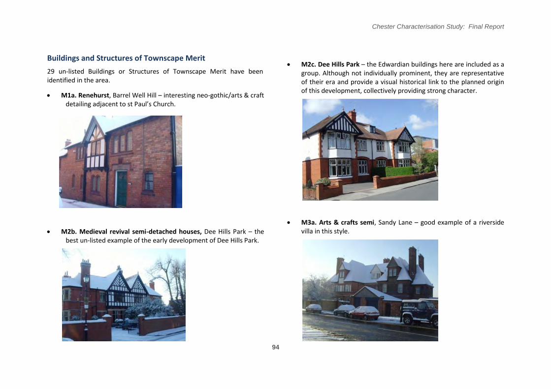
Buildings and Structures of Townscape Merit M2c. Dee Hills Park – the Edwardian buildings here are included as a
29 un-listed Buildings or Structures of Townscape Merit have been group. Although not individually prominent, they are representative identified in the area. of their era and provide a visual historical link to the planned origin
of this development, collectively providing strong character. M1a. Renehurst, Barrel Well Hill – interesting neo-gothic/arts & craft
detailing adjacent to st Paul’s �hurch/
M3a. Arts & crafts semi, Sandy Lane – good example of a riverside
M2b. Medieval revival semi-detached houses, Dee Hills Park – the villa in this style.
best un-listed example of the early development of Dee Hills Park.
94

Chester Characterisation Study: Final Report
M3c. Italianate villa, Sandy Lane – excellent set piece grand villa M3m. Earls Eye House (and adjacent buildings), Sandy Lane - group within courtyard grounds. of three villas. Main interest is on their riverside frontage.
M3d. Georgian end-terrace, Sandy Lane – end elevation is highly M4a. 20 Curzon Park North – fine Italianate riverside villa. visible from view uphill, distinctive coloured render.
95

Chester Characterisation Study: Final Report
M4b. 4 Curzon Park North – good Victorian villa. M4d. 8 Curzon Park North – Queen Anne style villa.
M4c. 6 & 6a Curzon Park North – good Italianate villa (now M4e. 10 Curzon Park North – fine Regency-style villa. subdivided).
96

Chester Characterisation Study: Final Report
M4f. Abbeygate and Rivermeade – distinctive gable-fronted pair. M4h. 20 Highfield – well restored Italianate villa.
M4g. 22 Curzon Park North – good Arts & Crafts style villa. M4i. 20 Curzon Park North – exceptionally well detailed Arts & Craft style pair.
97
Chester Characterisation Study: Final Report
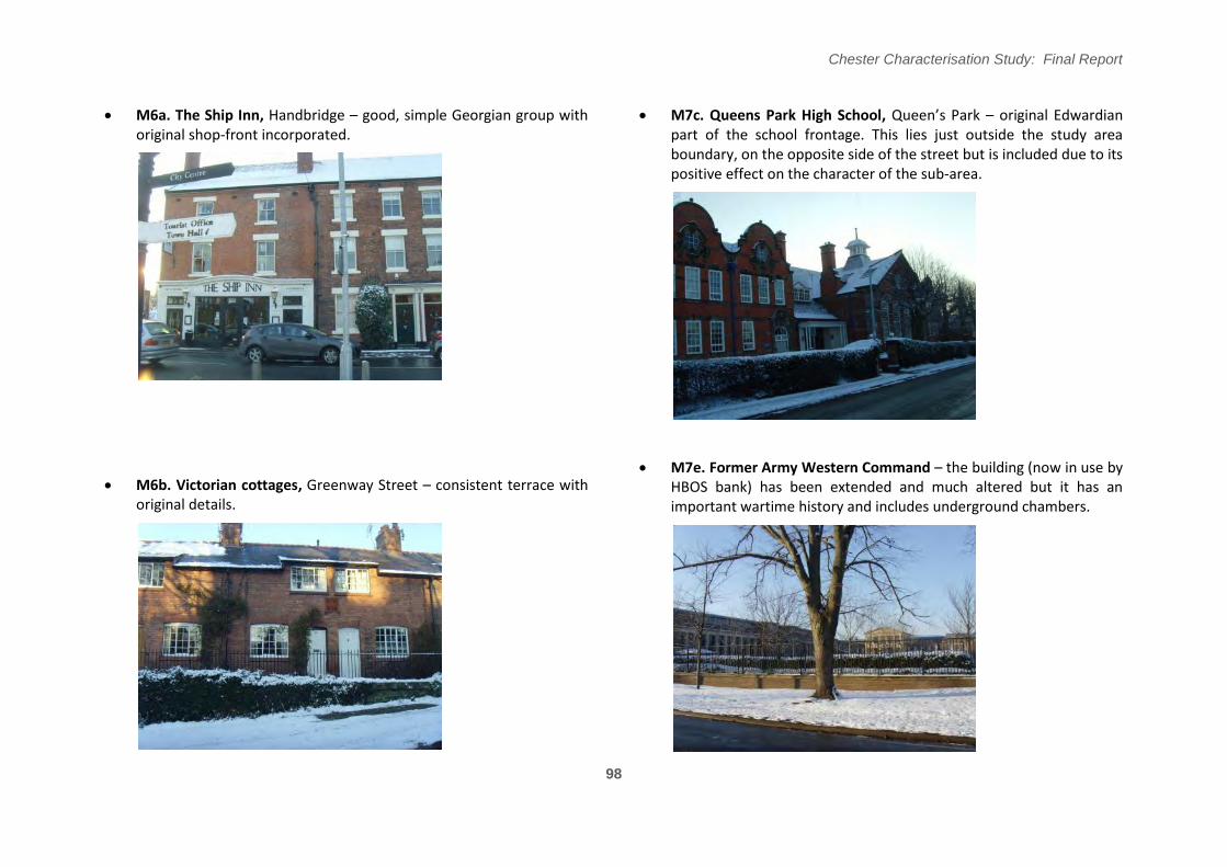
M6a. The Ship Inn, Handbridge – good, simple Georgian group with M7c. Queens Park High School, Queen’s Park – original Edwardian original shop-front incorporated. part of the school frontage. This lies just outside the study area
boundary, on the opposite side of the street but is included due to its positive effect on the character of the sub-area.
M7e. Former Army Western Command – the building (now in use by M6b. Victorian cottages, Greenway Street – consistent terrace with HBOS bank) has been extended and much altered but it has an
original details. important wartime history and includes underground chambers.
98

Chester Characterisation Study: Final Report
M8a. Victorian Villa, Victoria Crescent – riverside villa with M12h. Italianate style semi-detached houses, Dee Banks – group distinctive style and detailing. with varied but consistent style and details in excellent condition.
M12k. Victorian black & white villas, Dee Banks – group of three M12g. Edwardian semi, Dee Banks – distinctive styling. pairs, separated by altered or redeveloped houses. The southernmost (below) is the best example of this style here.
99

Chester Characterisation Study: Final Report
M12l. Georgian cottage (white), Dee Banks – a period property in M13i. Edwardian semi-detached, Dee Banks – well detailed property good condition. of good design.
M13e. Neo-gothic semi, Dee Banks – distinctive materials and M13j. Two Late Victorian semis, Dee Banks – good period middle unusual style for semi-detached housing. class housing.
100

Chester Characterisation Study: Final Report
M14f. Victorian domestic group, Private Walk – early Victorian group with modest detailing.
�oathouse at Earl͛s Eye Meadows.
Key Detractors
Two key detractors have been identified in this character area.
There is a low rise utilitarian boathouse at the entrance to Earl’s Eye Meadows from Lower Park Road. This is in poor condition and its plain, modern appearance is at odds with the surrounding villas and development on the far bank of the River. Consequently this forms a poor first impression at the gateway to this important space.
The 1960s concrete flats on Mill Street, (‘Salmon’s Leap’), are unsightly and do not respond to the high heritage value of the immediate vicinity, which includes the Old Dee Bridge. Moreover, they are highly visible both from the open space and more importantly from the bridge and from the opposite side of the River. Salmon͛s Leap flats seen from Old Dee �ridge.
101

Chester Characterisation Study: Final Report
102
Figure 5.4.5 (West)

Chester Characterisation Study: Final Report
103
Figure 5.4.5 East)

Summary: Character Assessment
In summary this is an area generally with a positive and consistent character throughout, defined by the River and the response of buildings to it.
M1. Boughton Deeside: Critical – series of good villas in varying forms with important riverside views, and the further interest of �arrel Well Hill and St Paul’s church.
M2. Dee Hills Park: Positive – good example of well defined late Victorian planned suburb.
M3. Sandy Lane: Critical – excellent series of riverside villas, visible across the River from Earls Eye Meadows.
M4. Curzon Park Riverside: Critical – complete example of fine riverside villas in a variety of architectural styles, visible from across the River on the Roodee.
M5. Styelane Croft: Positive – heavily vegetated area provides poor pedestrian experience but of value due to riverside location.
M6. Edgar's Field: Critical – includes mix of simple Victorian and Georgian properties and the historically critical Minerva shrine, with valuable views across the riverside.
M7. Old Dee Bridge: Critical – historically significant bridge and weir and fine views across the River to the walled City.
M8. Lower Park Road: Critical – a series of fine riverside villas contributing to character on both sides of the River; also benefits from the landmark Queen’s Park �ridge and riverside views.
M9. Earls Eye Meadows: Critical – a key open space in the urban form of the City, offers important views to, from and across it and the riverside.
Chester Characterisation Study: Final Report
M10. Stocks Lane Bowling Green: Positive - well kept greens provide attractive residential setting.
M11. Deva Heights: Neutral - modern primary school and housing.
M12. Dee Banks: Critical - Elevated views from Victorian riverside villas with gardens separated by the road.
M13. Walmoor House: Critical - Good Edwardian housing, dominated by the significant Walmoor House and its grounds.
M14. Private Road: Positive - attractive private street of domestic Victorian housing.
Character Statement
“The Riverside character area is defined by the 1840-1914 era of suburban expansion north and south of the River Dee and by the series of distinctive villas that circle the riverside. Views from and to the River and the three bridges that cross it (Queen’s Park �ridge, the Old Dee Bridge and Grosvenor Bridge) provide strong character, historical significance and features of City-wide importance “.
104

Chester Characterisation Study: Final Report
105
Riverside view from Boughton
Figure 5.4.6

Management and Policy Recommendations
The area remains generally in very good condition with the special character of the riverside and associated architecture still very much in evidence. There are a large number of Article 4 Directions in the area and these appear to be generally well observed. The key detractors are the few examples listed on page 95. Listed buildings are generally in good condition but the Minerva Shrine in Edgar's Field would benefit from better protection and setting. The Styelane Croft area would also benefit from more attractive landscaping and better maintenance, making the most of riverside views. Although this area is divided between several Conservation Areas the riverside theme is important and this form of integrated thinking should be maintained.
Capacity to Accommodate Change
There are few opportunities for significant new development given the absence of available plots, the rarity of low grade buildings and the importance of preserving views to and from important buildings and spaces on the riverside. Recent developments in the area though, have shown how existing significant buildings can be successfully restored, modernised and converted to new uses (for example the HBOS offices in the former British Army Western Command and the Red House pub).
Design Principles for New Development
In general, any new development or alterations should maintain the inherent character of the area and its significant buildings, as described in this report. If either of the two detractor sites were redeveloped the following points should be followed:
If the Earls Eye boathouse was to be redeveloped then its impact on the setting of the open space would be the paramount
Chester Characterisation Study: Final Report
consideration. Any new development is only likely to be permitted if it is for recreational or open space related uses. In such cases, this should be a low-rise building that provides attractive facades when viewed from the river and when marking a gateway to the meadow from Lower Park Crescent.
If the Salmon's Leap flats were redeveloped then new development should present a strong frontage to both the riverside and the two open spaces either side of the blocks. The riverside frontage should be regarded as the primary frontage. The position of development should also maintain the enclosure and setting of the two open spaces, and the separation between them, the most important of these being the riverside open spaces. The flats fronting Queen's Park Road could also be redeveloped and brought into this scheme, to present a stronger frontage to this road.The design of new development should reflect the characteristics of local townscape buildings. Heights should respect the setting of adjacent listed and townscape buildings.
Salmon's Leap Flats seen from the riverside open space
106