Characterizing Forest Degradation using Multiple SAR Approaches
12
Characterizing Forest Degradation using Multiple SAR Approaches: Case Study of Tropical Peatland Forests in Sumatera, Indonesia Arief Wijaya, Ari Susanti, Wahyu Wardhana, Sigit D. Sasmito, Serge C. Rafanoharana, Gilang Aria Seta, Oka Karyanto and Louis Verchot
-
Upload
center-for-international-forestry-research-cifor -
Category
Environment
-
view
79 -
download
1
Transcript of Characterizing Forest Degradation using Multiple SAR Approaches
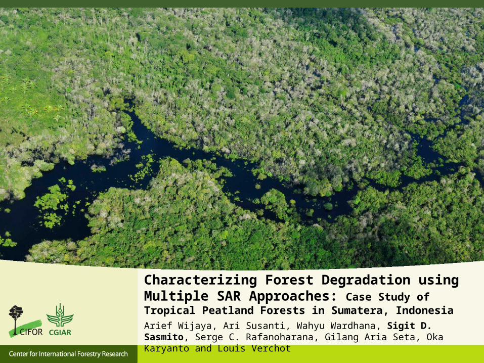
Characterizing Forest Degradation using Multiple SAR Approaches: Case Study of Tropical Peatland Forests in Sumatera, IndonesiaArief Wijaya, Ari Susanti, Wahyu Wardhana, Sigit D. Sasmito, Serge C. Rafanoharana, Gilang Aria Seta, Oka Karyanto and Louis Verchot
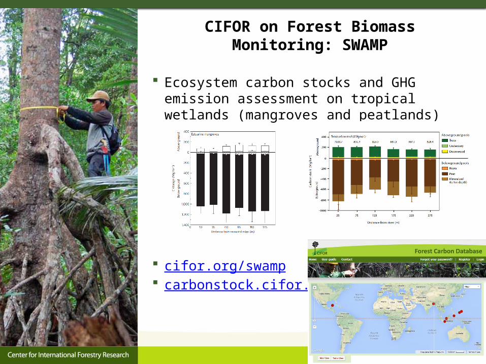
CIFOR on Forest Biomass Monitoring: SWAMP
Ecosystem carbon stocks and GHG emission assessment on tropical wetlands (mangroves and peatlands)
cifor.org/swamp carbonstock.cifor.org

Forest Degradation using Multiple SAR Approaches Study area: Kampar Peninsular, Sumatra
Data used:• quad-polarimetric ALOS PALSAR (May 2010)• Landsat 5 TM (February 2010)

Field Data Preparation
Land use Volume (m3/ha)
AGB (Mg/ha)
Carbon stocks (MgC/ha)
Tree height
(m)Basal area
(m2) LAI
Peat swamp forest
592.35 228.25 114.12 16.92 33.19 2.96
Pioneer species (Macaranga sp.)
32.63 7.47 3.74 11.22 9.71 3.09
Mangrove forest 182.16 105.65 52.82 9.53 11.79 2.38Plantation forest 196.33 130.95 65.48 12.57 13.22 1.32Rubber plantation
125.73 113.44 56.72 14.95 51.02 2.06

SAR Data Preprocessing Data calibration, correction and noise filtering Polarimetric features: entropy, anisotropy and alpha angle Supervised classification: Multi-Layer Perceptron Neural Network
(MLP-NN) method and Maximum Likelihood Classification (MLC)
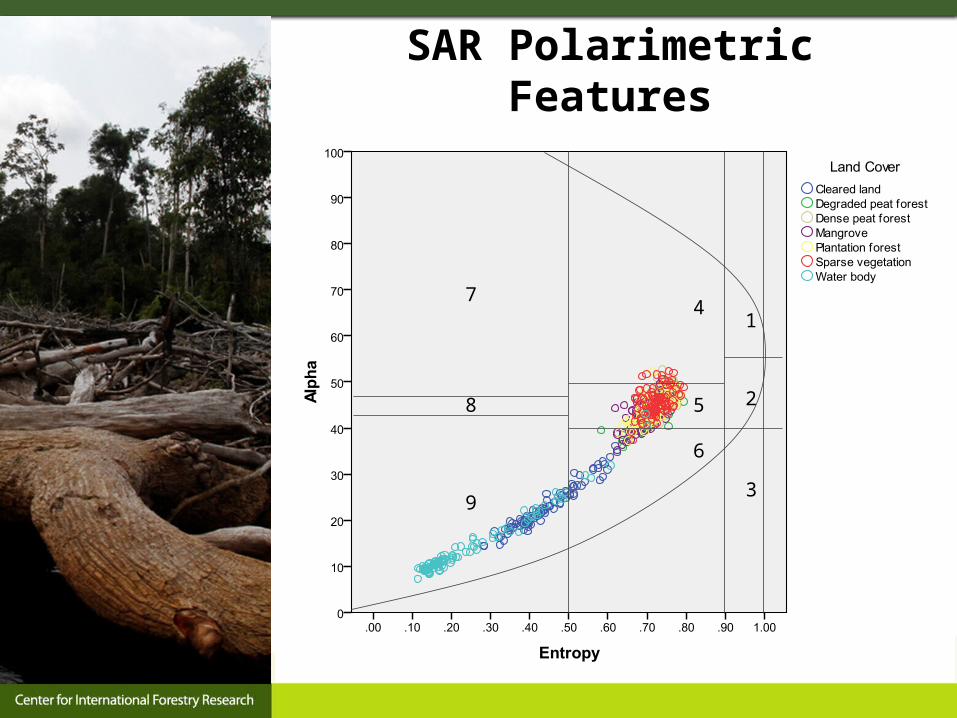
SAR Polarimetric Features
1
2
3
4
5
6
7
8
9

SAR Classification Results

Conclusion
This study shows an attempt to test multi SAR approaches for characterizing forest degradation event in tropical peat swamp forests,
L-Band of quad-polarimetric SAR data may provide useful information to characterize forest degradation,
MLP-NN classification is more sensitive to redundant input data, therefore the highest accuracy (79.9%) was achieved applying radar backscatter and multi-spectral Landsat bands in the classification.
Further study: feature selection of input data on MLP-NN classification would benefit for increasing the classification accuracy

Further Question ??
Arief Wijaya Ph.DPost-doctoral Research Fellow
Contact:CIFOR HeadquartersJalan CIFOR Situ GedeBogor 16115 Indonesia
Tel: +62-251-8622622 Fax: +62-251-8622100Email: [email protected]
OrSigit D. SasmitoEmail: [email protected]
Thank You
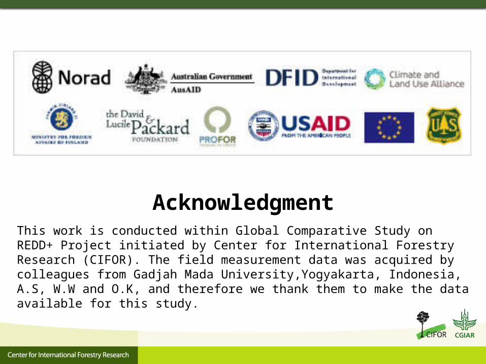
AcknowledgmentThis work is conducted within Global Comparative Study on REDD+ Project initiated by Center for International Forestry Research (CIFOR). The field measurement data was acquired by colleagues from Gadjah Mada University,Yogyakarta, Indonesia, A.S, W.W and O.K, and therefore we thank them to make the data available for this study.
References
[1] A. Luckman, et al., "A study of the relationship between radar backscatter and regenerating tropical forest biomass for spaceborne SAR instruments," Remote Sensing of Environment, vol. 60, pp. 1-13, April 1997 1996.
[2] T. M. Kuplich, et al., "Relating SAR image texture to the biomass of regenerating tropical forests," International Journal of Remote Sensing, vol. 26, pp. 4829-4854, 2005.
[3] J. E. S. Fransson and H. Israelsson, "Estimation of stem volume in boreal forests using ERS-1 C- and JERS-1 L-band SAR data," International Journal of Remote Sensing, vol. 20, pp. 123-137, 1999.
[4] I. Hajnsek, et al., "INDREX II - Indonesian airborne radar experiment campaign over tropical forest in L- and P-band: First results," in International Geoscience and Remote Sensing Symposium (IGARSS), Seoul, 2005, pp. 4335-4338.
[5] M. Isola and S. R. Cloude, "Forest height mapping using space-borne polarimetric SAR interferometry," in International Geoscience and Remote Sensing Symposium (IGARSS), Sydney, NSW, 2001, pp. 1095-1097.
[6] S. Kingsley and S. Quegan, Understanding radar systems, 1st Edition ed.: SciTech Publishing, 1992.[7] S. S. Saatchi, et al., "Mapping deforestation and land use in amazon rainforest by using SIR-C imagery," Remote Sensing
of Environment, vol. 59, pp. 191-202, 1997.[8] Y. Rauste, "Multi-temporal JERS SAR data in boreal forest biomass mapping," Remote Sensing of Environment, vol. 97,
pp. 263-275, 2005.[9] A. Luckman, et al., "A study of the relationship between radar backscatter and regenerating tropical forest biomass for
spaceborne SAR instruments," Remote Sensing of Environment, vol. 60, pp. 1-13, 1997.[10] K. J. Ranson, et al., "Mapping of boreal forest biomass from spaceborne synthetic aperture radar," Journal of Geophysical
Research D: Atmospheres, vol. 102, pp. 29599-29610, 1997.[11] E. Rignot, et al., "Mapping deforestation and secondary growth in Rondonia, Brazil, using imaging radar and thematic
mapper data," Remote Sensing of Environment, vol. 59, pp. 167-179, 1997.[12] Wahyunto, et al., Distribution of Peatlands and Carbon Stocks in Sumatera and Kalimantan (In Indonesian). Bogor:
Wetlands International - Indonesia Programme and Wildlife Habitat Canada, 2005.[13] A. Dermawan, et al., "Decentralization in Indonesia’s forestry sector – Is it over? What comes next?," in the Eleventh
Biennial Global Conference of The International Association for the Study of Common Property (IASCP) on the theme ‘Survival of the Commons: Mounting Challenges and New Realities’, Denpasar, Bali, 2006.