Characterization of Traditional Shipping Routes using AIS Data
5
Appendix III Characterization of Traditional Shipping Routes using AIS Data [Type the abstract of the document here. The abstract is typically a short summary of the contents of the document. Type the abstract of the document here. The abstract is typically a short summary of the contents of the document.]
Transcript of Characterization of Traditional Shipping Routes using AIS Data

Appendix III
Characterization of Traditional Shipping Routes
using AIS Data
[Type the abstract of the document here. The abstract is typically a short summary of the contents of the document. Type the abstract of the document here. The abstract is typically a short summary of the contents of the document.]

Appendix III
The following is a series of maps displaying 2011 Vessel Density plots along the Atlantic Coast. The Vessel Density plots were downloaded from the Multi-purpose Marine Cadastre website located at MarineCadastre.gov.
Atlantic Coast: Page - All Vessels 1 - Cargo 2 - Tanker 3 - Towing 4 - Passenger 5
Northeast - All Vessels 6 - Cargo 7 - Fishing 8 - Passenger 9 - Tanker 10 - Towing 11
New York - All Vessels 12 - Cargo 13 - Fishing 14 - Passenger 15 - Tanker 16 - Towing 17
Mid-Atlantic - All Vessels 18 - Cargo 19 - Fishing 20 - Passenger 21 - Tanker 22 - Towing 23
Southeast - All Vessels 24 - Cargo 25 - Passenger 26 - Tanker 27 - Towing 28
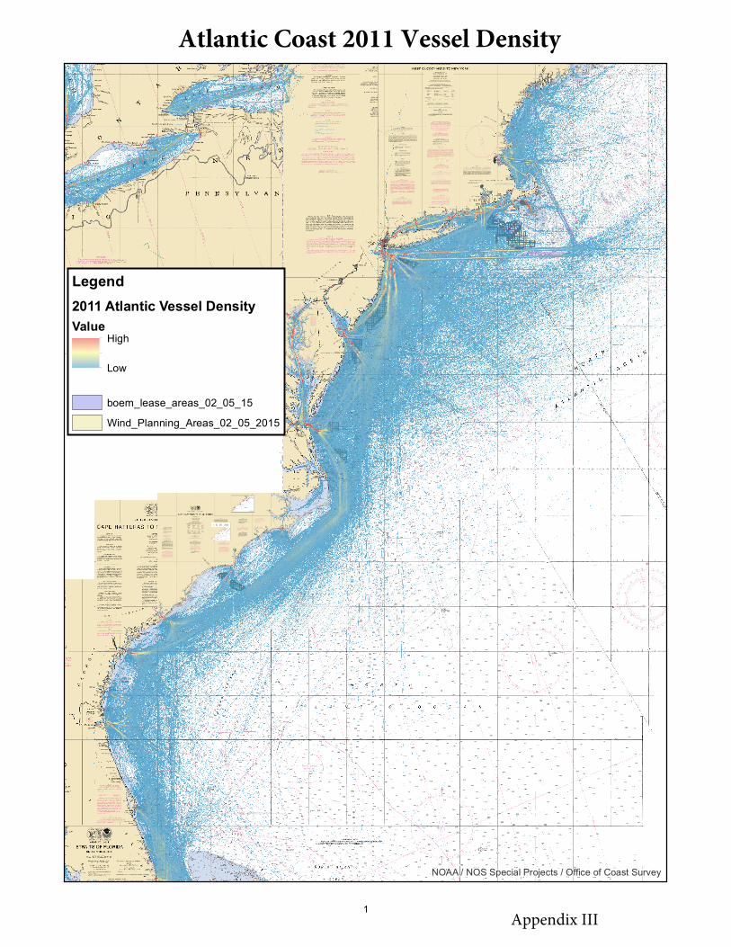
NOAA / NOS Special Projects / Office of Coast Survey
Legend2011 Atlantic Vessel DensityValue
High
Low
boem_lease_areas_02_05_15Wind_Planning_Areas_02_05_2015
Atlantic Coast 2011 Vessel Density
Appendix III 1

NOAA / NOS Special Projects / Office of Coast Survey
Legend2011 Atlantic Cargo Vessel DensityValue
High
Low
boem_lease_areas_02_05_15Wind_Planning_Areas_02_05_2015
Atlantic Coast 2011 Cargo Vessel Density
Appendix III 2

NOAA / NOS Special Projects / Office of Coast Survey
Legend2011 Atlantic Tanker Vessel DensityValue
High
Low
boem_lease_areas_02_05_15Wind_Planning_Areas_02_05_2015
Atlantic Coast 2011 Tanker Vessel Density
Appendix III 3