Characteristics of the Land Mobile Navigation Channel for ...
8
Characteristics of the Land Mobile Navigation Channel for Pedestrian Applications Andreas Lehner German Aerospace Center Münchnerstraße 20 D-82230 Weßling, Germany [email protected] Co-Authors: Alexander Steingaß, German Aerospace Center, Germany 1 Abstract One leading point in the choice of the signal format for the Galileo System is the multipath transmission channel. Studies concerning the signal structure (e.g. ESA Signal Design Study) [1] had clearly shown that the synchronisation performance of a specific signal strongly depends on the reflections in the environment. Especially, short delayed reflections significantly decrease the performance of the receiver. The positioning error becomes even worse if these reflections are strong and slowly varying over time, which is predominant in pedestrian applications. Although narrowband channels like GSM (COST 207) [2] or UMTS have been measured in the past, it became necessary to analyse the wideband navigation channel to minimize multipath effects in future highly accurate receivers. For these reasons we measured the channel from the satellite to a receiver in critical urban and suburban scenarios. This paper will present first preliminary statements and conclusions for typical pedestrian applications. 2 Channel measurement The satellite was simulated by a Zeppelin NT operating at distances of up to 4000 meters from the receiver. We transmitted a special measurement signal with 10W EIRP and a bandwidth of 100 MHz. The transmitted signal had a rectangular shaped line spectrum consisting of several hundred single carriers. This guaranteed us a time resolution of 10 ns for the channel impulse response. This very high resolution is necessary for the planned wideband services of Galileo using BOC signal structures. By applying an ESPRIT ("Estimation of Signal Parameters via Rotational Invariance Techniques") based super resolution algorithm, the time resolution for the final model will be increased to 1 ns. To achieve this high time resolution we used specially assembled rubidium clocks with an Allan variance of 10 -11 seconds over an integration time of 1 second, as references for the measurement devices.
Transcript of Characteristics of the Land Mobile Navigation Channel for ...
Characteristics of the Land MobileNavigation Channel for Pedestrian Applications
Andreas LehnerGerman Aerospace Center
Münchnerstraße 20D-82230 Weßling, Germany
Co-Authors:Alexander Steingaß, German Aerospace Center, Germany
1 AbstractOne leading point in the choice of the signal format for the Galileo System is themultipath transmission channel. Studies concerning the signal structure (e.g. ESASignal Design Study) [1] had clearly shown that the synchronisation performance of aspecific signal strongly depends on the reflections in the environment. Especially, shortdelayed reflections significantly decrease the performance of the receiver. Thepositioning error becomes even worse if these reflections are strong and slowly varyingover time, which is predominant in pedestrian applications. Although narrowbandchannels like GSM (COST 207) [2] or UMTS have been measured in the past, itbecame necessary to analyse the wideband navigation channel to minimize multipatheffects in future highly accurate receivers. For these reasons we measured the channelfrom the satellite to a receiver in critical urban and suburban scenarios. This paper willpresent first preliminary statements and conclusions for typical pedestrian applications.
2 Channel measurementThe satellite was simulated by a Zeppelin NT operating at distances of up to 4000meters from the receiver. We transmitted a special measurement signal with 10W EIRPand a bandwidth of 100 MHz. The transmitted signal had a rectangular shaped linespectrum consisting of several hundred single carriers. This guaranteed us a timeresolution of 10 ns for the channel impulse response. This very high resolution isnecessary for the planned wideband services of Galileo using BOC signal structures. Byapplying an ESPRIT ("Estimation of Signal Parameters via Rotational InvarianceTechniques") based super resolution algorithm, the time resolution for the final modelwill be increased to 1 ns. To achieve this high time resolution we used specially assembled rubidium clocks withan Allan variance of 10-11 seconds over an integration time of 1 second, as referencesfor the measurement devices.
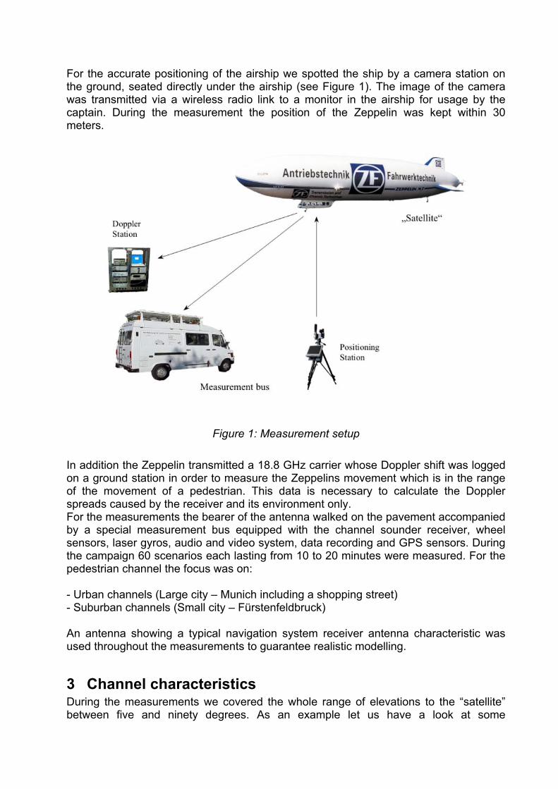
For the accurate positioning of the airship we spotted the ship by a camera station onthe ground, seated directly under the airship (see Figure 1). The image of the camerawas transmitted via a wireless radio link to a monitor in the airship for usage by thecaptain. During the measurement the position of the Zeppelin was kept within 30meters.
Figure 1: Measurement setup
In addition the Zeppelin transmitted a 18.8 GHz carrier whose Doppler shift was loggedon a ground station in order to measure the Zeppelins movement which is in the rangeof the movement of a pedestrian. This data is necessary to calculate the Dopplerspreads caused by the receiver and its environment only.For the measurements the bearer of the antenna walked on the pavement accompaniedby a special measurement bus equipped with the channel sounder receiver, wheelsensors, laser gyros, audio and video system, data recording and GPS sensors. Duringthe campaign 60 scenarios each lasting from 10 to 20 minutes were measured. For thepedestrian channel the focus was on:
- Urban channels (Large city – Munich including a shopping street)- Suburban channels (Small city – Fürstenfeldbruck)
An antenna showing a typical navigation system receiver antenna characteristic wasused throughout the measurements to guarantee realistic modelling.
3 Channel characteristicsDuring the measurements we covered the whole range of elevations to the “satellite”between five and ninety degrees. As an example let us have a look at some

measurement results of the urban pedestrian channel. The receiver moved along anarrow shopping street (see Figure 2) in the center of Munich. Figure 3, Figure 4 andFigure 5 show the channels impulse responses over the distance of the measured trackfor a satellite at elevations of 10°, 40° and 80°.
Figure 2: Measurement location in Munich
In Figure 3 we see clearly that for very low elevations many strong reflections can beseen whose delay decreases when approaching the reflecting structures. Note that inthis configuration the LOS signal might already be attenuated by the receiving antennapattern with an masking angle of about 10°. Some of this reflections appear anddisappear which can be best modelled by a Markhov state model, while for others aclear increasing power level is detected when approaching the reflector. There is alsostrong fading in the LOS path which is caused by the fact that a walking pedestrian isnot carrying the receiver antenna perfectly horizontal aligned. In the last 30 meters ofthe measurement we moved into a side street and the zeppelin was out of view,therefore we have no LOS signal but surprisingly strong reflections. Most of the echopower is within the delay range of one chip, thus these reflected signals will directlycause an error in the receivers DLL. Only delays larger than a chip length do not effectthe propagation delay measurement of the receiver. Compared to lower elevations, the approaching reflections become less powerful atelevations of 40°. The echo power becomes concentrated within a relative delay of 250ns. Because the channel has a rician characteristic, there is some remaining fading inthe LOS signal. Note that for the last part of the measurement the direct path becomesclearer. In Figure 5 we see that for very high elevations the zeppelin could be seenalmost during the whole measurement. Even without LOS signal some very shortdelayed reflections indicate the line of sight distance. The reflecting structures are closeto the receiver and echoes with constant delay have replaced the approaching ones.
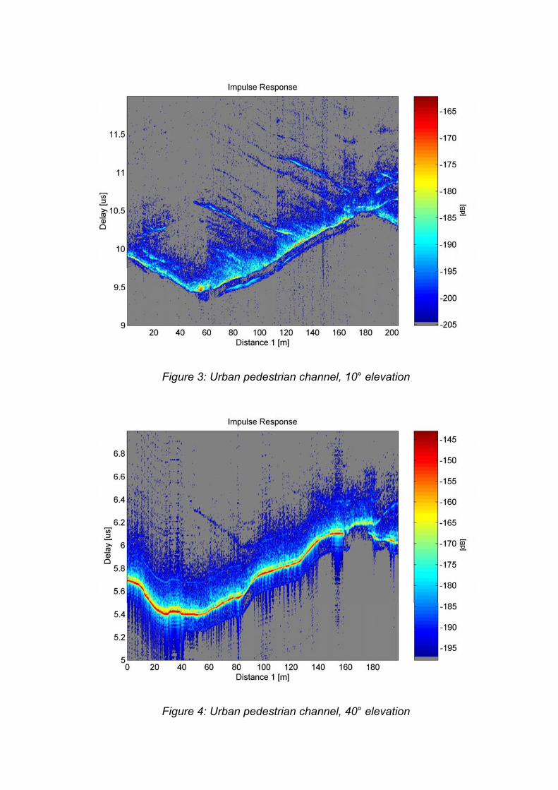
Figure 3: Urban pedestrian channel, 10° elevation
Figure 4: Urban pedestrian channel, 40° elevation

Figure 5: Urban pedestrian channel, 80° elevation
Looking into details reveals the constant delays to be related to the distance betweenthe houses and the receiver.
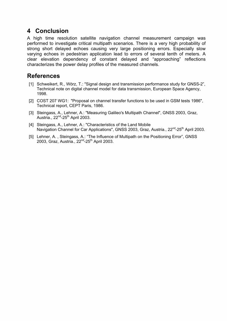
Another example for the pedestrian channel was measured in Fürstenfeldbruck, a smalltown near Munich (see Figure 6). Again the same track was measured for elevationsbetween 5 and 90 degrees. Figure 7 to Figure 9 show the channel for 5, 30 and 80degrees elevation, respectively. In the first 200 seconds of the measurement thereceiver moved more or less orthogonal to the Zeppelins position, therefore theabsolute distance stayed nearly constant. Note that in this part the echoes keep aconstant delay. But this constant delay again depends on the elevation. While there aresometimes echoes at delays of about 150 ns for low elevations, there is a strong staticecho at about 40 ns at high elevations which can be seen in detail in Figure 9.The rest of the measured track led radial to the Zeppelin position along the main road ofthe town and we can see the typical approaching reflectors. The very last one whichcould be seen during the whole second part of the measurement was the city hall whichis located at the end of the road directly facing the transmitter and therefore being astrong reflector. For 80 degrees elevation the Zeppelins position was directly above themain road. Due to this fact the absolute distance decreases in the beginning andremains about the same for the second part of the measurement.
For more details on the channel measurement campaign as well as first results of theurban, suburban and rural car channel we refer to [1] and [4]. The impact of shortdelayed slowly varying reflections on the positioning error was simulated and ispresented in [5].

Figure 6: Measurement location in Fürstenfeldbruck
Figure 7: Suburban pedestrian channel, 5° elevation
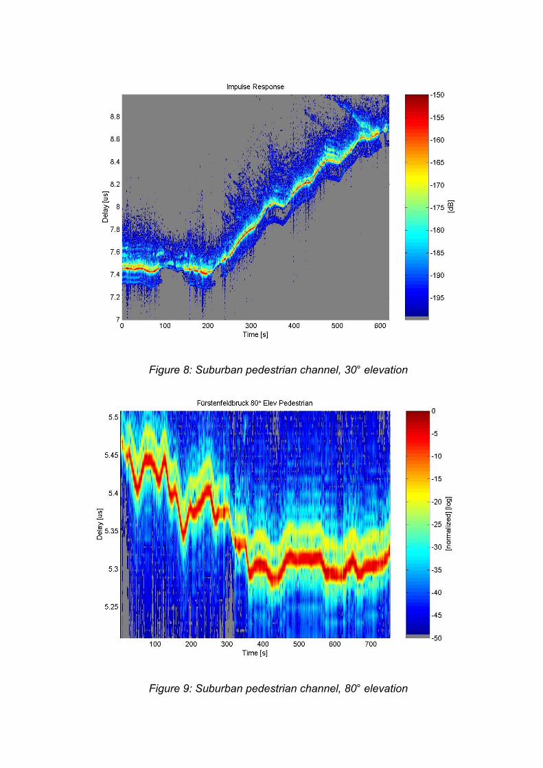
Figure 8: Suburban pedestrian channel, 30° elevation
Figure 9: Suburban pedestrian channel, 80° elevation
4 ConclusionA high time resolution satellite navigation channel measurement campaign wasperformed to investigate critical multipath scenarios. There is a very high probability ofstrong short delayed echoes causing very large positioning errors. Especially slowvarying echoes in pedestrian application lead to errors of several tenth of meters. Aclear elevation dependency of constant delayed and “approaching” reflectionscharacterizes the power delay profiles of the measured channels.
References [1] Schweikert, R., Wörz, T.: "Signal design and transmission performance study for GNSS-2”,
Technical note on digital channel model for data transmission, European Space Agency,1998.
[2] COST 207 WG1: "Proposal on channel transfer functions to be used in GSM tests 1986",Technical report, CEPT Paris, 1986.
[3] Steingass, A., Lehner, A.: "Measuring Galileo's Multipath Channel", GNSS 2003, Graz,Austria., 22nd-25th April 2003.
[4] Steingass, A., Lehner, A.: "Characteristics of the Land MobileNavigation Channel for Car Applications", GNSS 2003, Graz, Austria., 22nd-25th April 2003.
[5] Lehner, A. , Steingass, A.: “The Influence of Multipath on the Positioning Error”, GNSS2003, Graz, Austria., 22nd-25th April 2003.