
Characteristics of an Anomalous, Long-Lived Convective Snowstorm Rebecca L. Ebert Department of...
47
an Anomalous, an Anomalous, Long-Lived Long-Lived Convective Convective Snowstorm Snowstorm Rebecca L. Ebert Rebecca L. Ebert Department of Soil, Environmental, and Atmospheric Sciences Department of Soil, Environmental, and Atmospheric Sciences University of Missouri-Columbia University of Missouri-Columbia SEAS 410: Seminar SEAS 410: Seminar 29 March 2004 29 March 2004
-
date post
21-Dec-2015 -
Category
Documents
-
view
214 -
download
1
Transcript of Characteristics of an Anomalous, Long-Lived Convective Snowstorm Rebecca L. Ebert Department of...

Characteristics of an Characteristics of an Anomalous, Long-Anomalous, Long-Lived Convective Lived Convective
SnowstormSnowstorm
Rebecca L. EbertRebecca L. EbertDepartment of Soil, Environmental, and Atmospheric Department of Soil, Environmental, and Atmospheric
SciencesSciencesUniversity of Missouri-ColumbiaUniversity of Missouri-Columbia
SEAS 410: SeminarSEAS 410: Seminar
29 March 200429 March 2004

OutlineOutline
► IntroductionIntroduction What is Thundersnow?What is Thundersnow? Where does it happen?Where does it happen?
►MotivationMotivation►Data UsedData Used► Synoptic AnalysisSynoptic Analysis► Case StudyCase Study► ResultsResults► Conclusion and Future WorkConclusion and Future Work
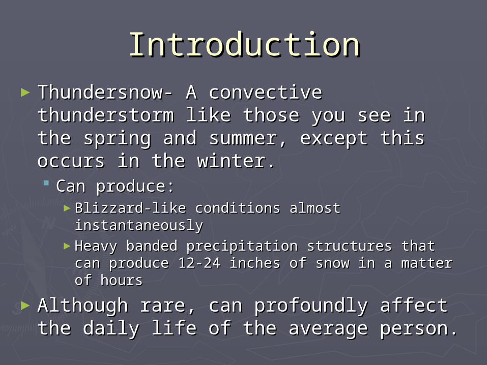
IntroductionIntroduction►Thundersnow- A convective Thundersnow- A convective
thunderstorm like those you see in the thunderstorm like those you see in the spring and summer, except this occurs spring and summer, except this occurs in the winter.in the winter. Can produce:Can produce:
►Blizzard-like conditions almost instantaneouslyBlizzard-like conditions almost instantaneously►Heavy banded precipitation structures that Heavy banded precipitation structures that
can produce 12-24 inches of snow in a matter can produce 12-24 inches of snow in a matter of hoursof hours
►Although rare, can profoundly affect Although rare, can profoundly affect the daily life of the average person.the daily life of the average person.

Introduction Cont.Introduction Cont.
►For 20 years researchers have studied For 20 years researchers have studied the atmospheric link between routine the atmospheric link between routine snowstorms and those with convection.snowstorms and those with convection.
►They assume that the ingredients are They assume that the ingredients are dynamic in naturedynamic in nature Occur around a surface cycloneOccur around a surface cyclone Or lake area in association with surface-Or lake area in association with surface-
based instabilitybased instability

MotivationMotivation► The purpose of this study is to reveal the The purpose of this study is to reveal the
dynamic characteristics of a particularly dynamic characteristics of a particularly strong, long-lived convective snowstorm.strong, long-lived convective snowstorm.
► The case that is studied was very unique with The case that is studied was very unique with 9 non-consecutive hours of thundersnow 9 non-consecutive hours of thundersnow reportedreported
The longest lasting event on record of which we The longest lasting event on record of which we are awareare aware
Observers witnessed lightning numerous times Observers witnessed lightning numerous times during the event during the event

Motivation cont.Motivation cont.
►With this work we expect to support the With this work we expect to support the efforts of previous investigators efforts of previous investigators Investigations by Market et al.(2002) revealed:Investigations by Market et al.(2002) revealed:
►Two maxima of thundersnow occurrencesTwo maxima of thundersnow occurrences Rocky MountainsRocky Mountains Central PlainsCentral Plains
►Location of thundersnow events in the Central Plains:Location of thundersnow events in the Central Plains:
Often occurs northwest or northeast of a surface cycloneOften occurs northwest or northeast of a surface cyclone
Oravetz (2003) performed a composite study of Oravetz (2003) performed a composite study of thundersnow occurrences northwest and thundersnow occurrences northwest and northeast of surface cyclonesnortheast of surface cyclones

Data UsedData Used► Surface Observations Surface Observations
TemperatureTemperature Relative humidityRelative humidity Wind directionWind direction VisibilityVisibility Current weather conditionsCurrent weather conditions
► Rawinsonde observationsRawinsonde observations Upper air analysisUpper air analysis Sounding profilesSounding profiles
►Objective AnalysisObjective Analysis Atmospheric characteristics observed during Atmospheric characteristics observed during
analysisanalysis

OverviewOverview
Eau Claire WisconsinEau Claire Wisconsin
23 March 196623 March 1966

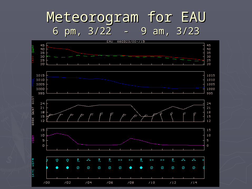
Meteorogram for EAUMeteorogram for EAU6 pm, 3/22 - 9 am, 3/236 pm, 3/22 - 9 am, 3/23

Storm Total Snowfall (inches)Storm Total Snowfall (inches)48 hr accumulations ending 6 pm, 3/23/196648 hr accumulations ending 6 pm, 3/23/1966
1”
1”
1”
5” 5”
10”
10”
1”
1” 1”
10”
5”
15”
10”
5” 5”
5”
15”10”
15”5”
1”
5”
1”
1”
1”5”10”15”
1”

SynopsisSynopsis0000 UTC 23 March 19660000 UTC 23 March 1966
(6 pm CST 22 March 1966)(6 pm CST 22 March 1966)

L
Surface Analysis 0000 UTC 23 March Surface Analysis 0000 UTC 23 March 19661966

850 mb Heights and Temperatures850 mb Heights and Temperatures

700 mb Heights and Temperatures700 mb Heights and Temperatures

700 mb 700 mb ee

500 mb Heights and Vorticity500 mb Heights and Vorticity
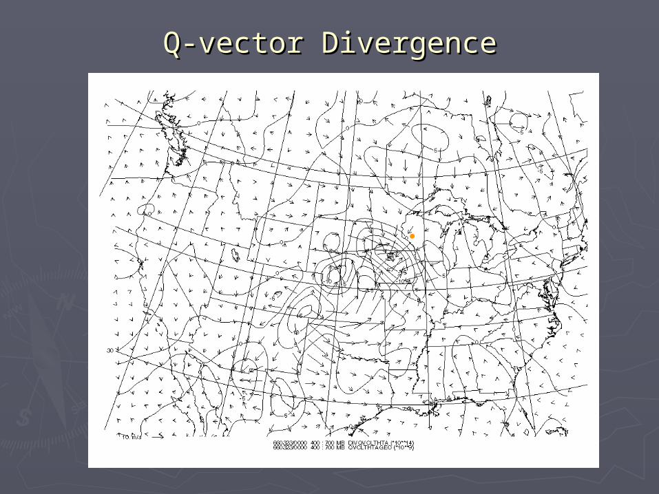
Q-vector DivergenceQ-vector Divergence

850-500 mb Layer Mean Relative 850-500 mb Layer Mean Relative HumidityHumidity

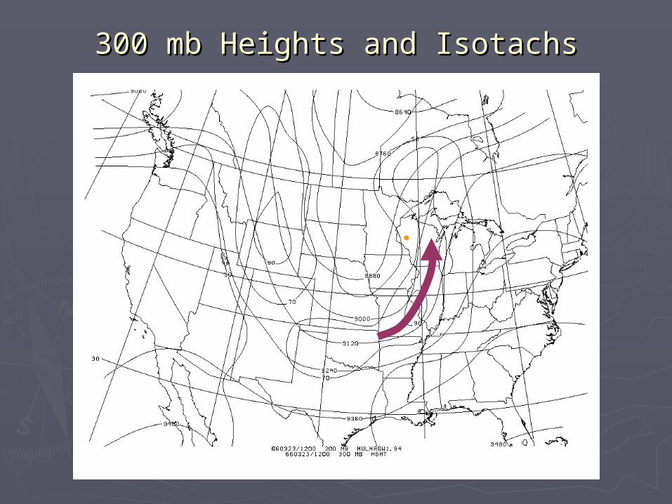
300 mb Heights and Isotachs300 mb Heights and Isotachs

Q-vector DivergenceQ-vector Divergence

Location of First Cross-SectionLocation of First Cross-Section

Cross-Section AnalysisCross-Section Analysis
EAU

Vertical Profile of EPV3Vertical Profile of EPV3

Vertical Profile of FrontogenesisVertical Profile of Frontogenesis

Vertical Profile of Vertical Profile of ee

Summary (0000 UTC)Summary (0000 UTC)
► Eau Claire, Wisconsin is located northeast of Eau Claire, Wisconsin is located northeast of a surface cyclonea surface cyclone Warm air advection (WAA) is present at 850 mb Warm air advection (WAA) is present at 850 mb
and 700 mband 700 mb A semblance of a A semblance of a TROTROugh of ugh of WWarm air arm air ALALoft oft
(TROWAL) is visible on the 700 mb (TROWAL) is visible on the 700 mb ee map map A positively tilted trough at 500 mb A positively tilted trough at 500 mb QQ Convergence downstream of event location Convergence downstream of event location Plenty of available moisturePlenty of available moisture Left exit region of a 70 knot curved jet streakLeft exit region of a 70 knot curved jet streak Presence of Equivalent Potential Vorticity (EPV) Presence of Equivalent Potential Vorticity (EPV)
and Conditional Symmetric Instability (CSI) and Conditional Symmetric Instability (CSI) present in Eau Claire. present in Eau Claire.
Producing slantwise convectionProducing slantwise convection

SynopsisSynopsis1200 UTC 23 March 19661200 UTC 23 March 1966
(6 am CST 23 March 1966)(6 am CST 23 March 1966)

L
Surface Analysis 1200 UTC 23 March Surface Analysis 1200 UTC 23 March 19661966

850 mb Heights and Temperatures850 mb Heights and Temperatures

700 mb Heights and Temperatures700 mb Heights and Temperatures

700 mb 700 mb ee

500 mb heights and Vorticity500 mb heights and Vorticity

Q-Vector DivergenceQ-Vector Divergence

850-500 Layer Mean Relative Humidity850-500 Layer Mean Relative Humidity
300 mb Heights and Isotachs300 mb Heights and Isotachs

Location of Second Cross-SectionLocation of Second Cross-Section

Cross-Section AnalysisCross-Section Analysis
EAU

Vertical Profile of EPV3Vertical Profile of EPV3

Vertical Profile of FrontogenesisVertical Profile of Frontogenesis

Vertical Profile of Theta EVertical Profile of Theta E

Summary (1200 UTC)Summary (1200 UTC)
► Eau Claire, Wisconsin is located northwest of a Eau Claire, Wisconsin is located northwest of a surface cyclonesurface cyclone Warm air advection (WAA) is present at 850 mb east of the Warm air advection (WAA) is present at 850 mb east of the
locationlocation The TROWAL is visible on the 700 mb The TROWAL is visible on the 700 mb ee map almost map almost
directly over Eau Claire, WIdirectly over Eau Claire, WI A negatively tilted trough at 500 mb is now presentA negatively tilted trough at 500 mb is now present QQ convergence downstream of event location has convergence downstream of event location has
weakened but is still relative strongweakened but is still relative strong Deep moisture is still presentDeep moisture is still present Jet streak has increased to 90 knots, with Eau Claire still in Jet streak has increased to 90 knots, with Eau Claire still in
the left exit region the left exit region Presence of Equivalent Potential Vorticity (EPV) and Presence of Equivalent Potential Vorticity (EPV) and
Conditional Symmetric Instability (CSI) present in Eau Conditional Symmetric Instability (CSI) present in Eau Claire. Claire.
Producing slantwise convectionProducing slantwise convection
Meteorogram for EAUMeteorogram for EAU6 pm, 3/22 - 9 am, 3/236 pm, 3/22 - 9 am, 3/23

Storm Total Snowfall (inches)Storm Total Snowfall (inches)48 hr accumulations ending 6 pm, 3/23/196648 hr accumulations ending 6 pm, 3/23/1966
1”
1”
1”
5” 5”
10”
10”
1”
1” 1”
10”
5”
15”
10”
5” 5”
5”
15”10”
15”5”
1”
5”
1”
1”
1”5”10”15”
1”

ConclusionsConclusions
► A long-lived thundersnow event occurred at A long-lived thundersnow event occurred at Eau Claire, WI for 9 non-consecutive hoursEau Claire, WI for 9 non-consecutive hours
► In the beginning of this event Eau Claire was In the beginning of this event Eau Claire was northeast of a surface cyclone at 0000 UTC northeast of a surface cyclone at 0000 UTC Present features included:Present features included:
► Ample moistureAmple moisture► ee pattern reveals a slight ridge southeast of pattern reveals a slight ridge southeast of
the event sites and east of the 700 mb lowthe event sites and east of the 700 mb low► Forcing for ascentForcing for ascent
Strong convergence in the 400-700 mb layerStrong convergence in the 400-700 mb layer► EPV and CSI present in a cross-section analysis EPV and CSI present in a cross-section analysis

Conclusions Cont.Conclusions Cont.
► As the system progressed over a 12 hour As the system progressed over a 12 hour period, Eau Claire became northwest of the period, Eau Claire became northwest of the surface cyclone at 1200 UTC surface cyclone at 1200 UTC Present features included:Present features included:
►Ample moistureAmple moisture►ee pattern at 700 mb indicates a TROWAL right over the pattern at 700 mb indicates a TROWAL right over the
Eau Claire locationEau Claire location►Forcing for ascentForcing for ascent
Again convergence is present in the 400-700mb layer of Again convergence is present in the 400-700mb layer of Q-vectorsQ-vectors
► Completes the composite work done by Completes the composite work done by Oravetz (2003)Oravetz (2003)

Future WorkFuture Work
► Incorporate the Workstation Eta Incorporate the Workstation Eta (WSEta) model run analysis of this (WSEta) model run analysis of this eventevent
Compare the model run with the actual Compare the model run with the actual observations from the event, correlating if observations from the event, correlating if the model can forecast such eventsthe model can forecast such events
Calculate slantwise convective available Calculate slantwise convective available potential energy (SCAPE) during the eventpotential energy (SCAPE) during the event

AcknowledgmentsAcknowledgments
►National Science FoundationNational Science Foundation►National Climatic Data CenterNational Climatic Data Center


