
CHAPTER V - ENVIRONMENTAL STUDIES - Welcome to · PDF fileCHAPTER V - ENVIRONMENTAL STUDIES...
41
GDOT Environmental Procedures Manual [1] Environmental Studies CHAPTER V - ENVIRONMENTAL STUDIES 3.0 Cultural Resources 3.1 Section 106 Procedures 3.1.1 Purpose of Section 106 Section 106 of the National Historic Preservation Act (NHPA) of 1966 requires federal agencies to take into account the effects of their undertakings on historic and archaeological resources and afford the Advisory Council on Historic Preservation (ACHP) a reasonable opportunity to comment on such undertakings. The Section 106 process seeks to accommodate historic preservation concerns with the needs of federal undertakings through consultation between agency officials and other parties interested in the effects of the undertaking on historic and archaeological resources. The goal of consultation is to identify historic resources that have the potential to be affected by an undertaking, assess the effects of the undertaking on identified historic and archaeological resources and identify ways to avoid, minimize harm or mitigate any adverse effects on historic and archaeological resources. It is important that the agency initiate the Section 106 process early in the planning process in order to insure that a broad range of alternatives may be considered during the planning process for the undertaking. 3.1.2 Participants in the Section 106 Process The federal agency official with jurisdiction over an undertaking holds the legal responsibility for compliance with Section 106. For Georgia Department of Transportation (GDOT) projects, the Federal Highway Administration (FHWA) generally is the agency official with jurisdiction; however, on state funded projects, another federal agency such as the US Army Corps of Engineers (USACE) may be the agency official with jurisdiction. The State Historic Preservation Officer (SHPO) plays a key role in the Section 106 process by consulting and concurring on resource identification and project effects. The GDOT notifies Regional Commissions (RC), local governments, and federally recognized American Indain tribes to request their input during project development. Other individuals and organizations with a demonstrated interest in the undertaking also are invited to participate in the Section 106 process. All employees or consultants of the agency must meet professional standards under regulations developed by the Secretary of the Interior, found at http://www.nps.gov/history/local- law/Prof_Qual_83.htm. 3.1.3 Initiation of the Section 106 Process A. Establish Undertaking In accordance with 36 CFR Part 800.16(y), an undertaking is defined as “a project,
Transcript of CHAPTER V - ENVIRONMENTAL STUDIES - Welcome to · PDF fileCHAPTER V - ENVIRONMENTAL STUDIES...

GDOT Environmental Procedures Manual [1] Environmental Studies
CHAPTER V - ENVIRONMENTAL STUDIES
3.0 Cultural Resources
3.1 Section 106 Procedures
3.1.1 Purpose of Section 106 Section 106 of the National Historic Preservation Act (NHPA) of 1966 requires federal agencies to take into account the effects of their undertakings on historic and archaeological resources and afford the Advisory Council on Historic Preservation (ACHP) a reasonable opportunity to comment on such undertakings.
The Section 106 process seeks to accommodate historic preservation concerns with the needs of federal undertakings through consultation between agency officials and other parties interested in the effects of the undertaking on historic and archaeological resources. The goal of consultation is to identify historic resources that have the potential to be affected by an undertaking, assess the effects of the undertaking on identified historic and archaeological resources and identify ways to avoid, minimize harm or mitigate any adverse effects on historic and archaeological resources. It is important that the agency initiate the Section 106 process early in the planning process in order to insure that a broad range of alternatives may be considered during the planning process for the undertaking.
3.1.2 Participants in the Section 106 Process The federal agency official with jurisdiction over an undertaking holds the legal responsibility for compliance with Section 106. For Georgia Department of Transportation (GDOT) projects, the Federal Highway Administration (FHWA) generally is the agency official with jurisdiction; however, on state funded projects, another federal agency such as the US Army Corps of Engineers (USACE) may be the agency official with jurisdiction. The State Historic Preservation Officer (SHPO) plays a key role in the Section 106 process by consulting and concurring on resource identification and project effects.
The GDOT notifies Regional Commissions (RC), local governments, and federally recognized American Indain tribes to request their input during project development. Other individuals and organizations with a demonstrated interest in the undertaking also are invited to participate in the Section 106 process.
All employees or consultants of the agency must meet professional standards under regulations developed by the Secretary of the Interior, found at http://www.nps.gov/history/local-law/Prof_Qual_83.htm.
3.1.3 Initiation of the Section 106 Process A. Establish Undertaking
In accordance with 36 CFR Part 800.16(y), an undertaking is defined as “a project,

GDOT Environmental Procedures Manual [2] Environmental Studies
activity or program funded in whole or part under the direct or indirect jurisdiction of a federal agency, including those carried out by or on behalf of a federal agency; those carried out with federal financial assistance; those requiring a federal permit, license or approval; and those subject to state or local regulation administered pursuant to a delegation or approval by a federal agency.” When initiating the Section 106 process, the agency official must first determine whether the proposed federal action constitutes an undertaking as defined above, and if so, whether it has the potential to cause effects on historic resources (districts, buildings, structures, objects, and archaeological resources).
B. Determination of Potential to Cause Effects If it has been determined by the agency official that the undertaking does not have the potential to cause effects on historic resources, then the agency official has no further obligations under Section 106.
Within the state of Georgia, a Memorandum of Understanding (MOU) between FHWA, GDOT and the SHPO has been established to serve as a consensus determination that certain GDOT maintenance and minor highway projects constitute an undertaking, but do not have the potential to cause an effect on historic resources (see the 2013 MOU for a list of applicable projects). As part of the MOU, the finding of No Potential to Cause Effects is documented in the Finding of No Potential to Cause Effects document. Following review and approval of this finding, copies of the document are provided to the NEPA analyst.
3.1.4 Initiating the identification of historic resources (historic structures and archaeological sites) A. Determine the Scope of the Identification Efforts
1. Determine and Document the Area of Potential Effect (APE) If it has been determined that an undertaking does have the potential to cause an effect on historic resources, then the Section 106 process continues with the identification of such resources by first defining the APE for the proposed undertaking. The APE, as defined in 36 CFR 800.16(d), “is the geographic area or areas within which an undertaking may directly or indirectly cause changes in the character or use of historic properties if any such properties exist.” The APE is based on the nature and the scope of the undertaking, the guidance in the GDOT/FHWA Historic Resources Survey Guidelines and past experience with similar projects. Generally, for historic structures the APE includes anything within the view shed of the project, while for archaeological sites, the APE is limited to the footprint of the project including all existing and required rights-of-way (ROW) and easements.
2. Review existing information on historic resources Once the APE is established, a review of existing information on historic and archaeological resources is conducted. See Section 3.1.5.A and Section 3.1.6.A for required background resources.
3. Seek information from consulting parties (Notification) Information regarding known historic resources within the APE of the undertaking will be obtained from consulting parties, American Indian tribes, and other individuals or

GDOT Environmental Procedures Manual [3] Environmental Studies
organizations that may have knowledge of, or concerns with, known historic resources. The Notification should be tailored to the project and indicate whether GDOT is seeking information in compliance with the Georgia Environmental Policy Act (GEPA) or compliance with Section 106. The project description in the Notification must be thorough and complete. It should include specific locations of the beginning and ending points of the project, amounts of existing and proposed ROW, median and lane widths (if applicable), and the total project length. Furthermore, the project description in any subsequent Section 106 documentation should be consistent with the project description in the Notification. If the scope of the project is modified after the distribution of the Notification but prior to the completion of the Section 106 process, it is appropriate to revise the project description in subsequent documentation and explain why the description has changed since distribution of the Notification. Upon review and approval, the GDOT archaeologist will mail the finalized Notification to the appropriate American Indian tribes per government-to-government coordination. The historian (both GDOT and consultant) will distribute all other copies of the Notification. The GDOT Tribal Liaison maintains a list of current American Indian tribal contacts.
The Notification also serves as an invitation to potential consulting parties to participate in the Section 106 process and to inform potential consulting parties of the identification efforts made up to this point in the Section 106 process. The Notification is always sent to the SHPO, representatives of local governments with jurisdiction over the area in which the undertaking will occur, the local RC, local historic preservation organizations and any individuals or organizations with a demonstrated interest in the undertaking due to the nature of their legal or economic relationship to the undertaking. A copy of the Notification also will be sent to all American Indian tribes that recognize Georgia as their ancestral home, as noted above.
The consultant will provide GDOT copies of any correspondence received in response to the Notification, in the event that the GDOT historian is not copied on the original response. In turn, GDOT will provide consultants copies of any correspondence received related to a particular project, including the SHPO’s Early Coordination Memorandum, which will indicate the HP or GP number assigned to the project by the SHPO. Because this number is SHPO’s primary method of tracking a project, always include it in all subsequent documentation and correspondence pertaining to a specific project.
The federal agency official also will ensure that a copy of the Notification is sent to the ACHP and the Secretary of the Interior where appropriate. In situations where the undertaking may have substantial impacts on important historic resources, important questions of policy or interpretation are encountered or anticipated, procedural problems are encountered or foreseen, or issues of concern to American Indian tribes are identified, the ACHP must receive a copy of the Notification. The Secretary of the Interior also must receive a copy of the Notification if an adverse effect is anticipated to a National Historic Landmark (NHL).

GDOT Environmental Procedures Manual [4] Environmental Studies
3.1.5 Historic resource surveys A survey for historic resources will be conducted within the project's APE to identify all individual resources, districts, and multiple property areas that currently are listed in or eligible for listing in the National Register of Historic Places (NR). The historian performing this work must meet professional standards under regulations developed by the Secretary of the Interior, found at http://www.nps.gov/history/local-law/Prof_Qual_83.htm.
Generally speaking, the resource must be a minimum of 50 years of age (though exceptions are made if the resource is of great significance, e.g., associated with the Civil Rights Movement). It must then be evaluated under the four NR Criteria, A through D; Criterion A: association with an event that made a significant contribution to the broad patterns of our history; Criterion B: association with a person significant in our past, Criterion C: significant for its design or construction, and, Criterion D: significant due to the information it may yield on prehistory or history. A resource may be eligible under one of three levels of significance: national, state, or local recognition of importance.
A resource must retain integrity to be considered eligible for the NR. Integrity is critical to the application of the criteria of eligibility. All qualified resources must meet one or more of the criteria of eligibility and must have integrity of location, design, setting, materials, workmanship, feeling, and association. Integrity does not demand absolute purity, but does demand enough purity to retain a "preservable entity" that communicates its relevant significance. Integrity also should be evaluated in the context of what makes a property significant; not all aspects of integrity mentioned are necessarily valid or relevant for each property.
This survey will be conducted in accordance with the following standards which outline the minimum amount of information required for the reviewer to clearly understand the nature of a particular project, to adequately assess the potential eligibility of historic resources, and to assess the potential impacts of a transportation project to eligible historic resources. Historians should not interpret these guidelines as limits on the amount of information that can be incorporated into a specific report. Instead, historians should use their own discretion in incorporating additional information they feel might be relevant in helping reviewers, including the SHPO and GDOT, better understand the nature of a project or a historic resource.
A. Background research Prior to the field survey the following work efforts will be accomplished:
1. The county/city-wide surveys for historic resources completed under the direction of the Georgia Department of Natural Resources (DNR), Historic Preservation Division (HPD) will be consulted in order to locate previously identified historic resources along the project corridor. Survey forms for any previously identified resource(s) along the project corridor, on file at the HPD, will be copied and the location(s) of the resource(s) delineated on an appropriate map for use in the field. Much of the survey data is available online through Georgia’s Natural, Archaeological, and Historic Resources Geographical Information System (GNAHRGIS).
2. The county listing of existing and proposed NR resources will be consulted in order to locate existing and proposed NR resources along the project corridor. The NR

GDOT Environmental Procedures Manual [5] Environmental Studies
Nomination Form(s) and the Proposed NR Summary Form(s), on file at HPD will be copied for any NR or proposed NR property/resources located along the project corridor and the locations of any such resources will be delineated on an appropriate map for use in the field. The NR Information System, a searchable database of the information on NR listed and eligible resources, is available online (http://www.nr.nps.gov/).
3. Aerial photographs and United States Geological Survey (USGS) quadrangle maps will be examined to determine if any structures are located in the project area.
4. The Georgia Historic Bridge Survey (GHBS) will be consulted to determine if any NR eligible bridges are located along the project corridor. If a bridge is identified in this database as being within the APE, a copy of the bridge survey form will be included in the Notification and in all subsequent Section 106 documentation. A copy of the GHBS can be obtained by contacting the History Unit Supervisor. The GHBS is currently being updated to pick up chronologically where the 1994 version ended. Any bridges identified in the APE, dating between 1955 and 1965 should be evaluated for eligibility by the historian in the field. Consultants can contact the History Team Leader for a copy of the draft bridge form from the updated survey to assist with identification and evaluation.
5. The online listing of NHL’s will be consulted to determine if any are located within the APE of the project (http://tps.cr.nps.gov/nhl/default.cfm).
6. Georgia’s State Traffic and Report Statistics (STARS) is an online GIS system that may be used to locate community resources such as cemeteries or churches that are located within the APE of a project (http://www.dot.ga.gov/statistics/stars/Pages/default.aspx).
7. Where available, online county tax assessor’s records should be searched prior to the field survey in order to help identify resources that are older than 50 years of age within the APE of a project. However, since tax records are not entirely reliable, discretion and professional judgment should be used when using tax assessor dates. Referencing the tax assessor is optional for all resources pre-dating 1940; however, the tax assessor should be referenced for all resources post-dating 1940. Tax records are more likely to be accurate for younger resources, and knowing the precise date for these resources is critical considering how close their age is to the 50 year threshold.
B. Survey methodology/field survey The field survey will be conducted in order to identify and locate on maps and aerial photography all proposed and existing NR resources and all buildings 50 years of age or older, bridges and railroads (including those within possible, not yet listed, historic districts and multiple property areas, if any). A Property Information Form (PIF) will be completed for each resource surveyed as part of the Historic Resources Survey Report. Since historic contexts have been developed for bridges, surveys for these property types less than 50 years of age will be conducted as noted below. Since the historic contexts have established periods of significance, these property types do not need to meet the

GDOT Environmental Procedures Manual [6] Environmental Studies
special considerations required under Criterion Consideration G in order to be considered eligible for listing in the NR.
1. Bridges The 2008 update of the GHBS established a period of significance for bridges built between 1955 and 1965, so bridges built as late as 1965 will be surveyed and evaluated for NR eligibility using this context.
For resources less than 50 years of age, the historian is to exercise professional judgment using historic contexts and personal experience and include in their historic resource surveys, resources that have exceptional importance per Criterion Consideration G.
C. Survey criteria 1. The historian will accomplish the following tasks for each individual building, district,
multiple property area, landscape, structure, object, other NR recognized historic property type, bridge, and railroad that is 50 years of age or older along the project corridor:
a. Individual buildings The following work will be accomplished for all resources 50 years of age or older: • Each building 50 years of age or older will be inspected. Information
recorded will include a description of the architectural details including additions and alterations as well as a description of both the immediate and general settings.
• Each building will be digitally photographed. All exterior elevations of the resource, including photographs of any significant or unusual architectural features will be photographed if the owner permits access to the property. If access to the property is denied, representative views will be taken from the ROW of the existing facility and an explanation for the lack of photographs will be included in the Historic Resources Survey Report. A panoramic view recording the building in its setting also will be taken including any out buildings and a photograph illustrating the resource's set-back from the existing facility and any landscaping features (including ditches and swales) within this set-back.
• If owner access is permitted, appropriate interior features also will be digitally photographed. Such features will include mantles, staircases, representative photographs of historic building materials, built-in furniture, doors, windows, and other pertinent architectural features.
• If access is permitted, the interior floor plan of the building will be sketched on 8-1/2 inch x 11-inch paper. The floor plan does not have to be to scale but all room divisions, fireplaces, door and window openings will be identified.
• Universal Transverse Mercator (UTM) readings will be provided for all resources regardless of NR eligibility status.
• Whenever possible, the property owners or local residents will be interviewed in order to confirm the date of construction of the resource

GDOT Environmental Procedures Manual [7] Environmental Studies
and dates of any alterations to the property. In addition, informants may provide information that helps to establish an historic context for the resource, which is especially important for resources that are evaluated under Criterion A, such as agricultural and commercial resources.
• If the resource is recommended eligible for listing in the NR, research will be conducted at the appropriate county courthouse to determine a date of construction and to establish a proposed NR boundary for the resource. Often, the proposed NR boundary and the legal boundary of a resource will be one in the same. However, for those resources that are located on large land holdings, a visual boundary is established unless the existing land holdings represent an intact historic boundary. In addition, the proposed NR boundaries of resources abutting a route/street name will be drawn at the existing ROW line of a route/street name unless vegetation (including an uninterrupted lawn) or other features associated with the resource such as steps or walls extend within the existing ROW. In these instances, the proposed NR boundary for resources abutting the project corridor will extend within the existing ROW to include these features. If the historic boundary is intact but has intrusions, a visual boundary may be appropriate. Research will consist of reviewing records at the appropriate tax assessor’s office to obtain the current owners name and the current legal boundary of the property. Deed research also will be conducted to determine a date of construction and the presence of an intact historic boundary.
• Based on the information obtained above, a proposed NR boundary will be delineated on aerial photography or on a county tax map if the proposed boundary corresponds to the current legal property boundary.
b. Districts For any historic district(s) identified along the project corridor, the historian will accomplish the following tasks: • Information recorded during the field survey will include a general
description of the area and its setting as well as the prevailing architectural styles and types present.
• Photographically record (with digital photographs) the district by taking exterior photographs of representative architectural styles and types within the district and representative streetscapes. The district's setting abutting the existing facility also will be photographically recorded through a series of panoramic views.
• Establish and delineate the proposed NR boundary of the district on aerial photography. If the limits of the aerial photography do not provide total coverage of the district, the boundary will be recorded on a city or cadastral map.
GDOT Environmental Procedures Manual [8] Environmental Studies
• In the event that the aerial photography does not cover the limits of the district, a site sketch will be prepared to serve as a photograph key. If applicable, the sketch does not have to be to scale but it will accurately depict local streets, state routes and federal routes. A city or cadastral map of the area can be used in lieu of a site sketch.
c. Bridges The historian will determine if any bridge located on the project is included in the 1994 GHBS. For those bridges included in the 1994 GHBS, the historian need only attach the bridge survey form to the survey report. An individual PIF is not required. For any bridge 50 years of age or older located on the project corridor not included in the 1994 GHBS, the historian will accomplish the following: • Complete a PIF. • Each bridge will be digitally photographed. Photographs will be taken
with all elevations, the substructure, the super-structure, the approaches, and details of the bridge railings or other pertinent features such as a bridge plate or an incised date. A panoramic view recording the bridge in its setting will also be taken.
• The following information is needed for completion of the PIF (consultants can contact the History Team Leader for information on bridges identified in the draft 2008 GHBS update --- bridges dating from 1965 and earlier):
o Name of bridge; o GDOT bridge serial number; o District; o Owner; o Date of construction; o Number of trusses or spans; o Overall length; o Width of bridge; and o Truss or span type and length. o The proposed NR boundary of the bridge will be delineated on
aerial photography. The proposed NR boundary will consist only of the dimensions of the bridge unless the bridge is sited in a dramatic or unique setting that would warrant its inclusion within the proposed NR boundary.
o The location of the bridge will be delineated on a map and UTM readings will be provided.
d. Railroads For any railroad corridor located on, abutting, or crossed by the project, the historian will accomplish the following: • For abandoned railroad corridors, consult “The Statewide Railroad
Industry Context” prepared in September 1991 by The Georgia Rails into Trails Society, The Trust for Public Land, and the DNR HPD.

GDOT Environmental Procedures Manual [9] Environmental Studies
• Consult with the current or previous owner and conduct research to determine age of line, and associated history of the company and the line.
• Photographically record (with digital photographs) the railroad corridor within the project area. Photographs will include representative views of the rail bed in the immediate vicinity of the project corridor including cut and fill sections, representative photographs of bridges, trestles, overpasses and underpasses, any historic buildings, depots, warehouses, utility sheds, and any other structures related to the railroad corridor located on the length of the line.
• For that portion of the railroad corridor within the APE, determine if portions of the line have been obliterated by construction or development or altered by other activities and, if so, the locations of those portions of the line. The proposed NR boundary of railroad corridors is consistent with the railroad ROW limits and need not be delineated on mapping or aerial photography.
• If the resource is recommended as eligible for the NR, the location of the historic railroad corridor will be delineated on a map. UTM readings are not required for railroad corridors.
e. Cemeteries All cemeteries located within the project APE and at least 50 years of age shall be considered historic resources and evaluated for NR eligibility utilizing NR Bulletin 41, “Guidelines for Evaluating and Registering Cemeteries and Burial Places” as guidance (http://www.nps.gov/history/nr/publications/bulletins/nrb41/).
3.1.6 Archaeological resources surveys The archaeologist, acting as or under the supervision of a Principal Investigator who is a qualified archaeologist and meets the Secretary of the Interior’s professional standards, will perform all data collection in accordance with the following. Depending on weather conditions and data gathered during the course of the survey, the archaeologist (in consultation with the GDOT archaeologist) reserves the right to make changes in the data collection strategy as long as it does not affect the final desired results.
A. Background research An extensive background literature research will be conducted to document previously identified archaeological sites and to delineate areas of high site potential within and adjacent to the survey corridor, and to develop cultural contexts for the survey corridor. Background research will include a review of pertinent documents housed at the University of Georgia Archaeological Site Files in Athens (GNAHRGIS also may be utilized); the Map Library and the Georgia Room at the University of Georgia, Athens; the HPD, Atlanta; the Georgia Department of Archives and History, and the Surveyor General's Collections, Atlanta. The state's preservation plan, “A Vision for the Future,” available at the HPD, its archaeological component, “A Strategy for Cultural Resource Planning in Georgia,” and appropriate archaeological contexts will be consulted. In addition, site specific research at

GDOT Environmental Procedures Manual [10] Environmental Studies
county level record sources including, libraries, courthouses, and historical and archaeological societies will be conducted, as required, during the site evaluation phase of the survey. NOTE: Georgia Archaeological Site File searches expire after 1 year.
B. Landowner notification and permits At least seven (7) days prior to fieldwork, the archaeologist will be responsible for notifying by mail persons owning property to which access will be required during the archaeological survey. If the contract originates from the Office of Environmental Services, the consultant will send the letters to the Archaeology Unit Manager for signature by the State Environmental Administrator. All other letters should be signed by the originating office head (i.e., projects through the Office of Program Delivery should be signed by the State Program Delivery Engineer). In the case of reevaluation surveys, a new landowner notification must be sent out if the original letter is more than one (1) year old. A copy of the landowner notification letter should be carried in the field during survey. If survey requires access to hunting camps, fenced areas, active livestock areas, gated property, manicured lawns, etc. an effort should be made to make landowner contact in-person or by phone. All interactions with landowners and members of the public should be professional, courteous, and documented in the project file. An example of the landowner letter and a list of recipients should be included as an appendix in the resulting archaeology report.
The archaeologist will be responsible for securing all required permits under the Archaeological Resource Protection Act (ARPA) etc. Consultants will obtain permits in consultation with the GDOT. Please note that GDOT, in consultation with the project’s lead federal agency, will conduct all early coordination with American Indian tribes. All required permits should be included in the appendix of the resulting archaeology report.
C. Intensive archaeological survey/testing
The archaeologist will conduct the survey/testing for archaeological resources in accordance with methods based in general on those presented in the most current version of the Environmental Procedures Manual (EPM), the “Georgia Standards and Guidelines for Archaeological Surveys,” from the Georgia Council of Professional Archaeologists (2001), as well as the “Archaeological Assessment Report Guidelines and Components,” from HPD (1994) and the Secretary of the Interior’s Standards and Guidelines [Federal Register 48(190):44734-44737].
1. Survey objectives The following survey objectives will be adopted for each project:
a. Provide accurate and reliable location of archaeological resources in the project area including an accurate and concise map of all sites, structures, and features. These will also be plotted on USGS 7.5 minute quadrangle maps and aerial photography.
b. Provide an evaluation of NR eligibility for all identified archaeological resources.
c. Provide insight into necessities for avoidance and/or measures to minimize harm of potentially NR eligible resources.

GDOT Environmental Procedures Manual [11] Environmental Studies
d. Provide recommendations that include data recovery/research design strategies and research questions that can be addressed through mitigation, if avoidance is not possible.
e. Any consultant requests to consult with the SHPO will be coordinated by the GDOT archaeologist.
2. Archaeological resource survey (Phase I)
a. An intensive archaeological survey will be conducted for the entire length of the survey corridor (the identified APE that includes applicable existing ROW, proposed ROW, and easements) to include an additional 100-foot width Expanded Survey Corridor (ESC) beyond each side of the identified APE for preliminary engineering purposes. The requirement to survey the ESC may be waived by the GDOT Archaeology Unit Manager for minor projects (i.e. projects that do not require ROW or easements and are unlikely to change). This request can be sent via email. All ESC waivers should be referenced in the resulting archaeological documentation.
b. Throughout the length of the survey corridor parallel survey transects and shovel tests will be spaced at 30 meter (m) intervals as dictated by the nature of the APE, and in areas where ground surface visibility is less than 75 percent. Shovel test intervals may be expanded or eliminated in steeply sloping terrain (>15 degree slope), areas of standing water, and highly disturbed areas at the discretion of the Principal Investigator. Shovel tests will be generally 30 centimeter (cm) x 30 cm in size and will be excavated to a maximum depth of 80 cm below surface (cmbs), or to an impenetrable substrate, or to the water table, or 10 cm into sterile subsoil. Shovel tests shall be enlarged to 1 m x 1 m excavation units at the discretion of the Principal Investigator or as conditions warrant. Additional shovel tests will be excavated where micro-land forms suggest the potential for buried archaeological resources. Deep testing in areas adjacent to rivers and creeks may be facilitated by use of hand turned augers or other mechanical means. If mechanical means are used for deep testing, the deep testing plan should be developed in consultation with the GDOT archaeologist. All deep testing should comply with OSHA Standards for Excavation Safety, 29 CFR 1926 Subpart P. Consultants are also encouraged to call 811 prior to conducting fieldwork in areas that may contain buried utilities. Geophysical prospection will be utilized on archaeological sites at the discretion of the Principal Investigator (in consultation with the GDOT archaeologist) as conditions warrant.
c. All discovered sites, structural remains, and cultural features will be recorded as to width, length, depth, and nature of fill within the APE and ESC. Additional parallel survey transects and close interval shovel testing (i.e., 10 to 15 m intervals) will be excavated at all discovered sites within the APE and ESC.

GDOT Environmental Procedures Manual [12] Environmental Studies
Close interval shovel test transects should also be excavated within the limits of all surface artifact distributions as well as artifact distributions identified by metal detector survey. Metal detection will be used to delineate all sites and isolated finds with an historic component, in conjunction with close interval shovel testing (as outlined in Section 3.1.6.C.2.i). Inside the APE and ESC, close interval shovel testing will be terminated on individual parallel transects and in cardinal directions when two consecutive negative shovel tests are recorded in association with each positive shovel test within the limits of the site or isolated find. Descriptive data recorded for each test shall include type of test (i.e., shovel test, 1 m x 1 m unit); topographic location; Munsell soil color, texture, and observed anomalies; depths of soil horizons; and the presence or absence of cultural material. A stratigraphic profile will be drawn and photographed for each excavation unit. All shovel test and excavation units will be backfilled. Structures, sites, stratigraphy, and cultural material will be recorded using standard archaeological techniques.
d. All excavated soil will be screened through 0.25 inch mesh hardware cloth. All archaeological sites will be plotted on aerial photography and 7.5 minute USGS quadrangle maps. Digital photographs will be taken of all aspects of the survey.
e. Consultants will provide all archaeological information in a GIS compatible with ESRI’s ArcGIS 9x or later software versions. This information will include polygon coverage (i.e., shape files) for all survey areas and archaeological site boundaries, as well as point data for all shovel tests and other features. This information will be provided on a CD along with the associated archaeological report.
f. At each site identified during the intensive Phase I survey, data collection will
be sufficient to support a recommendation of NR eligibility, if applicable. The National Park Service provides guidance on the evaluation of archaeological sites in the publications entitled How to Apply the National Register Criteria for Evaluation and Guidelines for Evaluating and Registering Archeological Properties. For those sites not determined eligible for the NR after the Phase I survey, a determination of potentially eligible for the NR will be accepted after the complete fulfillment of the Phase I survey methodology. An evaluation of sites that are potentially eligible for the NR will include the following: • Recommendations of avoidance alternatives (within and outside the APE [if
applicable]) or measures to minimize harm within the APE that would avoid the site or contributing elements thereof; and
• Recommendations that include testing strategies sufficient to determine NR eligibility of the site within the APE, if applicable. Consultants will perform this work in consultation with the GDOT archaeologist.
GDOT Environmental Procedures Manual [13] Environmental Studies
g. Procedures for Addressing American Indian Interments and Discovered Historic Graves/Burials. • Stop all work or activity in the area immediately adjacent to the burial. • Report the burial immediately to the on-site archaeologist in charge so that
the observation may be confirmed. • Notify immediately GDOT environmental office personnel, specifically the
GDOT’s Tribal Liaison, GDOT Archaeologist, or the State Environmental Administrator.
• Protect by reasonable means any pre-contact, historic, or American Indian remains, securing the area from unauthorized personnel or activity.
• The archaeologist will refrain from discussing the presence or absence of American Indian burials with the news media or general public without prior consultation with the State Environmental Administrator.
g. If a historic period archaeological site is located during survey and may be related to a historic structure, building, object, or district, the archaeologist should make every effort to share information and collaborate with the project historian. The relationship between the related resources should also be referenced in the archaeological report.
h. All archaeological sites with a NR recommendation of eligible, potentially eligible, or unknown and whose boundaries extend beyond the limits of the APE/ESC will be regarded as Environmentally Sensitive Areas (ESA). Each ESA boundary will be transmitted to the GDOT Project Manager and GDOT NEPA planner via letter and associated figure (example letter). Each ESA letter and associated graphic should first be sent to the GDOT archaeologist for review prior to submittal.The ESA should be drawn based on all available evidence such as geographic features, surface features, or can be arbitrarily boxed. Orange Safety Fence should be drawn along the edge of the APE (existing ROW, proposed ROW, or easement) along the extent of the site.. If an ESA is designated, depict and describe the limits of the ESA and recommendations for the placement of orange fabric safety fencing in terms of project station numbers or mile post markers along the corridor in the associated archaeological report.
i. Metal detection will be used during Phase I survey to delineate all identified sites and/or isolated finds containing an historic component (including those identified solely through above ground features such as a chimney fall, foundation piers, etc). Metal detection will proceed along the delineation shovel test transects until an equivalent distance of two negative shovel tests separates positive hits, or the edge of the APE/ESC is reached. New delineation transects are not required off of each positive metal detector hit and additional close interval shovel testing is not required if the boundaries of a site are expanded solely through metal detection (ie. positive hits occur beyond the two excavated negative shovel tests).

GDOT Environmental Procedures Manual [14] Environmental Studies
If background research indicates potential for historic site types such as a battlefield, mining site, still, etc. the project archaeologist shall consult with the GDOT archaeologist prior to their initial survey to determine the appropriate methodology for the resource type. In some instances, a combined Phase I/II methodology may be determined appropriate and a research design may be necessary prior to survey. Historic aerial photographs should be consulted prior to a survey to determine the potential for historic sites within the survey corridor which may require metal detection. Metal detectors shall set to read all metal types and all metal detector hits shall be investigated, recovered, and mapped using GPS. Discrimination of aluminum is permitted and should be fully documented in the methods section of the Archaeological Resources Survey Report. If a dense concentration of metal is observed, a 10% sample of hits should be excavated and collected to determine the nature of the concentration. Additionally, the full extent of the cluster should be mapped and the sampling strategy documented in the Archaeological Resources Survey Report regardless of whether or not all hits are dug so as to allow for accurate interpretation of the site and/or further investigation, if necessary. For areas in which a large amount of modern debris inhibits the ability to successfully delineate a site with metal detection, the area should be photographed, mapped, and documented as to why metal detection was not completed. Metal Detection methods and equipment specifications shall be outlined in the Methodology section of the Archaeological Report and include information on the make, model, and coil size of each machine used during the survey. In the instance that the required archaeological survey is the result of project changes and involves additional survey at a previously identified historic site beyond the original site boundary/APE, metal detection shall be included in the delineation of the entire site. If project changes do not occur in the area of a previously identified site and no additional archaeology would be required, the site does not have to be revisited with metal detection (ie. if no new shovel tests are required, no metal detection is necessary).
j. During fieldwork scoping, all projects will take into consideration the potential
need for an underwater survey. The survey limits, artifact recovery methods, and conservation/curation will be determined in consultation with the GDOT archaeologist. When conducting underwater surveys, the Principal Investigator and field crew (minimum crew of 4 divers; one safety, one top side control, and two divers in the water) will have a minimum of an Open Water Diver SCUBA Certification by a certified agency, completion of a scientific diving course, up-

GDOT Environmental Procedures Manual [15] Environmental Studies
to-date basic first-aid and CPR certification, be an archaeologist meeting the Secretary of Interior Standards, and at least one member of the crew must hold a up-to-date Emergency Oxygen Provider certification.
• All discovered underwater sites structural remains, and cultural features
will be recorded as to width, length, and depth, within the APE and ESC and within the view shed of the APE and ESC. (i.e., docks, piers, pilings, river crossings, boats, ships, fish weirs, ship graveyards, mills, shipyards, ballast, etc.). Depending on the nature of the site, a method of testing will be selected in consultation with the GDOT archaeologist. Descriptive data recorded for each test shall include type of test (i.e., geophysical survey, on-site recording, probing, hand fanning, visual inspections, circle searches, dredging, etc.); topographic location; Munsell soil color and texture; GPS location; topographic location; underwater depths; observed anomalies; weather, climate, and water conditions; photographs; and the presence or absence of cultural material. A stratigraphic profile and or plan view will be drawn for each excavation STP and/or unit. All excavation STPs and/or units will be backfilled. Structures, sites, stratigraphy and cultural material will be recorded using underwater archaeological techniques. Dive logs including PSI start and end amounts will be required for each diver.
3. Archaeological testing (Phase II) The archaeologist will perform all data collection in accordance with the following:
a. A testing program of potentially eligible NR archaeological sites will be conducted. Consultants will develop the testing strategy for each site in consultation with GDOT’s archaeologist. The testing strategy may include close interval shovel testing, mechanical striping, and hand excavation of formal test units (1 m x 1 m, 1 m x 2 m, 2 m x 2 m etc.). The excavation locations will be at the discretion of the Principal Investigator (in consultation with GDOT’s archaeologist) and based on the Phase I survey results. All test units will be excavated to a maximum depth of 150 cmbs and/or a minimum of 20 cm into culturally sterile subsoil and backfilled upon completion. All deep testing (units deeper than 150 cm) should comply with OSHA Standards for Excavation Safety, 29 CFR 1926 Subpart P. Geophysical prospection will be incorporated into the testing strategy (in consultation with GDOT’s archaeologist) where conditions warrant on archaeological sites requiring Phase II testing.
b. All discovered archaeological features will be recorded as to width, length, depth, and nature of fill. Descriptive data recorded for each test shall include type of test (i.e., 1 m x 2 m unit); topographic location; Munsell soil color, texture, and observed anomalies; depths of soil horizons; and the presence or absence of cultural material and features. A stratigraphic profile will be drawn for each excavation unit to include documentation with digital photography. Structures, sites, stratigraphy, and cultural material will be recorded using standard archaeological techniques.

GDOT Environmental Procedures Manual [16] Environmental Studies
c. All excavated soil will be screened through 0.25 inch mesh hardware cloth. Whenever sub plow zone midden and features are encountered, a sufficient soil sample will be recovered from each level (if applicable), of the midden/feature for flotation and micro-artifact analysis. All archaeological sites shall be plotted on aerial photography and on 7.5 minute USGS quadrangle maps. Digital photographs will be taken of all aspects of the survey. The data collection strategy (testing, etc.) will be of sufficient scope to support an assessment of NR eligibility.
d. The consultant shall coordinate all Phase II fieldwork with the landowner(s). The consultant should provide the landowner(s) with a schedule for fieldwork and address any reasonable concerns raised by the landowner(s).
4. Evaluation of archaeological sites recommended eligible for the NR will also include the following in consultation with GDOT’s archaeologist:
a. Recommendations of avoidance alternatives (within and outside the APE [if applicable]) or measures to minimize harm within the APE that would avoid the site or contributing elements thereof; and
b. Recommendations that include data recovery/research design strategies and research questions that can be addressed through mitigation, if applicable.
5. Mitigation/data recovery (Phase III) After the consideration of avoidance alternatives and measures to minimize harm (pursuant to 3.1.6:3[a]), and the NR Criteria of Adverse Effect have been applied, archaeological data recovery may be required to mitigate an adverse effect associated with a proposed undertaking. Due to the diverse nature of archaeological deposits and variety of archaeological site types, no standard data recovery methodology exists to adequately mitigate adverse effects to all archaeological sites. When an adverse effect is unavoidable to an archaeological site, the GDOT archaeologist will be required to consult with American Indian tribes, SHPO, other consulting parties, and the agency official to develop and implement a research design/data recovery plan specific to the representative archaeological site to mitigate the adverse effect associated with the proposed undertaking.
D. Data analysis and curation Artifact/data analysis generally should follow well-established classification schemes and typologies. The choice of a specific classification system will depend on the goals of the investigation, as discussed with the GDOT archaeologist, and should be fully defined and referenced in the Archaeology Report (please see GDOT Archaeological Survey and Testing Report Guidelines). Regarding curation, the following points will be adhered to:
1. The archaeologist will permanently curate project documentation (records, field notes, etc.) associated with projects that result in negative findings. Consultants will submit one copy of this documentation to GDOT either in original form, electronic form, or as copies on acid-free paper, as determined in consultation with the GDOT archaeologist.
GDOT Environmental Procedures Manual [17] Environmental Studies
2. The archaeologist will also submit to GDOT one copy of documentation (records, maps, analysis forms, field notes, etc.) as well as any original photographic data gathered during investigations of sites at which artifact collections were not made (for example, documentary investigations). Documentation should be either in original form or copies on acid-free paper. Printed photographic media should be placed in acid-free envelopes, folders, or polypropylene sheets; photographic media may also be submitted in electronic format.
3. For projects yielding collections, the archaeologist will utilize the University of West Georgia’s Antonio J. Waring, Jr. Archaeological Laboratory (Waring Laboratory) for permanent curation of project collections, defined as containing artifacts and associated documentation (records, maps, analysis forms, field notes, etc.). The archaeologist will comply with the most current version of the “Standards for Archaeological Collections” utilized by the Waring Laboratory concerning curation of the project collection, and the archaeologist is encouraged to consult with the GDOT archaeologist, the GDOT Laboratory Director, the Waring Laboratory Coordinator, and the Waring Laboratory Director early regarding processing issues and to resolve any questions regarding curation of the collection. In particular, the following points will be adhered to:
a. All artifactual materials will be washed/cleaned or otherwise stabilized, prepared, packaged, and cataloged according to the guidelines established by the Waring Laboratory. The archaeologist should specifically adhere to Waring Laboratory’s “Standards for Archaeological Collections” The original and two copies of the catalog must accompany the collection. Artifacts requiring special conservation (i.e., wood, metal, and shell) must be properly treated. Parts of the collection requiring special curation conditions (e.g., climate control) must be identified and packaged separately from the remainder of the collection.
b. Artifacts must be packaged in interlocking, heavy-duty plastic (minimum 4 mil thick) bags or small archival containers. Each bag must be properly labeled according to Waring Laboratory’s “Collection Labeling and Packaging Guide,” and should include information such as the catalog number, field context identification and other requisite information (Georgia Site File Number, GDOT Project Number [if assigned], and GDOT P.I. number). The same printed information must be inserted into the bag on a separate acid free paper tag.
c. All archaeological collections including artifacts and documentation must be packed in Hollinger archival boxes, 15-inch x 12.5-inch x 10-inch, with each box properly labeled on one outside end. An artifact and documentation inventory must accompany each box. Records must be boxed separately from their associated artifacts. The contents of each box cannot exceed 30 pounds in total weight.
d. Originals and copies of all documents (field and laboratory notes, final report, drawings, forms, and maps) will accompany the collection. These records must

GDOT Environmental Procedures Manual [18] Environmental Studies
be packaged separately from the artifacts and must be on acid-free paper or placed within acid-free folders. All printed photographs, accompanying negatives (if appropriate), and other photographic materials must be placed in archival quality sleeves. A photographic log of these materials must be included in the document inventory. Digital photographs are accepted, and the preferred format is .tiff file. Any electronically stored data (e.g., computer discs, CDs) must accompany hard copies of the records and be identified as to the requisite software, operating system, disk density and computer type.
e. The consultant will submit the collection for permanent curation to the Waring Laboratory within sixty (60) days after the acceptance of the final report. Should more time be needed between completion of the final report and submittal of the collection for permanent curation, the consultant, in consultation with the GDOT archaeologist, may continue to temporarily curate the collection at the consultant’s facility, for a set period of time agreed upon by GDOT. Once the collection is ready to be submitted, the consultant will notify the GDOT archaeologist and complete the “Certification of Collection” form for submittal with the collection. The GDOT archaeologist and GDOT Laboratory Director should be copied on all correspondence regarding project collections between the consultant and the Waring Laboratory.
f. The consultant will follow submission procedures for the Waring Laboratory as detailed in the “Standards for Archaeological Collections” and will be responsible for the acceptance and permanent curation of the collection at the Waring Laboratory. Retrieval of collections not meeting curation requirements will be the responsibility of the consultant. The consultant should consider packaging and submitting GDOT project collections as consolidated “multiple small collections”; doing so may require coordination with the Waring Laboratory, the GDOT archaeologist, and the GDOT Laboratory Director.
g. For consultant projects, permanent curation of the collection will be funded by the consultant and must be accounted for in the preparation of all preliminary engineering budget and proposal submittals to GDOT for archaeology. Consultants should contact Waring Laboratory prior to budget submittals to determine the current fees. Consultants will curate collections under the set fee contract option. Any requests for expedited service or processing services at the Waring Laboratory will be the sole responsibility of the consultant, and these costs will not be transferred to GDOT.
E. Cemeteries
All cemeteries located within the project APE and ESC should be recorded as archaeological sites and evaluated for NR eligibility. While cemeteries are not generally eligible for the National Register, as archaeological sites, burials may meet Criterion D by yielding information important to our understanding of history or prehistory. The National

GDOT Environmental Procedures Manual [19] Environmental Studies
Park Service provides a discussion of these issues in the publications entitled Guidelines for Evaluating and Registering Archaeological Properties (2000) and Guidelines for Evaluating and Registering Cemeteries and Burial Places (1992). The archaeologist will be responsible for securing a copy of the legal deed (from the applicable county seat) that establishes the boundary of the cemetery. If a legal deed does not exist establishing the cemetery boundary, then the archaeologist will be responsible for delineating the location and the boundary of the cemetery based on an archaeological report of findings (to include the number of graves believed to be present and their locations) and/or in consultation with the project historian. All cemeteries should be noted on the archaeological resources location map and the results of the deed research and archaeological investigation should be included within the associated project report by both archaeologists and historians. The documentation and evaluation of cemeteries should follow this process.
• Step 1: Identification by a historian and/or archaeologist • Step 2: Consultation between historian and archaeologist over initial findings,
research, and how to preoceed. • Step 3: Documentation and Evaluation
o Step 3A: Outside archaeological APE/ESC. Historian completes the Historic Structures Survey Report and evaluates for Criteria A-C. Include the following quote: “[Property Name] has only been evaluated for Criteria A, B, and C. The resource has not been evaluated for significance under Criterion D, which will therefore remain unknown. An official archaeological site form will be created for this property by the project archaeologist and will be included in the Archaeology Report. If eligible, also include: The current boundary is based on historical documentation only and may be expanded following future archaeological assessment.”
o Step 3B: Inside archaeological APE/ESC. Historian completes Historic Structures Survey Report and evaluates for Criteria A-C. Archaeologist surveys as usual, including the site in the Archaeological Report. If the cemetery can be avoided, evaluation for Criterion D can remain unknown. Otherwise, evaluate for full significance (surface/subsurface features) under Criterion D. Archaeologist responsible for Criterion D evaluation in the Archaeology Report. Any recommendations on Criterion D eligibility should be provided by Historian during initial consultation (in Step 2).
o If a cemetery is determined eligible by a historian, and archaeological survey changes the boundary, historian will revise the boundary in a memo to file prior to completing the Assesment of Effects.
o Archaeologist will complete a Site Form for all historic cemeteries in the viewshed of the project. Those not evaluated for Criterion D, eligibility will remain unknown.
F. Cemeteries and OCGA 36-72 If the proposed project will require right-of-way or easements from a cemetery, however no graves would require relocation, then GDOT has no obligation to seek a permit from the

GDOT Environmental Procedures Manual [20] Environmental Studies
County Superior Court for change in land use pursuant to OCGA 36-72-14(c), “Abandoned Cemeteries and Burial Grounds” (2011). The archaeologist will however need to comply with OCGA 36-72-5(2), which states that an archaeological report must be written detailing the investigation of the cemetery. The report shall detail the number of graves believed to be present, include a map of the cemetery including grave location and cemetery boundary, and a description of methods used to investigate the cemetery or burial ground. If the proposed project would result in the relocation of graves then compliance with OCGA 36-72 must be undertaken and a permit pursuant to OCGA 36-72-4 (permit application 36-72-5) must be acquired. The following procedures will be completed by the archaeologist (in consultation with the GDOT archaeologist) in order to obtain the necessary items for the permit application as specified in OCGA 36-72-5.
1. Background research An extensive background literature review will be conducted to develop the historic context for said cemetery and will include a review of pertinent documents housed at the Map Library and the Georgia Room at the University of Georgia, Athens; and examination of county-level record sources to include local libraries and the courthouse. Census and other genealogical records will be examined and informant interviews will be conducted, as required, to yield information on descendants.
2. Preparation of permit package (OCGA 36-72-5) The archaeologist will be responsible for completing/obtaining the following items (in consultation with the GDOT):
a. Title search to establish ownership and yield title opinion for parcel of land on which cemetery is located. If no legal deed exists defining the boundary of the cemetery, then it is the responsibility of the archaeologist to delineate an appropriate legal boundary that encompasses all contributing elements of the resource.
b. Archaeological delineation of boundaries of cemetery to include number and location of burials therein.
c. Survey by registered surveyor showing location and boundaries of cemetery based on the archaeological delineation. The location and boundary of the cemetery will be transferred to proposed project construction sheet for use in the permit application.
d. Plan for identification and notification of descendants of those buried in cemetery.
e. Plan for mitigation of cemetery if applicable to the removal and relocation of burials, or if not applicable, demonstrated efforts incorporated into the proposed project design that reflect minimization of harm relating to land use conversion from the cemetery parcel.
3. The completed permit package, above items a-e, shall be submitted to the GDOT. The archaeologist (consultant or GDOT, as appropriate) will be required to attend the Superior Court hearing as a witness when the court date is scheduled.
3.1.7 Survey report preparation A. Historic Resources Survey Report

GDOT Environmental Procedures Manual [21] Environmental Studies
• The historian will prepare a separate Historic Resources Survey Report containing the results of the historic resources survey. The template is a guide for the minimum amount of information required. While the Survey Report template should be followed as closely as possible, if a resource requires more information than outlined in the template, the consultant should elaborate and expand the format of the template as necessary. The Historic Resources Survey Report will contain recommendations of eligibility for the NR for all resources 50 years of age or older. Eligibility recommendations will be based on the NR Criteria for Evaluation and guidance provided by the SHPO and GDOT. Any consultant requests to consult with the SHPO will be coordinated by the GDOT historian. All DNR survey forms, Proposed NR Summary Forms and NR Nomination Forms (including NR boundary graphics) for resources within the project’s APE will be appended to the report along with the Notification and any correspondence received in response to the Notification. For bridges evaluated in the GHBS, a bridge survey form will be appended to the report, regardless of the NR eligibility determination.
Terminology will be consistent throughout all reports. This not only applies when discussing the various types and styles of historic resources but also in identifying historic resources and in describing the project. For example, if a road is identified as “US 27/SR 1” in the project description, it should be referenced as such throughout the document. Additionally, if a resource is identified as “Resource 1” initially, this name should be used consistently throughout the document and on all graphics (e.g., it should not be later referenced as “Property 1” or “Resource HR 01”). The historic resources will be numbered sequentially, with any gaps in the numbering system explained in the Historic Resources Survey Report.
Pages will be numbered in Historic Resources Survey Reports that are greater than 10 pages in length.
A project location map and resource location map will be included as part of the documentation of the field survey (they may be combined into one graphic). A city street map, USGS quadrangle map or county map will be used to identify the limits of the proposed project and the location of all identified resources. The project location map will include the GDOT Project Number (where applicable), P.I. Number (where applicable), north arrow and a scale. The map will include enough information (roads, landmarks, towns, bodies of water, etc.) to give the reviewer a good sense of the project and resource locations.
For each newly identified building, district, multiple property area, landscape, structure, object, other NR recognized historic property type, bridge, and railroad that is 50 years of age or older along the project corridor, a PIF will be completed as part of the Historic Resources Survey Report. A PIF will not be prepared for a property already listed in or nominated for listing in the NR, for a bridge identified in the 1994 GHBS, or for a resource whose eligibility has been previously determined (i.e., during the Section 106 process for another transportation project). In the latter case, the previously prepared

GDOT Environmental Procedures Manual [22] Environmental Studies
PIF for the resource will be appended to the Historic Resources Survey Report along with SHPO’s concurrence letter.
All sections of the PIF will be completed. If a section does not apply to a particular resource, indicate this by using “N/A.”
All eligible resources will be given a proper name (in addition to a number) that either corresponds to its historic name or the current owner’s last name. This proper name will be used to identify the resource in all subsequent documentation of the Section 106 process. Proper names will not be used to identify ineligible resources, which will be identified by a number or letter.
The “Date(s) of Development” section will include a property’s date of construction and the source of that date as well as dates and descriptions of alterations and/or additions to the resource. The section will also document any changes in the use of the property. The discussion of a property’s historic use is especially important for resources that are evaluated for eligibility under Criterion A, such as agricultural and commercial resources.
When describing residential resources, refer to Georgia’s Living Places: Historic Houses in Their Landscaped Settings. The SHPO has accepted the terminology used in this context study as representative of Georgia’s historic architecture. If a house does not fit a type or style identified in the study (with the exception of the American Small House, which has been identified since the publication of the study), it will be referred to as “No Academic Type or Style.” Descriptions such as “lateral gable cottage,” “rectangular wood frame vernacular residence,” or “side-gabled dwelling,” etc., are not acceptable.
Several points will be addressed when describing a resource including but not limited to the following: type, style, stylistic influences if several occur, decorative detailing, windows, doors, porches, chimneys, eaves, foundations, roofs, siding, materials, composition, alterations, and additions. The overall setting of the resource will be addressed and will include a description of any associated landscape features such as historic vegetation, retaining walls, fences, gates, gardens, etc. Outbuildings will be described and dates or approximate dates of construction will be given.
For all resources, eligible or ineligible, the historian will address all four Criteria of Eligibility and strongly argue why each should or should not be applied to a particular resource. Typically, historic resources that represent a type or style identified in Georgia’s Living Places: Historic Houses in Their Landscaped Settings and that retain integrity will be recommended eligible for the NR under Criterion C in the area of architecture. Resources that are not addressed in “Georgia’s Living Places: Historic Houses in Their Landscaped Settings” will be evaluated under Criterion A in addition to Criterion C. For example, a property with an association to the historic agriculture economy of an area should be evaluated under Criterion A in the area of agriculture following recommendations presented in “Tilling the Earth, Georgia’s Historic

GDOT Environmental Procedures Manual [23] Environmental Studies
Agricultural Heritage: A Context.” Similarly, historic resources such as mills or commercial resources will be evaluated under Criterion A in the areas of industry and commerce. When a resource is evaluated under Criterion A, it is important to address its historic associations in depth. A resource will be recommended eligible under Criterion A if the historic event (or pattern of events) is deemed important, and if the resource’s association with the event is important.
The eligibility of a resource hinges on it possessing the requisite integrity. All seven aspects of integrity will be addressed individually and supported with examples that provide a clear, convincing argument.
In recommending NR boundaries for eligible resources, “Defining Boundaries for National Register Resources” will be consulted. The proposed boundary will be established without regard to the transportation improvements proposed by the project. It is important that the boundaries are drawn to include all contributing elements of the resource and not drawn in such a way to avoid potential conflict with the proposed project. The choice of a legal or visual boundary will be clearly justified in the PIF. The legal boundary will be used as a starting point for determining the eligible boundary. Aerial photographs, deed records, and property owner interviews will be used as necessary to determine the appropriate boundary. If non-historic development or an overall change in land use has altered the setting of a resource, the boundary will be drawn to include only contributing features, even if the historic legal boundary is intact. Conversely, the boundary for agricultural resources, for example, may exceed the current legal boundary of a resource if the surrounding land has maintained its historic use and appearance, even if the original parcel has been subdivided. When the recommended NR boundary corresponds to a legal boundary, it is not necessary to provide a written description of the dimensions. The legal parcel number and approximate acreage of the parcel is a sufficient description. When the recommended NR boundary is a visual boundary, the approximate dimensions of the boundary will be described either in the written boundary section of the PIF or on the boundary graphic.
A statement will be included in the boundary description that indicates whether the boundary extends to the existing ROW, edge of pavement, or other feature. In most situations the boundary will correspond to the existing ROW. However, if contributing elements (trees, shrubs, walls, fences, steps, etc.) are present within the existing ROW, the boundary should be extended past the ROW line to include them. If an eligible property’s grassed lawn extends uninterrupted to the edge of pavement, or if a portion of the grassed lawn is present between a sidewalk and the roadway, the proposed boundary will correspond to the edge of pavement.
Universal Transverse Mercator coordinates will be provided for most resources, both eligible and ineligible. For large resources such as farm complexes and historic districts, one centrally located coordinate will be provided. For linear resources such as roads and railroads, UTM coordinates will not be provided.

GDOT Environmental Procedures Manual [24] Environmental Studies
The following items will be appended to each PIF:
• Photographs. • Site plan sketch (if the property has been recommended eligible or if the
complexity of an ineligible resource warrants a site map. • A graphic depicting the proposed NR boundary (if appropriate).
Photographs will be clearly and consistently labeled, and each caption will identify the direction of the photograph (e.g., “west elevation, view facing east”). Georgia DOT does not have a preferred labeling or numbering system for photographs. They may be labeled simply using a number (1, 2, 3…) or can be identified as “Figure 1,” “Caption 1,” “Photo 1,” etc. Also, it is acceptable to either number photographs sequentially throughout the entire report or to repeat a numbering sequence for each documented resource (i.e., begin with Photo #1 for each resource). Whatever numbering or labeling system is chosen will be used consistently throughout the document.
Digital color photographs will clearly depict all features that are used to determine a resource’s particular type, style, integrity, eligibility, and boundary justification. When taking photographs, it is important to “fill the frame” with the resource (with the exception of views of the setting). Photographs that contain intrusions such as automobiles, roads, and side-view mirrors are not acceptable. Photographs in which a portion of a resource is cropped or heavily obscured by vegetation or other objects are not acceptable. If the setting of a resource results in difficulty obtaining clear and detailed photographs (e.g., because all or part of the property is surrounded by dense vegetation) a note explaining the lack of photographic documentation will be made in the “Description” section of the PIF.
While there is no limit to the number of photographs that can be appended to a PIF, the more photographs provided, the easier it is for the reviewer and the SHPO to make an accurate assessment of a resource’s potential eligibility. At a minimum, photographs will include views of all elevations of the resource (straight on or oblique views are acceptable), the resource’s immediate setting (lawn and/or structural features that might be associated with the property), and any 50+ year old outbuildings. If it is not possible to provide this level of photographic documentation, an explanation for the lack of photographs will be included in the Historic Resources Survey Report (e.g., if access was denied by the property owner or aggressive animals were present). For resources recommended eligible, at least one photograph illustrating the existing ROW is required where relevant. All photographs for eligible resources will be keyed to the site plan. Georgia DOT or the SHPO may request additional photographic documentation from consultants of a resource if the photographs provided do not adequately depict the resource or its condition/integrity.
The boundary graphic will include the following: resource name, project number (where applicable), county, P.I. number (where applicable), north arrow, and a scale (or state “not to scale” if the scale is unknown). Boundaries will be depicted on aerial
GDOT Environmental Procedures Manual [25] Environmental Studies
photographs, unless the proposed boundary corresponds to an existing legal property boundary, in which case the boundary may be plotted on a county tax map. The boundary will not be depicted on construction plans or any other graphic that depicts transportation improvements proposed by the project. The dimensions of the proposed boundary will be labeled on the graphic if the boundary is a visual boundary and the dimensions are not described in the boundary section of the PIF. The graphic also will be labeled with enough information (roads, landmarks, bodies of waters, etc.) to give the reviewer a good sense of where the resource is located.
Appendices to the Historic Resources Survey Report will include the Notification and any correspondence from consulting parties. For NR listed or pending resources, the complete NR Nomination Form (including the boundary graphic) will also be included. For any bridges located within the APE, the GHBS bridge survey form will be attached.
• Should it be necessary to consult the SHPO during the Section 106 process, in determining the eligibility of resources or assessing the effects to them, Technical Assistance (TA) meetings will always be arranged through a GDOT historian, unless otherwise directed by GDOT. Historic Preservation Division staff will refer consultants to GDOT if they should call HPD directly to arrange a meeting. If a GDOT historian has not been assigned to a particular project, consultants should contact the GDOT History Team Leader to request that a GDOT historian be assigned.
The consultant will meet with the GDOT historian prior to the TA meeting to review the eligibility determinations for the resources or effect determinations. The consultant will have made eligibility and effect recommendations prior to meeting with GDOT.
When arranging the TA meeting through the GDOT historian, the following information will be provided:
o The expected time needed for the meeting (i.e., 30 minutes, one hour, etc.), o The number of attendees; the number of consultants attending the TA
meeting will be kept to a minimum (one to two staff members), o The number of resources, and o The reason for the meeting (i.e., whether eligibility concurrence or assistance
with effect determinations and mitigation will be discussed).
The following information will be provided to the SHPO for resources with potential significance under Criterion C:
o Photographs of two or more elevations, o Photographs of significant architectural features, o Photographs of the setting, and o Photographs of the right-of-way where applicable.
Typically, prints of digital photographs are the preferred medium; however, a projector can be provided if the photographs are only on disk. Consultants should arrange for a projector when they contact the GDOT historian to set up the TA meeting.

GDOT Environmental Procedures Manual [26] Environmental Studies
In addition to the information above, the following information will be provided to the SHPO for resources with potential significance under Criteria A or B (i.e., commercial buildings, churches, schools, etc.):
o Detailed research – including oral histories, deed research, local histories, county histories or any other research that might be relevant towards making a clear and binding determination of eligibility
For potentially eligible resources, aerials, tax maps, or quadrangle maps will be provided in order to show the proposed NR boundary.
The eligibility and significance determinations will have been made prior to meeting with the SHPO. During the TA meeting, the presentation of the information to the SHPO will be organized and concise. The consultant should be able to justify the eligibility recommendation(s) and demonstrate to the SHPO how he or she arrived at that determination.
All TA meetings will be followed up with a memo documenting the decisions made during the meeting. If a consultant is conducting the Historic Resources Survey, the consultant is responsible, rather than the GDOT historian, for drafting the memo documenting the determinations made at the meeting. The memo will be sent to the GDOT historian for review and transmittal.
• Consultants will submit copies with all appropriate attachments of the Historic Resources Survey Report to the GDOT NEPA analyst to circulate for review and comment. Upon approval, consultants will submit additional copies of the report. The GDOT historian will forward the copies to the appropriate parties who then have 30 days to respond.
• The consultant will provide all historic resource information in a GIS compatible with ESRI’s ArcView 3x or ArcGIS 9x software versions. This information will include polygon coverage (i.e., shape files) for all survey areas and historic resource boundaries. It also will include point data for all individual structures evaluated for NR eligibility during the survey and other features. This information will be provided on a CD.
B. Archaeological Resources Survey Report
Consultants will adhere to the following: • Within two weeks after completion of the Phase I fieldwork and prior to submitting
archaeological site forms for official site number designations at the University of Georgia Archaeological Site File, the consultant will prepare a Management Summary (only applicable to projects that produce positive results regarding archaeological material) of the archaeological investigation results for submittal to GDOT. The Management Summary will include sufficient information for the development of alternatives for avoidance, site minimization, or testing strategies of potentially NR eligible resources. The information should include: project description, description of the survey area (APE and ESC), site descriptions and locations, site maps, NRHP eligibility recommendations, shovel test data, artifact

GDOT Environmental Procedures Manual [27] Environmental Studies
counts, and DRAFT site forms. The Management Summary will also include a separate curation attachment that includes the following: firm and Principal Investigator identification; summary of scope of work (approximate level of investigation); makeup of collection (approximate volume and type of material); curation issues/concerns; approximate date of anticipated collection submittal to Waring Laboratory at the University of West Georgia (it is recommended that the consultant notify the Waring Laboratory at the University of West Georgia after fieldwork completion if potential curation problems are indentified). A Management Summary and curation statement should also be submitted after completing Phase II and Phase III fieldwork. The schedule for submitting the Phase II and Phase III Management Summaries should be done in consulation with the GDOT archaeologist.
• After GDOT review and approval of the Management Summary, the consultant will submit Georgia Site Forms to the University of Georgia Archaeological Site File for official site number designations and will prepare an Archaeological Resources Survey and Testing Report using reporting procedures outlined in the GDOT “Archaeological Survey and Testing Report Guidelines” as well as in accordance with standards acceptable to appropriate state and federal review agencies, as determined by the GDOT. These will include “Archaeological Assessment Report Guidelines and Components” (DNR HPD), American Antiquity 1992 “Style Guide,” and the Secretary of the Interior Standards and Guidelines (Federal Register 48[190]: 44734-447370).
• The draft report on the conduct of the proposed research will be prepared for review by GDOT within sixty (60) days after completion of fieldwork. One copy of a draft report should be submitted to the GDOT Project Archaeologist or the Archaeology Unit Manager, along with a cover sheet. Please consult with the GDOT Project Archaeologist or the Archaeology Unit Manger regarding acceptable formats for this initial submittal. Once an initial internal review is done by the GDOT archaeologist, he/she will request a number of copies (including bound as well as electronic formats) for distribution to consulting parties, or revisions may be requested prior to draft distribution. Draft acceptance is at the discretion of GDOT. Upon receipt of GDOT comments on the draft report, consultants shall address all comments and submit a revised draft within thirty (30) days (unless an alternate schedule has been agreed upon by GDOT). Revised documents should always be accompanied by a list of comments with specific responses as to how particular comments have been addressed (i.e. errata sheet). After acceptance of the draft by GDOT, additional copies of the draft report will be required within thirty (30) calendar days after consultant receipt of request from GDOT. The GDOT archaeologist will forward copies to the appropriate parties who will have thirty (30) days to respond. Comments on the distributed draft or revised draft will be returned to the consultant, and further revisions or a request for finals may be made. Consultants will submit copies of the final report addressing all received comments. Final acceptance is at the discretion of GDOT. Final requested copies may total five (5) or more copies; two copies will also be requested in Adobe PDF format on CD.
• Further, the consultant will provide all archaeological information in a GIS compatible with ESRI ArcGIS 9x or later software versions. This information will include polygon coverage (i.e., shape files) for all survey areas and archaeological site boundaries,
GDOT Environmental Procedures Manual [28] Environmental Studies
as well as point data for all shovel tests and other features. If available, electronic project files (such as dgns, etc.) should also be provided on a CD.
• If investigations are an extension or amendment to a previously submitted and reviewed project (report), an addendum to the existing report(s) may be prepared. Addendum reports should follow the guidelines for addendum reports presented in GDOT’s “Archaeological Survey and Testing Report Guidelines”. Addendum reports should be submitted for review in the same manner described above for standard archaeological reports.
• If no archaeological resources are identified, a GDOT Archaeological Report Short
Form for Negative Findings (Short Form) will be submitted in lieu of an Archaeological Resources Survey Report. The Short Form will be completed in PDF format according to the specified instructions. The Short Form should then be e-mailed to the Archaeology Unit Manager at the GDOT Office of Environmental Services along with corresponding graphics and attachments for review and comment. If revisions are necessary, the consultant will provide additional information and/or edit the Short Form and/or attachments to respond to GDOT comments. If the Short Form is determined acceptable, the consultant will transmit additional information as requested by GDOT to complete the final transaction associated with the report. * The consultant should never scope for a Short Form during contract negotiations.
• Project Changes and Reevaluations: If there are project design changes that occur within a previously surveyed area (for the current project), then these changes can be documented in a Memo to File. The Memo to file should include: previous project description, current project description, description of all changes since the previous archaeological survey, and a discussion of why no additional archaeological survey is required. The memo needs to be completed by an archaeologist and a draft should be sent to the GDOT archaeologist for review and comment.
• If applicable, appendices should include at a minimum the following: Georgia
Archaeological Site Forms, Artifact Catalog, short curriculum vitae (CV) of the Principal Investigator, and any applicable permits (ARPA), as well as construction plans or concept layouts showing project areas or areas surveyed, and a copy of the landowner notification letter with a table of letter recipients, along with any responses or issues noted. Appendices may also include scope of work, specialist analyses/reports, correspondence from interested/consulting parties, etc.
3.1.8 Requests for Determinations of Eligibility (DOE) (Archaeological sites only) The archaeologist will prepare "Requests for Determinations of Eligibility" (DOEs), as outlined below, for those archaeological resources identified for inclusion in the Assessment of Effects (AOE) as detailed under Section 3.1.9. For Historic Resources, the PIF (see Section 3.1.7.A) used for the Historic Resources Survey Report will serve in lieu of a formal DOE.

GDOT Environmental Procedures Manual [29] Environmental Studies
A. Based on and utilizing information obtained during the field survey, the archaeologist will complete a DOE for each archaeological site recommended eligible for the NR which will detail the following:
• Requesting agency; • Site name and Georgia Site Number; • Location; • Property owners name, address, and phone number (if available); • Representation in existing surveys; • Site description; • Significance; • Bibliography; • Geographical data, maps, and acreage; and • Name, title, firm and address of firm preparing documentation with vitae of
key personnel (Principal Investigator and author) attached. B. The following graphics will be included within or attached to the form in addition to
representative photographs and the Georgia Site Form. All graphics will be mounted on 8-1/2 inch x 11-inch paper and will include a north arrow, scale and figure number, if applicable.
• Project location map that delineates the project termini, project number/P.I. number and county, and the labeled location of the archaeological site.
• A graphic delineating the site limits, the construction limits of the project, and locations of shovel tests and unit excavations within and around the periphery of the site. Graphics should also include remote sensing (i.e. metal detecting transect, GPR grids, etc) information if applicable.
• An aerial photograph delineating the site limits.
3.1.9 Assessment of Effects (AOE) A. No Historic Resources Affected
If no resources 50 years of age or older are identified within the project’s APE, or concurrence has been received on the Historic Resources Survey Report and it has been determined that there are no NR eligible resources within the project’s APE or because of the nature and scope of the undertaking, no effects to any eligible historic resources are anticipated, then a No Historic Resources Affected document will be prepared (it should be noted that for archaeological clearance, the Short Form or the Archaeological Resources Survey Report are used in lieu of the No Historic Resources Affected Document).
The No Historic Resources Affected document will include the GDOT project number/P.I. number, a project description, a description of the project’s APE, a statement of efforts made to identify historic resources and a statement that no resources 50 years of age or older were identified in the project’s APE (if appropriate). The appendix to this document also will include the Notification and correspondence from consulting parties.

GDOT Environmental Procedures Manual [30] Environmental Studies
In situations where resources 50 years of age or older have been identified within the project’s APE, but have been determined not to be eligible for the NR, the No Historic Resources Affected document will also include a discussion of these identified historic resources and a statement that these resources have been determined not to be eligible for the NR by the SHPO. The appendix to the No Historic Resources Affected document will include the Notification and correspondence from consulting parties.
In situations where NR listed or eligible resources have been identified within the project’s APE, but due to the nature and scope of the undertaking, the project would have no effect on those resources, the No Historic Resources Affected document will also include a discussion of these identified historic resources and why the project would have no effect on those resources. A copy of the PIFs for all eligible resources will be appended to the No Historic Resources Affected document. The appendix to the No Historic Resources Affected document will also include the Notification and correspondence from consulting parties, as well as a graphic showing the project in the area of any eligible resource.
Consultants will submit copies with all appropriate attachments to the NEPA analyst at the GDOT Office of Environmental Services (OES) for review and comment. Additional copies of the report will be requested upon completion of the review process. The GDOT historian will forward the copies to the appropriate parties.
B. Assessments of Adverse and No Adverse Effects 1. Apply Criteria of Adverse Effect
Please note that if both NR eligible historic and archaeological resources are identified on a project, one AOE will be prepared.
An adverse effect is found when an undertaking may alter, directly or indirectly, any of the characteristics of a historic or archaeological resource that qualify the property for inclusion in the NR in a manner that would diminish the integrity of the property’s location, design, setting, materials, workmanship, feeling or association. Adverse effects may include reasonably foreseeable effects caused by the undertaking that may occur later in time, be farther removed in distance or be cumulative.
Examples of adverse effects include but are not limited to:
• Physical destruction or damage to all or part of a property; • Alterations that are not consistent with the Secretary of the
Interior’s Standards for the Treatment of Historic Resources (36 CFR Part 68 [http://www.nps.gov/history/hps/tps/standguide/];
• Removal of a property from its historic location; • Change in the character of a property’s use or physical features
within the property’s setting that contribute to its historic significance;
GDOT Environmental Procedures Manual [31] Environmental Studies
• Introduction of visual, atmospheric, or audible elements that diminish the integrity of significant historic features;
• Deterioration by neglect; and • Unrestricted transfer, lease or sale of a property out of federal
ownership or control.
In consultation with the SHPO and any American Indian tribe that attaches religious and cultural significance to identified historic and archaeological resources within the project’s APE, the agency official will apply the criteria of adverse effect to historic and archaeological resources within the project’s APE.
2. Finding of No Adverse Effect The agency official, in consultation with the SHPO, may propose a finding of no adverse effect when:
• The undertaking’s effects do not meet the Criteria of Adverse Effect in 36 CFR Part 800.5(a)(1) (http://www.achp.gov/regs.html)
• The undertaking is modified or conditions are imposed to ensure that the adverse effects are avoided. A Statement of Conditions for no adverse effect will be submitted along with the AOE, if applicable.
The finding of no adverse effect is documented in the AOE document. Consultants will submit copies of the document to the GDOT project archaeologist and/or project historia for review and comment, unless the AOE is prepared by the agency official (occasionally the USACE will prepare Section 106 documentation). Appendices to the AOE document will include the Notification and any correspondence from consulting parties, as well as a copy of the PIF or DOE (whichever is applicable) for each eligible NR property within the project’s APE. For NR listed or pending resources, the complete NR Nomination Form will also be included. For any bridges located within the project’s APE, the GHBS bridge survey form will be attached. For consultants, upon completion of the review process, GDOT’s OES will request additional copies of the document; the GDOT historian or archaeologist will forward the document to the appropriate parties who will have 30 days to respond.
If the project requires land from a historic property that constitutes a “use” as defined in Section 4(f) (see Chapter VI), the transmittal letter for the AOE will request the SHPO’s acknowledgement of a de minimis finding. The GDOT NEPA Manager will be copied on this letter.
3. Finding of Adverse Effect If an adverse effect is found, an AOE document will be completed for use in complying with Section 106. Effects to existing and eligible NR historic and archaeological resources identified within the proposed project's APE will be discussed in accordance with 36 CFR Part 800 (http://www.achp.gov/regs.html).

GDOT Environmental Procedures Manual [32] Environmental Studies
The AOE will utilize, as appropriate, information contained in the approved Historic Resources Survey Report and/or Archaeological Resources Survey Report. If historic and archaeological resources will be adversely affected, a three or four party Memorandum of Agreement (MOA) will be prepared depending upon the ACHP’s response regarding the notification of adverse effect as discussed under Section 3.1.9.B.4.c, below, for submittal with the AOE. The AOE will follow the format set forth below.
a. The AOE (Adverse or No Adverse Effect) will include the following: • An introduction, • The purpose and need statement as provided in the NEPA
document, • The project description as provided in the NEPA document, • A discussion of the survey results that will include a brief
description of the resources and their significance, • A discussion of the direct effects to the resources, • A discussion of the indirect effects to the resources, • A summary of the effects to resources, • A discussion of alternatives to avoid adverse effects, if applicable,
and • A discussion of planning to minimize harm and proposed
mitigation, if applicable. b. The following items will be included in or appended to all AOE
documents used in complying with Section 106: • A project location map prepared as instructed under Section
3.1.7.A, • A resource location map, which may be combined with the project
location map, • A graphic depicting the project in the area of the historic and
archaeological resources (including existing and proposed edge of pavement, existing and proposed ROW and easements),
• Copies of the DOEs and PIFs for all affected archaeological and historic resources,
• The Notification and any correspondence from consulting parties, • The complete NR Nomination Form for NR listed or pending
resources, and • The GHBS bridge survey form.
c. Consultants will submit draft copies of the AOE to the GDOT project archaeologist and/or historian to circulate for review and comment. Additional copies of the report will be requested upon completion of the review process. The GDOT historian or archaeologist will forward the copies to the appropriate parties who then have 30 days to respond. Should the project be determined to result in an adverse effect, the

GDOT Environmental Procedures Manual [33] Environmental Studies
consultant will provide the GDOT historian with an electronic (pdf) version of the report for later submittal to the ACHP.
4. Resolution of Adverse Effects
a. Continue consultation The GDOT historian or archaeologist will request that the agency official take steps to resolve adverse effects. The agency official will consult with the SHPO and other consulting parties to develop and evaluate alternatives or modifications to the undertaking that could avoid, minimize or mitigate adverse effects on historic resources. The agency official will notify the ACHP of the adverse effects and provide documentation of the undertaking (see Section 3.1.4.A.3 and 3.1.9.B.3). The notice will invite the ACHP to participate in the consultation when the agency official deems it appropriate and in cases where the undertaking will have an adverse effect on a NHL or a Programmatic Agreement is proposed. The ACHP will respond to the request to participate in the consultation within 15 days and will advise the agency official of its decision to enter the process. Additional parties also may be invited to be consulting parties at this time. Any party who will have obligations under the (MOA) will be invited. All consulting parties will be provided a copy of the AOE document. It is also the responsibility of the agency official to make available to the public copies of the AOE document, and provide an opportunity for members of the public to express their views on resolving adverse effects of the undertaking.
b. Resolution without the ACHP If the ACHP decides not to join in the consultation process, consultation with the SHPO and other consulting parties continues until an agreement on how to resolve the adverse effects of the undertaking is achieved. Once an agreement is achieved on how the adverse effects will be resolved, the parties will execute a MOA. The agency official will submit a copy of the MOA along with a copy of the AOE document to the ACHP prior to approving the undertaking.
If the agency official and the SHPO fail to agree on the terms of a MOA, the agency official shall request the ACHP to join the consultation.
C. Resolution with the ACHP If the ACHP decides to participate in the consultation process, consultation with the SHPO, the ACHP and other consulting parties continues until an agreement on how to resolve the adverse effects of the undertaking is achieved. Once an agreement is achieved on how the adverse effects will be resolved, the parties will execute a MOA.
3.1.10 Memorandum of Agreement (MOA) All AOEs with findings of Adverse Effect must be submitted with a draft MOA. The MOA is a standalone document and should not be attached to the AOE or included as an appendix. The
GDOT Environmental Procedures Manual [34] Environmental Studies
MOA specifies the measures that will be taken to mitigate the project adverse effects. These mitigation measures are set forth as stipulations. A MOA executed and implemented evidences the agency official’s compliance with Section 106. After acceptance by the FHWA (or if applicable, the USACE) and the SHPO, and filing with the ACHP and ratification of the MOA, all stipulations contained in the ratified MOA will be satisfied. All MOA stipulations will be included in the project’s Green Sheet. See Chapter IX of this manual.
A. Signatories The signatories have the sole authority to execute, amend or terminate the agreement. The signatories to a MOA always include the agency official and the SHPO. Other signatories may include the ACHP, an American Indian tribe or any party that assumes a responsibility under a MOA.
B. Duration Implementation of the undertaking in accordance with the stipulations for mitigating the adverse effects to historic resources as stated in the MOA must be executed within a period of seven (7) years or the agreement will be considered null and void, and the agency official, if it chooses to continue with the undertaking, will reconsider the terms of the agreement.
C. Examples of mitigation and procedures for fulfilling requirements Examples of mitigation measures frequently utilized by GDOT include Historic American Building Survey or Historic American Engineering Record (HABS/HAER) documentation; medium format photography; landscape plans; marketing, rehabilitation and/or relocation of metal truss bridges; the relocation of historic resources; and, archaeological excavation.
1. HABS/HAER documentation is undertaken for architecturally and structurally significant resources that warrant retention in the Library of Congress. HABS/HAER documentation will be coordinated with the National Parks Service (NPS) to determine the level of documentation required. This documentation generally includes a historic narrative and large format (four-inch by five-inch), archivally stable photographs.
Procedures for completion of HABS/HAER documentation will be provided by the NPS.
If HABS or HAER documentation is required, the draft documentation will be submitted to the FHWA and NPS for review. One final copy of the HABS or HAER documentation containing all originals will be submitted to NPS, one photocopy of the written documentation with one set of original photographs will be submitted to the SHPO, and two photocopied sets (one copy each) of the written information and photographs will be submitted for GDOT ‘s and FHWA’s files.
2. If a landscape plan is required, consultation with GDOT is necessary in order to determine the appropriate design and planting materials, as well as the appropriate format for producing the landscape plan. The landscape plan will be
GDOT Environmental Procedures Manual [35] Environmental Studies
designed by experienced qualified staff with degrees in Landscape Architecture or Landscape Design, or a closely allied field. The landscape plan also will be developed in consultation with the property owner if it cannot be contained within proposed ROW and an easement will be necessary. The following protocol will be followed during the development of landscape plans:
a. EARLY CONSULTATION-Before making a landscape plan commitment or during the earliest consideration in the development of a landscape plan, but prior to consultant selection when applicable, OES personnel or OES consultant representative (Ecology or Cultural Resources with OES oversight) will consult with GDOT Landscape Architects. OES will submit an existing documentation package to the Landscape Architects that will include the following: existing project documentation associated with the landscape site (such as project description or proposed speed limit, etc.); pictures of the existing conditions (vegetation, etc.) where the landscaping will occur; habitat description and list of species present from Ecology resources report, if available; Green Sheet, if completed, detailing why the landscaping is needed and for what purpose/environmental commitment (to screen a historic property from a proposed project); a generalized description of the proposed landscaping in concept (will trees be needed or ornamental vegetation); any relevant guidance from the regulating agency whom the landscaping plan intends to satisfy (e.g., Georgia Environmental Protection Division requires multi-trophic buffer restoration plan, if at all possible; U.S. Army Corps of Engineers requires native species be planted at mitigation sites, etc.); will riparian seed mix be required, etc.; proposed long term maintenance responsibility (GDOT, local government, private citizen); and, a plan sheet(s) where the landscaping will occur (for slope consideration, setback, etc. considerations). b. INITIAL ASSESSMENT-GDOT Landscape Architects will review the documentation and provide an initial assessment of the appropriateness of the site under consideration in relation to the goals of the landscape plan. The assessment will provide recommendations that should be considered in the development of the landscape plan, whether it is to be completed in-house or by consultant services. The assessment will address such issues as the following: is a plan even needed; can existing landscape features be retained to serve the purpose of the environmental commitment; types of planting materials/species best suited for the landscaping initiative; utilizing aesthetic vegetation for screening purposes as opposed to volunteer growth; design considerations associated with the proposed landscaping (future maintenance, growing season restrictions during construction, clear zone, etc.); and a generalized estimate of cost potentially related to the implementation of

GDOT Environmental Procedures Manual [36] Environmental Studies
the landscaping. Given current project loads, the initial assessment should take no more than 30 days to complete; if assessments become overly burdensome to the Landscape Architect staff and schedules become difficult to maintain because of personnel obligations/duties on other projects, one alternative solution would be to increase Landscape Architect staff in Maintenance.
c. DEVELOPMENT OF DRAFT LANDSCAPE PLAN-Although the recommendations provided in the initial assessment are not binding, they should be considered as the foundation for the preparation of a successful landscape plan. When applicable, the assessment and associated documentation (dgn files, planting detail template) should assist OES in the completion of mitigation stipulations and the development of a consultant scope-of-work (primarily all Cultural Resource landscape plans utilize consultant services, while Ecology may or may not utilize consultants). If consultant services are used, a site visit by the consultant prior to developing the plan will be required. As always, the draft plan should include planting materials/species, planting details (using the template), height and caliper of proposed tree planting, and requirement of riparian seed mix or not. Preferably these items should be placed on one single plan sheet when feasible. The draft plan should include plan notes as to which Special Provisions are being utilized as a result of the proposed landscape implementation (primarily Special Provisions 700 and 702 or variations thereof will be used). The consultant will no longer be required to draft formal Special Provisions as a deliverable, given that recent revisions to Special Provisions 700 and 702 now accommodate almost all planting situations. If the development of the landscape plan occurs in-house, the same general steps should be followed. Upon acceptance, additional copies and an electronic version (compatible with the version of Microstation currently utilized by GDOT) of the landscape plan will be submitted to GDOT.
d. REVIEW OF DRAFT LANDSCAPE PLAN-OES will submit a copy of the draft landscape plan to GDOT Landscape Architects, Utilities, Design, Engineering Services, and the assigned Project Manager for review and comment. The review will focus on constructability, safety, long term maintenance issues, monitoring during construction requirements, and general comments, if needed, on plant species and planting details. All comments requiring changes to the landscape plan will be revised accordingly (whether in-house or by consultant) and will be routed to GDOT Landscape Architects for a final check. A final draft of the landscape plan will be forwarded to respective regulatory agencies for review, comment and ultimate concurrence. Revisions to the plan will be made accordingly based on regulatory agency coordination. The draft landscape plan will be rerouted to the Offices/Project Manager as needed

GDOT Environmental Procedures Manual [37] Environmental Studies
based on the level of comments that were received and how the revised plan may affect constructability.
e. FINAL LANDSCAPE PLAN-OES will submit the final landscape plan to the Project Manager and Design for inclusion in the preliminary plans and/or final plans and on the Environmental Resources Impact Table. The landscape plan will also be given to the NEPA specialist so that it can be placed on the Green Sheet (if not already completed). To ensure that the landscape plan is successful and achieves its desired goal during construction, the Contractor will be required to provide correspondence (letter report) and photographs detailing the success rate (or failure thereof) of the landscape plan. The requirement to provide this report can be specified as plan notes on the final landscape construction plans or as a list attached to the contract documents to be filled out according to the requirements in Special Provision 702.3.06 for the First Establishment Period, Second Establishment Period, and Final Inspection Period. The Project Manager shall be responsible for ensuring that the Contractor submits the required report and photographs as required so that OES can review the documentation.
f. IMPLEMENTATION, SCHEDULING, AND MONITORING DURING CONSTRUCTION-OES or their Consultant representative shall discuss the landscape plan and any special monitoring requirements with the GDOT on-site engineer prior to construction. The landscape plan will be implemented through project construction as needed. The Project Manager will ensure that required inspections and vegetation replacements are completed pursuant to the schedule outlined in 702.3.06 and that the Contractor provides correspondence and photographs of the landscape plan area to OES. GDOT Landscape Architects are available to assist in the review of Contractor provided documentation if needed. With Final Inspection approval, OES can consider that the success of the landscape plan, when applicable, has been achieved in the spirit of the environmental commitment and no further monitoring will be required. OES will provide final instructions, as needed, to parties responsible for the long term maintenance of the landscaping initiative (GDOT, local government, private citizen) and further consultation to regulatory agencies as required.
3. Medium format (2 ¼-inch) photography is completed for resources that do not warrant retention in the Library of Congress. This type of photography is used for the majority of all photo mitigation. Documentation for medium format photography generally includes photographs of each elevation of a property, significant architectural details or features, outbuildings and landscape and hardscape features as well as a brief description of the resource and a statement describing project effects to the resource. All photographs will be labeled and

GDOT Environmental Procedures Manual [38] Environmental Studies
mounted on photograph mount cards. A site plan with photograph key and an index to the photographs will accompany the photographs. A location map also will be included.
4. The GDOT attempts to market movable metal truss bridges for relocation, rehabilitation and perpetual maintenance. The GDOT has developed Guidelines for Marketing Historic Bridges.
5. Relocation of a historic property may be utilized to avoid its acquisition. This mitigation measure requires permission from the owner and consultation with the owner to select a new location for the property. Coordination with GDOT Office of ROW also must be undertaken to assure that the property is moved in accordance with the Secretary of the Interior’s Guidelines for Moving Historic Resources.
6. Archaeological mitigation stipulations indicate the resource(s) to be mitigated, the professional qualifications required of those performing the mitigation (Secretary of Interior Standards and Guidelines), and the professional standards to be followed in conducting the mitigation (Secretary of Interior Standards and Guidelines).
D. Submittal requirements Consultants will submit draft copies of the MOA document to the GDOT NEPA analyst to circulate for review and comment, unless the MOA is prepared by the agency official (occasionally the USACE will prepare the Section 106 documentation). Additional copies of the AOE/MOA will be requested upon completion of the review process. The GDOT historian or archaeologist will forward the copies to the appropriate parties who will have thirty (30) days to respond.
3.1.11 Failure to resolve Adverse Effects A. Termination of consultation
The agency official, the SHPO or the ACHP may terminate consultations regarding adverse effects if it is believed that further consultation would be non-productive. The terminating party is responsible for notifying consulting parties and giving the reason for the termination. If the agency official initiates the termination, then the head of the agency must request ACHP comment. If the SHPO terminates consultation, the agency official and the ACHP may execute the MOA without SHPO participation. If the ACHP terminates consultation, the ACHP will notify the agency official, the agency’s federal preservation officer and all consulting parties and then provide comments.
B. ACHP comments without termination The ACHP may choose to provide additional advisory comments, even when a MOA will be executed. The ACHP will transmit its comments within forty-five (45) days of receipt of a request.
C. Response to ACHP comments The head of the federal agency will take into account the ACHP’s comments in reaching

GDOT Environmental Procedures Manual [39] Environmental Studies
a final decision on the undertaking. The agency head will document the final decision by preparing a summary that contains the rationale for the decision and evidence that ACHP comments were considered. This summary shall be provided to the ACHP and all consulting parties before approving the undertaking. The public will also be notified of the decision, and the record shall be made available for public inspection.
3.1.12 Emergency situations A. Agency procedures
The agency official, in consultation with the SHPO, affected American Indian tribes and the ACHP, will develop procedures for taking historic resources into account during operations which respond to a disaster or emergency declared by the President or the Governor of Georgia or which respond to other immediate threats to life or property. If approved by the ACHP, the procedures will govern the agency’s historic preservation responsibilities during a disaster or emergency. These procedures will only apply to undertakings that will be implemented within 30 days after the disaster or emergency has been formally declared by the appropriate authority. However, immediate rescue and salvage operations conducted to preserve life or property are exempt from the provisions of Section 106.
B. Alternatives to Agency procedures In the event that the agency official has not developed procedures for taking historic resources into account during operations which respond to a disaster or emergency declared by the Presiden or the Governor of Georgia or which respond to other immediate threats to life or property, the agency official may comply with Section 106 by following a Programmatic Agreement that contains specific provisions for dealing with historic resources in emergency situations. The agency official also may notify the ACHP, the SHPO and any American Indian tribes that may attach religious and cultural significance to historic resources likely to be affected prior to the undertaking and afford them an opportunity to comment within seven (7) days of notification, if possible, or within the time available.
3.1.13 Post-review discoveries In the event that historic resources are discovered or unanticipated effects on historic resources are found after the agency official has completed the Section 106 process, the agency official will make reasonable efforts to avoid, minimize or mitigate adverse effects to such resources. The agency official, in consultation with the SHPO, may assume a newly-discovered property to be eligible for the NR for Section 106 purposes. If construction on an approved undertaking has not commenced, the agency official shall consult to resolve adverse effects as outlined in Section 3.1.9 of this document. If construction on an approved undertaking has commenced, the agency official will determine what actions will be undertaken to resolve adverse effects, and will notify the SHPO, any American Indian tribe that might attach religious or cultural significance to the affected property, and the ACHP within 48 hours of the discovery. The notification will describe the actions proposed by the agency official to resolve adverse effects. The SHPO, any affected American Indian tribe and the ACHP shall have 48 hours to respond to the notification. The agency official will take into account the recommendations made by the SHPO, any affected American Indian tribe and the ACHP and carry out appropriate actions.

GDOT Environmental Procedures Manual [40] Environmental Studies
The agency official will also provide the SHPO, any affected American Indian tribe and the ACHP a report of the actions when they are completed.
3.2 Consultant deliverables As noted above and summarized here, consultants will deliver the following documents:
Product Number of copies
Notification letter 1 Historic & archaeological survey data on CD (GIS compatible)
1
History Survey Report Draft 1 Final (one copy must be in digital color pdf) 7 Archaeology field notes Original 1 Photocopies 3 Archaeology artifact catalogue 4 Management Summary and Curation Statement Draft 1 Archaeology survey report Review draft 1 Approved draft (check with GDOT Archaeologist) 10-20 Final (two copies must be in digital color pdf on CD)
7
Archaeology Determination of Eligibility (DOE) Draft 1 Final (copy must be attached as an appendix in respective AOE)
1
No Historic Resources Affected Draft 1 Final (one copy must be in digital color pdf) 6 GDOT Archaeology Report Short Form for Negative Findings Emailed PDF version 1 Assessment of Effects (AOE) Draft 1 Final (one copy must be in digital color pdf) 6 Memorandum of Agreement (MOA) Draft 1 Final 1 Cemetery permit application 4 HABS/HAER Draft 1 Final, original photos & photocopied narrative 1 Final, photocopied photos & narrative 3 Landscape plan Draft 1
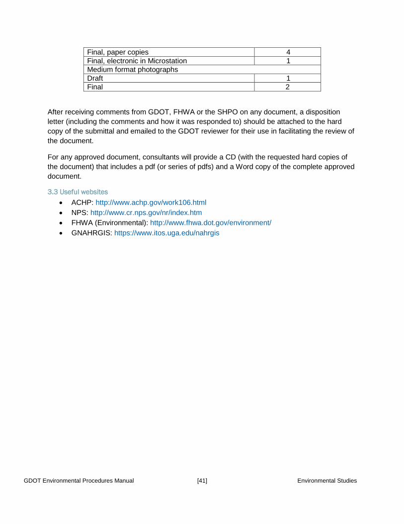
GDOT Environmental Procedures Manual [41] Environmental Studies
Final, paper copies 4 Final, electronic in Microstation 1 Medium format photographs Draft 1 Final 2
After receiving comments from GDOT, FHWA or the SHPO on any document, a disposition letter (including the comments and how it was responded to) should be attached to the hard copy of the submittal and emailed to the GDOT reviewer for their use in facilitating the review of the document.
For any approved document, consultants will provide a CD (with the requested hard copies of the document) that includes a pdf (or series of pdfs) and a Word copy of the complete approved document.
3.3 Useful websites • ACHP: http://www.achp.gov/work106.html • NPS: http://www.cr.nps.gov/nr/index.htm • FHWA (Environmental): http://www.fhwa.dot.gov/environment/ • GNAHRGIS: https://www.itos.uga.edu/nahrgis


![CHAPTER V - ENVIRONMENTAL · PDF fileGDOT Environmental Procedures Manual [1] Environmental Studies CHAPTER V - ENVIRONMENTAL STUDIES 6.0 Physical environment 6.1 Noise Assessment](https://static.fdocuments.in/doc/165x107/5a78b0087f8b9ae91b8dfddc/chapter-v-environmental-gdot-environmental-procedures-manual-1-environmental.jpg)


