Chapter PQ COAL QUALITY AND GEOCHEMISTRY, … · Ash yield in the Wyodak-Anderson coal zone in the...
27
Chapter PQ COAL QUALITY AND GEOCHEMISTRY, POWDER RIVER BASIN, WYOMING AND MONTANA By G.D. Stricker and M.S. Ellis in U.S. Geological Survey Professional Paper 1625-A
Transcript of Chapter PQ COAL QUALITY AND GEOCHEMISTRY, … · Ash yield in the Wyodak-Anderson coal zone in the...

Chapter PQ
COAL QUALITY AND GEOCHEMISTRY, POWDER RIVERBASIN, WYOMING AND MONTANA
By G.D. Stricker and M.S. Ellis
in U.S. Geological Survey Professional Paper 1625-A

PQ-ii
Contents
Coal Quality and Geochemistry, Powder River Basin, Wyoming and
Montana ..............................................................................................................PQ-1
References Cited .................................................................................................PQ-4
Figures
PQ-1. Index map showing the Powder River Basin.
PQ-2. Index map showing coal quality data distribution in the Wyodak-
Anderson coal zone in the Powder River Basin.
PQ-3. Ash yield in the Wyodak-Anderson coal zone in the Powder River Basin.
PQ-4. Total sulfur content in the Wyodak-Anderson coal zone in the Powder
River Basin.
PQ-5. Moist, mineral-matter-free Btu/lb in the Wyodak-Anderson coal zone in
the Powder River Basin.
PQ-6. Pounds of sulfur dioxide per million Btu (lbSO2 ) in the Wyodak-
Anderson coal zone in the Powder River Basin.
PQ-7. Antimony concentration in the Wyodak-Anderson coal zone in the
Powder River Basin.
PQ-8. Arsenic concentration in the Wyodak-Anderson coal zone in the Powder
River Basin.
PQ-9. Beryllium concentration in the Wyodak-Anderson coal zone in the
Powder River Basin.
PQ-10. Cadmium concentration in the Wyodak-Anderson coal zone in the Powder
River Basin.

PQ-iii
Figures-continued
PQ-11. Chromium concentration in the Wyodak-Anderson coal zone in the
Powder River Basin.
PQ-12. Cobalt concentration in the Wyodak-Anderson coal zone in the Powder
River Basin.
PQ-13. Lead concentration in the Wyodak-Anderson coal zone in the Powder
River Basin.
PQ-14. Manganese concentration in the Wyodak-Anderson coal zone in the
Powder River Basin.
PQ-15. Mercury concentration in the Wyodak-Anderson coal zone in the, Powder
River Basin.
PQ-16. Nickel concentration in the Wyodak-Anderson coal zone in the Powder
River Basin.
PQ-17. Selenium concentration in the Wyodak-Anderson coal zone in the Powder
River Basin.
PQ-18. Uranium concentration in the Wyodak-Anderson coal zone in the Powder
River Basin.
Table
PQ-1. Summary data for coal in the Wyodak-Anderson coal zone in the Powder
River Basin

PQ-1
COAL QUALITY AND GEOCHEMISTRY, POWDER RIVER
BASIN, WYOMING AND MONTANA
Actively mined coal from the Wyodak-Anderson coal zone in the Powder River
Basin in Wyoming and Montana (fig. PQ-1) is considered to be “clean coal.” For
the location and description of this coal zone, see Chapter PF-Framework Geology
of Fort Union coal in the Powder River Basin. This coal zone contains a low-
contaminant, subbituminous coal resource that has the following arithmetic mean
values (on an as-received basis) for coal that is not presently being mined or under
lease to be mined in the future: moisture–27.66 percent, ash–6.44 percent, total
sulfur–0.48 percent, calorific value–8,220 Btu/lb, lb SO2 per million Btu–1.24,
and moist, mineral-matter-free Btu–8,820. Arithmetic mean concentration (in
parts per million and on whole-coal and remnant-moisture basis) of elements of
environmental concern for coal in the Wyodak-Anderson coal zone (and
stratigraphically equivalent beds in Montana and Wyoming) are: antimony–0.50,
arsenic–2.6, beryllium–0.54, cadmium–0.21, chromium–6.1, cobalt–1.9,
lead–3.0, manganese–26, mercury-–0.13, nickel–4.6, selenium–1.1, and
uranium–1.3. Table PQ-1 is a summary of coal quality of the Wyodak-Anderson
coal zone in Wyoming and Montana. Coal from the Wyodak-Anderson coal zone
is produced from 23 mines in the Powder River Basin. This coal is utilized for
electric power generation at power plants in 26 states. The Wyodak-Anderson coal
is sometimes blended with higher sulfur coal to produce a compliant fuel.
Both proprietary and public data are used in the summary data tables, but is not
shown on location maps or on other graphic displays. A common problem in
statistical summaries of trace-element data arises when element values are below
the limits of detection. This results in a censored distribution. To compute

PQ-2
unbiased estimates of censored data for the elements in this table, we adopted the
protocol of reducing all “less than” values by 50 percent to generate a real value
for these data. Summary statistics of range (minimum, with an “L” indicating “less
than”, and maximum values) and arithmetic means were generated using the
modified data. Moisture values are reported on an as-received basis (American
Society for Testing and Materials, 1994b, designation D3180-89). Because no
equilibrium moisture values are available for this report, apparent ranks can not
reliably be determined.
Between 1974 and 1994, the U.S. Geological Survey analyzed samples of coal for
major-, minor-, and trace-element contents. Prior to performing the analyses, most
of the coal samples were dried at room temperature and humidity for as much as 80
hours. Some samples, however, may have only been dried enough to allow
grinding (to less than 100 mesh). Moisture content in the samples is unknown,
although moisture contents were probably similar to that which would remain after
air-dry loss determination (American Society for Testing and Materials, 1994c,
D3302-91). Since the actual moisture content of the samples analyzed between
1974 and 1994 is unknown and can not be determined, the major-, minor-, and
trace-element contents are reported on a remnant moisture basis. Also, the
elemental analysis of the samples cannot be converted to any other moisture basis.
In addition, these analyses can only provide an approximation of load factors (such
as, pounds of mercury per trillion Btu).
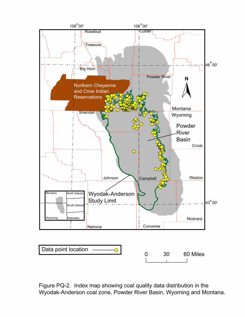
For the following graphical displays, figures PQ-2 through PQ-17, show public
data locations and values for variables listed in table PQ-1, except for calorific
value and moisture, for the Wyodak-Anderson coal zone. The locations of public
data points used in this summary are shown on figure PQ-2. When more than one

PQ-3
analysis was available per location, the analytical values were weight averaged on
coal sample thickness. For ash and total sulfur (figs. PQ-3 and PQ-4), the values
are color coded low, medium, and high, following guidelines established in U.S.
Geological Survey Circular 891 (Wood and others, 1983). For moist, mineral-
matter-free Btu, which is used in conjunction with other factors to determine
apparent rank (fig. PQ-5), we utilized the apparent rank designations established by
American Society for Testing and Materials, (1994a), designation D388-92a. For
pounds of SO2 per million Btu (lb SO2) (fig. PQ-6), values are color coded to the
U.S. Environmental Protection Agency’s Phase I, Phase II, and non-compliant
limits for sulfur emission from coal-fired power plants (U.S. Environmental
Protection Agency, 1996).
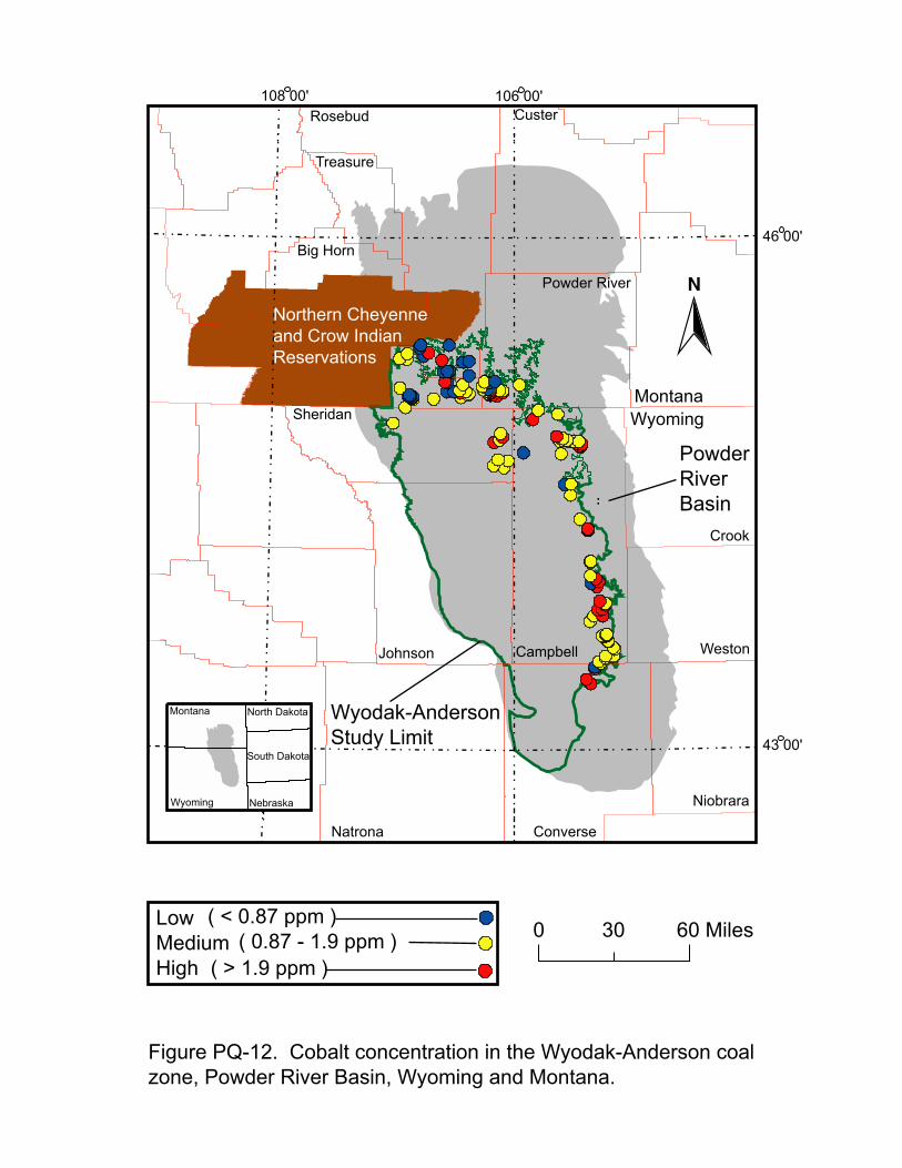
No guidelines have been established for the elements of environmental concern
(also referred to as “hazardous air pollutants” or “HAPs”). Analytical values for
these elements (figs. PQ-7 through PQ-18) are color keyed based on the following
parameters: (1) each element of environmental concern was ranked from the lowest
to highest value for all data in the Northern Rocky Mountains and Great Plains
region and (2) quartiles were established for each element such that low represents
those values that are less than the .25 quartile (also known as the lower quartile or
the 25th percentile), medium represents those values that are within the .25 to .75
quartiles (two quartiles representing 50 percent of the values or between the 25th to
75th percentile), and high represents those values that are in the upper .25 quartile
(or greater than the 75th percentile).

PQ-4
REFERENCES CITED
American Society for Testing and Materials, 1994a, Annual book of ASTM
Standards, Section 5, Petroleum products, lubricants and fossil fuels, vol.
05.05 Gaseous fuels; coal and coke; section D388-92a; Standard
Classification of Coal by Rank: American Society for Testing and Materials,
Philadelphia, Pennsylvania, p. 168-171.
1994b, Annual book of ASTM Standards, Section 5, Petroleum products,
lubricants and fossil fuels, vol. 05.05 Gaseous fuels; coal and coke; section
D3180-89; Standard Practice for Calculating Coal and Coke Analysis from
As-Determined to Different Bases: American Society for Testing and
Materials, Philadelphia, Pennsylvania, p. 318-320.
1994c, Annual book of ASTM Standards, Section 5, Petroleum products,
lubricants and fossil fuels, vol. 05.05 Gaseous fuels; coal and coke; section
D3302-91; Standard Test Method for Total Moisture in Coal: American
Society for Testing and Materials, Philadelphia, Pennsylvania, p. 330-336.
Bragg, L.J., Oman, J.K., Tewalt, S.J., Oman, C.L., Rega, N.H., Washington, P.M.,
and Finkleman, R.B, 1994, U.S. Geological Survey Coal Quality (Coalqual)
Database: Version 1.3: U.S. Geological Survey Open-File Report 94-205,
CD-ROM.
U.S. Environmental Protection Agency, 1996, Standards of Performance for New
Stationary Sources, 40CFR, Part 60.43, Standards for Sulfur Dioxide:
Environmental Protection Agency, 27 p.

PQ-5
Wood, G.H., Jr., Kehn, T.M., Carter, M.D., and Culbertson, W.C., 1983, Coal
resource classification system of the U.S. Geological Survey: U.S.
Geological Survey Circular 891, 65 p.

Montana
Nebraska
North Dakota
South Dakota
Colorado
Wyoming
New Mexico
Raton Basin
Denver Basin
North andMiddle Park
Basin
CarbonBasin
Hanna Basin
Wind River Basin
Big Horn Basin
Williston Basin
Powder River Basin
Bull Mountain Basin
Surface Fort Union Formation or equivalent formation
Subsurface Fort Union Formation or equivalent formation
Mines and/or lease
Targeted coal beds/zonesfor assessment
0 50 100 150 200 Miles
0 100 200 300 400 Kilometers
Figure PQ-1. Index map showing Powder River Basin, Wyoming and Montana
Greater Green River Basin
Northern Rocky Mountains
and Great Plains Region
Custer
Treasure
Rosebud
Powder River
Big Horn
Sheridan
Johnson
Natrona Converse
Niobrara
Weston
Crook
Campbell
Data point location
PowderRiverBasin
Wyoming
North Dakota
South Dakota
Nebraska
Montana
Northern Cheyenneand Crow IndianReservations
Wyodak-AndersonStudy Limit
MontanaWyoming
0 30 60 Miles
Figure PQ-2. Index map showing coal quality data distribution in the Wyodak-Anderson coal zone, Powder River Basin, Wyoming and Montana.
N
43 00'�
46 00'
108 00' 106 00'

Custer
Treasure
Rosebud
Powder River
Big Horn
Sheridan
Johnson
Natrona Converse
Niobrara
Weston
Crook
Campbell
( < 8 % )( 8 - 15 % )
( > 15 % )
LowMedium High
PowderRiverBasin
Figure PQ-3 Ash yield in the Wyodak-Anderson coal zone, PowderRiver Basin, Wyoming and Montana.
Wyoming
North Dakota
South Dakota
Nebraska
Montana
Northern Cheyenneand Crow IndianReservations
Wyodak-AndersonStudy Limit
MontanaWyoming
0 30 60 Miles
N
43 00'�
46 00'
108 00' 106 00'

43 00'
46 00'
108 00' 106 00'
Custer
Treasure
Rosebud
Powder River
Big Horn
Sheridan
Johnson
Natrona Converse
Niobrara
Weston
Crook
Campbell
( < 1 % )( 1 - 3 % )
( > 3 % )
LowMedium High
PowderRiverBasin
Wyoming
North Dakota
South Dakota
Nebraska
Montana
Northern Cheyenneand Crow IndianReservations
Wyodak-AndersonStudy Limit
MontanaWyoming
0 30 60 Miles
Figure PQ-4. Sulfur content in the Wyodak-Anderson coal zone, PowderRiver Basin, Wyoming and Montana.
N

43 00'�
46 00'
108 106 00'Custer
Treasure
Rosebud
Powder River
Big Horn
Sheridan
Johnson
Natrona Converse
Niobrara
Weston
Crook
Campbell
( < 8,300 )( 8,300 -10,500 )
( > 10,500 )
LigniteSubbituminous Bituminous
PowderRiverBasin
Wyoming
North Dakota
South Dakota
Nebraska
Montana
Northern Cheyenneand Crow IndianReservations
Wyodak-AndersonStudy Limit
Montana
Wyoming
0 30 60 Miles
Figure PQ-5. Moist, mineral-matter-free Btu in the Wyodak-Anderson coal zone, Powder River Basin, Wyoming and Montana.
N
00'

43 00'�
46 00'
108 106 00'Custer
Treasure
Rosebud
Powder River
Big Horn
Sheridan
Johnson
Natrona Converse
Niobrara
Weston
Crook
Campbell
( < 1.2 )( 1.2 - 2.4 )
( > 2.4 )
LowMedium High
PowderRiverBasin
Wyoming
North Dakota
South Dakota
Nebraska
Montana
Northern Cheyenneand Crow IndianReservations
Wyodak-AndersonStudy Limit
Montana
Wyoming
0 30 60 Miles
Figure PQ-6. Pounds of sulfur dioxide per million Btu in the Wyodak-Anderson coal zone, Powder River Basin, Wyoming and Montana.
N
00'

43 00'�
46 00'
108 00' 106 00'
Wyoming
North Dakota
South Dakota
Nebraska
Custer
Treasure
Rosebud
Powder River
Big Horn
Sheridan
Johnson
Natrona Converse
Niobrara
Weston
Crook
Campbell
( < 0.2 ppm )( 0.2 - 0.5 ppm )
( >0.5 ppm )
LowMedium High
PowderRiverBasin
Wyodak-AndersonStudy Limit
Montana
Northern Cheyenneand Crow IndianReservations
MontanaWyoming
0 30 60 Miles
Figure PQ-7. Antimony concentration in the Wyodak-Anderson coal zone, Powder River Basin, Wyoming and Montana.
N

Custer
Treasure
Rosebud
Powder River
Big Horn
Sheridan
Johnson
Natrona Converse
Niobrara
Weston
Crook
Campbell
PowderRiverBasin
Wyodak-AndersonStudy Limit
LowMedium High
( < 1.4 ppm )( 1.4 - 6.1 ppm )
( > 6.1 ppm )
Northern Cheyenneand Crow IndianReservation
MontanaWyoming
Montana
Wyoming
North Dakota
South Dakota
Nebraska
0 30 60 Miles
Figure PQ-8. Arsenic concentration in the Wyodak-Anderson coal zone, Powder River Basin, Wyoming and Montana.
N
43 00'�
46 00'
108 00' 106 00'

Custer
Treasure
Rosebud
Powder River
Big Horn
Sheridan
Johnson
Natrona Converse
Niobrara
Weston
Crook
Campbell
PowderRiverBasin
LowMedium High
( < 0.23 ppm )( 0.23 - 0.73 ppm )
( > 0.73 ppm )
Wyoming
North Dakota
South Dakota
Nebraska
Montana
Northern Cheyenneand Crow IndianReservations
Wyodak-AndersonStudy Limit
MontanaWyoming
N
0 30 60 Miles
Figure PQ-9. Beryllium concentration in the Wyodak-Anderson coal zone, Powder River Basin, Wyoming and Montana.
43 00'�
46 00'
108 00' 106 00'

43 00'
46 00'
108 00' 106 00'Custer
Treasure
Rosebud
Powder River
Big Horn
Sheridan
Johnson
Natrona Converse
Niobrara
Weston
Crook
Campbell
PowderRiverBasin
LowMedium High
( < 0.052 ppm )( 0.052 - 0.13 ppm )
( > 0.13 ppm )
0 30 60 Miles
Figure PQ-10. Cadmium concentration in the Wyodak-Anderson coal zone, Powder River Basin, Wyoming and Montana.
Wyoming
North Dakota
South Dakota
Nebraska
Montana
Northern Cheyenneand Crow IndianReservations
Wyodak-AndersonStudy Limit
MontanaWyoming
N

43 00'
46 00'
108 00' 106 00'Custer
Treasure
Rosebud
Powder River
Big Horn
Sheridan
Johnson
Natrona Converse
Niobrara
Weston
Crook
Campbell
PowderRiverBasin
LowMedium High
( < 3.0 ppm )( 3.0 - 8.2 ppm )
( > 8.2 ppm )
Wyoming
North Dakota
South Dakota
Nebraska
Montana
Northern Cheyenneand Crow IndianReservations
Wyodak-AndersonStudy Limit
MontanaWyoming
0 30 60 Miles
N
Figure PQ-11. Chromium concentration in the Wyodak-Anderson coal zone, Powder River Basin, Wyoming and Montana.
43 00'
46 00'
108 00'� 106 00'Custer
Treasure
Rosebud
Powder River
Big Horn
Sheridan
Johnson
Natrona Converse
Niobrara
Weston
Crook
Campbell
PowderRiverBasin
LowMedium High
( < 0.87 ppm )( 0.87 - 1.9 ppm )
( > 1.9 ppm )
Wyoming
North Dakota
South Dakota
Nebraska
Montana
Northern Cheyenneand Crow IndianReservations
Wyodak-AndersonStudy Limit
MontanaWyoming
0 30 60 Miles
N
Figure PQ-12. Cobalt concentration in the Wyodak-Anderson coal zone, Powder River Basin, Wyoming and Montana.

43 00'�
46 00'
108 00' 106 00' Custer
Treasure
Rosebud
Powder River
Big Horn
Sheridan
Johnson
Natrona Converse
Niobrara
Weston
Crook
Campbell
PowderRiverBasin
LowMedium High
( < 1.8 ppm )( 1.8 - 4.2 ppm )
( > 4.2 ppm )
Wyoming
North Dakota
South Dakota
Nebraska
Montana
Northern Cheyenneand Crow IndianReservations
Wyodak-AndersonStudy Limit�
MontanaWyoming
0 30 60 Miles
Figure PQ-13. Lead concentration in the Wyodak-Anderson coal zone, Powder River Basin, Wyoming and Montana.
N

43 00'
46 00'
108 00'� 106 00'Custer
Treasure
Rosebud
Powder River
Big Horn
Sheridan
Johnson
Natrona Converse
Niobrara
Weston
Crook
Campbell
PowderRiverBasin
LowMedium High
( < 12 ppm )( 12 - 49 ppm )
( > 49 ppm )
Wyoming
North Dakota
South Dakota
Nebraska
Montana
Northern Cheyenneand Crow IndianReservations
Wyodak-AndersonStudy Limit�
MontanaWyoming
0 30 60 Miles
Figure PQ-14. Manganese concentration in the Wyodak-Anderson coal zone, Powder River Basin, Wyoming and Montana.
N

43 00'
46 00'
106 00'108 00'
Custer
Treasure
Rosebud
Powder River
Big Horn
Sheridan
Johnson
Natrona Converse
Niobrara
Weston
Crook
Campbell
PowderRiverBasin
LowMedium High
( < 0.06 ppm )( 0.06 - 0.13 ppm )
( > 0.13 ppm )
Wyoming
North Dakota
South Dakota
Nebraska
Montana
Northern Cheyenneand Crow IndianReservations
Wyodak-AndersonStudy Limit
MontanaWyoming
0 30 60 Miles
Figure PQ-15. Mercury concentration in the Wyodak-Anderson coal zone, Powder River Basin, Wyoming and Montana.
N

43 00'
46 00'
108 00' 106 00' Custer
Treasure
Rosebud
Powder River
Big Horn
Sheridan
Johnson
Natrona Converse
Niobrara
Weston
Crook
Campbell
PowderRiverBasin
LowMedium High
( < 1.9 ppm )( 1.9 - 5.2 ppm )
( > 5.2 ppm )
Wyoming
North Dakota
South Dakota
Nebraska
Montana
Northern Cheyenneand Crow IndianReservations
Wyodak-AndersonStudy Limit
MontanaWyoming
0 30 60 Miles
Figure PQ-16. Nickel concentration in the Wyodak-Anderson coal zone, Powder River Basin, Wyoming and Montana.
N

43
46 00'
108 00' 106 00'Custer
Treasure
Rosebud
Powder River
Big Horn
Sheridan
Johnson
Natrona Converse
Niobrara
Weston
Crook
Campbell
PowderRiverBasin
Low ( <0.5 ppm ) Medium ( 0.5 - 1.1 ppm )High ( >1.1 ppm )
Wyoming
North Dakota
South Dakota
Nebraska
Montana
Northern Cheyenneand Crow IndianReservations
Wyodak-AndersonStudy Limit
MontanaWyoming
0 30 60 Miles
Figure PQ-17. Selenium concentration in the Wyodak-Anderson coal zone, Powder River Basin, Wyoming and Montana.
N
00'

43
46
108 106Custer
Treasure
Rosebud
Powder River
Big Horn
Sheridan
Johnson
Natrona Converse
Niobrara
Weston
Crook
Campbell
PowderRiverBasin
Low ( < 0.61 ppm ) Medium ( 0.61 - 1.6 ppm )High ( >1.6 ppm )
Wyoming
North Dakota
South Dakota
Nebraska
Montana
Northern Cheyenneand Crow IndianReservations
Wyodak-AndersonStudy Limit
MontanaWyoming
0 30 60 Miles
Figure PQ-18. Uranium concentration in the Wyodak-Anderson coal zone, Powder River Basin, Wyoming and Montana.
N
00'
00'
00' 00'

Table PQ-1. Summary data for coal in the Wyodak-Anderson coal zone in the
Powder River Basin, Wyoming and Montana. Calculated from the unpublished
U.S. Geological Survey coal quality database (USCHEM), February, 1992; Bragg
and others (1994); and proprietary source(s)
Variable Number Range Mean
of samples Minimum Maximum
Moisture 1 300 14.50 42.30 27.66Ash 1 279 2.86 25.06 6.44Total sulfur 1 279 0.06 2.40 0.48Calorific value 2 277 3,740 9,950 8,220lb SO2
3 277 0.14 7.88 1.24MMMFBtu 4 277 4,580 10,560 8,820Antimony 5 144 0.01L 17 0.49Arsenic 5 158 0.20L 19 2.6Beryllium 5 151 0.078L 3.3 0.54Cadmium 5 151 0.007L 3.0 0.21Chromium 5 161 0.59L 50 6.1Cobalt 5 160 0.38L 27 1.9Lead 5 162 0.50L 17 3.0Manganese 5 161 0.18 210 26Mercury 5 162 0.006L 27 0.13Nickel 5 161 0.71L 35 4.6Selenium 5 151 0.08L 16 1.1Uranium 5 157 0.11L 12 1.3
1 Values are in percent and on an as-received basis.2 Value is in British thermal units (Btu).3 Value is in pounds per million Btu and on an as-received basis.4 Value is in British thermal units on a moist, mineral-matter-free basis.5 Values are in parts per million (ppm) on a whole-coal and remnant moisture basis; “L” denotes less than value shown.