CHAPTER II STUDY AREA -...
36
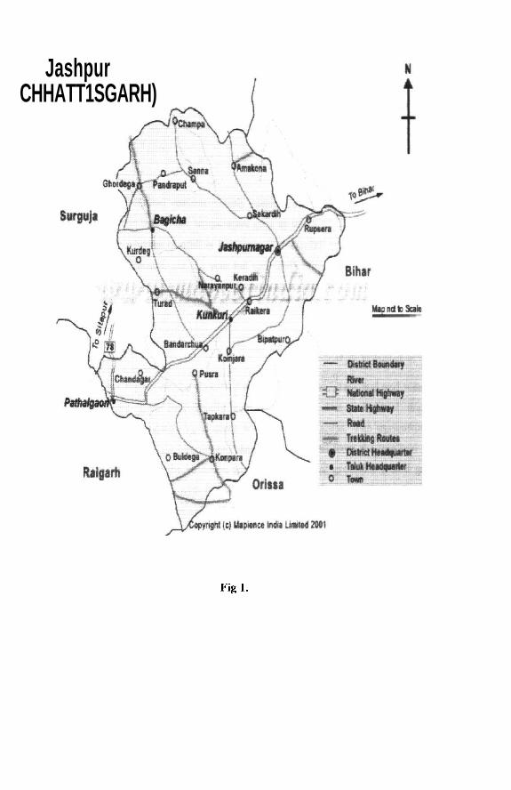
Study Area CHAPTER II STUDY AREA 2.1 Location Jaspur is a district in the newly created Chattisgarh state; earlier it was part of undivided Madhya Pradesh. The total geographical area of the Chattisgarh state is 135,100 Sq. Km. and its capital is Raipur. The state has Madhya Pradesh in the west direction, Andhra Pradesh in the south direction, Orissa in the east direction and another newly created Jharkhand state in the northeast direction and Uttar Pradesh in north direction. According to census 1991 the total population of the state is 1,76,15,000. Jaspur district is located in the north-eastern corner of the state (Map 1). It is located between 20°17' and 23°15' N Latitude and 80° 4' and 81°26' E Longitude. The geographical area of the district is 4570 sq. km. It is surrounded by Raigarh district in south, Sarguja district in west, Gumla District of Jharkhand in the northeast and Orissa in southeast. The total population of the district is 6,56,352. 2.2 Administration set up Jaspur district has four subdivisions under its jurisdiction, namely Jaspur, Kunkuri, Bagicha, and Pathalgaon. The district headquarter is located at Jaspur. There are six blocks in the district. The district has one forest division with three subdivisions Jaspur, Kunkuri, Pathalgaon, with six ranges namely Jaspur, Tapkara, Duldula, Sanna, Baderkhol, Pathalgaon and one wildlife sanctuary Kansabel. 2.3 Physical Features The Jaspur district is located in the Vindhya mountain ranges; it lies between 274 Mts. to 1136 Mts. above the sea level. The district is topographically divided into three agro-climatic zones namely low land area called as Nichaghat, which lies between 274-700 meters, and has two subdivisions namely Pathalgoan, and Kunkuri located in this region. Next is zone consisting of the gentle rolling hill of Jaspur block area, located in the altitude of 700-900 meters. In this region the subdivision of Jaspur located. The next zone is highland area called as Upper Ghat 39
Transcript of CHAPTER II STUDY AREA -...

Study Area
CHAPTER II
STUDY AREA
2.1 Location
Jaspur is a district in the newly created Chattisgarh state; earlier it was part of undivided Madhya
Pradesh. The total geographical area of the Chattisgarh state is 135,100 Sq. Km. and its capital is
Raipur. The state has Madhya Pradesh in the west direction, Andhra Pradesh in the south
direction, Orissa in the east direction and another newly created Jharkhand state in the northeast
direction and Uttar Pradesh in north direction. According to census 1991 the total population of
the state is 1,76,15,000.
Jaspur district is located in the north-eastern corner of the state (Map 1). It is located between
20°17' and 23°15' N Latitude and 80° 4' and 81°26' E Longitude. The geographical area of the
district is 4570 sq. km. It is surrounded by Raigarh district in south, Sarguja district in west,
Gumla District of Jharkhand in the northeast and Orissa in southeast. The total population of the
district is 6,56,352.
2.2 Administration set up
Jaspur district has four subdivisions under its jurisdiction, namely Jaspur, Kunkuri, Bagicha, and
Pathalgaon. The district headquarter is located at Jaspur. There are six blocks in the district. The
district has one forest division with three subdivisions Jaspur, Kunkuri, Pathalgaon, with six
ranges namely Jaspur, Tapkara, Duldula, Sanna, Baderkhol, Pathalgaon and one wildlife
sanctuary Kansabel.
2.3 Physical Features
The Jaspur district is located in the Vindhya mountain ranges; it lies between 274 Mts. to 1136
Mts. above the sea level. The district is topographically divided into three agro-climatic zones
namely low land area called as Nichaghat, which lies between 274-700 meters, and has two
subdivisions namely Pathalgoan, and Kunkuri located in this region. Next is zone consisting of
the gentle rolling hill of Jaspur block area, located in the altitude of 700-900 meters. In this
region the subdivision of Jaspur located. The next zone is highland area called as Upper Ghat
39
JashpurCHHATT1SGARH)
Fig l .
Study Area
lying between 900-1136 meters. The subdivision of Bagicha falls in this region. This region has
the highest peak of the district. The northwestern portion of the Upper Ghat has further elevated
to form plateau known as Pats. The areas of Khudia highland is situated in this region, Ib river
has it origin in the region.
2.4 Climate
The district has three distinct seasons namely summer, rainy and winter. The summer is spread
from April to June. The maximum temperature goes up to 45°C. The rainy season is spread from
July to October. The average rainfall is 1692 mm. The rainfall normally varies from 1599 mm to
1826 mm and occurs through out the year but very little during the months of February, March
and April. The winter is severe and minimum goes to as low as 1° C and it is spread from
November to March.
2.5 Resources
The resources of the region can be classified under land, forest, grassland and water. The land is
basically owned and used individually and collectively. The individual area consists of
predominantly large area under agriculture and settlement areas. The agriculture is basically
depended on the rain. Soils are latertie and sandy loam derived from the trap and granite. Under
the collective ownership are the common grazing land, burial grounds, sacred groves etc. The
ownership of these resources is with the state, but the use right rest collectively with the village
and it exclude other villages from using it.
The forest cover of the area is 35.3 percent of the total geographical area. The ownership of the
forest is with the state and managed by the forest department of the state. HG Champion (1968)
classifies the forest division of the district under "Moist Peninsular High Level" type. Sal
{Shorea robusta) forest is mostly situated on the slopes or at the base of hills. The Sal forest that
occurs in this area is "Sal Savanna forests". Within the above type considerable variations are
observed depending on the nature of soil, topography and biotic factors. The biotic factors,
which are significantly influencing forest growth, are reckless cutting of trees, frequently
40

Study Area
occurring forest fires, grazing by cattle and goats. According to Champion and Seth (1968)
following forest types exist in the region:
- Moist peninsular high level Sal forest,
Moist Sal savanna forest,
Dry peninsular Sal forest,
- Southern dry mixed deciduous forest.
The major species are Sal (Shorea robusta), Saja (Terminalia robusta\ Behara (Terminalia
bellirica), Hara (Terminalia chebula), Mahua (Madhuca indica% Bija {Pterocarpus marpusium),
Char (Bucnnania lanzari), Ghont (Zizyphus xylocarpus) etc. The wild animals include Chital,
Deer, Sambhar, Hare, Langur, Wild hen etc. Timber, fuel wood, Sal seed, Tendupatta and Hara
are the main forest produce in the region.
Grassland is available in the Pats area of upper high land in the Sanna region. As Ib River has
originated in this region of Khudia Rani Mountain; it is a sacred place in the district. Besides this
the forest area is also used for grazing purpose. In the area of agriculture land after harvesting of
crops is used as common for grazing.
Agriculture land is owned privately in the name of head of the family and all the male member
have right over the land as an inherited property. This land is used for agriculture purpose and
individual families grow crops on it. Livestock are reared and owned individually.
2.6 Communities
Number of ethnic groups inhabits the district of Jaspur. This district consists of communities
belonging to tribes and castes. The percentage of tribal population is 66 percent of the total
population. The district is a scheduled area district. Historically the district has seen large section
of tribal population converting to Christianity. The percentage of the converted Christians in this
district is 59 percent. The communities living in the district are Oraon, Kanwar, Korwa,
Rawotia, Lohar, Ghasi, Khairwar, Cherwa, Pinka, Gasiya, Domar, Tori, Nagesia, Mahkhur etc.
Korwa occupy the Upperghat and Khudia high land. The Oraon usually cultivate in valleys of
middle level altitude, lying between upperghat and Nichaghat. Raotia, Kanwar, Nagesia and
Mahakur inhabit the Nichaghat. The Mahakhur are professional grazers who graze their cattle on
the Khudia high land during the summer and rainy season.
41

Study Area
2.7 General Description of the studied villages
The villages selected for the study are Baghima, Ghamhariya, Komodo and Echkela. All these
four villages are located in the Jaspur block of the district, which falls in the middle zone of
altitudinal distribution of the district i.e. the area between Upperghat and Nichaghat. The region
has plain agriculture lands with gradually raising hill covered with forest on the western side
leading to the Upperghat zone of the district.
1. Baghima Village
Baghima village is at a distance of four-kilometres from the Jaspur town in the south direction on
the Sanna road (fig 2). The total geographical area of the village is 210.87 hectares. In Baghima
village, Sarhul Sarna, which on eastern side of the road, has a settlement often to fifteen houses
constructed on the west of the road leading to Sarna. In this settlement Baiga of the village lives
with his family. Sarhul Sarna is located in north east of the village settlement.
The village has six communities living in it. From table (2.1) it is clear that the Oraon form the
major community with ninety households, while others four communities constitute rest twenty
households. The Christian are basically the Oraon who have converted to Christianity in the past.
The Brahmins, referred to as Maharaj, by the villagers, have migrated from Bihar region in the
past. The other two communities are Lohar who provide the services of agriculture implement
repairing to the village. The Dhangar are schedule caste communities placed in the lowest level
of ladder and are engaged in basket making.
Table. 2.1 Composition of the different communities Baghima village
S.No
1
2
3
4
5
6
Community Name
Oraon
Christian
Brahmin
Lohar
Dhangar
Total
No. Of Household
90
10
4
4
2
110
42


Study Area
2. Komodo village
Komodo village is located at a distance of seven kilometres from the Jaspur town (fig 3). It is
located in the southwest direction, by road but in real sense the village is located in west of the
Jaspur town exactly behind the hills. The total geographical area of the village is 576.82 hectares.
This village has seven communities living in it. The Oraon is the predominant community
followed by Rajput. This village has service communities such as Lohar. Apart from this two
other communities i.e. Brahmin who moved into the village have come from Bihar, and Yadav
who have come here from Raigarh side. In the recent past two households belonging to Gond
tribe, have moved in from Sarguja region and settled at the outskirts of the village. The table2.2
gives the communities living in the villages.
Table. 2.2 Composition of the different communities Komodo village
S.No.
1
2
3
4
5
6
7
8
Community Name
Oraon
Christian
Rajput
Brahmin
Yadav
Lohar
Gond
Total
No. of Households
73
1
11
2
1
4
294
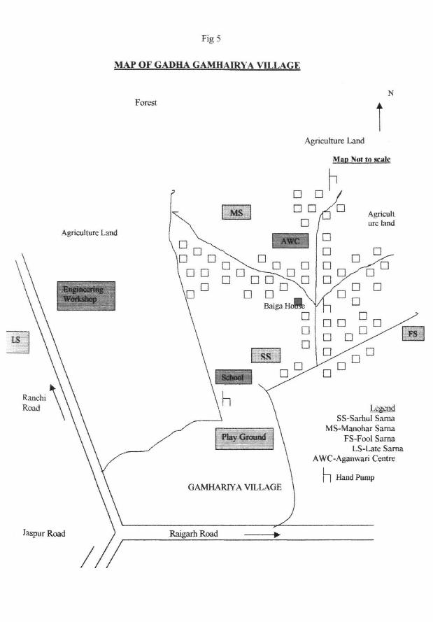
3. Ghamhariya Village
Ghamhariya village is located in southeast direction from Jaspur town (Fig 4). The distance of
this village from the Town is four kilometres and adjacent to Road linking Raipur and Ranchi,
capitals of Chattisgarh and Jharkhand. This village is distributed into two settlements, one is
Gadha Ghamhariya located at a distance of one and half kilometre from the main link road,
which is the older settlement and now considered as a village. Whereas Ghamhariya village is
located next to the main link road is the new settlement and is established by the communities
who have moved from the Jaspur town. These two villages share the Sarnas and participate in
the ritual collectively. Baiga of the Ghamhariya village is Mohandas Nagesia, whose age is fifty-
two years. The total geographical area of the village is 817.63 hectares.
43


Study Area
The Gadha Ghamhariya village has predominantly Oraon population, along with Nagesia SL tribal
community, Lohar and Gayar backward caste communities (fig 4). There is no Christian family
living in this village. The table 2.3 shows the community wise distribution in the village
Table.2.3 Composition of the different communities Gadha Ghamhariya village
S.No.
1
2
3
4
5
Community Name
Oraon
Nagesia
Gayar
Lohar
Total '
No. Of Households
91
3
2
1
97
Ghamhariya village has heterogeneous community composition of tribal and caste communities.
All together it has thirteen communities living in the village. The Raotia considered to be a
backward caste in the area, has maximum households of twenty-five followed by Nagesia tribe,
which has twenty households. There are caste communities like Brahmin, Rajput, Agarwal,
Gupta (both are trader communities), Sinha (Kayasth community) and two Jain families.
Kumhar and Lohar are the communities providing services to the agriculturalist communities of
the village. Apart from this, Gayar a backward caste, and Chick a scheduled caste live in the
village (Table2.4).
Table.2.4 Composition of the different communities Ghamhariya village
S.No.
1
2
3
4
5
6
7
8
9
10
11
12
13
14
Community Name
Raotia
Nagesia
Brahmin
Kumhar
Gayar
Oraon
Sinha
Rajput
Agarwal
Jain
Gupta
Lohar
Chick
Total
No. Of Households
25
20
5
12
8
4
2
1
12
1
2
2
85
44

Study Area
4. Echkela Village
Echkela village is located in the south and southeast direction from Jaspur town at a distance of
fourteen kilometres (Fig 5). This village is larger than three other study villages in size and
population. The entire village constitutes one panchayat, with no other settlement under its
jurisdiction. The total geographical area of the village is 1025.93 hectares.
All the Oraon households of the village have converted to Christianity about hundreds years ago.
At present none of them believe or follow the traditional culture of the Oraon. The Christians of
the village neither have belief in Sarna nor go to Sarna for rituals. Now days, they go to the
church constructed in the village. The converted Oraon register them as Oraon a scheduled tribe
in government census in order to claim the benefits of government scheme meant for the tribal
community.
Echkela village has total 200 households of which the population of Oraon community is 235
from fifty households. Other houses belong to the tribal as well as caste communities. Raotia
with hundred households is the dominant community of the village. Nagesia is the other tribal
community living in the village. The upper castes like Brahmin, Rajput along with the lower
castes like Lohar, Kumhar, and scheduled castes like Ghasi and Chick live in the village. There
is one Muslim family living in the village (Table 2.5).
Table.2.5 Composition of the different communities Echkela village
S.No.1
2
3
4
5
6
7
8
9
10
11
12
13
Community NameChristianRaotiaBrahminNagesiaLoharGhasiKumharRajputMuslimGayarHalwaiChickTotal
No. of Households50
100
1
18
8
6
4
1
1
8
1
2
200
45

Fig 6MAP OF ECHKELA VILLAGE

Study Area
2.8 Demography of the villages
The total population of the village Baghima is 538 from 110 households, whereas the total
population of the Komodo village is 516 from ninety-four households. The population of Gadha
Ghamhariya village is 461; from 97 households and of Ghamhariya village is 551, from 85
households. The above three villages have predominantly Oraon community along with other
communities living with them in village. Whereas the population of Echkela village is 1260,
which has Raotia community in majority and all the Oraon households have converted to
Christianity, along with other tribal communities. The table (2.6) gives the village wise
distribution of the population of the four villages.
Table.2. 6. Demographic detail of the studied villages
S.No
1
2
3
3
4
5
Name of the village
Baghima
Komodo
Gadha Ghamhariya
Ghamhariya
Echkela
Total
No of Households in each villages
110
94
97
85
200
586
Population of the village
538
516
461
551
1260
3326
2.9 Economic system of the villages
The village economy basically revolves around agriculture. All the households have agriculture
land. The agriculture is rain fed and fully depended on the southwest monsoon. The region has
intermittent rain through out the year, but the rainfall in the monsoon season only is helpful for
agriculture activities. The main crop grown is paddy. Apart from that the villagers grow maize
and vegetables in their homestead garden. As the agriculture is rain fed, the villagers get only
one crop of paddy.
46

Study Area
2.9.1 Land Ownership Pattern in the villages
The agriculture forms the main economic activity of these villages. The majority of the
households in the each village own the land. It is property owned hereditarily by the men
members of the family. Below is the land ownership pattern of the Komodo village (Table 2.7).
Out of the seventy-four households of Oraon, all households own land except one, this being an
old member living separately from his family members and has given land to his sons. The other
landless family belongs to the Lohar, who basically provide services to the agriculturalists in the
village. The caste families have moved in from other area and have gradually purchased land
from the local inhabitants.
Table.2.7. Community wise Land ownership pattern in Komodo village
S.No
1
2
3
4
5
6
7
8
9
10
Land owned
(acres)
Landless
0-2
2-4
4-6
6-8
8-10
10-12
12-14
14 & above
Total
Communities
Oraon
01
14
22
16
06
07
04
02
02
74
Rajput
01
02
03
01
03
01
11
Brahmin
01
01
02
Lohar
01
03
04
Yadav
01
01
Gond
02
02
Total
04
16
27
19
07
08
07
02
04
94
The Gadha Ghamhariya village has twenty-four households as landless, of which twenty-two
households belong to the Oraon community and one to Nagesia community and other to Gayar
community. The joint family of Birsai Ram has the maximum land holding of fifteen acres of
land. Out of other six households only four have land of medium size i.e. less than six acres of
land per households (Table 2.8).
47

Study Area
Table.2.8. Community-wise land ownership pattern in Gadha Ghamhariya village
S.No
1
2
3
4
5
6
7
8
9
10
Lands owned
(acres)
Landless
0-2
2-4
4-6
6-8
8-10
10-12
12-14
14 & above
Total
Communities
Oraon
22
10
22
15
9
6
5
1
1
91
Nagesia
1
1
1
3
Gayar
1
1
2
Lohar
1
1
Total
24
12
22
16
10
6
5
1
1
97
The Ghamhariya village with heterogeneous composition of communities has only three landless
households, of which two belonging to the households of Oraon and Nagesia tribal communities
and third one to a household of Lohar community. The maximum land belongs to a joint family
of Lohar, which has eighteen acres of land. In this village, fourteen households have land of
more than ten acres each, out of which eight households belong to the caste communities of
Lohar, Kumhar, Brahmin, Gupta, Sinha and Chick (see Table 2.9). The landless households
among the tribal have increased after the in-migration of the caste communities in the village.
Members of the caste communities apart from owning land are employed in the government jobs
like postman, Policeman, and Driver. Few of the caste families do business in the town of Jaspur.
They run hotel, general shops, and mechanic shop in the town.
In Echkela village the farmer with the highest area of agriculture is Seetal Kumar Raotia, who
has sixty-five acres of agriculture land. His is head of a joint family of four brothers living
together. The least land is with Meghnath Raotia who has only one acre of land.
48

Study Area
Table.2.9. Community
S.No
1
2
3
4
5
6
7
8
9
Land
(acres)
Landless
0-2
2-4
4-6
6-8
8-10
10-12
12-14
14&
above
Total
wise landI ownership pattern in Ghamhariya village
Communities*
R
1
3
11
4
3
1
2
25
N
5
6
6
1
2
20
L
1
1
2
K
2
5
2
2
1
1
12
O
1
2
4
B
1
2
1
1
5
G
3
1
1
1
1
1
8
C
1
1
2
Gu
1
1
S
1
1
2
J
1
1
2
Ra
1
1
A
1
1
Total
3
14
27
16
7
4
5
2
7
85
*R-Raotia,
Ra-Rajput,
N- Nagesia, L-Lohar, K- Kumhar, O-Oraon, B-Brahmin, G-Gayar, C-Chick, Gu-Gupta, S-Sinha, J-Jain,
A-Agarwal.
2.9.2 Other Occupational based communities of the villages
The Lohar community provides services needed for making and repairing of the agricultural
implements as well as iron material and utensils needed for domestic needs. The mode of
payment for this service is similar to Jajmani system in operation in caste based villages in India.
For some services cash is charged on the basis of work done at every instance.
The Dhangar are engaged in basketry work. The entire family makes the baskets and sells them
to the villagers as well as in the near by market place. For which the requirement of the Bamboo
is met from the forest or from the Nistar depot of the forest department. Earlier the communities
were allowed to collect species needed for economic as well as for domestic needs. Later on the
government, restricted this provision of collecting from the forest, instead it established depots
called as Nistar depots. Each depot has a fixed number of villages in a radius of five to ten
kilometres under its control to provide the forest material of economic as well as domestic needs
at rates fixed by the government.
49

Study Area
2.93 Agriculture Activities
The agriculture forms the primary activities in the monsoon season, when every household is
engaged in agriculture activities. Only the Kharif crop is cultivated in the fields. The labour for
agriculture is mostly from within the family and close kin groups, whereas in the case of caste-
based households of Brahmins and Rajput, they hire labour for agriculture work.
Once the agriculture season is over, a section of villagers migrate in search of employment in the
near by region of agriculture belt of Raipur in the south and Ranchi in the north. Mostly the
youth migrate to the areas of Raipur and Ranchi in search of employment in the agriculture and
non-farm sector for duration of five to six months. They return before start of agriculture
activities i.e. prior to coming of monsoon rains. This group of migrant population belongs to the
age group between 20-50. All those persons who have stayed back consisting of young and aged
persons manage the house, agriculture, and livestock. They are also engaged in collection of
NTFP (Non Timber Forest Produce) etc. The residents of Komodo are totally dependent for their
livelihood on Paddy cultivation, supplemented by rearing of livestock and collection of NTFP
from the forest. The villagers go to forest and collect fuel wood to sell in the market and make
some earning from it. The women and girls do the task of selling the fuel wood. Men also assist
women in domestic activities. For grazing of livestock they take them to forest areas and also
collect fodder and leaf forage from the forest to feed them.
The festivals and rituals of the village revolve around the agriculture and welfare of the village
and its community. Whenever there is drought, the villagers link it to the wrath of the village
deity and consider it needs to be appeased by an animal sacrifice. In order to appease the deity,
an animal is sacrificed in the grove. On the other hand, the girls of the village catch a frog and tie
it to a stick with its leg and roam around the village making noise. This is a magical approach,
which the villagers practice with a belief that it will bring rain. Oraon community gives prime
importance to Sarna, and believe that in Sarna their sacred deities resides. According to them
each trees is sacred and deity resides in each tree in the grove. Therefore they protect the Sarna,
because the deity in it provide them protection and assist in production of good agricultural crop.
50

Study Area
2.9.4 Usage of Forest Resources
The forest resource meets substantial needs of the villagers in the form of NTFP (Non Timber
Forest Produce), which they collect from the forest. The fuel wood is the primary item collected
from the forest on the daily basis. It fulfils energy requirements of the village population in the
winter season, where the other energy sources to protect from the cold are missing. Secondly fuel
need of cooking is met by the wood collected from the forest. The villagers stock up the wood
collected from the forest in their backyard and on the tree in the courtyard of the house and use
them at the time of rainy season as well as for distress sale. Men of the villages collect the fuel
wood from forest and make them into small pieces so that they are useable as well as easy to
transport for marketing. Women take them to town and sell them. The town is largely dependent
on the wood energy for the need of domestic purpose like cooking and heating. Thirty kilograms
of fuel wood generally fetch forty rupees in a day.
They collect NTFPs from forest like Mahua flowers, Mahua seeds, Sal flowers, Sal seeds, Sal
leaves, Mahul leaves, and Tendu leaves, Chrongi (Buccnania lenzen), Bamboo etc. The males,
females and children do the collection of NFTP from the forest as per the availability in the
season. Generally NTFP is available in the seasons when demand for agriculture work is low,
like leaves of Mahul are available in the month of July after sowing and transplantation of paddy,
when the villagers have free time to engage in collection of the leaves. Similarly Mahua is
available in the month of April, which is collected by all the family members. In this case, this
tree is owned on the hereditary basis and the villagers have developed a traditional system of
tenurial right in course of time; where a family is given right to collect it fruits and seeds for
personal use. Other villagers acknowledge this right, in term of usage of the product of the tree.
The leaves of Sal are collected for leaf plate making which is correlated with the demand for the
plates for ritual or other social occasion. The seeds are available in the month of June, i.e. pre-
monsoon period, where they have enough time to collect the seeds. Collection procedure of
NTFPs varies from the species to species collected. Some times NTFP is collected and sold for
income in off agriculture season, like Tendu leaves, which provides villagers with employment
for a period of forty-five days in the month of May-June. Tendu leaves are a monopoly
(nationalized) product and is collected and sold to the forest department at the rate fixed by the
51

Study Area
department. The men, women and children equally contribute in collection of Tendu leaves, after
collection, they make bundle of fifty leaves each and sell number of bundles to the collection
centre made by forest department. Forest department established Phad centres in various ranges,
where the collectors register themselves with it. These Phad centres act as collection centres, of
Tendu patta for forest department. In summer season especially in the month of May, collection
of Tendu leaves is done on large scale, under the management of Forest department, which
provides the tribal communities good earning in off-agriculture and low employment season.
The collection of NTFP like Tendu, Achar, Mahua, Mahul leaves, Sal seeds, and Honey from the
forest adjoining the village, provides them with additional sources of economic as well as
livelihood needs.
Apart from the fuel wood, the villagers go to forest to collect fodder and even take cattle to forest
for grazing. Besides this, some villagers' collects fodder from the forest to stall-feed their cattle.
The agriculture residue is also used as fodder for cattle. By using grass from different commons
and by product of agriculture, farmers try to meet the requirement of the fodder of the cattle. In
summer season there is shortage of fodder. In the time of dry season when the fodder availability
reduces, it is by substituted by the leaf of Sal and Pipal collected from the forest areas.
2.9.5 Livestock management
Rearing of livestock is done for meeting milk needs of family as well as for the agriculture work.
The cattle dung collected is used as manure for the agricultural field. The villagers of this region
consider cow a sacred animal and equate her to mother earth who supplies them with food
materials. Oraon community own livestock like cow, buffaloes, ox, goat, pig, hen etc. They
prefer cow and ox instead of buffaloes, and due to which the Oraon have lesser number of
buffaloes. Yadav community living in Komodo are engaged in tending to cattle like other
pastoral communities and take cattle for grazing in the forest hill of Upperghat in summer season
when the availability of grass is reduced. The ox is basically used for ploughing work. The
animals are taken into forest for grazing. Apart from that during of agriculture season, agriculture
fields are converted into season common for grazing of cattle. The goat, pig and cock are kept
for the purpose of nutritional needs as well as for sacrificial use.
52

Study Area
2.9.6 Other Services
Apart from traditional mode of occupation, the villagers based on individual educational
qualification are doing services in different sectors in the town, for example they are working as
teachers, helpers and assistant in shops etc. Some Individuals belonging to caste communities are
working in government department as postman, policeman, driver, teacher, and professor. Some
households own shops or run hotel or mechanic shop in the town. In Ghamhariya village
nineteen households have persons working in services sector, while seven households are
engaged in business. In Gadha Ghamhariya village, which has maximum number of landless
households, people belonging to these households are mostly working as wage labourers in
agriculture as well as in the town. This village has eight households working in services sector.
Jaspur is part of scheduled area, it falls in ITDP (Integrated Tribal Development Programme)
zone were number of tribal development programme are under taken for the development of the
communities and the region. Under the employment generation schemes, the local population got
opportunities to earn income in off agriculture season.
2.10 Social system of the villages
The social system of the villages give different panorama as it has communities ranging of tribal,
tribal converted to Christianity and in-migrated caste groups from the adjoining areas into the
region, who have settled in the villages of tribal dominance. Each unit of villages has its own
social arrangement pattern but collectively they reflect elements that are visible in other villages
of India in general, like hierarchy, social segregation, and pattern of sharing of food and space
with other members of village belonging to different communities.
The caste groups are considered upper in ladder and are referred as Maharaj for Brahmins and
Baba for Rajput. The households of caste groups in their relation with the tribal groups follow
the principle of segregation and separation in the matter of space use, sharing of food and other
interaction process. They do not take the food prepared by a tribal household, and share the food
with the tribal, only when the person belonging to the caste group prepares it. The place of
settlement of these caste groups is at a distance from the main settlement of tribals. The tribals
take food given by the upper caste households.
53

Study Area
Next in layer are the Oraon and other tribal communities. Here the principle of arrangement on
segregation and separation is linked to the nature of ownership of resources and occupation of
the group. The groups that own agriculture land and engaged in agriculture activities treat each
other as equal and share the space and food with one another. Where as the other communities
who do not have land are providing services are placed at lower order and a distance is
maintained in settlement and sharing of food is unidirectional i.e. food is taken by the service
communities from the tribal or land owning groups, while land owning groups do not take food
prepared by the service giving communities.
The caste-based families of Brahmin, Rajput and Yadav, follow the traditional system of
marriage that is marrying within caste group and maintaining the Gorta exogamy. The family
acts as primary unit of operation for all the activities of economic and social functions. The
organization of work amongst family members is on the bases of age and sex. The males,
supervise the agriculture work and women do the domestic work. These families hire labour for
agriculture and taking care of cattle. The labour is mostly from tribal communities living in the
village. The people of these communities have employment in services sector and also undertake
business.
The society of the Oraon and other tribal communities in the region is organized on the basis of
family, clan, and tribe. Each clan has a totem, which it protects and it is taboo to harm it. It has a
symbol on its flag, by which it is identified on the cultural occasions, when they collectively
assemble and celebrate. The clans of the Oraon community in the villages are Dhek (Frog),
Topo, Lakra (Hyena), Tigga (woodpecker), Kujur (Plam tree), Ekka (Tortoise), Tiriki (Cricket
insect), and Kindo (Tree). The clan totems are respected and tabooed from killing. The marriage
with in the clan is prohibited. These totems are mythologically linked with the origin of the
particular clan. They are respected and harming, killing as well as eating them is taboo for the
clan members.
Oraon and other tribal communities are patriarchal in nature with males having authority over
property and decision-making on family matters. The man owns the property. The eldest male is
the head of the family. The head of the family is decided on the basis of age and generation. The
eldest member of the highest generation will be the head of the family. But in some cases the
54

Study Area
qualities of the individual in making good decision and providing each individual with basic
needs, makes him the head of the family. The head of the family distributes the work among
family members on the basis of individual capability. The division of labour is based on age and
sex. There are works exclusively for the men like agriculture and for women like kitchen work or
domestic work. But women of tribal communities help in transplantation of paddy as well as at
the time of weeding.
2.10.1 Types of Family
The types of family reported from the region are Joint, nuclear, extended and broken or in-
complete households. In Joint family people of three or two generation live together in one
household. Here members of three different generations or at least two generation spread
horizontally and vertically live under one roof and eat from one hearth. The property is owned
collectively.
The head of the family manages all the family activities starting from economic, religious and
takes decisions in all matter from marriage of the family members to activities of agriculture.
Sometime an able person may not be the eldest or oldest person, leads and manages the family
affair and takes vital decisions concerning the family and acts as the head of the household.
There are few extended families existing in the village where apart from nuclear family one or
two extras members, mostly close relatives, live with the family.
All the resources and earnings are pooled with the head of the family. The head of the family
decides how to distribute it among the family members so that it contributes to the welfare of the
family. As per necessity of the family, he spends the earnings on them, decides how the earning
would be spent for meeting the family livelihood. The head of the family represents the family in
the community and activities of the village. The head of the family manages the family affairs at
family, neighbourhood and community level. If the head of the family dies then the eldest son of
the family takes over. But all the male children have equal right over the movable and
immovable property of their father.
55

Study Area
The family operates as a functional unit where the work is divided on the basis of age and sex.
The male looks after the agriculture work and women take care of the domestic work. In case of
agriculture work again members of different sex performs different activities. Male member do
the tilling work and sowing work, whereas the women assist their male members in weeding
activities and harvesting activities. Similarly males collect fuel wood from the forest and women
sell it in the market. Their division of labour is on the basis of age, as the young males are
assigned the work of grazing cattle in the common land and forest area. The young girls assist
their mother in the domestic work and looking after the cattle, feeding them, bring water and
contribute to the domestic chores.
The children after marriage establish their separate house with in the premises of the father's
house. The land some times is not divided when the father is alive, but the produce is shared. The
separated son contributes in the agriculture work on the family fields.
The most prominent from of family in village is of nuclear type, majority of households are of
this type. This married couple along with their unmarried children live under one roof and eat
from the same hearth. The family manages economy affairs by itself.
Another form of family that existed in village is extended family, where in an extra relative
stays, with the nuclear family. One house where an individual after separation from the family
lives alone as he is unmarried, this family is classified as broken or single member household.
All the villages studied have four types of family reported, namely Joint, Nuclear, Extended and
Isolated. The nuclear families are more in number in all villages except in Ghamhariya, in which
the majority caste families have land along with business and occupation to support the large
family. In the tribal dominated villages nuclear families are more in number followed by joint
families and extended families (Table 2.10). Few isolated families are reported from the villages.
These are the households where single member lives alone.
56

Study Area
Table.2.10. Types of families in studied villages
S.No
1
2
3
4
5
Communities
Baghima
Komodo
Gadha
Ghamhariya
Ghamhariya
Total
Types of family
Joint
28
22
25
49
123
Nuclear
75
51
62
31
221
Extended
6
15
10
2
33
Broken
1
6
3
9
Total
110
94
97
85
386
In Komodo village (Table 2.11) there are forty-nine nuclear families, and twenty-two joint
families. The extended families are fifteen in number and only six families are isolated type.
Table.2.11. Types of families in Komodo village
S.No.
1
2
3
4
5
6
7
8
Communities
Oraon
Christian
Brahmin
Rajput
Lohar
Yadav
Gond
Total
Types of family
Joint
19
2
1
22
Nuclear
37
1
2
6
2
1
2
51
Extended
12
2
1
15
Broken
5
1
6
Total
73
1
2
11
4
1
2
94
In Gadha Ghamhariya village nuclear type of families are more in number with sixty-two
households (Table 2.12). Joint families are twenty-five and extended families are ten. This
village does not have any isolated type of family.
57

Study Area
Table.2.12. Types of families in Gadha Ghamhariya village
S.No.
1
2
4
5
6
Communities
Oraon
Nagesia
Gayar
Lohar
Total
Types of family
Joint
23
1
1
25
Nuclear
58
• 2
2
62
Extended
10
10
Broken
Total
91
3
2
1
97
The Ghamhariya village has forty-eight joint families, thirty-five nuclear families and two each
extended and isolated families (Table 2.13). This village has caste communities residing in the
village who apart from owning land are engaged in occupation as well as in business, which can
support large families.
Table.2.13. Types of families in Ghamhariya village
S.No.
1
2
4
5
6
7
8
9
10
11
12
13
14
15
Communities
Oraon
Nagesia
Raotia
Gayar
Kumhar
Lohar
Jain
Gupta
Sinha
Agrawal
Brahmin
Rajput
Chick
Total
Types of family
Joint
11
14
6
10
2
1
1
2
1
1
49
Nuclear
3
7
10
2
2
1
5
1
31
Extended
1
1
2
Broken
1
1
1
3
Total
4
20
25
8
12
2
2
1
2
1
5
1
2
85
58

Study Area
2.11 Political system
In 1994, after passing of the 73rd amendment on Panchayati Raj bill to the Constitution for
empowerment of local bodies in rural areas, the government of Madhya Pradesh was the first
state in the country to implement it. The state government conducts Panchayat election at an
interval of every five-year and previous election was held in the year 1999. This was held prior
to division of the Madhya Pradesh.
Baghima panchayat has four villages under its jurisdiction namely Dumartoli, Tikingunj,
Karantoli and Baghima. The present sarpanch is a Christian Oraon by name Edwin. The village
has panchayat members to help in the conducting the work of Panchayat. Ghamhariya panchayat
has Ghamhariya, Gadha Ghamhariya, Pandri Pat, and Nawatoli villages under its jurisdiction.
The sarpanch of the panchayat is Donibai who belongs to Nagesia community. She is wife of
Sureshram Bhagat, who is Zila panchayat chairman. Vice sarpanch of the Panchayat is
Gulabram Nagesia whose is thirty-six old and is resident of Gadha Ghamhariya village.
The panchayat of Komodo village has three villages namely Komodo, Sirodi and Sirodi pat
under its jurisdiction. Komodo village Sarpanch's name is Tigga, who lives in Sirodi village and
vice-sarpanch name is Gopalram Nikunj Oraon who lives in Komodo village. The Patwari (land
revenue collector at village level) of the region named Rahit Kumar Sukra who age is thirty-three
years and he lives in Sirodi pat village. Only one village comes under the jurisdiction of the
Echkela panchayat i.e. Echkela village. The sarpanch of the Echkela village is a woman by
name Hiramani Triki, belonging to Oraon community. The panchayat secretary is Mehganath
Raotia, belonging to Raotia community.
Number of powers is passed on to the Panchayat in the state to empower them and make the
process of decentralisation more effective. The functions of Panchayat are examination of
annual accounts, conducting of development programmes, distribution of benefits of social
schemes to the target groups and budget preparation and preparation of future development
programmes and plans for the Gram Sabha area. As the process of decentralisation is in nascent
stage, most of village panchayat studied are functioning on ad hoc basis; only future will give
the real picture of its achievements in the area of decentralisation.
59

Study Area
Apart from the formal institution of Panchayat, the village has traditional form of social
organisation managed under the leadership of ?atel who acts as the traditional leader. The
traditional institution for resolving conflict in the village is referred as traditional panchayat. It
deals with the issues related to social, cultural and economic matters of the village. This is
constituted for settlement of dispute, and a meeting is held when the disputants make a request
for judgement. The process begins with assembly of at least one male member from every
household and each representative is considered to be one of the Panch (adjudicator). The
assembled Panchayat selects one Mukhiya (Head of Panch) to give final verdict after
consultation with the panch members present in the assembly. The villages studied have a higher
body of adjudication consisting of eight to ten villages to resolve those conflicts, which could not
be solved at village panchayat level. This is called as Parha panchayat and is headed by a Parha
Panch, who is elected for a fixed term of five years by the villagers falling under on Parha
Panchayat. The condition for being eligible this position of Parha panchayat is that one should
be member of any community living in the villages under on Parha Panchayat. The village
panchayat and Parha panchayat settles issues mostly related to marriage alliances, elopement,
property disputes, issues related illegal man and women relationship, deviation from societal
norms and matter pertaining to misuse oiSarna.
The Parha panch of Baghima village is Mohan Ahir who lives in Tikingunj village. Ghamhariya,
Gadha Ghamhariya, Pandripat, Durkachora, Chopati, Nawatoli, Juhanidand, and Echkela village
come under the jurisdiction of Ghamhariya Parha panchayat. The Parha panch is elected on the
basis of voting. The Parha Panch of this group of villages is Jabaruram Raotia, whose age is
forty-seven years and belongs to Juhanidand. The Baiga of the Komodo village named
Bahadurram Nagesia, forty years of age, lives in Motupara village. Parha panchayat of Komodo
village has six villages in its jurisdiction, which includes Sarodi, Sarodi pat, Duma toil, Dongar,
Pipal Pat.
2.12 Religious system
The community's living in these villages' practice three forms of religion namely the Sarna
religion (Sahai, 1976) practiced by the Oraon and other tribal communities, Hinduism practiced
by the Hindu communities and Christianity practiced by the Christian Oraons in the villages.
Among the traditional communities influence of the great tradition religion is conspicuous in
many belief and rituals practices.
60

Study Area
Sarna religion is oriented around the Sarna located within the boundary of the village, where the
village deity resides and worshipped at regular interval for the welfare of the village. The
communities have faith and belief in number of deities arranged in hierarchy (Roy, 1928:14-18).
The highest divinity is Dharmes or Supreme Being; the creator of the universe (sun) is at the top
of the layer. Next in layer is spirits of dead ancestors, followed by the tutelary deities and spirits
of village, called as Pat, Sarna Bhuria, Desauli, and Mahadani etc. The fourth class belongs to
Chandi, the spirit of hunting and war, propitiated by men and Achrel and Jodha, which are the
special spirits worshipped by women. Next in layer are the village spirits such as khunt Bhuts or
tutelary spirits of each original founder clan of the village.
In the sixth class are the spirits of household such as Barnda and Chigrinad etc, followed by
mysterious powers residing into certain objects and symbols such as the Mandar sala the Jatra
Khunta or the village flags, village emblems, totems, musical instruments etc. The next consist of
tramp or stray spirits, followed by forces such as evil eyes etc.
The Baiga of the village is the religious leaders and is assigned the task of performing all the
rituals related to the Sarna religion. This post is hereditarily held and the villagers make payment
in kind to the priest at the end of the harvest for his services to the village communities. The
villages have Ojha who is medicine man as well as curer of sorcery of the village.
The villagers celebrate number of festival ranging from Sarhul to Holi. The Sarhul festival is
celebrated in the month of Baisak (March -April); this is celebrated at the village level. The
other festivals celebrated in the villages are Ashadhi pujan celebrated in the month of June and
July; Hariyali celebrated in the month of July after the transplantation of paddy has taken place.
Karma is celebrated in the month of August and Jitia festival is celebrated in August or
September. The Kadleta festival is celebrated in the month of October and Nawakhani is
celebrated after the harvesting of paddy is done with and this is generally held in the month of
November or December. Holi is celebrated in the month of March.
Hindu communities practice Hindu religion and worship Hindu deities namely Shiva or
Mahadev, Ram, Hanuman and Durga etc. and have faith in Hindu scriptures like Ramacharita
Manas and Bhagavat Geeta. They celebrate festivals like Navaratri, the new year of Hindus,
which is held in the month of April. Followed by number of festival mainly Teej, Janmastami,
Navaratri, Diwali, Mahashivratri, Basant Panchami and year ends with celebration of Holi.
61

Study Area
There is a two way acculturation process between tribal communities and Hindu communities,
where they participate in one another rituals and show faith for either deities. The Converted
Christian has taken to Christianity faith and visit Church for the ritual and social activities. They
mainly celebrate Christian festivals like Good Friday, Christmas and New Year.
2.13. Life Cycle Rituals
Every society irrespective of region has some belief and rituals attached with various stages
through, which a human being passes i.e. from birth to death after it. The communities of the
villages perform several rituals from the time of birth, marriage and death.
2.13.1. Rituals Associated with Birth
The rituals associated with birth start from the movement it is known that a woman conceived.
The pregnant woman has to take number of precautions in order to protect herself from evil eye
and evil spirits, which may cause harm to the baby in her womb. Generally the pregnant woman
is asked to avoid going near the Sacred Groves and other such places that has presences of
deities or spirits in the village ecosystem. During this phase the woman is not allowed to go out
of the house and to far off places.
At the time of birth the midwife of the village is called for and the women of household and
relatives assist her in the process of childbirth. After the birth, newborn baby is bathed in hot
water. The umbilical cord is cut with a clean knife and the umbilical cord is buried underground.
As soon the child is born the women inform the men of the household about the sex of the baby,
who then accordingly place a plough or a basket at the door of the house, indicating the status of
the sex of the baby. The father of the newborn baby calls for the Baiga of the village. On his
arrival he is offered a red cock, rice and some money after blessing the baby by waving over the
head of the baby.
The households observe impurity for three days; the mother and her baby are secluded in the
lying room. The other members of the household are considered ceremonially unclean and do not
participate in the village ceremonies and do not take food from other households. During this
phase they do not worship the deities. Then for three days the mother of the child is massaged
with mustered oil. The baby is also massaged with dry fomentation made of mustered seed every
62

Study Area
day in the morning and evening for few months. The villagers consider that during this phase the
child and women are liable to be caught by the evil spirits therefore they take certain
precautionary measures to prevent it. To guard the mother and the child a stick with iron tipped
or a sickle is kept at the bedsides the mother's head.
On the fourth day and sometime on the fifth day after delivery, the house and its courtyard is
cleaned and plastered with the cow dung paste. The clothes used during the impurity days are
cleaned. The room used by the woman is cleaned and the clothes of both the child and woman
are cleaned. Some families call their relatives and celebrate the occasion by having dinner and
Handia (rice bear).
The naming of the child is performed within six month from the time of birth. For name giving
ceremony an unmarried boy shaves the child's head with a newly bought blade. In case of a boy,
the hair on the crown of the head is left out. The shaved off hair is thrown in the village stream.
Some selected elders of the villages are invited and in their presences the naming' ceremony is
carried out and mostly the name is based on the names ancestors.
The caste communities of the villages also have similar practises of birth ceremony, where they
take the help of the midwife and she is paid small remuneration for her service to the family. In
the cases of upper caste family the Brahmin priest is called to perform family rituals such as
naming ceremony etc. These households perform Chatti (Sixth day) ceremony; relatives and
neighbours of the newborn baby are invited to the house, for the purificatory rite followed by
feasting to acknowledge the new entrant in the community. On this day some families also
perform the naming ceremony. The tonsure ceremony i.e. removing of the first hair is done
within a year period, or in the odd year. For this the barber of the households is called to perform
the tonsure ceremony, who after shaving the head takes some money and rice for his services.
2.13.2 Marriage
The communities of the village practice monogamous system of marriage. The tribal
communities like Oraon, Nagesia etc., follow clan exogamy but endogamy with respect to the
tribe. If any person breaks this and marries out side the community then he is ostracized is
prohibited from participating in any community function and affair. Neither any person from the
63

Study Area
village will receive food, water, and other material from the ostracized person or his family, nor
share his things with him. All the households in the village end their social relationship with the
ostracized family. This is practiced strictly to keep the community norms and values protected
and respected individually and collectively by the whole community.
The community members follow monogamy form of marriage. Earlier they practiced polygamy
i.e. on the basis of economic standards those who could afford more wives, could marry. But
now days they strictly adhere to the monogamous custom. But if the wife expires, then the
person is free to marry second time. The widow marriage is also allowed in the community.
In the fixing of marriage some relatives act as mediators for settlement of the alliance. Marriage
process begins with the bride's family going to the bridegroom's house with a branch of Karma
tree and place it there. Thereafter the bridegroom's family takes the Chin tree and places it at the
bride's house and discusses the detail of the marriage alliance. Then they decide that they should
worship their respective deities and offer a pot of liquor, so that they get permission for the
alliance. Thereafter they agree for the marriage. The bridegroom's father with some elders of
village along with the Baiga goes to the bride's house and fixes the date of marriage. Till the
marriage procession reaches the bride's house, the worship of family deity goes on at regular
intervals. Once the bride goes to her in-laws places then the rituals are concluded and stopped.
Once a family approaches another family for alliance, and finalizes the relationship, from then
onwards, for two months both households keep worshiping their respective deities, requesting
them to keep the two new entrants safe from evil spirits and seek permission from the deity for
the martial knot. This process is also viewed as to appease the deities of each family so that they
do not become antagonistic and harm the families, instead to get the blessing for the newly
married for happy and long family life. For this they make sacrifice of cock or Buffalo to the
deities.
Bridegroom's family visits the bride's family in procession {Barat), to perform the marriage
rituals. This ceremony lasts for two days. The marriage is held at the brides place. After the
marriage the bridegroom returns to his village with bride. The father of the bride gives some
money to his daughter at the time of marriage. Once the bridegroom's family and the other
villagers return with bride to the village of bridegroom, each household in the village take the
64

Study Area
couple to their respective house and offer gifts and bless them with long life. The father of the
girl gives some amount to the son-in-law at the time of marriage as the daughter's share in his
property. They do not have dowry system in practice. The girl has no right over the property of
the father, but is considered to be partner in her husband property. The ownership right of
property is only for the male members of the family.
2.13.3 Death Ceremony
The tribal communities of the village depending on the age of the person bury or cremate the
dead body. Those of old age are cremated, while dead person of young age is buried. In the
Brahmin community, those dead males who have under gone initiation (Thread) ceremony are
cremated, while those who have not under gone initiation ceremony are buried. In the case on
women they are buried if unmarried, while married women are cremated.
Once a person dies in the tribal communities of the village the mourning process begins
immediately, the women of the households and their relatives starts wailing in chorus. The dead
body is taken out into the courtyard of the house by the usual door, and placed with the head
towards north and feet towards south. After removing the dead body from the houses the door is
shut and ashes of the hearth are spread on the floor.
The corpse is bathed in clod water, if the body is of a woman whose husband is alive then
Vermillion mixed in oil is anointed on the forehead and she is made ready as a married woman
with hair well parted. A lamp is lighted next to the corpse. After hearing the news the relatives
and neighbour collect at the residences of the deceased each one carrying some paddy and rice in
a basket. On reaching the house of the deceased, they go round the corpse and empty the straw
and rice into basket kept by the side of the corpse.
The wooden frame made of two long bamboo poles and with few cross bars fixed across is
prepared in the mean time by the male members of the village. On this the corpse is laid and
taken to the Masan (burial ground located in the forest) on the shoulder by the men, and women
also join the procession. The paddy kept in the basket is brought along with the procession. At
the cremation ground all the paddy in the basket is placed in the ground at the spot over which
the head of the corpse rests. Some rice and Handia beer is poured into the mouth of the corpse.

Study Area
Oraon follow a dual system of cremation that if the death is taken places prior to starting of
agriculture season or after the harvest the corpse is cremated. If it takes place in between the
agriculture season, then the body is buried and after the agriculture season is over then it is taken
out and cremated.
Once the cremation is over the members return and take bath in the pond or stream near the
village and go the house of the deceased, and undergo ceremonial purification. Oraons on the
day of burial offer a sacrifice of the pig to the dead body and prepare the food and eat it along
with the other community members. The Brahmins have thirteen days of mourning ending with a
feast on the thirteenth day for the entire community as well as village members.
In the Oraon, the Bones are collected and a ceremony is performed to place the deceased person
in the ranks of ancestors. After this the Baiga performs rituals of purifying the village and
placing the ancestor is the categories of deities.
2.14 Dress Pattern and Material culture
The population of the region along with the Oraon follow a specific dress pattern that can be
differentiated on the basis of age and sex. The older men folk of the village wear fewer clothes,
i.e. a Dhoti and Baniyan (vest). The new generation youth have adopted the Pant and Shirt as
dress. The women wear sari and the younger girls have taken to Salwar and Kurta, which is
prevalent over other parts of India. Their houses are made of mud and poles and stick of Sal trees
(Shorea robutsa), and they cover the roof by Koulu (tiles prepared traditionally at home).
Christian Oraon plaster their houses with black mud where as non converted tribes plaster it with
white and boarder the lower portion in three colour strips mainly, red, black and green. The
utensils used are mostly made of aluminium.
2.15 Infrastructure
The Baghima village is connected with a road connecting the village from Jaspur. Baghima
village has one primary school run by state government and an Aganwari centre. On the side of
Tikatgunj there is small water pond of the village. There are two-hand pumps and one well for
providing drinking water to the village. Ghamhariya village is adjacent to state highway
66

Study Area
connecting the Raigarh district with Ranchi city of Jharkhand. It has a primary school, a middle
school and a high school. It has a community hall and an Aganwari centre. The village has three
hand pumps to provide the water for drinking to the village. This village has a water tank (pond)
in the village, where as Gadha Ghamhariya has a primary school, three hand pumps and a village
pond. The Aganwari centre has one in-charge with an attendant to assist her.
Komodo village is connected by road and it has one community hall. Komodo village has two
primary schools and a middle school. The village has community hall and panchayat Bhavan in
one building. It has an Aganwari centre and four hand pumps for water. The Aganwari centre is
managed by an Aganwari in charge and assisted by one attendant. This centre has sixty-three
children in it.
Echkela has a metal road connecting the village with the Jaspur town. The village has three
primary schools of which one run by state government and two primary schools managed by a
private body. It also has a middle school and a high school of state government. This village has
one higher secondary school. This village has four Aganwari centres, and has a community hall
and a panchayat Bhavan. The village has five hand pumps provided by the government for water.
Earlier the source of water was well, this village has eleven wells and a water pond. Under the
housing development scheme (Indira Awas Yojana) four houses are constructed in the village.
2.16 Literacy
The literacy levels in the village vary on the basis of age, sex, caste and community. The older
generation has more number of illiterates. While the younger generation has more literate
population as the facilities of school are available in all the studied villages. Similarly the level
of educated is more in upper castes, since they have migrated to this region in search of
employment. The level of literacy is less in lower caste as they still are engaged in traditional
occupations and are less inclined toward education. The Christian families have more literate
person compared to the tribal families. The level of literacy in women is less compared to men
(Table 2.14).
67

Study Area
Table.2.14. Village wise literacy status of studied Villages
S.No.
1
2
3
4
Name of the
Village
Baghima
Ghamhariya
Komodo
Echkela
% Of Literate Population
Male
19.03
25
21.18
22.83
Female
6.09
6.27
12.98
15.29
% Of Illiterate Population
Male
80.97
75
78.82
77.17
Female
93.91
93.73
87.02
84.81
68