Chapter-II - INFLIBNETshodhganga.inflibnet.ac.in/bitstream/10603/18874/6/06_chapter 2.pdf ·...
25
Chapter-II Area of the Study, Data Base and Methodologies
Transcript of Chapter-II - INFLIBNETshodhganga.inflibnet.ac.in/bitstream/10603/18874/6/06_chapter 2.pdf ·...

Chapter-II
Area of the Study,
Data Base and
Methodologies

2.1 Area of the Study:
To resettle the people whose villages got submerged in the reservoir due to the
construction of Sardar Sarovar Project, sites have been developed in all the three
states i.e. Madhya Pradesh, Maharashtra and Gujarat. The Government of Gujarat
gave the option to the affected families of Madhya Pradesh and Maharashtra to settle
in Gujarat. However, the other two states did not give the option to resettle the
affected families from other states. To resettle the affected families from Madhya
Pradesh and Maharashtra who opted Gujarat for settlement and the families of Gujarat
submergence area, Sardar Sarovar Punarvasvat Agency (SSPA) has developed 235
sites. Out of these total resettlement sites, ten sites representing various physiographic
features have been selected for the present study. The selected villages are shown in
the map. A list of resettlement sites are given in Appendix 2.1. The displaced families
from all the above mentioned three states who opted to resettle in Gujarat have been
taken under study.
2.1.1 Displacement and Resettlement Sites in Sardar Sarovar Project:
In 1979, it was estimated by the government agencies that about 6,000
families would be displaced. In 1987, this figure rose to 12,000 families and in 1992,
it went up to 27,000. Recently, it is 46,715 families (Table 2.2). However, Narmada
Bachao Andolan (NBA) gives this figure to be about 85,000 families48•
Table 2.1 shows that the distribution of submerged villages in all the three
concerned states. It shows that the inhabitants of the 19 villages of Gujarat, 192
villages of Madhya Pradesh and 33 villages of Maharashtra came under submergence
fully or partly under the reservoir. Out of the total of244 villages submerged, the
Table: 2.1 Distribution of Submerged Villages by Sardar Sarovar Project (2009)
In Madhya In Gujarat In Total Pradesh Maharashtra
Fully affected villages 1 3 0 4 Partly affected villages 191 16 33 240 Total affected villages 192 19 33 244
Source: The summary progress report of SSP A as on June 2009 on R & R activities in Gujarat
48 Arundhati Roy (2000); "The Cost of Living", Frontline, Vol. 17, Issue 03,2000
27
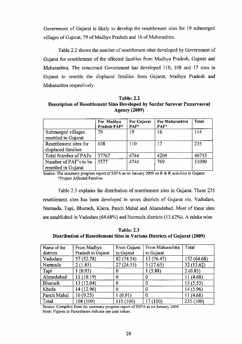
Government of Gujarat is likely to develop the resettlement sites for 19 submerged
villages of Gujarat, 79 of Madhya Pradesh and 16 of Maharashtra.
Table 2.2 shows the number of resettlement sites developed by Government of
Gujarat for resettlement of the affected families from Madhya Pradesh, Gujarat and
Maharashtra. Th~ concerned Government has developed 11 0, 1 08 and 17 sites in
Gujarat to resettle the displaced families from Gujarat, Madhya Pradesh and
Maharashtra respectively.
Table: 2.2 Description of Resettlement Sites Developed by Sardar Sarovar Punarvasvat
Agency (2009)
For Madhya For Gujarat For Maharashtra Total Pradesh P AF* PAF* PAF*
Submerged villages 79 19 16 114 resettled in Gujarat Resettlement sites for 108 110 17 235 displaced families Total Number ofPAFs 37767 4744 4204 46715 Number ofPAF's to be 5577 4744 769 11090 resettled in Gujarat
Source: The summary progress report of SSP A as on January 2009 on R & R activities in Gujarat *Project Affected Families
Table 2.3 explains the distribution of resettlement sites in Gujarat. These 235
resettlement sites has been developed in seven districts of Gujarat viz. Vadodara,
Narmada, Tapi, Bharuch, Khera, Panch Mahal and Ahamdebad. Most of these sites
are established in Vadodara (64.68%) and Narmada districts (13.62%). A taluka wise
Table: 2.3 Distribution of Resettlement Sites in Various Districts of Gujarat (2009)
Name of the From Madhya From Gujarat From Maharashtra districts Pradesh to Gujarat to Gujarat to Guiarat Vadodara 57 (52.78) 82 (74.54) 13 (76.47) Narmada 2 (1.85) 27 (24.55) 3 (17.65) Tapi 1 (0.93) 0 1 (5.88) Ahmedabad 11(10.19) 0 0 Bharuch 13 (12.04) 0 0 Kheda 14 (12.96) 0 0 Panch Mahal 10 (9.25) 1 (0.91) 0 Total 108 (100) 110 (100) 17 (100) Source: Compiled from the summary progress report of SSP A as on January 2009. Note: Figures in Parentheses indicate per cent values
28
Total
152 (64.68) 32 (13.62) 2 (0.85) 11 (4.68) 13 (5.53) 14 (5.96) 11 (4.68) 235 (100)

establishment of resettlement sites distribution reflects that the maximum number of
sites have been developed in Sankheda, Dab hoi and Waghodia ( 49, 31 and 28
respectively) ofVadodara district (Appendix 2.2).
The resettlement sites for the families of Madhya Pradesh settled in Gujarat
are maximum in Waghodia taluka (21 sites) followed by Dabhoi, Sankheda and Savli
talukas (11 sites each). Less than 5 sites have been developed in the rest of the talukas
in districts of Vadodara, Narmada, Panch Mahal, Ahmedabad, Kheda, Bharuch and
Tapi. Hence, the sample villages have been selected from those talukas that have high
concentration of project affected families (PAFs) from Madhya Pradesh. These
villages are Junarampura and Vyara-1 in Waghodia Taluka, Golagamdi in Sankheda
taluka and Vejpur-1 in Savli taluka in Vadodara district.
It is observed that all the PAFs belonging to Gujarat have been resettled in
Vadodara and Narmada districts except for one resettlement site in Jambughodha
taluka of Panch Mahal district. 32 such sites have been developed in Sankheda taluka
and 19 each in Dabhoi and Naswadi talukas of Vadodara district.15 sites have been
developed in Nandod taluka of Narmada district. Therefore, all the four sample sites
in this category i.e. PAFs from Gujarat have been taken from these two districts. The
selected sites are Pansoli from Dabhoi taluka, Parveta (Gather) from Sankheda taluka
of Vadodara district and Dhefa and Gora sites from the Nandod taluka of Narmada
district.
SSP A has developed 17 resettlement sites for Maharashtra affected families
who have opted to settle in Gujarat state. The highest number of sites have been
developed in Sankheda taluka (6 sites) followed by Waghodia taluka (4 sites) of
Vadodara district. 2 sites in Sagbara and one each in Dabhoi, Naswadi, Pavijetpur,
Dediapada, Vyara talukas have been established. Hence, two sites of PAFs from
Maharashtra have been selected. These are Parveta (Manibeli) from Sankheda taluka
and Vyara -2 from Waghodia taluka ofVadodara district.
Thus, a total of ten resettlement sites have been selected for the sample
survey. Out of these ten sites, four sites resettled by the affected families are from
Madhya Pradesh and Gujarat each and two sites settled by the affected families are
from Maharashtra.
29

2.1.2 Geographical Setting of Study Area:
The region is characterized with diverse physical features. The area spreads
from Ahmedabad in the north, to the Tapi River in the south and from Narmada in the
east to Bharuch in the west. Singh49 has classified this region as the Gujarat East
Region. This region can be divided into three second order divisions viz. Ahmadabad
Region, Khambhat (Cambay) Region or Baroda-Surat Region and the Eastern Hilly
Region. These second order regions are further subdivided into seven parts. These are
classified as Ahmadabad Region East, Ahmadabad Region West; Khambhat Region
North (Baroda Region) and Khambhat Region South (Surat Region); the Panch
Mahal; the Narmada- Tapi Tract; and the Dangs regions.
On the basis of topography, geological structure, climate and natural
vegetation and soil; Roy50 has classified the area under present study as the Gujarat
Plains and Eastern hills. These are further subdivided into micro regions under the
area where the resettlement process has taken place.
i) Viramgam Plain:
This region extends over a large part of Mandai, Detroj and Viramgam talukas
in the northern parts of Ahmedabad district. It is covered by alluvium soil.
ii) Sabarmati Basin:
The Sabarmati Basin lies in the north-eastern part of Ahmedabad district and
spreads over parts of Sanand, Bavla, Daskroi, Dholka and Ahmedabad city Talukas.
Alluviam soil is found in the region.
iii) Bhadar- Bhogava Lowland:
This lowland area occupies the central part of Ahmedabad district. It covers
parts ofViramgam, Bavla, Dholka and Dhandhuka talukas.
iv) Sabarmati- Vatrak Plain:
This plain region covers some parts of Matar, Mehmedabad and Kapadvanj
talukas of the western part of Kheda district. The depositional work of Sabarmati and
Vatrak Rivers has turned it into a gently undulating plain with a downward slope, yet
some depressions and sand hills can also be noticed in the plain that cause water
49 Singh R. L. (ed.); (2001): India: A Regional Geography; pp. 901-906. 50 Roy B. K. (1989); Regional Divisions of India- A Cartographic Analysis, Series- I, Voi.-V, Gujarat.
30

logging problem in Daskosi and Bhal. A stream of the Mahi River, too, flows through
the plain between Panch Mahal and Kheda districts.
v) Nadiad Plain:
This region extends over Nadiad, Thasra and the parts of Matar and
Kapadvanj talukas of the central part of Kheda district. This region is highly
developed and has a good industrial base. Some parts of it are also known as Goradu
or Mal land. Most of the area is characterized by gentle slope towards the south, but
the surface beside the Mahi River is undulating and is not of much agricultural use.
vi) Mahi Plain:
The Mahi Plain covers the western part of the Panch Mahals, the northwestern
part of Vadodara, and the eastern part of the Kheda Districts. It incorporates parts of
Lunawada, Santrampur, Godhra, Kalal, Shehera, Halol Talukas of Panch Mahal
district, parts of Padra, Vadodara, and Salvi talukas of Vadodara district and parts of
Balasinor and Thasra talukas of Kheda district. The region is an unbroken plain
sloping gently from the northeast towards the southwest. In the lower reaches deep
ravines have been formed by the Mahi River.
vii) Vadodara Plain:
This region is spread over the central part of the Vadodara district and extends
to Padra, Vadodara, Savli, Waghodia, Dabhoi, Karjan, Sinor and Sankheda talukas.
The region is blessed with a good agriculture base which gets reflected in its
development.
viii) Orsang-Heran Plain:
This region extends over parts of Dabhoi, Sankheda, Chhota Udaipur and
Jetpurpavi talukas of the mid-eastern part of Vadodara district, and the part of
Nandod, Naswadi and Tilakwada Talukas of Narmada districts.
ix) Khambhat Silting Plain:
This region covers the coastal areas of Amod, Vagra, Bharuch and Jambusar
Talukas in Bharuch district, the smallest part of Padra Taluka of Vadodara district and
southern part of Anand district.
31

x) Bharuch Plain:
The Bharuch Plain extends over the parts of Amod, Vagra, and Bharuch
talukas of Bharuch district. It is drained by the river Narmada. The general slope of
the region is westward. The region is agriculturally developed due to good irrigation
facilities.
xi) Valia Plain:
This region spreads over south - eastern part of the Bharuch district. It
occupies the parts of Valia Taluka. The river Kim and its tributaries flow through the
region. Hence, this region is agriculturally developed.
xii) Tapi Basin:
This region extends over the southeastern part of the Narmada district and
parts of the Tapi district. It spreads over Sagbara Taluka of Narmada district and
Vyara, Nizar, Uchchhal and Songadh talukas of Tapi district. The region is drained by
river Tapi and its tributaries. The region forms a part of the Deccan Trap and is also
agriculturally developed.
xiii) Mindhola-Purna Plain:
This region spreads over the northeastern part of Tapi district and covers
Vyara, Songadh and Valod Talukas.
xiv) Forested and Scrub Zone:
The whole of northern and eastern portion of the area are covered by hills and
forests intercepted by plains and cultivated land as well as by scrub zones cover parts
of Bakor, Kadana, Santrampur, Morva, Shehera, Godhra and Ghogamba Taluka of
Panchmahal district and north-eastern parts of Kheda district. This region also forms a
part of the Deccan Trap.
xv) Lower Narmada Valley:
This region lies to the south of the Vadodara plain and extends over Nandod,
Dediapara, and Tilakwada talukas of newly formed district of Narmada; Dabhoi,
Karjan, and Shinor ofVadodara and parts of Jhagadia, Bharuch, Ankleshwar, Hansot,
Valia Talukas of Bharuch. The slope of the region is south-west. It is covered with
forests. The presence of alluvium deposits by the river Narmada makes this region
agriculturaaly developed particularly in cotton production.
32

xvi) Satpura Hills:
These hills are situated to the south of the lower Narmada valley. They extend
over parts of Narmada and Bharuch districts in Nandod, Dediapada, and Sagbara
takulas of Narmada district and eastern part of Valia taluka of Bharuch district. This
region also consists of the Deccan Traps, but is mostly covered by forests.
xvii) Narmada Gorge:
A gorge on River Narmada extends over some parts of the Chhota Udepur,
Naswadi, Nandod and Dediapara talukas of Vadodara and Narmada districts. The
river Narmada divides this region into northern and southern parts. Due to the hilly
terrain, the means of transportation are less developed. It is mainly covered with
forests.
On the basis of above description, it can be said that the resettlement sites of
the study area cover diverse geographic regions. An analysis of geographical
dispersion of the resettlement sites (Fig 2.1) shows that the largest concentration of
resettlement sites are found in Vadodara Plain (76 resettlement sites) followed by
Orsang-Heran Plain (66 resettlement sites), Lower Narmada Valley (20 resettlement
Table: 2.4 Distribution of Resettlement Sites in Various Districts of Gu.iarat {2009)
Physiographical division From Madhya From From Total Pradesh to Gujarat to Maharashtra Gujarat Gu.iarat to Gujarat
1 Bhadar-Bhogava Lowland 3 3 2 Bharuch Plain 1 1 3 Forest and Scrub Zone 1 1 2 4 Khambhat Silting Plain 10 10 5 Lower Narmada Valley 3 17 20 6 Mahi Plain 17 17 7 Mindhola-Puma Plain 1 1 2 8 Nadiad Plain 9 9 9 Narmada Gorge 2 0 2 10 Orsang-Heran Plain 8 50 8 66 11 Sabarmati Basin 1 1 12 Sabarmati-Vatrak Plain 5 5 13 Satpura Hills 7 1 8 14 Tapi Basin 2 2 15 V adodara Plain 41 33 5 79 16 Valia Plain 1 1 17 Viramgam Plain 7 7
Total 108 110 17 235 Source: Compiled accordmg to B.K.Roy classification from the summary progress report of SSP A.
33

E T
1 t<h k
1 t<h k" 1
1 j K kt
arne!
Dorm
b K.,vu l
7 Naroshw
8 Bambo.
' ' ,, tftl
.4,{) K ik ll
1 Ak L1lu
14 ,ola -u ldt
111) Mol hntu :t
16 Vedpur
SARDAR SAROVAR PROJECT. RESETTLEMENT SITES
IN GUJARAT
L I
l' Kar-t w 71 ~.Hth
l• Kavrtha 7._ Gunetl 1
Br- I 11 7) .JI'anpu
C n 11 h 1
,f) KL 1 T 1r ,, hacia!X 76 1.. ht .. h
K .ur 1.'1 K C".lndt 1
l k IP\ r n 1
L B<J n Ia 11
6( 80 Shanadr
RESETILED FROM MAHARASHTRA TO GUJARAT
1 Khervadt 1
2 Khervadr 2
3. Jambuwada
4 Ra1bodoh
5 Kesarpura
6 Lunadra
7 Kahdoli (Stnhadra)
8 Parveta
R.F. 1 : 5,50,000 1 CM = 5.5 Kms.
FIG 2.1
N
t

sites) and Mahi Plain (17 resettlement sites). The resettlement sites for sample survey
have been selected from each of these groups in proportion to the number of sites. The
region wise distribution of sites are given in table 2.4.
2.1.3 Histogenesis of the Sample Villages:
Ten villages have been selected for survey. Out of these, four villages have
been selected from the Vadodara plain. Three villages have been selected from the
Orsang-Heran Plain. One village has been selected from the Mahi Plain, one from the
Lower Narmada Valley and one from the Narmada Gorge. The geographical and
social setting of the sample villages have been discussed below.
Junarampura:
The village 1s situated on Sayaji Sarovar (lake) in Waghodia taluka in
Vadodara district. This village is 9 km from the taluka head quarters and 20 km from
the district head quarters. It is situated at 22°08'39" north latitude and 73°34'11" east
longitude. This village is spread over 308.56 ha. About 8 local families of Patels, 20
of Vasavas, 28 of Baria Parmars, and 50 of Bhils are living in the village. Out of
these, 17 families (3 Nayakas, 5 Baria Parmars, 2 Patels, 3 Vasavas and 4 Bhils) have
been surveyed.
The government documents claim that the agricultural land has been allotted
to 52 families51 during 1993-94. However, only sixteen resettled families were found
present at the time of survey in this resettlement site. These families belong to Bhilala
Tribe and have shifted from Bhavti submerged village of Madhya Pradesh. SSP A has
provided internal roads, street electrification, primary school, dispensary, tree
platforms, handpumps and childrens' park. Ration cards have been distributed to 42
resettled families. However, the facilities such as four mills, post office and panchayat
ghar are available in the host village. These people have to go 2.5 kilometers to Gutal
village for veterinary centre and fair price shop.
Vyara-1 (Ramesarpura):
The village is situated on 22°15'39" north latitude and 73°26'40" east
longitude. It is in Vadodara Plain region which is 9 km from Waghodia on the
51 Sardar Sarovar Punarvasvat Agency: Junarampura Village Profile, Madhya Pradesh.
34

Kherwadi road. The government has given agricultural land to 93 families in this
resettlement site during 1991-92 but only 32 resettled families ( 4 Barias, 2 Bhilalas,
and 26 Nayaks) have been found at the time of survey. These families have migrated
from Kakrana and Jhandana villages of Alirajpur district in Madhya Pradesh. The
government has developed the internal road, street electricity, primary school,
childrens' park, dispensary, cattle trough, tree platforms, two handpumps, a tubewell
and a well in this resettlement site. But to use the facilities such as flour mill, bus stop
and post office, these people have to go half kilometer to Rameshwarpura.
The data for local families have been taken from Rameshwarpura village
because of the proximity and interaction with the resettled people. A total of 68 local
households (13 were belonged to Patels, 28 Patanwadias, 20 Vasavas, 4 Nayaks, 1
Harijans, 1 Bhatias or Barbers and 1 Chamars) are residing in the village. Out of
these, 34 families (1 Baria, 1 Rohit Chamars, 1 Harijans, 1 Nayak, 14 Patanwadias, 5
Patels and 11 Vasavas) have been surveyed. In the present study Vyara-1 has also
been cited as Rameshwarpura.
Vyara-2 (Talayapura):
This resettlement site has been established during 1993-94 near Talayapura. It
is located on 22°16'11" north latitude and 73°27'35" east longitude. The Government
has allotted agricultural land to 25 families but only 14 resettled families who shifted
from Chimalkhedi, Dhankhedi and Paula villages of Maharashtra and Bhitada village
of Madhya Pradesh were available during the survey. The caste composition is Pawra,
Bhil, Tadvi and Vasava. This site falls under Vyara Panchayat group. A primary
school, street electricity, internal roads, a dispensary, two cattle troughs, a tree
platform, three handpumps and childrens' park has been developed by SSPA. The
people have to go to Kherwadi village (1.5 kms) for fair price shop and to Vyara host
village (1 km) for utilizing flour mills and panchayat ghar.
The data for the local families have been collected from Talayapura village
due its proximity and interactions with the resettled population. Among the local
families, 15-20 families belong to Vasava and 3-4 families of Baria Parmar. Out of
these, 5 families of Vasava and 1 0 Baria Parmar castes have been surveyed. In the
present study Vyara-2 has also been cited as Talayapura.
35

Golagamdi:
Golagamdi village is located in Orsang-Heran Pain in Sankheda Taluka of
Vadodara district on the route from Dabhoi to Badeli. It is situated on 23°12'22" north
latitude and 73°32'20" east longitude. The area of the village is 824.39 ha. About six
hundred fifty families are residing in the host village, which is dominated by Tadvi
tribal families. Out of these, 27 families (2 Harijans, 3 Patels, 18 Tadvis and 4
Vasa vas) have been surveyed.
In the resettled colonies, 22 families were found present and were surveyed.
However, the Government of Gujarat claimed that 65 families have been resettled in
this site till 1991-92. They were displaced mainly from Jalsindhi, Akdiya, Anjanbara,
and Sakarja villages of Alirajpur district in Madhya Pradesh and belong to Bhilala
tribe, but they recognize themselves as 'Rathwas' in this area. As per award, the
internal roads, street electrification, primary school, dispensary, tree platforms,
hand pumps, borewell, and childrens' park has been provided at the resettlement site.
But the provisions have not been made for fair price shop, flour mill, panchayat ghar,
bus stop and post office by SSPA52.
Gora:
This village is situated in the Narmada River Gorge area. It is the nearest
village to the Sardar Sarovar Project dam where people have been resettled. It is
situated on 21 °51'08" north latitudes and 73°40'51" east longitude. The area of the
village is 871.84 ha.
About two hundred local households are dominated by Tadvi tribes. Out of the
total local households, 7 households belong to Vasava caste and their main occupation
is cattle grazing and hence they are known as Govals. 3 families belong to Shalat
caste. The main occupation of shalats is to make items from stone such as stone-quem
(making Gharganti etc). Two families belong to Rohit chamar caste. Out of the total
local households, 11 households (1 Shalat, 2 Vasavas and 8 Tadvis) from have been
surveyed.
52 Sardar Sarovar Punarvasvat Agency: Golagamdi Village Profile, Madhya Pradesh.
36

Only five resettled households have been found available at the time of survey
in the Gora resettlement site. Hence, these households belonging to Tadvi tribe have
been included under study, which came here in 1985-86. A tree platform, primary
school, childrens' park and wells have been provided at this resettlement site.
However, a dispensary has not been established in Gora.
Pansoli:
The latitudinal and longitudinal extent of Pansoli village is 22°10'35" north
and 73°27'12" east respectively. It spreads over 769.08 ha area. This village is eight
kilometers from Dabhoi and connected with it by metalled road. About 135 families
of the local people are living in the village. The caste composition of the village
incorporates 50 families of Rathoris and Vasava castes each, 2 Pathan Muslims, 12
Parmars, 2 Patels, 1 Harijan, 1 Patanwadia, 8 Rajputs, 8 Wankars and 1 Rohit caste.
Out of the total, 74 families among the local families have been surveyed that include,
28 Rathorias, 25 Vasavas, 8 Wankars, 5 Rajputs, 4 Parmars, 2 Muslim Pathans and
one each from Patel, Patanwadia and Rohit castes.
The resettlement site at Pansoli has been developed in 1989-90. SSPA has
allotted residences to Ill resettled families53. However, only 73 resettled families
were found available and surveyed belonging to Bhil, Nayak, Rathwa, Tadvi and
Vasava castes. The families have been displaced from Ferkada, Hanf, Mokhdi and
Turkheda villages of Gujarat. The government has developed the infrastructural
facilities such as internal roads, street electricity, primary school with mid day meal
scheme, angawadi centre (Asha worker), tree platforms, handpumps and borewells.
Ration cards have been issued to 97 resettled families.
Parveta (Gather):
The Parveta village is situated on 22°06'07" north latitude and 73°42'45" east
longitude. The village is located on the Heran River in Sankheda Taluka ofVadodara
district. The area ofthe village is 1507.58 ha. The Parveta host village consists of five
falias (small hamlet) viz. Verai falia, Gadiyo falia, Tanki falia, Lingdo falia and Rohit
falia. 136 families live in the host villages of which 50 are Rajputs, 30 Tadvis, 30
Bhils, one Harijan and 25 Rohit Chamars.
53 Sardar Sarovar Punarvasvat Agency: Pansoli Village Profile, Gujarat.
37

The resettled families came at this site in 1986-87. 30 families were available
have been included in the survey. All of them belong to Tadvi caste and some ofthem
became the followers of the Ramanandi sect (Pala Mandir). These families have been
displaced from Gather (submerged village) in Gujarat. This site has a primary school,
childrens' park, hanuman temple, internal roads, taps, tubewell, tailoring and
embroidery centre. However, hawada (government latrine) and dispensary were not
found in the resettlement site. Some people reported that during rainy season, water
logging becomes a problem for the villagers.
Kaledia/ Parveta (Manibeli):
The Parveta (Manibeli) village is situated at 22°05'12" north latitude and
73°43'21" east longitude. This village is located in Sankheda Taluka of Vadodara
district. The maximum of the displaced families, here, have shifted during 1985-86.
The Government records claim that the agricultural land has been allotted to 218
resettled families54 but 104 families were found available at the time of survey. All
the families belong to Tadvi caste except one general and two Vasava castes. They
have shifted from Manibeli, Bamani, and Dhankhedi villages of Maharashtra and
Vadgam village of Gujarat. SSPA has provided water facilities (handpumps,
borewell), street electricity, internal roads, primary and secondary schools,
dispensary, tree platforms and childrens' park. People here have to travel for 0.5
kilometers to Kaledia village for fair price shop, panchayat ghar and post office.
This site is adjacent to Kaledia village, and hence there is more interaction
with Kaledia. Hence, the local families Kaledia have been taken for survey. The
village Kaledia is located in Nasvadi Taluka of Vadodara district. About 250
households are living in this village mainly dominated by Tadvi, Baria and Bhil
communities. 50 families of Tadvi, Baria and Bhil each, 6 families of Shahs (a
business community), 8 Panchals I Lohars (ironsmith), 3 Nayaks, 5 Harigans, 8
Muslims, one Patel, and 4 Vasavas are living in the host village. Some people
narrated that it was a flourishing village 50 years ago. The train tract from Sankheda
to Tanakhala passes through the village. This village was known for Zin (Cotton)
factories controlled by the Shah Community. The raw cotton after zinnig was
exported to other countries from this village. But now train service has been stopped
54 Sardar Sarovar Punarvasvat Agency: Parveta (Manibeli) Village Profile, Maharashtra.
38

and due to other factors, the progress of the village has stagnated. The business
families have migrated to other places. In the present study Parveta (Manibeli) has
also been cited as Kaledia.
Dhefa:
This village is located on the Men River in Lower Narmada valley. It is
situated on 21°59'43" north latitude and 73°42'10" east latitude. The area of the
village is 136.77 ha. The history of this village is not very old and about 30 years ago
the host people came here from the nearby villages as tenants, sharecroppers and
agricultural labourers on the land which belonged to Mahant of Chandod Temple.
This village is 10 Km interior from the main road and one has to go on foot to the
village. All the 19 local households (18 Bhil Chauhans and 1 Rohit Chamar) have
been surveyed.
The resettled families came here during 1988-8955 from Vadgam village of
Nandod Taluka of Gujarat. The government documents claim that the agricultural
land has been allotted to 24 families. However, only 13 families found present at the
time of survey. As per NWDT award, the facilities such as street electrification,
primary school having three rooms, two tree platforms, two handpumps and a
childrens' park have been provided for these people. However, dispensary, veterinary
centre, panchayat ghar, seed store, linkage with the main road and post office has not
been provided to these people. Facilities like fair price shop, flour mill were available
in the host village. However, ration cards have not been issued to the displaced
families.
Vejpur-1 (Valavav)
Vejpur resettlement site has been established at 22°43'38" north latitude and
73°20'11" east longitude. This village is located to the North of Savli Taluka of
Vadodara district. This village is located in the Mahi Plain and the water of the Panam
River is used by the people in this area. The resettled families have shifted to Vejpur-
1 in 2004-2005. The government has allotted agricultural land to 116 families56 but
only 29 resettled families have been found at the time of survey that belong to Bhilala,
55 Sardar Sarovar Punarvasvat Agency: Dhefa Village Profile, Gujarat. 56 Sardar Sarovar Punarvasvat Agency: Vejpur-1 Village Profile, Madhya Pradesh
39

Baria, and Nayak castes. The families from Dharamrai and Sondul of Madhya
Pradesh have settled here. The land of Vejpur, Valavav and Lachhras villages has
been taken to establish the Vejpur -1 resettlement site. Street electricity, primary
school, dispensary, tree platforms, handpumps and childrens' park have been
developed by the SSP A. For Panchayat Ghar, flour mill, post office and temple,
people have to travel two kilometers to Valavav village.
The Valavav has been selected for study among the local families because it is
the nearest village to the resettlement site and the interaction of resettled people is
highest with this village. Therefore, Valavav village has been selected for local
families and 24 families (1 Rabari, 2 Harijans, 6 Rajput Parmars, 2 Solankis, 5
Rathorias, 1 Patel and 7 Vasa vas) have been surveyed. In the present study Vejpur-1
has also been cited as Valavav.
2.1.4 Socio-Demographic Profile of the Surveyed Villages:
The social and demographic structure of the sample villages is different due to
geographic spread of the study area in seven districts (Fig 2.2) from Viramgam plains
in Ahmedabad district to Satpura hills in the Tapi district.
2.1.4.1 Literacy Rate:
Literacy rate is one of the most important variables that indicate the status of
an individual and also that of family members in any society as well as the attitude of
society towards them. The literacy level of individual or family and society generally
reflects the quality of life of the people. In traditional societies, education has been the
privilege of the higher castes only; the lower castes were deprived of it because of
social customs, lack of awareness and financial scarcity. The general notion is that
stability, awareness and economic prosperity are positively correlated with the
education level.
Table: 2.5 Percentage of Literacy Level (2009)
Literacy Level Resettled population Local Population Illiterate 974 (45.88) 559 (34.68) up to Primary 556 (26.19) 408 (25.31) Up to Secondary 516 (24.31) 529 (32.82) Above Secondary 77 (3.63) 116 (7.20) Total 2123 (100.00) 1612 (100.00)
Source: compiled from survey data collected during March-June 2009.
40

"f !'DAR SAROVAR PROJEC SAMPLE SITES
IN GUJAR 1\,..
DAD
RAILWAY LINE
ISTRIL;T BOUNDARY
lSE..T LlD F-ROM ,UJARAT TO GUJARA r
RE:SE rTLED F-ROM MADHYA PR'\DESI- TO GUvARAT
RESETTLED FROM MAHARASHTRA TO GUJARAT
R.F. 1 : 5,50,000 1 CM = 5.5 Kms.
FIG 2.2
N
t
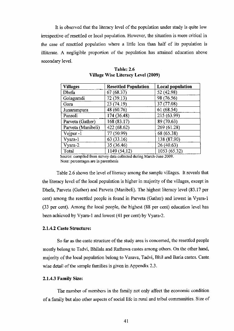
It is observed that the literacy level of the population under study is quite low
irrespective of resettled or local population. However, the situation is more critical in
the case of resettled population where a little less than half of its population is
illiterate. A negligible proportion of the population has attained education above
secondary level.
Table: 2.6 Village Wise Literacy Level (2009)
Villages Resettled Population Local population Dhefa 67 (68.37) 52 (42.98) Golagamdi 72 (39.13) 98 (76.56) Gora 23 (74.19) 37 (77.08) Junarampura 48 (60.76) 61 (68.54) Pansoli 174 (36.48) 215 (63.99) Parveta (Gather) 168 (83.17) 89 (70.63) Parveta (Manibeli) 422 (68.62) 269 (61.28) Vejpur -1 77 (50.99) 68 (65.38) Vyara-1 63 (33.16) 138 (87.90) Vyara-2 35 (36.46) 26 (40.63) Total 1149 (54.12) 1053 (65.32)
Source: comptled from survey data collected during March-June 2009. Note: percentages are in parenthesis
Table 2.6 shows the level of literacy among the sample villages. It reveals that
the literacy level of the local population is higher in majority of the villages, except in
Dhefa, Parveta (Gather) and Parveta (Manibeli). The highest literacy level (83.17 per
cent) among the resettled people is found in Parveta (Gather) and lowest in Vyara-1
(33 per cent). Among the local people, the highest (88 per cent) education level has
been achieved by Vyara-1 and lowest (41 per cent) by Vyara-2.
2.1.4.2 Caste Structure:
So far as the caste structure of the study area is concerned, the resettled people
mostly belong to Tadvi, Bhilala and Rathawa castes among others. On the other hand,
majority of the local population belong to Vasava, Tadvi, Bhil and Baria castes. Caste.
wise detail of the sample families is given in Appendix 2.3.
2.1.4.3 Family Size:
The number of members in the family not only affect the economic condition
of a family but also other aspects of social life in rural and tribal communities. Size of
41

family becomes more important in cultivation and animal husbandry because of
involvement in various activities. The more is the number of family members, the
easier it is to perform agricultural operations, animal rearing, hunting and gathering.
The family size acts as a catalyst in the process of resettlement of low-income
category and tribal people.
Table: 2.7 Family Size of the Surveyed Population (2009)
Name of the Villa2es Resettled Population Local Population Dhefa 8.77 7.68 Golagamdi 10.77 5.33 Gora 6.6 4.91 Junarampura 6.06 5.65 Pansoli 7.99 5.05 Parveta (Gather) 7.83 5.19 Parveta (Manibeli) 6.57 4.95 Vejpur -1 6.14 4.75 Vyara-1 7.66 4.94 Vyara-2 8.79 5.07 Overall average 7.48 5.19 Source: compiled from survey data collected dunng March-June 2009.
Table 2.7 has explained the size of family in the sample villages. The data
shows that the average family size of the resettled households was 7.48 whereas the
corresponding figure for the local households was 5.19. Furthermore, the average
family size of the resettled households was highest (10.77) in Golagamdi village and
the lowest ( 6.14) in Vejpur-1 whereas among the local families, the highest size was
found in Dhefa (7.68) and the lowest in Vejpur-1 (4.75).
2.1.4.4 Age and Sex Composition:
Age and sex composition is one of the most important determinants of social
status, social responsibility, social position and economic role of an individual. It is an
important factor in case of resettlers because the middle age group people can adjust
themselves easily and quickly in new social milieu rather than younger and old age
people.
Table 2.8 highlights the age-sex composition of both the population
categories. It is observed that the resettled population is dominated by 0-14 age group.
42

On the contrary, the highest concentration of local population was found in the age
groups of 15-34, 35-59, 60 and above.
Table: 2.8 Age and Sex Structure of Surveyed Population (2009)
Resettled Population Local Population Male Female Total Male Female Total
1 0-14 436 (34.36) 469 (37.25) 905 (35.80) 244 (25.74) 185 (21.92) 429 (23.94)
2 15-34 445 (35.07) 452 (35.90) 897 (35.48) 318(33.54) 302 (35.78) 620 (34.60)
3 35-59 294 (23.17) 258 (20.49) 552 (21.84) 293 (30.91) 267 (31.64) 560 (31.25)
4 60+ 94 (7.41) 80 (6.35) 174 (6.88) 93 (9.81) 90 (10.66) 183 (10.21)
Total 1269 (100) 1259 (100) 2528 (100) 948 (100) 844 (100) 1792 (100)
Source: comptled from survey data collected dunng March-June 2009.
2.2 Data Base:
The present research work is an empirical study to analyze the socio-economic
impact of resettlement on the resettled and host population. It is essential to have
relevant data in order to fulfill the objectives and to test the hypotheses of the present
spatial analysis. Data has been generated through a primary survey of 10 resettlement
villages. They cover social, economic, cultural and demographic aspects of the people
through a structured questionnaire. Preparation of questionnaires was supported by in
depth literature survey and consultation with senior faculty and researchers in this
area. Before administering the questionnaires a pilot survey was conducted and minor
survey problems were resolved. From the collected data following variables were
derived.
To examme the factors contributing to the selection of the villages as
destination by the displaced persons, the variables such as resettlement at relative's
village, resettlement at resourceful village, Government rehabilitation centre,
employment opportunities and similarity of culture and tradition have been
considered.
The variables such as the use of compensation money to purchase new land, to
purchase house and household items have been examined to judge whether the sample
households have used the compensation money to purchase productive assets or not.
The variables such as occupation before and after the resettlement, resource
base in pre-and post-resettlement phases and spatial interaction opportunities and
43

amenities in pre and post resettlement phases have been examined to identify the
changes in occupation of the target group.
To examine the socio-economic conditions the variables such as employment
status, size of land holding and agricultural productivity, number of animals per
family, conditions of living environment, education level, religious and cultural
practices and so on have been considered.
To examine the areas of socio-economic co-operation between the resettled
and the hosts, the variables such as exchange of labour, economic cooperation (in
terms of providing cash or kind) have been taken into account. To find out the
incidence of conflicts the variables as conflicts over residential plots, conflicts over
agricultural land, conflicts over grazing land and resources have been observed.
To study the health care status, the variables such as the frequency of illness,
source of medical treatment, expenditure on food, problems faced by women and
social problems have been used.
Table: 2.9 Village wise Description of Sample Households (2009)
Resettled Population Local Population Sample Total Sample Total Households Households* Households Households**
1 Dhefa 13 27 19 19 2 Golagamdi 22 55 27 161 3 Gora 5 15 11 225 4 Junarampura 16 53 17 195 5 Pansoli 73 104 74 294 6 Parveta (Gather) 30 32 26 665 7 Parveta 245 250
(Manibeli) 104 98 8 Vejpur- 1 29 116 24 156 9 Vyara-1 32 93 34 68 10 Vyara- 2 14 25 15 32
338 765 345 2065 Source: compiled from survey data collected durmg March-June 2009. *as per SSPA records **as per 2001 census
Thus, the study is based on the primary data obtained through field survey in
the study area. There were 2830 households in the selected villages, out of which 765
households belonged to resettled population and the remaining 2065 households
belonged to the local population. As the researcher is more concerned with the
44

resettled population, 44.18 per cent sample has been taken from this community
whereas 16.17 per cent sample has been selected from local population. The selected
households have been interviewed through well structured questionnaires for
resettlers (Appendix 2.4) and for local population separately (Appendix 2.5).
2.3 Methodologies:
The methodologies of the present study incorporate two stages. At the first
stage, the sample villages have been selected for survey. To find out the number and
location of the resettlement sites; SSP A records have been taken into consideration.
There are 235 resettlement sites spreading over seventeen physiographic divisions in
seven districts of Gujarat. It was decided to have a manageable sample. Hence, ten
sites have been selected for detailed survey work using stratified random sampling
technique according to physiographic divisions. Table 2.10 shows the geographical
description of these villages.
Table: 2.10 Geographical Distribution of Sample villages (2009)
Physical From Madhya From From Total Divisions Pradesh to Gujarat to Maharashtra
Gujarat Gu.iarat to Gu_jarat 1 Vadodara Plain Vyara 1 Pansoli Vyara2 4
(Rameshwarpura) (Talayapura) Junarampura
2 Orsang-Heran. Golagamdi Parveta Parveta 3 Plain (Gather) (Manibeli)
3 Mahi Plain Vejpur-1 1 4 Narmada Gorge Gora 1 5 Lower Narmada Dhefa 1
Valley Total 4 4 2 10
Source: compiled accordmg to B. K Roy classificatiOn.
On the basis of the physical setting of resettlement sites in Gujarat, four sites
.have been selected from the Vadodara Plain, three from the Orsang-Heran Plain and
one each from the Mahi Plain, the Narmada Gorge and the Lower Narmada Valley.
Out of the total selected sites, four sites each have been selected that are resettled by
the families from Madhya Pradesh and Gujarat and two sites have been selected
where the families from Maharashtra have been resettled.
45

Spot inquiry has been conducted in the sample villages that revealed a good
number of resettled families who were not permanently residing at these resettlement
sites. Hence, only 338 households were found available at the time of survey and data
has been collected from these resettled households for the present study (Plate 2.1 ).
To select the households for survey among local population, purposive sampling has
been carried out by taking into consideration variables such as caste, land considered
for resettlement and so on. To find out the change in occupational structure and socio
economic status among the affected communities, data for two time periods i.e. at the
time of migration and at the time of survey, have been collected.
To find out the factors affecting the choices in the selection process of
resettlement sites, various economic, socio-cultural and geographical factors have
been included. The economic variables are availability of fuel and fodder; gocher;
infrastructural facilities; and loan facilities. The socio-cultural factors include
variables such as the choice made by falia (hamlet) people; relatives and friends;
caste; family members; similar caste or tribe in recipient area; education and health
facilities. The geographical factors are good quality of agricultural land; nearness to
urban area; area nearness of agricultural fields to home.
To find out the pattern of utilization of compensation money, variables such as
income generating investment, essential expenditure and non-income generating
consumption have been studied. Income generating variables are Land Purchase;
Agricultural Equipments and Implements; Small Business and Household Industries;
and Bank savings. The variables for essential expenditure are House Construction;
Household items (food, clothing); Education; Health and Medicine and the variables
for non-income generating consumption are Social functions (marriage); Luxury
items (Motorcycle, mobile) and Jewellery; Liquor; Old Debts; and Court Cases.
To find out the socio-economic status among the resettled and local families,
variables such as ownership of agricultural land; size of land holding; sources of
irrigation; agricultural implements; cattle rearing; education; caste structure; family
size; housing conditions; civic amenities and sanitation facilities; social relations;
socio-cultural cerebrations; religious practices; dance and musical instruments have
been taken into consideration. To find out the health care status, the expenditure on
food and prevalence of diseases has been considered.
46

At second stage, the raw data have been classified and tabulated into
homogeneous groups for analysis. After tabulation, the data has been standardized by
the use of percentages at various levels to achieve the objectives. Hence, frequency
analysis has been adopted in the analytical section. Suitable statistical and
cartographic techniques have been used.
There are five maps in the present study. These maps are the most essential
part of the present research. The first map shows the distribution of resettlement sites
according to the physiographic divisions in the study area. The second map indicates
the location of sample resettlement sites. The third is the location map of Narmada
River and its basin in India. The fourth map deals with the location of major projects
developed or proposed on Narmada River and its tributaries. The fifth map shows the
site of Sardar Sarovar Project in Gujarat and its command area.
Apart from quantitative methods, qualitative methods have also been used like
documentation of information and its analysis from key informants like NGO's;
People's Organization; semi government centres like Centre of Social Studies, Surat;
Tata Institute of Social Sciences, Bombay; Patels (head of the tribal community in a
settlement) on social issues and from government officials from Sardar Sarovar
Punarvasvat Agency. Observation method while administering the questionnaires and
staying in the area for four months from March to June 2009 has also been used to
gather information about the social, cultural, and behavioural aspects of resettled and
local communities.
2.4 Scheme of Study:
The present study is divided into nine chapters. The first chapter deals with the
research problem, review of literature, conceptual framework, objectives and
hypotheses of the study. The second chapter contains study area, geographical
distribution of resettlement sites in Gujarat, histogenesis of sample villages, data base
and methodologies.
The third chapter contains with the historical evolution of the Sardar Sarovar
Project. The provisions made under the Narmada Water Dispute Tribunal Award has
been explained in this chapter. The various authorities and committees, their structure
and functions regarding SSP have also been elaborated. The events of political
47
agitation over the most controversial issue of resettlement and rehabilitation of
displaced people and the role ofNGOs have been studied.
The fourth chapter has been devoted to trace the factors affecting the choices
of the resettled people in selection of the resettlement sites. The choices given to these
affected families, distance of displacement and spread of families at different sites,
time provided by government for shifting to the new sites have been explained.
The fifth chapter focuses on the utilization pattern of the compensation money
among the resettled families and local population. The utilization of compensation
money has been broadly classified into three categories viz income generating
investment, essential expenditure and non-income generating consumption. The
compensation in kind given to the resettled communities have also been studied.
An analysis of the pattern of occupational structure of the resettled families
and local population has been undertaken in the sixth chapter. The main and
subsidiary occupations have been taken into consideration to find out the trends and
directions of occupational shifts after resettlement in both the communities.
The seventh chapter is divided into two sections. The first section deals with
the socio-economic status of the resettled and local communities. The economic
conditions such as land availability, sources of irrigation, animal husbandry, income
from various sources and expenditure has been included. On the other hand, the socio
cultural variables like education, caste structure, family size, housing conditions, civic
amenities, sanitation facilities, social relations, socio-cultural and religious practices
have been examined. In the second section, the cooperation and conflicts among the
resettled and local population have been analysed.
The eighth chapter deals with the health care status among the resettled and
local communities. The data on expenditure on food and occurrence of diseases in last
one year has been calculated. In the last or ninth chapter, summary of findings and
conclusions have been given.
48