Chapter Getting to Know the Golden State - Wiley · Getting to Know the Golden State C ......
34
1 Chapter 1 Getting to Know the Golden State C alifornia has always been a land of legendary extremes. Stories of its incred- ible natural beauty, its enormous wealth and diversity of natural resources and landscapes, and its violent and destructive natural disasters make world news headlines each year. These stories have been repeated since the first Spanish explorers and then settlers arrived here centuries ago. And, California’s people, both real and imagined, have always successfully competed with nature for the spotlight. Even its name originated from a mythical location. Exploiting imaginations after the European “dis- covery” of America, the Spanish writer Garcí Or- dóñez de Montalvo first named a place called Califor- nia in his Las Sergas de Esplandián (The Exploits of Esplandián). Even in this first use of California in 1510, he fabricated an island paradise near the Indies where beautiful black Amazons were surrounded with riches such as gold and pearls. The name California first appeared on Spanish maps labeling the Gulf of California and the Baja Peninsula in the 1560s. After the Spanish “discov- ered” California in 1542 and began moving and set- tling north in 1769, what is today known as California was often given the name Nueva (New) or Alta (Upper) California. As the first Spanish explorers and settlers sent their actual impressions back to their homeland, they described a landscape hauntingly similar to today’s. They painted pictures of wildly different landscapes that ranged between a comfortable paradise and a harsh land where agonizingly hard work and plenty of luck were required for survival. Similar expressions were recorded throughout the Spanish and Mexican Eras; such reports continued even after California be- came the thirty-first state in the United States in 1850. More recent writings continue to conflict as they por- tray a land of remarkable contrasts and contradictions. Today, California’s unsettled population is al- ways evolving, always moving on, creating repeated F rom Dreams to Reality: An Experiment Called California
Transcript of Chapter Getting to Know the Golden State - Wiley · Getting to Know the Golden State C ......

1
Chapter 1Getting to Know the Golden State
California has always been a land of legendary extremes. Stories of its incred-ible natural beauty, its enormous wealth and diversity of natural resourcesand landscapes, and its violent and destructive natural disasters make world
news headlines each year. These stories have been repeated since the first Spanishexplorers and then settlers arrived here centuries ago. And, California’s people,both real and imagined, have always successfully competed with nature for the
spotlight. Even its name originated from a mythicallocation.
Exploiting imaginations after the European “dis-covery” of America, the Spanish writer Garcí Or-dóñez de Montalvo first named a place called Califor-nia in his Las Sergas de Esplandián (The Exploits ofEsplandián). Even in this first use of California in1510, he fabricated an island paradise near the Indieswhere beautiful black Amazons were surroundedwith riches such as gold and pearls.
The name California first appeared on Spanishmaps labeling the Gulf of California and the BajaPeninsula in the 1560s. After the Spanish “discov-ered” California in 1542 and began moving and set-tling north in 1769, what is today known as Californiawas often given the name Nueva (New) or Alta(Upper) California.
As the first Spanish explorers and settlers senttheir actual impressions back to their homeland, theydescribed a landscape hauntingly similar to today’s.They painted pictures of wildly different landscapesthat ranged between a comfortable paradise and aharsh land where agonizingly hard work and plenty ofluck were required for survival. Similar expressionswere recorded throughout the Spanish and MexicanEras; such reports continued even after California be-came the thirty-first state in the United States in 1850.More recent writings continue to conflict as they por-tray a land of remarkable contrasts and contradictions.
Today, California’s unsettled population is al-ways evolving, always moving on, creating repeated
From Dreams to Reality:An Experiment Called California

social upheavals that leave its past in the dust like a for-gotten stranger. It is as if California’s people are trying toemulate the turbulent forces that shape its natural land-scapes as the world looks on. The result is the most di-verse population and economy on our planet. Californiais and will continue to be a celebrated culture hearth inthe twenty-first century. Critics beyond its borders havetried to minimize the importance of this nucleus for ourcivilization, and although some Californians fear the re-sponsibilities that accompany such esteem, California hastaken center stage. As the reality of the state’s stature,with all its positive and negative features, sets in, every
Californian will play a role in molding this great experi-ment, this model we call California.
Perhaps it was best expressed in a portion of the Uni-versity of California Berkeley’s 2004 course description fortheir course on California posted on their Web site: “Cali-fornia recently surpassed France to become the fifth largesteconomy in the world. California may be ‘a state of mind’—as bumper stickers say—but it is also the most powerfulplace in the most powerful country in the world. Its wealthand diversity in both human and natural resources has con-tributed to its extraordinary resilience, making it a center oftechnological and cultural innovation.”�
2
KEY ISSUES AND CONCEPTS
� This book is a systematic, topical survey ofthe modern geography of California. It is de-signed to provide useful information that canhelp us understand the state, examine mod-ern issues, and solve problems.
� California’s diverse natural and humanlandscapes represent ideal laboratories; theyprovide a wealth of opportunities to make sci-entific/geographic discoveries and to re-search a variety of processes, cycles, and sys-tems that are shaping landscapes on manyscales.
� The five fundamental geographic themesand six essential elements of geography arecommon threads that tie together topics cov-ered in this and other chapters of this book.
� Diversity, connections, and change are evi-dent in all California landscapes and in theprocesses responsible for shaping them; con-sequently, they are common themes used inthis chapter and this book.
� Critical to our understanding of Califor-nia is recognition of some important geo-graphic factors. They include its large areaand elongated shape, its situation in relationto the rest of the world, and the human/environment interaction that has shaped itslandscapes.
� Early California remained relatively iso-lated even after the Spanish, Russians, andother invaders discovered and began settlingit. Strong ties to Latin America developed,continued during the Mexican Era, and havebeen recently renewed. Since the mid-1800sand the Gold Rush, growing populations andadvanced technologies have strengthenedconnections with other cultures and nations,particularly on the Pacific Rim.
� The state can be divided into diverse phys-iographic regions which are connected inprofound ways and are experiencing differ-ent types and rates of change.
� The survey of the regional geography ofCalifornia in this chapter introduces thestate’s general landscapes and some of theprocesses that change them. In the survey,we sweep clockwise around the state from re-gion to region. This information will serve asa foundation on which the more dynamic andscientific, systematic, and topical study of thestate is constructed in later chapters.
� Though each physiographic region demon-strates unique and recognizable qualities,each also shares processes and landscapeswith its neighbors. These differences and di-visions and relationships and connectionscombine to shape modern California.

� GEOGRAPHERS STUDY CALIFORNIA
Some observers use a microscopic viewpoint to pickapart the very details that eventually come together tobuild California’s landscapes. Some of their precise ob-servations and studies may pinpoint particular locationsor focus on specific issues or problems, but investigatorsof detail must never forget the big picture. How are sur-rounding locations connected, and how are seeminglydisparate events related? At the other end of the spec-
trum are those who would use a telescope to view Cali-fornia. They see the major trends and paint the state andits people with sweeping generalizations. Though thismay be an easy method, it can provide an unrealistic pic-ture that denies the specific exceptions and the unique-ness within California’s landscapes and its people.
Therefore, it is necessary to zigzag between thesetwo approaches, going from the smallest to the largestscales and back again. A balance must be found betweenthem in any meaningful study of California. This is agreat challenge in a state that is so big and that has so
Geographers Study California 3
Recent Forces and Trends Shaping the Geography of California
More advanced, modern industries fuel California’s econ-omy in the twenty-first century. Silicon Valley’s celebratedhigh-tech boom of the late 1990s crashed into a bust in theearly 2000s. Mismanaged and exploited energy deregulationbrought a brief power crisis, causing further economic rip-ples. Still, robust recovery followed into 2005, boosted by a di-verse balance of manufacturing, business services, trade,tourism, entertainment, retail, real estate, and government ser-vices. And though the state’s massive economy grew to at leastthe seventh most powerful on the planet, there was anothercontinuing drama: economic realities and mismanagementleft us with a government deficit larger than the total budgetfor most states and many countries. These and other events setthe stage for ongoing political dramas and upheavals.
Powerful forces joined the spread of suburbs into ruralareas. Examples include big box super stores that take advan-tage of local tax incentives to bring sprawling parking lots andretail revolutions with their low prices and plentiful products,while squeezing out more traditional businesses with strongercommunity ties. Most of the landscapes in California’s fastestgrowing regions (now the Inland Empire and Central Valley)are defined by such developments among classic and some-times generic suburban sprawl.
Meanwhile, more urban centers are successfully redis-covering their downtowns in the new century, creating mixeduse smart cities that encourage walking, public transit, andcommunity meeting spaces over commute gridlock and isola-tion. People, capital, culture, entertainment, and excitementmay have already returned to a California downtown urban vil-lage near you. Whether you are more isolated in a conserva-tive suburb or living that connected cosmopolitan lifestyle inyour favorite city, California is offering more choices, if onlyaffordable housing and other infrastructure and services cankeep pace.
Yes, there are powerful forces reshaping and remakingCalifornia landscapes in the twenty-first century. Many ofthese recent trends and experiments encourage debate aboutimportant issues such as the quality of our environment,housing, economy, and living and working conditions, all ofwhich are addressed in this book. Such drama is nothing newto Californians.
The first several years of the twenty-first century brought innu-merable changes and dramas to California’s natural land-scapes, many that you will read about in more detail in Chap-ters 2–6. Tectonic plates continued to shift and earthquakesrumbled across the state. One opened up a steaming cauldronin a downtown Paso Robles parking lot. Months later and notfar away, the much anticipated and long overdue Parkfieldearthquake of 2004 finally became the most monitored tem-blor in history. Record drought ravaged Southern Californialandscapes, paving the way for bark beetle infestations thatdevastated more than 50% of many mountain forests. Historicwildfires followed on slopes from the Sierra Nevada to SanDiego County, taking lives, thousands of homes, and leavingsurrounding lowlands vulnerable to deadly mudslides that in-evitably followed with the rainy seasons.
While Californians continued their debates about howmuch water could be diverted from north to south without fur-ther damage to water systems in the Delta and Owens Valley,Colorado River water supplies became less reliable, and San Die-gans designed a method to buy water from desert farmers. Mean-while, Klamath Basin farmers near the Oregon border foughtwith downstream Native Americans and the fishing industry forKlamath River water rights. It is not surprising that the beginningof the twenty-first century brought little relief to decades of Cali-fornia water conflicts that you will read about later.
Changes in the Golden State’s human landscapes were justas remarkable during the first several years of the new centuryand are outlined in Chapters 7–12. The state continued to growby about half a million people per year, almost the equivalent ofadding the population of Boston or Cleveland or Washington,D.C. or Oklahoma City or New Orleans each year! By 2005,there continued to be no other state that rivaled California’spopulation of more than 37 million. And with continued immi-gration from other countries, no state or country can match Cal-ifornia’s numbers in ethnic and cultural diversity, including thenumber of languages spoken. California remains the numberone agricultural state, leading in the production of numerousproducts for the nation and the world. And though extensiverural lands continue to support primary industries, these bucolicregions also endure as some of the state’s most economically de-pressed, fueling debates about the use of our natural resources.

many diverse landscapes with so many powerful storiesto tell. It is also a challenge because most of California’slandscapes and its people fit somewhere between theextreme stereotypes that constantly bombard us frompopular sources of information. The reality is that mostCalifornians share the same basic values and dreams ofmany Americans and of people in other countries.
The big difference is that California landscapes andtheir people always seem a little closer to the edge. Al-though Californians’ dreams are lofty and spectacular,they are possible to realize. However, Californians’ fearsof impending failure and disaster may also be deeperthan other Americans. Like California’s landscapes, itspeople seem a little more willing to participate in thenext experiment. They are always evolving, but they arealso waiting for that next surprise, that next unexpecteddrama which must lie ahead in such a dynamic state.
Consequently, this state continues to be ripe for re-search and planning by modern geographers, whetherthey are formally trained professionals or amateurs and
volunteers just testing the waters. Like California, geog-raphy has evolved and is experiencing a renaissance.Modern geography has become a more practical, moreuseful discipline. It is being used by all of us to assess thesites or the environments of places where we live,work, and visit. And it is being used to understand thesituations (or surrounding environments) of those spe-cific locations and the relationships and connections be-tween them.
� HERE’S CALIFORNIA
Finding the Golden State and Its BoundariesStudy your state map for this section. California’s north-ern border with Oregon is at 42 degrees N. The southernborder with Mexico does not follow a line of latitude. Itstarts on California’s southwest corner just north of 32degrees, 30� N on the coast, and follows a line running
4 Chapter One Getting to Know the Golden State
Just as California continued to experience extraordinarychange on the brink of the twenty-first century, geographersaround the nation and the world organized to define and di-rect profound changes caused by the renaissance in theirown discipline. They identified and agreed on eighteen Na-tional Geography Standards and organized them under sixessential elements of geography. All of these were built onthe five original and fundamental geographic themes whichfocus on location, place, human/environment interaction,movement, and regions. These themes and standards are alsoamong the common threads that stitch together this work onthe geography of California.
How are essential geographic elements and standardsaddressed in this book? We will see California in spatialterms as we organize and analyze natural and humanprocesses, systems, and landscapes. This requires the use ofmaps (both physical and mental) and other geographic toolsand modern techniques. We will learn about the manyplaces and regions that make up California. We will exam-ine California’s physical (natural) landscapes and theprocesses that change them. We will also learn about thepeople and cultures of California, their human landscapes,and the processes that are changing them. Additionally, wewill look at the connections and relationships between Cali-fornia’s natural environment and its people. Specifically,how has the physical environment affected human popula-tions and landscapes? Then, how and why have humansmodified California’s physical landscapes and used its nat-ural resources? Finally, after interpreting California’s past,we will use geography to understand present landscapesand to plan for twenty-first century California.
Another way of looking at modern geography is to break itdown into its basic subdisciplines. Physical geography focuseson natural landscapes and the processes responsible for them.Geomorphologists, climatologists, biogeographers, and hydrol-ogists are among the many physical geographers. Human geog-raphers study human landscapes and the people who shapethem. They may have more specific interests, such as popula-tion, migration, cultures, economies, and rural or urban land-scapes. Finally, modern geographic techniques are being usedby all geographers. Computer cartography, air photo interpreta-tion and other remote sensing methods, and widespread appli-cations of geographic information systems (GIS) are tools of thetwenty-first century geographer. Regional geographers whostudy specific geographic regions must incorporate each ofthese subdisciplines and methods into their research.
Regardless of the specific method of study, it is obviousthat California’s natural history and landscapes and its humanhistory, its people and their landscapes are more than dy-namic and diverse; they are connected and related in pro-found ways. They offer hidden secrets yet to be discovered,and they offer astounding surprises yet to be experienced.This is why modern geographers—and all Californians—mustplay key roles in the understanding of California’s natural andhuman landscapes and the people who inhabit them. Theymust also help drive California in a direction that will improvethe living environments of all its people. If geography and ge-ographers are left out of the critical decision making that willshape the future of our state, it will be unfortunate for geogra-phers and a lost opportunity for all Californians.
A knowledge of geography will enable us to better under-stand our state and direct it toward a more promising future.
Modern Geography In California

slightly north of east, until it ends at the Arizona border(the most southeast corner of California).
The eastern border with Nevada follows the 120 de-gree line of longitude south—from the state’s northeastcorner on the Oregon border—to Lake Tahoe. Fromhere, another straight line then trends southeast, stillmarking the California/Nevada border, and slices acrosslines of latitude and longitude until it ends at a pointshared with the Nevada and Arizona borders in the Col-orado River. From here, the border with Arizona followsthe Colorado River south until it reaches Mexico at thefar southeast corner of California. This eastern borderand the Colorado River meander near, but never make itto, 114 degrees W, just east of the Whipple Mountains.
California’s coast veers from just past 117 degrees Wat the Mexican border, toward the northwest, far west ofthe 124 degree longitude at Cape Mendocino (the west-ernmost extension of California’s coastline). The coast-line’s enormous range of longitude might surprise thosewho consider this a north–south trending state. SanDiego’s longitude is the same as parts of Death Valleyand central Nevada, up to 650 km (400 miles) of longi-tude east of Cape Mendocino!
Consequently, this northwest–southeast trending,elongated state covers about 91⁄2 degrees of latitude andmore than 10 degrees of longitude on our earth.
Depending on the method and map projection used(use a good map in this section), the geographic centerof California is somewhere in the area between thesetwo example measurements:
Latitude 37�, 9� 58.23� NLongitude 119�, 26� 59.3� W
Latitude 36�, 51� 21.60� NLongitude 119�, 32� 59.3� W
The first location was often accepted after the 1970s, butsome geographers have since noted that the term “cen-ter” is somewhat subjective in such a strangely shapedstate. The second location was presented by Alon Yaar, astudent at the University of Southern California, at the1996 Annual Meeting of the California Geographical So-ciety. The average of these and other measurements putsthe center somewhere in the Sierra Nevada foothillsabout 35 km (just more than 20 miles) northeast ofFresno.
Therefore, if you find yourself around 37 degrees Nand 119 degrees, 30� W, you are near California’s geo-graphic center. Our review of California’s odd shape andborders may seem to diminish the importance of suchdetail (see Figure 1-1).
Size and Shape Help Define CaliforniaSo much of California is about being big. With approxi-mately 411,013 sq km (158,693 square miles), or101,563,520 acres, it is the third largest state, ranking be-
hind Alaska and Texas. It is larger than Japan, GreatBritain, Italy, or Norway. It is much longer than it is wide.A straight line from northwest to southeast along its coastruns about 1,220 km (nearly 760 miles), but there are atleast 2,027 km (1,260 miles) of entire jagged coastline.(California’s entire tidal shorelines—including inlets intobays and rivers and the outer coast and offshore islands—total far more than 5,000 km (more than 3,000 mileslong). In contrast, California is barely more than 240 km(150 miles) wide from San Francisco to Lake Tahoe. Atits widest, it is barely more than 400 km (250 miles) fromPoint Arguello to the Nevada border.
Diverse Natural LandscapesThis large area and long shape have contributed to thestate’s number one ranking in so many categories withinits natural and human landscapes. Its Death Valley hasthe lowest point in North America at 86 m (282 feet)below sea level. There are other desert valleys all the wayto the Mexican border that drop below sea level. Califor-nia has the highest mountain peak in the United Statesoutside Alaska—Mount Whitney, at 4,421 m (14,495 feet).There are numerous other peaks higher than 14,000 feet,and they are all in the Sierra Nevada except White Moun-tain Peak (14,246 feet) and majestic Mount Shasta (14,162feet). The variety of high mountains and deep valleys area result of the many different geologic processes andlandscapes contained in such a large state situated alongactive tectonic plate boundaries. California also has someof the most varied and abundant earth resources on ourplanet. These geologic processes and landscapes are re-viewed in Chapters 2 and 3.
Across such diverse topography and nearly 91⁄2 de-grees of latitude, there must also be a wide variation ofclimates. From near Death Valley to the northwest coast,mean annual precipitation ranges from less than 5 cm (2inches) to more than 250 cm (100 inches). Each year,temperatures in the state will range above 49�C (120�F)in the southern deserts to well below �18�C (0�F) on nu-merous occasions in the northern mountains. (Thehottest temperature ever recorded in North America was57�C (134�F) in Death Valley.) These climates are ex-plored in Chapter 4.
A splendid assortment of plants and animals haveadapted to these variations in climate and other physicalconditions. The tallest living things in the world—coastredwoods (Sequoia sempervirens)—grow on California’snorthwest coast. The largest living trees in the world—Sequoia redwoods (Sequoiadendron giganteum)—growin the western Sierra Nevada. The oldest living trees inthe world—bristlecone pines (Pinus longaeva)—grow ineastern California’s White Mountains. The oldest livingplants in the world—creosote bushes (Larrea triden-tata)—grow as rings of clones in the southeast deserts.As this list of records grows, these “firsts” serve only asexamples of the fascinating variety of plants and animalssurveyed in Chapter 5.
Here’s California 5

All of these natural factors have combined with hu-mans to produce diverse waterscapes scattered through-out California. Humans have now exploited these waterresources by building some of the largest water projectsin the world. This hydrology is the subject of Chapter 6.
Diverse Human LandscapesThe assorted human invaders and settlers were just as di-verse as the landscapes into which they moved (topics ofChapter 7). Their human landscapes have evolved to re-flect California’s impressive size. In 2005, California’s
6 Chapter One Getting to Know the Golden State
CONTRA COSTACONTRA COSTA
ALAMEDAALAMEDA
125˚
35˚
40˚
115˚
35˚
40˚
115˚
M E X I C O
N E VA D A U T
A Z
O R E G O N IDAHO
ALAMEDA
ALPINEAMADOR
BUTTE
CALAVERAS
COLUSA
CONTRA COSTA
DELNORTE
EL DORADO
FRESNO
GLENN
HUMBOLDT
IMPERIAL
INYO
KERN
KINGS
LAKE
LASSEN
LOS ANGELES
MADERA
MARIN
MARIPOSA
MENDOCINO
MERCED
MODOC
MONO
MONTEREY
NEVADA
ORANGE
PLACER
PLUMAS
RIVERSIDE
SACRAMENTO
SANBENITO
SAN BERNARDINO
SAN DIEGO
SAN FRANCISCO
SANJOAQUIN
SAN LUISOBISPO
SAN MATEO
SANTA BARBARA
SANTACLARA
SANTACRUZ
SHASTA
SIERRA
SISKIYOU
SOLANO
SONOMA
STANISLAUS
SUTTER
TEHAMA
TRINITY
TULARE
TUOLUMNE
VENTURA
YOLO
YUBA
NAPA
+GeographicCenter
Pa
c i f i c
O
c e an
100 km0
0 100 mi
Arctic CircleArctic Circle
Equator
Arctic CircleArctic Circle
Figure 1-1 Its location and situation and its size and shapehelp define the state of California. The boundaries and namesof counties reflect a rich history.

population (according to the U.S. Census Bureau and theCalifornia Department of Finance) soared past 37 mil-lion. It not only has the largest population of any state, itis also the most diverse. California contains the greatestpopulations in the world of several ethnic groups livingoutside their countries of origin. These are topics ofChapters 7 and 8.
California also has, by far, the largest and most pow-erful economy in the United States and it ranks at least7th in the world. Southern California alone would bethirteenth in a worldwide list. California is the standoutleader in agriculture, where it leads in the production ofseveral crops. These are topics for Chapter 9.
The state’s powerful primary industries are only sur-passed by its modern, advanced industrial powerhouses.The trade, high-tech, finance, entertainment, and serviceindustries in California are not only exploding past tradi-tional industries, they are overshadowing developmentsin other states and nations. Perhaps this helps explainwhy Los Angeles, Long Beach is the number one port inthe country. These are topics for Chapter 10. Chapter 11highlights some of the greatest urban landscapes in theworld. In Chapter 12 we apply geographic concepts andmethods to understand current issues, solve problems,and look to the future.
Yes, Californians have built an assortment of fasci-nating and unrivaled rural and urban landscapes.
California’s SituationCalifornia’s situation (its regional position in relation toother locations) has also had a profound impact on itsevolution, history, and settlement patterns.
Situation and Physical GeographyThe state is situated along tectonic plate boundaries,where dynamic geologic processes continue to shape avariety of landforms such as its giant mountain rangesbordered by deep valleys. You will find more details ongeologic processes in Chapter 2. California’s middle lati-tude climates are influenced by the Hawaiian (East Pa-cific) Subtropical High Pressure System, which causessummer drought. Then, the Aleutian Low slips southduring winter, ushering in storms to provide much-needed precipitation to the state. California is not farenough south to experience tropical climates; its loca-tion on the west coast and east side of the HawaiianHigh ensures a cool ocean current (known as the Califor-nia current) that moderates any tropical air masses mov-ing toward the state. You will find specific definitionsand details on weather and climate in Chapter 4.
California’s plants and animals have adapted to themiddle latitude Mediterranean climates that dominatewest of the major mountain ridges. Meanwhile, desertlife forms must endure prolonged drought and tempera-ture extremes common on the leeward sides of the very
Here’s California 7
Is Bigger Really Better?
Meanwhile, the populations of the San Francisco BayArea and parts of the Central Coast and Central Valley areoften caught in the middle of this philosophical tug-of-war.They may despise Southern California attitudes and lifestyles,but they also see themselves as more cosmopolitan and moreon the cultural and economic cutting edge than their ruralneighbors to the north. Some claim this calls for a third state—a Central or Middle California.
Such divisions are enhanced by geographic distance.How does a resident of San Diego relate to events in San Fran-cisco or the state capital of Sacramento, more than 800 km(500 miles) to the north, much less to someone in CrescentCity or Alturas, more than 1,300 km (800 miles) north? Andhow can an effective and efficient state government operateacross such disparate landscapes? It becomes apparent thatCalifornia’s very strengths—its size, the diversity of natural andhuman landscapes, and the various forces shaping them—canbe construed as liabilities by those who would divide the state.
Proponents of division may not realize how California’sseemingly separate regions and people depend on one anotherand are connected in profound ways. Just watch as the north’sabundant natural resources flow south and the political and eco-nomic clout of the southern cities help balance and stabilize anotherwise isolated north. On the occasions when this enormousstate recognizes its diverse economies and cultures as assets, theusual result is long-term stability, balance, and prosperity.
There are disadvantages to having such a large, elongate ter-ritory contained in one state. Divisions between the re-source-rich, rural north and the economic and politicalurban powerhouses of the south have always fueled talk ofbreaking up this one large state into two or three smallerones. The California legislature nearly split the state intonorth and south in 1965 and 1967. The idea became popularagain during the 1990s, when every rural northern countyvoted to break away into its own state of “Northern Califor-nia.” These water-rich Californians saw their rural valuesand lifestyles (supported by primary industries such as tim-ber, mining, agriculture, and ecotourism) as no match forthe perceived water-grabbing, cutting-edge urban giants tothe south. But, statistics show that instead of benefitingfrom the creation of a new state of Northern California,these rural counties would have isolated themselves intoone of the poorest states in the United States.
Still, whether perceived or real, the divisions exist. North-ern Californians often share typical stereotypes and sweepinggeneralizations about the south, including images of highcrime rates, air and water pollution, traffic jams, higher taxes,fast-paced, unrestrained lifestyles, and unmanageable cities. Inresponse, some southern urbanites may try to paint northern-ers as backward isolationists lacking culture and living wherethere are fewer conveniences, little social life or excitement,and little opportunity to change and grow.

mountain ranges that were shaped by the geologicprocesses previously mentioned. For more on the state’sbiogeography and hydrology, refer to Chapters 5 and 6.
Situation and Human HistoryIsolation. Most modern anthropologists agree that Cali-fornia’s first people were descendants of those whocrossed over the “land bridge” into North America fromAsia. Previously, the greatest ocean in the world had sep-arated these otherwise mobile people from California.(Some California Indians have very different traditionalstories and explanations of their origins.) Their popula-tions eventually swelled to more than 300,000 before theSpanish arrived. Many Native Americans in Californiawere often isolated by deserts and major topographicbarriers, not only from other North American Indians butalso from groups prospering in other California regions.Later, these same barriers would help keep California iso-lated from the westward expansions of Anglo-Americansthrough the early 1800s. The Rocky Mountains, greatsouthwestern deserts, and the Sierra Nevada combined torepresent formidable barriers to overland parties that mayhave otherwise considered California.
Consequently, the first European explorers and set-tlers of California almost always arrived by boat. TheSpanish sea expedition from the south headed by JuanRodríguez Cabrillo was apparently the first to “discover”California for the Europeans in 1542. A number of Span-ish and other European powers explored the Californiacoast after him, including Sir Francis Drake, who claimedparts of California for England as early as 1579. The stillisolated and distant regions of California would waituntil 1769 before Europeans made any serious attempt atsettlement. This is when Father Junípero Serra and Cap-tain Gaspar de Portolá established the first settlement atSan Diego. They continued north as Spain took formalpossession of “Alta California.”
Even after 1769, California’s continued isolation con-tributed to slow growth and expansion of the early Span-ish settlements. This left the door open to other invadersfrom the sea. These were the Russians from the north,who hunted sea otters down the northwest coast of Cali-fornia into the mid-1800s, until the otters were nearly ex-tinct. They met little resistance in this wild land and es-tablished and settled Fort Ross between 1812–1841.California’s Russian River and other geographic featurestook names from their distant homeland.
The Latin American Connection. By the early 1800s,the Spanish had already gained control of much of Califor-nia. After the 1769 start, they spread their presidio-mission-pueblo plan across California’s coastal valleys.They finally established solid land routes from New Spain(Mexico) north to “Alta California.” This introduced an-other major locational factor in California’s history and de-velopment: its strong ties to the people and cultures of thesouth—first Spanish, then Mexican—have had enormous
influence on California’s human landscapes. This involvesmuch more than the Spanish names of California’s streets,towns, and cities. It involves a Latino population and cul-ture that has always played and will increasingly play amajor role in California. It is a Latino population with rootsthat often extend far to the south of Mexico, into Centraland South America. It is a Latino population that makes upthe majority in many California schools, and it is expectedto become the statewide majority in the twenty-first cen-tury. Connections to Latin America were rejuvenatedby the late 1900s and they will continue to strengthen inmodern California.
Isolation Ends, New Connections Emerge. Duringthe mid-1800s, some of these connections to the southtemporarily waned after the discovery of gold broughtmasses of people into California. This trend especiallystarted with the ’49ers. The Mexican government had al-ready lost its grip on California as Anglo-Americans andpeople from all over the globe rushed in to find their for-tunes. California’s isolation was broken forever, but thegold rush was just the first of many major developmentsthat would gain the world’s attention. By 1850, Californiawas already a U.S. state. California’s growth was acceler-ated by major developments in transportation and commu-nication that strengthened its links to the rest of the world.
With these new technologies, the isolation that oncethwarted California’s growth and development became anasset. As the population and economies of California citiessuch as San Francisco and Los Angeles soared in the be-ginning of the twentieth century, there were few othercompetitors in nearby states. California was certainly thefocus of activity for a radius of more than 2,000 km (1250miles). San Francisco became the financial center of thewest from the mid-1800s through the early 1900s, and LosAngeles has held a commanding lead ever since. Through-out those decades to today, California’s situation has in-creasingly encouraged growth of historical proportions.
By the mid-1900s, the state’s population and econ-omy were number one in the nation, and Los Angeles’only rival city in the United States was New York, morethan 4,000 km (2,500 miles) away. Today, this state isperfectly positioned to reap the greatest economic ben-efit from the advanced technologies on the horizon.This brings the third major situational factor into focus.
Advantages of California’s Modern SituationToday’s Pacific Rim (referring to trading nations facingthe Pacific Ocean) has become such an economic and cul-tural catchword, it is almost cliché. This is because manyPacific Rim locations have become modern economic, po-litical, and cultural powerhouses. They include such gi-ants as Japan, Korea, and China. California looks directlywest to many of these economies and cultures, just as theylook directly across the Pacific to California, both literallyand figuratively. Additionally, the developing economies
8 Chapter One Getting to Know the Golden State

of growing Latin American countries ring the Pacific to thesouth. As highly sophisticated technologies, trade, fi-nance, entertainment, and services are fueling California’seconomic renaissance, the state is in a perfect geographicposition to gain from the new world economies.
The connections are dramatic. There are not onlymore Asians in California than any other state, but Asianpopulations are growing faster than any other major eth-nic group in California except for Latinos. Such changesare evident from the Little Saigons in Westminster andSan Jose to Los Angeles’ Little Tokyo and Koreatown.From Monterey Park east of Los Angeles to San Fran-cisco’s Chinatown and Japanese Cultural Center, theeconomic and cultural ripples are profound. These rip-ples are now extending into every California community.Examples include the growing Asian communities alongSan Francisco’s outer districts, such as the Richmond andSunset districts, in Millbrae, and throughout the BayArea, especially from San Francisco to San Jose.
California’s situation on this planet has certainlyshaped its history and influenced its modern landscapes.And thanks to modern communication, transportation,and other advanced technologies, the state is poised to exploit its advantageous situation in even moreprofound ways. These connections to the rest of theworld—particularly to the Pacific Rim—will certainly havesignificant impacts on California’s future landscapes.
Human/Environment InteractionObvious connections between California’s natural andhuman landscapes are evident throughout the state. Nat-ural processes and cycles have done more than createCalifornia’s physical landscapes; they have impacted andoften controlled how humans settle and live on the land.And humans have often done their best to modify andexploit these same natural landscapes.
People Controlled by NatureAn overlay showing the state’s topography and densesthuman populations reveals quite a match. With a few ex-ceptions, the most populous regions of the state have al-ways been in flatter valleys and basins. These were, atfirst, usually locations with more abundant water (espe-cially groundwater) that had drained down from sur-rounding watersheds and into the most fertile farmland.These lowlands were also easier to build on than sur-rounding steeper slopes, and they presented fewer topo-graphic obstacles. Obvious exceptions include parts ofSan Francisco and the early gold rush towns establishedin the foothills of the Sierra Nevada during the mid- tolate-1800s. San Francisco had exceptional advantages,including its convenient location where ships must enterthe bay. The miners had to live near the gold, so theirtowns grew up around foothill and mountain mines.
As California’s soaring populations filled most of itscoastal valleys and flatlands during the 1900s, peoplefirst began to settle at the foot of adjacent slopes. Those
who could afford the extra costs of construction and ac-cess crept into the very mountainous terrain that hadonce confined them. Examples are scattered throughoutthe state, from San Diego County to the rim of the LosAngeles Basin, from the hills surrounding the San Fran-cisco Bay Area, to recent invasions of former flatlandersinto Sierra Nevada foothills.
The price of a better view and distance from theurban basins is often higher than expected. Summer andfall wildfires and the winter mudflows that usually followhave devastated growing hill and mountain settlementsfrom the Laguna Hills to Malibu, from the Oakland Hillsto the Sierra Nevada and beyond. Great battles haveerupted between the powerful forces of nature, whichhave always ruled on the slopes and in the canyons, andthe pressures from encroaching urban settlers who try tocontrol nature. Though these settlers risk paying the ulti-mate price by losing their dreams, other California resi-dents are often forced to help protect them and thensubsidize their losses when disaster strikes.
A host of other natural factors caused the concentra-tion of early urban growth in the state’s coastal valleys andbasins (the lowlands of cismontane California). Cismon-tane is a convenient term used in this book to describe
Here’s California 9
Figure 1-2 The Golden Gate is the major break in the CoastRanges that connects the Pacific Ocean with inland locations,including the Central Valley. The Spanish recognized itsstrategic location and the Gold Rush brought thousandsthrough it. Today, many millions of people and billions of dol-lars of trade pass over and under its bridge, a magnificentlandmark for California visitors, immigrants, and natives.

more moist regions and landscapes on the Pacific Oceanside of major mountain barriers. In contrast, transmon-tane describes drier regions and landscapes on the inlandor continental sides of the state’s largest mountain ranges.Mild coastal climates—compared to nearly every regionthat was a source of great migrations to California—madefor ideal living and working environments. From Holly-wood films to aerospace to silicon chips, climate was andis a major drawing card for industry and people in thestate’s coastal valleys. The coastline itself has more to offerthan just a mild climate. Fishing, trade, and recreationdraw even more people to the coast.
It is, therefore, no surprise that California’s largestmetropolitan areas are, in order, housed within the LosAngeles Basin, the San Francisco Bay Area, and westernSan Diego County. The top five California cities in popu-lation well into the first decade of the twenty-first centuryall had oceanfront property, except San Jose, which is onthe southern end of San Francisco Bay. (The top fivecities are Los Angeles (3,940,000), San Diego (1,300,000),San Jose (926,000), San Francisco (795,000), and LongBeach (495,000). These are rounded estimates for 2005based on U.S. Census and state sources. Except for SanFrancisco, each city’s population continues to grow in thetwenty-first century.
Technology versus EnvironmentalConstraints: Nature Controlled by PeopleNumerous other natural factors that were once critical nolonger play major roles in concentrating human popula-tions in California. The Native Americans once estab-lished their densest settlements where there were abun-dant water resources and native plants and animals. (The water-wise Spanish did the same, but focused onfarmable lands.)
Later, the location of certain minerals and other earthresources first broke California from its isolation and ledto huge mining camps and towns in the Mother Lode.Especially within northern California forests, from the1800s and well into the 1900s, towns grew to support thetimber industry. And where the richest soils were de-posited, agricultural service towns erupted to support pro-ductive farms. Today, less than 20 percent of California’smodern population is even indirectly involved in theseoriginal primary industries or living in what we now con-sider rural landscapes. Timber, mining, and agriculturalactivities and populations, although important to the state,are not even in the same league with California’s greaturban population centers and modern economies.
Recently, as the prime coastal locations filled, thegreat urban areas quickly spread east away from tradi-tional coastal conveniences and into the inland valleyswith hotter, smoggier summers. In southern California,the urban growth more recently spilled farther inlandinto even harsher environments, through mountainpasses and into the high desert (including Antelope Val-
ley) and into the lower desert (including the Coachellaand Imperial valleys).
In central and northern California, the people haverecently poured into rapidly expanding urban areas ofthe Central Valley, and they are even creeping up manySierra Nevada slopes. The perception is that many of theprime coastal locations are still attractive, but they are al-ready discovered, filled, and too expensive. Californiansare now forced to move farther and farther inland to findtheir dreams. Fresno (465,000) and Sacramento (450,000)were the sixth and seventh most populated cities in Cali-fornia at the end of the twentieth century. Bakersfield,Riverside, and Stockton, (all approaching 300,000), wereeleventh, twelfth and thirteenth, respectively.
Most modern Californians in these urban fringeareas are rarely forced to consider confronting their nat-ural environments, except for the occasional wildfire orflood, a mountain lion or bear, or the construction-stopping endangered species that may interrupt theirperceptions of order and tranquility.
The trend away from our dependence on the naturalenvironment is especially noticeable when it comes towater. Just as the Indians settled along water courses, sothe Spanish were careful to locate almost every mission,presidio, or pueblo near a reliable source of water. Califor-nia’s early settlements were also near water sources. How-ever, by the 1900s, Californians were proving that theycould live and farm almost anywhere if they could importenough water. The irrigated farmlands of the San JoaquinValley grew almost as fast as the urban populations of Cal-ifornia. This was made possible by building the greatestwater projects on the planet to divert water away from thewater-rich, but population-poor, north and toward the de-manding populations, economies, and political power-houses of the south. Reliance on more efficient air condi-tioning and heating systems has also encouraged growthinto harsher climates with inexpensive land.
Examples of how we are controlled by nature andhow we are now controlling nature appear throughoutthis book. Although the occasional earthquake, land-slide, flood, or drought are reminders of nature’s power,Californians are increasingly learning how to control andexploit nature as they make more obvious human im-prints on the landscape. Some knowledge of these issuesis necessary to understand how the state’s natural andhuman landscapes have evolved and to predict howthey will continue to change.
� GETTING TO KNOWCALIFORNIA: A BRIEF SURVEYOF ITS DIVERSE REGIONS
This book was not designed to take the reader from regionto region, simply describing each section of California. In-stead, it is designed as a systematic approach to examining
10 Chapter One Getting to Know the Golden State

some of the more important and interesting topics, issues,and problems facing California today. Such a dynamicstate—with so many related and connected forces andlandscapes—deserves a modern, dynamic approach. A re-view of particular regions and more specific locations willbe incorporated as those places relate to or offer examplesof topics covered in each chapter.
Nevertheless, the remainder of this chapter is de-signed to introduce the reader to the state and its diverseregions. Remember that these regions, and many of themore specific locations within them, will be referred toin the chapters that follow (see Figure 1-3).
California’s major topographic features stand out. Morethan two-thirds of the state is considered mountainous
Getting to Know California: A Brief Survey of Its Diverse Regions 11
GreatCentralValley
GreatCentralValley
GreatCentralValley
PPeninsulareninsularRangesRanges
HumboldtBay
Monterey Bay
San Francisco Bay
LakeTahoe
San Diego Bay
SaltonSea
Santa Barbara Channel
Santa MonicaBay
Channel Islands
DeathValley
Mo j a ve De s e r t
SiskiyouMountains
KlamathMountains
Si
er
ra
Ne
va
da
C as
ca
de
Ra
ng
e
Sa
cr
am
en
t oV
al l e
y
Sa
nJ
oa
qu
in
Va
ll
e
y
Co
as
t
Ra
ng
e
s
Co
as
t
Ra
ng
es
Ow
en
sV
al l e
y
Tr a n sve rse R a n g e s
Pe n in s u l a r Ranges
CapeMendocino
Point Arguello
Point Conception
Basinand
RangeModocPlateau
CascadeRange
KlamathMountains
NorthernCoast
Ranges
Basinand
Range
Sierra Nevada
GreatCentralValley
Basin andRange
Mojave Desert
Transverse Ranges
PeninsularRanges
ColoradoDesert
SouthernCoast
Ranges
Mt. Shasta
Mt. Diablo
Mt. Whitney
0
0
100 mi
100 km
Figure 1-3 California’s landform divisions are often consid-ered natural provinces or physiographic regions. Someboundaries are not clear.

12 Chapter One Getting to Know the Golden State
Throughout this book there are more details about the nat-ural history of this region that has the heaviest rainfall (morethan 250 cm [100 inches] per year) and greatest runoff inCalifornia. Deep canyons and rugged terrain have con-tributed to the region’s cultural and economic isolation; res-idents of Southern California may be as unfamiliar with thepeople of northwestern California as they are with its naturalenvironments.
Historically, primary industries ruled the economieshere, but the region saw the peak of the timber industry comeand go in the 1950s. As the timber industry worked overtimeto cut the tallest stands of trees in the world, Redwood Na-tional Park and other reserves were created to protect some ofthe less than 10 percent of old-growth forest remaining in Cal-ifornia. While the industry waited for its second- and third-growth forests to mature, it was also changing its methods ofoperation.
Timber jobs were lost as the industry began loadingraw, unprocessed timber directly onto boats for processingoverseas. Automation replaced many of the remaining jobs,and companies were finding timber at lower prices abroad.Jobs and towns in the region began to wither while environ-
mentalists and industry management engaged in an ongoingcontroversy. Now, with less than 10 percent of California’sold-growth forests remaining, and much of that protected,these economies must rely on more efficient, sustained-yield timber production as they search for other sources ofincome.
By the 1970s and 1980s, illegal crops of marijuana hadbecome so valuable to the region’s economy that marijuanawars broke out. To the embarrassment of some Californiansliving in the number one agriculture state, marijuana was re-ported as the top cash crop in California; much of it was beinggrown in the northwestern region. The area’s still slumpingeconomies are left to depend on small manufacturing, retailtrade, tourism, fishing, and a swelling retired population.Some communities have investigated bringing in governmentprisons or offshore oil drilling to create jobs. With few excep-tions, such as the developments around Arcata Bay (includingEureka and Humboldt State) and the connections made byHighway (Hwy.) 101, this land and its people (less than 1 per-cent of the state’s population) remain relatively isolated insome of the world’s most beautiful mountain and coastalscenery.
Cultures and Economies of the Northwest
by the most conservative estimates. These topographicfeatures are often the major players in controlling temper-ature, precipitation, and prevailing wind patterns. Thedistribution of plants and animals, soils, and drainagepatterns are also frequently controlled by topography.We’ve already considered the powerful controls thesetopographic features have placed on people and theirsettlements.
Consequently, geographers and other scientists havetried to divide California into landform divisions some-times called natural provinces or physiographic re-gions. Regardless of the names or more specific divi-sions, each region is considered somewhat different fromthe others. Each region’s natural landscapes have oftensupported people and human landscapes that are alsosomehow different from other parts of California. Now,we will sweep clockwise around California from regionto region, starting with the northwest and ending back atthe Central Coast. We’ll look at that middle part of theclock—the Central Valley—last.
Get out your maps and prepare for this brief journeythrough each of California’s diverse regions. Countiesand the largest incorporated cities are listed for individ-ual regions. City populations are estimates based on datafrom the U.S. Census and the State of California around2005.
Northwestern California and the Klamath Mountains
Counties: Del Norte, western Siskiyou, Humboldt,Trinity, northern Mendocino, southwest corner ofShasta, western edge of Tehama
Largest Cities: Eureka (26,250), Arcata (17,200),Fortuna (11,250), Crescent City (7,550)
Among the obvious features that dominate northwest-ern California landscapes from the northern end of theCoast Ranges through the Klamath Mountains Physio-graphic Region are the exceptionally steep, moist,heavily forested mountain slopes. The Klamaths ex-tend nearly 250 km (150 miles) north–south and areabout 160 km (100 miles) wide. This entire region isbordered by the Pacific Ocean on the west, Oregon tothe north, Shasta Valley and the Cascades (with Inter-state 5 [I-5]) to the east, and the Sacramento Valley tothe southeast.
Rocks of the Klamaths have been caught and liftedabove the subduction zone where the continental platerides up over the ocean tectonic plate (as defined in thenext chapter). Like most California mountain ranges,granitic rocks are common (such as at Castle Crags StatePark). However, California’s most rugged mountain range

Getting to Know California: A Brief Survey of Its Diverse Regions 13
during winter and spring. As the Coast Ranges trend far-ther south and away from this region, they generally be-come drier and less rugged.
North/Central California with Its Southern Cascades
Counties: Siskiyou, Shasta
Largest Cities: Redding (88,500), Shasta Lake(10,100), Yreka (7,400), Mt. Shasta (3,650), Weed(2,960)
If not for its majestic composite volcanoes, this regionwould serve as a smoother transition from the Klamathson the west to the Modoc Plateau on the east. However,standing on top of 3,189 m (10,457 feet) Lassen Peak (themost southerly of the major Cascade volcanoes), you canlook south out of the Cascades and into the northernSierra Nevada. Looking north from Lassen, you can seethe ominous Mount Shasta in the distance. At 4,319 m(14,162 feet), it is the second largest volcano in thenorth–south trending Cascade Range. (Only Washing-ton’s Mount Rainier is higher.) It rises directly up fromShasta Valley for nearly 3,355 m (11,000 feet). A few ac-tive glaciers still creep down its slopes. There are severalsmaller volcanoes lined up within California’s southernCascades. Some are still active with fumaroles and vents.Lassen erupted from 1914–1917.
This relatively long, slender physiographic region iscut into north and far south sections by the Pit River,which flows west out of the Modoc Plateau and intoShasta Lake. The region is bounded by the edge of ShastaValley and the Klamaths to the west, Modoc Plateau tothe east, and the Central Valley and northern SierraNevada to the south. Tucked behind the Klamaths, Cali-fornia’s Cascade valleys are drier than valleys draining theslopes facing the Pacific Ocean, but precipitation, vegeta-tion, and forest densities increase toward the higher,cooler, wetter slopes. Winters are colder and summerswarmer than on Pacific-facing slopes; continental airmasses are more common here.
The Northeast and Modoc PlateauCounties: Modoc, Lassen, north tip of Plumas
Largest Cities: Susanville (18,200), Alturas (2,840)
Moving east from the majestic Cascades, the volcanicpeaks are smaller and the broad, flat basaltic lava flowsof the Modoc Plateau dominate the landscape. Surfacesof these thick lava flows average more than 1,350 m(about 4,500 feet) above sea level and may represent thesouthwestern extension of the Columbia Plateau. Thereare occasional interruptions by volcanic cones rising be-tween 300–1,050 m (1,000–3,500 feet) above the plateau.
also exhibits more old metamorphic rocks than are foundin most other provinces. Glacial features also remain asremnants of the Ice Age above about 1,675 m (5,500 feet)in this cool, damp range.
Within a high-density dendritic (branching, treelike)pattern, most major stream canyons of the Klamaths areeroded more than 300–600 m (1,000–2,000 feet) deep.Above these steep, narrow canyons, the Klamath ridgestower higher than 2,100–2,700 m (7,000–9,000 feet). TheScott Valley and Smith River’s coastal lowland are con-sidered large valleys for this region. Scott Valley, thelargest, is only about 0.8–8 km (0.5–5 miles) wide and 32km (20 miles) long.
Similar heavily forested terrain south of the Klamaths—in the northern Coast Ranges—is cut by more regularlynorthwest–southeast trending streams. Throughout thisnorth coast region, from the Oregon border into thenorthern Coast Ranges, are some of the state’s greatestrivers. Impressive discharges from the Smith, Klamathand Trinity, Mad and Eel, and other rivers and streams(reviewed in detail in Chapter 6) are common, especially
Figure 1-4 The Klamath is one of many powerful rivers tocut through the steep, forested, and isolated slopes of north-western California. Gentle flow on this sunny summer day isin contrast to the raging river that will return during winter’sheavy storms.

Lake. This region is bordered by the Sierra Nevada onthe south.
The Pit River represents the only major watersource in this region; it drains from northeast to south-west, bisecting it. To the north, some of the best exam-ples of volcanic features such as basaltic flows, lavatubes, and cinder cones are displayed at Lava Beds Na-tional Monument. North of that are Tule Lake and theLower Klamath Lake wildlife refuges and farms up tothe Oregon border. Volcanic hillslopes are commonsouth of the Pit.
Even farther east, the Modoc Plateau breaks up intoa series of dramatic fault-block valleys and mountainsmore characteristic (and actually a part of) the Basinand Range Physiographic Province. Examples includethe lofty Warner Mountains in California’s northeastcorner, which even support impressive stands of cool,damp aspen forest. The inland Alkali Lakes (in SurpriseValley east of the Warners) and Goose Lake to the westare examples of water accumulating in down-faultedbasins. Another finger of the Basin and Range Provinceextends in from Nevada farther south, around Honey
14 Chapter One Getting to Know the Golden State
Figure 1-5 Dunsmuir is a fine example of manysmall, quiet northern California towns that rely onprimary industries and tourism for survival. The his-toric California Theater, library, and a few shops andrestaurants line the main street; all are literally andfiguratively far away from city life.
People and Economies of North/Central California
and it represents the antithesis of the state’s three northern re-gions. (It could also be considered a part of the northern edgeof the Sacramento Valley.) The city’s past aggressive develop-ment strategies have resulted in a series of generic malls andbusinesses, neighborhoods, and urban scenes reminiscent oflarger population centers to the south.
While moving to Redding to escape the city, many peoplebrought it with them. This is especially evident on the eastside of the Sacramento River, which slices through the city.Today’s condominium and apartment complexes rest onbluffs overlooking the Sacramento River, and they over-shadow an older town center with a rich history. Redding’s in-fluential fingers stretch out for several miles into more exten-sively populated neighborhoods on the suburban/rural fringeand into nearby small, but growing, towns.
The string of towns along I-5 north to the Oregon borderis more characteristic of the region. Many serve as economicand population centers, although occasionally residents mayhave to travel north into Oregon or south back to Redding forgoods or services.
Since I-5 follows the western edge of this region, travellers arerewarded with views of impressive mountains on both sides ofthe interstate—the Klamaths to the west, the Cascades to theeast. This major transportation corridor links Pacific coast citiesin California with Oregon and Washington; it also breaks theisolation of regions to its west and east. Without it, Californianorth of Sacramento would be even less recognized, with evena smaller population and economy. All of the major towns ofCalifornia’s Cascades, which also serve the ranching and timberindustry so important to the region, are located along I-5. It evenslices through Shasta Valley, where cattle pastures are inter-rupted by some farming on the richer soils formed on sedi-ments carried from the surrounding mountains. The farther youwander away from this northern California corridor, the morethings have remained unchanged; there has been little popula-tion or economic growth beyond it. I-5 extends a similar influ-ential ribbon well to the south, into the Sacramento Valley.
For those traveling north, just up from the SacramentoValley, Redding welcomes visitors to the southern edge of theCascades. This is the largest city in the north end of the state,

Since this high plateau is in the rainshadow of the Kla-maths and Cascades, it receives little precipitation (about50 cm [20 inches] per year), and it experiences long, harshwinters while in the grip of dry continental air masses.Sagebrush steppe and juniper shrub savanna dominatethe vegetation of the plateau, where surface water usuallydrains freely and is lost through the lava flows. Yellowpine and other forests appear on higher slopes, whereorographic precipitation enhances water supplies.
Isolated Cultures and Economies of the NortheastLike people in the northwest, residents of northeast Cali-fornia are isolated. Due to drier climates, timber is lessimportant and ranching rules most of the economies.Grazing cattle and farmland stretch across almost everyModoc valley during summer, while events like therodeo in Surprise Valley’s Cedarville evoke the culture ofa land unfamiliar to many Californians. There is alsosome hunting, fishing, and tourism in this mostly cultur-ally conservative region. Local unemployment can rise to20 percent during the long, cold winters. In 1996, the PitRiver Indians started a casino to attract revenue. A 2005addition doubled its size. The region does not tend to at-tract industry, business, or people because of its isola-tion and lack of economic development.
Susanville, near Honey Lake, is an exception. First, itis the largest town in the northeast. Second, it lies on theedge of the Basin and Range landforms more common tothe east. Finally, it has stronger economic and culturalties to the east in Reno and Nevada than to California be-cause of easy access along Hwy. 395. Farther north,where Hwy. 395 crosses the Pit River, is the secondlargest town, Alturas. This is mostly an agricultural ser-vice town and is more typical of the northeast. Both Su-sanville and Alturas have their own tribal casinos.
Getting to Know California: A Brief Survey of Its Diverse Regions 15
How will the high-tech communication and com-puter revolution affect these northern California townsand their economies? It is too early to tell. However, asmore people in higher income groups use technologyto do more work at home, they are also able to movefarther out from the urban fringe. There may be inter-esting long-term consequences for all California re-gions that have remained relatively isolated and unde-veloped until now.
Basin and RangeCounties: Mono, Inyo
Largest Cities: Bishop (3,650), Mammoth Lakes(7,900, within the eastern Sierra Nevada butservices northern heart of Basin and Range)
The heart of the Basin and Range PhysiographicProvince extends east of the Sierra Nevada and through-out Nevada. It is sometimes referred to as the “Trans-Sierra” to help separate it from the local fault blocks ofvalleys and mountains that encroach into northeasternCalifornia and are actually a part of this province. It is bordered by the Sierra Nevada on the west, and it ends at the Garlock Fault and Mojave Desert to thesouth. Unlike the Mojave, its ranges are lofty and theytrend north–south—parallel to its deep, long valleys—insuch regular patterns that the ranges have been likenedto caterpillars crawling north.
These uplifted blocks, called horsts, are highest justeast of the Sierra Nevada. They include the White, Inyo,Coso, and Argus mountains, which form a north–southspine more than 250 km (160 miles) long and culminateat the 4,345 m (14,246 feet) White Mountain Peak. To thesoutheast, the Panamint Mountains are capped by the
Figure 1-6 Near Susanville in northeastern Cali-fornia, landscapes may resemble the Basin andRange more than the Modoc Plateau to the north.Regardless, high desert scrub reminds us that we areon the dry rainshadow side of major mountainranges and far removed from population centers.
3,370 m (11,049 feet) Telescope Peak, which looks di-rectly down into the lowest basin in North America(Death Valley at 86 m [282 feet] below sea level). DeathValley is an exaggerated version of the many elongated,down-dropped basins sometimes called grabens (actu-ally, it is a pull-apart basin) that separate the ranges.These basins represent base level for the interiordrainage they catch. When underground and surfacewater evaporates, it leaves the characteristic white saltyplayas with their borax, potash, soda ash, and other salts.
Volcanic activity, often found along many of thesefaults and fissures in the thin crust, is reviewed in Chap-ter 3. Mostly in and north of the Owens Valley, are hotsprings, craters, cones, lava flows, and other volcaniclandscapes.
In the rainshadow of the Sierra Nevada, these rangesare relatively dry with much sparser vegetation than theirbig brother to the west. Their unusual plant communitiesinclude bristlecone pines, the oldest living trees in theworld, and their more protected valleys rank amongsome of the hottest and driest places on earth. The cli-mates of some nearby valleys are almost as severe asDeath Valley, where the mean annual precipitation isonly 5 cm (2 inches) per year and the hottest tempera-ture in North America was recorded at nearly 57�C(134�F). Even the common desert scrub vegetation strug-gles to survive in these conditions.
Streams flowing out of the eastern Sierra Nevada to-ward the Owens Valley once represented the only majorsource of water for the Basin and Range. Then, startingin the early 1900s, even this water was diverted to LosAngeles, drying first the Owens River and Valley andthen impacting Mono Lake and Basin to the north.
Consequently, recreation (including fishing), tourism,and service industries have long since replaced many ofthe formerly important primary industries, even in theOwens Valley. In contrast to northwestern and northeast-ern California, the Basin and Range is home to very popu-lar destinations, and it is closer and more accessible to thesouthern California masses. Visitors crowd Hwy. 395 toMammoth (one of the greatest ski resorts in the world)during the ski season. They meander on the roads tothose eastern Sierra Nevada fishing holes and retreats orto visit Death Valley, Mono Lake, and other natural attrac-tions in these open landscapes. Familiar small settlementsin the Owens Valley along Hwy. 395—such as Little Lake,Lone Pine, Independence, and Big Pine—are dwarfed byBishop, which is becoming more than just a tourist stop.
Sierra NevadaCounties: Plumas, Sierra, eastern edges of Butte
and Yuba, Nevada, eastern Placer, El Dorado,Amador, Alpine, Calaveras, Tuolumne, Mariposa,eastern portions of Madera, Fresno, and Tulare,northeastern Kern, western fringes of Mono andInyo
Largest Cities: Paradise (26,750), South Lake Tahoe(23,700), Truckee (15,500), Auburn (12,850),Grass Valley (12,500)
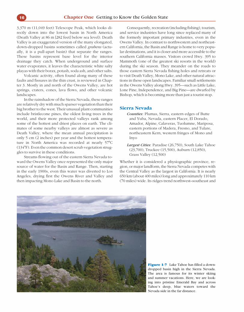
Whether it is considered a physiographic province, re-gion, or major landform, the Sierra Nevada competes withthe Central Valley as the largest in California. It is nearly650 km (about 400 miles) long and approximately 110 km(70 miles) wide. Its ridges trend northwest–southeast and
16 Chapter One Getting to Know the Golden State
Figure 1-7 Lake Tahoe has filled a down-dropped basin high in the Sierra Nevada.The area is famous for its winter skiing and summer vacations. Here, we are look-ing into pristine Emerald Bay and acrossTahoe’s deep, blue waters toward theNevada side in the far distance.

several peaks rise well above 4,270 m (14,000 feet). Thetallest peak in the United States outside Alaska is MountWhitney at 4,421 m (14,495 feet), and there are others notfar behind. Sierra Nevada’s sawtooth ridgelines split intwo to couch the Tahoe Basin in the north, and they arealso split by the Kern River to the south. Most of the verti-cal faulting responsible for lifting the range is evident onthe magnificently steep eastern wall, where the view fromLone Pine on Hwy. 395 (1,130 m [3,700 feet]) is directly upto Mount Whitney, which is only several miles away.
In contrast, the western slopes of this mighty rangegradually rise above the Central Valley until they reachthe top as far as 80 km (50 miles) to the east. This elon-gate region is bound by the Central Valley on the west,the Cascades on the north, the Basin and Range on theeast, and the Mojave Desert to the south. This orientationmakes the Sierra Nevada an almost perfect barrier tocatch orographic precipitation from the winter stormsthat sweep from west to east across California from thePacific. Tremendous winter snowfalls are common athigher elevations. When the snow melts, water poursinto streams, rivers, and reservoirs toward the CentralValley, where it is used for farming or diverted to thirstycities. Even greater snow packs accumulated during theIce Ages to build glaciers that carved spectacular sceneryin the high country and in major canyons. Yosemite andKings Canyon serve as outstanding examples of theselandscapes.
The varied climates—from drier foothills up to tow-ering peaks—have also produced life zones or belts ofvegetation containing a fascinating assemblage of plantsand animals that have been studied by biologists andbiogeographers. They include the only stands of thelargest (in bulk) living trees in the world, the GiantSierra Redwood, or Giant Sequoia, (Sequoiadendrongiganteum).
The granitic rocks so common in the Sierra Nevadaare similar to those forming the cores of almost everyother major California mountain range. Gold was discov-ered along the contact zones between these great graniticbatholiths and older, mostly metamorphic rocks as someof the gold weathered out and into the streams. The dis-covery of gold in 1848 in the western Sierra Nevadafoothills changed California forever. Thousands flockedfrom all over the world to the Mother Lode, and many ofthe gold rush towns they built are still there. Today, pow-erful human forces are molding new landscapes.
Explorer and naturalist John Muir properly namedthe Sierra Nevada “The Range of Light.” Many Californi-ans still think of the Sierra Nevada as a place where spec-tacular scenery and rich natural history is protected bythe expansive national forests and parks that make itworld famous. It has been a barrier to air masses, water,plant and animal species, and people (such as the Don-ner Party). It contains one of the largest areas withoutroads in the United States outside Alaska. South of Tioga
Pass, only two highways and one railroad cut throughthe range. During winter through at least early spring,the region becomes more inaccessible; snow typicallycloses the roads from Walker Pass in the south to thecentral Sierra Nevada north of Yosemite.
People Invade the Sierra NevadaToday, the old mining towns that became agriculturaland timber service towns are bulging with tourists, re-tirees, and even commuters! From Grass Valley andNevada City to Sonora and beyond, housing develop-ments and suburbs are spreading uphill from the CentralValley. In many cases, the escaping urbanites havebrought their freeways, generic shopping malls, andother service-oriented landscapes. And though thehigher elevations (such as in Alpine County) are moredistant and have escaped this encroachment, there arelocal exceptions. Residents of Lake Tahoe (with bustlingcasinos across the state line) and Mammoth Lakes arefighting over how to control the growth of their crowdedski resorts and housing developments.
Public lands and parks are also feeling the pinch asYosemite receives more than 3.5 million visitors eachyear. Daytime visitors from the Central Valley and week-end visitors escaping California’s great urban centerscrowd resorts such as Lake Isabella and the lower KernRiver at the Sierra Nevada’s southern end.
As many Sierra Nevada towns compete for moregrowth, jobs, and industry, the regional debate rages:Will tomorrow’s Sierra Nevada be set aside in parks andwild lands for recreation or will it serve as just anotherCalifornia suburb? As we debated this question, the re-gion’s population increased by 400 percent from 1960 to2000. There is extensive discussion about the SierraNevada’s natural and human landscapes in this book.
Southern California Deserts(Transmontane Southern California):About 20 Percent of the StateMojave Desert
Counties: southeastern corner of Kern,northeastern corner of Los Angeles, nearly all ofSan Bernardino leeward of coastal mountains,much of Riverside leeward of coastal mountains
Largest Cities: Palmdale (133,500), Lancaster(129,500), Victorville (80,000), Hesperia (72,000),Apple Valley (62,500)
The Mojave Desert begins just south of the Garlock Faultat the southern end of the Basin and Range and SierraNevada regions. Mountain ranges of the Mojave are notas commonplace or impressive as in the Basin andRange. Many of the Mojave ranges are older and weath-ered; they have crumbled into and filled the surroundingdesert plains with much debris, especially in the western
Getting to Know California: A Brief Survey of Its Diverse Regions 17

Mojave. Higher ranges of the eastern Mojave soar above2,150 m (7,050 feet), including the Kingston, Clark, NewYork, and Providence Mountains. Throughout the Mo-jave, at the base of the steeper mountains, are the gentlysloping alluvial fans and bajadas, depositional featurescommon to California’s desert terrain.
Although the Mojave generally makes up what isoften known as the northern deserts, or the “highdesert,” it is punctuated by deep valleys and desertplayas (salty lake beds). Just as in the Basin and Range,mineral-laden water may accumulate in these basins andevaporate to leave white, crusty salts on the surface.These lower basins are also home to some of the driestclimates and hottest summers in North America. SodaDry Lake and Silver Dry Lake basins near Baker and I-15are examples. Like the Basin and Range, there are only afew locations where sand has been blown into dunes.The Devil’s Playground and Kelso Dunes are stellar ex-amples southeast of Baker between I-15 and I-40.
The western corner of the Mojave begins east of Fra-zier Mountain and Tejon Pass (see Figure 1-3). This is anarrow wedge where the Sierra Nevada has tapered offinto the Tehachapis and where these ranges intersect theTransverse Ranges at an acute angle. On the rainshadowside of these intersecting ranges, the wedge opens upinto the desert basin toward the east, known as the Ante-lope Valley. The Mojave continues to widen toward theeast until it represents an enormous expanse of diversedesert topography all the way into Nevada and north-western Arizona. Just as the Garlock Fault separates theMojave from the Basin and Range, Sierra Nevada, andTehachapis to the north, so do the San Andreas Fault andother structures separate the Mojave from the TransverseRanges on its southwestern border. The generally lowerColorado Desert Physiographic Province lies to thesouth of the Mojave.
Since so much of the Mojave Desert is higher terrainthan its neighbor to the south, it is generally cooler andwetter than California’s hottest deserts. A few winterstorms commonly produce snowfall each year. Thethicker desert scrub and Joshua trees of the high desertmay even give way to pinyon, juniper, and sparse forestat the highest elevations. These life forms and their sur-rounding landscapes are spotlighted in Joshua Tree Na-tional Park and the Mojave National Preserve.
Multiple Uses for Open Spaces in the Mojave.Substantial military and mining operations and limitedgrazing fueled the economies of the tiny settlements inthe Mojave during the twentieth century, but the militarypresence was most noticeable. The Marine Corps Train-ing Center north of Twentynine Palms, Antelope Valley’sEdwards Air Force Base, Fort Irwin north of Barstow,and China Lake Naval Weapons Center are good exam-ples. Military activities required plenty of open space and
the Mojave had it. Expansive San Bernardino County—the largest U.S. county and most of it U.S. governmentland—offered ideal settings for many of these militaryoperations.
Transportation has always been vital to survival inthis harsh, wide-open country. This is why most of thefew people and economies of the Mojave Desert onceclung to the services provided along its major trans-portation corridors. One example is Barstow, wheretrain tracks and Hwy. 58 meet I-15 and I-40 and wherethe celebrated Route 66 once made the town famous.The traffic between Barstow and Las Vegas along I-15and the trickle of sightseers to Death Valley kept littleBaker’s pulse going. Trains, truckers, and travelers alsoconverged on the little town of Mojave. Later, a hugestorage facility for mothballed jet airliners was built inMojave. Tehachapis’ wind farms decorate desert slopesabove Mojave. Way out on I-40, near the ColoradoRiver, the little town of Needles gained fame as thelargest settlement near a proposed nuclear waste site inWard Valley.
Recent mass migrations of people from the coastalside of the mountains has transformed the economiesand landscapes, especially of the western Mojave andAntelope Valley. Some newcomers are retired, andsome have found work in the high desert. Many movedtheir families to this harsher climate for more space andcheap housing, but the price they pay is a commute toand from the L.A. Basin that may total several hourseach day. A heavy toll has been placed not only on thebreadwinners and their families, but on the very desert
18 Chapter One Getting to Know the Golden State
Figure 1-8 Looking northeast from the top of San Jac-into Peak. Beyond the Coachella Valley and across the SanAndreas Fault Zone are Joshua Tree National Park and the Mo-jave Desert extending into the distance. Train tracks, I-10, andwind farms below announce that San Gorgonio Pass is just toour left, where the desert is connected to inland and thencoastal valleys.

environments that once represented an escape fromurban life.
Giant malls, congestion, pollution, violence, andother urban problems are now commonplace in Palm-dale, Lancaster, and Victorville. Even that charming littleApple Valley of the 1960s—once just a wide spot onHwy. 18 where a trailer park and hamburger stand weremajor landmarks—has a population soaring past 62,000.The Joshua trees have come down and the housing de-velopments have gone up. Far to the southeast of Ante-lope Valley’s city lights are the strip of blossoming townsalong the north edge of Joshua Tree National Park; land-scapes from Twentynine Palms to Joshua Tree to YuccaValley and Morongo Valley are gaining new popula-tions. Some of this chaotic growth is spreading far intothe Mojave, where you can find major malls and occa-sional traffic jams outside of Barstow.
Population growth in southern California desertcounties has averaged nearly 40 percent per decadesince the 1960s.
The Colorado DesertCounties: Imperial, southern and eastern portions
of Riverside, far eastern edge of San Diego
Largest Cities: Indio (62,000), Cathedral City(51,000), Palm Desert (46,500), Palm Springs(44,500), El Centro (41,000)
South of the Mojave, extending into the Salton Troughand Mexico and then along a strip of the Colorado RiverValley, is the Colorado Desert. Often called the southerndeserts, or the “low desert,” it includes the farmlandsand developments of the Coachella and Imperial Val-leys. This region is tucked away on the rainshadow sideof the Peninsular Ranges to its west and the TransverseRanges to its northwest. It is generally hotter and drierthan the higher Mojave, and it probably has more incommon with the deserts of southern Arizona and north-ern Mexico than it does with the deserts of California.
In contrast to the higher Mojave, the ColoradoDesert’s annual precipitation is below 13 cm (5 inches)per year, daytime highs frequently break 43�C (110�F),and overnight lows may not drop below 27�C (80�F) dur-ing mid-summer. Desert scrub dominated by the ubiqui-tous creosote bush is common in both regions, but theColorado Desert lacks Joshua trees, which grow to thenorth in the Mojave. Also lacking are saguaro cacti,which only grow naturally in California along a thin stripof the Colorado River but are imported into human land-scapes of the Imperial and Coachella Valleys. However,several other species of cactus are common in the cactusscrub of the Colorado Desert’s lower desert terrain, andin some desert canyons you will find the state’s only na-tive palms. They are beautifully displayed in Anza Bor-rego, California’s largest state park.
The Salton Trough is being stretched and droppedin relation to the surrounding mountains, especially thePeninsular Ranges, which are being pulled away from itby tectonic forces reviewed in Chapters 2 and 3. ThePalm Springs Tramway lifts travelers over some of thesefaults on the trip from this desert floor up to the coolforests of the Peninsulars’ San Jacinto Mountains. Farthersouth, the Salton Sea was a mistake created and filled byoverflow from the rampaging Colorado River in the early1900s. It has since served as a sump for agriculturalrunoff from the Coachella and Imperial Valleys.
People and Their Landscapes Pour into LowDesert Valleys. As the inland valleys west of themountains fill with people, growth spills through Ban-ning (San Gorgonio) Pass, into the Coachella and Imper-ial Valleys, and even up parts of the Colorado River Val-ley. Even Blythe, once just a small agricultural servicecommunity and pit stop where I-10 crosses the ColoradoRiver, has blossomed to substantial town status. Suchpopulation and economic growth has brought divisionto the Coachella and Imperial Valleys.
Parts of cities like Palm Springs, Rancho Mirage, andPalm Desert still offer the resort atmosphere that once at-tracted Hollywood stars, the rich, and the famous. Incontrast to these traditionally wealthy visitors, there arenow a large number of lower-income workers in the ser-vice industries that support the resort economy. As wemove south, through Indio and into the farming commu-nities where the farm workers live, poverty and unem-ployment become more visible. Imperial County, with amajority Latino population, is now the poorest county inSouthern California. Because agribusiness is the only
Getting to Know California: A Brief Survey of Its Diverse Regions 19
Figure 1-9 High, forested Peninsular Ranges are barriers tomoist Pacific Ocean air masses (behind us) and the distantrainshadow deserts in front of us. Below, the ColoradoDesert’s Imperial Valley stretches out to the even more dis-tant Salton Sea and the Mexican border on the horizon.

major industry in the area and because there is a largepool of potential farm workers in Mexicali, just acrossthe Mexican border, the future looks bleak for the Impe-rial Valley’s working masses.
The long growing season and irrigation water fromthe Colorado River made the fertile farms of the SaltonTrough possible. The region produces as great a varietyand quantity of valuable crops as any area its size. Just aglance across this valley with its lettuce fields, grapevines, citrus groves, and towering date trees will serve astestimony to its productivity. Unfortunately, these advan-tages are barely translating into a subsistence-level in-come for much of the Coachella and Imperial Valleys’working class. A visit to some of the Imperial Valley’s lit-tle towns provides testimony to this disparity. (Ironically,many Imperial Valley farmers supported a recent plan totake some fields out of cultivation and sell excess waterto thirsty San Diego.)
While economic disparity is the rule in this region,many Coachella Valley cities, such as Cathedral City, aresomewhere in the middle, struggling to find their roles.They often find some answers when the snowbirds ar-rive to escape northern winters and crowd the CoachellaValley from November through April. This clean revenuesource evaporates in summer’s sizzling sun when thestreets, stores, and restaurants turn quiet again. Someresidents look toward the new Shadowrock Golf Courseor Palm Springs Air Museum to pump more energy intotheir economies.
Southern California’s Coast and Mountains (Cismontane Southern California)The dividing line between the Peninsular Ranges andTransverse Ranges Physiographic Provinces is clear nearBanning in San Gorgonio Pass along the San AndreasFault Zone. The San Bernardino Mountains of the Trans-verse Ranges tower above on the northern side, while tothe south, the spectacular San Jacinto Mountains loom asthe northern edge of the Peninsular Ranges. However,west of the pass, the coastal and inland valleys of River-side, San Bernardino, Orange, and Los Angeles Countiesbegin to blend together both physically and culturally.Elsewhere, it is often difficult to tell where the naturaland human landscapes of the Peninsular Ranges to thesouth yield to those of the Transverse Ranges to thenorth. We will consider these two landform provincesseparately, but under the same Southern California Coastand Mountains heading.
The Peninsular Ranges and South CoastThe Peninsular Ranges have much in common with theSierra Nevada. First, the core is primarily granitic rockthat cooled to form a huge batholith after it contacted
older, mostly metamorphic rock. Second, active faultinghas lifted the block at steep angles above the desert flooron the east side; slopes drop down more gradually to-ward the coastal plains on the west side. Finally, becauseof this orientation, the Peninsular Ranges catch consider-able orographic precipitation which accumulates andflows along major streams toward the west, mostly downthe gentle western slopes toward the very ocean it camefrom.
However, there remain major differences betweenthe Peninsular Ranges and the Sierra Nevada. First, theyare not as tall or as massive as the Sierra Nevada. Thehighest peak is San Jacinto at 3,295 m (10,804 feet) at thenorthern tip of the Peninsular Ranges. They trend lowertoward the south; the next range south of the San Jacin-tos is the 1,830 m (6,000 feet) average crest of the SantaRosas. Second, they are farther south. Not only are theyfarther away from winter’s major storm tracks, whichmakes them much drier, but they trend for nearly 1,300km (about 800 miles) out of California and all the waydown to southern Baja California.
Finally, the Peninsular Ranges are really a series of ranges interrupted by valleys (some substantial anddeep) and parallel faults, many of which are still active.One example is the San Jacinto Plain, which sits betweenthe San Jacinto Fault and Mountains to its east and the Elsinore Fault and Santa Ana Mountains to its west.More noticeable, however, is how the entire PeninsularRanges are pulling away from the Salton Trough and theGulf of California. They also include the Laguna Moun-tains, Palomar Mountain, and the islands trending paral-lel to them just offshore. They are bordered by the SaltonTrough on the east, while the Transverse Ranges cutthem off on the north.
Starting at the coast, a patchwork of coastal sagescrub yields to grasslands in the inland valleys and tochaparral on inland mountain slopes. In higher eleva-tions of the Peninsular Ranges, oak woodlands and thenyellow pine forests become dominant. Isolated patchesof cooler, wetter forests grow even higher in the San Jac-intos and near a few of the highest peaks to the south.Among the few mountain resorts within these coolerforests are Idyllwild, between Hemet and Palm Springs,and Julian, in the mountains east of San Diego. The Palo-mar Mountain Observatory, east of Oceanside, ranks asone of the world’s premier astronomical observationsites. It also looks down on some of the many inland val-leys which interrupt these ranges.
Interesting coastal landforms include the mesaswhich gradually drop down from the range to marineterraces along the San Diego County coast. As these ter-races overlook the ocean, they are occasionally slicedthrough by the westward flowing streams. The result canbe seen in a drive along I-5, mostly on the flat, raised ter-races, until there is the occasional drop into a deep
20 Chapter One Getting to Know the Golden State

stream canyon or valley and a view of the characteristiclagoon or estuary which has formed near the shoreline.
San Diego CountyCounties: San Diego
Largest Cities: San Diego (1,300,000), Chula Vista(210,000), Oceanside (175,000), Escondido(142,000).
During the mid-twentieth century, San Diego Countybuilt an economy based on such staples as the military,retirement, tourism, and construction. However, thiscounty with one of the mildest climates in the world be-came the fastest growing county in the state by the1980s. It grew so fast that nervous residents began rally-ing around groups with names such as “Not yet L.A.” Inspite of this reluctance, San Diego’s growth—at the ex-pense of its fields of flowers and its citrus and avocadogroves—was undeniable, and growth often occurredwithout plans or controls. The region’s history andquaint Spanish atmosphere and architecture were beingswept away by a host of developments including generichousing tracts, new urban developments, developmentalong Hotel Circle and the rest of Mission Valley, touristattractions such as Sea World, a redeveloped downtown,and an enlarged freeway system.
A good place to view the results of these changes isat Cabrillo National Monument, which looks down onSan Diego from atop Point Loma. (The monument wasnamed after the Portuguese soldier of fortune who dis-covered California for Spain in 1542. San Diego was fi-nally claimed and settled for Spain by Portolá and Serrain 1769.)
From Coronado to Mission Bay and Beach, from OldTown to Horton Plaza, from the Gaslamp Quarter and
the convention center nearby, heroic efforts were madeduring the 1980s and 1990s to change San Diego for thebetter and sometimes to even preserve its charm. How-ever, the city had become the second largest in Califor-nia, and it was still growing. San Diego’s populationsprawled up the coast through Del Mar and Encinitasand out toward San Diego Zoo’s Wild Animal Park. EvenOceanside experienced a burst in population and inconstruction to house all the newcomers. The masses arenow filling in the gap between San Diego and Tijuana(Chula Vista is the county’s second largest city), and they have spread east into and around communities like La Mesa and El Cajon and along I-15 to cities likeEscondido.
Like residents of San Francisco and its Bay Area,many who live in these extended communities oftenconsider themselves a part of that larger domain knownas San Diego. At the same time, they have also createdtheir own more independent urban centers as San DiegoCounty’s economy is forced to diversify along with itscultures. The county’s historic economic dependence onthe military and the “zoners” who come to escape south-ern Arizona’s searing summer heat is dwindling. High-tech manufacturing, biotech research, retail, and serviceshave become economic staples. Meanwhile, the Latinopopulation has swelled to nearly 25 percent while Asiansand Pacific Islanders (especially Filipino Americans) alsoplay key roles in breaking the old stereotype of a tradi-tionally white San Diego.
Today, residents can no longer blame traffic conges-tion, air pollution, crime, and economic bumps on LosAngeles. San Diego is in the big city league now, and inthe twenty-first century it will continue to be linked withits close neighbor to the south, a bulging and bustlingTijuana.
Getting to Know California: A Brief Survey of Its Diverse Regions 21
Figure 1-10 Northern San Diego’s coastline ismore than a playground for locals; its beaches andmild climate attract tourists from around the world,such as winter’s “snowbirds,” and its population andeconomy have grown more diverse. Looking southfrom the rock formations of this more secludedbeach, you can see distant developments growingalong and up the coastal slopes.

Predictions of what will become of this great experi-ment range from exciting to frightening. Already, SanDiego is beginning to meet head on the urban sprawlspilling south from southern Orange County, itself anoutpost of the urban sprawl from Los Angeles to thenorth. Only the open space of the United States MarineCorps’ Camp Pendleton prevents the merger of SanDiego and Los Angeles. Will anything stop these citiesfrom growing together into one coastal megalopolis thatwill eventually stretch from the San Fernando Valley oreven the Ventura/Oxnard Plain well into Mexico?
Northern Fringes of the Peninsular Ranges or Southern Fringes of theTransverse Ranges?Inland Empire
Counties: Southwest San Bernardino, westernRiverside
Largest Cities: Riverside (277,000), San Bernardino(200,000), Ontario (170,000)
This brings us to some of those eastern inland valley ex-tensions of the Los Angeles Basin (known as the InlandEmpire) and to the south part of the Basin itself. Fromthe retirement communities that flooded the valleyaround Hemet, to the gradual growth and more diverseeconomy of historic Riverside, these inland valleys expe-rienced soaring growth rates after Orange County hadfilled up. Corona, west of Riverside, caught the popula-tion overflow that spilled around the Santa Ana Moun-tains and through Santa Ana Canyon.
Few communities will ever match the explosivegrowth once seen in Moreno Valley, east of Riverside.During the 1980s, this little community grew from lessthan 10,000 to a city of over 100,000. Its populationsoared to over 150,000 in the early 2000s. The influx ofcommuters eager for inexpensive housing often resultedin a loss of the area’s citrus groves and dairy farms. Theirony is that residents brought the city they sought to es-cape with them. Many still must commute through tor-turous hours of traffic into the cities deep within the LosAngeles Basin to make a living. Whether the valley smogand long commutes are worth the bigger houses andyards is a question pondered in Moreno Valley neigh-borhoods every day.
The story is similar in San Bernardino and other in-land valleys farther to the north, technically on the edgeof the Transverse Range Province. The difference is thatmore urban poor of all ethnicities have flocked to these suburbs, assembling in neighborhoods troubledby gang activity and higher crime rates. Many localsand researchers extend the Inland Empire through themountain passes and into many desert communitiespreviously discussed, all on the opposite side of themountains. It is true that these generally conservativesuburbs sprawling away from the L.A. Basin are con-
nected in powerful ways. Regardless of where youdraw exact boundaries, the Inland Empire continues asone of the fastest-growing regions in California.
Orange CountyLargest Cities: Santa Ana (354,000), Anaheim
(350,000), Huntington Beach (200,000), Irvine(173,000), Garden Grove (172,000)
If it is now difficult to believe that Riverside is where thefirst navel orange trees grew, a glance at the modernlandscape makes it almost impossible to understandhow the county and city of Orange got their names. Thecity of Orange was founded in 1873; the county wasborn in 1889. Even into the mid-1900s, fruit trees andstrawberry fields were commonplace in Orange County.Orange County began growing as Los Angeles’ little sis-ter just after the San Fernando Valley began to fill andlong before those valleys to the east began to experiencepopulation growth. Newer communities to the east canlearn some valuable lessons from the county of Orange.
Orange County first grew as a Los Angeles suburb.As agriculture gave way to land development and con-struction, an economic strip grew along the Santa AnaFreeway (I-5), the main link to Los Angeles. I-5 slicesthrough inland Orange County, so it is not surprising thatDisneyland grew up next to it and Knott’s Berry Farmwas not far away. Backed by history and the county seat,Santa Ana became and still is the most populated city.Anaheim competed, building its convention centeracross from Disneyland and not far from Anaheim Sta-dium (“The Big A”), where major league baseball had ar-rived in the 1960s in the form of the California Angels.It’s now known as Angel Stadium of Anaheim and theteam name was changed in 2005 to Los Angeles Angelsof Anaheim. Just as economic development increasedwhere I-5 intersected with other new Orange Countyfreeways, the focus of activity and growth shifted south.
By the 1970s, Orange County beaches had solid rep-utations; surfing, swimming, sunbathing, and the beachculture that supposedly personified Southern Californiawere firmly established in the minds of visitors as typicalof the Orange County coast. Laguna, Newport, andHuntington Beaches evolved to represent coastal play-grounds that were more convenient and less crowdedthan the long-established retreats on Santa Monica Bayto the north. This delighted city officials and developersbecause people, industry, and jobs flocked to southernOrange County. As this economic activity moved south,it affected communities near the beach and along theSan Diego Freeway (I-405), such as Fountain Valley,Costa Mesa, and Irvine. Within about a decade, sprawl-ing farms were converted to housing tracts and industrialsites, the inevitable result of rapid population growth.
Today’s economy continues to evolve, pushing high-tech and service industries into the limelight. Some ob-
22 Chapter One Getting to Know the Golden State
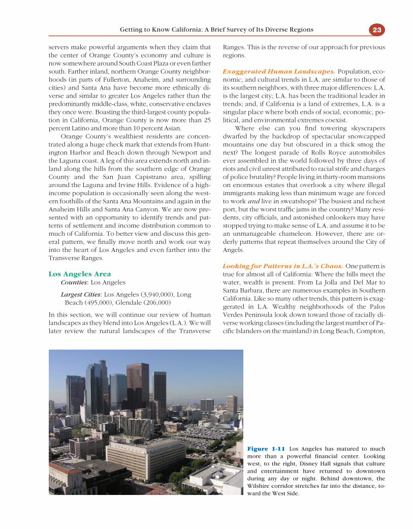
servers make powerful arguments when they claim thatthe center of Orange County’s economy and culture isnow somewhere around South Coast Plaza or even farthersouth. Farther inland, northern Orange County neighbor-hoods (in parts of Fullerton, Anaheim, and surroundingcities) and Santa Ana have become more ethnically di-verse and similar to greater Los Angeles rather than thepredominantly middle-class, white, conservative enclavesthey once were. Boasting the third-largest county popula-tion in California, Orange County is now more than 25percent Latino and more than 10 percent Asian.
Orange County’s wealthiest residents are concen-trated along a huge check mark that extends from Hunt-ington Harbor and Beach down through Newport andthe Laguna coast. A leg of this area extends north and in-land along the hills from the southern edge of OrangeCounty and the San Juan Capistrano area, spillingaround the Laguna and Irvine Hills. Evidence of a high-income population is occasionally seen along the west-ern foothills of the Santa Ana Mountains and again in theAnaheim Hills and Santa Ana Canyon. We are now pre-sented with an opportunity to identify trends and pat-terns of settlement and income distribution common tomuch of California. To better view and discuss this gen-eral pattern, we finally move north and work our wayinto the heart of Los Angeles and even farther into theTransverse Ranges.
Los Angeles AreaCounties: Los Angeles
Largest Cities: Los Angeles (3,940,000), LongBeach (495,000), Glendale (206,000)
In this section, we will continue our review of humanlandscapes as they blend into Los Angeles (L.A.). We willlater review the natural landscapes of the Transverse
Ranges. This is the reverse of our approach for previousregions.
Exaggerated Human Landscapes. Population, eco-nomic, and cultural trends in L.A. are similar to those ofits southern neighbors, with three major differences: L.A.is the largest city; L.A. has been the traditional leader intrends; and, if California is a land of extremes, L.A. is asingular place where both ends of social, economic, po-litical, and environmental extremes coexist.
Where else can you find towering skyscrapersdwarfed by the backdrop of spectacular snowcappedmountains one day but obscured in a thick smog thenext? The longest parade of Rolls Royce automobilesever assembled in the world followed by three days ofriots and civil unrest attributed to racial strife and chargesof police brutality? People living in thirty-room mansionson enormous estates that overlook a city where illegalimmigrants making less than minimum wage are forcedto work and live in sweatshops? The busiest and richestport, but the worst traffic jams in the country? Many resi-dents, city officials, and astonished onlookers may havestopped trying to make sense of L.A. and assume it to bean unmanageable chameleon. However, there are or-derly patterns that repeat themselves around the City ofAngels.
Looking for Patterns in L.A.’s Chaos. One pattern istrue for almost all of California: Where the hills meet thewater, wealth is present. From La Jolla and Del Mar toSanta Barbara, there are numerous examples in SouthernCalifornia. Like so many other trends, this pattern is exag-gerated in L.A. Wealthy neighborhoods of the PalosVerdes Peninsula look down toward those of racially di-verse working classes (including the largest number of Pa-cific Islanders on the mainland) in Long Beach, Compton,
Getting to Know California: A Brief Survey of Its Diverse Regions 23
Figure 1-11 Los Angeles has matured to muchmore than a powerful financial center. Lookingwest, to the right, Disney Hall signals that cultureand entertainment have returned to downtownduring any day or night. Behind downtown, theWilshire corridor stretches far into the distance, to-ward the West Side.

Carson, and the South Bay. Even farther west in the PalosVerdes hills, expensive properties offer a view away fromthis city of contradictions and toward the ocean.
From the Hollywood Hills to Beverly Hills, you canlook down on the poverty embedded in L.A.’s city lights.But, as you move toward the “West Side,” the poverty ofthe lowlands yields to wealth; generally, real estateprices escalate for land close to the ocean. Residents far-ther west in the Pacific Palisades or Malibu may find itdifficult to believe that there is a poverty-stricken, 57-square-mile segment of the L.A. area (mostly south andeast of downtown) where the majority of residents arenot even citizens. That is an area larger than the entirecity of San Francisco!
Income disparity and racial segregation were not inthe original plan when the Spanish founded a littlepueblo along the Los Angeles River in 1781. By the early1900s, newspaper and railroad tycoons and land baronsteamed up with William Mulholland to bring water tothe swelling population of L.A. The quest for resourcesgrew with the annexations of surrounding lands, thepopulation increase, and the booming economy. Thepath was paved for the movie industry. By 1915, Holly-wood (within the official city limits of L.A.) was alreadythe movie capital of the world. The discovery of oilpulled great industries, such as transportation and de-fense, to the L.A. area. This growing industrial base andthe mild climate attracted increasing numbers of people.As a result, the service economy boomed, thus provid-ing more jobs.
As we have seen in other regions of California, hous-ing developments, construction, aircraft plants, and animpressive tourist industry replaced agriculture and oilwells. Freeways stretched the settlements even fartheruntil they filled the San Fernando, San Gabriel, and moredistant inland valleys. The settlements filled OrangeCounty and the pressure finally squeezed them into thecanyons. Like chain-reaction explosions, outlying citieserupted almost overnight, mostly along freeways andhighways. More recently, they have spilled north towardMagic Mountain and into Canyon Country, creating thecity of Santa Clarita, and even farther out along Hwy. 14to the high desert and Palmdale and Lancaster. (Each ofthose cities has well over 100,000 people.) To the north-west, cities such as Simi Valley and Thousand Oaks(both also more than 100,000) are demolishing the for-mer gap between L.A. and the Ventura/Oxnard Plain.
Like the developments in southern Orange County,the spread northwest is mostly an extension of the flightof white residents, money, and jobs from the inner citythat was common in previous decades. Currently, thespread represents a migration from closer to outlyingsuburbs. However, in the Antelope Valley and many ofthe outlying inland valleys, these patterns are changing.This leads us to reassess some of the sweeping general-izations that are so often made about L.A. by those whosee it as too complex to understand.
L.A. Evolves. First, although many proclaim that L.A.never had a plan, much of the booming growth throughmost of the twentieth century was not only planned, butwelcomed by the city and surrounding communities.Unlike San Francisco, most of L.A.’s growth was usheredin with the automobile. Also, L.A. had a light rail systemthat was one of the best and most celebrated urbantransportation systems in the world. Since people wereable to live away from the urban center, along or at theend of rail car lines, communities sprang up all aroundL.A.’s periphery during the early 1900s. When this mostefficient transportation system was dismantled, the free-ways and their cars took its place during the mid-1900s.
The population spread was further encouraged byland developers who convinced so many families to buythe American dream—a California-style bungalow on abig lot in a new, clean neighborhood away from the city.The San Fernando Valley and other L.A. suburbs wereproducts of those developers’ and homeowners’ dreams.The plan was to disperse the population and make L.A.an assemblage of individual, loosely connected commu-nities. With more modest population density gradients,Angelenos would be spared the cramped conditions typ-ical of the huddled masses in great European and easternU.S. cities. Instead, they would have a piece of their ownspace to enjoy the year-round sunshine delivered by themild, Mediterranean climate.
Second, it is true that, as in most American cities, in-stitutional racial segregation forced African-Americansand other ethnic groups into specific neighborhoods. Itis also true that white flight and the subsequent drain ofwealth out of the inner city began to transform L.A. afterWorld War II and accelerated into the 1960s and 1970s.Downtown began to resemble a ghost town at night andon weekends as workers took their paychecks home tospend in suburban shopping malls. Minorities and thepoor were generally left behind in the inner city. Mean-while, the primarily white suburbs thrived as people andmoney poured in. However, things began to change inthe 1980s.
A booming economy brought redevelopment andgentrification to parts of L.A. as some young profession-als, tiring of their long commutes, trickled back towardthe city’s core. They evicted the poor, fixed up some ofthe old Victorians and bungalows, and reclaimed severalneighborhoods. This trend mixed the population potagain and contributed to a more complex and fascinat-ing human landscape. (Similar trends were affecting theSan Francisco area and, to a smaller extent, San Diegoand a few of California’s smaller cities.) Some of the dis-placed working class found homes in nearby neighbor-hoods, and some were left homeless. Many of themmoved out to the hinterland. Cities like Palmdale, Lan-caster, and San Bernardino have received an influx ofthese low-income families. Consequently, many distantsuburbs have now also become complicated humanlandscapes with diverse assemblages of families who
24 Chapter One Getting to Know the Golden State
represent many ethnic groups, cultures, and income lev-els. They, too, have “escaped” the urban core.
Finally, too often, L.A.’s many rich and diverse com-munities have been improperly lumped together. It istempting, especially while traveling through the Basin byfreeway, to discredit L.A. as a bunch of generic housingprojects that eventually grew into one another, emergingas a bland, expansive megalopolis. Such superficial ob-servations are not only incorrect, they are unfair to themany dedicated residents who identify with and are ac-tive in their specific communities and neighborhoods.After all, we are talking about nearly 4 million peoplewithin the city limits and a population of over 15 millionin the Basin and its connected settlements.
Divided L.A. Los Angeles still has an economic centerthat stretches from the central business district, westalong the Wilshire Corridor’s concrete canyon, into Cen-tury City and Westwood. Otherwise, economies and jobsin the Basin are so spread out, freeways are oftenjammed with commuters going in both directions (to andfrom downtown) during morning and evening rushhours. Perhaps understanding these economies is just asdifficult as understanding the complex cultures andneighborhoods that make up L.A. and California. Today,there is a new, powerful economic force that is puttingpressure on Californians in general and Angelenos inparticular: the global marketplace.
Current economic trends in L.A., as in most otherCalifornia cities, are toward an economy with two dis-tinct and very distant levels. Middle class manufacturingjobs are being replaced by two very different employ-ment extremes. One extreme is represented by the high-paying, high-tech, research and development jobs andtheir associated high-level services (finance, trade, pro-fessional, and information technologies). On the other
end are the growing low-paying, low-tech manufactur-ing jobs, such as garment sweatshops, and low-level ser-vices jobs, such as the fast-food industry.
The growing disparity in incomes and in levels ofeducation and skills is tightening the social vise, increas-ing tensions between and within these classes, and chal-lenging officials who are trying to figure out how to copewith the situation. To witness the impact these trendshave on L.A.’s and California’s human landscapes, youneed only walk through the streets of Pico-Union orSouth L.A. and then walk through the streets of Brent-wood or Beverly Hills.
The increased economic competition is also raisingtensions between lower-income groups. These tensionsare evident in places like South-Central L.A., where Lati-nos have recently displaced African Americans to be-come the majority ethnic group. Intricately entwinedeconomic and cultural trends are producing some fast-changing human landscapes throughout L.A. and Cali-fornia; such trends earn more attention here since theyare common to most of California’s major cities.
Transverse Ranges North of L.A.Counties: Santa Barbara, Ventura, northern Los
Angeles and higher mountains to the east
Largest Cities: Oxnard (192,000), Santa Clarita(170,000), Simi Valley (120,000), SanBuenaventura (Ventura) (108,000)
Moving Northwest, into Other Urban Centers inthe Transverse Ranges. Farther northwest is VenturaCounty, where the Ventura/Oxnard Plain’s rich agricul-tural fields are being consumed by the same kinds of in-dustrial parks, shopping malls, and housing projects that
Getting to Know California: A Brief Survey of Its Diverse Regions 25
WHERE IS L.A.?
Part of the difficulty in discussing L.A.’s issues and problems isthat few can figure out, much less agree on, where this greatcity begins and ends. Because we’ve already considered Or-ange County, the eastern inland valleys, and some high desertsuburbs, we are focusing here on Los Angeles County until welater sweep northwest and follow the Transverse Ranges.
There are many individual and unique neighborhoodswithin the city limits such as Echo Park, Boyle Heights, SilverLake, Hollywood, Van Nuys, Woodland Hills, Westwood, Cen-tury City, and Venice, whose residents often identify more withtheir particular communities than with the city of Los Angeles.In the early 1900s, L.A. annexed many of these locations—especially in the San Fernando Valley—to expand its waterrights. By the 1990s, efforts to preserve identity and unique-
ness reached a feverish pitch; some residents of the San Fer-nando Valley saw their communities as so distinct that theylaunched a movement to secede from L.A.
In contrast, there is the long list of cities that are fre-quently considered part of the city of L.A. but are actually sep-arate, official cities. A few examples are Santa Monica, CulverCity, Beverly Hills, West Hollywood, and Inglewood. Finally,there are the unincorporated communities within Los AngelesCounty. They don’t belong to any city, and they aren’t officialcities at all! East L.A. and Marina del Rey are examples.
Each of these communities proudly displays its own spe-cific cultures, lifestyles, and human landscapes, but all of themare a part of that sprawling abstract painting, that great exper-iment we often call Los Angeles.

took the San Fernando Valley and other L.A. suburbs bystorm so many years ago. Similar activities blossomingalong the strip of Ventura Freeway (such as in ThousandOaks) and in places like the spreading Simi Valley arestrengthening the connections with L.A. Experiencing somany of the same economic trends as L.A., this was oneof the fastest growing regions in California toward theend of the twentieth century. Oxnard outgrew its olderneighbor San Buenaventura (Ventura) many years ago.
Still farther to the northwest is the beautiful and stillsomewhat isolated strip of Santa Barbara coast. Past de-velopment has been mostly limited to that thin coastalplain with the ocean on one side and the steep SantaYnez Mountains on the other. Limited water suppliesshould play less important roles in the future since manyof these communities connected to the California WaterProject after 1996.
In spite of tourists, the crowded downtown shops, agrowing University of California, and development en-croaching from surrounding communities, Santa Bar-bara retains much of its magic and charm and an atmo-sphere that is more reminiscent of old California.Perhaps this is because it was just far enough from theexplosive growth of L.A. and, more recently, Venturaand Oxnard. Perhaps it is because land values and rentsare very high, there are not many high-paying jobs, andit is too far to commute into L.A. Whatever the reason,
when that dry sundowner wind blows through the im-ported palm trees, over the historic mission and towardits scenic beaches, Santa Barbara can still shine like noother California city.
It could be said that the sprawling suburbs ofCanyon Country and amalgamated communities of SantaClarita represent the antithesis of Santa Barbara. Theyare strongly connected by commuters to greater L.A. De-velopments are gobbling up open land at historic ratesand new residents are being surrounded with the sameL.A.-style suburbs, traffic, and expensive real estate theythought they had escaped. Breaking away from thesesuburbs in the heart of the Transverse Ranges (far awayfrom any beach) will probably require the use of a carand freeway. Many residents struggle to redefine theircommunities so that past mistakes are not repeated.
The Transverse Ranges—Natural Landscapes.Now we will review the natural landscapes and processesthat combine to form the Transverse Ranges.
The Transverse Ranges rise above and protect manysouthern California cities from winter’s cold snaps. Thisprotection is evident when north winds must sink and beheated by compression to get to the coastal valleysbelow. What would be cool winds are modified to warmand dry, causing autumn and winter heat waves. Whenthese Santa Anas blow during mid-winter, the mild
26 Chapter One Getting to Know the Golden State
Nature and Open Spaces Accessible to Millions
cape the city. Weekend traffic jams bring the crowds who fillevery picnic table, campground and trail, or winter ski resort.Here, especially along Angeles Crest Highway, is another ex-ample of how so many Californians strain to find a little pieceof that remaining wilderness and open space that once helpedmake Southern California famous.
The same problems plague the smaller Santa MonicaMountains, which are also peppered with developments.Within them are Griffith Park and the Hollywood Hills to theeast and the community of Topanga and the city of Malibu to-ward the west. The Santa Monicas are the most southerly ofthese Transverse Ranges and they are the only major mountainrange to bisect a major U.S. city. Meanwhile, all of these di-verse landscapes continue to star as scenery in countless Hol-lywood movies, TV programs, and commercials. Trending far-ther west, the northern Channel Islands are a structuralextension of the Santa Monicas.
From the San Gabriels, the Santa Susana, Topatopa, andSanta Ynez Mountains finally trend out to Points Conceptionand Arguello. Gradually, the remaining ranches and agricul-tural service towns like those near the Santa Clara River willprobably yield to the same developments that are surroundingthem and have already been reviewed in this chapter. North ofhere, Coast Ranges landforms rule and trend in a morenortherly direction. Landforms, coastal features, and coastalwaters become decisively central Californian to the north.
The Transverse Ranges have gained much of their fame becauseof their proximity to the Los Angeles Basin. On clear days, theyseem to erupt from the eastern edge of the San Fernando Valleyand especially the northern edge of the San Gabriel and north-eastern San Bernardino Valleys. The contrast between the Basin(with its warm winter sunshine, citrus groves, and palm trees)and the brilliant snowcapped peaks in the background was dis-played on magazine covers and promotional brochures foryears. Today’s Los Angeles skyscrapers have replaced the or-ange groves in a modern version of these breathtaking views.Residents of the Los Angeles Basin from the valleys to OrangeCounty and Santa Monica Bay beaches will recognize these fa-miliar landmarks looming toward the north and northeast.
The chaparral on these slopes yields to woodland and yel-low pine and even cooler forests at higher elevations that re-ceive more than 75 cm (30 inches) of precipitation per year.This serves as important watershed, since much of the waterflows down into the basin after accumulating in channelsflowing through deep canyons. When the water out of the SanGabriel River and other channels is ponded into spreadingbasins at the bottom of the mountain front, it recharges futuregroundwater supplies. However, during heavy winter storms,it can produce dangerous and destructive flooding.
The cool forests and winter snows of the San Gabriels andSan Bernardinos have also been magnets for millions of visi-tors willing to brave winding roads and the short drive to es-

southern Californian climate is the envy of snow shovel-ers in more wintery parts of the country.
However, these winds also bring the occasionalwildfires that scorch the chaparral and coastal sage andeven communities on the lower slopes of the TransverseRanges. The winter mudflows that follow these fires raceout of the mountain canyons and add to the destruction.They also add a little bit more material to the alluvial fansradiating out of the canyons and the more than 9,150 m(30,000 feet) of sediment already accumulated below theLos Angeles Basin.
The Transverse Ranges’ name comes from the waythey cut east–west, across the more common trend of land-forms, through California. They represent rocks and slicesof crust caught, crumbled, and lifted up throughout a wideregion near the big bend in the San Andreas Fault Zone.The Transverse Ranges trend all the way from Points Ar-guello and Conception and the Channel Islands NationalPark on the west into the little San Bernardino Mountainsand Joshua Tree National Park on the east. They are bor-dered by the Coast Ranges and Central Valley to the north-west and the Sierra Nevada and Mojave PhysiographicProvinces to the northeast. The Peninsular Ranges makeup their southern boundary, and the Coachella Valley is attheir southeastern boundary.
The Transverse Ranges are typically quite ruggedand especially lofty toward the east. The San BernardinoMountains include the resorts of Lake Arrowhead and BigBear and its popular ski slopes. San Gorgonio Mountainis the highest in southern California at 3,507 m (11,499feet). Across Cajon Pass and trending west are the SanGabriel Mountains, with 3,070 m (10,064 feet) Mount SanAntonio (Old Baldy) Peak towering above Wrightwoodand its popular ski resort. The rugged topography trendsfarther west to 1,742 m (5,710 feet) Mount Wilson and itsrenowned observatory. After becoming one of theworld’s premier astronomical observatories earlier in the1900s, its importance faded in later decades. Thanks tonew technologies, it enjoyed a rebirth in the 1990s.
A Geographic Pivot PointThere is an outstanding geographic pivot point in Califor-nia. It stands out because the bending San Andreas Faultmeets the Garlock and other faults there. It stands outwhere the corners of five different physiographic regionsintersect (the Coast Ranges, Central Valley, SierraNevada’s Tehachapi extension, the Mojave, and the Trans-verse Ranges). It stands near where three different moun-tain ranges and basins are wedged together with manydifferent rock types. It marks the center for a major moun-tain barrier between air masses to the north and south. Itdisplays an amazing mix of plants and animals that havecrept in from cismontane and transmontane, central andsouthern California, from lower to higher elevations.
This pivot point sits on a definitive natural and cul-tural boundary between southern California and the rest
of the state. Three counties (Ventura, Kern, and Los An-geles) intersect at this point near Frazier Peak and TejonPass. Even the cars, buses, and trucks on I-5 must strainto get over this barrier, as if some unknown force wastrying to make them turn back before it was too late, todiscourage them from entering that different world onthe other side. All of these factors come together on themap and on the ground to create a unique landscape atthis most unusual geographic pivot point.
We are getting closer to the end of our clockwisesweep around the various regions of the Golden State.It’s time to head northwest from here, into the CoastRanges. As usual, we will first look at the physical geog-raphy of the entire region, and then its human geogra-phy, saving the human landscapes of the San FranciscoBay Area for last. We will finally complete our journeywith a brief view of the Central Valley.
The Central Coast and Coast RangesCounties: far northern tip of Santa Barbara, San
Luis Obispo, Monterey, San Benito, Santa Cruz,Santa Clara, San Mateo, Alameda, San Francisco,Contra Costa, western edges of several SanJoaquin Valley counties, Marin, southwesternSolano, Sonoma, Napa, southern Mendocino,Lake, western edges of Glenn and Colusa
Largest Cities Beyond the Bay Area: Salinas(156,000), Santa Maria (87,500), Santa Cruz(56,400), San Luis Obispo (44,300)
Here, we consider the Central Coast and Ranges westof the Central Valley. They trend northwest along thecoast and the San Andreas Fault Zone from north of the
Getting to Know California: A Brief Survey of Its Diverse Regions 27
Figure 1-12 Vineyards spread across bucolic landscapes ofCentral California’s southern Coast Ranges. The lone oak treereminds us that our appetite for California’s fine wines hascreated an explosion of vineyards that are replacing some ofCalifornia’s most scenic natural landscapes. Surviving oakwoodlands may be seen farther up distant slopes.

Transverse Ranges, and finally blend in with the north-ern Coast Ranges and the northwest coast somewhere inMendocino County. There is no clear northern bound-ary, but the northern Coast Ranges and Klamath Moun-tains tend to be higher, more rugged, and wetter.
Major mountain ridges and valleys of the CoastRanges trend strikingly parallel to the northwest–southeast trending San Andreas and other splinter faults.They present formidable barriers to east–west travelthroughout the range. San Francisco Bay is often used asthe break between the north and south Coast Ranges,and with good reason. First, the path from the GoldenGate into the Bay and Carquinez Strait and on into theDelta is the only major natural break slicing across theCoast Ranges. This gash not only serves as a conduit sothat ocean air can flow into the Central Valley, but alsoas a channel for deep-water vessels into the valley. It isthe path followed by both saltwater, when it encroachesinland during high tide, and freshwater from the Deltathat flushes the system during heavy runoff and low tide.
Ridges of the Coast Ranges tend to be lower in thesouth, ranging above 600–1,200 m (about 2,000–4,000feet). Major ranges include the Santa Cruz Mountainsdown to Monterey Bay and the Santa Lucia Range downto Morro Bay. On the inland side are the Diablo Rangeeast and south of the Bay Area and the Temblor Rangefarther to the southeast. Deep and sometimes broad val-leys often parallel these ranges. The greatest is the Sali-nas. The Salinas River headwaters drain toward thenorthwest all the way from San Luis Obispo County. Theriver continues to flow northwest through the productivefarmlands of a widening Salinas Valley, past King Cityand Soledad and toward Salinas. Finally, the Valley andits river spill out into the Monterey Bay and its submarinecanyon, bounded by Santa Cruz on the north and Mon-terey on the south. Farther north is the Santa Clara Val-ley; it trends southeast out of San Jose and the Bay Areaand into Hollister.
North of San Francisco Bay, the Coast Range ridgeseventually reach higher. The northern ranges also re-ceive considerably more rainfall. This generally results inmore lush forests, especially on western slopes, com-pared to the southern ranges. “The Redwood Empire”was named with these forests in mind. In Lake County,Clear Lake is the largest freshwater lake totally containedwithin California’s boundaries. Even in the northernCoast Ranges, the inland valleys are hot and dry duringthe summer. Good examples include the Sonoma andNapa Valleys, which receive abundant rainfall in thewinter but turn warm and dry during summer, providingperfect grape-growing climates. Even farther north of theBay Area, the valleys and the coast tend to be more nar-row strips.
These coasts north and south of the Bay Area arealso some of the most picturesque, photographed, andfamous landscapes in the world. From Morro Rock to
the cliffs that erupt out of the sea at Big Sur, from Carmeland Monterey Bays, to Año Nuevo, Pescadero, and HalfMoon Bay, spectacular rock formations combine with apatchwork of plant communities and misty fog for someunparalleled coastal scenery. North of San Francisco,equally accessible and splendid coastal landscapes areon display from Stinson Beach to Point Reyes NationalSeashore and from Bodega Bay all the way up theSonoma and Mendocino coastlines. Several of nature’sattractions more inland and close to Bay Area popula-tions include Big Basin Redwoods in the Santa CruzMountains, Muir Woods in Marin County, and, farthernorth, the Russian River summer resorts near SantaRosa. (The Russian River also follows an inland valley,flowing southeast until it turns west just before SantaRosa and slices through the Coast Ranges to Jenner andthe Pacific.)
Human Landscapes of the Central CoastMonterey Bay and the Salinas Valley probably have therichest history along this coast outside the Bay Area.There were once nearly 100 sardine packing plants dur-ing the great fishing boom along Cannery Row in Mon-terey. The fishing boats can still be seen in Monterey,Morro Bay, and other Central Coast spots. However,none of these coastal communities rely on fishing to fueltheir economies as they did many decades ago.
Today, from Monterey Bay Aquarium and Carmel-by-the-Sea to Big Sur, San Simeon, and Morro Bay,tourism is king, and it is enhanced by some impressiveart communities. The Monterey Peninsula entertainsmore than 2 million tourists each year; the shops andother tourist attractions in Monterey and Carmel are testi-mony to this. To the north, Santa Cruz is a historicaltourist destination, especially for working folks escapingthe Central Valley’s summer heat or the Bay Area’scrowds. This tradition continues, but a more diverseeconomy now includes modern industries and the Uni-versity of California, Santa Cruz.
Between Monterey and Santa Cruz, once boomingcommunities grew in the shadow of Fort Ord whichhelped fuel their economies. Since the military baseclosed, Seaside, Marina, and many other surroundingcommunities search for an economic jump-start to re-place it. Perhaps the new Cal State University, MontereyBay, will lead the way.
Meanwhile, nearby Salinas Valley communities haveno identity crises. They continue to thrive in some of themost productive farmlands in the world, the same placesJohn Steinbeck wrote about. Here also is that same dis-parity in income we have noted previously betweenthose who plant and harvest the crops and those whorun the farms; it would look very familiar to someonefrom the Imperial Valley. Today, at least 40 percent ofthe Salinas population is Latino. (That percentage is evenhigher for nearby San Benito County.) To the south, Cal
28 Chapter One Getting to Know the Golden State

Poly, retirees, and transplants from Southern Californiahelp fuel the economy and increase land values in theSan Luis Obispo area. Gone are the days when youcould sell your modest home in L.A. and buy a smallranch in these rolling scenic hills.
Finally, way down on the southern tip of the CoastRanges (or northern Transverse Ranges) along the SantaMaria River is little Santa Maria, which at more than87,000 is no longer so little. Santa Maria is not a touristtown, though attempts are being made to diversify itseconomy. Unfortunately, toward the end of the twenti-eth century, it began to experience some of the prob-lems connected to rapid growth even though it is not asuburb attached to any city. It stands in real contrast tothe picturesque, gently rolling hills with grasslands andoak woodlands so common to other stretches of Hwy.101. If there is a nostalgic landscape typical of Califor-nia’s mission days, you may find it along or near CentralCalifornia’s Hwy. 101, but not in Santa Maria.
Human Landscapes of the San FranciscoBay Area
Largest Cities: San Jose (930,000), San Francisco(795,000), Oakland (414,000), Fremont (211,000),Santa Rosa (158,000), Hayward (146,000),Sunnyvale (133,000)
Although Bay Area residents may resist the idea, theirhuman landscapes have much in common with Los An-geles. We can make a brief list of those common eventsthat have had similar results in the Bay Area. First, as SanFrancisco, Oakland, and other traditional centers bulgedduring the middle to late 1900s, populations broke awayto establish enormous outlying suburbs. Many went tothe South Bay, others to the East Bay, and today they areeven filling North Bay spaces. Second, like Los Angeles,portions of central San Francisco and Oakland experi-enced urban decay during and after the mid-1900s.Mainly white populations moved to the suburbs alongwith money and jobs while lower income families andminorities were left behind. This trend eventually im-pacted even San Jose’s downtown. Third, these prob-lems were further exacerbated by redlining and the un-willingness of businesses to invest in some of theseblighted communities.
Just as in Los Angeles, from the 1980s into thetwenty-first century, urban redevelopment and gentrifi-cation attracted young professionals back to the city (es-pecially San Francisco), and the poor were squeezed fur-ther, many to the outlying suburbs. The result is thatsome lower-income and minority families have popu-lated a few of the suburbs far out on the urban fringe. AsBay Area suburbs continue to grow, traffic jams, pollu-tion, gangs, and crime may also grow. Today, public offi-cials are straining to create efficient infrastructures thatwill serve the edges of what has evolved into a compli-cated megalopolis.
Finally, the economies of the Bay Area, like Los An-geles, have also evolved away from the traditional mili-tary and manufacturing emphasis to high-tech, trade, en-tertainment, and service industries. There is also agrowing gap between the rich and poor, though it is lessextreme than in Los Angeles. All of these factors areplaying important roles in shaping the Bay Area’s humanlandscapes.
The Bay Area is Unique. Perhaps, to the delight ofnorthern Californians, there are also some major differ-ences between their Bay Area and the Los Angeles Basin.
First, San Francisco experienced most of its growthand development before the automobile. Its narrow,pedestrian-friendly streets and diverse neighborhoodsare packed close together. In this respect, San Franciscomore resembles Boston rather than a typical Californiacity. Second, unlike L.A. or San Diego, San Francisco is atiny city in area; once it filled its little end of the penin-sula, it could not expand outward. It had to becomedenser and grow upward, while the overflow popula-tions were sent to neighboring cities. This is why “The
Getting to Know California: A Brief Survey of Its Diverse Regions 29
Figure 1-13 San Francisco, built before the car, is stillsquashed together on its little peninsula. Cable cars in theforeground are reminders of The City’s celebrated history.The Bay Bridge is seen in the distance, rising up from the bay,peeking through downtown skyscrapers.

City” has often been called the city without a suburb, incontrast to Los Angeles, which has sometimes been con-sidered a group of suburbs without a city.
Second, there are no great lowlands to support thecontinuous interlocking developments common in LosAngeles. Instead, spreading populations have alwaysbeen detoured around the huge bays and then oftenconfined between steep hills. When all these factors areconsidered, it is easy to understand why so much un-likely development has occurred on such steep slopesthat would otherwise seem to prohibit settlement. How-ever, the real barriers are the great bays.
San Francisco has one of the world’s largest naturalharbors. San Francisco Bay spreads out south of SanFrancisco and Oakland. Some great cities are built on theflatlands surrounding it. They include Alameda, Hay-ward, San Mateo, Redwood City, Palo Alto, Fremont,Santa Clara, and San Jose to the south. North of the SanFrancisco–Oakland Bay Bridge are Berkeley, Richmond,and the Marin County settlements. The sprawling com-munities north of San Pablo Bay include Petaluma,Rohnert Park, huge Santa Rosa, and the growing com-munities up along the Napa and Sonoma Valleys. FromVallejo, cities have even grown near the shores of theCarquinez Strait and Suisun Bay and into the Delta. TheBay Bridge and the Richmond–San Rafael, San Mateo,and Dumbarton Bridges represent bold attempts to linkthese cities. But, that giant bay which separates the citylights continues to be the most conspicuous part of BayArea landscapes.
Finally, the Bay Area population, at more than 6 mil-lion, is still less than half that of the Los Angeles area.This and the dividing effects of the bays have made thisregion a little more manageable and user-friendly. Asproof of this, in the 1990s the region was temporarilytaken off a federal list of urban areas with dangerouslypolluted air. Another example is how the Bay Area RapidTransit (BART) system has combined with other trans-portation services to deliver relatively convenient, reli-able, and popular public transportation. The compactcity of San Francisco has the finest transportation systemin California, with the most options for its riders. Thisconvenience also encourages tourism. “The City” is thenumber two urban tourist destination in the U.S.
San Francisco erupted as a Wild West city almostovernight during the Gold Rush. The City’s strategic po-sition had and still has everything to do with the bay andthe city’s perch atop the entrance to it (the Golden Gate).It quickly became the financial capital of the west andheld that distinction from the mid-1800s to the mid-1900s, until Los Angeles took over. Its ability to attractpeople from so many ethnic groups, cultures, andlifestyles, often shunned by their homelands, has pre-vailed since its early and wild gold rush days. TheAfrican American population in the Fillmore, Latinos inthe Mission, Italian Americans at North Beach, the gay
and lesbian community in the Castro, and some of thegreatest concentrations of Asians and Pacific Islanders inthe country make it difficult to find another city of its sizewith such cultural diversity.
San Francisco quickly grew from the mid-1800s as areal city with a real skyline and a definite central core.Slicing through today’s towering downtown concretecanyons is Market Street; for a short distance it easily tri-umphs over its southern counterpart—Los Angeles’Wilshire Boulevard—as the city’s central strip. San Fran-cisco’s central business district is still well defined as aremost of its other districts and neighborhoods. It contin-ues to evolve as a walkable, exciting, and entertainingurban center, but a serious housing crunch has been cre-ated by those who compete to live in The City. Thegrowing populations were forced to other Bay Areacities. After WWII, Oakland was also developed and themasses spilled away from urban centers and settledsouth, east, and north around the bays. Just as in the L.A.area, each community has a unique story to tell. So don’tlet San Francisco’s well-earned history and fame castshadows on other big Bay Area cities. San Jose, Oakland,Fremont, Hayward, Sunnyvale, and others could bedominating urban centers in most other states.
Moving Away from San Francisco and Oakland.Just to the south there is Daly City, a bedroom commu-nity suburb identified with a 1960s song about “ticky-tacky” little boxes on the hillsides. Across the bay liesBerkeley, famous for its experimental politics and as thelocation for the state’s first University of California.There’s quaint Point Richmond, with beautiful viewsacross the bay on one side and Richmond on the otherwith its refinery, working class, and notable African Amer-ican community. From here, across the Richmond–SanRafael Bridge and connected to San Francisco by theGolden Gate Bridge is Marin, one of the wealthiest coun-ties in the United States. Marin County residents havestaged some monumental and successful battles to keepout the developers who have filled surrounding low-lands. However, the string of swelling suburbs in coun-ties to the north of San Francisco along Hwy. 101 goes allthe way up to Santa Rosa.
Almost as a mirror image with the north, the com-munities of the South Bay have experienced impressive,but earlier, growth as they culminate in California’s third-largest city, San Jose. When communities northwest ofSan Jose bathed in the industrial and technological richesbrought by Stanford researchers and the computer in-dustry during the 1970s, their lowland area took thename “Silicon Valley.” San Jose housed many of theworkers in these new industries until it earned the repu-tation of a little L.A. without the culture. As its bedroomcommunities grew together, they drained San Jose’sdowntown and created an enormous suburb, completewith malls, traffic jams, and smog.
30 Chapter One Getting to Know the Golden State

Unlike San Francisco, San Jose had plenty of roomto grow, so it surged ahead of The City in populationlater in the 1900s. Currently, the fingers of developmentare creeping even farther southeast and into the SantaClara Valley communities of Morgan Hill and Gilroy.However, after high-tech industry slumps into the early1990s, a magnificent boom in the late 1990s, followed byanother downturn in the early 2000s, the area’s cities areconsidering methods to diversify their economies. AsSan Jose continues to claim the title, “California’s City ofthe Future,” its residents and officials work hard to de-fine what that future city should be.
All of this is similar to the massive developments inthe East Bay’s inland valleys. Mount Diablo now looksdown on the daily traffic jams and congestion created asConcord and Walnut Creek grow together. These inlandvalleys are shielded from direct sea breezes, so they arehotter and drier during the summer. The valleys, withtheir new developments, extend even farther east toPleasanton and Livermore with its renowned researchlaboratories. The story is all too familiar as many of theseEast Bay communities are also competing for high-techand service industries to fuel their economies.
The developments are now spreading even farthereast, into the Delta and Central Valley. Commuters arefinding less expensive homes out there, but they are alsospending long hours commuting toward Bay Area jobs.Although most residents claim they don’t want to createanother Los Angeles, it is not difficult to visualize an-other megalopolis stretching from San Francisco norththrough Santa Rosa, south past San Jose, east through theEast Bay, into the Central Valley, and all the way toSacramento. Developments are already spilling into andfilling these valleys with views of Mount Diablo. Thesetrends are familiar: the search for affordable land andspace moves California growth farther inland.
We have reached the Central Valley. This is the cen-ter of our clock and the end of our journey.
Central ValleyCounties: southern tip of Shasta, Tehama, eastern
Glenn, western Butte, eastern Colusa, Sutter,western Yuba and Placer, Yolo, Sacramento,northeastern Solano, San Joaquin, Stanislaus,Merced, southwestern Madera and Fresno andTulare, Kings, western Kern
Largest Cities: Fresno (465,000), Sacramento(450,000), Bakersfield (290,000), Stockton(274,000), Modesto (206,000)
Natural SettingThe Central Valley (or Great Valley) competes with theSierra Nevada as the largest province or landform in Cal-ifornia. It stretches more than 640 km (400 miles) fromsouthern Shasta County south to the Tehachapis and
more than 80 km (50 miles) at its widest from the CoastRanges to the Sierra Nevada. It is also bordered by theKlamaths and Southern Cascades to the north, while itssouthern end is near that geographic pivot point withfour other physiographic provinces.
This extensive, mostly flat valley near sea level ex-hibits remarkable uniformity, especially for a Californiaregion. It is divided into two sections at the Delta. TheSacramento River and its tributaries drain the northernpart of the valley (the Sacramento Valley) into the Delta.The San Joaquin River and its tributaries drain most ofthe San Joaquin Valley into the Delta, except for farsouthern portions, which exhibit inland drainage.
This elongate valley has been downwarped for mil-lions of years between the Sierra Nevada and CoastRanges. It has also been filling with thousands of feet ofsediment during that time. Oil is extracted from some ofthe relatively older sediments in and around the SanJoaquin Valley, but the younger surface sediments areeven more productive. The soils formed on them aresome of the richest in the world.
The Central Valley receives scant precipitation com-pared to its surrounding mountains. However, for mil-lions of years, rivers and streams flowing out of thesemountains (especially off the western slopes of the SierraNevada) have delivered rich sediment and abundantwater to this basin. Native grasslands once dominatedthe valley and wide paths of riparian forests grew alongits waterways. During heavy runoff, water frequentlyponded to form huge lakes in the southern San JoaquinValley, while the Sacramento and San Joaquin Riversoften flooded much of their valleys and their delta.
People Bring Changes to the Central ValleyThe greatest water projects in the world have controlledannual floods and distributed the water more evenlythroughout the year. These projects have also allowedocean vessels to navigate along waterways to places likethe Port of Stockton and past Sacramento up the Sacra-mento River. They have also stored tremendous amountsof water for irrigation in what is the greatest and mostproductive agricultural valley in the world. The resultwas the early demise of those native grasslands. Thesetopics are addressed in more detail later in this book.
Evidence of agricultural productivity can be wit-nessed while traveling along Hwy. 99 or I-5 during anysummer when caravans of trucks are full of tomatoes,onions, cotton, and other crops. Great cattle yards, suchas those along I-5, harbor thousands of cattle just beforethey become hamburgers for the fast-food restaurantsthat originated in California and now line those monoto-nous strips of Central Valley highways. (The billion-dollar beef and dairy industry produces the number oneagricultural commodity in California.) Californians canthank the Central Valley for making the state numberone in agriculture in the United States.
Getting to Know California: A Brief Survey of Its Diverse Regions 31

Even the weather contributes to this productivity.Sun rules during spring, summer, and fall and growingseasons are long, especially in the southern part of thevalley. However, stagnant weather conditions that trapsummer smog also allow winter’s dreaded cold tule fogto settle and thicken out in all directions within this low-land protected by barriers on all sides.
Human populations are now also settling into thesemassive lowlands, consuming some of the most produc-tive farmlands in the Valley, and bringing the same issuesand problems we have seen elsewhere: traffic conges-tion, pollution, inadequate infrastructure, crime, urbansprawl, the loss of open space, and how to diversify andmodernize the economy. These dramas that have alreadybeen played out by so many California cities in milder cli-mates closer to the coast are now being repeated in theCentral Valley as its cities begin to grow and merge to-gether into what could be California’s new and most sur-prising megalopolis of the twenty-first century. The dif-ference in this region is the powerful grip agriculture hashad even on many urban economies and cultures sincepeople settled in the Valley. Evidence includes the myr-iad dealers displaying their latest tractors, other farmequipment, and repair services along the highways.
A Journey from South to North in the Central ValleyBakersfield is king of the southern San Joaquin Valley.This area has taken the nickname “Nashville West” be-cause of country music’s popularity in the area. Thehonky-tonk sound was refined here in the cowboy beerjoints and nightclubs as more than one country westernperformer and native son gained national fame. Thiscity was built on the Kern River where wealth from richagricultural land and nearby oil fields was enhanced bymajor transportation corridors which cut through thearea.
Fresno combines with its smaller neighbors to thesouth (including Visalia, Tulare, and Porterville) to rep-resent the focal point of the central San Joaquin Valley.It also straddles Hwy. 99, but it is near the entrance tocelebrated Kings Canyon and Sequoia National Parks tothe east. It once earned the title “Raisin Capital of theWorld,” a label that could only be attached to such anagricultural giant. (Nearby Selma has claimed that titlemore recently.)
The agribusiness that dominates throughout the Val-ley also rules here where the Valley’s ethnic diversity (in-cluding an especially large Latino population) standsout. Its economy has been diversified by such additionsas a large Cal State University campus. On the westernside of the Valley opposite Fresno, farms give way tomore extensive cattle grazing on drier lands.
North of Fresno, smaller communities are strung outalong Hwy. 99 and the major railroad lines that parallel
it. They culminate with the larger Modesto and evenlarger Stockton, with its deep-water port. Here is wherethe waters of the San Joaquin and Sacramento Riversconverge to flood their delta. The miles of Delta chan-nels meander around below-sea-level islands that areprotected by a complicated system of connected andaging levees, zigzagging across the landscape like somany exposed earth worms. Here is also where the EastBay’s urban sprawl is spilling farther east to meet Valleydevelopments. Mount Diablo seems to punctuate thesouthwestern horizon of all of these Delta landscapes.
Moving north into the Sacramento Valley, there isDavis, a bicycler’s haven made famous by its UC campuswith a traditional emphasis on agriculture. Finally, thereis Sacramento, the modern state capitol and California’sfastest-growing urban area where the meandering Sacra-mento and American Rivers meet. This was another WildWest product of the Gold Rush; it also erupted almostovernight in the mid-1800s. Until sediment from hy-draulic mining clogged the Sacramento River and its trib-utaries, boats hauled people and cargo past Sacramentoto the gold fields and towns and back to San Francisco.Ships returned decades later after the sediment had fi-nally been flushed.
Sacramento and Beyond. Meanwhile, Sacramento’slocation at the end of the transcontinental railroad keptthe attention of business people, shipping industries,and land barons across the state. Agriculture ruled fordecades, but its importance continues to wane within amore diversified economic environment. This includes areduced military presence, the official state business for
32 Chapter One Getting to Know the Golden State
Figure 1-14 The State Capitol Building is surrounded bydowntown Sacramento’s mix of parks, historical architec-ture, and modern office towers. Government services remaina vital part of Sacramento’s economy, but fast growth hasbrought many more diverse industries, while the city strug-gles to preserve its rich history.

thirty-six million Californians, industrial parks, commer-cial districts, and a Cal State campus.
It is appropriate to complete our clockwise sweep ofCalifornia here in Sacramento. It is the center of some ofCalifornia’s most magnificent history. It is in the center ofthis enormous physiographic region spread along thestate’s midsection. It is the center of the state’s politicalstructure, and it is now experiencing the same profoundchanges and confronting the same problems and issuescommon to nearly every California city.
How can we deal with the rapid growth that so oftendestroys the identities of our cities and communities?What will happen to the open space and productivefarmlands consumed by our seemingly insatiable ap-petites for continued growth? How will we attack themodern urban problems such as congestion, pollution,crime, and quality of life while we build the economiesand infrastructures required to serve California’s people?
These and other questions continue to haunt Califor-nians, partly because we fail to put aside our partisan-ships and self-serving agendas long enough to come tosome productive compromises. Once again, this time asthe Sacramento urban area expands and even begins tomeet with developments expanding from the East Bay,we are becoming the victims of change instead of makingchange work for us. Will we manage to come togetherand create better living environments that will improve
our quality of life? Some answers may be found in land-scapes within Sacramento and throughout California.
Perhaps there are clues in the beautiful Victorianhomes that have been preserved (some now housingsmall businesses) along the tree-lined streets and nearthe old Governor’s Mansion east of downtown Sacra-mento. Perhaps there are answers in the displays assem-bled by each California county in the hallways of theState Capitol building, which may represent attempts byresidents and officials to define who they are and showwhere they are going. A walk down Capitol Avenue andonto the bridge over the Sacramento River, then backinto refurbished Old Town reveals a mix of our past andcurrent landscapes and leaves hints of possibilities forthe future. Even the simple contrasts between the Down-town Plaza and the adjacent open K Street Mall suggestthat we cannot decide which basic urban environment isbest; perhaps it is actually a combination of diverse land-scapes and choices which make us most comfortable.
These kinds of observations once again take on agrander scale as we move out of the downtown and intosurrounding neighborhoods and outlying communities.How do we deal with the growing gap between rich andpoor, the interaction between diverse cultures, and thehuman landscapes these trends inevitably produce?Look around for the changes and trends that leave theirmarks on every California town and city.
Moving on to a Modern, Systematic Geography of California 33
Figure 1-15 Looking west, out of the Sierra Nevada foothills and into the expansive farm-lands of the Central Valley. Grasslands and oak trees are still being transformed into orchardshere, while some distant valley farmlands are being squeezed by suburban growth.

Basin and RangeCentral Valley (Great Valley)Coast Ranges (north and south)Colorado Deserthigh deserthuman/environment interactionKlamath Mountains
� ADDITIONAL KEY TERMS AND TOPICS �
34 Chapter One Getting to Know the Golden State
� SOME KEY TERMS AND TOPICS �
physiographic regionsSierra Nevadasite and situationsize and shapeSouthern CascadesTransverse Ranges
Latin American connectionlow desertModoc PlateauMojave DesertPacific RimPeninsular Ranges
Californiacismontaneculture hearthcyclesDeltadiversity, connections, changefive fundamental geographic themesgeographic center
geographic isolationgeographic pivot pointhistoryhuman landscapesmission, presidio, and puebloprocessesregional geographyrenaissance in geography
scales of studysix essential elements of geographySouth Coastsystematicsystemstopicaltransmontanetwenty-first century trends
What is to become of the smaller agricultural servicetowns and the sweeping farmlands north of Sacramento?How are the larger settlements strung up through the Val-ley (such as Yuba City and Marysville, and Chico with itsCSU campus) dealing with the quiet that returned afterbusy I-5 bypassed them far to the west years ago? Howfar will the Central Valley’s perfectly square roads and de-velopments encroach up Sierra Nevada slopes after theyare forced into the twisted patterns that match the morerugged topography above the Valley? Perhaps we can tryto imagine what it will be like to climb to the top of theconspicuous Sutter Buttes volcanoes for a view of Sacra-mento Valley landscapes 50 or 100 years from now.
As Californians debate so many of these issues, wesee once again that California’s diverse natural andhuman landscapes and people are related in profoundways. And they are always changing.
� MOVING ON TO A MODERN,SYSTEMATIC GEOGRAPHY OF CALIFORNIA
Layered beneath the Central Valley are thousands of feetof sediments washed down from the surrounding moun-tains during millions of years of geologic history. Theseand other California rock formations reveal fascinatingclues about some of California’s most distant past.
In the next chapters, we will begin with these ancientCalifornia landscapes and work our way to modern nat-ural landscapes. In later chapters, we will review the var-ious human patterns and landscapes scattered about thestate. This begins our systematic study of the related top-ics that combine to make modern California geographyso captivating and useful.